do not print this page - guernsey renewable energy · do not print this page ... the routes that...
TRANSCRIPT
338
DO NOT PRINT THIS PAGE
15 Shipping and Navigation 339
15.1 Introduction 339
15.2 Baseline Environment 341
15.3 Potential Effects 350
15.4 Sensitivity of vessels /receptors 351
15.5 Potential Significance of Effects 352
15.6 Likelihood of occurrence 355
15.7 Mitigation Measures 356
15.8 Confidence and Knowledge Gaps 357
15.9 Residual Effects 358
15.10 Recommendations for Survey and Monitoring 358

339
15 Shipping and Navigation
15.1 Introduction
RET has identified shipping and navigation as a key activity in the study area that
had considerable scope for interactions with marine renewable energy
development. This chapter of the REA gives an overview of the shipping
movements in the REA study area and considers the sensitivity of shipping and
navigation to marine renewable energy development before considering the
potential significance of effects on shipping and navigation. While the Study Area is
restricted to the 3 nm limit around Guernsey and Sark the proximity of the major
shipping routes in the English Channel and the jurisdiction and control of the
adjacent Sea Areas will also be considered.

340
Figure 15.1.1 Chart of English Channel West – to show shipping lanes, ITZ, and
Jurisdiction limits

341
15.2 Baseline Environment
The overview of the baseline situation is described in terms of the types of vessels using the study area and the significance of the English Channel shipping lanes identifying any patterns in the types of routes taken, the variation in the intensity of shipping across and close to the REA study area, and navigational issues (such as vessel routing schemes, and pinch points).
The overview of the baseline situation is broken down into the following sub-sections:
Information Sources
Bailiwick navigation and shipping traffic management
Overview of vessel traffic - identifying any patterns in the types of routes taken
Shipping intensity across and close to the study area
Identification of pinch points
Future developments
15.2.1 Information Sources
The key information source for this chapter is a review of the shipping movements through Bailiwick waters taken from statistics provided by the Guernsey Harbour Authority (GHA) which is also the de facto Coast Guard and Maritime Authority in local waters. Information on vessel traffic in adjacent sea areas is available from the UK MCA and the French Affaires Maritimes
Information sources available are:
Automatic Identification System (AIS) data. All vessels over 300 gross registered tonnes are required to carry AIS equipment
which transmits information about the ship and its movements to other suitably equipped vessels and coastal authorities. The Guernsey Harbour Authority and the French Affaires Maritime based at the Centre a Regionaux Operationnelles de Surveillance et de Sauvitage (CROSS) Jobourg receive AIS data for the local area. This data provides considerable information on the movements of vessels in the REA study area. It gives a good indication of the routes being taken and numbers of vessels transiting the area per day. It also gives an indication of the level of seasonal variation in shipping activities. This AIS data and the records held by the GHA have been used to provide the following overview of the different types of vessels transiting the study area:
Tankers –including those carrying oil, Liquefied Petroleum Gas (LPG), chemicals and vegetable oil
Dry cargo – including bulk carriers, container ships, roll-on roll-off (RO-RO), car carriers, general reefers, multipurpose and offshore supply vessels
Passenger – conventional ferry
Passenger –high speed ferry

342
Passenger - cruise ships
Miscellaneous – including dredgers, cable layers, support vessels, light house tenders, crane/drill, barges, workboats, tugs, Royal National Lifeboat Institution (RNLI) vessels, sail training vessels, Naval vessels.
Fishing vessels
Recreational craft/Yachts
The Royal Channel Islands Yacht Club, The Guernsey Yacht Club and the Guernsey Boat Owners Association. These organisations provide details of areas of general recreational boating and
the routes that recreational vessels might use as well as the locations of marinas and sailing clubs.
RADAR data Radar surveys can be used to track the movements of all vessels (in comparison to
AIS survey which only captures data on the large vessels over 300 gross registered tonnes). No radar survey work has been undertaken to inform this REA. However, radar information could be obtained from the French Affaires Maritimes radar at CROSS Jobourg , if required for more detailed assessments.
UK Hydrographic Office (UKHO) Admiralty Charts: UKHO charts have been used to give an overview of the navigational environment,
hazards and traffic management features. The charts show all the navigable areas, aids to navigation, depths of water, tidal streams and the locations of all the ports, anchorages and precautionary areas.
The traffic management features taken into consideration in this REA are:
International Maritime Organisation (IMO) recommended routes,
major deep water routes,
traffic separation schemes,
high speed craft routes
port fairways and approach routes
areas to be avoided.
These charts have been used to provide essential information relating to maritime safety and identify the more significant areas for shipping and navigation.
15.2.2 Bailiwick Navigation and Shipping Traffic Management
As noted above, the location of IMO recommended routes, major deep water routes, traffic separation schemes, high speed craft routes and areas to be avoided have been reviewed using UKHO chart data and local navigational directives and information. Shipping Traffic Management is split into IMO routing instructions and local shipping traffic managed by the GHA.

343
IMO Routing -The Casquets Traffic Separation Scheme (TSS) and Inshore Traffic Zone(ITZ) [reference Chart 5500 of Casquets TSS and ITZ]
The chart above shows the position of the Casquets TSS and ITZ. These were established by the IMO following a number high profile shipping accidents and they are controlled by the French Authorities (Jobourg Traffic) based at Cross Jobourg. The traffic separation scheme (TSS) organises the flow of the huge numbers of ships travelling along the south side of the English Channel keeping them some 7 nm NW of the Casquets and 18 nm NW of Guernsey. Between the TSS and the Casquets, Alderney and Guernsey an Inshore Traffic Zone (ITZ) has been established which prohibits vessels over 20m transiting through the ITZ unless they are bound for ports within the ITZ. This Traffic scheme has improved the safety of the major shipping routes up and down the English Channel however given the very high density of traffic there are still shipping casualties and these need to be considered as periodically casualty vessels drift into the REA area.
Guernsey Harbour Authority – Local management of shipping
The GHA exercises control over vessels entering the REA en route to the harbours of St Peter Port and St Sampson, or to anchorages within the Little Russel. There are a small number of vessels that pass directly through the area exercising the International right of innocent passage (outside of the ITZ) over which there is no control other than monitoring of the passage. These vessels normal use the Big Russel or pass down the west coast of Guernsey or to the East of Sark.

344
15.2.3 Overview of Vessel Traffic The density of maritime traffic in the English Channel is unrivalled anywhere in the
world equating to nearly 20% of world traffic. The following tables were taken from Affaires Maritime survey of vessels passing through the Casquets TSS in 2006.
Tables 15.2.1: Number of ships that crossed the Les Casquets TSS in
2006 per category of ship
TYPES OF SHIP* NUMBER OF SHIPS
Oil Tankers 2,844
Gas Tankers 2,593
Chemical Tankers 7,680
Cargo Ships 28,944
Bulk Carriers 9,444
Container Ships 14,291
Passenger Ferries 3,811
Fishing Boats 396
Beacon, Rescue and Police Ships 64
Scientific Ships 157
Tugs 424
Other 327
Total 70,975
* Only ships larger than 300 GRT are taken into account

345
Table 15.2.2: Maritime transport of hazardous products passing through the
Casquets TSS in 2006
IMO CLASSES TYPES OF PRODUCT QUANTITIES (in tonnes)
Explosives 411,537.00
Gases 17,705,595.01
Flammable liquids 260,064,828,22
Flammable solids
7,963,018.59
Organic oxidants and peroxides
4,159,927.43
Toxic materials and infectious substances
4 ,771,379.89
Radioactive materials
118,888.75
Corrosive materials
8,485,463.88
Miscellaneous
9,676,840.64
Total
313,357, 479.41
Sources : Affaires Maritimes, Traffic 2006 database
It should be noted that 80% of hazardous products that pass through the Channel are hydrocarbons.
The Channel is not just an area with high traffic density; it is also an area with a significant number of accidents, in which nearly 40% are caused by collisions between ships. With over 313,000,000 tonnes of hazardous products transported in 2006, a maritime accident, in addition to saving the lives of the crews involved, soon has major consequences for the environment and neighbouring populations. Analysis of the main incidents of pollution that have occurred in the English Channel proves that these damaging events occur regularly in this area. Around fifty incidences of pollution by hydrocarbon (over 50 T spilt) have been surveyed since the 1960s, an average of one per year, including some of the most serious incidences of pollution in the world (Torrey Canyon and Amoco Cadiz in particular). In terms of maritime safety, the English Channel is therefore a high risk area when compared to other European and international shipping areas.
Although the main English Channel shipping routes are clear of the REA area, their proximity to the area presents a significant risk that vessels or their hazardous cargoes may inadvertently stray or drift into the area following an accident or breakdown under the influence of wind and tidal stream. Serious consideration therefore needs to be given to deploying rescue assets and salvage vessels to assist casualty vessels and for anti pollution operations.
346
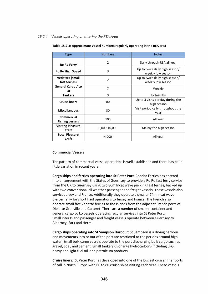
15.2.4 Vessels operating or entering the REA Area
Table 15.2.3: Approximate Vessel numbers regularly operating in the REA area
Type Numbers Notes
Ro Ro Ferry
2 Daily through REA all year
Ro Ro High Speed 3 Up to twice daily high season/
weekly low season
Vedettes (small fast ferries)
2 Up to twice daily high season/
weekly low season
General Cargo / Lo Lo
7 Weekly
Tankers 3 fortnightly
Cruise liners 80 Up to 3 visits per day during the
high season
Miscellaneous 30 Visit periodically throughout the
year
Commercial Fishing vessels
195 All year
Visiting Pleasure Craft
8,000-10,000 Mainly the high season
Local Pleasure Craft
4,000 All year
Commercial Vessels
The pattern of commercial vessel operations is well established and there has been
little variation in recent years.
Cargo ships and ferries operating into St Peter Port: Condor Ferries has entered into an agreement with the States of Guernsey to provide a Ro Ro fast ferry service from the UK to Guernsey using two 86m Incat wave piercing fast ferries, backed up with two conventional all weather passenger and freight vessels. These vessels also service Jersey and France. Additionally they operate a smaller 74m Incat wave piercer ferry for short haul operations to Jersey and France. The French also operate small fast Vedette ferries to the Islands from the adjacent French ports of Dielette Granville and Carteret. There are a number of smaller container and general cargo Lo Lo vessels operating regular services into St Peter Port.
Small inter Island passenger and freight vessels operate between Guernsey to Alderney, Sark and Herm.
Cargo ships operating into St Sampson Harbour: St Sampson is a drying harbour
and movements into or out of the port are restricted to the periods around high water. Small bulk cargo vessels operate to the port discharging bulk cargo such as gravel, coal, and cement. Small tankers discharge hydrocarbons including LPG, heavy and light fuel oil, and petroleum products.
Cruise liners: St Peter Port has developed into one of the busiest cruiser liner ports
of call in North Europe with 60 to 80 cruise ships visiting each year. These vessels
347
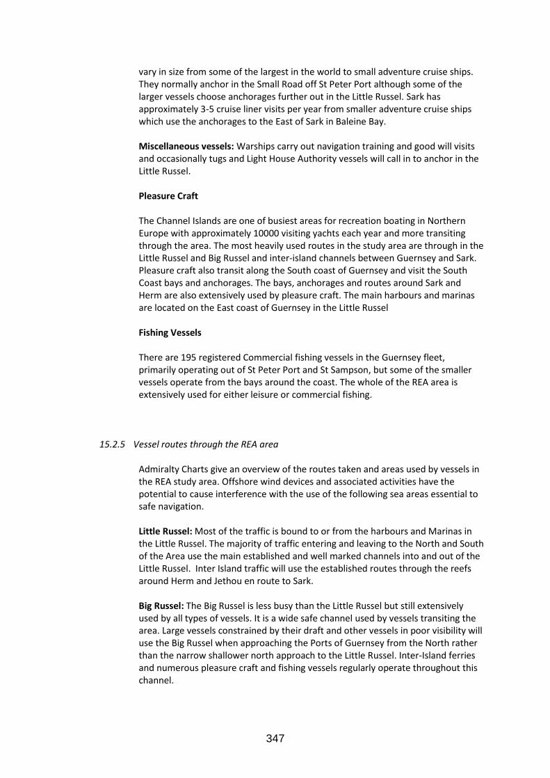
vary in size from some of the largest in the world to small adventure cruise ships. They normally anchor in the Small Road off St Peter Port although some of the larger vessels choose anchorages further out in the Little Russel. Sark has approximately 3-5 cruise liner visits per year from smaller adventure cruise ships which use the anchorages to the East of Sark in Baleine Bay.
Miscellaneous vessels: Warships carry out navigation training and good will visits
and occasionally tugs and Light House Authority vessels will call in to anchor in the Little Russel.
Pleasure Craft The Channel Islands are one of busiest areas for recreation boating in Northern
Europe with approximately 10000 visiting yachts each year and more transiting through the area. The most heavily used routes in the study area are through in the Little Russel and Big Russel and inter-island channels between Guernsey and Sark. Pleasure craft also transit along the South coast of Guernsey and visit the South Coast bays and anchorages. The bays, anchorages and routes around Sark and Herm are also extensively used by pleasure craft. The main harbours and marinas are located on the East coast of Guernsey in the Little Russel
Fishing Vessels
There are 195 registered Commercial fishing vessels in the Guernsey fleet, primarily operating out of St Peter Port and St Sampson, but some of the smaller vessels operate from the bays around the coast. The whole of the REA area is extensively used for either leisure or commercial fishing.
15.2.5 Vessel routes through the REA area
Admiralty Charts give an overview of the routes taken and areas used by vessels in the REA study area. Offshore wind devices and associated activities have the potential to cause interference with the use of the following sea areas essential to safe navigation. Little Russel: Most of the traffic is bound to or from the harbours and Marinas in the Little Russel. The majority of traffic entering and leaving to the North and South of the Area use the main established and well marked channels into and out of the Little Russel. Inter Island traffic will use the established routes through the reefs around Herm and Jethou en route to Sark.
Big Russel: The Big Russel is less busy than the Little Russel but still extensively used by all types of vessels. It is a wide safe channel used by vessels transiting the area. Large vessels constrained by their draft and other vessels in poor visibility will use the Big Russel when approaching the Ports of Guernsey from the North rather than the narrow shallower north approach to the Little Russel. Inter-Island ferries and numerous pleasure craft and fishing vessels regularly operate throughout this channel.

348
Guernsey South Coast: Vessels departing to the south west of Guernsey will normally transit the south coast at least 1 nm offshore to keep in deep water. Guernsey North West Coast: The out lying reefs extend some 2 nm from the mainland and this coast is particularly challenging and hazardous. Vessels transiting the North West coast therefore keep well offshore typically 1 nm clear of the outlying reefs and in-shore traffic is confined to the ‘Bay fishermen’ and a small number of local pleasure craft. Sark: The coastal waters around Sark are used extensively by all types of craft operating to the harbours, bays and landing sites on both east and west coast. Vessels regularly transit to the of East Sark but tend to keep to the east side of Blanchard Buoy some 2nm off mainland Sark. In this strategic study it has not been possible to consider each channel individually and therefore project-specific investigations would be required prior to any development taking place. However, when considering the positioning of marine renewable energy devices in the study area it is particularly important to take into account the following:
It is a requirement under the United Nations Law of the Sea (UNCLOS) that recognised sea lanes essential to international navigation must not be impeded.
In addition, many of the passages between islands are essential for inter-island trade, fishing and leisure craft activities.
Search and rescue practices and operations take place throughout the study area.
Anti-pollution operations need to be accommodated.
Approaches to ports and harbours must be maintained.
Approaches to marinas, anchorages and bay moorings must be maintained.
15.2.6 Pinch Points and Critical Areas Specific Areas identified in the REA study area that need to be considered as
particularly important for navigation are listed below, and shown on the relevant Admiralty Chart:
Little Russel Big Russel
The passages between Guernsey, Herm and Sark. The entrances to ports and harbours The numerous anchorages shown on Admiralty Charts.

349
Figure 15.2.1 – The important pinch points as illustrated on the Admiralty chart
15.2.7 Future Developments
Generally, the level of shipping and smaller craft is not expected to increase dramatically but consideration needs to be given to possibility that there will be
modest increases in all types of craft. Any renewable energy development must not restrict the potential to increase the number, size and draft of vessels using the pinch points and critical areas outlined above.
The GHA is actively working with the Culture and Leisure Department to
increase the number of visiting cruise liners and leisure craft. The GHA also has contingency plans to expand the Port of St Sampson to
provide deep water berths for the use of tankers and cargo vessels. Plans for this are available and should be consulted before any development is proposed in the
approaches or routes to and from St Sampson’s Harbour.

350
15.3 Potential Effects
All offshore wind devices have the potential to endanger or effect any of the above vessels and their crews. Impacts on shipping and navigation can be categorised as effects on safety, operational effects related to economics such as journey times and distances, and disruption to trade. It should also be noted that this report identifies generic effects, and where possible, assigns strategic effect significance based on the available high level data. Any proposed marine renewable energy development would need to examine the potential effects specific to that development. This would require use of more detailed data sources, further data collection and detailed navigation risk studies for each phase of the development ie. construction, operation and de- commissioning. Table 15.3.1: Table outlining Potential Safety Effects
Safety Effect Vessels/receptors Result
Collision All Damage/pollution/ sinking of
vessels
Counter Pollution Commercial vessels Impede anti pollution operations
Search and Rescue (SAR)
All Impede SAR operations or training
Reduced visibility All Obstruct navigational marks or
lights
Electronic/magnetic interference
All Interference with radar,
communications and magnetic compass and navigation aids
Changes to tidal streams, heights and
times All
Increased tidal stream and changes to tidal heights and times are a risk
to navigation

351
Table 15.3.2: Table outlining Potential Operational Effects.
Operational Effect Vessels/receptors Result
Increased Journey times and distances
All Delayed schedules and increased
costs to shipping
Displacement of shipping
All Increased densities of vessels
Reduced Trade Opportunities
Commercial vessels Disruption of trade
Reduced fishing Opportunities
Fishing vessels Disruption of fishing commercial
and leisure
Leisure vessels by-pass the area
Leisure vessels Loss of marine tourists and income
to marine traders
15.4 Sensitivity of vessels /receptors
Clearly all types of vessels could be affected by the presence of wind energy devices. Each development will need to give site specific consideration to the types and drafts of vessels likely to using the area and mitigate the risks appropriately.

352
15.5 Potential Significance of Effects
Table 15.5.1 Table outlining the significance of safety effects.
Safety Effect Vessels/receptors Significance
Collision All Major
Counter Pollution Commercial vessels Major
SAR All Major
Reduced visibility All Minor
Electronic/magnetic interference
All Minor
Changes to tidal streams, heights and
times All Moderate
Table 15.5.2: Table outlining the significance of Operational Effects.
Operational Effect Vessels/receptors Significance
Increased Journey times and distances
All Moderate
Displacement of shipping
All Minor
Reduced Trade Opportunities
Commercial vessels Minor
Reduced fishing Opportunities
Fishing vessels Major
Leisure vessels by-pass the area
Leisure vessels Moderate
15.5.1 Safety Effects
Collision The presence of stationary wind arrays is likely to affect the probability of collisions with both vessels moving under power and drifting vessels.
The presence of slow moving or stationary installation vessels and equipment is likely to increase the probability of close quarter encounters and collisions with vessels. These activities also have the potential to cause small and recreational vessels to modify their routes to use areas transited by larger vessels, which potentially increases the risk of encounter or collision. [Significance – Major]
Counter Pollution

353
Given the proximity of the very busy Channel shipping lanes and the amount of hazardous cargo being carried there is there is a risk that casualty vessels and or their cargo may drift into the area and collide with offshore wind devices or go aground in the vicinity of them with the possibility of extensive and serious pollution. The presence of stationary wind arrays could seriously impede any counter pollution operations. [Significance – Major]
Search and Rescue (SAR) Search and rescue exercises and operations could take place throughout the study area. The presence of stationary wind arrays could seriously impede SAR operations and it is important that SAR assets should be able to access all areas. [Significance – Major] Reduced visibility During construction in particular, the presence of large installation vessels, barges, jack-up rigs and other construction equipment has the potential to obstruct the view of other vessels, navigation aids such as lights and buoys and the coastline. This could cause a hazard to shipping in areas where visibility is particularly important for navigation or areas where the topography already constrains visibility. The turbines themselves and maintenance vessels could also obstruct navigation aids. [Significance – Minor]
Electronic and magnetic interference There is potential for structures, generating systems and seabed cabling to adversely affect communications including AIS, radar performance and navigation equipment. Magnetic interference can effect with ships compasses although compass deviation is only likely to be an issue in very shallow and intertidal areas which are typically of low importance for shipping . [Significance – Minor] Changes to Tidal streams, heights and times There is potential for large arrays to cause changes to the rates, direction, heights and times of local tides. Navigation in the REA area is already very challenging with vessels operating in narrow channels and with minimum under keel clearances. Entry into some ports is also restricted by tidal flows and heights. Any changes to the tidal regime could increase the risk of grounding, collision or restrict harbour entries and departures. [Significance – Minor]
15.5.2 Operational Effects Increased journey times and distances During installation, operation and de-commissioning it will be necessary to
establish exclusion or avoidance zones around renewable energy devices for safety purposes. The Department of Trade and Industry (DTI) is currently considering the establishment of safety zones around offshore renewable energy installations. The proposal under consultation is that a 500 m safety zone should be employed around construction activities and 50 m around operational installations. The introduction of safety zones into the study area will require vessels to move around the activities potentially increasing journey times and distances. The extent to which journey time or distances are affected will be highly variable depending on the location of the development. Increased journey distances will, of course, lead

354
to increased fuel use with the associated indirect increase in costs incurred by the shipping operator, and increased carbon emissions. [Significance – Moderate]
Displacement of shipping density The safety zones that will be in place during construction and operation could affect shipping density in already busy areas as vessels will be forced to move around the safety zones. [Significance – Minor] Reduced trade opportunities Temporary reduced access to ports and harbours may occur during construction activities in some island locations and this would have an effect on trade and supplies. [Significance – Minor] Reduced fishing opportunities Wind turbines, mooring equipment and submerged power cables would be snagging hazards for fishing gear and trawls etc. It is unlikely that the two activities could be carried out in the same area and there would be a requirement to establish no-fishing zones, which would inevitably reduce the areas available for fishing.[Significance – Major] Visiting leisure craft by-pass the area The large scale development of marine energy devices would inevitably increase the difficulty and risks of navigating leisure craft through the REA and could result in visiting craft taking easier routes and by-passing the area. This would result in a loss of revenue to the tourist and leisure marine industries.[Significance –Moderate]

355
15.6 Likelihood of occurrence
Table 15.6.1: Table outlining the probability of effects on vessels.
Safety Effect Vessels/receptors Likelihood of occurrence
Collision All High
Counter Pollution Commercial vessels High
SAR All High
Reduced visibility All Moderate
Electronic/magnetic interference
All Moderate
Changes to tidal streams, heights and times
All Low
Operational Effect Vessels/receptors Likelihood of occurrence
Increased Journey times and distances
All Moderate
Displacement of shipping All Moderate
Reduced Trade Opportunities
Commercial vessels Low
Reduced fishing Opportunities
Fishing vessels High
Leisure vessels by-pass the area
Visiting Leisure craft Low

356
15.7 Mitigation Measures
The developer will be required to fully assess the risks of the proposed development in an equivalent way to the UK MCA Guidance Note: “ MGN 371 (M+F). Offshore Renewable Energy Installations. Guidance on UK Navigational Practice, Safety and Emergency Response Issues.” following consultation with some or all of the following: Trinity House, UK Hydrographic Office, Guernsey and Sark Harbour Authorities, Guernsey Sea Fisheries, local Yacht clubs, Guernsey Marine Traders and Boat Owners association.
Where potentially significant impacts have been identified, some or all of the
following mitigation measures may be appropriate for avoiding or reducing the effects:
Detailed assessment of shipping traffic to determine most appropriate
location for development (avoidance of areas where there is risk of major disturbance to shipping traffic). Avoid development in shipping routes of importance to international and inter island navigation.
Marking the devices using the guidance given in the Association of Marine
Aids to Navigation and Lighthouse Authorities (IALA), and Trinity House guidance: “Renewable Energy Installations Farms and Fields – Provision and maintenance of aids to local navigation”.
Where appropriate establishing exclusion zones and avoidance areas.
Hydrographic surveys to accurately establish depths and effects on tidal
streams and currents.
Ensure mariners are aware of proposed works via the issue of chart corrections, Notices to Mariners and the use of other appropriate measures for promulgating Maritime Safety Information.
Emergency response cooperation plans which would include the provision of
equipment, emergency access routes, emergency shut down procedures and training.
Adaptation of search and rescue procedures and training.
Monitoring arrangements using appropriate sensors such as radar and or AIS
to provide early warning of potential emergencies and ensure compliance with agreed procedures. It must be stressed that the full application of surveillance and monitoring arrangements, including 365 day 24 hour manning of a monitoring station, would probably not be required unless the renewable energy deployment site were sited at a location where it was identified as being a distinct hazard to navigation. It is anticipated that, if a development is sited with due respect for navigational safety concerns, then such surveillance will not be required.

357
15.8 Confidence and Knowledge Gaps
Confidence and knowledge gaps are summarised below.
15.8.1 AIS Data It is noted that, at the time of this REA, a formal traffic survey and navigational risk assessment has not been undertaken. It is considered that the information that is currently available to the authors is sufficient to identify generic impacts and mitigation measures. As specific renewable energy projects are developed, the developers’ should be asked to undertake more detailed and project-specific work. This is likely to include procurement and analysis of AIS records. It is anticipated that it will be sufficient for the AIS data to be acquired for a minimum of two, 2-week periods (one in January and one in August) to inform the assessment. However, it should be noted that although this data would give a good indication of the shipping routes and densities across the study area for commercial traffic, the following limitations should be taken into account. AIS equipment is only mandatory for vessels over 300 GRT which means that some small supply vessels, recreational craft, and the majority of fishing vessels operating in the study area are not captured by this data. It is expected that these smaller vessels will often operate in areas marked as low density based on the AIS data. It is estimated that the AIS data used captures approximately 90% of commercial vessel movements. The majority of naval vessels do not use AIS and therefore these movements are not captured. The August dataset is considered to give an indication of summer shipping movements through the study area, and this is typically a time of highest shipping activity.
15.8.2 Journey Times and Distances, and Trade and Supplies A detailed assessment of how journey times and distances, trade and supplies
could be affected by marine renewable energy has not been undertaken for this REA as it is highly dependent on the locations and scales of individual developments. However, once individual developments are in the planning stage it would be possible to undertake a cumulative impact assessment that takes into account the cumulative effects of marine renewable energy developments.
15.8.3 Collision Risks Collision risk has not been quantified in this assessment as specific development locations and configurations are required in order to make a meaningful assessment, and such assessments are most appropriate at the project level. Similarly the consequences of a collision have not been considered in detail. It is expected the available industry guidelines on shipping and navigation risk and detailed baseline assessments will ensure that developments are not sited in high risk locations where effective mitigation cannot be applied. It is also expected that a development that presents a high level of collision risk will have difficulty achieving consent.

358
15.9 Residual Effects
15.9.1 Safety Effects
Proper and careful adherence to the mitigation measures outlined above should reduce the Safety Effects to acceptable levels and development should only be approved if this can be achieved. The use of UK MCA Guidance Note: “ MGN 371(M+F). Offshore Renewable Energy Installations. Guidance on UK Navigational Practice, Safety and Emergency Response Issues.” which is well established and proven guidance should give a high level of confidence that this can be achieved.
15.9.2 Operational Effects
The mitigation measures will have limited ability to reduce the significance of the operational effects highlighted in this report. Inevitably, the more development allowed the greater it will effect the operations of ships and all other vessels which have previously used this busy sea area without restrictions.
15.10 Recommendations for Survey and Monitoring
15.10.1 Survey
Vessel traffic surveys will be required before development to accurately establish shipping activities around development sites
Hydrographic surveys to establish clearances and sea bed profile for each development site will be required.
15.10.2 Monitoring Vessel flow monitoring is recommended to ensure compliance with agreed routing and safety separation schemes and to identify any potential risk of unfavourable interaction. Standard measures such as the monitoring of navigation aids marking devices to ensure they remain operational should also take place.
Hydrographic and tidal stream monitoring should be carried after development until it can be confirmed that any changes to the rates of flow, times and heights of tide and the sea bed profile resulting from the devices has been accurately established.
15.10.3 Multiple developments
Hydrographic and tide surveys, and vessel flow monitoring will also need to be
carried out in respect of multiple developments.