dna 6020f shots able, baker, charlie, and dog
TRANSCRIPT

DNA 6020F
SHOTS ABLE, BAKER, CHARLIE,
AND DOG The First Tests of the
TUMBLER-SNAPPER Series 1 APRIL - 1 MAY 1952
United States Atmospheric Nuclear Weapons Testa Nuclear Test Personnel Review
Prepared by the Defense Nuclear Agency as Executive Agency for the Department of Defense
Destroy this report when it is no longer needed. Do not return to sender.
PLEASE NOTIFY THE DEFENSE NUCLEAR AGENCY, ATTN: STTI, WASHINGTON, D.C. 20305, IF YOUR ADDRESS IS INCORRECT, IF YOU WISH TO BE DELETED FROM THE DISTRIBUTION LIST, OR IF THE ADDRESSEE IS NO LONGER EMPLOYED BY YOUR ORGANIZATION.
;ECURlTY CLASSIFICATION OF THIS PAGE (When Date Entered)
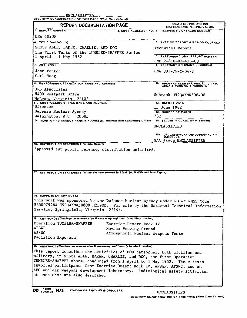
REPORTDOCUMENTATIONPAGE READ INSTRUCTIONS BEFORE COMPLETING FORM
1. REP’ORT NUMBER 2. GOVT ACCESSION NO. 3. RECIPIENT’S CATALOG NUMBER
DNA 6020F b. TITLE (and Subtftle) 5. TYPE OF REPORT 6 PERIOD COVERED
SHOTS ABLE, BARER, CHARLIE, AND DOG The First Tests of the TUMBLER-SNAPPER Series 1 April - 1 May 1952
(technical Report
6. PERFORMING ORG. REPORT NUMBER
JRB 2-816-03-423-00 1. AUTHOR(a) 6. CONTRACT OR GRANT NUMBER(a)
Jean Ponton Carl Maag
DNA 001-79-C-0473
8. PERFORMING ORGANIZATION NAME AND ADDRESS 10. PROGRAM ELEMENT, PROJECT, TASK AREA h WORK UNIT NUMBERS
JRB Associates 8400 Westpark Drive Subtask U99QAXMK506w08 McLean, Virginia 22102
* 1. CONTROLLING OFFICE NAME AND ADDRESS Director Defense Nuclear Agency Washington, D.C. 20305
12. REPORT DATE
15 June 1982 13. NUMBER OF PAGES 232
14. MONITORING AGENCY NAME h ADDRESS(If dfffermt from Controlling Offtee) 15. SECURITY CLASS. (of thfa repor?)
3NCLASSIFIED
16~. DECLASSIFICATION/DOWNGRADlNG SCHEDULE
.!!/A since UNCLASSIFIED 16. DISTRIBUTION STATEMENT (of Lie Raport)
Approved for public release; distribution unlimited.
7. DlSTRlBUTlON STATEMENT (of the #battact entered In Block 20, if dffferat trom Repoti)
16. SUPPLEMENTARY NOTES
This work was sponsored by the Defense Nuclear Agency under RDTdE RMSS Code B350079464 U99QAXMK50608 H2590D. For sale by the National Technical Information Service, Springfield, Virginia 22161.
19. KEY WORDS (Cmtfnuo on I~P~~~~ l idm If neceamty md fdentffy by block numb4
Operation TUMBLER-SNAPPER Exercise Desert Rock IV AFSWP Nevada Proving Ground AFSWC Atmospheric Nuclear Weapons Tests Radiation Exposure
Ihis report describes the activities of DOD personnel, both civilian and nilitary, in Shots ABLE, BARER, CHARLIE, and DOG, the first Operation IUMBLER-SNAPPER shots, conducted from 1 April to 1 May 1952. These tests involved participants from Exercise Desert Rock IV, AFSWP, AFSWC, and an AEC nuclear weapons development laboratory. at each shot are also described.
Radiological safety activities
00 I:“,““, 1473 ED)TlOY OF * WOV 65 IS 08SOLETE UNCLASSIFIED SECURlTY CLASSIFICATION OF THIS PAGE (- Data Entered)
8. SUPPLEMENTARY NOTES (Continued)
The Defense Nuclear Agency Action Officer, Lt. Col. H. L. Reese, USAF, under whom this work was done, wishes to acknowledge the research and editing contribution of numerous reviewers in the military services and other organizations, in addition to those writers listed in block 7.
UNCLASSIFIED SECURITY CLASSIFICATION OF THIS PAGEIWhon Data Entoted)
PREFACE
Between 1945 and 1962, the U.S. Government, through the Manhattan Engineer District and its successor agency, the Atomic Energy Commission (AEC), conducted 235 atmospheric nuclear weapons tests at sites in the United States and in the Atlantic and Pacific Oceans. In all, an estimated 220,000 Department of Defense (DOD) participants, both military and civilian, were present at the tests. Of these, approximately 90,000 partici- pated in the atmospheric nuclear weapons tests conducted at the Nevada Proving Ground (NPG),* northwest of Las Vegas, Nevada.
In 1977, 15 years after the last above-ground weapons test, the Center for Disease Control+ noted a possible leukemia cluster among a small group of soldiers at Shot SMOKY, one test of Operation PLUMBBOB, the series of atmospheric nuclear weapons tests conducted in 1957. Since that initial report by the Center for Disease Control, the Veterans Administration has received a
number of claims for medical benefits from former military
personnel who believe their health may have been affected by their participation in the weapons testing program.
In late 1977, the DOD began a study to provide data to both the Center for Disease Control and the Veterans Administration on potential exposures to ionizing radiation among the military and civilian participants in atmospheric nuclear weapons testing. The DOD organized an effort to:
l Identify DOD personnel who had taken part in the atmospheric nuclear weapons tests
*Renamed the Nevada Test Site in 1955.
+The Center for Disease Control is an agency of the U.S. Department of Health and Human Services (formerly the U.S. Department of Health, Education, and Welfare).
1

0 Determine the extent of the participants' exposure to ionizing radiation
0 Provide public disclosure of information concerning par- ticipation by DOD personnel in the atmospheric nuclear weapons tests.
METHODS AND SOURCES USED TO PREPARE THIS VOLUME
This report on the first four nuclear tests of Operation TUMBLER-SNAPPER is based on the military and technical documents associated with these atmospheric nuclear weapons tests. Many of the documents pertaining specifically to DOD involvement in these events were found in the Defense Nuclear Agency Technical Library, the Office of Air Force History, and the Modern Military Branch of the National Archives.
In most cases, the surviving historical documentation
addresses test specifications and technical information rather than the personnel data critical to the study undertaken by the Department of Defense. Moreover, these documents sometimes reveal inconsistencies in vital facts. Efforts have been made to resolve these inconsistencies where possible or to bring them to the attention of the reader.
In addition to these inconsistencies, documents from the Armed Forces Special Weapons Project (AFSWP) do not always refer to project titles and agencies in the same way. To make this information as uniform as possible, this report uses weapons test report titles for each project. Information concerning the dates and yields of the detonations is taken from the Department of
Energy, Announced United States Nuclear Tests, July 1945 through 1979 (NVO-209). Oth'er facts, such as meteorological conditions and dimensions of the clouds formed by the detonations, are taken from DNA 1251-1, Compilation of Local Fallout Data from Test Detonations 1945-1962, Volume 1, unless more specific information is available elsewhere.

For several of the Exercise Desert Rock and test organi- zation projects discussed in this volume, the only documents available are the Sixth Army Desert Rock operation orders and the Test Director's schedule of events from "Operation Order l-52." These sources detail the plans developed by DOD and AEC personnel during Operation TUMBLER-SNAPPER, but it is not known if all the projects addressed in the planning documents were conducted exactly as planned. Although some of the after-action documents summarize the projects performed during Operation TUMBLER- SNAPPER, they do not always supply shot-specific information. In the absence of shot-specific after-action reports, this volume describes projects according to the plans. The references indicate whether the description of activities is based on the schedule of events, operation orders, or after-action reports.
ORGANIZATION AND CONTENT OF OPERATION TUMBLER-SNAPPER REPORTS
This volume details participation by DOD personnel in the first four events of Operation TUMBLER-SNAPPER. Two other publi- cations address DOD activities during this test series:
0 Series volume: Operation TUMBLER-SNAPPER, 1952
0 Multi-shot volume: Shots EASY, FOX, GEORGE, and HOW, the Final Tests of the TUMBLER-SNAPPER Series.
The Operation TUMBLER-SNAPPER volumes are designed for use with one another. The series volume provides general information
on topics such as the historical context of the TUMBLER-SNAPPER test program, its overall objectives, and the layout of the Nevada Proving Ground. In addition, the series volume contains a bibliography of works consulted in the preparation of all three Operation TUMBLER-SNAPPER reports. The multi-shot volumes, on the other hand, describe several nuclear events and list only the sources referenced in the text. Descriptions of activities concerning any particular shot in the series may be supplemented by the general organizational and radiological safety information in the Operation TUMBLER-SNAPPER volume.
3

The first chapter of this volume describes the physical setting and general characteristics of Shots ABLE, BAKER, CHARLIE, and DOG and briefly introduces the Desert Rock exercises and the scientific activities in which DOD personnel partici- pated. The remaining four chapters address each of the four shots in turn. Each of these chapters describes the setting and characteristics of one detonation and details DOD participation in the scientific projects conducted by the test groups. The chapters describing CHARLIE and DOG also discuss the training activities associated with Exercise Desert Rock IV. The chapters conclude by discussing the radiological protection procedures used to minimize the potential for exposures to ionizing radia- tion. Details of the overall radiological protection program at Operation TUMBLER-SNAPPER are provided in the series volume.
The information in this report is supplemented by the Reference Manual: Background Materials for the CONUS Volumes, which summarizes information on radiation physics, radiation health concepts, exposure criteria, and measurement techniques. It also lists acronyms and provides a glossary of terms used in the DOD reports addressing test events in the continental United States.
4

TABLE OF CONTENTS
CHAPTER PAGE
PREFACE..........................
LIST OF ILLUSTRATIONS. . . . . . . . . . . . . . . . . . .
LIST OF TABLES . . . . . . . . . . . . . . . . . . . . . .
LIST OF ABBREVIATIONS AND ACRONYMS . . . . . . . . . . . .
1 INTRODUCTION. . . . . . . . . . . . . . . . . . . . . .
1.1 Department of Defense Participation at the First Four TUMBLER-SNAPPER Events. . . . . . . . .
1.2 Department of Defense Involvement in Joint AEC-DOD Organization Activities at the First Four TUMBLER-SNAPPER Events. . . . . . . . .
1.3 Exercise Desert Rock IV Activities at the First Four TUMBLER-SNAPPER Events. . . . . . . . . . . .
Shot ABLE Synopsis . . . . . . . . . . . . . l l . l . l l
2 SHOTABLE.......................
2.1 Exercise Desert Rock IV Operations at Shot ABLE. . 2.2 Department of Defense Participation in Scientific
and Support Activities at Shot ABLE. . . . . . . .
2.2.1 Military Effects Test Group Projects. . . . . . . . . . . . . . . . . .
2.2.2 Weapons Development Test Group Activities. . . . . . . . . . . . . . . . .
2.2.3 Air Force Special Weapons Center Activities. . . . . . . . . . . . . . . . .
2.3 Radiation Protection at Shot ABLE. . . . . . . . .
Shot BAKER Synopsis. . . . . . . . . . . . . . . . . . . .
3 SHOTBAKER.......................
3.1 Exercise Desert Rock IV Operations at Shot BAKER....................
3.2 Department of Defense Participation in Scientific and Support Activities at Shot BAKER . . . . . . .
1
7
9
10
11
12
17
18
20
21
21
22
22
35
38
44
49
50
50
53
5

TABLE OF CONTENTS (Continued)
CHAPTER
3.2.1 Military Effects Test Group Projects. . . . 3.2.2 Weapons Development Test Group
Activities. . . . . . . . . . . . . . . . . 3.2.3 Air Force Special Weapons Center
Activities. . . . . . . . . . . . . . . . .
3.3 Radiation Protection at Shot BAKER . . . . . . . .
Shot CHARLIE Synopsis. . . . . . . . . . . . . . . . . . .
4 SHOT
4.1
CHARLIE......................
Exercise Desert Rock IV Operations at Shot CHARLIE . . . . . . . . . . . . . . . . . . .
4.1.1 Participation of Camp Desert Rock Support Troops...................
4.1.2 Observer Activities . . . . . . . . . . . . 4.1.3 Tactical Troop Maneuver . . . . . . . . . .
4.2 Department of Defense Participation in Scientific and Support Activities at Shot CHARLIE . . . . . .
4.2.1 Military Effects Test Group Projects. . . . 4.2.2 Weapons Development Test Group
Activities. . . . . . . . . . . . . . . . . 4.2.3 Air Force Special Weapons Center
Activities. . . . . . . . . . . . . . . . .
4.3 Radiation Protection at Shot CHARLIE . . . . . . .
4.3.1 Desert Rock Radiation Protection Activities. . . . . . . . . . . . . . . . .
4.3.2 Joint AEC-DOD Radiation Protection Activities. . . . . . . . . . . . . . . . .
Shot DOG Synopsis. . . . . . . . . . . . . . . . . . . . .
5 SHOTDOG........................
5.1 Exercise Desert Rock IV Operations at Shot DOG . .
5.1.1 Participation of Camp Desert Rock Support Troops ...................
5.1.2 Troop Observer Activities ......... 5.1.3 Tactical Troop Maneuver ..........
5.2 Department of Defense Participation in Scientific and Support Activities at Shot DOG . . . . . . . .
PAGE
53
70
75
79
84
85
87
87 90 95
104
104
127
131
136
136
138
143
144
144
145 146 148
156
6

TABLE OF CONTENTS (Continued)
CHAPTER
5.3 Radiation Protection at Shot DOG . . . . . . . . .
5.2.1 Military Effects Test Group Projects. . . . 5.2.2 Weapons Development Test Group
Activities. . . . . . . . . . . . . . . . . 5.2.3 Air Force Special Weapons Center
Activities. . . . . . . . . . . . . . . . .
5.3.1 Desert Rock Radiation Protection Activities. . . . . . . . . . . . . . . . .
5.3.2 Joint AEC-DOD Radiation Protection Activities. . . . . . . . . . . . . . . . .
REFERENCE LIST . . . . . . . . . . . . . . . . . . . . . .
LIST OF ILLUSTRATIONS
PAGE
156
181
186
190
191
192
199
FIGURE PAGE
l-l
2-l
2-2
2-3
2-4
2-5
2-6
3-l
3-2
Location of Shots ABLE, BAKER, CHARLIE, and DOG at the Nevada Proving Ground in Relation to Other Shots in the TUMBLER-SNAPPER Series. . . . . . . . . . . . . . 14
Project 1.7 Personnel Install Accelerometers along the Blast Line. . . . . . . . . . . . . . . . . 27
Cameramen from the Air Force Lookout Mountain Laboratory Photograph the Development of the Cloud from a C-47 . . . . . . . . . . . . . . . . . . 34
Flight Pattern for B-50 Drop Aircraft, Shot ABLE. . . 40
Crew of the Disaster Aircraft Plots the Position of the Bombing Aircraft Enroute to the Shot Area . . . . 42
Radiation Isointensity Map for Shot ABLE, 1 April 1952, 1400to1500Hours.................. 47
Subsequent Radiation Isointensity Maps for Shot ABLE...................... 48
Area 7 Ground Zero Target, Shots BAKER, CHARLIE, DOG........................* 51
View of the BAKER Burst from the Control Point at YuccaPass...................... 52
LIST OF ILLUSTRATIONS (Continued)
FIGURE PAGE
3-3
3-4
3-5
3-6
4-l
4-2
4-3
4-4
4-5
4-6
4-7
4-8
4-9
4-10
4-11
5-1
Ground Zero and AFSWP Instrument Layouts for Shots BAKER, CHARLIE, and DOG . . . . . . . . . . . . 56
Project 8.6 Personnel Prepare Acoustic Velocity Equipment . . . . . . . . . . . . . . . . . . . . . . 67
Initial Radiation Isointensity Map for Shot BAKER, 15 April 1952, 1011 to 1040 Hours . . . . . . . . . .
Subsequent Radiation Isointensity Maps for Shot BAKER. . . . . . . . . . . . . . . . . . . . . .
81
Operation SCRIBE Activities at News Nob . . . . . . .
82
86
Observer Trenches, Display and Parking Areas, and Routes of Advance for Service Observers and Maneuver Troops at Shot CHARLIE . . . . . . . . . . . 89
Service Observers in Trenches for Rehearsal of Shot CHARLIE. . . . . . . . . . . . . . . . . . . . .
Official DOD and Government Observers at News Nob Rehearsing for Shot CHARLIE . . . . . . . . . . . . .
Air Force Personnel of the 140th Fighter-Bomber Group (Provisional) Marching to the Equipment Display Areas........................
Troops of the 82nd Airborne Division Putting on Their Parachutes. . . . . . . . . . . . . . . . . . .
Paratroopers of the 82nd Airborne Division Await the Signal to Jump. . . . . . . . . . . . . . . . . .
Paratroopers of the 82nd Airborne Division Descending over the Nevada Proving Ground . . . . . .
Participant in Project 3.1 Adjusting Instruments. . .
Initial Radiation Isointensity Map for Shot CHARLIE, 22 April 1952, 1015 to 1040 Hours . . .
91
93
99
100
102
103
113
140
Subsequent Radiation Isointensity Maps for Shot CHARLIE . . . . . . . . . . . . . . . . . . . 141
Observer Trenches, Display and Parking Areas, and Routes of Advance for Exercise Desert Rock IV Activities at Shot DOG . . . . . . . . . . . . . . . . 147

LIST OF ILLUSTRATIONS (Continued)
FIGURE PAGE
5-2
5-3
5-4
5-5
5-6
5-7
5-8
5-9
TABLE
l-l
2-l
3-l
4-l
4-2
5-l
Members of the Marine Corps Provisional Atomic Exercise Unit Assembling in the Trench Area before the DOG Detonation. . . . . . . . . . . . . . . 152
Marines Observe the Shot DOG Cloud . . . . . . . . . . 153
Marine Corps Photographer at Shot DOG Equipment Display. . . . . . . . . . . . . . . . . . . 154
Marine Monitors Participant in Maneuver at Shot DOG. . . . . . . . . . . . . . . . . . . . . . 155
A Member of the Radiological Safety Group Checks for Contamination with One of the Radiometers Used in Project 8.3. . . . . . . . . . . . . . . . . . . . . . 175
Project 9.1 Participant from Lookout Mountain Laboratory Photographing the DOG Fireball. . . . . . . 178
Initial Radiation Isointensity Map for Shot DOG, 1 May 1952, 0905 to 1005 Hours . . . . . . . . . . . . 195
Subsequent Radiation Isointensity Maps forShotDOG.....................196
LIST OF TABLES
PAGE
Summary of the First Four Operation TUMBLER-SNAPPER Events,1952..................... 13
Test Group Activities with Department of Defense Participation, Shot ABLE . . . . . . . . . . . . . . . 23
Test Group Activities with Department of Defense Participation, Shot BAKER. . . . . . . . . . . . . . . 54
Exercise Desert Rock IV Activities at Shot CHARLIE . . 87
Test Group Activities with Department of Defense Participation, Shot CHARLIE. . . . . . . . . . . . . . 105
Test Group Activities with Department of Defense Participation, Shot DOG. . . . . . . . . . . . . . . . 157
9

LIST OF ABBREVIATIONS AND ACRONYMS
The following abbreviations and acronyms are used in this volume:
AEC AFB AFSWC AFSWP BJY DOD EGBG HumRRO IBDA LASL NPG OR0 R/h SAC UCLA UTM
Atomic Energy Commission Air Force Base Air Force Special Weapons Center Armed Forces Special Weapons Project BUSTER-JANGLE Y Department of Defense Edgerton, Germeshausen, and Grier, Inc. Human Resources Research Office Indirect Bomb Damage Assessment Los Alamos Scientific Laboratory Nevada Proving Ground Operations Research Office Roentgens per hour Strategic Air Command University of California at Los Angeles Universal Transverse Mercator
10

CHAPTER 1
INTRODUCTION
Shots ABLE, BAKER, CHARLIE, and DOG were tests of nuclear
devices conducted from 1 April to 1 May 1952 at the Nevada
Proving Ground, the continental test site northwest of Las Vegas.
The shots were the first four detonations of Operation TUMBLER-
SNAPPER, the atmospheric nuclear weapons series conducted from
1 April to 5 June 1952. Shots ABLE, BAKER, CHARLIE, and DOG
were airdrops. Shot ABLE detonated over Frenchman Flat in Area
5. BAKER, CHARLIE, and DOG detonated over Area 7 of Yucca Flat
with nearly the same ground zero.
The Los Alamos Scientific Laboratory (LASL), an Atomic
Energy Commission nuclear weapons development laboratory,
designed and built these four nuclear devices. ABLE and BAKER,
part of the TUMBLER phase of Operation TUMBLER-SNAPPER, were
weapons effects tests. They were detonated to study the blast
pressures produced by an airdropped device. The peak blast over-
pressures for the airdrops of Operation BUSTER-JANGLE, the series
preceding TUMBLER-SNAPPER, were significantly lower than had been
predicted. TUMBLER was designed to investigate the reasons for
the differences between predicted and actual measurements. To
study the effect of surface on blast overpressure, Shot ABLE was
detonated over Frenchman Flat and BAKER over Yucca Flat (10; 98; 105).*
*All sources cited in the text are listed alphabetically and numbered in the Reference List, at the end of this volume. The number given in the citation in the text is the number of the source document in the Reference List.
11

Because CHARLIE and DOG were weapons effects and weapons development studies, they were part of both the TUMBLER and SNAPPER phases of Operation TUMBLER-SNAPPER. As weapons develop- ment shots, CHARLIE and DOG tested weapons for the nuclear stock- pile and techniques to be used in the Pacific during Operation IVY, scheduled for the fall of 1952 (94; 98; 105).
Table l-l summarizes information on the first four TUMBLER- SNAPPER events, including such information as the UTM* coor- dinates for the points of detonation and the heights of burst. Figure l-l displays a 1952 map of the positions of each TUMBLER- SNAPPER test within the Nevada Proving Ground (62).
1.1 DEPARTMENT OF DEFENSE PARTICIPATION AT THE FIRST FOUR TUMBLER-SNAPPER EVENTS
The joint AEC-DOD organization was established to plan, coordinate, and conduct atmospheric nuclear weapons tests during Operation TUMBLER-SNAPPER. Composed of personnel from the Atomic Energy Commission and the Department of Defense, the joint AEC-DOD organization also included representatives of various weapons development laboratories, AFSWP Test Command, and the Air Force Special Weapons Center (AFSWC). The many scientific and military projects conducted at the first four TUMBLER-SNAPPER events were fielded by two test groups and coordinated by the joint AEC-DOD organization. Other activities were conducted as part of the military training programs associated with Exercise
Desert Rock IV. These activities, planned and conducted by the armed services, were reviewed and approved by the Test Manager to ensure coordination with the AEC and the test groups.
*Universal Transverse Mercator (UTM) coordinates are used in this report. The first three digits refer to a point on an east-west axis, and the second three refer to a point on a north-south axis. The point so designated is the southwest corner of an area 100 meters square.
12

Table l-l: SUMMARY OF THE FIRST FOUR OPERATION TUMBLER-SNAPPER EVENTS, 1952
Shot
Sponsor
Planned Date
Actual Date
Time+
NPG Location
UJ 3
3 5 Y %
$ s 3
DOD-L4SL DOD-LASL DOD-LASL DOD-LASL
1 April 15 April 22 April 29 April
1 April 15 April 22 April 1 May
0900 0930 0930 0830
Area 5 Area 7 Area 7 Area 7 Frenchman
Flat
UTM Coordinates
Type of Detonation
Height of Burst (Feet above Terrain)
Yield (kilotons)
945729 872044 871045 871044
Airdrop Airdrop Airdrop Airdrop
793 1,109 3,447 1,040
1 1 31 19
l Pacific Standard Time
13

HOW I@
YUCCA FLAT ----------
ABLE
0
d Kilometers
Camp Desert Rock
Camp Mercury
Figure l-l: LOCATION OF SHOTS ABLE, BAKER, CHARLIE, AND DOG AT THE NEVADA PROVING GROUND IN RELATION TO OTHER SHOTS IN THE TUMBLER-SNAPPER SERIES
14

Department of Defense participation at Shots ABLE through DOG was of four types:
0 Administrative and support services for the joint AEC-DOD organization
0 Test group scientific and diagnostic activities, especially those of AFSWP
l Exercise Desert Rock IV military maneuvers and support
0 Air support.
Although the AEC was responsible for planning, coordinating, and executing the programs and activities associated with Opera- tion TUMBLER-SNAPPER, DOD personnel assisted the AEC Test Manager in these duties. The DOD personnel attached to the joint AEC-DOD organization were responsible for overseeing DOD's technical and
military planning objectives.
DOD personnel also participated in the scientific and diagnostic projects of two test groups: the Military Effects Test Group, directed by Test Command, AFSWP, and the Weapons Development Test Group with scientists from LASL, from Edgerton, Germeshausen, and Grier, Inc. (EG&G), from the Naval Research Laboratory, and from the Sandia Corporation. The Military Effects Test Group involved more DOD participants than the other test group. Drawn from various DOD civilian and military laboratories, these participants conducted experiments to study
weapons effects. Although activities of the AEC Weapons Development Test Group were conducted primarily by scientists from the Los Alamos Scientific Laboratory, some DOD personnel were assigned to LASL and participated in its projects.
Participants in test group projects generally placed instruments and experimental material around the intended ground zero in the days and weeks before the scheduled detonation. After the detonation, when the Test Manager had determined that
15

the radiological environment in the shot area would permit access, they returned to recover the equipment. During a detonation, project personnel were generally positioned at designated observer locations or were operating equipment or aircraft at substantial distances from ground zero.
Military training manuevers involving DOD personnel were conducted through the Exercise Desert Rock IV programs at Shots
CHARLIE and DOG. The Desert Rock IV programs usually involved more DOD participants than did the test group projects. Desert Rock activities generally included orientation and indoctrination
programs, highlighted by the observation of a nuclear burst. At Shots CHARLIE and DOG, Exercise Desert Rock IV also included tactical troop maneuvers after the detonations.
Approximately 1,500 soldiers from various Army units provided support for the Exercise Desert Rock programs. They maintained and operated Camp Desert Rock, an installation of the Sixth Army. These soldiers provided essential support services, such as food and housing. In addition, some of the Desert Rock support troops worked in the forward areas of the NPG to perform radiological safety monitoring, construct observer trenches, lay communication lines, provide transportation, and assist with other preparations for Desert Rock IV activities. Many of the Camp Desert Rock support personnel observed at least one detonation during the TUMBLER-SNAPPER series, and some were called upon to perform support or staff duties in the test areas during nuclear detonations.
Finally, DOD personnel of the Air Force Special Weapons Center provided air support for the Test Manager and the test groups. AFSWC conducted cloud sampling, sample courier missions, cloud tracking, aerial surveys of the terrain, and other air support as requested. AFSWC consisted of two units from Kirtland AFB: the 4925th Test Group (Atomic) and the 4901st Support Wing
16

(Atomic). These units used Indian Springs AFB, 30 kilometers* east of Camp Mercury, as a staging area during Operation TUMBLER-SNAPPER.
1.2 DEPARTMENT OF DEFENSE INVOLVEMENT IN ORGANIZATION ACTIVITIES AT THE FIRST SNAPPER EVENTS
JOINT AEC-DOD FOUR TUMBLER-
The Military Effects Test Group and the Weapons Development Test Group conducted scientific and diagnostic projects at Shots ABLE, BAKER, CHARLIE, and DOG. Information on the numbers of participants in the test group projects and the times of their activities has been obtained from the Test Director's "Operation Order l-52" (95). This document gives plans developed by DOD and AEC personnel before each TUMBLER-SNAPPER shot, but it does not describe the projects as actually conducted. In many instances, little or no documentation has been found to confirm whether the recovery times and numbers of personnel mentioned in project Plans were the times and numbers used in the actual tests. The description of test group activities in the following chapters assumes that projects were performed to specifications given in "Operation Order l-52."
Department of Defense participants followed radiation protection procedures established by the joint AEC-DOD organi- zation. These procedures, described in the TUMBLER-SNAPPER Series volume, were designed to minimize exposure to ionizing radiation. Documents differ as to the exposure limit for test group participants. The radiological safety report indicates that 3.9 roentgens was the limit (65), but other planning and after-action reports give the limit as 3.0 roentgens. AFSWC sampling pilots, however, were authorized to receive up to 3.9 roentgens during the series (57). To implement these criteria,
*Throughout this report, surface distances are given in metric units. The metric conversion factors include: 1 meter = 3.28 feet; 1 meter = 1.09 yards; 1 kilometer = 0.62 miles.
17

the AFSWP Radiological Safety Group controlled access to radio- active areas, and radiological safety monitors accompanied
project personnel recovering test instruments from radioactive
areas. The monitors, who continuously checked radiation
intensities in the recovery area, kept the participants informed
of the radiological environment. To monitor cumulative
exposures, project personnel were issued film badges. These film
badges were collected, developed, and evaluated at regular inter-
vals, and any individual whose cumulative exposure approached or
exceeded the established limits was barred from further partici-
pation in project activities in the forward area. Personnel
decontamination procedures were implemented, and emergency evacu-
ation plans were prepared for all test events.
Complete decontamination, including showers and issues of
clean clothing, was required of Air Force sampling personnel
following each project mission, regardless of the exposure received on the flight. Other aircrew members underwent decontamination as necessary. Aircraft were either decontam-
inated by washing or were isolated until radiation intensities
decayed to permissible levels.
1.3 EXERCISE DESERT ROCK IV ACTIVITIES AT THE FIRST FOUR TUMBLER-SNAPPER EVENTS
Exercise Desert Rock IV was part of the Armed Forces'
continuing program to train personnel in the use and effects of
nuclear weapons and to test battlefield doctrine and tactics
during the continental nuclear weapons tests. There were no
official Desert Rock activities at Shots ABLE and BAKER. During Shots CHARLIE and DOG, however, approximately 4,510 DOD personnel
took part in two Desert Rock IV programs:
0 The troop observer program, in which troops witnessed a nuclear detonation, involved an estimated 885 DOD personnel.
l The tactical troop maneuvers, which engaged troops after they had observed the detonations, involved an estimated 3,625 DOD participants.
18

In addition, about 1,500 Camp Desert Rock support troops provided communications, transportation, traffic control, and radiological safety monitoring for Desert Rock activities at Shots CHARLIE and DOG. Chemical, Biological, and Radiological monitors from units throughout the Sixth Army and additional monitors from participating Desert Rock units provided radio- logical safety monitoring for Exercise Desert Rock IV partici-
pants in the test area following the CHARLIE and DOG detonations. The AFSWP Radiological Safety Group provided technical advice to Desert Rock monitors, loaned radiac instruments and dosimeters, furnished and processed film badges for Desert Rock participants, and accompanied Desert Rock monitors on their initial surveys after Shots CHARLIE and DOG. This group was composed of soldiers from the 216th Chemical Service Company, the 17th Chemical Technical Intelligence Detachment, and officers and enlisted men from AFSWP, the Air Force, and the Navy (65; 75).
Camp Desert Rock personnel and exercise participants were limited to 3.0 roentgens of exposure during Exercise Desert Rock
IV. The radiation protection procedures of Exercise Desert Rock IV included provisions for:
a Maintaining minimum safe distances from nuclear detonations
0 Controlling access to radiation areas
0 Issuing film badges to Desert Rock personnel
0 Monitoring individuals working in radiation areas
0 Monitoring the cumulative doses of personnel
l Decontaminating personnel and equipment
0 Establishing emergency evacuation plans similar to those formulated by the test groups and AFSWC.
These procedures were intended to minimize exposure while allowing Desert Rock personnel to accomplish their missions (8; 75).
19
SHOT ABLE SYNOPSIS
AEC TEST SERIES: TUMBLER-SNAPPER DOD EXERCISE: None DATE/TIME: 1 April 1952, 0900 hours YIELD: 1 kiloton HEIGHT OF BURST: 793 feet (airdrop)
AEC Objectives: 1) To determine the effects of terrain on airblast pressure
2) To check the validity of air blast gauges used at Operation BUSTER-JANGLE.
Weather: At shot-time, the surface winds were from the northeast at six knots. Winds were ten knots from the south-southwest at 10,000 feet and 37 knots from the west at 20,000 feet. The temperature was 14OC, the relative humidity was 28 percent, and the pressure was 914 millibars.
Radiation Data: Onsite radioactivity was characterized by a small area of radiation around ground zero. About six hours after the shot, the 0.01 R/h radiation intensity line was at a radius of about 600 meters from ground zero.
Participants: Los Alamos Scientific Laboratory; Armed Forces Special Weapons Project; Atomic Energy Commission; Air Force Special Weapons Center; contractors.
20
CHAPTER 2
SHOT ABLE
Shot ABLE, primarily a weapons effects test, was conducted as scheduled at 0900 hours Pacific Standard Time on 1 April 1952. Developed by the Los Alamos Scientific Laboratory, the nuclear device was dropped from a B-50 aircraft flying over Frenchman Flat,* UTM coordinates 945729, at an altitude of 22,135 feet. The ABLE device, which was fired at a height of 793 feet, had a yield of one kiloton. The top of the Shot ABLE cloud reached an altitude of 16,200 feet, where the winds were from the west at about 20 knots, and moved east from the point of detonation (3; 39; 52; 57; 62).
Before the test, AEC and DOD personnel conducted two practice missions at the NPG. The first rehearsal, staged by the Air Force on 28 March, did not include an airdrop of any explo- sive device. The second rehearsal, conducted by the AEC and the Air Force Special Weapons Center on 30 March, involved the airdrop of a conventional high-explosive charge (3; 52; 57).
2.1 EXERCISE DESERT ROCK IV OPERATIONS AT SHOT ABLE
Shot ABLE was originally intended to be an indoctrination shot for many Desert Rock staff and camp personnel. However, the Test Director reduced the observer group to 15 members of the Desert Rock Exercise Director's staff (23).
*Frenchman Flat is approximately 3,000 feet above mean sea level. In this report., altitudes are usually measured in feet above mean sea level, and heights in feet above ground level.
21
2.2 DEPARTMENT OF DEFENSE PARTICIPATION IN SCIENTIFIC AND SUPPORT ACTIVITIES AT SHOT ABLE
Department of Defense personnel took part in scientific and
diagnostic projects of the Military Effects Test Group and the
Weapons Development Test Group. Table 2-l lists the test group
projects and identifies the participating agencies. In addition to participating in test group experiments, AFSWC provided air
support to the test groups and to the Test Manager.
2.2.1 Military Effects Test Group Projects
Because Shot ABLE was detonated primarily to document blast
pressures produced by an airdropped nuclear device, many of the Military Effects Test Group projects conducted at the shot were
part of Program 1, Blast Measurements, To document the blast
overpressure produced, project personnel spent several weeks
before the detonation placing and calibrating pressure gauges (10; 13-15; 105). These activities were completed the day before
the detonation.
The following project descriptions often discuss recovery operations as occurring after the announcement of recovery hour.
The actual time of recovery hour is not known, although it
probably was declared about an hour after the shot.
Project 1.2, Air Pressure versus Time, was conducted by the
Stanford Research Institute to collect data on the airblast
produced by an airdropped nuclear device. Before the detonation,
project personnel placed blast gauges at 11 stations located
between ground zero and 920 meters west of ground zero. One hour
after the area was opened for recovery operations, a party of
three collected data from blast gauges as close as 460 meters
from ground zero. Ten project personnel, accompanied by monitors, recovered the more distant gauges for use at Shot
BAKER. At 0930 hours on the day after the detonation, about ten
22

Table 2-1: TEST GROUP ACTIVITIES WITH DEPARTMENT OF DEFENSE PARTICIPATION, SHOT ABLE
Projectl Program Title
Military Effects Test Group
Participants
1.2
1.3 and 1.5
Air Pressure versus Time Stanford Research institute
Free-air and Ground-level Pressure Measurements Naval Ordnance Laboratory
1.4 Air Blast Measurements
1.6 Ground Acceleration Measurements
1.7 Earth Acceleration versus Time
1.9 Pre-shock Dust
2.1 Total Gamma Exposure versus Distance
3.1 Vulnerability of Parked Aircraft to Atomic Bombs
Ballistic Research Laboratories
Ballistic Research Laboratories
Stanford Research Institute
Army Chemical Center
Signal Corps Engineering Laboratories
Wright Air Development Center; Los Alamos Scientific Laboratory; Naval Radiological Defense Laboratory
6.1 Evaluation of Military Radiac Equipment Bureau of Ships; Signal Corps Engineering Laboratories
6.4
7.2
Operational Tests of Radar and Photographic Techniques for IBDA Detection of Airborne Low-frequency Sound from Atomic Explosions
Wright Air Development Center; Strategic Air Command Headquarters, Air Force; Signal Corps Engineering Laboratories; National Bureau of Standards
7.3 Radiochemical and Physical Analysis of Atomic Bomb Debris
Headquarters, Air Force
8.2 Air Temperatures in the Vicinity of a Nuclear Detonation
Naval Radiological Defense Laboratory
8.3 Thermal Radiation from a Nuclear Detonation Naval Radiological Defense Laboratory
8.6 Sound Velocity Changes near the Ground in the Vicinity of an Atomic Explosion
Naval Electronics Laboratory
9.1 Technical and Training Photography Naval Medical Research Institute; Air Force Lookout Mountain Laboratory; Wright Air Development Center; 4925th Test Group (Atomic); SAC 5th and 28th Reconnaissance Technical Squadrons; Signal Corps Engineering Laboratories; Army Pictorial Service Division
23

Table 2-1: TEST GROUP ACTIVITIES WITH DEPARTMENT OF DEFENSE PARTICIPATION, SHOT ABLE (Continued)
Project/ Program Title Participants
Military Effects Test Group (Continued)
9.2 Air Weather Service Participation
9.4 Effects of Atomic Explosions on the ionosphere
Air Weather Service
Signal Corps Engineering Laboratories; 9471st Technical Service Unit
Weapons Development Test Group
12.1
12.lc
13
17.1
18.1
Technical Photography
Bhangmeter Mod II
Radiochemistry Sampling Program
integral Neutron Measurements
Total Thermal Radiation and Atmospheric Transmission
EG&G
EG&G
4925th Test Group (Atomic)
Los Aiamos Scientific Laboratory
Naval Research Laboratory
18.4 High-resolution Spectroscopy
19.la Air Shock Pressure - Time versus Distance
Naval Research Laboratory
Sandia Corporation; Los Alamos Scientific Laboratory; Armed Forces Special Weapons Project; Stanford Rmrch institute; Naval Ordnance Laboratory; Ballistic Research Laboratories
19.lc-d Shock-gauge Evaluations Tests Sandia Laboratory; Los Alamos Scientific Laboratory
19.2a-b Blast-wave Material Velocity Measurements Los Alamos Scientific Laboratory; EG&G
19.2d interferometergauge Pressure-time Measurements Los Alamos Scientific Laboratory
19.2f Measurement of Preshock Sound Velocity Los Alamos Scientific Laboratory
24
project personnel in three vehicles collected the remaining blast gauges up to the ground zero location (95; 102).
Projects 1.3 and 1.5, Free-air and Ground-level Pressure Measurements, were conducted as one project by the Naval Ordnance Laboratory. The objective was to measure pressures produced by a nuclear detonation at ground level and in free air (20).
Project 1.3 personnel installed gauges flush with the surface around ground zero to measure air pressure at ground level. The results were transmitted to a recording trailer located 1,530 meters from ground zero. At the announcement of recovery hour, two Project 1.3 personnel began retrieving pressure records from the trailer. They spent about 30 minutes in the shot area. Three hours after the declaration of recovery hour, two project personnel were scheduled to inspect and retrieve the gauges. Their closest approach to ground zero was to be either 460 meters or the 0.1 R/h line, whichever they reached first. At 0930 hours on the day after the detonation, two project personnel and a radiological safety monitor collected ’
blast gauges from all other locations up to ground zero (20; 95).
Project 1.5 participants measured pressures in free air by photographing smoke rocket trails. At 1630 hours on the day before the detonation, six Project 1.5 personnel prepared rocket launchers 150 to 920 meters north of ground zero. Seconds before the shot, the smoke rockets were launched remotely, and imme- diately after the detonation their trails were photographed. At 0900 hours on the day following the detonation, six participants checked the rocket launchers (20; 95).
Project 1.4, Air Blast Measurements, was conducted by the Ballistic Research Laboratories. The objective was to determine the shape of the pressure pulse and peak pressure of the shock wave generated near the ground from a nuclear device detonated
25

high in the air. Before the detonation, personnel installed instruments on lo- and 50-foot towers, located 20, 150, and 920
meters from ground zero, and then left the area. Three hours
after recovery hour, three project personnel began retrieving
data from the stations for laboratory analysis. They spent about
20 minutes in recovery operations (21; 95).
Project 1.6, Ground Acceleration Measurements, was conducted
by the Ballistic Research Laboratories. Project personnel mea-
sured ground shock with accelerometers positioned before the
detonation at stations 60, 180, 330, 480, 630, and 940 meters
from ground zero. At 1630 hours on the day before the shot,
three project participants went to the stations to make a last-
minute check of the instruments. Three hours after recovery hour, four project participants drove by truck into the shot area
and spent two hours and 30 minutes retrieving the more distant
accelerometers. At 0930 hours on the day after the detonation,
four project personnel began recovering the accelerometers from
the stations closest to ground zero (60; 95).
Project 1.7, Earth Acceleration versus Time, was conducted
by the Stanford Research Institute to measure the proportion of
blast energy absorbed from the air by the earth. Before the
shot, project personnel instrumented 11 stations with acceler-
ometers. The stations were at the same locations as those used
for Project 1.2 and were positioned up to 920 meters west of
ground zero (103). Figure 2-l shows project personnel installing
accelerometers.
One hour after the area was opened for recovery operations,
a party of three collected the data. Meanwhile, ten project
personnel, accompanied by monitors and assisted by Project 1.2
personnel, retrieved some of the accelerometers for use at BAKER.
At 0930 hours on the day after the detonation, about ten project
personnel in three vehicles collected the remaining accelero-
meters up to ground zero (95; 103).
26


Project 1.9, Pre-shock Dust, was conducted by the Chemical and Radiological Laboratories of the Army Chemical Center. The
objective was to determine the concentration and the size
distribution of the dust generated before the arrival of the
shock wave by thermal radiation resulting from a nuclear
detonation. Before the detonation, project personnel installed
instruments for collecting dust particles at four stations: two
were 180 meters and two were 330 meters from ground zero. The
instruments, which included cascade impactors and filter
samplers, collected pre-shock dust particles generated during the brief interval between the detonation and the arrival of the
shock wave at each of the stations (27).
After the announcement of recovery hour, three project per-
.sonnel, accompanied by a radiological safety monitor, reentered
the shot area and removed instruments from the sampling stations.
This activity was scheduled to take one hour. Participants then
took the equipment and dust particle samples to the Yucca Flat
airstrip where, within four hours, each sample was packaged and
placed aboard a courier aircraft for transport to the Army
Chemical Center for analysis. Section 2.2.3, on AFSWC activities during ABLE, discusses the courier flights (27; 95).
Project 2.1, Total Gamma Exposure versus Distance, was con-
ducted by the Signal Corps Engineering Laboratories to measure
gamma radiation exposure as a function of distance. Shortly
before the detonation, project personnel placed film packets at
go-meter intervals along a radial line extending up to 1,000
meters from the point of detonation. When the area was opened
for recovery operations, two project personnel and a monitor
drove into the shot area to retrieve the film packets. Film
readings were shared with Projects 3.1 and 6.1 and the Office,
Chief of Army Field Forces (81; 95).
28

Project 3.1, Vulnerability of Parked Aircraft to Atomic Bombs, was performed by the Wright Air Development Center and by project personnel from LASL and the Naval Radiological Defense Laboratory. The objective at Shot ABLE was to test photographic equipment to be used for this project at Shots BAKER, CHARLIE, and DOG. Project personnel placed 12 cameras 670 meters from the intended ground zero in an emplacement shielded by lead bricks and sandbags. They positioned an oil drum 18 meters from and in view of the cameras. They then set the cameras to photograph automatically the effects of the blast on the oil drum for about 30 seconds. One hour after recovery hour, three project per- sonnel and a radiological safety monitor retrieved film from the cameras for processing at the base camp (95; 104).
Project 6.1, Evaluation of Military Radiac Equipment, was
conducted by the Bureau of Ships and the Signal Corps Engineering Laboratories to evaluate radiac survey equipment. Before the shot, personnel placed dosimeters 920 to 2,740 meters from ground zero. Starting two hours after recovery hour, six personnel and a monitor in a vehicle spent three hours recovering the dosi- meters. In addition, Project 6.1 personnel furnished standard and experimental radiation survey meters to other projects in order to evaluate the meters (95; 107).
Project 6.4, Operational Tests of Radar and Photographic Techniques for IBDA, was conducted by the Wright Air Development Center, with support from the Strategic Air Command. The objective was to evaluate the Indirect Bomb Damage Assessment (IBDA) system under development at the Wright Air Development Center. The 509th Bombardment Group of SAC staged three B-50D aircraft from Kirtland AFB to make a postshot test of the IBDA system.
Aircraft 1 and 2, simulating drop aircraft flying at 22,135, feet, flew 1,800 feet and 1,300 feet, respectively, above the
29

drop aircraft. Two seconds before shot-time, aircraft 1 made a 40-degree turn to the right, and aircraft 2 made a 30-degree turn to the left. The headings were held until eight seconds after the detonation. Aircraft 3, simulating an escort aircraft, was 800 feet above and seven nautical miles behind the drop aircraft. Aircraft 3 held the same heading for approximately 45 seconds after shot-time and then turned to leave the area. The following listing presents additional information on the aircraft, which began and ended their missions at Kirtland AFB (26; 57):
AIRCRAFT DEPARTURE LANDING TYPE TIME TIME
B-50 0515 1125 B-50 0525 1125
B-50 0535 1105
Project 7.2, Detection of Airborne Low-frequency Sound from Atomic Explosions, was conducted by Headquarters, Air Force, with assistance from the Signal Corps Engineering Laboratories and the National Bureau of Standards. The objective was to determine the accuracy of long-range acoustic detection methods. The Signal
Corps Engineering Laboratories operated stations in Alaska, Hawaii, Kentucky, New Jersey, Texas, and Washington. The National Bureau of Standards operated a station in Washington, D.C. (97).
Project 7.3, Radiochemical and Physical Analysis of Atomic Bomb Debris, was conducted by Headquarters, Air Force. The project, which involved analysis of particulate and gaseous samples from the Shot ABLE cloud, was conducted in conjunction with Program 13, Radiochemistry Sampling. Cloud sampling, performed by the 4925th Test Group (Atomic) of Kirtland AFB, is discussed in section 2.2.3, on AFSWC participation at ABLE (106).
30

Project 8.2, Air Temperatures in the Vicinity of a Nuclear
Detonation, was conducted by the Naval Radiological Defense Labo- ratory to determine the air temperature at various elevations and distances from ground zero. Before the shot, participants installed thermocouples at ground level and on steel towers of various heights. The towers were located at ground zero and at distances up to 910 meters from ground zero. When the shot area was opened for recovery operations, two crews, each made up of three project personnel and a monitor, entered instrumented stations 150 and 610 meters from ground zero to retrieve tempera- ture records and, if necessary, repair the equipment. This activity was scheduled to take six hours (28). Six hours after recovery hour, two four-man crews with monitors began inspecting thermocouples 910 to 460 meters from ground zero, or up to the 0.1 R/h line. The estimated working time was three hours. At 0930 hours on the day after the detonation, two four-man crews with monitors completed the recovery of thermocouples up to ground zero (28; 95).
Project 8.3, Thermal Radiation from a Nuclear Detonation, was conducted by Project 8.2 and 8.3 personnel from the Naval Radiological Defense Laboratory. The objective was to measure the total thermal radiation and the intensity-time relationship of the radiation as a function of distance from ground zero. Project participants placed several types of instruments in six tower stations located at 150-meter intervals out to 920 meters
from ground zero. These instruments included calorimeters and radiometers. Other personnel at Kirtland AFB installed three disk calorimeters in the B-50 drop aircraft (29).
After the declaration of recovery hour, two teams, each with three project personnel and a monitor, drove by truck into the test area. They spent six hours retrieving instruments 150 to 610 meters from ground zero. Six hours after recovery hour, eight project personnel, accompanied by two monitors and two
31

photographers, photographed equipment and recovered instruments from stations 460 to 920 meters from ground zero, spending about three hours in the test area. By about 0930 hours on the day following the shot, eight project personnel accompanied by two monitors had completed recovery operations. Project 8.2 and 8.3 personnel at Kirtland AFB removed the calorimeters from the B-50 drop aircraft (29; 95).
Project 8.6, Sound Velocity Changes near the Ground in the Vicinity of an Atomic Explosion, was conducted by the Naval Elec- tronics Laboratory. The objective was to determine the velocity of sound at heights of 1.5, 10, and 54 feet above ground, at various distances from ground zero, in the interval between deto- nation and blast wave arrival. Project personnel installed instruments for detecting sound velocity changes near the ground at ground zero and at distances of 150, 320, 460, and 610 meters from ground zero. Six hours before shot-time, four participants entered the shot area to make a final check of the equipment. They left the area approximately one hour later. After the announcement of recovery hour, four project personnel spent two hours retrieving the instruments (91; 95).
Project 9.1, Technical and Training Photography, was conducted by personnel from the following agencies:
0 Air Force Lookout Mountain Laboratory 0 Army Pictorial Service Division
0 Naval Medical Research Institute l Signal Corps Engineering Laboratories 0 SAC 5th Reconnaissance Technical Squadron 0 SAC 28th Reconnaissance Technical Squadron a Wright Air Development Center 0 4925th Test Group (Atomic).
Photographs of the shot were taken by remote-controlled cameras on steel towers positioned at unknown distances from
32
ground zero. Film was probably retrieved from these cameras within two days after the shot. Lookout Mountain Laboratory personnel in an AFSWC C-47 aircraft also photographed the detonation. The C-47, which left Indian Springs AFB at about 0800 hours and entered the area over the NPG at 0812 hours, was at an altitude of iO,OOO feet approximately 11 kilometers south of ground zero at shot-time. Participants photographed the detonation and the resulting cloud formation until about 0903 hours, when they left the area for Indian Springs AFB, arriving there about 0910 hours. Figure 2-2 shows Lookout Mountain Lab- oratory photographers in the C-47 recording the development of the cloud (57; 95). Project 9.1 personnel also took still photo- graphs and motion pictures of various Military Effects Test Group projects.
Project 9.2, Air Weather Service Participation, involved Air Force personnel who compiled data from various weather stations at the NPG and offsite, prepared weather maps, and briefed NPG officials on current and predicted weather conditions. Project participants were from the 6th Weather Squadron (Mobile) of the 2059th Air Weather Wing, Tinker AFB, Oklahoma. These personnel were deployed as follows (78; 95):
0 Eight forecasters, 13 weather observers, and two equipment operators at the Control Point Weather Station near Yucca Pass
0 Twelve airmen from the Rawinsonde Weather Observation Section at the Control Point and 11 airmen at a station in Tonopah, Nevada
0 Three airmen from the Pibal Weather Observation Section at Beatty, Caliente, Crystal Springs, Currant, and Warm Springs, Nevada, and St. George, Utah.
Before Shot ABLE, participants installed wind and humidity measuring instruments at two stations along the blast line 150 and 600 meters from ground zero. From eight to three hours before the detonation, two participants checked the instruments
33


hourly. Four other participants from the Air Weather Service completed their weather observations in the shot area about five hours before the detonation and left immediately for the Control Point (78; 95).
Project 9.4, Effects of Atomic Explosions on the Ionosphere, was conducted by the Signal Corps Engineering Laboratories, with assistance from personnel of the 9471st Technical Service Unit. The objective was to obtain data on the effects of a nuclear detonation on the ionosphere and on ionospheric radiowave propa- gation. Personnel worked at transmitter and receiver stations. The only onsite station was a transmitter located about one kilo- meter north of the Control Point. Two other transmitters were at Mather AFB, Sacramento, California. The radio receiver stations were at Navaho Ordnance Depot in Flagstaff, Arizona; White Sands Proving Ground, New Mexico; and Fort Sill, Oklahoma.
In the days before the shot, personnel practiced operating the transmitters and receivers. On shot-day, they operated instruments from one hour before to one hour after the detona- tion. Information obtained at the project stations was sent for analysis to the Signal Corps Engineering Laboratories (49).
2.2.2 Weapons Development Test Group Activities
The Weapons Development Test Group conducted experiments at Shot ABLE that had a few DOD participants. These individuals were assigned either to LASL or to the Weapons Development Test Group to assist in the projects listed in table 2-l.
Project 12.1, Technical Photography, was conducted by personnel from EGbG, with assistance from Navy personnel. They provided technical photography support-, including dust studies, preshock turbulence studies, light absorption and mirage studies, fireball growth measurement, thermal effects studies, and other coverage required by the Weapons Development Test Group.
35

Two days before the shot, personnel prepared the film at the Control Point Building. The afternoon before Shot ABLE, person- nel loaded film into remote-controlled cameras located at various stations in the ground zero area. After the detonation, EGIG personnel recovered the exposed film and processed some of it in the mobile unit set up in the Control Point area. The remaining film was flown to laboratories of Consolidated Film Industries in
Hollywood, California, and in the city of Fort Lee, New Jersey, for processing (64).
Project 12.lc, Bhangmeter Mod II, was conducted by EG&G to evaluate and test a new bhangmeter. Project personnel installed these instruments for measuring the yield of a detonation at the Control Point and in the drop aircraft. Bhangmeter readings recorded at shot-time were analyzed after the shot (63).
Program 13, Radiochemistry Sampling, involved cloud- sampling missions conducted by personnel from the 4925th Test Group (Atomic) (57). The sampling missions are discussed in section 2.2.3, on AFSWC activities at Shot ABLE.
Project 18.1, Total Thermal Radiation and Atmospheric Transmission, was conducted by the Naval Research Laboratory to study the transmission of light and thermal radiation emitted by nuclear detonations of various yields. To measure the trans- mission of light, personnel placed one photoelectric brightness meter at the Control Point and another in the Frenchman Flat area of the NPG. In addition, they installed a transmissometer near the BUSTER-JANGLE Y (BJY) and a receiver at the Control Point. Participants manually operated the instruments at the Control Point during the shot. To obtain data on thermal radiation emissions, personnel also installed four thermopile recorder systems and operated them from the Control Point during the shot. They shut down equipment after the detonation to analyze recorded data (84).
36

Project 18.4, High-resolution Spectroscopy, was conducted by the Naval Research Laboratory to supplement information obtained from spectroscopy measurements taken during previous nuclear weapons test series, such as Operations GREENHOUSE and BUSTER- JANGLE. Project personnel installed a spectrograph at the Control Point, 19 kilometers from ground zero (24).
Project 19.la, Air Shock Pressure --Time versus Distance, was conducted by the Sandia Corporation. Representatives of LASL, AFSWP, the Stanford Research Institute, the Naval Ordnance Laboratory, and the Ballistic Research Laboratories helped to plan this project. The objective was to obtain pressure measure- ments to use in determining the relationship between air shock pressure and height of burst. Personnel installed pressure gauges along the ground from 75 to 1,220 meters from ground zero. They also placed gauges on towers of various heights located from 150 to 460 meters from ground zero. At the instant of burst, information from the gauges was telemetered to a recording station and monitored by project personnel (93).
Projects 19.lc and 19.ld, Shock-gauge Evaluations Tests, were conducted by Sandia Laboratory. Personnel from LASL and contractors assisted in calibrating and installing instruments.
The project was intended to develop and test new instruments for measuring dynamic and static pressures, wind directions, sound and wind speeds, and temperature rises resulting from a shock wave. Project personnel installed instruments at two stations located 330 meters and 630 meters from ground zero. Cables connected the instruments to equipment that recorded the infor- mation (47).
Projects 19.2a and 19.2b, Blast-wave Material Velocity Measurements, were conducted by LASL. EGLG provided photography services. The objective was to photograph peak overpressure phenomena associated with a nuclear burst. The smoke canisters
37

were fired into the air by mortars immediately before the burst so that air disturbances would be visible. Project personnel entered the shot area before the detonation to load the smoke canisters into mortars located along a blast line extending roughly 150 to 915 meters west of ground zero. An electronic timing device triggered the firing of the mortars. EG%G personnel retrieved film from automatically operated camera stations after the detonation (99).
Project 19.2d, Interferometer-gauge Pressure-time Measurements, was conducted by LASL (99).
Project 19.2f, Measurement of Preshock Sound Velocity, was conducted by LASL with Air Force participation. The objective was to measure the velocity of sound in the air near the ground before shock wave arrival. Project personnel installed oscillators and recording equipment at several stations near ground zero. After the detonation, personnel recovered the records from the instrument stations (99).
2.2.3 Air Force Special Weapons Center Activities
The Air Force Special Weapons Center provided personnel to staff the Air Operations Center, located at the Control Point. Besides airdropping the ABLE device, AFSWC personnel conducted cloud-sampling missions and sample courier missions for the test groups and cloud-tracking missions and aerial radiological surveys of the terrain for the Test Manager. In addition to the AFSWC personnel, SAC personnel witnessed the detonation. Although the SAC observers were not part of AFSWC, they were under the operational control of AFSWC while over the NPG and are therefore discussed in this section (3-5; 57; 100).
38
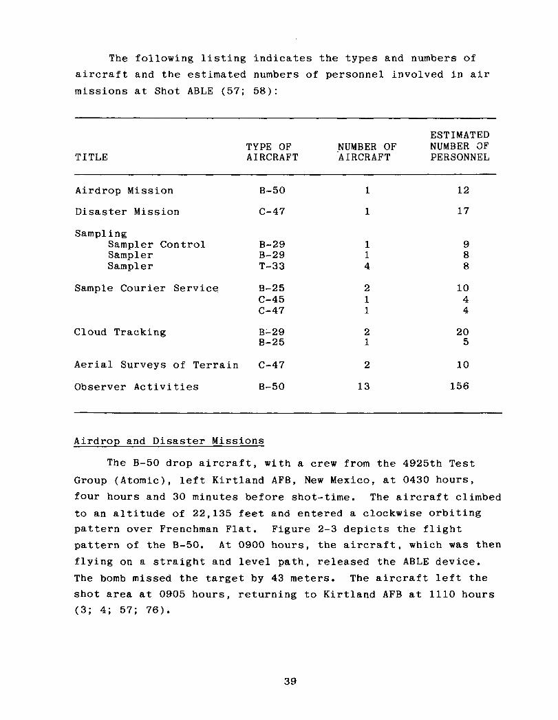
The following listing indicates the types and numbers of aircraft and the estimated numbers of personnel involved in air missions at Shot ABLE (57; 58):
TITLE TYPE OF AIRCRAFT
ESTIMATED NUMBER OF NUMBER OF 'AIRCRAFT PERSONNEL
Airdrop Mission
Disaster Mission
Sampling Sampler Control Sampler Sampler
Sample Courier Service
B-50
c-47
B-29 1 9 B-29 1 8 T-33 4 8
B-25 c-45 c-47
Cloud Tracking B-29 B-25
Aerial Surveys of Terrain c-47
Observer Activities B-50 13 156
1
1
2 1 1
2 1
2
12
17
10 4 4
20 5
10
Airdrop and Disaster Missions
The B-50 drop aircraft, with a crew from the 4925th Test Group (Atomic), left Kirtland AFB, New Mexico, at 0430 hours, four hours and 30 minutes before shot-time. The aircraft climbed to an altitude of 22,135 feet and entered a clockwise orbiting pattern over Frenchman Flat. Figure 2-3 depicts the flight pattern of the B-50. At 0900 hours, the aircraft, which was then flying on a straight and level path, released the ABLE device. The bomb missed the target by 43 meters. The aircraft left the shot area at 0905 hours, returning to Kirtland AFB at 1110 hours (3; 4; 57; 76).
39

040 BOMB DROP AIRCRAFT
Not to scale.
Figure 2-3: FLIGHT PATTERN FOR B-50 DROP AIRCRAFT, SHOT ABLE
40

The C-47 disaster aircraft, with a crew from the 4901st Support Wing (Atomic), left Kirtland AFB at about 0330 hours and circled over Las Vegas while the B-50 completed its bomb drop mission over the NPG. If the bomb-carrying aircraft crashed or accidentally released its weapon, the la-man disaster team was to protect the weapon and monitor radiation contamination. The disaster team plotted the position of the B-50 drop aircraft during its mission, as shown in figure 2-4 (4). At 0903 hours, the disaster aircraft began its return to Kirtland AFB, where it arrived at 1200 hours (3; 4; 57; 58; 76).
Cloud Sampling
One B-29 and four T-33s collected particulate and gaseous samples of the Shot ABLE cloud for Project 7.3, Radiochemical and Physical Analysis of Atomic Bomb Debris, and for Program 13, Radiochemistry Sampling. A B-29 sampler control aircraft, with an AFSWC aircrew and a LASL scientific advisor on board, directed the operations of the sampler aircraft. Each sampler penetrated the cloud twice except for a T-33 sampler (tail number 048),
which made three penetrations of the cloud. The samplers flew at altitudes of 14,000 to 15,000 feet. The following listing details the activities of each sampler aircraft (3; 4; 57; 58; 76):
TOTAL TOTAL TIME DOSJMETER
AIRCRAFT TYPE AND TAKEOFF IN CLOUD READING LANDING TAIL NUMBER TIME (seconds) (roentgens) TIME
Sampler Control B-29 (386) 0755 1145
B-29 (285) 0910 NR* 0.105 1145 T-33 (920) 1020 90 0.080 1100 T-33 (951) 1026 120 0.090 1055 T-33 (048) 1031 180 0.085 1105 T-33 (913) 1036 NR 0.090 1105
*NR indicates not reported.
41


After completing their missions, the samplers returned to
Indian Springs AFB and parked in the northeast corner of the
parking area. Pilots then shut down the engines. The crews of
the B-29s left the aircraft through the rear door between the
stabilizer and the wing. The crews of the T-33s opened their
canopies and disembarked by stepping onto a removable ladder
attached to the side of the aircraft. The sample removing team
and radiological safety monitors used long-handled tools to take
samples from the aircraft and place them in shielded containers.
They also removed the bottles containing the gaseous samples.
They then loaded the sample containers onto courier aircraft for
delivery to laboratories for analysis (3; 4; 57; 58; 76).
Courier Missions
After the samples had been removed, four aircraft of the
4901st Support Wing (Atomic) transported them to various airbases
for analysis by nuclear weapons development and other labora-
tories. At 1200 hours, a B-25 flew from Indian Springs AFB to
McClellan AFB with Project 7.3 samples. Soon after, a C-47 flew
from Indian Springs AFB to LASL with Program 13 samples. At 1300 hours, a B-25 left Yucca Lake airstrip for the Army Chemical
Center, and a C-45 took off from Yucca Lake for LASL (3; 4; 57;
58; 76).
Cloud Tracking
Immediately after the detonation, one B-25 and two B-29s
from Indian Springs AFB flew cloud-tracking missions over and
beyond the Nevada Proving Ground. The B-25 (tail number 099)
spent five hours tracking the cloud at heights of 10,000 to
12,000 feet above the terrain, returning at 1425 hours. The
first B-29 (tail number 774) left at 0915 hours but returned
after five minutes because of engine failure. The second B-29
(tail number 826) took off at 0935 hours, tracked the cloud for about six hours, and landed at 1615 hours (3; 4; 57; 58; 76).
43

Aerial Surveys of Terrain
After the detonation, two C-47s, each probably carrying a crew of four, conducted onsite and offsite radiological surveys of the terrain. One C-47 (tail number 386) left Indian Springs AFB at 1130 hours, flew at heights of 2,000 to 7,500 feet, and returned to Indian Springs at 1540 hours. The other C-47 (tail number 308) left Indian Springs AFB at 1220 hours, conducted its survey at 10,000 feet above the terrain, and returned at 1530 hours (3; 4; 57; 76).
Observer Activities
Thirteen B-50 aircraft with observers from the Strategic Air Command participated in an orientation and indoctrination exercise in nuclear weapons effects. On shot-day, the first of these B-50s left Travis AFB and arrived over the NPG at 0830 hours. The other 12 aircraft left Castle AFB and entered NPG airspace at 0852 hours. All the aircraft remained in a holding pattern through shot-time. The SAC observers witnessed the detonation and subsequent cloud development from an unspecified distance. At 0903 hours, the B-50s left the test area for their bases (3-5; 11; 57; 76; 100).
2.3 RADIATION PROTECTION AT SHOT ABLE
The primary purpose of the radiation protection procedures developed by the test groups and AFSWC for Shot ABLE was to keep individual exposures to ionizing radiation to a minimum, while still allowing participants to accomplish their missions.
Logistics and Materiel
During the period of 1 April to 14 April 1952, which covers the 1 April detonation of Shot ABLE, the Logistics and Materiel Department of the AFSW? Radiological Safety Group issued 691 film
44

badges to AEC and DOD participants in 14 programs and 53 proj- ects. In addition, the department issued 603 sets of protective clothing and 248 radiological survey instruments (65).
Monitoring
In order to identify where measurements were taken during radiation surveys of the ground zero area, original plans called for the use of eight radial lines of numbered stakes. These stakes were to be spaced about 90 meters apart, centered on ground zero, and oriented toward the eight principal points of the compass. However, the stakes did not arrive in time to be used at Shot ABLE, so the only way to determine distance from ground zero was by reference to the test data collecting stations located along the blast line parallel to the main access road.
About 30 minutes after the detonation, the initial ground survey team began taking readings along the main blast line. The team approached as close as 60 meters to ground zero, where it noted radiation intensities as high as 1.2 R/h. Recovery parties provided information on radiation intensities at other locations. The area was resurveyed on 2, 3, and 4 April.
From eight to 13 two-man mobile teams participated in off- site monitoring. About six hours before the detonation, the teams left the NPG for assigned offsite locations. The highest radiation intensity they encountered was 0.0001 R/h in an area 32 kilometers north of Alamo, Nevada (located about 95 kilometers northeast of the Control Point), almost five hours after the detonation.
Two C-47 aircraft conducted radiological surveys of the terrain after the detonation. The highest radiation intensity encountered by either aircraft was 0.0035 R/h (65).
45

Plotting and Briefing
Although the initial radiological safety monitoring team completed its survey along the blast line an hour after the detonation, sufficient data for an isointensity plot of the entire shot area were not obtained until almost six hours after the shot. Monitors working in the field with recovery parties provided the additional survey data needed for the isointensity plots (65).
Plotting and Briefing personnel consolidated the data to make the first isointensity plot, as shown in figure 2-5. Copies of the isointensity maps generated from resurveys conducted on 2 and 3 April are shown in figure 2-6 (65).
Dosimetry Data
Film badge records indicate that none of the participants received exposures in excess of 3.0 roentgens (65).
46

. .
l
.
.
.
. .
. .
. .
. .
. .
. . . . . .
. . . .
. .
l
.
.
.
.
.
.
.
l
.
/-
/
/
0 8
/ I \
\ \
\ ‘.
\
\
\
I /
/
. \ . .
. .
0 -- 4’
. ‘0. . l .
. ’ l . , . .
. .
. . . .
. . .
. .
. . . . l * . . .
.
8. l
. . ’ . .
.
. . . . . . . . . . . .
. .
. .
.
.*.... . 0.01 R/h - - - - 0.1 R/h
Figure 2-5: RADIATION ISOINTENSITY MAP FOR SHOT ABLE, 1 APRIL 1952,140O TO 1500 HOURS
47

. . * *.** . . . . .
,
. . .
* *. . . . . . *
0 100 1 1 1 Meters
-...._ P N
2 APRIL 1952,073O HOURS
..-. . . . . . . . . .
. .
* GZ 0.09RIh . *. \@ ..-*
.
. -. . . . ._-.
0 L-LY Meters
3 APRIL 1952,073O HOURS 0.01 R/h 0.1 R/h
Figure 2-6: SUBSEQUENT RADIATION ISDINTENSITY MAPS FOR SHOT ABLE
48

SHOT BAKER SYNOPSIS
AEC Objectives:
Weather:
Radiation Data:
Participants:
AEC TEST SERIES: TUMBLER-SNAPPER DOD EXERCISE: None DATE/TIME: 15 April 1952, 0930 hours YIELD: 1 kiloton HEIGHT OF BURST: 1,109 feet (airdrop)
1) To obtain experimental data on blast pressure from a higher burst than used during previous test series
2) To determine optimum burst height and to obtain maximum blast effects.
At shot-time, the surface winds were six knots from the northeast. Winds were nine knots from the north at 10,000 feet and 25 knots from the northwest at 20,000 feet. The temperature was 12"C, the relative humidity was 30 percent, and the pressure was 878 millibars.
Onsite radioactivity was characterized by a small area of radiation around ground zero. The initial radiological survey team found a radiation intensity of 0.01 R/h extending as far as 750 meters to the south of ground zero about one hour after the shot.
Los Alamos Scientific Laboratory; Armed Forces Special Weapons Project; Atomic Energy Commission; Air Force Special Weapons Center; contractors.
49

CHAPTER 3
SHOT BAKER
Shot BAKER, the second detonation of Operation TUMBLER- SNAPPER, was conducted as scheduled at 0930 hours Pacific
Standard Time on 15 April 1952. Developed by the Los Alamos
Scientific Laboratory and the Department of Defense, the BAKER
device was dropped from a B-50 aircraft flying over Area 7 of
Yucca Flat,* UTM coordinates 872044, at an altitude of 22,600
feet. Primarily a weapons effects test, BAKER was detonated at a
height of 1,109 feet and had a yield of one kiloton (3; 4; 52;
57; 62). Figure 3-1 shows the ground zero target for BAKER; this
target was also used for Shots CHARLIE and DOG. Figure 3-2 shows
the BAKER detonation as seen from the Control Point at Yucca
Pass.
The top of the Shot BAKER cloud reached an altitude of
15,700 feet, where the winds were from the northwest at about
16 knots, and moved southeast from the point of detonation (62).
The data obtained from BAKER were compared with the height of
burst and blast pressure data obtained from Shot ABLE and from
the BAKER burst of Operation BUSTER-JANGLE (105).
3.1
Rock
Test
EXERCISE DESERT ROCK IV OPERATIONS AT SHOT BAKER
The Desert Rock Exercise Director asked that 300 Camp Desert
personnel be allowed to observe Shot BAKER. However, the
Director refused this request, and only ten individuals from
the Exercise Director's immediate staff witnessed the shot,
probably from near the Control Point (23).
*Yucca Flat is approximately 4,000 feet above mean sea level.
50


3.2 DEPARTMENT OF DEFENSE PARTICIPATION IN SCIENTIFIC AND SUPPORT ACTIVITIES AT SHOT BAKER
Department of Defense personnel took part in scientific and diagnostic experiments conducted by the Military Effects Test Group and the Weapons Development Test Group. Table 3-l lists the test group projects and participating agencies. In addition to the test group experiments, DOD personnel were involved in AFSWC air support activities.
3.2.1 Military Effects Test Group Projects
Because Shot BAKER was detonated primarily to measure blast overpressures produced by an airdropped nuclear device, many of the Military Effects Test Group projects conducted at the shot were part of Program 1, Blast Measurements. To document the blast overpressures produced, project personnel spent several weeks before the detonation placing and calibrating pressure gauges. They completed these activities several days before the detonation. Figure 3-3 shows the instrument layouts for the
Military Effects Test Group activities (10; 13-16; 98; 105).
The following project descriptions often discuss recovery operations as occurring after recovery hour. The actual time of recovery hour is not known, although it probably was declared shortly after the completion of the initial radiological survey, about an hour after the shot.
Project 1.2, Air Pressure versus Time, was conducted by the Stanford Research Institute to collect data on the airblast produced by an airdropped nuclear device. At 2130 hours on the night before the detonation, four personnel spent up to eight hours checking .blast gauges placed along the blast line from ground zero to 2,750 meters from ground zero. One hour after the area was opened for recovery operations, four personnel began collecting data from blast gauges positioned 2,290 and 1,140
53

Table 3-1: TEST GROUP ACTIVITIES WITH DEPARTMENT OF DEFENSE PARTICIPATION, SHOT BAKER
Project/ ‘rogram Title Participants
Military Effects Test Group
1.2
1.3 and 1.5
Air Pressure versus Time Stanford Research Institute
Free-air and Ground-level Pressure Measurements Naval Ordnance Laboratory
1.4 Air Blast Measurements
1.6 Ground Acceleration Measurements
1.7 Earth Acceleration versus Time
1.9 Pm-shock Dust
1.13 Measurement of Air Blast Pressure versus Time
2.1 Total Gamma Exposure versus Distance
3.1 Vulnerability of Parked Aircraft to Atomic Bombs
Ballistic Research Laboratories
Ballistic Research Laboratories
Stanford Research Institute
Army Chemical Center
David Taylor Model Basin
Signal Corps Engineering Laboratories
Wright Air Development Center; Los Alamos Scientific Laboratory; Naval Radiological Defense Laboratory
3.3 Blast Damage to Trees - Isolated Conifers
3.4 Minefield Clearance
Forest Service, Department of Agriculture
Engineer Research and Development Laboratories
6.1 Evaluation of Military Radiic Equipment Bureau of Ships; Signal Corps Engineering Laboratories
6.4
7.lb
7.2
Operational Tests of Radar and Photographic Techniques for IBDA
Long Range Light Measurements
Detection of Airborne Low-frequency Sound from Atomic Explosions
Wright Air Development Center; Strategic Air Command
EGBG; Headquarters, Air Force
Headquarters, Air Force; Signal Corps Engineering Laboratories; National Bureau of Standards
7.3
7.4
6.2
Radiochemical and Physical Analysis of Atomic Bomb Debris
Seismic Waves from A-Bombs Detonated over a Desert Valley
Air Temperatures in the Vicinity of a Nuclear Detonation
Headquarters, Air Force
Air Force 1699th Special Weapons Squadron; Coast and Geodetic Survey
Naval Radiological Defense Laboratory
8.3 Thermal Radiation from a Nuclear Detonation Naval Radiological Defense Laboratory
54

Table 3-1: TEST GROUP ACTIVITIES WITH DEPARTMENT OF DEFENSE PARTICIPATION, SHOT BAKER (Continued)
Project/ Program Title Participants
Military Effects Test Group (Continuedj
8.4 Atmospheric Transmission and Weather Measurements
Naval Material Laboratory
8.6 Sound Velocity Changes near the Ground in the Vicinity of an Atomic Explosion
Naval Electronics Laboratory
9.1 Technical and Training Photography Naval Medical Research Institute; Air Force Lookout Mountain Laboratory; Wright Air Development Center; 4925th Test Group (Atomic); SAC 5th and 28th Reconnaissance Technical Squadrons; Signal Corps Engineering Laboratories; Army Pictorial Service Division
9.2 Air Weather Service Participation
9.4 Effects of Atomic Explosions on the Ionosphere
Air Weather Service
Signal Corps Engineering Laboratories; 8471 st Technical Service Unit
9.5 Electromagnetic Radiation over the Radio Spectrum Signal Corps Engineering Laboratories; from Nuclear Detonations 8467th Technical Service Unit .H
Weapons Development Test Group
10.1 Measurement of Alpha Naval Research Laboratory
11.1 Measurement of Transit Time Naval Research Laboratory
12.1 Technical Photography EGBG
12.lc Ehangmeter Mod II EG&G
12.2a-d High-speed Photography EGbG; Los Alamos Scientific Laboratory
13 Radiochemistry Sampling Program 4925th Test Group (Atomic)
15.2 Gamma Radiation Exposure as a Function of Distance Los Alamos Scientific Laboratory
18.1 Total Thermal Radiation and Atmospheric Naval Research Laboratory Transmission
18.3 Color Temperatures
18.4 High-resolution Spectroscopy
lS.la Air Shock Pressure - Time versus Distance
Naval Research Laboratory
Naval Research Laboratory
Sandia Corporation: Los Alamos Scientific Laboratory; Armed Forces Special Weapons Project; Stanford Research Institute; Naval Ordnance Laboratory; Ballistic Research Laboratories
19.lc-d Shock-gauge Evaluations Tests Sandia Laboratory; Los Alamos Scientific Laboratory
lS.le Air Shock Pressures as Affected by Hills and Dales Sandia Corporation
19.2a-b Blast-wave Material Velocity Measurements Los Alamos Scientific Laboratory; EGBG
19.2c Beta-densitometer Feasibility Test Los Alamos Scientific Laboratory
19.2d Interferometer-gauge Pressure-time Measurements Los Alamos Scientific Laboratory
19.2f Measurement of Preshock Sound Velocity Los Alamos Scientific Laboratory
55

Program 3 Aircraft Areas
I- Biomedical Line I
I
I
I
I
I Program 8 I- Blast and
Thermal Line
0 I,: Kilometer
Program 3 Forest Service Line
3
Figure 3-3: GROUND ZERO AND AFSWP INSTRUMENT LAYOUTS FOR SHOTS BAKER, CHARLIE, AND DOG

meters from ground zero. This operation took two hours. Beginning at 0900 hours on the day after the detonation, about ten project participants retrieved the remaining gauges up to the 0.1 R/h line. They spent approximately six hours in the shot area (95; 102).
Projects 1.3 and 1.5, Free-air and Ground-level Pressure Measurements, were conducted as one project by the Naval Ordnance Laboratory. The objective was to measure pressures produced by a nuclear detonation at ground level and in free air (20).
Five hours before the detonation, four Project 1.3 personnel spent about one hour preparing pressure gauges located between ground zero and a point 3,660 meters from ground zero. Data from the gauges were telemetered to a recording trailer about 3,660
meters from ground zero. At recovery hour, two participants began retrieving pressure data from the trailer. Their estimated working time was 30 minutes. Three hours after recovery hour, two personnel started retrieving blast gauges 3,660 meters from ground zero and continued to the 0.1 R/h line. They spent about two hours in this procedure. Beginning at 0900 hours on the day after the shot, two personnel began to inspect the blast gauges, an operation that took two hours (20; 95).
Project 1.5 measured pressures in free air by photographing smoke rocket trails. At 1630 hours on the day before the shot, six personnel spent about two hours loading rocket launchers 180 to 1,070 meters north of ground zero. Seconds before the shot, the smoke rockets were launched remotely, and, immediately after the detonation, their trails were photographed. Twenty minutes after the shot, two personnel accompanied by a radiological survey team inspected and unloaded unfired rockets 920 and 1,070 meters from ground zero. Three hours after recovery operations began, six participants replaced damaged rocket launchers 180 to 920 meters from ground zero (20; 95).
57

Project 1.4, Air Blast Measurements, was conducted by the Ballistic Research Laboratories. The objective was to determine the shape of the pressure pulse and the peak pressure of the shock wave generated near the ground by a nuclear device detonated high in the air. Before the detonation, personnel installed instruments on lo- and 50-foot towers located about 110 and 230 meters from ground zero and then left the area.
Three hours after recovery hour was declared, three project personnel began retrieving data from the stations for laboratory analysis. They spent 20 minutes in recovery operations (21; 95).
Project 1.6, Ground Acceleration Measurements, was conducted by the Ballistic Research Laboratories to obtain ground accelera- tion measurements from an airburst nuclear detonation. Personnel measured ground shock with accelerometers positioned,before the detonation at stations 40, 190, 420, 880, and 1,330 meters from ground zero (60).
At 1530 hours on the day before the shot, three project
participants went to the stations to make a final instrument check. At 0900 hours on the day after the detonation, four personnel began recovering the accelerometers. Recovery took about two hours and 30 minutes (60; 95).
Project 1.7, Earth Acceleration versus Time, was conducted by the Stanford Research Institute to measure the proportion of blast energy absorbed from the air by the earth. At 2130 hours
on the night before the detonation, four personnel spent about eight hours checking accelerometers along the instrument line from ground zero to 2,750 meters from ground zero. One hour after the area was opened for recovery operations, four personnel began collecting data from accelerometers 2,290 and 1,140 meters from ground zero. This operation took up to two hours. Begin- ning at 0900 hours on the day after the detonation, about ten participants retrieved the remaining accelerometers up to the 0.1 R/h area, spending about six hours in the shot area (95; 103).
58

Project 1.9, Pre-shock Dust, was conducted by the Chemical
and Radiological Laboratories of the Army Chemical Center. The
objective was to determine the concentration and the size distri-
bution of the dust generated before the arrival of the shock wave
by thermal radiation resulting from a nuclear detonation. The
day before the detonation, project personnel inspected instru-
ments for collecting dust particles at six stations: two were
located 190 meters, two others 420 meters, and two additional
stations 880 meters from ground zero. The instruments, which
included cascade impactors and filter samplers, collected
pre-shock dust particles generated during the brief interval
between the detonation and the arrival of the shock wave at each
of the stations (27).
After recovery hour, two project personnel and a monitor
spent one hour retrieving instruments from the stations. Project
personnel then took dust particle samples to the Yucca Flat
airstrip where each sample was packaged, placed aboard a courier
aircraft, and transported for analysis to the Army Chemical
Center. Section 3.2.3, which describes AFSWC activities,
discusses the courier flights (27; 95).
Project 1.13, Measurement of Air Blast Pressure versus Time,
was conducted by the David Taylor Model Basin. The project was designed to provide blast pressure data for Program 3 agencies,
particularly those participating in Project 3.1, discussed later
in this section. Before the shot, personnel calibrated and
installed gauges at 16 Project 3.1 stations located 880, 1,190,
and 2,400 meters from ground zero. Beginning at 2130 hours the
night before the shot, four men made a final check of the gauges
and left the shot area about six hours before shot-time (46).
After recovery hour was announced, seven participants
accompanied by a monitor spent up to two hours and 30 minutes
retrieving the gauges. Five other project participants and a
59
radiological safety monitor spent about two hours collecting film from cameras positioned in the shot area (46; 95).
Project 2.1, Total' Gamma Exposure versus Distance, was con- ducted by the Signal Corps Engineering Laboratories to measure gamma radiation exposure as a function of distance. Within 24 hours before the detonation, personnel placed film packets at go-meter intervals along a radial line extending up to 1,000 meters from the point of detonation. When the area was opened for recovery operations, two personnel accompanied by a monitor drove by truck into the shot area and spent about one hour retrieving the film packets. Film readings were shared with Projects 1.13, 3.1, and 6.1; the Office, Chief of Army Field
Forces; and the Marine Corps (81; 95).
Project 3.1, Vulnerability of Parked Aircraft to Atomic Bombs, was performed by the Wright Air Development Center and by project personnel from LASL and the Naval Radiological Defense Laboratory. The experiment was coordinated with Project 1.13, which provided airblast pressure data. The objective was to determine the effects of an airburst nuclear detonation on parked
aircraft (104).
Before the shot, project personnel placed aircraft at the following locations:
0 Four aircraft 720 meters north-northwest of ground zero l One aircraft 1,320 meters southeast of ground zero 0 12 aircraft 2,430 meters southwest of ground zero l Eight aircraft 3,190 meters southwest of ground zero.
To compare the protection afforded by various defense structures, some of the aircraft were placed in revetments and behind walls, while others were positioned in the open. Personnel instrumented the aircraft with devices to measure blast, thermal, and radiation effects.
60

At about 0930 hours on the day before the detonation, two project personnel in a van began photographing the aircraft in the shot area and loading and aligning remote-controlled cameras. They left the area by 1430 hours. At that time, four project participants in a van began inspecting the aircraft, an activity that took about six hours (95; 104).
At 1730 hours on the night before the shot, two project personnel began checking instruments in the field, a process that took about two hours. On shot-day, two individuals in a jeep made a final check of the instruments and then left the area four hours before shot-time (95; 104).
When recovery hour was declared, three project personnel and a monitor began retrieving film 720 meters from ground zero, a
procedure that took about three hours. Another five participants with a radiological safety monitor spent four hours recovering film 1,320 and 2,430 meters from ground zero. Three other project participants and a monitor spent about four hours col- lecting film 3,190 meters from ground zero (95; 104).
One hour after the announcement of recovery hour, two five- man parties began inspecting the aircraft, a process that took about four hours. At 0800 hours on the day after the shot, three two-man parties began examining instruments at the aircraft stations. They spent approximately eight hours performing this task (95; 104).
Project 3.3, Blast Damage to Trees--Isolated Conifers, was conducted by the Forest Service, Department of Agriculture. The experiment was designed to measure motion and strain on isolated coniferous trees subjected to a nuclear detonation. Before the shot, personnel placed four conifers, along with instruments to measure strain on the trees, at each of four stations on the Forest Service Line in Area 7. The stations were 1,520, 1,830,
61
2,130, and 2,440 meters from ground zero. The trees, approxi- mately 50 feet high, were anchored in concrete. At 2130 hours on the night before the detonation, personnel entered the shot area to begin checking instruments at the stations, a procedure that took about one hour (30; 95).
At the declaration of recovery hour, five project personnel
entered the shot area in a weapons carrier and spent about 30 minutes inspecting the trees and recovering the instruments from the station 1,520 meters from ground zero. One hour after recovery operations began, two Project 9.1 photographers from
Lookout Mountain Laboratory traveled to the Forest Service line to photograph the stations 1,520 and 1,830 meters from ground zero. They also extinguished any fires in the area. Seven hours after the announcement of recovery hour, four project personnel entered the shot area in a weapons carrier and spent about two hours inspecting the trees (30; 95).
Project 3.4, Minefield Clearance, was performed by the Engineer Research and Development Laboratories. The objective was to study the detonation of land mines by a nuclear blast. Before Shot BAKER, personnel placed mines in an area 15 meters wide, which extended approximately 90 to 1,830 meters from ground zero (101).
At 0800 hours on the day after the detonation, four personnel in a weapons carrier recovered mines along the blast line up to the 0.1 R/h area and determined which mines had been detonated. At the same time, they laid other mines to be used in this experiment at Shot CHARLIE. These operations took about eight hours. A representative of the Director, Military Effects Group, and three photographers took pictures of these activities (95; 101).
62
Project 6.1, Evaluation of Military Radiac Equipment, was conducted by the Bureau of Ships and the Signal Corps Engineering Laboratories to evaluate radiac survey equipment. Project 6.1 participants furnished standard and experimental radiation survey meters to other projects in order to evaluate the meters (107).
Project 6.4, Operational Tests of Radar and Photographic Techniques for IBDA, was conducted by the Wright Air Development Center, assisted by the Strategic Air Command. The objective was to evaluate the Indirect Bomb Damage Assessment system under development at the Wright Air Development Center. The 509th Bombardment Group of SAC provided three B-50D aircraft to make a postshot test of the IBDA system. The aircraft staged from Kirtland AFB (26).
Aircraft 1 and 2, simulating drop aircraft flying at an altitude of 22,600 feet, flew 1,800 and 1,300 feet, respectively, above the drop aircraft. Two seconds before release of the weapon, aircraft 1 made a 40-degree turn to the right, and air- craft 2 made a 30-degree turn to the left. The headings were
held until eight seconds after shot-time. Aircraft 3, simulating an escort aircraft, was 800 feet above and five nautical miles behind the drop aircraft. Aircraft 3 held the same heading for approximately 45 seconds after shot-time and then turned to leave the area (26; 57).
Project 7.lb, Long Range Light Measurements, was conducted
entirely offsite by Edgerton, Germeshausen, and Grier, Inc., and Headquarters, Air Force. The objective was to gain information on the long-range detection of light produced by a nuclear detonation. EG&G and the Air Force established light-detecting stations in Arizona, Idaho, Texas, and Washington. An estimated two EG8G employees and ten Air Force personnel from the Sacramento Air Materiel Area, McClellan AFB, operated each station from about six hours before to one hour after the detonation (55).
63

Project 7.2, Detection of Airborne Low-frequency Sound from Atomic Explosions, was conducted by Headquarters, Air Force, with assistance from the Signal Corps Engineering Laboratories and the National Bureau of Standards. The objective was to determine the accuracy of long-range acoustic detection methods. The Signal Corps Engineering Laboratories operated stations in Alaska, Hawaii, Kentucky, New Jersey, Texas, and Washington, while the National Bureau of Standards operated its station in Washington, D.C. (97).
Project 7.3, Radiochemical and Physical Analysis of Atomic
Bomb Debris, was conducted by Headquarters, Air Force. The
project, which involved analysis of particulate and gaseous samples from the Shot BAKER cloud, was conducted in conjunction with Program 13, Radiochemistry Sampling. Cloud sampling, performed by the 4925th Test Group (Atomic) of Kirtland AFB, is discussed in section 3.2.3, on AFSWC participation at BAKER (57; 106).
Project 7.4, Seismic Waves from A-Bombs Detonated over a Desert Valley, was conducted by the Air Force 1009th Special Weapons Squadron and the Coast and Geodetic Survey. The objec- tive was to determine the seismic properties of the geological structure of the test area. One unmanned station was located onsite, almost ten kilometers north-northwest of ground zero. No recovery operations were necessary to obtain the seismic records. The data were probably recorded at the Control Point (105).
Project 8.2, Air Temperatures in the Vicinity of a Nuclear Detonation, was conducted by the Naval Radiological Defense Labo- ratory to determine the air temperature at various elevations and distances from ground zero. Before the shot, participants installed thermocouples at ground level and on steel towers of various heights. The towers were located at ground zero and at distances up to 1,260 meters from ground zero. At 1730 hours on
64

the day before the detonation, two participants checked thermo- couples used to measure temperatures in the shot area. At 2130 hours on the night before the shot, six personnel spent abut two hours making final adjustments to the thermal instruments (28).
When the shot area was opened for recovery operations, two crews, each consisting of three project personnel and a monitor, traveled to the instrument shelters to inspect and repair damage. They spent approximately six hours in this activity. Their for- ward limit was either 1,830 meters from ground zero or the 0.1 R/h line. At 0900 hours the next day, four personnel, accompanied by a Project 9.1 photographer, finished recovering the thermal detectors up to the 0.1 R/h line. They stayed in the area about four hours (28; 95).
Project 8.3, Thermal Radiation from a Nuclear Detonation, was conducted by Project 8.2 and 8.3 personnel from the Naval Radiological Defense Laboratory. The objective was to measure the total thermal radiation and the intensity-time relationship
of the radiation as a function of distance from ground zero. Before the shot, participants placed several types of instruments in five tower stations located at various intervals up to 1,370 meters from ground zero. These instruments included calorimeters and radiometers. Other personnel at Kirtland AFB installed three disk calorimeters in the B-50 drop aircraft. At 1730 hours on the day before the detonation, two personnel entered the shot area to check the instruments. At 2130 hours that evening, six participants proceeded into the area in a weapons carrier to adjust instruments at two of the stations. These personnel left the area within two hours (29).
After the declaration of recovery hour, two teams, each of three project personnel and a monitor, drove by truck into the test area and spent a maximum of six hours retrieving instruments up to the 0.1 R/h line. An AFSWP representative accompanied
65
three Lookout Mountain Laboratory photographers into the shot area to photograph recovery operations. At 0800 hours on the day after the shot, the Lookout Mountain Laboratory personnel reentered the shot area to take more photographs. At about 0900 on the same day, four project personnel and a photographer recovered instruments remaining in the shot area up to the 0.1 R/h line. Project 8.2 and 8.3 personnel at Kirtland AFB
removed the calorimeters from the B-50 drop aircraft (29; 95).
Project 8.4, Atmospheric Transmission and Weather Measure- ments, was conducted by the Naval Material Laboratory. The project was designed to provide data on meteorological conditions for use in thermal radiation projects and to supplement informa- tion supplied by Project 9.2, Air Weather Service Participation. On the morning of shot-day, project personnel measured barometric
pressure, temperature, humidity, and rainfall several times. They worked from a station at the BJY, where they received transmissions from two self-operating stations five kilometers northwest of the BJY. They returned to the Control Point before the shot. At the declaration of recovery hour, three project personnel went to the receiver station and spent about one hour collecting data (53; 95).
Project 8.6, Sound Velocity Changes near the Ground in the Vicinity of an Atomic Explosion, was conducted by 18 Naval Elec- tronics Laboratory personnel. The objective was to determine the velocity of sound at heights of 1.5, 10, and 54 feet above the ground at various distances from ground zero, in the interval between detonation and blast wave arrival. Participants installed instruments for detecting changes in the velocity of sound at ground zero and at stations 150, 310, 460, .and 610 meters from ground zero. Figure 3-4 shows participants installing the instruments. Six hours before shot-time, four participants entered the shot area to make a final check of the equipment, leaving the area about one hour later. After the
66


announcement of recovery hour, project personnel retrieved equipment 3,660 meters south of ground zero, a process that took about two hours. They recovered the remaining instruments on the following day (91; 95).
Project 9.1, Technical and Training Photography, was conducted by personnel from the following agencies (57; 95):
0 Air Force Lookout Mountain Laboratory Army Pictorial Service Division Naval Medical Research Institute Signal Corps Engineering Laboratories SAC 5th Reconnaissance Technical Squadron SAC 28th Reconnaissance Technical Squadron Wright Air Development Center 4925th Test Group (Atomic).
Project personnel from Lookout Mountain Laboratory photographed the detonation from five stations: two near the Control Point and three about 15 kilometers from ground zero near the Yucca Lake landing strip. Lookout Mountain Laboratory personnel also photographed Shot BAKER from a C-47 aircraft. The aircraft, which left Indian Springs AFB at about 0830 hours, was at an altitude of 10,000 feet approximately 11 kilometers south of ground zero at shot-time. Participants photographed the detonation and the resulting cloud formation until 0939 hours, when they began the return to Indian Springs AFB. They landed at about 0955 hours (57; 95).
Project 9.1 personnel also took still photographs and motion pictures of various Military Effects Test Group projects, including Projects 1.3, 3.3, 8.2, and 8.3. For one unspecified project at Shot BAKER, five Lookout Mountain Laboratory photog- raphers and a monitor began photographing a blast line at recovery hour, a procedure that took about one hour (95).
68

For Project 9.2, Air Weather Service Participation, Air Force personnel compiled data from various weather stations at the NPG and offsite, prepared weather maps, and briefed NPG officials on current and predicted weather conditions. Participants were from the 6th Weather Squadron (Mobile) of the 2059th Air Weather Wing, Tinker AFB, Oklahoma. These personnel were deployed as follows (78):
l Eight forecasters, 13 weather observers, and two equipment operators at the Control Point Weather Station near Yucca Pass
l Twelve airmen from the Rawinsonde Weather Observation Section at the Control Point and 11 airmen at a station in Tonopah, Nevada
0 Three airmen from the Pibal Weather Observation Section at Beatty, Caliente, Crystal Springs, Currant, and Warm Springs, Nevada, and St. George, Utah.
Before SHOT BAKER, participants installed wind and humidity measuring instruments at two stations along the blast line 920 and 1,830 meters from ground zero. Two men began checking instruments at these stations at about 2130 hours on the night before the shot and checked the instruments hourly from eight to three hours before the detonation.
About three hours after recovery hour, two participants began retrieving records from the two stations, a procedure that took two hours. At 0900 hours on the day after the shot, two personnel and a radiological monitor reentered the shot area and recovered instruments along the blast line, an activity that took approximately two hours (78; 95).
Project 9.4, Effects of Atomic Explosions on the Ionosphere, was conducted by the Signal Corps Engineering Laboratories, with assistance from personnel of the 9471st Technical Service Unit. The objective was to obtain data on the effects of a nuclear detonation on the ionosphere and on subsequent ionospheric radiowave propagation.
69
Project personnel worked at transmitter and receiver sta- tions. The only onsite station was a transmitter located 910 meters north of the Control Point. Two other transmitters were at Mather AFB, Sacramento, California. The radio receiver stations were at Navaho Ordnance Depot, Flagstaff, Arizona; White Sands Proving Ground, New Mexico; and Fort Sill, Oklahoma.
In the days before the shot, project personnel rehearsed procedures for operating the transmitters and receivers. On shot-day, they operated instruments from one hour before to one hour after the detonation. Information collected at the project
stations was sent for analysis to the Signal Corps Engineering Laboratories (49).
Project 9.5, Electromagnetic Radiation over the Radio Spec- trum from Nuclear Detonations, was conducted by the Signal Corps Engineering Laboratories, with assistance from the 9467th Technical Service Unit, Electronic Warfare Center. The objective was to determine the wave shape and the amplitude of radio
frequency energy emanating from a nuclear detonation. During the shot, personnel operated two stations 16 to 24 kilometers from ground zero. In addition, participants manned one station at White Sands Proving Grounds, New Mexico, and another at the Evans Signal Laboratory in Belmar, New Jersey (31).
3.2.2 Weapons Development Test Group Activities
During Shot BAKER, the Weapons Development Test Group conducted experiments that involved a few DOD participants. These individuals were assigned either to LASL or to the Weapons Development Test Group to assist in the projects.
Project 10.1, Measurement of Alpha, was conducted by the Naval Research Laboratory. At the announcement of recovery hour, four participants, accompanied by a radiological safety monitor,
70
entered the target area and recovered film from a station about 460 meters from ground zero. Their estimated working time was one hour. An hour later, a party of five and a monitor entered the same station to work on instruments for the remainder of the day (80; 95).
Project 11.1, Measurement of Transit Time, was conducted by the Naval Research Laboratory. Project participants were not required to conduct recovery operations (80).
Project 12.1, Technical Photography, was conducted by personnel from EGLG, with assistance from Navy personnel. They provided technical photography support, including dust studies, preshock turbulence studies, light absorption and mirage studies, fireball growth measurement, thermal effects studies, and other
coverage required by the Weapons Development Test Group.
Two days before the shot, project personnel prepared the film at the Control Point Building. The afternoon before Shot BAKER, project personnel loaded film into remote-controlled cameras located at various stations in the ground zero area. After the detonation, EG&G personnel recovered the exposed film and processed some of it in the mobile unit set up in the Control Point area. The remaining film was flown to laboratories of Consolidated Film Industries in Hollywood, California, and in the city of Fort Lee, New Jersey, for processing (64).
Project 12.lc, Bhangmeter Mod II, was conducted by EGBG to evaluate and test a new bhangmeter. Project personnel installed these instruments for measuring the yield of a detonation at the Control Point and in the drop aircraft. Bhangmeter readings recorded at shot-time were analyzed after the shot (63).
Project 12.2a-d, High-speed Photography, was conducted by LASL and EGIG. The objectives were to study early fireball
71

growth and to correlate shock arrival time with the appearance of the fireball. Project personnel mounted special cameras in a trailer at the BJY about four kilometers from ground zero and retrieved the film for analysis after the detonation (59).
Program 13, Radiochemistry Sampling, involved cloud-sampling missions conducted by personnel from the 4925th Test Group
(Atomic) (57). The sampling missions are discussed in section 3.2.3, which describes AFSWC activities at BAKER.
Project 15.2, Gamma Radiation Exposure as a Function of Distance, was conducted by personnel from LASL. The objective was to measure gamma radiation exposure at various distances from the detonation. Project personnel placed gamma-detecting instruments in the ground at distances of 540 to 2,810 meters from ground zero. At recovery hour, four men accompanied by two monitors entered the shot area to recover the instruments (109).
Project 18.1, Total Thermal Radiation and Atmospheric
Transmission, was conducted by the Naval Research Laboratory to study the transmission of light and thermal radiation emitted by nuclear detonations of various yields. To measure the trans- mission of light, personnel placed one photoelectric brightness meter at the Control Point and another in Area 2 of the NPG. In addition, they installed a transmissometer near the BJY and a receiver at the Control Point. To obtain data on thermal radiation emissions, personnel also installed four thermopile recorder systems. Instruments were operated manually from the Control Point during the shot. Personnel shut down equipment after the detonation to analyze recorded data (84).
Project 18.3, Color Temperatures, was conducted by the Naval Research Laboratory to measure the spectral characteristics of a nuclear fireball as a function of time. Measurements were taken with a high-speed spectrograph (61).
72

Project 18.4, High-resolution Spectroscopy, was conducted by the Naval Research Laboratory to supplement information obtained from spectroscopy measurements taken during previous nuclear weapons testing series, such as Operations GREENHOUSE and BUSTER-JANGLE. Project personnel installed a spectrograph at the Control Point, 17 kilometers from ground zero (24).
Project 19.la, Air Shock Pressure--Time versus Distance, was conducted by the Sandia Corporation. Representatives of LASL, AFSWP, the Stanford Research Institute, the Naval Ordnance Laboratory, and the Ballistic Research Laboratories helped to plan this project. The objective was to obtain pressure measurements to use in determining the relationship between air shock pressure and height of burst. Personnel installed pressure gauges along the ground between 230 and 3,500 meters from ground zero. They also placed gauges on towers of various heights located 430 to 1,370 meters from ground zero. At the instant of burst, information from the gauges was telemetered to a recording station where it was monitored by project personnel (93).
Projects 19.lc and 19.ld, Shock-gauge Evaluations Tests, were conducted by Sandia Laboratory. Personnel from LASL and contractors assisted in calibrating and installing instruments. The project was intended to develop and test new instruments for measuring dynamic and static pressures, wind directions, sound and wind speeds, and temperature rises resulting from a shock wave. Project personnel installed instruments at two stations,
located 875 meters and 1,790 meters from ground zero. Cables connected the instruments to equipment that recorded the information (47).
Project 19.le, Air Shock Pressures as Affected by Hills and Dales, was conducted by personnel from Sandia Corporation and AEC contractors. The objective was to collect more information about the influence of hills and valleys on the shock waves from
73
airbursts and to study the shielding effects of hills. Project personnel installed gauges to record air shock pressure in a line running up the front slope and down the back slope of a hill at
six locations ranging from 4,940 to 5,840 meters from ground
zero. Cables connected the gauges to recording equipment in a nearby mobile van. Sometime after the detonation, project participants recovered the records from the van (92).
Projects 19.2a and 19.2b, Blast-wave Material Velocity Measurements, were conducted by LASL. An officer and six men from the Antiaircraft Artillery and Guided Missile Center, Fort
Bliss, Texas, installed and maintained the 90-millimeter battery. The objective was to photograph peak overpressure phenomena associated with a nuclear burst. Smoke canisters were fired into the air from mortars and guns immediately before the burst so
that air disturbances would be visible and could be photographed.
Before the shot, project personnel entered the shot area to emplace the mortar units, set up two 90-millimeter gun stations 5,190 meters southwest of ground zero, and load the smoke
canisters into the mortars and guns. Other personnel entered the shot area to load the cameras with film. An electronic timing device triggered the mortars and guns seconds before the shot. After the detonation, personnel reentered the area to retrieve film and to reload the guns and mortars for Shot CHARLIE (99).
Project 19.2c, Beta-densitometer Feasibility Test, was conducted by personnel from LASL, assisted by Army personnel. The objective was to test two types of densitometers and to measure air density as a function of time after a shock wave. The densitometers, connected to recording equipment, were installed in the ground near the BAKER target area. They were set to start functioning upon receipt of an electronic timing signal. After the burst, project personnel entered the area to recover instruments and records (99).
74

Project 19.2d, Interferometer-gauge Pressure-time Measure-
ment, was conducted by LASL (99).
Project 19.2f, Measurement of Preshock Sound Velocity, was
conducted by LASL with Air Force participation. The objective
was to measure the velocity of sound in the air near the ground
before the shock wave from the detonation arrived. Personnel
installed oscillators and recording equipment at several stations
near ground zero. After the detonation, personnel recovered the
records from the instrument stations (99).
3.2.3 Air Force Special Weapons Center Activities
The Air Force Special Weapons Center provided personnel to
staff the Air Operations Center, located at the Control Point.
Besides airdropping the BAKER device, AFSWC conducted cloud
sampling and sample courier missions for the test groups and
cloud tracking and aerial radiological surveys of the terrain for
the Test Manager. In addition to the AFSWC personnel, Strategic
Air Command personnel witnessed the detonation. Although the SAC observers were not part of AFSWC, they were under the operational
control of AFSWC while over the NPG, and are therefore discussed
in this section (3-5; 57; 100).
The following listing indicates the types and numbers of
aircraft and the estimated numbers of personnel involved in air
missions at Shot BAKER (57; 58):
75
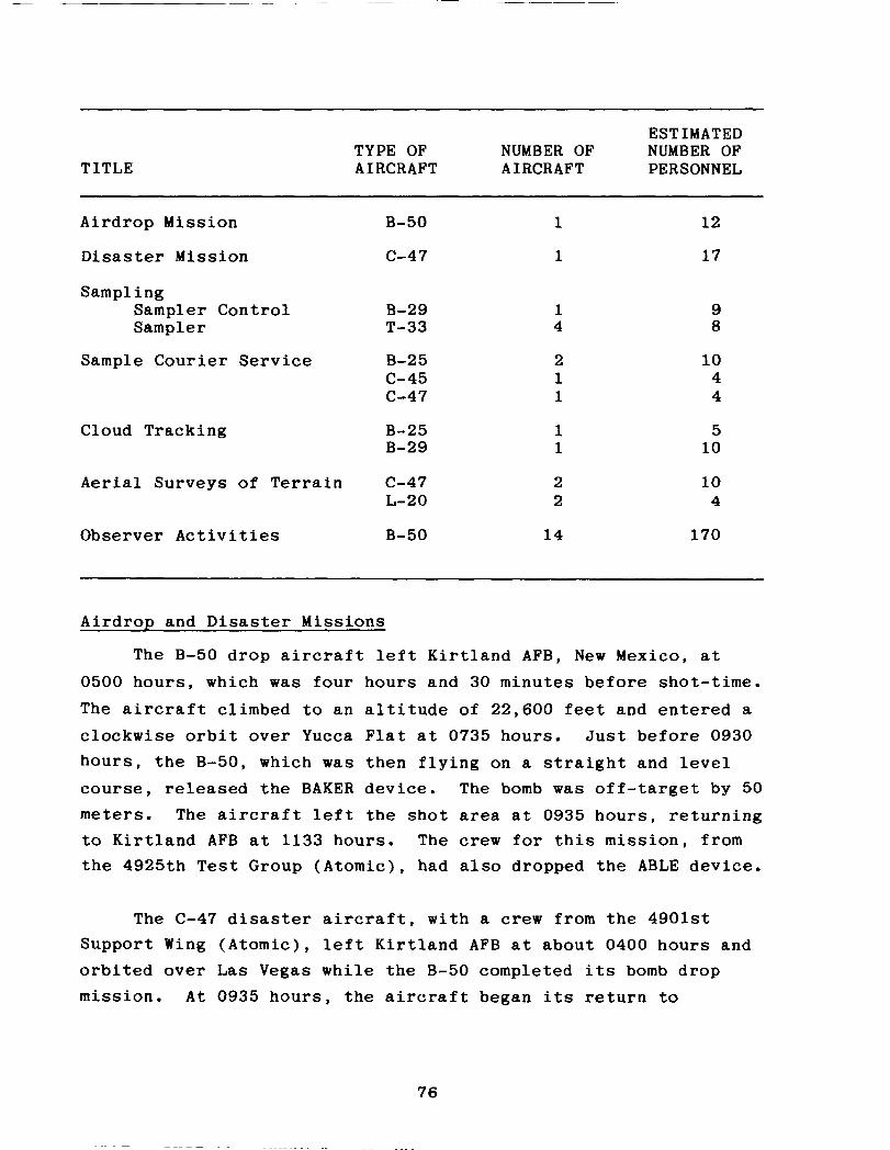
TITLE TYPE OF AIRCRAFT
ESTIMATED NUMBER OF NUMBER OF AIRCRAFT PERSONNEL
Airdrop Mission B-50
Disaster Mission c-47
Sampling Sampler Control Sampler
B-29 T-33
Sample Courier Service B-25 c-45 c-47
Cloud Tracking
Aerial Surveys of Terrain
Observer Activities
B-25 B-29
c-47 L-20
B-50
1
1
1 4
2 1 1
1 1
2 2
14
12
17
9 8
10 4 4
5 10
10 4
170
Airdrop and Disaster Missions
The B-50 drop aircraft left Kirtland AFB, New Mexico, at 0500 hours, which was four hours and 30 minutes before shot-time.
The aircraft climbed to an altitude of 22,600 feet and entered a clockwise orbit over Yucca Flat at 0735 hours. Just before 0930 hours, the B-50, which was then flying on a straight and level course, released the BAKER device. The bomb was off-target by 50 meters. The aircraft left the shot area at 0935 hours, returning to Kirtland AFB at 1133 hours. The crew for this mission, from the 4925th Test Group (Atomic), had also dropped the ABLE device.
The C-47 disaster aircraft, with a crew from the 4901st Support Wing (Atomic), left Kirtland AFB at about 0400 hours and orbited over Las Vegas while the B-50 completed its bomb drop mission. At 0935 hours, the aircraft began its return to
76

Kirtland AFB, arriving there at about 1230 hours (3; 4; 57; 58; 76).
Cloud Sampling
One B-29 and four T-33s collected particulate and gaseous samples of the Shot BAKER cloud for Project 7.3, Radiochemical and Physical Analysis of Atomic Bomb Debris, and for Program 13, Radiochemistry Sampling. An additional B-29 was scheduled for cloud sampling but aborted its mission because of a fuel leak. The B-29 sampler control aircraft conducted the sampling in place of the other B-29. The control aircraft, with an AFSWC aircrew
and a LASL scientific advisor onboard, directed the operations of the other sampler aircraft. The control aircraft and two samplers (tail numbers 920 and 048) each penetrated the cloud four times. Each of the other two samplers made three penetrations of the cloud. The aircraft flew at altitudes of 11,500 to 15,000 feet. The following listing details the activities of each sampler aircraft (3; 4; 57; 58; 76):
AIRCRAFT TYPE AND TAKEOFF TAIL NUMBER TIME
TOTAL DOSIMETER READINGS (roentgens)
LANDING TIME
Sampler Control B-29 (386)
0935 0.146 1300
T-33 (920) 1100 0.030 1145
T-33 (951) 1125 0.060 1230
T-33 (048) 1105 0.045 1150
T-33 (913) 1101 0.148 1200
Upon completion of their missions, the samplers returned to Indian Springs AFB and parked in the northeast corner of the
parking area. Pilots then shut down the engines. The crew of
77

the B-29 left the aircraft through the rear door between the stabilizer and the wing. The crews of the T-33s opened their
canopies and disembarked by stepping onto a boarding ladder
attached to the side of the aircraft. The sample-removing team
and radiological safety monitors used long-handled tools to take
samples from the aircraft and place them in shielded containers.
They also removed the bottles containing the gaseous samples.
They then loaded the sample containers onto courier aircraft for
delivery to laboratories for analysis (3; 4; 57; 58; 76).
Courier Missions
After the sampling missions had been completed, four air-
craft of the 4901st Support Wing (Atomic) transported the cloud
samples to various airbases for laboratory analysis. At 1230
hours, a B-25 flew from Indian Springs AFB to McClellan AFB with
Project 7.3 samples. A C-47 flew from Indian Springs AFB to LASL
at 1330 hours with Program 13 samples. Also at 1330 hours, a
C-45 left Yucca Lake airstrip on a courier mission to LASL. At
1430 hours, a B-25 with Project 1.9 samples flew from Yucca Lake
airstrip to the Army Chemical Center (3; 4; 57; 58; 76).
Cloud Tracking
Immediately after the detonation, one B-25 and one B-29 from
Indian Springs AFB flew cloud-tracking missions over and beyond
the NPG. The B-25 (tail number 099) took off at 0948 hours,
tracked the cloud at heights ranging from 6,000 to 12,000 feet,
and landed at 1518 hours. The B-29 (tail number 826) took off at
0945 hours, tracked the cloud at heights of 12,000 to 17,000 feet, and landed at 1430 hours (3; 4; 57; 58; 76).
Aerial Surveys of Terrain
After the detonation, two C-47 and one L-20 aircraft, all
based at Indian Springs AFB, conducted radiological surveys of
the terrain onsite and offsite. The following listing provides
information on their activities (3; 4; 57; 76):
78

AIRCRAFT TYPE AND TAIL NUMBER
DEPARTURE HEIGHT LANDING TIME (feet above TIME
terrain)
c-47 (308) 1210 400-7,000 1740 C-47 (386) 1215 10,000 1715 L-20 (464) 1430 250-1,000 1800
Observer Activities
At Shot BAKER, 14 B-50 aircraft from the Strategic Air Command participated in an orientation and indoctrination exer- cise in nuclear weapons effects. On shot-day, 12 of the aircraft with SAC observers left Barksdale AFB-, Louisiana, and arrived
over the NPG at 0829 hours. The other two B-50s took off from Travis AFB and arrived at the NPG at 0835 hours. The aircraft remained in a holding pattern through shot-time, so that observers could witness the detonation and subsequent cloud development. At 0935 hours, all aircraft left the test area for their bases (3-5; 11; 57; 76; 100).
3.3 RADIATION PROTECTION AT SHOT BAKER
The primary purpose of the radiation protection procedures developed by the test groups and AFSWC for Shot BAKER was to keep individual exposures to ionizing radiation to a minimum, while still allowing participants to accomplish their missions.
Logistics and Materiel
From 15 April to 22 April 1952, which covers the 15 April detonation of Shot BAKER, the Logistics and Materiel Department of the AFSWP Radiological Safety Group issued 247 film badges to AEC and DOD participants in 17 programs and 66 projects. The
79
department also issued 392 sets of protective clothing and 90 radiological survey instruments (65).
Monitoring
Beginning with BAKER, eight radial lines of numbered wooden stakes were placed at go-meter intervals in the target area. These radial lines were centered on ground zero and were generally oriented toward the eight principal points of the compass. The ground survey teams measured radiation intensities at these locations. The initial ground survey teams reported data from about 30 to 75 minutes after the detonation. Toward the end of the survey, the team reported a maximum radiation intensity of 1.2 R/h at ground zero (65).
Offsite ground monitoring teams and personnel who were to operate fixed sampling stations left for their assigned locations the day before the shot. The highest radiation intensity detected by these offsite monitors was 0.006 to 0.007 R/h on Nevada Route 52, approximately 25 kilometers south of Indian Springs, seven hours and 30 minutes after the detonation (65).
Two C-47 and one L-20 aircraft conducted offsite aerial surveys of the terrain. None of the aircraft encountered significant radiation intensities (65).
Plotting and Briefing
The ground radiation monitoring teams provided survey data for the radiation isointensity plots. Plotting and Briefing personnel used these data to make the initial isointensity plot, a copy of which is shown in figure 3-5. Resurveys were conducted three hours later on shot-day and on 16, 17, and 18 April. Copies of the isointensity maps generated from these resurveys are shown in figure 3-6 (65). The labels of the maps in the source document do not always reflect the range of survey times given in the tables of intensity readings that accompany the maps.
80

. .
. . .
- GZ 1.2Rih~
t
. .
.
.
. .
\/ .
. .
. .
. .
. .
. .
0 100 I ’ I Meters
w . .
. . Stake Lines . .
.
I
. :. . . . . . . . 0.01 R/h . .
l . . l ------ O.lR/tl
Figure 3-5: INITIAL RADIATION ISOINTENSITY MAP FOR SHOT BAKER, 15 APRIL 1952,lOll TO 1040 HOURS
81

,Meters I
15 APRIL 1952,130O TO 1400 HOURS
GZ 0.036 R/h%
’ .
. . /‘/ * 0 100
Meters
/
P N . .
. .
. . . f
\
17 APRIL 1952,063O HOURS
GZ 0.15 R/h
Meters
16 APRIL 1952,070O HOURS
18 APRIL 1952,060O TO 0632 HOURS
Stake Lines
. . . . . . . . . 0.01 R/h
------ 0.1 R/h
Figure 3-6: SUBSEQUENT RADIATION ISOINTENSITY MAPS FOR SHOT BAKER
82

Dosimetry Data
The AFSWP Radiological Safety Report indicates that the
highest accumulated exposure for any AFSWP participant who was
issued a film badge during the period 15 to 21 April 1952 was
0.14 roentgens, well below the established limit (65).
83
SHOT CHARLIE SYNOPSIS
AEC TEST SERIES: TUMBLER-SNAPPER DOD EXERCISE: Exercise Desert Rock IV DATE/TIME: 22 April 1952, 0930 hours YIELD: 31 kilotons HEIGHT OF BURST: 3,447 feet (airdrop)
DOD Objectives: 1) To indoctrinate troops in the effects of a nuclear detonation on military equipment
2) To determine the psychological reactions of troops observing a detonation
3) To train troops in the tactical use of nuclear weapons and in radiological protection measures.
Weather: At shot-time, the surface winds were six knots from the southwest. Winds were five knots from the west-northwest at 10,000 feet, 15 knots from the north-northwest at 20,000 feet, 29 knots from the northwest at 30,000 feet, and 22 knots from the west at 40,000 feet. The temperature was 19'C, the relative humidity was 30 percent, and the pressure was 873 millibars.
Radiation Data: About one hour after the shot, radiation intensities of 0.01 R/h were found at a radius of about one kilometer from ground zero.
Participants: Exercise Desert Rock IV participants; Armed Forces Special Weapons Project; Air Force Special Weapons Center; Los Alamos Scientific Laboratory; Atomic Energy Commission; contractors.
84

CHAPTER 4
SHOT CHARLIE
Shot CHARLIE, an airdropped nuclear device, detonated with a yield of 31 kilotons at 0930 hours on 22 April 1952. CHARLIE, the third nuclear test of Operation TUMBLER-SNAPPER, was developed by the Los Alamos Scientific Laboratory. The nuclear device was dropped from an AFSWC B-50 aircraft flying over Area 7 of Yucca Flat, UTM coordinates 871045, at an altitude of 32,640 feet. Shot CHARLIE had the same ground zero as Shot BAKER, shown in figure 3-l. The cloud formed by the detonation reached from 31,000 to 42,000 feet, where the winds were from the west- northwest at 15 to 30 knots. The cloud drifted southeast into Arizona (3; 4; 39; 52; 57; 62).
CHARLIE was a weapons development and effects test. Thus, it was part of both the TUMBLER and SNAPPER phases of the opera- tion. One of the objectives was to compare blast overpressure data from Shots CHARLIE, DOG, and EASY of Operation BUSTER-JANGLE with data from a blast detonated over the same terrain but at a different height of burst and with a larger yield. The over- Pressure data were also compared with the results of Shots ABLE and BAKER of Operation TUMBLER-SNAPPER (3; 4; 98; 105).
Shot CHARLIE was the first nuclear event of Operation TUMBLER-SNAPPER opened on a limited scale to the news media. Through a program called Operation SCRIBE, representatives of the press participated in preshot activities, including tours of Indian Springs AFB, Camp Mercury, Camp Desert Rock, and the AEC Control Point at Yucca Pass. They witnessed the detonation from News Nob, a rocky hill located near the Control Point and more than 15 kilometers south of ground zero (3; 16). Figure 4-l shows some of the news media preparing to photograph the detonation from News Nob (4).
85


4.1 EXERCISE DESERT ROCK IV OPERATIONS AT SHOT CHARLIE
At Shot CHARLIE, approximately 2,210 exercise troops and observers participated in Exercise Desert Rock IV programs. An additional 1,500 Camp Desert Rock troops provided radiological safety, transportation, communications, and control functions for the exercises in the forward areas. A total of 535 Army and Air Force personnel took part in the troop observer program. The tactical troop maneuvers engaged about 1,675 Army and Air Force personnel, the largest number of participants in any Exercise Desert Rock activity at Operation TUMBLER-SNAPPER (37; 50). Table 4-l summarizes information on the Desert Rock IV programs at Shot CHARLIE.
Table 4-1: EXERCISE DESERT ROCK IV ACTIVITIES AT SHOT CHARLIE
Program Participating Service Estimated
DOD Personnel
Observers Army 300 Air Force 235
Tactical Troop Maneuver Army Air Force
1,300 375
4.1.1 Participation of Camp Desert Rock Support Troops
Camp Desert Rock troops provided logistical, operational, and administrative support to the exercise troops. In performing these duties, the support troops sometimes entered the forward area.
87

Two special staff sections of Exercise Desert Rock IV particularly involved in shot-day operations were the Radio- logical Safety Group and the Instructor Group. The Desert Rock
Radiological Safety Group surveyed radiological conditions in the Desert Rock maneuver area after the CHARLIE detonation. AFSWP monitors supervised the Desert Rock group in this survey. In addition, a Desert Rock radiological safety team accompanied each platoon into the forward area. The Instructor Group consisted of five officers, an operations sergeant, one stenographer, and a classroom assistant. Instructors led the maneuver units through the display area to view the damage caused by the detonation and noted differences between the predicted and actual effects of the burst (75).
Several other Desert Rock support elements engaged in activities at CHARLIE. Before the shot, personnel from the 369th
Engineer Amphibious Support Regiment spent several days in the equipment display area placing military vehicles and ordnance at various distances from ground zero. Exercise troops inspected
these displays as part of their orientation before and after the detonation (75).
The 23rd and 31st Transportation Truck Companies transported
military personnel to and from the forward area during rehearsals and on shot-day. At shot-time, these vehicles were parked south of the trench area, shown in figure 4-2 (69; 75).
The Camp Desert Rock Signal Detachment, composed of personnel from the 314th Signal Construction Battalion and the 504th Signal Base Maintenance Company, established wire and radio communications within the forward area, as well as at Camp Desert Rock. It was planned that, after the shot, signal personnel would operate the two mobile public address systems in the display area to assist the Instructor Group in its presentations.

GROUND ZERO (UTM 871045)
Note: This figure does not show the route taken by the official observer
Pam/.
Route of Advance
- e Foot route
W Truck route
OU
Kilometers
t
t
TROOP TRENCH AREA
4 4 PARKING AREAS
Figure 4-2: OBSERVER TRENCHES, DISPLAY AND PARKING AREAS, AND ROUTES OF ADVANCE FOR SERVICE OBSERVERS AND MANEUVER TROOPS AT SHOT CHARLIE
89

A medical detachment from the 369th Engineer Amphibious Support Regiment, augmented by Sixth Army medical personnel, provided support in the forward area and at Camp Desert Rock. A medical officer and aidmen accompanied the Control Group to the forward area and established an aid station south of the trenches in the parking area (75).
Company A, 505th Military Police Battalion, provided traffic control in Camp Desert Rock and along the convoy route during rehearsals and on shot-day as part of the observer exercise (37; 75).
4.1.2 Observer Activities
Two groups of observers viewed the detonation. The service observers, approximately 300 Army and 235 Air Force personnel from various continental Army and Air Force commands and military service schools, observed Shot CHARLIE from trenches about 6,400 meters from ground zero. The other group of observers consisted of DOD officials, along with representatives of the news media and some local, state, and Federal Government officials. Their vantage point was News Nob, more than 15 kilometers south of ground zero (3; 4; 16; 37; 40; 75).
Service Observers
Both the Army and the Air Force observers participated in the same orientation and indoctrination activities for the event. Most observers reported for duty between 18 April and 21 April. On 19 April, the observers rehearsed their shot-day activities, proceeding into the trenches, shown in figure 4-3, and inspecting the equipment display area. From 19 April to 21 April, the Instructor Group used films and lectures to familiarize the observers with the characteristics of a nuclear detonation and the procedures to follow during a nuclear test (16; 42; 75).
90

At 0454 hours on 22 April, the observers left Camp Desert Rock by truck convoy for the trench area. They wore fatigue uniforms and boots and carried protective masks and helmets. The Army and Air Force personnel who were to participate in troop maneuvers were also in this convoy. Observers and exercise troops reached the trenches by about 0815 hours (69).
From 75 minutes before to about 15 minutes after the deto- nation, a Desert Rock instructor briefed and instructed the observers. Ten minutes before shot-time, he directed them to enter their foxholes and trenches. Two minutes before shot- time, the observers knelt in their trenches, covering their faces with their hands and leaning against the forward trench wall. They remained below ground level until after the detonation.
Three seconds after the flash of light from the detonation, clearance was given for participants to stand upright to view the fireball and Shot CHARLIE cloud. Approximately 15 seconds after the flash, the blast wave reached the trench area 'and temporarily obscured vision. Observers remained in the trench area while Desert Rock monitors, supported by AFSWP radiological safety monitors, performed the initial radiological survey of the area. After this survey was completed, the Test Manager opened the shot
area for personnel activities. The observers accompanied maneuver troops on their inspection of the equipment display area, discussed in section 4.1.3 of this chapter (16; 37; 75).
Official Observers
The official observers were briefed before the shot concerning the scheduled events and radiological safety procedures. Some of the observers were given high-density goggles to wear while viewing the burst. Others were told to face away and to shield their eyes during the detonation. Figure 4-4 shows this group of observers rehearsing for Shot CHARLIE. These observers witnessed the shot from News Nob, more than 15 kilometers south of ground zero (3; 9; 16; 75).
92

One observer at News Nob described CHARLIE, shortly after detonation, as follows:
It was possible to discern the outline of the fireball, the rocket trails and the antiaircraft smoke puffs, although the light was near blinding. It appeared the sky behind the bomb was a deep red with white rocket lines etched on it....
The cloud left a white vapor trail as it rose, there was no mushroom stem as ordinarily occurs in low level bursts. This, combined with the high yield, gave an unusually clean and spectacular atomic cloud. The cloud formed its customary doughnut in which the brown oxides of nitrogen were clearly visible. The cloud retained its clear identity for perhaps five minutes.
The noise hurt my ears and of course the dust carried by the blast blotted out everything beyond a yard for a minute or so. The Desert Rock Master of Ceremonies had repeatedly warned the observers of the dust storm which would follow the blast, yet many individuals were so impressed by the first sight of the fireball that they were standing with their mouths wide open. Conse- quently when the blast wave arrived these persons received a mouth full of dust as their second impres- sion of the atomic detonation.
Some observers stated that they could see the dust from the blast rolling towards their position (16).
Thirty minutes after the detonation, or at about 1000 hours,
nine official observers who were unable to participate in post-
shot activities took a bus from News Nob to Indian Springs AFB.
At about 1045 hours, four buses of official DOD and Government
observers, one bus of DOD technical consultants, and two buses of
AEC technical observers left News Nob for the shot area. At
about 1100 hours, the official observers were notified that a
parachute drop maneuver to be held in conjunction with the troop
maneuver had been advanced to 1115 hours. To make sure their
activities would not conflict with the parachute drop, the
observers stopped ahead of schedule and began lunch at about 1120
hours.
94

At approximately 1150 hours, the official observer convoy proceeded to an instrument shelter located near Mercury Highway, where the observers received a radiological safety briefing and toured the shelter. The convoy next proceeded to the Area 7 access road and to the radiological safety checkpoint. It then traveled on the Area 7 access road to the Project 3.1 statior area, where the observers inspected parked aircraft and were briefed by a project participant on the detonation's effects on the aircraft. The buses continued on the access road to the 0.01 R/h line, which was about 910 meters from ground zero. At this point, the official observer convoy turned back.
At about 1300 hours, the bus convoy left the shot area for the return trip on Mercury Highway to the Control Point. Upon reaching the Control Point, the buses were checked for contami-
nation. At about 1400 hours, the buses left the Control Point for Indian Springs AFB, which they reached at approximately 1530 hours. At 1710 and 1800 hours, C-54 aircraft left Indian Springs AFB to return official observers to their home stations (16).
4.1.3 Tactical Troop Maneuver
The following description of the troop maneuver at Shot CHARLIE has been reconstructed from Desert Rock IV planning documents, from scattered documents written after the exercise, and from information about the troop maneuver at Shot DOG, which was similar to the maneuver at CHARLIE.
The objectives of the tactical maneuver at Shot CHARLIE, the first Army exercise of Desert Rock IV, were to:
0 Provide training in the tactical employment of nuclear weapons and in radiological protection measures
l Determine the psychological reactions of troops watching a detonation and passing through the area of the detonation shortly after shot-time
95
0 Determine the effects of the detonation on military equipment situated at various distances from ground zero.
Two Army contractors, the Human Resources Research Office (HumRRO) and the Operations Research Office (ORO), conducted the psychological tests (25; 77; 113).
Army units participating in the maneuver were (2; 40; 75):
0 2nd Battalion, 504th Airborne Infantry Regiment, 82nd Airborne Division, Fort Bragg, North Carolina
l Company B, 167th Infantry Regiment, 31st Infantry Division, Camp Atterbury, Indiana
a Company C, 135th Infantry Regiment, 47th Infantry Division, Fort Rucker, Alabama
l Tank Platoon, 11th Armored Cavalry Regiment, Camp Carson, Colorado
0 Engineer Platoon, 369th Engineer Amphibious Support Regiment, Fort Worden, Washington
0 Medical Detachment, 369th Engineer Amphibious Support Regiment (augmented from Sixth Army), numerous Army posts.
About 375 Air Force personnel from the 140th Fighter-Bomber Group (Provisional), consisting of elements from the 140th Fighter- Bomber Wing from Clovis AFB, New Mexico, also took part in the ground maneuver. For the exercise, the Army and Air Force units were organized into a battalion combat team (16; 25; 37; 68; 72; 75; 82).
The Army planned the troop maneuver according to the following scenario. An aggressor with overwhelming forces invaded the western United States and pushed friendly forces into retreat. The aggressor then established a hypothetical line of strong defensive positions which resisted breakthrough by friendly forces using conventional weapons. To gain the offen- sive and penetrate enemy lines, friendly forces detonated Shot
96
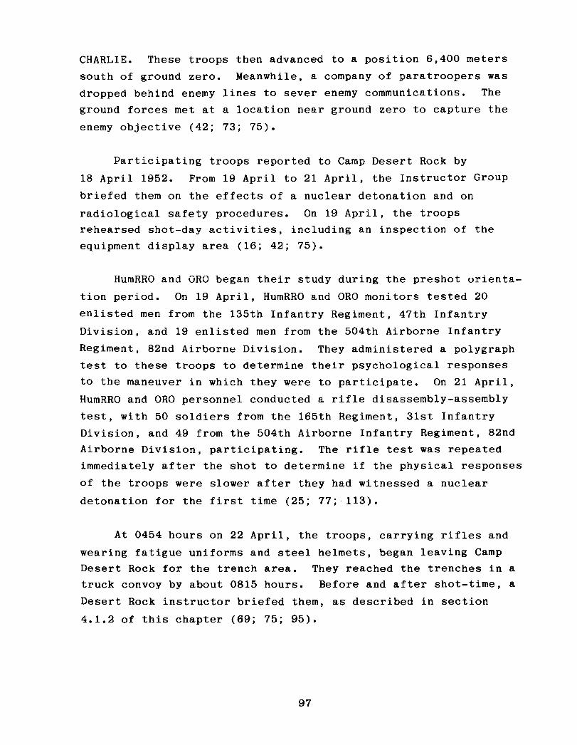
CHARLIE. These troops then advanced to a position 6,400 meters south of ground zero. Meanwhile, a company of paratroopers was dropped behind enemy lines to sever enemy communications. The ground forces met at a location near ground zero to capture the enemy objective (42; 73; 75).
Participating troops reported to Camp Desert Rock by 18 April 1952. From 19 April to 21 April, the Instructor Group briefed them on the effects of a nuclear detonation and on radiological safety procedures. On 19 April, the troops rehearsed shot-day activities, including an inspection of the equipment display area (16; 42; 75).
HumRRO and OR0 began their study during the preshot orienta- tion period. On 19 April, HumRRO and OR0 monitors tested 20 enlisted men from the 135th Infantry Regiment, 47th Infantry Division, and 19 enlisted men from the 504th Airborne Infantry Regiment, 82nd Airborne Division. They administered a polygraph test to these troops to determine their psychological responses to the maneuver in which they were to participate. On 21 April, HumRRO and OR0 personnel conducted a rifle disassembly-assembly test, with 50 soldiers from the 165th Regiment, 31st Infantry Division, and 49 from the 504th Airborne Infantry Regiment, 82nd Airborne Division, participating. The rifle test was repeated immediately after the shot to determine if the physical responses
of the troops were slower after they had witnessed a nuclear detonation for the first time (25; 77; 113).
At 0454 hours on 22 April, the troops, carrying rifles and wearing fatigue uniforms and steel helmets, began leaving Camp Desert Rock for the trench area. They reached the trenches in a truck convoy by about 0815 hours. Before and after shot-time, a Desert Rock instructor briefed them, as described in section
4.1.2 of this chapter (69; 75; 95).
97

Troops entered their foxholes and trenches ten minutes before shot-time. Two minutes before the shot, they knelt,
covering their faces with their hands and leaning against the
forward trench wall. Three seconds after the detonation, the
troops were cleared to stand up and view the fireball and
resulting cloud (75).
Following the detonation, the troops remained in the trench
area, while Desert Rock monitors accompanied AFSWP radiological
monitoring teams on the initial survey of the shot area. Mean-
while, in the trench area, HumRRO and OR0 monitors retested 25 of
the original participants from the 165th Regiment in rifle
disassembly-assembly (25; 75).
At about 1030 hours, when the Test Manager announced
recovery hour, the Exercise Director permitted personnel,
including the observers, to advance by motor convoy to the shot
area. The convoy traveled north on Mercury Highway to the BJy
area, where it parked northeast of the intersection, shown in
figure 4-2. The troops and observers then proceeded on foot to the equipment display areas, located between 3,200 meters and 180
meters west and southwest of ground zero. Figure 4-5 shows
personnel of the 140th Fighter-Bomber Group (Provisional)
marching to the equipment display areas. After viewing the
displays, the troops advanced toward the paratrooper drop area
northwest of ground zero. On their march, they approached as
close as 160 meters to ground zero (16; 23; 75; 82).
While ground troops were performing these activities, the
Army paratroopers conducted their part of the maneuver. Before boarding the drop aircraft, paratroopers put on their parachutes,
as shown in figure 4-6. At 1059 hours, five Tactical Air Command
C-46 aircraft, carrying 150 paratroopers from the 2nd Battalion,
504th Airborne Infantry Regiment, 82nd Airborne Division, took
off from Indian Springs AFB. The aircraft reached the test site
98


at about 1105 hours and established an orbiting pattern. The
paratroopers were to start parachuting at 1115 hours into the
area north-northwest of ground zero, shown in figure 4-2. Figure
4-7 shows the paratroopers awaiting the signal to jump. At 1109
hours, the $aratroopers in one C-46 began their jump, landing as
far as 13 kilometers from the designated drop zone. Soon after,
they notified the pilot that five paratroopers had been injured
on landing. At 1120 hours, the crew of this C-46 reported to the Air Operations Center that its paratroopers had jumped
prematurely, and the pilot asked the Air Operations Center to
send a helicopter to assist the injured personnel. At 1141
hours, a YH-12 helicopter was dispatched from the Control Point.
The YH-12 crew reported to the Air Operations Center at 1151
hours that the paratroopers' injuries were minor. An ambulance
returned the injured paratroopers to Camp Desert Rock for medical
attention (3-5; 57; 75).
Paratroopers in the other four aircraft jumped as scheduled. By 1120, they were either in descent or just reaching the ground.
Figure 4-S shows paratroopers descending over the designated drop
zone. By about 1125, the aircraft left the shot area for the
Yucca Lake airstrip, which they reached at 1143 hours (3-5; 57).
The paratroopers who landed in the designated drop zone
probably marched south to meet the maneuver troops and service
observers. This completed the maneuver. The ground troops,
service observers, and paratroopers walked back to the parking
area near the BJY to be monitored for radiation. According to
the Schedule of Events, they were to leave the parking area at
approximately 1330 hours and travel in a truck convoy south on
Mercury Highway, reaching Camp Desert Rock between 1500 and 1530
hours (95).
After the troops returned to Camp Desert Rock on shot-day,
HumRRO and OR0 monitors readministered the polygraph test to
101


20 soldiers from the 135th Infantry Regiment and 19 of the
participants from the 504th Airborne Infantry Regiment. They
also retested the troops on 23 April. By 24 April, the ground
troops and the paratroopers were to have left Camp Desert Rock
for their home stations (25).
4.2 DEPARTMENT OF DEFENSE PARTICIPATION IN SCIENTIFIC AND SUPPORT ACTIVITIES AT SHOT CHARLIE
Department of Defense personnel took part in scientific and
diagnostic projects conducted by the Military Effects Test Group
and the Weapons Development Test Group. Table 4-2 lists the test
group projects and identifies the participating agencies. In
addition to participating in test group experiments, DOD per-
sonnel were involved in AFSWC air‘ support activities.
4.2.1 Military Effects Test Group Projects
The Military Effects Test Group projects at Shot CHARLIE
were primarily designed to document blast pressure. Personnel
spent several weeks before the detonation placing and calibrating pressure gauges and other instruments in the shot area. These
activities were completed the day before the detonation, when
personnel left the target area after finishing their last-minute
instrument checks and calibrations. Figure 3-3 shows the
instrument layout for Military Effects Test Group activities at
Shots CHARLIE, BAKER, and DOG. Recovery operations began after
the announcement of recovery hour at 1030 hours.
Project 1.2, Air Pressure versus Time, was conducted by the
Stanford Research Institute to collect data on the airblast
produced by an airdropped nuclear device. At 2130 hours on the
night before the detonation, four personnel checked blast gauges
placed along the blast line from ground zero to 2,750 meters from
ground zero. They spent up to eight hours performing this
104

Table 4-2: TEST GROUP ACTIVITIES WITH DEPARTMENT OF DEFENSE PARTICIPATION, SHOT CHARLIE
Project/ Program Title
Military Effects Test Group
Participants
1.2
1.3 and 1.5
Air Pressure versus Time Stanford Research Institute
Free-air and Ground-level Pressure Measurements Naval Ordnance Laboratory
1.6 Ground Acceleration Measurements
1.7 Earth Acceleration versus Time
1.9 Pm-shock Dust
1.13 Measurement of Air Blast Pressure versus Time
2.1 Total Gamma Exposure versus Distance
2.3 Neutron Flux and Energy Measurements
3.1 Vulnerability of Parked Aircraft to Atomic Bombs
Ballistic Research Laboratories
Stanford Research Institute
Army Chemical Center
David Taylor Model Basin
Signal Corps Engineering Laboratories
Naval Research Laboratory
Wright Air Development Center; Los Alamos Scientific Laboratory; Naval Radiological Defense Leboraton/
3.3 Blast Damage to Trees - Isolated Conifers
3.4 Minefield Clearance
Forest Service, Department of Agriculture
Engineer Research and Development Laboratories
4.2
4.3
Biomedical Exposure Equipment
Biological Effectiveness of Neutron Radiation from Nuclear Weapons
Naval Medical Research Institute
Naval Radiological Defense Laboratory
4.4 Gamma Depth Dose Measurement in Unit Density Material
Naval Medical Research Institute
4.5 Flash Blindness Air Force School of Aviation Medicine; Air Training Command; Brooke Army Medical Center; Strategic Air Command
4.6
6.1
Time Course of Thermal Radiation as Measured by Bums in Pigs
Evaluation of Military Radiac Equipment
Neval Medical Research Institute; University of Rochester Atomic Energy Project
Bureau of Ships; Signal Corps Engineering Leboratories
6.4
7.la
Operational Tests of Radar and Photographic Techniques for IBDA
Electromagnetic Effects from Atomic Explosions
Wright Air Development Center; Strategic Air Command
National Bureau of Standards; Air Force Cambridge Research Center; Air Weather Service; Geophysical Laboratory of the University of California at Los Angeles
7.1 b Long Range Light Measurements EG&G; Headquarters, Air Force
105

Table 4-2: TEST GROUP ACTIVITIES WITH DEPARTMENT OF DEFENSE PARTICIPATION, SHOT CHARLIE (Continued)
Project/ Program Title Participants
Military Effects Test Group Kontinuedl
7.2 Detection of Airborne Low-frequency Sound from Atomic Explosions
Headquarters, Air Force; Signal Corps Engineering Laboratories; National Bureau of Standards
7.3 Radiochemical and Physical Analysis of Atomic Bomb Debris
Headquarters, Air Force
7.4
8.1
8.2
Seismic Waves from A-Bombs Detonated over a Desert Valley
Effects of Atomic Explosions on Forest Fuels
Air Temperatures in the Vicinity of a Nuclear Detonation
Air Force 1009th Special Weapons Squadron; Coast and Geodetic Survey
Forest Service, Department of Agriculture
Naval Radiological Defense Laboratory
8.3
83a
Thermal Radiation from a Nuclear Detonation
Thermal Radiation Measurements Using Passive Indicators
Naval Radiological Defense Laboratory
Naval Material Laboratory
8.4 Atmospheric Transmission and Weather Measurements
Naval Material Laboratory
8.5
8.6
Incendiary Effects of Atomic Bomb Tests on Building Sections at Yucca Flat
Sound Velocity Changes near the Ground in the Vicinity of an Atomic Explosion
Forest Products Laboratory of the Forestry Service
Naval Electronics Laboratory
9.1 Technical and Training Photography Naval Medical Research Institute; Air Force Lookout Mountain Laboratory; Wright Air Development Center; 4925th Test Group (Atomic); SAC 5th and 28th Reconnaissance Technical Squadrons; 301 st Signal Photo Company; Signal Corps Engineering Laboratories; Army Pictorial Service Division
9.2 Air Weather Service Participation
9.4 Effects of Atomic Explosions on the Ionosphere
Air Weather Service
Signal Corps Engineering Laboratories; 9471st Technical Service Unit
9.5 Electromagnetic Radiation over the Radio Spectrum Signal Corps Engineering Laboratories; from Nuclear Detonations 9467th Technical Service Unit
Weapons Development Test Group
10.1 Measurement of Alpha Naval Research Laboratory
12.1 Technical Photography EGBG
12.lc Bhangmeter Mod II EGBG
12.2a-d High-speed Photography EGBG; Los Alamos Scientific Laboratory
106

Table 4-2: TEST GROUP ACTIVITIES WITH DEPARTMENT OF DEFENSE PARTICIPATION, SHOT CHARLIE (Continued)
Projectl Program Title Participants
Weapons Development Test Group (Continued)
13
15.2
15.3
18.1
Radiochemistry Sampling Program
Gamma Radiation Exposure as a Function of Distance
Radiation Monitoring Measurements
Total Thermal Radiation and Atmospheric Transmission
4925th Test Group (Atomic)
Los Alamos Scientific Laboratory
Los Alamos Scientific Laboratory
Naval Research Laboratory
18.4 High-resolution Spectroscopy
19.la Air Shock Pressure - Time versus Distance
Naval Research Laboratory
Sandia Corporation; Los Alemos Scientific Laboratory; Armed Forces Special Weapons Project; Stanford Research Institute; Naval Ordnance Laboratory; Ballistic Research Laboratories
19.1 c-d Shock-gauge Evaluations Tests Sandia Laboratory; Los Alamos Scientific Laboratory
19.le Air Shock Pressures as Affected by Hills and Dales Sandia Corporation
19.2a-b Blast-wave Material Velocity Measurements Los Alamos Scientific Laboratory; EG&G
19.2c Betadensitometer Feasibility Test Los Alamos Scientific Laboratory
19.2d Interferometer-gauge Pressure-time Measurements Los Alamos Scientific Laboratory
19.2f Measurement of Preshock Sound Velocity Los Alamos Scientific Laboratory
107

activity. One hour after the area was opened for recovery operations, four personnel began collecting data from blast gauges up to ground zero. This operation took two hours (95; 102).
Projects 1.3 and 1.5, Free-air and Ground-level Pressure Measurements, were conducted as one project by the Naval Ordnance Laboratory. The objective was to measure pressures produced by a nuclear detonation at ground level and in free air (20).
Three hours before the detonation, four Project 1.3 person- nel completed their check of pressure gauges placed flush with the earth's surface and left the shot area. The gauge measure- ments were telemetered to a recording trailer about 3,660 meters from ground zero. Three hours after the announcement of recovery hour, two participants spent about two hours retrieving data from the trailer. At 0900 hours on the day after the detonation, two personnel and a radiological safety monitor finished inspecting and retrieving gauges up to ground zero. Their estimated working
time was two hours (20; 95).
Project 1.5 measured pressures in free air by photographing smoke rocket trails. At 1530 hours on the day before the shot, six personnel spent about two hours loading rocket launchers in the shot area. Seconds before the shot, the smoke rockets were launched remotely, and immediately after the detonation, their trails were photographed. Twenty minutes after the shot, two Participants accompanied the radiological survey team into the target area, where they unloaded any unfired rockets 920 and 1,070 meters from ground zero. At 0900 hours on the day following the detonation, six project personnel replaced and reloaded smoke rocket launchers 150 meters to 920 meters from ground zero. The Schedule of Events lists their working time as "indefinite" (20; 95).
108

Project 1.6, Ground Acceleration Measurements, was conducted
bv the Ballistic Research Laboratories. Project personnel meas-
ured ground shock with accelerometers positioned before the deto-
nation at stations 60, 200, 430, 890, 1,340, 1,800, and 2,700
meters from ground zero. At 1530 hours on the day before the
detonation, three project participants went to the stations to
make a final instrument check. They left the area within two
hours. At about 0900 hours on the day after the shot, four
project personnel began recovering the accelerometers located in
the stations along the blast line up to the 5.0 R/h area. They
completed this activity within six hours (60; 95).
Project 1.7, Earth Acceleration versus Time, was conducted
by the Stanford Research Institute to measure the proportion of
blast energy absorbed from the air by the earth. At 2130 hours
on the night before the detonation, four personnel checked accelerometers placed along the instrument line from ground zero
to 2,750 meters from ground zero. They spent up to eight hours
in performing this activity. One hour after the area was opened
for recovery operations, four personnel began collecting data
from accelerometers positioned 2,290 and 1,150 meters from ground zero. This operation took two hours (95; 103).
Project 1.9, Pre-shock Dust, was conducted by the Chemical and Radiological Laboratories of the Army Chemical Center. The
objective was to determine the concentration and the size distri-
bution of the dust generated before the arrival of the shock wave
by thermal radiation resulting from a nuclear detonation. About
four hours before shot-time, personnel inspected instruments for
collecting dust particles at six stations: two were located
200 meters from ground zero, another two 430 meters, and two
other stations 880 meters from ground zero. The instruments,
which included cascade impactors and filter samplers, collected
pre-shock dust particles generated during the brief period of
time between the detonation and the arrival of the shock wave at
each of the stations (27).
109

At the announcement of recovery hour, two personnel and a
radiological safety monitor were scheduled to reenter the shot
area and spend one hour retrieving instruments from the sampling
stations. They then took the equipment and dust particle samples
to the Yucca Flat airstrip where, within four hours, each sample
was packaged and placed aboard a courier aircraft for transport
to the Army Chemical Center for analysis (27; 95). Section
4.2.3, on AFSWC activities during CHARLIE, discusses the courier flights.
Project 1.13, Measurement of Air Blast Pressure versus Time,
was conducted by the David Taylor Model Basin. The pro,ject was
to provide blast pressure data for Program 3 agencies, particu-
larly those participating in Pro.ject 3.1, Vulnerability of Parked Aircraft to Atomic Bombs (46).
Before the shot, personnel calibrated and installed gauges
at 16 Project 3.1 stations located 670, 890, 1,180, 2,370, 2,380,
2,410, 3,110, and 3,130 meters from ground zero. Four people
made a final check of the gauges beginning at 2130 hours the
evening before the detonation. They left the shot area several
hours before shot-time. After the announcement of recovery hour,
five participants in a weapons carrier and truck spent up to two
hours retrieving the gauges. Seven other participants and a
radiological safety monitor spent up to two hours and 30 minutes
collecting film from cameras in the shot area (46; 95).
Project 2.1, Total Gamma Exposure versus Distance, was con-
ducted by the Signal Corps Engineering Laboratories to measure
gamma radiation exposure as a function of distance. Shortly
before the detonation, personnel placed film packets at go-meter
intervals along a radial line extending 1,070 to 2,400 meters
outward from the point of detonation. About two hours after the
declaration of recovery hour, four participants accompanied by a
radiological safety monitor drove by truck into the area and
110

began retrieving film packets. They recovered the film packets
farthest from ground zero and then worked their way toward ground
zero. The estimated time for this task was four hours. Film
readings were shared with Projects 1.13, 3.1, and 6.1; the
Office, Chief of Army Field Forces; and the Marine Corps (81; 95).
Project 2.3, Neutron Flux and Energy Measurements, was per-
formed by the Naval Research Laboratory to measure neutron flux
and to evaluate neutron dosimetry techniques. Before the shot, personnel placed gold and sulphur neutron detectors at stations
1,070 to 1,410 meters east of ground zero. Almost immediately
after the shot, seven participants, a radiological safety monitor,
and some Project 17.1 personnel entered the shot area to retrieve
some of the instruments. They spent 75 minutes in the area
(66; 95).
Project 3.1, Vulnerability of Parked Aircraft to Atomic
Bombs, was performed by the Wright Air Development Center and by project personnel from LASL and the Naval Radiological Defense
Laboratory. The experiment was coordinated with Project 1.13,
which provided air blast pressure data. The objective was to
determine the effects of an airburst nuclear detonation on parked
aircraft (104).
Before the shot, project personnel placed aircraft at the
following locations:
0 Two aircraft 440 meters north-northwest of ground zero
a 12 aircraft 690 meters north-northwest of ground zero
0 Three aircraft 1,180 meters southwest of ground zero
0 One aircraft 1,360 meters southeast of ground zero
0 11 aircraft 2,390 meters southwest of ground zero
0 Six aircraft 3,160 meters southwest of ground zero.
To compare the protection afforded by various defense structures,
some of the aircraft were placed in revetments and behind walls,
111

while others were positioned in the open. Personnel instrumented
the aircraft with devices to measure blast, thermal, and radi-
ation effects. In addition, they installed a motion picture
camera 2,390 meters from ground zero.
At 1730 hours on the day preceding the detonation, two
personnel began checking and adjusting instruments in the field,
a process that took about two hours. Figure 4-9 shows a Project
3.1 participant adjusting instruments. At about 0530 hours on
shot-day, four individuals in a jeep and a l/a-ton truck entered
the shot area to remove dust from some of the instruments. They
left the area about three hours before the detonation.
At the declaration of recovery hour, two project personnel, eight firemen, and two radiological safety monitors in two pickup
trucks extinguished fires at the airc.raft stations in the shot
area. Nineteen project personnel with two radiological safety
monitors spent about four hours inspecting blast effects on the
aircraft. Three Lookout Mountain Laboratory photographers from
Project 9.1 spent about three hours photographing the aircraft.
Nine other participants and a radiological safety monitor took
about three hours retrieving records from the aircraft stations.
In addition, eight personnel spent four hours recovering film at
the station 690 meters from ground zero, nine other personnel
spent four hours retrieving film 2,390 meters from ground zero,
and six others spent four hours collecting film 3,160 meters from
ground zero. At about 0800 hours on the day after the shot,
three inspection parties of two men each entered the shot area to
inspect further the blast effects on the aircraft. This task was
completed within eight hours (95; 104).
Project 3.3, Blast Damage to Trees--Isolated Conifers, was
conducted by the Forest Service, Department of Agriculture. The
experiment was designed to measure motion and strain on isolated coniferous trees subjected to a nuclear detonation. Before the
112
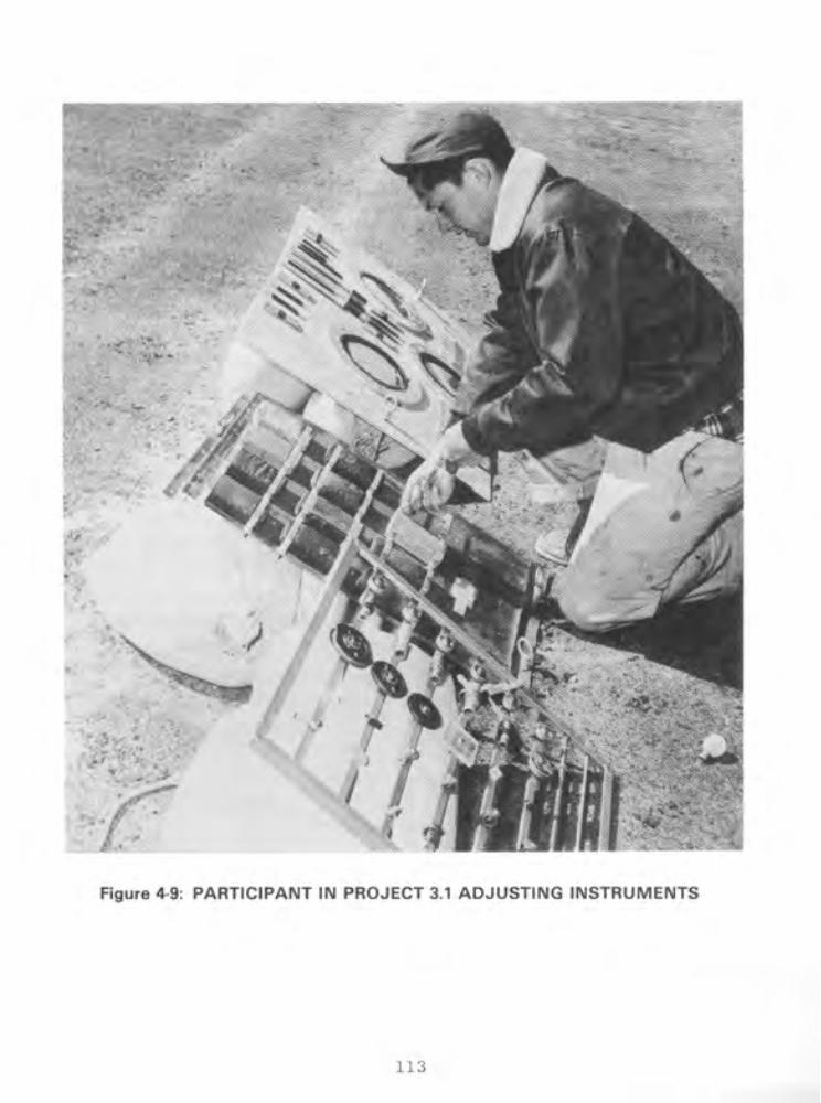

shot, personnel placed four conifers, with instruments to measure strain on the trees, at each of four stations on the Forest
Service Line in Area 7. The stations were 1,520, 1,820, 2,130,
and 2,440 meters from ground zero. The trees, approximately 50
feet high, were anchored in concrete. At 2130 hours the day
before the detonation, three project personnel entered the shot
area to begin checking instruments at the stations. This
procedure took about two hours.
At the declaration of recovery hour, eight project personnel
and three Project 9.1 photographers from Lookout Mountain
Laboratory entered the shot area in a weapons carrier and spent
about three hours inspecting and photographing the trees and
recovering the instruments. Six hours after recovery hour, four personnel entered the shot area in a weapons carrier and spent
about two hours inspecting the trees (30; 95).
Project 3.4, Minefield Clearance, was performed by the Engineer Research and Development Laboratories. The study eval-
uated the practicality of using nuclear weapons to clear mine- fields. Before the shot, personnel laid a minefield 15 meters
wide, which extended about 90 to 1,830 meters from ground zero.
Two hours after recovery hour was declared, two project partici-
pants in a vehicle checked instruments at stations 910 and 1,830
meters from ground zero. At 0800 hours on the day after the
detonation, 13 personnel and a radiological safety monitor in a
weapons carrier recovered mines along the blast line and
determined which mines had been detonated. At the same time,
they laid other mines to be used in this experiment at Shot DOG.
This operation took about eight hours (95; 101).
Project 4.2, Biomedical Exposure Equipment, was conducted by
the Naval Medical Research Institute to evaluate instruments
designed to measure blast, thermal, and radiation effects on
animals. To measure exposure to direct airblast, personnel
114
instrumented wood models of dogs with accelerometers and then
placed them in containers fitted with pressure recorders. Before
the detonation, they placed the containers 260, 340, 430, and 600
meters from ground zero. About three hours after the declaration
of recovery hour, four participants and two radiological safety
monitors began recovering instruments from the containers, a
process that took about two hours (54).
To measure thermal effects, personnel began placing swine in
instrumented containers at about 0400 hours on shot-day. They
positioned the containers 1,090, 1,570, and 2,400 meters from
ground zero. In addition, they loaded heat-sensitive film into
cameras located 1,130, 1,620, and 2,440 meters from ground zero.
After the declaration of recovery hour, they retrieved the
animals, instruments, and film (54).
To measure radiation effects, participants placed dosimeters
in mouse cages located 90, 120, 150, 180, 370, 460, 640, 820, and
1,010 meters from ground zero. They also positioned cameras 460,
640, 820, and 1,010 meters from ground zero. After the area was
opened for recovery operations, personnel recovered dosimeters
from the cages and film from the cameras (54; 95).
Project 4.3, Biological Effectiveness of Neutron Radiation from Nuclear Weapons, was conducted by the Naval Radiological
Defense Laboratory. The objective was to study the biological
effects of neutron radiation on mice. At about 1900 hours the
evening before the detonation, eight participants in two weapons
carriers began placing approximately 30 mice in each of the mouse
cages used in Project 4.2. They spent about one hour on this
assignment and then left the shot area (35; 95).
After the area was opened for recovery operations, eight
participants and a radiological safety monitor in two weapons
carriers spent about one hour retrieving the mice. To determine
115

the effects of neutron radiation on the mice, laboratory person- nel did a pathological examination of the animals (35; 95).
Project 4.4, Gamma Depth Dose Measurement in Unit Density Material, was performed by the Naval Medical Research Institute. The objective was to improve techniques used to evaluate bio- logical effects of radiation on living tissue, particularly the
human body. To measure initial and residual gamma doses, project participants placed dosimeters in lucite spheres, approximating human tissue in density. Before the detonation, they placed six spheres on A-frames approximately 1,140 to 1,600 meters south of
ground zero. After the declaration of recovery hour, seven personnel in two weapons carriers spent about one hour retrieving the spheres (36; 95).
Project 4.5, Flash Blindness, was conducted by the Air Force School of Aviation Medicine. Participating in the project were personnel from the Air Training Command, SAC, and Brooke Army Medical Center. The objective was to determine to what degree the flash of a nuclear detonation impairs night vision. Two hours before the shot, 27 personnel traveled by bus to a trailer near the Control Point at Yucca Pass, approximately 15 kilometers from the intended ground zero. They witnessed the detonation from this trailer. Project procedure required participants to adapt their eyes to darkness by wearing dark goggles for 30 minutes and then by remaining in the darkened trailer for another 30 minutes before the shot (33; 38; 111).
Along the side of the trailer were 12 portholes fitted with shutters for exposing the eyes of the test subjects to the nuclear flash. The shutters opened 48 milliseconds after the detonation and closed two seconds later. During the exposure, half of the test subjects wore protective goggles. After the exposure, participants were required to read lighted instruments to determine how soon after exposure a person could see well
116

enough to perform assigned tasks. Various instruments were used to examine the subjects' vision after exposure (33; 38; 95; 111).
Project 4.6, Time Course of Thermal Radiation as Measured by Burns in Pigs, was conducted by the Naval Medical Research Insti- tute and the University of Rochester Atomic Energy Project. The Naval Medical Research Institute provided project equipment, while the Atomic Energy Project supplied the test animals and conducted the biological experiments. The project was designed to study the degree of skin burns in pigs exposed to a nuclear detonation (79).
On the day before the detonation, project personnel weighed the pigs and inspected their skin for disease and injury. From five to three hours before the detonation, seven participants transported the pigs by truck to stations 1,080, 1,570, and 2,400 meters from ground zero. After anesthetizing the pigs and placing them in containers, the participants left the shot area.
About two hours after the detonation, seven personnel in a truck recovered the animals and inspected the containers to determine if they had functioned properly during the blast. They then transported the pigs by truck to an AEC laboratory for eval- uation of burns (79; 95).
Project 6.1, Evaluation of Military Radiac Equipment, was conducted by the Bureau of Ships and the Signal Corps Engineering Laboratories to evaluate dosimeters. Before the shot, personnel placed 11 different dosimeters at ranges of 920 to 2,740 meters from ground zero. Two hours after the announcement of recovery hour, six project personnel and a radiological safety monitor in a vehicle began recovering the dosimeters, an activity taking three hours. In addition, Project 6.1 personnel furnished standard and experimental radiation survey meters to other projects in order to evaluate the meters (95; 107).
117

Project 6.4, Operational Tests of Radar and Photographic
Techniques for IBDA, was conducted by the Wright Air Development
Center, assisted by the Strategic Air Command. The objective was
to evaluate the Indirect Bomb Damage Assessment system under
development at the Wright Air Development Center. The 509th
Bombardment Group of SAC provided three B-50D aircraft to make a
postshot test of the IBDA system. The following listing presents
information on flight times for the aircraft, which staged from
Kirtland AFB (26):
DEPARTURE LANDING AIRCRAFT TIME TIME
B-50D 0530 1530 B-50D 0540 1210
B-50D 0550 1140
Aircraft 1 and 2, simulating the drop aircraft, flew 1,800
and 1,300 feet, respectively, above the drop aircraft. Both
aircraft made 40 degree turns, aircraft 1 to the right and air-
craft 2 to the left. The headings were held until ten seconds before shot-time. Aircraft 3, simulating an escort aircraft, was
800 feet above and seven nautical miles behind the drop aircraft.
Aircraft 3 held the same heading for approximately 45 seconds
after shot-time and then turned to leave the area (26; 57).
Project 7.la, Electromagnetic Effects from Atomic Explo-
sions, was conducted by the National Bureau of Standards, Air
Force Cambridge Research Center, Air Weather Service, and Geophysical Laboratory of the University of California at Los
Angeles. The project was designed to study the electromagnetic
pulses produced by a nuclear detonation. Data were evaluated as
a means of determining the location of distant nuclear detona-
tions. Onsite stations were at Frenchman and Yucca Flats, and
118
offsite stations were in Colorado, Florida, Georgia, Massachusetts,
New Mexico, Virginia, Bermuda, Germany, and Puerto Rico. Three
hours before the detonation, five project personnel entered the
Yucca Lake recording station, 15 kilometers from ground zero, and
remained there through shot-time (95; 96).
Project 7.lb, Long-range Light Measurements, was conducted
entirely offsite by Edgerton, Germeshausen, and Grier, Inc., and
Headquarters, Air Force. The objective was to gain additional
information on the long-range detection of light produced by a nuclear detonation. EGbG and the Air Force established light-
detecting stations in Arizona, Idaho, Texas, and Washington. An
estimated two EG8G &mployees and ten Air Force personnel from the I 1
Sacramento Air Materiel Area, McClellan AFB, operated each
station from about sixhours before to one hour after the
detonation (55).
Project 7.2, Detection of Airborne Low-frequency Sound from
Atomic Explosions, was conducted by Headquarters, Air Force, with
assistance from the Signal Corps Engineering Laboratories and the
National Bureau of Standards. The objective was to determine the
accuracy of long-range acoustic detection methods. The Signal
Corps Engineering Laboratories operated stations in Alaska,
Hawaii, Kentucky, New Jersey, Texas, and Washington. The National Bureau of Standards operated a station in Washington, D.C. (97).
Project 7.3, Radiochemical and Physical Analysis of Atomic
Bomb Debris, was conducted by Headquarters, Air Force. The
project, which involved analysis of particulate and gaseous
samples from the Shot CHARLIE cloud, was conducted in conjunction
with Program 13, Radiochemistry Sampling. Cloud sampling, performed by the 4925th Test Group (Atomic) of Kirtland AFB, is
discussed in section 4.2.3 (106).
119

Project 7.4, Seismic Waves from A-Bombs Detonated over a
Desert Valley, was conducted by the Air Force 1009th Special
Weapons Squadron and the Coast and Geodetic Survey. The
objective was to determine the seismic properties of the
geological structure of the test area. Four hours after the
announcement of recovery hour, two project personnel and a
radiological safety monitor recovered seismic records from
stations 310 and 920 meters from ground zero. Recovery
operations took one hour (34; 95).
Project 8.1, Effects of Atomic Explosions on Forest Fuels,
was performed by the Forest Service, Department of Agriculture,
with assistance from Project 3.3 personnel and Project 9.1
photographers. The experiment was to determine the minimum thermal energies required to ignite common forest fuels (19).
From five to three hours before the detonation, seven
project personnel arranged forest fuels, such as conifer needles,
hardwood leaves, grass, and rotten wood, in 71 trays placed at
various distances from ground zero. Personnel from the LASL
graphic arts section photographed the fuel beds both before and
after the shot. In addition, the Army Pictorial Service Division, Office of the Chief Signal Officer, installed three
motion picture cameras to photograph the ignition and combustion
of the fuel beds. Thirty minutes after the detonation, six
personnel with a radiological survey party entered the shot area
to collect a moisture sample. The task took about 20 minutes
(19; 95).
Project 8.2, Air Temperatures in the Vicinity of a Nuclear
Detonation, was conducted by the Naval Radiological Defense
Laboratory to determine air temperatures at various elevations
and distances from ground zero. Before the shot, participants
installed thermocouples at ground level and on steel towers of
various heights. The towers were located at ground zero and at
120

distances up to 2,740 meters from ground zero. At about 0330 hours on shot-day, project personnel left the test area. At the declaration of recovery hour, two three-man crews, including monitors, entered instrument shelters 920 and 460 meters from
ground zero. The personnel spent up to six hours at the shelters recovering thermal data and unloading the thermal detectors. At 0900 hours on the day after the detonation, four project members,
accompanied by a monitor and a photographer, recovered the thermal detectors. The estimated time of this recovery operation was six hours (28; 95).
Project 8.3, Thermal Radiation from a Nuclear Detonation, was conducted by Project 8.2 and 8.3 personnel from the Naval Radiological Defense Laboratory. The objective was to measure the total thermal radiation and the intensity-time relationship
of the radiation as a function of distance from ground zero (29).
Before the shot, project participants placed several types of instruments in tower stations located at various intervals out to 6,100 meters from ground zero. Instruments included calori- meters, photonic cells, passive receiver panels, and radiometers. Other personnel at Kirtland AFB installed three disk calorimeters in the B-50 drop aircraft. On shot-day, personnel checked the
instruments and left the area by 0330 hours.
At recovery hour, six project personnel and a radiological safety monitor entered the shot area in a weapons carrier and spent a maximum of six hours retrieving instruments located farther than 460 meters from ground zero. At about 0900 hours on the day following the shot, four personnel and a radiological safety monitor recovered the remaining instruments along the blast line to ground zero. A photographer from Lookout Mountain Laboratory photographed recovery operations. Project 8.2 and 8.3 personnel at Kirtland AFB removed the calorimeters from the B-50 drop aircraft (29; 95).
121

Project 8.3a, Thermal Radiation Measurements Using Passive
Indicators, was conducted by the Naval Material Laboratory. The purpose was twofold:
l To evaluate the field performance of passive heat-sensitive materials in measuring the total thermal radiation incident as a function of distance from ground zero
a To test the indicators for their future use during Operation UPSHOT-KNOTHOLE in determining yield, temperature, and integrated thermal flux from the fireball.
Before the detonation, Project 8.4 participants placed
indicators 1,820 to 3,340 meters from the intended ground zero.
Project 8.4 personnel probably retrieved these instruments along
with their own instruments after the declaration of recovery hour
(22; 95).
Project 8.4, Atmospheric Transmission and Weather Measure-
ments, was conducted by the Naval Material Laboratory. The
project was designed to provide meteorological data for use in
thermal radiation projects and to supplement information supplied
by Project 9.2, Air Weather Service Participation. In addition,
Project 8.4 participants assisted in Project 8.3a.
At various times during shot-day, project personnel measured
barometric pressure, temperature, humidity, and rainfall. They worked from a station at the BJY, where they received trans-
missions from two self-operating stations five kilometers to the
northwest. They returned to the Control Point before the
detonation. Two hours after recovery hour, seven personnel in a
jeep went to the receiver station and began collecting data.
They spent about three hours in the shot area (53; 95).
Project 8.5, Incendiary Effects of Atomic Bomb Tests on
Building Sections at Yucca Flat, was performed by the Forest
Products Laboratory of the Forest Service. The objective was to
122
determine the probability of primary fires resulting in urban
areas from a nuclear detonation. The types of structures tested
were:
0 Cubicle room
l Right angle corner between walls
0 Right angle corner with cornice
0 Roof section.
The items were constructed and mounted to resist demolition by
the blast so that the incendiary effects of the nuclear flash could be studied. Thirty-one of these structures were installed
at stations ranging 1,820 to 4,860 meters from ground zero (32).
Project 9.1 personnel from Lookout Mountain Laboratory took
documentary photographs of the displays before and after the
detonation. At the declaration of recovery hour, three project
participants in a weapons carrier started inspecting the
displays, a process that took four hours (32; 95).
Project 8.6, Sound Velocity Changes near the Ground in the
Vicinity of an Atomic Explosion, was conducted by the Naval Elec- tronics Laboratory. The objective was to determine the velocity of sound during the interval between detonation and shock wave
arrival at heights of 1.5, 10, and 54 feet above ground and at
various distances from ground zero (91).
Before the detonation, project personnel installed instru-
ments able to detect changes in sound velocity near the ground at
stations 50, 430, 890, 1,340, and 1,800 meters from ground zero. Six hours before shot-time, four participants entered the shot area and made a final check of the equipment. They left the area
approximately one hour later. After the announcement of recovery
hour, four project personnel spent four hours retrieving
instruments. Remaining instruments were recovered on the
following day (91; 95).
123

Project 9.1, Technical and Training Photography, was con- ducted by personnel from the following agencies (1; 57; 95):
Air Force Lookout Mountain Laboratory Army Pictorial Service Division Naval Medical Research Institute SAC 5th Reconnaissance Technical Squadron SAC 28th Reconnaissance Technical Squadron Signal Corps Engineering Laboratories Wright Air Development Center 301st Signal Photo Company 4925th Test Group (Atomic).
Lookout Mountain Laboratory personnel photographed the CHARLIE shot from a C-47 aircraft. The aircraft, which left Indian Springs AFB at about 0832 hours, was at an altitude of
10,000 feet approximately 11 kilometers south of ground zero at shot-time. Participants photographed the detonation and the resulting cloud formation until 0941 hours, when they left the area and returned to Indian Springs AFB. They reached base at about 1000 hours (57).
Project 9.1 personnel also took still photographs and motion pictures of various Military Effects Test Group projects, including 3.1, 3.3, and 8.1. In addition, they performed the following photography missions, which have not been associated with a specific project (95).
At 0330 hours on shot-day, three participants proceeded to stations 1,530 and 1,830 meters from ground zero to make final adjustments to their cameras. Their estimated working time was three hours. Three hours before the detonation, Lookout Mountain Laboratory personnel went to three stations: one 610 meters northwest of the Control Point, one at the junction between the access road and the main road, and one at UTM coordinates 902928 (95).
124

One Lookout Mountain Laboratory photographer, three other
project participants, and a monitor began photographing along the
blast line at recovery hour. Their estimated working time was
one hour. An hour after the announcement of recovery hour, eight
participants began unloading cameras at locations between 1,530
and 4,880 meters from ground zero. They spent about four hours
in this activity (95).
Project 9.2, Air Weather Service Participation, involved Air
Force personnel who compiled data from various weather stations
at the NPG and offsite, prepared weather maps, and briefed NPG
officials on current and predicted weather conditions. Project
participants were from the 6th Weather Squadron (Mobile) of the
2059th Air Weather Wing, Tinker AFB, Oklahoma. These personnel
were deployed as follows (78):
0 Eight forecasters, 13 weather observers, and two equipment operators at the Control Point Weather Station near Yucca Pass
0 Twelve airmen from the Rawinsonde Weather Observation Section at the Control Point and 11 airmen at a station in Tonopah, Nevada
0 Three airmen from the Pibal Weather Observation Section at Beatty, Caliente, Crystal Springs, Currant, and Warm Springs, Nevada, and St. George, Utah.
Before Shot CHARLIE, participants installed wind and
humidity measuring instruments at two stations along the blast
line 920 and 1,830 meters from ground zero. Two men checked
instruments at these stations at about 2130 hours the night
before the shot and hourly from eight to three hours before the
detonation (95).
About three hours after the announcement of recovery hour,
two participants and a radiological safety monitor in a pickup truck began retrieving records from the two stations, a procedure
that took two hours. At 0900 hours on the day after the
125

detonation, two personnel reentered the shot area to complete
recovery operations. This activity took approximately two hours
(78; 95).
Project 9.4, Effects of Atomic Explosions on the Ionosphere,
was conducted by the Signal Corps Engineering Laboratories, with
assistance from personnel of the 9471st Technical Service Unit.
The objective was to obtain data on the effects of a nuclear
detonation on ionospheric radiowave propagation.
Personnel worked at transmitter and receiver stations. The
only onsite facility was a transmitter at Station 9.4, 910 meters
north of the Control Point. Two other transmitters were at
Mather AFB, Sacramento, California. The radio receiver stations
were at the Navaho Ordnance Depot, Flagstaff, Arizona; White
Sands Proving Ground, New Mexico; and Fort Sill, Oklahoma (49).
On the day before the shot, personnel practiced operating the transmitters and receivers. On shot-day, they operated
instruments from one hour before to one hour after the detona-
tion. All data obtained at the project stations were sent for
analysis to the Signal Corps Engineering Laboratories (49; 95).
Project 9.5, Electromagnetic Radiation over the Radio
Spectrum from Nuclear Detonations, was conducted by the Signal
Corps Engineering Laboratories, with assistance from the 9467th
Technical Service Unit, Electronic Warfare Center. The project
was designed to determine the wave shape and amplitude of radio
frequency energy emanating from a nuclear detonation. Project
personnel operated two stations 16 to 24 kilometers from ground
zero through the detonation. In addition, participants manned
one station at White Sands Proving Ground, New Mexico, and
another at the Evans Signal Laboratory in Belmar, New Jersey
(31; 95).
126

4.2.2 Weapons Development Test Group Activities
Although most of the Weapons Development Test Group activ- ities were performed by AEC laboratories and contractors, some of the projects were conducted by DOD agencies. For example, the Naval Research Laboratory performed the experiments for Program 18, Thermal Measurements. In addition, a few DOD personnel wzre assigned to LASL or to the Weapons Development Test Group to assist in the projects listed in table 4-2.
Project 10.1, Measurement of Alpha, was conducted by the Naval Research Laboratory. At the announcement of recovery hour, five participants and a radiological safety monitor began retriev- ing film from a station 920 meters from ground zero. They spent about one hour in the shot area. An hour later, five personnel and a monitor entered the station to work on instruments. This activity took the remainder of the day (80; 95).
Project 12.1, Technical Photography, was conducted by personnel from EG&G, with assistance from Navy personnel. They provided technical photography support, including dust studies, preshock turbulence studies, light absorption and mirage studies, fireball growth measurement, thermal effects studies, and other technical coverage required by the Weapons Development Test Group.
Two days before the shot, personnel prepared the film at the Control Point Building. The afternoon before Shot CHARLIE, they loaded film into remote-controlled cameras at various stations in the ground zero area. After the detonation, EGIG personnel recovered the exposed film and processed some of it in the mobile unit set up in the Control Point area. The remaining
film was flown for processing to laboratories of Consolidated Film Industries in Hollywood, California, or in the city of Fort Lee, New Jersey (64).
127

Project 12.lc, Bhangmeter Mod II, was conducted by EGIG to evaluate and test a new bhangmeter. Personnel installed these instruments for measuring the yield of a detonation at the Control Point and in the drop aircraft. Bhangmeter readings recorded at shot-time were analyzed after the shot (63).
Project 12.2a-d, High-speed Photography, was conducted by
LASL and EG&G. The objectives were to study early fireball growth and obtain measurements correlating shock arrival time with the appearance of the fireball. Personnel mounted special cameras in a trailer about four kilometers from ground zero and retrieved the film for analysis after the detonation (59).
Program 13, Radiochemistry Sampling, involved cloud-sampling by personnel from the 4925th Test Group (Atomic). The sampling missions are discussed in section 4.2'.3, on AFSWC activities at CHARLIE (57).
Project 15.2, Gamma Radiation Exposure as a Function of
Distance, was conducted by personnel from LASL. The objective was to measure gamma radiation exposure at various distances from the detonation. Personnel placed gamma-detecting instruments in the ground at locations between 430 and 3,690 meters from ground zero. One hour after recovery hour, two men and a monitor were scheduled to enter the shot area in a weapons carrier and spend one hour recovering the instruments (109).
Project 15.3, Radiation Monitoring Measurements, was conducted by personnel from LASL. The objectives were to monitor gamma radiation levels from the radioactive fallout after a nuclear detonation and to test several prototype radiation monitoring instruments for use at Operation IVY, scheduled for the fall of 1952. The information on radiation levels was alS0
used by the recovery parties. Participants installed recording equipment in stations located about 640 and 1,000 meters
128

northwest of ground zero. The recording equipment was set up to telemeter information on gamma radiation levels to the Control Point (83).
Project 18.1, Total Thermal Radiation and Atmospheric Transmission, was conducted by the Naval Research Laboratory to study the transmission of light and thermal radiation emitted by nuclear detonations of various yields. To measure the trans- mission of light, personnel placed one photoelectric brightness meter at the Control Point and another in Area 2 of the NPG. In addition, they installed a transmissometer near the BJY and a receiver at the Control Point. To obtain data on thermal radiation emissions, personnel also installed four thermopile recorder systems. Participants manually operated the instruments from the Control Point during the shot. They shut down equipment
after the detonation to analyze recorded data (84).
Project 18.4, High-resolution Spectroscopy, was conducted by the Naval Research Laboratory to supplement information obtained from spectroscopy measurements taken during previous nuclear weapons testing series, such as Operations GREENHOUSE and BUSTER-JANGLE. Personnel installed a spectrograph at the Control Point, 17 kilometers from ground zero (24).
Project 19.la, Air Shock Pressure--Time versus Distance, was
conducted by the Sandia Corporation. Representatives of LASL, AFSWP, the Stanford Research Institute, the Naval Ordnance
Laboratory, and the Ballistic Research Laboratories helped to plan this project. The objective was to obtain pressure measurements to use in determining the relationship between air shock pressure and height of burst. Personnel installed pressure
gauges along the ground between 230 and 3,500 meters from ground zero. They also placed gauges on towers of various heights located 460 to 1,370 meters from ground zero. At the instant of burst, information from the gauges was telemetered to a recording
station and monitored by project personnel (93).
129

Projects 19.lc and 19.ld, Shock-gauge Evaluations Tests, were conducted by Sandia Laboratory. Personnel from LASL and
contractors assisted in calibrating and installing instruments.
The project was intended to develop and test new instruments for
measuring dynamic and static pressures, wind directions, sound
and wind speeds, and temperature rises resulting from a shock
wave. Personnel installed instruments at two stations located
885 meters and 1,800 meters from ground zero. Cables connected
the instruments to equipment that recorded the information (47).
Project 19.le, Air Shock Pressures as Affected by Hills and
Dales, was conducted by personnel from Sandia Corporation and AEC contractors. The objective was to collect information about the influence of hills and valleys on the shock waves from airbursts and to study the shielding effects of hills. Project personnel
installed gauges to record air shock pressure at six points in a line running over a hill. Cables connected the gauges to
recording equipment in a nearby mobile van. Sometime after the detonation, participants went to the van to recover the records
and found that the cables had been disconnected as a result of
the detonation (92).
Projects 19.2a and 19.2b, Blast-wave Material Velocity
Measurements, were conducted by LASL. An officer and six men from the Antiaircraft Artillery and Guided Missile Center, Fort
Bliss, Texas, installed and maintained a 90-millimeter battery.
EGbG provided photography services. The objective was to photo-
graph peak overpressure phenomena associated with a nuclear
burst. Smoke canisters were fired into the air from mortars and
guns immediately before the burst so that the air disturbance would be visible (99).
Before the shot, project personnel emplaced mortar units
along a blast line extending about one kilometer from ground zero and set up four 90-millimeter gun stations about 5,190
130

meters southwest of ground zero. These mortars and guns were fired by an electronic timing device. During this time, EGtG personnel loaded the cameras with film. After the detonation,
personnel reentered the area to load the mortars and guns for Shot DOG. EGBG personnel retrieved film from camera stations in the shot area (99).
Project 19.2c, Beta-densitometer Feasibility Test, was conducted by LASL personnel assisted by Army personnel. The objective was to test two types of densitometers and to measure air density as a function of time after a shock wave. Partici- pants installed densitometers, which were connected to recording equipment, in the ground near ground zero. The equipment was set to start functioning upon receipt of an electronic timing signal. After the burst, project personnel entered the area to recover
instruments and records (99).
Project 19.2d, Interferometer-gauge Pressure-time Measure- ments, was conducted by LASL (99).
Project 19.2f, Measurement of Preshock Sound Velocity, was conducted by LASL with Air Force participation. The objective was to measure the velocity of sound in the air near the ground
before shock wave arrival. Personnel installed oscillators and recording equipment at several stations about 1,110 meters from
ground zero. After the detonation, personnel recovered the records from the instrument stations (99).
4.2.3 Air Force Special Weapons Center Activities
Besides airdropping the CHARLIE device, AFSWC personnel conducted cloud sampling and sample courier missions for the test groups and cloud tracking and aerial radiological surveys of the terrain for the Test Manager. The Air Force Special Weapons Center also provided the personnel to staff the Air Operations
131

Center, located at the Control Point. In addition to the AFSWC participants, Strategic Air Command personnel witnessed the deto- nation. Although the SAC observers were not part of AFSWC, they were under the operational control of AFSWC while over the NPG and are therefore discussed in this section (3-5; 57; 58; 100).
The following listing indicates the types and numbers of air- craft and the estimated numbers of personnel involved in air missions at Shot CHARLIE (57; 58):
TITLE TYPE OF AIRCRAFT
NUMBER OF NUMBER OF AIRCRAFT PERSONNEL
Airdrop Mission
Disaster Mission c-47
Sampling Sampler Control Sampler Sampler Sampler
B-29 1 9 B-29 1 8 T-33 3 6 F-84 5 5
Sample Courier Service B-25 2 10 c-47 2 8
Cloud Tracking
Aerial Surveys of Terrain
Observer Activities
B-50
B-25 B-29
c-47 L-20
B-50 16 192
1
1
1 2
2 2
10
17
5 20
10 4
Airdrop and Disaster Missions
The B-50 drop aircraft, with a crew from the 4925th Test Group (Atomic), left Kirtland AFB, New Mexico, at 0445 hours. Climbing to an altitude of 32,640 feet, the aircraft entered a clockwise bombing orbit over Yucca Flat. Just before 0930 hours, the B-50, flying a straight and level course, released the
132

CHARLIE device. The bomb was off-target by 45 meters. The aircraft left the shot area at 0941 hours, returning to Kirtland AFB at 1145 (3; 4; 57; 58; 76).
The C-47 disaster aircraft, with a crew from the 4901st Support Wing (Atomic), left Kirtland AFB at about 0345 hours and orbited over Las Vegas during the NPG bomb drop mission. At 0934 hours, the aircraft began its return to Kirtland AFB, which it reached at 1250 hours (3; 4; 57; 58; 76).
Cloud Sampling
One B-29, three T-33s, and five F-84s collected particulate and gaseous samples of the Shot CHARLIE cloud for Project 7.3, Radiochemical and Physical Analysis of Atomic Bomb Debris, and for Program 13, Radiochemistry Sampling. A B-29 sampler control aircraft, with an AFSWC aircrew and a LASL scientific advisor on board, flew from Indian Springs AFB at 0815 hours and directed the operations of the sampler aircraft. The samplers flew at altitudes of 30,000 to 40,000 feet and penetrated the cloud up to 21 times. The following list summarizes their activities (3; 4; 57; 58; 76):
133

AIRCRAFT TYPE TAKEOFF AND TAIL NUMBER TIME
TOTAL DOSIMETER READING (roentgens)
LANDING TIME
Sampler Control B-29 (285)
B-29 (386) T-33 (951) T-33 (048)
T-33 (920) T-33 (920,
2nd mission) F-84 (033) F-84 (051) F-84 (054)
F-84 (043) F-84 (042)
0815 NR* 1430 0838 0.125 1327 1145 0.0003 1255 1155 0.950 1310
NR 0.150 NR 1345 0.500 NR
1306 0.200 1358 1328 0.010 1425 1312 0.180 1420
1330 0.175 1425 1335 0.100 1435
*NR indicates not reported.
One T-33 sampler (tail number 920) flew two sampling missions because another T-33 sampler (tail number 913) had been forced to abort upon reaching 30,000 feet because of engine and
fuel pressure problems. The sampling sorties lasted two hours longer than anticipated. The aircraft remained in orbit for the maximum time allowed because of the relatively slow dissipation of the CHARLIE cloud (3; 4; 57; 58; 76).
Upon completion of their mission, the samplers returned to Indian Springs AFB and parked in the northeast corner of the parking area. Pilots then shut down the engines. The crews of the B-29s left the craft through the rear door between the stabilizer and the wing. The aircrews of the T-33s and F-84s disembarked by stepping onto a boarding ladder attached to the side of the aircraft. The sample-removing team and radiological
134

safety monitors used long-handled tools to take samples from the
aircraft and place them in shielded containers. They also
removed the bottles containing the gaseous samples. They then
loaded the sample containers onto courier aircraft for delivery
to laboratories for analysis (3; 4; 57; 58; 76).
Courier Missions
After the sampling missions had been completed, two B-25 and
two C-47 aircraft left Indian Springs AFB on shot-day to trans-
port samples and filter papers to various laboratories for anal-
ysis. The 4901st Support Wing (Atomic) conducted these courier
missions.
Within a few hours after the detonation, a B-25 flew from
Indian Springs AFB to McClellan AFB with Project 7.3 samples.
Shortly after, a C-47 flew from Indian Springs AFB to LASL with
Program 13 samples. At 1330 hours, a B-25 left Yucca Lake air-
strip with Project 1.9 samples for the Army Chemical Center, and
a C-47 left on a courier mission to LASL (3; 4; 57; 58; 76).
Cloud Tracking
Soon after the detonation, one B-25 and two B-29s f.rom
Indian Springs AFB flew cloud-tracking missions over and beyond
the Nevada Proving Ground. The B-25 (tail number 099) took off
at 0948 hours, tracked the cloud at heights ranging from 8,500 to 12,000 feet, and landed at 1248 hours. One B-29 (tail number
826) left at 0945 hours, tracked the cloud at heights of 15,000
to 26,000 feet, and returned at 1505 hours. The second B-29
(tail number not recorded) left at 1230 (3; 4; 57; 58; 76).
Aerial Surveys of Terrain
After the detonation, two C-47 and one L-20 aircraft, all based at Indian Springs AFB, conducted radiological surveys of the onsite and offsite terrain. One C-47 (tail number 308) left
135

at 1300 hours, flew at heights of 100 to 1,500 feet, and landed at 1730 hours. The other C-47 (tail number 386) left at 1252 hours, conducted its survey at an altitude of 10,000 feet, and returned at 1550 hours. The L-20 (tail number 467) took off at 1120 hours, conducted its survey at heights of 100 to 500 feet, and returned at 1405 hours. The two C-47s performed similar surveys on 23 April (3; 57; 65).
Observer Activities
At Shot CHARLIE, 16 B-50 aircraft from the Strategic Air Command participated in an orientation and indoctrination exercise in nuclear weapons effects. On shot-day, the B-50s with
SAC observers entered the Nevada Proving Ground area, possibly from Castle AFB and Travis AFB, between 0656 and 0828 hours. The aircraft remained in an orbiting patt.ern through shot-time so that the observers could witness the detonation and subsequent cloud development. Between 0934 and 0946 hours, all aircraft left the test area for their bases (3-5; 11; 57; 76; 100).
4.3 RADIATION PROTECTION AT SHOT CHARLIE
The primary purpose of the radiation protection procedures developed by Exercise Desert Rock IV, the test groups, and AFSWC for Operation TUMBLER-SNAPPER was to keep individual exposure to ionizing radiation to a minimum, while still allowing partici- pants to accomplish their missions.
4.3.1 Desert Rock Radiation Protection Activities
The Desert Rock Radiological Safety Group devised plans and supplied personnel for radiological safety procedures associated with the CHARLIE observer activities and troop maneuver. The AEC supervised the Army in conducting these procedures. Film badge readings are limited for Desert Rock personnel at CHARLIE.
136

Orientation and Briefing
From 19 April to 21 April, the Instructor Group conducted an indoctrination course for all Desert Rock participants at Shot CHARLIE (75).
Dosimetry and Protective Equipment
The Desert Rock Radiological Safety Group issued film badges to participants in Desert Rock IV exercises. In the indoctrination course, the instructors directed the participants to place their film badges in their left breast pocket, with the numbers of the badge facing outward from the body. Although the Desert Rock Radiological Safety Group issued the film badges, the AFSWP Radiological Safety Group processed them (12; 65; 75; 95).
The instructors also explained the proper use of field protective masks, which the participants brought with them to Camp Desert Rock. The masks were to be worn if directions were given to evacuate the area (75).
Monitoring
After the detonation, Desert Rock monitors accompanied the AFSWP radiological monitoring teams in surveying the route of approach to the equipment display area. The monitors located the 0.01 R/h line along the route. After the monitors had surveyed the display route and AFSWP monitors had finished surveying the rest of the shot area, the Test Manager declared the area safe to
enter. Desert Rock monitors then accompanied the troops and observers as they toured the equipment display area (12; 65; 75; 95).
Decontamination
In the parking area near the BJY, decontamination personnel brushed troops and observers with brooms to remove contaminated dust. They then surveyed the personnel with AN/PDR-TlB meters.
137

Those individuals whose contamination level could not be reduced
to less than 0.01 R/h were ordered to the decontamination station
at Yucca Pass for showering. Vehicles were also monitored and
sent to the decontamination station near the Control Point if
brushing could not reduce their level of contamination to less than 0.01 R/h.
At the decontamination station, personnel were to shower and
put on clean clothing. Monitors surveyed these personnel after they had showered to ensure that radiation intensities were less
than 0.0015 R/h on clothing and nondetectable on the skin, as
measured with AN/PDR-TlB meters (75).
4.3.2 Joint AEC-DOD Radiation Protection Activities
Information concerning Shot CHARLIE was obtained from the
radiological safety report prepared by AFSWP (65). This document
includes data on radiation safety equipment, onsite and offsite
monitoring procedures, and isointensity maps.
Logistics and Materiel
During the period 22 April to 30 April 1952, which covers
the 22 April detonation of Shot CHARLIE, the Logistics and
Materiel Department of the AFSWP Radiological Safety Group issued
film badges to approximately 125 AEC and DOD participants in test
group projects. The Logistics and Materiel Department also
issued 435 sets of protective clothing and 250 radiological
survey instruments (65).
Monitoring
Shot CHARLIE was detonated over approximately the same
Area 7 location as Shot BAKER. Initial ground survey monitors
began recording radiation intensities at 1014 hours, 44 minutes
after the detonation. They encountered low levels of residual
138

ground radioactivity since CHARLIE was detonated at a height of
3,447 feet. In addition to the initial survey, monitors
conducted resurveys on 23 and 24 April (65).
A helicopter also conducted a survey around the target area.
The maximum intensity measured from the helicopter was 0.09 R/h
at 1020 hours (65).
From eight to 13 two-man mobile teams participated in
offsite monitoring. About six hours before the detonation, they left the test area for assigned offsite locations. The levels of
radioactivity found in offsite areas were barely detectable. The
highest reported reading, 0.0002 R/h, was taken east of Lathrop
Wells, approximately 50 kilometers southwest of the Control
Point (65).
Two C-47s conducted offsite aerial surveys. Neither air-
craft encountered significant radiation intensities (65).
Plotting and Briefing
Ground radiation monitoring teams provided survey data for
the isointensity plots. Plotting and Briefing personnel used
these data to make the initial isointensity plot, a copy of which
is shown in figure 4-10. Resurveys were conducted later on 22 April and on 23 April. Copies of the isointensity maps generated
from these surveys are shown in figure 4-11 (65). The labels of
the maps in the source document do not always reflect the range
of survey times given in the tables of intensity readings that
accompany the maps.
Decontamination
The director of the Logistics and Materiel Department
established a vehicle "hot park" near the Control Point On
23 April. This area was set aside for vehicles not decontami-
nated below established levels and for vehicles parked overnight
at the Control Point (65).
139

Stake Lines . . . . . . . 0.01 R/h
0 5ou I I I
Meters
Figure 4-10: INITIAL RADIATION ISOINTENSITY MAP FOR SHOT CHARLIE, 22 APRIL 1952,1015 TO 1040 HOURS
140

22 APRIL 1952,153O HOURS
23 APRIL 1952,0645 TO 1045 HOURS Stake Lines . . . . . . 0.01 R/h
Figure 4-11: SUBSEQUENT RADIATION ISOINTENSITY MAPS FOR SHOT CHARLIE
141

Dosimetrv Data
The highest accumulated exposure for any AFSWP participant
who was issued a film badge during the period 22 to 30 April 1952
was 0.55 roentgens (65).
142

SHOT DOG SYNOPSIS
D
AEC TEST SERIES: TUMBLER-SNAPPER DOD EXERCISE: Exercise Desert Rock IV DATE/TIME: 1 May 1952, 0830 hours YIELD: 19 kilotons HEIGHT OF BURST: 1,040 feet (airdrop)
1OD Objectives: 1) To train troops in the tactical use of nuclear weapons and in radiological protection measures
2) To determine the psychological reactions of troops participating in a nuclear exercise
3) To determine the effects of a nuclear detonation on military equipment placed at various distances from ground zero.
Weather:
Radiation Data:
Participants:
At shot-time, the surface winds were three knots from the north-northeast. Winds were 31 knots from the west at 20,000 feet, 38 knots from the west-southwest at 30,000 feet, and 41 knots from the west at 35,000 feet. The temperature was 17OC, the relative humidity was 47 percent, and the pressure was 877 milli- bars.
The initial radiological survey team measured intensities of 0.01 R/h at a radius of about 1.6 kilometers from ground zero.
Exercise Desert Rock IV participants; Armed Forces Special Weapons Project; Air Force Special Weapons Center; Atomic Energy Commission; Los Alamos Scientific Laboratory; contractors.
143

CHAPTER 5
SHOT DOG
Shot DOG, an airdropped yield of 19 kilotons at 0830
nuclear device, was detonated with a hours Pacific Standard Time* on 1
May 1952. This fourth nuclear test of Operation TUMBLER-SNAPPER was originally planned for 29 April but was rescheduled because of adverse weather conditions. Developed by the Los Alamos Scientific Laboratory, the nuclear device was dropped from a B-45
aircraft flying at an altitude of 23,050 feet over Area 7 of Yucca Flat, UTM coordinates 872044. Ground zero for Shot DOG,
which was detonated at a height of 1,040 feet above Yucca Flat,
was the same as that for Shots BAKER and CHARLIE. The bottom of
the Shot DOG cloud reached an altitude of 28,000 feet, while the
top extended to 44,000 feet. Winds were 41 knots from the west
at 35,000 feet, and the cloud drifted east from the point of
detonation (52; 57; 62).
Shot DOG, like CHARLIE, was both a weapons effects and a
weapons development test. Thus, it was part of both the TUMBLER
and SNAPPER phases of the operation. The primary AEC objective
was to compare blast pressure data obtained from Shots CHARLIE, DOG, and EASY of Operation BUSTER-JANGLE with data attained from
a blast detonated at the same scaled height of burst and over the same terrain (3; 10; 98; 105).
5.1 EXERCISE DESERT ROCK IV OPERATIONS AT SHOT DOG
Approximately 2,300 exercise troops and observers partic-
ipated in Desert Rock IV programs at Shot DOG. Of these troops,
*Pacific Daylight Time came into effect on 27 April 1952, but because many of the times for Shot DOG are reported in Pacific Standard Time, this report uses Pacific Standard Time for consistency.
144
350 Navy and Marine Corps personnel took part in the observer program, and about 1,950 personnel from the Marine Corps Provisional Atomic Exercise Unit participated in the tactical troop maneuver (23). In addition, Camp Desert Rock support troops provided logistical support for the Marine Corps exercise in the forward area and at Camp Desert Rock.
5.1.1 Participation of Camp Desert Rock Support Troops
Camp Desert Rock troops provided logistical, operational, and administrative support to the Marine Corps exercise troops. In performing these duties, the troops sometimes entered the forward area.
Members of the Desert Rock Radiological Safety Group assisted the AFSWP Radiological Safety Group in enforcing radiological safety criteria and conducting radiation surveys. Survey teams from the Marine Corps Provisional Atomic Exercise
Unit participated in the postshot survey of the shot area. Each survey team consisted of one radiological safety monitor from the Marine Corps Provisional Atomic Exercise Unit, one monitor from the AFSWP Radiological Safety Group, and an unspecified number of Desert Rock monitors. A radiological safety team, consisting of two Marine Corps monitors, also accompanied each platoon into the forward area. The Instructor Group led the maneuver units through the display area to view the damage caused by the detonation and noted the differences between the predicted and actual effects (75; 88).
In addition to the Instructor Group and the Radiological Safety Group, several other support elements were active at Shot DOG.
Before the shot, Marines from the Marine Corps Provisional Atomic Exercise Unit spent several days preparing the equipment
145

display area, shown in figure 5-1. Marine Corps exercise troops
would examine the preshot condition of these displays, predict
the expected damage, and re-inspect these displays after the
detonation (89).
The 23rd and 31st Transportation Truck Companies, assigned
to Camp Desert Rock, provided vehicles and drivers to transport
Navy and Marine Corps personnel to and from the forward area.
The vehicles were parked south of the trench area at shot-time
(70; 90).
Personnel from the Camp Desert Rock Signal Detachment
furnished wire and sound communications facilities within the
forward area, as well as at Camp Desert Rock. However, it was
planned that Marine Corps signal personnel would operate the two
mobile public address systems in the display area to assist with
the Instructor Group's postshot presentations and with other _
communications needs (75; 89).
The Marine Corps 1st and 2d Provisional Medical Clearing
Platoons provided medical support in the forward area during the
maneuver. One Navy medical officer was to accompany the Control
Group to the forward area and remain at the forward command post
throughout the maneuvers (89).
Company A, 505th Military Police Battalion, provided traffic
control in Camp Desert Rock and along the convoy route during
rehearsals and on shot-day as part of the observer exercise
(75; 89).
5.1.2 Troop Observer Activities
The Navy and Marine Corps observers took part in the same
orientation and training activities for the event. Most
observers reported for duty between 24 April and 28 April. On
146
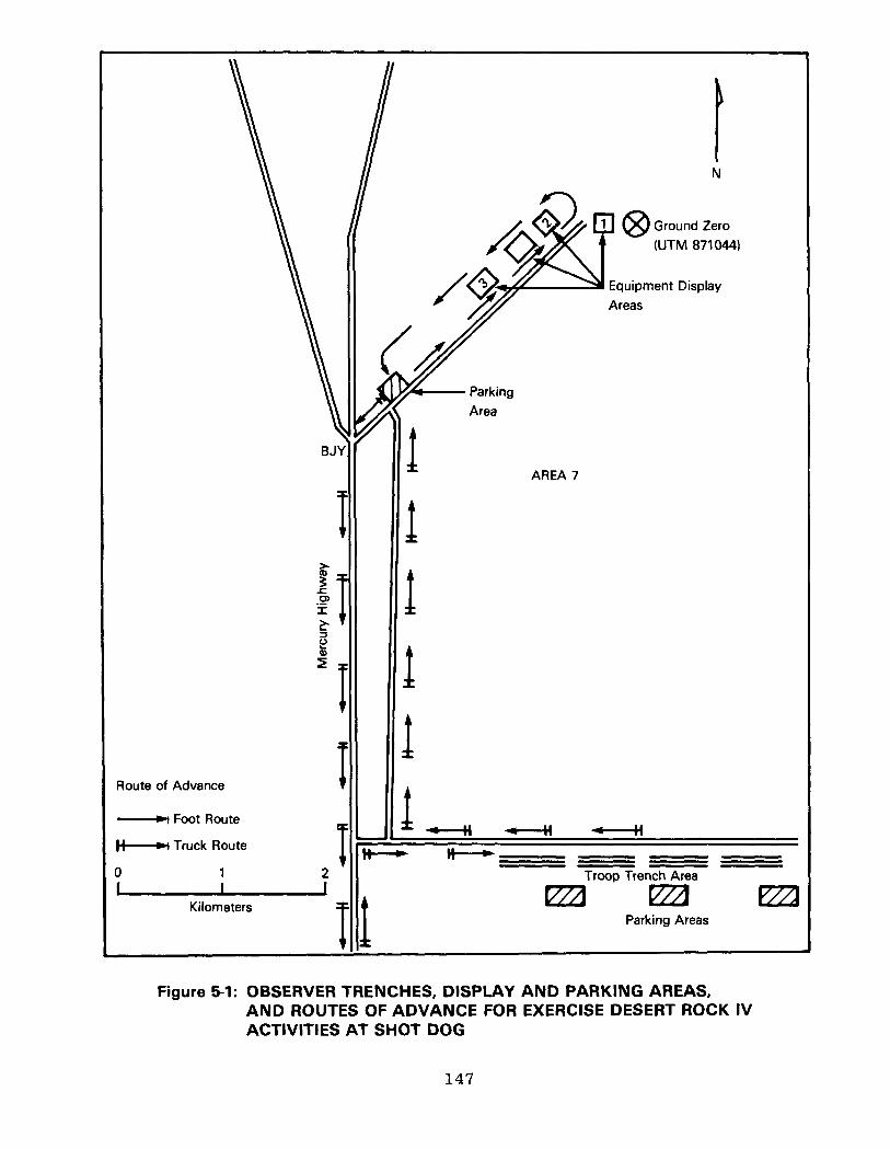
Ground Zero
(UTM 871044)
Equipment Display
- Parking
\\ Il./x Area
II A II AREA 7
Route of Advance
_) Foot Route
H-4 Truck Route
0 1 I I
Kilometers I
Troop Trench Area
eza eza m Parking Areas
Figure 5-1: OBSERVER TRENCHES, DISPLAY AND PARKING AREAS, AND ROUTES OF ADVANCE FOR EXERCISE DESERT ROCK IV ACTIVITIES AT SHOT DOG
147
27 April, they rehearsed their shot-day activities, including an inspection of the equipment display area. From 26 April to 29 April, the Instructor Group presented an orientation for the observers, who viewed films and attended lectures on the charac- teristics of a nuclear detonation and the procedures to follow during a detonation. When Shot DOG was postponed for 48 hours, the Instructor Group presented additional information to the observers (6; 7; 17; 70; 71; 75; 86-90).
At 0400 hours on 1 May, the observers left Camp Desert Rock for the trench area. The trenches were 6,400 meters south of
ground zero, at UTM coordinates 871983. After the observers arrived at the trench area at about 0630 hours, the Instructor Group conducted a preshot orientation. Ten minutes before shot- time, the observers were directed to enter the trenches.
About 90 minutes after the detonation, the observers began their trip by truck to the display areas shown in figure 5-l. The observers followed the same route as the maneuver troops, described in section 5.1.3. Following their tour of the display area, they returned to Camp Desert Rock (70; 71; 75; 85-87; 89; 90).
5.1.3 Tactical Troop Maneuver
An estimated 1,950 personnel from the Marine Corps Pro- visional Atomic Exercise Unit took part in the tactical maneuver at Shot DOG. This was the first Marine Corps maneuver of the continental nuclear weapons testing series. The objectives of the maneuver, as described by the Commandant of the Marine Corps, were to (87):
0 Provide realistic training for ground units when supported by tactical atomic weapons
a Provide realistic training in protective measures
148

0 Determine the type and amount of nuclear warfare indoctrination required for all personnel
0 Determine the psychological reactions of troops participating in the exercise.
In late March 1952, at Camp Pendleton, California, the Commanding General, Department of the Pacific, and Marine Corps staff officers began planning for Marine Corps participation in Exercise Desert Rock IV. On 31 March, the officers attended a Desert Rock IV planning conference with the Exercise Director and his staff at Camp Desert Rock, Nevada. Among other decisions, the conferees decided that a Marine Corps officer would serve as liaison between the Marine Corps and the Sixth Army to coordinate Desert Rock IV exercises.
During the same period, the Commanding General, Department of the Pacific, directed approximately 100 officers and enlisted men to report to Camp Pendleton, where they were organized into the Headquarters, Marine Corps Provisional Atomic Exercise Unit. This group was officially activated on 9 April 1952, to direct Marine Corps maneuvers at the Nevada Proving Ground.
Also in March 1952, the Marine Corps organized two provi- sional composite infantry battalions to participate in the maneuvers. The two battalions, each consisting of about 950 men, were the 1st Provisional Marine Battalion of Camp Pendleton, California, and the 2d Provisional Marine Battalion of Camp Lejeune, North Carolina. At the Nevada Proving Ground, the battalions became the maneuver units of the Marine Corps Provisional Atomic Exercise Unit (41; 43-45; 56; 70; 71; 88; 89).
The two battalions received instruction at their home stations concerning radiological safety procedures and the effects of a nuclear detonation. They were then airlifted to Camp Desert Rock, where the 1st Provisional Marine Battalion arrived on 23 April and the 2d Battalion on 24 April 1952.
149

On 25 April, the Marines completed modifications and equipment installations at the four display areas shown in figure 5-l. The display areas, located on approximately the same sites used at Shot CHARLIE, were west and southwest of ground zero at the following locations:
0 Display area 1, located about 270 to 370 meters from ground zero
0 Display area 2, located about 820 to 910 meters from ground zero
0 Display area 3, located about 1,550 to 1,600 meters from ground zero
0 Special display area (unnumbered), located about 1,190 meters from ground zero.
On 26 April, the troops completed their orientation program,
which included lectures on the maneuvers and on radiological monitoring techniques. A full rehearsal of the Marine exercise, scheduled for 26 April, was postponed until 27 April.
The Marine Corps Provisional Atomic Exercise Unit developed the troop maneuver according to the following scenario. An aggressor with overwhelming forces invaded an island called Yucca (Yucca Flat in the exercise) and pushed friendly forces into retreat. The aggressor then established a line of strong defensive positions which resisted breakthrough by friendly forces. To gain the offensive and penetrate enemy lines, friendly forces detonated Shot DOG. Three Marine divisions
landed on the southern end of Yucca Island and advanced to a position 6,400 meters from the two enemy divisions entrenched near the intended ground zero. After detonating DOG, friendly forces gained control of the island both on the ground and in the air.
Participants in the Marine Corps exercise wore utility uniforms with boots, steel helmets, and web belts with canteens
150

and first aid packets. Each Marine also wore a film badge and carried a protective mask and a rifle (70; 75; 85-87; 89; 90).
The Marine Corps Provisional Atomic Exercise Unit began the trip by truck convoy to the trench area at 0400 hours on 1 May 1952. The convoy reached the trenches one hour before the detonation. Figure 5-2 shows Marines assembling in the trench area before the shot (85; 90).
Beginning 45 minutes before the detonation, a Desert Rock instructor briefed and instructed the troops. Ten minutes before shot-time, he directed participants to enter their trenches and foxholes, which had also been used for the troop maneuver at Shot CHARLIE. Two minutes before shot-time, the instructor told participants to crouch and to remain below ground level until after the detonation. After the flash of light from the deto- nation, personnel were cleared to stand and view the fireball and Shot DOG cloud. Figure 5-3 shows Marines in the trench area watching the cloud (70; 75; 85-87; 89; 90).
While the troops remained at the trench area, the radio- logical safety party of the Marine Corps Provisional Atomic Exercise Unit accompanied AFSWP and Desert Rock monitoring teams
on the initial survey of the ground zero area. After the Test Manager announced recovery hour at 0951 hours, the Marines traveled by truck to the parking area northeast of the BJY. They formed company-sized units to tour display areas 2 and 3 on foot. Because of the radiation intensity, they could not inspect display area 1, nor could they launch an attack on ground zero. Marine Corps photographers, one of whom is shown in figure 5-4, took pictures of the damage in the display area (75; 88; 89).
The Marines then returned to the parking area near the BJY, where they were monitored, as shown in figure 5-5. They began
151

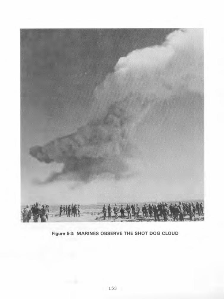
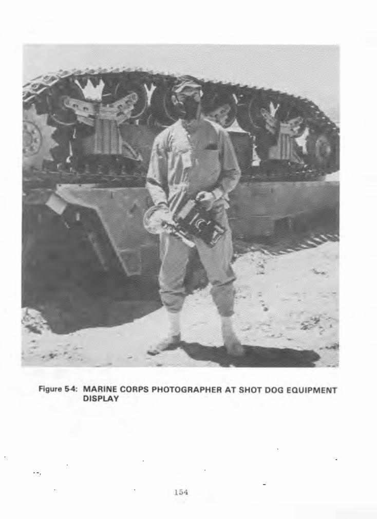


their return by truck to Camp Desert Rock at about 1350 hours. The convoy traveled south on Mercury Highway and reached Camp Desert Rock around 1530 hours. On arrival, participants were required to shower to reduce radiation intensities to background levels (71; 85; 95).
The day after the detonation, Marine participants prepared
to return to their home bases. By evening, all units had been transported either to Indian Springs AFB or to McCarran Field, Las Vegas, and had left for their destinations by Air Force or commercial aircraft (70; 75; 85-89).
5.2 DEPARTMENT OF DEFENSE PARTICIPATION IN SCIENTIFIC AND SUPPORT ACTIVITIES AT SHOT DOG
Department of Defense personnel took part in scientific and diagnostic experiments conducted by the Military Effects Test Group and the Weapons Development Test Group. Table 5-l lists the test group experiments and identifies the participating
agencies. In addition to the participants in test group experi- ments, Air Force Special Weapons Center personnel provided air support to the test groups and the Test Manager (17).
5.2.1 Military Effects Test Group Projects
Projects conducted by the Military Effects Test Group at Shot DOG were primarily designed to document blast pressures. Project participants spent several weeks before the detonation placing and calibrating pressure gauges and other instruments. These activities were completed by the day before the detonation. Figure 3-3 shows the instrument layout for Military Effects Test Group activities at Shots DOG, BAKER, and CHARLIE. Recovery operations began after the announcement of recovery hour at 0951 hours.
156

Table 5-1: TEST GROUP ACTIVITIES WITH DEPARTMENT OF DEFENSE PARTICIPATION, SHOT DOG
Project/ Program Title Participants
Military Effects Test Group
1.2
1.3 and 1.5
Air Pressure versus Time Stanford Research Institute
Free-air and Ground-level Pressure Measurements Naval Ordnance Laboratory
1.4 Air Blast Measurements
1.6 Ground Acceleration Measurements
1.7 Earth Acceleration versus Time
1.9 Pm-shock Dust
1.13 Measurement of Air Blast Pressure versus Time
2.1 Total Gamma Exposure versus Distance
2.3 Neutron Flux and Energy Measurements
3.1 Vulnerability of Parked Aircraft to Atomic Bombs
Ballistic Research Laboratories
Ballistic Research Laboratories
Stanford Research Institute
Army Chemical Center
David Taylor Model Basin
Signal Corps Engineering Laboratories
Naval Research Laboratory
Wright Air Development Center; Los Alamos Scientific Laboratory; Naval Radiological Defense Laboratory
3.3 Blast Damage to Trees - Isolated Conifers
3.4 Minefield Clearance
Forest Service, Department of Agriculture
Engineer Research and Development Laboratories
4.2
4.3
Biomedical Exposure Equipment
Biological Effectiveness of Neutron Radiation from Nuclear Weapons
Naval Medical Research Institute
Naval Radiological Defense Laboratory
4.4 Gamma Depth Dose Measurement in Unit Density Material
Naval Medical Research Institute
4.5 Flash Blindness Air Force School of Aviation Medicine; Air Training Command; Brooke Army Medical Center; Strategic Air Command
4.6
6.1
Time Course of Thermal Radiation as Measured by Burns in Pigs
Evaluation of Military Radiac Equipment
Naval Medical Research Institute; University of Rochester Atomic Energy Project
Bureau of Ships; Signal Corps Engineering Laboratories
6.4
6.5
Operational Tests of Radar and Photographic Techniques for IBDA
Decontamination of Aircraft
7.la Electromagnetic Effects from Atomic Explosions
Wright Air Development Center; Strategic Air Command
Wright Air Development Center; Naval Radiological Defense Laboratory
National Bureau of Standards; Air Force Cambridge Research Center; Air Weather Service; Geophysical Laboratory of the University of California at Los Angeles
7.lb Long Range Light Measurements EG&G; Headquarters, Air Force

Table 51: TEST GROUP ACTIVITIES WITH DEPARTMENT OF DEFENSE PARTICIPATION, SHOT DOG (Continued)
Project/ Program Title Participants
Military Effects Test Group (Continued)
7.2 Detection of Airborne Low-frequency Sound from Atomic Explosions
Headquarters, Air Force; Signal Corps Engineering Laboratories; National Bureau of Standards
7.3 Radiochemical and Physical Analysis of Atomic Bomb Debris
Headquarters, Air Force
7.4
8.1
8.2
Seismic Waves from A-Bombs Detonated over a Desert Valley
Effects of Atomic Explosions on Forest Fuels
Air Temperatures in the Vicinity of a Nuclear Detonation
Air Force 1809th Special Weapons Squadron; Coast and Geodetic Survey
Forest Service, Department of Agriculture
Naval Radiological Defense Laboratory
8.3
8.4
Thermal Radiation from a Nuclear Detonation
Atmospheric Transmission and Weather Measurements
Naval Radiological Defense Laboratory
Naval Material Laboratory
8.5
8.8
Incendiary Effects of Atomic Bomb Tests on Building Sections at Yucca Flat
Sound Velocity Changes near the Ground in the Vicinity of an Atomic Explosion
Forest Products Laboratory of the Forest Service
Naval Electronics Laboratory
9.1 Technical and Training Photography Naval Medical Research Institute; Air Force Lookout Mountain LaboratorY; Wright Air Development Center; 4925th Test Group (Atomic); SAC 5th and 28th Reconnaissance Technical Squadrons; Signal Corps Engineering Laboratories; Army Pictorial Service Division
9.2 Air Weather Service Participation Air Weather Service
9.4 Effects of Atomic Explosions on the ionosphere Signal Corps Engineering Laboratories: 9471 st Technical Service Unit
9.5 Electromagnetic Radiation over the Radio Spectrum Signal Corps Engineering l&oratories; from Nuclear Detonations I 9487th Technical Service Unit
Weapons Development Test Group
10.1 Measurement of Alpha Naval Research Laboratory
12.1 Technical Photography EGBG
12.lc Bhangmeter Mod ii EGbG
12.2a-d High-speed Photography EGbG; Los Alamos Scientific Laboratory
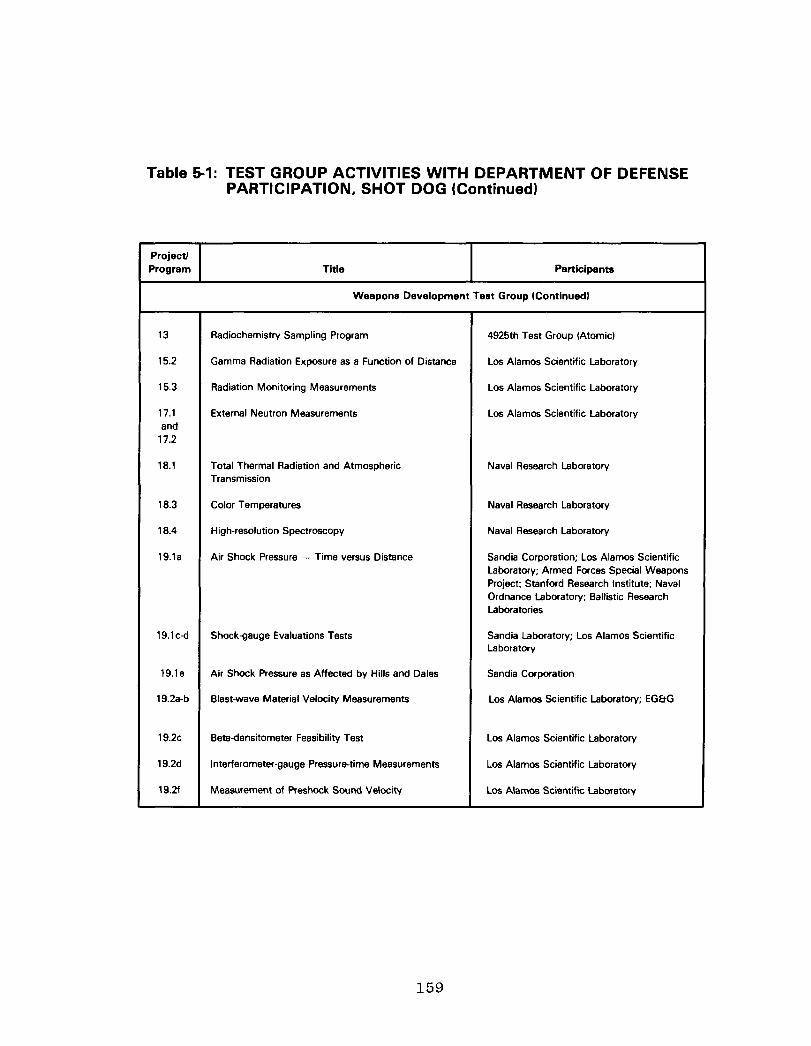
Table 5-1: TEST GROUP ACTIVITIES WITH DEPARTMENT OF DEFENSE PARTICIPATION, SHOT DOG (Continued)
Project/ Program Title Participants
Weapons Development Test Group Kontinued)
13
15.2
15.3
17.1 and
17.2
Radiochemistry Sampling Program 4925th Test Group (Atomic)
Gamma Radiation Exposure as a Function of Distance Los Alamos Scientific Laboratory
Radiation Monitoring Measurements Los Alamos Scientific Laboratory
External Neutron Measurements Los Alamos Scientific Laboratory
18.1 Total Thermal Radiation and Atmospheric Transmission
Naval Research Laboratory
18.3 Color Temperatures
18.4 High-resolution Spectroscopy
19.la Air Shock Pressure - Time versus Distance
Naval Research Laboratory
Naval Research Laboratory
Sandia Corporation; Los Alamos Scientific Laboratory; Armed Forces Special Weapons Project; Stanford Research Institute; Naval Ordnance Laboratory; Ballistic Research Laboratories
19.1 c-d Shock-gauge Evaluations Tests
19.le Air Shock Pressure as Affected by Hills and Dales
19.2a-b Blast-wave Material Velocity Measurements
19.2c Betadensitometer Feasibility Test
19.2d Interferometer-gauge Pressure-time Measurements
19.2f Measurement of Preshock Sound Velocity
Sandia Laboratory; Los Alamos Scientific Laboratory
Sandia Corporation
Los Alamos Scientific Laboratory; EG&G
Los Alamos Scientific Laboratory
Los Alamos Scientific Laboratory
Los Alamos Scientific Laboratory
159

Project 1.2, Air Pressure versus Time, was conducted by the Stanford Research Institute to collect data on the airblast produced by an airdropped nuclear device. At 2130 hours on the night before the detonation, four personnel checked blast gauges placed along the blast line from ground zero to 2,750 meters from ground zero. They spent up to eight hours performing this activity.
One hour after the area was opened for recovery operations, four personnel began collecting data from blast gauges 2,290 and 1,140 meters from ground zero. This operation took two hours.
Beginning at 0900 hours on the day after Shot DOG, about ten participants retrieved remaining gauges up to the 0.5 R/h line. They spent about six hours in the shot area (95; 102).
Projects 1.3 and 1.5, Free-air and Ground-level Pressure Measurements, were conducted as one project by the Naval Ordnance Laboratory. The objective was to measure pressures produced by a nuclear detonation at ground level and in free air (20).
Project 1.3 personnel installed gauges flush with the earth's surface to measure air pressure at ground level. The gauge readings were telemetered to a trailer 3,660 meters from
ground zero. Three hours after the announcement of recovery hour, two two-man teams began retrieving data from the trailer and gauges up to the 0.1 R/h line. They spent about two hours in these activities (20; 95).
Project 1.5 measured pressures in free air by photographing smoke rocket trails. At 1530 hours on the day before the detonation, six Project 1.5 personnel loaded rocket launchers 150 to 1,070 meters from ground zero. Their estimated working time was two hours. At shot-time, they launched the rockets remotely, and the rocket trails were photographed. Thirty minutes after the detonation, two project members accompanied the radiological
160

survey team into the target area. There, they disarmed and unloaded the unfired rockets at locations 920 to 1,070 meters from ground zero. At 0900 hours on the day after the detonation, six project participants removed rocket launchers, working up to the 0.5 R/h line (20; 95).
Project 1.4, Air Blast Measurements, was conducted by the Ballistic Research Laboratories to determine the shape and peak pressure of the shock wave generated near the ground from a nuclear device detonated high in the air. Before the shot, personnel installed instruments on lo- and 50-foot towers at
ground zero and at stations 460 and 920 meters from ground zero. Three hours after the declaration of recovery hour, personnel reentered the shot area and spent about 20 minutes collecting data from the stations for laboratory analysis (21; 95).
Project 1.6, Ground Acceleration Measurements, was conducted by the Ballistic Research Laboratories to obtain secondary ground acceleration measurements. Participants measured ground shock with accelerometers positioned at stations 80, 190, 410, 870, 1,320, 1,780, and 2,690 meters from ground zero. At 1530 hours on the day before the detonation, three project participants went to the stations to make a last-minute instrument check. They left the area within two hours. At about 0900 hours on the day after the detonation, four project personnel began recovering the accelerometers located in the stations along the blast line to the 0.5 R/h line. They completed this activity within six hours (60; 95).
Project 1.7, Earth Acceleration versus Time, was conducted by the Stanford Research Institute to measure the proportion of blast energy absorbed from the air by the earth. At 2130 hours on the night before the detonation, four personnel checked accelerometers placed along the instrument line from ground zero to 2,750 meters from ground zero. They spent up to eight hours in performing this activity (95; 103).
161

One hour after the area was opened for recovery operations, four project personnel began collecting data from accelerometers 2,290 and 1,140 meters from ground zero. This operation took two hours. Beginning at 0900 hours on the day after the detonation, about ten participants retrieved the remaining accelerometers up to the 0.5 R/h line. They spent about six hours in the shot area (95; 103).
Project 1.9, Pre-shock Dust, was conducted by the Chemical and Radiological Laboratories of the Army Chemical Center. The objective was to determine the concentration and distribution of the dust generated by the action of thermal radiation on the surface of the ground (27).
About four hours'before shot-time, personnel inspected instruments for collecting dust particles at seven stations: two were located 210 meters from ground zero, two located 420 meters from ground zero, and three located 870 meters from ground zero. The instruments, which included cascade impactors and filter
samplers, collected pre-shock dust particles generated during the brief period of time between the detonation and the arrival of the shock wave (27; 95).
Two hours after the announcement of recovery hour, two project personnel were scheduled to reenter the shot area and spend no more than one hour removing instruments from the sampling stations. They then took the equipment and dust particle samples to the Yucca Flat airstrip where, within four hours, each sample was packaged and placed aboard a courier air- craft for transport to the Army Chemical Center for analysis (27; 95). Section 5.2.3, on AFSWC activities during Shot DOG, discusses the courier flights.
Project 1.13, Measurement of Air Blast Pressure versus Time, was conducted by the David Taylor Model Basin. The project was
162

designed to provide blast pressure data for Program 3 agencies, particularly those participating in Project 3.1, Vulnerability of Parked Aircraft to Atomic Bombs (46).
Before the detonation, personnel calibrated and installed gauges at 16 Project 3.1 stations located 680 to 3,110 meters from ground zero. Four men made a final check of the gauges beginning at 2130 hours on the evening before the detonation and ending several hours before shot-time. After the announcement of recovery hour, five participants spent up to two hours retrieving the gauges. Seven other participants entered the shot area when radiation intensities had decreased to 0.5 R/h and spent up to two hours and 30 minutes collecting film from cameras 800 meters from ground zero (46; 95).
Project 2.1, Total Gamma Exposure versus Distance, was conducted by the Signal Corps Engineering Laboratories. The objective was to measure gamma radiation exposure as a function of distance by placing National Bureau of Standards film at go-meter intervals along a radial line 1,030 to 2,720 meters from the point of detonation.
Project personnel placed film packets in the shot area shortly before the burst. About two hours after the declaration of recovery hour, four men drove by truck into the area and began retrieving film packets located 460 to 1,830 meters from ground zero. They recovered the film farthest from ground zero and then worked their way toward ground zero. The time for this task was about four hours. Information from the film was eventually shared with personnel from Projects 1.13, 3.1, and 6.1; the Office, Chief of Army Field Forces; and the Marine Corps (81; 95).
Project 2.3, Neutron Flux and Energy Measurements, was performed by the Naval Research Laboratory to measure neutron flux and neutron dosimetry techniques. Before the shot,
163

personnel placed gold, sulphur, and tantalum neutron detectors at stations 390 to 1,890 meters from the intended ground zero. After the shot, two participants retrieved the instruments up to 550 meters from ground zero. They also assisted Project 17.1 personnel in recovery operations. The neutron detectors were taken to laboratories for analysis (66; 95).
Project 3.1, Vulnerability of Parked Aircraft to Atomic Bombs, was performed by the Wright Air Development Center and by personnel from LASL and the Naval Radiological Defense Labora- tory. The objective was to determine the effects of an airburst nuclear detonation on parked aircraft. The experiment was coordinated with Project 1.13, which provided airblast pressure data. The test aircraft included F-47s, B-17s, F-86s, an F-90, a B-45, and a B-29, which were displayed at three stations 900,
2,450, and 2,750 to 3,350 meters from ground zero. To compare the protection afforded by various defense structures, some of the aircraft were placed in revetments and behind walls, while others were positioned in the open (104).
Before the shot, personnel positioned the aircraft, aircraft components, and instruments. They then instrumented the aircraft with devices to measure blast, thermal, and radiation effects.
In addition, they photographed the aircraft and then installed motion picture cameras at a station 2,430 meters from ground zero.
At 1630 hours on the evening before the detonation, four men in a van began inspecting the aircraft. They left the shot area by 2230 hours. At 1730 hours, two men began checking instruments at the stations, a process that took about two hours. On shot-
day, four individuals in a jeep entered the shot area to inspect instruments. They left the area about three hours before the detonation.
164

After the declaration of recovery hour, 30 project personnel and three Project 9.1 photographers from Lookout Mountain Lab- oratory spent about four hours inspecting blast effects on the aircraft and photographing the damage. Thirteen other partici- pants spent approximately four hours recovering film from the stations. Seven additional personnel spent about four hours retrieving records from the stations. At about 0800 hours on the day after the detonation, 20 personnel in six vehicles entered the shot area to continue the inspection of the aircraft. Eight hours were needed for this task (95; 104).
Project 3.3, Blast Damage to Trees--Isolated Conifers, was conducted by the Forest Service, Department of Agriculture. The project was part of a research program aimed at determining the. effects of a nuclear blast on forests. This experiment, which
was confined to isolated coniferous trees, was designed to measure motion and strain on trees subject to a nuclear detonation (30).
Before the shot, project personnel placed four conifers, along with instruments to measure strain on the trees, at each of four stations on the Forest Service Line in Area 7. The stations were 1,520, 1,820, 2,130, and 2,440 meters from ground zero. The trees, approximately 50 feet high, were anchored in concrete.
At the declaration of recovery hour, eight project personnel and a photographer entered the shot area in a weapons carrier and
spent about three hours inspecting the trees and recovering the instruments. Six hours after the announcement of recovery hour, four other personnel entered the shot area in a weapons carrier and spent about two hours inspecting the trees (30; 95).
Project 3.4, Minefield Clearance, was performed by the Army Engineer Research and Development Laboratories to evaluate the practicality of using nuclear weapons to clear minefields.
165

Before the shot, personnel laid a minefield 15 meters wide, which extended approximately 90 to 1,830 meters from ground zero (101).
Two hours after the declaration of recovery hour, 12 project participants in two vehicles checked instruments at stations 910 and 1,830 meters from ground zero. At 0800 on the day after the detonation, 13 participants in two weapons carriers inspected
mines along the blast line to the 0.5 R/h area. In addition, they recovered the mines and instruments. These activities on the day after detonation took about eight hours (95; 101).
Project 4.2, Biomedical Exposure Equipment, was conducted by the Naval Medical Research Institute to measure blast, thermal, and radiation effects on animals. To measure exposure to direct airblast, personnel instrumented wood models of dogs with accelerometers and then placed them in containers fitted with pressure recorders. Before the detonation, they placed the containers 350, 490, 580, 850, and 1,310 meters from ground zero. About one hour after recovery hour, four project participants and two radiological safety monitors began recovering instruments from the containers, a process that took about two hours.
To measure thermal effects, project personnel placed swine
in instrumented containers at about 0400 hours on shot-day. They positioned the containers 1,060, 1,280, 1,550, and 2,400 meters
from ground zero. In addition, they loaded heat-sensitive film into cameras located 1,130, 1,340, and 1,620 meters from ground zero. They then left the shot area. After the declaration of recovery hour, they retrieved the animals, instruments, and film.
To measure radiation effects, participants placed dosimeters in mouse cages placed 90 to 1,680 meters from ground zero. They also positioned cameras 1,070, 1,220, and 1,370 meters from ground zero. After the area was opened for recovery operations, project personnel recovered dosimeters from the cages and film from the cameras (54; 95).
166

Project 4.3, Biological Effectiveness of Neutron Radiation
from Nuclear Weapons, was conducted by the Naval Radiological Defense Laboratory to study the biological effects of neutron
radiation on mice. At about 1900 hours the evening before the
detonation, eight participants in two weapons carriers began
placing approximately 30 mice in mouse cages at each field
station. They spent about one hour in this assignment. The
stations, which were shielded with lead, bismuth, or aluminum,
were approximately 780 to 1,330 meters from ground zero (35; 95).
After the area was opened for recovery operations, 12
participants spent about 30 minutes retrieving the mice. To
determine the effects of neutron radiation on the mice, project
participants performed a pathological examination of the animals
in the laboratory (35; 95).
Project 4.4, Gamma Depth Dose Measurement in Unit Density
Material, was performed by the Naval Medical Research Institute.
The experiment was designed to improve techniques used to eval-
uate biological effects of radiation on living tissue, partic-
ularly of the human body. To measure initial and residual gamma
doses, project participants placed dosimeters inside lucite spheres, which approximated the density of human tissue. Before
the detonation, personnel placed nine spheres on A-frames located about 1,140 to 1,690 meters south of ground zero. After recovery
hour was declared, seven personnel in a weapons carrier and a
pickup truck spent about one hour retrieving the spheres (36; 95).
Project 4.5, Flash Blindness, was conducted by the Air Force
School of Aviation Medicine, with assistance from the Air Train-
ing Command, SAC, and Brooke Army Medical Center. The project
was to determine how much the flash of a nuclear detonation
impairs night vision. The protection afforded by the use of
protective goggles was also evaluated (33; 38; 111).
167
Two hours before the shot, 27 personnel traveled by bus to a trailer near the Control Point at Yucca Pass, approximately 16 kilometers from the intended ground zero, to witness the deto- nation. Project procedure required participants to adapt their eyes to darkness by wearing dark goggles for 30 minutes and then by remaining in the darkened trailer for another 30 minutes before the detonation.
Along the side of the trailer were 12 portholes fitted with shutters for exposing the eyes of the test subjects to the nuclear flash. The shutters opened 48 milliseconds after the detonation and closed two seconds later. During the exposure, half of the subjects wore protective red goggles. After the exposure, participants were required to read lighted instruments to determine how soon after exposure a person could see well enough to perform assigned tasks. Various instruments were used to examine the subjects' vision after exposure (33; 38; 95; 111).
Project 4.6, Time Course of Thermal Radiation as Measured by Burns in Pigs, was conducted by the Naval Medical Research Institute and the University of Rochester Atomic Energy Project. The Naval Medical Research Institute provided equipment, while the Atomic Energy Project supplied the test animals and conducted the biological experiments. The project was designed to study the biological effects of thermal radiation on pigs (79).
On the day before the detonation, project personnel weighed
the pigs and inspected their skin for disease or injury. From five to three hours before the detonation, nine project partic- ipants transported the pigs to stations 1,070, 1,280, 1,550, and 2,370 meters from ground zero. After anesthetizing the pigs and placing them in containers, the men left the shot area.
About two hours after the detonation, four men in a truck began recovering the animals and inspecting their containers to
168

determine if they had functioned properly during the blast. They then transported the pigs by truck to an AEC laboratory for eval- uation of burns (79; 95).
Project 6.1, Evaluation of Military Radiac Equipment, was conducted by the Bureau of Ships and the Signal Corps Engineering Laboratories. The objective was to evaluate radiac survey and dose-alarm equipment, dosimeters, and the instruments and tech- niques used for rapid aerial surveys. Project 6.1 personnel furnished standard and experimental radiation survey meters to other projects in order to evaluate the meters (65; 107).
Project 6.4, Operational Tests of Radar and Photographic Techniques for IBDA, was conducted by the Wright Air Development Center, assisted by the Strategic Air Command. The 509th Bombardment Group of SAC provided three B-50D aircraft for a
postshot test of the IBDA system. The following listing summarizes flight times for the aircraft, which staged from Kirtland AFB:
AIRCRAFT DEPARTURE TIME LANDING TIME
B-50 0450 1058 B-50 0500 1125 B-50 0510 1035
Aircraft 1 and 2, simulating the drop aircraft which was flying at an altitude of 23,050 feet, flew at 20,800 and 20,300 feet, respectively, in a loose formation. Before the shot, both aircraft made 40-degree turns, aircraft 1 to the right and aircraft 2 to the left. The headings were held until ten seconds before shot-time. Aircraft 3, simulating an escort aircraft, was at 21,800 feet and five nautical miles behind the drop aircraft.
169

Aircraft 3 held the same heading for approximately 45 seconds
after shot-time and then turned to leave the area (26; 57).
Project 6.5, Decontamination of Aircraft, was conducted by
the Wright Air Development Center and by the Naval Radiological
Defense Laboratory. The project was designed to investigate methods of reducing the radiological exposure of maintenance and
flight crews.
To study adhesion of contamination to differently treated
surfaces, personnel treated various parts of four T-33 aircraft
with acid, polish, oil, or some combination of the three. These aircraft conducted the cloud sampling described in section 5.2.3.
Five personnel, wearing protective clothing, film badges, and pocket dosimeters, surveyed each aircraft immediately upon its
landing. Using AN/PDR-TlB instruments, they surveyed radiation
intensities at 32 locations on the aircraft before and after
decontamination. Aircraft were considered radiologically safe
when intensities were less than 0.02 R/h.
For another part of this project, personnel attempted to
decontaminate the engines of an F-84G cloud sampler and a T-33 without dismantling the engines. They sprayed the engines with
solvent, followed by steam and a fresh water rinse. They measured the radiation intensity at the turbines before and after
this process.
For the third part of this project, participants measured
radiation levels inside the cockpit of one of the T-33 aircraft
used in the first part of the project before and after decontami-
nation. With these measurements, they evaluated the contribu-
tions of various aircraft sections to exposure rates inside the
cockpit (110).
170

Project 7.la, Electromagnetic Effects from Atomic Explosions,
was conducted by the National Bureau of Standards, Air Force
Cambridge Research Center, Air Weather Service, and Geophysical
Laboratory of the University of California at Los Angeles. The
project was designed to study the electromagnetic pulses produced
by a nuclear detonation. Data were evaluated as a means of
determining the location of distant nuclear detonations. Onsite
stations were at Frenchman and Yucca Flats, and offsite stations
were in Colorado, Florida, Georgia, Massachusetts, New Mexico,
Virginia, Bermuda, Germany, and Puerto Rico (96).
Four hours before the detonation, two participants went to the primary station, located near the Control Point. They spent 30 minutes adjusting electrical equipment. Four hours after
recovery hour was announced, two participants recovered records
from a station eight kilometers south of ground zero (95; 96).
Project 7.lb, Long Range Light Measurements, was conducted entirely offsite by Edgerton, Germeshausen, and Grier, Inc., and
Headquarters, Air Force. The objective was to study the long-
range detection of light produced by a nuclear detonation. EG&G
and the Air Force established light-detecting stations in
Arizona, Idaho, Texas, and Washington. An estimated two EG8G
employees and ten Air Force personnel from the Sacramento Air Materiel Area, McClellan AFB, operated each station from about
six hours before to one hour after the detonation (55).
Project 7.2, Detection of Airborne Low-frequency Sound from
Atomic Explosions, was sponsored by Headquarters, Air Force, with
assistance from the Signal Corps Engineering Laboratories and the
National Bureau of Standards. The objective,, was to determine the
accuracy of long-range acoustic detection methods. The Signal
Corps Engineering Laboratories operated stations in Alaska, Hawaii, Kentucky, New Jersey, Texas, and Washington. The
National Bureau of Standards operated a station in Washington,
D.C. (97).
171

Project 7.3, Radiochemical and Physical Analysis of Atomic Bomb Debris, was conducted by Headquarters, Air Force. The project, which involved analysis of particulate and gaseous samples from the Shot DOG cloud, was conducted in conjunction with Program 13, Radiochemistry Sampling. Cloud sampling, performed by the 4925th Test Group (Atomic) of Kirtland AFB, is discussed in section 5.2.3 (57; 106).
Project 7.4, Seismic Waves from A-Bombs Detonated over a Desert Valley, was conducted by the Air Force 1009th Special Weapons Squadron and the Coast and Geodetic Survey. The objec- tive was to determine the seismic properties of the geological structure of the test area. Four hours after the announcement of recovery hour, two personnel recovered seismic records from stations 310 and 920 meters from ground zero. Recovery operations took about one hour (34; 95).
Project 8.1, Effects of Atomic Explosions on Forest Fuels, was performed by the Forest Service, Department of Agriculture, with assistance from Project 3.3 personnel. The objective was to determine the minimum thermal energies required to ignite common forest fuels, such as conifer needles, hardwood leaves, grass, and rotten wood. Other objectives were to (19):
0 Determine blast wave effect on the persistence of ignition
l Provide field data for laboratory tests
0 Provide information for possible offensive and defensive military operations in woodland areas and civilian defense activities in urban and rural areas.
From five to three hours before the detonation, seven project personnel arranged forest fuels in trays at stations located at various distances from ground zero. Personnel from the Los Alamos Graphic Arts Section photographed the fuel beds for documentary purposes both before and after the shot. In
172

addition, the Army Pictorial Service Division, Office of the Chief Signal Officer, installed three motion picture cameras to photograph the ignition and combustion of the fuel beds.
Thirty minutes after the detonation, six project personnel accompanied by a radiological survey party entered the shot area to obtain a moisture sample. About 20 minutes were required for the task. At 0800 hours on the day after the shot, five partic- ipants began recovering fuel samples, a procedure that took about eight hours (19; 95).
Project 8.2, Air Temperatures in the Vicinity of a Nuclear Detonation, was conducted by the Naval Radiological Defense Laboratory to determine the air temperature at various elevations and distances from ground zero. Before the shot, participants installed thermocouples at ground level and on steel towers of various heights. The towers were located at ground zero and at distances up to 2,740 meters from ground zero. At 1730 hours on the day before the detonation, two participants spent about ten
hours checking the thermal equipment along the blast line. At the declaration of recovery hour, two three-man crews entered instrument shelters 460 to 5,490 meters from ground zero to unload thermal detectors. Their working time was six hours. At
0900 hours on the day after the detonation, four personnel con- tinued recovering thermal detectors, working up to the 0.5 R/h line. The estimated time of this operation was six hours (28; 95).
Project 8.3, Thermal Radiation from a Nuclear Detonation, was conducted by Project 8.2 and 8.3 personnel from the Naval Radiological Defense Laboratory. The objective was to measure the total thermal radiation and the intensity-time relationship of the radiation as a function of distance from ground zero (29).
173

Before the shot, project participants placed several types of instruments in tower and ground stations located at various points out to 5,490 meters from ground zero. These instruments included calorimeters, photonic cells, passive receiver panels, and radiometers. Project 8.2 and 8.3 personnel at Kirtland AFB installed three disk calorimeters in the B-50 drop aircraft. On the day before the shot, two personnel and a member of the Radiological Safety Group, shown in figure 5-6, checked the instruments. They left the shot area six hours before the detonation.
After the announcement of recovery hour, two teams, each with three project personnel and a radiological safety monitor, drove by truck into the test area. They spent about six hours retrieving instruments 460 to 5,490 meters from ground zero. At about 0900 hours on the day after the shot, four personnel and a radiological safety monitor entered the shot area in two weapons carriers and took about six hours to recover the remaining instruments along the blast line up to ground zero. At 1400 hours, they were met by a photographer from Lookout Mountain Laboratory who photographed recovery operations. Personnel at Kirtland AFB removed the calorimeters from the B-50 drop aircraft (29; 95).
Project 8.4, Atmospheric Transmission and Weather Measure- ments, was conducted by the Naval Material Laboratory. The project was to provide meteorological data for use in thermal radiation projects and to supplement information supplied by Project 9.2, Air Weather Service Participation.
At various times during shot-day, project personnel measured barometric pressure, temperature, humidity, and rainfall. They worked from a station at BJY, where they received transmissions from two self-operating stations five kilometers to the north- west. They returned to the Control Point before the detonation.
174


After the declaration of recovery hour, project personnel began collecting data from the receiver station, a process that took about three hours. At 0800 hours on the day following the detonation, five project personnel went to the receiving station,
where they spent up to eight hours gathering data (53; 95).
Project 8.5, Incendiary Effects of Atomic Bomb Tests on
Building Sections at Yucca Flat, was performed by the Forest Products Laboratory of the Forest Service. The objective was to determine the probability of primary fires resulting from a nuclear detonation in urban areas. The types of structures tested were:
l Cubicle room 0 Right angle corner 0 Right angle corner 0 Roof section.
The items were constructed
between walls with cornice
and mounted to resist demolition by the blast so that the incendiary effects of the nuclear flash could be studied separately. Fifty-one of these structures were installed at stations 1,200 to 3,930 meters from ground zero (32).
Three Project 9.1 personnel from Lookout Mountain Laboratory took documentary photographs of the displays before and after the detonation. At the declaration of recovery hour, three partic- ipants in a weapons carrier started inspecting the displays, a process that took four hours. At 0800 hours on the day following the detonation, eight personnel began recovering the structures. This process took about eight hours (32; 95).
Project 8.6, Sound Velocity Changes near the Ground in the Vicinity of an Atomic Explosion, was conducted by the Navy Elec- tronics Laboratory. The objective was to determine the velocity of sound at heights of 1.5, 10, and 54 feet above ground zero and at various distances from ground zero, in the interval between
detonation and shock wave arrival (91).
176

Before the detonation, project personnel developed instru- ments to detect sound velocity changes near the ground during the shot. They installed the instruments at ground zero and at distances ranging from 90 to 3,810 meters from ground zero. Six hours before shot-time, four participants entered the shot area to make a final check of the equipment. They left approximately one hour later.
After the announcement of recovery hour, four personnel retrieved instruments 3,810 meters from ground zero, a process that took about two hours. At 0800 hours the next day, six personnel recovered instruments 70 to 1,780 meters from ground zero, to the 0.5 R/h line. They spent an estimated eight hours
in the shot area (91; 95).
Project 9.1, Technical and Training Photography, was conducted by personnel from the following agencies (57; 95):
Air Force Lookout Mountain Laboratory Army Pictorial Service Division Marine Corps Provisional Atomic Exercise Unit Naval Medical Research Institute Signal Corps Engineering Laboratories SAC 5th Reconnaissance Technical Squadron SAC 28th Reconnaissance Technical Squadron Wright Air Development Center 4925th Test Group (Atomic).
Personnel from these agencies photographed the detonation. At 2330 hours the evening before the shot, six participants spent about seven hours making final checks of their cameras. Three hours before the detonation, Lookout Mountain Laboratory person-
nel went to four stations: three near the Control Point and one about 11 kilometers from ground zero (95). Figure 5-7 shows a Lookout Mountain Laboratory participant photographing the fireball (4).
177


Lookout Mountain Laboratory personnel also photographed Shot
DOG from a C-47 aircraft. The C-47, which left Indian Springs
AFB at 0732 hours, was at an altitude of 10,000 feet, about 11
kilometers south of ground zero at shot-time. Participants
photographed the detonation and the resulting cloud formation
until 0839 hours, when they left the area. They reached Indian
Springs AFB at 0907 hours (57).
Project 9.1 personnel also took still photographs and motion
pictures of various Military Effects Test Group projects, such as
Projects 3.1 and 8.5. In addition, they performed the following
photography activities, which have not been linked to a specific
project.
At recovery hour, one Lookout Mountain Laboratory photog-
rapher and three other Project 9.1 participants began photo-
graphing along the blast line, up to the 10.0 R/h line. Their
working time was one hour. Meanwhile, eight personnel began
unloading cameras located 1,530 to 4,880 meters from ground zero,
an activity that took about four hours. At 0900 hours on the day
after the shot, four personnel from Project 9.1 removed photog-
raphy equipment from stations 1,530 to 4,880 meters from ground zero, along the blast line. Their working time was about two
hours (95).
Project 9.2, Air Weather Service Participation, involved
Air Force personnel who compiled data from various weather
stations at the NPG and offsite, prepared weather maps, and
briefed NPG officials on current and predicted weather
conditions. Participants were from the 6th Weather Squadron
(Mobile) of the 2059th Air Weather Wing, Tinker AFB, Oklahoma.
These personnel were deployed as follows (78):
0 Eight forecasters, 13 weather observers, and two equipment operators at the Control Point Weather Station near Yucca Pass
179
l Twelve airmen in the Rawinsonde Weather Observation Section at the Control Point and 11 airmen from that section at a station in Tonopah, Nevada
a Three airmen in the Pibal Weather Observation Section at Beatty, Caliente, Crystal Springs, Currant, and Warm Springs, Nevada, and St. George, Utah.
Before Shot DOG, project participants installed wind and humidity measuring instruments at two stations along the blast line 910 and 1,830 meters from ground zero. From eight to three hours before the detonation, two participants reentered the area hourly to check the instruments.
About four hours after the announcement of recovery hour, two participants began retrieving records from the two stations, a procedure that took two hours. At 0900 hours on the day after
the detonation, personnel reentered the shot area to complete recovery operations (78; 95).
Project 9.4, Effects of Atomic Explosions on the Ionosphere, was conducted by the Signal Corps Engineering Laboratories, with assistance from personnel of the 9471st Technical Service Unit. The objective was to obtain data on the effects of a nuclear
detonation on ionospheric radiowave propagation. Project personnel worked at transmitter and receiver stations, all but one of which were located offsite. The onsite transmitter was at Station 9.4, 910 meters north of the Control Point. Two other transmitters were at Mather AFB, Sacramento, California. The radio receiver stations were at the Navaho Ordnance Depot, Flagstaff, Arizona; White Sands Proving Ground, New Mexico; and Fort Sill, Oklahoma (49).
On the day before the shot, personnel practiced operating the transmitters and receivers. On shot-day, they operated instruments from one hour before to one hour after the deto-
nation. All information obtained at the stations was sent for analysis to the Signal Corps Engineering Laboratories (49; 95).
180

Project 9.5, Electromagnetic Radiation over the Radio Spectrum from Nuclear Detonations, was conducted by the Signal Corps Engineering Laboratories, with assistance from the 9467th Technical Service Unit, Electronic Warfare Center. The project was designed to determine the wave shape and amplitude of radio frequency energy emanating from a nuclear detonation. Personnel operated two stations 15 to 25 kilometers from ground zero during the detonation. In addition, project participants manned one station at White Sands Proving Ground in New Mexico and another at the Evans Signal Laboratory in Belmar, New Jersey (31; 95).
5.2.2 Weapons Development Test Group Activities
Although most of the Weapons Development Test Group projects were performed by scientific agencies under contract to the Atomic Energy Commission, some of the projects were conducted by DOD agencies. For example, the Naval Research Laboratory performed the experiments in Program 18, Thermal Measurements. Documentation is available for only three of the six projects in
this program. In addition, a few DOD personnel were assigned to LASL or to the Weapons Development Test Group to assist in the projects listed in table 5-l.
Project 10.1, Measurement of Alpha, was conducted by the Naval Research Laboratory. An hour after recovery hour, a party of five entered a station 460 meters from ground zero. They remained there the rest of the day working on instruments. Two
hours later, five participants spent about one hour recovering film at the same location (80; 95).
Project 12.1, Technical Photography, was conducted by
personnel from EGIG, with assistance from Navy personnel. They provided technical photography support, including dust studies, preshock turbulence studies, light absorption and mirage studies, fireball growth measurement, thermal effects studies, and other coverage required by the Weapons Development Test Group.
181

Two days before the shot, project personnel prepared the film at the Control Point Building. The afternoon before the shot, personnel loaded film into remote-controlled cameras located at various stations in the ground zero area. After the shot, EGIG personnel recovered the exposed film and processed some of it in the mobile unit set up in the Control Point area. The remaining film was flown to laboratories of Consolidated Film Industries in Hollywood, California, or in the city of Fort Lee, New Jersey, for processing (64).
Project 12.lc, Bhangmeter Mod II, was conducted by EGLG.
The objective was to evaluate and test a new bhangmeter. Project personnel installed these instruments for measuring the yield of a detonation at the Control Point and in the drop aircraft. Bhangmeter readings recorded at shot-time were analyzed after the shot (63).
Project 12.2a-d, High-speed Photography, was conducted by LASL and EGIG. The objectives were to study early fireball growth and obtain measurements correlating shock arrival time with the appearance of the fireball. Personnel mounted special cameras in a trailer about four kilometers from ground zero and retrieved the film for analysis after the detonation (59).
Program 13, Radiochemistry Sampling, involved cloud sampling conducted by personnel from the 4925th Test Group (Atomic). The
sampling missions are discussed in section 5.2.3, on AFSWC activ- ities at DOG (57).
Project 15.2, Gamma Radiation Exposure as a Function of Distance, was conducted by personnel from LASL. The objective was to measure gamma radiation exposure at various distances from the detonation. Project personnel placed gamma-detecting instru- ments in the ground at distances of 1,280 to 3,540 meters from ground zero. At recovery hour, personnel entered the shot area to recover the instruments (109).
182

Project 15.3, Radiation Monitoring Measurements, was
conducted by personnel from LASL. The objectives were to monitor
gamma radiation levels from the radioactive fallout after a
nuclear detonation and to test several prototype radiation
monitoring instruments for use at Operation IVY, scheduled for
the fall of 1952. The information on radiation levels was also
used by recovery parties. Project personnel installed recording
equipment in stations located about 685 and 915 meters northwest
of ground zero and 550 meters north of ground zero. The
recording equipment was set to telemeter information on gamma
radiation levels to the Control Point (83).
Projects 17.1 and 17.2, External Neutron Measurements, were
conducted by personnel from LASL. The objective of these proj-
ects was to use threshold detectors to measure external neutron
flux as a function of distance. LASL also loaned some threshold
detectors to the Naval Radiological Defense Laboratory for Proj-
ect 4.3 and to the Naval Research Laboratory for Project 2.3.
Personnel placed threshold detectors in the ground and on
stakes, at intervals of about 25 and 50 meters, out to about
3,660 meters from ground zero. Participants also installed an
underground shelter 1,220 meters from ground zero, which con-
tained oscilloscopes set to run automatically at shot-time. After the detonation, personnel recovered the threshold detectors
and the records from the underground shelter. AFSWC courier
aircraft transported the detectors to LASL for analysis (48).
Project 18.1, Total Thermal Radiation and Atmospheric
Transmission, was conducted by the Naval Research Laboratory to
obtain information on the transmission of light and thermal
radiation emitted by nuclear detonations of various yields. To
measure the transmission of light, personnel placed one photo-
electric brightness meter at the Control Point and another in
Area 2 of the NPG. In addition, they installed a transmissometer
183

near the BJY and a receiver at the Control Point. Participants manually operated the instruments at the Control Point during the shot. To obtain data on thermal radiation emissions, personnel installed four thermopile recorder systems and operated them from the Control Point during the shot. They shut down equipment after the shot to analyze recorded data (84).
Project 18.3, Color Temperatures, was conducted by the Naval Research Laboratory to measure the spectral characteristics of a nuclear fireball as a function of time. Measurements were taken with a high-speed spectrograph (61).
Project 18.4, High-resolution Spectroscopy, was conducted by the Naval Research Laboratory to supplement information obtained from spectroscopy measurements taken during previous nuclear weapons testing operations, such as GREENHOUSE and BUSTER-JANGLE. Personnel installed a spectrograph at the Control Point, 17 kilo- meters from ground zero (24).
Project 19.la, Air Shock Pressure --Time versus Distance, was conducted by the Sandia Corporation. Representatives of LASL, AFSWP, the Stanford Research Institute, the Naval Ordnance Laboratory, and the Ballistic Research Laboratories helped to plan this project. The objective was to obtain pressure measure- ments to use in determining the relationship between air shock pressure and height of burst. Personnel installed pressure gauges in the ground at points 230 to 3,500 meters from ground zero. They also placed gauges on towers of various heights located 460 to 1,370 meters from ground zero. At the instant of burst, information from the gauges was telemetered to a recording station where it was monitored by project personnel (93).
Projects 19.1~ and 19.ld, Shock-gauge Evaluations Tests, were conducted by Sandia Laboratory. Personnel from LASL and contractors assisted in calibrating and installing instruments.
184

The project was intended to develop and test new instruments for measuring dynamic and static pressures, wind directions, sound and wind speeds, and temperature rises resulting from a shock wave. Personnel installed instruments at two stations located 865 meters and 1,780 meters from ground zero. Cables connected the instruments to equipment that recorded the information (47).
Project 19.le, Air Shock Pressure as Affected by Hills and Dales, was conducted by personnel from Sandia Corporation and AEC contractors. The objective was to collect more information about the influence of hills and valleys on the shock waves from air- bursts and to study the shielding effects of hills. Project personnel installed gauges to record air shock pressure at six locations, ranging from 3,700 to 4,780 meters west of ground zero, in a line running over a hill. Cables connected the gauges
to recording equipment in a nearby mobile van. Sometime after the detonation, project participants recovered the records from the van (92).
projects 19.2a and 19.2b, Blast-wave Material Velocity Measurements, were conducted by LASL. An officer and six men from the Antiaircraft Artillery and Guided Missile Center, Fort Bliss, Texas, installed and maintained a 90-millimeter battery. EG&G provided photography services. The objective was to photo- graph peak overpressure phenomena associated with a nuclear burst. Smoke canisters were fired into the air from mortars and guns immediately before the burst so that the air disturbance would be visible.
Before the shot, personnel emplaced mortar units along a blast line extending about a thousand meters from ground zero and set up four 90-millimeter gun stations about 5.2 kilometers southwest of ground zero. These mortars and guns were fired by an electronic timing device. After the detonation, EGBG person- nel reentered the area to retrieve film from their electronically
operated camera stations (99).
185

Project 19.2c, Beta-densitometer Feasibility Test, was conducted by LASL with assistance from the Army. The objective was to test two types of densitometers and to measure air density as a function of time after a shock wave. The densitometers, connected to recording equipment, were installed in the ground near the DOG target area. They were set to start functioning upon receipt of an electronic timing signal. After the burst,
Personnel entered the area to recover instruments and records (99).
Project 19.2d, Interferometer-gauge Pressure-time Measure- ments, was conducted by LASL (99).
Project 19.2f, Measurement of Preshock Sound Velocity, was conducted by LASL with Air Force participation. The objective was to measure the velocity of sound in the air near the ground
before shock wave arrival. Project personnel installed oscillators and recording equipment at several stations about 1,090 meters from ground zero. After the detonation, personnel recovered the records from the instrument stations (99).
5.2.3 Air Force Special Weapons Center Activities
Besides airdropping the DOG device, AFSWC personnel conducted cloud sampling and sample courier missions for the test groups and cloud tracking and aerial radiological surveys of the terrain for the Test Manager. AFSWC also provided personnel to staff the Air Operations Center at the Control Point. In addition to the AFSWC participants, Air Force personnel included SAC observers who witnessed the detonation from airborne aircraft. Although the SAC observers were not part of AFSWC, they were under the operational control of AFSWC while over the NPG and are therefore discussed here (3-5; 57; 58; 100).
The following listing indicates the types and numbers of aircraft and the estimated numbers of personnel involved in air missions at Shot DOG (57; 58):
186

TITLE TYPE OF NUMBER OF NUMBER OF AIRCRAFT AIRCRAFT PERSONNEL
Airdrop Mission
Disaster Mission
Sampling Sampler Control Sampler Sampler Sampler
Sample Courier Service
B-45
c-47
B-29 B-29 T-33 F-84
B-25 c-47
Cloud Tracking B-25 B-29
Aerial Surveys of Terrain c-47 L-20
Observer Activities B-50
1
1
1 1 4 5
3 1
1 1
2 1
15
4
17
9 8 8 5
15 4
5 10
10 2
180
Airdrop and Disaster Missions
The B-45 drop aircraft, with a crew from the 4925th Test
Group (Atomic), left Kirtland AFB, New Mexico, at 0600 hours.
Climbing to an altitude of 23,050 feet, the aircraft entered a
bombing orbit over Yucca Flat. Just before 0830 hours, the B-45, flying a straight and level course, released the DOG device. The
bomb was off-target by 14 meters. The aircraft left the shot
area at 0832 hours, returning to Kirtland AFB at 0947 hours (3;
4; 57; 58; 76).
The C-47 disaster aircraft, with a crew from the 4901st
Support Wing (Atomic), left Kirtland AFB at about 0440 hours and
orbited over Las Vegas during the NPG bomb drop mission. The
aircraft began its return to Kirtland AFB at 0834 hours and
arrived at 1125 hours (3; 4; 57; 58; 76).
187

Cloud Sampling
One B-29, four T-33s, and five F-84s collected particulate and gaseous samples of the Shot DOG cloud for Project 7.3, Radio- chemical and Physical Analysis of Atomic Bomb Debris, and for Program 13, Radiochemistry Sampling. A B-29 sampler control aircraft, with an AFSWC aircrew and a LASL scientific advisor onboard, flew from Indian Springs AFB at 0720 hours but returned
to the base at 0920 hours because of radio receiver failure. The sampler control aircraft departed again at 0947 hours and directed the operations of the sampler aircraft. The samplers flew at altitudes of 16,500 to 42,500 feet and made up to 34 penetrations of the cloud. The following list details their activities (3; 4; 57; 58; 76):
TOTAL TOTAL TIME DOSIMETER
AIRCRAFT TYPE AND TAKEOFF IN CLOUD READING LANDING TAIL NUMBER TIME (seconds) (roentgens) TIME
Sampler Control B-29 0947
B-29 (386) 0730
T-33 (951) 0949
T-33 (048) 1004
T-33 (913) 1015
T-33 (920) 0920
F-84 (033) 1110
F-84 (051) 1115
F-84 (054) 1118
F-84 (043) 1120
F-84 (042) 1155
NR* 1.500
NR 1.600
NR 1.600
NR 1.750
95 0.600
42 0.075
500 0.075
NR 0.075
NR 0.075
NR 0.075
1150
1215
1040
1104
1155
NR
1210
1220
1153
1220
1208
*NR indicates not reported.
188

Upon completion of their mission, the samplers returned to
Indian Springs AFB and parked in the northeast corner of the
parking area. Pilots then shut down the engines. The crews of
the B-29s left the aircraft through the rear door between the
stabilizer and the wing. The crews of the T-33s and F-84s
disembarked by stepping onto a boarding ladder attached to the
side of the aircraft. The sample-removing team and radiological
safety monitors used long-handled tools to take samples from the
aircraft and place them in shielded containers. They also
removed the bottles containing the gaseous samples. They then loaded the sample containers onto courier aircraft for delivery
to laboratories for analysis (3; 4; 57; 58; 76).
Courier Missions
After the sampling missions had been completed, three B-25s
and one C-47 aircraft left Indian Springs AFB on shot-day to
transport samples and filter papers to various laboratories for
analysis. The 4901st Support Wing (Atomic) conducted these
courier missions (3; 4; 57; 58; 76).
At about 1130 hours, a B-25 flew from Indian Springs AFB to
McClellan AFB with Project 7.3 samples. Soon after, a C-47 flew
from Indian Springs AFB to LASL with Program 13 samples. At 1230
hours, a B-25 flew from Yucca Lake airstrip to LASL, via Kirtland AFB, with Project 17.1 samples. At 1330 hours, a B-25 flew from
Yucca Lake airstrip to Bolling AFB, Mitchell AFB, and the Army
Chemical Center with samples for Projects 1.9, 2.3, and 9.1,
respectively (3; 4; 57; 58; 76).
Cloud Tracking
Immediately after the detonation, one B-25 and one B-29 from
Indian Springs AFB flew cloud-tracking missions over and beyond
the Nevada Proving Ground. The B-25 (tail number 099) left
Indian Springs AFB at 0810 hours, tracked the cloud at heights
ranging from 7,000 to 12,000 feet above the terrain, and returned
189

to base at 1240 hours. The B-29 (tail number 774) flew from the
base at 0845 hours, tracked the cloud at heights up to 23,000
feet, and landed at Indian Springs AFB at 1347 hours (3; 4; 57;
58; 76).
Aerial Surveys of Terrain
After the detonation, two C-47 and one L-20 aircraft, all
based at Indian Springs AFB, conducted radiological surveys of
the terrain onsite and offsite. One C-47 (tail number 308) took
off at 1131 hours, flew at heights of 200 to 2,000 feet above the
terrain, and landed at 1656 hours. The other C-47 (tail number
380) left at 1155 hours, conducted its survey at 1,700 to 10,000
feet, and returned at 1620 hours. The L-20 (tail number 464)
took off at an undesignated time, conducted its survey at 1,000 to 1,500 feet, and landed at an undesignated time (3; 57).
Observer Activities
Fifteen B-50 aircraft from the Strategic Air Command partic-
ipated in an orientation and indoctrination exercise in nuclear
weapons effects. On shot-day, the B-50s with SAC observers
entered the Nevada Proving Ground airspace, possibly from Walker
AFB, between 0521 and 0749 hours. The aircraft remained in an
orbiting pattern through shot-time, so that the observers could
witness the detonation and subsequent cloud development. Between
0834 and 0836 hours, all aircraft left the test area for their base (3-5; 11; 57; 76; 100).
5.3 RADIATION PROTECTION AT SHOT DOG
The primary purpose of the radiation protection procedures
developed by Exercise Desert Rock IV, the test groups, and AFSWC
for Operation TUMBLERiSNAPPER was to keep individual exposure to
ionizing radiation to a minimum, while still allowing partici- pants to accomplish/their missions.
190

5.3.1 Desert Rock Radiation Protection Activities
For the maneuver conducted by the Marine Corps Provisional Atomic Exercise Unit, the Marine Corps devised plans and supplied personnel for radiation protection activities. The AFSWP Radiological Safety Group supervised the Marine Corps in these activities and also processed the film badges. Film badge readings are available for 25 of the Marines who participated in the exercise. The highest reading among these 25 film badges was 1.5 roentgens (51; 65; 70; 71; 85-87; 89).
Orientation and Briefing
Marine Corps and Navy participants at Shot DOG attended the indoctrination course conducted from 26 April to 1 May by members of the Instructor Group (75).
Dosimetry and Protective Equipment
The Radiological Safety Section of the Marine Corps Pro- visional Atomic Exercise Unit issued film badges and field protective masks to all participants in the Marine maneuver. At the indoctrination course, the instructors told the Marines to place their film badges in their left breast pocket, with the numbers of the badge facing outward from the body. In addition, they instructed participants in the proper use of their field protective masks. The masks were to be worn if directions were given to evacuate the area (75; 88; 89).
Monitoring
After the shot, four Marine Corps monitors accompanied AFSWP Radiological Safety Group and Camp Desert Rock monitors to the target area. Using AN/PDR-TlB meters, they marked the 10.0, 1.0, 0.5, 0.1, and 0.01 R/h lines. The 0.5 R/h line was the forward limit for maneuver personnel (75; 87; 89).
191
After the monitors had surveyed the target area and the AEC had declared the area safe to enter, troops and observers inspected the equipment displays. Two Marine Corps monitors accompanied each platoon, one preceding the platoon and recording radiation intensities, the other remaining with the group. The monitor who had recorded the radiation intensities at various locations transferred these records to the Marine Corps Provi- sional Atomic Exercise Unit upon return to Camp Desert Rock.
Because some radiation intensities within the equipment display area exceeded 0.5 R/h, the decision was made to inspect display area 1 (the display nearest ground zero) from a distance of 90 to 180 meters. Since display area 1 was 270 to 370 meters from ground zero, the troops did not advance closer than approx- imately 550 meters to ground zero (23; 75; 85-89).
Decontamination
In the parking area near the BJY, decontamination personnel brushed troops with brooms to remove contaminated dust. They then surveyed all personnel with AN/PDR-TlB meters. The Radia- tion Safety Officer, Marine Corps Provisional Atomic Exercise Unit, directed individuals whose contamination levels had not been reduced to lower than 0.01 R/h to take showers at the decon- tamination station at Yucca Pass. The participants, however, were well below the 0.01 R/h limit and were cleared for return to Camp Desert Rock. Personnel were required to shower and put on clean clothes upon their return to camp. Decontamination person- nel also monitored vehicles. They sent vehicles to the decon- tamination station if brushing could not reduce vehicle contamination to less than 0.01 R/h (75; 87; 89).
5.3.2 Joint AEC-DOD Radiation Protection Activities
Information concerning Shot DOG was obtained from the radiological safety report prepared by AFSWP (65). This document
192

includes data on radiological safety equipment, onsite and off- site monitoring procedures, and plotting and briefing activities.
Logistics and Materiel
During the period of 1 May to 6 May 1952, which covers the 1 May detonation of Shot DOG, the Logistics and Materiel Department issued about 440 film badges to AEC and DOD
participants in 19 programs and 78 projects. The Logistics and Materiel Department also issued 709 sets of-protective clothing and 252 radiation survey instruments (65).
Monitoring
Shot DOG was detonated in Area 7, at approximately the same location as Shots BAKER and CHARLIE. The initial ground survey team began recording radiation intens'ities at 0915 hours, about
45 minutes after the detonation, and concluded by 1056 hours. The survey team found that the radiation levels in the target area were much higher than those resulting from the previous shots in this test series. The 0.01 R/h radiation intensity line extended approximately 1.6 kilometers from ground zero. For the first time in Operation TUMBLER-SNAPPER, radiation levels exceed- ing the limits of the AN/PDR-TlB survey meter, which has a maximum range of 50 R/h, were encountered. An experimental instrument called a "Jasper," developed by the Army Signal Corps, was used to measure a level of approximately 300 R/h at ground zero one hour after the detonation. In order to keep the cumulative exposures of monitoring team members as low as possible, the 10.0 R/h radiation isointensity line was not established on shot-day but was computed from the results of subsequent surveys a'nd known decay factors. This marked the first time during Operation TUMBLER-SNAPPER that a 10.0 R/h line was delineated.
Because of the radiation levels, much recovery work was delayed until after 2 May. Each day thereafter, radiological
193
safety monitors were assigned to recovery parties until the area was declared open, ten days after the shot (65).
In addition to the ground survey teams, a helicopter team surveyed the ground zero area. Ninety minutes after the deto- nation, the helicopter survey team measured an intensity of 50 R/h, the limit of their survey instrument, 60 meters from ground zero at a height of 200 feet.
From eight to 13 two-man mobile teams participated in offsite monitoring. About six hours before the detonation, they left the test area for their assigned locations. The highest recorded intensity was 0.004 R/h in Glendale, Nevada, located about 135 kilometers east-southeast of the Control Point.
Two C-47 and one L-20 aircraft began aerial surveys of the offsite terrain shortly after the detonation. None of the aircraft encountered significant radiation intensities (65).
Plotting and Briefing
Ground monitoring teams provided survey data used in plotting isointensity contours. A copy of the initial survey plot is shown in figure 5-8. Copies of the isointensity maps
generated from resurveys are shown in figure 5-9 (65). The labels of the maps in the source document do not always reflect the range of survey times given in the tables of intensity readings that accompany the maps.
Decontamination
Information is not available on the numbers of personnel and vehicles decontaminated. Shot DOG, however, induced high levels of radioactivity in metallic equipment in the target area. In some cases, regular decontamination procedures did not suffi- ciently reduce the radioactivity of vehicles and equipment. The contaminated items were placed in a "hot park" to allow contami- nation to decay to predetermined safe levels (65).
194
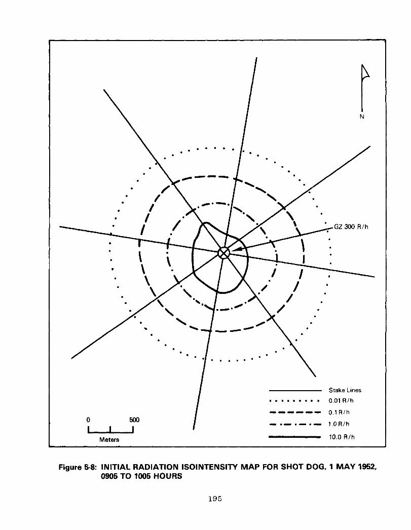
Meters
. . . . . . . . . 0.01 R/h
------ O.lR/h
- l - l - a- l.OR/h
10.0 R/h
Figure 5-8: INITIAL RADIATION ISOINTENSITY MAP FOR SHOT DOG, 1 MAY 1952, 0905 TO 1005 HOURS
195

Metas I
2 MAY 1952,‘0530 HOURS
4 MAY 1952,053O HOURS
Stake Lines . . . . . . . . l 0.01 A/h
------ 0.1 d/h
-.-.3.- 1.0 R/h
Figure 5-9: SUBSEQUENT RADIATION ISOINTENSITY MAPS FOR SHOT DOG
196

Dosimetry Data
Film badge records show that accumulated exposures increased markedly by the time Shot DOG activities were completed. Fifteen
AFSWP participants who were issued film badges during the period 1 to 6 May 1952 accumulated total exposures greater than 3.0 roentgens. Of these 15, two were radiological safety personnel (65).
197

198

SHOTS ABLE THROUGH DOG REFERENCE LIST
The following list of references represents only those documents cited in the ABLE through DOG volume. When a DNA-WT document is followed by an EX, the latest version has been cited. A complete list of documents reviewed during the preparation of the TUMBLER-SNAPPER reports is contained in the Operation TUMBLER- SNAPPER volume.
199

AVAILABILITY INFORMATION
An availability statement has been included at the end of the reference citation for those readers who wish to read or obtain copies of source documents. Availability statements were correct at the time the bibliography was prepared. It is anticipated that many of the documents marked unavailable may become available during the declassification review process. The Coordination and Information Center (CIC) and the National Technical Information Service (NTIS) will be provided future DNA-WT documents bearing an EX after the report number.
Source documents bearing an availability statement of CIC may be reviewed at the following address:
Department of Energy Coordination and Information Center (Operated by Reynolds Electrical 8 Engineering Co., Inc.) ATTN: Mr. Richard V. Nutley 2753 S. Highland P.O. Box 14100 Phone: (702) 734-3194 Las Vegas, Nevada 89114 FTS: 598-3194
Source documents bearing an availability statement of NTIS may be purchased from the National Technical Information Service. When ordering by mail or phone, please include both the price code and the NTIS number. The price code appears in parentheses before the NTIS order number.
National Technical Information Service 5285 Port Royal Road Phone: (703) 487-4650 Springfield, Virginia 22161 (Sales Office)
Additional ordering information or assistance may be obtained by writing to the NTIS, Attention: Customer Service, or by calling (703) 487-4660.
200

SHOTS ABLE THROUGH DOG REFERENCE LIST
1.
2.
3.
4.
5.
6.
7.
8.
301st Signal Photo Company. Morning Reports for 11 April 1952 and 5 May 1952. Camp Gordon, GA.: Third US Army. 1952. 3 Pages.***
504th Airborne Infantry Regiment, 2nd Battalion, Headquarters and Headquarters Company. Extracts from Morning Reports for 22 and 24 April 1952. Third US Army. Fort Bragg, NC.: 83rd Airborne Division. 1952. 2 Pages.***
Air
Air
Air
Air
Force Special Weapons Center, Historical Division. History of the Air Force Special Weapons Center in Operation TUMBLER-SNAPPER, April-June. Vol. I: *Narrative Account." Kirtland AFB, NM.: AFSWC. January 1953. 204 Pages.***
Force Special Weapons Center, Historical Division. History of the Air Force Special Weapons Center in Operation TUMBLER-SNAPPER. Vol. II: "Pictorial Account." Kirtland AFB, NM.: AFSWC. January 1953. 66 Pages.***
Force Special Weapons Center, SWO. D/F to Adjutant General Command Historian, Subject: Aircraft Participation in TUMBLER-SNAPPER. Kirtland AFB, NM.: AFSWC, Special Weapons Office. 9 June 1952. 43 Pages.**
War College. Memorandum for Commandant, Air War College. Subject: Report of Official Observers Attending Shot 4. Maxwell AFB, AL.: Air War College. 22 May 1952. 2 Pages.***
Anonymous. [File, Subject: Desert Rock Exercise IV, January 1952 to December 1953.1 Washington, D.C.: US Marine Corps. 1953. 100 Pages.
Anonymous. [Correspondence File, Subject: Rad Safety for Troops, from AEC; AFSWP; D/A, G-3.1 April 1952. 12 Pages.**
*Available from NTIS; order number appears before the asterisk. **Available at CIC.
***Not available, see Availability Information page. ****Requests subject to Privacy Act restrictions.
201

9.
10.
11.
12.
13.
14.
15.
16.
17. Armed Forces Special Weapons Project, Test Command. "Weekly Activities Summary, Period Ending 9 May 1952." Mercury, NV.: TC, AFSWP. 9 May 1952. 6 Pages.***
18. DELETED.
Armed Forces Special Weapons Project. Memorandum for Commanding Officer Tinker AFB, Subject: Official Observers at Operation TUMBLER-SNAPPER. Washington, D.C. 16 April 1952. 2 Pages.***
Armed Forces Special Weapons Project. "Operation TUMBLER Preliminary Report, Parts One and Two." Washington, D.C.: AFSWP. 15 May 1952. 101 Pages.**
Armed Forces Special Weapons Project, Test Command. Letter to Test Director; Nevada Proving Grounds, Subject: SAC Participation in Operation TUMBLER/SNAPPER, w/l incl: Outline of SAC Participation. Mercury, NV. 27 March 1951. 3 Pages.**
Armed Forces Special Weapons Project, Test Command. "Operations Plan l-52 (TUMBLER-SNAPPER)." Albuquerque, NM.: Test Command, AFSWP. 17 March 1952. 104 Pages.**
Armed Forces Special Weapons Project, Test Command. "Weekly Activities Summary, Period Ending 18 March 1952." Mercury, NV.: TC, AFSWP. 18 March 1952. 35 Pages.***
Armed Forces Special Weapons Project [Test Command]. "Weekly Activities Summary, Period Ending 28 March 1952." Washington, D.C.: AFSWP. 28 March 1952. 3 Pages.***
Armed Forces Special Weapons Project, Test Command. "Weekly Activities Summary for Period Ending 4 April 1952." Mercury, NV.: TC, AFSWP. 4 April 1952. 20 Pages.***
Armed Forces Special Weapons Project, Test Command. "Weekly Activities Summary, Period Ending 25 April 1952." Mercury, NV.: TC, AFSWP. 25 April 1952. 15 Pages.***
*Available from NTIS; order number appears before the asterisk.
**Available at CIC. ***Not available, see Availability Information page.
****Requests subject to Privacy Act restrictions.
202

19.
20.
21.
22.
23.
24.
25.
26.
27.
Arnold, Keith. "Effects of Atomic Explosions on Forest Fuels, Project 8.1." Washington, D.C.: AFSWP. WT-506. 1952. 35 Pages.***
Aronson, C. J.; Moulton, J. F.; Petes, J.; et al. Free-Air and Ground-Level Pressures Measurements, projects 1.3 and 1.5. Washington, D.C.: Headquarters, AFSWP. WT-513-EX. March 1980. 254 Pages. (All) AD/A995 029.*
Ballistic Research Laboratories. "Air Blast Measurements, Project 1.4." Washington, D.C.: AFSWP. WT-515. December 1952. 75 Pages. (A04) AD/A078 547.*
Banet, L.; Grinoch, P.; Hirschman, A.; Monahan, T. "Thermal Radiation Measurements Using Passive Indicators, Project 8.3a.l' Washington, D.C.: AFSWP. WT-544. February 1953. 23 Pages. (A02) AD/B951 586.*
Banks, C. E., LTC, USA. "Final Report --TUMBLER/SNAPPER Desert Rock, Liaison Section J-3, Test Command, AFSWP." w/o 3 incls. Mercury, NV.: Test Command, AFSWP. 2 June 1953. 10 Pages.**
Beck, C. A.; Campbell, J. H. "High Resolution Spectroscopy, Project 18.4." Washington, D.C.: Naval Research Laboratory. WT-571. April 1955. 28 Pages.***
Billingsley, S. G.; Balloch, J. C.; Hausrath, A. H. Reactions of Troops in Atomic Maneuvers, Exercise besert Rock IV. Chevy Chase, MD.: Operations Research Office. ORO-T-240. July 1953. 116 Pages. (A06) AD 026 280.*
Boone, H. F., Lt. Col., USAF. "Operational Tests of Radar and Photographic Techniques for IBDA, Operation SNAPPER, Project 6.4." Washington, D.C.: AFSWP. WT-534. August 1952. 54 Pages. (A04) AD/A080 269.*
Bouton, E. H.; Elder, C. S.;, Kemper, J. S.; Wilsey, E. Pre-shock Dust, Project 1.9. Washington, D.C.: AFSW (A,,~*AD,~:7?~~9~*
October 1952. 95 Pages.
*Available from NTIS; order number appears before the asterisk. **Available at CIC.
***Not available, see Availability Information page. ****Requests subject to Privacy Act restrictions.
203

28. Broida, T. R.; Broido, A.; Willoughby, A. B. Air Temperatures in the Vicinity of a Nuclear Detonation, Project 8.2. Washington, D.C.: AFSWP. WT-542. 1 September 1952. 83 Pages. (A05) AD 483 422.*
29. Broido, A.; Butler, C. P.; Day, R. P.; et al. Thermal Radiation from a Nuclear Detonation, Project 8.3. Washington, D.C.: AFSWP. WT-543. March 1953. 109 Pages. (A06) AD/B951 585.*
30. Brown, A. A.; Arnold, R. K.; Fons, W. L.; et al. "Blast Damage to Trees--Isolated Conifers--Project 3.3." Washington, D.C.: AFSWP. WT-509. January 1953. 69 Pages.***
31. Brown, P.; Carp, G.; Castellini, N.; et al. Electro- magnetic Radiation over the Radio Spectrum from Nuclear Detonations, Project 9.5. Washington, D.C.: AFSWP. WT-548. June 1953. 82 Pages.***
32. Bruce, H. D. "Incendiary Effects of Atomic Bomb Tests on Building Sections at Yucca Flat, Project 8.5." Washington, D.C.: AFSWP. WT-510. October 1952. 61 Pages.***
33. Byrnes, V. A. "Flash Blindness, Project 4.5." Washington, D.C.: AFSWP. WT-530. March 1953. 33 Pages. (A03) AD/A078 548.*
34. Carder, D. S. "Seismic Waves from A-Bombs Detonated over a Desert Valley, Operation SNAPPER, Project 7.4." Washington, D.C.: AFSWP. WT-541. February 1953. 53 Pages.***
35. Carter, R. E.; et al. The Biological Effectiveness of Neutron Radiation from Nuclear Weapons, Project 4.3. Washington, D.C.: Defense Nuclear Agency. WT-528-EX. February 1980. 90 Pages. (A05) AD/A995 016.*
36. Chambers, F. W., Jr. "Gamma Depth Dose Measurement in Unit Density Material, Project 4.4." Washington, D.C.: AFSWP. WT-529. February 1953. 43 Pages. (A03) AD/B950 689.*
*Available from NTIS; order number appears before the asterisk. **Available at CIC.
***Not available, see Availability Information page. ****Requests subject to Privacy Act restrictions.
204

37.
38.
39.
40.
41.
42.
43.
44.
45.
Chief of Army Field Forces. Letter to Commanding General, Sixth Army, Subject: Desert Rock IV w/incl: Directive for Exercise Desert Rock IV. Fort Monroe, VA. ATTNG-43354/115. 19 March 1952. 11 Pages.**
Clark, J. C. Letter to COL. Kenner Hertford, USA, Director Office of Test Operations, SFOO, Subject: Project 4.5, w/attachment. 5 March 1952. 3 Pages.**
Clark, J. C. Deputy Test Director, [Summaries of Shots l-3, 5, and 7.1 1952. 20 Pages.**
Commandant, Army War College. Memorandum for Officers Concerned, Subject: Observers, Desert Rock IV, with Objectives of Shot CHARLIE. Carlisle Barracks, PA. 15 April 1952. 7 Pages.**
Commandant, Marine Corps. Memorandum to Distribution, Subject: Marine Corps Troop Participation at Operation SNAPPER: w/l incl. Washington, D.C.: USMC. 12 March 1952. 5 Pages.***
Commanding General, Camp Desert Rock. Message to Distribution, Subject: Military Participation in Operation TUMBLER-SNAPPER. Camp Desert Rock, NM.: Hqs., Camp Desert Rock. 1952. 2 Pages. AMCDR-ADR 04-23.***
Commanding General, Department of the Pacific. Memorandum for Commandant of the Marine Corps, Subject: Report on Marine Corps Participation in Exercise Desert Rock IV. San Francisco, CA. 29 May 1952. 3 Pages.***
Commanding General, Department of the Pacific. Memorandum for Commanding General, Marine Corps Provisional Exercise Unit, Subject: Exercise Desert Rock IV,. San Francisco, CA. 4 April 1952. 4 Pages.***
Commanding General, Department of the Pacific. Memorandum for Commanding General, Marine Corps Provisional Exercise Unit, Subject: MC Participation in SNAPPER, San Francisco, CA.: USMC, FMF, DP. 7 April 1952. 4 Pages.***
*Available from NTIS; order number appears before the asterisk. **Available at CIC.
***Not available, see Availability Information page. ****Requests subject to Privacy Act restrictions.
205

46. Cook, G. W.; Benjamin, V. E. Measurement of Air Blast Pressure vs. Time, Project 1.13. Washington, D.C.: AFSWP. WT-521. March 1953. 71 Pages. (A04) AD/A078 546.*
47. Cook, Thomas B., Jr.; Kammermeyer, Karl. Sandia Laboratory Shock-Gauge Evaluations Tests, Projects 19.lc and 19.ld (U). Sandia Corporation. Washington, D.C.: AFSWP. WT-505. October 1952. 103 Pages.***
48. Cowan, C. L. (ed). External Neutron Measurements Project 17.1 and 17.2 (U). Los Alamos Scientffic Laboratory. Washington, D.C.: AFSWP. WT-555-EX. January 1979. 79 Pages. (A05) AD/B951 747.*
49. Daniels, F. B.; Harris, A. K. "Effects of Atomic Explosions on the Ionosphere, Project 9.4." Washington, D.C.: AFSWP. WT-547. January 1953. 69 Pages.***
50. Dean, Gordon, Chairman, Atomic Energy Commission. Letter to BGEN. H. B. Loper, Chief, AFSWP, Subject: Troop Participation in Operation TUMBLER-SNAPPER. Washington, D.C. April 2, 1952. 4 Pages.**
51. Defense Nuclear Agency. "Personnel Exposed to Radiation from Atmospheric Nuclear Tests (File C)." Computer Magnetic Tape: TUMBLER-SNAPPER. Washington, D.C.: DNA. HDNA 609-03. June 1982.****
52. Department of Energy, Office of Public Affairs; Los Alamos Scientific Laboratory; Lawrence Livermore Laboratory; Sandia Laboratories. "Announced United States Nuclear Tests, July 1945 through 1979." [Mercury, NV.]: Nevada Operations Office. NVO-209. January 1980. 38 Pages.
53.
54.
Derksen, W. L.; Bates, J. J.; Murtha, T. D.; et al. "Atmospheric Transmission and Weather Measurements, Project 8.4." Washington, D.C.: AFSWP. WT-545. January 1953. 45 Pages. (A02) AD 460 278.*
Draeger, R. H.; Either, M.; Ely, T. S.; et al. "Biomedical Exposure Equipment, Project 4.2." Washington, D.C.: AFSWP. WT-527. December 1952. 81 Pages. (A05) AD/A078 564.*
*Available from NTIS; order number appears before the asterisk. **Available at CIC.
***Not available,- see Availability Information page. ****Requests subject to Privacy Act restrictions.
206

55.
56.
57.
58.
59.
60.
61.
62.
63.
64.
Edgerton, Germeshausen and Grier, Inc. "Long Range Light Measurements for AFOAT-1, Project 7.lb." Washington, D.C.: AFSWP. WT-538. March 1953. 51 Pages.***
Eighth Marine Motor Transport Battalion. Temporary Additional Duty Orders. Camp Lejeune, NC.: Hqs., Camp Lejeune. 9 April 1952. 3 Pages.***
Fackler, P. H. Technical Air Operations, Operation TUMBLER-SNAPPER. Kirtland AFB, NM.: AFSWC. January 1953. 184 Pages.***
Fackler, P. H. Interview with Col. Paul H. Fackler, USAF (Ret.), Former Air Operations Officer, 4925th Test Group, Subject: CONUS Tests. McLean, VA. April 22, 1981.***
Felt, G. L.; et al. "High-Speed Photography -- Project 12.2a to d (U)." Los Alamos Scientific Laboratory. Washington, D. C.: AFSWP. WT-563. September 1952. 41 Pages.***
Fischer, J. S.; Reisler, R. E. "Ground Acceleration Measurements, Project 1.6." Washington, D.C.: AFSWP. WT-516. January 1953. 51 Pages. (A04) AD 483 928.*
Fussell, W. B. "Color Temperatures at Operation TUMBLER-SNAPPER, Project 18.3." Washington, D.C.: Naval Research Laboratory. NRL 4615. August 1955. 18 Pages.***
General Electric Company--TEMPO. Compilation of Local Fallout Data from Test Detonations 1945-1962. Vol. 1: Continental US Tests. Washington, D.C.: Defense Nuclear Agency. DNA 1251-l-EX. 1979. 619 Pages. (A99) AD/A079 309.*
Grier, Herbert E. and Staff. "Bhangmeter MOD II (U)." Edgerton, Germeshausen & Grier, Inc. Washington, D.C.: AFSWP. WT-562. January 1953. 15 Pages. Secret.***
Grier, Herbert E. Technical Photography, Operation TUMBLER-SNAPPER Project 12.1. Edgerton, Germeshausen & Grier. Inc. AFSWP. WT-569. April 1954.
Washington, D.C.: 155 Pages. -(AOS) AD/A995 066.*
*Available from NTIS; order number appears before the asterisk. **Available at CIC.
***Not available, see Availability Information page. ****Requests subject to Privacy Act restrictions.
207

65.
66.
67.
68.
69.
70.
71.
72.
73.
74.
Gwynn, P. S., Lt. Col., USAF. Radiological Safety, Operation TUMBLER-SNAPPER. Washington, D.C.: AFSWP. WT-558-EX. February 1980. 334 Pages. (A15) AD/A995 071.*
Hanscome, T. D.; Willett, D. K.; Mali&, C. W.; et al. "Neutron Flux Measurements, Project 2.3." Washington, D.C.: AFSWP. WT-524-EX. February 1980. 53 Pages. (A04) AD/A995 033.*
DELETED.
Headquarters, Camp Desert Rock. Letter to Commanding General, 140th Fighter Bomber Wing, Subject: Commendation; w/6 incls. Camp Desert Rock, NV. 26 April 1952. 8 Pages.**
Headquarters, Exercise Desert Rock IV. Operation Order #3, Exercise Desert Rock IV, Annex 3 (Personnel and Vehicles). Las Vegas, NV.: Headquarters, Camp Desert Rock. 17 April 1952. 46 Pages.**
Headquarters, Exercise Desert Rock IV. Operation Order Number 4, Exercise Desert Rock IV, w/Annex 3. Camp Desert Rock, NV.: Hqs., Camp Desert Rock. April 1952. 7 Pages.**
Headquarters, Fleet Marine Force, Atlantic. Desert Rock IV, Operation Order 6-52, Revised. Norfolk, VA.: Hqs., FMF, Atlantic. 14 April 1952. 10 Pages.**
Headquarters, Ninth Air Force. Letter to Commanding General, 140th Fighter-Bomber Wing, (Clovis AFB) Subject: Unit Participation in Operation SNAPPER. Pope AFB, NC. 26 March 1952. 1 Page.**
Headquarters, Sixth Army. [Desert Rock IV Letter of Instruction No. 1, w/7 incls.] Presidio of San Francisco, CA.: Sixth US Army. 19 March 1952. 14 Pages. AMGCT-4 354.2. **
DELETED.
*Available from NTIS; order number appears before the asterisk. **Available at CIC.
***Not available, see Availability Information page. ****Requests subject to Privacy Act restrictions.
208

75.
76.
77.
78.
79.
80.
81.
82.
83.
Headquarters, Sixth Army. Exercise Desert Rock IV: April-June 1952. Presidio of San Francisco, CA.: Sixth US Army. 1952. 236 Pages. (All) AD/A078 565.*
Headquarters, Special Weapons Command. Extracts from: "Operations Plan 2-52: Operation TUMBLER-SNAPPER." Kirtland AFB, NM.: AFSWC. 26 February 1952. 51 Pages.**
Human Resources Research Office. Desert Rock IV: Reactions of an Armoured Infantry Battalion to an Atomic Bomb Maneuver. Washington, D.C.: HumRRO. TR-2. August 1953. 225 Pages. (AlO) AD 016 451.*
Karstens, E. H., Lt. Col., USAF; Dyer, Co L., Jr., S/Sgt, USAF. Air Weather Service Participation, Project 9.2. Washington, D.C.: AFSWP. WT-508. March 1953. 77 Pages. (A05) AD/A995 045.*
Kingsley, H. D.; Schloerb, P. R.; Murden, C. H. "The Time-Course of Thermal Radiation as Measured by Burns in Pigs, Project 4.6." Washington, D.C.: AFSWP. WT-531. March 1953. 49 Pages.***
Krause, E. H.; and Staff. Measurement of Alpha and Transit Time, Projects 10.1 and 11.1. Washington, D.C.: Naval Research Laboratory. WT-554. November 1952. 181 Pages.***
Larrick, R. G.; Fuller, E. J.; Smith, L. J.; et al. "Total Gamma Exposure vs. Distance, Project 2.1." Washington, D.C.: AFSWP. WT-522. September 1952. 45 Pages. (A03) AD/A077 502.*
Lawrence, Henry W., Lt. Col., USAF. Report of Participation in Exercise Desert Rock IV, w/o incls. Clovis AFB, NM.: 140th Fighter-Bomber Wing, Office of Adjutant. 1952. 4 Pages.**
Mailik, John S. "Radiation Monitoring Measurements, Project 15.3 (U)." Los Alamos Scientific Laboratory. Washington, D.C.: AFSWP. WT-507. June 1952. 18 Pages.***
*Available from NTIS; order number appears before the asterisk. **Available at CIC.
***Not available, see Availability Information page. ****Requests subject to Privacy Act restrictions.
209
84.
85.
86.
87.
88.
89.
90.
91.
92.
93.
Man, E. hi., Jr. "Total Thermal Radiation and Atmospheric Transmission, Project 18.1." Washington, D. C.: Naval Research Laboratory. NRL 5434. February 1960. 20 Pages.***
Marine Corps Motion Picture Unit. Pictorial Supplement, Desert Rock IV, US Marine Corps Exercise Unit. Oceanside, CA.: Marine Barracks, Camp Pendleton. 1952. 48 Pages.***
Marine Corps Provisional Exercise Unit. Administrative Instructions #l-52; w/Movement Plan #l-52. Camp Pendleton, CA.: MCPEU. 16 April 1952. 12 Pages.
Marine Corps Provisional Exercise Unit. "Desert Rock IV." Camp Desert Rock, NV.: MCPEU. 21 April 1952. 16 Pages.**
Marine Corps Provisional Exercise Unit. Memorandum for Commandant, USMC, Subject: Exercise Desert Rock IV--Marine Corps Report on Camp Desert Rock. Camp Desert Rock, NV. 17 May 1952. 8 Pages. Serial 149.***
Marine Corps Provisional Exercise Unit. "Operation Plan No. l-52." [w/attachment: Movement Plan 2-521. Camp Desert Rock, NV.: MCPEU. 25 April 1952. 50 Pages.**
Marine Corps Provisional Exercise Unit. Vehicle Assignment Table. Camp Desert Rock, NV.: MCPEU. 26 April 1952. 51 Pages.**
McLaughlin, R. C. Sound Velocity Changes near the Ground in the Vicinity of an Atomic Explosion, Project 8.6. Washington, D.C.: AFSWP. WT-546. March 1953. 145 Pages.***
Merritt, M. L. "Air Shock Pressures as Affected by Hills and Dales, Project 19.le.l' Sandia Corporation. Washington, D.C.: AFSWP. WT-502. September 1952. 37 Pages.***
Murphey, B. F. "Air Shock Pressure-Time vs. Distance, Project 19.la (U)." Sandia Corporation. Washington, D.C.: AFSWP. WT-501. August 1952. 65 Pages.***
*Available from NTIS; order number appears before the asterisk. **Available at CIC.
***Not available, see Availability Information page. ****Requests subject to Privacy Act restrictions.
210

94.
95.
96.
97.
98.
99.
100.
101.
102.
103.
Office of Test Information. "Background Information on Nevada Nuclear Tests." Mercury, NV.: Nevada Test Organization. 15 July 1957. 72 Pages.**
Office of the Test Director. Operation Order l-52 (TUMBLER-SNAPPER). Los Alamos, NM.: LASL. February 2, 1952. 200 Pages.**
Oleson, M. H. "Electromagnetic Effects from Atomic Explosions, Operation SNAPPER, Project 7.la.l' Washington, D.C.: Defense Nuclear Agency. WT-537-EX. February 1980. 57 Pages. (A04) AD/B951 763.*
Olmsted, G. B. "Detection of Low Frequency Sound from Atomic Explosions, Operation TUMBLER-SNAPPER, Project 7.2." Washington, D.C.: Defense Nuclear Agency. WT-539-EX. February 1980. 34 Pages. (AG3) AD/B951 746.*
Page, G. B., Lt. Col., USAF. "Operation SNAPPER, Final Report." Washington, D.C.: Defense Nuclear Agency. WT-564-EX. October 1979. 48 Pages. (A03) AD/B951 764.*
Porzel, F. B. (ed). Blast Measurements--Projects 19.2a--19.2f. Los Alamos Scientific Laboratory. Washington, D.C.: AFSWP. WT-556. August 1952. 171 Pages.***
Power, T. S., Maj. Gen., USAF. Letter to Deputy Chief of Staff, Operations, Hqs. USAF, Subject: SAC Participation in Operation TUMBLER-SNAPPER, w/2 enclosures. Offutt AFB, NB. 8 March 1952. 5 Pages.***
Richmond, 0. "Minefield Clearance, Project 3.4." Washington, D.C.: AFSWP. WT-526. February 1953. 73 Pages. (A04) AD/A995 044.*
Salmon, V. Air Pressure vs. Time, Project 1.2. Washington, D.C.: AFSWP. WT-512. February 1953. 185 Pages.***
Salmon, V.; Hornig, S. R. Earth Acceleration vs. Time and Distance, Project 1.7. Washington, D.C.: AFSWP. WT-517. February 1953. 113 Pages.***
*Available from NTIS; order number appears before the asterisk. **Available at CIC.
***Not available, see Availability Information page. ****Requests subject to Privacy Act restrictions.
211

104.
105.
106. Singlevich, Walter. "Radiochemical and Physical Analysis of Atomic Bomb Debris, Project 7.3." Washington, D.C.: AFSWP. UT-540. March 1953. 44 Pages.***
107. Sisk. F. J.. LCDR.. USN; Nielsen, D. E., 1st LT., USA.
108. DELETED.
109. Storm, Ellery. "Gamma Radiation Exposure as a Function of Distance --Project 15.2." Los Alamos Scientific Laboratory. Washington, D.C.: AFSWP. UT-549. July 1952. 54 Pages.***
110.
111.
112.
113.
Schraut, K. C.; Breidenbach, L. J. Vulnerability of Parked Aircraft to Atomic Bombs, Project 3.1. Washington, D.C.: AFSWP. UT-525. February 1953. 493 Pages. (A21) AD/A995 050.*
Scoville, M.; Sussholz, B.; Ifland, P. W.; Streets, L. B. Summary Report Operation TUMBLER. Washington, D.C.: AFSWP. UT-514-EX. February 1980. 125 Pages. (A06) AD/A995 015.*
'Evaluation of-Military Radiac Equipment, Operation SNAPPER, Project 6.1. Washington, D.C.: AFSWP. UT-532. January 1953. 77 Pages. (A05) AD/A077 498.*
Teres, J.; Wellhouser, H. N.; Hawkins, M. B. "Decontamination of Aircraft, Operation SNAPPER, Project 6.5." Washington, D.C.: AFSWP. UT-535. March 1953. 69 Pages. (A04) AD/A995 023.*
Tyler, Carroll L. Manager SFOO. Memorandum for BGEN. K. E. Fields, USA, Subject: Responsibility for Injury to Human Subjects in Test Operations at Nevada Proving Grounds [Project 4.51. Santa Fe, N.M. 19 March 1952. 1 Page.**
DELETED.
Winograd, B. "Gain in Information in the Desert Rock A-Bomb Maneuvers." Washington, D.C.: HumRRO. March 1954. 18 Pages. (A02) AD 482 184.*
*Available from NTIS; order number appears before the asterisk. **Available at CIC.
***Not available, see Availability Information page. ****Requests subject to Privacy Act restrictions.
212

DISTRIBUTION LIST
DEPARTMENT OF DEFENSE
Aned Forces Staff College ATTN: Library
Assistant Secretary of Defense, Public Affairs ATTN: PA0
Defense Nuclear Agency ATTN: PA0 ATTN: GC ATTN: BA
5 cy ATTN: NTPR 25 cy ATTN: TITL
Defense Technical Information Center 12 cy ATTN: DD
Field Command Defense Nuclear Agency
ATTN: FCLS ATTN: FCTT, W. Summa ATTN: FCTT, G. Ganong ATTN: FCLS, MAJ D. Norton
Interservice Nuclear Weapons School ATTN: TTY
National Defense University ATTN: ICAF Tech Library
Assistant to the Secretary of Defense Atomic Energy
ATTN: Military Applications ATTN: Executive Assistant
DEPARTMENT OF THE ARMY
Army library ATTN: Military Dot Set
Army Nuclear Test Personnel Review 2 cy ATTN: DAAG-AMR-R Tago
U.S. Army Center of Military History ATTN: DAMH-HSO
U.S. Army Chemical School
U.S.
U.S.
U.S.
U.S.
ATTN: ATZN-CM-CS ATTN: ATZN-CM-AL
Army Comd & General Staff College ATTN: Library
Army War College ATTN: Library
Army Nuclear & Chemical Agency ATTN: Library
Military Academy ATTN: Director of Libraries
DEPARTMENT OF THE NAVY
Aviation History Unit Department of the Navy
ATTN: Library
Marine Corps Dev & Education Command ATTN: J. C. Breckinridge Lib
DEPARTMENT OF THE NAVY (Continued)_
James Carson Breckinridqe Library Department of the Navy
ATTN: Library Div
Marine Corps Nuclear Test Personnel Review ATTN: Code MSRB-6C
Merchant Marine Academy ATTN: Director of Libraries
Naval Aviation School Command ATTN: Library
Naval Hospital Corps School ATTN: Library
Naval Ocean Systems Center ATTN: Library
Naval Oceanographic Office ATTN: Code 025, Historian
Naval Postgraduate School ATTN: Code 1424, Library
Naval Research Laboratory ATTN: Library
Naval School Naval Construction Battalion Center
ATTN: Cornsanding Officer
Naval Sea Systems Command ATTN: Nuclear Technology Div
Naval Surface Weapons Center ATTN: Library
Naval War College ATTN: Professor 8 Libraries
Naval Weapons Center ATTN: Code 233. Tech Lib
Naval Weapons Evaluation Facility ATTN: Library
Navy Dept Library ATTN: Librn
Navy Nuclear Power School ATTN: Library
Navy Nuclear Test Personnel Review 2 cy ATTN: W. Loeffler
U.S. Naval Academy Nimitz Library
ATTN: Documents I Reports Dept
Marine Corps Base ATTN: Document Custodian
Bureau of Medicine and Surgery Department of the Navy
ATTN: Asst for Med Surgery
213

DEPARTMENT OF THE NAVY (Continued)
Office of the Judge Adv Gen Department of the Navy
ATTN: Code 73
Marine Corps Historical Center 2 cy ATTN: Code HDH-2
U.S. Merchant Marine Academy ATTN: Librn
U.S. Naval Air Station Library Department of the Navy
ATTN: Library
DEPARTMENT OF THE AIR FORCE --
Academy Library DFSELD U.S. Air Force Academy
ATTN: Library
Aerospace Defense Command ATTN: Historian
Air Force Comnunications Cormnand ATTN: Historian
Air Force Institute of Technology ATTN: Library
Air Force Logistics Connnand ATTN: Historian
Air Force Nuclear Test Personnel Review ATTN: HQ USAF/SGES
Air Force School of Aerospace Medicine ATTN: Strughold Library
Air Force Systems Command ATTN: Historian
Air Force Technical Applications Center ATTN: Historian
Air Force Weapons Laboratory Air Force Systems Comnand
ATTN: Tech Library
Air National Guard ATTN: Historian
Air Training Command ATTN: Historian
Air University Library Department of the Air Force
ATTN: AUL-LSE
Military Air Lift Command ATTN: Historian
Commander-in-Chief Pacific Air Forces
ATTN: Historian
Tactical Air Command Department of the Air Force
ATTN: Historian
DEPARTMENT OF THE AIR FORCE (Continued)
Strategic Air Comnand Department of the Air Force
ATTN: NRI-STINFO Library ATTN: Historian
U.S. Air Force Occupational & Env Health Lab ATTN: NTPR
DEPARTMENT OF ENERGY
Department of Energy ATTN: OMA
Department of Energy Nevada Operations Office
ATTN: Health Physics Div 2 cy ATTN: R. Nutley
Department of Energy Human Health & Assessments Division
ATTN: EV-31
OTHER GOVERNMENT AGENCIES
Centers for Disease Control U.S. Public Health Service
ATTN: G. Caldwell
Central Intelligence Agency ATTN: Office of Medical Services
Department of Health & Human Svcs ATTN: Office of General Counsel
Exec Oft of The President Management & Budget Off Lib
ATTN: Librn
Library of Congress ATTN: Library Service Division ATTN: Science & Technology Div ATTN: Serial & Govt Publication
National Atomic Museum ATTN: Historian
Department of Commerce National Bureau of Standards
ATTN: Librn
Occupational Safety & Health Admin ATTN: Library
Office of Health & Disability (ASPER) ATTN: R. Copeland
Oft of Workers Compensation Program Department of Labor
ATTN: R. Larson
U.S. Coast Guard Academy Library ATTN: Librn
U.S. House of Representatives ATTN: Conittee on Armed SVCS
214

OTHER GOVERNMENT AGENCIES (Continued)
U.S. House of Representatives Committee on Interstate & Foreign Comnerce
ATTN: Subcommittee on Health & Envir
U.S. Senate Committee on Armed Services
ATTN: Committee on Veterans Affairs
U.S. Senate ATTN: Committee on Veterans Affairs
Veterans Administration-R0 Providence, RI
ATTN: Director
Veterans Administration-R0 Montgomery, AL
ATTN: Director
Veterans Administration-R0 Anchorage, AK
ATTN: Director
Veterans Administration-R0 Phoenix, AZ
ATTN: Director
Veterans Administration-R0 Little Rock, AR
ATTN: Director
Veterans Administration-R0 Los Angeles, CA
ATTN: Director
Veterans Administration-R0 San Francisco, CA
ATTN: Director
Veterans Administration-R0 Denver, CO
ATTN: Director
Veterans Administration-R0 Hartford, CT
ATTN: Director
Veterans Administration-R0 Wilmington, DE
ATTN: Director
Veterans Administration-OFC Central Washinaton. 13. C.
JITTN 1 Dept Veterans Benefit. Central Oft ATTN: Director
Veterans Administration Washington, D. C.
ATTN: Board of Veteran Appeal
Veterans Administration-R0 St. Petersburg, FL
ATTN: Director
Veterans Administration-R0 Atlanta, GA
ATTN: Director
OTHER GOVERNMENT AGENCIES (Continued)
Veterans Administration-R0 Honolulu, HI
ATTN: Director
Veterans Administration-R0 Chicago, IL
ATTN: Director
Veterans Administration-R0 Seattle, WA
ATTN: Director
Veterans Administration-R0 Indianapolis, IN
ATTN: Director
Veterans Administration-R0 Des Moines, IA
ATTN: Director
Veterans Administration-R0 Wichita, KS
ATTN: Director
Veterans Administration-R0 Louisville, KY
ATTN: Director
Veterans Administration-R0 New Orleans, LA
ATTN: Director
Veterans Administration-RD Togus, ME
ATTN: Director
Veterans Administration-R0 Baltimore, MD
ATTN: Director
Veterans Administration-R0 Boston, MA
ATTN: Director
Veterans Administration-R0 St. Paul, MN
ATTN: Director
Veterans Administration-R0 Jackson, MS
ATTN: Director
Veterans Administration-R0 Huntington, WV
ATTN: Director
Veterans Administration-R0 St. Louis, MO
ATTN: Director
Veterans Administration-R0 Ft. Harrison, MT
ATTN: Director
National Archives ATTN: Librn
215

OTHER GOVERNMENT AGENCIES (Continued)
Veterans Administration-RO Lincoln, NE
ATTN: Director
Veterans Administration-R0 Rena. NV
ATTN: Director
Veterans Administration-R0 Manchester. NH
ATTN: Director
Veterans Administration-R0 Newark. NJ
ATTN: Director
Veterans Administration-R0 Milwaukee, WI
ATTN: Director
Veterans Administration-R0 Albuquerque, NM
ATTN: Director
Veterans Administration-R0 Buffalo, NV
ATTN: Director
Veterans Administration-R0 New York. NV
ATTN: Director
Veterans Administration-R0 Winston-Salem, NC
ATTN: Director
Veterans Administration-RD Fargo, ND
ATTN: Director
Veterans Administration-R0 Cleveland, OH
ATTN: Director
Veterans Administration-R0 Muskogee, OK
ATTN: Director
Veterans Administration-R0 Portland, OR
ATTN: Director
Veterans Administration-R0 Pittsburgh, PA
ATTN: Director
Veterans Administration-R0 Philadelphia, PA
ATTN: Director
Veterans Administration-R0 San Francisco, CA
ATTN: Director
Veterans Administration-RD San Juan, Puerto Rico
ATTN: Director
OTHER GOVERNMENT AGENCIES (Continued)_
Veterans A&ninistration-RD Columbia. SC
ATTN: Director
Veterans Administration-R0 Sioux Falls, SD
ATTN: Director
Veterans Administration-R0 Houston, TX
ATTN: Director
Veterans Administration-R0 Waco, TX
ATTN: Director
Veterans Administration-R0 Salt Lake City, UT
ATTN: Director
Veterans Administraiton-RO White River Junction, VT
ATTN: Director
Veterans Administration40 Roanoke, VA
ATTN: Director
Veterans Administration-R0 Cheyenne, WV
ATTN: Director
Veterans Administration-R0 San Diego, CA
ATTN: Director
Veterans Administration-R0 Boise, ID
ATTN: Director
Veterans Administration-R0 Detroit, MI
ATTN: Director
Veterans Administration-R0 Nashville, TN
ATTN: Director
The White House ATTN: Domestic Policy Staff
DEPARTMENT OF ENERGY CONTRACTORS
Lawrence Livermore National Lab ATTN: Tech Info Dept Library
Los Alamos National Lab ATTN: Library
2 cy ATTN: ADPA MMS 195
Sandia National Lab ATTN: W. Hereford ATTN: Central Library
Reynolds Electrical & Engr Co., Inc ATTN: CIC ATTN: W. Brady
216

OTHER
Adams State College ATTN: Librn
Akron Public Library ATTN: Libm
Alabama State Dept of Archives & History ATTN: Military Records Div
University of Alabama ATTN: Reference Oept, Documents
University of Alaska Library at Anchorage ATTN: Librn
University of Alaska ATTN: Dir of Libraries
Albany Public Library ATTN: Librn
Alexander City State Jr College ATTN: Librn
Allegheny College ATTN: Librn
Allen County Public Library ATTN: Librn
Altoona Area Public Library ATTN: Librn
American Statistics Index Congressional Info Service. Inc
ATTN: Cathy Jarvey
Anaheim Public Library ATTN: Librn
College of Wooster ATTN: Gov Dots
Angelo State University Library ATTN: Librn
Angelo Iacoboni Public Library ATT?!: Librn
Anoka County Library ATTN: Librn
Appalachian State University ATTN: Library Dots
Arizona State University Library ATTN: Librn
University of Arizona ATTN: Gov Dot Dept/C. Bower
Arkans;iTollege Library : Library
Brooklyn College ATTN: Dot Div
DTHER (Continued)
Arkansas Library Comn ATTN: Library
Arkansas State University ATTN: Library
University of Arkansas ATTN: Gov Dots Div
Austin College ATTN: Librn
Atlanta Public Library ATTN: Ivan Allen Dept
Atlanta University ATTN: Librn
AuburnA;;;versity Library et Mongomery (Reg) : Librn
C. W. Post Ctr Long Island University ATTN: Librn
Bangor Public Library ATTN: Librn
Bates College Library ATTN: Librn
BaylorAkiiersity Library : Dots Dept
Beloit College Libraries ATTN: Serials Dots
Bemidji State College ATTN: Library
State University College ATTN: Gov Dots
DePt
Akron University ATTN: Gov Dots
Boston Public Library (Reg) ATTN: Dots Dept
Eowdoin College ATTN: Librn
Bowling Green State University ATTN: Lib Gov Dots Services
Bradley University ATTN: Librn
Brandeis University Library ATTN: Dots Section
Brigham Young University ATTN: Librn
Brigham Young University ATTN: Dots Collection
Brookhaven National Laboratory ATTN: Tech Library
217

DTHER (Continued)
Broward County Library Sys ATTN: Librn
Brown University ATTN: Librn
Bucknell University ATTN: Reference Dept
Buffalo & Erie Co Public Library ATTN: Librn
State University Library of California at Fresno ATTN: Library
University Library of California at Los Angeles ATTN: Pub Affairs Serv U.S. Dots
University of California at San Diego ATTN: Dots Dept
State College Library of California at Stanislaus ATTN: Library
California State Polytechnic University Library ATTN: Librn
California State University at Northridge ATTN: Gov Dot
California State Library (Reg) ATTN: Librn
California State University at Long Beach Library ATTN: Librn
California State University ATTN: Librn
California State University ATTN: Librn
California University Library ATTN: Gov Pub Dept
California University Library ATTN: Librn
California University Library ATTN: Gov Dots Dept
California University Library ATTN: Dots Set
University of California ATTN: Gov Dots Dept
Calvin College Library ATTN: Librn
Kearney State College ATTN: Gov Dots Dept
Cambria County Library Sys ATTN: Librn
Carleton College Library ATTN: Librn
OTHER (Continued)
Carnegie Library of Pittsburgh ATTN: Librn
Carnegie Mellon University ATTN: Dir of Libraries
Carson Regional Library ATTN: Gov Pubs Unit
Case W;;;;rn Reserve University : Librn
Casper College ATTN: Librn
University of Central Florida ATTN: Library Dots Dept
Central Michigan University ATTN: Library Oocs Set
Central Missouri State Univ ATTN: Gov Dots
Central State University ATTN: Lib Dots Dept
Central Washington University ATTN: Lib Dots Set
Central Wyoming College Library ATTN: Librn
Charleston County Library ATTN: Librn
Charlotte & Mechlenburg County Public Library ATTN: E. Correll
Chatta;;;;a H;,;J;on County. Bicentennial Library
Chesapeake Public Library System ATTN: Librn
Chicago Public Library ATTN: Gov Pubs Dept
State pTi;rsity of Chicago : Librn
ChicagiT;;iversity Library : Dir of Libraries
ATTN: Oocs Processing
Cincinnati University Library ATTN: Librn
Claremont Colleges Libraries ATTN: Dot Collection
Clemson University ATTN: Dir of Libraries
218

OTHER (Continued1
Cleveland Public Library ATTN: Dots Collection
Cleveland State University Library ATTN: Librn
Coe Library ATTN: Dots Div
Colgate University Library ATTN: Ref Lib
Colorado State University Libraries ATTN: Librn
University of Colorado Libraries ATTN: Dir of Libraries
Columbia University Library ATTN: Dots Svc Ctr
Columbus & Franklin Cty Public Library ATTN: Gen Ret Div
Compton Library ATTN: Librn
Connecticut State Library (Reg) ATTN: Librn
University of Connecticut ATTN: Gov't of Connecticut
University of Connecticut ATTN: Dir of Libraries
Cornell University Library ATTN: Librn
CorpusA;;;isti State University Library : Librn
Culver City Library ATTN: Librn
Curry College Library ATTN: Librn
University of North Carolina at Asheville ATTN: Librn
Dallas County Public Library ATTN: Librn
Dallas Public Library ATTN: Librn
Dalton Junior College Library ATTN: Librn
Dartmouth College ATTN: Librn
Davenport Public Library ATTN: Librn
Davidson College ATTN: Librn
OTHER (Continued)
Dayton & Montgomery City Public Library ATTN: Librn
University of Dayton ATTN: Librn
Decatur Public Library ATTN: Librn
Dekalb Carmunity College So Cpus ATTN: Librn
Delaware Pauw University ATTN: Librn
University of Delaware ATTN: Librn
Delta College Library ATTN: Librn
Delta State University ATTN: Librn
Denison University Library ATTN: Librn
Denver Public Library (Reg) ATTN: Dots Div
Dept of Library & Archives (Reg) ATTN: Librn
Detroit Public Library ATTN: Librn
Burlington Library ATTN. Librn
Dickinson State College ATTN: Librn
Alabama Agricultural Mechanical University & Co11 ATTN: Librn
Drake University ATTN: Cowles Library
Drew University ATTN: Librn
Duke University ATTN: Pub Dots Dept
Duluth Public Library ATTN: Dots Set
East Carolina University ATTN: Lib Dots Dept
East Central University ATTN: Librn
East Islip Public Library ATTN: Librn
219
_OTHER (Continued)
East Orange Public Library ATTN: U.S. Gov't Depository
East Tennessee State University Sherrod Library ATTN: Dots Dept
East Texas State University ATTN: Library
Monmouth County Library Eastern Branch ATTN: Libm
Eastern Illinois University ATTN: Librn
Eastern Kentucky University ATTN: Librn
Eastern Michigan University Library ATTN: Library
Eastern Montana College Library ATTN: Dots Dept
Eastern New Mexico University ATTN: Librn
Eastern Oregon College Library ATTN: Librn
Eastern Washington University ATTN: Librn
El Paso Public Library ATTN: Dots 6 Geneology DePt
Elko County Library ATTN: Librn
Elmira College AT-TN: Librn
Elon College Library ATTN: Librn
Enoch Pratt Free Library ATTN: Dots Oft
Emory University ATTN: Librn
Evansville L Vanderburgh Cty Public Library ATTN: Libm
Everett Public Library ATTN: Librn
Fairleigh Dickinson University ATTN: Depository Dept
Florida A A M University ATTN: Librn
Florida Atlantic University Library ATTN: Div of Pub Oocs
OTHER (Continued)
Florida Institute of Technology ATTN: Library
Florida International University Library ATTN: Dots Set
Florida State Library ATTN: Dots Set
Florida State University ATTN: Libm
University of Florida ATTN: oocs Dept
Fond Du Lac Public Library ATTN: Librn
Ft Hays State University Ft Hays Kansas State College
ATTN: Libm
Ft Worth Public Library ATTN: Librn
Free Public Library of Elizabeth ATTN: Libm
Free Public Library ATTN: Librn
Freeport Public Library ATTN: Librn
Fresno Cty Free Library ATTN: Libm
Gadsden Public Library ATTN: Libm
Garden Public Library ATM: Librn
Gardner Webb College ATTN: Dots Library
Gary Public L~ii;;;y ATTN:
Georgetown University Library ATTN: Gov Oocs Room
Georgia Institute of Technology ATTN: Librn
Georgia South;;;r;ollege ATTN:
Georgia Southwestern College ATTN: Dir of Libraries
Georgia State University Library ATTN: Librn
220
_OTHER (Continued)
University of Georgia ATTN: Dir of Libraries (Reg)
Glassboro State College ATTN: Librn
Gleeson Library ATTN: Librn
Graceland College ATTN: Librn
Grand Forks P$l$ City-County Library ATTN:
Grand Rapids Public Library ATTN: Dir of Lib
Greenville County Library ATTN: Librn
Government Publications Library-M ATTN: Director of Libraries (Reg)
Guam RFK Memorial University Library ATTN: Fed Depository Co11
University of Guam ATTN: Librn
Gustavus Adolphus College ATTN: Librn
South Dakota University ATTN: Librn
Hardin-Simnons University Library ATTN: Librn
Hartford Public Library ATTN: Librn
Harvard College Library ATTN: Dir of Lib
Harvard College Library ATTN: Serials Ret Div
University of Hawaii Library ATTN: Gov Dots co11
Hawaii State Library ATTN: Fed DOCS Unit
University of Hawaii at Monoa ATTN: Dir of Libraries (Reg)
University of Hawaii Hilo C$;;s Library
: Librn
HaydonA!;ris Library : Librn
Hennep;;Ttunty Library : C&v Dots
Henry Ford Cannunity College Library ATTN: Librn
DTHER (Continued)
Herbert H. Lehman College ATTN: Lib Dots Div
Hofstra University Library ATTN: Dots Dept
Hollins College ATTN: Librn
Hopkinsville Comaunity College ATTN: Librn
Wagner College ATTN: Librn
University of Houston Library ATTN: Dots Div
Houston Public Library ATTN: Librn
Tulane University ATTN: Dots Dept
Hoyt Public Library ATTN: Librn
Humboldt State College Library ATTN: Dots Dept
Huntin;;;; Park Library : Librn
Hutchinson Public Library ATTN: Librn
Idaho Public Library S Information Center ATTN: Librn
Idaho State Library ATTN: Librn
Idaho T,$e University Library : Dots Dept
University of Idaho ATTN: Dir of Libraries (Reg) ATTN: Dots Set
Univer;;;; of Illinois Library : Dots Set
Illino;n;tate Library (Reg) : Gov Dots Br
Illinois University at Urbana-Champaign ATTN: P. Watson Dots Lib
Illinois Valley Conmiunity College ATTN: Library
Illinois State University ATTN: Librn
Indiana State Library (Reg) ATTN: Serial Set
Indian;T;;te University : Dots Library
221
GTHER (Continued)
Indiana University Library ATTN: Dots Dept
Indianapolis Marion County Public Library ATTN: Social Science Div
Iowa State University Library ATTN: Gov Dots Dept
Iowa University Library ATTN: Gov Dots Dept
Butler University ATTN: Librn
Isaac Delchdo College ATTN: Librn
James Madison University ATTN: Librn
Jefferson County Public Library Lakewood Regional Library
ATTN: Librn
Jersey City State College ATTN: F. A. Irwin Library Periodicals
Dot Set
Johns Hopkins University ATTN: Dots Library
La Roche College ATTN: Librn
Johnson Free Public Library ATTN: Librn
Kalamazoo Public Library ATTN: Librn
Kansas City Public Library ATTN: Dots Div
Kansas State Library ATTN: Librn
Kansas State University Library ATTN: Dots Dept
University of Kansas ATTN: Dir of Library (Reg)
University of Texas ATTN: Lyndon B. Johnson School of Public
Affairs Library
Maine Maritime Academy ATTN: Librn
University of Maine ATTN: Librn
OTHER (Continued)
Kent State University Library ATTN: Dots Div
Kentucky Dept of Library 8 Archives ATTN: Dots Set
University of Kentucky ATTN: Gov Pub Dept ATTN: Dir of Lib (Reg)
Kenyon College Library ATTN: Librn
Lake Forest College ATTN: Librn
Lake Sumter Community College Library ATTN: Librn
Lakeland Public Library ATTN: Librn
Lsncaster Regional Library ATTN: Librn
Lawrence University ATTN: Dots Dept
Brigham Young University ATTN: Dots & Map Set
Lewis University Library ATTN: Librn
Library and Statutory Dist & Svc 2 cy ATTN: Librn
Earlham College ATTN: Librn
LittleA;y;k Public Library : Librn
Long Beach Public Library ATTN: Librn
Los Angeles Public Library ATTN: Serials Div U.S. Dots
Louisiana State University ATTN: Gov Dot Dept ATTN: Dir of Libraries (Reg)
Louisville Free Public Library ATTN: Librn
Louisville University Library ATTN: Librn
Hoover Institution ATTN: J. Gingham
222

OTHER (Continued)
Manchester City Library ATTN: Librn
Mankato State College ATTN: Gov Pubs
University of Maine at Farmington ATTN: Dir of Libraries
Marathon County Public Library ATTN: Librn
Principia College ATTN: Librn
University of Maryland ATTN: McKeldin Library Dots Div
University of Maryland ATTN: Librn
University of Massachusetts ATTN: Gov Dots Co11
Kahului Library ATTN: Librn
McNeese State University ATTN: Librn
Memphis & Shelby County Public Library & Information Center
ATTN: Librn
Memphis State University ATTN: Librn
Mercer University ATTN: Librn
Mesa W&y Public Library : Librn
Univer;;;; of Miami Library : Gov Pubs
Miami Public Library ATTN: Dots Div
Miami University Library ATTN: Dots Dept
University of Santa Clara ATTN: Dots Div
Michig~;T;at~,~;;rary
Michlg;TT;;at;iE;;versity Library
MurrayA;;;: ;$versity Library
DTHER (Continued)
Michigan Tech University ATTN: Lib Dots Dept
University of Michigan ATTN: Acq Set Dots Unit
Middlebury College Library ATTN: Librn
Millersville State College ATTN: Librn
State University of New York ATTN: Dots Librn
Milwaukee Public Library ATTN: Librn
Minneapolis Public Library ATTN: Librn
Minot State College ATTN: Librn
Mississippi State University ATTN: Librn
University of Mississippi ATTN: Dir of Libraries
Missouri University at Kansas City General ATTN: Librn
University of Missouri Library ATTN: Gov Dots
M.I.T. Libraries ATTN: Librn
Mobile Public Library ATTN: Gov Info Div
Midwestern University ATTN: Librn
Montana State Library ATTN: Librn
Montana State University Library ATTN: Librn
University of Montana ATTN: Dir of Libraries (Reg)
Montebello Library ATTN: Librn
Moorhead State College ATTN: Llbrary
Mt Prospect Public Library ATTN: Cov't Info Ctr
223

GTHER (Continued)
Nassau Library System ATTN: Librn
Natrona County Public Library ATTN: Librn
--
DTHER (Continued)
State University of New York ATTN: Librn
New York State University ATTN: Dots Ctr
State University of New York ATTN: Dots Dept
New York University Library ATTN: Dots Dept
Newark Free Library ATTN: Librn
Newark Public Library ATTN: Librn
Niagara Falls Public Library ATTN: Librn
Nicholls State University Library ATTN: Dots Div
Nieves M. Flores Memorial Library ATTN: Librn
Norfolk Public Library ATTN: R. Parker
North Carolina Agricultural E Tech State University
ATTN: Librn
University of North Carolina at Charlotte ATTN: Atkins Lib Dot Dept
University Library of North Carolina at Greensboro ATTN: Librn
Nebraska Library Community Nebraska Public Clearinghouse
ATTN: Librn
University of Nebraska at Omaha ATTN: Univ Lib Dots
Nebraska Western College Library ATTN: Librn
University of Nebraska ATTN: Dir of Libraries (Reg)
University of Nebraska Library ATTN: Acquisitions Dept
University of Nevada Library ATTN: Gov Pubs Dept
University of Nevada at Las Vegas ATTN: Dir of Libraries
New Hampshire University Library ATTN: Librn
New Hanover County Public Library ATTN: Librn
New Mexico State Library ATTN: Librn
New Mexico State University ATTN: Lib Dots Div
University of New Mexico ATTN: Dir of Libraries (Reg)
University of New Orleans Library ATTN: Gov Dots Div
New Orleans Public Library ATTN: Librn
New York Public Library ATTN: Librn
New York State Library ATTN: Dots Control Cultural Ed Ctr
State University of New York at Stony Brook ATTN: Main Lib Dots Set
State University of New York Co1 Memorial Lib at Cortland
ATTN: Librn
State University of New York ATTN: Lib Dots Set
North Texas State University Library ATTN: Librn
University of North Carolina at Wilmington ATTN: Librn
North Carolina Central University ATTN: Librn
North Carolina State University ATTN: Librn
University of North Carolina ATTN: BA SS Div Dots
North Dakota State University Library ATTN: Dots Librn
University of North Dakota ATTN: Librn
North Georgia College ATTN: Librn
Minnesota Div cf Emergency Svcs ATTN: Librn
Miami Dade Cotmeunity College ATTN: Library
224

rJTHER (Continued)
Northeast Missouri State University ATTN: Librn
Northeastern Oklahoma State University ATTN: Librn
Northeastern University ATTN: Dodge Library
Northern Arizona University Library ATTN: Gov Dots Dept
Northern Illinois University ATTN: Librn
Northern Michigan University ATTN: Dots
Northern Montana College Library ATTN: Librn
Northwestern Michigan College ATTN: Librn
Northwestern State University ATTN: Librn
Northwestern State University Library ATTN: Librn
Northwestern University Library ATTN: Gov Pubs Dept
Norwalk Public Library ATTN: Librn
Northeastern Illinois University ATTN: Library
University of Notre Dame ATTN: Dot Ctr
Oakland Public Library ATTN: Librn
Oberlin College Library ATTN: Librn
Ocean County College ATTN: Librn
Ohio S;;;i Library : Librn
Ohio State University ATTN: Lib Dots Div
Ohio University Library ATTN: Dots Dept
OklahoE;T;ity University Library : Librn
Oklahoma City University Library ATTN: Librn
OTHER (Continued).
Oklahoma Department of Libraries ATTN: U.S. Gov Dots
University of Oklahoma ATTN: Dots Div
Old Dominion University ATTN: Dot Dept Univ Lib
Olivet College Library ATTN: Librn
Omaha Public Library Clark Branch ATTN: Librn
Onondaga County Public Library ATTN: Gov Dots Set
Oregon State Library ATTN: Librn
University of Oregon ATTN: Dots Set
Ouachita Baptist University ATTN: Librn
Pan American University Library ATTN: Librn
Passaic Public Library ATTN: Librn
QueensA;;;lege : Dots Dept
Pennsylvania State Library ATTN: Gov Pubs Set
Pennsylvania State University ATTN: Lib Dot Set
University of Pennsylvania ATTN: Dir of Libraries
University of Denver ATTN: Penrose Library
Peoria Public Library ATTN: Business. Science & Tech Dept
Free Library of Philadelphia ATTN: Gov Pubs Dept
Philipsburg Free Public Library ATTN: Library
Phoenix Public Library ATTN: Librn
Univers;;; of Pittsburgh : Dots Office, G8
Plainfield Public Library ATTN: Librn
225
OTHER (Continued) OTHER (Continued)
Richland County Public Library ATTN: Librn
Riverside Public Library ATTN: Librn
University of Rochester Library ATTN: Dots Set
Popular Creek Public Library District ATTN: Librn
Association of Portland Library ATTN: Librn
Portland Public Library ATTN: Librn
Portland State University Library ATTN: Librn
Pratt Institute Library ATTN: Librn
Louisiana Tech University ATTN: Librn
Princeton University Library ATTN: Dots Div
Providence College ATTN: Librn
Providence Public Library ATTN: Librn
Public Library Cincinnati & Hamilton County ATTN: Librn
Public Library of Nashville and Davidson County ATTN: Librn
University of Puerto Rico ATTN: Dot & Maps Room
Purdue University Library ATTN: Librn
Quinebaug Valley Community College ATTN: Librn
Auburn University ATTN: Microforms & Dots Dept
Rapid City Public Library ATTN: Librn
Reading Public Library ATTN: Librn
Reed College Library ATTN: Librn
Augusta College ATTN: Librn
University of Rhode Island Library ATTN: Gov Pubs Oft
University of Rhode Island ATTN: Dir of Libraries
Rice University ATTN: Dir of Libraries
Louisiana College ATTN: Librn
University of Rutgers Camden Library ATTN: Librn
State University of Rutgers ATTN: Librn
Rutgers University ATTN: Dir of Libraries (Reg)
Rutgers University Law Library ATTN: Fed Dots Dept
Salem College Library ATTN: Librn
Samford University ATTN: Lib6
San
San
San
San
San
San
San
San
Antonio Public Library ATTN: Bus Science & Tech Cept
Diego County Library ATTN: C. Jones, Acquisitions
Diego Public Library ATTN: Librn
Diego State University Library ATTN: Gov Pubs Dept
Francisco Public Library ATTN: Gov Dots Dept
Francisco State College ATTN: Gov Pubs Co11
Jose State College Library ATTN: Dots Dept
Luis Obispo City-County Library ATTN: Librn
Savannah Public & Effingham Liberty Regional Library
ATTN: Librn
Scottsbluff Public Librarv ATTN: Librn
Scranton Public Librarv ATTN: Librn
Seattle Public Librarv ATTN: Ref Dots Asst
University of Richmond ATTN: Library
226

OTHER (Continued1
Selby Public Library ATTN: Librn
Shawnee Library System ATTN: Librn
Shreve Memorial Library ATTN: Librn
Silas Bronson Public Library ATTN: Librn
Sioux City Public Library ATTN: Librn
Skidmore College ATTN: Librn
Slippery Rock State College Library ATTN: Librn
South Carolina State Library ATTN: Librn
University of South Carolina ATTN: Librn
University of South Carolina ATTN: Gov Dots
South Dakota School of Mines & Technical Library ATTN: Librn
South Dakota State Library ATTN: Fed Dots Dept
University of South Dakota ATTN: Dots Librn
South Florida University Library ATTN: Librn
Southeast Missouri State University ATTN: Librn
Southeastern Massachusetts University Library ATTN: Dots Set
University of Southern Alabama ATTN: Librn
Southern California University Library ATTN: Dots Dept
Southern Connecticut State College ATTN: Library
Southern Illinois University ATTN: Librn
Southern Illinois University ATTN: Dots Ctr
Southern Methodist University ATTN: Librn
University of Southern Mississippi ATTN: Library
OTHER (Continued)
Southern Oregon College ATTN: Library
Southern University in New Orleans Library ATTN: Librn
Southern Utah State College Library ATTN: Dots Dept
Southwest Missouri State College ATTN: Library
University of Southwestern Louisiana Libraries ATTN: Librn
Southwestern University ATTN: Librn
Spokane Public Library ATTN: Ref Dept
Springfield City Library ATTN: Dots Set
St Bonaventure University ATTN: Librn
St Joseph Public Library ATTN. Librn
St Lawrence University ATTN. Librn
St Louis Public Library ATTN. Librn
St Paul Public Library ATTN: Librn
Stanford University Library ATTN. Gov Dots Dept
State Historical Sot Library ATTN: Dots Serials Set
State Library of Massachusetts ATTN. Librn
State IJniversity of New York ATTN: Librn
Stetson University ATTN: Librn
University of Steubenville ATTN: Librn
Stockton & San Joaquin Public Library ATTN: Librn
Stockton State College Library ATTN. Librn
227

JITHER (Continued)
Superior Public Library ATTN: Librn
Swarthmore College Library ATTN: Ref Dept
Syracuse University Library ATTN: Dots Div
Tacoma Public Library ATTN: Librn
Hillsborough County Public Library at Tampa ATTN: Librn
Temple University ATTN: Librn
Tennessee Technological University ATTN: Librn
University of Tennessee ATTN: Dir of Libraries
College of Idaho ATTN: Librn
Texas A & M University Library ATTN: Librn
University of Texas at Arlington ATTN: Library Dots
University of Texas at San Antonio ATTN: Library
Texas Christian University ATTN: Librn
Texas State Library ATTN: U.S. Dots Set
Texas Tech University Library ATTN: Gov Dots Dept
Texas University at Austin ATTN: Dots Co11
University of Toledo Library ATTN: Librn
Toledo Public Library ATTN: Social Science Dept
Torrance Civic Center Library ATTN: Librn
Traverse City Public Library ATTN: Librn
Trenton Free Public Library ATTN: Librn
Trinity College Library ATTN: Librn
Trinity University Library ATTN: Dots Co11
_OTHER (Continued)
Tufts University Library ATTN: Dots Dept
University of Tulsa ATTN: Librn
UCLA Research Library ATTN: Pub Affairs Svc/U.S. Dots
Uniformed Services University of the Health Sciences
ATTN: LRC Library
University Libraries ATTN: Dir of Lib
University of Maine at Oreno ATTN: Librn
University of Northern Iowa ATTN: Library
Upper Iowa College ATTN: Dots Co11
Utah State University ATTN: Librn
University of Utah ATTN: Special Collections
University of Utah ATTN: Dir of Libraries ATTN: Dept of Pharmacology
Valencia Library ATTN: Librn
Vanderbilt University Library ATTN: Gov Dots Set
University of Vermont ATTN: Dir of Libraries
Virginia Commonwealth University ATTN: Librn
Virginia Military Institute ATTN; Librn
Virginia Polytechnic Institute Library ATTN: Dots Dept
Virginia State Library ATTN: Serials Set
University of Virginia ATTN: Pub Dots
Volusia County Public Library ATTN: Librn
228

OTHER (Continued)
Washington State Library ATTN: Dots Set
Washington State University ATTN: Lib Dots Set
Washington University Libraries ATTN: Dir of Lib
University of Washington ATTN: Dots Div
Wayne State University Library ATTN: Librn
Wayne State University Law Library ATTN: Dots Dept
Weber State College Library ATTN: Librn
Wesleyan University ATTN: Dots Librn
West Chester State College ATTN: Dots Dept
West Covina Library ATTN: Librn
University of West Florida ATT!I: Librn
West Hills Conunity College ATTN: Library
West Texas State University ATTN: Library
West Virginia College of Grad Studies Library ATTN: Librn
University of West Virginia ATTN: Dir of Libraries (Reg)
Westerly Public Library ATTN: Librn
Western Carolina University ATTN: Librn
Western Illinois University Library ATTN: Librn
Western Washington University ATTN: Librn
Western Wyoming Community College Library ATTN: Librn
Westmoreland City Community College ATTN: Learning Resource Ctr
DTHER (Continued)
Whitman College ATTN: Librn
Wichita State University Library ATTN: Librn
William & Mary College ATTN: Dots Dept
Emporia Kansas State College ATTN: Gov Dots Div
William College Library ATTN: Librn
Willimantic Public Library ATTN: Librn
Winthrop College ATTN: Dots Dept
University of Wisconsin at Whitewater ATTN: Gov Dots Lib
University of Wisconsin at Milwaukee ATTN: Lib Dots
University of Wisconsin at Oshkosh ATTN: Librn
University of Wisconsin at Platteville ATTN: Dot Unit Lib
University of Wisconsin at Stevens Point ATTN: Dots Set
University of Wisconsin ATTN: Gov Pubs Dept
University of Wisconsin ATTN: Acquisitions Dept
Worcester Public Library ATTN: Librn
Wright State University Library ATTN: Gov Dots Librn
Wyoming State Library ATTN: Librn
University of Wyoming ATTN: Dots Div
Yale University ATTN: Dir of Libraries
Yeshiva University ATTN: Librn
Yuma City County Library ATTN: Librn
Simon ;;;rb Mem Lib, Columbus Co1 : Librn
229

DEPARTMENT OF DEFENSE CONTRACTORS
Advanced Research & Applications Corp ATTN:
JAVCOR ATTN:
10 cy ATTN:
Kaman Tempo ATTN: ATTN:
Kaman Tempo ATTN:
H. Lee
A. Nelson Health & Environment Div
DASIAC E. Martin
R. Miller
Science Applications, Inc JR6 Associates Div 10 cy ATTN: L. Novotney
DEPARTMENT OF DEFENSE CONTRACTORS (Continued)
Kaman Tempo ATTN: C. Jones
National Academy of Sciences ATTN: C. Robinette ATTN: Med Follow-up Agency ATTN: Nat Mat Advisory Bd
Pacific-Sierra Research Corp ATTN: H. Brode. Chairman SAGE
Science Applications, ATTN: Tech Lib
R & D Associates ATTN: P. Haas
Inc
230

Y
