district plan change 56: residential rules
TRANSCRIPT

Revised PC56 Provisions – Council Decision Chapter 5
5. RESIDENTIAL RULES
5.1 Permitted Activities
The following activities are permitted in Residential Areas (which includes the Inner and Outer Residential Areas as shown on the planning maps) provided that they comply with any specified conditions and payment of any financial contribution (refer to rule 3.4).
Where Inner Residential Areas are situated within the Central Area Boundary as defined on the planning maps, the relevant Residential objectives, policies and rules will apply to those Inner Residential Areas.
5.1.1 Residential activities are Permitted Activities provided that they comply with the following conditions:
5.1.1.1 Noise
5.1.1.1.1 Noise emission levels resulting from noise associated with power generation, heating, ventilation or air conditioning systems, or water orsewage pumping/treatment systems or other similar domestic instal-lations when measured at or within the boundary of any site, other thanthe site from which the noise is generated, in the Residential Area shall not exceed the following limits:
Inner Residential Area Monday to Saturday 7 am to 10 pm 50dBA(L10) At all other times 40dBA(L10) All days 10pm to 7am 65dBA(Lmax)
Outer Residential Area Monday to Saturday 7am to 10pm 45dBA(L10) At all other times 40dBA(L10) All days 10pm to 7am 65dBA(Lmax)
This rule applies to those sources that can be readily controlled by the noise performance standards. Other day to day residential activities which may cause a noise nuisance will be controlled using the excessive noise provisions of the Act.
5.1.1.1.2 Where it is impractical to measure outside a residential building, then measurements shall be made inside (with windows closed). Where indoor measurements are made the noise limits stated above shall be reduced by 15dBA.
5.1.1.1.3 Any activity occurring within the Residential Area when measured from any other area listed in Appendix 1 must comply with the stated noise limits.
5.1.1.2 Vehicle Parking
On-site parking shall be provided as follows:
• residential activities: minimum 1 space per household unit.
• visitor parking for residential activities: minimum 1 dedicated space for every four household units for any proposal that results in 7 units or more, considered under Rules 5.3.4, 5.3.10, 5.4.6 or 5.4.8.
Where an assessment of the required parking standards results in a fractional space, any fraction less than or equal to 0.5 under one

Revised PC56 Provisions – Council Decision Chapter 5
half shall be disregarded. Any fraction of one half and greater than 0.5 shall be counted as one visitor space.
• for boarding houses the parking requirement shall be 1 space per 4 residents
• all parking must be provided and maintained in accordance with the standards set out in Appendix 2.
5.1.1.3 Site Access
5.1.1.3.1 No vehicle access is permitted to a site across any restricted road frontage identified on District Plan Maps 43 to 46.
5.1.1.3.2 Site access for vehicles must be formalised by a legal right of way instrument where not directly from a public road and be provided and maintained in accordance with the standards set out in Appendix 3.
5.1.1.3.3 There shall be a maximum of one vehicular access to a site, except that a site with more than one road frontage may have one access per frontage.
5.1.1.3.4 The width of any vehicular access to a site shall not exceed 3.7 metres in the Inner Residential Area and shall not exceed 6 metres in the Outer Residential Area.
5.1.1.3.5 No access shall be provided to a primary street on sites with frontage to a secondary street.
5.1.1.3.6 As shown in Appendix 3 the minimum distances of any vehicular access to an intersection shall be:
Arterial and principal streets 20m Collector streets 15m Other streets 10m
Suburban areas provide the environment where most people in the City live. Residential activities are therefore permitted as they are in accordance with the outcomes sought. The conditions on these activities are designed to ensure that the amenities enjoyed by residents are reasonably protected. The parking and access conditions are aimed at maintaining access and safety on suburban streets but parking is not required for every person on a site who may own a vehicle.
5.1.2 Work from home activities are Permitted Activities providing that they comply with the following conditions:
5.1.3 The construction, alteration of, and addition to, residential buildings, accessory buildings, [and residential structures,]PC6 is a Permitted Activity (except in residential character areas or on a legal road) provided the new building [or structure]PC6 or the new part of the building [or structure]PC6 complies with the following conditions:
For subdivisions above Patna Street and Huntleigh Park Way, Ngaio and David Crescent, Karori refer to Appendix 17 and 21
5.1.3.1 Number of Household Units
Not more than two household units shall be permitted on any site except that:
• in that part of the Inner Residential Area identified in Appendix 8 no morethan 1 household unit shall be permitted on any site
• in Thorndon, Mt Victoria and [Aro Valley]PC7 (shown in Appendix 9) no more than 1 household unit shall be permitted on any site
For Lot 2 DP 71465 off Stockden Place, Karori refer to Appendix 13
For Section 105, Ohariu District, west of Johnsonville refer to Appendix 14
Revised PC56 Provisions – Council Decision Chapter 5
• in the Oriental Bay Height Area (shown in Appendix 4) there shall beno limit to the number of household units. [New buildings, and significant alterations and additions to buildings, will be assessedagainst the requirements of the Oriental Parade Design Guide under rule 5.3.13.] PC18
• [no more than one household unit shall be permitted on any part of asite that is within the Hazard (Fault Line) Area.] PC22
Provided that Rule 5.1.3.1 does not apply where the construction,alteration or addition does not increase the number of household units on the site.
5.1.3.2 Yards Front Yards
For Ridvan Gardens, off Downing Street, Ngaio refer to Appendix 16
Inner Residential Area –
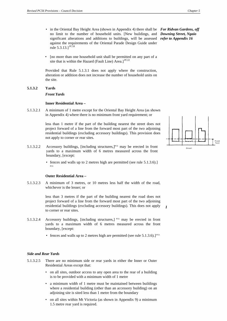
5.1.3.2.1 A minimum of 1 metre except for the Oriental Bay Height Area (as shownin Appendix 4) where there is no minimum front yard requirement; or
less than 1 metre if the part of the building nearest the street does notproject forward of a line from the forward most part of the two adjoiningresidential buildings (excluding accessory buildings). This provision does not apply to corner or rear sites.
5.1.3.2.2 Accessory buildings, [including structures,]PC6 may be erected in front yards to a maximum width of 6 metres measured across the front boundary, [except:
• fences and walls up to 2 metres high are permitted (see rule 5.1.3.6).]
PC6
Outer Residential Area –
5.1.3.2.3 A minimum of 3 metres, or 10 metres less half the width of the road,whichever is the lesser; or
less than 3 metres if the part of the building nearest the road does notproject forward of a line from the forward most part of the two adjoiningresidential buildings (excluding accessory buildings). This does not applyto corner or rear sites.
5.1.3.2.4 Accessory buildings, [including structures,] PC6 may be erected in front yards to a maximum width of 6 metres measured across the frontboundary, [except:
• fences and walls up to 2 metres high are permitted (see rule 5.1.3.6).] PC6
1
Side and Rear Yards
5.1.3.2.5 There are no minimum side or rear yards in either the Inner or Outer Residential Areas except that:
• on all sites, outdoor access to any open area to the rear of a building is to be provided with a minimum width of 1 metre
• a minimum width of 1 metre must be maintained between buildings where a residential building (other than an accessory building) on an adjoining site is sited less than 1 metre from the boundary
• on all sites within Mt Victoria (as shown in Appendix 9) a minimum 1.5 metre rear yard is required.

Revised PC56 Provisions – Council Decision Chapter 5
[5.1.3.2.5A] PC6Decks, terraces, [or] PC6 balconies with a finished floor, [paving or turf] PC6 level of 1.5 metres or more above ground level [at the boundary]
PC6 shall be located no closer than 2 metres to any side or rear boundary, [except for the following:
• driveways and parking structures
• pedestrian walkways, provided they are not more than 1.5 metres wide
• stairs and stair landings, provided that the area of any individual stair tread or landing is not more than 4 square metres
• Where a side or rear boundary abuts an access lot, access strip, public accessway or drainage reserve, the boundary may be taken from the furthest boundary of the access lot, access strip, public accessway or drainage reserve or any combination of these areas.] PC6
5.1.3.2.6 5.1.3.2.5 [and 5.1.3.2.5A do] PC18 not apply to the Oriental Bay Height Area (as shown in Appendix 4) except
• for 282-300 Oriental Parade a minimum 1 metre rear yard is required
• for 232-234 Oriental Parade a minimum 6 metre rear yard is required.
General Yards 5.1.3.2.7 No building [or structure, including a fence or wall,] PC6 shall be located
closer than 3 metres to a waterbody or the coastal marine area, excluding artificial ponds or channels, [or closer than 5 metres to the Porirua Stream within the Tawa Hazard (Flooding) Area.]PC1
5.1.3.2.8 No impervious surface associated with the use of the site shall extend
closer than 3 metres to a waterbody or the coastal marine area, excluding artificial ponds or channels.
5.1.3.2A Open Space (Mt Cook, Newtown and Berhampore (as shown in
Appendix 9) Provision introduced by Plan Change 39. 5.1.3.2B Open Space
Inner Residential (except in the Oriental Bay Height Area) NB: Multi-unit
developments and 5.1.3.2B.1 On-site ground level open space shall be provided at a minimum of 35 square metres per household unit. Open space shall be calculated as an aggregate total for the site and may be provided as either private or shared open space.
infill developments that do not meet the permitted activity standards will be assessed against the 5.1.3.2B.2 No area of ground level open space shall be used for vehicle
accessways, parking or manoeuvring areas, or be covered by buildings, provided that:
Residential Design Guide. That Guide outlines additional
• Balconies, or verandahs may extend out of over ground level open space up to a maximum depth of 1.5 metres.
requirement for the provision of open space, designed to
• Uncovered decks less than 1m above ground are regarded as ground level open space for this rule.
ensure such space is of the highest quality
5.1.3.2B.3 All areas of ground level open space must have a minimum width of at least 3 metres and be directly accessible from adjoin the dwelling.
for its users.
5.1.3.2B.4 Any household unit that has less than 20 square metres of private ground level open space must also provide private open space in the form of a deck or balcony. A total deck area of at least 6 square metres is required for one bedroom units, while units with two or more bedrooms must provide a deck area of at least 10 square metres.
• All decks must have a minimum dimension of at least 2 metres. • Open space provided as decks does not contribute towards the
aggregate open space total for the site. 5.1.3.2.B.5 For the purpose of this rule:

Revised PC56 Provisions – Council Decision Chapter 5
Private Open Space means open space that adjoins the unit to which it relates and which is for the exclusive use of the occupiers of that unit. Shared Open Space means open space that is provided on-site but which is not for the exclusive use of any specific occupier. Shared open space may be provided in more than one area on site, but each area of shared open space shall have a minimum area of 30 square metres and a minimum width of 3 metres.
Outer Residential Area 5.1.3.2B.6 On-site ground level open space shall be provided at a minimum of 50
square metres per household unit. 5.1.3.2B.7 Not more than 15m2 of ground level open space area shall be used for
vehicle accessways or manoeuvring areas. 5.1.3.2B.8 No area of ground level open space shall be used for vehicle
accessways, parking or manoeuvring areas, or be covered by buildings, provided that:
• Balconies, or verandahs may extend out of over ground level open space up to a maximum depth of 1.5 metres.
• Uncovered decks less than 1m above ground are regarded as ground level open space for this rule.
5.1.3.2B. 79 All areas of ground level open space must have a minimum width of at least 4 metres and be directly accessible from adjoin the dwelling.
5.1.3.2B.10 Rules 5.1.3.2B.6 – 5.1.3.2B.9 do not apply to the conversion of an
existing residential dwelling from one to two household units if the conversion does not involve external changes to the building that results in an increase the site coverage of the existing dwelling.
5.1.3.3 Site Coverage 5.1.3.3.1 In the Inner Residential Area the maximum coverage is 50 percent
except for the following:
• in the Oriental Bay Height Area (as shown in Appendix 4) there is no maximum coverage
• in the Aro Valley Area (as shown in Appendix 10) the maximum coverage is 40 percent.
5.1.3.3.2 In the Outer Residential Area the maximum coverage is 35 percent, except for the following:
• site coverage can be increased above 35%, to a maximum of 40%
[,where the extra site coverage is comprised of uncovered decks.] PC6 This excludes the Mitchelltown and Roseneath Areas referred to in this rule

Revised PC56 Provisions – Council Decision Chapter 5
• for the Mitchelltown Area (as shown in Appendix 5): – in density area (1) the maximum coverage is 40 percent – in density area (2) the maximum coverage is 30 percent – in density area (3) the maximum coverage is 20 percent
• for the Roseneath Area (as shown in Appendix 7) the maximum site coverage is 45%.
5.1.3.4 [Maximum]PC6 Height. Subject to rules 5.1.3.5 and 5.1.3.6, the following applies:
5.1.3.4.1 In the Inner Residential Area the maximum height [for buildings and structures, including fences and walls,] PC6 is 10 metres, except for the following:
• [for fences or walls within 1 metre of a boundary or in a front yard (refer to rule 5.1.3.6)] PC6
• for [maximum] PC6 heights in the Thorndon Character Area refer to the design guide Volume 2
• in the Aro Valley Area (as shown in Appendix 10) the maximum height is 7.5 metres
• in the Oriental Bay Height Area the maximum height is as shown in Appendix 4
• in the North Kelburn/Bolton St Area the maximum height is as shown in Appendix 6.
5.1.3.4.2 In the Outer Residential Area the maximum height is 8 metres, except for the following:
• in the Roseneath area (as shown in Appendix 7) the maximum height is 10 metres
• [within the land shown in Appendix 24 (16-50 Rhine Street, Island Bay) no part of any building or structure shall extend above or penetrate a horizontal line over the land at a height of 70 metres above mean sea level.
• For the avoidance of doubt proposals shall comply with whichever is the lesser (i.e. the lower height) of this height plane condition and the maximum building height of 8 metres.]PC9
• An Infill Household Unit in the Outer Residential Area (ie. condition 5.1.3.4.3)
5.1.3.4.3 Height of a second an Infill Household Unit on an Outer Residential Area site
In the Outer Residential Area, the maximum building height of an Infill Household Unit a second household unit which is outside the footprint of the existing household unit and on a fee-simple site area of less than 1000m2 is 4.5 metres shall be:
• 4.5 metres on a building site that has a slope of no more than 3:1 (approximately 15 degrees)
• 6.0 metres on a building site that has a slope of more than 3:1 (approximately 15 degrees)
For the purposes of this rule only:
1. A building site is the footprint of a building + 2m(or less if the site boundary is within that 2m); and
2 A slope is determined by the longest section of sloping ground on a building site that falls at the same angle.

Revised PC56 Provisions – Council Decision Chapter 5
3 The longest section of slope is measured horizontally,
from where the slope of the same angle starts to where it finishes, and excludes any vertical bank or wall less than 1.5m in height.
5.1.3.5 Sunlight Access
Inner Residential
5.1.3.5.1 All buildings [and structures, including fences and walls,] PC6 shall be contained within a sunlight access control envelope (in form of a “tent” constructed by drawing sunlight access control lines over the site from all parts of all boundaries, except for any boundary fronting a road), and provided further that gable end roofs may penetrate the sunlight access control line by no more than one-third of the gable height.
5.1.3.5.2 Each sunlight access control line shall rise vertically for 2.5m from ground level at the boundary and then incline inwards, at 90° to the boundary in plan, at an angle to the horizontal related to the orientation of the boundary and its bearing.
5.1.3.5.3 Determination of the angle of inclination of the sunlight access control
line. The inclination of the sunlight access control line to the horizontal shall
be based upon the direction in which the boundary faces which is ascertained by the bearing of a line drawn outwards from the site at 90° to that boundary line, so that:

Revised PC56 Provisions – Council Decision Chapter 5
• for a boundary that faces between 330° and 30°, the angle ofinclination shall be 3 vertical to 1 horizontal (71° 30' approximately)
• for a boundary that faces between 270° and 330° or between 30° and 90°, the angle of inclination shall be 2 vertical to 1 horizontal (63° 30'approximately)
• for a boundary that faces between 90° and 150° or between 210° and270°, the angle of inclination shall be 1.5 vertical to 1 horizontal (56°20' approximately)
• for a boundary that faces between 150° and 210°, the angle ofinclination shall be 1 vertical to 1 horizontal (45°)
• in the Aro Valley Area (as shown in Appendix 10) for a boundarythat faces between 150º and 210º, the angle of inclination shall be 0.5 vertical to 1 horizontal (26º 34' approximately). For boundaries thatface between 30º and 150º and 210º and 330º, the angle of inclinationshall be 0.85 vertical to 1 horizontal (40º 21' approximately). For aboundary that faces between 330º and 30º the angle of inclination shall be 3 vertical to 1 horizontal (71º 30' approximately)
• where a bearing lies exactly on a boundary between two of the above sectors, the owner of the site may use either of the two sector inclinations
• no account shall be taken of aerials, chimneys or decorative features that do not exceed 1 metre in any horizontal direction
• gable end roofs may penetrate the [sunlight access] PC6 plane by no more than one third of the gable height.

Revised PC56 Provisions – Officer’s Recommendations Chapter 5
[5.1.3.5.3A Where two boundaries of a site have an angle between them that is
greater than 1800 (meaning the sunlight access planes cannot be inclined at right angles in plan from the boundaries to all the areas adjoining theboundaries), a sunlight access control plane shall be inclined to coverthe whole area between the two closest positions where lines can bedrawn at right angles to the boundaries. Where the two boundaries arein different bearing sectors the owner of the site may use either of thetwo sector inclinations for the area between the boundaries.] PC6
5.1.3.5.4 Rules 5.1.3.5.1 to 5.1.3.5.3 shall not apply to site boundaries fronting the street.
5.1.3.5.5 Rule 5.1.3.5.1 shall not apply in the Oriental Bay Height Area (as
shown in Appendix 4) except on the boundary of adjacent residentialproperties not situated within the Oriental Bay Height Area.
5.1.3.5.6 Rule 5.1.3.5.1 shall not apply in the Thorndon Character Area except for
boundaries on the edge of the Character Area. 5.1.3.5.7 [Where a boundary abuts an access lot, access strip, public accessway or
drainage reserve, the boundary may be taken from the furthest boundary of the access lot, access strip, public accessway or drainage reserve orany combination of these areas.] PC6
Outer Residential 5.1.3.5.8 All parts of a building [or structure, including a fence or wall,] PC6 shall
be contained within a 45º plane commencing at a point 2.5 metres above ground level inclined inwards at right angles in plan from all parts of the site’s boundaries, except:
• gable end roofs may penetrate the 45º plane by no more than one
third of the gable height
• no account shall be taken of aerials, chimneys or decorative featuresthat do not exceed 1 metre in any horizontal direction
• rule 5.1.3.5.8 shall not apply to site boundaries fronting the street.

Revised PC56 Provisions – Officer’s Recommendations Chapter 5
Wellington City District Plan Page 5/10
[5.1.3.5.8A Where two boundaries of a site have an angle between them that isgreater than 1800 (meaning the sunlight access planes cannot be inclined at right angles in plan from the boundaries to all the areasadjoining the boundaries), a sunlight access control plane shall beinclined at 450, commencing at a point 2.5 metres above ground level,to cover the whole area between the two closest positions where lines can be drawn at right angles to the boundaries.] PC6
}
5.1.3.5.9 [Where a boundary abuts an access lot, access strip, public accessway or
drainage reserve, the boundary may be taken from the furthest boundary of the access lot, access strip, public accessway or drainage reserve or any combination of these areas.] PC6

Revised PC56 Provisions – Officer’s Recommendations Chapter 5
Wellington City District Plan Page 5/11
5.1.3.6 Maximum Fence Height
[Within 1 metre of a boundary or in a front yard, a fence or wall, or combination of these structures (whether separate or joined together), shall have a maximum height of 2 metres measured from the ground level at the boundary.] PC6
[ 5.1.3.7 Residential buildings within a Hazard (Fault Line) Area.
In any Hazard (Fault Line) Area, residential buildings shall have a maximum height of 8m and be built with a light roof and light wall cladding.]PC22
5.1.3.8 Noise Insulation: Airport Area
Any new residential dwelling inside the airnoise boundary depicted on Map 35 must be designed and constructed so as to achieve an internal level of 45 dBA Ldn inside any habitable room with the doors and windows closed.
The certification of an approved acoustical engineer will be accepted as evidence that designs meet the insulation standard. A list of approved acoustical engineers shall be agreed between the Council and the Airnoise Management Committee and shall be made available on request by the Council.
5.1.3.9 Proximity to High Voltage Transmission Lines
Any residential buildings, including additions, shall be further than 30 metres from high voltage transmission lines (as measured from the centreline at ground level).
The essential visual character of particular neighbourhoods is determined by the bulk and location of residences and the amount of open space around them.
The rules which apply to residential buildings are designed to ensure that a reasonable level of development can proceed with minimum restriction while the primary visual character and amenity of residential neighbourhoods is maintained. The standards have been varied in neighbourhoods where special provisions such as Design Guides apply.Sunlight access provisions allow a reasonable amount of sunshine to reach neighbouring sites by requiring the location of development away from boundaries. Less restrictive sunlight access provisions apply in the inner-city

Revised PC56 Provisions – Officer’s Recommendations Chapter 5
Wellington City District Plan Page 5/12
residential areas where the encouragement of existing building forms is also a consideration.
There are no controls to protect views from private property. This is a matter which Council considers is better dealt with by private agreement.
High fences [and walls] PC6 along or close to the boundary of residential sites are controlled to enable the effects of shading on adjoining sites to be assessed.
[The restrictions of residential buildings within the Hazard (Fault Line) Area is intended to promote the safety and welfare of both occupiers and neighbours by reducing the risk of building failure following a fault rupture.]PC22
[Residential buildings have been managed in the Porirua Stream catchment to prevent as much as possible any increase in the flooding hazard.]PC1
In Residential Areas any new residential building, including additions must be located further than 30 metres from high voltage transmission lines as defined on the Planning Maps (refer to Policy 4.2.11.3).
5.1.3.A Adaptation and re-use of existing buildings NB: Failure to meet the requirements of Rule The alteration of, and addition to existing residential buildings that do 5.1.3A does not preclude not comply with any of the following permitted activity conditions: an assessment of the proposed works against s10 • 5.1.3.2 (yards) of the RMA. • 5.1.3.3 (site coverage) but only in relation to 5.1.3.A.2a and
5.1.3.A.3a Where proposed works fail • 5.1.3.4 (maximum height) to meet 5.1.3A and s10 of • 5.1.3.5 (sunlight access) the RMA, then the proposed works will be
assessed against the are a Permitted Activity provided any new part of the existing building relevant items of Rule (and proposed works) comply with the following conditions: 5.3.3.
5.1.3.A.1 the existing non-compliance was lawfully constructed before 27 July 2000.
For Inner Residential Area sites:5.1.3.A.2 5.1.3.A.2a: any internal or external alteration, including the insertion of windows, may be made provided it is contained within the existing building volume. 5.1.3.A.2b: any additions within the footprint of the existing building must comply with conditions 5.1.3.2 (yards), 5.1.3.4 (height) and 5.1.3.5 (sunlight access)..
5.1.3.A.2c any addition that increases the footprint of the existing building must not exceed a building height of 4.5 metres
5.1.3.A.3 For Outer Residential Area sites:
5.1.3.A.3a: , any internal or external alteration, including the insertion of windows, must be limited to the complying
parts of the existing building. 5.1.3.A.3b: any additions within the footprint of the existing
building must comply with conditions 5.1.3.2 (yards), 5.1.3.4 (height) and 5.1.3.5 (sunlight access)..
5.1.3.A.3c any addition that increases the footprint of the existing

Revised PC56 Provisions – Officer’s Recommendations Chapter 5
Wellington City District Plan Page 5/13
The rules adopted to ensure better management of infill housing in existing residential areas include a reduced permitted height level for the second dwelling on a site and introducing an open space requirement for each dwelling on site.
The requirement to provide open space is an important tool in maintaining a sense of openness and space between buildings. The open space standards are set to reflect typical density patterns of the Inner and Outer Residential Areas. It will also have a benefit for occupants though increased amenity values, and provide space for the retention of vegetation.
Rule 5.1.3 contains bulk and location provisions that guide the scale of building works that can occur on sites within Residential Areas. The provisions are set at levels that provide for a reasonable scale of development, while at the some same time providing neighbouring properties with appropriate access to sunlight, daylight and amenity. Many older buildings, particularly in the Inner Residential Area, do not comply with the bulk and location provisions. This is because these buildings are often built close to side boundaries and are unable to comply with the yard and sunlight access requirements. Because of the non-compliance created by the existing building, undertaking ‘complying’ additions and alterations to these buildings often requires an assessment to consider the combined effect of the proposed work and the areas of non-compliance created by the existing building (or structure). Rule 5.1.3.A stipulates the scale of work that can be undertaken on an existing ‘non-complying’ building as a permitted activity. Rule 5.1.3A is specifically designed to encourage the adaptation and re-use of existing buildings which do not comply with the current planning provisions by allowing certain works on those buildings to be treated as permitted activities. The scope of works able to be conducted within the rule are set at a level which is not expected to create adverse effects on the residential amenity of adjoining neighbours or on the streetscape generally. Additions and alterations to an existing building are permitted provided they are contained within the existing building footprint, and comply with the rules for maximum height and sunlight access. Additions that increase the footprint of the
building must not exceed a building height of 4.5 metres
5.1.3.A.4 the alterations and/or additions provided for under 5.1.3.A.2b-c and 5.1.3.A3b-c must not increase the degree of non-compliance of the building.
5.1.3.A.5
Any work undertaken under this rule must comply with conditions 5.1.3.1 (number of household units), 5.1.3.2.A and 5.1.3.2.B (open space), 5.1.3.3 (site coverage), 5.1.3.7 (Hazard (Fault Line) Area), 5.1.3.8 (noise insulation: Airport Area) and 5.1.3.9 (high voltage transmission lines) , and In relation to provisions 5.1.3.A.2b –c and 5.1.3.A.3b-c, any work undertaken must comply with condition 5.1.3.3 (site coverage). Definitions for the purposes of Rule 5.1.3A: Footprint means any existing building or structure that would be included within the site coverage definition. Building Volume means the total three dimensional bulk of the existing building on the site. Alteration refers to any modification of the fabric of the building that does not result in an increase of mass, bulk or height to any part of the building.

Revised PC56 Provisions – Officer’s Recommendations Chapter 5
Wellington City District Plan Page 5/14
building are limited to a single storey (measured as being below 4.5 metres in height) are considered appropriate as the potential for shading or loss of privacy on adjoining sites is limited. Accordingly Rule 5.1.3.A provides for these additions as a permitted activity, provided they comply with the other bulk and location standards contained in Rule 5.1.3. This will make additions to character houses easier, encouraging their retention and adaptation. When an existing building does not comply with the bulk and location standards in the District Plan, any new works to that building not provided for under Rule 5.1.3.A will be subject to an existing use rights assessment under section 10 of the Resource Management Act. In order to carry out work under existing use rights, the proposal must be able to demonstrate that the combined effects of the proposed works and the existing dwelling, will be the same (or similar) in character, scale and intensity, as the effects created by the existing dwelling. If the proposed work does not fall within the ambit of existing use rights, a resource consent would need to be sought and granted before work can be undertaken.
5.1.4 The total or partial demolition or removal of buildings and structures are Permitted Activities except:
For schedule of listed heritage items, refer to Chapter 21
• those listed in the District Plan as heritage items
• all buildings constructed before 1930 in the Thorndon Character Area
See Thorndon Character Area Design Guide, Volume 2
• any demolition of any building in Thorndon or Mt Victoria that is restricted by rule 5.3.11.
5.1.5 The creation of open land for recreation or amenity purposes is a Permitted Activity.
5.1.6 Temporary activities and uses are Permitted Activities.
Council uses its powers under the Act to ensure that the general duty under section 17 to avoid, remedy or mitigate any adverse effects of activities on the environment is met.
5.1.7 Any activity relating to the upgrade and maintenance of existing formed roads and [public]PC6 accessways including associated earthworks, except the construction of new legal road, is a
Permitted Activity.

Revised PC56 Provisions – Officer’s Recommendations Chapter 5
Wellington City District Plan Page 5/15
5.1.8 Signs are Permitted Activities provided that they comply with the following conditions:
5.1.8.1 For permanent signs on residential sites and buildings:
• the maximum area must not exceed 0.5m2
• only one sign may be displayed on any site
• signs must denote only the name, character or purpose of any Permitted Activity on the site
• signs must not be illuminated.
5.1.8.2 For temporary signs:
• the maximum area must not exceed 3m2
• the maximum height must not exceed 4 metres
• signs must not be erected more than 28 days before, and must be removed within 7 days of the completion of the purpose or event for which the sign was erected.
5.1.8.3 For signs on non-residential sites and buildings:
• the maximum combined area of permanent signs must not exceed 5m2
• signs must denote only the name, character or purpose of any Permitted Activity on the site
• illuminated signs must not flash
• signs must be displayed only on plain wall surfaces where they do not obscure windows or architectural features
• no sign shall project above the parapet level or the highest part of the building to which it is attached.
Limiting the size and type of signs will help maintain the appearance of Residential Areas by ensuring that individual signs are not a dominant element of the townscape and that a cluttered sign environment will not result. Temporary signs are permitted because they carry useful information and have no lasting environmental effects.
For subdivision of Lot 1 DP 25046 and Pt Sec 10 Kaiwharawhara District above Patna Street and Huntleigh Park Way, Ngaio refer to Appendix 17
5.1.9 Earthworks are Permitted Activities provided that they comply with the following conditions:
5.1.9.1 That existing ground level is not to be altered by more than 2.5 metres measured vertically.
5.1.9.2 That total area of ground surface disturbance is less than 250m2.
For Ridvan Gardens, off Downing Street, Ngaio refer to Appendix 16
5.1.9.3 That earthworks do not take place in Hazard (Flooding) Areas.
5.1.9.4 That earthworks are not undertaken on slopes of more than 45º.
5.1.9.5 That no earthworks are carried out within 5 metres of a waterbody or thecoastal marine area.
5.1.9.6 That no contamination, including siltation, of any waterbody or coastal water occurs.
5.1.9.7 Nothing in rules 5.1.9.1 to 5.1.9.5 shall apply to utilities which are a Permitted Activity.

Revised PC56 Provisions – Officer’s Recommendations Chapter 5
Wellington City District Plan Page 5/16
5.1.10 The storage, use or handling of hazardous substances are Permitted Activities, except in a Hazard Area, provided that they comply with the following conditions:
See Exemptions to the Hazardous Facilities Screening Procedure contained in section
5.1.10.1 For those activities which are not specifically exempted (see Section3.5.2.2) the cumulative Effect Ratio calculated using the HFSP will beused to determine whether or not those other activities should bePermitted Activities according to the table below.
3.5.2
Location Either Zone Either Zone
Effect Ratio 0.002 < [ER]PC35 ≤0.02 ≤0.002
Conditions applying 5.1.10.2 to 5.1.10.12 5.1.10.9, 5.1.10.11 and 5.1.10.12 only
Activities that do not meet the above Effects Ratio criteria or do not otherwise comply with the applicable conditions will be Discretionary (Unrestricted) Activities.
5.1.10.2 Except for the storage, use or handling of Liquid Petroleum Gas (LPG), any area where hazardous substances are used, stored or handled in any manner on-site shall have secondary containment (via bunding or other-wise) using materials that are resistant to the hazardous substances contained on-site. [Secondary containment systems also need to comply with any relevant provisions under the Hazardous Substances and New Organisms Act 1996.]PC35
5.1.10.3 Except for the storage, use or handling of Liquid Petroleum Gas (LPG), any secondary containment system shall be maintained to ensure that it will perform the functions for which it was designed and contain any spill or accidental release.
5.1.10.4 Except for the storage, use or handling of Liquid Petroleum Gas (LPG), any area(s) where hazardous substances are loaded, unloaded, packaged, mixed, manufactured or otherwise handled shall have a spill contain-ment system [that is compliant with relevant provisions under the Hazardous Substances and New Organisms Act 1996.] PC35
5.1.10.5 Except for the storage, use or handling of Liquid Petroleum Gas (LPG), secondary containment systems shall be designed to contain any spill or accidental release of hazardous substance, and any storm water and/or fire water that has become contaminated, and prevent any contaminant from entering the environment unless expressly permitted under a resource consent or trade waste permit.
5.1.10.6 All stormwater grates, collection structures and inspection chamber covers on the site shall be clearly marked as such.
5.1.10.7 Any area where vehicles, equipment or containers that are or may have been contaminated with hazardous substances are washed down shall be designed, constructed and managed to prevent the effluent from the washdown area from discharge into or onto land, entry or discharge into the sewerage or stormwater drainage system unless expressly permitted by a rule in a regional plan, trade waste permit or resource consent.
5.1.10.8 Underground tanks for the storage of petroleum products shall be designed, constructed, installed, maintained, operated, managed and at the end of their life removed, to prevent leakage and spills. Compliance with [any relevant provisions under the Hazardous Substances and New Organisms Act 1996 and] PC35 the OSH Code of Practice for the "Design,

Revised PC56 Provisions – Officer’s Recommendations Chapter 5
Wellington City District Plan Page 5/17
Installation and Operation of Underground Petroleum Storage Systems" (1992) is a minimum [requirement.] PC35
Signage
5.1.10.9 [All facilities must display signage to indicate the nature of the hazardous substances present (compliance with the provisions of the Hazardous Substances and New Organisms Act 1996 and the requirements of the Building Code (F8) or the Code of Practice “Signage for Premises Storing Hazardous Substances and Dangerous Goods” of the New Zealand Chemical Industry Council (Nov 2004) is a minimum requirement).] PC35
Waste Management
5.1.10.10 Any process waste or waste containing hazardous substances shall bestored in a manner which complies with 5.1.10.1 to 5.1.10.9 above.
5.1.10.11 Any hazardous facility generating wastes containing hazardoussubstances shall dispose of these wastes to facilities which, or wastedisposal contractors who, meet all the requirements of regional anddistrict rules for discharges to the environment [and also the provisionsof the Hazardous Substances and New Organisms Act 1996.] PC35
Other
5.1.10.12 Council must be informed of the activity’s location, the nature of the activity and when the activity commences and ceases.
[The on-site disposal of hazardous substances will be controlled through Council’s Waste Management Strategy, through obtaining the appropriate discharge consents from the Regional Council or trade waste permits, and through relevant controls on disposal of hazardous substances by the Hazardous Substances and New Organisms Act 1996.] PC35
[In addition to the provisions of the Plan, all activities which involve the use, storage, handling or transportation of hazardous substances are regulated for on-site and off-site effects by a range of other legislation and regulations, and associated standards and codes of practice which should be complied with. Key pieces of legislation include: • the Hazardous Substance and New Organisms Act 1996 • legislation, rules and standards relating to the transportation of hazardous
substances (Land Transport Act 1993, Land Transport Rule: Dangerous Goods 1999 and New Zealand Standard 5433:1999)
• Building Act 1991 • Health Act 1956 • Fire Service Act 1975 • Health and Safety in Employment Act 1992 • Radiation Protection Act 1965 • Agricultural Compounds and Veterinary Medicines Act 1997] PC35
5.1.11 Except for company lease, cross lease and unit title subdivision, any subdivision around an existing lawfully established residential building which does not result in the creation of any new undeveloped allotment that contains no residential building is a Permitted Activity provided that it complies with the following conditions:
5.1.11.1 Every building [or structure]PC6 adjoining a new boundary must comply fully with all conditions in rule 5.1.3 unless a resource consent has been obtained for any non-complying aspect which is generated by the proposed subdivision.

Revised PC56 Provisions – Officer’s Recommendations Chapter 5
5.1.11.2 Any new services must be in compliance with the City Bylaws and if applicable the Council’s Code of Practice for Land Development.
5.1.11.3 Every allotment must have practical, physical and legal access directly to a formed legal road or by way of a registered right-of-way.
5.1.11.4 Every allotment must have drive-on vehicle access and parking constructed in accordance with rules [5.1.1.2 and]PC34 5.1.1.3.
5.1.11.5 Any earthworks are authorised by rule 5.1.9.
5.1.11.6 No part of any allotment being subdivided may be within 20 metres of any river whose bed has an average width of 3 metres or more where the river flows through or adjoins an allotment.
5.1.11.7 No part of any allotment being subdivided may be within 20 metres of the line of mean high water springs.
5.1.11.8 No subdivision may occur within a heritage area or on a site associated with a heritage item unless in the latter case the subdivision involves land that is not occupied by the heritage item and is not specifically identified for preservation by the Plan as important to the setting of the item.
5.1.11.9 A Certificate of Compliance must be obtained for the subdivision to allow Council to assess survey plans for approval. An applicant must supply the following:
• information to allow Council to assess compliance with conditions 5.1.11.1 to 5.1.11.8
• a certificate stating that all existing services have been located so that they are all contained entirely within the boundaries of the site being serviced, or within such existing or proposed right of way or easement relating to the site and are in accordance with the City Bylaws and if applicable the Council’s Code of Practice for Land Development
• current copies of titles for all affected properties
• accurately drawn A4 plans at a scale of 1:500 or at a larger scale as appropriate
All certificates, plans and information supplied must be signed by a registered surveyor or other suitably qualified person certifying their accuracy.
Because of the diversity of the situations that arise and the need to ensure that particular circumstances are covered by appropriate conditions, most subdivisions will require a resource consent. Subdivisions resulting in the issue of separate certificates of title for existing residential buildings can be permitted subject to specified conditions. This will facilitate any subdivision of land which has no effect on the existing topography or building development.
Applicants are reminded of the need for proposed subdivisions to comply with the City Bylaws. In addition, where private infrastructure is proposed to be vested in the Council or where private stormwater, water and sewerage lines are connected or proposed to be connected to public infrastructure, applicants will need to liaise with the Council concerning the requirements set out in the Council’s Code of Practice for Land Development so that the Council will either accept the vesting of such infrastructure or will authorise connection or continued connection to public infrastructure. Refer to Section 3.9 of the Plan
Wellington City District Plan Page 5/18

Revised PC56 Provisions – Officer’s Recommendations Chapter 5
[5.1.12 In the Tawa Hazard (Flooding) Area, internal alterations, minor additions to existing residential buildings and new accessory buildings are Permitted Activities provided that they comply with the following conditions:
5.1.12.1 Additions shall not be below the floor level of the existing dwelling and shall not exceed 10m2.
5.1.12.2 The floor area of accessory buildings shall not exceed 10m2.
Minor additions to existing residential buildings and accessory buildings not in excess of 10m2 have been provided as Permitted Activities in the Tawa Hazard (Flooding) Area. This recognises that minor development works of this scale would not significantly increase the flood hazard risk, whilst taking into account the practical and aesthetic implications of allowing minor buildings and additions at a similar floor level to the existing dwelling.]PC1
Wellington City District Plan Page 5/19
Revised PC56 Provisions – Officer’s Recommendations Chapter 5
5.2 Controlled Activities
Section 5.2 describes which activities are Controlled Activities in Residential Areas. A resource consent will be required but consent cannot be refused. Conditions may be imposed relating to the matters specified in Rules 5.2.1 to 5.2.5. The decision on whether or not a resource consent will be notified will be made in accordance with the provisions on notification in the Act.
5.2.1
Early childhood centres catering for up to 30 children, except within the Inner Residential Area north of John Street/
Hutchinson Road, are Controlled Activities in respect of:
5.2.1.1 landscaping and site layout
5.2.1.2 vehicle parking
5.2.1.3 site access.
Non-notification
The written approval of affected persons will not be necessary in respect of items 5.2.1.1 to 5.2.1.3. [Notice of applications need not be served on affected persons]PC28 and applications need not be notified.
Standards and Terms
[This activity must comply with the conditions for noise (5.1.1.1) and site access (5.1.1.3) in rule 5.1.1 and provide one off-street car park for each full time (or equivalent) staff member. Any construction, alteration of, and addition to buildings and structures must comply with the conditions for residential buildings in rule 5.1.3.2 - 5.1.3.9.]PC11
Assessment Criteria
In determining the conditions to be imposed, if any, Council will have regard to the following criteria:
5.2.1.4 Whether existing trees on the site can be preserved to enhance the neighbourhood or new planting should be undertaken, particularly where it will improve the appearance of the property from the street. Appropriate fencing should also be provided to keep children safe. Outdoor play areas should be located in sunny situations. New and existing vegetation shall be of non-poisonous varieties and there shall be sufficient outdoor shade provided for children.
5.2.1.5 The necessity for off-street parking: parking arrangements will be assessed with regard to the number of staff to be employed on the site and visitors. Council seeks to ensure that off-street parking is available for each staff member. Stacked parking arrangements may be con-sidered. Council requires any parking, either on-street or on-site, to be safe for the setting down or picking up of children.
5.2.1.6 Whether the location and design of vehicle access to the site is safe. Council seeks to avoid hazardous situations such as access to and from busy streets or rear sites served by shared access drives. Additionally, the proximity of any proposed facility to other activities which generate high number of vehicle movements will be taken into account.
Wellington City District Plan Page 5/20

Revised PC56 Provisions – Officer’s Recommendations Chapter 5
Wellington City District Plan Page 5/21
Early childhood centres provide a needed community service, and small to medium-sized centres catering for up to 30 children are considered appropriate in Residential Areas. They have been included as a Controlled Activity to make sure that their appearance does not detract from the neighbourhood and that children are safe on the roads nearby. Early childhood centres have however been excluded from Residential Areas surrounding the Central Area because of the tendency of such uses to establish close to the City. Proposals for Early Childhood Centres in the Inner Residential Area north of John Street/Hutchison Road are therefore considered as Discretionary Activities (Unrestricted) because of a desire to protect the residential character and amenities of those areas.
[ 5.2.2 Non-residential activities in existing non-residential buildings (that contain a shopfront display window adjacent to the footpath) and extensions to existing non-residential buildings (that contain a shopfront display window adjacent to the footpath), are Controlled Activities in respect of:
5.2.2.1 the design and external appearance of buildings
5.2.2.2 the effects of the generation of noise, dust, glare, vibration, fumes, smoke, electromagnetic radiation, odours or the discharge of contaminants
5.2.2.3 hours of operation
5.2.2.4 vehicle parking. ]PC11
Non-notification
The written approval of affected persons will not be necessary in respect of item 5.2.2.1. [Notice of applications need not be served on affected persons]PC28 and applications need not be notified.
Standards and Terms
[ The non-residential activity must comply with the conditions for noise (5.1.1.1) and site access (5.1.1.3) in rule 5.1.1. Any extension to an existing non-residential building must comply with the conditions for residential buildings in 5.1.3.2 - 5.1.3.9.]PC11
Assessment Criteria
In determining the conditions to be imposed, if any, Council will have regard to the following criteria:
5.2.2.5 The extent to which the scale, design and appearance of buildings will complement existing residences in the immediate neighbourhood.
5.2.2.6 Whether there are effects from the generation of noise, dust, glare, vibration, fumes, smoke, electromagnetic radiation, odour, or the discharge of contaminants.
5.2.2.7 Whether the activity will operate at hours that will cause a nuisance to residential occupiers. Opening hours will generally be restricted to 7am to 6pm Monday to Saturday.

Revised PC56 Provisions – Officer’s Recommendations Chapter 5
Wellington City District Plan Page 5/22
5.2.2.8 The necessity for off-street parking. Parking arrangements will be assessed with regard to the number of people employed on the site and customer needs. Council seeks to ensure that off-street parking is available for each person employed where practicable. Stacked parking arrangements may be considered.
Many non-residential premises (mainly old retail shops) exist in Residential Areas. Non-residential activities are permitted in these premises to make use of these buildings. In order to avoid, remedy or mitigate impacts on surrounding residential uses, they are included as Controlled Activities.
5.2.3 In residential character areas identified on the District Plan maps, the construction, alteration of, and addition to residential buildings, accessory buildings [and residential structures]PC6, are Controlled Activities in respect of:
For location of residential character areas, refer to District Plan Maps 12, 17 and 18
5.2.3.1 design, external appearance and siting
5.2.3.2 [maximum]PC6 height in the Thorndon Character Area.
Non-notification
The written approval of affected persons will not be necessary in respect of applications relating to matters specified in the relevant character area Design Guide. [Notice of applications need not be served on affected persons]PC28 and applications need not be notified.
Standards and Terms
[All the conditions in rule 5.1.3 must be met]PC11
Assessment Criteria
In determining the conditions to be imposed, if any, Council will have regard to the following criteria:
5.2.3.3 In the Thorndon Character Area the extent to which the proposal meets the provisions of the Thorndon Character Area Design Guide.
5.2.3.4 In the Mt Victoria North Character Area the extent to which the proposal meets the provisions of the Mt Victoria North Character Area Design Guide. In this area control in respect of design and external appearance for existing buildings only applies to the north or northwest frontage of buildings.
Within the Residential Areas, local areas with a special visual character or amenity have been identified. To protect and enhance these areas, all new development will be assessed with reference to the provisions of a Design Guide. The Design Guides, by way of written statements and illustrations, provide the criteria for assessment. It is Council’s view that the use of Design Guides provides the most effective means of encouraging appropriate building development in special residential neighbourhoods.

Last Amended 6 July 2006 Residential Area Operative 27/07/00
Wellington City District Plan Page 5/23
5.2.4
5.2.4.1
Except where covered by rule 5.3.10 [and Rule 5.4.8]PC22, the construction, alteration of, and addition to residential buildings, accessory buildings [and residential structures,]PC6 in that part of the Inner Residential Area identified in Appendix 8 where the result will be two household units on any site is a Controlled Activity in respect of:
The streetscape character
Non-notification
The written approval of affected persons will not be necessary in respect of item 5.2.4.1. [Notice of applications need not be served on affected persons]PC28 and applications need not be notified.
Standards and Terms
[All the conditions in rule 5.1.3 (except 5.1.3.1) must be met.]PC11
Assessment Criteria
In determining the conditions to be imposed, if any, Council will have regard to the following criteria:
5.2.4.2 In respect of streetscape character for the identified Appendix 8 areas, the extent to which the proposal meets the Character provisions of the Residential Design Guide.
Within the Inner Residential Areas identified in Appendix 8 two unit multi-unit developments have been made a Controlled Activity to enable the effects on streetscape character to be assessed. The Inner Residential Area around the city retains high concentrations of original housing stock which is important in projecting the image of typical inner city residential development and maintaining the identity of the city as a whole. Council seeks to maintain and enhance these areas of local character by ensuring that two unit developments are sensitive to established streetscape patterns.
5.2.5 Any subdivision that is not a Permitted Activity and;
(a) creates five or less allotments, except those that:
• create more than 10 linear metres of legal road; or
• are on a ridgeline or a hilltop; or
• involves a requirement to set aside esplanade land; or
• results in an allotment less than 400m2 and cannot contain a circle with a radius of 7m; or
• is the result of boundary adjustments that increase the
degree of non-compliance with the residential permitted activity conditions
is a Controlled Activity in respect of:
5.2.5.1 site design, frontage and area
For subdivision of Lot 1 DP 25046 and Pt Sec 10 Kaiwharawhara District above Patna Street and Huntleigh Park Way, Ngaio refer to Appendix 17
For Subdivision of Lot 1 DP 29604 off the end of Silverstream Road, Ngaio refer to Appendix 12

Last Amended 6 July 2006 Residential Area Operative 27/07/00
Wellington City District Plan Page 5/24
5.2.5.2 standard, construction and location of vehicular access
5.2.5.3 road design and construction
5.2.5.4 earthworks
For subdivision of Lot 3 DP 71465 and Lot 33 DP 1022 off Allanbrooke Place refer to Appendix 13
5.2.5.5 landscaping
5.2.5.6 utility and/or services provision
5.2.5.7 protection of any special amenity feature. For subdivision of Lot
(b) is a company lease, cross lease or unit title subdivision is a Controlled Activity in respect of:
29, DP 1747 off Freeling Street, Island Bay refer to Appendix 20
5.2.5.8 stormwater, sewerage and water services
5.2.5.9 the allocation of accessory units to principal units and theallocation of covenant areas to leased areas to ensure compliancewith rule 5.1.1.2 (vehicle parking) and to ensure practical physicalaccess to every household unit.
Non-notification
The written approval of affected persons will not be necessary in respect of items 5.2.5.1 to 5.2.5.9. [Notice of applications need not be served on affected persons]PC28 and applications need not be notified.
Standards and Terms
[All activities, buildings and structures (existing and proposed) must meet the conditions for vehicle parking (5.1.1.2), site access (5.1.1.3) and building (5.1.3) in relation to all existing and proposed fee simple allotments or meet the terms of any relevant resource consent or have existing use rights under section 10 of the Act]PC11, or in the case of unit title subdivision, concurrently seek and obtain landuse consent for the building or buildings to be subdivided. Assessment Criteria
In determining the conditions to be imposed, if any, Council will have regard to the following criteria:
5.2.5.10 The requirements of Section 106 of the Act.
5.2.5.11 Whether proposed allotments are capable of accommodating Permitted Activities in compliance with the Residential Area rules.
5.2.5.12 The extent of compliance with the relevant parts of the Subdivision Design Guide, City Bylaws and if applicable the Council’s Code of Practice for Land Development.
5.2.5.13 In respect of cross lease or unit title subdivisions:
• the need for permanent site access and access to and around buildings
• the current and future allocation for use of land area, accessory buildings and amenities
• the need to service and use land and buildings efficiently.

Last Amended 6 July 2006 Residential Area Operative 27/07/00
Wellington City District Plan Page 5/25
Subdivisions involving few allotments and which are of a size capable of containing permitted residential activities that will fit well with the surrounding residential environment are a Controlled Activity to facilitate the process of infill and Greenfield development, whilst ensuring the adverse effects of such development on residential character are minimised. The more significant subdivisions will be assessed as Discretionary Activities (Restricted) or (Unrestricted). [It is intended that the design of each allotment can accommodate permitted developments under the District Plan. If the activities, buildings or structures (either existing or proposed) do not meet the specified conditions for permitted activities the subdivision will be assessed as a Discretionary Activity. However, the application will remain a Controlled Activity where the land use was established under an earlier resource consent or it has existing use rights under the Act]PC1, or in the case of unit title subdivisions, obtains a concurrent landuse consent for the proposed buildings.
Conditions will be imposed by Council to ensure that a quality subdivision design is attained. In particular, Council will assess the proposal against the Subdivision Design Guide, and assess access requirements, allotment size and the potential for development. Council is seeking to retain in a permanent manner appropriate site arrangements that are established at the time of cross leasing. This is intended to ensure the efficient use of land. Flexibility of use can be addressed through private arrangements or by reapplying to Council for alterations to the lease arrangements.
Applicants are reminded of the need for proposed subdivisions to comply with the City Bylaws. In addition, where private infrastructure is proposed to be vested in the Council or where private stormwater, water and sewerage lines are connected or proposed to be connected to public infrastructure, applicants will need to liaise with the Council concerning the requirements set out in the Council’s Code of Practice for Land Development so that the Council will either accept the vesting of such infrastructure or will authorise connection or continued connection to public infrastructure. Refer to Section 3.9 of the Plan.
[ 5.2.6 In the Tawa Hazard (Flooding) Area the construction, alteration of, and addition to residential buildings, including accessory buildings, that
• is not a Permitted Activity; and
• has a floor level above the 1 in 100 year flood event
is a Controlled Activity in respect of:
5.2.6.1 building location within the site
5.2.6.2 building floor area.
“For the purposes of clarification, this rule does not apply to network utility infrastructure, as they are provided for in ‘Section 23. Utility Rules’ of the District Plan.”
Non-notification
The written approval of affected persons will not be necessary in respect of items 5.2.6.1 and 5.2.6.2. [Notice of applications need

Last Amended 6 July 2006 Residential Area Operative 27/07/00
Wellington City District Plan Page 5/26
not be served on affected persons]PC28 and applications need not be notified.
Standards and Terms
This activity must comply with the conditions specified for activities in rules 5.1.1 and 5.1.3. If the activity exceeds the conditions for Permitted Activities in rules 5.1.1 and 5.1.3 then rules 5.3.1, 5.3.3 and/or 5.3.4 shall apply.
Assessment Criteria
In determining the conditions to be imposed, if any, Council will have regard to the following criteria:
5.2.6.3 Whether the size or siting of the building will impede the flow of flood waters.
5.2.6.4 Whether the building or associated works will accelerate, worsen, or result in the erosion or inundation of the site, or any other site or building.
Flooding problems exist in the Porirua Stream catchment. To protect the health and safety of residential building occupants, the Council will generally require that residential building floor levels are above the predicted flood levels for the 1 in 100 year flood event. The detail of flood depths for land within the Tawa Hazard (Flooding) Area is held by Wellington City Council. These depths are based on the best information available to the Council and vary with the topography of the area. New building development has been included as a Controlled Activity to ensure that the size or location of any building on the site does not impede the flow of flood waters and the flooding risk is not increased for other properties or sites.]PC1
Last Amended 6 July 2006 Residential Area Operative 27/07/00
Wellington City District Plan Page 5/27
5.3 Discretionary Activities (Restricted)
Section 5.3 describes which activities are Discretionary Activities (Restricted) in Residential Areas. Consent may be refused or granted subject to conditions. Grounds for refusal and conditions will be restricted to the matters specified in rules 5.3.1 to 5.3.11. The decision on whether or not a resource consent application will be notified will be made in accordance with the provisions on notification in the Act.
[ 5.3.1 Residential activities that do not comply with one or more of the following conditions for Permitted Activities in rule 5.1.1:
5.3.1.1 noise
5.3.1.2 vehicle parking
5.3.1.3 site access
are Discretionary Activities (Restricted) in respect of the condition(s) not met.]PC11
Non-notification
The written approval of affected persons will not be necessary in respect of items 5.3.1.2 and 5.3.1.3. [Notice of applications need not be served on affected persons]PC28 and applications need not be notified
Standards and Terms
[Noise emission levels under rule 5.1.1.1. shall not be exceeded by more than 5 decibels.]PC11
Assessment Criteria
In determining whether to grant consent and what conditions, if any, to impose, Council will have regard to the following criteria:
5.3.1.4 Whether the topography, size or shape of the site or the location of any natural or built feature(s) on the site or other requirements such as easements, rights-of-way or restrictive covenants impose constraints that make compliance impracticable.
5.3.1.5 Whether the use will not generate the demand for the required parking.
5.3.1.6 Whether the creation of on-site (including visitor) parking (particularly if located in the front yard) will detract from the visual appearance of the property, and adversely affect the streetscape.
5.3.1.7 Whether suitable alternative provision for parking can be made. 5.3.1.8 Whether the required on-site (including visitor) parking can
instead be easily accommodated on nearby streets without causing congestion or danger.

Last Amended 6 July 2006 Residential Area Operative 27/07/00
Wellington City District Plan Page 5/28
5.3.1.9 Whether the requirement to provide on-site (including visitor)
parking is off-set by the loss of kerbside parking in areas where kerbside parking is at a premium.
5.3.1.10 Whether the creation of on-site (including visitor) parking results in
a significant increase in hard surfacing, adversely affecting the visual appearance of the site and creating adverse environmental effects.
5.3.1.911 Whether the nature of adjacent roads is such that the entry, exit and
manoeuvring of vehicles can be conducted safely.
5.3.1.1012 In respect of noise the extent to which noise emissions will be intrusive. Council will seek to ensure that the best practicable option is used to mitigate noise and that adverse effects are minor.
5.3.1.1113 Whether an increase in the width of the vehicle access to the site will result in a loss of on-street parking in streets where on-street parking is at a premium, or reduce streetscape values as a result of vehicle dominance of the front yard, loss of street trees or affect pedestrian safety.
The maintenance of amenities, road safety and the minimisation of congestion on roads are important objectives for the Residential Areas. Nevertheless Residential Areas are very diverse and conditions for Permitted Activities should be able to be reduced or varied to allow for worthwhile new development. Care will be taken to ensure that any variation from amenity standards is minor. In particular Council will seek to ensure that in the Inner Residential Area, site amenity standards are not compromised by the provision of off street parking.
[5.3.2 Work from home activities that do not comply with one or more of the following conditions for Permitted Activities in rule 5.1.2:
5.3.2.1 noise
5.3.2.2 the floor area of buildings to be used
5.3.2.3 external storage
5.3.2.4 the generation of any dust nuisance
5.3.2.5 vehicle parking, trucks and other heavy vehicles
5.3.2.6 the number of home occupation workers employed or resident on the site
are Discretionary (Restricted) Activities in respect of the condition(s) not met. ] PC11
Non-notification
The written approval of affected persons will not be necessary in respect of item 5.3.2.2. [Notice of applications need not be served on affected persons]PC28 and the application need not be notified.
Standards and Terms
[Except for the matters requiring consent under rule 5.3.2 this activity must comply with all the conditions in rule 5.1.2 except:

Last Amended 6 July 2006 Residential Area Operative 27/07/00
Wellington City District Plan Page 5/29
• no more than one half of the gross floor area of buildings on the site shall be used for work from home activities
• noise emission levels under rule 5.1.1.1 shall not be exceeded by more than 5 decibels.]PC11
Assessment Criteria
In determining whether to grant consent and what conditions, if any, to impose, Council will have regard to the following criteria:
5.3.2.7 The extent to which the residential character and appearance of the property is fully maintained and any adverse effects of the activity are avoided, mitigated or reduced.
5.3.2.8 In respect of noise the extent to which noise emissions will be intrusive. Council will seek to ensure that the best practicable option is used to mitigate noise and that adverse effects are minor.
Council supports work from home activities in Residential Areas, provided that the amenities enjoyed by adjoining residents are protected and that residential amenities are protected. The conditions applying to Permitted Activities provide the necessary protection, but in certain cases, some of the conditions may be varied to facilitate worthwhile development. In respect of assessments of applications, such factors as the size of the house in respect of floorspace percentage, and the proximity of the residence of other workers to the site in respect of carparking, will be taken into account.
1
[5.3.3 The construction, alteration of, and addition to residential
buildings, accessory buildings [and residential structures]PC6, which do not comply with any one or more of the following conditions for Permitted Activities in rule 5.1.3:
5.3.3.1 Yards
5.3.3.2 site coverage
5.3.3.3
[maximum]PC6 height (except the requirement in 5.1.4.3.45.1.3.4.3 – Height of an Infill Household Unit second dwelling)
Proposals to exceed the permitted activity condition for the height of the second dwelling require consent under Rule 5.3.4
5.3.3.4 sunlight access
[5.3.3.4A
5.3.3.4B
maximum fence height]PC6
open space
are Discretionary Activities (Restricted) in respect of the condition(s) that are not met.]PC11
Non-notification In respect of item 5.3.3.4B, applications do not need to be publicly notified and do not need to be served on affected persons where: • the site is in the Outer Residential Area site and rule 5.1.3.2B.6 applies;
and

Last Amended 6 July 2006 Residential Area Operative 27/07/00
Wellington City District Plan Page 5/30
• the open space provided under rule 5.1.3.2B.6 is greater than 35m2 or the open space area under 5.1.3.2B.9 has a minimum dimension greater than 3.5m; and
• the open space area not provided is the portion of open space that may be used for vehicle accessways and manoeuvring as outlined in rule 5.1.3.2B.7.
Standards and Terms
[Rule 5.1.3.3 relating to site coverage may only be exceeded by a maximum of 20% in:
- the Inner Residential Area including the Aro Valley Area (Appendix 10)
- the Mitchelltown Area (Appendix 5)
- the Roseneath Area (Appendix 7)
In the remainder of the Outer Residential Area, the maximum site coverage including decks shall not exceed 42%.
Rule 5.1.3.4 relating to [maximum]PC6 height may only be exceeded by a maximum of 20%. [In the Oriental Bay Height Area rule 5.1.3.4 relating to maximum height may only be exceeded by 20% for the property at 20A Oriental Terrace. For other properties in the Oriental Bay Height Area (Appendix 4) the height limited specified in Appendix 4 shall not be exceeded.]PC18/19 ]PC11
[Rule 5.1.3.5 relating to sunlight access may only be exceeded by a maximum of 3 metres (the maximum of 3 metres cannot be increased by the gable end roof allowance).]PC6
Assessment Criteria
In determining whether to grant consent and what conditions, if any, to impose, Council will have regard to the following criteria: 5.3.3.5 Whether a better standard of development can be achieved by
varying the specified conditions.
5.3.3.6 Whether the topography of the site or the location of any built feature(s) on the site or other requirements such as easements or rights-of-way impose constraints that make compliance impracticable.
5.3.3.7 Whether the form, scale and character of the new building [or structure]PC6 is compatible with that of buildings [and structures]PC6 in the immediate vicinity of the site, and streetscape amenities can be maintained. For multi-unit residential development Council will have regard to the Residential Design Guide. For all development subject to this rule in Thorndon, Mt Victoria and [Aro Valley]PC7, Council will have regard to the relevant area related appendix to the Multi-unit Residential Design Guide.
5.3.3.8 Whether new building work will cause significant loss of sunlight,
daylight or privacy to adjoining sites.
5.3.3.9 The extent to which it can be demonstrated that buildings [or structures]PC6 adjoining Conservation Sites will have no adverse effects on the ecological values of the Conservation Site.
5.3.3.10 Where a proposal results in a breach of site coverage, the extent to which that breach will adversely affect the amenity of adjoining
Last Amended 6 July 2006 Residential Area Operative 27/07/00
Wellington City District Plan Page 5/31
sites as well as the cumulative effect of a highly developed sight over-development on the surrounding environment
5.3.3.11 Where a proposal fails to provide the specified open space requirement per unit:
• the degree to which it results in a development density that is not consistent or compatible with the surrounding residential environment (see Policy 4.2.3.1A), or
• in respect of multi-unit developments assessed against the Residential Design Guide, the degree to which the entire development, including the open space areas, is of a high quality and responds well to its surrounding residential context.
5.3.3.12 Where a proposal involves breaches to several permitted activity conditions, the extent to which the cumulative effects of that proposal results in a development that is out of scale with the surrounding residential development and whether it will create adverse effects on the neighbourhood amenity of that residential environment. that are not reasonably anticipated by the Plan.
The conditions for permitted dwellinghouse activities [and]5 accessory buildings, [including fences and walls,]6 are designed to ensure that the visual amenities of both the Inner and Outer Residential Areas are generally maintained. However, because residential building development in the City is very diverse and Wellington’s topography is rugged, conditions will need to be varied on occasion. Variations to the extent specified are flexible enough to allow the establishment of new residential development while maintaining general amenity standards.
Proposals that involve more than one breach of the permitted activity conditions (especially site coverage, sunlight access planes and height standards) may result in cumulative effects on the surrounding environment that are not anticipated by the Plan. It is likely that the proposal will be of an intensity and scale that is not in keeping with the surrounding residential environment. Council will consider the cumulative effects and seek to ensure that the proposal adopts measures that will mitigate any such effects.
[In the Oriental Bay Height Area, building heights have been set to maximise potential for residential development, while at the same time offering protection for the amenity of properties to the rear, the public amenity along Oriental Parade, and views of St Gerard’s Monastery and the escarpment below the monastery from along Oriental Parade and further a field. Because permitted building heights in the Oriental Bay Height Area have been assessed and set on a site by site basis, the flexibility provided by discretionary height increases is not required.]7 [The exception to this is the property at 20A Oriental Terrace, where provision for a discretionary height increase has been provided in recognition of the constraints placed on developing the property by its inclusion in the Oriental Bay Height Area (rather than the Inner Residential Area) combined with the site topography and elevation above the mean sea level.]8

Last Amended 6 July 2006 Residential Area Operative 27/07/00
Wellington City District Plan Page 5/32
5.3.4 Except:
• in the area shown in Appendix 9 (Thorndon, Mt Victoria and [Aro Valley]1)
• in the Thorndon and Mt Victoria North Character Areas
• [in the circumstances where Rule 5.4.8 applies]2 in a Hazard (Faultline) Area
• inside the airnoise boundary depicted on Map 35
the construction, alteration of, and addition to residential buildings, accessory buildings [and residential structures]3, where the result will be three or more household units on any site is a Discretionary Activity (Restricted) in respect of:
5.3.4.1 design, external appearance and siting
5.3.4.2 site landscaping
5.3.4.3 parking and site access.
Non-notification
The written approval of affected persons will not be necessary in respect of items 5.3.4.1 to 5.3.4.3. [Notice of applications need not be served on affected persons]4 and applications need not be notified.
Standards and Terms
[All activities, buildings and structures must meet the conditions for parking (5.1.1.2), site access (5.1.1.3) and building (5.1.3.2 - 5.1.3.6 and 5.1.3.9) unless consent is concurrently sought and granted for the condition(s) not met.]5
Assessment Criteria
In determining whether to grant consent and what conditions, if any, to impose, Council will have regard to the following criteria:
5.3.4.4 The Design Guide for Multi-unit Development.
Although multi-unit residential development provides desirable variety and diversity of accommodation, it can detract from the visual character or amenities of residential neighbourhoods. The Design Guide for multi-unit development provides the criteria for assessment. The general intention of the Guide is not to impose specific design solutions but to identify design principles that will promote better development and enhance existing suburban environments.
[Multi-unit development within the Hazard (Fault Line) Area is classified as a Discretionary (Unrestricted) Activity because intensive development of sites within this area is generally inappropriate except where site specific conditions and design proposals can mitigate the risk to personal safety.]6

Last Amended 6 July 2006 Residential Area Operative 27/07/00
Wellington City District Plan Page 5/33
5.3.4 Multi-unit Development and Infill Household Units
5.3.4a The construction, alteration of, and addition to residential buildings, accessory buildings [and residential structures]3, where the result will be three or more household units on any site, except
• in the area shown in Appendix 9 (Thorndon, Mt Victoria and [Aro Valley]1)
• in the Thorndon and Mt Victoria North Character Areas
• [in the circumstances where Rule 5.4.8 applies]2 in a Hazard (Faultline) Area
• inside the airnoise boundary depicted on Map 35;
or
5.3.4b where the result will be two household units on any site and the proposal does not meet condition 5.1.3.4.3;
the proposal is a Discretionary Activity (Restricted) in respect of:
5.3.4.1 design (including building bulk, height, and scale), external appearance, and siting
5.3.4.2
5.3.4.3 5.3.4.4
site landscaping
parking and site access (in particular the proportion of the site devoted to parking, site access and manoeuvring)
where relevant, height of 2nd dwelling on a site
Non-notification In respect of rule 5.3.4 applications do not need to be publicly notified and do not need to be served on affected persons. This non-notification clause does not apply if the proposal for residential development requires land use consent under rule 5.3.3 for failure to meet the permitted activity conditions, or where consent is required under rule 5.3.4 for failure to comply with rule 5.1.3.4.3.
applications do not need to be publicly notified and do not need to be served on affected persons, unless:
• for an application under rule 5.3.4a, the height of any proposed building or structure exceeds 4.5 metres, or
• for an application under rule 5.3.4b, the building height of an Infill Household Unit exceeds 4.5 metres, or
• the residential development requires concurrent land use consent for failure to meet the permitted activity conditions required to be met by the standards and terms and a non-notification or non service clause does not apply to the concurrent consent.
Standards and Terms [All activities, buildings and structures must meet the conditions for parking (5.1.1.2), site access (5.1.1.3) and building (5.1.3.2, 5.1.3.2A, 5.1.3.2B – 5.1.3.3, 5.1.3.4.1 – 5.1.3.4.3, 5.1.3.5 – 5.1.3.6, and 5.1.3.9) unless consent is concurrently sought and granted for the condition(s) not met.]5

Last Amended 6 July 2006 Residential Area Operative 27/07/00
Wellington City District Plan Page 5/34
A proposed development under Rule 5.3.4.4 (relating to the maximum height of a For the avoidance of doubt on the meaning of this standard and term, the definition of Building Height in section 3 of the Plan does not apply.
second unit on a site) may not exceed 7 metres.
No part of the building or structure (excluding chimneys, flues, ventilation shafts, aerials, spires, flag-poles or other decorative features that do not exceed 1 metre in any horizontal direction) shall exceed 8m above the ground level immediately below.
Assessment Criteria
In determining whether to grant consent and what conditions, if any, to impose, Council will have regard to the following criteria:
5.3.4.4 The Design Guide for Residential Development.
5.3.4.5 Where rules 5.1.3 for yards, site coverage, building height, sunlight access, and open space are not met and the written approval of any affected person has not been obtained, whether new building work will cause significant loss of sunlight, daylight or privacy to adjoining sites.
5.3.4.6 The extent to which building bulk, scale and siting of the proposal respects the scale, building form and topography of the neighbourhood.
5.3.4.7 The degree to which the proposal (through inappropriate siting, building height and bulk) significantly increases the opportunities for overlooking into adjacent properties (both indoor and outdoor spaces), reducing amenity for neighbours.
5.3.4.8 Whether additional hard surfacing for on-site parking and manoeuvring areas is minimised or mitigated by appropriate site landscaping.
5.3.4.9 The extent to which the landscaping plan ensures that buildings, accessways, parking areas, visible earthworks and retaining structures are integrated into the surrounding neighbourhood and the degree to which sufficient space is provided for maturing trees, and the retention of existing trees. Where trees or other vegetation is removed as a result of site redevelopment, whether replacement trees and vegetation are of a similar nature and scale.
5.3.5.6 Whether any trees removed from the site in the previous two years will be replaced by planting of a similar nature and scale.
5.3.5.6 Whether the amount of kerbside parking is reduced as a result of the development (ie additional vehicle access way or a widened kerb crossing), especially in areas where on-street parking is at a premium.
5.3.4.10 The extent to which parking, vehicle accessways and manoeuvring areas makes up a significant proportion of the site area reducing opportunities for adequate open space and whether additional hard surfacing for on-site parking and manoeuvring areas is minimised or mitigated by appropriate site landscaping.
Multi-unit developments can include both comprehensive townhouse development proposals as well as additional detached dwellings associated with infill housing. Although both of these development scenarios provide desirable variety and diversity of accommodation, they can detract from the visual character or amenities of residential neighbourhoods. The Design Guide for residential development provides the criteria for assessment. The general intention of the Guide is not to
Last Amended 6 July 2006 Residential Area Operative 27/07/00
Wellington City District Plan Page 5/35
impose specific design solutions but to identify design principles that will promote better development and enhance existing suburban environments.
A second household unit on a site that are generally over height breaches the 4.5m height requirement can result in adverse amenity effects on surrounding neighbours, especially where the second dwelling is located so that it overlooks and shadows living areas of adjoining dwelling and valued outdoor open space areas of adjoining properties. The residential design guide provides guidance on the design of such dwellings, seeking to ensure that adjoining properties will not be adversely affected by an infill development resulting in a much greater intensity of development on a site.
Multi-unit development within the Hazard (Fault Line) Area is classified as a Discretionary (Unrestricted) Activity because intensive development of sites within this area is generally inappropriate except where site specific conditions and design proposals can mitigate the risk to personal safety.
5.3.10 In the area shown in Appendix 9 (Thorndon, Mt Victoria and [Aro Valley]PC7), and in the Thorndon Character Area, the construction, alteration of, and addition to residential buildings, accessory buildings [and residential structures]PC6, where the result will be two or more household units on any site is a Discretionary Activity (Restricted), except [in the circumstances where Rule 5.4.8 applies]PC22 in a Hazard (Fault Line) Area, in respect of:
5.3.10.1 Design (including building bulk, height and scale), external appearance and siting
5.3.10.2 site landscaping
5.3.10.3
parking and site access (in particular the proportion of the sitedevoted to parking, site access and manoeuvring)
Non-notification
The written approval of affected persons will not be necessary in respect of items 5.3.10.1 – 5.3.10.3. [Notice of applications need not be served on affected persons]PC28 and applications need not be notified except where the Rules 5.1.3.2, 5.1.3.3, 5.1.3.4 and 5.1.3.5 are not met. Where this occurs the presumption towards non-notification will not apply.
Standards and Terms
[All the conditions in rules 5.1.1.2, 5.1.1.3 and rule 5.1.3.6 must be met unless consent is concurrently sought and granted under rule 5.3.1 and/or rule 5.3.3 in respect of any non-compliance. For the avoidance of doubt conditions 5.1.3.2, 5.1.3.3, 5.1.3.4 and 5.1.3.5 of the Permitted Activity rule 5.1.3 do not apply]PC11 [and proposals that do not meet these conditions will be assessed under this rule (rule 5.3.10).]PC34
Assessment Criteria
In determining whether to grant consent and what conditions, if any, to impose, Council will have regard to the following criteria:
5.3.10.4 The extent to which the proposal fulfils the intent of the Design Guide for Residential Development (particular attention will be paid to area specific Appendices).

Last Amended 6 July 2006 Residential Area Operative 27/07/00
Wellington City District Plan Page 5/36
5.3.10.5 The relevant character area design guide.
In respect of development in the Mt Victoria North Character Area the Residential Design Guide shall be the predominant document. In respect of development in the Thorndon Character Area, the Thorndon Character Area Design Guide shall be the predominant document.
5.3.10.6 Where rules 5.1.3 for yards, site coverage, building height, sunlight access and open space are not met and the written approval of any affected person has not been obtained, whether new building work will cause significant loss of sunlight, daylight or privacy to adjoining sites.
5.3.10.7 The extent to which building bulk, scale and siting of the proposal respects the scale, building form and topography of the neighbourhood.
5.3.10.8 The degree to which the proposal (through inappropriate siting, building height and bulk) significantly increases the opportunities for overlooking into adjacent properties (both indoor and outdoor spaces), reducing amenity for neighbours.
5.3.10.9 The extent to which the landscaping plan ensures that buildings, accessways, parking areas, visible earthworks and retaining structures are integrated into the surrounding neighbourhood and the degree to which sufficient space is provided for maturing trees, and the retention of existing trees. Where trees or other vegetation is removed as a result of site redevelopment, whether replacement trees and vegetation are of a similar nature and scale.
5.3.10.10 The extent to which parking, vehicle accessways and manoeuvring areas makes up a significant proportion of the site area reducing opportunities for adequate open space and whether additional hard surfacing for on-site parking and manoeuvring areas is minimised or mitigated by appropriate site landscaping.
5.3.5.6 Whether any trees removed from the site in the previous two years will be replaced by planting of a similar nature and scale.
5.3.5.6 Whether the amount of kerbside parking is reduced as a result of the development (ie additional vehicle access way or a widened kerb crossing), especially in areas where on-street parking is at a premium.
Multi-unit developments can include both comprehensive townhouse development proposals as well as additional detached dwellings associated with infill housing. Although both of these development scenarios provide desirable variety and diversity of accommodation, they can also detract from the visual character or amenities of residential neighbourhoods. The Design Guide for residential development provides the criteria for assessment. The general intention of the Guide is not to impose specific design solutions but to identify design principles that will promote better development and enhance existing suburban environments.
Thorndon, Mt Victoria and [Aro Valley]PC7 have a distinctive character which makes a significant contribution to the identity of the City. While not precluding renewal and redevelopment the Council is concerned to ensure that new multi-unit residential

Last Amended 6 July 2006 Residential Area Operative 27/07/00
Wellington City District Plan Page 5/37
buildings in Thorndon, Mt Victoria and [Aro Valley]PC7 are well designed and respect the predominant patterns.
For this reason multi-unit development has been made a Discretionary Activity (Restricted) and no specific building standards and terms apply to multi-unit development in these areas. This is to enable proposals to be assessed against design guidance tailored specifically for each area and to ensure that common development patterns are maintained. The purpose of the design guides is not to impose specific design solutions but to identify design principles that will promote better development and enhance Mt Victoria, Thorndon and [Aro Valley.]PC7 The presumption towards non-notification will not apply for proposals which exceed the permitted rules (Rule 5.1.3) such as building height, site coverage, sunlight access and yards. Such proposals will only be non-notified if they meet the conditions of section 94(2) of the Resource Management Act.
5.3.11 The demolition of any building in Thorndon or Mt Victoria (shown in Appendix 9), excluding accessory buildings, constructed before 1930, or for which approval for construction was granted before 1930, is a Discretionary Activity (Restricted) in respect of:
5.3.11.1 the contribution of the building to the streetscape character of theneighbourhood.
Non-notification
Where an application contains details on the outcome of consultation with the local residents’ association about the possible demolition of the building, and the Council is able to verify (in writing) that such consultation has occurred and the outcome of such consultation, then the approval of affected persons will not be necessary, [notice of applications need not be served on affected persons]PC28 and applications need not be notified.
If no information on the outcome of the consultation is provided, or the Council is unable to verify that consultation has occurred and the outcome of that consultation, then this non-notification clause will not apply.
Assessment Criteria
In determining whether to grant consent and what conditions, if any, to impose, Council will have regard to the following criteria:
5.3.11.2 Whether the building is consistent in form and style with surrounding buildings and is consistent with a strong local pattern. In particular, whether the building is an integral part of a row of buildings that are consistent in form, scale and siting.
5.3.11.3 Whether the building is within a sub-area as identified in the Mt Victoria appendix to the Residential Design Guide.
5.3.11.4 The extent to which the building retains its original design features relating to form, materials and detailing and the extent to which the form, style and important details have been modified to the extent that restoration is not reasonably practicable.
5.3.11.5 The degree of the economic effects on the owner and occupier through the retention of the building.
5.3.11.6 The effectiveness of other statutory and non-statutory methods available to ensure retention of the streetscape character, including the extent to

Last Amended 6 July 2006 Residential Area Operative 27/07/00
Wellington City District Plan Page 5/38
which the design of new building on the site will ensure that particular streetscape values of the neighbourhood will be maintained.
5.3.11.7 Whether the building is important to the context of a building listed in the Schedule of Listed Heritage Items.
5.3.11.8 Whether the building poses a risk to life in the event of an earthquake.
Mt Victoria and Thorndon contain large numbers of older buildings which collec-tively are important to the identity of Wellington City as a whole. To help protect the value of these buildings to the streetscape the demolition or removal of pre 1930 buildings has been made a Discretionary (Restricted) Activity. The focus of this rule is the contribution of the buildings to the streetscape. This rule does not restrict the addition to or alteration of existing building.
The date of 1930 has been chosen as buildings older than that date tend to match the characteristic building types of the area. The Council holds information on the ages of buildings which is available on request. It is recognised that different parts of the same building might be different ages. The age of the primary form of the building will be taken as the relevant date. Primary form means the simple form that is central to and the basis of the dwelling. It is typically the largest identifiable form or combination of relatively equal sized geometrically simple and box-like forms.
There are many variations of primary form. However, the primary form of the Victorian and Edwardian villa is typically square or rectangular in plan, one or two stories in height with a hip roof. The primary form of the cottage is typically single storey, rectangular in plan, with a gable roof.
Council archives and the building consent database contain records as to the date of many of the buildings in Mount Victoria and Thorndon. These should be used in the first instance to establish the date of construction or approval for construction. Where Council records are inadequate to determine the date of construction, or approval for construction, a report from a suitably qualified conservation architect may be required. It is also a requirement that information be provided as part of any application for resource consent on the outcome of discussions with the local residents’ association about the possible demolition of the building. (See Section 3.2 – Information Requirements).
Individual buildings or groups of buildings with particular heritage significance have been identified in the Council’s Schedule of Listed Heritage Items and are subject to the provisions of Chapters 20 and 21.

Last Amended 6 July 2006 Residential Area Operative 27/07/00
Wellington City District Plan Page 5/39
[5.3.12 In the Tawa Hazard (Flooding) Area, the construction, alteration of, and addition to residential buildings, including accessory buildings, that is not a Permitted or Controlled Activity, is a Discretionary Activity (Restricted) in respect of:
5.3.12.1 building floor level
5.3.12.2 building location within the site
5.3.12.3 building floor area.
“For the purposes of clarification, this rule does not apply to network utility infrastructure, as they are provided for in ‘Section 23. Utility Rules’ of the District Plan.”
Non-notification
The written approval of affected persons will not be necessary in respect of items 5.3.12.1, 5.3.12.2 and 5.3.12.3. [Notice of applications need not be served on affected persons]PC28 and applications need not be notified.
Standards and Terms
This activity must comply with the conditions specified for activities in rules 5.1.1 and 5.1.3 unless consents are concurrently sought and granted under rules 5.3.1, 5.3.3 and/or 5.3.4 for those conditions not met.
Assessment Criteria
In determining whether to grant consent and what conditions, if any, to impose, Council will have regard to the following criteria:
5.3.12.4 Whether the size or siting of the building will impede the flow of flood waters.
5.3.12.5 Whether the building or associated works will accelerate, worsen or result in the erosion or inundation of the site, or any other site or building.
5.3.12.6 Whether the potential threat to the health and safety of people, property or the environment from flooding is avoided, remedied or mitigated.
Flooding problems exist in the Porirua Stream catchment. To protect the health and safety of residential building occupants, the Council will generally require that residential building floor levels are above the predicted flood levels for the 1 in 100 year flood event. The detail of flood depths for and within the Tawa Hazard (Flooding) Area is held by Wellington City Council. These depths are based on the best information available to the Council and vary with the topography of the area. The Council will also require that the location of any building on the site does not impede the flow of flood waters and the flooding risk is not increased for other properties or sites. Buildings with floor levels below the predicted flood levels have been made a Discretionary Activity (Restricted) to ensure that the implications of such development are fully considered.]PC1

Last Amended 6 July 2006 Residential Area Operative 27/07/00
Wellington City District Plan Page 5/40
[5.3.13 The construction or alteration of, and addition to buildings and structures within the Oriental Bay Height Area (as shown in Appendix 4) except:
• Additions or alterations to existing buildings three storeys or less in height (including garaging), provided that the works do not increase the height of the building above the existing highest point of the building. For the purposes of this rule chimneys, flues, ventilation shafts, aerials, spires, flagpoles, or other decorative features shall be excluded from the measurement of the highest point; or
• additions or alterations that do not alter the external appearance of the building or structure; or
• additions or alterations that are not visible from public places; or
• additions or alterations that do not require an application for building consent
(all of which are Permitted Activities)
are Discretionary Activities (Restricted) in respect of:
5.3.13.1 Design, external appearance and siting.
Non-notification
The written approval of affected persons will not be necessary in respect of item 5.3.13[. Notice of applications need not be served on affected persons]PC28 and applications need not be notified.
Standards and Terms
All the conditions in rule 5.1.3 must be met [unless consent is concurrently sought and granted for the condition(s) not met.] PC11 Assessment Criteria In determining whether to grant consent and what conditions, if any, to impose, Council will have regard to the following criteria:
5.3.13.2 The extent to which the proposal will meet the provisions of the Oriental Parade Design Guide.
Oriental Bay serves as a backdrop to the central city and is an integral part of the City’s public environment. Council wishes to ensure that new buildings, and significant building alterations and additions, in the Oriental Bay Height Area make a positive contribution to the surrounding environment and streetscape. To assist in achieving this objective new development will be assessed against the requirements of the Oriental Parade Design Guide.
The Oriental Parade Design Guide is tailored towards medium to high rise residential developments which are provided for in some parts of the Oriental Bay Height Area. Due to their increased height, bulk and with the trend towards developing on amalgamated sites, multi-storey apartment developments have a greater potential to modify, alter, enhance or compromise the character and amenity of the Oriental Bay area. Developments across amalgamated sites must be considered with particular care as they can create buildings with dominating bulk, which are out of scale with their surroundings and have, therefore, the potential to affect the existing character of the street. To this end it is important that the massing and form of such buildings recognise and reflect the traditional sub-division

Last Amended 6 July 2006 Residential Area Operative 27/07/00
Wellington City District Plan Page 5/41
patterns of the area as a means of addressing bulk issues, along with other guidelines. The design guide is less relevant to the smaller villas that remain along parts of Oriental Parade (mainly two or three storeys in height). Small scale additions and alterations to these villas (i.e. works that do not result in additional storeys) would generally have only minor impact on the collective streetscape and amenity of Oriental Bay, and are therefore not subject to the design guide assessment.] PC18
5.3.14 Any subdivision that is not a Permitted or Controlled Activity and;
(a) creates five or less allotments, except those that:
• create more than 10 linear metres of legal road; or
• are on a ridgeline or a hilltop; or
• involves a requirement to set aside esplanade land
is a Discretionary Restricted Activity in respect of:
5.3.14.1 site design, frontage and area
5.3.14.2 lot size
5.3.14.3 standard, construction and location of vehicular access
5.3.14.4 road design and construction
5.3.14.5 landscaping
5.3.14.6 utility and/or services provision
5.3.14.7 protection of any special amenity feature
(a) is a unit title subdivision that does not meet the standardsand terms for unit title subdivision in rule 5.2.5b is aDiscretionary (Restricted) Activity in respect of:
5.3.14.8 stormwater, sewerage and water services
5.3.14.9 the allocation of accessory units to principal units and theallocation of covenant areas to leased areas to ensure compliancewith rule 5.1.1.2 (vehicle parking) and to ensure practical physicalaccess to every household unit.
Non-notification
In respect of rule 5.3.14 applications do not need to be publicly notified and do not need to be served on affected persons, except where the application involves a lot less than 400m2 and does not ensure that a household unit will be constructed to the permitted building height provided for in rule 5.1.3.4.3. Standards and Terms
For all lots containing existing buildings and structures, all activities, buildings and structures (existing and proposed) must meet the conditions for vehicle parking (5.1.1.2), site access (5.1.1.3) and building (5.1.3) in relation to all existing and proposed fee simple allotments or meet the terms of any relevant resource consent or have existing use rights under section 10 of the Act. For all other lots the application must show that the proposed development complies with the conditions for permitted activities. meets the requirements of the residential rules.

Last Amended 6 July 2006 Residential Area Operative 27/07/00
Wellington City District Plan Page 5/42
Assessment Criteria
In determining whether to grant consent and what the conditions are to be imposed, if any, Council will have regard to the following criteria: 5.3.14.10 The requirements of Section 106 of the Act.
5.3.14.11 The extent of compliance with the Subdivision Design Guide, City Bylaws and if applicable the Council’s Code of Practice for Land Development.
5.3.14.12 Where the subdivision is used to create a vacant lot, and where there is no landuse consent sought in conjunction with the subdivision consent, whether the proposed lot size is capable of accommodating a wide variety of building forms compatible with the surrounding residential environment.
5.3.14.13 Where the subdivision process is used to facilitate a residential infill development within an existing residential area:
• Whether the proposed lot is capable of accommodating permitted activity residential buildings that are compatible with the predominant housing pattern or density of the surrounding residential area.
• The degree to which any lot size, which is significantly smaller than surrounding lots, will result in a dwelling which creates adverse effects on adjoining properties that are generally not anticipated by the permitted activities of the Plan (were subdivision not a feature of the development), eg. position of dwelling on the lot, its height and bulk. due to its ‘infill nature’. That is, due to its position on site, its height and bulk, the extent to which the proposed development results in adverse effects not generally anticipated by the permitted activities of the Plan (were subdivision not a feature of the development).
• The degree to which the proposed lot will result in a residential dwelling that is not capable of complying with the Residential Area objectives and policies for residential development and Section 1 relevant guidelines of the Residential Design Guide (Building form, location and planning).
5.3.14.14 In respect of cross lease or unit title subdivisions:
• the need for permanent site access and access to and around buildings
• the current and future allocation for use of land area, accessory buildings and amenities
• the need to service and use land and buildings efficiently.
Subdivision is an important process used to facilitate land tenure; either a Greenfield subdivision or residential infill subdivision within an existing suburb.
If designed poorly, subdivision can adversely affect the quality of developments subsequently created on the newly formed lot as well as the amenities of neighbouring lots. Greater emphasis on the design of the

Last Amended 6 July 2006 Residential Area Operative 27/07/00
Wellington City District Plan Page 5/43
subdivision is needed to ensure future developments are compatible with the surrounding residential area. The Subdivision Design Guide is applied to both residential infill subdivision as well as large subdivision proposals typically associated with Greenfield subdivision.
Subdivisions will be assessed to ensure they are capable of containing residential activities that are in keeping with the surrounding residential environment. Council will assess access requirements, allotment size and shape and the potential for development against the permitted activity conditions and the Subdivision Design Guide. Covenants may be imposed to ensure that future residential dwellings will be of a scale or height that is appropriate for the surrounding residential context. the residential dwelling proposed is built in accordance with any approved subdivision.
If the activities, buildings or structures (either existing or proposed) do not meet the specified conditions for permitted activities the subdivision will be assessed as a Discretionary Activity (Unrestricted). However, the application will remain a Discretionary (Restricted) Activity where the land use was established under an earlier resource consent or it has existing use rights under the Act. The more significant subdivisions will be assessed as Discretionary Activities (Unrestricted).
Council is seeking to retain in a permanent manner appropriate site arrangements that are established at the time of cross leasing. This is intended to ensure the efficient use of land. Flexibility of use can be addressed through private arrangements or by reapplying to Council for alterations to the lease arrangements.
Applicants are reminded of the need for proposed subdivisions to comply with the City Bylaws. In addition, where private infrastructure is proposed to be vested in the Council or where private stormwater, water and sewerage lines are connected or proposed to be connected to public infrastructure, applicants will need to liaise with the Council concerning the requirements set out in the Council’s Code of Practice for Land Development so that the Council will either accept the vesting of such infrastructure or will authorise connection or continued connection to public infrastructure. Refer to Section 3.9 of the Plan.

Last Amended 6 July 2006 Residential Area Operative 27/07/00
Wellington City District Plan Page 5/44
5.4 Discretionary Activities (Unrestricted)
Section 5.4 describes which activities are Discretionary Activities (Unrestricted) in Residential Areas. The decision on whether or not a resource consent application will be notified will be made in accordance with the provisions on notification in the Act.
[5.4.1 Non-residential activities, non-residential buildings [and structures]PC6 (including additions and alterations) not specifically provided for as Permitted or Controlled Activities or that do not meet the conditions or standards and terms for Permitted or Controlled Activities are Discretionary Activities (Unrestricted).]PC11
Assessment Criteria
In determining whether to grant consent and what conditions, if any, to impose, Council will have regard to the following criteria:
5.4.1.1 Whether the scale of any buildings or other structures on the site would be generally compatible with existing residential development. Council’s aim is to ensure that new development generally reflects established building forms. More substantial building development may be acceptable in circumstances where:
• the size or location of sites permits a greater separation from existing development
• the local topography or existing vegetation will diminish the impact of new development; or
• development on adjacent sites is similar in size and scale.
5.4.1.2 Whether existing residential amenities are lessened to any significant extent or whether effects such as noise, dust, glare, vibration, fumes, smoke, electromagnetic effects, odours or other discharges or pollutants have an adverse effect on the neighbourhood. Particular consideration is given to maintaining a quiet night-time environment.
5.4.1.3 Whether the site is appropriately located for the scale of building development proposed and the intensity of the activity. Large or more intensive developments are generally favoured in locations where they adjoin or extend existing non-residential development (such as established Suburban Centres) or where they are isolated from established housing. Council seeks to encourage the general dispersal of non-residential activities in Residential Areas to avoid the creation of new unplanned Suburban Centres and to protect sensitive areas such as the coast. Activities which generate significant vehicular traffic should be directed towards streets which already have high traffic flows or sites that can be well accessed by means other than the private car. Activities which generate significant pedestrian traffic should be sited within reasonable walking distance of public transport routes or terminals.
5.4.1.4 Whether vehicular traffic generated by any activity can be accom-modated without a loss of safety or residential amenity or without causing congestion. On-site vehicle parking will be assessed with regard to the number of people employed or occupying the site and the demands of visitors and customers. Reasonable parking should be provided on site.

Last Amended 6 July 2006 Residential Area Operative 27/07/00
Wellington City District Plan Page 5/45
5.4.1.5 Whether the design and appearance reflect the form and scale of residential buildings [and structures]PC6. Where appropriate, sites should be landscaped to a high standard, particularly on site boundaries. Existing vegetation on the site should be retained where possible.
5.4.1.6 Whether non-residential activities, particularly critical facilities proposed to be located in Residential Areas are sited in secure areas. It is important that the effects of natural disasters on the environment and such facilities are avoided, remedied or mitigated.
5.4.1.7 Where the activity is within a Maori precinct, the outcome of consultation with tangata whenua and other Maori.
Most suburban neighbourhoods in the City are not uniformly residential, but contain a wide range of non-residential activities. Many of these activities provide community, recreational or commercial/business services for residents. Council believes that residents should continue to have access to such services and facilities close to home.
Allowing more mixed activity in Residential Areas also helps to promote Council’s aim of achieving a more sustainable city. A range of services and facilities in Residential Areas offers the benefits of convenience and improved access without the need for increased commuting.
Council aims to ensure that any non-residential activity is in keeping with its surroundings. It is important to protect residential amenities. For this reason non-residential activities have been included as a Discretionary Activity (Unrestricted). This enables the full effects of a proposal to be evaluated and where necessary, protective measures to be sought.
For Thorndon Character Area, refer to Volume 2
5.4.2 The total or partial demolition or removal of any building constructed before 1930 in the Thorndon Character Area is a Discretionary Activity (Unrestricted).
Assessment Criteria
In determining whether to grant consent and what conditions, if any, to impose, Council will have regard to the following criteria:
5.4.2.1 The historical significance of the buildings, and the effect of its demolition on the streetscape and character of the area.
5.4.2.2 Whether the building can reasonably be relocated on the site or another site within the Thorndon Character Area or immediate surrounds.
Within the Thorndon Character Area the majority of buildings that give the area its heritage character were built before 1930 and most are still standing. To help protect the townscape of this special area the demolition or removal of pre 1930s buildings has been made a Discretionary Activity.

Last Amended 6 July 2006 Residential Area Operative 27/07/00
Wellington City District Plan Page 5/46
See Exemptions to the Hazardous Facilities Screening Procedure contained in section 3.5.2
5.4.3 The storage, use, handling or disposal of hazardous substances that do not meet the conditions for Permitted Activities are Discretionary Activities (Unrestricted).
Standards and Terms
This rule applies where:
• the cumulative Effects Ratio as assessed under the Hazardous Facilities Screening Procedure for the site where the activity is to occur is less than or equal to [0.5] PC35 and does not meet the conditions in rule 5.1.10.
• the hazardous facility is located in a Hazard Area, the cumulative Effects Ratio as assessed under the Hazardous Facilities Screening Procedure for the site where the activity is to occur is less than or equal to 0.1 and does not meet the conditions in rule 5.1.10.
Assessment Criteria
In determining whether to grant consent and what conditions, if any, to impose, Council will have regard to the following criteria:
5.4.3.1 Site design and management to avoid, remedy or mitigate any adverse effects of the activity.
5.4.3.2 The adequacy of the design, construction and management of any part of a hazardous facility site where hazardous substances are used for their intended function, stored, manufactured, mixed, packaged, loaded, unloaded or otherwise handled such that:
• any significant adverse effects of the intended use from occurring outside the intended use, handling or storage area is prevented
• the contamination of any land in the event of a spill or other unintentional release of hazardous substances is prevented
• the entry or discharge of the hazardous substances into surface or groundwater, the stormwater drainage system or into the sewerage system (unless permitted under a regional plan, resource consent or trade waste permit) is prevented.
5.4.3.3 Location of the facility in relation to the nearest waterbody or the coastal marine area.
5.4.3.4 Access routes to the facility, location and separation distance between the facility and sensitive activities and uses, sensitive environments and areas of high population density.
5.4.3.5 Existing and proposed (if any currently under consideration by Council) neighbouring uses.
5.4.3.6 Potential cumulative hazards presented in conjunction with nearby facilities.
5.4.3.7 Transport of hazardous substances to and from the site.
5.4.3.8 Potential for contamination of the surroundings of the site and sensi-tivity of the surrounding environment.
5.4.3.9 Whether the site has adequate signage to indicate the presence of hazardous substances.

Last Amended 6 July 2006 Residential Area Operative 27/07/00
Wellington City District Plan Page 5/47
5.4.3.10 Whether adequate arrangement has been made for the environmentally safe disposal of any hazardous substance or hazardous wastes generated.
5.4.3.11 Whether the site design has been subject to risk analysis, such as Hazop (Hazard and Operabilities Studies), to identify the potential hazards, failure modes and exposure pathways.
5.4.3.12 Where the hazardous facility is located within a Hazard Area, any additional requirements to mitigate the potential effect of natural hazard event.
5.4.3.13 Type and nature of the existing facility.
[5.4.3.14 Whether appropriate contingency measures and emergency plans are in place.
5.4.3.15 Whether the facility complies with the provisions of the Hazardous Substances and New Organisms Act 1996, and whether more stringent controls are required to take account of site-specific conditions.]PC35
To reduce the potential adverse effects, Council will require the production of a Site Management Plan or Environmental Management System when a resource consent application is made, this will be before hazardous substances are brought onto the hazardous facility. In addition, Council will require the design of the site to include measures which will prevent the accidental releases of any hazardous substances into the environment. Through this process, Council seeks to protect the sur-rounding environment from any adverse effects of the hazardous facility.
5.4.4 Notwithstanding any rule to the contrary, any activity, use, or construction, alteration of, and addition to buildings or structures, on a contaminated site is a Discretionary Activity (Unrestricted).
Standards and Terms
[All the conditions in rule 5.1.1 and rule 5.1.3 must be met unless consent is concurrently sought and granted for the condition(s) not met.]PC11
Assessment Criteria
In determining whether to grant consent and what conditions, if any, to impose, Council will have regard to the following criteria:
5.4.4.1 The nature of the contamination and the extent to which the occupants of the site, the community and the environment will be exposed to the contaminants.
5.4.4.2 The proposed approach to, and timing of, the future decontamination of the site.
5.4.4.3 The management of the decontamination risk or risk due to any residual contamination remaining on the site.
5.4.4.4 Whether issues relating to the ongoing management of any residual contamination on the site are addressed (e.g. risks associated with installation and maintenance of underground services, risks associated with earthworking and soil disturbance, and compliance with management regimes).
Activities on contaminated sites are controlled for two reasons. First, to prevent the contamination adversely affecting occupiers of the site, the community or the environment, and second, to ensure that such sites are cleaned up. The former
Last Amended 6 July 2006 Residential Area Operative 27/07/00
Wellington City District Plan Page 5/48
landfill in Seatoun (refer Appendix 15) is an example of an area which, while mapped Outer Residential, requires specific management should development occur. Contaminated sites will become more common in Wellington as they are discovered through the environmental monitoring procedures of both the City and Regional Councils. Although the use of contaminated sites is discretionary, this will not be used as a barrier to the decontamination of the site. Council is eager to see such sites cleaned up and will facilitate this process to the best of its ability. Council will seek decontamination in accordance with ANZECC “Guidelines for the Assessment and Management of Contaminated Sites” or similar.
For subdivision of Lot 1 DP 25046 and Pt Sec 10 Kaiwharawhara District above Patna Street and Huntleigh Park Way, Ngaio refer to Appendix 17
5.4.5 Any subdivision which is not a Permitted, Controlled or Discretionary (Restricted) Activity is a Discretionary Activity (Unrestricted).
Standards and Terms
[For any subdivision incorporating new roads, all services must be reticulated underground.]PC11
For subdivision of Lot 3 DP 71465 on CT 40D/668 and Lot 33 DP 1022, Section 39 Karori District on CT A2/321 (being land off Allanbrooke Place) there is an additional assessment criteria, refer to Appendix 13
Assessment Criteria
In determining whether to grant consent and what conditions, if any, to impose, Council will have regard to the following criteria:
5.4.5.1 The requirements of section 106 of the Act.
5.4.5.2 Whether proposed allotments are capable of accommodating Permitted Activities in compliance with the Residential Area rules.
5.4.5.2A Where the proposal involves a subdivision where permitted activities are For subdivision of Lot 24, DP 70931, Stebbings Valley refer to Appendix 18
not demonstrated cannot be achieved, the extent to which mitigation measures have been adopted in the proposal to ensure that future landuse activities will not cause significant adverse effects on the amenity of adjoining neighbours.
For subdivision of Lot 29, DP 1747, off Freeling Street, Island Bay refer to Appendix 20
5.4.5.2B Whether a dwelling of two or more storeys is proposed as the future intended land use and the degree to which site topography, subdivision design and the nature and scale of surrounding land uses mitigate any the adverse effects typically associated with such dwellings on the amenity of adjoining properties.
5.4.5.3 The extent of compliance with the relevant parts of the Subdivision Design Guide and the Code of Practice for Land Development.
5.4.5.4 Where the activity is within a Maori Precinct, the outcome of consul-tation with tangata whenua and other Maori.
All the more significant subdivisions in Residential Areas, particularly those which involve substantial modification of existing land forms and more roads, will beassessed as Discretionary Activities (Unrestricted). This will enable the full effectsof a subdivision to be considered with public involvement where appropriate. Even though subdivisions under this rule will occur on land within the urban area of theCity which is generally available for development, the resource consent process willbe used to determine the extent of land considered suitable for subdivision and the most appropriate design having regard to the intended future use.
5.4.5.5 Whether esplanade land is required to be set aside as part of the subdivision. Esplanade land to a maximum of 20 metres is required as a

Last Amended 6 July 2006 Residential Area Operative 27/07/00
Wellington City District Plan Page 5/49
part of subdivision on the following water bodies or the coastal marine area where they meet the criteria specified in the Act:
• all parts of the Wellington Coast
• the Porirua Stream and tributaries
• the Kaiwharawhara Stream and tributaries.
A reduction in the width of land required and the appropriate type of land tenure will be assessed as part of the subdivision application. The need for esplanade land will be assessed against the following:
• whether the land holds conservation or ecological values
• whether the land is necessary to maintain or enhance conservation or ecological values of the adjacent land, water or the water quality of the waterbody or coastal water
• whether the land is necessary to provide or maintain public access, both present and future, to or along the edge of the waterbody or the coastal marine area
• whether the land is necessary to maintain or enhance other natural values of the esplanade land.
` The requirement to provide 20 metres of esplanade land may be waived totally where the land will not:
• contribute to the protection of conservation values
• enable public access along or to water bodies or the coastal marine area
• enable public recreational use of esplanade land or waterbodies or the coastal marine area.
Where there is no necessity for Council to own esplanade land to achieve these outcomes, esplanade strips will be considered as a way of ensuring access or maintaining natural values.
Access to waterways and the coast remains an important issue. Council aims to continue to provide access to waterbodies and the coastal marine area and to conserve their natural values. Each subdivision is assessed on its merits. Each application for subdivision should address the issue of providing esplanade land in the context of the listed criteria. Esplanade land may also be considered for reserves contributions where esplanade reserves or strips are not deemed to be necessary. With regard to esplanade land, section 345(3) of the Local Government Act 1974 also applies to esplanade land

Last Amended 6 July 2006 Residential Area Operative 27/07/00
Wellington City District Plan Page 5/50
5.4.6 The construction of residential buildings, accessory buildings [and residential structures]PC6, where the result will be three or more household units on any site inside the airnoise boundary depicted on Map 35, is a Discretionary Activity (Unrestricted).
Assessment Criteria
In determining whether to grant consent and what conditions, if any, to impose, Council will have regard to the following criteria:
5.4.6.1 Compliance with relevant conditions in rules 5.1.1, 5.1.3 and the assessment criteria for multi-unit development in rule 5.3.4.
5.4.6.2 Whether the proposed development is proposed to be designed and constructed so as to achieve an internal level of 45 dBA Ldn inside any habitable room with the doors and windows closed.
5.4.6.3 The location of the site in relation to the airport and the airnoise
boundary, and the likely exposure to airport noise.
5.4.6.4 Whether the location of the site and likely exposure to airport noise will lead to an unreasonable level of amenity for future occupiers.
5.4.6.5 Whether in the circumstances the development is likely to lead to potential conflict with and adverse effects on airport activities.
Multi unit residential development within the airnoise boundary may be acceptable in some circumstances. In order to adequately assess the effects on prospective owners and occupiers and any adverse effects of airport noise, and to consider potential further constraints or other adverse effects on activities at the airport, each proposal will be considered against these assessment criteria. Applications for resource consent will in general be notified.
The certification of an approved acoustical engineer will be accepted as evidence that designs meet the insulation standard in 5.4.6.2. A list of approved acoustical engineers shall be agreed between the Council and the Airnoise Management Committee and shall be made available on request by the Council

Revised PC56 Provisions – Officer’s Recommendations Chapter 5
Wellington City District Plan Page 5/51
5.4.7 On the site of the former landfill in Seatoun (refer Appendix 15) any subdivision is a Discretionary Activity (Unrestricted).
Standards and Terms
Any proposal must comply with the standards and terms in Rule 5.4.5.
Assessment Criteria
In determining whether to grant consent and what conditions, if any, to impose, Council will have regard to the criteria in Rule 5.4.5 of the District Plan and the following additional assessment criteria:
5.4.7.1 Whether any subdivision can be designed to achieve integrated future management of the potential effects of the contaminated site.
5.4.7.2 The balance between the remediation measures proposed and the ongoing site management.
5.4.7.3 Whether any land stability issues related to site development are satisfactorily addressed.
The site of the former landfill in Seatoun has been assessed and identified as a contaminated site. Council seeks to ensure that any subdivision and development will achieve long term integrated management and mitigation of the contamination. Council recognises that there are a range of development options which may be suitable for the site. The site has been mapped Outer Residential with provisions to ensure that any development will not expose occupants of the site, the community or the environment to contaminants. Restrictions on subdivision are a means to ensure that the land ownership patterns are compatible with ongoing site management requirements.
There is a restriction on building any structures within 5 metres of the landward side of the Open Space B or Outer Residential boundary at the northern end of the coastal cliffs. This is shown on appendix 15. It is intended that this restriction be given effect to through conditions of consent and recorded on the affected titles on any subdivision of the land. The reason for the restriction is to maintain the area at the northern end of the coastal cliffs (in the vicinity of the coastal strip) free of structures to protect the coastal values of the area, maintain linkages between the coastal Open Space B area and the hillside Open Space B area, and protect the visual values of the coastal cliffs.
[5.4.8 The construction, alteration of, and addition to residential buildings, where the result will be two or more household units on any part of a site within the Hazard (Fault Line) Area, is a Discretionary Activity (Unrestricted).
Standards and Terms
All activities, buildings and structures must meet the following conditions for parking (5.1.1.2), site access (5.1.1.3) and buildings (5.1.3.2 – 5.1.3.6 and 5.1.3.9) unless consent is concurrently sought and granted for the condition(s) not met.
Assessment Criteria
In determining whether to grant consent and what conditions, if any, to impose, Council will have regard to the following criteria:
5.4.8.1 The Residential Design Guide.

Revised PC56 Provisions – Officer’s Recommendations Chapter 5
Wellington City District Plan Page 5/52
5.4.8.2 The extent to which the building height or construction type can be varied without jeopardising the safety of occupiers and neighbours. Council will seek to ensure all developments have light roofs and light wall cladding or appropriate alternatives.
Refer to Rule 3.2.2.13 for information on geotechnical and engineering design reports
5.4.8.3 Whether the development is located in the fault rupture hazard area, and the extent to which the siting and layout of the development will reduce the effects of fault rupture on the safety of occupiers and neighbours.
5.4.8.4 The extent to which a geotechnical report and an engineering design report shows that the risk of building failure following a fault rupture on the safety of the occupiers and neighbours.
Multi unit residential development within the Hazard (Fault Line) Area may be acceptable in some circumstances. Light roof and light wall cladding is considered to withstand the effects of fault rupture better than other construction materials.
The fault rupture hazard area is a narrower zone within the wider Hazard (Fault Line) Area. As the fault is expected to rupture within this narrower zone, it is desirable to avoid locating new structures and buildings in this zone.
The Hazard (Fault Line) Area extends beyond the fault rupture hazard zone because of inherent uncertainties associated with fault rupture. Engineering measures should also be applied to buildings in this wider hazard area to reduce the effects of a fault rupture.
The provision of site-specific geotechnical and engineering design reports carried out by experts will assist the Council to assess the adverse effects arising from the fault rupture hazard for the development site and how those effects can be minimised.]PC22
[5.4.9 Within the land shown in Appendix 24 (16-50 Rhine Street, Island Bay):
In areas denoted (A) any subdivision, use or activity, including the construction, alteration of, and addition to buildings or structures, that is not a permitted activity, is a Discretionary Activity (Unrestricted). The exception to this rule is that Rule 5.1.9 relating to earthworks shall not apply and all earthworks will be assessed as a Discretionary Activity (Unrestricted).
In areas denoted (B) and (C) any subdivision, use or activity including any earthworks is a Discretionary Activity
(Unrestricted).
Standards and Terms For areas denoted (B) in Appendix 24 a geotechnical report and engineering design report shall be provided in respect of any proposed subdivision, building or infrastructure development. In areas denoted (B) and (C) Rule 5.1.3.4.2 shall apply unless Discretionary Activity (Unrestricted) consent is concurrently sought and granted. Assessment Criteria In determining whether to grant consent and what conditions, if any, to impose, Council will have regard to the following criteria:
5.4.9.1 The extent to which filled areas and any building proposals on filled
areas denoted as Area (B) in Appendix 24 can be engineered or designed to achieve development that is safe and secure.

Revised PC56 Provisions – Officer’s Recommendations Chapter 5
Wellington City District Plan Page 5/53
5.4.9.2 The extent to which new earthworks are necessary to provide for the
remediation or rehabilitation of the land. 5.4.9.3 Whether contamination issues related to the land are adequately
addressed by the proposal. The assessment criteria under Rule 5.4.4 shall apply if relevant.
5.4.9.4 Siting – whilst the siting of new buildings on all of the land should be
carefully considered, particular attention should be given to any potential adverse effects on visual amenity and conservation values of proposed development, including earthworks, on the elevated south-western area and on the surrounding hillsides and ridges, where it may extend above or penetrate a horizontal height plane at a height of 70 metres above mean sea level. Where any such development is proposed a visual impact assessment is required.
5.4.9.5 The extent to which any proposal supports the comprehensive and
integrated development of the land, taking into account its location between an existing and well established residential area and Conservation Site and Open Space land. Consideration should be given to how the scale, density and design of development on the site could avoid, remedy or mitigate any adverse effects on the environment, including existing residential amenity values, beyond the boundaries of the site.
5.4.9.6 Design and external appearance - proposed buildings should be
sympathetic to existing patterns of residential development in the vicinity of the land, as well as the adjoining Conservation Site and Open Space environments.
5.4.9.7 When relevant, the Residential Design Guide. 5.4.9.8 Site landscaping - particular consideration should be given in any
planting and landscaping plan to the extent to which buildings can be integrated into the surrounding area through the use of planting, landscaping and visual screening.
5.4.9.9 Whether traffic, parking and site access issues are adequately
addressed through the design of the proposal, including adjacent street amenity (kerb, channel, footpath and berm) and whether any off-site effects on the surrounding roading and footpath network can be avoided, remedied or mitigated.
5.4.9.10 In addition to the above where relevant, in the case of subdivision:
• the requirements of section 106 of the Act • the extent of compliance with the relevant parts of the Subdivision
Design Guide and the Code of Practice for Land Development. Explanation These site-specific provisions reflect a number of particular resource management issues associated with the land. Parts of the land have been highly modified, with a long history of land filling and earthworks. It is likely that these areas will not be suitable for any development that involves building or unfrastructure services and extensive testing and possible re-engineering will therefore be required to assess the suitability of ground conditions for any development in these areas. For this reason all proposed development on filled areas will require a Discretionary Activity (Unrestricted) application. A specific provision has been imposed requiring geotechnical and engineering design reports.

Revised PC56 Provisions – Officer’s Recommendations Chapter 5
The history of landfilling has also resulted in the land being identified as a potentially ‘contaminated site’. This is a matter that will also require extensive investigation before any development occurs. Because of land stability and contamination issues arising in the past the Council is particularly concerning to have control over any proposed new earthworks on the land. Additional requirements have been imposed to limit any new development including earthworks that would extend above a horizontal line set at 70 metres above mean sea level. This is to protect the landscape and amenity and conservation values of the hillside and ridges surrounding the land. On areas of original ground where development is appropriate a high level of control has also been maintained to ensure these and other issues, such as effects on visual and amenity values and roading can be assessed. Applications will be encouraged where consideration has been given to the integrated development of the land, rather than a series of piecemeal development proposals. The Council will be particularly concerned that any proposed development adequately addresses the relationship of the land to adjoining Residential, Open Space and Conservation Site environments.] PC9
Wellington City District Plan Page 5/54

Revised PC56 Provisions – Officer’s Recommendations Chapter 5
5.5 Non-Complying Activities
Activities that contravene a rule in the Plan, and which have not been provided for as Discretionary Activities (Restricted) or Discretionary Activities (Unrestricted) are Non-Complying Activities. Resource consents will be assessed in terms of section 105(2A)(b) of the Act.
The decision on whether or not a resource consent application will be notified will be made in accordance with the provisions on notification in the Act.
Where an application for a non-complying activity is made in respect of any site between 62 to 90 Oriental Parade, written approval must be obtained from the owners and occupiers of adjoining land on Roxburgh Street before notification can be dispensed in accordance with section 94(2) of the Resource Management Act 1991.
Wellington City District Plan Page 5/55