distributional survey of rare small mammals (orders
TRANSCRIPT

Distributional Survey of Rare Small
Mammals (Orders Insectivora, Chiroptera and Rodentia) in Colorado: Year One
Jeremy L. Siemers, Robert A. Schorr and Aaron C. Rinker
Colorado Natural Heritage Program 254 General Services Building
Colorado State University Fort Collins, Colorado
Prepared for:
Colorado Division of Wildlife
2003
Table of Contents Introduction............................................................................................1 Methods...................................................................................................2 Study Area ..........................................................................................2 Selection and Prioritization of Small Mammal Taxa .........................7 Inventory Methods..............................................................................8 Results ...................................................................................................10 Trapping Effort .................................................................................10 Fine-filter Species .............................................................................12 Northern Pocket Gopher (Thomomys talpoides) .........................12 Valley Pocket Gopher (Thomomys bottae)..................................13 Yellow-faced Pocket Gopher (Cratogeomys castanops) ............13 Coarse-filter Species .........................................................................14 Olive-backed Pocket Mouse (Perognathus fasciatus) ................14 Bats ..............................................................................................14 Shrews..........................................................................................15 Discussion..............................................................................................16 Acknowledgements ..............................................................................17 Literature Cited ...................................................................................17 Appendix ...............................................................................................19

Introduction As a group, the distributions of small mammals have been well studied in Colorado (Warren 1910, 1942, Lechleitner 1969, Armstrong 1972, Fitzgerald et al. 1994), yet the geographic ranges of individual species are not well understood. About 30 years ago, Armstrong (1972) conducted an exhaustive review of museum specimens to determine distribution and taxonomy of mammals in Colorado. However, gaps in information exist because many mammalian groups are understudied. Because the ecology and distribution of some species are poorly understood, it is difficult to determine the best strategies for conservation. A better understanding of small mammal distributions throughout Colorado should allow the development of more comprehensive and successful conservation strategies. The goals of this project are twofold. Primarily we are interested in better understanding the distributions of rare small mammals in Colorado. Additionally, we would like to address the lack of surveys for small mammals in general. Aside from those focused on federally listed species (e.g. Zapus hudsonius preblei), distributional surveys for small mammals are rare. The mammalian taxonomic orders addressed in this study are Insectivora (shrews and moles), Chiroptera (bats), and Rodentia (mice, rats, voles, gophers, squirrels, prairie dogs, etc.). The less-common species and subspecies have been prioritized in order to better inform conservation strategies for rare small mammals, but this project will attempt to clarify the ranges of many small mammals. In order to meet the primary objective of clarifying the distribution of lesser-known small mammals in Colorado, Schorr and Siemers (2001) developed a protocol that focuses on a prioritized list of species, but also allows for the sampling of mammals in major habitats throughout the State. This protocol does not address all species equally, but focuses on rare or understudied species. Furthermore, surveys focused on habitat types within latitude/longitude blocks, not simply latitude/longitude blocks. See Methods below for further discussion.
Figure 1. Sorex monticolus from El Paso County. Photo by R.A. Schorr
1

Methods The methods follow those outlined by Schorr and Siemers (2001) with a few exceptions. The most notable exception is the use of Ecological Systems developed by NatureServe (Comer et al. 2003a; Comer et al. 2003b) as opposed to the habitat categories developed within the survey protocol (Schorr and Siemers 2001). While both classifications are based upon the Colorado Gap Analysis Project (GAP), the Ecological Systems have been developed for the entire state of Colorado and provide a consistent framework and methodology within which the mammal project can work throughout its duration. Additionally, the methods presented here are specific to the first year’s survey whereas the original protocol was not specific to any one year. Ecological Systems will be referred to as habitats throughout this report. Study Area Using latitude/longitude (latilong) blocks (1o latitude by 1o longitude), Colorado was sectioned into ten approximately-equal parts (Schorr and Siemers 2001). The study area for this year’s effort includes three latilong blocks along the Front Range of Colorado (Front Range Group) (Figure 2).
#
#
#
#
#
#
#
#
Fort Collins
Fort MorganBoulder
Denver
Limon
Colorado Springs
Pueblo
La Junta
The study aSystems (TaMountain Fover 82% o
Figure 2. Three latilong blocks of Year 1 study area.
rea was further broken down into 36 habitat types based on Ecological ble 1). Three of these 36 habitats (Herbaceous Planted/Cultivated, Rocky
oothill Grassland, and Western Great Plains Shortgrass Prairie) represented f the total study area (Figures 3-5).
2

Table 1. Area and percent of total area of each Ecological System (habitat) in the study area.
Ecological System Acres Percent of total
Herbaceous Planted/Cultivated 2358738.27 33.35%High Intensity Residential 281909.81 3.99%Inter-Mountain Basins Active and Stabilized Dune 867.11 0.01%Inter-Mountain Basins Big Sagebrush Shrubland 787.73 0.01%Inter-Mountain Basins Big Sagebrush Steppe 2251.31 0.03%Inter-Mountain Basins Greasewood Flat 2192.14 0.03%Inter-Mountain Basins Mixed Salt Desert Scrub 143601.12 2.03%North American Arid West Emergent Marsh 16665.02 0.24%Open Water 24151.86 0.34%Quarries/Strip Mines/Gravel Pits 1667.73 0.02%Rocky Mountain Aspen Forest and Woodland 2693.19 0.04%Rocky Mountain Cliff and Canyon 2499.81 0.04%Rocky Mountain Dry Tundra 1195.12 0.02%Rocky Mountain Foothill Grassland 1340987.23 18.96%Rocky Mountain Foothill Limber Pine - Juniper Woodland 62.72 0.00%Rocky Mountain Gambel Oak - Mixed Montane Shrubland 112166.74 1.59%Rocky Mountain Juniper Woodland and Savanna 13892.06 0.20%Rocky Mountain Lodgepole Pine Forest 7987.57 0.11%Rocky Mountain Lower Montane - Foothill Shrubland 27916.06 0.39%Rocky Mountain Lower Montane Riparian Woodland and Shrubland 34087.57 0.48%Rocky Mountain Montane Dry - Mesic Mixed Conifer Forest and Woodland 24755.87 0.35%Rocky Mountain Montane Mesic Mixed Conifer Forest and Woodland 29.80 0.00%Rocky Mountain Ponderosa Pine Savanna 53682.65 0.76%Rocky Mountain Ponderosa Pine Woodland 157376.57 2.23%Rocky Mountain Subalpine - Montane Limber - Bristlecone Pine Woodland 6164.94 0.09%Rocky Mountain Subalpine - Montane Riparian Woodland and Shrubland 5322.18 0.08%Rocky Mountain Subalpine Dry - Mesic Spruce-Fir Forest and Woodland 5501.91 0.08%Rocky Mountain Subalpine Mesic - Spruce-Fir Forest and Woodland 5749.87 0.08%Rocky Mountain Subalpine Mesic Meadow 561.70 0.01%Southern Rocky Mountain Montane Grassland 40872.09 0.58%Southern Rocky Mountain Pinyon - Juniper Woodland 129019.58 1.82%Western Great Plains Cliff and Outcrop 47718.81 0.67%Western Great Plains Riparian/Western Great Plains Floodplain 87726.92 1.24%Western Great Plains Sand Prairie 9501.78 0.13%Western Great Plains Sandhill Shrubland 498720.11 7.05%Western Great Plains Shortgrass Prairie 2121815.14 30.00%
3
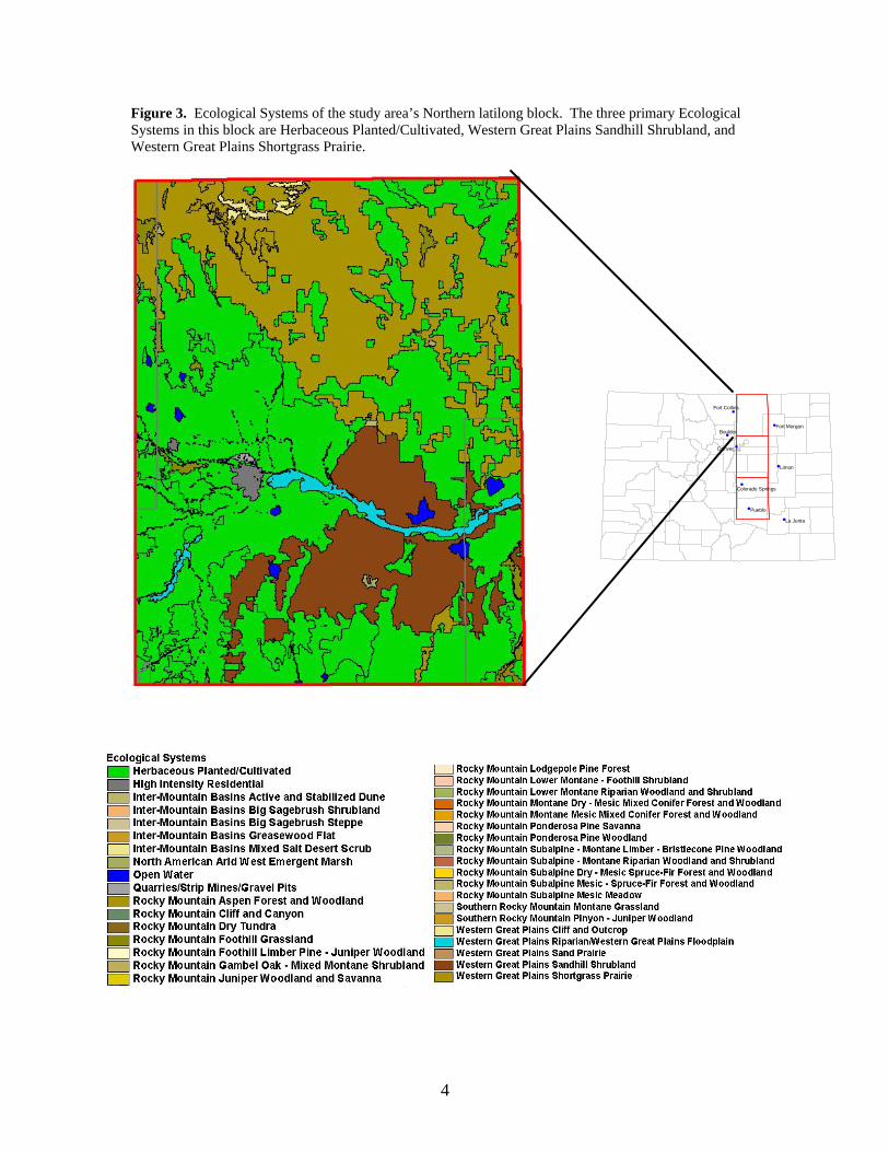
Figure 3. Ecological Systems of the study area’s Northern latilong block. The three primary Ecological Systems in this block are Herbaceous Planted/Cultivated, Western Great Plains Sandhill Shrubland, and Western Great Plains Shortgrass Prairie.
#
#
#
#
#
#
#
#
Fort Collins
Fort MorganBoulder
Denver
Limon
Colorado Springs
Pueblo
La Junta
4
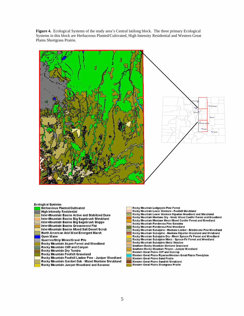
Figure 4. Ecological Systems of the study area’s Central latilong block. The three primary Ecological Systems in this block are Herbaceous Planted/Cultivated, High Intensity Residential and Western Great Plains Shortgrass Prairie.
#
#
#
#
#
#
#
#
Fort Collins
Fort MorganBoulder
Denver
Limon
Colorado Springs
Pueblo
La Junta
5
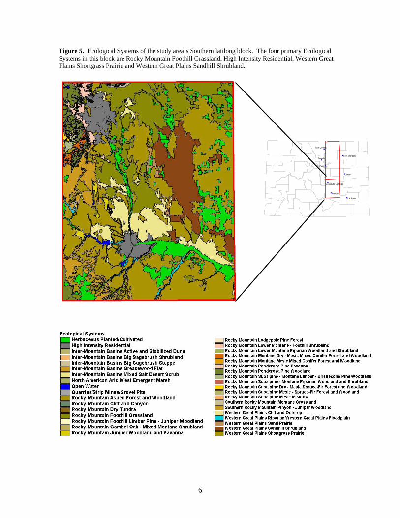
Figure 5. Ecological Systems of the study area’s Southern latilong block. The four primary Ecological Systems in this block are Rocky Mountain Foothill Grassland, High Intensity Residential, Western Great Plains Shortgrass Prairie and Western Great Plains Sandhill Shrubland.
#
#
#
#
#
#
#
#
Fort Collins
Fort MorganBoulder
Denver
Limon
Colorado Springs
Pueblo
La Junta
6
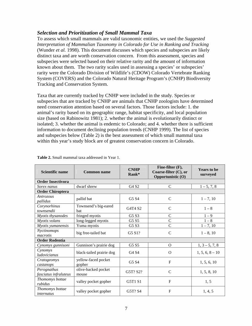
Selection and Prioritization of Small Mammal Taxa To assess which small mammals are valid taxonomic entities, we used the Suggested Interpretation of Mammalian Taxonomy in Colorado for Use in Ranking and Tracking (Wunder et al. 1998). This document discusses which species and subspecies are likely distinct taxa and are worth conservation concern. From this assessment, species and subspecies were selected based on their relative rarity and the amount of information known about them. The two rarity scales used in assessing a species’ or subspecies’ rarity were the Colorado Division of Wildlife’s (CDOW) Colorado Vertebrate Ranking System (COVERS) and the Colorado Natural Heritage Program’s (CNHP) Biodiversity Tracking and Conservation System. Taxa that are currently tracked by CNHP were included in the study. Species or subspecies that are tracked by CNHP are animals that CNHP zoologists have determined need conservation attention based on several factors. Those factors include: 1. the animal’s rarity based on its geographic range, habitat specificity, and local population size (based on Rabinowitz 1981); 2. whether the animal is evolutionarily distinct or isolated; 3. whether the animal is endemic to Colorado; and 4. whether there is sufficient information to document declining population trends (CNHP 1999). The list of species and subspecies below (Table 2) is the best assessment of which small mammal taxa within this year’s study block are of greatest conservation concern in Colorado. Table 2. Small mammal taxa addressed in Year 1.
Scientific name Common name CNHP Rank*
Fine-filter (F), Coarse-filter (C), or Opportunistic (O)
Years to be surveyed
Order Insectivora Sorex nanus dwarf shrew G4 S2 C 1 – 5, 7, 8 Order Chiroptera Antrozous pallidus pallid bat G5 S4 C 1 – 7, 10
Corynorhinus townsendii
Townsend’s big-eared bat G4T4 S2 C 1 – 8
Myotis thysanodes fringed myotis G5 S3 C 1 – 9 Myotis volans long-legged myotis G5 S5 C 1 – 8 Myotis yumanensis Yuma myotis G5 S3 C 1 – 7, 10 Nyctinomops macrotis big free-tailed bat G5 S1? C 1 – 8, 10
Order Rodentia Cynomys gunnisoni Gunnison’s prairie dog G5 S5 O 1, 3 – 5, 7, 8 Cynomys ludovicianus black-tailed prairie dog G4 S4 O 1, 5, 6, 8 – 10
Cratogeomys castanops
yellow-faced pocket gopher G5 S4 F 1, 5, 6, 10
Perognathus fasciatus infraluteus
olive-backed pocket mouse G5T? S2? C 1, 5, 8, 10
Thomomys bottae rubidus valley pocket gopher G5T1 S1 F 1, 5
Thomomys bottae internatus valley pocket gopher G5T? S4 F 1, 4, 5
7

Table 2 (cont.)
Scientific name Common name CNHP Rank*
Fine-filter (F), Coarse-filter (C), or Opportunistic (O)
Years to be surveyed
Order Rodentia (cont.) Thomomys talpoides macrotis northern pocket gopher G5T1 S1 F 1
Thomomys talpoides retrorsus northern pocket gopher G5T? S4 F 1, 9, 10
Zapus hudsonius preblei meadow jumping mouse G5T2 S1 O 1, 8
*Colorado Natural Heritage Program Biodiversity Tracking and Conservation System. Inventory methods 1. Field survey techniques: a. Rodent live-trapping: Small mammal fauna were sampled using Sherman live traps
(approximately 8cm x 8cm x 24 cm). Traps were baited with rolled oats and a ball of polyfil (polyester fiberfill) was placed in each trap to provide warmth. Traps were set in the evening (after 5 pm) and checked the following morning before 11 am. Traps were set out of direct sunlight to prevent overheating. All animals were identified immediately during the checking of traps. Sometimes measurements of external physical features, such as weights and lengths, were taken. Individuals that were not new or notable location records or needed for positive identification were released.
b. Pitfall trapping: Pitfall traps were used to capture insectivores and other small
mammals, which are frequently under-sampled in live trapping. Pitfall traps are 4-liter, number-10 coffee cans or similar-sized plastic paint buckets buried flush in the ground along natural features in the area. These traps were inspected to retrieve and identify any animals that were captured. Individuals that were not new or notable location records or needed for positive identification were released.
c. Mist netting: Mist nets were used to capture bats. Mist nets are the most effective
means of capturing flying bats in open areas. Mist nets are constructed of fine synthetic fibers supported by a lattice-work of braided nylon. The frame and trammels of the net are supported to form a capture area perpendicular to the ground with 4 or 5 long horizontal pockets of fine mesh (Wilson et al. 1996). The nets were monitored constantly to prevent bats from becoming completely ensnared and to prevent damage to the nets. Bats were removed, identified, and measurements of key features are taken. Individuals that were not new or notable location records or needed for positive identification were released. Before being released, bats were allowed to recover from stress imposed during handling.
d. Fossorial mammal trapping: Pocket gophers (Thomomys, Geomys, and Cratogeomys
spp.) were captured using Victor gopher traps. These traps are commonly used for gopher control throughout the state of Colorado. Gopher sign (active mounds, tunnels) dictated how many and where traps were set.
8

e. Visual identification: Not all species or subspecies required the collection of voucher specimens to document their presence in an area. Visual observations of mammals or their sign can assist in delineating a species or subspecies range. For instance, prairie dogs can be identified to species without taking specimens and documentation of the extent of the mounds seen in an area can be used to delineate prairie dog colonies.
2. Survey protocol:
Each mammal on the prioritized list for year one of the survey (Table 2) was evaluated to determine how its distribution could be delineated most appropriately. We used a method based on scale-dependent (fine or coarse) surveying. We used the following characteristics to determine which mammals would be surveyed using coarse-filter methods and which would be surveyed using fine-filter methods: 1. the size of the animal’s distribution in Colorado (based on Fitzgerald et al. 1994); 2. how well-defended this distribution is (how many locations have been documented to determine the current distribution). A third category for surveying (opportunistic) was included for taxa that are not of the highest priority for this project, but additional information would be beneficial for assessing conservation action.
i. Fine-filter surveying: For mammals that have a fairly restricted distribution in Colorado (e.g. pocket gopher subspecies), we used a targeted effort to better determine their distribution and their presence within that distribution. This involved surveying within and at select limits of their current known distribution. As the mammals were detected at the outer limits of the distribution, additional survey took place further and further from the edge of the distribution until the species or subspecies of interest could no longer be detected.
ii. Coarse-filter surveying: The distributions of some of the small mammals on
the prioritized list are difficult to assess. For some taxa there are few data on their current distribution (e.g. Perognathus fasciatus), others are more widely distributed, but there are relatively few records within their distributions (e.g. most shrews and bats). Logistically, it would be difficult to adequately delineate the distribution of these species or subspecies. For these taxa (and others that may not be apparent), surveys were conducted in major habitat types within the study area in an attempt to obtain new location records. For the coarse-filter animals that have better-described habitat associations (e.g. Perognathus fasciatus) we conducted coarse-filter surveys in similar habitat types throughout the study area.
iii. Opportunistic surveying: Several rare taxa have well-delineated distributions
and this project did not focus its efforts on these mammals. Included in this category are Zapus hudsonius preblei, Cynomys ludovicianus, and Cynomys gunnisoni.
9

Results Trapping Effort Fossorial Mammal Trapping Trapping for pocket gophers took place in 45 locations and in eight different Ecological Systems (Figure 6). Locations represent 5-20 gopher traps set for one day. Pitfall Trapping Pitfall traps were set in 62 locations and in 13 different Ecological Systems (Figure 7). Locations represent 5 to 10 pitfall traps set for one night.
Figure 6. Gopher trapping localities. Figure 7. Pitfall trapping localities.
10
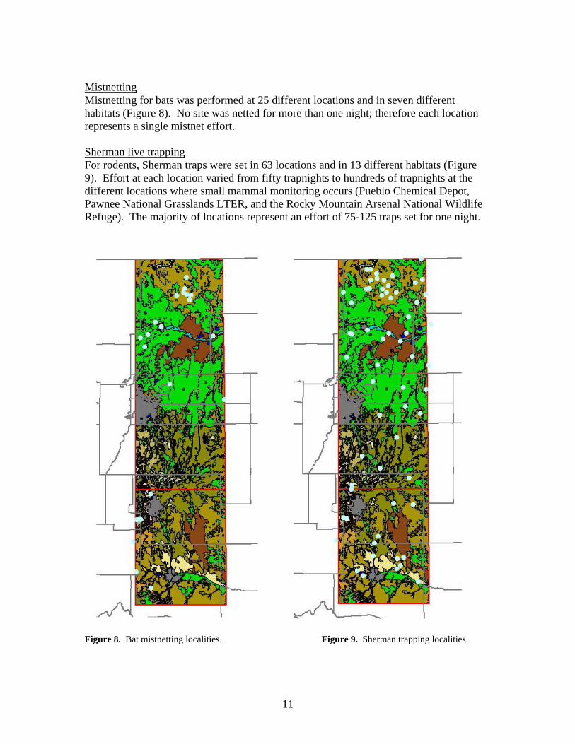
Mistnetting Mistnetting for bats was performed at 25 different locations and in seven different habitats (Figure 8). No site was netted for more than one night; therefore each location represents a single mistnet effort. Sherman live trapping For rodents, Sherman traps were set in 63 locations and in 13 different habitats (Figure 9). Effort at each location varied from fifty trapnights to hundreds of trapnights at the different locations where small mammal monitoring occurs (Pueblo Chemical Depot, Pawnee National Grasslands LTER, and the Rocky Mountain Arsenal National Wildlife Refuge). The majority of locations represent an effort of 75-125 traps set for one night.
Figure 8. Bat mistnetting localities. Figure 9. Sherman trapping localities.
11
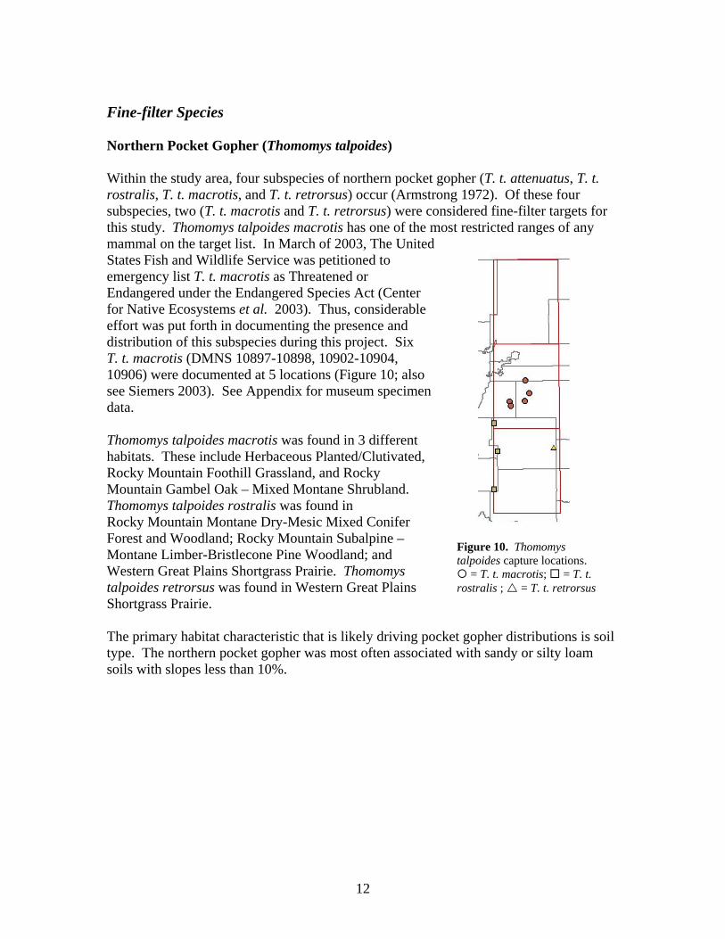
Fine-filter Species Northern Pocket Gopher (Thomomys talpoides) Within the study area, four subspecies of northern pocket gopher (T. t. attenuatus, T. t. rostralis, T. t. macrotis, and T. t. retrorsus) occur (Armstrong 1972). Of these four subspecies, two (T. t. macrotis and T. t. retrorsus) were considered fine-filter targets for this study. Thomomys talpoides macrotis has one of the most restricted ranges of any mammal on the target list. In March of 2003, The United States Fish and Wildlife Service was petitioned to emergency list T. t. macrotis as Threatened or Endangered under the Endangered Species Act (Center for Native Ecosystems et al. 2003). Thus, considerable effort was put forth in documenting the presence and distribution of this subspecies during this project. Six T. t. macrotis (DMNS 10897-10898, 10902-10904, 10906) were documented at 5 locations (Figure 10; also see Siemers 2003). See Appendix for museum specimen data. Thomomys talpoides macrotis was found in 3 different habitats. These include Herbaceous Planted/Clutivated, Rocky Mountain Foothill Grassland, and Rocky Mountain Gambel Oak – Mixed Montane Shrubland. Thomomys talpoides rostralis was found in Rocky Mountain Montane Dry-Mesic Mixed Conifer Forest and Woodland; Rocky Mountain Subalpine – Montane Limber-Bristlecone Pine Woodland; and Western Great Plains Shortgrass Prairie. Thomomys
Figure 10. Thomomys talpoides capture locations.
= T. t. macrotis; = T. t. rostralis ; = T. t. retrorsus talpoides retrorsus was found in Western Great Plains
Shortgrass Prairie. The primary habitat characteristic that is likely driving pocket gopher distributions is soil type. The northern pocket gopher was most often associated with sandy or silty loam soils with slopes less than 10%.
12
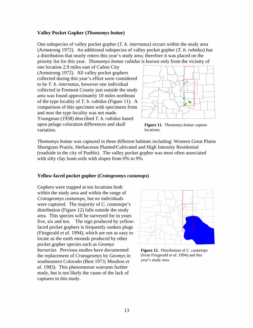
Valley Pocket Gopher (Thomomys bottae)
Figure 12. Distribution of C. castanops (from Fitzgerald et al. 1994) and this year’s study area.
Figure 11. Thomomys bottae capture locations.
One subspecies of valley pocket gopher (T. b. internatus) occurs within the study area (Armstrong 1972). An additional subspecies of valley pocket gopher (T. b. rubidus) has a distribution that nearly enters this year’s study area; therefore it was placed on the priority list for this year. Thomomys bottae rubidus is known only from the vicinity of one location 2.9 miles east of Cañon City (Armstrong 1972). All valley pocket gophers collected during this year’s effort were considered to be T. b. internatus, however one individual collected in Fremont County just outside the study area was found approximately 10 miles northeast of the type locality of T. b. rubidus (Figure 11). A comparison of this specimen with specimens from and near the type locality was not made. Youngman (1958) described T. b. rubidus based upon pelage coloration differences and skull variation.
#S
#S#S
#S#S#S
#S
Thomomys bottae was captured in three different habitats including: Western Great Plains Shortgrass Prairie, Herbaceous Planted/Cultivated and High Intensity Residential (roadside in the city of Pueblo). The valley pocket gopher was most often associated with silty clay loam soils with slopes from 0% to 9%. Yellow-faced pocket gopher (Cratogeomys castanops) Gophers were trapped at ten locations both within the study area and within the range of Cratogeomys castanops, but no individuals were captured. The majority of C. castanops’s distribution (Figure 12) falls outside the study area. This species will be surveyed for in years five, six and ten. The sign produced by yellow-faced pocket gophers is frequently sunken plugs (Fitzgerald et al. 1994), which are not as easy to locate as the earth mounds produced by other pocket gopher species such as Geomys bursarius. Previous studies have documented the replacement of Cratogeomys by Geomys in southeastern Colorado (Best 1973; Moulton et al. 1983). This phenomenon warrants further study, but is not likely the cause of the lack of captures in this study.
13

Coarse-filter Species Olive-backed Pocket Mouse (Perognathus fasciatus) One subspecies of olive-backed pocket mouse (P. f. infraluteus) occurs within the study ar(Armstrong 1972). The olive-backed pocket mouse was found at two locations in Arapahoe and Elbert Counties (Figure 13). The specimens from Elbert County were collected from the Western Great Plains Shortgrass Prairie habitat and the specimen from Arapahoe County was collected from the Rocky Mountain Foothill Grassland habitat. All specimens were collected from pitfall Figure 13. Perognathus fasciatus capture
locations.
#S
#S
ea
traps. Bats Limited roosting sites for bats are available in most of the habitats (e.g. shortgrass prairie) throughout the study area. We mistnetted water sources in such habitats with limited success. A number of urban/suburban sites were netted, with little capture success. Captures in these habitats consisted primarily of big brown bats (Eptesicus fuscus). The forested regions on the western margin of the study area provide more roost sites and support a greater diversity of species. Species trapped during efforts in that area include the long-legged bat (Myotis volans), the long-eared myotis (Myotis evotis), the fringed myotis (Myotis thysanodes), the silver-haired bat (Lasionycteris noctivagans), big brown bat (Eptesicus fuscus), the little brown bat (Myotis lucifugus), the Yuma myotis (Myotis yumanensis), and the Western small-footed myotis (Myotis ciliolabrum). Priority species are listed in Table 3. No caves or mines were surveyed during this year’s effort. Table 3. Number of priority bat species capture locations and ecological systems in which captures occurred. Bat Species # of locations Ecological System(s)
Myotis thysanodes 3
Rocky Mountain Subalpine – Montane Limber-Bristlecone Pine Woodland; Western Great Plains Shortgrass Prairie & Rocky Mountain Subalpine – Montane Riparian Woodland and Shrubland
Myotis volans 3 Rocky Mountain Subalpine – Montane Limber-Bristlecone Pine Woodland & Western Great Plains Shortgrass Prairie
Myotis yumanensis 1 Western Great Plains Shortgrass Prairie
14
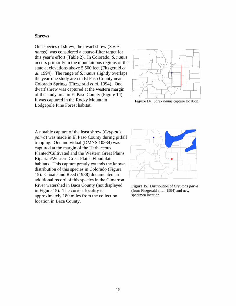
Shrews One species of shrew, the dwarf shrew (Sorex
Figure 14. Sorex nanus capture location.
nanus), was considered a coarse-filter target for this year’s effort (Table 2). In Colorado, S. nanus occurs primarily in the mountainous regions of the state at elevations above 5,500 feet (Fitzgerald et al. 1994). The range of S. nanus slightly overlaps the year-one study area in El Paso County near Colorado Springs (Fitzgerald et al. 1994). One dwarf shrew was captured at the western margin of the study area in El Paso County (Figure 14). It was captured in the Rocky Mountain Lodgepole Pine Forest habitat. A notable capture of the least shrew (Cryptotis parva) was made in El Paso County during pitfall trapping. One individual (DMNS 10884) was captured at the margin of the Herbaceous Planted/Cultivated and the Western Great Plains Riparian/Western Great Plains Floodplain habitats. This capture greatly extends the known distribution of this species in Colorado (Figure 15). Choate and Reed (1988) documented an additional record of this species in the Cimarron River watershed in Baca County (not displayed in Figure 15). The current locality is approximately 180 miles from the collection location in Baca County.
##
#S
r
15
Figure 15. Distribution of Cryptotis parva(from Fitzgerald et al. 1994) and new specimen location.
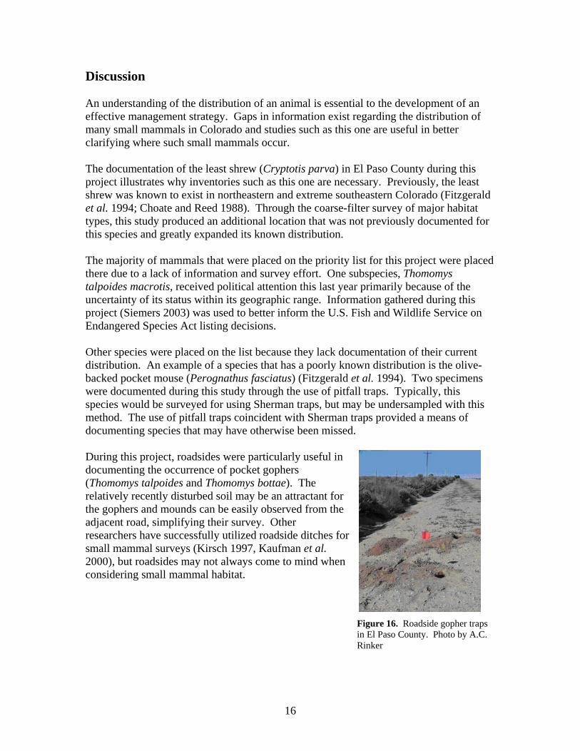
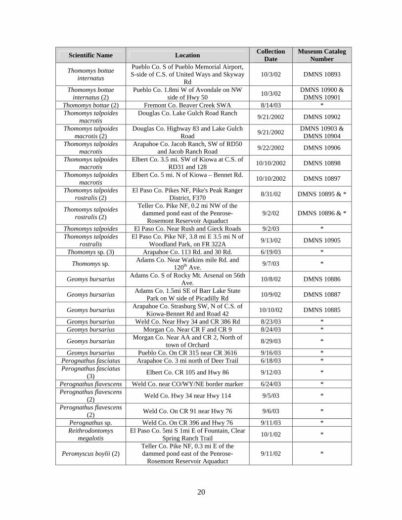
Discussion An understanding of the distribution of an animal is essential to the development of an effective management strategy. Gaps in information exist regarding the distribution of many small mammals in Colorado and studies such as this one are useful in better clarifying where such small mammals occur. The documentation of the least shrew (Cryptotis parva) in El Paso County during this project illustrates why inventories such as this one are necessary. Previously, the least shrew was known to exist in northeastern and extreme southeastern Colorado (Fitzgerald et al. 1994; Choate and Reed 1988). Through the coarse-filter survey of major habitat types, this study produced an additional location that was not previously documented for this species and greatly expanded its known distribution. The majority of mammals that were placed on the priority list for this project were placed there due to a lack of information and survey effort. One subspecies, Thomomys talpoides macrotis, received political attention this last year primarily because of the uncertainty of its status within its geographic range. Information gathered during this project (Siemers 2003) was used to better inform the U.S. Fish and Wildlife Service on Endangered Species Act listing decisions. Other species were placed on the list because they lack documentation of their current distribution. An example of a species that has a poorly known distribution is the olive-backed pocket mouse (Perognathus fasciatus) (Fitzgerald et al. 1994). Two specimens were documented during this study through the use of pitfall traps. Typically, this species would be surveyed for using Sherman traps, but may be undersampled with this method. The use of pitfall traps coincident with Sherman traps provided a means of documenting species that may have otherwise been missed. During this project, roadsides were particularly useful in documenting the occurrence of pocket gophers (Thomomys talpoides and Thomomys bottae). The relatively recently disturbed soil may be an attractant for the gophers and mounds can be easily observed from the adjacent road, simplifying their survey. Other researchers have successfully utilized roadside ditches for small mammal surveys (Kirsch 1997, Kaufman et al. 2000), but roadsides may not always come to mind when considering small mammal habitat. Figure 16. Roadside gopher traps
in El Paso County. Photo by A.C. Rinker
16

Acknowledgments Roni Chen, Kim Cornelisse, Lisa Rinker, Bobby Weidmann, Jennifer Kreps performed additional fieldwork. Roni Chen was a great help in preparing museum specimens. Thanks to Bill Alther and Cheri Jones at the Denver Museum of Nature and Science. Additional small mammal data were provided by Dr. Paul Stapp from the Long Term Ecological Research station in Weld County and by Dr. Eric Stone from the Rocky Mountain Arsenal National Wildlife Refuge in Adams County. John Sovell provided helpful comments on the report. Literature Cited Armstrong, D. M. 1972. Distribution of mammals in Colorado. University of Kansas
Press, Lawrence. 415 pp. Best, T. L. 1973. Ecological separation of three genera of pocket gophers (Geomyidae).
Ecology 54:1311-1319. Center for Native Ecosystems, Forest Guardians, M. C. McGowan, and J. Smith. 2003.
Petition for a rule to list Thomomys talpoides macrotis (northern pocket gopher, subspecies macrotis) as Threatened or Endangered under the Endangered Species Act.
Choate, J. R., and M. P. Reed. 1988. Least shrew, Cryptotis parva, in southwestern
Kansas and southeastern Colorado. Southwestern Naturalist 33(3):361-362. Colorado Natural Heritage Program. 1999. Conservation status handbook: Colorado’s
animals, plants, and plant communities of special concern. 259 pp. Comer, P., S. Menard, M. Tuffly, K. Kindscher, R. Rondeau, G. Jones, G. Steinuaer, and
D. Ode. 2003a. Upland and wetland Ecological Systems in Colorado, Wyoming, South Dakota, Nebraska, and Kansas. Report and map (10 hectare minimum map unit) to the National Gap Analysis Program. Dept. of Interior USGS. NatureServe.
Comer, P., D. Faber-Langendoen, R. Evans, S. Gawler, C. Josse, G. Kittel, S. Menard, M.
Pyne, M. Reid, K. Schulz, K. Snow, and J. Teague. 2003b. Ecological Systems of the United States: A Working Classification of U.S. Terrestrial Systems. NatureServe, Arlington, Virginia.
Fitzgerald, J. P., C. Meaney, and D. M. Armstrong. 1994. Mammals of Colorado.
University Press of Colorado, Nowat. 467 pp.
17

Kaufman, D. W., G. A. Kaufman, and B. K. Clark. 2000. Small mammals in native and anthropogenic habitats in the Lake Wilson area of north-central Kansas. Southwestern Naturalist 45(1):45-60.
Kirsch, E. M. 1997. Small mammal community composition in cornfields, roadside
ditches, and prairies in eastern Nebraska. Natural Areas Journal 17(3):204-211. Lechleitner, R. R. 1969. Wild mammals of Colorado: Their appearance, habits,
distribution, and abundance. Prett Publishing Co., Boulder, CO. Moulton, M. P., J. R. Choate, and S. T. Bissell. 1983. Biogeographic relationships of pocket gophers in southeastern Colorado. Southwestern Naturalist 28:53-60.
Rabinowitz, D. 1981. Seven forms of rarity. Pp. 205-217 in The Biological Aspects of
Rare Plant Conservation (ed. H. Synge). John Wiley and Sons, New York. Schorr, R. A. and J. L. Siemers. 2001. An evaluation of small mammal distribution in
Colorado, prioritizing rare taxa: A proposed study design. Unpublished report to the Colorado Division of Wildlife by the Colorado Natural Heritage Program.
Siemers, J. L. 2003. Preliminary Report on the Distribution of Thomomys talpoides
macrotis in Douglas, Arapahoe and Elbert Counties, Colorado. Unpublished report to the Colorado Division of Wildlife by the Colorado Natural Heritage Program.
Warren, E. R. 1910. The mammals of Colorado. G. P. Putnam and Sons, New York. Warren, E. R. 1942. The mammals of Colorado. University of Oklahoma Press, Norman.
330 pp. Wilson, D. E., F. R. Cole, J. D. Nichols, R. Rudran, and M. S. Foster. 1996. Measuring
and monitoring biological diversity: Standard methods for mammals. Smithsonian Institute Press, Washington, D. C. 409 pp.
Wunder, M. B., J. Gross, and R. A. Schorr. 1998. Suggested Interpretation of Mammalian
Taxonomy in Colorado for Use in Ranking and Tracking. Unpublished report by The Colorado Natural Heritage Program. 15 pp.
Youngman, P. M. 1958. Geographic variation in the pocket gopher, Thomomys bottae, in
Colorado. University of Kansas Publications, Museum of Natural History 9(12):363-384.
18

Appendix. Museum specimen data. All specimens have been submitted to the Denver
Museum of Nature and Science. Catalog numbers are provided where available.
Scientific Name Location Collection Date
Museum Catalog Number
Order Insectivora
Sorex cinereus Teller Co. Pike NF, Deer Park Wetland Area 9/11/02 DMNS 10794
Sorex cinereus Teller Co. Pike NF, Deer Park Wetland Area 9/11/02 *
Sorex cinereus El Paso Co. Pike NF, 3.8 mi E 3.5 mi N of Woodland Park, on FR 322A 9/13/02 *
Sorex cinereus El Paso Co. Pike NF, 3.8 mi E 3.5 mi N of Woodland Park, on FR 322A 9/19/02 *
Sorex cinereus El Paso Co. Pike NF, 3.8 mi E 3.5 mi N of Woodland Park, on FR 322A 9/19/02 *
Sorex monticolus Teller Co. Pike NF, East Beaver Creek west bank 9/11/02 DMNS 10791
Sorex monticolus (2) Teller Co. Pike NF, Elk Park Wetland Area 9/11/02 DMNS 10792-10793
Sorex monticolus El Paso Co. Pike NF, 3.8 mi E 3.5 mi N of Woodland Park, on FR 322A 9/13/02 *
Sorex cinereus Teller Co. Pike NF, 0.3 mi E of the dammed pond east of the Penrose-
Rosemont Reservoir Aquaduct 9/11/02 *
Sorex cinereus Teller Co. Pike NF, Deer Park Wetland Area 9/11/02 *
Sorex monticolus Teller Co. Pike NF, East Beaver Creek west bank 9/11/02 *
Sorex cinereus Teller Co. Pike NF, East Beaver Creek west bank 9/11/02 *
Sorex nanus El Paso Co. Pike NF, 7 mi N 5 mi E of Woodland Park, on FR 300 9/19/02 *
Cryptotis parva El Paso Co. 5mi S 1mi E of Fountain, Clear Spring Ranch Trail 10/1/02 DMNS 10884
Sorex sp. Teller Co. Pike NF, East Beaver Creek west bank 9/11/02 *
Order Rodentia
Thomomys bottae internatus (2)
Pueblo Co. 2.5mi SE of Beulah, Upper Hudson Ranch at North St. Charles River
Canyon 9/25/02 DMNS 10888 & *
Thomomys bottae internatus
Pueblo Co. 2.5mi SE of Beulah, Upper Hudson Ranch at North St. Charles River
Canyon 9/26/02 DMNS 10891
Thomomys bottae internatus (2)
Pueblo Co. Cedar Grove at Rock Creek, Lower Hudson Ranch 9/26/02 DMNS 10890 & *
Thomomys bottae internatus
Pueblo Co. Business Hwy 50 E-bound exit ramp to Pueblo Memorial Airport 10/2/02 DMNS 10889
Thomomys bottae internatus
Pueblo Co. S of Pueblo Memorial Airport, S-side of C.S. of United Ways and Skyway
Rd 10/2/02 DMNS 10892
Thomomys bottae internatus (2)
Pueblo Co. Business Hwy 50 E-bound exit ramp to Pueblo Memorial Airport 10/2/02 DMNS 10894 &
DMNS 10899
19
Scientific Name Location Collection Date
Museum Catalog Number
Thomomys bottae internatus
Pueblo Co. S of Pueblo Memorial Airport, S-side of C.S. of United Ways and Skyway
Rd 10/3/02 DMNS 10893
Thomomys bottae internatus (2)
Pueblo Co. 1.8mi W of Avondale on NW side of Hwy 50 10/3/02 DMNS 10900 &
DMNS 10901 Thomomys bottae (2) Fremont Co. Beaver Creek SWA 8/14/03 * Thomomys talpoides
macrotis Douglas Co. Lake Gulch Road Ranch 9/21/2002 DMNS 10902
Thomomys talpoides macrotis (2)
Douglas Co. Highway 83 and Lake Gulch Road 9/21/2002 DMNS 10903 &
DMNS 10904 Thomomys talpoides
macrotis Arapahoe Co. Jacob Ranch, SW of RD50
and Jacob Ranch Road 9/22/2002 DMNS 10906
Thomomys talpoides macrotis
Elbert Co. 3.5 mi. SW of Kiowa at C.S. of RD31 and 128 10/10/2002 DMNS 10898
Thomomys talpoides macrotis
Elbert Co. 5 mi. N of Kiowa – Bennet Rd. 10/10/2002 DMNS 10897
Thomomys talpoides rostralis (2)
El Paso Co. Pikes NF, Pike's Peak Ranger District, F370 8/31/02 DMNS 10895 & *
Thomomys talpoides rostralis (2)
Teller Co. Pike NF, 0.2 mi NW of the dammed pond east of the Penrose-
Rosemont Reservoir Aquaduct 9/2/02 DMNS 10896 & *
Thomomys talpoides El Paso Co. Near Rush and Gieck Roads 9/2/03 * Thomomys talpoides
rostralis El Paso Co. Pike NF, 3.8 mi E 3.5 mi N of
Woodland Park, on FR 322A 9/13/02 DMNS 10905
Thomomys sp. (3) Arapahoe Co. 113 Rd. and 30 Rd. 6/19/03 *
Thomomys sp. Adams Co. Near Watkins mile Rd. and 120th Ave. 9/7/03 *
Geomys bursarius Adams Co. S of Rocky Mt. Arsenal on 56th Ave. 10/8/02 DMNS 10886
Geomys bursarius Adams Co. 1.5mi SE of Barr Lake State Park on W side of Picadilly Rd 10/9/02 DMNS 10887
Geomys bursarius Arapahoe Co. Strasburg SW, N of C.S. of Kiowa-Bennet Rd and Road 42 10/10/02 DMNS 10885
Geomys bursarius Weld Co. Near Hwy 34 and CR 386 Rd 8/23/03 * Geomys bursarius Morgan Co. Near CR F and CR 9 8/24/03 *
Geomys bursarius Morgan Co. Near AA and CR 2, North of town of Orchard 8/29/03 *
Geomys bursarius Pueblo Co. On CR 315 near CR 3616 9/16/03 * Perognathus fasciatus Arapahoe Co. 3 mi north of Deer Trail 6/18/03 * Perognathus fasciatus
(3) Elbert Co. CR 105 and Hwy 86 9/12/03 *
Perognathus flavescens Weld Co. near CO/WY/NE border marker 6/24/03 * Perognathus flavescens
(2) Weld Co. Hwy 34 near Hwy 114 9/5/03 *
Perognathus flavescens (2) Weld Co. On CR 91 near Hwy 76 9/6/03 *
Perognathus sp. Weld Co. On CR 396 and Hwy 76 9/11/03 * Reithrodontomys
megalotis El Paso Co. 5mi S 1mi E of Fountain, Clear
Spring Ranch Trail 10/1/02 *
Peromyscus boylii (2) Teller Co. Pike NF, 0.3 mi E of the dammed pond east of the Penrose-
Rosemont Reservoir Aquaduct 9/11/02 *
20

Scientific Name Location Collection Date
Museum Catalog Number
Peromyscus boylii El Paso Co. 5mi S 1mi E of Fountain, Clear Spring Ranch Trail 10/3/02 *
Peromyscus sp. El Paso Co. Pike NF, 3.8 mi E 3.5 mi N of Woodland Park, on FR 322A 9/19/02 *
Peromyscus maniculatus (2) Weld Co. On CR 396 and Hwy 76 9/11/03 *
Peromyscus maniculatus Elbert Co. On CR 125 on bend of Road 9/12/03 *
Microtus montanus El Paso Co. Pike NF 9/5/02 *
Microtus sp. El Paso Co. Pike NF, Pikes Peak Ranger District, FR 370 8/31/02 DMNS 10883
Microtus sp. El Paso Co. Pikes NF, Pike's Peak Ranger District, FR370 9/1/02 *
Microtus sp. El Paso Co. Pikes NF, Pike's Peak Ranger District, FR370 9/1/02 *
Microtus sp. El Paso Co. Pikes NF, Pike's Peak Ranger District, FR370 9/2/02 *
Microtus sp. El Paso Co. Pikes NF, Pike's Peak Ranger District, FR370 9/2/02 *
* Museum catalog numbers and verification of identifications pending.
21