distribution, geochemistry, and storage of mining sediment
TRANSCRIPT
1
TThhee OOzzaarrkkss EEnnvviirroonnmmeennttaall aanndd WWaatteerr RReessoouurrcceess IInnssttiittuuttee ((OOEEWWRRII))
MMiissssoouurrii SSttaattee UUnniivveerrssiittyy ((MMSSUU))
Big River Mining Sediment Assessment Project
Distribution, Geochemistry, and Storage of Mining Sediment in
Channel and Floodplain Deposits of the Big River System in St.
Francois, Washington, and Jefferson Counties, Missouri
Field work completed Fall 2008 to Spring 2009
FINAL REPORT
Prepared by:
Robert T. Pavlowsky, Ph.D., Principal Investigator Marc R. Owen, M.S., Research Specialist II Derek J. Martin, M.S., Research Specialist I
Ozarks Environmental and Water Resources Institute Missouri State University
901 South National Avenue Springfield, MO 65897
Funded by: U.S. Fish and Wildlife Service
Cooperative Ecosystems Studies Unit
David E. Mosby, Environmental Contaminants Specialist Columbia Missouri Field Office
573-234-2132 Ext. 113 [email protected]
June 18, 2010
OEWRI EDR-10-002

2
TABLE OF CONTENTS
TABLE OF CONTENTS ......................................................................................................................... 2
LIST OF TABLES .................................................................................................................................... 3
LIST OF FIGURES .................................................................................................................................. 4
ABSTRACT ............................................................................................................................................... 6
INTRODUCTION..................................................................................................................................... 7
BACKGROUND ..................................................................................................................................... 10
STUDY AREA ......................................................................................................................................... 11
Geology and Soils ................................................................................................................................ 11 Mining History..................................................................................................................................... 12 Climate and Hydrology ....................................................................................................................... 12 County Boundaries .............................................................................................................................. 12
METHODS .............................................................................................................................................. 13
Sampling Design .................................................................................................................................. 13 Field Methods ...................................................................................................................................... 13
Geomorphic Analyses of Channel and Bar Areas. ....................................................................... 14 Channel Surveys ........................................................................................................................... 14 Sediment Sampling and Characterization ..................................................................................... 14
Laboratory Methods ........................................................................................................................... 16 Sample Preparation ....................................................................................................................... 16 Sediment Texture .......................................................................................................................... 16 Chat Grain Counts......................................................................................................................... 17 Geochemical Analysis .................................................................................................................. 17
Geospatial Data and Analysis ............................................................................................................ 20 GIS Data Sources .......................................................................................................................... 20 Channel and Floodplain Feature Classification ............................................................................ 21
River Kilometer Scale ......................................................................................................................... 22 Background Information and Appendices ........................................................................................ 22
RESULTS AND DISCUSSION ............................................................................................................. 23
Tailings Input Geochemistry .............................................................................................................. 23 Channel Sediment Geochemistry and Particle Size Trends ............................................................ 24
Comparison of Glide and Bar Geochemistry ................................................................................ 24 Within-Site Geochemical Variability ........................................................................................... 25 Particle Size of Channel Glide and Bar Deposits ......................................................................... 25 Chat Grain Mineralogy ................................................................................................................. 26 Downstream changes in Sediment Geochemistry......................................................................... 27 Tributary Channel Sediment Contamination ................................................................................ 29 Bar Core Analysis ......................................................................................................................... 29 Lead Concentrations in the <2 mm and Chat Fractions of Channel Sediment ............................. 31

3
Contamination Trends in Floodplain Deposits ................................................................................. 31 Depth of Contaminated Floodplain Deposits ................................................................................ 32 Maximum Floodplain Contamination ........................................................................................... 32 Surface Floodplain Contamination ............................................................................................... 32 Floodplain Contamination Processes ............................................................................................ 33 Average Floodplain Contamination .............................................................................................. 34 Spatial Variability of Floodplain Geochemistry ........................................................................... 35 Tributary Floodplain Contamination ............................................................................................ 36 Pb:Zn Ratios of Floodplain Deposits ............................................................................................ 36
Storage of Contaminated Sediment and Lead .................................................................................. 37 Channel Sediment and Lead Storage ............................................................................................ 37 Floodplain Soil and Lead Storage ................................................................................................. 39
CONCLUSIONS ..................................................................................................................................... 42
LITERATURE CITED .......................................................................................................................... 45
TABLES ................................................................................................................................................... 50
FIGURES ................................................................................................................................................. 65
APPENDIX ............................................................................................................................................ 106
LIST OF TABLES
Table 1: Location and Size of Tailings Piles ...........................................................................................................50 Table 2: Lead and Zinc in Tailings Piles .................................................................................................................51 Table 3: Explanation of Geologic Map Units ..........................................................................................................52 Table 4: Sample Site Descriptions...........................................................................................................................53 Table 5: Geospatial Data Sources ............................................................................................................................54 Table 6: Size Fractionation of Metals in Tailings Materials ...................................................................................55 Table 7: Geochemical Differentiation by Size Fraction ..........................................................................................56 Table 8a: Channel Sediment Geochemistry (Arithmetic) .......................................................................................57 Table 9: Geochemistry of Chat Grains from Different Sources ..............................................................................59 Table 10: Channel sediment geochemistry at Tributaries and Control Sites ...........................................................60 Table 11: Comparison of Surface and Core Metal Content in Bar Deposits ...........................................................61 Table 12: Step Model for Depth of Floodplain Contamination ...............................................................................61 Table 13: Floodplain Sediment Geochemistry at Tributaries and Control Sites ......................................................62 Table 14: Step Model for In-Channel Pb Concentrations. .......................................................................................62 Table 15: Channel Dimensions and Unit Storage ...................................................................................................63 Table 16: Channel and Floodplain Storage Volume by County ..............................................................................63 Table 17. Sediment Volume and Pb Mass as a Percent of Total by County ...........................................................64

4
LIST OF FIGURES
Figure 1: Mining areas in the Big River watershed ..................................................................................................65 Figure 2. Bedrock Geology of the Big River Basin ................................................................................................66 Figure 3: Sample Site Locations ...............................................................................................................................67 Figure 4A: Glide Photos ...........................................................................................................................................68 Figure 5A: Bar Photo - High Gravel Bar Deposit ...................................................................................................69 Figure 6A: Bar Coring ..............................................................................................................................................70 Figure 7A: Floodplain Sediment Sampling ..............................................................................................................72 Figure 8: Channel Sediment Source Distribution .....................................................................................................73 Figure 9: Downstream Pb contamination trends. .....................................................................................................74 Figure 10: Downstream Trends in Channel Sediment Pb ........................................................................................74 Figure 11: Channel Sediment Pb Comparison with Previous Studies ......................................................................75 Figure 12A: Downstream Trends in Channel Sediment Zn ....................................................................................75 Figure 13: Fine Sediment Distribution in Bar and Glide Samples ...........................................................................77 Figure 14: Coarse Gravel Distribution in Bar and Glide Samples ...........................................................................78 Figure 15: Chat-Sized Sediment Distribution in Bar and Glide Samples ................................................................78 Figure 16: Chat Composition in Channel Sediments ...............................................................................................79 Figure 17 A&B: Downstream Patterns in Metal-Sediment Size Relationships .......................................................80 Figure 18: Metal Contaminant Variability Among in Bar Cores and Surface Samples ..........................................84 Figure 19: Relationship of Bar Surface Metal Content to Core Composite Average ..............................................85 Figure 20: Depth of Contaminated Soil on Floodplain ...........................................................................................86 Figure 21: Downstream Trends in Maximum Floodplain Pb Concentrations .........................................................86 Figure 22: Downstream Pb Concentration at Floodplain Surface ...........................................................................87 Figure 23: Downstream Mean Floodplain Pb Concentrations .................................................................................87 Figure 24: Downstream Mean Floodplain Zn and Ca ..............................................................................................88 Figure 25: Downstream Mean Floodplain Fe and Mn .............................................................................................88 Figure 26: Variability in Floodplain Pb in Cores at Selected Sites .........................................................................89 Figure 27: Variability in Floodplain Zn in Cores at Selected Sites .........................................................................90 Figure 28: Variability in Floodplain Ca in Cores at Selected Sites .........................................................................91 Figure 29: Washington State Park Transect #1 ........................................................................................................92 Figure 30: St. Francois State Park Transect #1 .......................................................................................................93 Figure 31: Washington State Park Transect #3 .......................................................................................................94 Figure 32: Morse Mill Transect #2 ..........................................................................................................................95 Figure 33: Pb:Zn Ratios in Floodplain Deposits .....................................................................................................96 Figure 34: Pb:Zn Ratios in the <2 mm Fraction in Channel Deposits.....................................................................96 Figure 35: Dispersal Trend for In-Channel Pb Concentrations ................................................................................97 Figure 36: Mean Reach Width by Site ....................................................................................................................97 Figure 37: Downstream mean reach channel width .................................................................................................98 Figure 38: Reach Channel Sediment Depth by Site ................................................................................................98 Figure 39: Downstream Mean Reach In-Channel Sediment Depth .........................................................................99 Figure 40: Downstream Unit Volume of In-Channel Storage ..................................................................................99 Figure 41: Mean Unit Channel Sediment Storage at each Study Site ...................................................................100 Figure 42: Relative Bar Sediment Storage at each Study Site ................................................................................100 Figure 43: Channel Feature Classification Data Extracted from 2007 2-ft Resolution, Leaf-Off Aerial Photography ............................................................................................................................................................101

5
Figure 44: Contaminated channel sediment and lead storage in the Big River ......................................................102 Figure 45: Downstream Floodplain Area by Landform .........................................................................................103 Figure 46: Downstream Floodplain Sediment and Pb Mass per Unit Distance .....................................................104

6
ABSTRACT
The Old Lead Belt is a historic lead (Pb) and zinc (Zn) mining sub-district within the Southeast Missouri Lead Mining District which was a global producer of Pb worldwide from 1869 to 1972. Past and ongoing releases of chat, tailings, and other mining wastes to the Big River have resulted in the contamination of channel sediment and floodplain deposits with toxic levels of Pb along 170 river kilometers of the Big River from Leadwood to its confluence with the Meramec River. Previous studies by the USGS and USFWS identified elevated Pb concentrations in the active channel sediments of Big River. However, what is not well understood are the spatial and temporal patterns of the volume or mass storage of mining sediment in channel and floodplain deposits of the Big River and its major tributaries.
The magnitude and impact of mining operations on the sediment load and geochemistry of the Big River has been significant. Active channel bed and bar deposits are contaminated above the aquatic sediment PEC with >128 ppm Pb from Leadwood (R-km 171) to the confluence with the Meramec River (R-km 0). In channel sediments, the highest Pb concentrations (>1,000 ppm Pb) occur from Desloge (R-km 158.1) to St. Francois State Park (R-km 140.3). Similarly, overbank floodplain deposits are contaminated above the residential soil threshold limit of 400 ppm Pb along the entire length of the river below Leadwood to a depth of 1 to 4 meters or more. In floodplain deposits, the highest concentrations (>2,000 ppm) tend to occur between the Bonehole (R-km 165.3) and Browns Ford (R-km 79.5).
Both fine-grained and coarse sediments are contaminated with Pb and other metals in the Big River. XRF Pb analyses for <2 mm fraction of channel sediment typically approach 2,500 ppm in St. Francois County, while larger chat (4-8 mm) fractions can contain over 5,000 ppm Pb. Mill slimes (<63 um) were released directly to the river during mining operations and contained concentrations of Pb typically >10,000 ppm.
The occurrence of mining chat (2-16 mm) deposits is largely limited to channel segments in St. Francois County between Leadwood and Bonne Terre. Dolomite tailings fragments were only detected in the channel from below the Desloge pile (R-km 158.1) to Highway E (R-km 132.9). Calcium analyses (tailings tracer) suggest that the downstream extent of transport for mining chat is probably about 10 km upstream of the Jefferson County line. However, finer tailings sediment fractions (<2 mm) are present further downstream to Browns Ford (R-km 79). Tile probe depths in bar and bed locations of the channel are used to estimate the storage of contaminated sediment. Average unit storage rates are 2,570 +/- 14% (1s) m3/100 m from R-km 171 to 90 and 1,580 +/- 12% from R-km 90 to 15. The storage budget for contaminated sediment and Pb focuses attention on the role of floodplains as sources and sinks of contaminants in mined watersheds. There is about 3,700,000 m3 of contaminated sediment stored in the channel and 86,800,000 m3 stored in floodplains. Following, there is 3,800 Mg Pb stored in the channel and 226,000 Mg Pb stored in floodplain deposits in along the Big River. About 63% of the contaminated sediment is stored in Jefferson County, but 73% of the Pb is stored in St. Francois County. Of the total metallic Pb contained in the 227 million Mg of tailings produced during the mining period, 23% still remains stored in tailings piles and 32% is stored in channel sediments and floodplain deposits of the Big River.

7
INTRODUCTION
The Old Lead Belt is a historic lead (Pb) and zinc (Zn) mining sub-district within the Southeast Missouri Lead Mining District which was a leading producer of Pb worldwide from 1869 to 1972. During the century-long mining period, large volumes of metaliferous wastes were produced during ore processing and stored in piles and slurry ponds near the mill. Generally referred to as tailings, these mining wastes are composed of sand- and fine gravel-sized particles of crushed rock and ore that contain relatively high concentrations of Pb, Zn, and other heavy metals such as copper and cadmium. Presently, six large abandoned tailings piles are located in the towns of Leadwood, Desloge, Elvins/Rivermines, Park Hills/Federal, Flat River/National, and Bonne Terre. The footprints of several piles cover over a square mile each (Figure 1). From about 1850 to World War II, mining wastes were released unabated to the surrounding landscape and nearby streams. After World War II, mining wastes were generally confined to on-site piles and impoundments. However, even after mine closure, tailings materials were still able to enter waterways due to ongoing erosion, slope failures, and dam breaches--such as occurred in 1977 at the Desloge pile (Newfields, 2007). All major tailings piles in St. Francois County have been stabilized or are undergoing construction for stabilization under the regulatory framework of the Comprehensive Environmental Response Compensation Liability Act, commonly known as ―Superfund.‖ There have been concerns for some time about the geochemistry of, and toxic effects posed by, mining sediment in rivers draining the Old Lead Belt (Smith and Schumacher, 1991, 1993; Gale et al., 2004, 2002). Mining-related sediment contamination generally occurs via three mechanisms: (i) direct discharge of ore processing effluents and mine water during active mining periods; (ii) mechanical erosion of metal-laden particles from tailings piles from both active and abandoned mine sites; and (ii) leaching of dissolved weathering products from tailings piles by surface runoff or groundwater over long time periods (Ritcey, 1989; Moore and Luoma, 1990). Relatively low levels of mining-related pollution can cause measureable sediment contamination, since metal concentrations in tailings tend to be 10 to 100 times greater than natural or background concentrations. For example, tailings piles in the Old Lead Belt typically average 2,000 to 4,000 ppm Pb (Wixson, et al., 1983), while similarly fine-grained sediments from background control sites typically contain <100 ppm Pb (Smith and Schumacher, 1991, 1993). Mine tailings can be classified into three different types based on the diameter of the particles produced for specific milling purposes: chat (4-16 mm) for gravity separation; fine tailings (0.06 mm to 0.20 mm) for flotation; and slimes (<32 um) released in mill effluents. In most tailings piles, varying mixtures of all three sizes of materials are present. ―Mining sediment‖ refers to any channel deposit or floodplain soil along the Big River that was in some part formed by or contaminated with wastes released from mining operations in the Old Lead Belt. It commonly is composed of a mixture of natural watershed-derived minerals (e.g. quartz and feldspar) and contaminated mine tailings (e.g. dolomite and primary sulfides) (Smith and Schumacher, 1991, 1993). In addition, metals sorbed from solution to particle surfaces can also contaminate mining sediment. Mining sediment deposits usually have different textural and mineralogical properties compared to uncontaminated deposits and so can appear visually as a distinct unit or feature.

8
There is an extensive literature focusing on understanding the physical and geochemical processes in controlling mining sediment transport. It is well known that fluvial processes can effectively disperse contaminated mining sediments far downstream (James 1989, 1991; Knighton, 1989). Indeed, detrital sulfide ore grains about 20 um in diameter from tailings sources were found in reservoir sediments 500 km downstream (Horowitz et al. 1988; Horowitz et al. 1990). Metal concentrations in fluvial sediments generally decrease exponentially downstream from mine source points due to the influence of both physical and chemical processes (Wolfenden and Lewin, 1978; Axtmann and Luoma, 1991). This longitudinal trend of decreasing sediment-metal concentrations from source is caused by the influence of one or more of the following factors: (i) mixing and dilution with tributary sediment inputs (Marcus, 1987; Marron, 1989); (ii) release of metals from the particle surface to the water column by weathering and solution of primary sulfides (Reece et al., 1978; Mann and Lintern, 1983); (iii) selective deposition of higher density, metal-rich sulfide grains along the channel bed close to the source (Best and Brayshaw, 1985; Day and Fletcher, 1991); and (iv) removal from transport by deposition of mining sediment in channel bars and overbank floodplain deposits (Bradley, 1989; Pavlowsky, 1996; Lecce and Pavlowsky, 2001). Indeed, floodplains can act as both source and sink for mining contaminants (Moore and Luoma, 1990). During the period of mining, greater than 40% of the tailings introduced into a river system may go into storage in floodplain deposits (Jeffery et al. 1988; Marron, 1989, 1992). However, after mine closure, subsequent remobilization of stored mining sediment by bank erosion and weathering can continue to contaminate the river for centuries (Ongley, 1987; Leenaers, 1989; Lecce et al., 2008). Previous studies identified elevated Pb and Zn concentrations as a potential environmental problem in present-day channel sediments of Big River (Schmitt and Finger, 1982; Smith and Schumacher, 1993; Roberts et al., 2009). However, what is not well understood are the spatial and temporal patterns of the volume or mass storage of mining sediment in channel and floodplain deposits of the Big River and its major tributaries. This information is needed to understand the long-term fate of Pb contamination, predict the recovery period, and develop mitigation plans for the Big River. The magnitude of mining sediment and Pb storage in the Big River watershed is only generally understood. It is estimated that out of a total of about 227 million megagrams (Mg) of tailings produced during the mining period, 57 million Mg of tailings (i.e. about 23%) still remain within tailings confinement areas today (Newfields, 2006) (Table 1). Tailings piles contain Pb concentrations ranging from about 600 to 12,000 ppm (Table 2). The mass of Pb storage in the tailings piles (Table 1) is calculated by multiplying three values: (i) volume of tailings in each pile (Table 1); (ii) average Pb concentration in each pile (Table 2); and (iii) specific gravity for tailings piles of 1.9 (lab measurement). Following, about 166,000 Mg Pb is stored in the six major tailings piles and this amount is roughly similar to St. Francois County’s peak annual lead production of 179,000 Mg in 1942 (Newfields, 2006). While the majority of these piles have had some level of stabilization which has reduced or contained erosion, questions still remain about the fate of the materials presently in transit in the channel system or temporarily stored in floodplain deposits. A preliminary assessment of the storage of mining chat and tailings in St. Francois County estimated that 840,000 m3 is stored in channel deposits of the Big River and 9,900 m3 in Flat River Creek. These estimates were based on visual chat deposit estimates and probe depth surveys at 10 transects along 25 miles of the Big River and 10 transects along 5 miles of Flat River Creek (Newfields, 2007).

9
The purpose of this project is to improve our understanding of the physical mobility and geochemistry of mining sediment and Pb, Zn, and other metals in the Big River and its affected tributaries in southeast Missouri. In addition, this study aims to reliably quantify the amounts and locations of mining sediment storages within channel and floodplain deposits that are available for future transport. Specifically, it addresses the following objectives and research questions:
(1) Perform a field study to determine the concentrations, geochemical associations, and spatial distribution of Pb and Zn contamination in the channel and floodplain sediments of the Big River; a. What are the textural and geochemical characteristics of contaminated mining sediment?
b. What is the longitudinal pattern of Pb contamination in channel and floodplain deposits?
c. How far downstream below the St. Francois County mines are mining chat and fine-tailings
detectable in channel sediment?
(2) Quantify the volume of potentially toxic sediment stored in channel bed and bar deposits and floodplains;
a. What is the volume and spatial pattern of contaminated sediment stored in channel and
floodplain deposits? b. What is the mass and spatial pattern of Pb stored in channel and floodplain deposits?
(3) Evaluate the spatial contamination trends observed to describe present-day source areas and
transport processes of mining sediment and Pb and Zn in the Big River Basin.
a. What is the relative importance of the Washington County mining areas to extent of contamination along the lower segment of the Big River in Jefferson County?
b. What are the present-day sources of sediment Pb contamination?
c. To what degree are contaminated floodplains contributing to present-day contamination by
bank erosion?
10
BACKGROUND
The Big River drains the majority of the mining areas in the Old Lead Belt. Past and ongoing releases of chat and fine tailings to the river have resulted in the large-scale contamination of channel sediment and floodplain deposits with toxic levels of Pb along 90 miles of the Big River from Leadwood to its confluence with the Meramec River (MDNR, 2007a; Roberts et al., 2009). Toxic criteria used in this study are metal concentrations found in excess of the Probable Effects Concentrations (PEC) for aquatic sediments established by MacDonald et al. (2000). The PEC is the expected concentration above which harmful effects to aquatic organisms are likely to be observed. In this study, the PEC threshold value for aquatic or channel sediments is 128 ppm Pb and 459 ppm Zn (MacDonald et al. 2000). For floodplain deposits, the threshold limit of 400 ppm Pb was used for residential soil in accordance with U.S.E.P.A. Region 9 "Regional Screening Levels (RSL) for Chemical Contaminants at Superfund Sites" reported at http://www.epa.gov/region09/superfund/prg/index.html. This threshold limit is also being used by U.S.E.P.A. Region 7 for soil contamination projects in Missouri. The Missouri 2008 303(d) List identifies over 55 miles of the Big River and 10 miles along its tributaries as impaired due to mining sediment, Pb, Zn, and cadmium (Cd). A Total Maximum Daily Load has been approved for Pb, Zn, and sediment for the Big River and Flat River Creek (MDNR, 2007b). Ecological consequences of mining contamination have been documented in the Big River. Reduced freshwater mussel density and diversity have been reported in stream reaches below tailings input points (Buchanon et al., 1979; Schmitt et al., 1987; Roberts and Bruenderman, 2000). A 2007 screening level survey of mussel populations and sediment metal concentrations in the Big River demonstrated that mussels are less abundant and less diverse in sampling locations below mining impacts where sediment concentrations exceed either the Pb or Zn PEC (Roberts et al, 2009). Moreover, elevated levels of metals have been found in aquatic plants and animals in contaminated segments of the Big River (Schmitt and Finger, 1982; Gale et al., 2002, 2004). The transport and environmental fate of tailings materials and mining sediment in the Big River is largely controlled by the physical characteristics of mill wastes. Tailings are produced by crushing during the separation of ore from host rock. They contain high levels of residual metals since recoveries typically ranged from <80 to 95 percent during the mining period (Taggart, 1945; Wixson et al. 1983). Mining sediments in the Big River are mainly composed of fragments of dolomite, shale, quartz, and sulfide minerals including pyrite, galena, and sphalerite (Wronkiewicz et al. 2006). Channel bed sediments in tributaries draining tailings piles contain abundant dolomite while sediment further downstream in the main channel is dominated by quartz (Smith and Schumacher, 1991, 1993; Wronkiewicz et al. 2006). Mill wastes in the Old Lead Belt are generally referred to as tailings, however, they can be further classified into three different types based on the milling process and texture or grain-size of the material produced. Chat is 4 to 16 mm in diameter (i.e. fine gravel) and was produced during the dry gravity separation of ore. Fine tailings are 0.06 mm to 0.20 mm in diameter (sand) and were produced during wet separation by shaking tables or flotation. Slimes were comprised of powdered rock fragments that are too small (<32 um) to separate and concentrate from the mill feed (Taggart, 1945). These small particles were usually washed through the circuit and released directly to

11
tailings impoundments or nearby streams even though they contained high levels of Pb and other heavy metals (Taggart, 1945; Somasundaran, 1986). The mobility and rate of transport of mining sediment in Big River has not yet been studied. However, experience indicates that chat-sized and smaller materials can be transported downstream by seasonal floods. Finer-grained mining sediment is transported as suspended load and deposited along channel margins on floodplains and low terrace surfaces during floods. During periods of low flow, chat- and sand-sized particles settle out on the channel bed and form bar deposits. Typically, sediments <2 mm in diameter are the most mobile and contain metal concentrations that are potentially toxic to aquatic life (Schmitt and Finger, 1982; MDNR, 2001 and 2003; Roberts et al., 2009). In addition, small sulfide grains containing high concentrations of Pb and Zn have been detected in channel bed sediments up to 12 km downstream of tailings piles in St. Francois County (Wronkiewicz et al. 2006) and at Richwoods on the Big River (R-km 88) in Jefferson County below Mill and Mineral Fork Creeks (Smith and Schumacher, 1991, 1993). Resistance to mechanical and chemical weathering of the sulfide minerals in the Big River decreases in the order: galena (Pb sulfide), sphalerite (Zn sulfide), and pyrite (iron (Fe) sulfide) (Wronkiewicz et al. 2006).
STUDY AREA
A brief study area description is provided here, but more in-depth information can be found in Brown (1981), Smith and Schumacher (1993), and Meneau (1997). Geology and Soils
The Old Lead Belt and Big River are primarily located on the Salem Plateau of the Ozarks Highlands. The Big River drains about 2,500 km2 before it flows into the Meramec River near Eureka, Missouri. Land elevations range from 700 to 1,000 ft above sea level. The rugged terrain is well-dissected with narrow divides. The headwaters of the river are in the St. Francois Mountains which are composed of igneous rocks (Table 3; Figure 2). However, most of the drainage area of the Big River is underlain by dolomite with some limestone and shale units. Sandstones outcrop locally in the southern and northern portions of the basin. The chief host-rock of Pb and Zn mineralization is the Bonne Terre Dolomite of Cambrian age which outcrops at the surface in the southern and eastern portions of the basin (Table 3; Figure 2) . The main ore minerals are galena (Pb-sulfide), sphalerite (Zn-sulfide), and some smithsonite (Zn-carbonate). Other sulfides are also found in association with Pb-sulfide including pyrite (Fe-sulfide, gangue) and various copper sulfides (Smith and Schumacher, 1993). The richest deposits are found in association with shale layers and breccias in the lower third of the formation. In the area, the Bonne Terre Dolomite is typically from 375 to 400 ft thick and typically 200 to 1000 ft deep, but it is exposed at the surface in some places. Upland soils in the area are typically formed in a thin layer of silty Pleistocene loess overlying cherty or non-cherty residuum formed in dolomite, limestone, and shale (Brown, 1981).

12
Mining History
The Old Lead Belt Mining Sub-district is located in St. Francois County, about 110 km south of St. Louis (Figure 1). Lead was first mined in the region between 1742 and 1762. Early mining involved the extraction of relatively large galena crystals from shallow pits until the middle 1800s. Around 1864 the first organized mining operations began in Bonne Terre and large-scale mining began in the Old Lead Belt from around 1904. Initially, gravity milling produced coarse chat wastes until the 1930s. Froth flotation was introduced in 1917 and produced fine-grained tailings. Annual metallic lead production peaked in 1942 and the last mine closed in 1972. About 227 million Mg of tailings were produced during the mining period with coarse chat wastes stored in large piles (Table 1). Fine tailings were slurried and transported by pipe to impoundments, called slime ponds, into dammed valleys (Newfield, 2006). Presently, mine wastes of both types cover over 11 km2 of land in St. Francois County with 12 % of the area as chat piles (Table 1). The Hayden Creek pile is small and, as shown later, does not appear to affect Pb concentrations in main channel sediments of the Big River. The Leadwood pile covers 2.3 km2 and drains to the Big River by Eaton Creek (R-km 172). The Desloge pile covers 1.5 km2 in the middle of a large bend of the Big River between R-km 165 and R-km 160. The Federal (4.7 km2), Elvins/Rivermines (0.6 km2), and National (0.6 km2) piles drain into Flat River Creek which flows into the Big River at R-km 155. The Bonne Terre pile covers 1.4 km2 and drains into the Big River at several points between R-km 145 and Turkey Creek (R-km 136).
Climate and Hydrology
Southeastern Missouri is in a moist continental climate region. The average annual temperature is about 55 oF ranging from an average of 32 oF in January to 77 oF in July. The annual rainfall in the region averages about 40 inches with the wettest period in the spring months. There are three U.S. Geological Survey discharge gaging stations on the Big River located at the following locations: (1) Irondale (07017200), draining 453 km2 with a mean flow of 5.2 m3/s since 1965; (2) Richwoods (07018100), draining 1,904 km2 with a mean flow of 20 m3/s since 1942; and (3) Byrnesville (07018500), draining 2,375 km2 with a mean flow of 25 m3/s since 1921.
County Boundaries The Big River first flows into St. Francois County from Washington County at R-km 182 at the Hwy 8 Bridge. It then leaves St. Francois County in a progressive manner where it first forms the boundary between St. Francois County (west bank) and Jefferson County (east bank) at R-km 121 at Dickinson Road. The Big River exits St. Francois County completely at R-km 110, about 8 km upstream of

13
Washington State Park, where it flows between Washington County (west bank) and Jefferson County (east bank). The Big River enters Jefferson County entirely at R-km 99 and remains in the county until its confluence with the Meramec River at R-km 0. The appendix contains a reference table of important locations by river-kilometer along the Big River including sampling sites, tributary confluences, and road crossings.
METHODS
Sampling Design
To identify watershed-scale patterns in tailings dispersal, mining sediment storage, and Pb and Zn contamination, sampling sites were distributed along river segments affected by mining and along major tributaries. In general, sampling sites were located at bridge crossings or public access areas on the Big River at intervals of approximately 10 km or less, from Leadwood to the confluence with the Meramec River. Twenty five sites were sampled on the main stem of the Big River, including 2 control sites above mining areas and 23 sites near to or downstream of mining areas (Table 4; Figure 3). In addition, seven sites were sampled on major tributaries. Two sites were sampled on Flat River Creek, including one site located downstream of three major piles and one upstream control site. Three sites were sampled on Mill Creek: (i) at the confluence with the Big River, (ii) near the town of Tiff, and (iii) below the town of Mineral Point. Two sites were sampled in Mineral Fork Creek: (i) a downstream site within a few kilometers of the Big River; and (ii) a control site upstream of known mining at County Highway F. Samples of chat and tailing materials were also collected from the piles at Leadwood, St. Joe State Park (Federal), and Park Hill (National).
Field Methods
Field assessment activities for the project were divided into two components: (i) geomorphic analyses of the channel bed profile, cross-section, and depth of sediment storage; and (ii) sediment and soil sampling and characterization of bed, bar, and floodplain deposits. A storage volume assessment including both geomorphic analyses and sediment characterization was completed at 10 sample sites along the main stem of the Big River and three of its tributaries (―data collection‖ column in Table 4). The other sites were sampled for physical and geochemical properties of channel and floodplain deposits (i.e. bar and glide designations, Table 4). Subsurface sampling of contaminated and undisturbed floodplain soils was completed during this study. Core samples were collected at cut-bank exposures and through the use of a truck-mounted Giddings rig. In addition, the truck-mounted coring rig was also used to collect core samples of bar deposits at an easily accessible location about 2 km downstream of the Bonehole site, upstream of the Desloge tailings pile (R-km 163.4). A separate appendix volume contains detailed maps of each sampling site and the types of information collected. One example is included in the appendix of this report.

14
Geomorphic Analyses of Channel and Bar Areas. The center of each sample reach was located within a glide channel unit just above a riffle crest except where low water bridges or dams affect the character of the river (i.e. at Leadwood, Cedar Hill, and Rockford Beach). For each site where the sediment storage volume of the channel was determined, three types of geomorphic data were collected. First, a longitudinal profile along the thalweg or deepest thread of the channel was used to determine bed form and location of riffle and pool areas. Second, nine or ten channel cross-sections--spaced at one channel width intervals--were used to measure channel capacity and locations of channel bar and bed deposits. Third, in order to estimate the thickness of chat-sized sediment and scour depth in the channel, refusal depth in bed or bar areas was determined with a tile probe at 5 to 10 locations across the active channel (similar to Newfields, 2007).
Channel Surveys Topographic channel surveys were used to determine channel dimensions, size of channel bedforms, height of banks or floodplain surfaces, channel hydraulic parameters for bed load equations, and minimum/maximum depths of potential mining sediment. Surveys were performed with either a Topcon GTS electronic total station, a Topcon GPT-7500 electronic total station, or--at sites not conducive to total station use--a Topcon Autolevel. Survey data were geo-referenced with at least two Global Positioning System (GPS) points collected along the survey with Trimble GeoXH GPS receivers fitted with a Zephyr antenna. At a majority of the sites, surveys were converted to true elevations using high accuracy GPS base station coordinates. For each survey, a longitudinal profile and several cross-sectional transects were completed to determine channel topography. At each site, 10 channel cross-sections were measured, evenly spaced one channel width apart. Permanent monuments were set at the end of each cross-section and located with total station and/or GPS coordinates so that repeat sampling, if needed, could be conducted more easily. Each cross-section survey included, at a minimum, the following points: the permanent survey monument, floodplain elevation, top of the bank edge, water edge, bank toe, deepest point in the channel (thalweg), opposite bank toe, water edge, top of bank, and floodplain on the opposite bank. To create a longitudinal profile, points were surveyed at the thalweg starting one channel width upstream of the first cross-section and ending one channel width downstream of the last cross-section. Thalweg points were surveyed at each cross-section with at least one additional point in between each cross-sectional transect. All photographs included in the report were taken by the lead author or OEWRI staff during field work for this study. A record of these photographs is stored by OEWRI at Missouri State University. Sediment Sampling and Characterization Two types of in-channel deposits were evaluated for texture and geochemistry in this study. Glides are channel units located along the bed where flow shallows and spreads out at the tail-end of a pool prior to crossing a riffle crest or along a relatively featureless plane bed with shallow flow depth (Figure 4). Bars are depositional features that are exposed above the water line during low flow conditions (Figure 5). To document locations, GPS coordinates were recorded for all sediment sampling sites.
15
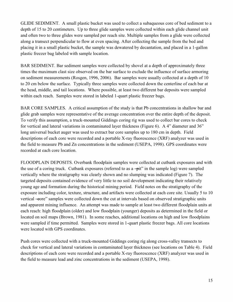
GLIDE SEDIMENT. A small plastic bucket was used to collect a subaqueous core of bed sediment to a depth of 15 to 20 centimeters. Up to three glide samples were collected within each glide channel unit and often two to three glides were sampled per reach site. Multiple samples from a glide were collected along a transect perpendicular to flow at even spacing. After collecting the sample from the bed and placing it in a small plastic bucket, the sample was dewatered by decantation, and placed in a 1-gallon plastic freezer bag labeled with sample location. BAR SEDIMENT. Bar sediment samples were collected by shovel at a depth of approximately three times the maximum clast size observed on the bar surface to exclude the influence of surface armoring on sediment measurements (Rosgen, 1996, 2006). Bar samples were usually collected at a depth of 10 to 20 cm below the surface. Typically three samples were collected down the centerline of each bar at the head, middle, and tail locations. Where possible, at least two different bar deposits were sampled within each reach. Samples were stored in labeled 1-quart plastic freezer bags. BAR CORE SAMPLES. A critical assumption of the study is that Pb concentrations in shallow bar and glide grab samples were representative of the average concentration over the entire depth of the deposit. To verify this assumption, a truck-mounted Giddings coring rig was used to collect bar cores to check for vertical and lateral variations in contaminated layer thickness (Figure 6). A 4‖ diameter and 36‖ long universal bucket auger was used to extract bar core samples up to 180 cm in depth. Field descriptions of each core were recorded and a portable X-ray fluorescence (XRF) analyzer was used in the field to measure Pb and Zn concentrations in the sediment (USEPA, 1998). GPS coordinates were recorded at each core location. FLOODPLAIN DEPOSITS. Overbank floodplain samples were collected at cutbank exposures and with the use of a coring truck. Cutbank exposures (referred to as a ―pit‖ in the sample log) were sampled vertically where the stratigraphy was clearly shown and no slumping was indicated (Figure 7). The targeted deposits contained evidence of very little to no soil development indicating their relatively young age and formation during the historical mining period. Field notes on the stratigraphy of the exposure including color, texture, structure, and artifacts were collected at each core site. Usually 5 to 10 vertical ―core‖ samples were collected down the cut at intervals based on observed stratigraphic units and apparent mining influence. An attempt was made to sample at least two different floodplain units at each reach: high floodplain (older) and low floodplain (younger) deposits as determined in the field or located on soil maps (Brown, 1981). In some reaches, additional locations on high and low floodplains were sampled if time permitted. Samples were stored in 1-quart plastic freezer bags. All core locations were located with GPS coordinates. Push cores were collected with a truck-mounted Giddings coring rig along cross-valley transects to check for vertical and lateral variations in contaminated layer thickness (see locations on Table 4). Field descriptions of each core were recorded and a portable X-ray fluorescence (XRF) analyzer was used in the field to measure lead and zinc concentrations in the sediment (USEPA, 1998).

16
Laboratory Methods
Laboratory methods involved the preparation, physical analysis, and geochemical analysis of bed, bar, and overbank samples. All laboratory work was carried out by Ozarks Environmental and Water Resources Institute staff at Missouri State University. Standard operating procedures (SOPs) can be found at http://oewri.missouristate.edu/.
Sample Preparation All sediment samples analyzed at the laboratory were stored in new plastic freezer bags labeled with the sample number, location, and field description. Upon receipt, the laboratory verified the information on the bag with corresponding field notes. Samples were dried in an oven at 60 oC, disaggregated with mortar and pestle (if needed), and put through a sieve set to isolate mining-related size-fractions for gravimetric, physical, and chemical analysis.
Sediment Texture Mining sediment texture is controlled by the milling process, subsequent weathering during fluvial transport, fluvial sorting/selective transport, and degree of mixing with background sediment. Textural information is important for interpreting the source and mobility of sediment in a river channel. Channel bed/glide and bar samples were hand sieved to determine particle size distribution and isolate size fractions for further analysis. Specific size fractions are reported as a percentage of total mass of the bulk sample passing through a 64 mm sieve. Larger clasts (>64 mm) were excluded from sampling because they were too large for the sampling procedures being used, represent a relatively small fraction of the glide, bar, and bank deposits sampled for this study, and rarely originate from mining sources. Sieving was conducted manually on dry samples. Dry sieving saves time and involves less particle disturbance during sample preparation. Moreover, no significant differences in geochemistry were detected in samples derived from dry sieving and wet sieving in a recent study of Big River sediment contamination (MDNRa, 2007). In this study, ―bulk‖ samples are defined as the as the <64 mm sediment fraction. This distinction is important because some other studies of Big River sediments define bulk samples differently. Roberts et al. (2009) describe the < 2 mm size fraction as a bulk sample. MDNR (2007a) describe a ―bulk composite‖ sample that represents the average geochemistry of several different size fractions analyzed separately including fine gravel (>2 mm) or chat. The selection of a larger range of particle sizes for bulk analysis in the present study is justified because it includes the entire size range of mining inputs (i.e. chat) and bed and bar deposits of the Big River in St. Francois County (Taggart, 1945; MDNRa, 2007; Newfields, 2007).

17
Sieve stacks were set up to fractionate bulk sediment samples according to the following rationale (mill screen information from Taggart, 1945; size classes after Rosgen, 1996, 2006): >64 mm- initial screening out of any cobble-sized material, if present 32 mm- maximum diameter of ore feed into the mill circuit; coarse/very coarse gravel break 16 mm- typical maximum diameter of chat; medium/coarse gravel break 4 mm- typical minimum diameter of chat; very fine/fine gravel break 2 mm- maximum sand size; sand/very fine gravel break 1 mm- coarse/very coarse sand break <250 um- flotation tailings size range; fine/medium sand break <32-63 um- slime particles size range; silt and clay fraction In this study, the <2 mm fraction of the sample was routinely analyzed for particle size and geochemistry for all samples. Other size factions, both finer and coarser than <2 mm, were analyzed for selected bar and glide samples. Chat Grain Counts Field observations and laboratory tests indicated that angular dolomite fragments typically compose almost 100% of the fine-gravel or chat-sized fraction in tailings piles. This mineral type and shape seemed to be lacking in fine gravel fractions collected from control or uncontaminated river segments. Thus, visual grain counts were used in this study to quantify the direct mining origin of chat-sized particles in the 4-8 mm sediment fraction of glide and bar deposits. Chat-sized grains were classified into five groups: (i) dolomite chips related to tailings inputs; (ii) natural weathered chert and other grains indicative of non-mining sources; (iii) quartz grains also from natural sources; (iv) shale grains from tailings inputs; and (v) slag or coal fragments from industrial sources such as mining, smelters, foundries, or steam engines (Figure 8). Results were tabulated as percent of total number of 50 to 100 grains counted.
Geochemical Analysis Geochemical analysis is used on Big River sediments to (i) measure the level of contamination, (i) identify the source fingerprint from mining inputs, and (iii) determine the chemical conditions within different fluvial deposits. Geochemical procedures are aimed to evaluate both the mining and natural or background source fingerprints in river sediments (Horowitz, 1991). In Madison County, located just south of the present study area, the geochemistry of mining-contaminated soil samples was found to be controlled by three source factors listed in the order of decreasing significance: (i) inputs from mining wastes; (ii) secondary minerals formed from the long-term supply by natural weathering; and (iii) local bedrock composition (Davies and Wixson, 1987). In addition, the importance of specific geochemical substrates for the transport of mining contaminants such as sulfides, carbonates, and secondary iron-manganese oxides has been previously documented in Big River channel sediments from St. Francois County (Schmitt and Finger, 1982; Smith and Schumacher, 1981, 1983; Wronkiewicz et al. 2006). In order to investigate the geochemical and transport processes affecting contaminant transport in the Big River, the following analytical procedures were selected for geochemical analysis.

18
INORGANIC CARBON ANALYSIS. It is expected that mining sediment will be enriched in Ca and Mg carbonate grains from dolomite and calcite inputs compared to samples from control sites located outside of mining influence. Thus, relatively high concentrations of inorganic C were assumed to be a specific indicator of the presence of tailings particles in fluvial deposits. An Elementar Vario EL CNHS Elemental Analyzer was used to determine the carbon content of Big River sediment samples. Total carbon was determined for an untreated sample and inorganic carbon was determined after burning off the organic carbon as carbon dioxide (CO2) in a muffle furnace at 450 oC. The SOP for use of the CNHS Elemental Analyzer in the OEWRI laboratory can be found at http://oewri.missouristate.edu/. Standard checks and duplicate analyses are routinely used every 10 to 20 samples. For total carbon analysis on 7 batches of Big River sediment samples, accuracy errors typically ranged from -2 to 1 RD% and precision errors from -5 to 4 RD% (relative difference). For inorganic carbon analysis on 6 batches of Big River sediment samples, accuracy errors typically ranged from -1 to 1 RD% and precision errors from -3 to 13 RD%. ELEMENTAL AND METAL ANALYSIS. High Pb and Zn concentrations in channel sediment samples from the Big River tend to be positively related to the degree of mining influence (Schmitt and Finger, 1982; Smith and Schumacher, 1993; Roberts et al., 2009). Hence, the concentrations of mining-related metals in sediment samples will be used to quantify mining contribution by comparing contaminated and control samples in the same way as the carbonate testing described above. X-ray Fluorescence (XRF) analysis was used in the field and OEWRI laboratory to determine the geochemistry of mining and background sediment samples. Several other studies have also used similar analytical technology to determine levels of sediment contaminants in the Big River (MDNR, 2001, 2003, 2007a; Roberts et al. 2009). In the present study, an Oxford Instruments X-MET 3000 TXS+ was used to determine the concentrations of Pb, Zn, Fe, Mn, and Ca in tailings, channel, floodplain, and control site sediment samples. The SOP for using the XRF in the OEWRI laboratory can be found at http://oewri.missouristate.edu/. Standard checks and duplicate analyses were routinely used every 10 to 20 samples. The following error summaries correspond to 22 batches of Big River channel sediment samples for laboratory use of the XRF. For Pb, accuracy errors typically ranged from -6 to 1 RD% and precision errors from -3 to 2 RD%. For Zn, accuracy errors typically ranged from -6 to -1 RD% and precision errors from -3 to 4 RD%. For Fe, accuracy errors typically ranged from -4 to 2 RD% and precision errors from -2 to 3 RD%. For Mn, accuracy errors typically ranged from -22 to 19 RD% and precision errors from -4 to 4 RD%. Finally, for Ca, accuracy errors typically ranged from 1 to 9 RD% and precision errors from -7 to 1 RD%. However, field use of the XRF on untreated floodplain samples over varying weather conditions typically yields poorer levels of accuracy and precision, with errors in the range of 10 to 20 RD%. The wide range of accuracy errors for Mn relates to the relatively low content of the metal in the check standard. However, the median accuracy error for Mn is reasonable at 3 RD%.
19
PARTICLE SIZE FRACTIONATION. Geochemical properties were compared among three different size fractions to evaluate the effects of selective transport, fluvial sorting, and physical dilution on downstream contamination trends in channel sediment samples. The size fractions are indicative of mining source contributions as follows: (i) chat, 4 mm to 8 mm; (ii) chat-tailings transition, 1 mm to 2 mm; and (iii) fine tailings and slimes, <250 mm. Chat-sized and chat-tailings transition fractions were powdered in a ball mill prior to geochemical analysis to improve analytical accuracy and precision. GEOCHEMICAL INDICATORS AND TRACERS. Three types of geochemical indicators were evaluated in this study: toxic metals, secondary geochemical substrates, and carbonate tracers. Toxic metals include both Pb and Zn concentrations. Metal toxicity is evaluated based on published PECs above which ecological effects are expected for contaminated aquatic sediments. The PECs used here are 128 ppm Pb and 459 ppm Zn (MacDonald et al. 2000). The toxic threshold for floodplain soils as prescribed by USEPA Region 9 for residential soils is 400 ppm Pb (http://www.epa.gov/region09/superfund/prg/index.html). Lead:Zinc ratios are used to isolate subtle changes in source and transport of the contaminated sediments in the Big River. Control sites tend to have very low Pb:Zn ratios compared to contaminated sediments. However, there were variations in the composition of mineral deposits and milling procedures among the major mining areas. Thus, distinct geochemical signatures related to variations in Pb:Zn ratios may be used to track the source contributions of individual tailings piles to channel and floodplain deposits. The Pb:Zn ratios in tailings piles tend to decrease in the following order: (i) >4, Bonne Terre and National; (ii) >1 to 4, Desloge and Federal; and (iii) <1, Elvins/Rivermines and Leadwood (Newfields, 2006) (Table 1). Secondary geochemical substrates include mineral coatings and organic matter particles that have the capacity to bind metals to relative high concentrations in uncontaminated sediments (Horowitz, 1991). In this study, Fe and Mn concentrations are used to evaluate the potential influence of secondary oxides on contamination trends in Big River sediments. Organic C concentrations are used to evaluate the role of organic matter particles as binding agents of mining-related metals. Hypothetically, as unaltered mining sediment is affected by weathering over time and redox processes release sediment contaminants to pore water periodically, there may be a shift of Pb and Zn from sulfide and silicate minerals to more mobile secondary substrates (Horowitz, 1991; Pavlowsky, 1996; Wronkiewicz et al. 2006). Fe-Mn oxides have been found in sediments from both contaminated and control sites (Smith and Schumacher, 1991, 1993). Moreover, Fe and Mn concentrations also correlate with mining source inputs and are elevated to moderate levels in channel sediments below tailings piles. Following, it may be hard to resolve secondary contamination effects in the Big River since the mining signal may overwhelm more subtle secondary geochemical trends (Schmitt and Finger, 1982; Smith and Schumacher, 1993). Carbonate tracers indicate source inputs of excess dolomite and calcite fragments introduced to the channel by mill discharges and tailings piles. In this study, inorganic C by elemental analysis and Ca by XRF are used as indicators of tailings particle inputs. Dolomite (Ca Mg (CO3)2) forms the majority of
20
underlying bedrock of the Big River basin and is the primary host rock of the Pb-Zn mineralization in the Old Lead Belt (Smith and Schumacher, 1993). In addition, calcite (Ca CO3) is a common gangue mineral associated with Pb and Zn sulfide ores and is the primary mineral found in scattered limestone formations in the region. Tailings particles of all sizes are typically composed of dolomite with lesser amounts of primary Pb, Zn, Fe, and Cu sulfides (Smith and Schumacher, 1991, 1993). Pure dolomite with a Ca:Mg molar ratio of 1 is composed of 21.7% Ca and 13.0% C. Pure calcite is composed of 40.1% Ca and 12.0% C. Thus, a sample composed of 100% tailings would be expected to contain about 21% Ca and the concentration of Ca would increase slightly in proportion to the amount of calcite in the sample. Carbonate mineral tracers are expected to be a conservative indicator of mining sediment in the Big River. Tailings materials that end up in channel deposits are mainly composed of relatively unaltered dolomitic grains in the very fine sand to fine gravel size range. Since tailings materials were artificially created by the crushing and grinding of uniformly selected ore, gross mineralogy can vary little among different particle size fractions (Taggart, 1945; Wixson et al., 1983). This homogenizing effect is often inherited by mining sediment deposited in the main channel and tributaries of the Big River (Smith and Schumacher, 1991, 1993; MDNR, 2007a; Roberts, et al., 2009). Carbonate tracers will also likely be a robust indicator of tailings inputs with maximum effect concentrations ranging from 10 to 20 times background levels. The term ―background‖ is commonly used to describe the natural or uncontaminated geochemistry and supply characteristics of river sediment. While carbonate bedrock outcrops frequently in bluffs along the Big River and beds of its tributaries, these formations do not apparently produce measureable amounts of carbonate-containing sediment for fluvial transport. Channel sediments from a control site on the Big River at Irondale, far above mining areas, contained no dolomite and only 0.8 to 1.2 % Ca (Smith and Schumacher, 1991, 1993). However, sediments from ―tunnel seep‖ which drains the Desloge pile contain >90% dolomite and from 15 to 20% Ca. Similarly, sediments collected downstream of the seep in the Big River below the Desloge pile contain 85 to 88 % dolomite and 8 to 13% Ca (Smith and Schumacher, 1991, 1993).
Geospatial Data and Analysis
A geospatial data base and Geographic Information System (GIS) were used to organize and analyze field and laboratory data. A series of 2007 aerial photographs with 2-foot resolution were used as a base map. Geospatial technologies and analysis were used to evaluate sample reach characteristics and channel sediment storage capacity of mining sediment.
GIS Data Sources The Big River geospatial data base is composed of spatial data from multiple sources. Data were either readily available in ArcGIS®, or collected in the field with survey equipment and geo-referenced. Much of the base data were available through the OEWRI Ozarks GIS database. Base data that were not available in-house were downloaded from the Missouri Spatial Data Information Service (MSDIS). The data used for spatial analysis (i.e. channel areas, floodplain areas, river kilometers, in-channel bar areas, etc.) were created in ArcGIS® through a variety of feature editing procedures, both automated and manual. Data were also extracted from 2-foot resolution, leaf-off aerial photographs, (also available

21
from MSDIS). The development of spatial data files involves the creation of vast amounts of subsequent files. Table 5 lists the files and file sources used for this project.
Channel and Floodplain Feature Classification Channel features were classified based on the interpretation of the 2-foot resolution aerial photographs in the GIS. All features of interest were easily recognizable given the resolution of the photographs and the low flow conditions that existed at the time the photo was taken. In this study, channel features were classified as low flow channel, high bar, low bar, vegetated bar, or delta bar. The low flow channel is delineated by the two sides of the wetted channel that are adjacent to either channel bars or banks. A high bar is the exposed gravel bar surface above the waterline. A low bar is a submerged gravel bar that is visible below the water surface. A vegetated bar is a sub-aerial bar that has been stabilized by vegetation. Finally, a delta bar is defined by accumulations of gravel immediately downstream of a tributary confluence with the Big River. The entire channel length was divided into one kilometer long channel cells along the centerline of the channel and included all channel and bar areas. This GIS layer was used to divide the channel into channel segments for channel sediment and Pb storage calculations. All the counties in the Big River watershed have published soil surveys available along with GIS data layers of the soil series maps and soil attributes (e.g. Brown, 1981). These soil maps were used to identify flood prone soils adjacent to the Big River. Published soil descriptions and field evaluations by OEWRI staff were used to interpret the elevation and age of floodplain units that could be expected to contain historical mining sediment. Field sampling and assessment of metal contaminated profiles were used to verify floodplain interpretations. Floodplain areas were delineated using a combination of the digital elevation model (DEM), the alluvial soils layer, and the aerial photographs. First, the 100-year floodplain coverage was evaluated to determine the boundaries of the floodplains on the valley floor of the Big River. However, the boundaries of the 100-year floodplain proved to be too erratic and hard to relate to soil survey data. Therefore, floodplains along the Big River were delineated by best professional judgement (i.e., heads up method). Differences in resolution between the soils layer and the DEM produced slight inconsistencies when viewed simultaneously. These were evaluated separately for each channel-floodplain segment. In order to smooth out differences in floodplain boundaries between contrasting DEM elevations and soil survey units, elevations were extracted from the DEM at the soil type boundaries to identify breaks in the various depositional surfaces. In many cases the surface breaks could be confirmed through various features on the aerial photograph. To facilitate the calculation of floodplain storage for contaminated sediment and Pb, the floodplain was also divided into two kilometer long cells based on the valley centerline. Only floodplain soil areas within the delineated floodplain boundaries were included in the analysis. In this study, individual floodplain units were designated by the distribution of mapped alluvial soil series as described in USDA soil surveys (e.g., Brown, 1981). Only those floodplain features that were formed or received sediment since the beginning of the mining period to present were included in this analysis. Floodplain areas in soil surveys generally include both active floodplain areas and older
22
terraces of different heights. Floodplains were classified as areas that flood once or more every two years (frequent) and terraces as areas that flood once or more every 20 years (occasional). High terraces were classified as areas that flood once every 100 years (rarely). Additional soil series were mapped on higher/older alluvial terrace surfaces in the Big River valley. However, since the elevations of these surfaces were beyond the range of present day flooding and therefore sediment contamination, they were omitted from this analysis. Floodplain areas for storage calculations were based only on the distribution of high and low floodplain soil series as mapped by the soil surveys. Four floodplain classes composed of eight soil series were used to describe historical alluvial deposits and older terraces in this study (Brown, 1981): 1. Low Floodplain (LP) with frequent flooding: 75398-Kaintuck series (A/C soil profile; youngest deposit); 2. High Floodplain (HP) with frequent flooding: 66014-Haymond series (A/Bw)- well drained, 66024-Wilbur series (A/Bw)- low-lying areas; 3. Low Terrace (LT) with frequent to occasional flooding: 75453-Sturkie series (A/Bw); and 4. High Terrace (HT) with occasional to rare flooding: 64007-Freeburg series (A/E/Bt/Btg), 66000-Moniteau series (A/E/Btg), 75375-Horsecreek series (A/Bt), 75385-Gabriel (A/Bt). River Kilometer Scale
Locations along the length of the Big River are referenced by river kilometer (R-km) with R-km 0 at the confluence with the Meramec River (mouth of the Big River). The appendix contains a reference table that relates river kilometer to study reach locations, road crossings, and tributary confluences. The scaling of the R-km system used in this report is based on the center line of the river as determined by Missouri State University staff using a recent aerial photograph geo-referenced in a GIS.
Background Information and Appendices
A complete appendix volume will be provided as a companion volume to this report. However, an abbreviated appendix is included in this report and it contains the following information: 1) River Kilometer and Mile Reference Tables

23
2) Channel sediment sample locations 3) Channel sediment sample geochemistry 4) Channel sediment sample particle size distributions 5) Floodplain core sample locations 6) Floodplain pit sample locations 7) Floodplain sediment sample geochemistry
RESULTS AND DISCUSSION
Tailings Input Geochemistry
Historical inputs of tailings from the St. Francois County mines were responsible for the large-scale contamination of the Big River system. Therefore, the first step in understanding the spatial patterns of sediment contamination involves obtaining information about the physical and chemical characteristics of tailings piles. The location, size, and geochemistry of the remaining tailings piles in St. Francois County have been previously studied (Tables 1 and 2; Figure 1). Further, the physical and mineralogical characteristics of tailings materials have already been reviewed in this report in the background section of the introduction. Assessments of the Pb and Zn concentrations in indvidual tailings piles were completed by previous studies (Wixson et al., 1983; Table 2). Variations in tailing composition reflect both the characteristics of the mineralization and the milling process. Tailings sources to the Big River above the Flat River Creek confluence (Leadwood and Desloge) tend to average between 1,800 to 2,000 ppm Pb, while the piles along and below Flat River Creek (Federal, Elvins, National, Bonne Terre) have higher Pb concentrations ranging from 3,000 to 4,000 ppm (Table 3). Average zinc concentrations at in the Leadwood and Elvin piles were typically >3,900 ppm. The National and Bonne Terre tailings piles contain relatively lower Zn concentrations at <500 ppm. Differences in Pb:Zn ratios of tailing source materials should imprint on the mining sediment and may be used to identify source influence of particular tailings piles. Typical Pb:Zn ratios ranged from 0.4 to 0.7 at the Leadwood pile to 7.7 to 13.7 at the National pile (Wixson et al., 1983; Table 1). Analysis of the data in Wixson et al., (1983) revealed that Pb and Zn concentrations in tailings are log-normally distributed and the geometric-mean is a relatively precise measure of central tendency. The coefficient of variation (Cv%) or relative standard deviation can be used to evaluate the variability or error associated with set of values such as geochemical data. It is calculated as the standard deviation divided by the mean in percent. Arithmetic coefficients of variation in percent (Cv%) ranged from 43%

24
to 100% for Pb and 36% to 153% for Zn. However, analyzing the log-10 values of the data set normalized the geochemical data and reduced the Cv% to <10%. Geochemical data for soils and sediments are typically distributed in a log-normal manner (Horowitz, 1991). The reduction in the Cv% values by using a logarithmic transformation supports the assumption of log-normality for tailings materials and this aspect may be transferred to contaminants in mining sediment too. The geochemistry of several different size fractions of tailings was compared for this study (Table 6). In Table 6, the ―cr‖ suffix attached to the sample label indicates that ball mill crushing was used to prepare the sample for XRF analysis. In the Leadwood and National piles, the highest Pb concentrations were found in both the finest (<63 um) and coarsest (4-8 mm) fractions examined. This trend is caused by the tendency of the milling process to be more efficient in recovering Pb and Zn from the middle range of the crushed and ground ore feed (Taggart, 1945). For the 1-2 mm fraction, ball mill crushing prior to XRF analysis resulted in higher metal concentrations in some cases (Table 6), however crushed and uncrushed samples generally yielded similar results as found in another recent study of Big River channel deposits (MDNR, 2007a). As expected, chat and tailings materials contain relatively high Ca concentrations ranging from 21.1 % to 24.2 % (Table 6). Given that the theoretical composition of Ca in pure dolomite is 21.7% and pure calcite is 40%, tailings materials are almost entirely composed of carbonate minerals and generally >98% dolomite. In comparison, the ore mineral galena contains 87% Pb and it would take about 0.35% galena mineral to yield a Pb concentration of 3,000 ppm in a typical tailings sample.
In most cases, the ―routine‖ sediment analysis of the <2 mm fraction yielded results that were in the same range as the concentrations reported for the <250 um and 1-2 mm fractions. Indeed, while finer particles in mining-contaminated sediment in the Big River has been previously reported to contain slightly higher metal concentrations (Roberts et al., 2009), metal concentration ratios between the <63um and <2 mm fractions in tailings and channel sediments tend toward unity suggesting a common geochemical origin and similar composition (Table 7). The 4-8 mm chat-size fraction contains relatively high levels of both metals in the tailings samples tested. The fact that high concentrations of metals were found in the chat-sized fraction underscores the importance of the coarse fraction for metal contamination and long-term storage in streams in mined regions. Channel Sediment Geochemistry and Particle Size Trends
Comparison of Glide and Bar Geochemistry Lead concentrations in channel bar samples show similar trends to glide samples suggesting a well mixed sediment load on the bed as well as mixing to depth at the reach-scale (Figure 9). Previous studies on the Big River also found that there was very little within-reach contrast in sediment geochemistry between riffle and pool channel units (Schmidt and Finger, 1982) and bar and bed areas (MDNR, 2007a). At the basin-scale, Pb concentrations in channel sediments follow a distance decay trend from the source to the mouth. Concentrations range from 2,500 ppm at Desloge (R-km 158.1) to near 100 ppm near the mouth (R-km 1.8). Lead concentrations begin to increase at Leadwood and then peak in St. Francois County between the Bonehole (R-km 165.3) and Cherokee Landing (R-km 136.7). Bar and glide samples yield concentrations of concern (above the PEC of 128 ppm) along the entire 171

25
km distance of the river to its confluence with the Meramec River. From Leadwood to Morse Mill (R-km 170.7 to 49.8) only 3 out of 111 bar and glide samples (<3%) collected contained Pb concentrations below the PEC. However, in the lower portion of the Big River, Pb concentrations were below the PEC in 11 of the 22 samples (50%) collected between Cedar Hill and the mouth (below R-km 40). Channel sediment Pb concentrations along the Big River have remained relatively consistent over the past three years (2007 to 2009). Similar Pb trends were found in both this study and a previous screening-level study by the U.S. Fish and Wildlife Service, even though different depositional features were sampled in the two studies (Roberts et al., 2009) (Figure 9). Within-Site Geochemical Variability Since ―at-a-site‖ geochemistry of glide and bar deposits were comparable and produced identical downstream trends (Figure 9), geochemical data were pooled and averaged for each site (Table 8). It is important to understand the variability of such estimates of metal contamination to evaluate them properly. To determine the statistical precision associated with mean values, Cv% values were compared among sites. As with the tailings samples (Table 3), the data appear to be log-normally distributed as Cv% values of logged data are typically 5 to 10 times lower than arithmetic values. Arithmetic Cv% values typically range from 30% to 60% for both Pb and Zn. In comparison, geometric Cv% values are typically <10% for both metals. For environmental data, averages with Cv% values less than 20% are considered reliable. Site-averaged Pb concentrations rise rapidly below Leadwood (R-km 170.7) from <50 ppm at upstream control sites to peak levels of almost 2,500 ppm between Desloge (R-km 158.1) and St. Francois State Park (R-km 140.3) (Figure 10). After peaking, Pb concentrations decrease exponentially downstream to the Meramec River. While the geometric site means have lower errors compared to the arithmetic means, there is little difference between Pb decay trends as they plot very close to one another (Figure 10). Comparison of geometric site means from this study with Pb data from previous studies show fairly good agreement given that the sampling period for these different studies extends for almost 30 years and includes different types of sediment samples and analytical methods (Figure 11). As expected, earlier samples collected closer to the active mining period and finer-grained sediment fractions tend to yield higher Pb concentrations compared to the present study. The other metals included in this study show similar decay trends as observed for Pb (Figure 12 A-D). With the exception of very high concentrations > 4,000 ppm near Leadwood and Desloge, Zn concentrations are lower than those for Pb (Figure 12-A). Iron concentrations tend to be about 10 times larger than Mn concentration in Big River channel sediments (Figures 12-B & C). The response of Ca to tailings inputs is striking and concentrations drop by over 100,000 times from its peak below Flat River Creek (R-km 147.1) to near background at Cedar Hill (R-km 32.7) (Figure 12-D).
Particle Size of Channel Glide and Bar Deposits The percent of bulk sediment <2 mm is an indicator of the abundance of fine-grained sediment on the bed. Increases in the fine sediment deposition in the channel near mining areas may be caused by local inputs of sand-sized tailings. Upstream control sites show a similar percentage of fine-grained sediment in glides and bars, ranging from 20% to 35% (Figure 13). Tailings inputs may be responsible for the

26
increasing abundance of sandy sediment in channel bar and glide sediments in St. Francois County below Leadwood (R-km 170.7). In mining affected segments, between 20% and 40% in bar deposits and 10% and 50% in glides is composed of fine-grained sediment (Figure 13). Bar sediments tend to be finer than glide sediments because they were formed and sampled at higher elevations in the channel and the size of sediment in transport tends to decrease with height above the bed (Bridge, 2003). While relatively fine bar deposits are found in the mining areas in St. Francois County, there may be a natural sandstone source responsible for sandy bar deposits in the lower Big River (below R-km 15) (Table 3; Figure 2). Coarse gravel-sized sediments (>32mm) make up less than 20% of bar and glide deposits with the exception of two sites where gravel content is greater than 20% by mass of the sediment found in glides (Figure 14). Channel sediment in the size range for mining chat of 2 mm to 32 mm is considered ―chat-sized.‖ Chat-sized sediment percentages in bar deposits vary widely ranging between 10% and 80% of the sediment by mass (Figure 15). Glides contain chat percentages ranging from 50% to 80%. No downstream trend in chat-sized material is observed. Deposits rich in sand (i.e. a high percentage <2 mm) correspondingly show a relative depletion in chat-sized materials. The relatively high variability of chat-sized material in channel deposits may be due to supply variations from both natural and mining inputs. Control sites (above R-km 171) have relatively high proportions of chat-sized sediments ranging from 50% to 75% and indicate a natural fine gravel source to the Big River (Figure 15). Nevertheless, control reaches tend to have coarser glides and bars overall compared to the mining areas since they are not affected significantly by natural sandstone or sandy tailings source inputs. Therefore, the occurrence of chat-sized material in the channel is not a precise indicator of mining inputs since there is apparently a sufficient supply from other natural sources. However, the mineralogy and geochemistry of chat-sized sediment in mining-affected river segments is different compared to control sites and these trends are discussed below.
Chat Grain Mineralogy Given that the quantity of chat-sized material in the channel is affected by both natural and artificial inputs, the characteristics of chat-sized grains can be used to determine mining influence. Grain counts based on the shape and mineralogy of the 4-8 mm fraction use dolomite chips as an indicator of chat input from mining areas. Laboratory tests of tailings from the Leadwood, Federal, and National Piles indicated that chat is composed of 100 percent dolomite chips. Conversely, control site sediments typically contain >95% weathered chert and feldspar grains from natural sources, but no dolomite chips. Chert grains from natural sources tend to contain <500 ppm Pb and <1% Ca, while dolomite chips contain more than 5,000 ppm Pb and >20% Ca (Table 9). Slightly elevated Pb and Zn levels in the natural chert and feldspar fraction may be caused by surface sorption of metals from surrounding contaminated deposits and waters, possibly by iron-manganese oxides or contaminated silt coatings (Schmidt and Finger, 1982; Smith and Schumacher, 1991, 1993; Wronkiewicz et al. 2006). The highest concentrations of dolomite chips in the Big River are found in bar and glide deposits in the segment from a location beginning below the Desloge pile (R-km 158.1) and extending to Highway E (R-km 132.9) in St. Francois County. Farther downstream, reaches below Dickenson Road bridge and
27
the Mill Creek confluence (approximately R-km 120) typically contain 0 percent dolomite chips in the 4-8 mm sediment fraction (Figure 16). Flat River Creek contains high percentages of dolomite chips because it was affected by tailings inputs from several nearby mining operations (Table 1; Figure 1). Conversely, Mill and Mineral Fork Creeks do not contain dolomite chips suggesting that milling operations in these tributary watersheds did not produce chat at levels high enough to be measured in stream sediments. Mining along these tributaries in Washington County primarily involved shallow pit Pb and barite mining which did not, and still does not, involve large-scale milling of Pb ores and creation of large tailings piles like in St. Francois County. However, Washington County mining activities may have released eroded soil and clayey wash water to streams (Figure 1), but not tailings or chat materials in amounts large enough to affect the carbonate mineralogy of sediment loads (Smith and Schumacher, 1991, 1993). In another recent study, relatively high barium (Ba) concentrations (>2,000 ppm) were found in channel sediments of the two major tributaries that drain Washington County mining areas (i.e. Mill Creek and Mineral Fork Creek) (Roberts et al., 2009). Barium concentrations also increased in channel sediments of the Big River below these tributaries and then gradually decreased downstream from there indicating a geochemical source of Ba in Washington and Jefferson Counties that is not present in St. Francois County. However, Washington County was not found to be a significant source of Pb and Zn contamination to the Big River (Roberts et al., 2009). These trends suggest that chat sources were primarily located in St. Francois County and that chat deposits barely extend to the Jefferson County line in the channel of the Big River. Downstream changes in Sediment Geochemistry Systematic variations in geochemical trends downstream of mining sources of metals can provide evidence for specific source characteristics and transport processes (Wolfenden and Lewin, 1978; Marcus, 1987). In order to evaluate the effect of particle-size on transport patterns, three size fractions (i.e. <250 um, 1-2 mm, and 4-8 mm) from selected samples were analyzed for inorganic C, Ca, Fe, Mn, Pb, and Zn (Figure 17). High concentrations of inorganic C and Ca in channel sediments indicate a tailings source due to the presence of calcium carbonate minerals from crushed dolomite, limestone, or calcite (Smith and Schumacher, 1991, 1993; Wronkiewicz et al. 2006). In contrast, natural soils in the region are usually weathered and depleted in calcium carbonate (Brown, 1981). The highest concentrations of Ca and C in each size fraction tend to be found in locations expected to receive heavy tailings loads such as below the Desloge pile (R-km 158.1) and confluence of Flat River Creek (R-km 155) (Figure 17-A & B). The lowest concentrations of Ca and C are found in <250 um fraction, suggesting that this fraction either contained lower proportions of carbonate minerals initially or that contributions of fine soil particles from soil and bank erosion are diluting the finer carbonate sediment fraction at a relatively high rate compared to the larger grains studied. CALCIUM AND INORGANIC CARBON. As expected, the distance of downstream dispersal of each size fraction appears to be negatively related to particle size (Figure 17-A & B). The smallest and most mobile fraction (<250 um) has been transported the furthest downstream to below Mineral Fork Creek (R-km 99). The intermediate-sized, coarse sand fraction has been transported as far as Mill Creek (R-km 115). The largest sediment fraction representing the chat-size fraction has moved the shortest distance downstream with Ca and C enrichment only extending to Cherokee Landing (R-km 137), about
28
16 km from the Jefferson County line at R-km 121. This dispersal pattern shows that tailings particles are selectively transported by size and sorted longitudinally over a channel distance of 40 km—finer particles are dispersed furthest downstream because they are easier to erode and transport by fluvial processes (Bridge, 2003). It may be possible that this trend is the result of recent transport of the material released by the tailings dam breach at the Desloge pile about 30 years ago. However, C and Ca concentrations tend to peak farther downstream below the Flat River Creek confluence and not immediately below the Desloge tailings dam. This pattern suggests a more cumulative source of the sorted material and not a single pulse-release from a dam break. In addition, as will be made evident by the discussion of mining sediment storage below, the volume of the tailings released by the breach (about 50,000 cubic yards) is relatively insignificant compared to the total mining sediment stored in the channel system. IRON AND MANGANESE. Iron and manganese are important metals in mining-affected rivers since their distribution in sediments can reflect the influences of both the tailings source of primary mineral particles and the precipitation of dissolved metals released by weathering as oxide coatings on sediment particles (Horowitz, 1991) In general, the dispersal trends for Fe and Mn show similar patterns compared to Ca and inorganic C, but peak concentrations have shifted downstream about 20 km from the Flat River Creek confluence (R-km 155) to Cherokee Landing below Bonne Terre (R-km 137) (Figure 17 C & D). The coarse sand fraction again contains the highest concentrations of both metals due to either primary tailings source contributions or formation of secondary Fe-Mn oxides coatings on sand grains (Horowitz et al., 1993; Evans and Davies, 1994). However, the influence of selective transport by size (i.e. physical sorting) is not as clear for Mn and Fe as it is for Ca. Secondary Fe-Mn oxides have previously been identified in contaminated sediments in the Big River (Schmitt and Finger, 1982; Smith and Schumacher, 1991, 1993; Wronkiewicz et al. 2006). Further, groundwater seepage into the channel from underground mines can be a source of dissolved Fe and Mn that forms oxide coatings shortly after entering surface waters (Smith and Schumacher, 1993; Newfields, 2006; Wronkiewicz et al. 2006). Thus, Fe and Mn dispersal trends may partially reflect the influence of geochemical redistribution causing geochemical peaks to shift downstream and cloud grain-size relationships. LEAD AND ZINC. The longitudinal patterns of Pb and Zn in bar and glide sediments clearly show the influence of tailing pile sources (Figure 17 E & F). Peak concentrations of both metals occur just below the Desloge pile, Flat River Creek confluence, and Bonne Terre pile where the coarse sand fraction contains the highest concentrations of Pb (5,000 ppm). In St. Francois County, the highest Pb concentrations are associated with the coarsest sediment fractions. However, in the lower segments of the river in Jefferson County, this trend reverses and the <250um fraction becomes the most contaminated albeit at a lower concentration. Zinc trends are a bit different with the <250 um fraction most contaminated at 3,000 ppm at Desloge and below Flat River Creek but then moderates downtream (Figure 17 F). Concentrations of both metals seem to decrease to steady levels below Mineral Fork Creek (R-km 99). Downstream trends in Pb:Zn ratios show the influence of the Leadwood tailings inputs (i.e. relatively high Zn content) on sediment geochemistry above Flat River Creek (Figure 17 G). The Big River below R-km 125 and in Jefferson County contains a relatively high Pb:Zn ratio in the <250um fraction. This trend may be explained by several factors: (i) selective transport of fine-grained
29
sediment far downstream from high ratio tailings piles (i.e. Federal, National, Bonne Terre), (ii) bank erosion inputs of contaminated sediment stored in overbank floodplain deposits; and (iii) low-level contamination from Washington County mines and related soil erosion inputs.
Tributary Channel Sediment Contamination Channel sediments were sampled and evaluated for texture and geochemistry at seven tributary sites and two control sites along the upper Big River (Table 10). Channel sediments from unmined drainages tend to have Pb concentrations <100 ppm with normal range between 10 and 60 ppm. Zinc concentrations in unmined areas are typically similar or up to twice the Pb concentrations. Ratios of Pb:Zn are usually <0.8 in background channel sediments. One exception is in the upper Flat River Creek at Davis Crossing Road where Pb:Zn ratios are near 1.7 (Table 10). This geochemical effect may be related to the different sediment supply from weathered igneous bedrock in the St. Francois Mountains (Table 3; Figure 3). Indeed, Smith and Schumacher (1991,1993) found an igneous fingerprint in the mineralogy of channel sediments in the upper Flat River Creek. Contaminated channel sediments are obviously found in the lower Flat River Creek at St. Joe Bridge, Pb concentrations are >2,000 ppm with Pb:Zn ratios >2. In Mill Creek, there appears to be slightly elevated Pb concentrations in sediments at Tiff, but well within the regional influence of elevated sediment background levels. However, Zn concentrations seem to be elevated above what would be normally expected. Maybe this is the result of the early Pb mining history and intense Ba mining operations in the Mill Creek watershed. Samples from the lower Mill Creek contain high Pb levels, but the source is probably related to local supply from eroding banks formed within contaminated floodplain deposits along the Big River. The Mineral Point sample was collected on a tributary below an old Pb mining area far from the Big River confluence. Bar Core Analysis If surface sediment contamination is an adequate indicator of deeper contamination trends within the larger deposit, then a better case can be made for a surface sediment monitoring program in the Big River. Coring in sand and gravel bars above and below the water table is difficult because most economical coring methods are not suited for this type of sampling and access to bar sites is often limited. In all, eight individual bar cores were evaluated for this study. Three were collected during a previous study at St. Francois State Park by the Missouri Department of Natural Resources (MDNR, 2007a) and five were collected during this study by MSU from a large, accessible bar above Desloge (R-km 163.4) (Table 11). The DNR cores ranged from 70 to 100 cm in depth and the MSU cores ranged from 100 to 180 cm in depth. MSU bar coring activities yielded three cores at the head of the bar and two at the tail end (Figure 18). Averages of single cores tend to be relatively representative of the surface and uniform with depth. The Cv% values for core means were typically <30% for Pb and Zn (Figure 18). Surface sample variability was evaluated in two ways: (i) arithmetic average of four samples collected in a routine manner; and (ii) arithmetic average of the surface samples from each core. The results showed similar variability as compared to the deeper cores. As shown, the mean concentrations of each core were not identical, but
30
the variability with the core and among surface samples was within limits for a precise analysis. In addition, the grand mean of all four core averages had a Cv% of <30% for Pb. The next step was to relate surface sample geochemistry to mean core chemistry (Table 11, Figure 19). The relative percent difference between the surface sample Pb concentration and mean core Pb concentration was calculated for each core. At core depths of 1 meter or less, the surface sample concentration was nearly equal to the core mean (Figure 19 A). However, as cores get deeper, mean core values increased to up to 40% of the surface sample value. Given this analysis, surface samples under-predict the mean concentration of deeper cores. For bar depths greater than 1 meter, surface sample data could be multiplied by a factor of 1.2 to 1.4 to correct for depth variations. Another way to evaluate this relationship is to compare the surface concentration to mean core concentration by direct correlation (Figure 19 B). A regression equation was used to predict the average core Pb concentration given the surface concentration value. A 1:1 line shows that the surface and core mean concentrations are fairly consistent. The values for shallow cores (1 meter or less) plot close to the 1:1 line. The other cores all plot about 400 to 500 ppm Pb above or below the 1:1 line. The conclusion of this analysis is that surface samples are relatively good predictors of deeper core mean concentrations. For bar deposits deeper than 1 meter, surface sample values should be multiplied by 1.2 to correct for depth variations (Figure 19). The analysis above supports the assumption that the bulk geochemistry of glide and bar surface samples is a good estimate of the composition of deeper materials, at least to the refusal depth of the tile probe (which usually ranges from 0.10 to 2 meters). There are other reasons that justify the homogenous deposit assumption and these are described below.
1. Glide and bar deposits are well-mixed within a reach due to source characteristics. Mining sediment is generally composed of fine-gravel and sand with varying amounts of silt and clay. Sediment in this size range is relatively mobile and can be mixed by floods and re-deposited in bar and bed areas until stabilized by geomorphic conditions or vegetation (Bridge, 2003). In addition, relatively high rates of tailings inputs entered the river system from the same source points for more than 70 years. This is probably enough time for distance-decay relationships between source and sediment geochemistry to balance out and remain relatively stable over time (Marcus, 1987; Ongley, 1987).
2. A recent study of bar deposits in St.Francois State Park indicates homogenous deposit to a depth of about 1 meter (Lister et al., 2009). Several pits were excavated in active bar deposits along the river and both grain-size and Pb concentration were found to not vary significantly with depth.
3. The main stem of the Big River channel is typically bedrock or bluff confined and thusly limited in ability to erode and develop laterally. Therefore, most of the bars along the Big River are of the center or longitudinal types (Rosgen, 1996). When they change location, these bar types tend to erode as a unit and shift randomly across the channel with some downstream translocation of
31
sediment (Bridge, 2003). Typically, they will not build across the valley floor and gradually bury older deposits with younger materials, at least over timescales of 10 years or so. Given this geomorphic evolution, they may tend to be well mixed over the time of interest to this study. Nevertheless, there is always the chance that more or less contaminated sediments can be buried at depth compared to surface materials in the bar deposits along the Big River due to local variations in bar sedimentation and time of mining sediment inputs..
4. In some places, the depth of floodplain contamination extends below the present-day bed elevation suggesting that the bar deposits in that reach are relatively young and of similar age.
Thus, it is suggested that most of the channel bar deposits containing mining sediment are composed of sedimentary bodies that are of similar age and are generally homogenous. Bar and bed deposits are not time-transgressive in form and so do not usually yield systematic age and compositional changes vertically or laterally. This conclusion is supported by the findings that within-reach geochemistry (e.g. Pb concentration) does not vary much among glide, bar, and riffle tail deposits (Table 8; Figure 9) and between riffle and pool sediments (Schmidt and Finger, 1982) in the Big River.
Lead Concentrations in the <2 mm and Chat Fractions of Channel Sediment The <2 mm fraction was routinely analyzed by XRF for metal content for all sediment samples evaluated for this study. Accordingly, the assumption is made that the <2 mm fraction is an accurate indicator of the Pb concentrations in mining sediment as a whole including contributions from the chat fraction. For floodplain deposits, this assumption is reasonable since almost all overbank sediment is <2 mm in size. However, a significant fraction of the channel sediment is coarser than 2 mm (Figure 13). Indeed, the abundance of the >2 mm or gravel fraction in contaminated bar and glide samples averages 52% and 69% in St. Francois County and 47% and 73% in Jefferson County, respectively. In order to evaluate the validity of storage estimates based on the geochemistry of the <2 mm fraction, Pb concentrations were compared between the <2 mm and chat-sized (4-8 mm) fractions from the same sample in a subset of bar and glide samples (n=29). While not a perfect correlation, the relationship between the two fractions is linear and very close to 1:1 (slope=0.97 and r2=0.76). While the geochemical mobility of the Pb in the two different fractions may be different, the total lead concentration is similar. Thus, Pb concentrations derived from the analysis of the <2 mm fraction can be applied to the bulk sediment (including chat) in storage calculations for channel sediment. Contamination Trends in Floodplain Deposits
In all, 512 samples of floodplain deposits from 71 cores or pits were evaluated for this study (see appendix). The 25%-tile, median, and 75%-tile concentrations were 96 ppm, 902 ppm, and 1,798 ppm for Pb and 110 ppm, 212 ppm, and 483 ppm for Zn, respectively. Sixty-four percent of the samples exceeded the PEC threshold of 400 ppm Pb. Background Pb concentrations in uncontaminated basal layers from 44 floodplain cores at 14 sites along the main stem of the Big River had a geometric mean of

32
45 ppm with a high range value of 70 ppm. The geometric mean of background Zn concentrations is 90 ppm with an upper limit of 146 ppm. Typical Pb-Zn ratios in background floodplain sediments are approximately 0.5. Depth of Contaminated Floodplain Deposits In order to calculate the volume of contaminated soil and mass of Pb stored in floodplain deposits, the depth of contamination was determined at the core depth where Pb concentrations fall below the residential soil threshold of 400 ppm. The contaminated depth varies downstream ranging from <1 meter to as high as 5 meters (Figure 20). A step model was used to estimate contaminated soil depths in floodplain areas along the Big River from Leadwood to the confluence with the Meramec River (Table 13). In the step model, average contaminated depths along segments of the Big River ranged from 1.8 m to 3.1 meters. The Cv% for depth estimates typically ranged from 30 % to 63 %. More study of floodplain contamination trends at the reach-scale must be completed to improve on this depth model. Maximum Floodplain Contamination Maximum Pb concentrations in floodplain deposits were high (>2,000 ppm) from Leadwood all the way to the mouth and did not show the expected trend of decreasing Pb concentration with distance due to dilution (Figure 21). The highest Pb concentrations (>8,000 ppm) measured during the study were in cores collected in Jefferson County at Washington State Park (R-km 101.7) and Browns Ford (R-km 79.5). Moreover, peak Pb concentrations >6,000 ppm were found far downstream near Meramec River confluence at Highway W (R-km 1.8 and 2.8). The most contaminated floodplain deposits typically occur in brown to light brown layers that range from 0.2 to 0.6 m thick and have a silt loam texture. Occasionally, heavily contaminated gray or mottled-brown fine sand layers <0.2 m thick are found in floodplain deposits that occur closer to mining source areas in St. Francois County. In general, the most heavily contaminated floodplain layers are found in association with higher relief areas of frequently flooded floodplains at soil depths ranging from 1 to 3 m. More moderately contaminated floodplain deposits occur across a variety of floodplain locations and range of soil depths. Surface Floodplain Contamination Downstream contamination patterns of floodplain surface deposits (i.e. within 0.3 m of surface) show a different pattern compared to peak Pb concentrations (Figure 22). Lead concentrations in surface soils are about one-third those of the maximum levels and show longitudinal decay trends similar to that of active channel sediments (Figure 9). The surface deposits are relatively recent, probably less than 30-50 years old, and reflect a record of mining contamination related to a period of decreasing ore production, mine closure, and in-transit sediment delivery with little new tailings sediment creation. It is possible that the main supply of the contaminated sediment and Pb to the surface soil is related to the weathering of in-channel deposits (Wronkiewicz et al., 2006) and the downstream dilution of this source during floods. Nevertheless, surface soils of low and high floodplains contain from 1,500 to 3,000 ppm Pb between Leadwood and Browns Ford (R-km 79.7) and from 500 to 1,500 ppm Pb from below Browns Ford to Hwy W (R-km 1.8) (Figure 22).

33
Floodplain Contamination Processes Typically, concentrations of mining-contaminants in sediments tend to decrease noticeably over long transport distances from source points (Wolfenden and Lewin, 1978; Axtmann and Luoma, 1991). Thus, the occurrence of high Pb concentrations (>6,000 ppm) in floodplain soil layers near the mouth about 135 km downstream of the Bonne Terre pile (last tailings source) is striking because of the lack of sedimentary dilution effects (Figure 21). Interestingly, a downstream decay trend is shown by surface floodplain soil Pb concentrations indicating a sedimentary dilution effect on recently contaminated floodplain deposits (Figure 22). The maximum trend (little/no dilution) was deposited during the period of peak mining when the mills were running nonstop and few pollution controls were in place. Field evaluations of floodplain stratigraphy suggest that the most heavily contaminated floodplain units were probably deposited after the onset of large-scale mining around 1900 and prior to the widespread implementation of managed tailings ponds in the late 1930s. In contrast, the surface floodplain trend (strong dilution) reflects contaminated sediment transport during the post-mining period after 1972 when mines were closed and the primary source of contamination was the erosion of tailings pile and remobilization of previously contaminated mining sediment. While more studies are needed to confirm the stratigraphic relationships described above, errors are probably on the order of decades at most and do not negate the results described in this section. Interpretation of the contrasting sediment contamination trends present in floodplain layers from the two different times periods requires an understanding of both the mining history in the Old Lead Belt and the sedimentation processes during the mining period. Floodplain contamination in mined watersheds generally involves three processes: (i) delivery of excessive supply of tailings to the channel; (ii) transport and deposition of contaminated sediment by overbank floods; and (iii) downstream decrease in metal-sediment concentrations due to sediment dilution from tributary/stream bank inputs and alluvial storage by channel and floodplain deposition (Bradley, 1989). Floods capable of inundating floodplains along the middle and lower segments of the river would be caused by regional storm systems. Under these storm conditions, tributaries would supply watershed contributions of suspended sediment and bed load to the main stem of the Big River from upland soil, gully, and channel bank erosion sources. Thus, dilution of the mining sediment load should occur downstream. This scenario explains the recent trend of floodplain contamination as shown in surface soils (Figure 22). However, there is little evidence for peak Pb dilution in floodplain layers deposited during the mining period. Thus, the explanation for peak Pb transport must involve mining-related source and transport factors (numbers i and ii above), and not upland sediment supply (number iii). It is hypothesized that the highest Pb concentrations in floodplain layers deposited along the lower segments of the Big River in Jefferson County (as well as St. Francois County) were probably caused by the release of very fine tailings particles or ―slimes‖ from mining operations in St. Francois County. Slimes are composed of powdered rock particles too small to allow metal recovery that were usually washed through mill circuits with little control (Taggart, 1945; Somasundaran, 1986). Given that the mills operated continuously, there would be a constant supply of slimes being produced and dumped into Big River and Flat River Creek. During low flow periods, loose deposits or suspensions of these small particles probably accumulated below mill input points in pools and other low energy areas within

34
the channel. When floods occurred, slimes were scoured from fair-weather storage areas in the channel and then flushed en masse down the length of the Big River in an episodic sediment pulse or slug. Assuming an excessive and readily mobile supply of cohesive and muddy slime sediment already in the channel, entrainment would occur almost instantaneously and transport would occur in the form of a relatively concentrated and dense flow that could partially resist turbulent mixing and in-channel dispersal. Overbank floods would spread out from the channel and deposit contaminated sediment over adjacent floodplains one event at a time during the period of highest rates of slime delivery to the river (probably between 1910 and 1930). It may be possible that a catastrophic tailings dam break could also deliver high loads of tailings to the channel in an episodic manner. A tailings dam break would release chat and fine sand tailings as well a slime material, but there is no chat and little tailings sand associated with peak Pb contamination layers below St. Francois State Park at R-km 140. Typically, maximum Pb concentrations in floodplain soils are usually associated with finer material in the silt and clay size range. Indirect evidence in support of the slime hypothesis was observed during field work for this study. Two slime deposits were sampled during this study and the geochemical results lend support to the slug transport hypothesis described above. The first sample was collected at the Desloge site (R-km 158.1) from the channel bed where the slime deposit was partially exposed from underneath chat-sized gravel. The geochemistry of sample #1 is as follows: 13,706 ppm Pb, 1,676 ppm Zn, and 10.3% Ca. The second sample was collected at the Bone Hole site (R-km 165.3) where cohesive blocks of the material had been ripped up by an excavator during sediment removal for a borrow pit mitigation project. The geochemistry of sample #2 is as follows: 20,695 ppm Pb, 3,755 ppm Zn, and 14.6 % Ca. These Pb levels were some of the highest concentrations measured in this study and clearly support the hypothesis that slime particles, as well as other mining sediments, from St. Francois County mines were responsible for historical floodplain contamination along the middle and lower sections of the Big River. The in-channel slime deposits described above indicate that not all slime materials were mobilized by floods and that buried slime deposits may represent a potential source of mobile Pb and Zn in other locations in the Big River. The preservation of these distinct tailings deposits is explained as follows. Typically, floods will transport recent slime sediments downstream. However, if enough time passes between floods, slime deposits will compress under gravity, expel pore water, and form very cohesive layers that are relatively resistant to erosion. If conditions are right, other channel sediments will bury these deposits and preserve them as a distinct unit in the sub-stratum of the channel bed. The lead author (Pavlowsky) has seen similar channel deposits in another carbonate-hosted Pb-Zn District in Wisconsin. In the Old Lead Belt, these slime deposits are reduced, bluish green, and very cohesive. Average Floodplain Contamination Average floodplain contamination trends represent the cumulative influence of mining sediment deposited during the entire history of active mining and post-mining contamination. The average Pb concentration for the contaminated portion of each core ranges from 1,000 ppm to 4,000 ppm between Leadwood and Browns Ford (R-km 79.7) and 500 ppm to 3,000 ppm from below Browns Ford to Hwy W (R-km 1.8) (Figure 23). Only the sample values from the length of the core that contained Pb

35
concentrations above the residential soil limit of 400 ppm were included in the mean calculation (Figure 20). A polynomial regression curve has been fitted to the data. The equation for the curve was used to predict Pb concentrations in floodplain deposits for the Big River (Figure 23). While the average Pb concentrations for contaminated cores shows a decay trend downstream from source, this trend is attenuated somewhat due to the probable influence of slug-like transport of very contaminated slime sediments downstream, as described above. A comparison between the Pb trend and the trends for other mining-associated metal underscores this effect on Pb transport and floodplain deposition. Both Zn and Ca are found in relatively high concentrations in St. Francois County but their levels drop off rapidly downstream in Jefferson County in contrast to the Pb trend (Figure 24). A similar pattern is shown for average core Fe and Mn concentrations (Figure 25). Spatial Variability of Floodplain Geochemistry Floodplain deposition and contamination is not uniform across the valley floor. Sediment depth and Pb profiles vary longitudinally, vertically, and laterally within floodplain deposits. Vertical variations in geochemistry indicate temporal changes in both sediment deposition and metal contamination rates at a floodplain core location. High concentrations of Pb can be found in floodplain deposits from Leadwood to the confluence with Meramec River, with peak Pb concentrations ranging from 1 to 4 m in depth (Figure 26). In core sediment layers deposited during the mining period on relatively flat floodplain surfaces, Pb peaks are clearly shown in core profiles. However, where deposition occurs on channel margins or after mine closure, peak Pb core profiles are not as heavily contaminated or clearly delineated. Indeed, near channel cores in the low floodplain (i.e. Kaintuck soil series) show relatively deep contamination, but at a lesser concentration than older historical high floodplain deposits formed during the period of maximum tailings supply (i.e. Haymond soil series) (Brown, 1981) (see ―near channel cores‖ in Figure 26). Near-channel deposits are significant because there is potential of remobilization where the river has been actively migrating over recent time. Vertical profiles in concentrations of Zn show similar trends as for Pb (Figure 27). Calcium concentrations in contaminated floodplain deposits range from 14 to 19 % in St. Francois County to <2% along the lower segment in Jefferson County (Figure 28). The occurrence of higher Ca concentrations in contaminated floodplains in St. Francois County is probably related to the presence of higher percentages of dolomitic fine tailings (fine sand grains) in floodplain deposits. Decreasing content of sandy tailings in downstream floodplain deposits may be related to: (i) high sand supply rate due to close proximity to mining sources; (ii) lack of tributary inputs to dilute tailings loads; (iii) higher fluvial energy available to transport sand up on floodplains due to geomorphic conditions; and/or (iv) dilution of tailings sand signal by sediment inputs from Mill Creek and Mineral Fork Creek. Contaminated floodplain deposits usually extend laterally across the entire valley floor where floodplain soils have been mapped as being frequently or frequently to occasionally flooded (Brown, 1981). A good example of the range of lateral core variations in contaminated floodplain deposit thickness and peak Pb contamination is shown for Washington State Park (R-km 101.7, transect #1) (Figure 29). The depth of contaminated soil in the floodplain ranges from 1 m near the valley wall to as high as >4 m close to the present channel. Concentrations at the surface are elevated, but relatively consistent across

36
the valley floor at or just below 2,000 ppm Pb. Maximum Pb concentrations found in individual cores near the surface range from 2,000 ppm in cores #2, #3, #7, and #8 to as high as 12,000 ppm in core #6 (Figure 29). Notice that contaminated sediment is found below the present channel bed elevation at core #8. This cross-valley Pb trend also indicates that since the most contaminated deposits occur in cores #4, #5, and #6, the channel location was about 50 to 100 meters further to the south (in the vicinity of the most contaminated cores) during the peak mining period. Core profiles along three other cross-valley transects show similar trends for Pb at St. Francois State Park (R-km 140.3), Washington State Park (R-km 101.7, Transect #3), and Morse Mill (R-km 49.6) (Figures 30, 31, & 32). Tributary Floodplain Contamination Floodplain cores were collected for geochemical analysis at three tributary sites: Flat River Creek, Mill Creek, and Mineral Fork Creek (Table 13). As expected, floodplain deposits are heavily contaminated along Flat River Creek below the old tailings piles to concentrations of up to 4,000 ppm Pb and 1,000 ppm Zn. Floodplain deposits along both Mill Creek and Mineral Fork Creek contain low to moderate levels of Pb contamination with one core sample in Mill Creek exceeding the soil threshold level (>400 ppm Pb). Zinc concentrations are also elevated to relatively high levels in floodplain deposits (Table 13). Since large-scale Pb and Zn mining operations and tailings production did not occur in Mill Creek and Mineral Fork Creek watersheds to near the extent as in St. Francois County, the low levels of Pb contamination present are probably related to nonpoint influence of various past and present soil disturbance, mining, and other industrial activities. In small drainage basins containing widespread mineralization, natural weathering and erosion processes can transport relatively high concentrations of metals downstream to become enriched in channel and floodplain sediments (Rose et al., 1970; Hawkes, 1976; Ottesen et al., 1989). The degree of influence, if any, of this potential natural contamination source on Pb and Zn concentrations in tributary floodplain soil geochemistry is not clear at present. However, the relatively low background levels of Pb and Zn measured in uncontaminated basal units of floodplain cores along the Big River in Jefferson County suggests little effect on main stem metal trends.
Pb:Zn Ratios of Floodplain Deposits Examination of the spatial patterns of the Pb:Zn ratios and their variations with sediment size can yield clues to identify the sources of channel contamination in Jefferson County. The Pb:Zn ratios in contaminated floodplain deposits tend to increase downstream from <2 at Leadwood and Desloge , 4 to 8 at the Jefferson County line, and up to 10 along the lower Big River (Figure 33). The high-ratio floodplain deposits in Jefferson County do not reflect local source influence, but rather transport of mining sediment contaminated from tailings released from tailing piles in St. Francois County (Tables 1 & 6). Local sediment supply from natural sources and tributary inputs in Jefferson County is largely a low-ratio source. Uncontaminated floodplain sediments along the Big River and both channel and floodplain sediments from Mill and Mineral Fork Creek tributaries tend to have Pb:Zn ratios <1 (Tables 10 & 13; Figure 33). However, as discussed earlier, Pb:Zn ratios tend to be much higher in samples from the Federal, National, and Bonne Terre piles (i.e. >10) (Tables 1 & 6). Moreover, the two slime samples collected in this study have Pb:Zn ratios of 6 at the Bone Hole and 8 at Desloge in a river segment affected by tailings inputs with low ratios (i.e. <2 at the Leadwood and Desloge piles (Table 1).
37
It is probable that the slime fraction from in samples of higher ratio tailings at Bonne Terre and Flat River would have supplied even higher-ratio particles to the channel. These results indicate that the high Pb:Zn ratios in the floodplain deposits of Jefferson County were caused by tailings inputs from St. Francois County. Thus, mining activities in Washington County seem to have little effect on the regional trends of Pb and Zn contamination in the Big River (see also Roberts et al., 2009). Comparisons of spatial patterns of Pb:Zn ratios between channel sediments and floodplain deposits can help identify contamination sources to the Big River in Jefferson County. The <2 mm fraction of channel sediments in the Big River tends to have Pb:Zn ratios that increase from 1 at Leadwood to 2 to 4 at the county line. From that point, ratios decrease to 1 to 2 at the mouth (Figure 34). The ratio pattern of the <2 mm fraction tends to follow the trend of high Pb:Zn ratio values in the <250 um fraction of about 3 in Jefferson County (Figure 17 G). Further, the <250 um fraction is the most contaminated of the fractions evaluated here, suggesting that it is strongly influencing the overall ratio trend of the <2 m fraction (Figure 16). The source of high ratio sediment in the <250 um channel fraction may be the contemporary delivery of suspended sediment load from St. Francois County. However, the relatively higher ratios in the <250 um channel sediment fraction (i.e. fine tailings- and slime-sized fractions) may also be related to river bank erosion and the remobilization stored high ratio sediment (possibly of slime origin during the first half of the mining period) (Figure 33). Thus, present-day contamination of channel sediments in the lower Big River in Jefferson County is probably related to varying contributions of at least two sources of contaminated fine-grained sediment: (i) on-going weathering and remobilization of stored mining sediment in St. Francois County (distant source); and (ii) river bank erosion in Jefferson County (local source). Storage of Contaminated Sediment and Lead
Channel Sediment and Lead Storage MODELLING APPROACH. The volume of in-channel glide and bar sediment storage was estimated using field survey data from reaches at 10 sites on the main stem of the river. Contaminated channel storage volume in cubic meters was calculated as: reach length (m) multiplied by mean channel width (m) multiplied by mean probe depth (m). Probe depth transects used to calculate storage cross-section areas were divided into glide and bar areas to better understand the distribution of contaminated sediment on the channel. Contaminated sediment was identified by a step model where sample average concentrations were applied to discrete river segments (Table 14; Figure 35). Total contaminated depth was operationally approximated by the probe refusal depth since surface samples were contaminated to concentrations above the PEC by the step model all the way to Cedar Hill (R-km 32.7) (Table 11). In the Big River below Cedar Hill, Pb concentrations in about half of the channel sediment samples collected fell below the PEC with a mean value of 122 ppm and a standard deviation of 58 ppm (n=8) (Table 14). Therefore, a conservative approach was taken and sediment volumes below Cedar Hill were not considered for inclusion in contaminated volume estimates. However, correlation analysis of surface and core samples suggests that Pb concentrations may increase with deposit depth (Figure 19). Because of potentially slightly higher concentrations at depth as well as sampling error, future sediment surveys might be expected to sometimes identify this segment as ―contaminated‖ although just above the PEC.

38
CHANNEL CHARACTERISTICS. Sample reach lengths (or longitudinal profiles) on the main stem ranged in length from 305 m at Cherokee Landing to 771 m at Hwy W (i.e. 11 to 18 bankfull widths) (Table 15). Mean active channel width ranged from 31 m at Hwy 67 above Flat River Creek to 53 m at Rockford Beach MDC Access (Figure 36). If these two extremes are removed from consideration, channel width only increases downstream by <5 m over a distance of 171 km (Figure 19). A regression equation relating distance (in ―R-km‖) to channel width (m) was used to calculate the reach width of channel cells for sediment storage calculations (Figure 37). Mean probe depth ranged between 0.37 to 0.80 m at 9 out of 10 sites (Table 15; top of blue bar, Figure 38). The furthest downstream site at Highway W (R-km 1.8) near the confluence with the Meramec River had a mean sediment depth of 0.09 m. This reach has bedrock exposed along the bed in several places and also has a cobble bed with little fine sediment accumulation. Thalweg probe depths averaged from 0.2 to almost 1 m (top of red bar, Figure 38). Assuming that the thalweg should normally be at bedrock or on cobble where probe depths would be <0.2 m (see site M-24), some of these channels are in a slightly aggraded condition where bed elevation may have risen over time, but we have no reference stream data for comparison. The mean probe depth of the deepest point on each transect ranged from 1.2 m to almost 2 m (top of green bar, Figure 38). The deepest probe refusal depths measured in this study were 3.2 m at Blackwell and 3.3 m at Rockford Beach. At some locations along the Big River in Jefferson County, average probe depths may not indicate just the depth of ―chat‖ deposits, but also fine-grained sediment layers (cohesive gray to light brown) composed of material from bank failure, back-water deposition, and older alluvium. A regression equation relating distance (in ―R-km‖) to mean probe depth (m) was used to calculate the reach sediment depth in channel cells for sediment storage calculations (Figure 39). UNIT VOLUME SEDIMENT STORAGE. Unit volume storage per 100 meters of channel length decreased downstream, excluding Rockford Beach (Table 15). Volume estimates from Leadwood (R-km 171) to Blackwell and the Mill Creek Confluence (R-km 115) are slightly higher, but comparable with the recent Newfields report (Newfields, 2007) (Figure 40). Average unit storage rates are 2,570 +/- 14% (1s) m3/100 m from R-km 171 to 90 and 1,580 +/- 12% from R-km 90 to 15 (Figure 41). Storage rates can be locally high behind low water bridges or old mill dams such as found at Leadwood and Rockford Beach sites. Bar deposits typically contain about 10% of the total contaminated sediment in the reaches studied, but may range from 0% to 35% (Table 15; Figure 42). This proportion is roughly equivalent to the bar areas shown on 2007 aerial photography (Figure 43). To estimate depth errors caused by probe limitations due to armoring or pavement layers buried in bar deposits, sediment depths were recalculated for the deepest probe depth at each cross-section (in contrast to the average probe depth across each transect). Reach sediment depths increased to a maximum of 1.5 m and unit storage volumes increased by 1.4 to 2.7 times (Table 15). It is probable that the actual sediment depth is somewhere between the mean and maximum depths reported here (Table 10). SEDIMENT VOLUME. A distance-storage regression equation was used to predict the contaminated sediment storage for 1 km channel increments from Leadwood (R-km 171) to the Meramec River (R-km

39
0) (Figure 40). The total volume of contaminated sediment stored in the channel of the Big River from R-km 171 to the mouth is 3,669,000 m3 or 4,828,000 yd3 (Table 16). The storage in St. Francois County (R-km 171 to R-km 121) is 1,357,000 m3 or 37% of the total. In Jefferson County from R-km 121 to the mouth there is an estimated 2,311,000 m3 or 63% of total of channel sediment stored in the Big River. LEAD MASS. It is possible that the spatial distribution of contaminated sediment volume and stored Pb metal may differ enough to affect management decisions for remediation plans. Lead mass storage was calculated by multiplying sediment volume by a bulk density value of 2 g/cm3 and Pb concentrations from the step model for a given river segment (Table 14). In addition, metal concentrations in the step model were reduced by the Pb PEC limit of 128 ppm to calculate only the potentially toxic sediment mass. This background correction value is conservative and probably underestimates the actual mass of mining-contaminated sediment by up to 5 percent since the actual background level appears to be <50 ppm Pb. Nevertheless, there is about 6,600,000 Mg of contaminated sediment and 3,800 Mg Pb stored in the channel bed and bar deposits of the Big River (Table 16). Recall, Pb mass calculations assume that there is no contaminated sediment below Cedar Hill (R-km 32) even though half of the samples in that river segment contained concentrations above the PEC limit. Lead mass storage in channel sediment is highest in St. Francois County and declines is an exponential trend in Jefferson County (Figure 44). Maximum Pb storage occurs in the channel segment from Leadwood (R-km 171) to Cherokee Landing (R-km 137), moderate levels of Pb storage occur from Cherokee Landing (R-km 137) to the Mineral Fork confluence (R-km 99), and progressively lower levels of Pb storage occur from Mineral Fork to Cedar Hill (Figure 25). The mass of Pb stored in channel deposits represents about 2.2 percent of the total amount of lead still stored in present-day tailings and chat piles in the Old Lead Belt (Tables 1 & 16). Floodplain Soil and Lead Storage CONTAMINATED SOIL VOLUME. To calculate the volume of contaminated soil, the average depth of Pb contamination in each 2 km long floodplain valley cell (Table 12) is multiplied by the floodplain surface area within each cell (Figure 39). Again, the depth of contamination is determined at the point in the lower core where Pb concentrations drop below the residential soil threshold of 400 ppm. The individual volumes for each cell area are then summed by segment or entire river length to determine the amount and distribution of basin-scale storage (Table 16). About 86,800,000 m3 or 114,200,000 yd3 of contaminated floodplain material is currently stored along the main stem of the Big River valley.
About 21% of the contaminated floodplain volume is stored in St. Francois County. Jefferson County contains most of the contaminated floodplain sediment because of three reasons. First, there is more linear length of river in Jefferson County (121 km of channel and 94 km of valley) compared to St. Francois County (50 km of channel and 40 km of valley). Second, floodplains within Jefferson County are almost two times wider on average and therefore offer more area for sediment deposition and storage (Figure 45). The average floodplain width in St. Francois County is 189 m (+/- 53 Cv%) compared to 342 m (+/- 47 Cv%) in Jefferson County. Finally, there is only a moderate degree of distance decay of Pb by dilution or deposition in floodplain deposits downstream from the tailings pile sources in St.
40
Francois County (Figure 23). The depth of floodplain contamination varies within a site, but in general does not change significantly downstream at 2 to 3 meters (Figure 20). Relatively high concentrations of Pb in the floodplains extend all the way from Leadwood (R-km 171) to the Meramec River (R-km 0) (Figure 21). While Pb concentrations in floodplain soils were highest during the mining period at >4,000 ppm, floodplain deposits formed over the past decade still typically contain between 1,000 to 2,000 ppm Pb.
LEAD MASS. The spatial distribution of contaminated soil storage primarily depends on the area of the valley floor available for overbank flooding and sedimentation since contaminated depth does vary greatly downstream (Figure 20). However, if the mass of lead storage is desired, then the concentration of Pb in the floodplain soil also becomes an important variable in determining the final pattern of storage. To calculate the mass of contaminated Pb storage in the floodplain, the volume of contaminated floodplain storage is multiplied by both the predicted Pb concentration using a distance-concentration regression equation (Figure 23) and the bulk density of the floodplain soil estimated to be 1.5 g/cm3 (Brown, 1981). The results of mass distribution show a slightly different pattern compared to volume-based storage (Figure 46). While the mass of contaminated sediment storage is still controlled by valley morphology, the distribution of Pb mass storage shifts upstream toward St. Francois County (Figure 46). Even so, out of the total floodplain storage of 226,000 Mg Pb only 27% of the floodplain Pb mass is stored in St. Francois County, with more than 72% is stored in Jefferson County (Table 16).
Total Storage in Channel and Floodplain Deposits The total contaminated storage volume for the entire river system is 90,500,000 m3 (119,100,000 yd3) sediment and 230,000 Mg Pb (Tables 16 and 17). The relative importance of individual storages by county in the Big River valley is as follows: (i) Jefferson Co. channel sediment, 2.6%; (ii) St. Francois Co. channel sediment, 1.5%; (iii) Jefferson Co. floodplain deposits, 76.2%; and (iv) St. Francois Co. floodplain deposits, 19.7%. The distribution of Pb mass storage is as follows: (i) Jefferson Co. channel sediment, 0.6%; (ii) St. Francois Co. channel sediment, 1.2%; (iii) Jefferson Co. floodplain deposits, 71.8%; and (iv) St. Francois Co. floodplain deposits, 26.4%. Most of the contaminated sediment and Pb storage is presently in Jefferson County even though the primary source of the contamination was in St. Francois County. Spatial Patterns of Mining Sediment Storage in the Big River Contaminated sediment and Pb storage is evaluated for six river segments delineated according to source area, county boundaries, and network location as follows: 1) Upper Mining area: R-km 171 to 155: Leadwood to Flat River Creek Confluence; 2) Lower Mining area: R-km 154 to 136: Below Flat River Creek to Cherokee Landing; 3) Southern St. Francis County segment: R-km 135 to 118: Cherokee Landing to Mill Creek/Jefferson County Line;
41
4) Southern Jefferson County segment: R-km 117 to 71: County Line to below Browns Ford MDC Access; 5) Middle Jefferson County segment: R-km 70 to 31: From above Morse Mill Park to Cedar Hill Park; and 6) Northern Jefferson County segment: R-km 31 to 0: From below Cedar Hill to the Meramec River. Storage is evaluated in two ways: (i) relative contribution to total storage in each segment (in %) (Figures 47 A & B), and (ii) unit volume of segment storage (storage/km river length) (Figures C & D). ―Relative‖ storage describes the amount of storage in a segment and ―unit‖ storage describes the intensity of storage in a segment adjusted for differences in segment length. Channel storage trends are affected by the variable lengths of each segment and downstream bed and bar sediment depth relationships. Lead metal storage tends to decrease downstream with more than half of the Pb stored in the channel in the upper two segments in the mining areas (Figure 47 A). Floodplain storage is more controlled by valley form and the amount of floodplain area available for sediment deposition. About 20% of the contaminated sediment volume and 30% of the Pb is stored in floodplains within St. Francois County (Figure 48 B). Unit storage of channel sediment decreases gradually downstream from 25,000 to 28,000 m3/km in St. Francois County, to 23,000 m3/km in southern Jefferson County, and finally to 10,000 m3/km in northern Jefferson County (Figure 47 C). As expected, channel Pb unit storage is highest in the upper two segments near the mining areas at 50 to 60 Mg/km (Figure 47 C). Unit Pb storage in channel sediments drops dramatically from 30 Mg/km in southern St. Francois County to <2 Mg/km in northern Jefferson County. Efforts to mitigate contaminated sediment and reduce channel sources to downstream segments should focus on channel areas extending from Leadwood to Cherokee Landing, R-km 171 to136 (Figure 47 A & C). Unit storage of floodplain sediment increases by four times from the upper most segment to the lower segment since contaminated floodplains become wider and slightly deeper downstream (Figure 47 D). Storage volumes range from 200,000 to 400,000 Mg/km in St. Francois County to almost 800,000 Mg/km in northern Jefferson County. Interestingly, the unit storage trend for floodplain Pb is rather uniform in the downstream direction, with the exception of the Leadwood segment where unit storage is about half that of the rest of the river system (700 Mg/km). The rest of the segments have unit Pb storage values ranging from 1,200 to 1,500 Mg/km (Figure 47 D). The mining sediment and Pb storage budget in the Big River system focuses attention on the role of floodplains as sources and sinks of contaminants in mined watersheds. In the Big River, downstream variations in storage of contaminated mining sediment and Pb are primarily controlled by valley form and available floodplain depositional area as well as soil Pb content (Figure 39). In addition, lateral variations in Pb concentration and contaminated depth in floodplain soils are also affected by the age of the deposit relative to the mining period and the elevation of the floodplain surface relative to expected

42
flood stages (Figure 45). These relationships need to be investigated further to better understand reach-scale variations in floodplain contamination. In addition, more information is needed that describe bank erosion rates along the Big River to better understand the locations and rates of contaminated sediment remobilization and long-term contamination risk to the Big River. Two types of information are required to better evaluate potential bank erosion risk to channel contamination: (i) locations of major disturbance zones along the Big River using historical aerial photograph analysis; and (ii) locations and patterns of Pb concentrations in near-channel deposits most available for erosion and channel contamination.
CONCLUSIONS
There are eleven main conclusions in this report:
1. The magnitude and impact of mining operations on the sediment load and geochemistry of the Big River has been significant. Active channel glide and bar deposits are contaminated above the PEC with >128 ppm Pb from Leadwood (R-km 171) to the confluence with the Meramec River (R-km 0). However, below R-km 30 at Cedar Hill, Pb concentrations in the channel occur at levels both above and below the PEC value. The river segment with the highest Pb concentrations of five-times the PEC value extends from the Bone Hole (R-km 165.3) to Hwy E (132.9).
2. Both fine and coarse sediment fractions are contaminated in channel deposits of the Big River. In St. Francois County near mining areas, XRF Pb analyses for <2 mm fraction of in-channel sediment typically approach 2,500 ppm. The coarse sand (1-2 mm) and chat (4-8 mm) fractions typically contain 3,000 ppm Pb or more. While finer sediment fractions (<63 um and <250 um) may contain the highest Pb concentrations in some samples, mining sediment typically contains similar Pb concentrations across a range of size fractions.
3. Overbank floodplain deposits are contaminated above the residential threshold level of 400 ppm Pb from Leadwood to the confluence with the Meramec River to a depth of 1 to 4 meters or more. While there is significant variability in the vertical and lateral trends of Pb profiles in floodplain cores, contaminated deposits occur across valley floor areas generally ranging in width from 200 m to 800 m in soil series mapped as floodplains in NRCS soil surveys. These soil series are: (i) 75398-Kaintuck series, low floodplain with frequent flooding; (ii) 66014-Haymond and 66024-Wilbur series, high floodplain with frequent flooding; and (iii) 75453-Sturkie series, low terrace with frequent to occasional flooding.
4. Calcium analysis is an excellent tool to use as a tracer of tailings transport in channel and floodplain sediments in the Big River. Tailings from gravity (chat inputs) and flotation mills (sand inputs) located in St. Francois County were composed almost entirely of dolomite (and some calcite) fragments of various sizes ranging from fine silt and clay to medium gravel (<16 mm). These minerals are common in the bedrock and ore deposits in the District. Calcium is

43
found in similar concentrations in both dolomite and in tailings piles (around 22 %), but is not common in the sediment load of undisturbed rivers (<2% Ca). Calcium concentrations are highest in channel sediments located between Leadwood and Bonne Terre and then decrease in an exponential trend downstream to near undisturbed levels in Jefferson County.
5. Mine tailings from St. Francois County have been selectively transported downstream in association with channel sediment according to size. In general, Ca concentrations indicating tailings inputs remain elevated in finer channel sediment fractions (<2 mm) downstream to between Browns Ford (R-km 79) and Morse Mill (R-km 50). Selected samples were sieved and analyzed to compare the relative mobility of different size fractions. In this subsample, no evidence was found for the transport of mining chat by the Big River into Jefferson County. Chat (4-8 mm diameter), sand tailings (1-2 mm), and slimes (<63 um) have been gradationally sorted by size for over a 40 km segment of the Big River. Chat was only detected as far downstream to Cherokee Landing (R-km 137). Following, the historical chat supply to the Big River must be stored in bed, bar, or young floodplain deposits in St. Francois County, probably within 20 km or less of input points. As expected, coarse sand tailings have been transported about 22 km farther downstream to Mill Creek (R-km 115) and the <250 um fraction even farther to below Mineral Fork Creek (R-km 99). Some floodplain layers composed of silt and clay material are contaminated the entire length of the river with Ca concentrations about 2 to 3 times those in the channel suggesting that the tailings signal presently extends further downstream in floodplain soils compared to active channel sediments. However, floodplain soils were most heavily contaminated during the active mining period and so present-day floodplain trends have been inherited from historical contamination events to a large extent.
6. There is about 3,700,000 m3 of contaminated sediment and 3,000 Mg of Pb stored in channel bed
and bar deposits of the Big River. About 63% of the contaminated sediment is stored in Jefferson County, but 73% of the mining sediment Pb is stored in St. Francois County.
7. The spatial distribution of contaminated sediment storage in the channel has been quantified for the Big River. Average unit storage rates are 2,570 +/- 14% (1s) m3/100 m from R-km 171 to 90 and 1,580 +/- 12% from R-km 90 to 15. Storage rates may be locally high behind low water bridges or old mill dams such as those found at Leadwood and Rockford Beach. Bar deposits typically contain about 10% of the total contaminated sediment in the reaches studied.
8. The storage budget for contaminated sediment and Pb focuses attention on the role of floodplains as sources and sinks of contaminants in mined watersheds. The distribution of contaminated sediment volume storage in the Big River valley is as follows: (i) Jefferson Co. channel sediment, 2.6%; (ii) St. Francois Co. channel sediment, 1.5%; (iii) Jefferson Co. floodplain deposits, 76.2%; and (iv) St. Francois Co. floodplain deposits, 19.7%. The distribution of Pb mass storage in the Big River valley is as follows: (i) Jefferson Co. channel sediment, 0.6%; (ii) St. Francois Co. channel sediment, 1.2%; (iii) Jefferson Co. floodplain deposits, 71.8%; and (iv) St. Francois Co. floodplain deposits, 26.4%. Almost all of the contaminated sediment and Pb
44
storage in Jefferson County today originally came from the historical mining operations in St. Francois County.
9. Floodplain contamination is generally more severe and extends further downstream compared to channel sediments. The depth of contamination (>400 ppm Pb) in floodplain soils typically extends to 2 to 3 meters with some reaching >4 m. Maximum Pb concentrations in floodplain soils typically occur in a 0.1 to 0.4 m layer at a depth of 1 to 3 m and show little influence of downstream dilution. Lead concentrations >6,000 ppm have been measured in floodplain soils located near R-km 0 at the mouth. The hypothesized cause of this pattern resulted from the episodic ―slug-like‖ transport of slimes (<63 um) released into the river by mill discharges and then scoured by floods from temporary pool storage areas during the active mining period. Slime tailings contain very high concentrations of Pb typically >10,000 ppm. Floodplain surface soils less than two decades old contain between 1,000 and 2,000 ppm Pb. In these layers, Pb concentrations decrease downstream from the mining areas in St. Francois County due to the influence of dilution and upstream deposition.
10. Tributary inputs can be a source of mining contamination to the Big River in some instances. Flat River Creek still represents an important source of mining-related contamination to the Big River. Both channel and floodplain deposits are contaminated to moderate or high levels. Mill Creek and Mineral Fork Creek both contain elevated Pb and Zn concentrations in channel sediments, but these are usually below the PEC. Floodplain deposits in these creeks tend to also be elevated in both Pb (near toxic levels) and Zn concentrations. The source of contamination from Washington County along the lower Big River is probably related to the release of metals to the stream from past and present mining activities and other industries. Nevertheless, the release of contaminated sediment from Mill Creek and Mineral Fork Creek to the Big River does not appear to influence the regional trend of mining-related sediment contamination along the main stem of the Big River. The pollution signal from St. Francois County mines overwhelms any tributary influence, at least at the scale of this study. There may be localized contamination problems that can have significant effect on the environment, but these still need to be investigated.
11. Floodplain soil and bank erosion represent a significant potential Pb source to the Big River. Lead concentrations in floodplain deposits are typically 10 times greater than that in channel sediments in the lower segments of the Big River. Present-day sources of mining sediment contamination to the channel in St. Francois County include the remobilization of stored mining sediment in channel and floodplain deposits, in-transit mining sediment temporarily stored in tributaries, and localized releases from remaining unstabilized tailings piles. Sources of contamination to the lower Big River in Jefferson County include the release of contaminated fine particles by winnowing or weathering of channel deposits in St. Francois County, the local reworking of older channel deposits, and erosion of previously contaminated floodplain deposits.

45
LITERATURE CITED
Axtmann, E.V., and S.N. Luoma, 1991. Large-scale distribution of metal contamination in fine-grained sediments of the Clark Fork River, Montana, U.S.A. Applied Geochemistry 6:75-88. Best, J.L., and A.C. Brayshaw, 1985. Flow separation- a physical process for the concentration of heavy minerals within alluvial channels. Journal of the Geological Society of London 142:747-755. Bradley, S.B., 1989. Incorporation of metalliferous sediments from historic mining into floodplains. GeoJournal 19(1):27-36. Bridge, J.S., 2003. Rivers and Floodplains: Forms, Processes, and Sedimentary Record. Blackwell Science Ltd., Blackwell Publishing. Brown, B.L., 1981. Soil Survey of St. Francois County, Missouri. United States Department of Agriculture, Soil Conservation Service and Forest Service in cooperation with the Missouri Agricultural Experiment Station. Buchanan, A.C. 1979. Mussels (Naiades) of the Meramec River Basin, Missouri. Final report prepared for U. S. Army Corps of Engineers, St. Louis District. Buckley, E.R., 1908. Geology of the disseminated lead deposits of St. Francois and Washington Counties, Missouri Bureau of Geology and Mines (Missouri Geological Survey): Hugh Stephens Printing Company: Jefferson City, Missouri. Davies, B.E., and B.G. Wixson, 1987. Use of factor analysis to differentiate pollutants from other trace metals in surface soils of the mineralized area of Madison County, Missouri, U.S.A.. Water, Air, and Soil Pollution 33:339-348. Day, S.J., and W.K. Fletcher, 1991. Concentration of magnetite and gold at bar and reach scales in a gravel bed stream, British Columbia, Canada. Journal of Sedimentary Petrology 61(6):871-882. Evans, D., and B.E. Davies, 1994. The influence of channel morphology on the chemical partitioning of Pb and Zn in contaminated river sediments. Applied Geochemistry 9:45-52. Gale, N.L., C.D. Adms, B.G.Wixson, K.A. Loftin, and Y. Huang, 2002. Lead concentrations in fish and river sediments in the Old Lead Belt of Missouri. Environmental Science and Technology 36(20):4262-4268. Hawkes, H.E., 1976. The downstream dilution of stream sediment anomalies. Journal of Geochemical Exploration 6:345-358. Horowitz, A.J., 1991. A Primer on Sediment-Trace Element Chemistry, 2nd Ed. Lewis Publishers, Inc., Chelsea, Michigan.
Horowitz, A.J., K.A. Elrick, and E. Callender, 1988. The effect of mining on the sediment-trace element geochemistry of or cores from the Cheyenne River arm of Lake Oahe, South Dakota, U.S.A. Chemical Geology 67:17-33.
46
Horowitz, A.J., K.A. Elrick, and R.B. Cook, 1990. Arsenopyrite in the bank deposits of the Whitewood Creek-Belle-Fourche-Cheyenne River-Lake Oahe System, South Dakota, U.S.A., The Science of the Total Environment 97/98:219-233.
Horowitz, A.J., K.A. Elrick, and R.B. Cook, 1993. Effect of mining and related activities on sediment trace element geochemistry lf Lake Coeur D’Alene, Idaho, USA., part I: surface sediments. Hydrological Processes 7:403-423. James, L.A., 1989. Sustained storage and transport of hydraulic gold mining sediment in the Bear River, California. Annals of the Association of American Geographers 79:570-592. James, L.A., 1991. Quartz concentration as an index of sediment mixing: hydraulic mine-tailings in the Sierra Nevada, California. Geomorphology 4:125-144. Jeffery, J., N. Marshman, and W. Salomons, 1988. Behavior of trace metals in a tropical river system affected by mining. In, Chemistry and Biology of Solid Waste: Dredged Material and Mine Tailings, (eds.) Salomons, W., and U. Forstner, pp. 259-274, Springer-Verlag, Berlin. Knighton, A.D., 1989. River adjustment to changes in sediment load: the effects of Tin mining on the Ringarooma River, Tasmania, 1875-1984. Earth Surface Processes and Landforms 14:333-359. Lecce, S.A., and R.T. Pavlowsky, 2001. Use of mining-contaminated sediment tracers to investigate the timing and rates of historical floodplain sedimentation: Geomorphology, 38:85-108. Lecce, S.A., R.T. Pavlowsky, and G. Schlomer, 2008. Mercury contamination of active channel sediment and floodplain deposits from historical gold mining at Gold Hill, North Carolina, USA: Environmental Geology 55:113-121. Leenaers, H., 1989. Downstream changes of total and partitioned metal concentrations in the flood deposits of the River Geul (the Netherlands). GeoJournal 19(1):37-43. Mann, A.W., and M. Lintern, 1983. Heavy metal dispersion patterns form tailings dumps, Northhampton District, Western Australia. Environmental Pollution (Series B) 6:33-49. Marcus, W.A., 1987. Copper dispersion in ephemeral stream sediments. Earth Surface Processes and Landforms 12:217-228. Marron, D.C., 1989. Physical and chemical characteristics of a metal-contaminated overbank deposit, west-central South Dakota, U.S.A. Earth Surface Processes and Landforms 14:419-432. Marron, D.C., 1992. Flodplain storage of mine tailings in the Belle Fourche River system: a sediment budget approach. Earth Surface Processes and Landforms 17:675-685. Meneau, K.J, 1997. Big River Watershed Inventory and Assessment. Missouri Department of Conservation, http://mdc.mo.gov/fish/watershed/big/contents/. Moore, J.N., and S.N., Luoma, 1990. Hazardous wastes from large-scale metal extraction: a case study. Environmental Science and Technology 24(9):1278-1285.

47
MDNR, 2001. Biological assessment and fine sediment study: Flat River (Flat River Creek), St. Francois County, Missouri. Prepared by the Water Quality Monitoring Section, Environmental Services Program, Air and Land Protection Division of the Missouri Department of Natural Resources. MDNR, 2003. Biological assessment and fine sediment study: Big River (lower): Irondale to Washington State Park, St. Francois, Washington, and Jefferson Counties, Missouri. Prepared by the Water Quality Monitoring Section, Environmental Services Program, Air and Land Protection Division of the Missouri Department of Natural Resources. MDNR, 2007a . The Estimated Volume of Mine-Related Benthic Sediment in Big River at Two Point Bars in St. Francois State Park Using Ground Penetrating Radar and X-Ray Flourescence. Prepared by the Water Quality Monitoring Unit, Environmental Services Program, Field Services Division of the Missouri Department of Natural Resources. MDNR, 2007b. Total Maximum Daily Load Information Sheet: Big River and Flat River Creek. http://www.dnr.mo.gov/env/wpp/tmdl/info/2074-2080-2168-big-r-info.pdf
MacDonald D.D., C.G. Ingersoll, and T.A. Berger. 2000. Development and evaluation of consensus-based sediment quality guidelines for freshwater ecosystems. Arch. Environ. Contam. Toxicol. 39:20-31. Newfields, 2006. Hydrogeology and groundwater quality of mill waste piles: St. Francois County, Missouri. Report submitted on November 30, 2006 as an addendum to the March 2006 ―Focused Remedial Investigation of Mined Areas in St. Francois County, Missouri‖ by Newfields, 730 17th Street, Suite 925, Denver, CO 80202. Newfields, 2007. Volume of sediment in Big River, Flat River Creek, and Owl Creek-St. Francois County mined Areas, Missouri. Report submitted on June 29, 2007 as an addendum to the March 2006 ―Focused Remedial Investigation of Mined Areas in St. Francois County, Missouri‖ by Newfields, 730 17th Street, Suite 925, Denver, CO 80202. Pavlowsky,R.T., 1996. Fluvial transport and long-term mobility of mining-related zinc: In, Tailings and Mine Waste ’96, Proceedings of the second international conference on tailings and mine waste ’96, Fort Collins, CO, January 17-20. A.A. Balkema Publishers, Rotterdam. Nord, L.G., C.D. Adams, B.G. Wixson, K.A. Loftin, and Y-W Huang, 2002. Lead concentrations in fish and river sediments in the Old Lead Belt of Missouri. Environmental Science and Technology, 36:4262-4268. Nord, L.G., C.D. Adams, B.G. Wixson, K.A. Loftin, and Y-W Huang, 2004. Lead, zinc, copper, and cadmium in fish and sediments from the Big River and Flat Creek of Missouri’s Old Lead Belt. Environmental Geochemistry and Health, 26:37-49. Ongley, E.D., 1987. Scale effects in fluvial associated chemical data. Hydrological Processes 1:171-179. Ottesen, R.T., J. Bogen, B. Bolviken, and T. Volden, 1989. Overbank sediment: a representative sample medim for regional geochemical mapping. Journal of Geochemical Exploration, 32:257-277.

48
Reece, D.E., J.R. Felkey, and C.M. Wai, 1978. Heavy mental pollution in the sediments of the Coeur d’Alene River, Idaho. Environmental Geology 2(5):289-293. Ritcey, G.M., 1989. Tailings Management: Problems and Solutions in the Mining Industry, Elsevier, Amsterdam. Roberts, A.D. and S. Bruenderman. 2000. A reassessment of the status of freshwater mussels in the Meramec River Basin, Missouri. Report prepared for the U.S. Fish and Wildlife Service, Whipple Federal Building, 1 Federal Drive, Fort Snelling, Minnesota 55111-4056. 141 pp. Roberts, A.D., D.E. Mosby, J.S. Weber, J. Besser, J. Hundley, S. McMurray, and S. Faiman,S., 2009. An assessment of freshwater mussel (Bivalvia Margaritiferidae and Unionidae) populations and heavy metal sediment contamination in the Big River, Missouri. Report prepared for U.S. Department of the Interior, Washington D.C. Rose, A.W., E.C. Dahlberg, and M.L. Keith, 1970. A multiple regression technique for adjusting background values in stream sediment geochemistry. Economic Geology 65:156-165. Rosgen, D., 1996. Applied River Morphology. Wildland Hydrology, Pagosa Springs, Colorado. Rosgen, D., 2006. Watershed assessment of river stability and sediment supply (WARSSS). Wildland Hydrology, Fort Collins, Colorado. Schmitt, C.J., and S.E. Finger, 1982. The dynamics of metals from past and present mining activities in the Big and Black River watersheds, southeastern Missouri. Final report to the U.S. Army Corps of Engineers, St. Louis District, project No. DACW43-80-A-0109. Schmitt, C.J., S.E. Finger, T.W. May, M.S. Kaiser, M.S., 1987, Bioavailability of lead and cadmium from mine tailings to the pocketbook mussel (Lampsilis ventricosa), in Neves, R.J., ed., Proceedings of the Workshop on Die-offs of Freshwater Mussels in the United States: Rock Island, Illinois, U.S. Fish and Wildlife Service and Upper Mississippi River Conservation Committee, p. 115−142. Smith, B.J., and J.G. Schumacher, 1991. Hydrochemical and sediment data for the Old Lead Belt, Southeastern Missouri—1988-89. USGS Open File Report 91-211.. Smith, B.J., and J.G. Schumacher, 1993. Surface-water and sediment quality in the Old Lead Belt, southeastern Missouri—1988-89. USGS Water-Resources Investigations Report 93-4012. Somasundaran, P., 1986. An Overview of the ultrafine problem. In, Mineral Processing at a Crossroads: Problems and Prospects, (eds.) Wills, B.A., and R.W. Barley, pp. 1-36, Martinus Nijhoff Publishers, Dordrecht, Germany. Taggart, A.F., 1945. Handbook of Mineral Dressing: Ores and Industrial Minerals. John Wiley and Sons, New York. Ward, D., and S.W. Trimble, 2004. Environmental Hydrology, 2nd Ed., CRC Press, Boca Raton, Florida.
49
Wixson, B.G., N.L. Gale, and B.E. Davies, 1983. A study on the possible use of chat and tailings from the Old Lead Belt of Missouri for agricultural limestone. A research report completed by the University of Missouri-Rolla and submitted to the Missouri Department of Natural Resources in December 1883. Wronkiewicz, D.J., C.D. Adams, and C. Mendosa, 2006. Transport processes of mining related metals in the Black River of Missouri’s New Lead Belt. In the ―Center for the Study of Metals in the Environment: Final Report‖ submitted to USEPA and project officer Iris Goodman by the University of Delaware. Wolfenden, P.J., and J. Lewin, 1978. Distribution of metal pollution in active stream sediments. Catrena 5:67-78.
USEPA, 1998. Field Portable X-Ray Fluorescence Spectrometry for the Determination of Elemental Concentrations in Soil and Sediment. EPA-SW-846-6200. Washington, DC: USEPA. 32pp. USFWS and MDNR, 2007. ASARCO Bankruptcy Natural Resource Damage Assesssment and Restoration Costs Estimates. U.S. Department of the Interior, Fish and Wildlife Service and Missouri Department of Natural Resources.

50
TABLES
Table 1: Location and Size of Tailings Piles
Big River Land Area* Chat + Tailings Pb
Tailings Pile Input Point Total Chat Volume Mass Mass Pb:Zn
R-km km2 % m
3 Mg Mg Ratio
Big River above Flat River Creek
Hayden Creek 177 0.03 0.0 NA NA NA NA
Leadwood 172 2.3 6.2 3,896,000 7,403,000 17,630 0.5
Desloge 165-160 1.5 26 4,966,000 9,435,000 19,860 1.7
Flat River Creek
Federal 155 4.7 2.8 3,973,000 7,548,000 6,680 3.0
Elvins/Rivermines 155 0.6 48 7,946,000 15,097,000 67,030 0.8
National 155 0.6 29 4,890,000 9,290,000 34,010 8.8
Big River below Flat River Creek
Bonne Terre 145-136 1.4 11 4,355,000 8,274,000 20,640 5.5
TOTAL 11.13 12 30,026,000 57,047,000 165,850 1.2
* All tailings data from PAS, 2008 after Newfields 2006 and USFWS and MDNR 2007

51
Table 2: Lead and Zinc in Tailings Piles
n # Lead Zinc
Tailings Pile Pb/Zn min max mean min max mean
count ppm ppm ppm ppm ppm ppm
Big River above Flat River Creek
Leadwood 108/107 597 17,000 2,382 400 25,800 4,691
Desloge 74/74 826 6,200 2,105 233 3,990 1,243
Flat River Creek
Federal 69/69 349 4,638 885 43 1,057 293
Elvins/Rivermines 92/93 851 11,600 4,440 108 11,900 5,541
National 96/96 1,100 9,283 3,661 34 5,055 417
Big River below Flat River Creek
Bonne Terre 88/88 660 7,610 2,495 51 1,470 457
# From PAS, 2008 after Newfields 2006 and USFWS and MDNR 2007

52
Table 3: Explanation of Geologic Map Units
Geologic Map
Symbol Period Series Description
Pu Pennsylvanian Uncertain Pennsylvanian
D Devonian Upper Series Shale, Middle Series Limestone
Omk Ordovician Cincinattian Limestone
Ojc Ordovician Ibexian Dolomite
Or Ordovician Ibexian Roubidoux Sandstone
Og Ordovician Ibexian Gasconade Dolomite
Ojd Ordovician Mohawkian Joachim Dolomite, Dutchtown Formation
Odp Ordovician Mohawkian Decorah Group Shale, Plattin Group Limestone
Mo Ordovician Osagean Limestone
Ospe Ordovician Whiterockian Everton Formation
Clm Cambrian Croixian Lamotte Sandstone
Ceb Cambrian Croixian Bonne Terre Dolomite
Cep Cambrian Croixian Potosi Dolomite
i Pre-Cambrian Alkali Granite, St. Francois Intrusive Suite
v Pre-Cambrian Alkali Rhyolite, St. Francois Mtn. Volcanic Supergroup
d Pre-Cambrian Diabase Dikes and Sills

53
Table 4: Sample Site Descriptions
Code Location County MO East State Plane Coordinates River
Km
Ad
(km2)
Elev
(m)
Valley
Slope
Valley
Sinuosity Data Collection
X Y
C-1 Irondale at Hwy U-control Washington 764,939.995407 727,063.045679 191.7 457 233 0.0025 1.05 Bar/Glide
C-2 Highway 8 above Leadwood-control St. Francois 779,836.775276 740,704.092372 181.2 572 223 0.009 1.02 Bar/Glide
M-1 Leadwood MDC Access St. Francois 795,438.829942 741,478.174467 170.7 638 214 0.003 1.18 Volume/Core
M-2 Bone Hole at BS-#1 St. Francois 805,450.291702 743,473.586089 165.3 659 210 0.0135 1.42 Bar/Glide/Pit
M-3 Above Desloge at BS-#2 St. Francois 802,834.056000 748,278.405000 163.4 661 205 0.0005 1.56 Bar
M-4 Desloge above Old BT Rd. St. Francois 812,245.012312 748,255.693252 158.1 675 204 0.0005 1.15 Bar/Glide/Pit
M-5 Highway 67 above Flat R. Cr. St. Francois 815,943.404543 748,857.757104 156.5 678 202 0.002 1.04 Volume
M-6 Highway K below Flat R. Cr. St. Francois 820,501.887990 761,810.730824 147.1 821 195 0.006 1.31 Bar/Glide/Pit
M-7 St. Francois State Park (upper) St. Francois 808,839.051095 772,269.440016 140.8 1007 191 0.007 1.1 Bar/Glide/Core
M-8 St. Francois State Park (lower) St. Francois 808,391.803662 773,765.998733 140.3 1008 191 0.007 1.1 Bar/Glide/Pit/Core
M-9 Hwy 67 at Cherokee Landing St. Francois 805,312.677107 772,441.458259 136.7 1021 187 0.0005 1.05 Volume
M-10 Hwy E below Bonne Terre St. Francois 798,517.956497 777,068.749004 132.9 1050 187 0.0005 1.14 Bar/Glide/Pit
M-11 Dickenson Rd. Jefferson 784,859.707980 791,329.061373 121.1 1139 180 0.0005 1.14 Bar
M-12 US of Mill Cr. Jefferson 786,872.321426 793,857.729549 118.9 1142 180 0.001 1.18 Bar/Glide
M-13 CC Bridge at Blackwell Jefferson 785,306.955412 804,006.805903 115.5 1282 179 0.0005 1.05 Volume
M-14 Washington Park Jefferson 767,864.305543 820,675.373678 101.7 1363 169 0.0035 1.46 Bar/Core
M-15 Mammoth MDC Access Jefferson 769,412.469732 831,392.110235 97.0 1861 168 0.0025 1.12 Volume/Core
M-16 Merrill Horse MDC Access Jefferson 760,484.722905 847,647.834227 87.3 1906 163 0.0035 1.03 Core
M-17 Browns Ford MDC Access Jefferson 760,587.933851 865,434.520583 79.5 1959 156 0.0015 1.01 Volume/Core
M-18 Morse Mill Park Jefferson 776,379.208586 888,708.588900 49.8 2165 144 0.005 1.04 Volume/Core
M-19 Cedar Hill Park Jefferson 779,681.958857 915,698.251273 32.7 2296 138 0.0065 1.08 Volume/Core
M-20 Byrnes Mill at Byrnesville Rd. Jefferson 781,006.499330 932,005.580737 23.4 2367 133 0.0085 1.2 Bar
M-21 Rockford Beach MDC Access Jefferson 794,234.702239 941,569.795064 16.9 2386 132 0.0025 1.02 Volume/Core
M-22 Twin River Road Jefferson 788,024.843657 956,621.391352 4.9 2493 130 0.0055 1.01 Bar
M-23 Hwy W (upper) Jefferson 785,891.817440 954,660.383379 2.8 2492 130 0.0195 1.04 Bar/Core
M-24 Hwy W (lower) Jefferson 784,154.433182 955,933.318379 1.8 2499 130 0.0195 1.04 Volume
FRC-1 Flat R. Cr. at Davis St. Francois 794,659.244580 721,559.489904 14.8 22.8 262 0.011 1.27 Bar/Glide
FRC-2 Flat R. Cr. at St. Joe Bridge St. Francois 818,742.614971 740,865.275547 3.4 79.5 211 0.011 1.11 Volume
Mill-1 Tributary to Mill Ck at Min Pt Washington 756,595.087808 770,696.293456 21.1 20.7 255 0.022 1.04 Bar
Mill-2 Mill Creek at Tiff Washington 776,879.745660 794,892.342732 5.2 96.3 189 0.01 1.47 Volume
Mill-3 Mill Creek near Confluence St. Francois 785,430.229239 801,926.783123 0.2 133 180 0.006 1.07 Bar/Glide/Pit
MF-1 Mineral Fork at Hwy F-Cntrl Washington 722,294.815556 802,966.297060 24.2 300 204 0.004 1.69 Bar
MF-2 Mineral Fork near Mouth Washington 758,966.671043 823,228.828877 4.4 485 173 0.001 1.15 Volume

54
Table 5: Geospatial Data Sources
Spatial Data File File Type Source
Roads shapefile OEWRI GDBMines shapefile MSDISStreams shapefile OEWRI GDBTowns shapefile ESRIStates shapefile ESRICounties shapefile ESRI2007 Leaf-off Aerial Photos Raster MSDISAlluvial Soils shapefile SSURGODigital Elevation Model (30m) Raster MSDIS100 Year Floodplain shapefile City of SpringfieldBig River Watershed shapefile DEMSubwatersheds shapefile DEMActive Channel shapefile Aerial PhotographChannel Centerline shapefile Channel ShapefileAlluvial Valley shapefile Floodplain/SoilsValley Centerline shapefile Valley ShapefileAlluvial Features shapefile Aerial PhotographSampling Sites shapefile GPSSite Surveys shapefile Field SurveyGPS Points shapefile GPS
MSDIS - Missouri Spatial Data Information ServiceSSURGO - Soil Survey Geographic DatabaseESRI - Environmental Systems Research InstituteDEM - Digital Elevation ModelOEWRI GDB - OEWRI geodatabase
Ava
ilabl
e D
ata
Cre
ated
Dat
a

55
Table 6: Size Fractionation of Metals in Tailings Materials
Size Pb Zn Fe Mn Ca Cin Pb:Zn
Fraction (ppm) (ppm) (%) (ppm) (%) (%) (ratio)
LEADWOOD PILE
<63 um 5,380 9,720 2.4 3,508 21.8 0.6<250 um 1,291 4,210 2.1 3,762 22.3 0.31-2 mm 1,556 1,687 2.2 3,625 21.6 0.91-2 mm cr 4,191 3,560 2.0 3,474 21.5 11.7 1.24-8 mm cr 3,362 1,178 1.9 3,466 21.1 11.3 2.9
<2 mm 1,329 5,164 2.0 3,433 21.8 0.3
NATIONAL PILE
<63 um 5,156 676 4.3 4,945 21.7 7.6<250 um 1,452 287 3.9 5,050 22.7 5.11-2 mm 2,193 162 3.8 4,692 21.7 13.51-2 mm cr 2,224 185 4.0 5,251 22.9 11.3 12.04-8 mm cr 9,902 307 5.7 6,318 25.2 11.6 32.3
<2 mm 1,385 275 4.1 5,423 24.1 5.0

56
Table 7: Geochemical Differentiation by Size Fraction
Description Fraction Pb Zn Fe Mn Ca Pb:Zn
(& ratio) ppm ppm % ppm % ratio
National <2mm 4,783 689 4.3 4,778 21.8 6.9Tailings <63um 5,156 676 4.3 4,945 21.7 7.6
63:2 1.1 1.0 1.0 1.0 1.0 1.1
Federal <2mm 3,072 452 3.9 4,813 21.4 6.8Tailings <63um 3,435 471 4.2 4,940 22.1 7.3
63:2 1.1 1.0 1.1 1.0 1.0 1.1
Leadwood <2mm 3,413 8,417 2.2 3,403 22.0 0.4Tailings <63um 5,380 9,720 2.4 3,508 21.8 0.6
63:2 1.6 1.2 1.1 1.0 1.0 1.4
M-2 Bonehole <2mm 5,513 3,380 2.8 5,359 3.6 1.6R-km 165.3 <63um 5,868 3,571 2.8 5,153 3.0 1.6
63:2 1.1 1.1 1.0 1.0 0.8 1.0
M-7 ST. Fran SP <2mm 2,560 1,090 4.8 7,906 14.3 2.3R-km 140.81 <63um 3,495 1,529 6.3 10,229 16.4 2.3
63:2 1.4 1.4 1.3 1.3 1.1 1.0
M-7 ST. Fran SP <2mm 1,377 667 2.4 2,883 10.3 2.1R-km 140.92 <63um 2,528 1,094 2.5 2,790 7.1 2.3
63:2 1.8 1.6 1.0 1.0 0.7 1.1
M-10 Hwy E <2mm 1,800 974 2.6 2,837 6.0 1.8R-km 132.86 <63um 2,428 1,298 3.0 3,185 6.0 1.9
63:2 1.3 1.3 1.1 1.1 1.0 1.0
M-24 Hwy W <2mm 351 138 1.6 901 1.2 2.5R-km 1.7 63:2 384 155 1.7 794 1.3 2.5
1.1 1.1 1.1 0.9 1.1 1.0

57
Table 8a: Channel Sediment Geochemistry (Arithmetic)
Code Site R-km n Arith. Mean
Arith. cv%
Pb (ppm) Zn (ppm) Fe (ppm) Mn (ppm) Ca (ppm) Pb (ppm) Zn (ppm) Fe (ppm) Mn (ppm) Ca (ppm)
C1 Irondale at Hwy U-control 191.7 4 15 21 11,528 597 3,565 0.0 17.8 17.7 25.2 83.3
C2 Hwy 8 above Leadwood-control 181.2 2 15 43 13,541 534 6,410 0.0 13.2 1.1 85.2 36.3
M1 Leadwood MDC Access 170.7 7 287 284 15,480 619 8,430 109.5 93.3 19.2 86.1 74.4
M2 Bone Hole at BS-#1 165.3 3 1,766 2,663 22,199 2,620 101,218 41.7 119.7 42.7 45.4 40.8
M3 Above Desloge at BS-#2 163.4 4 1,043 1,837 25,521 1,791 108,905 17.9 102.2 31.9 10.1 11.6
M4 Desloge above Old Bonne Terre Rd 158.1 5 1,143 1,415 21,522 2,127 110,224 27.0 32.6 7.9 9.4 13.9
M5 Hwy 67 above Flat River Ck 156.5 14 1,211 1,424 25,084 2,587 139,577 26.8 49.4 29.8 13.0 13.3
M6 Hwy K below Flat River Ck 147.1 6 1,440 673 32,414 3,516 148,068 35.2 22.5 26.6 27.6 15.5
M7 St. Francois State Park (upper) 140.8 8 1,209 497 34,164 3,753 114,647 58.4 43.1 40.9 45.3 17.2
M8 St. Francois State Park (lower) 140.3 5 1,331 647 33,655 3,891 112,625 28.4 61.1 28.3 30.0 18.6
M9 Hwy 67 at Cherokee Landing 136.7 8 601 327 21,406 2,132 100,286 36.1 27.1 23.1 23.0 13.2
M10 Hwy E below Bonne Terre 132.9 5 785 394 24,152 2,314 88,744 25.2 27.3 21.8 23.6 27.7
M11 Dickinson Rd 121.1 3 475 230 20,088 1,344 53,452 10.7 41.9 27.7 30.3 52.2
M12 US of Mill Cr. 118.9 4 633 298 19,797 1,857 73,350 55.2 53.3 12.9 16.0 15.0
M13 CC Bridge at Blackwell 115.5 10 449 199 14,419 986 46,279 53.2 65.7 39.8 51.2 59.7
M14 Washington Park 101.7 3 329 109 12,139 690 35,070 18.9 8.4 6.9 47.8 45.4
M15 Mammoth MDC Access 97.0 11 353 121 10,560 458 18,447 36.4 25.8 21.2 56.9 59.0
M17 Browns Ford MDC Access 79.5 8 245 141 8,358 320 7,821 49.0 35.8 31.1 83.8 112.2
M18 Morse Mill Park 49.8 7 273 120 11,679 572 6,119 32.9 35.3 34.2 76.9 43.4
M19 Cedar Hill Park 32.7 5 242 91 8,507 213 4,224 56.2 47.8 33.7 79.6 70.6
M20 Byrnes Mill at Byrnesville Rd 23.4 3 119 94 9,498 293 2,266 77.0 108.6 72.8 95.4 60.3
M21 Rockford Beach MDC Access 16.9 5 93 61 8,160 424 4,154 59.4 67.5 41.5 76.5 75.3
M22 Twin River Road 4.9 2 102 71 8,305 189 945 30.5 2.0 11.9 82.2 21.6
M23 Hwy W (upper) 2.8 3 48 39 4,835 282 800 36.1 38.2 37.0 127.3 0.0
M24 Hwy W (lower) 1.8 4 170 95 11,349 551 6,393 39.9 39.3 43.2 46.1 68.5
FRC1 Flat River Creek at Davis- control 14.8 3 54 31 22,539 2,307 16,068 40.0 39.4 14.3 3.3 96.5
FRC2 Flat River Creek at St. Joe Rd Bridge 3.4 4 2,289 1,161 35,760 3,969 151,707 24.6 49.2 9.0 12.2 4.3
Mill1 Tributary to Mill Ck at Min Pt 21.1 1 306 1,338 74,787 1,267 12,899
Mill2 Mill at Tiff 5.2 4 67 303 21,526 256 12,098 56.9 21.2 26.7 39.9 92.9
Mill3 Mill Creek near confluence 0.2 5 251 320 20,100 535 11,403 20.6 19.1 21.8 26.4 31.5
MF1 Mineral Fork at Hwy F- control 24.2 1 46 131 10,129 85 5,838
MF2 Mineral Fork near mouth 4.4 4 82 132 14,240 342 6,298 39.0 25.1 35.1 50.2 85.1

58
Table 8b: Channel Sediment Geochemistry (Logarithmic)
Code
Site
R-km
n
Geomean
Geo-cv%
Pb (ppm) Zn (ppm) Fe (ppm) Mn (ppm) Ca (ppm) Pb (%) Zn (%) Fe (%) Mn (%) Ca (%)
C1 Irondale at Hwy U-control 191.7 4 15 21 11,385 581 2,910 0.0 5.8 2.0 4.3 8.5
C2 Hwy 8 above Leadwood-control 181.2 2 15 43 13,540 426 6,195 0.0 3.5 0.1 16.3 4.2
M1 Leadwood MDC Access 170.7 7 145 187 15,218 494 5,788 28.6 19.3 2.1 10.7 12.2
M2 Bone Hole at BS-#1 165.3 3 1,638 1,622 20,726 2,425 94,575 6.8 16.0 4.7 6.4 4.1
M3 Above Desloge at BS-#2 163.4 4 1,030 1,355 24,561 1,784 108,344 2.6 11.4 3.2 1.3 1.0
M4 Desloge above Old Bonne Terre Rd 158.1 5 1,111 1,353 21,468 2,119 109,344 3.8 4.7 0.8 1.2 1.2
M5 Hwy 67 above Flat River Ck 156.5 14 1,177 1,310 24,232 2,566 138,329 3.4 5.5 2.6 1.7 1.2
M6 Hwy K below Flat River Ck 147.1 6 1,365 657 31,393 3,402 146,535 5.1 3.7 2.7 3.5 1.3
M7 St. Francois State Park (upper) 140.8 8 1,062 462 32,348 3,441 113,159 7.6 6.5 3.2 5.4 1.5
M8 St. Francois State Park (lower) 140.3 5 1,291 579 32,551 3,768 111,035 3.8 7.7 2.8 3.4 1.6
M9 Hwy 67 at Cherokee Landing 136.7 8 562 316 20,821 2,079 99,509 6.5 5.0 2.7 3.2 1.2
M10 Hwy E below Bonne Terre 132.9 5 766 382 23,716 2,264 86,223 3.8 4.6 2.1 3.0 2.3
M11 Dickinson Rd 121.1 3 473 217 19,564 1,304 49,089 1.7 7.8 2.9 4.2 4.6
M12 US of Mill Cr. 118.9 4 568 273 19,672 1,838 72,709 8.4 8.1 1.3 2.2 1.4
M13 CC Bridge at Blackwell 115.5 10 365 157 12,722 745 29,135 13.7 16.0 6.6 15.4 14.0
M14 Washington Park 101.7 3 326 109 12,120 640 32,677 3.1 1.8 0.7 7.3 4.5
M15 Mammoth MDC Access 97.0 11 329 118 10,349 378 14,870 7.2 5.7 2.3 12.2 7.8
M17 Browns Ford MDC Access 79.5 8 223 133 8,026 235 4,175 8.2 7.3 3.4 15.3 14.9
M18 Morse Mill Park 49.8 7 261 114 11,121 458 5,423 5.7 7.5 3.6 11.4 6.9
M19 Cedar Hill Park 32.7 5 207 81 8,009 126 3,257 12.7 12.9 4.6 30.2 10.6
M20 Byrnes Mill at Byrnesville Rd 23.4 3 99 62 8,056 201 2,011 15.9 27.4 7.6 21.2 7.8
M21 Rockford Beach MDC Access 16.9 5 80 51 7,571 309 3,426 14.8 16.2 5.0 17.0 8.3
M22 Twin River Road 4.9 2 100 71 8,276 153 933 6.7 0.5 1.3 18.7 3.2
M23 Hwy W (upper) 2.8 3 45 37 4,572 138 800 11.0 12.5 5.1 31.6 0.0
M24 Hwy W (lower) 1.8 4 159 90 10,600 494 5,028 8.7 8.6 4.6 9.5 10.1
FRC1 Flat River Creek at Davis- control 14.8 3 50 29 22,379 2,306 11,890 12.1 13.7 1.5 0.4 9.8
FRC2 Flat River Creek at St. Joe Rd Bridge 3.4 4 2,240 1,059 35,649 3,946 151,604 3.1 7.1 0.9 1.5 0.4
Mill1 Tributary to Mill Ck at Min Pt 21.1 1 306 1,338 74,787 1,267 12,899
Mill2 Mill at Tiff 5.2 4 54 297 21,002 238 9,003 21.9 4.1 2.5 8.6 9.6
Mill3 Mill Creek near confluence 0.2 5 247 315 19,741 521 10,957 3.9 3.4 2.1 4.2 3.4
MF1 Mineral Fork at Hwy F- control 24.2 1 46 131 10,129 85 5,838
MF2 Mineral Fork near mouth 4.4 4 76 129 13,637 296 4,343 11.1 5.6 3.5 12.1 13.3
59
Table 9: Geochemistry of Chat Grains from Different Sources
Sample Pb Zn Fe Mn Ca Pb:Zn
Site Code R km (ppm) (ppm) (%) (ppm) (%)
Weathered Grains (natural source)
M-5 B-5 156.9 574 719 1.68 667 0.29 0.8
G-7 156.5 542 731 3.05 1,167 3.74 0.7
M-8 G-33 140.3 452 296 1.89 696 0.26 1.5
M-10 B-40 132.9 513 373 2.30 1,362 0.64 1.4
G-34 132.8 220 347 2.19 1,933 0.71 0.6
M-14 B-95 101.7 311 193 1.93 288 0.05 1.6
Dolomite Chips (mining source)
M-5 B-5 156.9 3,869 512 2.32 4,175 23.2 7.6
G-7 156.5 5,406 1,265 2.91 4,825 21.2 4.3
M-8 G-33 140.3 2,411 1,827 3.78 5,518 22.5 1.3
M-10 B-40 132.9 838 154 3.75 5,936 22.4 5.4
G-34 132.8 2,564 305 3.38 4,946 22.3 8.4
M-14 B-95 101.7 No dolomite chips observed in the sample

60
Table 10: Channel sediment geochemistry at Tributaries and Control Sites
Site Location Texture Geochemistry
<2 mm 4-8 mm Ca Fe Mn Pb Zn Pb:Zn
(data value) % fines % chat % % ppm ppm ppm Ratio
Flat River Creek (confluence with Big River at R-km 155)
Davis Crossing Bridge at 15 km above the Big River (n=3)
Geometric mean 11 17 1 2 2,306 50 29 1.7
Minimum value 3 13 1 2 2,226 29 17 1.7
Maximum value 21 24 3 3 2,379 68 40 1.8
St. Joe Bridge at 3.5 km about the Big River (n=4)
Geometric mean 37 9 15 4 3,946 2,240 1,059 2.1
Minimum value 30 6 15 3 3,322 1,777 689 1.3
Maximum value 46 11 16 4 4,443 3,046 1,874 2.8
Mill Creek (confluence with Big River at R-km 116)
Mineral Point, MO at 21 km above the Big River (n=1)
Single va lue 20 30 1 7 1,267 306 1,338 0.2
Tiff, MO at 5.2 km above the Big River (n=4)
Geometric mean 25 17 1 2 238 54 297 0.2
Minimum value 19 14 0 2 123 15 214 0.1
Maximum value 49 19 3 3 358 105 368 0.3
Near confluence at 0.2 km above the Big River (n=5)
Geometric mean 23 15 1 2 521 247 315 0.8
Minimum value 8 4 1 2 380 182 245 0.6
Maximum value 56 26 2 3 743 306 393 1.0
Mineral Fork Creek (confluence with Big River at R-km 99)
Highway F at 24 km above the Big River (n=1)
Single va lue 35 14 1 1 85 46 131 0.4
NW of Washington State Park at 4.4 km above the Big River (n=3)
Geometric mean 20 16 0 1 296 76 129 0.6
Minimum value 7 9 0 1 109 38 88 0.4
Maximum value 51 22 1 2 513 106 168 0.8
Upper Big River Control Sites above Leadwood
Irondale, MO at R-km 192 (n=4)
Geometric mean 25 20 0 1 581 <15 21 <0.7
Minimum value 21 15 0 1 400 <15 17 <0.8
Maximum value 31 23 1 1 730 <15 26 <0.9
Highway 8 Bridge at R-km 181 (n=2)
Geometric mean 32 18 1 1 426 <15 43 <0.4
Minimum value 30 12 0 1 212 <15 39 <0.3
Maximum value 34 26 1 1 855 <15 47 <0.4
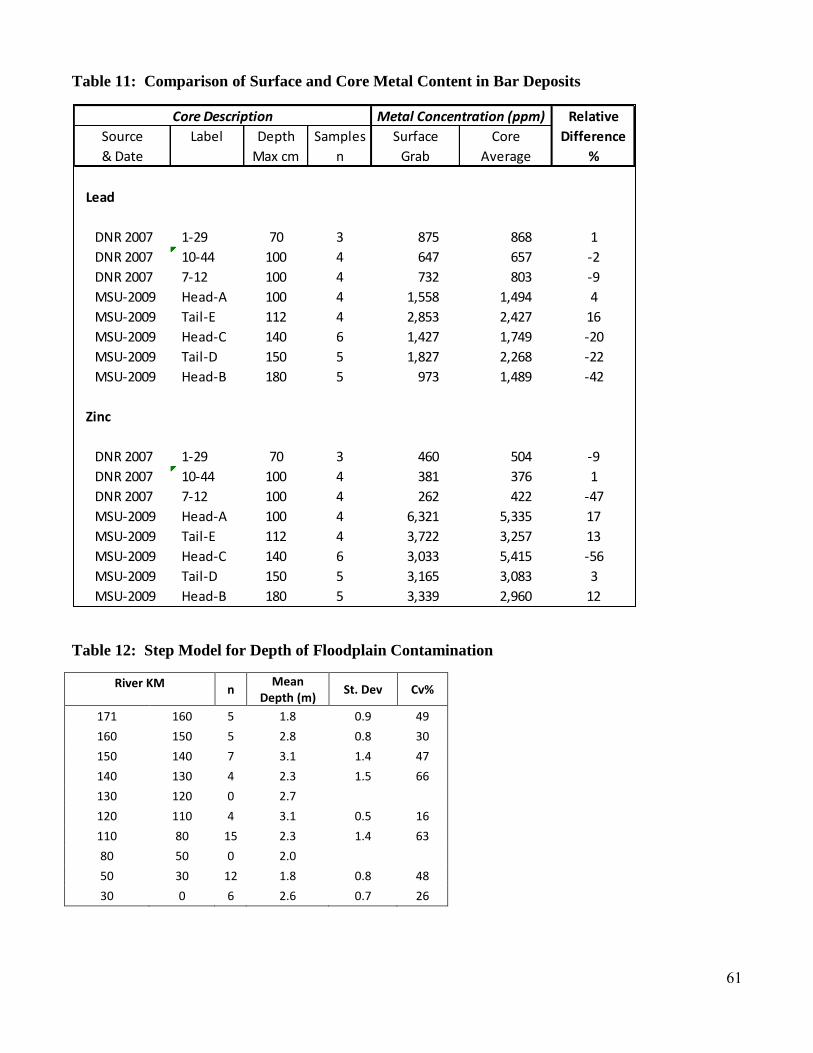
61
Table 11: Comparison of Surface and Core Metal Content in Bar Deposits
Table 12: Step Model for Depth of Floodplain Contamination
River KM n Mean
Depth (m) St. Dev Cv%
171 160 5 1.8 0.9 49
160 150 5 2.8 0.8 30
150 140 7 3.1 1.4 47
140 130 4 2.3 1.5 66
130 120 0 2.7
120 110 4 3.1 0.5 16
110 80 15 2.3 1.4 63
80 50 0 2.0
50 30 12 1.8 0.8 48
30 0 6 2.6 0.7 26
Core Description Metal Concentration (ppm) Relative
Source Label Depth Samples Surface Core Difference
& Date Max cm n Grab Average %
Lead
DNR 2007 1-29 70 3 875 868 1
DNR 2007 10-44 100 4 647 657 -2
DNR 2007 7-12 100 4 732 803 -9
MSU-2009 Head-A 100 4 1,558 1,494 4
MSU-2009 Tail-E 112 4 2,853 2,427 16
MSU-2009 Head-C 140 6 1,427 1,749 -20
MSU-2009 Tail-D 150 5 1,827 2,268 -22
MSU-2009 Head-B 180 5 973 1,489 -42
Zinc
DNR 2007 1-29 70 3 460 504 -9
DNR 2007 10-44 100 4 381 376 1
DNR 2007 7-12 100 4 262 422 -47
MSU-2009 Head-A 100 4 6,321 5,335 17
MSU-2009 Tail-E 112 4 3,722 3,257 13
MSU-2009 Head-C 140 6 3,033 5,415 -56
MSU-2009 Tail-D 150 5 3,165 3,083 3
MSU-2009 Head-B 180 5 3,339 2,960 12

62
Table 13: Floodplain Sediment Geochemistry at Tributaries and Control Sites
Table 14: Step Model for In-Channel Pb Concentrations.
PitDistance to
confluenceDepth n Value Ca Fe Mn Pb Zn Pb:Zn
# km max, cm count % % ppm ppm ppm ratio
Flat River Creek (confluence with Big River at R-km 155)
37 3.5 120 4 Geomean 15.5 3.58 3,749 2,916 760 3.8Min 13.3 3.17 3,096 2,025 685 2.8
Max 18.3 3.89 4,250 4,002 926 5.5
38 3.4 110 3 Geomean 15.1 3.59 3,829 2,985 1,095 2.7Min 13.8 3.27 3,499 2,704 1,017 2.6
Max 16.8 3.80 4,137 3,579 1,263 2.8
Mill Creek (confluence with Big River at R-km 116)
41 5.3 240 4 Geomean 0.73 2.12 345 148 445 0.3Min 0.31 1.59 73 79 231 0.2
Max 1.53 3.78 1,410 411 780 0.5
Mineral Fork Creek (confluence with Big River at R-km 99)
39 4.3 220 8 Geomean 0.64 1.71 680 169 220 0.8Min 0.35 1.28 380 107 164 0.7
Max 1.03 2.37 1,406 308 343 1.0
River KM n Mean Pb
(ppm) St. Dev Cv%
171 160 4 922 896 97
160 150 4 1,154 143 12
150 140 6 1,404 278 20
140 130 4 768 141 18
130 120 0 646
120 110 5 524 195 37
110 100 0 417
100 30 8 311 67 22
30 0 8 122 58 47

63
Table 15: Channel Dimensions and Unit Storage
Reach Reach Width Probe Depth Unit Volume Ratio Bar %
Length mean mean max Mean Max (Max/ mean
(m) (m) (m) (m3/100m) Mean)
Mainstem
M-1 Leadwood 515 40.3 0.7 1.1 2,963 4,485 1.5 9.3
M-5 Hwy 67 ab Flat River Ck 484 31.0 0.8 1.1 2,470 3,356 1.4 25.5
M-9 Cherokee Landing 395 33.6 0.6 1.3 2,035 4,295 2.1 9.5
M-13 CC Bridge at Blackwell 516 41.2 0.6 1.2 2,508 4,737 1.9 34.5
M-15 Mammoth Access 520 35.7 0.8 1.5 2,852 5,327 1.9 2.8
M-17 Browns Ford Access 428 38.0 0.4 1.1 1,591 4,298 2.7 1.8
M-18 Morse Mill Park 534 42.4 0.4 1.1 1,776 4,504 2.5 12.3
M-19 Cedar Hill Park 512 37.8 0.4 0.7 1,385 2,644 1.9 0.0
M-21 Rockford Beach Access 660 52.6 0.7 1.3 3,764 6,685 1.8 0.0
M-24 Downstream of Hwy W 771 41.8 0.1 0.2 364 847 2.3 1.3
Tributaries
FRC-2 Flat R Ck at St. Joe Bridge 157 17.9 0.3 0.6 590 1,142 1.9 16.5
Mill-3 Mill Ck Near Confluence 123 12.1 0.1 0.2 100 243 2.4 8.6
MF-2 Mineral Fork Ck 195 21.8 0.4 0.8 885 1,687 1.9 16.0
Table 16: Channel and Floodplain Storage Volume by County
Location In-Channel Floodplain Total
Volume (m
3) Volume (m
3) Volume (m
3) %
St. Francois County 1,357,370 17,854,091 19,211,461 21
Jefferson County 2,311,174 68,938,738 71,249,911 79
Total 3,668,543 86,792,829 90,461,372 100
Pb (Mg) Pb (Mg) Pb (Mg) %
St. Francois County 2,562 61,350 63,912 28
Jefferson County 1,248 164,469 165,717 72
Total 3,810 225,819 229,629 100

64
Table 17. Sediment Volume and Pb Mass as a Percent of Total by County
A. Location Sediment Volume (%)
County In-Channel Floodplain
St. Francois 1.5% 19.7%
Jefferson 2.6% 76.2%
Total Sediment Volume = 90,461,000 m3
B. Location Pb Mass (%)
County In-Channel Floodplain
St. Francois 1.1% 26.7%
Jefferson 0.6% 71.6%
Total Pb Mass = 230,000 Mg
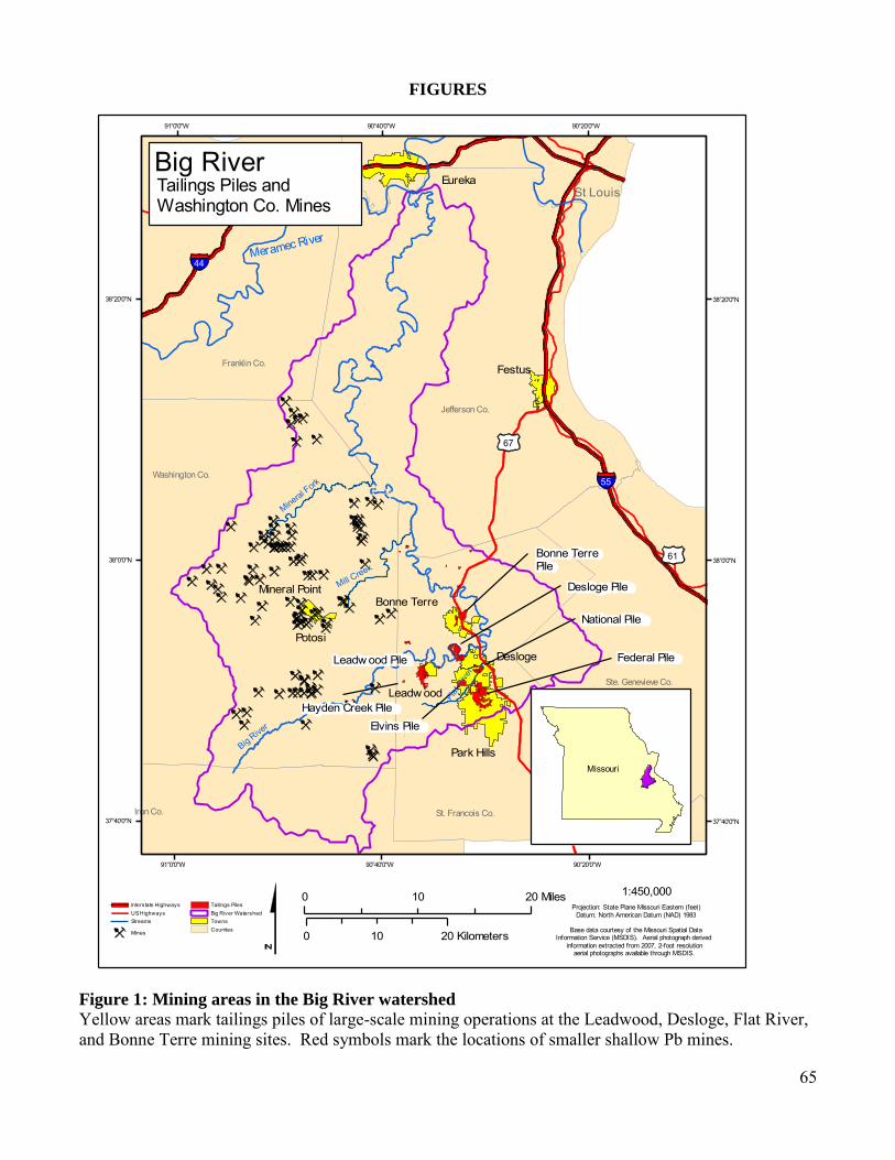
65
FIGURES
Figure 1: Mining areas in the Big River watershed
Yellow areas mark tailings piles of large-scale mining operations at the Leadwood, Desloge, Flat River, and Bonne Terre mining sites. Red symbols mark the locations of smaller shallow Pb mines.
Jefferson Co.
Washington Co.
Potosi
Leadw ood
Desloge
Bonne Terre
Festus
Eureka
Big River
Franklin Co.
St. Francois Co.
Ste. Genevieve Co.
Iron Co.
Park Hills
Bonne Terre Pile
National Pile
Federal Pile
Elvins Pile
Leadw ood Pile
Desloge Pile
Hayden Creek Pile
Mineral Point
St Louis
55
44
67
61
Mill Creek
Flat
Rive
r
Mineral Fork
Meramec River
90°20'0"W
90°20'0"W
90°40'0"W
90°40'0"W
91°0'0"W
91°0'0"W
38°20'0"N 38°20'0"N
38°0'0"N 38°0'0"N
37°40'0"N 37°40'0"N
0 2010 Miles
0 2010 Kilometers
Interstate HighwaysUS HighwaysStreams
Mines
Tailings PilesBig River WatershedTownsCounties
Missouri
Big River
Projection: State Plane Missouri Eastern (feet)Datum: North American Datum (NAD) 1983
1:450,000
Base data courtesy of the Missouri Spatial DataInformation Service (MSDIS). Aerial photograph derived
information extracted from 2007, 2-foot resolution aerial photographs available through MSDIS.
Tailings Piles andWashington Co. Mines

66
Figure 2. Bedrock Geology of the Big River Basin
Big River
Iron
55
44
67
61
Mill Creek
Flat
River
Mineral Fork
Cep
Ceb
Ojc
Ceb
Og
Cep
i i
Clm
v
v v
v
Og
Odp
Og
Clm
Or
Ospe
Ojd
Or
Mo
Or
v
Odp
v
i
i
v
v
i
v
Mo Omk
D
d
M
eramec River
Meramec River
Mis
siss
ippi
90°20'0"W
90°20'0"W
90°40'0"W
90°40'0"W
91°0'0"W
91°0'0"W
38°20'0"N 38°20'0"N
38°0'0"N 38°0'0"N
37°40'0"N 37°40'0"N
0 157.5 Miles
0 2512.5 Kilometers
Missouri
rivers
Bedrock Geology
Pu
D
Ojc
Mo
Or
Omk
Ospe
Ojd
Odp
Og
Clm
Ceb
Cep
i
v
d
Big River Watershed
Projection: State Plane Missouri Eastern (feet)Datum: North American Datum (NAD) 1983
1:450,000
Base data courtesy of the Missouri Spatial DataInformation Service (MSDIS). Aerial photograph derived
information extracted from 2007, 2-foot resolution aerial photographs available through MSDIS.
Geology
Refer to table containing more detailed explanations
of geologic symbols
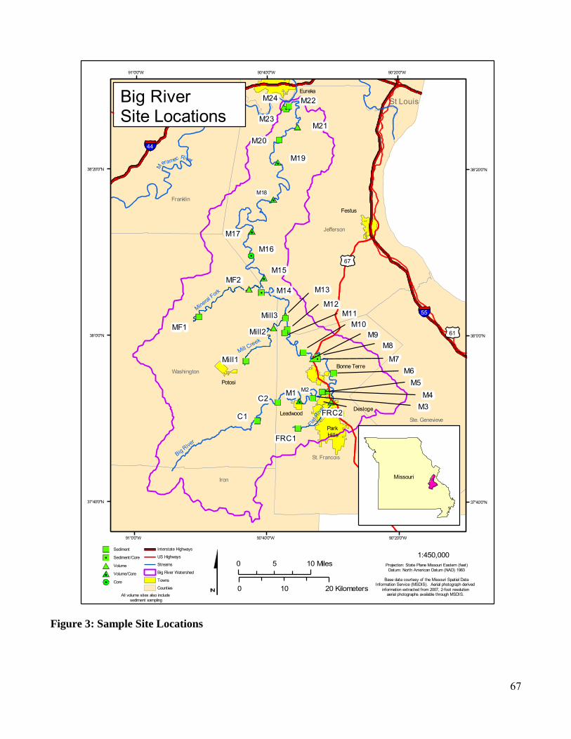
67
Figure 3: Sample Site Locations
Jefferson
Washington
Desloge
Bonne Terre
Festus
Eureka
Big River
Franklin
St. Francois
Ste. Genevieve
Iron
Potosi
Leadwood
ParkHills
M18
M2
St Louis
FRC2
M6
M11
M22M24
FRC1
Mill1
Mill2
MF2
M16
M17
M19
M20
MF1
C2M1
M7
M8M9
M10
M13M14
C1
M23
Mill3
M15
M21
M3M4
M5
M1255
44
67
61
Mill Creek
Flat
Rive
r
Mineral Fork
Meramec River
90°20'0"W
90°20'0"W
90°40'0"W
90°40'0"W
91°0'0"W
91°0'0"W
38°20'0"N 38°20'0"N
38°0'0"N 38°0'0"N
37°40'0"N 37°40'0"N
0 105 Miles
0 2010 Kilometers
Missouri
Sediment
Sediment/Core
Volume
Volume/Core
Core
Interstate Highways
US Highways
Streams
Big River Watershed
Towns
Counties
All volume sites also includesediment sampling
Big River Site Locations
Projection: State Plane Missouri Eastern (feet)Datum: North American Datum (NAD) 1983
1:450,000
Base data courtesy of the Missouri Spatial DataInformation Service (MSDIS). Aerial photograph derived
information extracted from 2007, 2-foot resolution aerial photographs available through MSDIS.

68
Figure 4A: Glide Photos
Looking down a glide to distant riffle
Figure 4B: Glide Photos - Channel Sediment
Glide at Mammoth Access, River km 97. Note fine-grained sediment on the bed, but lacking grayish tailing and chat deposits.

69
Figure 4C: Glide Photo - Channel Sediment
Glide at Hwy W DS, river km 2.0. Note coarser gravel and cobble bed with little to fine material present.
Figure 5A: Bar Photo - High Gravel Bar Deposit
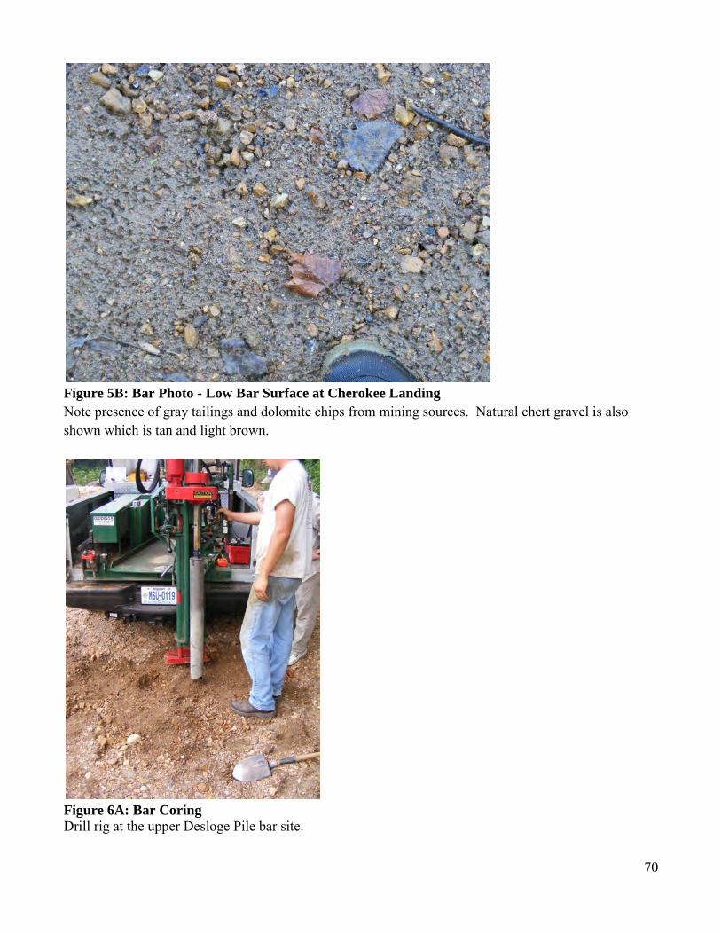
70
Figure 5B: Bar Photo - Low Bar Surface at Cherokee Landing
Note presence of gray tailings and dolomite chips from mining sources. Natural chert gravel is also shown which is tan and light brown.
Figure 6A: Bar Coring Drill rig at the upper Desloge Pile bar site.

71
Figure 6B: Bar coring
Bucket auger moving through bar material
Figure 6C: Bar Coring 180 cm core.
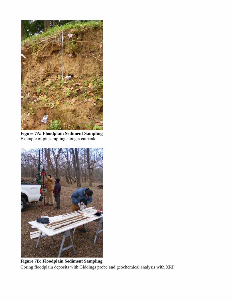
Figure 7A: Floodplain Sediment Sampling
Example of pit sampling along a cutbank
Figure 7B: Floodplain Sediment Sampling Coring floodplain deposits with Giddings probe and geochemical analysis with XRF

73
Figure 8: Channel Sediment Source Distribution Results of grain-counts for the Chat-sized fraction (4-8 mm) at St. Francis State Park (R-km 140.3) showing, clockwise from upper left: (i) Dolomite chips related to tailings inputs; (ii) Natural weathered chert and other grains indicative of non-mining sources; (iii) Quartz grains also from natural sources; and (iv) shale grain from tailings inputs.

74
Figure 9: Downstream Pb contamination trends. Comparison of sediment from MSU (this study) and previous sediment monitoring activities by the US Fish and Wildlife Service (Roberts et al., 2009).
Figure 10: Downstream Trends in Channel Sediment Pb
0
500
1,000
1,500
2,000
2,500
0 25 50 75 100 125 150 175 200
Pb
pp
m
River Kilometer above the Meramec River
FWS 07 riffle slackwater
bulk
FWS 08 riffle slackwater bulk
MSU 09 bar <2mm
MSU 09 glide <2mm
MSU 09 Geo-mean
Probable Effect
128 ppm Pb
Big River Channel sed-PbContamination
171- Eaton Ck155- Flat R Ck116- Mill Ck
99- Min Fork34- Belews Ck
y = 78.359e0.0169x
R² = 0.8998
y = 87.027e0.0165x
R² = 0.8972
y = 135.15e0.0163x
R² = 0.8443
0
500
1,000
1,500
2,000
2,500
3,000
0 50 100 150 200 250
Pb
(p
pm
)
River km
Geomean (below Leadwood)
Arth. Mean (below Leadwood)
Max (below Leadwood)
Geomean (above Leadwood)
Arth. Mean (above Leadwood)
Max (above Leadwood)

75
Figure 11: Channel Sediment Pb Comparison with Previous Studies
Figure 12A: Downstream Trends in Channel Sediment Zn
y = 78.358e0.0169x
R² = 0.8998
0
1,000
2,000
3,000
4,000
5,000
6,000
7,000
0 50 100 150 200 250
Pb
(p
pm
)
River km
OEWRI 2009 - below Leadwood (<2mm)
OEWRI 2009 - above Leadwood (<2mm)
MDNR, 2007a (bulk composite)
MDNR, 2003 (<2mm)
Gale et al., 2001 (<63um)
Smith and Schumacher, 1991 (<63um)
Schmitt and Finger, 1982 (<2mm)
y = 40.351e0.0182x
R² = 0.8302
y = 44.255e0.0184x
R² = 0.8042
y = 63.293e0.0199x
R² = 0.7425
0
1,000
2,000
3,000
4,000
5,000
6,000
7,000
0 50 100 150 200 250
Zn (
pp
m)
River km
Geomean (below Leadwood)
Arth. Mean (below Leadwood)
Max (below Leadwood)
Geomean (above Leadwood)
Arth. Mean (above Leadwood)
Max (above Leadwood)

76
Figure 12B: Downstream Trends in Channel Sediment Fe
Figure 12C: Downstream Trends Channel Sediment Mn
y = 6488.7e0.0085x
R² = 0.7769
y = 6940.7e0.0083x
R² = 0.768
y = 9748.6e0.0081x
R² = 0.6502
0
10,000
20,000
30,000
40,000
50,000
60,000
70,000
80,000
0 50 100 150 200 250
Fe (
pp
m)
River km
Geomean (below Leadwood)
Arth. Mean (below Leadwood)
Max (below Leadwood)
Geomean (above Leadwood)
Arth. Mean (above Leadwood)
Max (above Leadwood)
y = 152.76e0.0177x
R² = 0.7949
y = 227.51e0.0153x
R² = 0.7869
y = 472e0.0125x
R² = 0.7236
0
1,000
2,000
3,000
4,000
5,000
6,000
7,000
8,000
0 50 100 150 200 250
Mn
(p
pm
)
River km
Geomean (below Leadwood)
Arth. Mean (below Leadwood)
Max (below Leadwood)
Geomean (above Leadwood)
Arth. Mean (above Leadwood)
Max (above Leadwood)

77
Figure 12D: Downstream Trends Channel Sediment Ca
Figure 13: Fine Sediment Distribution in Bar and Glide Samples
y = 1320.6e0.0292x
R² = 0.9166
y = 1604.7e0.0284x
R² = 0.9221
y = 2710.6e0.0268x
R² = 0.8878
0
50,000
100,000
150,000
200,000
250,000
0 50 100 150 200 250
Ca
(pp
m)
River km
Geomean (below Leadwood)
Arth. Mean (below Leadwood)
Max (below Leadwood)
Geomean (above Leadwood)
Arth. Mean (above Leadwood)
Max (above Leadwood)
0
20
40
60
80
100
0 25 50 75 100 125 150 175 200
<2 m
m b
y m
ass
(%)
River Km
Percent Fines in Channel Deposits of Big River
Bar <2mm
Glide <2mm
Desloge/Bone Hole at Rkm 165
Mill Creek at Rkm 116
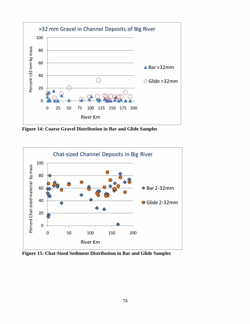
78
Figure 14: Coarse Gravel Distribution in Bar and Glide Samples
Figure 15: Chat-Sized Sediment Distribution in Bar and Glide Samples
0
20
40
60
80
100
0 25 50 75 100 125 150 175 200
Perc
ent >
32 m
m b
y m
ass
River Km
>32 mm Gravel in Channel Deposits of Big River
Bar >32mm
Glide >32mm
0
20
40
60
80
100
0 50 100 150 200Perc
ent C
hat-
size
d m
ater
ial
by m
ass
River Km
Chat-sized Channel Deposits in Big River
Bar 2-32mm
Glide 2-32mm

79
Figure 16: Chat Composition in Channel Sediments
Confluence of Mill Ck is at 116 km and Mineral Fork Creek at 99 km. Flat River Ck flows in to the Big River at 155 km.
0
20
40
60
80
100
0 25 50 75 100 125 150 175 200
Pe
rce
nt
of
Tota
l G
rain
s
River Kilometer
Chat Grain Counts (4-8 mm fraction)
Chips Trend
Natural Trend
Chips-Trib
Natural-Trib
Flat R Ck
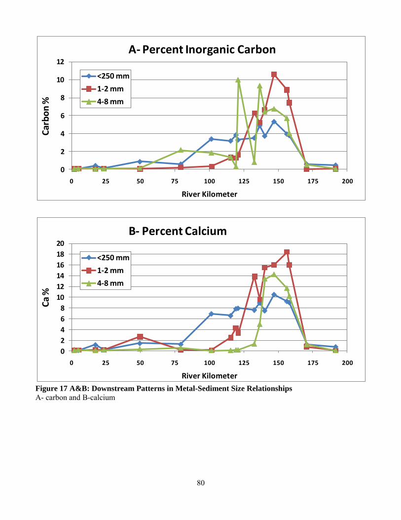
80
Figure 17 A&B: Downstream Patterns in Metal-Sediment Size Relationships
A- carbon and B-calcium
0
2
4
6
8
10
12
0 25 50 75 100 125 150 175 200
Car
bo
n %
River Kilometer
A- Percent Inorganic Carbon
<250 mm
1-2 mm
4-8 mm
0
2
4
6
8
10
12
14
16
18
20
0 25 50 75 100 125 150 175 200
Ca
%
River Kilometer
B- Percent Calcium
<250 mm
1-2 mm
4-8 mm

81
Figure 17 C&D: Downstream Patterns in Metal-Sediment Size Relationships
C- iron and D-manganese
0
1
2
3
4
5
6
0 25 50 75 100 125 150 175 200
Fe %
River Kilometer
C- Percent Iron
<250 mm
1-2 mm
4-8 mm
0
1000
2000
3000
4000
5000
6000
7000
8000
9000
0 25 50 75 100 125 150 175 200
Mn
pp
m
River Kilometer
D- ppm Manganese
<250 mm
1-2 mm
4-8 mm

82
Figure 17 E&F: Downstream Patterns in Metal-Sediment Size Relationships
E- lead and F-zinc
0
1000
2000
3000
4000
5000
6000
0 25 50 75 100 125 150 175 200
Pb
pp
m
River Kilometer
E- ppm Lead
<250 mm
1-2 mm
4-8 mm
0
500
1000
1500
2000
2500
3000
3500
0 25 50 75 100 125 150 175 200
Zn p
pm
River Kilometer
F- ppm Zinc
<250 mm
1-2 mm
4-8 mm

83
Figure 17 G: Downstream Patterns in Metal-Sediment Size Relationships
0.0
0.5
1.0
1.5
2.0
2.5
3.0
3.5
4.0
4.5
5.0
0 25 50 75 100 125 150 175 200
Pb
pp
m /
Zn
pp
m
River Kilometer
Lead:Zinc ratio
<250 mm
1-2 mm
4-8 mm

84
Figure 18: Metal Contaminant Variability Among in Bar Cores and Surface Samples
A- Sample mean and standard deviation for ppm lead B- Sample mean and standard deviation for ppm Zinc
0
1000
2000
3000
pp
mA- ppm Lead (XRF)
+1s
mean
0
3000
6000
9000
pp
m
B- ppm Zinc (XRF)
+1s
mean

85
Figure 19: Relationship of Bar Surface Metal Content to Core Composite Average
A- Relative difference % between surface grab sample and composite core average. Trendline shows relationship over depth for Pb. B- Relationship between surface grab sample Pb and core average Pb. 1:1 line is gray and regression line is black.
Pb RD% = 41.4 - 0.425 Depth cmR² = 0.672
-70
-60
-50
-40
-30
-20
-10
0
10
20
30
0 50 100 150 200
RD
%
Core Depth (cm)
A- Relative Difference: Top Grab - Core (%)
Pb
Zn
Core average-Pb = 350 + 0.823 surface-PbR² = 0.83
0
500
1,000
1,500
2,000
2,500
3,000
3,500
0 500 1,000 1,500 2,000 2,500 3,000 3,500
Co
re A
vera
ge (p
pm
Pb
)
Surface Grab Sample (ppm Pb)
B- Core over Surface ppm Pb

86
Figure 20: Depth of Contaminated Soil on Floodplain
Figure 21: Downstream Trends in Maximum Floodplain Pb Concentrations
FPdepth (m) = 0.0029 RK + 2.08R² = 0.015
0
1
2
3
4
5
6
7
0 20 40 60 80 100 120 140 160 180
Co
nta
min
ated
Flo
od
pla
in D
epth
(m
)
River Kilometer (km from the Meramec River)
Contaminated Soil Depth on Floodplain Areas along the Big River
Core Data
FP Depth Model
Linear (Core Data)
0
2,000
4,000
6,000
8,000
10,000
12,000
14,000
0 50 100 150 200
Pb
(p
pm
)
River KM
Downstream Floodplain Max Pb
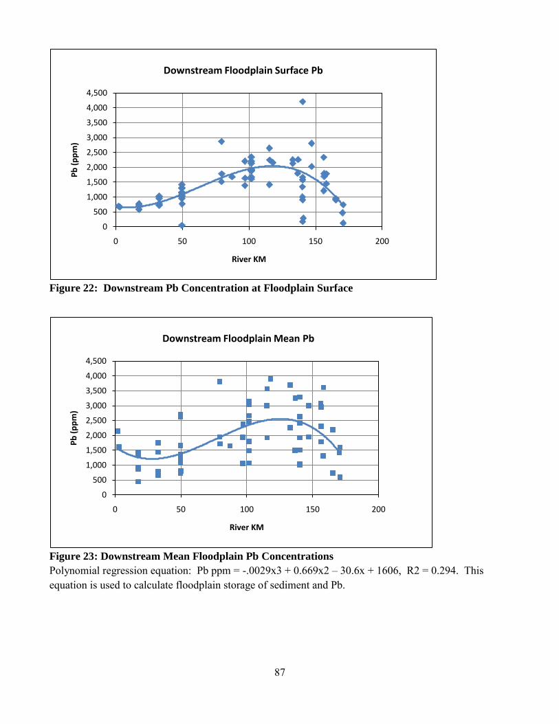
87
Figure 22: Downstream Pb Concentration at Floodplain Surface
Figure 23: Downstream Mean Floodplain Pb Concentrations
Polynomial regression equation: Pb ppm = -.0029x3 + 0.669x2 – 30.6x + 1606, R2 = 0.294. This equation is used to calculate floodplain storage of sediment and Pb.
0
500
1,000
1,500
2,000
2,500
3,000
3,500
4,000
4,500
0 50 100 150 200
Pb
(p
pm
)
River KM
Downstream Floodplain Surface Pb
0
500
1,000
1,500
2,000
2,500
3,000
3,500
4,000
4,500
0 50 100 150 200
Pb
(p
pm
)
River KM
Downstream Floodplain Mean Pb

88
Figure 24: Downstream Mean Floodplain Zn and Ca
Figure 25: Downstream Mean Floodplain Fe and Mn
0
30,000
60,000
90,000
120,000
0
1,000
2,000
3,000
4,000
0 50 100 150 200
Ca
(pp
m)
Zn (
pp
m)
River KM
Downstream Floodplain Average Zn and Ca
Zn Ca
0
500
1,000
1,500
2,000
2,500
3,000
3,500
0
10,000
20,000
30,000
40,000
50,000
60,000
70,000
0 50 100 150 200
Mn
(p
pm
)
Fe (
pp
m)
River KM
Downstream Floodplain Average Fe and Mn
Fe Mn
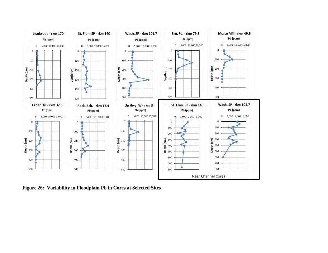
Figure 26: Variability in Floodplain Pb in Cores at Selected Sites
Near Channel Cores

90
Figure 27: Variability in Floodplain Zn in Cores at Selected Sites
Near Channel Cores

91
Figure 28: Variability in Floodplain Ca in Cores at Selected Sites
Near Channel Cores

Figure 29: Washington State Park Transect #1
Looking from the road to the channel
(station 150-250 meters)
Looking from the road to the bluff
(station 0-150 meters)

Figure 30: St. Francois State Park Transect #1
9899
100101102103104105106107108109110111112
0 50 100 150
Re
l. E
leva
tio
n (
m)
Distance (m)
Core 1
Core 3Core 2Core 4
Pit 18.1
0
100
200
300
400
500
600
700
800
0 2,000 4,000 6,000 8,000
Dep
th (
cm)
Pb (ppm)
T-1 Core 4 - St. Fran. SP
0
100
200
300
400
500
600
700
800
0 2,000 4,000 6,000 8,000
Dep
th (
cm)
Pb (ppm)
T-1 Core 2 - St. Fran. SP
0
100
200
300
400
500
600
700
800
0 2,000 4,000 6,000 8,000D
epth
(cm
)
Pb (ppm)
T-1 Core 3 - St. Fran. SP
0
100
200
300
400
500
600
700
800
0 2,000 4,000 6,000 8,000
Dep
th (
cm)
Pb (ppm)
T-1 Core 1 - St. Fran. SP
0
100
200
300
400
500
600
700
800
0 2,000 4,000 6,000 8,000
Dep
th (
cm)
Pb (ppm)
T-1 Pit 18.1 - St. Fran. SP

94
Figure 31: Washington State Park Transect #3
132133134135136137138139140141142143144145146
0 50 100 150 200
Ele
vati
on
(m
)
Distance (m)
Core 1Core 2
Core 3Core 4
Core 5
0
50
100
150
200
250
300
350
400
450
0 5,000 10,000 15,000
Dep
th (
cm)
Pb (ppm)
T-3 Core 1 - Wash. SP
0
50
100
150
200
250
300
350
400
450
0 5,000 10,000 15,000
Dep
th (
cm)
Pb (ppm)
T-3 Core 2 - Wash. SP
0
50
100
150
200
250
300
350
400
450
0 5,000 10,000 15,000
Dep
th (
cm)
Pb (ppm)
T-3 Core 3 - Wash. SP
0
50
100
150
200
250
300
350
400
450
0 5,000 10,000 15,000
Dep
th (
cm)
Pb (ppm)
T-3 Core 4 - Wash. SP
0
50
100
150
200
250
300
350
400
450
0 5,000 10,000 15,000
Dep
th (
cm)
Pb (ppm)
T-3 Core 5 - Wash. SP
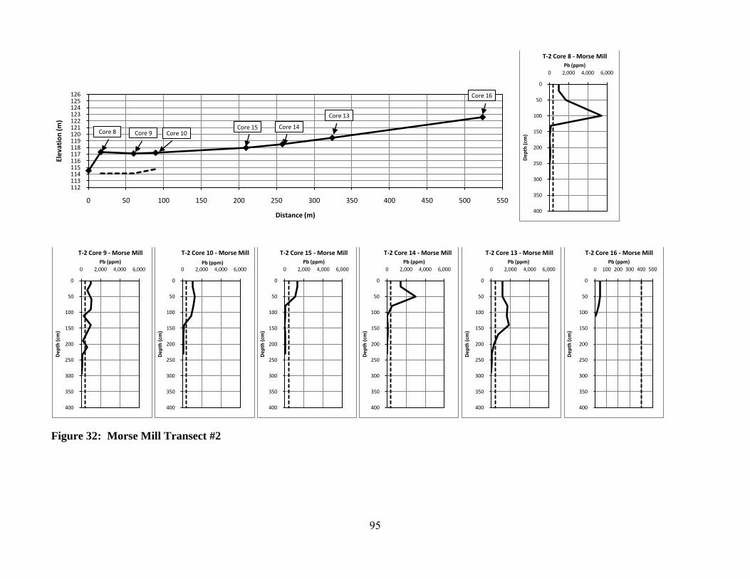
95
Figure 32: Morse Mill Transect #2
112113114115116117118119120121122123124125126
0 50 100 150 200 250 300 350 400 450 500 550
Ele
vati
on
(m
)
Distance (m)
Core 8 Core 9 Core 10Core 15 Core 14
Core 13
Core 16
0
50
100
150
200
250
300
350
400
0 2,000 4,000 6,000
Dep
th (
cm)
Pb (ppm)
T-2 Core 8 - Morse Mill
0
50
100
150
200
250
300
350
400
0 2,000 4,000 6,000
Dep
th (
cm)
Pb (ppm)
T-2 Core 9 - Morse Mill
0
50
100
150
200
250
300
350
400
0 2,000 4,000 6,000
Dep
th (
cm)
Pb (ppm)
T-2 Core 10 - Morse Mill
0
50
100
150
200
250
300
350
400
0 2,000 4,000 6,000
Dep
th (
cm)
Pb (ppm)
T-2 Core 15 - Morse Mill
0
50
100
150
200
250
300
350
400
0 2,000 4,000 6,000
Dep
th (
cm)
Pb (ppm)
T-2 Core 14 - Morse Mill
0
50
100
150
200
250
300
350
400
0 2,000 4,000 6,000
Dep
th (
cm)
Pb (ppm)
T-2 Core 13 - Morse Mill
0
50
100
150
200
250
300
350
400
0 100 200 300 400 500
Dep
th (
cm)
Pb (ppm)
T-2 Core 16 - Morse Mill

Figure 33: Pb:Zn Ratios in Floodplain Deposits
Symbols are coded according to the depth of contamination. ―X‖ symbols show ratio values for uncontaminated bottom core samples. Ratios are shown for the floodplain cores collected from the major tributaries: Flat River Creek, Mill Creek, and Mineral Fork Creek.
Figure 34: Pb:Zn Ratios in the <2 mm Fraction in Channel Deposits
0
2
4
6
8
10
12
0 50 100 150 200
Pb
:Zn
Rat
io
River Kilometer (R-km)
Pb:Zn Ratios in Floodplain Deposits
Con <1.5 m
Con 1.5-3 m
Con >3 m
Pre-mining background
Flat
Mill
MinFk
0
1
2
3
4
5
0 25 50 75 100 125 150 175 200
Pb
:Zn
Rat
io
River kilometer (R-km)
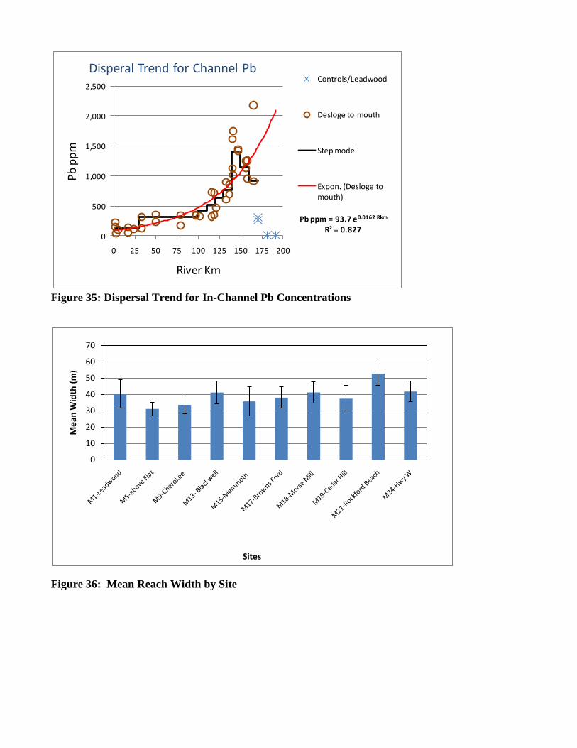
Figure 35: Dispersal Trend for In-Channel Pb Concentrations
Figure 36: Mean Reach Width by Site
Pb ppm = 93.7 e0.0162 Rkm
R² = 0.8270
500
1,000
1,500
2,000
2,500
0 25 50 75 100 125 150 175 200
Pb
pp
m
River Km
Disperal Trend for Channel PbControls/Leadwood
Desloge to mouth
Step model
Expon. (Desloge to mouth)
0
10
20
30
40
50
60
70
Me
an W
idth
(m
)
Sites
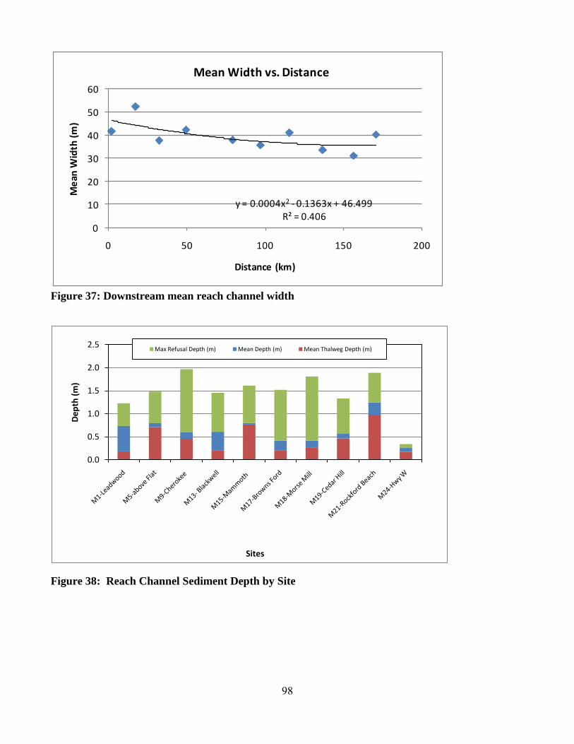
98
Figure 37: Downstream mean reach channel width
Figure 38: Reach Channel Sediment Depth by Site
y = 0.0004x2 - 0.1363x + 46.499R² = 0.406
0
10
20
30
40
50
60
0 50 100 150 200
Me
an W
idth
(m
)
Distance (km)
Mean Width vs. Distance
0.0
0.5
1.0
1.5
2.0
2.5
De
pth
(m
)
Sites
Max Refusal Depth (m) Mean Depth (m) Mean Thalweg Depth (m)

99
Figure 39: Downstream Mean Reach In-Channel Sediment Depth
Figure 40: Downstream Unit Volume of In-Channel Storage
y = 0.0923x0.4165
R² = 0.730
0.01
0.1
1
10
0 50 100 150 200
Me
an D
ep
th (
m)
Distance (km)
Mean Depth vs. Distance
y = 448.13x0.3617
R² = 0.571
100
1,000
10,000
0 25 50 75 100 125 150 175 200
Un
it V
olu
me
(m
3/1
00
m)
Distance (km)
Unit Volume vs. Distance
MSU-OEWRI
Newfields

100
Figure 41: Mean Unit Channel Sediment Storage at each Study Site Average unit storage rates are 2,570 +/- 14% m3/100 m from R-km 171 to 90 and 1,580 +/- 12% from R-km 90 to 15. Storage rates can be locally high behind low water bridges or old mill dams such as found at Leadwood and Rockford Beach.
Figure 42: Relative Bar Sediment Storage at each Study Site

101
Figure 43: Channel Feature Classification Data Extracted from 2007 2-ft Resolution, Leaf-Off
Aerial Photography
(A) Channel feature area per 5km channel unit and (B) channel feature % composition per 5km channel unit.
0.00
0.05
0.10
0.15
0.20
0.25
0.30
0.35
0.40
5 25 45 65 85 105 125 145 165 185 205
Are
a (k
m2)
Distance upstream from confluence with Meramec River (km)
Channel Feature Classification
Vegetated Bar
Unvegetated Bar
Wetted Channel
A
40
50
60
70
80
90
100
5 25 45 65 85 105 125 145 165 185 205
% o
f A
ctiv
e C
han
ne
l Are
a
Distance upstream from confluence with Meramec River (km)
Channel Feature Classification
B
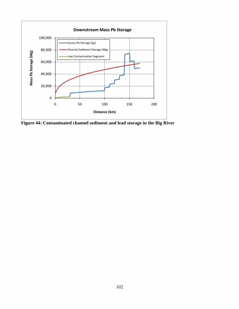
102
Figure 44: Contaminated channel sediment and lead storage in the Big River
0
20,000
40,000
60,000
80,000
100,000
0 50 100 150 200
Mas
s P
b S
tora
ge (
Mg)
Distance (km)
Downstream Mass Pb Storage
Excess Pb Storage (kg)
Channel Sediment Storage (Mg)
Low Contamination Segment

103
Figure 45: Downstream Floodplain Area by Landform
0.0
0.5
1.0
1.5
2.0
2.5
3.0
3.5
4.0
0 180
Are
a (k
m2 )
River km
Floodplain Landform by Valley Cell
High Terrace/Colluvium
Kaintuck (LF)
Wilbur (HF)
Haymond (HF)
Sturkie (LT)
Mineral Fork (99 km)
Mill Creek (115.5 km)
Flat River Creek (155 km)
30 60 90 120 150

104
Figure 46: Downstream Floodplain Sediment and Pb Mass per Unit Distance
0
500,000
1,000,000
1,500,000
2,000,000
2,500,000
3,000,000
3,500,000
4,000,000
0 50 100 150 200
Mas
s P
er
km
Distance (km)
Downstream Floodplain Storage
Pb (kg/km)
Sediment (Mg/km)

105
Figure 47: Contaminated Sediment Storage and Pb Mass by River Segment
0
5
10
15
20
25
30
35
0-30 31-70 71-117 118-135 136-154 155-171
% o
f To
tal
River km
In-Channel Volume (%)
In-Channel Pb Mass (%)
A.
0
5
10
15
20
25
30
35
0-30 31-70 71-117 118-135 136-154 155-171
% o
f To
tal
River km
Floodplain Volume (%)
Floodplain Pb Mass (%)
B.
0
10,000
20,000
30,000
40,000
50,000
60,000
70,000
0-30 31-70 71-117 118-135 136-154 155-171
Un
it V
olu
me
(m
3/k
m) a
nd
Mas
s (k
g/ k
m)
River km
In-Channel Volume
In-Channel Pb Mass
C.
0200400600800
1,0001,2001,4001,6001,8002,000
0-30 31-70 71-117 118-135 136-154 155-171
Un
it V
olu
me
(m
3*
10
3/k
m) a
nd
M
ass
(Mg/
km)
River km
Floodplain Volume
Floodplain Pb Mass
D.

106
APPENDIX
River Kilometer Reference Table
Locations along the length of the Big River are referenced by river kilometer (R-km) with R-km 0 at the confluence with the Meramec River. The table below contains reference informaton that relates river kilometer to study reach locations, road crossings, and tributary confluences. For consistency, the River Kilometer scale used in this report can be converted into the river mile scale used by the U.S. Fish and Wildlife Service (Roberts et al., 2009). The conversions use the following equations:
MSU km to USFWS mi = MSU km x 0.663
MSU mi to USFS mi = MSU mi x 1.06
USFWS mi to MSU km = USFWS mi x 1.51
USFWS mi to MSU mi = USFWS mi x 0.943

107
River Mile Reference
MSU
River Km
USFWS
River
Mi
Sample Sites Trib
Confluence Bridge USGS Gage Dams
County
Boundary
0 0.0 Meramec
River
0.8 0.5 Twin River
Rd.
1.8 1.3 M24 - Hwy
Lower
2.8 2.0 M23 - Hwy
Upper
4.9 3.3 M22 - Twin
River Rd.
17.0 11.3
Rockford
Beach Mill
Dam
16.9 11.5
M21 -
Rockford
Beach
Heads Creek
17.5 11.6 Hwy W
23.4 15.5 M20 - Byrnes
Mill
Byrnesville
Rd.
07018500
Big River at
Byrnesville
23.8 15.7 Byrnes Mill
Dam
31.5 20.9 St. Rte. 30
32.2 21.3 Cedar Hill
Rd
Cedar Hill
Mill Dam
32.7 21.5 M19 - Cedar
Mill
34.5 22.9 Belews
Creek
44.5 29.5 Jones Creek
45.5 30.2 Klondike Rd.
49 32.5 St. Rte. B
49.8 32.9 M18 - Morse
Mill
Morse Mill
Dam
52 34.5 Dry Creek

108
MSU
River Km
USFWS
River
Mi
Sample Sites Trib
Confluence Bridge USGS Gage Dams
County
Boundary
61.2 40.6 St. Rte. Y
79 52.4 Brownford
Rd.
79.5 52.6 M17 -
Browns Ford
87.3 57.9 M16 - Merrill
Horse
87.5 58.0 St. Rte. H
07018100
Big River at
Richwoods
90.6 60.1 Washington
92.0 61.0 Jefferson
96.5 64.0 Mammoth
Rd.
97 64.3
M15 -
Mammoth
Access
99 65.6 Mineral
Fork
Wash/Jeff
Cnty Line
100.5 66.6 Big River
Heights Rd.
Wash/Jeff
Cnty Line
101.7 67.4
M14 -
Washington
S.P.
Wash/Jeff
Cnty Line
107 70.9 St. Rte. 21 Wash/Jeff
Cnty Line
109.2 72.4
Wash/Jeff/St.
Francois
Cnty Line
115 76.2 Hwy CC Jeff/St. Fran
Cnty Line
115.5 76.6 M13 -
Blackwell CC Mill Creek
Jeff/St. Fran
Cnty Line
118 78.2 Mill Rd. Jeff/St. Fran
Cnty Line
118.9 79.1 M12 - US of
Mill Cr.
Jeff/St. Fran
Cnty Line
109
MSU
River Km
USFWS
River
Mi
Sample Sites Trib
Confluence Bridge USGS Gage Dams
County
Boundary
120.3 79.8 Jeff/St. Fran
Cnty Line
121.1 80.2
M11 -
Dickenson
Rd
Dickenson
Rd.
Low-water
bridge
125 82.9 Hill Creek
125.5 83.2 Bear Creek
128.5 85.2 Peter's
Creek
132.5 87.8 Cabanna
Course
132.9 88.3 M10 - Hwy E St. Rte. E
134.5 89.2 Bee Creek
136.5 90.5 Berry Rd.
(Closed)
136.7 90.6 M9 – Hwy 67
at Cherokee U.S. Rte. 67
140.3 93.0 M8 – STF
Lower
140.8 93.4 M7 - STF
Upper
144.5 95.8 Terre Bleue
Creek
147.1 97.4 M6 - Hwy K St. Rte. K
155 102.8 Flat River
156 103.4
U.S. Rte. 67,
Vo-Tech
School Rd.
156.5 103.7 M5 - Hwy 67
158.1 104.8 M4 -
Deslodge
Old Bonne
Terre Rd.
163.4
M3 - BS#2
Above
Desloge

110
MSU
River Km
USFWS
River
Mi
Sample Sites Trib
Confluence Bridge USGS Gage Dams
County
Boundary
165.3 109.7 M2 - Bone
Hole at BS#1 Owl Creek
Low-water
bridge
170.7 113.2 M1 -
Leadwood Hunt St.
Low-water
bridge
171 113.4 Eaton Creek
181.2 120.1 C2 - Highway
8 St. Rte. 8
181.8 120.5 Washington
182.5 121.0 Benny
Meyer Rd.
187.5 124.3 Wallen
Creek
191 126.6 Mill Creek
191.7 127.1 C1 Irondale St. Rte. U
00717200
Big River at
Irondale
196 129.9 Cedar Creek
201.5 133.6 Flat Creek St. Rte. 21
204.5 135.6 Clear Creek
209 138.6 St. Rte. C
211 139.9 James Creek St. Rte. JJ
215 142.5 Big River Rd.

111
Lab No. Site Description Coordinates
Missouri State Plane East (feet)
Water Body Code Location X Y
B 25 Big River C1 Hwy U at Irondale-control 765,014.772783 727,047.185739
B 26 Big River C1 Hwy U at Irondale-control 765,013.054611 727,046.427210
G 25 Big River C1 Hwy U at Irondale-control 764,937.654160 727,070.376930
G 26 Big River C1 Hwy U at Irondale-control 764,942.348584 727,083.618960
B 61 Big River C2 Hwy 8 above Leadwood-control 779,910.361759 740,691.821835
G 48 Big River C2 Hwy 8 above Leadwood-control 779,916.514054 740,673.988041
B 1 Big River M1 Leadwood Access 794,875.015884 742,152.657824
B 2 Big River M1 Leadwood Access 794,853.637646 742,195.838840
B 3 Big River M1 Leadwood Access 794,836.171802 742,239.434882
B 4 Big River M1 Leadwood Access 794,816.616723 742,241.535271
G 1 Big River M1 Leadwood Access 795,790.269187 741,240.894355
G 2 Big River M1 Leadwood Access 795,773.577715 741,205.676418
G 3 Big River M1 Leadwood Access 795,766.174312 741,167.233308
B 62 Big River M2 Bone Hole 805,764.882884 743,376.965087
G 49 Big River M2 Bone Hole 805,641.782288 743,366.924400
G 50 Big River M2 Bone Hole 805,670.973455 743,432.166944
B 63 Big River M3 Desloge 812,264.492260 748,192.671991
B 64 Big River M3 Desloge 812,257.134335 748,335.367244
B 65 Big River M3 Desloge 812,295.583733 748,584.628556
G 51 Big River M3 Desloge 812,213.596446 748,079.273200
G 52 Big River M3 Desloge 812,242.423820 748,101.748780
B 5 Big River M4 Hwy 67 above Flat River Ck 814,838.719044 748,968.739074
B 6 Big River M4 Hwy 67 above Flat River Ck 814,910.876380 748,934.488815
B 7 Big River M4 Hwy 67 above Flat River Ck 815,057.600824 748,918.265094
B 8 Big River M4 Hwy 67 above Flat River Ck 815,864.611021 748,814.680656
B 9 Big River M4 Hwy 67 above Flat River Ck 816,047.264527 748,820.154398
B 10 Big River M4 Hwy 67 above Flat River Ck 816,186.756702 748,855.999142
B 11 Big River M4 Hwy 67 above Flat River Ck 816,344.974233 748,896.481345
G 4 Big River M4 Hwy 67 above Flat River Ck 815,533.989987 748,884.028630
G 5 Big River M4 Hwy 67 above Flat River Ck 815,498.850414 748,861.539955
G 6 Big River M4 Hwy 67 above Flat River Ck 815,491.718324 748,838.892649
G 7 Big River M4 Hwy 67 above Flat River Ck 816,110.666985 748,768.029408
G 8 Big River M4 Hwy 67 above Flat River Ck 816,118.459973 748,780.275730
G 9 Big River M4 Hwy 67 above Flat River Ck 816,819.180784 748,735.191946
G 10 Big River M4 Hwy 67 above Flat River Ck 816,807.332378 748,708.825790
B 27 Big River M5 Hwy K below Flat River Ck 820,698.110892 761,641.323571
B 28 Big River M5 Hwy K below Flat River Ck 820,504.422303 761,840.910443
B 29 Big River M5 Hwy K below Flat River Ck 820,191.807442 761,976.531562
G 27 Big River M5 Hwy K below Flat River Ck 820,674.602305 761,731.845315
G 28 Big River M5 Hwy K below Flat River Ck 820,591.664239 761,786.313232

112
Lab No. Site Description Coordinates
Missouri State Plane East (feet)
Water Body Code Location X Y
G 29 Big River M5 Hwy K below Flat River Ck 820,179.368784 762,004.368951
B 30 Big River M6 St. Francois State Park (US) 808,920.250917 772,190.408444
B 31 Big River M6 St. Francois State Park (US) 808,799.238364 772,224.452011
B 33 Big River M6 St. Francois State Park (US) 808,799.238364 772,224.450699
B 34 Big River M6 St. Francois State Park (US) 808,799.238364 772,224.450699
B 35 Big River M6 St. Francois State Park (US) 808,799.238364 772,224.450699
B 32 Big River M6 St. Francois State Park (US) 808,650.318714 772,305.370485
G 31 Big River M6 St. Francois State Park (US) 809,182.655878 772,121.840185
G 30 Big River M6 St. Francois State Park (US) 809,140.026418 772,159.533703
B 38 Big River M7 St. Francois State Park (DS) 808,262.441865 773,697.924130
B 37 Big River M7 St. Francois State Park (DS) 808,361.307809 773,908.155665
B 36 Big River M7 St. Francois State Park (DS) 808,491.307877 774,057.992308
G 32 Big River M7 St. Francois State Park (DS) 808,222.958890 773,638.275146
G 33 Big River M7 St. Francois State Park (DS) 808,200.857627 773,601.135557
B 12 Big River M8 Hwy 67 at Cherokee Landing 805,681.407598 772,490.904566
B 13 Big River M8 Hwy 67 at Cherokee Landing 805,611.449405 772,475.264177
G 11 Big River M8 Hwy 67 at Cherokee Landing 805,972.422899 772,554.138654
G 12 Big River M8 Hwy 67 at Cherokee Landing 805,952.545133 772,573.876685
G 13 Big River M8 Hwy 67 at Cherokee Landing 805,373.935922 772,456.934410
G 14 Big River M8 Hwy 67 at Cherokee Landing 805,373.285776 772,429.173309
G 15 Big River M8 Hwy 67 at Cherokee Landing 804,626.467567 772,379.509685
G 16 Big River M8 Hwy 67 at Cherokee Landing 804,626.697130 772,368.821085
B 40 Big River M9 Hwy E below Bonne Terre 798,580.868709 777,035.939436
B 41 Big River M9 Hwy E below Bonne Terre 798,555.181752 777,089.025944
B 42 Big River M9 Hwy E below Bonne Terre 798,518.430514 777,058.618524
G 35 Big River M9 Hwy E below Bonne Terre 798,559.619465 777,114.387548
G 34 Big River M9 Hwy E below Bonne Terre 798,541.065732 777,143.528576
B 89 Big River M10 Dickinson Rd 784,642.095733 791,330.519770
B 88 Big River M10 Dickinson Rd 784,922.643401 791,387.270969
B 87 Big River M10 Dickinson Rd 785,057.952841 791,491.875747
B 81 Big River M11 US of Mill Cr. 786,761.634801 793,765.438457
B 82 Big River M11 US of Mill Cr. 786,892.434081 793,803.233657
B 83 Big River M11 US of Mill Cr. 787,063.450799 793,883.809939
G 58 Big River M11 US of Mill Cr. 786,912.933664 793,899.058356
B 46 Big River M12 CC Bridge at Blackwell 785,468.334895 802,918.218708
B 47 Big River M12 CC Bridge at Blackwell 785,424.439313 803,012.177181
B 45 Big River M12 CC Bridge at Blackwell 785,432.783128 803,089.810884
B 44 Big River M12 CC Bridge at Blackwell 785,394.549696 804,164.104558
B 43 Big River M12 CC Bridge at Blackwell 785,354.618947 804,107.475496
B 90 Big River M12 CC Bridge at Blackwell 785,376.099843 805,069.303316
B 91 Big River M12 CC Bridge at Blackwell 785,341.732786 805,121.690351

113
Lab No. Site Description Coordinates
Missouri State Plane East (feet)
Water Body Code Location X Y
G 36 Big River M12 CC Bridge at Blackwell 785,331.358214 803,417.571922
G 37 Big River M12 CC Bridge at Blackwell 785,296.811992 803,425.205365
G 38 Big River M12 CC Bridge at Blackwell 785,318.602063 804,174.025193
B 94 Big River M13 Washington Park 767,924.582909 820,736.479659
B 95 Big River M13 Washington Park 767,755.784362 820,668.468968
B 96 Big River M13 Washington Park 767,653.895130 820,601.022581
B 20 Big River M14 Mammoth Access 769,096.183584 831,079.723736
B 19 Big River M14 Mammoth Access 769,162.324856 831,165.162214
B 23 Big River M14 Mammoth Access 769,593.757392 831,795.350586
B 24 Big River M14 Mammoth Access 769,593.046763 831,795.150783
B 21 Big River M14 Mammoth Access 769,738.782364 832,045.999035
B 22 Big River M14 Mammoth Access 769,746.211155 832,141.811507
G 22 Big River M14 Mammoth Access 769,296.772909 831,284.794703
G 21 Big River M14 Mammoth Access 769,313.150272 831,330.013345
G 20 Big River M14 Mammoth Access 769,334.438525 831,351.798608
G 23 Big River M14 Mammoth Access 769,398.757185 831,442.753780
G 24 Big River M14 Mammoth Access 769,456.986230 831,391.243471
B 14 Big River M15 Browns Ford Access 759,266.207837 864,584.528118
B 15 Big River M15 Browns Ford Access 759,316.379653 864,590.151138
B 16 Big River M15 Browns Ford Access 759,381.749273 864,592.246606
B 17 Big River M15 Browns Ford Access 760,323.801522 864,926.154075
B 18 Big River M15 Browns Ford Access 760,348.564268 864,978.344587
G 17 Big River M15 Browns Ford Access 760,579.139445 865,426.223240
G 18 Big River M15 Browns Ford Access 760,546.688466 865,433.829586
G 19 Big River M15 Browns Ford Access 760,511.387549 865,432.561367
B 48 Big River M16 Morse Mill Park 776,279.511081 887,694.266347
B 49 Big River M16 Morse Mill Park 776,344.238313 887,739.691125
B 50 Big River M16 Morse Mill Park 776,371.864571 887,818.460652
B 51 Big River M16 Morse Mill Park 776,747.928779 889,161.590840
B 52 Big River M16 Morse Mill Park 776,881.885860 889,191.960530
G 39 Big River M16 Morse Mill Park 776,282.192661 887,606.103962
G 40 Big River M16 Morse Mill Park 776,290.243268 887,669.098685
B 53 Big River M17 Cedar Hill Park 780,060.162312 915,380.947850
B 54 Big River M17 Cedar Hill Park 779,954.283259 915,427.449069
B 55 Big River M17 Cedar Hill Park 779,883.274871 915,465.122550
G 42 Big River M17 Cedar Hill Park 780,225.443579 915,338.137525
G 41 Big River M17 Cedar Hill Park 780,144.441794 915,370.809785
B 78 Big River M18 Byrnes Mill 781,018.401865 931,935.754307
B 79 Big River M18 Byrnes Mill 781,077.100567 931,977.359867
B 80 Big River M18 Byrnes Mill 781,172.856281 932,039.651081
B 72 Big River M19 Rockford Beach Access 794,760.434548 942,554.951912

114
Lab No. Site Description Coordinates
Missouri State Plane East (feet)
Water Body Code Location X Y
B 73 Big River M19 Rockford Beach Access 794,646.104579 942,608.033651
B 74 Big River M19 Rockford Beach Access 794,335.374190 942,697.918324
G 43 Big River M19 Rockford Beach Access 794,741.894835 942,362.854489
G 44 Big River M19 Rockford Beach Access 794,757.926184 942,369.640384
B 58 Big River M20 Twin River Road 788,032.088928 956,584.404724
B 57 Big River M20 Twin River Road 787,959.212166 956,579.021782
B 75 Big River M21 Hwy W (upstream) 786,206.868194 954,980.745947
B 76 Big River M21 Hwy W (upstream) 785,979.781378 954,852.461755
B 77 Big River M21 Hwy W (upstream) 785,803.782386 954,565.858653
B 60 Big River M22 Hwy W (downstream) 784,097.111259 956,235.778214
G 46 Big River M22 Hwy W (downstream) 784,158.374309 955,890.983014
G 47 Big River M22 Hwy W (downstream) 784,136.817270 955,914.965392
G 45 Big River M22 Hwy W (downstream) 784,106.088661 955,948.957398
B 69 Flat R Creek T1 Upper Flat at Davis- control 794,575.765171 721,575.870894
B 68 Flat R Creek T1 Upper Flat at Davis- control 794,752.216917 721,619.435439
G 53 Flat R Creek T1 Upper Flat at Davis- control 794,784.247435 721,624.540948
B 67 Flat R Creek T2 Flat at St. Joe Bridge 818,741.939279 740,779.989638
B 66 Flat R Creek T2 Flat at St. Joe Bridge 818,769.745982 740,898.292879
G 54 Flat R Creek T2 Flat at St. Joe Bridge 818,769.053885 740,797.553119
G 55 Flat R Creek T2 Flat at St. Joe Bridge 818,780.466549 740,797.617886
B 97 Mill Creek T3 Tributary to Mill Ck at Min Pt 755,446.206291 770,580.279447
B 92 Mill Creek T4 Mill at Tiff 776,888.000021 794,828.759493
B 93 Mill Creek T4 Mill at Tiff 776,934.909048 794,929.836062
G 61 Mill Creek T4 Mill at Tiff 776,907.999417 794,947.800390
G 62 Mill Creek T4 Mill at Tiff 776,923.157840 794,950.491215
B 84 Mill Creek T5 Mill at confluence 785,304.853594 801,992.890178
B 85 Mill Creek T5 Mill at confluence 785,395.284188 802,017.992490
B 86 Mill Creek T5 Mill at confluence 785,470.600638 801,968.347904
G 59 Mill Creek T5 Mill at confluence 785,256.959224 801,949.160754
G 60 Mill Creek T5 Mill at confluence 785,289.330383 801,949.115807
B 98 Mineral Fork Ck T6 Mineral Fork at Hwy F- control 722,355.177657 802,958.438444
B 70 Mineral Fork Ck T7 Mineral Fork near mouth 759,014.319561 822,898.237475
B 71 Mineral Fork Ck T7 Mineral Fork near mouth 759,043.988465 822,940.942114
G 56 Mineral Fork Ck T7 Mineral Fork near mouth 759,073.908012 823,077.107672
G 57 Mineral Fork Ck T7 Mineral Fork near mouth 759,061.102181 823,079.018013
115
Lab No. River Collection XRF Analysis (<2 mm fraction) Km Date Pb Zn Fe Mn Ca
(0 =mouth) (ppm) (ppm) (ppm) (ppm) (ppm)
B 25 191.64 11/23/2008 15 21 13,826 560 2,037 B 26 191.64 11/23/2008 15 17 11,636 400 8,015 G 25 191.66 10/23/2008 15 26 11,800 730 2,294 G 26 191.66 10/23/2008 15 20 8,851 697 1,915 B 61 181.17 1/19/2009 15 39 13,642 855 4,766 G 48 181.17 1/19/2009 15 47 13,439 212 8,053 B 1 170.91 10/1/2008 196 99 17,403 359 4,126 B 2 170.91 10/1/2008 15 64 14,459 364 1,128 B 3 170.91 10/1/2008 810 649 13,365 847 15,420 B 4 170.91 10/1/2008 42 60 19,453 293 1,862 G 1 170.50 10/1/2008 111 191 15,820 299 8,991 G 2 170.50 10/1/2008 182 258 10,541 424 16,527 G 3 170.50 10/1/2008 656 666 17,322 1,748 10,957 B 62 165.26 1/19/2009 915 763 12,494 1,426 55,347 G 49 165.30 1/19/2009 2,182 6,344 22,668 3,803 112,749 G 50 165.28 1/19/2009 2,200 882 31,435 2,630 135,559 B 63 158.13 1/19/2009 1,606 1,527 23,603 2,004 89,036 B 64 158.08 1/19/2009 1,230 2,023 20,892 2,159 121,391 B 65 158.00 1/19/2009 963 1,027 22,591 2,025 101,721 G 51 158.16 1/19/2009 1,130 1,613 21,379 1,982 111,736 G 52 158.16 1/19/2009 788 887 19,145 2,463 127,236 B 5 156.86 10/2/2008 1,563 1,572 33,202 2,501 138,086 B 6 156.84 10/2/2008 992 1,082 20,286 2,664 162,097 B 7 156.79 10/2/2008 790 910 19,634 2,576 135,317 B 8 156.54 10/2/2008 1,345 936 32,159 2,924 161,131 B 9 156.48 10/2/2008 1,088 904 20,436 2,345 152,898 B 10 156.44 10/2/2008 933 1,831 18,412 1,923 117,199 B 11 156.39 10/2/2008 1,245 1,852 19,992 2,710 146,701 G 4 156.65 10/2/2008 1,265 1,113 45,098 2,946 131,309 G 5 156.65 10/2/2008 1,326 1,569 21,262 2,976 145,762 G 6 156.65 10/2/2008 1,172 1,372 18,717 2,121 96,611 G 7 156.46 10/2/2008 2,108 3,540 26,528 3,094 163,324 G 8 156.46 10/2/2008 1,094 835 24,188 2,324 125,722 G 9 156.24 10/2/2008 1,022 1,478 23,729 2,493 133,582 G 10 156.24 10/2/2008 1,009 944 27,533 2,626 144,345 B 27 147.21 11/24/2008 2,244 691 42,373 3,717 164,338 B 28 147.12 11/24/2008 1,251 701 26,977 3,114 133,858 B 29 147.01 11/24/2008 771 432 19,933 2,223 115,870 G 27 147.19 10/23/2008 1,484 894 33,996 4,852 165,916 G 28 147.15 10/23/2008 1,169 604 41,226 4,311 173,475
116
Lab No. River Collection XRF Analysis (<2 mm fraction) Km Date Pb Zn Fe Mn Ca
(0 =mouth) (ppm) (ppm) (ppm) (ppm) (ppm)
G 29 147.00 10/23/2008 1,720 715 29,976 2,879 134,948 B 30 140.85 11/24/2008 1,982 791 34,950 6,796 133,997 B 31 140.81 11/24/2008 1,073 374 29,317 2,516 95,943 B 33 140.81 11/24/2008 1,101 552 32,725 3,952 142,437 B 34 140.81 11/24/2008 750 381 29,193 5,047 97,475 B 35 140.81 11/24/2008 736 308 27,555 2,545 123,555 B 32 140.75 11/24/2008 522 305 21,400 2,114 89,204 G 31 140.93 10/24/2008 932 417 30,853 2,211 107,857 G 30 140.92 10/24/2008 2,579 851 67,315 4,846 126,709 B 38 140.28 11/24/2008 1,422 488 44,707 5,857 138,114 B 37 140.21 11/24/2008 959 441 21,891 3,768 94,978 B 36 140.15 11/24/2008 1,031 402 28,797 2,728 117,398 G 32 140.31 10/24/2008 1,909 1,347 42,013 3,523 87,763 G 33 140.31 10/24/2008 1,335 559 30,865 3,579 124,871 B 12 136.79 10/3/2008 914 434 26,119 2,144 90,289 B 13 136.77 10/3/2008 480 236 18,318 1,817 92,502 G 11 136.88 10/3/2008 632 374 22,493 2,712 121,395 G 12 136.88 10/3/2008 842 409 25,814 2,736 107,221 G 13 136.69 10/3/2008 491 290 20,115 1,786 96,488 G 14 136.69 10/3/2008 708 399 19,901 2,442 110,313 G 15 136.47 10/23/2008 253 197 11,985 1,318 79,297 G 16 136.47 10/23/2008 486 275 26,501 2,099 104,779 B 40 132.86 11/24/2008 1,007 411 26,828 2,919 124,390 B 41 132.86 11/24/2008 723 417 18,627 1,792 72,264 B 42 132.86 11/24/2008 984 550 31,939 1,951 68,481 G 35 132.86 10/24/2008 605 265 21,898 2,894 104,495 G 34 132.84 10/24/2008 607 327 21,466 2,014 74,088 B 89 121.16 1/21/2009 464 211 14,567 978 42,524 B 88 121.07 1/21/2009 430 145 20,019 1,784 85,173 B 87 121.02 1/21/2009 530 335 25,677 1,271 32,660 B 81 118.91 1/21/2009 382 196 18,897 1,473 75,961 B 82 118.87 1/21/2009 679 244 22,533 2,195 85,861 B 83 118.81 1/21/2009 1,109 534 21,052 1,921 59,234 G 58 118.87 1/22/2009 361 217 16,707 1,838 72,342 B 46 115.82 11/24/2008 363 167 16,156 905 49,470 B 47 115.78 11/24/2008 452 175 16,803 1,557 93,833 B 45 115.75 11/24/2008 497 177 16,187 1,079 59,148 B 44 115.43 11/24/2008 50 24 2,737 ND ND B 43 115.40 11/24/2008 223 91 7,374 269 7,267 B 90 115.10 1/21/2009 313 146 12,353 759 43,371 B 91 115.10 1/21/2009 388 163 12,914 1,156 58,163
117
Lab No. River Collection XRF Analysis (<2 mm fraction) Km Date Pb Zn Fe Mn Ca
(0 =mouth) (ppm) (ppm) (ppm) (ppm) (ppm)
G 36 115.66 10/24/2008 601 194 18,868 1,582 65,039 G 37 115.66 10/24/2008 817 391 20,185 1,169 30,478 G 38 115.42 10/24/2008 783 460 20,609 1,324 55,223 B 94 101.80 1/22/2009 295 111 11,352 412 20,607 B 95 101.74 1/22/2009 401 117 13,017 1,055 52,109 B 96 101.70 1/22/2009 292 99 12,047 604 32,493 B 20 97.16 10/21/2008 299 129 11,571 193 33,932 B 19 97.13 10/21/2008 341 162 15,511 298 6,919 B 23 96.88 10/21/2008 470 106 9,562 476 19,750 B 24 96.88 10/21/2008 610 175 11,014 533 21,073 B 21 96.79 10/21/2008 124 72 6,934 71 3,828 B 22 96.76 10/21/2008 319 110 10,370 276 6,236 G 22 97.07 10/20/2008 422 133 10,747 727 29,680 G 21 97.06 10/20/2008 417 136 11,716 961 32,695 G 20 97.05 10/20/2008 369 130 11,457 705 22,767 G 23 97.01 10/20/2008 286 102 9,134 430 8,907 G 24 97.01 10/20/2008 229 81 8,142 368 17,127 B 14 79.83 10/20/2008 128 76 5,300 81 2,433 B 15 79.81 10/20/2008 195 121 7,100 265 2,099 B 16 79.79 10/20/2008 200 101 6,411 109 4,711 B 17 79.47 10/20/2008 217 164 9,502 177 1,123 B 18 79.45 10/20/2008 152 124 7,743 126 882 G 17 79.29 10/20/2008 202 118 6,673 338 8,519 G 18 79.29 10/20/2008 462 199 11,523 759 19,706 G 19 79.29 10/20/2008 400 224 12,612 702 23,091 B 48 50.00 11/25/2008 253 124 13,261 775 5,823 B 49 49.98 11/25/2008 345 98 10,621 214 7,833 B 50 49.95 11/25/2008 185 67 6,786 261 7,236 B 51 49.42 11/25/2008 210 87 8,455 258 3,411 B 52 49.38 11/25/2008 192 192 18,766 410 1,760 G 39 50.02 10/24/2008 299 118 10,021 640 7,566 G 40 50.00 10/24/2008 428 155 13,842 1,448 9,206 B 53 32.66 11/25/2008 443 138 10,800 392 8,123 B 54 32.63 11/25/2008 265 132 9,618 147 4,179 B 55 32.60 11/25/2008 255 78 7,451 11 6,138 G 42 32.71 10/24/2008 72 34 3,985 127 1,531 G 41 32.68 10/24/2008 177 74 10,683 387 1,149 B 78 23.37 1/21/2009 55 23 4,749 64 1,832 B 79 23.36 1/21/2009 224 211 17,431 605 3,798 B 80 23.32 1/21/2009 78 48 6,315 211 1,169 B 72 16.91 1/20/2009 44 33 6,221 226 2,440
118
Lab No. River Collection XRF Analysis (<2 mm fraction) Km Date Pb Zn Fe Mn Ca
(0 =mouth) (ppm) (ppm) (ppm) (ppm) (ppm)
B 73 16.87 1/20/2009 95 50 12,251 828 9,513 B 74 16.77 1/19/2009 38 25 4,111 74 1,543 G 43 16.95 10/24/2008 172 128 11,003 704 3,856 G 44 16.95 10/24/2008 118 68 7,216 290 3,418 B 58 4.91 11/25/2008 80 72 7,606 79 1,089 B 57 4.89 11/25/2008 124 70 9,004 298 ND B 75 2.86 1/22/2009 58 48 6,133 694 ND B 76 2.77 1/22/2009 28 22 2,792 31 ND B 77 2.66 1/22/2009 58 48 5,581 122 ND B 60 1.70 11/25/2008 232 107 12,564 774 9,968 G 46 1.81 10/24/2008 91 64 7,092 215 1,749 G 47 1.80 10/24/2008 220 142 17,764 719 3,563 G 45 1.79 10/24/2008 136 66 7,976 496 10,291 B 69 14.80 1/19/2009 29 17 18,949 2,226 5,933 B 68 14.75 1/19/2009 68 40 23,526 2,317 8,353 G 53 14.74 1/19/2009 64 35 25,142 2,379 33,918 B 67 3.46 1/19/2009 1,959 689 34,796 3,901 160,328 B 66 3.40 1/19/2009 1,777 709 31,636 3,322 146,098 G 54 3.45 1/19/2009 3,046 1,372 38,380 4,210 147,341 G 55 3.45 1/19/2009 2,373 1,874 38,228 4,443 153,060 B 97 21.10 1/22/2009 306 1,338 74,787 1,267 12,899 B 92 5.27 1/22/2009 105 314 17,413 358 28,617 B 93 5.24 1/22/2009 15 214 17,434 235 7,823 G 61 5.23 1/22/2009 67 316 21,634 123 3,453 G 62 5.23 1/22/2009 79 368 29,624 308 8,500 B 84 0.19 1/21/2009 306 393 23,093 743 16,919 B 85 0.17 1/21/2009 182 245 16,771 380 10,661 B 86 0.14 1/21/2009 260 273 16,473 434 6,918 G 59 0.21 1/22/2009 217 361 26,295 536 11,691 G 60 0.21 1/22/2009 292 326 17,870 584 10,825 B 98 24.16 1/22/2009 46 131 10,129 85 5,838 B 70 4.44 1/19/2009 78 133 14,563 410 6,492 B 71 4.42 1/19/2009 38 88 9,740 109 4,141 G 56 4.38 1/20/2009 106 168 21,109 334 974 G 57 4.38 1/20/2009 105 139 11,549 513 13,584

119
Lab No. Size Distribution by Mass (%) Fines VFG FG MG CG VCG
(<2 mm) (2-4 mm) (4-8 mm) (8-16 mm) (16-32 mm)
(32-64 mm)
B 25 31 18 23 16 12 0 B 26 22 18 21 22 17 0 G 25 26 17 20 22 15 0 G 26 21 12 15 18 20 13 B 61 30 21 26 17 6 0 G 48 34 11 12 17 14 13 B 1 8 14 23 34 22 0 B 2 8 10 22 28 26 6 B 3 18 11 22 23 26 0 B 4 29 29 22 14 6 0 G 1 24 22 29 18 7 0 G 2 23 14 20 23 12 6 G 3 3 12 21 29 22 13 B 62 98 2 0 0 0 0 G 49 29 18 17 12 14 11 G 50 32 14 15 11 26 2 B 63 16 27 23 17 11 6 B 64 42 27 20 8 2 0 B 65 24 26 26 12 3 8 G 51 49 18 14 9 5 5 G 52 31 19 23 12 16 0 B 5 27 21 25 15 11 0 B 6 45 29 16 7 4 0 B 7 70 17 9 4 0 0 B 8 40 21 16 11 7 5 B 9 45 18 14 11 12 0 B 10 31 24 17 11 17 0 B 11 47 27 16 7 4 0 G 4 44 24 19 10 2 0 G 5 36 18 15 11 12 8 G 6 23 16 24 17 8 11 G 7 10 6 8 13 25 37 G 8 34 11 14 15 23 4 G 9 44 16 14 9 8 8 G 10 35 23 20 13 7 1 B 27 23 23 28 18 9 0 B 28 11 18 25 15 31 0 B 29 77 11 8 4 1 0 G 27 29 29 28 11 3 1 G 28 7 16 23 13 22 18
120
Lab No. Size Distribution by Mass (%) Fines VFG FG MG CG VCG
(<2 mm) (2-4 mm) (4-8 mm) (8-16 mm) (16-32 mm)
(32-64 mm)
G 29 25 12 22 21 18 2 B 30 39 21 18 11 4 7 B 31 63 19 11 5 3 0 B 33 52 14 12 14 8 0 B 34 49 14 14 13 10 0 B 35 47 13 15 9 15 0 B 32 44 20 17 12 6 0 G 31 46 19 21 12 3 0 G 30 58 19 14 6 2 0 B 38 41 39 16 1 2 0 B 37 59 18 12 7 4 0 B 36 50 25 11 4 10 0 G 32 8 23 37 19 13 0 G 33 16 25 24 17 12 6 B 12 47 17 16 16 4 0 B 13 51 15 16 12 6 0 G 11 19 21 25 24 12 0 G 12 59 14 14 10 4 0 G 13 88 5 3 3 1 0 G 14 85 6 2 1 2 5 G 15 43 11 12 16 11 7 G 16 45 16 13 9 16 2 B 40 43 12 11 14 12 9 B 41 82 9 1 4 4 0 B 42 89 6 3 2 1 0 G 35 32 9 11 16 24 8 G 34 29 12 14 14 22 8 B 89 41 10 12 16 14 6 B 88 73 9 8 8 2 0 B 87 16 28 30 16 10 0 B 81 56 9 10 8 17 0 B 82 48 16 15 11 10 0 B 83 31 11 18 27 14 0 G 58 19 5 6 10 27 33 B 46 49 7 12 21 10 0 B 47 35 7 12 17 15 14 B 45 59 10 12 13 5 0 B 44 100 0 0 0 0 0 B 43 85 4 8 3 0 0 B 90 63 9 12 9 7 0 B 91 99 1 0 0 0 0

121
Lab No. Size Distribution by Mass (%) Fines VFG FG MG CG VCG
(<2 mm) (2-4 mm) (4-8 mm) (8-16 mm) (16-32 mm)
(32-64 mm)
G 36 22 10 13 21 22 12 G 37 69 12 12 6 0 0 G 38 32 8 14 20 19 8 B 94 48 11 14 18 4 5 B 95 42 8 11 12 11 15 B 96 66 13 17 4 0 0 B 20 40 12 15 17 17 0 B 19 28 11 14 20 16 11 B 23 31 11 23 29 7 0 B 24 54 10 13 18 6 0 B 21 37 10 14 20 19 0 B 22 28 8 16 24 24 0 G 22 38 15 21 17 9 0 G 21 37 8 13 19 18 5 G 20 28 8 13 19 21 11 G 23 30 7 10 18 21 13 G 24 31 7 11 18 19 0 B 14 43 18 19 14 5 0 B 15 66 9 11 10 4 0 B 16 67 11 9 7 1 5 B 17 41 14 16 17 13 0 B 18 34 12 20 24 10 0 G 17 40 13 20 18 9 0 G 18 22 17 31 21 8 0 G 19 23 12 18 22 19 7 B 48 35 17 19 15 11 3 B 49 26 10 17 18 28 0 B 50 43 14 16 11 15 0 B 51 31 12 16 18 24 0 B 52 27 15 22 25 11 0 G 39 11 7 14 16 28 24 G 40 17 11 13 18 24 17 B 53 28 6 13 23 29 0 B 54 48 7 9 10 3 25 B 55 91 2 5 2 0 0 G 42 42 12 16 19 10 0 G 41 22 10 12 15 20 21 B 78 64 13 13 10 0 0 B 79 12 18 18 37 16 0 B 80 37 27 27 8 1 0 B 72 28 23 23 21 5 0
122
Lab No. Size Distribution by Mass (%) Fines VFG FG MG CG VCG
(<2 mm) (2-4 mm) (4-8 mm) (8-16 mm) (16-32 mm)
(32-64 mm)
B 73 19 22 22 25 12 0 B 74 47 11 11 14 16 0 G 43 30 17 19 21 10 4 G 44 31 10 17 24 13 5 B 58 60 10 13 15 3 0 B 57 43 12 18 15 9 4 B 75 56 14 14 12 4 0 B 76 93 3 3 1 0 0 B 77 100 0 0 0 0 0 B 60 86 4 5 4 0 0 G 46 35 12 17 24 9 2 G 47 15 10 17 25 27 5 G 45 12 9 11 18 22 27 B 69 20 9 12 13 14 31 B 68 21 13 23 24 19 0 G 53 3 3 8 15 28 43 B 67 30 12 11 10 11 26 B 66 46 19 13 11 11 0 G 54 37 15 13 10 16 10 G 55 38 28 20 6 8 0 B 97 20 19 29 30 2 0 B 92 49 20 11 14 2 4 B 93 21 18 21 18 13 8 G 61 21 12 11 16 21 18 G 62 19 17 18 19 22 6 B 84 12 21 29 23 6 9 B 85 44 15 14 12 1 14 B 86 56 20 10 4 0 10 G 59 30 12 19 23 14 2 G 60 8 14 23 26 26 4 B 98 35 12 13 14 26 0 B 70 31 17 17 21 14 0 B 71 51 20 20 9 0 0 G 56 15 16 20 22 23 5 G 57 7 7 11 19 38 18 B samples = Bar G samples = glide

123
Core Locations
Core Core Location RK GPS Coordinates Date Samples Max Depth Soil
Name # Y X Collected (n) (cm) Unit
LW-1 1 Leadwood Access 170.7 741001.54661 795815.86538 4 100 HF
LW-2 2 Leadwood Access 170.7 740942.24227 795973.51106 8 190 HF
SF-1 1 St. Francois State Park 140.3 773949.48268 808483.20455 14 760 HF
SF-2 2 St. Francois State Park 140.3 773900.51460 808555.98655 8 220 HF
SF-3 3 St. Francois State Park 140.3 773835.81460 808447.04320 12 430 HF
SF-4 4 St. Francois State Park 140.3 773648.19260 808539.79400 4 110 HF
SF-5 5 St. Francois State Park 140.8 772511.65518 808851.54305 3 100 HF
SF-6 6 St. Francois State Park 140.3 773372.97104 808307.24394 6 220 HF
SF-7 7 St. Francois State Park 140.3 773342.07445 808340.55227 5 180 HF
MA-1 1 Mammoth Access 97.0 832900.58656 769488.25859 6 180 HF
MH-1 1 Merrill Horse Access 87.3 847599.36852 760396.04580 8 220 LT
WP-1 1 Washington State Park 101.7 820059.96902 767932.95688 10 270 LF
WP-2 2 Washington State Park 101.7 820124.15055 767924.39623 10 330 LF
WP-3 3 Washington State Park 101.7 820222.46094 767912.07497 11 700 LF
WP-4 4 Washington State Park 101.7 820336.73160 767895.77072 15 430 LF
WP-5 5 Washington State Park 101.7 820433.68083 767882.63608 14 395 LF
WP-6 6 Washington State Park 101.7 820513.78724 767865.18626 17 461? LF
WP-7 7 Washington State Park 101.7 820664.23476 768035.51949 15 600 LF
WP-8 8 Washington State Park 101.7 820601.95434 767815.25938 15 410 LF
BF-1 1 Browns Ford Access 79.3 866532.71582 761020.25420 11 310 HF
MM-1 1 Morse Mill Park 49.6 777277.46077 889154.80713 9 300 LF
MM-2 2 Morse Mill Park 49.6 777271.28554 889006.59964 11 295 LF
MM-3 3 Morse Mill Park 49.6 777290.96328 888918.64889 8 230 LF
MM-4 4 Morse Mill Park 49.6 776681.83828 889062.00154 12 340 LF
MM-5 5 Morse Mill Park 49.6 776632.15296 888841.65416 8 200 LF
MM-6 6 Morse Mill Park 49.6 777534.60974 888183.74438 10 290 LT
MM-7 7 Morse Mill Park 49.6 777447.39060 888383.80368 8 230 HF
MM-8 8 Morse Mill Park 49.6 777418.01934 888544.03235 8 230 HF
MM-9 9 Morse Mill Park 49.6 777813.86325 887554.06416 4 110 HT
CH-1 1 Cedar Hill Park 32.5 778873.62213 916033.85223 7 200 HF
CH-1a 1a Cedar Hill Park 32.5 778873.62213 916033.85223 15 430 HF
CH-2 2 Cedar Hill Park 32.5 778906.01272 915936.94511 6 230 HF
RB-1 1 Rockford Beach Access 17.4 942423.99580 794179.97922 8 220 HF
RB-2 2 Rockford Beach Access 17.4 942568.10509 794276.27528 5 130 HF
RB-3 3 Rockford Beach Access 17.4 942646.13479 794182.54680 13 370 HF
UW-1 1 Upstream of Hwy W 3.0 954285.04473 785743.28765 13 320 HF

124
Pit Locations
Pit Location RKM Coordinates
Missouri State Plane East (feet)
Y X
5 Leadwood Access 171.0 742,572.42735 794,877.86898
4 Leadwood Access 171.0 742,500.62507 794,843.08975
2 Leadwood Access 171.0 742,358.66812 794,804.92479
1 Leadwood Access 171.0 742,230.24460 794,893.57573
3 Leadwood Access 171.0 742,223.93744 794,879.63322
31 Leadwood Access 170.2 740,576.76503 796,326.53961
33 Bone Hole 165.3 743,290.85422 805,578.93554
32 Bone Hole 165.3 743,280.55345 805,679.03770
34 Deslodge 158.2 748,081.71620 812,305.45316
35 Deslodge 158.1 748,397.35151 812,154.96450
36 Deslodge 158.1 748,397.35151 812,154.96450
7 Upstream of Flat 156.5 748,723.37900 815,823.07307
6 Upstream of Flat 156.4 748,850.45704 816,179.16464
9 Upstream of Flat 156.2 748,748.34854 816,946.30802
8 Upstream of Flat 156.2 748,624.91362 816,951.62030
17 Downstream of Flat 147.0 761,936.40933 820,240.19110
16 Downstream of Flat 147.0 762,063.17333 820,209.88916
18 St. Francois State Park 140.2 774,074.18635 808,346.97037
11 Cherokee Landing 136.9 772,546.51567 806,028.30477
10 Cherokee Landing 136.6 772,312.89897 804,916.74292
19 Highway E 133.0 777,071.38045 798,669.02646
20 Highway E 132.8 777,172.51363 798,361.25376
23 Blackwell/Highway CC 115.5 804,087.36436 785,213.16471
22 Blackwell/Highway CC 115.4 804,300.04449 785,494.81243
21 Blackwell/Highway CC 115.3 804,649.15471 785,460.90064
44 Blackwell/Highway CC 115.1 805,086.50110 785,311.02115
14 Mammoth Access 97.1 831,250.71253 769,093.45112
15 Mammoth Access 96.9 831,749.92595 769,757.99543
12 Browns Ford Access 79.6 864,643.17347 760,056.92798
13 Browns Ford Access 79.3 865,302.91892 760,454.15763
24 Morse Mill Park 49.8 888,177.66499 776,601.59946
25 Cedar Hill Park 32.6 915,524.73436 780,012.31541
26 Rockford Beach Access 17.4 941,239.47848 794,109.01030
27 Rockford Beach Access 17.4 941,163.50244 794,258.98156
28 Rockford Beach Access 17.4 NO GPS LOCATION -
Slackwater 41 Mill at Tiff 5.3 794,800.12404 776,837.91999
39 Mineral Fork near Mouth 4.3 823,311.12857 759,126.43582

125
Pit Location RKM Coordinates
Missouri State Plane East (feet)
Y X
37 Flat at Saint Joe Bridge 3.5 740,760.10760 818,746.49979
38 Flat at Saint Joe Bridge 3.4 740,980.65629 818,818.32785
30 Highway W Downstream 2.2 954,880.38598 784,663.35563
29 Highway W Downstream 2.1 955,242.16449 784,490.11788
40 Mill Creek at Mouth 0.1 801,935.58630 785,698.12865

126
Sample ID Water Body Sample Site River Unit Sample Depth XRF Analysis (<2 mm fraction) Code No. Location Kilometer Code No. Upper Mid Lower Pb Zn Fe Mn Ca
(0 =mouth) (cm) (cm) (cm) (ppm) (ppm) (ppm) (ppm) (ppm)
OV 25 Big River Leadwood Access 171.04 Pit 5 0 15 30 ND 63 23579 794 1897 OV 26 Big River Leadwood Access 171.04 Pit 5 30 55 80 ND 56 21734 439 1573 OV 27 Big River Leadwood Access 171.04 Pit 5 80 95 110 50 81 28825 815 1832 OV 28 Big River Leadwood Access 171.04 Pit 5 110 150 190 63 69 23870 653 1334 OV 29 Big River Leadwood Access 171.04 Pit 5 190 235 280 50 70 22700 931 1886 OV 18 Big River Leadwood Access 171.02 Pit 4 35 40 45 40 58 16037 826 1884 OV 19 Big River Leadwood Access 171.02 Pit 4 135 140 145 53 63 20824 638 1242 OV 20 Big River Leadwood Access 171.02 Pit 4 235 240 245 35 54 19083 697 1086 OV 21 Big River Leadwood Access 171.02 Pit 4 315 320 325 61 81 22000 1122 1890 OV 22 Big River Leadwood Access 171.02 Pit 4 415 420 425 56 81 23361 1268 2098 OV 23 Big River Leadwood Access 171.02 Pit 4 500 505 510 62 101 24867 1736 2213 OV 24 Big River Leadwood Access 171.02 Pit 4 445 450 455 40 91 32566 1789 2478 OV 3 Big River Leadwood Access 170.98 Pit 2 0 12.5 25 42 47 13469 829 5391 OV 4 Big River Leadwood Access 170.98 Pit 2 25 45 65 ND 19 10496 397 2702 OV 5 Big River Leadwood Access 170.98 Pit 2 65 80 95 47 67 15629 722 3095 OV 6 Big River Leadwood Access 170.98 Pit 2 95 115 135 35 35 14543 829 1541 OV 7 Big River Leadwood Access 170.98 Pit 2 135 152.5 170 69 69 25530 1324 5395 OV 8 Big River Leadwood Access 170.98 Pit 2 170 187.5 205 111 228 14171 544 3257 OV 9 Big River Leadwood Access 170.98 Pit 2 205 230 255 144 529 11851 202 4391 OV 10 Big River Leadwood Access 170.98 Pit 2 255 265 275 275 1020 18014 206 7161 OV 1 Big River Leadwood Access 170.95 Pit 1 0 20 40 47 52 11528 482 3543 OV 2 Big River Leadwood Access 170.95 Pit 1 40 50 60 36 48 12821 446 3507 OV 12 Big River Leadwood Access 170.95 Pit 3 10 15 20 98 120 18520 1269 4722 OV 13 Big River Leadwood Access 170.95 Pit 3 40 45 50 87 92 18299 1213 5578 OV 14 Big River Leadwood Access 170.95 Pit 3 80 85 90 84 88 17809 1321 6623 OV 15 Big River Leadwood Access 170.95 Pit 3 100 105 110 51 70 16948 1231 3924 OV 16 Big River Leadwood Access 170.95 Pit 3 140 145 150 75 103 17356 1175 8120 OV 17 Big River Leadwood Access 170.95 Pit 3 180 185 190 97 94 18762 1293 7282 FC 183 Big River Leadwood Access 170.7 Core 22 5 10 15 741 204 13897 557 6989 FC 184 Big River Leadwood Access 170.7 Core 22 35 40 45 764 225 15837 629 2612 FC 185 Big River Leadwood Access 170.7 Core 22 65 70 75 1469 228 16406 765 4900 FC 186 Big River Leadwood Access 170.7 Core 22 95 100 105 3414 278 18177 827 7347 FC 187 Big River Leadwood Access 170.7 Core 23 5 10 15 123 104 15329 494 ND FC 188 Big River Leadwood Access 170.7 Core 23 25 30 35 139 119 14944 563 ND

127
Sample ID Water Body Sample Site River Unit Sample Depth XRF Analysis (<2 mm fraction) Code No. Location Kilometer Code No. Upper Mid Lower Pb Zn Fe Mn Ca
(0 =mouth) (cm) (cm) (cm) (ppm) (ppm) (ppm) (ppm) (ppm)
FC 189 Big River Leadwood Access 170.7 Core 23 45 50 55 668 108 17376 625 ND FC 190 Big River Leadwood Access 170.7 Core 23 65 70 75 1129 92 14282 624 ND FC 191 Big River Leadwood Access 170.7 Core 23 95 100 105 779 188 14720 567 4539 FC 192 Big River Leadwood Access 170.7 Core 23 125 130 135 998 162 14380 609 8730 FC 193 Big River Leadwood Access 170.7 Core 23 155 160 165 855 115 13755 530 1875 FC 194 Big River Leadwood Access 170.7 Core 23 185 190 195 76 111 13791 590 ND OV 156 Big River Leadwood Access 170.24 Pit 31 45 47.5 50 472 479 19468 1319 17110 OV 157 Big River Leadwood Access 170.24 Pit 31 145 147.5 150 783 993 19680 1224 11550 OV 158 Big River Leadwood Access 170.24 Pit 31 205 207.5 210 1017 1677 21508 1521 37191 OV 159 Big River Leadwood Access 170.24 Pit 31 315 317.5 320 2527 3962 27390 3291 2E+05 OV 160 Big River Leadwood Access 170.24 Pit 31 350 360 370 284 3166 28707 381 8439 OV 161 Big River Leadwood Access 170.24 Pit 31 250 255 260 1987 4458 22625 3118 2E+05 OV 162 Big River Leadwood Access 170.24 Pit 31 300 305 310 2851 5816 47535 5193 2E+05 OV 167 Big River Bone Hole 165.32 Pit 33 10 20 30 952 1082 20084 1418 18343 OV 168 Big River Bone Hole 165.32 Pit 33 100 105 110 443 542 22203 1424 8811 OV 169 Big River Bone Hole 165.32 Pit 33 200 205 210 811 1288 20594 1395 15634 OV 163 Big River Bone Hole 165.28 Pit 32 0 10 20 902 846 20994 1447 16018 OV 164 Big River Bone Hole 165.28 Pit 32 60 65 70 3478 2118 22923 2067 63652 OV 165 Big River Bone Hole 165.28 Pit 32 120 125 130 103 346 20002 1338 5801 OV 166 Big River Bone Hole 165.28 Pit 32 200 205 210 135 82 22240 1453 4800 OV 170 Big River Desloge 158.16 Pit 34 0 5 10 1784 2224 25382 2325 74184 OV 171 Big River Desloge 158.16 Pit 34 100 110 120 832 1674 23775 1822 35978 OV 172 Big River Desloge 158.16 Pit 34 200 210 220 4147 2172 24481 1894 63408 OV 173 Big River Desloge 158.16 Pit 34 300 310 320 7691 2093 29494 2154 99929 OV 174 Big River Desloge 158.07 Pit 35 50 55 60 1445 3246 26999 2745 97019 OV 175 Big River Desloge 158.07 Pit 35 150 155 160 1188 2849 24452 2007 55690 OV 32 Big River Hwy 67 above Flat River Ck 156.54 Pit 7 0 25 50 1699 2083 27694 2835 1E+05 OV 33 Big River Hwy 67 above Flat River Ck 156.54 Pit 7 50 75 100 1092 2255 23574 2062 44034 OV 34 Big River Hwy 67 above Flat River Ck 156.54 Pit 7 100 115 130 1927 1722 24763 1883 52062 OV 35 Big River Hwy 67 above Flat River Ck 156.54 Pit 7 130 145 160 1983 5010 29156 3349 2E+05 OV 36 Big River Hwy 67 above Flat River Ck 156.54 Pit 7 160 190 220 7551 2758 25654 2162 69059 OV 37 Big River Hwy 67 above Flat River Ck 156.54 Pit 7 220 250 280 3505 2457 21402 1001 17574 OV 38 Big River Hwy 67 above Flat River Ck 156.54 Pit 7 280 305 330 62 2038 15728 1371 2951 OV 39 Big River Hwy 67 above Flat River Ck 156.54 Pit 7 330 350 370 110 1736 16344 1693 2703 OV 40 Big River Hwy 67 above Flat River Ck 156.54 Pit 7 370 395 420 51 52 15663 1217 3585

128
Sample ID Water Body Sample Site River Unit Sample Depth XRF Analysis (<2 mm fraction) Code No. Location Kilometer Code No. Upper Mid Lower Pb Zn Fe Mn Ca
(0 =mouth) (cm) (cm) (cm) (ppm) (ppm) (ppm) (ppm) (ppm)
OV 30 Big River Hwy 67 above Flat River Ck 156.44 Pit 6 0 15 30 1785 1735 29752 2751 85396 OV 31 Big River Hwy 67 above Flat River Ck 156.44 Pit 6 30 48.5 67 1569 1391 26103 1802 28240 OV 46 Big River Hwy 67 above Flat River Ck 156.20 Pit 9 40 50 60 1213 2029 25672 2093 45473 OV 47 Big River Hwy 67 above Flat River Ck 156.20 Pit 9 90 100 110 4523 2245 26154 2486 95768 OV 48 Big River Hwy 67 above Flat River Ck 156.20 Pit 9 90 100 110 1635 2657 22289 1696 44696 OV 49 Big River Hwy 67 above Flat River Ck 156.20 Pit 9 130 140 150 660 3420 20709 1395 2018 OV 50 Big River Hwy 67 above Flat River Ck 156.20 Pit 9 195 205 215 1857 2544 23127 1593 9971 OV 51 Big River Hwy 67 above Flat River Ck 156.20 Pit 9 270 280 290 3549 2102 22301 1002 11206 OV 52 Big River Hwy 67 above Flat River Ck 156.20 Pit 9 370 380 390 2707 132 22402 1189 13507 OV 41 Big River Hwy 67 above Flat River Ck 156.18 Pit 8 0 25 50 2336 2279 25339 2263 68267 OV 42 Big River Hwy 67 above Flat River Ck 156.18 Pit 8 50 75 100 1262 1584 25514 2176 64761 OV 43 Big River Hwy 67 above Flat River Ck 156.18 Pit 8 100 130 160 1018 926 23721 1814 23515 OV 44 Big River Hwy 67 above Flat River Ck 156.18 Pit 8 150 175 200 2652 2083 25436 2229 60543 OV 45 Big River Hwy 67 above Flat River Ck 156.18 Pit 8 200 230 260 8125 2723 27851 2413 89456 OV 99 Big River Hwy K below Flat River Ck 147.03 Pit 17 10 15 20 2026 1045 23513 2551 72765 OV 100 Big River Hwy K below Flat River Ck 147.03 Pit 17 100 110 120 2544 1476 26567 2563 74819 OV 101 Big River Hwy K below Flat River Ck 147.03 Pit 17 140 150 160 1266 850 27790 3261 1E+05 OV 93 Big River Hwy K below Flat River Ck 147.00 Pit 16 0 15 30 2804 1180 29887 2908 80527 OV 94 Big River Hwy K below Flat River Ck 147.00 Pit 16 100 110 120 1913 877 29502 2388 59154 OV 95 Big River Hwy K below Flat River Ck 147.00 Pit 16 200 210 220 6139 1567 30822 2555 76870 OV 96 Big River Hwy K below Flat River Ck 147.00 Pit 16 320 330 340 205 1575 22589 1715 3808 OV 97 Big River Hwy K below Flat River Ck 147.00 Pit 16 420 430 440 3960 1383 29279 2744 63405 OV 98 Big River Hwy K below Flat River Ck 147.00 Pit 16 470 485 500 223 128 21322 2248 14963 FC 1 Big River St. Francois State Park 140.30 Core 1 5 10 15 1571 608 18038 1579 31987 FC 2 Big River St. Francois State Park 140.30 Core 1 65 70 75 1116 406 18925 2229 81393 FC 3 Big River St. Francois State Park 140.30 Core 1 105 110 115 824 523 19436 1763 76600 FC 4 Big River St. Francois State Park 140.30 Core 1 125 130 135 1219 684 21594 1645 25794 FC 5 Big River St. Francois State Park 140.30 Core 1 155 160 165 1305 515 20794 1540 22979 FC 6 Big River St. Francois State Park 140.30 Core 1 185 190 195 288 175 18492 1282 4149 FC 7 Big River St. Francois State Park 140.30 Core 1 205 210 215 1065 309 21057 1729 26744 FC 8 Big River St. Francois State Park 140.30 Core 1 235 240 245 788 279 19091 1366 19590 FC 9 Big River St. Francois State Park 140.30 Core 1 285 290 295 1038 357 20671 1698 38869 FC 10 Big River St. Francois State Park 140.30 Core 1 335 340 345 1401 517 21367 2158 13747 FC 11 Big River St. Francois State Park 140.30 Core 1 375 380 385 761 383 21221 1317 57108 FC 12 Big River St. Francois State Park 140.30 Core 1 395 400 405 1177 785 19469 1661 64422

129
Sample ID Water Body Sample Site River Unit Sample Depth XRF Analysis (<2 mm fraction) Code No. Location Kilometer Code No. Upper Mid Lower Pb Zn Fe Mn Ca
(0 =mouth) (cm) (cm) (cm) (ppm) (ppm) (ppm) (ppm) (ppm)
FC 13 Big River St. Francois State Park 140.30 Core 1 515 520 525 1031 680 23871 1895 38024 FC 14 Big River St. Francois State Park 140.30 Core 1 755 760 765 830 1081 20780 1591 33668 FC 15 Big River St. Francois State Park 140.30 Core 2 25 30 35 902 237 16183 1361 10563 FC 16 Big River St. Francois State Park 140.30 Core 2 65 70 75 3279 721 21861 1830 54104 FC 17 Big River St. Francois State Park 140.30 Core 2 105 110 115 7287 762 24716 2219 87224 FC 18 Big River St. Francois State Park 140.30 Core 2 125 130 135 6849 898 21645 1856 42134 FC 19 Big River St. Francois State Park 140.30 Core 2 145 150 155 552 1385 15487 1402 1604 FC 20 Big River St. Francois State Park 140.30 Core 2 155 160 165 886 890 15126 1229 4804 FC 21 Big River St. Francois State Park 140.30 Core 2 175 180 185 102 146 15375 1324 2511 FC 22 Big River St. Francois State Park 140.30 Core 2 215 220 225 ND 9 10988 604 ND FC 23 Big River St. Francois State Park 140.30 Core 3 15 20 25 1663 622 20630 1818 38684 FC 24 Big River St. Francois State Park 140.30 Core 3 45 50 55 918 421 18290 1539 20715 FC 25 Big River St. Francois State Park 140.30 Core 3 85 90 95 1534 243 26366 2021 60801 FC 26 Big River St. Francois State Park 140.30 Core 3 135 140 145 678 357 18757 1077 12539 FC 27 Big River St. Francois State Park 140.30 Core 3 165 170 175 2749 558 21211 1226 29382 FC 28 Big River St. Francois State Park 140.30 Core 3 205 210 215 3281 593 26317 2408 ##### FC 29 Big River St. Francois State Park 140.30 Core 3 245 250 255 2571 500 24404 2673 ##### FC 30 Big River St. Francois State Park 140.30 Core 3 285 290 295 2998 844 25983 2711 ##### FC 31 Big River St. Francois State Park 140.30 Core 3 335 340 345 2470 555 27781 3202 ##### FC 32 Big River St. Francois State Park 140.30 Core 3 365 370 375 5542 616 27520 2849 ##### FC 33 Big River St. Francois State Park 140.30 Core 3 385 390 395 1811 633 18762 1822 87905 FC 34 Big River St. Francois State Park 140.30 Core 3 425 430 435 2891 3213 24488 2627 ##### FC 35 Big River St. Francois State Park 140.30 Core 4 10 15 20 174 65 13572 556 ND FC 36 Big River St. Francois State Park 140.30 Core 4 40 45 50 115 23 14250 1080 ND FC 37 Big River St. Francois State Park 140.30 Core 4 65 70 75 ND 14 8255 ND ND FC 38 Big River St. Francois State Park 140.30 Core 4 105 110 115 23 20 16211 282 ND FC 39 Big River St. Francois State Park 140.30 Core 5 5 10 15 290 94 11780 834 ND FC 40 Big River St. Francois State Park 140.30 Core 5 45 50 55 ND 21 12457 560 ND FC 41 Big River St. Francois State Park 140.30 Core 5 95 100 105 ND 36 24429 819 ND FC 42 Big River St. Francois State Park 140.30 Core 6 15 20 25 1584 582 21263 1730 29161 FC 43 Big River St. Francois State Park 140.30 Core 6 55 60 65 1740 592 21869 1572 39958 FC 44 Big River St. Francois State Park 140.30 Core 6 105 110 115 2459 409 22925 3034 1E+05 FC 45 Big River St. Francois State Park 140.30 Core 6 135 140 145 121 1307 18244 1166 2784 FC 46 Big River St. Francois State Park 140.30 Core 6 165 170 175 43 69 17065 1115 ND FC 47 Big River St. Francois State Park 140.30 Core 6 215 220 225 ND 17 8253 225 ND

130
Sample ID Water Body Sample Site River Unit Sample Depth XRF Analysis (<2 mm fraction) Code No. Location Kilometer Code No. Upper Mid Lower Pb Zn Fe Mn Ca
(0 =mouth) (cm) (cm) (cm) (ppm) (ppm) (ppm) (ppm) (ppm)
FC 48 Big River St. Francois State Park 140.30 Core 7 15 20 25 4207 1050 21588 2198 64896 FC 49 Big River St. Francois State Park 140.30 Core 7 45 50 55 1055 306 17373 1432 27414 FC 50 Big River St. Francois State Park 140.30 Core 7 95 100 105 42 37 16318 669 ND FC 51 Big River St. Francois State Park 140.30 Core 7 135 140 145 42 47 17718 423 ND FC 52 Big River St. Francois State Park 140.30 Core 7 175 180 185 40 51 19624 146 ND OV 103 Big River St. Francois State Park (DS) 140.15 Pit 18.1 70 85 100 1345 730 28278 2516 52199 OV 105 Big River St. Francois State Park (DS) 140.15 Pit 18.1 290 300 310 1677 714 32937 3505 89707 OV 106 Big River St. Francois State Park (DS) 140.15 Pit 18.1 490 500 510 66 572 19880 1513 3869 OV 102 Big River St. Francois State Park (DS) 140.15 Pit 18.2 10 20 30 999 656 20322 2077 73092 OV 104 Big River St. Francois State Park (DS) 140.15 Pit 18.2 90 100 110 979 1088 27437 2548 56789 OV 57 Big River Hwy 67 at Cherokee Landing 136.90 Pit 11 10 20 30 2258 806 25065 2377 49780 OV 58 Big River Hwy 67 at Cherokee Landing 136.90 Pit 11 40 50 60 2280 911 27021 2794 66615 OV 59 Big River Hwy 67 at Cherokee Landing 136.90 Pit 11 100 105 110 1659 942 27867 2664 59304 OV 60 Big River Hwy 67 at Cherokee Landing 136.90 Pit 11 150 160 170 2164 782 27147 2503 65022 OV 61 Big River Hwy 67 at Cherokee Landing 136.90 Pit 11 210 220 230 3543 925 28284 2335 72881 OV 62 Big River Hwy 67 at Cherokee Landing 136.90 Pit 11 280 290 300 4850 905 34295 3859 2E+05 OV 63 Big River Hwy 67 at Cherokee Landing 136.90 Pit 11 350 360 370 6551 980 30237 2816 1E+05 OV 64 Big River Hwy 67 at Cherokee Landing 136.90 Pit 11 390 400 410 5670 376 22519 1583 52858 OV 53 Big River Hwy 67 at Cherokee Landing 136.55 Pit 10 10 15 20 1797 872 26954 2621 62108 OV 54 Big River Hwy 67 at Cherokee Landing 136.55 Pit 10 100 105 110 1725 761 32222 2964 76199 OV 55 Big River Hwy 67 at Cherokee Landing 136.55 Pit 10 150 160 170 957 1900 97051 726 21831 OV 56 Big River Hwy 67 at Cherokee Landing 136.55 Pit 10 215 220 225 33 81 17122 971 3250 OV 108 Big River Hwy E below Bonne Terre 132.86 Pit 19 0 25 50 2254 912 27055 2175 40162 OV 107 Big River Hwy E below Bonne Terre 132.86 Pit 19 50 75 100 65 90 27055 1316 3099 OV 111 Big River Hwy E below Bonne Terre 132.84 Pit 20 0 10 20 2128 665 27620 2273 41178 OV 110 Big River Hwy E below Bonne Terre 132.84 Pit 20 90 100 110 8096 1007 35648 3976 1E+05 OV 109 Big River Hwy E below Bonne Terre 132.84 Pit 20 240 250 260 841 1918 19434 1293 4462 OV 192 Big River Mill Ck confluence 118.00 Pit 40 0 50 100 2158 662 23904 2080 65511 OV 193 Big River Mill Ck confluence 118.00 Pit 40 100 150 200 5473 813 30611 2968 1E+05 OV 194 Big River Mill Ck confluence 118.00 Pit 40 200 250 300 4068 1659 20972 1334 19185 OV 122 Big River CC Bridge at Blackwell 115.45 Pit 23 90 95 100 2247 614 26801 2384 73770 OV 123 Big River CC Bridge at Blackwell 115.45 Pit 23 200 210 220 1987 805 36364 2263 59537 OV 124 Big River CC Bridge at Blackwell 115.45 Pit 23 340 350 360 6469 683 40293 4054 2E+05 OV 125 Big River CC Bridge at Blackwell 115.45 Pit 23 400 410 420 109 250 22908 1369 3293 OV 118 Big River CC Bridge at Blackwell 115.35 Pit 22 30 40 50 1418 517 20104 1663 68134

131
Sample ID Water Body Sample Site River Unit Sample Depth XRF Analysis (<2 mm fraction) Code No. Location Kilometer Code No. Upper Mid Lower Pb Zn Fe Mn Ca
(0 =mouth) (cm) (cm) (cm) (ppm) (ppm) (ppm) (ppm) (ppm)
OV 119 Big River CC Bridge at Blackwell 115.35 Pit 22 90 100 110 1486 452 21353 2080 81515 OV 120 Big River CC Bridge at Blackwell 115.35 Pit 22 170 180 190 2513 691 31094 2426 41919 OV 121 Big River CC Bridge at Blackwell 115.35 Pit 22 250 255 260 2266 807 32086 2004 43058 OV 112 Big River CC Bridge at Blackwell 115.27 Pit 21 20 30 40 2646 778 26955 2392 69296 OV 113 Big River CC Bridge at Blackwell 115.27 Pit 21 90 100 110 1286 402 24336 1875 48540 OV 114 Big River CC Bridge at Blackwell 115.27 Pit 21 170 175 180 2624 706 25431 1970 49163 OV 115 Big River CC Bridge at Blackwell 115.27 Pit 21 200 210 220 3993 632 26408 2054 60982 OV 116 Big River CC Bridge at Blackwell 115.27 Pit 21 250 260 270 5244 673 38858 4174 2E+05 OV 117 Big River CC Bridge at Blackwell 115.27 Pit 21 300 305 310 2241 259 19389 1766 91686 FC 195 Big River Washington State Park 101.7 Core 24 5 10 15 1673 491 22038 1075 15241 FC 196 Big River Washington State Park 101.7 Core 24 35 40 45 1320 352 20017 1238 15156 FC 197 Big River Washington State Park 101.7 Core 24 65 70 75 4426 440 20696 1342 29308 FC 198 Big River Washington State Park 101.7 Core 24 95 100 105 350 198 15014 818 ND FC 199 Big River Washington State Park 101.7 Core 24 125 130 135 229 210 18426 1016 1827 FC 200 Big River Washington State Park 101.7 Core 24 155 160 165 91 123 17977 328 ND FC 201 Big River Washington State Park 101.7 Core 24 185 190 195 56 125 18808 988 ND FC 202 Big River Washington State Park 101.7 Core 24 215 220 225 91 126 16194 886 2136 FC 203 Big River Washington State Park 101.7 Core 24 245 250 255 44 84 15142 818 1435 FC 204 Big River Washington State Park 101.7 Core 24 265 270 275 43 58 11506 560 ND FC 205 Big River Washington State Park 101.7 Core 25 5 10 15 2136 557 22013 1272 12891 FC 206 Big River Washington State Park 101.7 Core 25 35 40 45 1780 483 23643 1410 23087 FC 207 Big River Washington State Park 101.7 Core 25 65 70 75 2277 291 17897 989 13168 FC 208 Big River Washington State Park 101.7 Core 25 95 100 105 958 236 16007 776 1890 FC 209 Big River Washington State Park 101.7 Core 25 125 130 135 101 89 13845 655 ND FC 210 Big River Washington State Park 101.7 Core 25 155 160 165 38 23 5125 ND ND FC 211 Big River Washington State Park 101.7 Core 25 185 190 195 ND 55 8811 211 ND FC 212 Big River Washington State Park 101.7 Core 25 215 220 225 ND 26 10754 58 ND FC 213 Big River Washington State Park 101.7 Core 25 265 270 275 ND 26 6222 48 ND FC 214 Big River Washington State Park 101.7 Core 25 325 330 335 ND 77 12505 475 ND FC 215 Big River Washington State Park 101.7 Core 26 5 10 15 1915 476 19597 1181 17803 FC 216 Big River Washington State Park 101.7 Core 26 35 40 45 1679 450 22789 1263 21193 FC 217 Big River Washington State Park 101.7 Core 26 65 70 75 190 110 14756 706 ND FC 218 Big River Washington State Park 101.7 Core 26 95 100 105 21 64 10094 354 ND FC 219 Big River Washington State Park 101.7 Core 26 125 130 135 27 63 9911 274 ND FC 220 Big River Washington State Park 101.7 Core 26 155 160 165 15 50 9171 283 ND

132
Sample ID Water Body Sample Site River Unit Sample Depth XRF Analysis (<2 mm fraction) Code No. Location Kilometer Code No. Upper Mid Lower Pb Zn Fe Mn Ca
(0 =mouth) (cm) (cm) (cm) (ppm) (ppm) (ppm) (ppm) (ppm)
FC 221 Big River Washington State Park 101.7 Core 26 185 190 195 ND 52 9573 264 ND FC 222 Big River Washington State Park 101.7 Core 26 215 220 225 243 106 11824 442 3094 FC 223 Big River Washington State Park 101.7 Core 26 345 350 355 ND 56 10923 422 1446 FC 224 Big River Washington State Park 101.7 Core 26 285 290 295 15 44 9254 340 ND FC 225 Big River Washington State Park 101.7 Core 26 695 700 705 50 80 12192 397 2081 FC 226 Big River Washington State Park 101.7 Core 27 5 10 15 2204 530 19503 1326 22282 FC 227 Big River Washington State Park 101.7 Core 27 35 40 45 1928 485 20245 1221 22316 FC 228 Big River Washington State Park 101.7 Core 27 65 70 75 1810 413 20493 1122 23375 FC 229 Big River Washington State Park 101.7 Core 27 95 100 105 3190 499 23031 1482 35294 FC 230 Big River Washington State Park 101.7 Core 27 125 130 135 8541 720 19478 1483 39190 FC 231 Big River Washington State Park 101.7 Core 27 155 160 165 1230 461 16019 870 2170 FC 232 Big River Washington State Park 101.7 Core 27 185 190 195 113 64 7205 262 ND FC 233 Big River Washington State Park 101.7 Core 27 215 220 225 118 20 3778 ND ND FC 234 Big River Washington State Park 101.7 Core 27 245 250 255 221 159 13141 653 2282 FC 235 Big River Washington State Park 101.7 Core 27 275 280 285 49 107 10296 641 ND FC 236 Big River Washington State Park 101.7 Core 27 305 310 315 135 153 18063 1519 1267 FC 237 Big River Washington State Park 101.7 Core 27 335 340 345 330 156 15830 955 2236 FC 238 Big River Washington State Park 101.7 Core 27 365 370 375 164 166 20776 1237 ND FC 239 Big River Washington State Park 101.7 Core 27 395 400 405 78 94 12829 526 ND FC 240 Big River Washington State Park 101.7 Core 27 425 430 435 33 89 14341 648 1775 FC 241 Big River Washington State Park 101.7 Core 28 5 10 15 1877 451 18236 1404 32846 FC 242 Big River Washington State Park 101.7 Core 28 35 40 45 2043 552 21188 1377 29071 FC 243 Big River Washington State Park 101.7 Core 28 65 70 75 1555 402 19697 997 19911 FC 244 Big River Washington State Park 101.7 Core 28 95 100 105 1800 389 21223 1104 21500 FC 245 Big River Washington State Park 101.7 Core 28 125 130 135 2542 386 17136 1046 16998 FC 246 Big River Washington State Park 101.7 Core 28 155 160 165 4159 412 18774 1341 40824 FC 247 Big River Washington State Park 101.7 Core 28 185 190 195 3877 454 16242 906 11119 FC 248 Big River Washington State Park 101.7 Core 28 215 220 225 3610 212 16974 1074 7920 FC 249 Big River Washington State Park 101.7 Core 28 245 250 255 3375 161 14184 887 14648 FC 250 Big River Washington State Park 101.7 Core 28 275 280 285 1806 123 13463 579 10217 FC 251 Big River Washington State Park 101.7 Core 28 305 310 315 162 76 11021 572 1596 FC 252 Big River Washington State Park 101.7 Core 28 335 340 345 108 127 12643 581 ND FC 253 Big River Washington State Park 101.7 Core 28 365 370 375 51 79 12557 795 ND FC 254 Big River Washington State Park 101.7 Core 28 390 395 400 31 73 11397 690 ND FC 255 Big River Washington State Park 101.7 Core 29 5 10 15 2347 492 21243 1372 36354

133
Sample ID Water Body Sample Site River Unit Sample Depth XRF Analysis (<2 mm fraction) Code No. Location Kilometer Code No. Upper Mid Lower Pb Zn Fe Mn Ca
(0 =mouth) (cm) (cm) (cm) (ppm) (ppm) (ppm) (ppm) (ppm)
FC 256 Big River Washington State Park 101.7 Core 29 35 40 45 2055 463 18598 1278 25667 FC 257 Big River Washington State Park 101.7 Core 29 65 70 75 1934 498 22462 1448 24899 FC 258 Big River Washington State Park 101.7 Core 29 95 100 105 1927 423 22666 1303 27460 FC 259 Big River Washington State Park 101.7 Core 29 125 130 135 2100 444 22648 1322 18455 FC 260 Big River Washington State Park 101.7 Core 29 155 160 165 1852 283 17247 1261 27774 FC 261 Big River Washington State Park 101.7 Core 29 185 190 195 1731 303 20588 1239 17964 FC 262 Big River Washington State Park 101.7 Core 29 215 220 225 2481 123 12106 498 6498 FC 263 Big River Washington State Park 101.7 Core 29 245 250 255 3791 144 14865 624 7573 FC 264 Big River Washington State Park 101.7 Core 29 275 280 285 5254 121 14439 993 7798 FC 265 Big River Washington State Park 101.7 Core 29 305 310 315 12307 230 19136 787 20154 FC 266 Big River Washington State Park 101.7 Core 29 335 340 345 490 37 5932 241 2711 FC 267 Big River Washington State Park 101.7 Core 29 365 370 375 1393 67 9962 230 5162 FC 268 Big River Washington State Park 101.7 Core 29 395 400 405 251 93 9205 164 2494 FC 269 Big River Washington State Park 101.7 Core 29 425 430 435 87 82 8585 136 1821 FC 270 Big River Washington State Park 101.7 Core 29 455 460 465 ND 69 7653 ND ND FC 271 Big River Washington State Park 101.7 Core 29 475 480 485 44 66 7512 ND 1484 FC 272 Big River Washington State Park 101.7 Core 30 5 10 15 1916 439 17658 1310 35943 FC 273 Big River Washington State Park 101.7 Core 30 35 40 45 2220 534 17880 1301 41102 FC 274 Big River Washington State Park 101.7 Core 30 65 70 75 1911 441 18894 1421 45349 FC 275 Big River Washington State Park 101.7 Core 30 95 100 105 867 223 13713 902 33719 FC 276 Big River Washington State Park 101.7 Core 30 125 130 135 1436 446 23228 1197 14206 FC 277 Big River Washington State Park 101.7 Core 30 155 160 165 1525 454 22429 1204 16395 FC 278 Big River Washington State Park 101.7 Core 30 185 190 195 1617 492 21234 847 16510 FC 279 Big River Washington State Park 101.7 Core 30 215 220 225 1785 314 18300 1345 21895 FC 280 Big River Washington State Park 101.7 Core 30 245 250 255 1012 321 15925 1136 10196 FC 281 Big River Washington State Park 101.7 Core 30 275 280 285 818 205 14788 778 12569 FC 282 Big River Washington State Park 101.7 Core 30 305 310 315 1306 275 16193 1466 9665 FC 283 Big River Washington State Park 101.7 Core 30 335 340 345 1863 370 12552 834 22189 FC 284 Big River Washington State Park 101.7 Core 30 355 360 365 1413 197 9294 214 10252 FC 285 Big River Washington State Park 101.7 Core 30 385 390 395 1080 323 13353 744 10694 FC 286 Big River Washington State Park 101.7 Core 30 595 600 605 123 83 15989 552 4960 FC 287 Big River Washington State Park 101.7 Core 31 5 10 15 1613 615 19612 1176 15264 FC 288 Big River Washington State Park 101.7 Core 31 35 40 45 1982 421 18762 1471 53542 FC 289 Big River Washington State Park 101.7 Core 31 65 70 75 1919 431 18175 1345 35650 FC 290 Big River Washington State Park 101.7 Core 31 95 100 105 1525 351 16494 1437 46091

134
Sample ID Water Body Sample Site River Unit Sample Depth XRF Analysis (<2 mm fraction) Code No. Location Kilometer Code No. Upper Mid Lower Pb Zn Fe Mn Ca
(0 =mouth) (cm) (cm) (cm) (ppm) (ppm) (ppm) (ppm) (ppm)
FC 291 Big River Washington State Park 101.7 Core 31 125 130 135 1633 376 17385 1549 46363 FC 292 Big River Washington State Park 101.7 Core 31 155 160 165 1580 518 20409 1249 41314 FC 293 Big River Washington State Park 101.7 Core 31 185 190 195 1096 228 13389 893 31258 FC 294 Big River Washington State Park 101.7 Core 31 215 220 225 818 181 13178 668 29494 FC 295 Big River Washington State Park 101.7 Core 31 245 250 255 576 133 7613 312 12932 FC 296 Big River Washington State Park 101.7 Core 31 275 280 285 350 117 7630 246 10807 FC 297 Big River Washington State Park 101.7 Core 31 285 290 295 620 143 10978 291 26030 FC 298 Big River Washington State Park 101.7 Core 31 315 320 325 424 93 7626 207 21343 FC 299 Big River Washington State Park 101.7 Core 31 345 350 355 259 57 7017 431 31418 FC 300 Big River Washington State Park 101.7 Core 31 375 380 385 587 158 9539 503 17813 FC 301 Big River Washington State Park 101.7 Core 31 405 410 415 314 77 6736 244 15931 OV 76 Big River Mammoth Access 97.13 Pit 14 0 10 20 1637 337 17923 1059 24261 OV 77 Big River Mammoth Access 97.13 Pit 14 60 70 80 1988 500 24290 1511 25850 OV 78 Big River Mammoth Access 97.13 Pit 14 100 110 120 1936 362 23351 1500 26621 OV 79 Big River Mammoth Access 97.13 Pit 14 180 190 200 4909 671 29035 2501 74632 OV 80 Big River Mammoth Access 97.13 Pit 14 260 270 280 2549 130 14079 698 10315 OV 81 Big River Mammoth Access 97.13 Pit 14 320 330 340 1250 187 17548 959 5421 OV 82 Big River Mammoth Access 97.13 Pit 14 400 410 420 195 216 19199 1036 5473 OV 83 Big River Mammoth Access 97.13 Pit 14 430 440 450 94 182 18656 927 3415 FC 328 Big River Mammoth Access 97 Core 35 35 40 45 1389 262 14779 624 14276 FC 329 Big River Mammoth Access 97 Core 35 65 70 75 1435 291 16609 1001 21032 FC 330 Big River Mammoth Access 97 Core 35 95 100 105 1184 267 12900 626 13933 FC 331 Big River Mammoth Access 97 Core 35 125 130 135 591 127 11289 439 9715 FC 332 Big River Mammoth Access 97 Core 35 155 160 165 664 131 10879 440 8822 FC 333 Big River Mammoth Access 97 Core 35 175 180 185 70 61 8352 257 1993 OV 86 Big River Mammoth Access 96.88 Pit 15 10 20 30 2206 483 20644 1346 27817 OV 87 Big River Mammoth Access 96.88 Pit 15 50 55 60 1659 481 27137 1657 19101 OV 88 Big River Mammoth Access 96.88 Pit 15 70 80 90 91 182 24915 1239 3245 OV 90 Big River Mammoth Access 96.88 Pit 15 150 160 170 49 139 18839 806 3066 OV 91 Big River Mammoth Access 96.88 Pit 15 250 260 270 58 133 18027 835 3005 OV 92 Big River Mammoth Access 96.88 Pit 15 270 285 300 47 89 12126 660 2137 FC 334 Big River Merrill Horse Access 87.3 Core 36 5 10 15 1679 391 18050 1096 21470 FC 335 Big River Merrill Horse Access 87.3 Core 36 35 40 45 1616 323 16888 913 14577 FC 336 Big River Merrill Horse Access 87.3 Core 36 65 70 75 2036 287 15920 973 19222 FC 337 Big River Merrill Horse Access 87.3 Core 36 95 100 105 1263 153 14473 817 2882

135
Sample ID Water Body Sample Site River Unit Sample Depth XRF Analysis (<2 mm fraction) Code No. Location Kilometer Code No. Upper Mid Lower Pb Zn Fe Mn Ca
(0 =mouth) (cm) (cm) (cm) (ppm) (ppm) (ppm) (ppm) (ppm)
FC 338 Big River Merrill Horse Access 87.3 Core 36 125 130 135 115 169 14949 692 ND FC 339 Big River Merrill Horse Access 87.3 Core 36 155 160 165 30 96 11865 561 ND FC 340 Big River Merrill Horse Access 87.3 Core 36 185 190 195 ND 94 12530 586 ND FC 341 Big River Merrill Horse Access 87.3 Core 36 215 220 225 ND 123 15363 586 ND OV 65 Big River Browns Ford Access 79.59 Pit 12 10 15 20 1777 489 20667 1484 22415 OV 66 Big River Browns Ford Access 79.59 Pit 12 50 60 70 1653 437 24790 1367 13886 OV 67 Big River Browns Ford Access 79.59 Pit 12 130 140 150 250 259 22021 1250 3032 OV 68 Big River Browns Ford Access 79.59 Pit 12 180 185 190 214 231 21818 1465 3280 OV 69 Big River Browns Ford Access 79.59 Pit 12 220 225 230 27 147 15234 298 ND OV 70 Big River Browns Ford Access 79.34 Pit 13 0 10 20 1534 432 19622 1267 22317 OV 71 Big River Browns Ford Access 79.34 Pit 13 80 90 100 2064 481 21094 1322 23100 OV 72 Big River Browns Ford Access 79.34 Pit 13 180 190 200 1511 445 23309 1298 14638 OV 73 Big River Browns Ford Access 79.34 Pit 13 280 290 300 1464 395 22975 1171 13563 OV 74 Big River Browns Ford Access 79.34 Pit 13 380 390 400 2869 335 24028 1458 22650 OV 75 Big River Browns Ford Access 79.34 Pit 13 450 455 460 2243 516 23355 1042 24257 FC 172 Big River Browns Ford Access 79.3 Core 21 5 10 15 1518 463 17029 836 11719 FC 173 Big River Browns Ford Access 79.3 Core 21 35 40 45 1704 632 21362 1780 12550 FC 174 Big River Browns Ford Access 79.3 Core 21 65 70 75 2067 348 18255 1326 10797 FC 175 Big River Browns Ford Access 79.3 Core 21 95 100 105 7085 658 22475 1758 52118 FC 176 Big River Browns Ford Access 79.3 Core 21 125 130 135 10231 630 23022 1550 54815 FC 177 Big River Browns Ford Access 79.3 Core 21 155 160 165 5193 364 17488 812 12191 FC 178 Big River Browns Ford Access 79.3 Core 21 185 190 195 1704 145 15459 806 3090 FC 179 Big River Browns Ford Access 79.3 Core 21 215 220 225 1007 219 16104 933 3101 FC 180 Big River Browns Ford Access 79.3 Core 21 245 250 255 206 211 13818 622 1603 FC 181 Big River Browns Ford Access 79.3 Core 21 275 280 285 123 179 12849 572 2663 FC 182 Big River Browns Ford Access 79.3 Core 21 305 310 315 74 144 14101 887 1388 OV 126 Big River Morse Mill Park 49.82 Pit 24 10 20 30 774 192 14510 761 9648 OV 127 Big River Morse Mill Park 49.82 Pit 24 50 60 70 966 250 17090 988 8723 OV 128 Big River Morse Mill Park 49.82 Pit 24 110 120 130 655 249 21833 1045 7634 OV 129 Big River Morse Mill Park 49.82 Pit 24 200 210 220 70 192 21797 1032 2743 OV 130 Big River Morse Mill Park 49.82 Pit 24 300 310 320 41 110 14583 178 2447 FC 53 Big River Morse Mill Park 49.6 Core 8 15 20 25 949 222 13790 628 7201 FC 54 Big River Morse Mill Park 49.6 Core 8 45 50 55 1721 220 15120 761 7965 FC 55 Big River Morse Mill Park 49.6 Core 8 95 100 105 5457 406 18105 763 12310 FC 56 Big River Morse Mill Park 49.6 Core 8 125 130 135 150 118 14392 498 ND

136
Sample ID Water Body Sample Site River Unit Sample Depth XRF Analysis (<2 mm fraction) Code No. Location Kilometer Code No. Upper Mid Lower Pb Zn Fe Mn Ca
(0 =mouth) (cm) (cm) (cm) (ppm) (ppm) (ppm) (ppm) (ppm)
FC 57 Big River Morse Mill Park 49.6 Core 8 165 170 175 42 104 12162 409 ND FC 58 Big River Morse Mill Park 49.6 Core 8 205 210 215 122 133 14871 559 ND FC 59 Big River Morse Mill Park 49.6 Core 8 225 230 235 96 64 9470 345 ND FC 60 Big River Morse Mill Park 49.6 Core 8 245 250 255 ND 23 4084 ND ND FC 61 Big River Morse Mill Park 49.6 Core 8 295 300 305 ND 19 3463 ND ND FC 62 Big River Morse Mill Park 49.6 Core 9 5 10 15 1025 240 13583 689 8302 FC 63 Big River Morse Mill Park 49.6 Core 9 25 30 35 631 126 12546 533 5726 FC 64 Big River Morse Mill Park 49.6 Core 9 55 60 65 1084 220 16807 639 6067 FC 65 Big River Morse Mill Park 49.6 Core 9 85 90 95 1012 213 13572 320 4480 FC 66 Big River Morse Mill Park 49.6 Core 9 105 110 115 272 150 22410 70 ND FC 67 Big River Morse Mill Park 49.6 Core 9 135 140 145 1031 212 15930 630 4536 FC 68 Big River Morse Mill Park 49.6 Core 9 195 200 205 175 126 14306 250 ND FC 69 Big River Morse Mill Park 49.6 Core 9 225 230 235 619 188 16022 416 3320 FC 70 Big River Morse Mill Park 49.6 Core 9 230 235 240 82 133 15035 206 ND FC 71 Big River Morse Mill Park 49.6 Core 9 260 265 270 79 130 15138 350 ND FC 72 Big River Morse Mill Park 49.6 Core 9 290 295 300 64 130 14461 816 ND FC 73 Big River Morse Mill Park 49.6 Core 10 15 20 25 1067 242 14448 728 7606 FC 74 Big River Morse Mill Park 49.6 Core 10 45 50 55 1256 342 17731 929 6261 FC 75 Big River Morse Mill Park 49.6 Core 10 75 80 85 1117 249 14610 684 4669 FC 76 Big River Morse Mill Park 49.6 Core 10 105 110 115 907 248 16121 835 5463 FC 77 Big River Morse Mill Park 49.6 Core 10 135 140 145 179 155 14624 588 ND FC 78 Big River Morse Mill Park 49.6 Core 10 165 170 175 83 162 17211 678 ND FC 79 Big River Morse Mill Park 49.6 Core 10 195 200 205 62 136 15568 681 ND FC 80 Big River Morse Mill Park 49.6 Core 10 225 230 235 60 174 19047 762 1903 FC 81 Big River Morse Mill Park 49.6 Core 11 10 15 20 1300 269 15026 735 6575 FC 82 Big River Morse Mill Park 49.6 Core 11 35 40 45 1513 265 15855 869 8710 FC 83 Big River Morse Mill Park 49.6 Core 11 65 70 75 4705 454 19026 1394 35142 FC 84 Big River Morse Mill Park 49.6 Core 11 95 100 105 6526 554 19348 1170 19807 FC 85 Big River Morse Mill Park 49.6 Core 11 125 130 135 1922 66 11595 657 2905 FC 86 Big River Morse Mill Park 49.6 Core 11 155 160 165 1277 92 12189 681 2629 FC 87 Big River Morse Mill Park 49.6 Core 11 185 190 195 1131 104 11411 250 3230 FC 88 Big River Morse Mill Park 49.6 Core 11 215 220 225 190 129 12248 1005 1520 FC 89 Big River Morse Mill Park 49.6 Core 11 245 250 255 204 162 13666 653 ND FC 90 Big River Morse Mill Park 49.6 Core 11 275 280 285 68 91 9961 628 ND FC 91 Big River Morse Mill Park 49.6 Core 11 305 310 315 71 104 12108 165 2381

137
Sample ID Water Body Sample Site River Unit Sample Depth XRF Analysis (<2 mm fraction) Code No. Location Kilometer Code No. Upper Mid Lower Pb Zn Fe Mn Ca
(0 =mouth) (cm) (cm) (cm) (ppm) (ppm) (ppm) (ppm) (ppm)
FC 92 Big River Morse Mill Park 49.6 Core 11 335 340 345 62 155 8449 ND 2272 FC 93 Big River Morse Mill Park 49.6 Core 12 15 20 25 1130 253 16468 713 5293 FC 94 Big River Morse Mill Park 49.6 Core 12 45 50 55 1254 226 13917 801 5138 FC 95 Big River Morse Mill Park 49.6 Core 12 75 80 85 1350 219 15197 728 7691 FC 96 Big River Morse Mill Park 49.6 Core 12 105 110 115 936 245 14285 684 4407 FC 97 Big River Morse Mill Park 49.6 Core 12 120 125 130 ND 92 13360 523 ND FC 98 Big River Morse Mill Park 49.6 Core 12 135 140 145 39 83 11371 324 ND FC 99 Big River Morse Mill Park 49.6 Core 12 165 170 175 28 91 12560 487 ND FC 100 Big River Morse Mill Park 49.6 Core 12 195 200 205 40 128 15676 662 1398 FC 101 Big River Morse Mill Park 49.6 Core 13 20 25 30 1154 230 15921 785 4323 FC 102 Big River Morse Mill Park 49.6 Core 13 45 50 55 1196 234 15114 793 5217 FC 103 Big River Morse Mill Park 49.6 Core 13 75 80 85 1657 253 17968 1056 6553 FC 104 Big River Morse Mill Park 49.6 Core 13 105 110 115 1651 221 15240 944 9089 FC 105 Big River Morse Mill Park 49.6 Core 13 135 140 145 1813 181 14992 901 3595 FC 106 Big River Morse Mill Park 49.6 Core 13 165 170 175 719 134 17185 1101 1860 FC 107 Big River Morse Mill Park 49.6 Core 13 195 200 205 284 132 15617 974 1745 FC 108 Big River Morse Mill Park 49.6 Core 13 225 230 235 67 126 15217 1001 ND FC 109 Big River Morse Mill Park 49.6 Core 13 255 260 265 43 129 14947 790 ND FC 110 Big River Morse Mill Park 49.6 Core 13 285 290 295 ND 118 16782 626 ND FC 111 Big River Morse Mill Park 49.6 Core 14 15 20 25 1416 264 15512 764 6822 FC 112 Big River Morse Mill Park 49.6 Core 14 45 50 55 3032 203 14726 765 7718 FC 113 Big River Morse Mill Park 49.6 Core 14 75 80 85 521 128 13135 601 ND FC 114 Big River Morse Mill Park 49.6 Core 14 105 110 115 41 125 13915 648 ND FC 115 Big River Morse Mill Park 49.6 Core 14 135 140 145 75 142 16128 659 ND FC 116 Big River Morse Mill Park 49.6 Core 14 165 170 175 52 158 17955 717 ND FC 117 Big River Morse Mill Park 49.6 Core 14 195 200 205 ND 123 14404 552 ND FC 118 Big River Morse Mill Park 49.6 Core 14 225 230 235 ND 123 14978 456 ND FC 119 Big River Morse Mill Park 49.6 Core 15 15 20 25 1298 256 15932 753 5877 FC 120 Big River Morse Mill Park 49.6 Core 15 45 50 55 1045 128 13974 708 1554 FC 121 Big River Morse Mill Park 49.6 Core 15 75 80 85 80 120 14789 680 ND FC 122 Big River Morse Mill Park 49.6 Core 15 105 110 115 68 129 16192 657 ND FC 123 Big River Morse Mill Park 49.6 Core 15 135 140 145 ND 166 17358 653 ND FC 124 Big River Morse Mill Park 49.6 Core 15 165 170 175 60 152 17514 669 1437 FC 125 Big River Morse Mill Park 49.6 Core 15 195 200 205 40 140 16648 541 ND FC 126 Big River Morse Mill Park 49.6 Core 15 225 230 235 52 131 15994 652 ND
138
Sample ID Water Body Sample Site River Unit Sample Depth XRF Analysis (<2 mm fraction) Code No. Location Kilometer Code No. Upper Mid Lower Pb Zn Fe Mn Ca
(0 =mouth) (cm) (cm) (cm) (ppm) (ppm) (ppm) (ppm) (ppm)
FC 127 Big River Morse Mill Park 49.6 Core 16 15 20 25 44 83 12681 539 ND FC 128 Big River Morse Mill Park 49.6 Core 16 45 50 55 40 70 14811 309 ND FC 129 Big River Morse Mill Park 49.6 Core 16 75 80 85 32 102 18965 103 ND FC 130 Big River Morse Mill Park 49.6 Core 16 105 110 115 ND 119 22344 529 ND OV 131 Big River Cedar Hill Park 32.60 Pit 25 10 20 30 724 198 13755 697 8803 OV 132 Big River Cedar Hill Park 32.60 Pit 25 70 75 80 331 76 8745 437 3295 OV 133 Big River Cedar Hill Park 32.60 Pit 25 140 150 160 658 155 15398 798 7992 OV 134 Big River Cedar Hill Park 32.60 Pit 25 240 250 260 892 75 13951 740 3043 OV 135 Big River Cedar Hill Park 32.60 Pit 25 340 350 360 81 115 14845 769 4640 FC 131 Big River Cedar Hill Park 32.5 Core 17 15 20 25 1026 257 15625 746 9708 FC 132 Big River Cedar Hill Park 32.5 Core 17 45 50 55 548 124 11469 477 2497 FC 133 Big River Cedar Hill Park 32.5 Core 17 75 80 85 594 118 9271 842 ND FC 134 Big River Cedar Hill Park 32.5 Core 17 105 110 115 722 135 14505 525 4280 FC 135 Big River Cedar Hill Park 32.5 Core 17 135 140 145 1968 144 10488 597 9159 FC 136 Big River Cedar Hill Park 32.5 Core 17 165 170 175 3135 293 14125 647 12756 FC 137 Big River Cedar Hill Park 32.5 Core 17 195 200 205 4256 433 16250 762 13455 FC 138 Big River Cedar Hill Park 32.5 Core 18 15 20 25 948 235 14520 708 8636 FC 139 Big River Cedar Hill Park 32.5 Core 18 45 50 55 503 141 11293 1249 3062 FC 140 Big River Cedar Hill Park 32.5 Core 18 75 80 85 317 63 7099 144 2845 FC 141 Big River Cedar Hill Park 32.5 Core 18 105 110 115 1601 187 16207 405 7382 FC 142 Big River Cedar Hill Park 32.5 Core 18 135 140 145 1886 188 15979 587 12013 FC 143 Big River Cedar Hill Park 32.5 Core 18 165 170 175 3229 232 15651 1018 12200 FC 144 Big River Cedar Hill Park 32.5 Core 18 195 200 205 2577 268 12238 498 12147 FC 145 Big River Cedar Hill Park 32.5 Core 18 225 230 235 2366 117 13094 198 8352 FC 146 Big River Cedar Hill Park 32.5 Core 18 255 260 265 239 30 7796 ND 1792 FC 147 Big River Cedar Hill Park 32.5 Core 18 285 290 295 148 34 6983 90 ND FC 148 Big River Cedar Hill Park 32.5 Core 18 315 320 325 2382 84 13610 1156 4675 FC 149 Big River Cedar Hill Park 32.5 Core 18 335 340 345 1082 67 9436 36 ND FC 150 Big River Cedar Hill Park 32.5 Core 18 365 370 375 44 110 10855 160 ND FC 151 Big River Cedar Hill Park 32.5 Core 18 395 400 405 20 45 8384 165 ND FC 152 Big River Cedar Hill Park 32.5 Core 18 425 430 435 64 86 11379 106 ND FC 153 Big River Cedar Hill Park 32.5 Core 19 15 20 25 781 173 13367 577 5362 FC 154 Big River Cedar Hill Park 32.5 Core 19 45 50 55 261 105 12631 450 ND FC 155 Big River Cedar Hill Park 32.5 Core 19 75 80 85 47 106 14181 570 ND FC 156 Big River Cedar Hill Park 32.5 Core 19 105 110 115 ND 133 17078 638 ND

139
Sample ID Water Body Sample Site River Unit Sample Depth XRF Analysis (<2 mm fraction) Code No. Location Kilometer Code No. Upper Mid Lower Pb Zn Fe Mn Ca
(0 =mouth) (cm) (cm) (cm) (ppm) (ppm) (ppm) (ppm) (ppm)
FC 157 Big River Cedar Hill Park 32.5 Core 19 135 140 145 ND 109 14841 560 ND FC 158 Big River Cedar Hill Park 32.5 Core 19 225 230 235 22 63 9758 248 ND FC 302 Big River Rockford Beach Access 17.4 Core 32 5 10 15 741 204 13897 557 6989 FC 303 Big River Rockford Beach Access 17.4 Core 32 35 40 45 764 225 15837 629 2612 FC 304 Big River Rockford Beach Access 17.4 Core 32 65 70 75 1469 228 16406 765 4900 FC 305 Big River Rockford Beach Access 17.4 Core 32 95 100 105 3414 278 18177 827 7347 FC 306 Big River Rockford Beach Access 17.4 Core 32 125 130 135 1129 92 14282 624 ND FC 307 Big River Rockford Beach Access 17.4 Core 32 155 160 165 668 108 17376 625 ND FC 308 Big River Rockford Beach Access 17.4 Core 32 185 190 195 139 119 14944 563 ND FC 309 Big River Rockford Beach Access 17.4 Core 32 215 220 225 123 104 15329 494 ND FC 310 Big River Rockford Beach Access 17.4 Core 33 5 10 15 779 188 14720 567 4539 FC 311 Big River Rockford Beach Access 17.4 Core 33 35 40 45 998 162 14380 609 8730 FC 312 Big River Rockford Beach Access 17.4 Core 33 65 70 75 855 115 13755 530 1875 FC 313 Big River Rockford Beach Access 17.4 Core 33 95 100 105 76 111 13791 590 ND FC 314 Big River Rockford Beach Access 17.4 Core 33 125 130 135 35 81 11890 402 ND FC 315 Big River Rockford Beach Access 17.4 Core 34 5 10 15 589 166 12150 500 6503 FC 316 Big River Rockford Beach Access 17.4 Core 34 35 40 45 677 184 13231 611 3845 FC 317 Big River Rockford Beach Access 17.4 Core 34 65 70 75 526 131 13324 494 2680 FC 318 Big River Rockford Beach Access 17.4 Core 34 95 100 105 447 96 9360 369 1742 FC 319 Big River Rockford Beach Access 17.4 Core 34 125 130 135 987 171 13926 794 3954 FC 320 Big River Rockford Beach Access 17.4 Core 34 155 160 165 1055 157 16699 655 4925 FC 321 Big River Rockford Beach Access 17.4 Core 34 185 190 195 1709 192 15111 717 8987 FC 322 Big River Rockford Beach Access 17.4 Core 34 215 220 225 2889 210 12760 516 9377 FC 323 Big River Rockford Beach Access 17.4 Core 34 245 250 255 4287 339 16924 718 12080 FC 324 Big River Rockford Beach Access 17.4 Core 34 275 280 285 1086 341 16580 382 4768 FC 325 Big River Rockford Beach Access 17.4 Core 34 305 310 315 2501 218 17667 657 6701 FC 326 Big River Rockford Beach Access 17.4 Core 34 335 340 345 382 101 8485 296 2655 FC 327 Big River Rockford Beach Access 17.4 Core 34 365 370 375 ND 36 3734 ND ND OV 136 Big River Rockford Beach Access 17.39 Pit 26 0 5 10 697 224 18916 1029 13762 OV 137 Big River Rockford Beach Access 17.39 Pit 26 50 55 60 959 288 19253 951 11877 OV 138 Big River Rockford Beach Access 17.39 Pit 26 100 105 110 961 296 19691 1053 9828 OV 139 Big River Rockford Beach Access 17.39 Pit 26 150 155 160 1033 337 20856 1067 9293 OV 140 Big River Rockford Beach Access 17.39 Pit 26 200 210 220 1015 307 21587 1077 9128 OV 141 Big River Rockford Beach Access 17.39 Pit 27 0 10 20 580 171 13792 657 7367 OV 142 Big River Rockford Beach Access 17.39 Pit 27 100 110 120 516 139 15078 730 6550

140
Sample ID Water Body Sample Site River Unit Sample Depth XRF Analysis (<2 mm fraction) Code No. Location Kilometer Code No. Upper Mid Lower Pb Zn Fe Mn Ca
(0 =mouth) (cm) (cm) (cm) (ppm) (ppm) (ppm) (ppm) (ppm)
OV 143 Big River Rockford Beach Access 17.39 Pit 27 200 210 220 611 170 14296 727 6340 OV 144 Big River Rockford Beach Access 17.39 Pit 27 300 310 320 72 113 16487 675 3044 OV 145 Big River Rockford Beach Access 17.39 Pit 27 370 380 390 482 197 19242 880 9366 FC 159 Big River Upstream of Hwy W 3 Core 20 15 20 25 662 184 14419 535 3643 FC 160 Big River Upstream of Hwy W 3 Core 20 45 50 55 604 146 15873 688 2750 FC 161 Big River Upstream of Hwy W 3 Core 20 75 80 85 1544 205 18520 809 5445 FC 162 Big River Upstream of Hwy W 3 Core 20 105 110 115 6193 372 18320 969 22145 FC 163 Big River Upstream of Hwy W 3 Core 20 135 140 145 802 70 13784 703 2646 FC 164 Big River Upstream of Hwy W 3 Core 20 165 170 175 699 81 13230 367 2782 FC 165 Big River Upstream of Hwy W 3 Core 20 195 200 205 756 78 14775 767 ND FC 166 Big River Upstream of Hwy W 3 Core 20 225 230 235 145 119 15178 769 ND FC 167 Big River Upstream of Hwy W 3 Core 20 235 240 245 162 109 13177 873 ND FC 168 Big River Upstream of Hwy W 3 Core 20 245 250 255 48 79 13982 569 ND FC 169 Big River Upstream of Hwy W 3 Core 20 255 260 265 72 109 13541 844 6642 FC 170 Big River Upstream of Hwy W 3 Core 20 285 290 295 64 93 14735 822 ND FC 171 Big River Upstream of Hwy W 3 Core 20 315 320 325 36 87 13917 975 1952 OV 147 Big River Upstream of Hwy W 2.05 Pit 29 0 10 20 691 209 18341 947 6166 OV 148 Big River Upstream of Hwy W 2.05 Pit 29 60 70 80 1122 284 23418 1153 8199 OV 149 Big River Upstream of Hwy W 2.05 Pit 29 120 125 130 6550 464 25389 1484 22378 OV 150 Big River Upstream of Hwy W 2.05 Pit 29 180 190 200 1684 134 20708 1049 4084 OV 152 Big River Upstream of Hwy W 2.05 Pit 29 250 260 270 687 186 20701 974 5493 OV 153 Big River Upstream of Hwy W 2.05 Pit 29 360 370 380 4584 319 21201 1177 14212 OV 151 Big River Upstream of Hwy W 2.05 Pit 29 460 470 480 45 95 17508 1800 2806
OV 177 Flat River Creek St. Joe Bridge 3.48 Pit 37 0 5 10 2025 720 31724 3096 #####
OV 178 Flat River Creek St. Joe Bridge 3.48 Pit 37 30 35 40 2780 926 34484 3593 ##### OV 179 Flat River Creek St. Joe Bridge 3.48 Pit 37 60 65 70 3211 685 38541 4250 ##### OV 180 Flat River Creek St. Joe Bridge 3.48 Pit 37 110 115 120 4002 732 38936 4177 ##### OV 181 Flat River Creek St. Joe Bridge 3.39 Pit 38 10 15 20 2704 1021 32712 3499 ##### OV 183 Flat River Creek St. Joe Bridge 3.39 Pit 38 40 45 50 3579 1263 37170 3877 1E+05 OV 182 Flat River Creek St. Joe Bridge 3.39 Pit 38 100 105 110 2749 1017 37990 4137 2E+05 OV 184 Mineral Fork Creek Mineral F. 4.30 Pit 39 20 25 30 156 199 15635 636 8609 OV 185 Mineral Fork Creek Mineral F. 4.30 Pit 39 30 40 50 115 172 14251 380 8483 OV 186 Mineral Fork Creek Mineral F. 4.30 Pit 39 50 65 80 181 237 17343 578 10266
141
Sample ID Water Body Sample Site River Unit Sample Depth XRF Analysis (<2 mm fraction) Code No. Location Kilometer Code No. Upper Mid Lower Pb Zn Fe Mn Ca
(0 =mouth) (cm) (cm) (cm) (ppm) (ppm) (ppm) (ppm) (ppm)
OV 187 Mineral Fork Creek Mineral F. 4.30 Pit 39 80 90 100 134 189 16321 551 3909 OV 188 Mineral Fork Creek Mineral F. 4.30 Pit 39 100 110 120 281 289 20484 960 7423 OV 189 Mineral Fork Creek Mineral F. 4.30 Pit 39 120 130 140 107 164 12816 553 3519 OV 190 Mineral Fork Creek Mineral F. 4.30 Pit 39 140 155 170 308 343 23673 1406 5908 OV 191 Mineral Fork Creek Mineral F. 4.30 Pit 39 170 195 220 169 220 18709 795 6305 OV 195 Mill Creek Mill Ck at Tiff 5.28 Pit 41 0 10 20 411 780 37771 870 15340 OV 196 Mill Creek Mill Ck at Tiff 5.28 Pit 41 40 50 60 108 260 16745 338 10533 OV 197 Mill Creek Mill Ck at Tiff 5.28 Pit 41 80 90 100 79 231 15915 161 4626 OV 198 Mill Creek Mill Ck at Tiff 5.28 Pit 41 130 135 140 173 430 24140 1410 8545 OV 199 Mill Creek Mill Ck at Tiff 5.28 Pit 41 170 175 180 127 653 19568 73 7575 OV 200 Mill Creek Mill Ck at Tiff 5.28 Pit 41 220 230 240 137 589 19050 ND 3105