dissolution process and at times may fonn a protective
TRANSCRIPT
The tenn karst defines a terrain with distinctive landfonns and drainage arising from greater rocksolubility in natural waters than elsewhere (Jennings, 1987). Karst has also been defined as a diageneticfacies; an overprint in subaerially-exposed carbonate bodies produced and controlled by dissolution andmigration of calcium carbonate in meteoric water, occurring in a wide variety of climatic and tectonicsettings and generating a recognisable landscape. The realisation that karst processes were active incarbonate rocks throughout geological time added a further dimension to research in this field and led tothe introduction of the tenn palaeokarst meaning simply fossilised carbonate features.
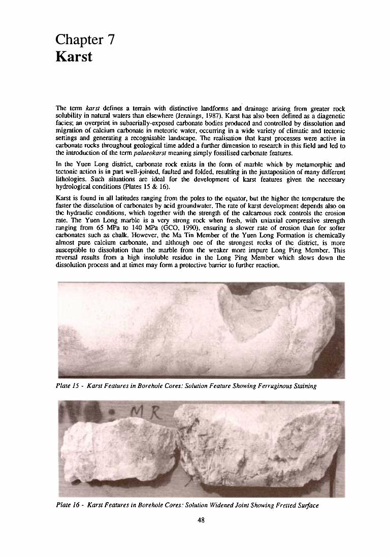
In the Yuen Long district, carbonate rock exists in the fonn of marble which by metamorphic andtectonic action is in part well-jointed, faulted and folded, resulting in the juxtaposition of many differentlithologies. Such situations are ideal for the development of karst features given the necessaryhydrological conditions (plates 15 & 16).
Karst is found in all latitudes ranging from the poles to the equator, but the higher the temperature thefaster the dissolution of carbonates by acid groundwater. The rate of karst development depends also onthe hydraulic conditions, which together with the strength of the calcareous rock controls the erosionrate. The Yuen Long marble is a very strong rock when fresh, with uniaxial compressive strengthranging from 65 MPa to 140 MPa (GCO, 1990), ensuring a slower rate of erosion than for softercarbonates such as chalk. However, the Ma Tin Member of the Yuen Long Fonnation is chemicallyalmost pure calcium carbonate, and although one of the strongest rocks of the district, is moresusceptible to dissolution than the marble from the weaker more impure Long Ping Member. Thisreversal results from a high insoluble residue in the Long Ping Member which slows down thedissolution process and at times may fonn a protective barrier to further reaction.
Plate 15 -Karst Features in Borehole Cores: Solution Feature Showing Ferruginous Staining
Plate 16 -Karst Features in Borehole Cores: Solution Widened Joint Showing Fretted Sulfate
48

Notwithstanding the above variables, no rock surface is ever unifonn, even if horizontal and of recentage. It will have suffered variable pressures resulting from the diagenetic processes, experienced localcompaction effects, and may have been subjected to regional tectonic and metamorphic events. Bodiesof rock respond to stresses occurring during geological history by fonning joints and fractures. It isalong such hydraulic channels that the initial attack by acidic water is concentrated, leaving other zonesvirtually unchanged. Selective chemical weathering and erosion is therefore started, which with timeresults in the many types of karst geomorphology now well documented throughout the world(Jennings, 1987). Examples of some of the types detected in the palaeokarst of Yuen Long aredescribed below.
A site adjacent to Wang Lok Street [212 357] on the Yuen Long Industrial Estate was investigated by24 drillholes, and the configuration of the marble rockhead is shown in Figure 18. It is dominated by anorth-south trending ridge with a steep eastern face. The marble shelves both to the east and west todepths greater than -70 mPD, with the top of the ridge close to -20 mPD proving a relief of some 50 m.A nearby site [213 356] proved by thirteen boreholes shows a depression with a diameter of some100 m and side slopes inclined at angles between 20. and 40. (Figure 19). The bottom of thedepression is at about -75 mPD, confinning a range in relief of about 50 m. The bedrock herecomprises both marble and granodiorite, and the faulted/intrusive boundary is obviously an importantfactor in the fonnation of this fossil sinkhole structure.
The tenns'sinkhole, swallow hole or swallet refer to closed depressions in karst. These English ternshave, however, been used very loosely and the word doline is now accepted for closed depressionsvarying from circular to oval in plan and dish-shaped, conical or cylindrical in cross-section. Suchvariety of fonns results from the solution, erosion and collapse processes operating (Jennings, 1987;James & Chokuette, 1987). A doline, therefore, is an indication at the rock surface of a process ofremoval underground of a considerable volume of material. Numerous closed depressions exist withinthe marble rockhead of the district, and clay-filled joints and cavities occur commonly at depth. It canbe logically concluded that the dolines and cavities are connected. In Yuen Long, doline fonnation washalted at least 50 000 years ago, based on the age of the overlying sediments, with the connectingchannels between doline and the epikarst being sealed.
The geological model derived from nearly one hundred drillholes at a site on Hop Choi Street[2115 3375] in the southeast of Yuen Long illustrates the juxtaposition and alignment of theirregularities in a palaeokarst terrain (Figure 20). It also shows not only the surface phenomena of karst,but also more fundamental structural trends in the north of the site where the marble surface dipssteeply beneath overlying fonnations. Examination of the direction of jointing for site YL 1L 429[2065 3355] in the south of Yuen Long adjacent to Ma Tin Road (Houghton, 1988) showed a widespread of values but with a dominant strike along a northwest-southeast axis. Most joints dip at anglesgreater than 50.. The fITst few metres of the karst top are usually poorly recovered in drillholes, and thecore consists of numerous broken fragments of stained marble. Although this surface profile of the karstis irregular, possibly with sporadic detached corestones, the drilling process has however exaggeratedthis disruption of the surface. Inspection of more than 1 000 drillholes through marble in the districtshows that in general the top 5 m of the karstic rockhead is most affected by dissolution (plates 15& 16). The next 25 m also shows karstification which decreases in intensity with depth until the onlyindications of dissolution are stained joint planes. This total zone of karstic erosion is tenned theepikarst.
One of the main concerns for development in an area of karst terrain is the presence of cavities withinthe carbonate fonnation. These may be shallow structures closely linked by widened joints to thesurface or deep-seated voids, partially or totally fllled by recent sediments. Such sediments are usuallypoorly cemented silts and sands or soft clays, commonly with an organic content.
Cavities within the district are of three types:1 Cavities in the epikarst usually in the top 30 m of the marble bedrock2 Cavities beneath the epikarst, usually 30 to 60 m below the marble rockhead but probably
linked to the surface by major joints or discontinuities3 Cavities associated with other lithologies or faults
Recovery of cavity-fill material from drillholes is usually poor, with the soft sediments being washedaway by the drill flush. However in BGS 2 a mazier sample provided an excellent section from 76.28to 77 m of part of a 3.45 m wide cavity (Figure 21) which indicates a repetitive cyclical sedimentation.The basal 100 mm of the recovered section consists of cross-bedded silty fine sand with interlaminatedclay layers, proving an initial surge of sediments in a relatively high energy environment. These sandsare overlain by structureless grey to black organic sandy clays, suggesting slow deposition possibly inbrackish water. The clays contain angular fragments of chert up to 20 mm long which may have fallenfrom a vein in the roof or side of the cavity. The clays pass upwards by interlamination into grey silts.
49


cavities are near vertical or steeply dipping joint-controlled features which have been widened, and inplaces filled or partly filled with sands and clays. These joints are the dominant overprint in the marbleof the regional metamorphism of the district, and therefore form the commonest type of cavity. Theirsteeply dipping attitude explains why one borehole will show well developed karstification, whilst analmost adjacent borehole proves sound rock. In Florida it has been calculated that some 6% of thelimestone has been dissolved in one area affected by karst processes. Similar calculations in the YuenLong area show a range of 6% to 50% dissolution of the marble in the karst zone. The high figures arederived, however, from many boreholes which have been drilled vertically down karstic joints. If mostof the cavities are formed along near vertical joints then an inclined borehole should pass throughmultiple sets of cavities, joints or discontinuities within the rock formation. This was confirmed byHoughton (1988) for a site in southern Yuen Long.
Whilst the majority of cavities occur in the epikarst zone within some 30 m of the rockhead, someboreholes have encountered clay-filled cavities at depths down to -80 mPD. Such voids must havedeveloped at a stage of the karstification process when the sea was at its lowest level relative to theland. The hydraulic link between these deep cavities and the rockhead surface must have been verytenuous, particularly with the discontinuous nature of the marble outcrop; such cavities should beinfrequent and small. In parts of the district a large number of major discontinuities such as faults andlithological boundaries exist which have been a focus for karstification, and in many cases have givenrise to cavities with a greater lateral extent than those developed from joints.
Figure 22 shows the position of a thrust plane separating marble from siltstone and sandstone near OnHong Road [20503365] towards the southern margin of Yuen Long. This plane was bordered by a zoneseveral metres wide containing numerous fractures associated with tectonic movements. Watermovement appears to have been channelled into this zone, with dissolution and erosion creating aninclined void some 50 m deep by 10 m wide. This void, which tapers with depth, probably does notextend beyond -100 mPD. It is one of the deepest cavities identified in the district and is filled with softsilts and sands.
Reactivation of Karst Features
In certain parts of the world where shallow buried karst exists, catastrophic ground collapses occurwhere palaeokarst sinkholes are reactivated. In most cases these collapses are caused by fluctuations ingr()undwater level. Old sinkholes form a vertical hydraulic link between differing lithologies and in theYuen Long area are now plugged by sediments such as recent silts sands and clays. Erosion of thissediment plug over a period of time may undermine the adjacent strata and transmit the disruption tothe surface with resulting ground movement and damage to structures built upon it (Culshaw &Waltham, 1987).
There are paleokarst sinkholes beneath the district which, if reactivated, are potential areas of collapse.However, the fluctuations of the groundwater are slight (Gale & Cook, 1989) so the opportunities fordisturbance of sinkhole plugs are limited. Under certain abnormal conditions, such as surface waterinundation by a broken water main or flood, sufficient erosive force from surface water may weakensediment plugs if the water table has been lowered locally by excessive extraction of groundwater bypumping.
Chan (1988) considered the factors affecting sinkhole formation, and concluded that their widespreadrecurrence in Yuen Long was unlikely, provided that the water table remained above rockhead. Therehas been no evidence of sinkhole formation at the surface since the sealing of the karst surface by theoverlying superficial deposits, despite hydrogeological conditions which must have been far moreconducive to sinkhole development than those of the present day. However, civil engineering worksmay disturb the existing hydrogeological regime, for example by causing ponding of surface water, anddrilling operations may also induce local ground collapse.
54
