dispersal of the zhujiang river (pearl river) derived ... · dispersal of the zhujiang river (pearl...
TRANSCRIPT
Dispersal of the Zhujiang River (Pearl River) derived sediment in the HoloceneGE Qian1*, LIU J. P.2, XUE Zuo2, CHU Fengyou1
1 Key Laboratory of Submarine Geosciences, State Oceanic Administration, Second Institute of Oceanography, State Oceanic Administration, Hangzhou 310012, China
2 Department of Marine, Earth and Atmospheric Sciences, North Carolina State University, Raleigh, NC 27695, USA
Received 6 November 2012; accepted 23 July 2013
©The Chinese Society of Oceanography and Springer-Verlag Berlin Heidelberg 2014
AbstractHigh-resolution Chirp profiling and coring reveals an elongated (ca. 400 km) Holocene Zhujiang River (Pearl River)-derived mud area (maximum thickness > 20 m) extending from the Zhujiang River Delta, southwest-ward off the Guangdong coast, to the Leizhou Peninsula. Two depo-centers, one proximal and one distal, are identified. On the continental shelf off the west Guangdong Province, the mud is deposited in water depth shallower than 50 m; while to the southeast of the Zhujiang River Estuary, the mud area can extend to the −120 m isobath. A combined analysis with the stratigraphic sequences of other muddy deposits in the West-ern Pacific marginal seas (mainly Changjiang (Yangtze) and Huanghe (Yellow) Rivers derived) indicates that the initiation of the Zhujiang River muddy deposit can be further divided into two stages: Stage 1 is before the mid-Holocene sea-level highstand (ca. 7.0 cal. ka BP), the proximal mud was mostly deposited after 9.0 cal. ka BP, when the sea-level rose slowly after the Meltwater Pulse -1C; Stage 2, after the mid-Holocene sea-level highstand, clinoform developed on the continental shelf off the west Guangdong Province, extending ca. 400 km from the Zhujiang River Estuary. The proximal clinoform thins offshore, from ca. 10 m thickness around 5–10 m water depth to less than 1–2 m around 20–30 m water depth. In addition, we also find a de-veloped distal clinoform in the east of the Leizhou Peninsula.Key words: South China Sea, Zhujiang River, mud, clinoform
Citation: Ge Qian, Liu J. P., Xue Zuo, Chu Fengyou. 2014. Dispersal of the Zhujiang River (Pearl River) derived sediment in the Ho-locene. Acta Oceanologica Sinica, 33(8): 1–9, doi: 10.1007/s13131-014-0407-8
1 IntroductionRivers are the major carriers for delivering terrigenous ma-
terials to the ocean (Milliman and Meade, 1983; Milliman and Syvitski, 1992; Syvitski et al., 2005). The total suspended sedi-ment delivered by rivers to the ocean is about 15×109 t annually, of which Asian rivers discharge nearly more than 70% (Liu et al., 2009). Most of the sediment is either trapped in the estuaries or deposited on the continental shelves, with less than 5%–10% of the fluvial sediments escaping to the deep sea (Liu et al., 2009; Meade, 1996). Among the large rivers in Asian, those originat-ed in the Tibetan Plateau are major contributors to the huge amount of sediment delivered to the West Pacific marginal seas. In recent years, numerous efforts have been made to investi-gate the delivering process and distribution of the large-river-derived sediment (e.g., Huanghe River (Alexander et al., 1991; Liu et al., 2004; Yang and Liu, 2007), Changjiang River (Chen et al., 2000; Liu et al., 2006, 2007a; Xu et al., 2009), and Mekong River (Ta et al., 2002; Xue et al., 2010)). A series of distal depo-centers are revealed by acoustic profiling and coring, which provide profound insight into Holocene sea-level variations and climatic conditions as well. However, the research of those about the Zhujiang River is still limited.
The Zhujiang River is the third largest river in China and the
second largest river, after the Mekong River, which drains into the South China Sea (Dai et al., 2008). It originates from the Yun-nan-Guizhou Plateau, drains the Yunnan, Guizhou, Guangxi and Guangdong Provinces of China, flows toward the east and empties into the South China Sea through the Zhujiang River Delta, which is one of the most important economic centers in China, embracing Hongkong, Macao, Guangzhou, Shenzhen, and other metropolis. The Zhujiang River drains an area of more than 0.45×10⁶ km2 (Tong, 2007), and its average water discharge is 302×109 m3 annually (Huang et al., 1982). The Zhujiang River is a compound river system and mainly comprises the Xijiang, Beijiang, and Dongjiang Rivers. Among these tributaries, the Xi-jiang River is the largest branch, and has a length of 2 214 km and a drainage area of 0.35×10⁶ km2. The upper reach of the Xi-jiang River (Hongshuihe River), which drains a karst area, is the main source for river sediment. The estimated Xijiang River-de-rived sediment flux is ca. 67×106 t/a (Dai et al., 2008). The Zhuji-ang River Delta locates in the subtropical zone, and has a warm and wet climate, with an annual mean temperature of 22°C, and an annual precipitation of 1 600–2 200 mm (Huang et al., 1982). Rain is seasonal, with most of the annual rainfall arriving be-tween June and August. The average sedimentation rate in delta is about 2–3 mm annually (Huang et al., 1982).
Acta Oceanol. Sin., 2014, Vol. 33, No. 8, P. 1–9
DOI: 10.1007/s13131-014-0407-8
http://www.hyxb.org.cn
E-mail: [email protected]
Foundation item: The National Natural Science Foundation of China under contract Nos 41106045 and 41206045; the Scientific Research Fund of the Second Institute of Oceanography, SOA under contract No. JT1102; the Basic Research Fund of State Oceanic Administration (named as Pale-oceanographic Research in the Western Pacific).*Corresponding author, E-mail: [email protected]
GE Qian et al. Acta Oceanol. Sin., 2014, Vol. 33, No. 8, P. 1–92
The Zhujiang River-derived muddy sediment is transported southwestward by the coastal current and deposited on the continental shelf after delivering to the South China Sea (Fig. 1), due to the influence of the geostrophic flow. However, little is known about the morphological, stratigraphic, and other fea-tures of the Zhujiang River-derived muddy deposit. In this study, we present the Chirp sonar sub-bottom profiles, which obtained from the northern South China Sea geophysical in-vestigation cruise in 2007. In conjunction with sediment char-acteristics analysis of four boreholes and previously published coring studies in the adjacent region, we aim to understand the distribution and delivering process of the Zhujiang River-derived sediment in the Holocene.
2 Methods and dataApproximate 620 km high-resolution acoustic data was
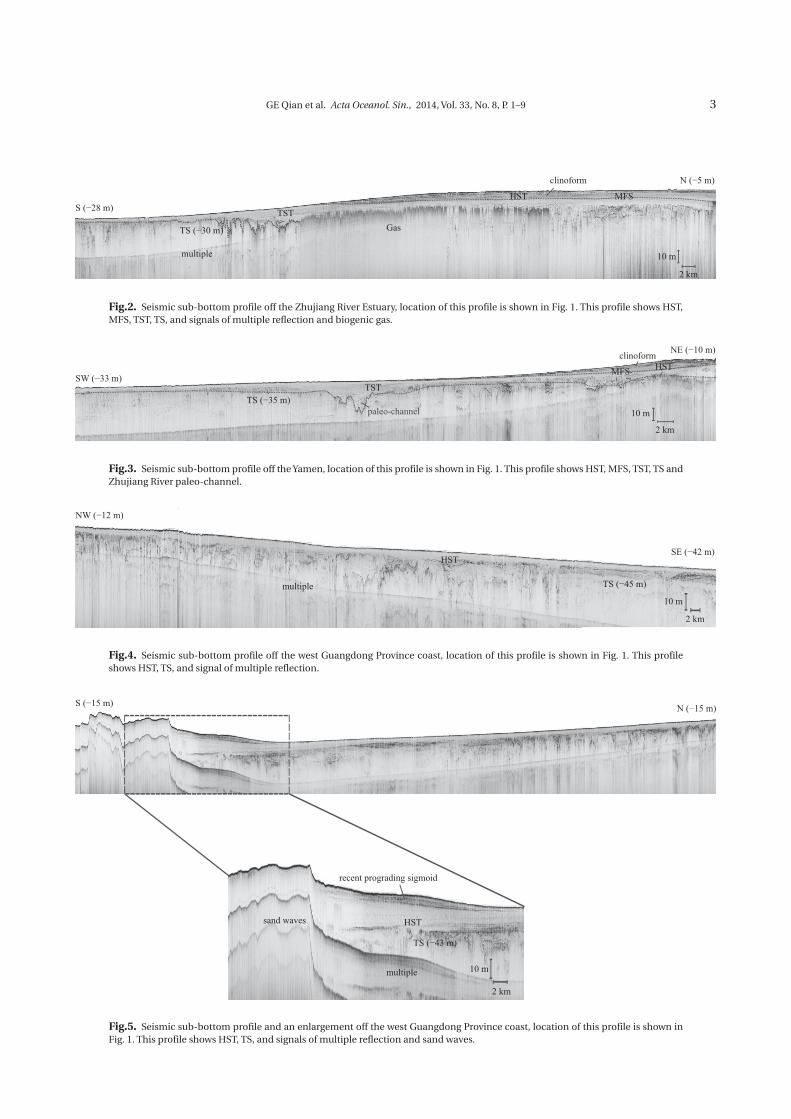
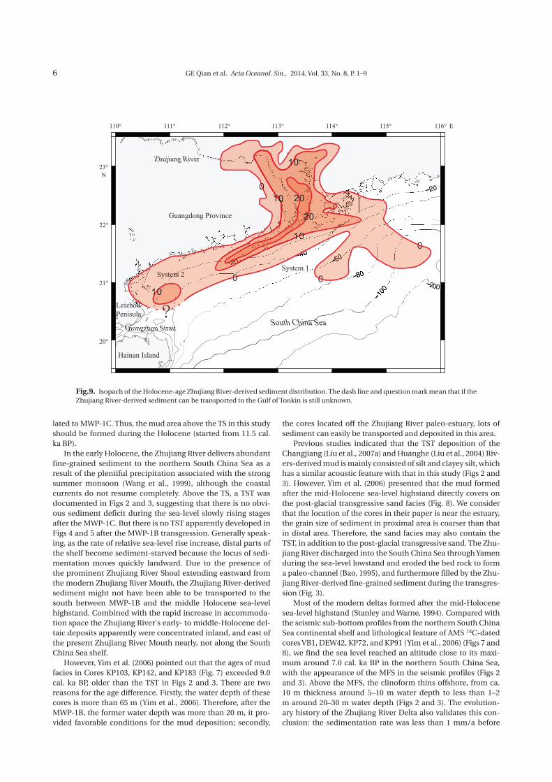
retrieved using an EdgeTech 0512i Chirp Sonar Sub-bottom Profiler (frequency range: 0.5–12 kHz) in 2007 (Figs 1–6). Back in laboratory, all acoustic data were post-processed using the Discover software (Version 3.0), and an acoustic velocity of 1 500 m/s was assumed to calculate water depth and sediment thickness. Five of nine acoustic profiles are discussed in this paper (Fig. 1). The distribution or isopach map of the Zhujiang River-derived mud on the Zhujiang River delta plain and estu-ary is mainly based on 53 boreholes data from previous studies (Owen et al., 1998; Fyfe et al., 1999; Yim, 2001; Yim et al., 2008; Lan et al., 2008; Zong et al., 2009a, b), while that on the north-ern South China Sea shelf is based on the acoustic profiles and other 24 boreholes data (Huang and Ge, 1995; Xiao et al., 2006; Yim et al., 2006; Zhao et al., 2007a) (Fig. 7).
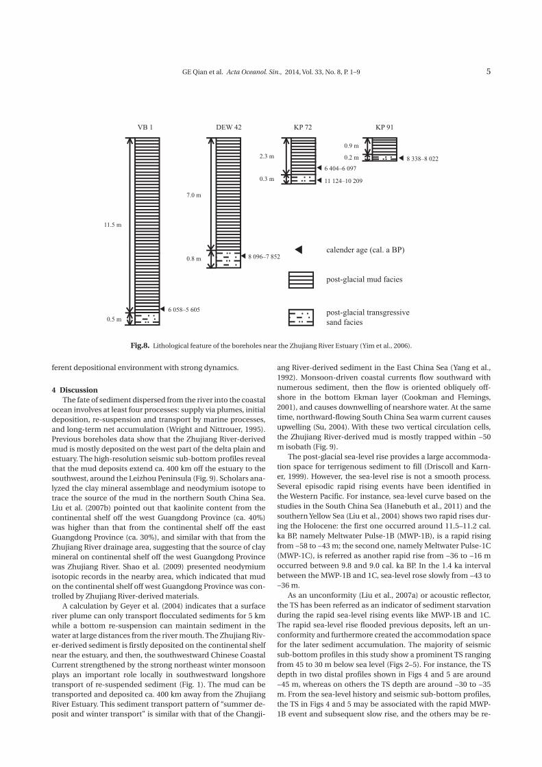
3 ResultsCombined with the selected seismic sub-bottom profiles
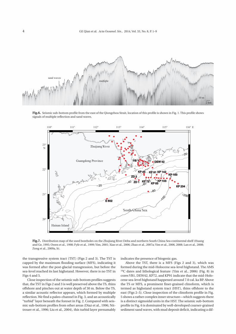
(Figs 2–6), lithological feature of AMS 14C-dated cores VB1, DEW42, KP72, and KP91 (Yim et al., 2006) (Fig. 8), and other
boreholes data (Huang and Ge, 1995; Owen et al., 1998; Fyfe et al., 1999; Yim, 2001; Xiao et al., 2006; Zhao et al., 2007a; Yim et al., 2006, 2008; Lan et al., 2008; Zong et al., 2009a, b) (Fig. 7), we find an elongated (ca. 400 km), more than 20 m thick, pri-marily Zhujiang River-derived muddy deposit extending from the river mouth southwestward off the Guangdong coast to the Leizhou Peninsula. We further divide this extensive deposit into two sub-systems: System 1 represents the Zhujiang River Delta, which includes the subaerial delta plain, estuary, and the sub-aqueous part (delta front and prodelta). System 2 is the Leizhou Penisula Mud Wedge, which represents the distal part of the Zhujiang River-derived mud deposits delivered by China Coast-al Current (Fig. 9). Muddy deposit in System 1 thins offshore in two directions: along-shelf to the west, the deposit pinches out at water depths 40 to 50 m off the west Guangdong continental shelf; in the across-shelf direction, the mud deposit can extend to water depth 120 m off the estuary (Fig. 9). Besides the seismic sub-bottom profiles, boundary of the mud area is also based on the data of relict sediment cores E602 (Xiao et al., 2006), KP43, KP83, KP234 (Yim et al., 2006), ZD1, and ZD2 (Zhao et al., 2007a) (Fig. 7), and the preliminary distribution of the northern South China Sea sediment described by Liu et al. (2002). The high-res-olution seismic profiles allow more closely examination of the internal architecture of the northern South China Sea continen-tal shelf mud deposit.
Overall, seismic sub-bottom profiles show a prominent sub-surface acoustic reflector (Figs 2–5). Based on previous stud-ies of other deposition systems in the Western Pacific (e.g., the Changjiang subaqueous delta (Chen et al., 2000), distal deposits in the Yellow Sea (Liu et al., 2004; Yang and Liu, 2007) and East China Sea (Liu et al., 2007a)), this prominent acoustic reflector is referred as the base of the post-glacial transgressive surface (TS), which is apparently caused by a rapid landward transgres-sion during a rapid sea-level rise. Above the TS, there is a ho-mogeneous mud layer thinning offshore, which is referred to
Zhujiang River
Jianjiang River
South China Sea
Yamen
Nandu River
Fig 2.
China
Fig 3.
Fig 4.
Fig 5.
Fig 6.
Hong Kong
Hainan Island
Guangdong Province
N
LeizhouPenisula
Qiongzhou Strait
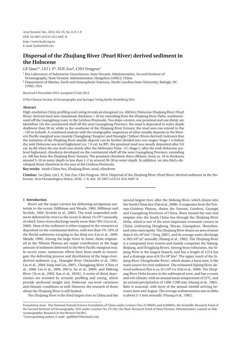
Fig.1. Satellite image of the northern South China Sea taken on November 2001 (from NASA visible Earth at http://visibleearth.nasa.gov/view_rec.php?id=2301). Suspended-sediment plume off the Zhujiang River extended to the southwest. Red lines represent the positions of seismic tracklines which obtained from the northern South China Sea geophysical investigation cruise in 2007.
GE Qian et al. Acta Oceanol. Sin., 2014, Vol. 33, No. 8, P. 1–9 3
N (−5 m)
S (−28 m)
TS (−30 m)
TSTGas
HST
clinoform
MFS
2 km
10 mmultiple
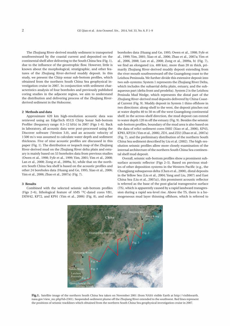
Fig.2. Seismic sub-bottom profile off the Zhujiang River Estuary, location of this profile is shown in Fig. 1. This profile shows HST, MFS, TST, TS, and signals of multiple reflection and biogenic gas.
SW (−33 m)
TS (−35 m)
NE (−10 m)
2 km
10 m
HSTMFS
clinoform
TST
paleo-channel
Fig.3. Seismic sub-bottom profile off the Yamen, location of this profile is shown in Fig. 1. This profile shows HST, MFS, TST, TS and Zhujiang River paleo-channel.
NW (−12 m)
multiple
HST
TS (−45 m)
2 km
10 m
SE (−42 m)
Fig.4. Seismic sub-bottom profile off the west Guangdong Province coast, location of this profile is shown in Fig. 1. This profile shows HST, TS, and signal of multiple reflection.
S (−15 m) N (−15 m)
multiple
recent prograding sigmoid
sand waves
2 km
10 m
TS (−43 m)
HST
Fig.5. Seismic sub-bottom profile and an enlargement off the west Guangdong Province coast, location of this profile is shown in Fig. 1. This profile shows HST, TS, and signals of multiple reflection and sand waves.
GE Qian et al. Acta Oceanol. Sin., 2014, Vol. 33, No. 8, P. 1–94
the transgressive system tract (TST) (Figs 2 and 3). The TST is capped by the maximum flooding surface (MFS), indicating it was formed after the post-glacial transgression, but before the sea-level reached its last highstand. However, there is no TST in Figs 4 and 5.
Close inspection of the seismic sub-bottom profiles suggests that, the TST in Figs 2 and 3 is well preserved above the TS, thins offshore and pinches out at water depth of 30 m. Below the TS, a similar acoustic reflector appears, which formed by multiple reflection. We find a paleo-channel in Fig. 3, and an acoustically “turbid” layer beneath the foreset in Fig. 2. Compared with seis-mic sub-bottom profiles from other areas (Diaz et al., 1996; Nit-trouer et al., 1996; Liu et al., 2004), this turbid layer presumably
indicates the presence of biogenic gas. Above the TST, there is a MFS (Figs 2 and 3), which was
formed during the mid-Holocene sea-level highstand. The AMS 14C dates and lithological feature (Yim et al., 2006) (Fig. 8) in cores VB1, DEW42, KP72, and KP91 indicate that the mid-Holo-cene sea-level highstand happened around 7.0 cal. ka BP. Above the TS or MFS, a prominent finer-grained clinoform, which is termed as highstand system tract (HST), thins offshore to the east (Figs 2–5). Close inspection of the clinoform profile in Fig. 5 shows a rather complex inner structure—which suggests there is a distinct sigmoidal units in the HST. The seismic sub-bottom profile in Fig. 6 is dominated by well-developed coarser-grained sediment sand waves, with mud deposit deficit, indicating a dif-
South China Sea
Guangdong Province
Zhujiang River
Hainan Island
N
E
23°
22°
21°
20°
110° 111° 112° 113° 114° 115° 116°
Fig.7. Distribution map of the used boreholes on the Zhujiang River Delta and northern South China Sea continental shelf (Huang and Ge, 1995; Owen et al., 1998; Fyfe et al., 1999; Yim, 2001; Xiao et al., 2006; Zhao et al., 2007a; Yim et al., 2006, 2008; Lan et al., 2008; Zong et al., 2009a, b).
multiplesand waves
2 km
10 m
Fig.6. Seismic sub-bottom profile from the east of the Qiongzhou Strait, location of this profile is shown in Fig. 1. This profile shows signals of multiple reflection and sand waves.
GE Qian et al. Acta Oceanol. Sin., 2014, Vol. 33, No. 8, P. 1–9 5
ferent depositional environment with strong dynamics.
4 DiscussionThe fate of sediment dispersed from the river into the coastal
ocean involves at least four processes: supply via plumes, initial deposition, re-suspension and transport by marine processes, and long-term net accumulation (Wright and Nittrouer, 1995). Previous boreholes data show that the Zhujiang River-derived mud is mostly deposited on the west part of the delta plain and estuary. The high-resolution seismic sub-bottom profiles reveal that the mud deposits extend ca. 400 km off the estuary to the southwest, around the Leizhou Peninsula (Fig. 9). Scholars ana-lyzed the clay mineral assemblage and neodymium isotope to trace the source of the mud in the northern South China Sea. Liu et al. (2007b) pointed out that kaolinite content from the continental shelf off the west Guangdong Province (ca. 40%) was higher than that from the continental shelf off the east Guangdong Province (ca. 30%), and similar with that from the Zhujiang River drainage area, suggesting that the source of clay mineral on continental shelf off the west Guangdong Province was Zhujiang River. Shao et al. (2009) presented neodymium isotopic records in the nearby area, which indicated that mud on the continental shelf off west Guangdong Province was con-trolled by Zhujiang River-derived materials.
A calculation by Geyer et al. (2004) indicates that a surface river plume can only transport flocculated sediments for 5 km while a bottom re-suspension can maintain sediment in the water at large distances from the river mouth. The Zhujiang Riv-er-derived sediment is firstly deposited on the continental shelf near the estuary, and then, the southwestward Chinese Coastal Current strengthened by the strong northeast winter monsoon plays an important role locally in southwestward longshore transport of re-suspended sediment (Fig. 1). The mud can be transported and deposited ca. 400 km away from the Zhujiang River Estuary. This sediment transport pattern of “summer de-posit and winter transport” is similar with that of the Changji-
ang River-derived sediment in the East China Sea (Yang et al., 1992). Monsoon-driven coastal currents flow southward with numerous sediment, then the flow is oriented obliquely off-shore in the bottom Ekman layer (Cookman and Flemings, 2001), and causes downwelling of nearshore water. At the same time, northward-flowing South China Sea warm current causes upwelling (Su, 2004). With these two vertical circulation cells, the Zhujiang River-derived mud is mostly trapped within −50 m isobath (Fig. 9).
The post-glacial sea-level rise provides a large accommoda-tion space for terrigenous sediment to fill (Driscoll and Karn-er, 1999). However, the sea-level rise is not a smooth process. Several episodic rapid rising events have been identified in the Western Pacific. For instance, sea-level curve based on the studies in the South China Sea (Hanebuth et al., 2011) and the southern Yellow Sea (Liu et al., 2004) shows two rapid rises dur-ing the Holocene: the first one occurred around 11.5–11.2 cal. ka BP, namely Meltwater Pulse-1B (MWP-1B), is a rapid rising from −58 to −43 m; the second one, namely Meltwater Pulse-1C (MWP-1C), is referred as another rapid rise from −36 to −16 m occurred between 9.8 and 9.0 cal. ka BP. In the 1.4 ka interval between the MWP-1B and 1C, sea-level rose slowly from −43 to −36 m.
As an unconformity (Liu et al., 2007a) or acoustic reflector, the TS has been referred as an indicator of sediment starvation during the rapid sea-level rising events like MWP-1B and 1C. The rapid sea-level rise flooded previous deposits, left an un-conformity and furthermore created the accommodation space for the later sediment accumulation. The majority of seismic sub-bottom profiles in this study show a prominent TS ranging from 45 to 30 m below sea level (Figs 2–5). For instance, the TS depth in two distal profiles shown in Figs 4 and 5 are around −45 m, whereas on others the TS depth are around −30 to −35 m. From the sea-level history and seismic sub-bottom profiles, the TS in Figs 4 and 5 may be associated with the rapid MWP-1B event and subsequent slow rise, and the others may be re-
VB 1 DEW 42 KP 72 KP 91
calender age (cal. a BP)
post-glacial mud facies
post-glacial transgressivesand facies
11.5 m
0.5 m
7.0 m
0.8 m
6 058–5 605
8 096–7 852
8 338–8 0226 404–6 097
11 124–10 2090.3 m
2.3 m 0.2 m
0.9 m
Fig.8. Lithological feature of the boreholes near the Zhujiang River Estuary (Yim et al., 2006).
GE Qian et al. Acta Oceanol. Sin., 2014, Vol. 33, No. 8, P. 1–96
lated to MWP-1C. Thus, the mud area above the TS in this study should be formed during the Holocene (started from 11.5 cal. ka BP).
In the early Holocene, the Zhujiang River delivers abundant fine-grained sediment to the northern South China Sea as a result of the plentiful precipitation associated with the strong summer monsoon (Wang et al., 1999), although the coastal currents do not resume completely. Above the TS, a TST was documented in Figs 2 and 3, suggesting that there is no obvi-ous sediment deficit during the sea-level slowly rising stages after the MWP-1C. But there is no TST apparently developed in Figs 4 and 5 after the MWP-1B transgression. Generally speak-ing, as the rate of relative sea-level rise increase, distal parts of the shelf become sediment-starved because the locus of sedi-mentation moves quickly landward. Due to the presence of the prominent Zhujiang River Shoal extending eastward from the modern Zhujiang River Mouth, the Zhujiang River-derived sediment might not have been able to be transported to the south between MWP-1B and the middle Holocene sea-level highstand. Combined with the rapid increase in accommoda-tion space the Zhujiang River's early- to middle-Holocene del-taic deposits apparently were concentrated inland, and east of the present Zhujiang River Mouth nearly, not along the South China Sea shelf.
However, Yim et al. (2006) pointed out that the ages of mud facies in Cores KP103, KP142, and KP183 (Fig. 7) exceeded 9.0 cal. ka BP, older than the TST in Figs 2 and 3. There are two reasons for the age difference. Firstly, the water depth of these cores is more than 65 m (Yim et al., 2006). Therefore, after the MWP-1B, the former water depth was more than 20 m, it pro-vided favorable conditions for the mud deposition; secondly,
the cores located off the Zhujiang River paleo-estuary, lots of sediment can easily be transported and deposited in this area.
Previous studies indicated that the TST deposition of the Changjiang (Liu et al., 2007a) and Huanghe (Liu et al., 2004) Riv-ers-derived mud is mainly consisted of silt and clayey silt, which has a similar acoustic feature with that in this study (Figs 2 and 3). However, Yim et al. (2006) presented that the mud formed after the mid-Holocene sea-level highstand directly covers on the post-glacial transgressive sand facies (Fig. 8). We consider that the location of the cores in their paper is near the estuary, the grain size of sediment in proximal area is coarser than that in distal area. Therefore, the sand facies may also contain the TST, in addition to the post-glacial transgressive sand. The Zhu-jiang River discharged into the South China Sea through Yamen during the sea-level lowstand and eroded the bed rock to form a paleo-channel (Bao, 1995), and furthermore filled by the Zhu-jiang River-derived fine-grained sediment during the transgres-sion (Fig. 3).
Most of the modern deltas formed after the mid-Holocene sea-level highstand (Stanley and Warne, 1994). Compared with the seismic sub-bottom profiles from the northern South China Sea continental shelf and lithological feature of AMS 14C-dated cores VB1, DEW42, KP72, and KP91 (Yim et al., 2006) (Figs 7 and 8), we find the sea level reached an altitude close to its maxi-mum around 7.0 cal. ka BP in the northern South China Sea, with the appearance of the MFS in the seismic profiles (Figs 2 and 3). Above the MFS, the clinoform thins offshore, from ca. 10 m thickness around 5–10 m water depth to less than 1–2 m around 20–30 m water depth (Figs 2 and 3). The evolution-ary history of the Zhujiang River Delta also validates this con-clusion: the sedimentation rate was less than 1 mm/a before
N
E
23°
22°
21°
20°
110° 111° 112° 113° 114° 115° 116°
South China Sea
Guangdong Province
Zhujiang River
Hainan Island
System 1System 2
LeizhouPenisula
Qiongzhou Strait
Fig.9. Isopach of the Holocene-age Zhujiang River-derived sediment distribution. The dash line and question mark mean that if the Zhujiang River-derived sediment can be transported to the Gulf of Tonkin is still unknown.
GE Qian et al. Acta Oceanol. Sin., 2014, Vol. 33, No. 8, P. 1–9 7
the mid-Holocene sea-level highstand, and after that the rate speeded up to more than 2 mm/a (Huang et al., 1982). Before the 7.0 cal. ka BP, the sediment from the Zhujiang River was mostly delivered to the ocean, rarely involved in the formation of delta. During this time, rapid sea level rise was the dominant driving mechanism, with variation of monsoon as the second-ary driving mechanism for the Zhujiang River Delta evolution. After the mid-Holocene sea-level highstand, monsoon became the dominant controlling variable for sedimentary processes, the Zhujiang River Delta advanced quickly (Zong et al., 2009a). The paleo-shoreline progradation rate is 10.5 m/a between 6.8 and 4.5 cal. ka BP, then slows down to 6.4 m/a between 4.5 and 2.0 cal. ka BP, and finally increases to 29 m/a after 2.0 cal. ka BP (Zong et al., 2009a). The slowing in progradation rate is possibly a result of a gradual reduction in sediment supply because of a weakening summer monsoon and consequently decreased freshwater/sediment discharge (Wang et al., 2005). The acceler-ated progradation rate after 2.0 cal. ka BP has been correlated to the increased human activities (Zong et al., 2009a) or middle- to late-Holocene sea level fall and then regressive processes. Al-though the monsoon-driven water discharge reduced, as a re-sult of the weaken summer monsoon (Zong et al., 2006), the re-claimant in the Zhujiang River catchment increased soil erosion and sediment supply (Owen, 2005). This shift can be seen in Fig. 5. Most of the sediment may be trapped in the delta plain and involved in formation of the Zhujiang River Delta, which leads to the reduction of sediment discharge into the ocean (Zong et al., 2009a).
Compared with the mud delivery capacity of the Changjiang (ca. 800 km) (Liu et al., 2006, 2007a) and Amazon (ca. 1 500 km) (Nittrouer et al., 1986; Allison et al., 2000), that of the Zhujiang River (ca. 400 km) is limited. The main reasons of this phe-nomenon are the low sediment discharge and the block of the Leizhou Peninsula. However, the mud delivery capacity of the Zhujiang River is similar with Mekong River's (ca. 200 km) (Xue et al., 2010). Although the annual sediment discharge of Mekong River is large (ca. 160×106 t/a) (Milliman and Syvitski, 1992), the gradient of the delta plain is gentle (ca. 0.000 03 m/km) (Syvitski and Saito, 2007), which is not conducive to the mud delivery. Furthermore, the Mekong delta locates at the junction of two different tidal systems (irregular South China Sea semi-diurnal tide with 3 m tidal range from the east direction, and Gulf of Thailand diurnal tide with 1 m tidal range from the west direc-tion), the sediment load of seawater is limited, and numerous Mekong-derived materials are trapped and deposited on Me-kong delta front (Cape Camau) to form the high-angle clino-form (Xue et al., 2010).
The seismic sub-bottom profiles in Figs 5 and 6 are dominat-ed by sand waves, which indicate a strong dynamic deposition environment (Peng, 2000). A similar stratigraphy has also been documented in the dynamic Taiwan Strait (Liu et al., 2008). The sand was formed by eroding the old stratum in sea floor (Wang, 2000). Geographically, the Qiongzhou Strait forms during the early- to mid-Holocene (Zhao et al., 2007b), the clinoform in Fig. 5 may be the result of the sediment exchange between the northern South China Sea continental shelf and Gulf of Tonkin after the mid-Holocene sea-level highstand. The fine-grained sediment from Gulf of Tonkin was delivered into the study area, and directly deposited above the Zhujiang River-derived mud after the sorting in dynamic environment. However, based upon the research of the tidal sediment load in Qiongzhou Strait, Li
and Ke (2000) pointed out that both the suspended load sedi-ment and bedload sediment are transported from east to west in the Qiongzhou Strait. Therefore, the Gulf of Tonkin-derived sediment hypothesis is unacceptable. The satellite image (Fig. 1, obtained in the November 2001 by NASA), shows that the Zhu-jiang River-derived fine-grained sediment was transported to the Gulf of Leizhou by the coastal current, and then continued southward delivery along the Leizhou Peninsula. In the east of the Qiongzhou Strait, the coastal current converged with an ir-regular diurnal tide (Li and Ke, 2000), these two reverse current directions form a local cyclonic circulation (Li et al., 2011), the sediment load of seawater reduced rapidly, which lead to the fast deposition to form this distal depo-center. Therefore, the main material source of the clinoform in Fig. 5 is the Zhujiang River, and Jianjiang River and Nandu River may also contribute to this mud area. However, if the Zhujiang River-derived sedi-ment can be transported to the Gulf of Tonkin is still unknown (question mark in Fig. 9), we need more works in the Qiongzhou Strait and Gulf of Tonkin.
5 ConclusionsThe acoustic profiling and reexamination of previously pub-
lished boreholes reveal an elongated (ca. 400 km) Holocene Zhujiang River-derived muddy deposit (maximum thickness > 20 m) extending from the Zhujiang River delta plain south-westward off the Guangdong coast to the Leizhou Peninsula. On the continental shelf off the west Guangdong Province, the mud is deposited in water depth shallower than 50 m; while to the southeast off the Zhujiang River Estuary, the mud area can extend to the −120 m isobath. A prominent subsurface acoustic reflector, referred as transgressive surface (TS), is identified in the majority of the profiles. Above the TS, there is a homoge-neous mud deposit, which is referred as the transgressive sys-tem tract (TST). The TST in profiles, is probably formed after 9.0 cal. ka BP, during the sea-level rising was slow after the MWP-1C. After the mid-Holocene sea-level highstand (ca. 7.0 cal. ka BP), clinoform developed on the continental shelf off the west Guangdong Province, extending ca. 400 km southwestward from the Zhujiang River Estuary. The proximal clinoform thins offshore, from ca. 10 m thickness around 5–10 m water depth to less than 1–2 m around 20–30 m water depth. In addition, we also find a developed distal depo-center in the east of the Leizhou Peninsula. The convergence of coastal current and ir-regular diurnal tide in the east of the Qiongzhou Strait leads to the reduction of the sediment load, rapid sediment deposition, and formation of the clinoform.
AcknowledgementsThe authors would like to thank the two anonymous review-
ers for their constructive comments.
References
Alexander C R, DeMaster D J, Nittrouer C A. 1991. Sediment accumu-lation in a modern epicontinental-shelf setting: the Yellow Sea. Marine Geology, 98(1): 51–72
Allison M A, Lee M T, Ogston A S, et al. 2000. Origin of Amazon mud-banks along the northeastern coast of South America. Marine Geology, 163(1–4): 241–256
Bao Caiwang. 1995. Buried ancient channels and deltas in the Zhujiang River mouth shelf area. Marine Geology & Quaternary Geology (in Chinese), 15(2): 25–34
GE Qian et al. Acta Oceanol. Sin., 2014, Vol. 33, No. 8, P. 1–98
Chen Zhongyuan, Song Baoping, Wang Zhanghua, et al. 2000. Late Quaternary evolution of the sub-aqueous Yangtze Delta, China: sedimentation, stratigraphy, palynology, and deformation. Ma-rine Geology, 162: 423–441
Cookman J L, Flemings P B. 2001. STORMSED 1.0: hydrodynamics and sediment transport in a 2-D, steady-state, wind- and wave-driven coastal circulation model. Computers and Geosciences, 27(6): 647–674
Dai Shibao, Yang Shilun, Cai Aimin. 2008. Impacts of dams on the sedi-ment flux of the Pearl River, southern China. Catena, 76: 36–43
Diaz J I, Palanques A, Nelson C H, et al. 1996. Morpho-structure and sedimentary of the Holocene Ebro prodelta mud belt (north-western Mediterranean Sea). Continental Shelf Research, 16(4): 435–456
Driscoll N W, Karner G D. 1999. Three-dimensional quantitative mod-eling of clinoform development. Marine Geology, 154(1–4): 383–398
Fyfe J A, Selby I C, Plater A J, et al. 1999. Erosion and sedimentation associated with the last sea level rise offshore Hong Kong, South China Sea. Quaternary International, 55: 93–100
Hanebuth T J J, Voris H K, Yokoyama Y, et al. 2011. Formation and fate of sedimentary depocentres on Southeast Asia's Sunda Shelf over the past sea-level cycle and biogeographic implications. Earth-Science Reviews, 104: 92–110
Huang Yongyang, Ge Tongming. 1995. Late Quaternary stratigraphy and environment in the Zhujiang River mouth basin. Marine Geology & Quaternary Geology (in Chinese), 15(4): 23–36
Huang Zhenguo, Li Pingri, Zhang Zhongying, et al. 1982. Initiation, de-velopment, and evolution of the Pearl River delta (in Chinese). Guangzhou: Popular Science Press
Geyer W R, Hill P S, Kineke G C. 2004. The transport, transformation and dispersal of sediment by buoyant coastal flows. Continental Shelf Research, 24(7–8): 927–949
Lan Binbin, Lan Dongzhao, Zheng Zhichang, et al. 2008. Diatoms and their palaeoenvironments from the cores of Xijiang Delta in Chi-na. Acta Oceanologica Sinica (in Chinese), 30(1): 94–99
Li Zhanhai, Ke Xiankun. 2000. Preliminary study on tidally-induced sediment fluxes of the Qiongzhou strait. Marine Science Bulletin (in Chinese), 19(6): 42–49
Li Kaizhi, Yin Jianqiang, Huang Liangmin, et al. 2011. Distribution and abundance of thaliaceans in the northwest continental shelf of South China Sea, with response to environmental factors driven by monsoon. Continental Shelf Research, 31: 979–989
Liu Zhifei, Colin C, Huang Wei, et al. 2007b. Clay minerals in surface sediments of the Pearl River drainage basin and their contribu-tion to the South China Sea. Chinese Science Bulletin (in Chi-nese), 52(4): 448–456
Liu Jingpu, Li Anchun, Xu Kehui, et al. 2006. Sedimentary features of the Yangtze River-derived along-shelf clinoform deposit in the East China Sea. Continental Shelf Research, 26: 2141–2156
Liu Jingpu, Liu C S, Xu Kehui, et al. 2008. Flux and fate of small moun-tainous rivers derived sediments into the Taiwan Strait. Marine Geology, 256: 65–76
Liu Jingpu, Milliman J D, Gao Shu, et al. 2004. Holocene development of the Yellow River's subaqueous delta, North Yellow Sea. Marine Geology, 209: 45–67
Liu Jingpu, Xu Kehui, Li Anchun, et al. 2007a. Flux and fate of Yangtze River sediment delivered to the East China Sea. Geomorphology, 85: 208–224
Liu Jingpu, Xue Zuo, Ross K, et al. 2009. Fate of sediments delivered to the sea by Asian large rivers: Long-distance transport and forma-tion of remote alongshore clinothems. The sedimentary Record, 7(4): 4–9
Liu Zhaoshu, Zhao Huanting, Fan Shiqing, et al. 2002. Geology of the South China Sea (in Chinese). Beijing: Science Press
Meade R H. 1996. River-sediment inputs to major deltas. In: Milliman J, Haq B, eds. Sea-level Rise and Coastal Subsidence. London: Kluwer, 63–85
Milliman J D, Meade R H. 1983. World-wide delivery of river sediment
to the oceans. Journal of Geology, 91: 1–21Milliman J D, Syvitski J P M. 1992. Geomorphic/tectonic control of sed-
iment discharge to the ocean: the importance of small moun-tainous rivers. Journal of Geology, 100: 525–544
Nittrouer C A, Curtin T B, DeMaster D J. 1986. Concentration and flux of suspended sediment on the Amazon continental shelf. Conti-nental Shelf Research, 6(1–2): 151–174
Nittrouer C A, Kuehl S A, Figueiredo A G, et al. 1996. The geological record preserved by Amazon shelf sedimentation. Continental Shelf Research, 16: 817–841
Owen R B. 2005. Modern fine-grained sedimentation-spatial variability and environmental controls on an inner pericontinental shelf, Hong Kong. Marine Geology, 214: 1–26
Owen R B, Neller R J, Shaw R, et al. 1998. Late Quaternary environmen-tal changes in Hong Kong. Palaeogeography, Palaeoclimatology, Palaeoecology, 138: 151–173
Peng Xuechao. 2000. Geological structure characterics and cause of formation analyzing in Qiongzhou strait, South China Sea. Geo-logical South China Sea (in Chinese), (12): 44–57
Shao Lei, Qiao Peijun, Pang Xiong, et al. 2009. Nd isotopic variations and its implications in the recent sediments from the northern South China Sea. Chinese Science Bulletin (in Chinese), 54(1): 98–103
Stanley D J, Warne A G. 1994. Worldwide initiation of Holocene marine deltas by deceleration of sea-level rise. Science, 265: 228–231
Su Jilan. 2004. Overview of the South China Sea circulation and its in-fluence on the coastal physical oceanography outside the Pearl River Estuary. Continental Shelf Research, 24: 1745–1760
Syvitski J P M, Saito Y. 2007. Morphodynamics of deltas under the influ-ence of humans. Global and Planetary Change, 57: 261–282
Syvitski J P M, Vorosmarty C J, Kettner A J, et al. 2005. Impact of humans on the flux of terrestrial sediment to the global coastal ocean. Science, 308: 376–380
Ta T K O, Nguyen V L, Tateishi M, et al. 2002. Sediment facies and Late Holocene progradation of the Mekong River Delta in Bentre Province, southern Vietnam: an example of evolution from a tide-dominated to a tide- and wave-dominated delta. Sedimen-tary Geology, 152: 313–325
Tong Juan. 2007. The generality and hydrological character of pearl river basin. Water Conservancy Science and Technology and Economy (in Chinese), 13(1): 31–33
Wang Wenjie. 2000. Propagation of tidal waves and development of sea-bottom sand ridges and sand ripples in northern South Chi-na Sea. Tropic Oceanology (in Chinese), 19(1): 1–7
Wang Yongjin, Cheng Hai, Edwards R L, et al. 2005. The Holocene Asian monsoon: links to solar changes and North Atlantic climate. Sci-ence, 308: 854–857
Wang Lvjiang, Sarnthein M, Erlenkeuser H, et al. 1999. East Asian mon-soon climate during the Late Pleistocene: high-resolution sedi-ment records from the South China Sea. Marine Geology, 156: 245–284
Wright L D, Nittrouer C A. 1995. Dispersal of river sediments in coastal seas: six contrasting cases. Estuaries, 18(3): 494–508
Xiao Shangbin, Chen Muhong, Lu Jun, et al. 2006. New evidence for remnant deposits recorded by columnar sediments in the shelf of the northern South China Sea. Marine Geology & Quaternary Geology (in Chinese), 26(3): 1–5
Xu Kehui, Milliman J D, Li Anchun, et al. 2009. Yangtze- and Taiwan-de-rived sediments on the inner shelf of East China Sea. Continental Shelf Research, 29: 2240–2256
Xue Zuo, Liu Jingpu, DeMaster D, et al. 2010. Late Holocene evolution of the Mekong subaqueous delta, southern Vietnam. Marine Ge-ology, 269(1–2): 46–60
Yang Zuosheng, Guo Zhigang, Wang Zhaoxiang, et al. 1992. The macro pattern of suspended particulate matter transport to the eastern open ocean on the Yellow and East China Sea shelf. Acta Oceano-logica Sinica (in Chinese), 14(2): 81–90
Yang Zuosheng, Liu Jingpu. 2007. A unique Yellow River-derived dis-tal subaqueous delta in the Yellow Sea. Marine Geology, 240:
GE Qian et al. Acta Oceanol. Sin., 2014, Vol. 33, No. 8, P. 1–9 9
169–176Yim W W-S. 2001. Stratigraphy of Quaternary offshore sand and gravel
deposits in the Hong Kong SAR, China. Quaternary Internation-al, 82: 101–116
Yim W W-S, Hilgers A, Huang G, et al. 2008. Stratigraphy and optically stimulated luminescence dating of subaerially exposed Quater-nary deposits from two shallow bays in Hong Kong China. Qua-ternary International, 183: 23–39
Yim W W-S, Huang G, Fontugne M R, et al. 2006. Postglacial sea-level changes in the northern South China Sea continental shelf: Evi-dence for a post-8200 calendar yr BP meltwater pulse. Quater-nary International, 145–146: 55–67
Zhao Huanting, Wang Lirong, Yuan Jiayi. 2007b. Origin and time of Qiongzhou strait. Marine Geology & Quaternary Geology (in Chinese), 27(2): 33–40
Zhao Tiehu, Zhang Xunhua, Wang Xiutian, et al. 2007a. Sub-bottom profiling (SBP) acoustic characteristics and geological inter-pretation on offshore from Pearl River estuary to Dongping in Guangdong Province. Computing Techniques for Geophysical and Geochemical Exploration (in Chinese), 29(3): 183–188
Zong Y, Huang G, Switzer A D, et al. 2009a. An evolutionary model for the Holocene formation of the Pearl River delta, China. The Ho-locene, 19: 129–142
Zong Y, Lloyd J M, Leng M J, et al. 2006. Reconstruction of Holocene monsoon history from the Pearl River estuary, southern China, using diatoms and carbon isotope ratios. The Holocene, 16: 251–263
Zong Y, Yim W W-S, Yu F, et al. 2009b. Late Quaternary environmental changes in the Pearl River mouth region, China. Quaternary In-ternational, 206: 35–45