digital geologic map data model, version 4 · attempting to store the actual symbol tables in the...
TRANSCRIPT
Geologic Map Data Model 10/01/98Addendum: version 4.3
1
DIGITAL GEOLOGIC MAP DATA MODEL
Addendum to Chapter 2
Version 4.3
October 1, 1998
By
Bruce R. Johnson, Boyan Brodaric, Gary L. Raines, Jordan T. Hastings, andRon Wahl
Current version of this report is available at: http://ncgmp.usgs.gov/ngmdbproject
Comments and discussion concerning this report are available at: http://geology.usgs.gov/dm/

Geologic Map Data Model 10/01/98Addendum: version 4.3
2
ContentsContents ...................................................................................................................................................... 2Figures ........................................................................................................................................................ 2Tables ......................................................................................................................................................... 2
About this Document .............................................................................................................................. 4Acknowledgment .................................................................................................................................... 4Typing Conventions................................................................................................................................ 4
Addendum to Chapter 2, Model version 4.3 ............................................................................................... 5Metadata, Legend and Related Tables .................................................................................................... 5Spatial Object Archive............................................................................................................................ 5Singular Object Archive ......................................................................................................................... 6Compound Object Archive ..................................................................................................................... 6
Descriptions of Individual Tables............................................................................................................. 12Metadata and Related Tables................................................................................................................ 12Legend and Related Tables................................................................................................................... 16Spatial Object Archive and Related Tables .......................................................................................... 18Singular Object Archive Tables............................................................................................................ 19Compound Object Archive and Related Tables.................................................................................... 22Rock Units and Related Tables............................................................................................................. 24Structure Table ..................................................................................................................................... 30Metamorphic Facies Table.................................................................................................................... 31
References Cited....................................................................................................................................... 32
FiguresFigure 2-6. Legend and Metadata portions of the relational model............................................................................... 7Figure 2-7. Singular Object Archive and Spatial Object Archive (GIS) portions of the model. ................................... 8Figure 2-8. Compound Object Archive portion of the data model. ............................................................................... 9Figure 2-9. Rock Unit and related tables portion of the Compound Object Archive. ................................................. 10Figure 2-10. Standard look-up tables which are used with the Compound Object Archive. ....................................... 11
TablesTable 2-2: Definition of the attributes in the Source Table. ........................................................................................ 13Table 2-3a: Definition of the attributes in the Related Source Table. ......................................................................... 14Table 2-3b: Examples of words that could be used for the source_relation attibute in the Related Source Table. .... 14Table 2-3c: Definition of the attributes in the Projection Table.................................................................................. 14Table 2-3d: Definition of the attributes in the Organization Table. ............................................................................ 15Table 2-4: Definition of the attributes in the Classification Scheme Table................................................................. 15Table 2-5: Definition of the attributes in the Classification Name Table.................................................................... 16Table 2-6: Definition of the attributes in the Classification Object Table................................................................... 16Table 2-7: Examples of words that could be used for the class_group attibute in the Classification Object Table.... 17Table 2-8: Definition of the attributes in the Cartographic Object Table.................................................................... 17Table 2-9: Definition of the attributes in the Symbol Table........................................................................................ 18Table 2-12: Definition of the attributes in the Color Table......................................................................................... 18Table 2-13: Definition of the attributes in the Data Classification Table.................................................................... 18Table 2-14: Definition of the attributes in the Spatial Objects Table.......................................................................... 19Table 2-18: Definition of the attributes in the Spatial Classification Table. ............................................................... 19Table 2-19: Definition of the attributes in the Spatial Object Name Table. ................................................................ 20Table 2-20: Definition of the attributes in the Spatial Object Composition Table. ..................................................... 20Table 2-21: Definition of the attributes in the Spatial Object Age Table.................................................................... 21
Geologic Map Data Model 10/01/98Addendum: version 4.3
3
Table 2-22: Definition of the attributes in the Structural Measurement Table. ........................................................... 21Table 2-23: Definition of the attributes in the Fossil Table ........................................................................................ 22Table 2-24: Definition of the attributes in the COA Table.......................................................................................... 22Table 2-25: Word list for the coa_type attribute in the COA Table............................................................................ 23Table 2-26: Definition of the attributes in the Formal Unit Table............................................................................... 23Table 2-27: Definition of the attributes in the COA Relation Table. .......................................................................... 23Table 2-28: Example word list for the relation attribute in the COA Relation Table. ................................................ 24Table 2-29: Definition of the attributes in the COA Tree Table. ................................................................................ 24Table 2-30: Definition of the attributes in the Rock Unit Table.................................................................................. 25Table 2-32: Definition of the attributes in the Rock Unit Rank Table. ....................................................................... 25Table 2-31: Example word list for the rock_rank attribute in the Rock Unit Table. .................................................. 26Table 2-33: Examples of the rock_rank and rock_level values for the Rock Unit Rank Table.................................. 26Table 2-34: Definition of the attributes in the Rock Composition Table. ................................................................... 27Table 2-35: Definition of the attributes in the Lithology Table. ................................................................................. 27Table 2-37: Definition of the attributes in the Lithology Tree Table. ......................................................................... 28Table 2-38: Example of the data in the Lithology Tree Table. ................................................................................... 28Table 2-39: Definition of the attributes in the Geochronologic Age Table................................................................. 28Table 2-40: Definition of the attributes in the Stratigraphic Age Table. ..................................................................... 29Table 2-41: Definition of the attributes in the Stratigraphic Time Scale Table........................................................... 29Table 2-43: Definition of the attributes in the Stratigraphic Tree Table. .................................................................... 30Table 2-45: Definition of the attributes in the Stratigraphic Rank Table. ................................................................... 30Table 2-46: Values for strat_level in the Stratigraphic Rank table. ............................................................................ 30Table 2-47: Definition of the attributes in the Structure Table. .................................................................................. 31Table 2-48: Definition of the attributes in the Structural Type Table. ........................................................................ 31Table 2-50: Definition of the attributes in the Metamorphic Facies Table.................................................................. 31

Geologic Map Data Model 10/01/98Addendum: version 4.3
4
About this DocumentThe following is a working document that constitutes a portion of the recommendations of the Geologic
Map Data Model Working Group. The working group was formed as a cooperative effort by the Association ofAmerican State Geologists (AASG) and the U.S. Geological Survey (USGS), to support the needs of the NationalGeologic Map Database Project. This report has not been reviewed or approved by either the AASG or USGS.Updated releases of this report will be placed on the World Wide Web (http://ncgmp.usgs.gov/ngmdbproject) and ona data model discussion site on the Web (http://geology.usgs.gov/dm/) as the report evolves as part of an informalreview process. If you have Web access, please use the discussion Web site for all comments and suggestions. If youdo not have Web access, please forward all comments and suggestions to Gary L. Raines (address below). Todiscuss this report or ask detailed questions, contact one of the following: Bruce Johnson, U.S. Geological Survey,954 National Center, Reston, Virginia 20192, USA, telephone: 703-648-6051, fax: 703-648-6383, email:[email protected]; Boyan Brodaric, Geological Survey of Canada, 615 Booth St., room 234B, Ottawa, OntarioK1A 0E9, Canada, telephone: 613/992-3562 fax: 613/995-9273 email: [email protected]; or Gary Raines,U.S. Geological Survey, c/o Mackay School of Mines MS 176, University of Nevada Reno, Reno, Nevada 89557,USA, telephone: 702-784-5596, fax: 702-784-5079, email: [email protected]. Please label all comments with theversion and date of the manuscript.
AcknowledgmentThe effort to create a data model for digital geologic maps has involved many people and a lot of intense
discussion. This document attempts to condense that discussion into a manageable form and to present the results, adata model. Consequently the authors have drawn on their own experiences as well as the contributions of manyothers. We wish to acknowledge the many people who have contributed, both in direct conversations with theauthors and with comments submitted to the discussion Web site mentioned above. We have attempted to organizeand compile our understanding of these diverse thoughts to define the grammar and some of the vocabulary ofgeologic maps in a computer geographic information system context.
Typing ConventionsWithin the text of this addendum, the names of attributes (columns, or fields in tables) are italicized, such as
source_title. Key attributes that are used to link one table to another are in italicized bold, such as source_id. Inaddition, the names of model tables are capitalized within the descriptive text.
Within the tables and figures, the following conventions are used:
x Primary keys for a table are preceded with an asterisk (*).
x Foreign keys are followed by an @ symbol. Foreign keys are attributes in one table, which are alsoprimary keys in a different table.
x Attributes whose values are selected from a pre-existing word list (pick list) are followed by a <symbol.

Geologic Map Data Model 10/01/98Addendum: version 4.3
5
Addendum to Chapter 2, Model version 4.3This addendum presents changes to the document, “Digital Geologic Map Data Model”, ver. 4.2, by
Johnson, B. R., Brodaric, Boyan, and Raines, G. L. In particular, this addendum replaces most of the figures andtables of Chapter 2 of that document and updates the data model to version 4.3. With the exception of a few staticword lists, all of the data model figures and tables from Chapter 2 are repeated here. An attempt has been made touse the same numbers for figures and tables as were used in Chapter 2 so that comparisons can be easily made. Newtables have been given numbers such as 2-2a, 2-2b, etc. to avoid interrupting the previous numbering scheme. Thisaddendum, however, does not include all of the information in Chapter 2 and is intended as a supplement to theprevious document, not as a total replacement for it.
Metadata, Legend and Related TablesThe geologic map data model is divided into five interconnected diagrams (figures 2-6 through 2-10) along
the same lines as the divisions made in the general overview of the data model as presented in Chapter 2, figure 2-4.The first diagram (figure 2-6) includes the legend and metadata portions of the model along with some associatedtables.
MetadataThe metadata portion of the model is, perhaps, the most changed from the previous version. Because of
significant user confusion concerning the function of the Map Table and the Source Table, and because of thesignificant overlap in attributes between the two tables, in version 4.3 the tables have been combined into a singleSource Table. In addition, published reference attributes have been revised to better match the needs of NSDI-compliant formal metadata. The Source Table also uses a single source_id attribute in place of the previousversion’s two attributes, source_org and source_id.
Other changes to the metadata portion of the model include the addition of three new tables, RelatedSource, Organization, and Projection. The Related Source Table is used to document relationships between varioussources of information. The Organization Table is used to provide a full, formal name for organizations in additionto the shorter, abbreviated identifier that is used in the Source Table. Finally, in the previous version, map projectioninformation was confined to a single text attribute. In this version, it is expanded to a full table giving all of theparameters necessary to fully specify the map projection for each source of information.
LegendThe second major portion of the model that is diagrammed on figure 2-6 is the legend. The legend consists
of two data tables and a number of standard look-up tables. The only significant change to the Legend portion of themodel is to combine the Point, Line, and Area Symbol Tables of the previous version into a single Symbol Table.This change makes it easier to separate the GIS-specific information from the data stored in the model. Instead ofattempting to store the actual symbol tables in the model, this version stores pointers to the GIS symbol tables alongwith the information needed to select a specific symbol from one of several symbol tables.
Legend Correlation TablesThe Classification Object Table, and therefore the legend, is connected to the rest of the model through
three correlation tables. These correlation tables have had only minor revisions in this version of the model.
Spatial Object ArchiveThe Spatial Object Archive (figure 2-7) is the storage location for the spatial (geographic and geometric)
description of all objects within the map library. All information concerning the shape, size, location, etc. of eachmap feature is stored in this archive. Changes to the Spatial Object Archive, in this version, are primarily cosmetic.The goal was to make the data model representation of the Spatial Object Archive more general and less Arc/Info-

Geologic Map Data Model 10/01/98Addendum: version 4.3
6
centric. The generic term, data set, has been substituted for coverage and details of how many data sets will be in thearchive and their content are left up to individual implementations.
Singular Object ArchiveThe Singular Object Archive is composed of several tables that are used to store descriptive information
related to individual spatial objects. Although only five tables are shown in the Singular Object Archive on figure 2-7, the archive could include many more tables. Changes to the Singular Object Archive are primarily cosmetic.Attribute names have been changed to make their purpose more obvious and a few attributes have been added,primarily to the Structure Measurement and Fossil Tables.
Compound Object ArchiveThe Compound Object Archive is composed of a number of data tables and look-up tables (figures 2-8, 2-9,
and 2-10) which are used to define Compound Geologic Objects. The heart of the archive is the COA Table. TheCOA Table links the legend, and thus the rest of the data model, to the various types of compound geologic objectsthat can be described and defined within the archive. Changes to the Compound Object Archive are also primarilycosmetic. Attributes have been re-named for clarity and additional attributes have been added, primarily to the RockUnit and Geochronologic Age Tables.
Rock UnitsThe Rock Unit Table (figure 2-9) is the main entry point for descriptive information concerning rock units.
For purposes of the model, rock unit is defined as any mapped unit which may occur on a geologic map, including alltypes of stratigraphic units, whether layered or not, unconsolidated sediment units, water and ice features whereunderlying geology is not mapped, etc. The Rock Unit Table has been expanded to include attributes for recordingthe thickness of rock units.
A rock unit may have any number of geochronologic ages associated with it in the data model. These agesare stored in a separate table, the Geochronologic Age Table, and related to the Rock Unit Table by a one-to-manyrelation. The Geochronologic Age Table has been extended by including attributes for storing the method of analysisand a description of the sample media analyzed.
Structural FeaturesAs with all other objects in the Compound Object Archive, structural features are represented in the COA
Table (figure 2-8) with an object identification number, a name, a description, source information, and a type codewhich identifies the object as a structural feature.
The Structure Table is used in much the same manner as other correlation tables in the data model. It servesto convert a many-to-many relation between the COA Table and the Structural Type Table (figure 2-10) into twoone-to-many relations. The Structure Table has been modified by splitting the accuracy attribute of the previousversion into two attributes, loc_accuracy and confidence. This split separates terms for positional accuracy fromterms for uncertainty, or confidence, in the existence of the structure in question.
Metamorphic Facies UnitsMetamorphic Facies units are included in the data model to demonstrate the model’s capacity to incorporate
various types of map units. Any type of polygonal unit that overlies a base polygonal unit can be treated in a similarmanner. In the case of the metamorphic facies units, the overlay represents areas of consistent metamorphic grade.On a geologic map, these polygonal areas would normally be shown as a pattern which overlays the solid colorpolygons of the rock units. Other examples of the use of this type of unit might be to display areas of alteration orextent of glaciation. There have been no changes to this section of the archive other than a change of name for thetable.
Geologic Map Data Model 10/01/98Addendum: version 4.3
7
Metadata, Legend and Related Tables
SpatialClassification
(fig. 2-7)
0-M
Color1/color
* cart_color_table* cart_colorCMYKRGBdesc
Symbol1/symbol
* cart_sym_type <* cart_sym_table* cart_symdesc
0-1
Cartographic Object1/cart. object
* class_obj_id @* cart_seqcart_desccart_sym_type @cart_sym_table @cart_sym @cart_color_table @cart_color @
1-M
0-M
0-1 0-M
COA(fig. 2-8)
1
Data Classification1/ class subunit
* class_obj_id @* coa_id @vol_percentvol_qualitydata_seq
0-M
0-M
Compound ObjectArchive
Source1/source
* source_idorg_id @source_authorsource_datesource_titlepub_editionpub_seriespub_issuepub_placepub_contactsource_scalesource_resolutionprj_id @max_latmin_latmax_longmin_longurlcommentsource_contribution
1
0-M
Classification Name1/class. scheme
* class_scheme_idclass_scheme_namesource_id @
0-1
1
1
1
1
Classification Object
1/class obj.
* class_obj_idclass_groupclass_labelclass_nameclass_desc
ClassificationScheme
1/correlation
* source_id @* class_obj_id @class_scheme_id @class_seqdisp_prioritydisp_visibility
0-M
Metadata
Legend
0-1
1-M
Organization1/org.
* org_idorg_name
Projection1/projection
* prj_idprj_type <zoneellipsoid <scale_factor <units <origin_latorigin_longcen_meridianfalse_eastfalse_northparallel_1parallel_2radius
1
0-M
Related Source1/relation
* source1_id @* source2_id @source_relation <0-M
0-M
1
1
1-M
Spatial ObjectArchive
Figure 2-6. Legend and Metadata portions of the relational model.
The model is in five parts; the Spatial and Singular Archive portions are shown on figure 2-7, the CompoundObject Archive portion is shown on figures 2-8 and 2-9, and some standard look-up tables are shown on figure2-10. Note that shaded boxes are standard tables that are used with many maps (figures 2-6 through 2-10).Central to this diagram is the classification object. It permits spatial objects to be connected with theirdescriptive data in the Compound Object Archive, and it permits symbolization to be assigned to each object.
Geologic Map Data Model 10/01/98Addendum: version 4.3
8
Singular Object Archive, Spatial Object Archive, and Related Tables
Figure 2-1. Singular Object Archive and Spatial Object Archive (GIS) portions of the model.
A relationship can exist between an individual table in the Singular Object Archive and any data set within theGIS. Geologic entities of any type can be represented as any of the GIS geometric types (i.e. areas, lines, orpoints on 2-D maps) and individual map entities (single point, line segment, or polygon) can be given a specificname and can represent more than one sub-unit. For example, although site details are normally associated withmap points, the model allows site details (in the Singular Object Archive) to be associated with any type of mapentity. The Singular Object Archive, presented here as individual tables in the relational database, could just aswell represent connections to external databases (e.g. a database of field notes). Note that all entities are tied toan original source.
Singular Object Archive
0-10-1
Fossil
1/description
* fossil_idspatial_obj_id @dataset_id @site_namefossil_namesite_labelmin_strat_name <max_strat_name <commentsource_id @
0-M
StructuralMeasurement
1/measurement
* struct_idspatial_obj_id @dataset_id @site_namefeature_type <strike_trenddip_plungedip_directionplanar_linear <commentsource_id @
0-M
Spatial ObjectComp.
1/sub-unit
*spatial_obj_id@* dataset_id @* coa_id @* comp_seq @vol_percentvol_qualitysource_id @
Spatial ObjectName
1/name
*spatial_obj_id@* dataset_id @* namesource_id @
0-1
0-M
0-1
0-M
Spatial Object Archive(Represents one or more data sets in a GIS)
Spatial Classification1/spatial obj./class. obj.
* spatial_obj_id @* dataset_id @* class_obj_id @
ClassificationObject
(fig. 2-6)
0-1
1-M
10-M
Spatial Object Age1/age
*spatial_obj_id@* dataset_id @* coa_id @* chron_seq @site_name
0-M
0-1
Spatial Objects1/object
* spatial_obj_id* dataset_idsource_id @

Geologic Map Data Model 10/01/98Addendum: version 4.3
9
Compound Object Archive and Related Tables
Figure 2-2. Compound Object Archive portion of the data model.
The Compound Object Archive portion of the relational geologic map data model contains descriptive data. Alltypes of map units are treated uniformly and relationships can be defined between units. Additional types ofmap units can be easily added. The following figure shows a detailed expansion of the Rock Unit type. Similardetails will be needed for additional unit types. Note that all units and their relationships are tied to an originalsource.
Formal Unit1/formal unit
* coa_id @nametype_sectionetc.
0-1
MetamorphicFacies
1/meta. object
* coa_id @meta_grade <etc.
0-1
COA Relation1/relationship
* rel_idcoa_id @rel_coa_id @relation <rel_desc
0-M
DataClassification
(fig. 2-6)0-M
Rock Unit(fig. 2-9)
0-1
Structure1/link
* coa_id @* struct_typ_id @loc_accuracy <confidence <
0-M
Compound ObjectArchive
Compound ObjectLook-up Tables
(fig. 2-10)
COA1/object
* coa_idcoa_namecoa_type <coa_descsource_id @
1
1
1
11 1
1
AdditionalCOA Types
1/ object
* coa_id @other attribs.
0-1
0-M 0-M 0-M 0-M
11 1
1
COA Tree1/pair
* coa_id @* parent_id @
0-M
1

Geologic Map Data Model 10/01/98Addendum: version 4.3
10
Rock Units and Related Tables
Figure 2-3. Rock Unit and related tables portion of the Compound Object Archive.
Each rock unit as a whole can have associated any number of stratigraphic age ranges as well as any number ofgeochronologic ages. These data can come from sources that are different than the source of the unit definition.Each rock unit has a rank (group, formation, member, etc.) and the relative level of unit ranks is maintained in aUnit Rank table. This table allows easy creation of derivative maps at various rank levels. Each rock unit ismade up of one or more compositions. Rock compositions correspond to individual rock types, or lithologies,which are included in the defined unit. For example, a clastic rock unit composed of conglomerate, sandstone,and shale would have three rock composition records. Each would describe a single lithology within the unit.
COA(fig. 2-8)
Rock Unit1/rock unit
* coa_id @rock_rank @min_thickmax_thicktyp_thickthick_qual
0-1
1
1
Rock Unit Rank1/rock rank
* rock_rankrock_level
Stratigraphic Age1/age range
* coa_id @ * strat_seqmin_strat_name @max_strat_name @min_source_id @max_source_id @
0-M
1 1
0-M
Time Scale(fig. 2-10)
2
Rock Composition1/composition
* coa_id @* comp_seqrock_namelith_class @lith_form @vol_percentvol_qualitymineralogy_desccolor_desctexture_descalteration_descdescription
1-M
Lithology(fig. 2-10)
1
0-M
0-M
Geochron Age1/date
* coa_id @* chron_seqchron_method <sample_material <chron_datechron_err_pluschron_err_minuscommentsource_id @
10-M
Geologic Map Data Model 10/01/98Addendum: version 4.3
11
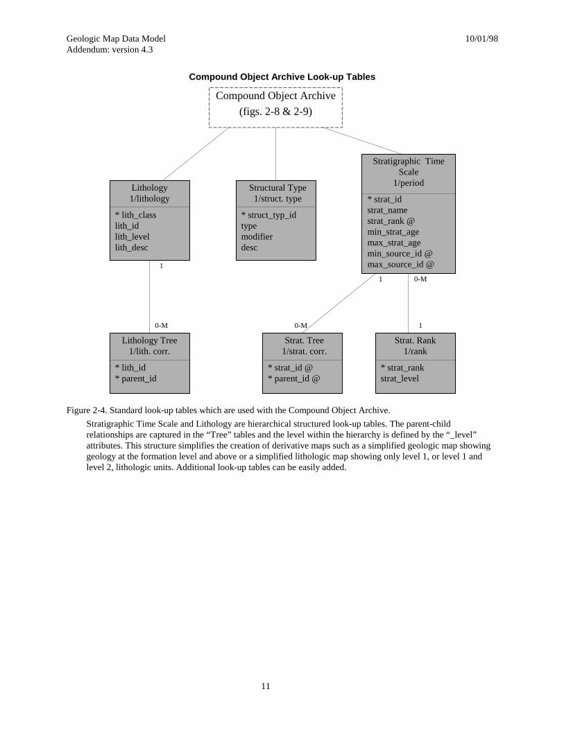
Compound Object Archive Look-up Tables
Figure 2-4. Standard look-up tables which are used with the Compound Object Archive.
Stratigraphic Time Scale and Lithology are hierarchical structured look-up tables. The parent-childrelationships are captured in the “Tree” tables and the level within the hierarchy is defined by the “_level”attributes. This structure simplifies the creation of derivative maps such as a simplified geologic map showinggeology at the formation level and above or a simplified lithologic map showing only level 1, or level 1 andlevel 2, lithologic units. Additional look-up tables can be easily added.
Structural Type1/struct. type
* struct_typ_idtypemodifierdesc
Stratigraphic TimeScale
1/period
* strat_idstrat_namestrat_rank @min_strat_agemax_strat_agemin_source_id @max_source_id @
Compound Object Archive
(figs. 2-8 & 2-9)
Lithology1/lithology
* lith_classlith_idlith_levellith_desc
1
0-M
Lithology Tree1/lith. corr.
* lith_id* parent_id
Strat. Rank1/rank
* strat_rankstrat_level
Strat. Tree1/strat. corr.
* strat_id @* parent_id @
1
10-M
0-M

Geologic Map Data Model 10/01/98Addendum: version 4.3
12
Descriptions of Individual TablesThis section of the report defines the attributes that are included in each of the data model tables. Each
attribute is named, defined, and assigned a format. The formats used are primarily character, integer, and float.Character format attributes are used to store text of any kind. Integer formats are used to store numeric values,primarily unique, integer identification numbers used to associate tables with each other. Float formats are used tostore real numbers. Lengths of attribute fields are not specified as these may vary between implementations. Forattributes which make use of restricted word or term lists, tables of the applicable words or terms are included. Thesetables are, in general, neither complete nor final. Comments and improvements are encouraged. Please contact theauthors.
Metadata and Related TablesThe metadata portion of the model now includes 4 tables, Source, Related Source, Organization, and
Projection. The information in these tables may be used to link to a database of formal metadata. These tables areintended to supply reference information for all geologic objects in the archive. In an archive of more than one map,the source_id attribute is carried throughout the archive so that any object within the archive can always be tracedback to its original source. In addition, there are two related tables that are defined here, the Classification Schemeand Classification Name tables.
Map TableThe Map Table (table 2-1 in ver. 4.2) was combined with the Source table in version 4.3 and is, therefore,
no longer needed.
Source TableThe Source Table (table 2-2) now contains reference information for all original information sources in the
archive. The two-part source identification (attributes, source_org and source_id in ver. 4.2), has been dropped infavor of a single attribute (source_id). The reference citation attribute, source_ref, has been split into the followingattributes to better conform to formal metadata requirements: pub_edition, pub_series, pub_issue, pub_place, andpub_contact. The following additional attributes have been added to the table: org_id, prj_id, max_lat, min_lat,max_long, min_long, url, comment, and source_contribution.

Geologic Map Data Model 10/01/98Addendum: version 4.3
13
Table 2-2: Definition of the attributes in the Source Table.
Attribute Definition Format
* source_id Unique identification number of an information source integer
org_id @ Unique organization identifier for an information source character
source_author List of information source authors character
source_date Year of information source publication or creation date
source_title Title of information source character
pub_edition Publication edition of a published information source character
pub_series Publication series name of a published information source character
pub_issue Issue identification of a published information source character
pub_place Place of publication character
pub_contact Contact for information about the source character
source_scale Scale of source map (denominator of scale fraction) integer
source_resolution Resolution of digital source map, in meters integer
prj_id @ An identification code linking to the projection definition in the projectiontable
character
max_lat Northern limit of map in decimal degrees float
min_lat Southern limit of map in decimal degrees float
max_long Eastern limit of map in decimal degrees float
min_long Western limit of map in decimal degrees float
url World Wide Web address for the organization that published the source character
comment Additional information about the source character
source_contribution The contribution made by this source to an object referencing this source; e.g.if the source is documenting a change to a geologic object on a map, then thisfield would record the nature of the modification
character
Map/Source Correlation TableThe Map/Source Correlation Table (table 2-3 in ver. 4.2) is no longer needed in version 4.3.
Related Source TableThe Related Source Table (table 2-3a) is a new table that has been added for version 4.3. This table is used
to record relationships between records in the Source Table.

Geologic Map Data Model 10/01/98Addendum: version 4.3
14
Table 2-3a: Definition of the attributes in the Related Source Table.
Attribute Definition Format
* source1_id @ Unique identification number of an information source integer
* source2_id @ Unique identification number of a second information source integer
source_relation < Specifies the type of relationship source1 has with source2 character
The following table (table 2-3b) contains examples of terms that might be entered into the source_relationattribute. This list is not intended to be comprehensive, but to serve as an example only.
Table 2-3b: Examples of words that could be used for the source_relation attibute in the Related Source Table.
source_relation Definition
digitized from Indicates source1 is a digital version of source2
modified from Indicates source1 has been modified from source2. The source_contribution attribute insource1 might include details of the type of modification
Projection TableThe Projection Table (table 2-3c) is a new table that has been added for version 4.3. This table is used to
record the map projection details for records in the Source Table. Multiple records in the Source Table can refer tothe same record in the Projection Table if the details of the projection are the same.
Table 2-3c: Definition of the attributes in the Projection Table.
Attribute Definition Format
* prj_id A unique identification code assigned to a projection record character
prj_type < Type of projection; e.g. UTM, TM, Mercator, etc. character
zone The grid zone specification for a UTM projection integer
ellipsoid < The name of the ellipsoid used character
scale_factor < The scale factor for the projection float
units < The units; e.g. feet, survey feet, meters, etc. character
origin_lat The latitude of the origin of the projection in decimal degrees float
origin_long The longitude of the origin of the projection in decimal degrees float
cen_meridian The longitude of the central meridian of the projection in decimal degrees float
false_east The offset in the x direction in projection units. float
false_north The offset in the y direction in projection units. float
parallel_1 The first standard parallel for a Lambert projection in decimal degrees float
parallel_2 The second standard parallel for a Lambert projection in decimal degrees float
radius The radius associated with some polar-type projections, in kilometers float
Geologic Map Data Model 10/01/98Addendum: version 4.3
15
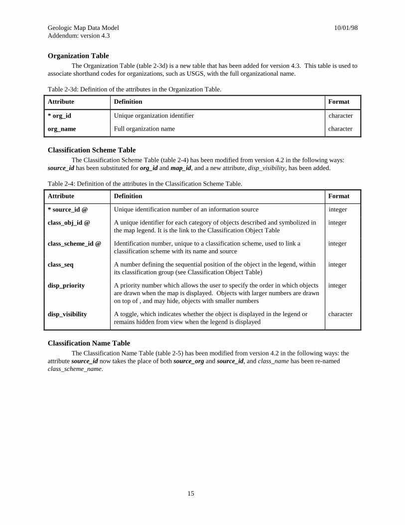
Organization TableThe Organization Table (table 2-3d) is a new table that has been added for version 4.3. This table is used to
associate shorthand codes for organizations, such as USGS, with the full organizational name.
Table 2-3d: Definition of the attributes in the Organization Table.
Attribute Definition Format
* org_id Unique organization identifier character
org_name Full organization name character
Classification Scheme TableThe Classification Scheme Table (table 2-4) has been modified from version 4.2 in the following ways:
source_id has been substituted for org_id and map_id, and a new attribute, disp_visibility, has been added.
Table 2-4: Definition of the attributes in the Classification Scheme Table.
Attribute Definition Format
* source_id @ Unique identification number of an information source integer
class_obj_id @ A unique identifier for each category of objects described and symbolized inthe map legend. It is the link to the Classification Object Table
integer
class_scheme_id @ Identification number, unique to a classification scheme, used to link aclassification scheme with its name and source
integer
class_seq A number defining the sequential position of the object in the legend, withinits classification group (see Classification Object Table)
integer
disp_priority A priority number which allows the user to specify the order in which objectsare drawn when the map is displayed. Objects with larger numbers are drawnon top of , and may hide, objects with smaller numbers
integer
disp_visibility A toggle, which indicates whether the object is displayed in the legend orremains hidden from view when the legend is displayed
character
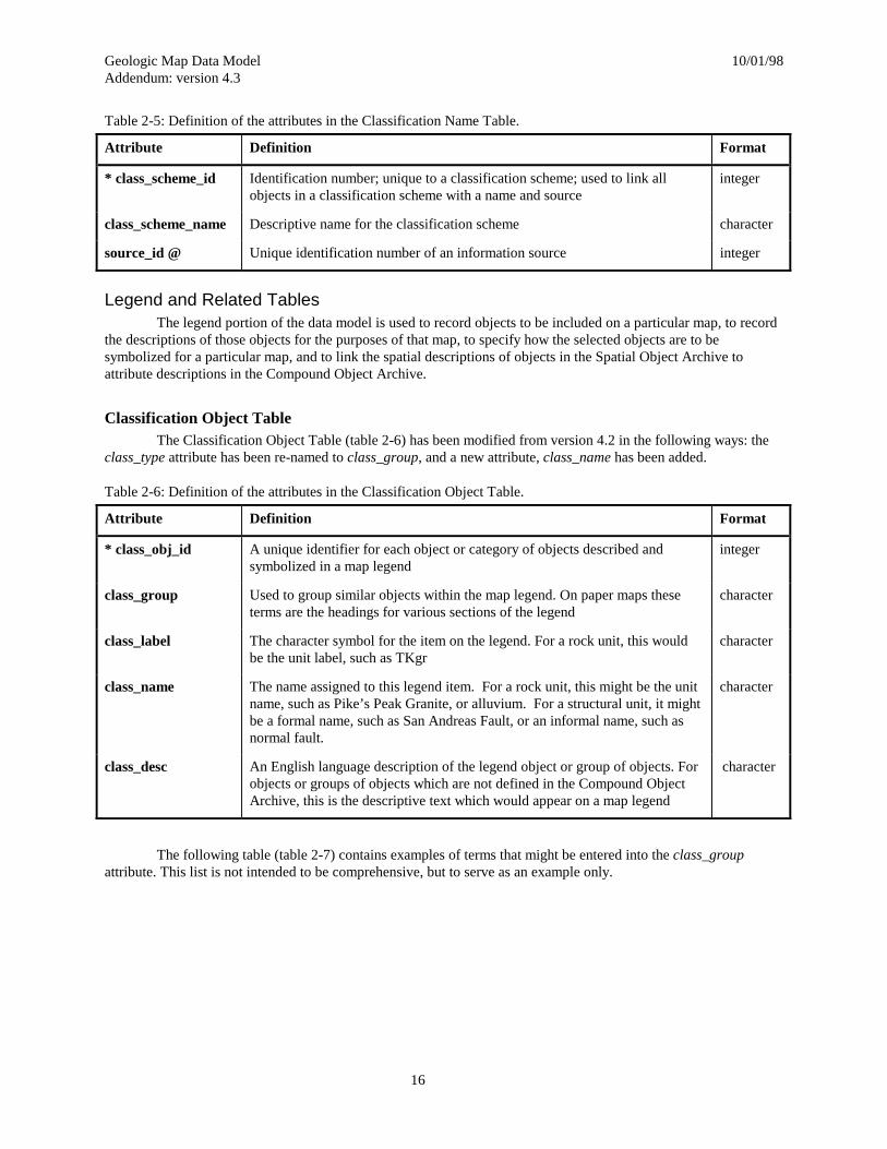
Classification Name TableThe Classification Name Table (table 2-5) has been modified from version 4.2 in the following ways: the
attribute source_id now takes the place of both source_org and source_id, and class_name has been re-namedclass_scheme_name.
Geologic Map Data Model 10/01/98Addendum: version 4.3
16
Table 2-5: Definition of the attributes in the Classification Name Table.
Attribute Definition Format
* class_scheme_id Identification number; unique to a classification scheme; used to link allobjects in a classification scheme with a name and source
integer
class_scheme_name Descriptive name for the classification scheme character
source_id @ Unique identification number of an information source integer
Legend and Related TablesThe legend portion of the data model is used to record objects to be included on a particular map, to record
the descriptions of those objects for the purposes of that map, to specify how the selected objects are to besymbolized for a particular map, and to link the spatial descriptions of objects in the Spatial Object Archive toattribute descriptions in the Compound Object Archive.
Classification Object TableThe Classification Object Table (table 2-6) has been modified from version 4.2 in the following ways: the
class_type attribute has been re-named to class_group, and a new attribute, class_name has been added.
Table 2-6: Definition of the attributes in the Classification Object Table.
Attribute Definition Format
* class_obj_id A unique identifier for each object or category of objects described andsymbolized in a map legend
integer
class_group Used to group similar objects within the map legend. On paper maps theseterms are the headings for various sections of the legend
character
class_label The character symbol for the item on the legend. For a rock unit, this wouldbe the unit label, such as TKgr
character
class_name The name assigned to this legend item. For a rock unit, this might be the unitname, such as Pike’s Peak Granite, or alluvium. For a structural unit, it mightbe a formal name, such as San Andreas Fault, or an informal name, such asnormal fault.
character
class_desc An English language description of the legend object or group of objects. Forobjects or groups of objects which are not defined in the Compound ObjectArchive, this is the descriptive text which would appear on a map legend
character
The following table (table 2-7) contains examples of terms that might be entered into the class_groupattribute. This list is not intended to be comprehensive, but to serve as an example only.
Geologic Map Data Model 10/01/98Addendum: version 4.3
17
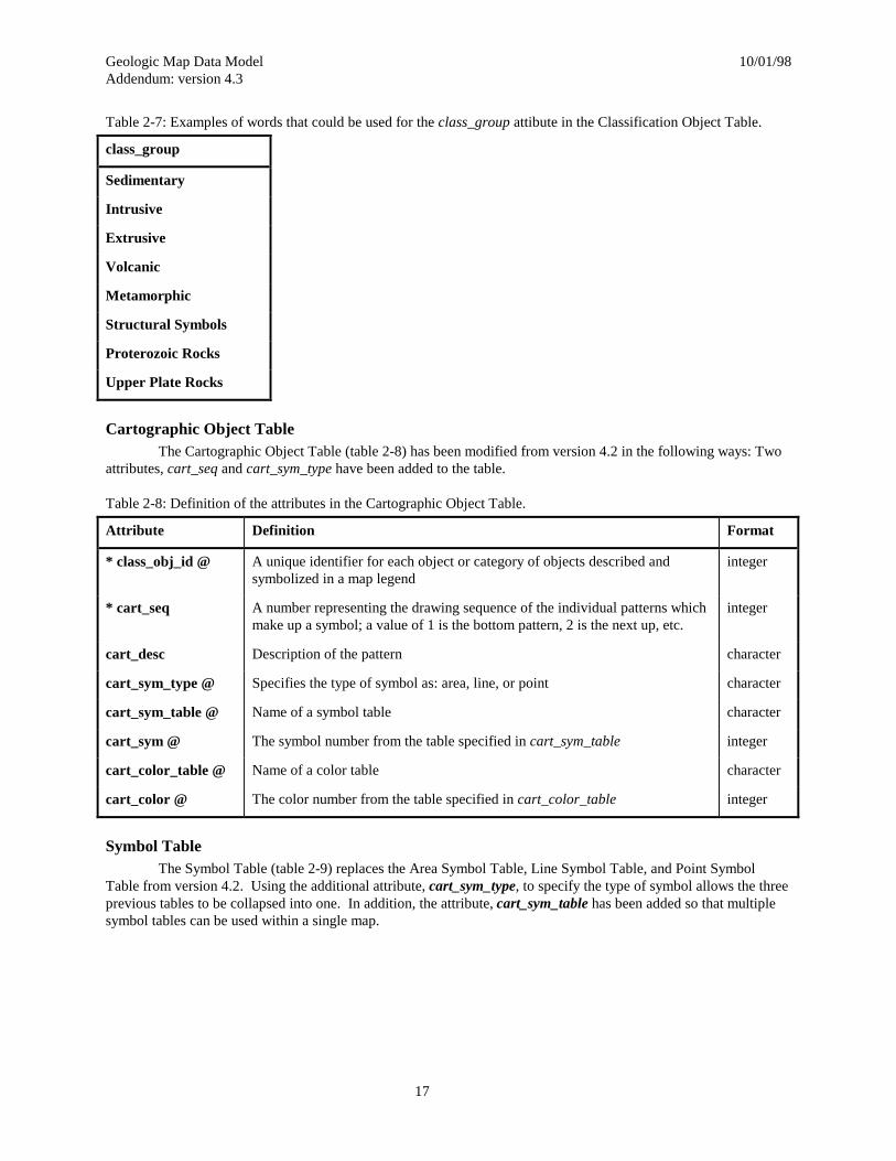
Table 2-7: Examples of words that could be used for the class_group attibute in the Classification Object Table.
class_group
Sedimentary
Intrusive
Extrusive
Volcanic
Metamorphic
Structural Symbols
Proterozoic Rocks
Upper Plate Rocks
Cartographic Object TableThe Cartographic Object Table (table 2-8) has been modified from version 4.2 in the following ways: Two
attributes, cart_seq and cart_sym_type have been added to the table.
Table 2-8: Definition of the attributes in the Cartographic Object Table.
Attribute Definition Format
* class_obj_id @ A unique identifier for each object or category of objects described andsymbolized in a map legend
integer
* cart_seq A number representing the drawing sequence of the individual patterns whichmake up a symbol; a value of 1 is the bottom pattern, 2 is the next up, etc.
integer
cart_desc Description of the pattern character
cart_sym_type @ Specifies the type of symbol as: area, line, or point character
cart_sym_table @ Name of a symbol table character
cart_sym @ The symbol number from the table specified in cart_sym_table integer
cart_color_table @ Name of a color table character
cart_color @ The color number from the table specified in cart_color_table integer
Symbol TableThe Symbol Table (table 2-9) replaces the Area Symbol Table, Line Symbol Table, and Point Symbol
Table from version 4.2. Using the additional attribute, cart_sym_type, to specify the type of symbol allows the threeprevious tables to be collapsed into one. In addition, the attribute, cart_sym_table has been added so that multiplesymbol tables can be used within a single map.
Geologic Map Data Model 10/01/98Addendum: version 4.3
18
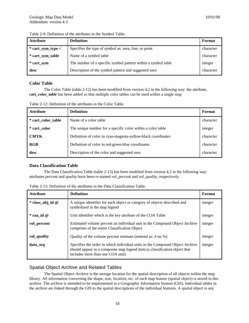
Table 2-9: Definition of the attributes in the Symbol Table.
Attribute Definition Format
* cart_sym_type < Specifies the type of symbol as: area, line, or point character
* cart_sym_table Name of a symbol table character
* cart_sym The number of a specific symbol pattern within a symbol table integer
desc Description of the symbol pattern and suggested uses character
Color TableThe Color Table (table 2-12) has been modified from version 4.2 in the following way: the attribute,
cart_color_table has been added so that multiple color tables can be used within a single map
Table 2-12: Definition of the attributes in the Color Table.
Attribute Definition Format
* cart_color_table Name of a color table character
* cart_color The unique number for a specific color within a color table integer
CMYK Definition of color in cyan-magenta-yellow-black coordinates character
RGB Definition of color in red-green-blue coordinates character
desc Description of the color and suggested uses character
Data Classification TableThe Data Classification Table (table 2-13) has been modified from version 4.2 in the following way:
attributes percent and quality have been re-named vol_percent and vol_quality, respectively.
Table 2-13: Definition of the attributes in the Data Classification Table.
Attribute Definition Format
* class_obj_id @ A unique identifier for each object or category of objects described andsymbolized in the map legend
integer
* coa_id @ Unit identifier which is the key attribute of the COA Table integer
vol_percent Estimated volume percent an individual unit in the Compound Object Archivecomprises of the entire Classification Object
integer
vol_quality Quality of the volume percent estimate (entered as: r nn %) integer
data_seq Specifies the order in which individual units in the Compound Object Archiveshould appear in a composite map legend item (a classification object thatincludes more than one COA unit)
integer
Spatial Object Archive and Related TablesThe Spatial Object Archive is the storage location for the spatial description of all objects within the map
library. All information concerning the shape, size, location, etc. of each map feature (spatial object) is stored in thisarchive. The archive is intended to be implemented in a Geographic Information System (GIS). Individual tables inthe archive are linked through the GIS to the spatial descriptions of the individual features. A spatial object is any

Geologic Map Data Model 10/01/98Addendum: version 4.3
19
geometric object (e.g. polygon, line, or point, etc.) that is defined, and stored in the GIS. The spatial objects arestored in individual data sets within the GIS. Depending on the implementation in the GIS, a digital map will requireone or more data sets for complete storage of all map objects. Each map object in a single data set is assigned aunique spatial_obj_id attribute. The combination of the spatial_obj_id and the data set identifier, which is stored inthe dataset_id attribute, are sufficient to uniquely identify any individual map object within the archive.
Spatial Objects Table: An Example of a GIS Data SetOne or more GIS data sets are used to store the geographic coordinates and topologic definitions that make
up the spatial description of map objects. The spatial data stored in the GIS is linked to the rest of the data modelthrough attribute tables (table 2-14 is an example). The combination of spatial_obj_id and dataset_id provide aunique identifier for each spatial object in the data set, while the source_id attribute provides a link back to theoriginal source for every spatial object. The example table shown in table 2-14 replaces the Geology PolygonsTable, Geology Lines Table, Miscellaneous Lines Table, and the Points Table from version 4.2. The table has beenmodified from version 4.2 in the following ways: the attribute source_id now takes the place of both source_org andsource_id, and the attribute, cover_id, has been re-named dataset_id.
Table 2-14: Definition of the attributes in the Spatial Objects Table.
Attribute Definition Format
* spatial_obj_id A unique identifier for each object in an individual data set, or layer integer
* dataset_id Unique identification number for each data set or layer in a GIS integer
source_id @ Unique identification number of an information source integer
Spatial Classification TableThe Spatial Classification Table (table 2-18) has been modified from version 4.2 in the following way: the
attribute, cover_id, has been re-named dataset_id.
Table 2-18: Definition of the attributes in the Spatial Classification Table.
Attribute Definition Format
* spatial_obj_id @ A unique identifier for each object in an individual data set, or layer integer
* dataset_id @ Unique identification number for each data set or layer in a GIS integer
* class_obj_id @ A unique identifier for each object or category of objects described andsymbolized in a map legend
integer
Singular Object Archive TablesThe Singular Object Archive is composed of several tables that are used to store descriptive information
related to individual spatial objects. Although only five tables are described below, the archive could include manymore tables. Those described here are intended as examples only. All tables in the archive include the attributes,spatial_obj_id and dataset_id, which are used to specify the particular spatial object to which each record in thearchive table refers. Each record in each table in the archive may only refer to a single spatial object, hence thename, Singular Object Archive.
Spatial Object Name TableThe Spatial Object Name Table (table 2-19) has been modified from version 4.2 in the following ways: the
attribute source_id now takes the place of both source_org and source_id, and the attribute, cover_id, has been re-named dataset_id.

Geologic Map Data Model 10/01/98Addendum: version 4.3
20
Table 2-19: Definition of the attributes in the Spatial Object Name Table.
Attribute Definition Format
* spatial_obj_id @ A unique identifier for each object in an individual data set, or layer integer
* dataset_id @ Unique identification number for each data set or layer in a GIS integer
* name Name to be attached to an individual point, line, or polygon. For example thename of a pluton or a fault
character
source_id @ Unique identification number of an information source integer
Spatial Object Composition TableThe Spatial Object Composition Table (table 2-20) has been modified from version 4.2 in the following
ways: the attribute source_id now takes the place of both source_org and source_id; the attribute, cover_id, hasbeen re-named dataset_id; and the attributes percent and quality have been re-named vol_percent and vol_quality,respectively.
Table 2-20: Definition of the attributes in the Spatial Object Composition Table.
Attribute Definition Format
* spatial_obj_id @ A unique identifier for each object in an individual data set, or layer integer
* dataset_id @ Unique identification number for each data set or layer in a GIS integer
* coa_id @ Unit identifier which is the key attribute of the COA Table integer
* comp_seq @ Identification number of a single composition description within a rock unit(see Rock Composition Table) or zero to indicate entire unit
integer
vol_percent Estimated volume percent that the individual unit or composition in theCompound Object Archive comprises of the single spatial object
integer
vol_quality Quality of the volume percent estimate (entered as: r nn %) integer
source_id @ Unique identification number of an information source integer
Spatial Object Age TableThe Spatial Object Age Table (table 2-21) has been modified from version 4.2 in the following ways: the
attribute, cover_id, has been re-named dataset_id; the attribute rad_seq had been re-named chron_seq; and theattribute site_name has been added.
Geologic Map Data Model 10/01/98Addendum: version 4.3
21
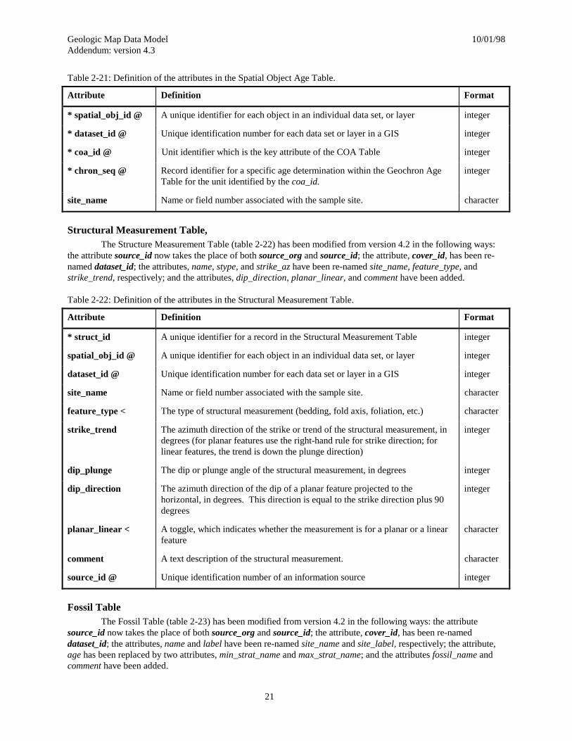
Table 2-21: Definition of the attributes in the Spatial Object Age Table.
Attribute Definition Format
* spatial_obj_id @ A unique identifier for each object in an individual data set, or layer integer
* dataset_id @ Unique identification number for each data set or layer in a GIS integer
* coa_id @ Unit identifier which is the key attribute of the COA Table integer
* chron_seq @ Record identifier for a specific age determination within the Geochron AgeTable for the unit identified by the coa_id.
integer
site_name Name or field number associated with the sample site. character
Structural Measurement Table,The Structure Measurement Table (table 2-22) has been modified from version 4.2 in the following ways:
the attribute source_id now takes the place of both source_org and source_id; the attribute, cover_id, has been re-named dataset_id; the attributes, name, stype, and strike_az have been re-named site_name, feature_type, andstrike_trend, respectively; and the attributes, dip_direction, planar_linear, and comment have been added.
Table 2-22: Definition of the attributes in the Structural Measurement Table.
Attribute Definition Format
* struct_id A unique identifier for a record in the Structural Measurement Table integer
spatial_obj_id @ A unique identifier for each object in an individual data set, or layer integer
dataset_id @ Unique identification number for each data set or layer in a GIS integer
site_name Name or field number associated with the sample site. character
feature_type < The type of structural measurement (bedding, fold axis, foliation, etc.) character
strike_trend The azimuth direction of the strike or trend of the structural measurement, indegrees (for planar features use the right-hand rule for strike direction; forlinear features, the trend is down the plunge direction)
integer
dip_plunge The dip or plunge angle of the structural measurement, in degrees integer
dip_direction The azimuth direction of the dip of a planar feature projected to thehorizontal, in degrees. This direction is equal to the strike direction plus 90degrees
integer
planar_linear < A toggle, which indicates whether the measurement is for a planar or a linearfeature
character
comment A text description of the structural measurement. character
source_id @ Unique identification number of an information source integer
Fossil TableThe Fossil Table (table 2-23) has been modified from version 4.2 in the following ways: the attribute
source_id now takes the place of both source_org and source_id; the attribute, cover_id, has been re-nameddataset_id; the attributes, name and label have been re-named site_name and site_label, respectively; the attribute,age has been replaced by two attributes, min_strat_name and max_strat_name; and the attributes fossil_name andcomment have been added.
Geologic Map Data Model 10/01/98Addendum: version 4.3
22
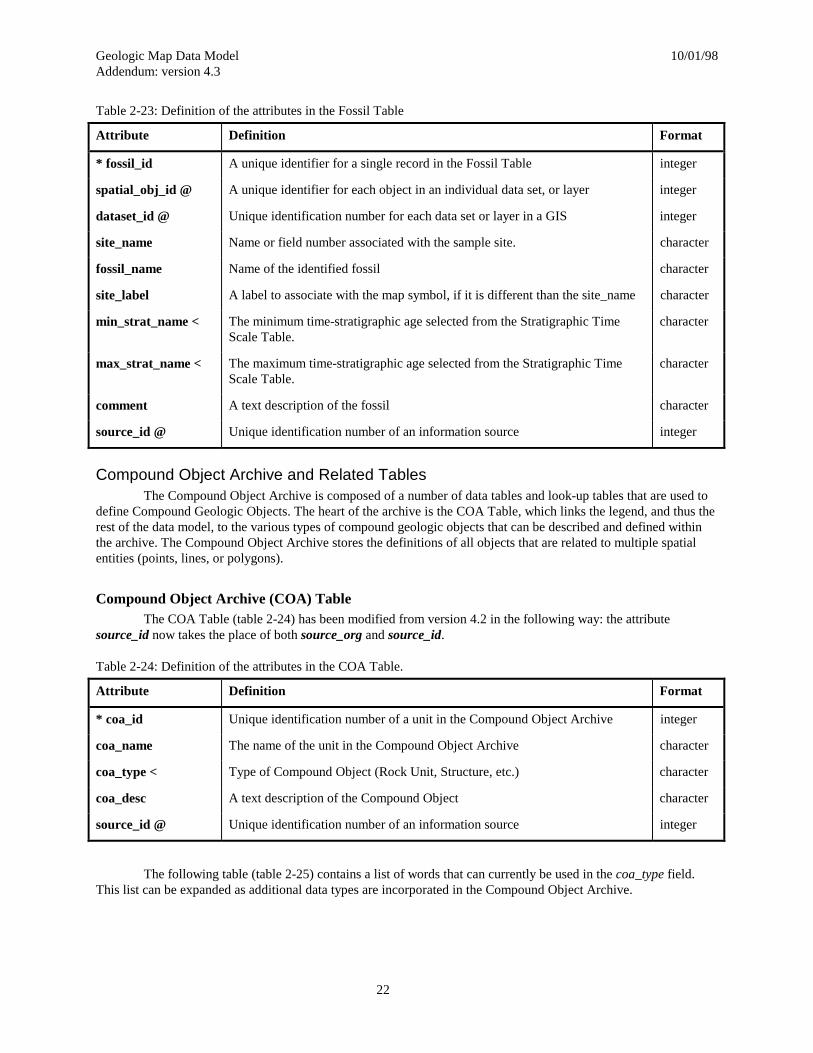
Table 2-23: Definition of the attributes in the Fossil Table
Attribute Definition Format
* fossil_id A unique identifier for a single record in the Fossil Table integer
spatial_obj_id @ A unique identifier for each object in an individual data set, or layer integer
dataset_id @ Unique identification number for each data set or layer in a GIS integer
site_name Name or field number associated with the sample site. character
fossil_name Name of the identified fossil character
site_label A label to associate with the map symbol, if it is different than the site_name character
min_strat_name < The minimum time-stratigraphic age selected from the Stratigraphic TimeScale Table.
character
max_strat_name < The maximum time-stratigraphic age selected from the Stratigraphic TimeScale Table.
character
comment A text description of the fossil character
source_id @ Unique identification number of an information source integer
Compound Object Archive and Related TablesThe Compound Object Archive is composed of a number of data tables and look-up tables that are used to
define Compound Geologic Objects. The heart of the archive is the COA Table, which links the legend, and thus therest of the data model, to the various types of compound geologic objects that can be described and defined withinthe archive. The Compound Object Archive stores the definitions of all objects that are related to multiple spatialentities (points, lines, or polygons).
Compound Object Archive (COA) TableThe COA Table (table 2-24) has been modified from version 4.2 in the following way: the attribute
source_id now takes the place of both source_org and source_id.
Table 2-24: Definition of the attributes in the COA Table.
Attribute Definition Format
* coa_id Unique identification number of a unit in the Compound Object Archive integer
coa_name The name of the unit in the Compound Object Archive character
coa_type < Type of Compound Object (Rock Unit, Structure, etc.) character
coa_desc A text description of the Compound Object character
source_id @ Unique identification number of an information source integer
The following table (table 2-25) contains a list of words that can currently be used in the coa_type field.This list can be expanded as additional data types are incorporated in the Compound Object Archive.
Geologic Map Data Model 10/01/98Addendum: version 4.3
23
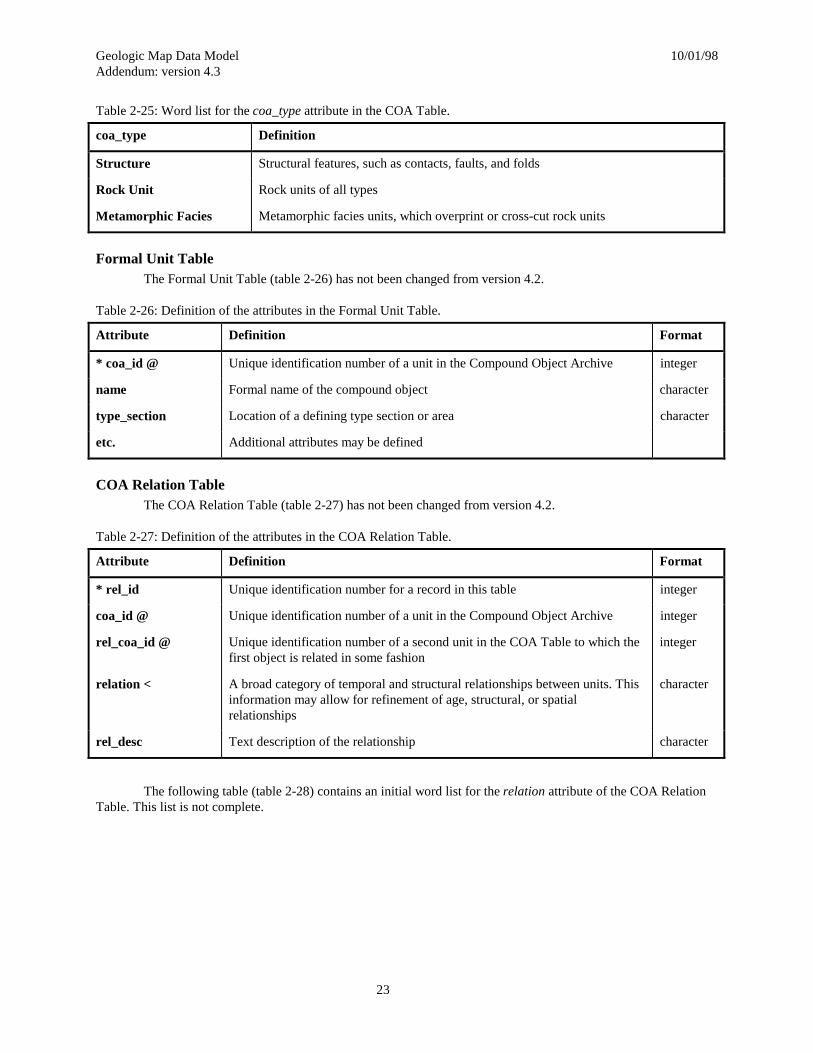
Table 2-25: Word list for the coa_type attribute in the COA Table.
coa_type Definition
Structure Structural features, such as contacts, faults, and folds
Rock Unit Rock units of all types
Metamorphic Facies Metamorphic facies units, which overprint or cross-cut rock units
Formal Unit TableThe Formal Unit Table (table 2-26) has not been changed from version 4.2.
Table 2-26: Definition of the attributes in the Formal Unit Table.
Attribute Definition Format
* coa_id @ Unique identification number of a unit in the Compound Object Archive integer
name Formal name of the compound object character
type_section Location of a defining type section or area character
etc. Additional attributes may be defined
COA Relation TableThe COA Relation Table (table 2-27) has not been changed from version 4.2.
Table 2-27: Definition of the attributes in the COA Relation Table.
Attribute Definition Format
* rel_id Unique identification number for a record in this table integer
coa_id @ Unique identification number of a unit in the Compound Object Archive integer
rel_coa_id @ Unique identification number of a second unit in the COA Table to which thefirst object is related in some fashion
integer
relation < A broad category of temporal and structural relationships between units. Thisinformation may allow for refinement of age, structural, or spatialrelationships
character
rel_desc Text description of the relationship character
The following table (table 2-28) contains an initial word list for the relation attribute of the COA RelationTable. This list is not complete.

Geologic Map Data Model 10/01/98Addendum: version 4.3
24
Table 2-28: Example word list for the relation attribute in the COA Relation Table.
Relation Definition
contains A relationship in which coa_id contains rel_coa_id
contemporaneous Formed or existing at the same time (Jackson, 1997).
correlates To show correspondence in character and stratigraphic position between such geologicphenomena as formations or fossil faunas of two or more separate areas (Jackson, 1997).
equivalent Corresponding in geologic age or stratigraphic position; esp. said of strata or formations thatare contemporaneous in time of formation or deposition or that contain the same fossil forms(Jackson, 1997)
intrudes An intrusive rock relationship in which coa_id intrudes rel_coa_id
overlies A lithostratigraphic relationship in which coa_id is stratigraphically younger than rel_coa_id
above A structural relationship in which coa_id is above rel_coa_id because of a structural process,such as faulting
COA Tree TableThe COA Tree Table (table 2-29) has not been changed from version 4.2. Although this table is required
for certain COA queries, in some implementations it could be computed from the COA Relations Table by addingthe relation, “child of”, to the allowed relation word list.
Table 2-29: Definition of the attributes in the COA Tree Table.
Attribute Definition Format
* coa_id @ Unique identification number of a unit in the Compound Object Archive integer
* parent_id @ Unique identification number of a second unit in the COA Table which is theparent of the unit identified in coa_id
integer
Rock Units and Related TablesThese tables store information about the composition, rank, and age of rock units. For purposes of the
model, rock unit is defined as any mapped unit which may occur on a geologic map, including all types of rock units,whether layered or not, unconsolidated sediment units, water and ice features where underlying geology is notmapped, etc.
Rock Unit TableThe Rock Unit Table (table 2-30) has been modified from version 4.2 in the following way: attributes have
been added to record the thickness of the rock unit.

Geologic Map Data Model 10/01/98Addendum: version 4.3
25
Table 2-30: Definition of the attributes in the Rock Unit Table.
Attribute Definition Format
* coa_id @ Unique identification number of a unit in the Compound Object Archive integer
rock_rank @ A keyword defining the lithostratigraphic level or rank of the defined unit character
min_thick Minimum thickness of the rock unit, in meters integer
max_thick Maximum thickness of the rock unit, in meters integer
typ_thick Typical, or average thickness of the rock unit, in meters integer
thick_qual Quality of the typical thickness estimate as a percent of the typical thickness(entered as: r nn %)
integer
Rock Unit Rank TableThe Rock Unit Rank Table (table 2-32) has not been changed from version 4.2.
Table 2-32: Definition of the attributes in the Rock Unit Rank Table.
Attribute Definition Format
* rock_rank A keyword defining the lithostratigraphic level or rank of the defined unit character
rock_level A number indicating the relative rank. integer
The following table (table 2-31) is an initial word list for the rock_rank attribute of the Rock Unit Table.This list is incomplete and intended as an example to amplify the definition and intended usage.
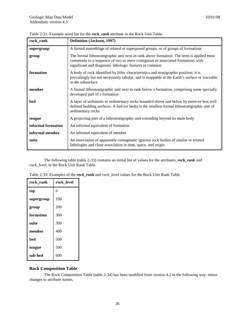
Geologic Map Data Model 10/01/98Addendum: version 4.3
26
Table 2-31: Example word list for the rock_rank attribute in the Rock Unit Table.
rock_rank Definition (Jackson, 1997)
supergroup A formal assemblage of related or superposed groups, or of groups of formations
group The formal lithostratigraphic unit next in rank above formation. The term is applied mostcommonly to a sequence of two or more contiguous or associated formations withsignificant and diagnostic lithologic features in common
formation A body of rock identified by lithic characteristics and stratigraphic position; it isprevailingly but not necessarily tabular, and is mappable at the Earth’s surface or traceablein the subsurface
member A formal lithostratigraphic unit next in rank below a formation, comprising some speciallydeveloped part of a formation
bed A layer of sediments or sedimentary rocks bounded above and below by more-or-less welldefined bedding surfaces. A bed (or beds) is the smallest formal lithostratigraphic unit ofsedimentary rocks
tongue A projecting part of a lithostratigraphic unit extending beyond its main body
informal formation An informal equivalent of formation
informal member An informal equivalent of member
suite An association of apparently comagmatic igneous rock bodies of similar or relatedlithologies and close association in time, space, and origin
The following table (table 2-33) contains an initial list of values for the attributes, rock_rank androck_level, in the Rock Unit Rank Table.
Table 2-33: Examples of the rock_rank and rock_level values for the Rock Unit Rank Table.
rock_rank rock_level
top 0
supergroup 100
group 200
formation 300
suite 300
member 400
bed 500
tongue 500
sub-bed 600
Rock Composition TableThe Rock Composition Table (table 2-34) has been modified from version 4.2 in the following way: minor
changes to attribute names.

Geologic Map Data Model 10/01/98Addendum: version 4.3
27
Table 2-34: Definition of the attributes in the Rock Composition Table.
Attribute Definition Format
* coa_id @ Unique identification number of a unit in the Compound Object Archive integer
* comp_seq Unique identification number of a composition within a rock unit. Alsoindicates the sequence number for displaying descriptive information aboutthis composition within a rock unit description. Compositions are normallysequenced from most abundant to least abundant
integer
rock_name A free-text attribute for storing the map author’s preferred complete name forthe rock composition
character
lith_class @ A lithologic classification term selected from those available in the LithologyTable (see below)
character
lith_form @ A form or morphology classification term selected from those available in aForm Table (not yet created)
character
vol_percent An estimate of the volume percent of the composition within the rock unit integer
vol_quality Quality of the volume percent estimate (entered as: r nn %) integer
mineralogy_desc A mineral modifier associated with the rock name, or description of themineralogy of the composition
character
color_desc A description of the color or colors of the composition character
texture_desc A description of the texture of the composition character
alteration_desc A description of any alteration associated with the composition character
description A text description of this composition. Intended to be read by people, this iswhere a long, detailed map legend description would be stored.
character
Lithology TableThe Lithology Table (table 2-35) has not been changed from version 4.2.
Table 2-35: Definition of the attributes in the Lithology Table.
Attribute Definition Format
* lith_class A predefined hierarchical list of lithologic terms used for classifying rockcompositions.
character
lith_id A unique identifier for the lithologic term which is used in the Lithology Treetable to store parent-child relations
integer
lith_level A numeric value for the level in the hierarchy of lithologic terms. integer
lith_desc An English language definition of the lithologic term. character
The hierarchical lithologic classification is unchanged from version 4.2. For a detailed explanation, pleasesee table 2-36 in Chapter 2 of version 4.2.

Geologic Map Data Model 10/01/98Addendum: version 4.3
28
Lithology Tree TableThe Lithology Tree Table (table 2-37) has not been changed from version 4.2.
Table 2-37: Definition of the attributes in the Lithology Tree Table.
Attribute Definition Format
* lith_id A unique identifier for a lithologic term from the Lithology Table integer
* parent_id A unique identifier for a second lithologic term from the Lithology Tablewhich is the parent of the first term
integer
The following table (table 2-38) shows some sample data as it would appear in the Lithology Tree Table.
Table 2-38: Example of the data in the Lithology Tree Table.
lith_id parent_id
41 40
41 35
40 35
Geochronologic Age TableThe Geochronologic Age Table (table 2-39) has been modified from version 4.2 in the following ways: the
attribute source_id now takes the place of both source_org and source_id; the table has been renamed fromRadiometric Age to Geochronologic Age to reflect the possibility that precise age assignments other than radiometricwill also be stored; several attributes have been renamed to reflect the name change; and the attributes,chron_method and sample_material have been added.
Table 2-39: Definition of the attributes in the Geochronologic Age Table.
Attribute Definition Format
* coa_id @ Unique identification number of a unit in the Compound Object Archive integer
* chron_seq Record identifier for a specific age determination for the unit identified by thecoa_id.
integer
chron_method < Analytical method used to obtain the age character
sample_material < A description of the material sampled character
chron_date Geochronologic age, in millions of years float
chron_err_plus The positive error for the geochronologic age, in millions of years float
chron_err_minus The negative error for the geochronologic age, in millions of years float
comment Additional comments concerning this age determination character
source_id @ Unique identification number of an information source integer
Geologic Map Data Model 10/01/98Addendum: version 4.3
29
Stratigraphic Age TableThe Stratigraphic Age Table (table 2-40) has been modified from version 4.2 in the following ways: min
and max source_id attributes now takes the place of both min and max source_org and source_id attributes.
Table 2-40: Definition of the attributes in the Stratigraphic Age Table.
Attribute Definition Format
* coa_id @ Unique identification number of a unit in the Compound Object Archive integer
* strat_seq Record identifier for a specific time interval for the unit identified by thecoa_id.
integer
min_strat_name @ The minimum time-stratigraphic age selected from the Stratigraphic TimeScale Table
character
max_strat_name @ The maximum time-stratigraphic age selected from the Stratigraphic TimeScale Table
character
min_source_id @ Unique identification number of an information source for the minimum agereference
integer
max_source_id @ Unique identification number of an information source for the maximum agereference
integer
Stratigraphic Time Scale TableThe Stratigraphic Time Scale Table (table 2-41) has been modified from version 4.2 in the following ways:
min and max source_id attributes now takes the place of both min and max source_org and source_id attributes.
Table 2-41: Definition of the attributes in the Stratigraphic Time Scale Table.
Attribute Definition Format
* strat_id A unique identifier for the strat_name integer
strat_name The time-stratigraphic name for the time interval character
strat_rank @ A keyword representing the rank of the time-stratigraphic term. Must bedefined in the Stratigraphic Rank table
character
min_strat_age Minimum numerical age, in millions of years float
max_start_age Maximum numerical age, in millions of years float
min_source_id @ Unique identification number of an information source for the minimum agereference
integer
max_source_id @ Unique identification number of an information source for the maximum agereference
integer
The sample stratigraphic classification is unchanged from version 4.2. For a detailed explanation, pleasesee table 2-42 in Chapter 2 of version 4.2.
Stratigraphic Tree TableThe Stratigraphic Tree Table (table 2-43) has not been changed from version 4.2.
Geologic Map Data Model 10/01/98Addendum: version 4.3
30
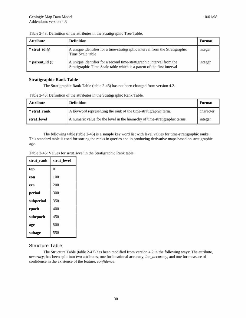
Table 2-43: Definition of the attributes in the Stratigraphic Tree Table.
Attribute Definition Format
* strat_id @ A unique identifier for a time-stratigraphic interval from the StratigraphicTime Scale table
integer
* parent_id @ A unique identifier for a second time-stratigraphic interval from theStratigraphic Time Scale table which is a parent of the first interval
integer
Stratigraphic Rank TableThe Stratigraphic Rank Table (table 2-45) has not been changed from version 4.2.
Table 2-45: Definition of the attributes in the Stratigraphic Rank Table.
Attribute Definition Format
* strat_rank A keyword representing the rank of the time-stratigraphic term. character
strat_level A numeric value for the level in the hierarchy of time-stratigraphic terms. integer
The following table (table 2-46) is a sample key word list with level values for time-stratigraphic ranks.This standard table is used for sorting the ranks in queries and in producing derivative maps based on stratigraphicage.
Table 2-46: Values for strat_level in the Stratigraphic Rank table.
strat_rank strat_level
top 0
eon 100
era 200
period 300
subperiod 350
epoch 400
subepoch 450
age 500
subage 550
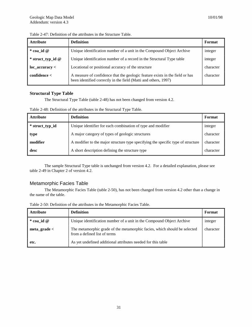
Structure TableThe Structure Table (table 2-47) has been modified from version 4.2 in the following ways: The attribute,
accuracy, has been split into two attributes, one for locational accuracy, loc_accuracy, and one for measure ofconfidence in the existence of the feature, confidence.
Geologic Map Data Model 10/01/98Addendum: version 4.3
31
Table 2-47: Definition of the attributes in the Structure Table.
Attribute Definition Format
* coa_id @ Unique identification number of a unit in the Compound Object Archive integer
* struct_typ_id @ Unique identification number of a record in the Structural Type table integer
loc_accuracy < Locational or positional accuracy of the structure character
confidence < A measure of confidence that the geologic feature exists in the field or hasbeen identified correctly in the field (Matti and others, 1997)
character
Structural Type TableThe Structural Type Table (table 2-48) has not been changed from version 4.2.
Table 2-48: Definition of the attributes in the Structural Type Table.
Attribute Definition Format
* struct_typ_id Unique identifier for each combination of type and modifier integer
type A major category of types of geologic structures character
modifier A modifier to the major structure type specifying the specific type of structure character
desc A short description defining the structure type character
The sample Structural Type table is unchanged from version 4.2. For a detailed explanation, please seetable 2-49 in Chapter 2 of version 4.2.
Metamorphic Facies TableThe Metamorphic Facies Table (table 2-50), has not been changed from version 4.2 other than a change in
the name of the table.
Table 2-50: Definition of the attributes in the Metamorphic Facies Table.
Attribute Definition Format
* coa_id @ Unique identification number of a unit in the Compound Object Archive integer
meta_grade < The metamorphic grade of the metamorphic facies, which should be selectedfrom a defined list of terms
character
etc. As yet undefined additional attributes needed for this table

Geologic Map Data Model 10/01/98Addendum: version 4.3
32
References CitedJackson, J. A., ed., 1997, Glossary of Geology, fourth ed.: American Geological Institute, Alexandria, Virginia,
769 pp.
Matti, J.C., Powell, R.E., Mill, S.A., Kennedy, K.R., Ruppert, G.L., and Cossette, P.M., 1997, Geologic-lineattributes for digital geologic-map data bases produced by the Southern California Areal Mapping Project(SCAMP) Version 1.0: U. S. Geological Survey Open File Report 97-861, p. 5.