digital building surveying and planning in existing
TRANSCRIPT
1st ASCAAD International Conference, e-Design in Architecture
KFUPM, Dhahran, Saudi Arabia. December 2004 73
DIGITAL BUILDING SURVEYING AND PLANNING IN EXISTING BUILDING
Capturing and structuring survey information
FRANK PETZOLD AND DIRK DONATH Bauhaus University Weimar, 99421 Weimar, Germany Faculty of Architecture Email address: petzold|[email protected]
Abstract. For planning in existing built contexts, the building survey is the starting point for initial planning proposals, for the diagnosis and documentation of building damages, for the creation of objectives catalogues, for the detailed design of renovation and conversion measures and for ensuring fulfilment of building legislation, particularly by change of use and refitting.
An examination of currently available IT-tools shows insufficient support for planning within existing contexts, most notably a deficit with regard to information capture and administration.
In ongoing research at the Bauhaus-Universität Weimar (SFB524-Collaborative research center 524 “Materials and Structure in Revitalization of Buildings”) methods and techniques of revitalisation are being investigated (SFB 524, 2004). A special branch of SFB524-D2 entitled “Planning-Relevant Digital Building Surveying and Information Systems” is investigating possibilities of computer-aided building survey and communication platforms for architects and civil engineers.
This paper discusses the concept for a modular surveying system (basic concept, structuring of collected data, separation of geometry from semantic data, and separation into sub-systems) and the prototypical realisation of a system for the complete support of the entire building surveying process for existing buildings. The project aims to contribute to the development of a planning system for existing buildings.
The project is funded by the German Research Institute "Deutsche Forschungsgesellschaft (DFG)".

74 Frank Petzold and Dirk Donath
1. Building in Existing Built Contexts in Germany
After the period of reconstruction following World War II and the expansion of the built environment in the last 20-30 years a process of consolidation and renewal within the existing built context has begun. A variety of factors contribute towards this development, e.g.
Dwindling population figures are leading to a decrease in demand for living space
Population drift away from the former industrial regions
New approaches to working, telework, decentralised services etc. have reduced the need for dedicated production spaces
A steadily increasing need to renovate existing buildings
In 1997 the ratio between new building and renovation work was 53.7% : 46.3%. In 2001 prognoses estimated a change in this ratio to 43,8% : 56.2 % (BMBF, 2002).
Building in existing built contexts is becoming ever more important and the proportion is set to increase still further in the coming years.
The loose title “building in existing built contexts” covers a wide variety of different aspects. These include measures for maintaining and increasing the value of a property. They also include measures such as renovation, modernisation and conversion of existing buildings for new uses very often in combination with new buildings. In future planning tasks look set to include a variety of parallel tasks e.g. new building and conversion as well as renovation measures (BMVBW, 2001).
In contrast to new building, planning within existing built contexts necessitates more complex interactions with existing built substance and infrastructure with their own special and specific requirements.
Not least the actual presence of the building including its prehistory and amendments made during its lifetime are a central aspect. Existing building substance is characterised by a high degree of information with implications for the planning process, for the functional use of the building and particular building elements and the coordination of renovation measures. Typically new information comes to light and new questions arise during the actual renovation works with implications for the rest of the planning process and building measures. The existing building substance is in all cases the basis for planning tasks and building measures.

Digital Building Surveying and Planning in Existing Building 75
Planners are often confronted with new and different planning tasks which depend upon the respective form of the building and the planning aims of the particular project.
The planning and realisation problems of such renovation works have as yet not been researched in detail and tools for managing these problems are insufficient. A variety of initiatives funded by the German Government are currently investigating these aspects, e.g. “Bauen und Wohnen im 21. Jahrhundert” (Living and Building in the 21st Century) (BMBF, 2001) or the special research area at the Bauhaus-Universität Weimar SFB524 “Materials and Structure in Revitalization of Buildings” (SFB 524, 2004).
2. The Building Survey: The basis for building in existing built contexts
During the process of building works in and around existing buildings it is not uncommon that the actual situation on-site does not tally with existing planning documentation. Very often these mean additional costs as a result of planning amendments made during the building process or interruptions to the building progress.
Reliable, informative and accurate planning documentation is a prerequisite for efficient and economical planning in the context of existing buildings and can reduce the need for potentially costly ad-hoc decisions made on-site. Very often existing building documentation is non-existent or insufficient (not to scale, archive plans not kept up to date or even preliminary plans that do not reflect the actual situation as originally built).
Typically a building survey is only commissioned when existing building documentation is not available or cannot be used. Despite the cost, a building survey is the best means of obtaining reliable and accurate planning documents, either through a survey of the building in its entirety or parts thereof, of in some cases as verification of existing building documentation.
The building survey is therefore an essential part of the planning process and provides the information basis for all further planning activities. Existing information such as sketches, plans, measured geometric data and newly surveyed information must be combined and organised in a structured manner so that they can serve as useful parameters for the actual design and planning process.
3. Computer-Supported Building Surveying: Current situation
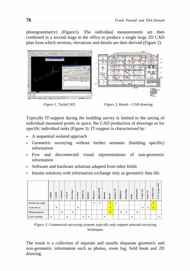
Architects typically produced measured drawings of individual building elements and measure such elements on site using conventional equipment (measuring stick or computerised optical distance meters) or using more complex surveying techniques (tacheometry, laser scanning and
76 Frank Petzold and Dirk Donath
photogrammetry) (Figure1). The individual measurements are then combined in a second stage in the office to produce a single large 2D CAD plan from which sections, elevations and details are then derived (Figure 2).
Figure 1. TachyCAD Figure 2. Result – CAD drawing
Typically IT-support during the building survey is limited to the saving of individual measured points in space, the CAD production of drawings or for specific individual tasks (Figure 3). IT-support is characterised by:
A sequential isolated approach Geometric surveying without further semantic (building specific)
information Few and disconnected visual representations of non-geometric
information Software and hardware solutions adapted from other fields Insular solutions with information exchange only as geometric data file
Figure 3. Commercial surveying systems typically only support selected surveying
techniques
The result is a collection of separate and usually disparate geometric and non-geometric information such as photos, room log, field book and 2D drawing.

Digital Building Surveying and Planning in Existing Building 77
4. The Research Project “The Building Surveying during the Planning Process”: A possible situation
The essential difference between planning new buildings and planning within existing built contexts is the necessity of capturing and evaluating the actual built situation. The current situation can be described as the original built situation taking into account building damages and changed conditions as a result of material fatigue and wear and tear. This depends largely on the previous level of maintenance carried out on the building. Building technology in existing buildings varies considerably depending upon building style, age and materials. Likewise, planning tasks vary greatly from project to project. It is therefore difficult to define standard solutions and approaches to the building survey and structuring system (building model, data interchange formats etc.)
Based upon an empirical examination of existing computer-assisted planning software and IT-solutions as well as geodetic tools, the following requirements for planning-relevant building surveying have been identified. Briefly put they include:
All data capture tools and methods (such as tacheometry, photogrammetry, vectorisation etc) should be viewed as tools within an integrated toolkit which can be used in combination,
The degree of information detail (density) should be flexible and extendable on demand as not all information is required at every stage of the planning process. A sketch-like overview is sufficient for elaborating basic planning intentions, for other areas a high degree of detail is imperative,
An organisational structure for data should be provided which is standardised for particular building types but whose structure can be dynamically modified to fit the specific requirements of individual surveying requirements and buildings,
It should be possible to collect, survey and combine different forms of information, such as formal data (descriptive), informal data (multimedia information) and structured data,
The captured data must be presented to the user in an adequate form to enable the user to “explore” the building digitally.
Planning activities in the context of existing buildings involve: the step by step collection of building-relevant information; rule and parameter based solution development; combination of classic and automatic surveying methods and equipment which contribute to the creation (survey) and editing (planning) of a building model i.e. which enable access to the building as a

78 Frank Petzold and Dirk Donath
container of information; the consideration of the entire process (building survey); intensification of information density to be captured (from the sketch to detail); the attribution of planning-relevant characteristic values; the provision and modification of ordering systems; and the free combination of different input techniques (surveying methods) in a single system.
Figure 4. Sub-systems of the concept Figure 5. The relationship between the building survey and the planning process
Based upon these requirements a software concept was developed and realised in prototypical form to provide suitable tools for the respective phases of the building survey. The tools are applied to a central model organised in a model management system (Figure 4 and 5).
4.1 THE INFORMATION CONTAINER – TYPES OF BUILDING INFORMATION
The computer-supported building survey is not simply a geometric description of a building. It should also provide a multitude of features and characteristics relevant both to the buildings future use and to its later CAD planning processing. In addition to its geometric form, the software concept allows each building element to be further described by specific properties: formal-descriptive attributes (building parameters), informal-descriptive attributes (text, images, videos, sketches etc.) and relational attributes (inferred structural connections) (Figure 6).
Figure 6. Information container Figure 7. The relationship between user
class and geometry
Digital Building Surveying and Planning in Existing Building 79
This data is ordered within a semantic structure (structure elements of the building construction / user class).
An user-class – a spatial, building-element or project class – is described by formal, informal, geometric and relational properties (attributes). Geometric properties are only linked to elements within a geometric structure. The geometry is “just an attribute” of an element (Figure 7).
A link between parameters of the geometric structure and formal properties (attributes) of the user-classes can likewise be defined, and this forms a central concept of the system employing the adjustment algorithm to mediate between different sources of information (Thurow, 2004a).
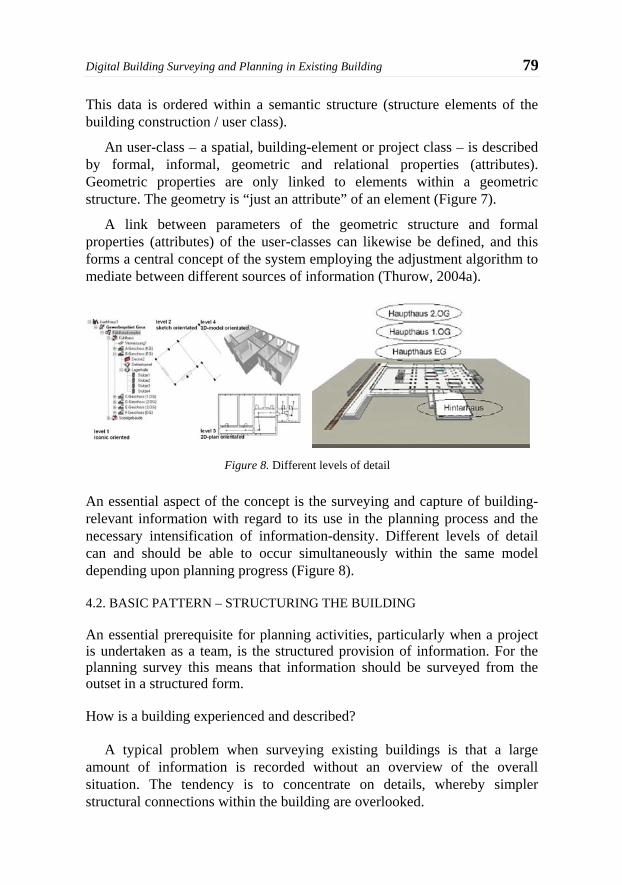
Figure 8. Different levels of detail
An essential aspect of the concept is the surveying and capture of building-relevant information with regard to its use in the planning process and the necessary intensification of information-density. Different levels of detail can and should be able to occur simultaneously within the same model depending upon planning progress (Figure 8).
4.2. BASIC PATTERN – STRUCTURING THE BUILDING
An essential prerequisite for planning activities, particularly when a project is undertaken as a team, is the structured provision of information. For the planning survey this means that information should be surveyed from the outset in a structured form. How is a building experienced and described?
A typical problem when surveying existing buildings is that a large amount of information is recorded without an overview of the overall situation. The tendency is to concentrate on details, whereby simpler structural connections within the building are overlooked.

80 Frank Petzold and Dirk Donath
As buildings and projects are more or less unique, pre-defined organisational structures for building models have only limited application. At present there is no comprehensive ordering system for describing all existing buildings.
How could a building and the information contained within be structured efficiently with a view to its later processing using computer-aided tools?
The concept employs an open, flexible, adaptable and extendable organisational structure which is based upon the process of the building surveying.
A building survey is typically undertaken room-by-room. Buildings are perceived as a series of different rooms, each room conceived as a functional unit in itself.
Rooms are defined, at least in visual terms, by their spatial characteristics. The room can therefore only be described by the form of its enveloping boundaries, its perceived surfaces. Thickness is not an identifiable parameter. In this case building elements (walls, pillars, columns etc.) can be interpreted as 'material rooms' and described by their actual surfaces.
Figure 9. Relationships between building and room elements
The concept envisages a comprehensive organisational system with the ability to be extended flexibly. With regard to representing an existing building, three primary structures are relevant when describing an existing building:
The Project Structure – a database for project-relevant characteristic values,
The Spatial Structure – a summary of all spatial objects used to classify the building, and
Digital Building Surveying and Planning in Existing Building 81
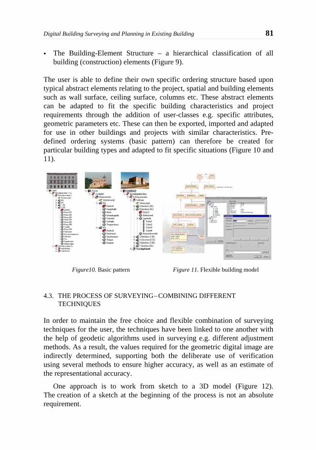
The Building-Element Structure – a hierarchical classification of all building (construction) elements (Figure 9).
The user is able to define their own specific ordering structure based upon typical abstract elements relating to the project, spatial and building elements such as wall surface, ceiling surface, columns etc. These abstract elements can be adapted to fit the specific building characteristics and project requirements through the addition of user-classes e.g. specific attributes, geometric parameters etc. These can then be exported, imported and adapted for use in other buildings and projects with similar characteristics. Pre-defined ordering systems (basic pattern) can therefore be created for particular building types and adapted to fit specific situations (Figure 10 and 11).
Figure10. Basic pattern Figure 11. Flexible building model
4.3. THE PROCESS OF SURVEYING–COMBINING DIFFERENT TECHNIQUES
In order to maintain the free choice and flexible combination of surveying techniques for the user, the techniques have been linked to one another with the help of geodetic algorithms used in surveying e.g. different adjustment methods. As a result, the values required for the geometric digital image are indirectly determined, supporting both the deliberate use of verification using several methods to ensure higher accuracy, as well as an estimate of the representational accuracy.
One approach is to work from sketch to a 3D model (Figure 12). The creation of a sketch at the beginning of the process is not an absolute requirement.

82 Frank Petzold and Dirk Donath
Figure 12. From the sketch to a 3D model
Another approach is to reconstruct surveyed spatial boundaries. This involves taking a collection of measured values and through the provision of supplementary information to create the topography and geometry of the space-defining surfaces (Figure 13).
Figure 13. Reconstructing surveyed spatial boundaries
4.4. CONCEPT AND PROTOTYPES FOR A MODULARISED SYSTEM AND RELATED TOOLS
The system concept follows a modular principle. Oriented around the process of surveying the following sub-systems were conceived:
“Initial site visit” – supports the creation of a building model and definition of the spatial ordering system. The core functionality includes tools to describe the essential elements of the building in a sketch-like or iconic form, both spatially as well as the building’s constructional elements. The capture of both formal and informal information is possible in this phase.The result of this phase is an approximate sketch-like organisation of the spatial structure of the building not necessarily to scale. It can serve as the basis for initial cost estimates or viability analyses.
“Survey” – supports the non-destructive and structured capturing of geometric data and relevant parameters on site. The survey can be undertaken conventionally in two dimensions or in 3D dimensions for use in a 3D model. Input devices include traditional measuring equipment such as measuring stick, distance meter and measuring tape as well as more complex equipment such as theodolites. The survey records the perceived surfaces of rooms and elements. The data captured is therefore often incomplete and not necessarily contiguous. The result is a structured 2D or 3D building model of spatially defined elements, enriched with further planning-relevant information.
“Build-element structuring” – supports the description of a building construction through its structural (load-bearing etc.) building elements and
Digital Building Surveying and Planning in Existing Building 83
their interconnections. The module provides tool, with which surveyed surfaces can be grouped to form building elements of the building’s construction (Petzold, 2001).
In addition to these modules further aspects must be supported, for example sufficient tools to enable the architect to evaluate and prepare the collected data:
Documentation, presentation, transfer to other applications (for example the creation of room and building logs) (Tonn, Wolkowicz, Thurow, Ruth and Donath, 2004)
Navigating and information module (Wender, 2004) Each of the modular sub-systems provide the user with individual tools.
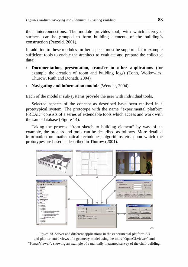
Selected aspects of the concept as described have been realised in a prototypical system. The prototype with the name “experimental platform FREAK” consists of a series of extendable tools which access and work with the same database (Figure 14).
Taking the process “from sketch to building element” by way of an example, the process and tools can be described as follows. More detailed information on mathematical techniques, algorithms etc. upon which the prototypes are based is described in Thurow (2001).
Figure 14. Server and different applications in the experimental platform-3D
and plan-oriented views of a geometry model using the tools “OpenGLviewer” and “PlanarViewer”, showing an example of a manually measured survey of the chair building.

84 Frank Petzold and Dirk Donath
The tools allow the sketch-based, plan-oriented creation of simple building geometries and their adaptation to fit measurements as captured (Figure 15). After the building geometry has been entered in sketch form the system looks for likely geometric abstractions, see Thurow (2004a). Using various different tools manual measurements or measurements obtained through tacheometry or photogrammetry (Luhmann, 2000) can be introduced into the model. The geometry is then adapted accordingly, based on computational adjustment algorithms (Figure 16).
Figure 15. Plan-oriented survey using a
Tablet-PC Figure 16. A room containing
measurements obtained through manual measuring, tacheometry and
photogrammetry
Through the use of a motorised tacheometer with visible laser beam it is possible to compare model and reality in real-scale. The tacheometer rotates to show the location of points in the geometrical model as a laser-beam point in the real building. Another method is the visual comparison between a distortion-corrected photo and the geometry model (Figure 17).
Figure 17. Comparison of coordinate point in the model with the real situation:
a) using a motorised tacheometer with laser beam
b) using a distortion-corrected photo as model overlay
Digital Building Surveying and Planning in Existing Building 85
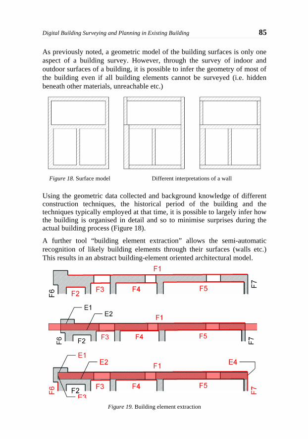
As previously noted, a geometric model of the building surfaces is only one aspect of a building survey. However, through the survey of indoor and outdoor surfaces of a building, it is possible to infer the geometry of most of the building even if all building elements cannot be surveyed (i.e. hidden beneath other materials, unreachable etc.)
Figure 18. Surface model Different interpretations of a wall
Using the geometric data collected and background knowledge of different construction techniques, the historical period of the building and the techniques typically employed at that time, it is possible to largely infer how the building is organised in detail and so to minimise surprises during the actual building process (Figure 18).
A further tool “building element extraction” allows the semi-automatic recognition of likely building elements through their surfaces (walls etc.) This results in an abstract building-element oriented architectural model.
Figure 19. Building element extraction

86 Frank Petzold and Dirk Donath
The information gathered through this process of building-element extraction is, however, somewhat vague in nature and cannot always be applied. Certain structural building elements with differing geometries are not materially separate from one another and cannot strictly be defined as separate elements. The surveyor is able to define where one element begins and the next ends but in such a case this is of arbitrary nature.
For these reasons the following approach has been taken: The identity and geometric description of building elements are separated in their implementation and defined instead through relations (Figure 19). A particular building element is defined in a building class by establishing relations to available surfaces in the model. In order to allow a building element to have its own geometric parameters such as breadth, depth and height, observation objects are introduced. These observation objects examine geometric dimensions from the geometric model of the building and represent these as geometric parameters of the building object. As a result building elements can be created that are defined by a relation to the original model but can be utilised as individual objects e.g. in CAAD systems (Thurow, 2004).
5. Conclusion
An economically viable project realisation necessitates the capture of a particular amount of relevant information. The principal means of obtaining this information is through an initial building survey – an initial site visit – (i.e. room and building-element oriented recording of a building and access routes) and through research into historical documentation and basic geodetic, geotechnical and other basic information regarding the immediate relevant surroundings. All this should be recorded with a view to the envisaged future use of the building and the associated planning requirements. (Kohler, Hermann and Schloeßer, 1999; Kalusche, 2002; Xbau, 2004)
Future research will focus on assessing the data captured. Of particular relevance are modules for supporting financial viability, for supporting the design process and an adequate information presentation module (Petzold, 2004).
The concept described in this paper, as well as the experimental platform discussed here, confirm the relevance of this approach in developing a use-oriented model and information container for planning within existing built contexts.
Digital Building Surveying and Planning in Existing Building 87
References
BMBF: 2001, Living and Building in the 21st Century, <http://www.bauwo.net> (10. August 2004)
BMBF: 2002, Workshop- Living and Building, http://www.bmbf.de/pub/ nachhaltiges _bauen _im_bestand.pdf> (10. August 2004).
BMVBW: 2001, Initiative Architektur und Baukultur – Bundesministerum für Verkehr, Bau- und Wohnungswesen (BMVBW),<http://www.bmvbw.de/architektur-baukultur/> (25 May 2002).
Kalusche, W.: 2002, Projektmanagement für Bauherren und Planer, Oldenbourg Verlag, Oldenbourg.
Kohler, N., Hermann, M. and Schloeßer, D.: 1999, Logoe - Umweltorientierte Planungs-instrumente für den Lebenszyklus von Gebäuden, <http://www.ifib.uni-karlsruhe.de> (10 October 2001).
Luhmann, T.: 2000, Nahbereichsphotogrammetrie - Grundlagen, Methoden und Anwendungen, Herbert Wichmann Verlag, Heidelberg.
Petzold, F. and Donath, D.: 2004, The building as a container of information The starting point for project development and design formulation, in K. Beucke, B. Firmenich, D. Donath, R. Fruchter and K. Roddis (eds), Xth International Conference of Computing in Cuvial and Building Engineering, VDG Weimar, pp. 164-165.
Petzold, F.: 2001, Computergestützte Bauaufnahme als Grundlage für die Planung im Bestand - Untersuchungen zur digitalen Modellbildung, Dissertation at the Bauhaus University Weimar.
SFB 524: 2004, Collaborative research center 524 “Materials and Structure in Revitalization of Buildings”, < http://www.uni-weimar.de/sfb> (10. August 2004).
Thurow, T.: 2001, Prototyp D2-Technical Report, http://infar.architektur.uni-weimar.de/ infar/deu/forschung/tech_report/index.html (15. August 2001).
Thurow, T.: 2004a, A vision of an adaptive geometry model for computer- assisted building surveying, in K. Beucke, B. Firmenich, D. Donath, R. Fruchter and K. Roddis (eds), Xth International Conference of Computing in Cuvial and Building Engineering, VDG Weimar, pp. 140-141.
Thurow, T.: 2004b, Digitaler Architekturbestand - Untersuchungen zur computergestützten, schrittweisen Erfassung und Abbildung der Geometrie von Gebäuden im Kontext der planungsrelevanten Bauaufnahme, Dissertation at the Bauhaus University Weimar, submitted.
Tonn, T., Wolkowicz, C., Thurow, T., Ruth, J. and Donath, D.: 2004, Plausibility in architectural design.– software support for the formal shaping and architect- oriented design of shell structures, in K. Beucke, B. Firmenich, D. Donath, R. Fruchter and K. Roddis (eds), X th International Conference of Computing in Cuvial and Building Engineering, VDG Weimar, pp. 158-159.
Wender, K.: 2004, Preparation and provision of building information for planning within existing built contexts, in K. Beucke, B. Firmenich, D. Donath, R. Fruchter and K. Roddis (eds), Xth International Conference of Computing in Cuvial and Building Engineering, VDG Weimar, pp. 160-161.
XBAU: 2004, Das Projekt OSCI-XBau 1.0 - Standardisierung im elektronischen Austausch von Verwaltungsdaten im Bauwesen, http://www.mediakomm.esslingen.de/ (10. January 2004).