dictionary of southern african place names vir... · introduction 1. standardization of ... m...
TRANSCRIPT
DICTIONARY OF SOUTHERN AFRICAN PLACE NAMES
P E Raper
Head, Onomastic Research Centre, HSRC
CONTENTS
Preface Abbreviations ix Introduction 1. Standardization of place names 1.1 Background 1.2 International standardization 1.3 National standardization 1.3.1 The National Place Names Committee 1.3.2 Principles and guidelines 1.3.2.1 General suggestions 1.3.2.2 Spelling and form A Afrikaans place names B Dutch place names C English place names D Dual forms E Khoekhoen place names F Place names from African languages 2. Structure of place names 3. Meanings of place names 3.1 Conceptual, descriptive or lexical meaning 3.2 Grammatical meaning
3.3 Connotative or pragmatic meaning 4. Reference of place names 5. Syntax of place names Dictionary Place Names Bibliography
PREFACE
Onomastics, or the study of names, has of late been enjoying a greater measure of attention all over the world. Nearly fifty years ago the International Committee of Onomastic Sciences (ICOS) came into being. This body has held fifteen triennial international congresses to date, the most recent being in Leipzig in 1984. With its headquarters in Louvain, Belgium, it publishes a bibliographical and information periodical, Onoma, an indispensable aid to researchers.
Since 1967 the United Nations Group of Experts on Geographical Names (UNGEGN) has provided for co-ordination and liaison between countries to further the standardization of geographical names. To date eleven working sessions and four international conferences have been held.
In most countries of the world there are institutes and centres for onomastic research, official bodies for the national standardization of place names, and names societies.
South Africa has not been lagging behind in this regard. Since 1939 a Place Names Committee (now the National Place Names Committee or NPNC) has seen to the standardization of official place names, while since 1970 the Onomastic Research Centre of the Human Sciences Research Council has undertaken, stimulated and helped to co-ordinate research into names. The
Names Society of Southern Africa was founded in 1981 and has held three national congresses to date. At universities in Southern Africa research into names has been and is being undertaken, particularly at post-graduate level. As a result of all of these onomastic activities, publications have proliferated. However, most of them have been of a specialist nature. Furthermore, general works on names such as C Pettman’s South African Place Names Past and Present (1931, reprinted by Lowry Publishers in 1985) and P J Nienaber’s Suid-Afrikaanse Pleknaam woordeboek (1963, reprinted for the HSRC by Tafelberg in 1972) either do not contain names given during the past fifty years, or are out of print.
This book seeks to provide a semi-popular guide to the major place names in Southern Africa: names of cities, towns, villages, mountains, rivers, promontories, bays, and other cultural and natural features In its compilation the recommendations of the United Nations on Geographical Names and the requirements of the Na t iona l Place Names Committee have been taken into account, while at the same time an attempt has been made to provide accurate, interesting and valuable data for the use of travellers, tourists, cartographers, researchers, and everyone interested in Southern African place names. The introductory chapters are intended not as comprehensive treatises on all aspects of place names, but as brief glimpses into some of the fascinating problems which have occupied linguists, philosophers and onomasticians over the years.
Finally, thanks are extended to all who were involved in the compilation of this work, particularly to Mrs P F Nel and Mrs S S Smit for their assistance with the proof-reading, and to Mrs Smit for helping to compile the bibliography.
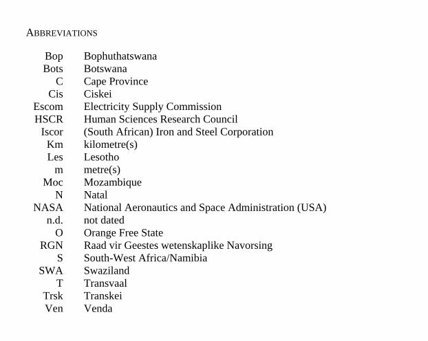
ABBREVIATIONS
Bop Bophuthatswana Bots Botswana
C Cape Province Cis Ciskei
Escom Electricity Supply Commission HSCR Human Sciences Research Council
Iscor (South African) Iron and Steel Corporation Km kilometre(s) Les Lesotho
m metre(s) Moc Mozambique
N Natal NASA National Aeronautics and Space Administration (USA)
n.d. not dated O Orange Free State
RGN Raad vir Geestes wetenskaplike Navorsing S South-West Africa/Namibia
SWA Swaziland T Transvaal
Trsk Transkei Ven Venda
INTRODUCTION
1. STANDARDIZATION OF PLACE NAMES
1.1 BACKGROUND
The place names of Southern Africa present fascinating and intriguing linguistic, cultural, sociological and psychological patterns. The oldest names are those of the San (Bushmen) and Khoekhoen (Hottentots), probably the true indigenous peoples of the country, and those of the African peoples. From the second half of the 15th century, Portuguese, Dutch, English, French, German and other names were given. The evolution of Afrikaans further enriched the geographical nomenclature. Settlement, colonization and immigration, particularly as a result of the exploitation of metal and mineral resources, and of urban and industrial development, added names from Latin, Greek, Hebrew, Italian, Indian and other languages.
As may be expected, cultural and language contact between these peoples is reflected in the place names of the country. Older names were altered, adapted, translated (wholly or in part), and supplanted. Hybrid forms, with part of the name in one language and another part in a different language, came into being. It also happened that many names were spelt in different ways by different people and at different times. Moreover, some individual places came to bear more than one name, bestowed by different language groups.
The variety of forms and spellings resulted in a measure of confusion and some problems in communication, with a concomitant wastage of time, expense and energy.
These and similar problems are, of course, not unique to Southern Africa, but occur world-wide, with greater or lesser ramifications, depending on the linguistic and other relevant conditions applying in the various countries.
1.2 INTERNATIONAL STANDARDIZATION
Efforts towards the international standardization of geographical names date from as early as 1820, when attempts were made to develop a script or alphabet which could be used world-wide to write place names. Since then, various national and international organizations have given attention to the problem of international standardization, inter alia the International Committee of Onomastic Sciences, the International Civil Aviation Association, the Pan American Institute of Geography and History, and similar organizations. In 1953 the Economic and Social Council of the United Nations requested the Secretary-General to draft a framework of a programme aimed at maximum uniformity of writing geographical names, and to set up a small group of consultants to deal with the matter.
In 1960 the United Nations Group of Experts on Geographical Names (UNGEGN) came into being. Since that date eleven sessions of the UNGEGN
have been held, as well as four international Conferences on the standardization of geographical names.
The UNGEGN comprises experts in the fields of cartography and linguistics designated by governments of states at the invitation of the Secretary-General of the United Nations. Experts participating in the sessions of the UNGEGN serve in their personal capacities as individuals of recognized competence and experience in their respective fields. In 1984 the Permanent South African Mission to the United Nations in New York designated Dr P E Raper to represent the Republic of South Africa in the UNGEGN.
The UNGEGN has the task of providing for continuous coordination and liaison between countries to further the standardization of geographical names.
One of the fundamental guidelines for the international standardization of geographical names is that it be based on national standardization.
1.3 NATIONAL STANDARDIZATION
1.3.1 THE NATIONAL PLACE NAMES COMMITTEE
As early as 1936 it was realized that a measure of standardization of place names in South Africa was necessary, and a committee was appointed by the then Minister of the Interior to investigate the situation. At the recommendation of this committee, a Place Names Committee, later to become the National Place Names Committee (NPNC), was appointed in 1939. Comprising experts in the
various languages of the country, onomasticians, and representatives of state departments and academic institutions, this committee has a mandate which includes
(a) the gradual correction of the spelling of all geographical names in the Republic of South Africa;
(b) the approval or rejection of all proposed new place names;
(c) the consideration of all cases where a change of name is desired;
(d) the compilation of dictionaries of geographical names; and
(e) the standardization of foreign place names in Afrikaans.
The work of the NPNC has led to the publication of Official Place Names in the Union and South-West Africa (1951), and Official Place Names in the Republic of South Africa and in South-West Africa (1978), as well as a Manual for the Giving of Place Names (1979). A list of official place names approved between 1978 and 1985 is currently in preparation, while from 1986 the official names approved will be published annually.
All of the above publications, however, deal with official place names, that is, names of cities, towns, townships, post offices, railway stations, sidings, airports, stopping places of South African Transport Services buses, etc.
The compilation of dictionaries of geographical proper names has been entrusted to the Onomastic Research Centre of the Human Sciences Research Council. Since these dictionaries are to include names of cultural entities as well as those of geographical features, and since these names originate in all the various languages spoken in the country, it is clear that the compilation of these dictionaries must be based on intensive scientific research, and that this is a long term undertaking.
The present publication may be regarded as a first step towards the final work. It includes the names of the most important cities, towns, townships, villages, regions, mountains, rivers, lakes, forests, and other features. Where such names have been approved by the NPNC, they have been marked with an asterisk.
1.3.2 PRINCIPLES AND GUIDELINES
One of the primary functions of the NPNC is the recommendation for the approval or rejection of proposed new official place names. In order to facilitate matters for organizations and persons wishing to propose such names, the NPNC has formulated a number of principles and guidelines. These read as follows:
1.3.2.1 GENERAL SUGGESTIONS
1. The following names should be avoided:
(a) Names already existing in the Republic or in South-West Africa;
(b) names of well-known places in other countries;
(c) names having the same or almost the same spellings or having the same pronunciations as or very similar pronunciations to existing names: this would eliminate unnecessary confusion, e.g. in the postal, telegraph or telephone services;
(d) names that are blasphemous, indecent, obscene, vulgar or unaesthetic;
(e) names that are discriminatory or derogatory in regard to race, colour, religion, sex, political affiliation or other social factors;
(f) names that are too long, clumsily compounded or impractical (more especially in view of the limited space available for such names on post office or municipal date-stamps, on railway tickets, on station name boards, etc.);
(g) names that consist of no more than the name of a person and are therefore likely to cause confusion between place and person;
(h) names that are too easily translated and may therefore lead to dual forms;
(i) names that may be interpreted as advertising a specific firm or product.
2. Existing names that are satisfactory and acceptable should not be changed without good reason.
3. Where there is a clear connection between a proposed name and the specific place, e.g., where a motorbus halt is given the name of the farm on which it is situated, or where a post office is given the name of the suburb in which it is situated, the spelling of the new name should be the same as that of the place from which the name has been derived.
4. New names should not be used on name-boards, in advertisements, etc., unless they have been approved by the Committee.
5. It is a known fact that almost any name given to a place will in time, by association or otherwise, become firmly attached to that place. However, for aesthetic reasons, and considering factors such as the population group preponderating in a place or locality, it is advisable for a name with a more appropriate connection with the place or locality concerned to be given right from the start. This can be done by choosing names that are descriptive of local geographical features: names associated with rock formations or the flora and fauna which are or have been characteristic of the locality; names connected with historical figures and/or events; or names associated with the traditions, way of life and background of the local inhabitants, etc.1
1 See the Introduction to Official Place Names in the Republic of South Africa and in South West Africa, compiled by the Place Names Committee (Pretoria, Government Printer, 1978); summarized in Raper, P.E., Nienaber, G.S. and Marais, J.S.B. Manual for the Giving of Place Names (Pretoria, HSRC, 1979). Quotes are from the latter publication, but have been adapted.

1.3.2.2 SPELLING AND FORM
The NPNC has laid down that
(a) The recognized spelling and forms of writing of the language from which the name is derived should be adhered to as far as possible.
(b) Diacritical signs should be used in accordance with the requirements of the language.
A. AFRIKAANS PLACE NAMES
(1) Simplexes
Names consisting of a simplex should not cause any problems.
(2) Compound names
Compound names are normally written as one word. The following two types will serve as examples.
(i) Boesmankop, Bultfontein, Klawerkuil, Koedoedraai, Each of these names consists of two parts which in a non-onomastic context are two nouns. Sometimes the two parts are also linked with an -s, for example in Boesmanskraal, Broedersput, Klawershoek. Note: (i) Sometimes there is uncertainty as to which one a of the following pairs is admissible: laagte or leegte, rand or rant, olien or oliewen, wilge or wilger, et cetera. It is
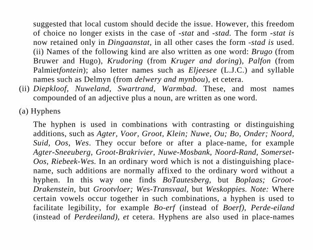
suggested that local custom should decide the issue. However, this freedom of choice no longer exists in the case of -stat and -stad. The form -stat is now retained only in Dingaanstat, in all other cases the form -stad is used. (ii) Names of the following kind are also written as one word: Brugo (from Bruwer and Hugo), Krudoring (from Kruger and doring), Palfon (from Palmietfontein); also letter names such as Eljeesee (L.J.C.) and syllable names such as Delmyn (from delwery and mynbou), et cetera.
(ii) Diepkloof, Nuweland, Swartrand, Warmbad. These, and most names compounded of an adjective plus a noun, are written as one word.
(a) Hyphens
The hyphen is used in combinations with contrasting or distinguishing additions, such as Agter, Voor, Groot, Klein; Nuwe, Ou; Bo, Onder; Noord, Suid, Oos, Wes. They occur before or after a place-name, for example Agter-Sneeuberg, Groot-Brakrivier, Nuwe-Mosbank, Noord-Rand, Somerset-Oos, Riebeek-Wes. In an ordinary word which is not a distinguishing place-name, such additions are normally affixed to the ordinary word without a hyphen. In this way one finds BoTautesberg, but Boplaas; Groot-Drakenstein, but Grootvloer; Wes-Transvaal, but Weskoppies. Note: Where certain vowels occur together in such combinations, a hyphen is used to facilitate legibility, for example Bo-erf (instead of Boerf), Perde-eiland (instead of Perdeeiland), et cetera. Hyphens are also used in place-names
consisting of two words linked by en, for example Haak-en-Steek, Rus-en-Vrede, Hoog-en-Droog.
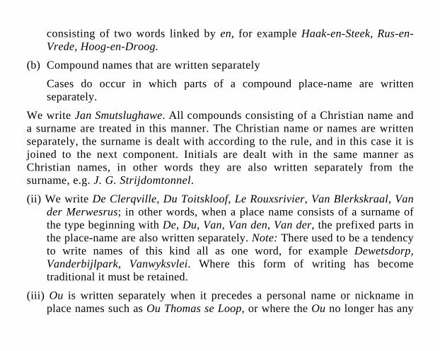
(b) Compound names that are written separately
Cases do occur in which parts of a compound place-name are written separately.
We write Jan Smutslughawe. All compounds consisting of a Christian name and a surname are treated in this manner. The Christian name or names are written separately, the surname is dealt with according to the rule, and in this case it is joined to the next component. Initials are dealt with in the same manner as Christian names, in other words they are also written separately from the surname, e.g. J. G. Strijdomtonnel.
(ii) We write De Clerqville, Du Toitskloof, Le Rouxsrivier, Van Blerkskraal, Van der Merwesrus; in other words, when a place name consists of a surname of the type beginning with De, Du, Van, Van den, Van der, the prefixed parts in the place-name are also written separately. Note: There used to be a tendency to write names of this kind all as one word, for example Dewetsdorp, Vanderbijlpark, Vanwyksvlei. Where this form of writing has become traditional it must be retained.
(iii) Ou is written separately when it precedes a personal name or nickname in place names such as Ou Thomas se Loop, or where the Ou no longer has any
distinguishing or contrast value, for example Ou Handelspos. Note: Compare this to what was said under “hyphen” above.
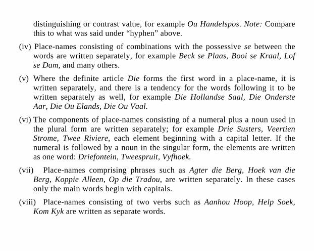
(iv) Place-names consisting of combinations with the possessive se between the words are written separately, for example Beck se Plaas, Booi se Kraal, Lof se Dam, and many others.
(v) Where the definite article Die forms the first word in a place-name, it is written separately, and there is a tendency for the words following it to be written separately as well, for example Die Hollandse Saal, Die Onderste Aar, Die Ou Elands, Die Ou Vaal.
(vi) The components of place-names consisting of a numeral plus a noun used in the plural form are written separately; for example Drie Susters, Veertien Strome, Twee Riviere, each element beginning with a capital letter. If the numeral is followed by a noun in the singular form, the elements are written as one word: Driefontein, Tweespruit, Vyfhoek.
(vii) Place-names comprising phrases such as Agter die Berg, Hoek van die Berg, Koppie Alleen, Op die Tradou, are written separately. In these cases only the main words begin with capitals.
(viii) Place-names consisting of two verbs such as Aanhou Hoop, Help Soek, Kom Kyk are written as separate words.
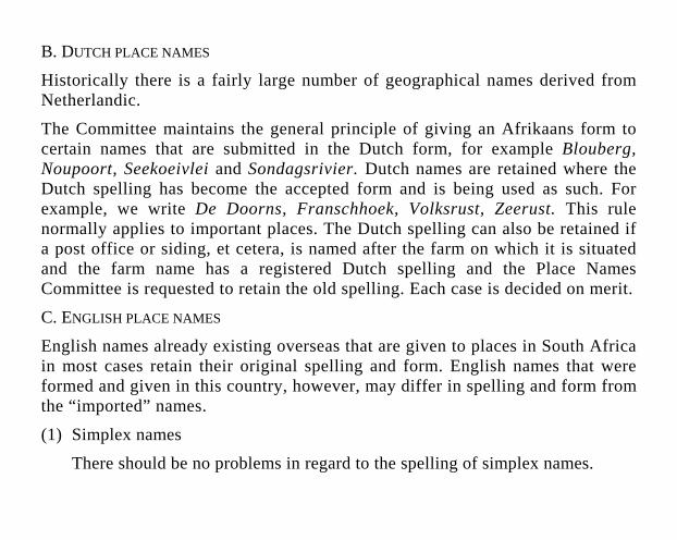
B. DUTCH PLACE NAMES
Historically there is a fairly large number of geographical names derived from Netherlandic.
The Committee maintains the general principle of giving an Afrikaans form to certain names that are submitted in the Dutch form, for example Blouberg, Noupoort, Seekoeivlei and Sondagsrivier. Dutch names are retained where the Dutch spelling has become the accepted form and is being used as such. For example, we write De Doorns, Franschhoek, Volksrust, Zeerust. This rule normally applies to important places. The Dutch spelling can also be retained if a post office or siding, et cetera, is named after the farm on which it is situated and the farm name has a registered Dutch spelling and the Place Names Committee is requested to retain the old spelling. Each case is decided on merit.
C. ENGLISH PLACE NAMES
English names already existing overseas that are given to places in South Africa in most cases retain their original spelling and form. English names that were formed and given in this country, however, may differ in spelling and form from the “imported” names.
(1) Simplex names
There should be no problems in regard to the spelling of simplex names.
(2) Compound names
It is not easy to provide guidelines for the spelling of compound English place-names. In practice a certain degree of irregularity is found in the writing of such place-names. For example, names ending in crest, end, gate, hill, view, may be written either as one word or as two. Thus are encoun-tered Wavecrest but Leisure Crest; Teaksend but Flats End; Westgate but North Gate; Foxhill but Calf Hill; Redhouse but Blue House; Aloeridge but Gravel Ridge; Bayview but Mountain View. The Place Names Committee has studied the written form of English place-names in South Africa. An analysis of certain types of word combinations has indicated that in some cases a pattern, or at least a tendency, can be discerned in the writing of English place-names.
(a) Names that are written separately
The following types of place-names are normally written as separate words:
(i) most names of which the first part is one of the following adjectives: Bonny, Golden, Lower, Old, et cetera; New, Rocky, Sweet, et cetera. Examples are Bonny Rest, Golden Grove, Lower Adamson, Old Place; New Centre, Rocky Hill, Sweet Hope;

(ii) names in which the generic term is still strongly felt as a common noun, e.g. Amatole Basin, Algoa Bay, Brighton Beach, Nagle Dam, Albert Falls, Cape Flats, Bretby Mine, Table Mountain, Sand River, Berg River Valley;
(iii) most names of which the second part is a plural noun, e.g. Birch Acres, Beecham Woods, Broken Slopes;
(iv) names with Crown, Fort, Loch, Mount and Port as the first part, e.g. Crown Reefs, Fort Beaufort, Loch Maree, Mount Frere and Port Alfred;
(v) names of which the second part indicates the situation, e.g. Beaufort West, Boksburg North, Modder East, Randfontein South;
(vi) names consisting of a numeral plus a noun, e.g. Four Pines, Three Sisters, Twenty Four Rivers;
(vii) names consisting of Glen plus a personal name, e.g. Glen Karen, Glen Lynden;
(viii) phrases used as place names, e.g. Ascot on Vaal, Henley on Klip, Ebb and Flow, The Hole in the Wall;
(ix) names of which the first part is written with an apostrophe, e.g. Davey’s Halt, Gordon’s Bay, Eagle’s Crag, Lion’s Head;
(x) names consisting of the abbreviation St plus a proper name, e.g. St Andrew’s, St Mark’s.
(b) Names written as one word
The following kinds of place-names are normally written as one word:
Names ending in bourne, bury, combe, dene, hurst, lea, leigh, mere, wick, et cetera. For example Ashbourne, Woodbury, Ashcombe, Forestdene, Meadhurst, Birchleigh, Buttermere, Thornwick, et cetera;
(ii) names beginning with Broad, Cross, Gay or Middle, e.g. Broadlands, Crossmoor, Gayridge, Middlebrook;
(iii) names beginning with Bal, Brae, Clan, Craig, Dal, Holm, Pen, Sel, Strath, et cetera. For example Balcraig, Braeview, Clanville, Craigend, Dalview, Holmleigh, Pendale, Selcourt, Strathcona, et cetera;
(iv) names composed of syllables or parts of names or words, such as Atcem from (Atlas Cement Company), (Coronation Brick), Navex (Navarro Exploration), Soweto (South Western Townships).
D. DUAL FORMS
In South Africa where English and Afrikaans are the official languages, one may expect a large number of place-names that are used in the one language also to be used in a translated form in the other language. In the course of time dual forms of names have established themselves for the same places.
Three kinds of translations can be differentiated, viz.
(a) names of which all the parts are translated, e.g. Bloedrivier - Blood River; Coffee Bay - Koffiebaai; Drieankerbaai - Three Anchor Bay, et cetera;
(b) names of which both parts are ordinary words in the language concerned, but only the second part is translated, e.g. Bergrivier - Berg River; Melkbosrand - Melkbos Ridge, et cetera;
(c) names of which the first part is a personal name and the second a generic term, e.g. Boshoffweg - Boshoff Road; Caledonplein - Caledon Square.
In terms of the country’s policy of bilingualism the members of each language group have the right to insist on the form they use in the natural context of their own language. For official purposes, however, precedence may be given to one form, that is, the “first of the two equals”. This precedence is based on the derivation and linguistic composition of the name, its age, the population group preponderating in the locality concerned, et cetera.
We write Brighton North, but Randfontein-Suid. In combinations of this kind the precedence form in the first type is normally English, and in the second, Afrikaans. In the first type the main word is derived from English, in the second from Afrikaans. The part of the name which indicates the name type or the point of the compass, or which constitutes a descriptive addition will be indicated in the same language as the main word in the precedence form. Thus we write Bay Road (Bayweg), Bergrivier (Berg River), Oos-Rand (East
Rand). The precedence form is given in italics. Combinations of which the first part is a word derived from an indigenous language are written as one word if the second part is Afrikaans, and as two words if the second part is English, e.g. Gamtoosrivier, Kaya Fort.
E. KHOEKHOEN (HOTTENTOT) PLACE NAMES
The Khoekhoen languages have become virtually extinct within the borders of the Republic. The possibilities of these languages producing any new place-names are therefore very slight. There is, however, a large number of farms and other places with Khoekhoen names of which some may be submitted to the National Place Names Committee for approval as official names. The following principles will apply in such cases.
(a) Khoekhoen place names are normally written as one word.
(b) Diacritical signs to indicate pitch, nasalization, et cetera, are not rendered in writing.
(c) Clicks are not indicated.
(d) Established forms of spelling, such as Henkries, Kango, Knysna, are left unchanged.
(e) Spelling should be changed as little as possible except that at the end of a name:
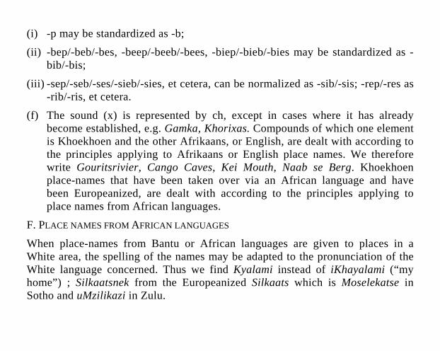
(i) -p may be standardized as -b;
(ii) -bep/-beb/-bes, -beep/-beeb/-bees, -biep/-bieb/-bies may be standardized as -bib/-bis;
(iii) -sep/-seb/-ses/-sieb/-sies, et cetera, can be normalized as -sib/-sis; -rep/-res as -rib/-ris, et cetera.
(f) The sound (x) is represented by ch, except in cases where it has already become established, e.g. Gamka, Khorixas. Compounds of which one element is Khoekhoen and the other Afrikaans, or English, are dealt with according to the principles applying to Afrikaans or English place names. We therefore write Gouritsrivier, Cango Caves, Kei Mouth, Naab se Berg. Khoekhoen place-names that have been taken over via an African language and have been Europeanized, are dealt with according to the principles applying to place names from African languages.
F. PLACE NAMES FROM AFRICAN LANGUAGES
When place-names from Bantu or African languages are given to places in a White area, the spelling of the names may be adapted to the pronunciation of the White language concerned. Thus we find Kyalami instead of iKhayalami (“my home”) ; Silkaatsnek from the Europeanized Silkaats which is Moselekatse in Sotho and uMzilikazi in Zulu.
Firmly established or traditionally adapted African language place-names in White areas remain unchanged, e.g. Congella, Illovo, Isando, Umbogintwini, et cetera.
Names of places in self-governing territories and in urban areas inhabited by Blacks are written in accordance with the officially recognized orthography of the language concerned. The diacritical signs of the languages are also written in place-names in these areas. Personal names and surnames used in or as place-names are also spelled in accordance with the recognized orthography.
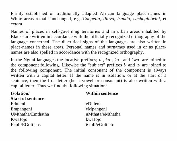
In the Nguni languages the locative prefixes; o-, ku-, ko-, and kwa- are joined to the component following. Likewise the “subject” prefixes i- and u- are joined to the following component. The initial consonant of the component is always written with a capital letter. If the name is in isolation, or at the start of a sentence, then the first letter (be it vowel or consonant) is also written with a capital letter. Thus we find the following situation:
Isolation/ Within sentence Start of sentence Eduleni eDuleni Empangeni eMpangeni UMthatha/Emthatha uMthata/eMthatha KwaJojo kwaJojo IGoli/EGoli etc. iGoli/eGoli etc
Ga and Ha in the Sotho languages are written as one word with the following component; both the Ga/Ha and the next component begin with capital letters, for example GaDikgale, GaRankuwa.
In Tsonga Ka and eka and the component following them are written as separate words, for example eka Mpofu, eka Mhinga.
In Venda Ha and the personal name following it are written as one word. The Ha begins with a capital letter and the personal name with a small letter, e.g. Hamasia, Hamakuya.
Kwa in the Sotho languages is regularly omitted before place names.
When a place-name consists of a contraction or an abridgement of more than one word, it is written as one word, e.g. Thabatshweu, iNtabankulu.
2. STRUCTURE OF PLACE NAMES
Generally speaking, it may be stated that the structure of place names varies according to the language of origin of the names. Khoekhoen names, for instance, are characterized by masculine endings -b or -p and feminine endings -s, thus Goab, Neip, Goms. In addition, they may include locative morphemes such as -se, -si, -re, -ri, -te, -ti, -be, -bi, -bee, etc, which generally occur in the penultimate position, as in Nababeep, Komtes, Gobabis, Gobaseb.
Toponyms from the African languages are characterized by locative prefixes such as Sotho Ga (GaDikgale), Nguni Kwa (KwaMashu), Venda Ha (Hamasia), Tsonga eKa (eKa Mhinga), or by prefixes and suffixes, such as Nguni o-ini (Otobotim), e-ni (Edulini), o-eni (Obenjeni), etc.
What seems to be a universal feature of place names is that some are compounded, consisting of more than one element, while others are non-compounded, consisting of one element. Examples are Springs as opposed to Table Mountain. Compounded names apparently preponderate. By and large, too, names of natural features seem more often to be descriptive and consequently lexically transparent, while names of cultural features are more often derived from personal names, inversions, acronyms, anagrams, etc.
Compounded names generally consist of a term indicating the type of feature to which the name refers (mountain, river, etc.), and a term which describes, qualifies or modifies it. The former is known as the generic term (or generic) and the latter the specific term (or specific).
An analysis of place names has indicated that the generic term usually refers to elevations and depressions, the presence of water, or settlement, demarcation, allocation or division of land. Thus occur names such as Attakwas Mountains, Enselsberg, Girinaris, Thaba Bosiu; Bonnievale, Gamkaskloof, Otjikoto, Tsubgaos; Albert Falls, Bronkhorstspruit, Nossob, Manzimnyama; Bellville, Boland, Nuhub, Roggeveld, Windhoek.
Specific terms are usually of a more varied character. They may be descriptive of colour (Blouberg, Heigariep), size (Great Fish River, Klein-Karoo), or shape (Gouib, Spitskop, Table Mountain); they may refer to fauna or flora encountered there (Crocodile River, Gamka, Taung; Knysna, Umhlume, Wilge River); they may be descriptive of the type of soil or rock (Duineveld, Kalk Bay, Modder River); they may refer to climatological conditions (Cold Bokkeveld, Noagore, Terra dos Bramidos); they may refer to people in authority (Colesberg, Land van Waveren) or to owners of land (Adendorp, Odendaalsrus) or someone who had a link with the place (Daveyton, Trappe’s Valley).
Because the original lexical meaning is irrelevant in toponyms, a generic term is sometimes not regarded as a word with meaning, and another, different generic may be added to the name; or else a new generic may be added to an existing name to indicate an extended entity. Thus names occur such as Breede River Valley, Karkloofrivier, Fairmount Ridge.
Hybrid place names are those in which elements from more than one language occur, eg Hout Bay, Kei Mouth, Buffalo Nek. Sometimes a generic term from a specific language is added to an existing name already containing a generic. In such instances tautology may occur, eg Cheridouws Poort, Nossob River, Heidelberg Hills, Waterkloof Glen.
The converse may, of course, also happen, namely that the generic term is omitted altogether, eg The Dargle (River), Knights (Station), Warden (Town). In such cases the names are said to display a zero generic term.
It will be noted that in most cases, and in most languages, the specific term precedes the generic, as in Piketberg, Soetap, Westville. Examples of names in which the generic term precedes the specific are Amanzimtoti, Lake Mentz, Mount Frere, Ntababovu, Port Beaufort, Thabatshweu.
3. MEANINGS OF PLACE NAMES
3.1 CONCEPTUAL, DESCRIPTIVE OR LEXICAL MEANING
A cursory glance at any reasonably comprehensive list of place names will probably indicate a number of things. Firstly, it will be noted that each name consists of a word, or of more than one word. Secondly, some of the names will immediately be ‘understandable’, or apparently semantically transparent, while others will be semantically opaque. Thirdly, each name will be the appellation of a particular place or geographic entity.
Several comments on these observations may be in order. Place names, or ‘toponyms’, as they are also called, are proper names. As is the case with common names, or common nouns, each consists of a spoken or written form and an internal content, sense or meaning. A name also refers to, or denotes, an extra-linguistic entity.

There may be a number of reasons why the ‘meaning’ of a name is not readily discernible. The name, or a part of the name, may be in an unknown language; the name may be so old that the word(s) from which it is derived is or are no longer in current use; or the name may have been so greatly adapted (some say ‘corrupted’) that it is no longer recognizable.
In addition to the fact that there are names which do not have a readily discernible meaning, there are also names the meanings of which are not relevant to the entities, eg geographical names used for cultural features. These and similar considerations have prompted linguists, philosophers and others to ask the question whether names have meaning at all. Some scholars maintain that proper names, including place names, have no meaning, while others aver that names are the most meaningful of all words.
Names are an integral part of language, and a primary function of language is to communicate. It would therefore seem to be unreasonable to assume that names have no meaning at all. Yet some clearly do not appear to ‘mean’ very much, except to indicate what a particular place is called. The solution to the problem seems to lie in what is meant by ‘meaning’.
Normally the meaning of a common name may be determined by consulting a dictionary. Thus the Concise Oxford Dictionary (6th edn, 1980, p 712) gives the meaning of mountain as, inter a1ia, ‘large natural elevation of earth’s surface, large or high or steep hill, esp. one over 1 000 ft. high’. This definition will hold
for every mountain, and a mountain can be defined in terms of these characteris-tics, which are applicable to all members of the class of mountain. No such definition is possible for a proper name. Rietfontein may appear to mean ‘reedy fountain’, but when it is the name of a suburb of Pretoria, or of a post office, that is not, or no longer, its meaning.
In the above cases what is meant by ‘meaning’ is dictionary meaning, also termed logico-semantic, lexical, descriptive or conceptual meaning. Most scholars today maintain that proper names do not have current lexical meaning. Yet Table Mountain immediately calls to mind the idea of a mountain in some way resembling a table, namely being flat on top; Blue Lagoon obviously refers to the colour of such a feature. If, on the other hand, current lexical value were a prerequisite or defining characteristic of a name, Cango, Namib, Nossob, Parys and others would not qualify as such.
The problem may be solved by distinguishing between synchronic and diachronic meaning. Synchronic meaning is that which is discernible in the name at a (the present) point in time, diachronic meaning that which may be discerned by viewing the name through the course of time. Synchronically, names are generally regarded as being devoid of lexical or conceptual meaning. Diachronically, when a name is viewed as being derived from (a) descriptive common noun(s), the etymological meaning may be either discerned or traced. Thus an apparently transparent name is homonymous with its appellative counterpart. For place names such as these, which have counterparts which are
common nouns or appellatives (Table Mountain as opposed to ‘table mountain’), the terms appellative name or semi-appellative name have been coined. At which stage a common noun like ‘(the) pine grove’ becomes a proper name like Pinegrove, cannot always be determined. But when it does attain this status of a proper name, the dictionary meaning becomes irrelevant. Thus a name like Coldstream, originally applied to a brook in which there is cold water, is also applied to a post office and a town. Rietfontein, originally ‘a fountain at which reeds grow’, has also become a residential suburb, a farm, a hospital, and so forth.
In the course of time the lexical or dictionary meanings of the common nouns underlying the place names may become forgotten, but the name itself survives. Thus there are place names still existing derived from languages which have died out, and of which even the peoples who spoke these languages no longer exist. In such cases research is necessary to trace the etymology.
The determination of that etymology has been described as only the first step in onomastic investigation. Yet it is often an indispensable step. Too often have name scholars fallen into the trap of assuming that a name means what it seems to mean. Take a name like Koppies, for example. Patently derived from Afrikaans, this name could mean ‘hillocks’, ‘little heads’ or ‘cups’. Since Koppies is a geo-graphical name, one would presume the meaning to be ‘hillocks’. One would be wrong. Referring to a place in the Northern Cape, the name Koppies is derived from a San or Khoekhoen word meaning ‘wild sage’ (Tarchonanthus camphoratus).
Similarly, an obviously English name such as The Coombs is not English at all, but Khoekhoen; it means ‘river of wild olive trees’ (Olea africana).
Thus the examples could proliferate. Armoed is not derived from Afrikaans, nor is Koringhuis, Aap se Kloof or Katjiesberg. Goodhouse is not English. Any onomastician who takes a name at face value runs the risk of talking or writing nonsense. Onomastics is not a guessing game.
A lovely example of misunderstanding is the following. In the Northern Cape is a hill with the Khoekhoen name Goariep. This name has correctly been explained in English as ‘granite boss’. Not being familiar with the word boss in the sense of ‘protuberance’, the editor of an Afrikaans publication has translated it as ‘graniet-baas’, literally ‘granite master’, from a homonym of boss!
Meaningless words are alien to language, and the human mind when confronted with sounds which seem familiar, will imbue those sounds with what it conceives to be the correct and appropriate content or meaning. Thus folk-etymological adaptations of names such as those above come into being, and thus incorrect etymologies of names are sometimes given.
In this publication the etymologies have been furnished as encountered in various sources. Some of them, such as those of the Khoekhoen and Zulu names, are based on research and may be regarded as reliable. In other cases the most likely or most acceptable etymology (or the only one available) has been given.
Sometimes more than one possibility has been mentioned. It is trusted that this publication will serve as the basis for further toponymical study.
3.2 GRAMMATICAL MEANING
If lexical or descriptive meaning is absent in place names, grammatical meaning, which involves such aspects as number, case and gender, is only peripherally present. It has been stated that names are always definite. Definiteness is linked to existence of the referent, not existence in reality, but existence in the realm of interpretation of speaker and hearer. Thus a place name like Xanadu or Jurie Steyn’s Post Office is just as valid as Pretoria or Zeerust.
The notion of definiteness implies that a name cannot be used, for example, with an indefinite article. If one speaks of ‘a Johannesburg’, ‘another Vrededorp’, and so forth, the notion behind these utterances concerns the characteristics of the entities bearing the name. It has been said that in such phrases the proper names are being used as common names.
A second aspect of place names is that they are always inherently singular or, to be more specific, each proper name selects and identifies, in a particular context, an individual member of a discrete set. Apparent plurals, such as Die Spitskoppe, The Crags and so forth, are felt to be collectives and therefore singular.
3.3 CONNOTATIVE OR PRAGMATIC MEANING
As has been stated above, some authorities maintain that names are the most meaningful of all words. If, as has been shown, names generally contain virtually no descriptive or lexical meaning, something else must be meant. That something is connotative meaning, that is, the connotations that come to mind when a name is heard or read. These associations attach themselves to the name via the feature to which the name refers, the extra-linguistic entity bearing the name. This connotative or associative meaning is subjective, being dependent on one’s knowledge of the place. Thus the name Durban may call to mind an experience in a particular hotel, the beach and all its attractions, the Bluff, the Esplanade, the rickshas, the milling crowds, shark-nets, oil-polluted shores, a honeymoon, or whatever. To someone who does not know the place, it will have as little meaning as, say, Muressa. To this category of meaning belong such factors as social standing (it is ‘better’ to live in Houghton than in Mayfair), stigma (Watergate), and so forth.
Thus, depending on one’s background knowledge of a place, the name of that place may have an infinite number of connotations differing from speaker to speaker, though in the case of better-known entities some of these associations may be shared.
4. REFERENCE OF PLACE NAMES
The most important function of a place name is to refer to an entity; that is, to select one particular entity from a host of others of a similar or different nature, and to identify it and distinguish it from others.
If the name Stellenbosch is used in a particular context, speaker and listener will normally both realize that the university town 48 km east of Cape Town, famous for its wine estates and oak trees, is being referred to. This use of place names to refer to one specific, unique entity in a particular context led some scholars to speak of a name as referring individually or uniquely. These terms were later misunderstood; it was thought that what was meant was that a name can have only one referent, such as Popocatepetl is supposed to have. In actual fact few, if any, names have only one referent and, if that were to happen, there is nothing preventing that name from being bestowed on another entity and destroying its uniqueness.
What is meant by referring individually or uniquely, is that, in a specific context, only one entity is referred to when a particular name is used. Thus no matter how many places there are with the name, say, of Nooitgedacht, when this name is used, it will refer to only one specific place within that particular context.
5. SYNTAX OF PLACE NAMES
When speaking of the syntax of names, a distinction should be made between internal and external syntax. By the former is meant the grammatical relationships embedded in the name itself. Thus the internal syntax of Cisiqua would be something like ‘river, the water of which has a salty flavour’, ie ‘salt(y) river’; that of Champagne Castle would be ‘mountain with a shape reminiscent of a castle, on which an altercation arose over a bottle of champagne’. It is clear from these examples that the internal syntax of place names differs widely from that of common nouns, and that it presents an intriguing field of study.
By the external syntax of place names is meant the relationship between these names and other items in the same utterance, sentence or construction. The criteria most often proposed as appertaining to place names are
(i) that they are not used in the plural;
(ii) that they do not accept modifying restrictive relative clauses; and
(iii) that they do not occur with the range of articles available to common nouns.
As regards the first of these statements it has been argued that, because place names are inherently definite, they must always be singular. Most names, indeed, have a singular form, eg Krugersdorp, Randfontein, Table Mountain. They may, however, have a plural form, eg Springs, Twenty-four Rivers. In such instances,
however, it has been pointed out that the name is a collective plural, a pluralia tantum. Springs, originally the term for a number of fountains, has become the name of a town; Twenty-four Rivers is the name of a single river with a number of channels, also used for other features; Outeniqua Mountains refers to a mountain range. In a statement such as ‘There are four hundred Rietfonteins in Transvaal’, Rietfonteins is not a plural name; what is meant is ‘There are four hundred places called Rietfontein in Transvaal’.
The second thesis, namely that place names do not accept modifying restrictive relative clauses, has been the object of some contention. At this juncture it would seem that place names differ to a considerable extent from, for instance, personal names in this respect, and that any conclusions would have to be based on an analysis of a representative body of information. Factors such as the occurrence of names including the definite article (eg The Heads) would need to be taken into account, since the syntactical use of such names may be different in certain instances from that of names which do not contain a definite article. The behaviour of place names in conjunction with adjectives or restrictive phrases, too, promises to yield interesting results.
The question of articles used in conjunction with place names is a complex one. In a number of instances the definite article is part of the name, eg The Coombs, in other cases the definite article is expressed as a zero article; in other words, it does not appear in speech or writing. However, in certain syntactic constructions the definite article may be explicit, particularly when modifiers are employed;
compare ‘the Mayfair I remember’, ‘the beautiful Orange Free State’, ‘the fairest Cape in all the world’.
It is generally accepted that place names do not take indefinite articles, because place names are inherently definite. In utterances such as a Benoni, a different Vrededorp, the place names are said to be employed as common nouns, ie referring to characteristics of the entity bearing the name.
This particular distinction is a very nebulous one, however, and the last word on the subject has still to be spoken.
From what has been said above, it will be clear that the various aspects of place names are intricately interwoven. For many years scholars have studied them and made certain pronouncements. In a number of cases a measure of clarity has been achieved; in other instances the confusion and fuzzy thinking persists or has been aggravated. It has not been my intention to solve problems here, but to highlight a number of salient features in the hope that interest may be stimulated and our own place names studied with the intensity names in other countries have enjoyed.
DICTIONARY
1. NOTES ON THE ENTRIES
The entries take the following form.
1.1 Names appear in bold characters. Officially approved names are preceded by an asterisk. Names printed bold within the text are dealt with at the relevant alphabetical place and may be referred to.
1.2 Situation of the entity or feature to which the name refers appears in brackets.
(a) The letter or abbreviation reference indicates administrative division - see Abbreviations.
(b) The four-figure reference indicates latitude and longitude. Thus 2829 means 28°S., 29°E. The reference is always to the north-western corner of the one-degree square.
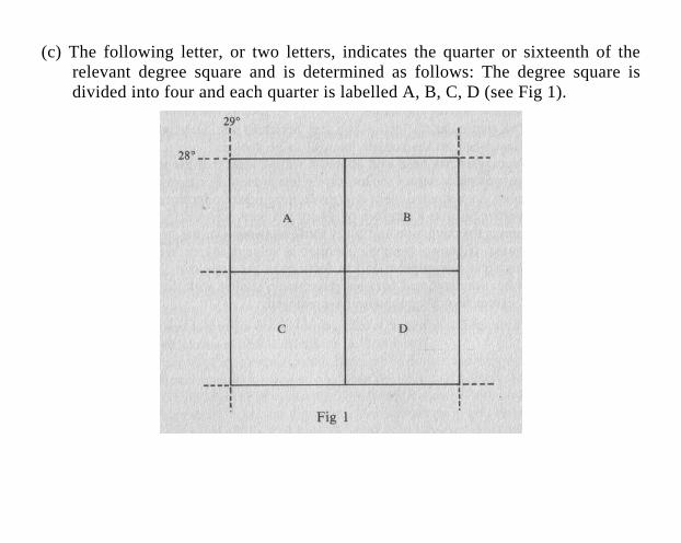
(c) The following letter, or two letters, indicates the quarter or sixteenth of the relevant degree square and is determined as follows: The degree square is divided into four and each quarter is labelled A, B, C, D (see Fig 1).
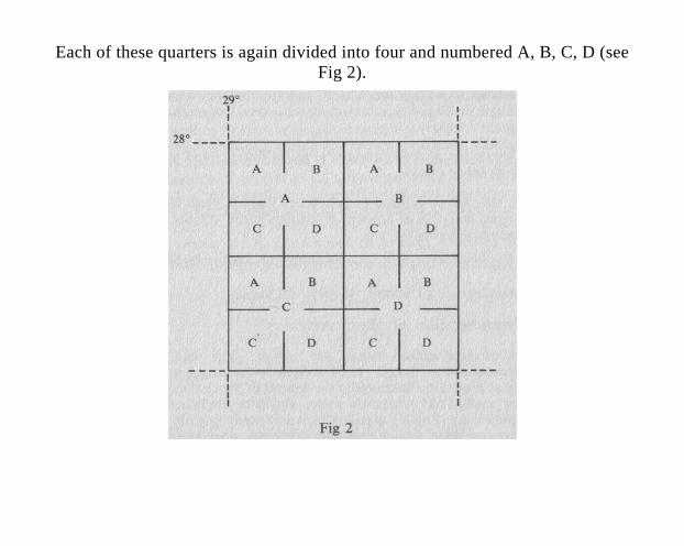
Each of these quarters is again divided into four and numbered A, B, C, D (see Fig 2).
For example reference 2829 AA means that the relevant feature is situated in the large block A, and in the smaller block A of that block; 2829 DB means the feature is in the large block D and in the smaller block B within the block D. The alphabetical reference is thus to the quarter-degree block (30’), and then to the sixteenth-degree block (15’).
This method of indicating the situation serves another purpose as well. The various official map-sheets compiled by the Directorate of Surveys and Mapping are referred to in terms of degree square. Thus reference numbers for 1:50 000 maps are, for example, 2728 AA Elandskop, 2729 CC Hopedale, etc. The location indicator given between brackets thus also serves as a guide to the map-sheet on which the name of the feature can be found. References without the alphabetical indicators (eg 2728) are to larger-scale maps (1:250 000 Topographical and Topo-cadastral).
1.3 Description of feature, that is, indication of the topographic category such as city, island, mountain, river, township, village, etc.
1,.4 Description of the location in terms of distance and direction from other entities.
1.5 In the case of cultural or man-made features, such as cities, towns, etc, a brief account of establishment, official status, historical highlights, etc.
1.6 Language of origin of the name’(if other than English). 1.7 Meaning and (if known) origin of the name.
2. PRONUNCIATION OF PLACE NAMES
2.1 When geographical names are spoken, they tend to be pronounced as though they belonged to the language of the speaker or to the language in the context of which they are being used. Thus Afrikaans names would be anglicized when spoken by English-speaking persons, and English names pronounced as though they were Afrikaans when pronounced by Afrikaners.
2.2 This tendency is particularly strong in the case of Khoekhoen since the Khoekhoen languages are no longer extant in the Republic of South Africa. Thus not only are the suction consonants or clicks omitted, but the original pitch (high, middle, and low) is ignored, and the names are pronounced as though they were Afrikaans or English. This phonological adaptation is sometimes reflected in the orthography.
2.3 Geographical names derived from the various African languages, too, are adapted phonologically (and orthographically) to Afrikaans and English.
2.4 In view of the complexity of the phonological situation, it has been deemed advisable to dispense with an indication of pronunciation of place names at this stage.

3. TRANSLATION OF GENERIC TERMS
The translation of Afrikaans generic terms is sometimes not given in the text. Thus, for example, Van Wyksvlei is explained as having been named after a farmer with the surname Van Wyk. For a fuller understanding of such names, the reader is referred to the following list of Afrikaans generics with their approximate translations.
A word of caution is in order, however. Because the topography and climate of Southern Africa differ from those elsewhere in the world, the terms used to explain the Afrikaans generics are not precise. A vlei, for example, is actually a hollow in which water may collect during rainy seasons, but the term may also be used for a marsh, swamp or bog. The designation ‘swamp’ for Dronkvlei, for example, does thus not necessarily signify a permanent swamp.
aar underground watercourse akker field, plot of land
baai bay bad bath, (mineral) spring
bank shelf berg mountain bron spring bult hillock, ridge, rise
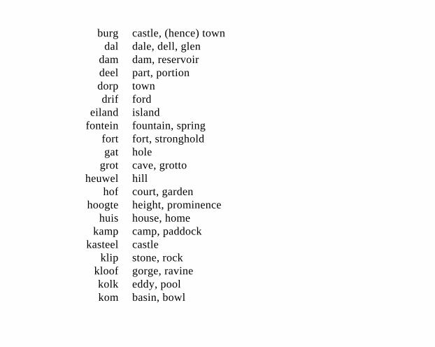
burg castle, (hence) town dal dale, dell, glen
dam dam, reservoir deel part, portion dorp town drif ford
eiland island fontein fountain, spring
fort fort, stronghold gat hole
grot cave, grotto heuwel hill
hof court, garden hoogte height, prominence
huis house, home kamp camp, paddock
kasteel castle klip stone, rock
kloof gorge, ravine kolk eddy, pool kom basin, bowl
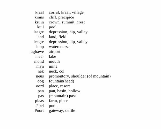
kraal corral, kraal, village krans cliff, precipice kruin crown, summit, crest
kuil pool laagte depression, dip, valley
land land, field leegte depression, dip, valley
loop watercourse lughawe airport
meer lake mond mouth
myn mine nek neck, col
neus promontory, shoulder (of mountain) oog fountain(head)
oord place, resort pan pan, basin, hollow pas (mountain) pass
plaas farm, place Poel pool
Poort gateway, defile
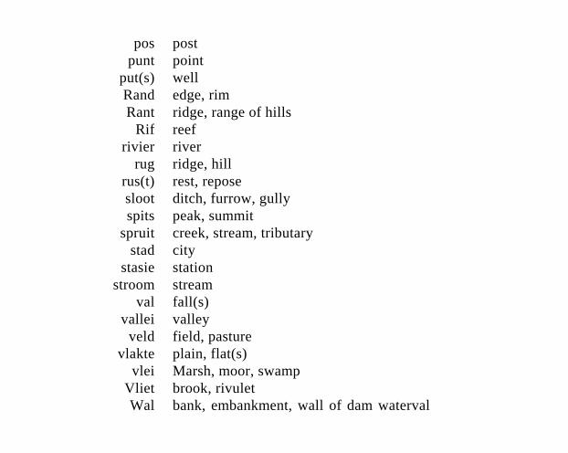
pos post punt point
put(s) well Rand edge, rim Rant ridge, range of hills
Rif reef rivier river
rug ridge, hill rus(t) rest, repose sloot ditch, furrow, gully spits peak, summit
spruit creek, stream, tributary stad city
stasie station stroom stream
val fall(s) vallei valley
veld field, pasture vlakte plain, flat(s)
vlei Marsh, moor, swamp Vliet brook, rivulet Wal bank, embankment, wall of dam waterval
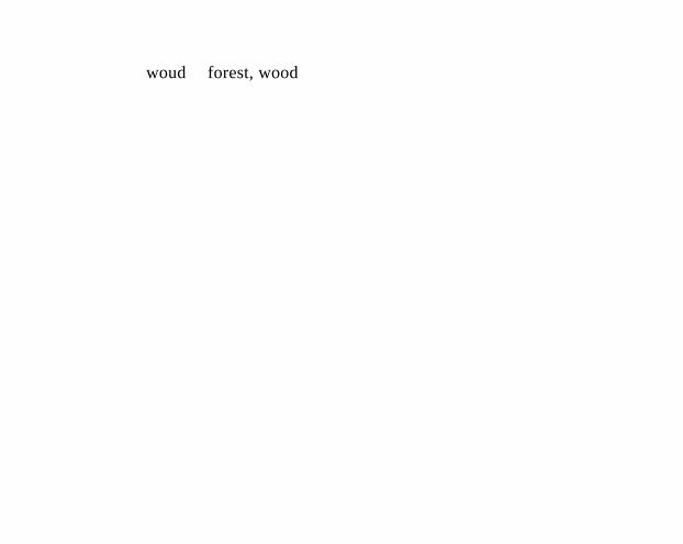
woud forest, wood
PLACE NAMES
A Abel Erasmus Pass (T 2430 DA). Mountain pass some 11 km long between Hoedspruit and Ohrigstad. Named after a well-known farmer and civil servant from the days of the Transvaal Republic. The J G Strijdom Tunnel forms part of the pass.
*Abenab (S 1918 AC). Village some 32 km north of Grootfontein. It came into being in 1921 to serve a mine producing lead, vanadium and zinc, which closed down in 1958. Of Khoekhoen origin, the name is said to mean ‘climbing river’.
*Aberdeen (C 3224 AC). Town some 55 km south-east of Graaff-Reinet, 155 km east-south-east of
Beaufort West, 32 km south of the Camdebo Mountains. Laid out on the farm Brakkefontein as a settlement of the Dutch Reformed Church in 1856, it became a municipality in 1858. It is named after Aberdeen in Scotland, birthplace of the Reverend Andrew Murray of Graaff-Reinet, relieving minister.
Abna (C 3421). Khoekhoen name for the Vals River, tributary of the Gourits River. The Afrikaans name, meaning ‘false river’, is a direct translation.
Acacia Park see Akasiapark
*Acornhoek (T 2431 CA). Village some 29 km south-east of Hoedspruit and 165 km north-west of Komati-poort. The name is variously explained as being an adaptation of Eekhoornhoek (‘squirrel corner’);
derived from the German surname Eichhorn, and named after the acorn-like fruits of the mabula tree.
*Adams Mission (N 3030 BB). Settlement west of Amanzimtoti and south of Durban, in the Umlazi district. Established in 1836, it was destroyed by Dingaan but rebuilt in 1839. Named after the American missionary Dr Newton Adams who arrived in Natal in 1835 and who played a prominent role in respect to this mission. Adams Mission is an important educational institution.
*Addo (C 3325). Region east of the Sundays River, some 72 km north-east of Port Elizabeth. In 1931 about 680 ha were enclosed to form the Addo Elephant National Park. The name is also borne by a railway sta-tion, post office and bridge. Of
Khoekhoen origin, the name proba-bly means ‘euphorbia ravine’.
*Adelaide (C 3226 CB). Town some 22 km east of Bedford, 37 km west of Fort Beaufort and 91 km north of Grahamstown. Founded as a military post in 1834, it gradually developed until it achieved municipal status in 1896. It was named after Queen Adelaide, wife of William IV of England.
Adendorp (C 3224 BC). Village some 8 km south of Graaff-Reinet, in the Sundays River Valley. Named after the former owner of the farm, N J Adendorff, who sub-divided it into smallholdings in about 1858. Muni-cipal status was attained in 1878.
Agter-Bruintjieshoogte (C 3226). Region north of Bruintjieshoogte, embracing the upper reaches of the
Little Fish River. Named after Nic de Bruyn, or De Bruin, former heem-raad of Swellendam.
Agterwitsenbergkom (C 3319). Region in the Ceres district, meaning ‘basin behind the Witsenberg’. See Witsenberg.
Aguada de Sâo Bras (C 3422). Portuguese name of Mossel Bay, given by Vasco da Gama on 26 November 1497. ‘The watering-place of St Blaize’, so called because Da Gama filled his casks with fresh water there on the name-day of St Blaize. Cape St Blaize takes its name from this bay.
Agulhas (C 3420 CC). Coastal resort near Cape Agulhas, some 32 km south of Bredasdorp. Portuguese for ‘needle’, the name is said to have been given to the cape because the
compass-needle was seen to point due north, that is, with no magnetic deviation. The Agulhas Bank is reputed to be the richest fishing area in the Southern Hemisphere.
Agulhas, Cape see Cape Agulhas
Aiab (S 2417/2517). Khoekhoen name of the Lewer rivier, ‘liver river’, which is a direct translation.
*Ai-Ais (S 2717 DC). Holiday resort with hot mineral springs, in the bed of the Fish River, some 128 km west of Karasburg and 224 km south-west of Keetmanshoop. From Khoekhoen /Ae-/aes, ‘firefire’, ie ‘hot as fire’.
Aigams (S 2217 CA). Nama name for Windhoek. From /ae, ‘fire’, //gams, ‘water’, the name refers to the hot springs there.
Aigams (S 2818 BD). Nama name of Warmbad. From lael/gams, ‘fire (hot) water’, the name refers to the hot springs there.
Airob (S 2417/2517). Khoekhoen name of Lewer rivier, ‘liver river’, a translation.
Akasiapark (C 3318 DC). Residen-tial area for civil servants, members of Parliament and railway officials, laid out on part of Wingfield, a former naval aerodrome. Named Sassar from 1947 to 1 December 1959, then Acacia Park, after the Port Jackson willows (Acacia cyanophylla) growing there.
Albania (C 2824). Region bounded by the Orange River in the south, the Vetberg line in the north, the Vaal River in the west and the Rama-
Belmont line in the east. Named after Albany.
Albany (C 3325). Region established on 7 January 1814 by Sir John Cradock (1762-18I1), Governor of the Cape Colony from 1811 to 1812. Bounded by the Great Fish River in the north, Bruintjeshoogte in the south, the Bosberg in the west and the Suurberg in the east. Named in honour of the Duke of York. Formerly this was the Suurveld.
Albasini Dam (T 2330 AA). Dam at the foot of the Soutpansberg, named after Joao Albasini (?-1885), head of the Magwamba tribe, Vice-Consul for Portugal and superintendent of the African peoples in the Soutpans-berg under the ZAR.
Albert (C 3026). Region between the Stormberg and the Orange River,
embracing approximately the present districts of Albert, Wodehouse and Aliwal North. Named after the consort of Queen Victoria.
*Albert Falls (N 2930 AD). Water-fall in the Umgeni River, 22 km north-east of Pietermaritzburg and 13 km west-south-west of New Han-over. Probably named after the consort of Queen Victoria. It is also the name of a railway station 30 km from Pietermaritzburg.
*Albertinia (C 3421 BA). Village 50 km west of Mossel Bay. It was laid out in 1900 on the farm Groot-fontein and became a municipality in 1920. The name is derived from the surname of Johannes Rudolph Albertyn (1847-1920), the first Dutch Reformed minister to serve the community.
*Alberton (T 2628 AA). Town 6 km south-west of Germiston and 11 km south-east of Johannesburg. It was laid out on the farm Elandsfontein in 1904 and attained municipal status in 1939. Named after General Hendrik Abraham Alberts, chairman of a syndicate which purchased the estate in 1904.
*Alexander Bay (C 2816 CB-DA). Cove on the west coast, 7 km south of the mouth of the Orange River, in the Namaqualand district. Named after Sir James Edward Alexander (1803-1885), British officer and explorer.
*Alexandra (T 2628 AA). Township some 13 km north-east of Johannes-burg. Presumably named after Queen Alexandra, wife of King Edward VII of England.

*Alexandria (C 3326 AB). Town some 112 km north-east of Port Elizabeth. Originally Olifantshoek, the name was changed in 1873 to Alexandria, after Alexander Smith, a Scottish minister of the Dutch Reformed Church in Uitenhage.
Alfred County (N 3029). Region bounded by the districts of Mount Currie, Umzimkulu, Ixopo, Port Shepstone and Bizana. Named after Prince Alfred, son of Queen Victoria, who visited Natal in 1860.
Algoa Bay (C 3325 DD). Large inlet on the Indian Ocean, between Cape Padrone and Cape Recife, on which Port Elizabeth is situated. Named Angra da Roca by Bartolomeu Dias in 1488, subsequently renamed Bahia da Lagoa, which was corrupted to Algoa Bay. Of Portuguese origin, the name means ‘marsh bay’,
*Alice (Cis 3226 DD). Town on the Tyume River, some 120 km north-west of East London. It was named in 1847 by the Governor, Sir Peregrine Maitland, after Princess Alice, the second daughter of Queen Victoria. Municipal status was attained in 1852.
*Alicedale (C 3326 AC). Village in the Albany district, some 42 km west of Grahamstown. Named after Alice Slessor (née Dale), wife of the engi-neer who constructed the railway.
Aliwal North (C 3026 DA). Town on the banks of the Orange River, some 195 km from Bloemfontein, on the road to East London. It was founded in 1849 and named by the Governor of the Cape Colony, Sir Harry Smith (1847-1852), to comme-morate his decisive victory over the Sikhs under Runjeet Singh at Aliwal

in India on 28 January 1846. Munici-pal status was achieved in 1882.
Aliwal South (C 3422 AA). Alterna-tive name about 1850 for Mossel Bay.
*Alkmaar (T 2,530 BD). Hamlet on the Crocodile River, some 18 km west of Nelspruit. Named after a town in the Netherlands, 32 km north-north-west of Amsterdam.
*Allanridge (O 2726 DC). Gold-mining town 14 km north of Oden-daalsrus and 34 km north of Welkom. It was founded in 1950 and is administered by a village manage-ment board. Named after Allan Roberts who interested himself in prospecting for gold in the OFS.
*Amajuba (N 2729 BD). Also Majuba; mountain 14 km south-west of Volksrust and 32 km north of
Newcastle; the scene of an historic battle in the First Anglo-Boer War. The name is derived from Zulu and means ‘hill of many doves’. It has given its name to the post office Amajuba and the railway station Majuba.
*Amalienstein (C 3321 AD). Former mission station of the Berlin Missionary Society, 22 km east of Ladismith, on the road to Calitzdorp. Named after Amalie von Stein, bene-factress of German missions.
Amandelboom (C 3120 BD). Origi-nal name of Williston. Afrikaans for ‘almond tree’, it refers to the situation of the Rhenish mission station from which the town devel-oped, and was used from 1845 to 1919.
*Amanzimtoti (N 3030 BB). Town and holiday resort on the South Coast, 29 km south-west of Durban. It was founded in 1928, proclaimed a township in 1939 and became a borough in 1952. In 1961 Amanzim-toti, Isipingo Beach and Isipingo Rail were amalgamated into a. single municipality. Named after the Manzimtoti River; the name is derived from Zulu and means ‘sweet water’ or ‘the water is sweet’.
Amatikulu (N 2931 BA). Town some 130 km north-east of Durban, near Gingindlovu. Named after the Matigulu, also spelt Amatikulu, River. From Lala or Zulu, probably ‘large water’, ie ‘large river’. The approved form is aMatikulu.
*Amatole (Cis 3227 DB). Mountain range, subsidiary of the Winterberg range, 15 km north-east of Alice and
between Seymour and Stutterheim, extending westwards to the Great Fish River. The name is of Xhosa origin and means ‘weaned calves’.
Ameis (S 2718 CB). Khoekhoen name of Grunau, which is a trans-lation: ‘green surface’, ‘green face’.
*Amersfoort (T 2729 BB). Town 56 km south of Ermelo and 72 km south-east of Bethal, on the banks of the Schulpspruit. It was founded in 1876 and proclaimed in 1888. Named after the city Amersfoort in the Netherlands by its founder, F Lion Cachet.
Amphlett (N 2929 AB). Hill on the ridge leading to Cathkin Peak, 50 km west of Estcourt. Named after G T Amphlett, president of the local mountain club in 1908.
Amstel (C 3418 AA). Name applied until 1657 to the Liesbeek River, after the canal flowing through Amsterdam in Holland.
Amsterdam (O 2728 CD). Original name of Reitz.
*Amsterdam (T 2630 DA). Town some 77 km east of Ermelo. Part of a Scottish settlement established by Alexander McCorkindale, it was proclaimed a town in June 1881. At first called Roburnial the name was changed on 5 July 1882 to Amster-dam, after the Dutch city where the State Secretary, Eduard Bok, was born, and out of gratitude for Dutch sympathy during the First Anglo-Boer War (1880-1881).
Amsterdam Flats (C 3325). Region between the Swartkops and Coega rivers, near Port Elizabeth. Named
after the Dutch East India Company ship Amsterdam which was wrecked on 15 December 1817. The settle-ment Amsterdamhoek was also named after that ship.
Andalusia (C 2724 DD). Former name of Jan Kempdorp. Named after Andalusia in Spain.
Anenousberg (C 2917 BC). Moun-tain some 56 km north of Springbok, in the Namaqualand district. Derived from Khoekhoen !Nani #nus, ‘the side of the mountain’. *Anerley (N 3030 CB). Holiday resort some 111 km south-west of Durban and 10 km north-east of Port Shepstone. Said to be named after a district in the south-east of London.
Angra da Roca (C 3325). Bay now known as Algoa Bay, thus named in 1488 by Bartolomeu Dias.
Angra das Vaccas (C 3421 BD). Old name for Vleesbaai. Named after the cows the Portuguese mariners saw grazing there.
Angra das Voltas (S 2615 CA). Former name of Luderitz Bay. Por-tuguese for ‘bay of tacks’, the name was given in 1488 by the Portuguese mariner Bartolomeu Dias because contrary winds caused them to make many tacks there.
Angra dos Ilheos (S 2615 CA). Now Lüderitzbucht. ‘Bay of little islands’, named by Dias; subse-quently Angra Pequena, ‘penguin harbour’ and Lüderitzbucht.
Angra dos Vaqueiros (C 3421 BD). Now Mossel Bay. ‘Bay of herds-men’; thus named by Dias because he saw many cattle on the shore. Renamed Aguada de Sâo Bras
(‘watering-place of St Blaize’) by Vasco da Gama in 1497 and Mossel-baai by Paulus van Caerden in 1601.
Angra Pequena (S 2615 CA). Now Liideritzbucht. ‘Small bay’.
Anhalt-Schmidt (C 3323 CB). Sta-tion of the Berlin Missionary Society in the Uniondale district. Named after the missionary Schmidt who in 1737 began to work among the Hottentots, and his birthplace in Moravia, Anhalt.
Anis (S 2317 AC). Nama name of Rehoboth, meaning ‘smoke’, from the steam seen at the hot springs on winter mornings.
*Anysberg (C 3219-3320). Moun-tain range west of the Little Swart-berg, forming portion of the northern boundary of the Ladismith district. Named either after aniseed (Pimp-
inella anisum), ‘anys’ in Afrikaans, or after an anise-scented buchu (Diosma vulgaris).
*Apiesrivier (T 2528). River which has its source in the Fountains Valley and flows through Pretoria. Said to have been named after the large numbers of vervet monkeys which lived in the trees on its banks between Daspoort and the Fountains Valley. An alternative derivation is that it takes its name from Tshwana (‘the little monkey’), son of and successor to Musi, chief of a branch of the Nguni tribe which settled in the Transvaal some 350 years ago at the time of the Nguni migration to Natal. The Ndebele name is Enzwa-buklunga, Enzwabuhlungu or Entsabotluku, from en Zubuh-lungu, ‘the one that hurts’, ‘painful’, after the sharpness of the stones.
*Aranos (S 2419 AA). Village in the Gibeon district, on the banks of the Nossob, some 176 km from Mariental. Supplanted the name Arahoab owing to confusion with Aroab. Derived from Arahoab and Nossob.
*Ariamsvlei (S 2819 BB). Village with post office and railway station, between Keetmanshoop and Upington, 16 km west of Nakop. The name is derived from Khoekhoen, # ari am, ‘raisin-bush (Grewia) fountain’.
Armoedsweiding (C 3421). Region abutting on the Vals River, probably where Weltevreden is now situated. Thus named on 26 January 1689 by Isaq Schrijver. ‘Poor grazing’, ‘pasturage of poverty’.
Arniston (C 3420 CA). Village officially known as Waenhuis-krans, named after the British troopship Arniston which was wrecked in Marcus Bay some 40 km north-east of Cape Agulhas on 30 May 1815 with the loss of 372 lives, and with 6 survivors.
*Aroab (S 2619 DC). Village some 170 km east of Keetmanshoop. The name is derived from Khoekhoen # aro (Zizyphus mucranatus) and !ab, ‘river’, after this type of thorn-tree growing on the banks.
Arthur, Lake see Lake Arthur
Artjesvlei (C 3419). Region in the Hermanus district, bounded by the Babilonstoring range in the north and the Kleinrivierberge in the south. Named after the wild peas growing there, the name was used
from about 1870. Also Atchasvlei, now Ertjiesvlei.
*Asab (S 2517 BD). Settlement some 100 km south of Mariental. Derived from Khoekhoen, the name means ‘new place’.
Asbestos Mountains (C 2823). Moun-tains in the Hay district, formerly known as Rooiberge, a term now only applied to the hills north of Tsineng. Known. in Afrikaans as Asbesberge, which has the same meaning.
Asherville (N 2930 DD). Township some 8 km north-west of Durban city hall. Named after a former city councillor, Mrs Mary Asher, who was particularly interested in the welfare of the Indian population.
*Ashton (C 3320 CC). Town at the foot of the Langeberg, 10 km south-west of Montagu and 19 km east-
south-east of Robertson. It was established in 1897 on the farm Roodewal and attained municipal status in January 1956. Named after the first station-master.
*Asrivier (O 2828 AD). River some 8 km south-east of Bethlehem which flows into Loch Lomond. Afrikaans for ‘axle river’, the name was given because the axle of a wagon broke at a ford here during the Great Trek, causing some delay.
Attaquas Kloof (C 3321 DD). Ravine some 43 km north-west of Mossel Bay. Named after the Attaqua group of Khoekhoen. Variants of the name include Atquaskloof, Attakwaskloof, Artaquas and Hartequaskloof. There is also an Attaquaskloof 23 km south-west of Caledon (C 3419 AC-AD).
Attaquas Mountains (C 3321). Mountain range between George and Mossel Bay. Named after the Attaqua group of Khoekhoen, it is also encountered as Attakwasberge.
*Atteridgeville (T2528 CA). Town-ship 11 km west of Church Square in Pretoria, established in 1939 and named after Mrs M P Atteridge, Chairman of the City Council’s Committee for Non-European Affairs at that time.
Auas Mountains (S 2217 CA). Range some 56 km long, part of the Damara-land Highlands, in the Windhoek district. Derived from Khoekhoen, the name is said to refer to a type of tree growing there which bears small, hard, red berries.
Augrabies Falls (C 2820 CB). Waterfall in the Orange River,
40 km north-west of Kakamas, 88 km west of Upington. From Khoekhoen (Korana), probably ‘hollow place’. Formerly the names King George’s Cataract and Hercules Falls were given but did not survive. The Afrikaans form Augrabieswaterval has been approved.
*Augrabieswaterval see Augrabies Falls
*Auob (S 2418-2620). Tributary of the Nossob, which it joins at Twee Rivieren at the Botswana border after ‘flowing’ south-east for some 560 km past Stampriet, Gochas, Eindpaal and Mata Mata. The name is of Khoekhoen origin and means ‘bitter river’.
*Aurora (C 3218 CB). Town 43 km north-west of Piketberg and 29 km
south of Redelinghuys. Established in 1906, it was named after the Roman goddess of dawn.
Aurora Peak (C 3127). Slightly east of the Drakensberg. After the Roman goddess of dawn, it is said to be so named because of its situation in the Eastern Cape, and because it is one of the first peaks to catch the rays of the rising sun.
*Aus (S 2616 CB). Village some 125 km east of Luderitz and 114 km west of Konkiep (Goageb). The name is derived from Khoekhoen and probably means ‘snake fountain’, ‘place of snakes’. Aus became a municipality in 1949.
*Avontuur (C 3323 CA). Town some 13 km south-east of Union-dale. Afrikaans for ‘adventure’, the origin of the name is obscure. The
river from which the town takes its name was known thus in 1778.
B *Babanango (N 2831). Mountain 38 km north-west of Melmoth. Said to have been named after an incident in which the child of a Zulu chief of the Buthelezi tribe was lost in the mist. He was found by his brother who called ‘Baba nango!’ - ‘Father, there he is!’ An alternative explana-tion is that the name is derived from that of a tree or shrub, ibabanango, but existing dictionaries list no such word. The name is also borne by a stream.
*Babanango (N 2831 AC). Town some 58 km north-west of Melmoth. Founded in 1904, it probably takes its name from the geographical features nearby, the stream and the mountain.
Babilonstoring (C 3318 DB). Mountain at the entrance to the Paarl Valley, between Stellenbosch and Paarl. The name, bestowed prior to 1690 and also encountered as Babylons Toren, means ‘tower of Babel’; the reference is to its height.
*Badplaas (T 2530 DC). Health resort with hot sulphur springs near the Buffelspruit, 48 km east of Carolina on the road to Barberton. Known to the indigenous people as Emanzana, ‘healing waters’. Dis-covered in 1876, it was proclaimed state property on 6 November 1893. In December 1947 it was proclaimed a township. The name is Afrikaans, derived from Dutch, and means ‘bathing place’, ‘spa’.
Bahia de Sâo Francisco (C 3425 AA). ‘Bay of St Francis’, now St Francis Bay. This Portuguese name
was given by Perestrelo to Golfo dos Pastores, ‘bay of the shepherds’.
Bahia dos Vaqueiros (C 3421 BD). Former name of Fish Bay; given by Bartolomeu Dias in February 1488, meaning ‘bay of the cowherds’.
Bahia Formosa (C 3423 AB). Now Plettenberg Bay. Meaning ‘beautiful bay’, it was given this name in 1576 by the Portuguese navigator Manuel de Mesquita Perestrelo.
Bain’s Kloof Pass (C 3319 CA). Mountain pass over the Drakenstein range 29 km west-north-west of Worcester, between the Breede River Valley and Wellington. Started in 1849 and opened in Sep-tember 1853. Named after its builder, Andrew Geddes Bain (?-1864), road engineer, explorer and geologist.
*Bain’s Vlei (0 2926 AA). Settle-ment on the road to Kimberley, situ-ated 8 km west of Bloemfontein, Named after the owner, Andrew Hudson Bain, who bought it in 1849. Bakens River (C 3325 CD). River near Port Elizabeth. Afrikaans, originally Dutch; ‘beacon river’, so called because Ensign August Beutler erected a beacon at its mouth when demarcating the terri-tory of the Dutch East India Company in 1752. It also served as a beacon for sailors seeking the landing-place. The spellings Baak-ens, Baaker and Baker are also encountered.
Bakoven (C 3418 AB). Settlement on the west coast of the Cape Peninsula, south of Camps Bay. ‘Baking oven’, possibly after an off-
shore rock of that shape; the name is Dutch in origin.
Balelasberg (N 2730). Branch of the Drakensberg, named after an Amahlubi chief, Langalibalela, who lived there, ‘The scorching (libalele) sun (langa)’.
*Balfour (C 3226 DA). Village at the foot of the Katberg. Established as a station of the Glasgow Mission-ary Society in 1828 by John Ross and McDiarmid, and named after Robert Balfour, first Secretary of the Society.
*Balfour (T 2628 DA). Town and post office, some 80 km southeast of Johannesburg, Established on the farms Vlakfontein No. 101 and No. 108 which belonged to Frederick Stuart McHattie, and named McHattiesburg after him in 1897.
Proclaimed on 16 February 1898, it was renamed Balfour on 15 February 1905, after Arthur James Balfour, Prime Minister of Great Britain, 1902-1905, who visited South Africa in that year.
Bamboesberg (C 3126). Mountain range south-east of Steynsburg and north-east of Hofmeyr; an extension westward of the Stormberg Range. ‘Bamboo mountain’, probably from the Cape bamboo (Arundinaria tesselata) growing in the ravines, used in former times for whip handles.
*Bandelierkop (T 2329 BD). Village some 35 km south-west of Louis Trichardt, on the route from Pietersburg to Beit Bridge. Afrikaans for ‘bandolier hill”; said to have been named after an incident in which a burgher, Jan du Preez,
was sent back to fetch the bandolier he had left behind when the commando struck camp.
*Banghoek (C 3318 DD). Mountain glen near Helshoogte. Said to have been so named because lions and tigers presented a danger at night and caused people to be afraid (Afrikaans ‘bang’), and because the dangerous Helshoogte had to be crossed. The Banghoek Mountains take their name from this glen.
Bantry Bay (C 3318 CD). Exten-sion of Sea Point, Cape Town, where the coast becomes rocky and precipitous, 6 km west of Cape Town. Formerly called Botany Bay. Possibly named after Bantry Bay in Ireland.
*Barberspan (T 2625 DA). Pan or depression containing water, 20 km
from Delareyville. Some 3 km wide and 11 km long, it receives its water when the Harts River, next to which it is situated, overflows. Afrikaans for ‘barbel depression’, after that type of fish. The pan was proclaimed a nature reserve in 1949.
*Barberton (T 2531 CC). Town at the foot of the Makonjwa Moun-tains, 45 km south-west of Nelspruit. Named after Graham Hoare Barber (1835-1888) who discovered a rich gold-bearing reef there in 1884. Became a municipality in 1904.
*Barkly East (C 3027 DC). Town some 116 km south-east of Aliwal North. Laid out in 1874 on the farm Rocky Park and named after Sir Henry Barkly, Governor of the Cape from 1870 to 1877. Became a municipality in 1881.
*Barkly Pass (C 3127 BB). Mountain pass 10 km long over the southern Drakensberg, between Barkly East and Elliot. Named after Sir Henry Barkly, Governor of the Cape, 1870-1877.
*Barkly West (C 2824 DA). Town on the Vaal River, some 36 km north-west of Kimberley. Formerly known as Klipdrift, it began as a camp for alluvial diamond diggers in 1869. In 1870 it was named Barkly West, after Governor Sir Henry Barkly. Occupied by Boer forces for four months during the Second Anglo-Boer War and re-named Nieu-Boshof. Became a municipality in 1881.
Barmen (S 2216 B). Former mission station of the Rhenish Missionary Society, 24 km from Okahandja, established in 1844 as
Neu-Barmen. Named after the headquarters of the Society at Barmen in Germany; now Gross-Barmen.
*Barrydale (C 3320 DC). Village on the Tradouw River, 42 km north-east of Swellendam. Named after Joseph Barry, a merchant well known in the 19th century. Became a municipality in 1921.
*Bashee (Trsk 3128 CD). Popular adaptation of Mbashe; occurs as a station name, in Bashee Bridge, etc.
*Basuto Hill (O 2829 AC). Hill on the west bank of the Wilge River, 5 km south-south-west of Harri-smith. Named in memory of the murder by Matselaan of H O Dreyer and J Simbeeck on 29 March 1866. He was believed to be a member of
the Basotho (Basuto), but in fact he was a Zulu.
*Bathurst (C 3326 DB). Town on the Kowie River, 55 km southeast of Grahamstown and 15 km north-west of Port Alfred. Founded in 1820 and named after Lord Bathurst, Secre-tary of State for the Colonies, by Sir Rufane Donkin (1733-1841), Acting Governor of the Cape at that time.
Baviaanskloof (C 3323-3324). Ravine 161 km long in the Baviaanskloof Mountains. Dutch, ‘baboons ravine’, from the large numbers of baboons encountered there.
Baviaanskloof (C 3419 BA). Original name of Genadendal, station of the Moravian Missionary Society in the Caledon district. The
name is of Dutch origin and means ‘baboons ravine’.
Baviaansrivier (C 3226). River in the Somerset district. The name is Dutch for ‘baboons river’, translated from the Khoekhoen Gomee. Also encountered as Prehns Rivier, Bobotyana and Incwama.
Baynes Mountains (S 1712 BA-BB). Mountain range in the northern part of South-West Africa, border-ing the Kunene River. Named after Maudslay Baynes, the first white man to follow the Kunene basin on foot from the Ruacana Falls to the west of the mountains, which he did in 1911.
Bay’s Hill (T 2528). Hill near Pretoria; named after the Queen’s Bays, a British regiment in the
Second Anglo-Boer War (1899-1902).
*Beaufort West (C 3222 BC). Town 573 km from Cape Town, established in 1818 on the farm Hooyvlakte. Named by Lord Charles Somerset, Governor of the Cape, 1814-1826, after his father, the fifth Duke of Bedford. Became the first municipality in South Africa on 3 February 1837.
Bechuanaland (C 2623). Region north and south of the Molopo River. After 1880 the districts of Gordonia, Kuruman, Mafeking, Taung and Vryburg became known as British Bechuanaland. In the nineties Gordonia developed as an independent district, and the area north of the Molopo became Bechuanaland Protectorate. Named after the BaTswana, popularly called
Bechuana or, in Afrikaans, Betsjoe-ana.
*Bedford (C 3226 CA). Town 85 km south-east of Cradock. Founded in 1854 on part of the farm Maasstrom which belonged to Sir Andries Stockenström, and named by him after the Duke of Bedford. Became a municipality in 1856.
*Bedfordview (T 2628 AA). Township 7 km from Germiston and 11 km from Johannesburg, east of the latter. Laid out as agricultural plots on the farm Elandsfontein under the name Geldenhuis Estate Small Holdings. The name was changed on 4 February 1926 to Bedfordview, after Bedford Farm, the property of Sir George Storrar, which could be seen from there.
Bega River (C 3326 CB-DA). Tributary of the Bushmans River, rising north-west of Alexandria and flowing eastwards along the border between the Alexandria and Bath-urst districts. Of Khoekhoen origin, the name probably means ‘milk-wood (river)’.
Belekazana (C 3226 DB/3227 CA). Xhosa name for Hogsback. Derived from ulu-beleka, ‘carry on the back’, because the hill resembles a mother carrying a child on her back.
*Belfast (T 2530 CA). Town some 210 km east of Pretoria, situated in the foothills of the Drakensberg. Established in 1890 on the farm Tweefontein, and named after Belfast in Ireland, birthplace of John O’Neill, father of Richard C O’Neill, owner of Tweefontein. Be-came a municipality in 1966.
*Bell (C 3327 AB). Village 30 km south-east of Peddie and 80 km south-west of East London. Named after Charles Davidson Bell (1813-1882), Surveyor-General in 1857.
Bell’s Kop (T 2630 BD). Hill 82 km east of Ermelo. Named after Robert Bell, resident Justice of the Peace for the Ermelo district who, with 12 constables, was murdered by Bekana and his Swazi followers while collecting tax which the Swazis, living on farms allocated to Scottish settlers, refused to pay.
*Bellville (C 3318 DC). Town 19 km east of Cape Town and 10 km south of Durbanville. Originally known as Twelve Mile Stone, after its distance from Cape Town, it received its present name in 1861. Named after Charles Davidson Bell, Surveyor--General of the Cape from
1848 to 1872; it became a municipality in 1940.
Ben Dearg (C 3127 BB). Peak 2 770 m high in the Drakensberg, 27 km north-east of Elliot. Named after Ben Dearg in Scotland, which it resembles.
*Benoni (T 2628 AB). Town 29 km east of Johannesburg and about 8 km north-west of Brakpan. It developed from a gold-mining camp. Named by Johann Rissik, the surveyor who was experiencing difficulty with this piece of uitvalgrond - land between occupied farms - in 1881, after the biblical Benoni, son of Rachel (Gen. 35:18). The name is Hebrew and means ‘son of my sorrows’. Became a munici-pality in 1907.
*Berea (Les 2927 BC). Station of the French Missionary Society, established in 1843. Scene of British victory over the Basotho under Moshesh in 1852 and of a battle in 1865 between the Basotho and Orange Free State forces under General Fick. The origin of the name is biblical (Acts 17:10-11) and refers to the place to which Paul and Silas were sent. Subsequently it became fashionable for an elevated site and is borne by suburbs of Durban and Johannesburg.
*Berg River (C 3218). River rising in the Jonkershoek Mountains 15 km south-east of Stellenbosch, and at Assegaaibos near Franschhoek, and debouching into the Atlantic Ocean in St Helena Bay near Velddrif, 129 km north of Cape Town. The name is encountered in Van
Riebeeck’s journal of 15 November 1657. Given by Abraham Gabbema in 1657, the name means ‘mountain river’ and refers to the seemingly impenetrable range of mountains at the foot of which it flows in a northerly direction. It formerly bore the name Rio de Santiago or Santiaguo. The form Bergrivier is preferred for official purposes.
Berg River, Little (C 3319). Tributary of the Berg River. Rises near Tulbagh and joins the Berg River south-east of the Twenty-four Rivers at the farm Mond van de Kleine Bergrivier. The name was given by Pieter Cruythoff’s expedi-tion on 7 February 1661.
Bergriviervallei (C 3318). Region bounded in the east by the Draken-stein Mountains and in the west by Paarlberg. First settled and culti-
vated in 1687 when Governor Simon van der Stel allocated 33 farms of 51 ha each. Afrikaans for ‘mountain river valley’, it takes its name from the Berg River which flows through it.
*Bergville (N 2829 CB). Town on the Tugela River, 52 km southwest of Ladysmith and 19 km north-west of Winterton. It was laid out in 1895 on the farm Klein Waterval and became a municipality in 1961. The name was given in 1903 and refers to its situation at the foot of the Drakensberg, popularly known as The Berg.
*Berlin (C 3227 DC). Village some 20 km east of King William’s Town. Founded in 1857 by German settlers of the British-German Legion and named after the German capital. The name is also borne by a settlement
with a mission station and shops below the Pienaars River Dam in Transvaal.
*Berseba (S 2517 DD). Station of the Rhenish Missionary Society some 97 km north-west of Keet-manshoop, at the foot of the Bruk-karos Mountain. Founded in 1850 by Samuel Hahn (1805-1883) and named by him with reference to the biblical Berseba (Gen. 21:31), ‘well of the oath’.
*Bethal (T 2629 AD). Town 150 km east of Johannesburg. Established on portion of the farm Blesbokspruit and proclaimed on 12 October 1880, it attained municipal status in 1921. Named after two sisters, Elizabeth du Plooy and Alida Naude, wives of the original owners of the farm.
*Bethanie (T 2527 DA). Station of the Hermannsburg Missionary Society 37 km south-east of Rusten-burg, established in 1864. Of bib-lical origin (Matt. 26:6 and Mark 14:3; 11:1), the name is Hebrew for ‘house of sorrow or misery’.
Bethanien (S 2617 AC). Village 30 km north of Goageb and 160 km west of Keetmanshoop. Established in 1814 as a station of the Rhenish Missionary Society at Uigantes by J H Schmelen and named by him. The reference is biblical (Mark 11:1). ‘House of misery’. Approved as Bethanie.
*Bethany (O 2925 DB). Station of the Berlin Missionary Society es-tablished in 1834 by Gebel and Kraul to serve the Korana. Hebrew for ‘house of misery’. The railway station was renamed Wurasoord in
1919, after C Wuras, who took charge of it then.
*Bethelsdorp (C 3325 CD). Mission station of the London Missionary Society, 20 km north-west of Port Elizabeth. Established in 1803 by J T van der Kemp on the farm Roodepas of Theunis Botha. From the Hebrew Baith-eel, ‘house of God’.
*Bethlehem (O 2820 AB). Town 250 km north-east of Bloemfontein and 260 km south of Johannesburg, established in 1860 on the farm Pretoriuskloof and proclaimed in 1884. Named after the biblical Bethlehem (Judg. 17:7), the birth-place of Jesus. ‘House of bread’, so called because wheat was found to thrive there.
*Bethulie (O 3025 BD). Town 193 km south of Bloemfontein, es-tablished on 4 March 1863 and named Heidelberg; renamed after the nearby mission station in 1872 to avoid confusion with the Heidel-bergs in the Cape and Transvaal.
*Bethulie (O 3025 BD). Mission station. Originally Moordenaars-poort, so named because many San and Griquas were killed there by Basotho. A mission which had been established by the Reverend Clark of the London Missionary Society in 1829 was taken over by Jean Pierre Pellissier of the French Missionary Society in 1835 and named Verheullpolis. The directors of the Society preferred a biblical name and in the same year renamed it Bethulia (Judith 4:6,7), Hebrew,
‘maiden of the Lord’ or ‘chosen by God’. Now spelt Bethulie.
*Betty’s Bay (C 3419 BD). Village and holiday resort east of Cape Hangklip, some 16 km west-south-west of Kleinmondstrand. Named after the only daughter of Arthur Youldon, chief director of the com-pany Hangklip Beach Estates.
Bidouw Mountains (C 3219 AB). Mountains some 39 km east-north-east of Clanwilliam. Named after the indigenous biedou or bietou plant (Chrysanthemoides monili-fera), they have given their name to the Bidou River, a tributary of the Doting. The name is also spelt Biedouw.
Biela Bela (T 2428 CD). Tswana name of Warmbad, meaning ‘it boils
of its own accord’, referring to the hot springs there.
*Big Bend (Swa 2631 DD). Village 83 km south of Stegi (Siteki) and 57 km south-east of Manzini. The name refers to a large bend in the Great Usutu River there, and is also borne by an irrigation scheme.
*Biggarsberg (N 2829-2830). Mountain between Buffelsrivier and Wasbank, 8 km south of Glencoe. It was named after Alexander Biggar (?-1838), a British colonist whose servants overturned a cart there in December 1838.
Bilanhlola see Bulanhloya
Bira (Cis 3327). River rising near Peddie and flowing south-east past Wooldridge to enter the Indian Ocean at Madagascar Reef, south-west of Hamburg. The name is a
Xhosa adaptation of the Khoekhoen Bega, Begha, Becha, etc, meaning ‘milk (river)’.
Bird Island (C 3218 AB). Small island near Lambert’s Bay, since 27 October 1962 joined to the coast by a concrete wall. Named after the thousands of sea-birds which congregate there. Also known as Penguin Island.
Bird Island (C 3326 CD). Island some 64 km east of Port Elizabeth and 8 km from Cape Woody, in the Alexandria district. So called because many seagulls inhabit it and the surrounding islands. The Dod-dington was wrecked on it in 1755.
Bisho (Cis 3227 CD). Capital city of the Ciskei, situated several kilo-metres north-east of King William’s Town. It takes its name from the
Buffalo River which flows past it; the name is Xhosa for ‘buffalo’.
*Bisi (Trsk 3029). Tributary of the Mzimkulu. It rises in the Drakens-berg north-east of Kokstad and flows eastwards to enter the main stream south of Umzimkulu. Derived from Xhosa u-bisi, ‘milk’ and was formerly known as Ibisi.
*Bivane (N 2730-273i). Tributary of the Pongolo River, it rises in the Balelasberg and flows between Paulpietersburg and Vryheid to enter the main stream north-west of Louwsburg. Uncertain whether this Zulu name is derived from beva, ‘be angry’, ‘roar’, or from ubivane, ‘rising and falling’, or from imba-vana, impivane, ‘waterbuck’.
B J Schoeman Airport (C 3327 BB). Airport 13 km north-west of
East London, on land acquired in 1938 and named Collondale after a local farm. Named after Barend Jacobus (Ben) Schoeman (1905-1986), former Minister of Transport.
B J Vorster Airport (C 2824 DD). Airport at Kimberley, named after Balthazar John Vorster (1915-1983), former Prime Minister of the Republic of South Africa.
*Blanco (C 3322 CD). Village some 8 km west of George. Founded in 1847 as a builders’ camp, it was at first known as White’s Villa, after Henry Fancourt White, engineer on the Montagu Pass built between 1844 and 1847. The name was later changed to Blanco, a play on the name ‘White’.
Blesberg (O 2926 BB). Voortrekker name for Thaba Nchu, Derived from
Afrikaans bles, ‘blazed’, or ‘bald’. Thus ‘blazed mountain’, ‘bald mountain’.
Blesbokspruit (T 2628). Stream rising between Springs and Delmas and flowing south-west past Nigel and Heidelberg to its confluence with the Suikerbosrand River south-west of the latter town. The name, Afrikaans for ‘blesbok stream’, refers to the fact that the area around the source of this stream was a favourite hunting-place of these animals.
Blijde Uitkomst (S 2818 BC). Station of the London Missionary Society at the site of the present Warmbad. It was established in 1805 by Christian and Abraham Albrecht but destroyed in 1811 by Khoekhoen under Jager Afrikaner.
The name is Dutch for ‘joyful deliverance’.
*Bloedrivier (N 2830 BA). Afri-kaans name for Blood River, tribu-tary of the Buffels River. The name refers to the famous battle between 12 000 Zulus and 460 Voortrekkers on 16 December 1838.
*Bloemfontein (O 2926 AA). Capital city of the Orange Free State and judicial capital of the RSA. It was established in 1846 by Major H D Warden on the farm Bloem-fontein, originally owned by a Griqua, Mauritz Pretorius. It has been claimed to have been named after a person with the surname Bloem or after an ox with this name. Probably, however, it was named after flowers growing at the foun-tain, from Dutch bloem, ‘flower’.
Municipal status was attained in 1880.
Bloemhof (T 2725 DA). Town 170 km north-east of Kimberley, established in 1866 on the farm Klipfontein, which belonged to John Barclay. Said to have been named after white lilies covering the veld. An alternative explanation is that it derived its name from the flower-garden of Barclay’s daughter, later Mrs Webster. In either event the name is derived from Dutch bloem, ‘flower’.
*Blood River (N 2830 BA). Tribu-tary of the Tugela River. It rises north-east of Utrecht and flows southwards, joining with the Buffels River 29 km east of Dundee and entering the Tugela at Vantsdrift, north-east of Kranskop. Known to the Zulu as Ncome, ‘the pleasant
one’. The English name, and its Afrikaans equivalent of Bloedrivier, refer to a famous battle on 16 December 1838 between 12 000 Zulus and 460 Voortrekkers, when the waters were coloured with the blood of the fallen. The Afrikaans form Bloedrivier is preferred for official use.
*Blouberg (C 3318 CB). Hill some 5 km north of Bloubergstrand, on the northern border of the Cape district. ‘Blue mountain’, from the colour the hill assumes when viewed from ships approaching Table Bay. Originally it bore the Dutch form Blaauwberg.
*Blouberg (T 2328-2329). Moun-tain west of the Soutpansberg. Afri-kaans, ‘blue mountain’. Called Mouna a senna morini (‘the man with no hair’) by the local people,
referring to the absence of bush or grass on its summit. The name Blouberg is also borne by a settle-ment on its slopes, north of Pietersburg.
*Bloubergstrand (C 3318 CD). Village 24 km from Cape Town, on the shore of Table Bay. Originally in the Dutch form Blaauwberg Strand, it takes its name from the beach named after the hill, ‘blue mountain beach’. Scene of a battle in 1806 which heralded the second British occupation of the Cape.
Bloukrans Pass (C 3323 DC). Mountain pass 6 km beyond the Groot River Pass, on the route between Knysna and Storms River, in the Tsitsikamma Forest. Con-structed by Thomas Bain and completed in 1884, it possibly takes
its name from the Bloukrans River. Afrikaans, ‘blue cliff’.
Bloukransrivier (N 2830). River, scene of the murder of the Voor-trekker leader Piet Retief and more than 500 of his followers by the Zulu on 17 February 1838. Afri-kaans, the name means ‘blue cliff river’. The Zulu name is Msuluzi, ‘the one which disappears’.
Bluff (N 2931 CC). Promontory and suburb of Durban, extending 8 km from the entrance to Durban harbour and separated from The Point by the channel forming the entrance to the harbour. Known to the Zulu as isiBubulangu. A bluff is a headland or point with a broad, perpendicular face and the name is thus most apt.
*Blyde River (C 3225 CA). Stream rising on the Groot Bruintjies-hoogte north-east of Pearston and joining the Voël River, a tributary of the Sundays River, 13 km south of Pearston. Of Dutch origin, the name means ‘happy river’. The reason for the name is unknown. The Afrikaans form Blyderivier is preferred for official use.
*Blyderivier (T 2430). River rising in the Drakensberg and joining the Olifants River 13 km south of Mica. Dutch ‘happy river’, so called because in 1844 Hendrik Potgieter and others returned safely from Delagoa Bay to the rest of their party of trekkers who had considered them dead. While still under this misapprehension they had named the rivier where they had
been encamped, Treurrivier, ‘mourn-ing river’.
*Blythswood (Trsk 3228 AA). Pres-byterian mission station near Butter-worth. Named after Captain Matthew T Blyth, first Chief Magistrate of the Transkei. It is an important education centre.
*Blyvooruitsig (T 2627 AD). Town-ship serving the Blyvooruitzicht Gold Mining Co from 1937, incorporated into the Carletonville municipal area on 1 July 1959. ‘Joyous prospect’, this Afrikaans name is derived from the Dutch Blyvooruitzicht.
Bobbejaanberg (C 3318 AD). Moun-tain, modernization of Baviaansberg, so named by Simon van der Stel after baboons living in caves there. ‘Baboon mountain’.
*Boboyi River (N 3030 CD). River debouching between Oslo Beach and Shelley Beach. Possibly from Zulu ubobuyi, ‘hoopoe’ (Upupa africana), a bird which is common in the area. It has also been stated that the name is derived from a type of grass growing on the banks, and also that it is derived from Zulu bhoba, ‘prattle’, ‘drill a hole’; thus ‘bubbling brook’.
*Bochum (T 2329 AC). Settlement some 93 km north-west of Pietersburg, on the route to Doringpad. A corrup-tion of Bochim, a biblical name (Judg. 2:1 and 5), given by the German missionary Carl Franz and his wife Helen to a mission station they established there in 1890.
*Bodiam (Cis 3327 AB). Village 8 km from Bell and 38 km from Peddie, near the mouth of the Keiskamma River. Named after
Bodiam Castle in England. Formerly known as Mandy’s Farm.
Boesmankop (O 2927). Hill so named by the Hottentots of William Corn-wallis Harris because on 2 January 1836 the draught oxen of their expedition were stolen and eaten by San. ‘Bushman hill’.
Boesmanland (C 2920-3021). Afri-kaans name of Bushmanland.
Boesmansberg (C 3225). Early name for Bosberge.
Boesmanshoed (C 3024 AD). Moun-tain some 32 km west of Colesberg. Also encountered as The Mosque because of its shape, and as Chinaman’s Hat, the reference being to the Bushmen or San in that vicinity who were known in the 18th century as ‘Chineesen’ or ‘Chinese Hotten-
tots’. The name is Afrikaans and means ‘Bushman’s hat’. Boesmansrivier see Bushman’s River
*Boetsap (C 2724 CD). Village between Barkly West and Vryburg. From Tswana bucwa, ‘fat’, ‘sleek’, it is said to refer to the condition of the cattle there; Bootschap as recorded by the early missionaries.
*Boipatong (T 2627 DB). Township in Vanderbijlpark municipal area, founded in 1955 under the name Tsirela but renamed to avoid confu-sion with a similar name. ‘Place of shelter’, because the owner of the farm had permitted unemployed families to live in huts on the farm.
*Boitumelong (T 2725 DA). Town-ship 5 km from Bloemhof, on the farm Klipfontein No HO 344. Tswana, meaning ‘place of happiness’, from the
fact that the residents were happy to move to the new township.
Bokkeveld (C 3219). Region between Clanwilliam and Tulbagh, east of the Bokkeveld Mountains. Named after the millions of springbok which migrated thither in former times. The Cold Bokkeveld is east of the Cold Bokkeveld Mountains and north of Ceres, the Warm Bokkeveld south of it.
*Boknesstrand (C 3326 DA). Village 19 km south-east of Alexandria, at the mouth of the Boknes River, from which it takes its name. Formerly called Jammerfontein. The name Boknes is derived from Khoekhoen and means ‘father’s river’. The forms Bocna, Bokana etc. are also encountered.
*Boksburg (T 2628 AB). Town 22 km east of Johannesburg, between Benoni and Germiston. Established on 2 March 1887 on Vogelfontein and named in honour of Willem Eduard Bok (1846-1904), Transvaal State Secretary. Became a municipality in October 1905.
Boland (C 3318). Region approx-imately between the mouth of the Berg River and Swellendam, in the Western Cape; the precise boundaries are not clearly defined. Although situated at a low elevation, it was so called because the Berg and Breede rivers flow from here to the Onderveld east and north of the Hex River Mountains. ‘Top country’, ‘upper area’, ‘land above’.
Bomvanaland (Trsk 3128). Region north of the Bashee River, extending some 32 km from the coast towards the Umtata River, and bounded by
Galekaland in the south and by East Tembuland in the west. Named after the Bomvana tribe of Xhosa who inhabit it, it later became known as the district of Elliotdale.
Bomvini (N 2831 AA). Stream 18 km east-north-east of Hlabisa. From Zulu isibomvu, ubombvu, ‘red ground’; ibomvu, ‘red clay’. Literally ‘at the red ground’.
Bomvu Ridge (Swa 2632 AA). Southern extremity of the Ngwenya Mountains and site of a haematite mine. Derived from Swazi, the name means ‘red ridge’, referring to the colour imparted by the haematite or ‘blood-stone’. In mining activities important archaeological and anthro-pological evidence has been unearthed, eg that haematite was being mined there some 30 000 years ago. Ntababomvu is the Swazi name.
*Bon Accord (T 2528 CA). Dam and irrigation works on the Apies River, 14 km north of Pretoria. Completed in 1924 and adapted in 1931. Possibly named by General J C Smuts (1870-1950), former Prime Minister, after an old estate called Bon Accord, part of De Hoop, in Gardens, Cape Town, granted to Johannes Smuts in 1777.
Bondels Reserve (S 2818). Reserve for the Bondelswarts tribe of Khoek-hoen, 72 km x 24 km in extent, near Karasburg. The name is derived from that of the Bondelswarts tribe. Liter-ally ‘bundle blacks’, the name is a translation of Khoekhoen !Gami #nun; the origin is uncertain.
*Bongolethu (C 3322 CA). Township 10 km east of Oudtshoorn. Derived from Xhosa, the name means ‘our pride’.
*Bonnievale (C 3320 CC). Town 64 km south-east of Worcester, in the Breede River Valley. Founded in 1922 and named after the railway siding which had been called Vale since its opening in 1902 and Bonnie Vale in 1917. Municipal status was gained in April 1953.
*Bontberg (C 3221 AC). Mountain 40 km east of Sutherland; named thus because of its red spots against the black background. The name is Afrikaans, meaning ‘dappled moun-tain’.
Bontebok National Park (C 3420). Reserve near Bredasdorp, between Caledon and Swellendam, south of the Langeberg. Established in 1931 and named after the bontebok (Damaliscus pygargus), which were settled here and thus saved from extinction. The
Afrikaans form Bontebokpark has been approved for official use.
Bontebokvlakte (Trsk 3127). Region near the Swartkeirivier, on the border of Silva, a station of the Moravian Mission established to serve the Tam-boekies. Named after the bontebok (Damaliscus pygargus).
*Bosberg (C 3225 DA). Region bounded by Swaershoek in the north and Somerset East in the south. Encountered in 1711 as Boschberg, the name is derived from that of the mountains. Afrikaans for ‘bush mountain’, after the vegetation on the slopes.
Bosberge (C 3225 DA). Mountains near Somerset East, so named because they are covered with trees and shrubs. Formerly known as Boesmansberg or

Bosjesmans Berg. ‘Bush mountains’; the name is Afrikaans.
*Bosbokrand (T 2431 CC). Village 32 km east of Pilgrim’s Rest, on the route between Nelspruit and Tzaneen. Formerly Bushbuck Ridge, a name it translates, after the bushbuck (Trage-laphus scriptus) which occurred there in great numbers.
*Boshof (O 2825 CA). Town 55 km north-east of Kimberley. Established in March 1856 on the farm Vanwyks-vlei, which had been named after a Griqua who sowed his crops on it from time to time. Named in honour of Jacobus Nicolaas Boshof (1808-1881), second President of the Orange Free State (1855-59) and founder of its civil service. Became a municipality in 1872.
*Boskop (T 2626 BA). Village 16 km north of Potchefstroom, renowned as the site of the discovery in 1913 of the first fossil skull found in South Africa. Approved for a post office, Potchef-stroom, and a station on the route Potchefstroom-Welverdiend, the name is Afrikaans and means ‘bush hill’.
*Bosveld see Bushveld
Botany Bay (C 3318 CD). Name of the present Bantry Bay until at least 1839. Named after a botanical garden which Dr F L Liesching and Jean Jacques de Ziegler had there for the cultivation of medicinal herbs.
*Botha’s Hill (N 2930 DC). Village 37 km north-west of Durban, on the road to Pietermaritzburg. It was named after a settler, Philip Rudolph Botha, grandfather of General Louis Botha
(1862-1919), first Prime Minister of the Union of South Africa.
*Bothasig (C 3318 CD/DC). Town-ship 2,5 km from Milnerton, laid out on the farm Bosmansdam and named after it, but renamed in 1966 after P W Botha, then Minister of Community Development and subsequently Prime Minister and State President of the Republic of South Africa.
*Bothaville (O 2626 BC). Town 78 km north-west of Kroonstad. Estab-lished in 1893 on the farm Botharnia, a portion of Gladdedrift which had been bought by Theunis Louis Botha, and named after him.
*Bothibelong (T 2628 BA). Township 3 km north of Delmas. The name is derived from Sotho and means ‘protection’.
*Bot River (C 3419 AA). Village in the Caledon district, 93 km southeast of Cape Town. It takes its name from the river on the west bank of which it is situated. The form Botrivier is preferred for official use.
Bot River (C 3419 AC). River rising in the Groenland Mountains and flowing south into the Botriviervlei which enters the Indian Ocean north-west of Mudge Point. The name is derived from Botter (‘butter’) Rivier, a translation of Khoekhoen Gouga. Said to be so called because in the early 18th century people from Cape Town went there to obtain butter from the Khoekhoen, who had their kraals there because the grazing was good. Other forms of the name include Boter Rivier, Both, Butyrosum and Boater.
Botshabelo (T 2529 CB). Mission station of the Berlin Missionary
Society, 13 km north of Middelburg, founded in 1865 on the farm Bosch-hoek (now Toevlugt) by Alexander Merensky, to serve the Bapedi. ‘Place of refuge’, so called because a fort was built to protect the converted Bapedi from attacks by Sekhukhune’s warriors.
*Bottelary (C 3318 DD). Region in the vicinity of Bottelary Mountain, Stellenbosch district. Said to have been so named because it was the common butlery for horses, farmers coming from near and far to collect the hay which the area produced in great quantities. Another explanation is that the mountain was so named because provisions of the Dutch East India Company were kept there; a ‘bot-telary’ was the provisions-room on a ship.
Bottelaryberg (C 3318 DD). Moun-tain 8 km west-north-west of Stellen-bosch, so named because provisions were kept there by the Dutch East India Company. ‘Bottelary’ was the provisions-room on a ship. See also Bottelary.
Bottelierskop (C 3422 AA). Hill 16 km north of Mossel Bay. Possibly so called because of its resemblance to a butler’s cap; it has also been suggested that the name is an adaptation of ‘Beutler’ and that the hill was so called to commemorate the visit of August F Beutler, an ensign of the Dutch East India Company who led an expedition into the interior in 1752.
Bowesdorp (C 3017 DD). Former town between Garies and Springbok, 60 km south of the latter. Established on the farm Wilgenhoutskloof and
named after Henry Bowe, doctor in Namaqualand. Situated in a narrow valley between high mountains, there was not sufficient water or space for expansion, and the church, post office, police station, shops etc were moved to Kamieskroon 7 km away.
*Brackenfell (C 3318 DC). Village 26 km north-east of Cape Town, on the route to Paarl. Named after the farm Brackenfell, portion of Kruispad, which George Henry Walton bought in 1901 and named thus because he was reminded of Scotland. It became a municipality in 1970.
*Brakpan (T 2628 AB). Town 37 km east of Johannesburg. Founded in 1886 on the farm Weltevreden No 20 and proclaimed a township in 1912, it was a suburb of Benoni until 1919 when it became a separate munici-pality. Named after a pan of brackish
water on its outskirts; brak is Afrikaans for ‘brackish’, pan is a depression.
Brak River (C 2922 DB). Tributary of the Orange River. It rises between Richmond and Hanover and flows 265 km north-west to enter the Orange 20 km north-east of Prieska. The name is derived from Afrikaans brak, ‘brackish’.
*Brandberg (S 2114 AB/BA). Moun-tain massif some 30 km from east to west and 24 km wide, 86 km north-east of Cape Cross, 136 km north-west of Omaruru, on the eastern edge of the Namib. Composed of pink granite surrounded by Karoo sediments and dark basaltic lava, the mountain appears in a certain light to glow, and the black rocks have a burnt appear-ance. This phenomenon probably gave rise to the name, from Afrikaans
brand, ‘burn’. There are other theories, eg that it was named after Pieter Brand, who visited the country in 1792. The Herero name, Omukuruwaro, and the Nama name, Daunas, Daures, Daureb, also mean ‘burning’ or ‘burnt mountain’.
Brandboontjiesrivier (T,2330 CA). River flowing through Duiwels-kloof. Afrikaans, literally ‘burning bean river’, after a plant which grows there.
*Brandfort (O 2826 CB). Town some 56 km north-east of Bloem-fontein and 115 km south-west of Winburg, established on the farm Keerom on 30 October 1866, proclaimed in 1874. Municipal status was achieved in 1884. Named after J H Brand (1823-1888), fourth President of the Republic. He was the son of Sir Christoffel and Lady
Catherina Frederica Brand. It is sometimes claimed that the town was so called because a fort on the nearby Keeromkoppie was burnt down by San or Basotho.
Brandvlei (C 3319). Region in the vicinity of Worcester. Encountered about 1776 in the spelling Brand-valley, it owes its name to South Africa’s largest thermal spring; derived from Afrikaans brand, ‘burn’.
Brandvlei Dam (C 3319 CB). Storage and irrigation dam 6 km southwest of Worcester, on the Breede River, built in 1920-22. Takes its name from the original vlei at the southern end of which is South Africa’s largest single thermal spring. Also known as Lake Marais.
*Bredasdorp (C 3420 CA). Town 195 km south-east of Cape Town. Established on 16 May 1838 on the farm Lange Fontein, it became a municipality in 1917. Named after Michiel van Breda (1775-1847), member of the Cape Legislative Assembly from 1838 and first mayor of Cape Town from 1840.
*Breede River (C 3220-3420). River 325 km long, rising in the mountains around Ceres and debouching into the Indian Ocean at Whitesands, 56 km south-east of Swellendam. The name is derived from Dutch breede, Afrikaans breë, ‘broad’ or ‘wide’, referring to its course after its confluence with the Riviersonderend, especially after floods. Known before 1502 as Rio de Nazaret. It seems as though the present name is a translation of
Khoekhoen Sijnna. The form Breërivier is preferred for official use.
*Breërivier see Breede River
Bremersdorp (Swa 2631 AD). Former name of Manzini; after a trader, Albert Bremer.
Brenton Island (C 3325 DD). Island 19 km north-east of Port Elizabeth. It was named after Sir Jahleel Brenton (1770-1844), naval commander and artist.
*Breyten (T 2629 BD). Town some 30 km north of Ermelo and 32 km south of Carolina. It was laid out on the western portion of the farm Bothasrust, sold by Lukas Potgieter to Nicolaas Breytenbach (1844-1918), who helped check the Jameson Raid and was fieldcornet of Ward 3 of Ermelo in the Second Anglo-Boer
War. Surveyed by H Nott on 25 October 1906 and named Breyten, an abbreviation of Breytenbach.
British Bechuanaland (C 2721). Former region established when Stellaland ceased to exist, originally bounded by the South African Republic on the east, by the Colony of the Cape of Good Hope on the south, by the Molopo River on the west, and on the north by the Molopo to its junction with the Ramathlabama Spruit, and thence by that spruit to the frontier of the South African Republic. The territory was divided into the districts of Mafeking, Taung and Vryburg. It was extended in 1891, and in 1895 consisted of the districts of Kuruman, Taung, Vryburg and Gordonia. In 1895 it was annexed to the Cape. The name is derived from
that of the Batswana or BaTswana, formerly known as Bechuanas.
British Caffraria (C 3227). Former region in the Eastern Cape. On 23 December 1847 the borders were defined as follows: from the mouth of the Keiskamma River to the Kouga Mountains; thence to the source of the Klipplaats River; thence along the right bank of this river to the Kei River, and along the bank of the Kei River to the sea. The region was incorporated into the Cape Colony on 17 April 1866. The name is derived from the term caffer or kaffir, now having a derogatory connotation, to refer to indigenous (black) people of South Africa. It in turn is derived from Chaldean cofar, ‘infidel’. The eastern section of Africa was called Cofar by the Arabs because the inhabitants did not have the same religion as theirs;

these people they called Cofars or Caffers.
*Brits (T 2527 DB). Town on the Crocodile River, some 50 km north-west of Pretoria. Founded on 25 May 1924 on the farm Roode Kopjes and named after the owner, Gert Brits, it became a municipality in 1944.
*Britstown (C 3023 DA). Town 48 km west of De Aar, on the national road between Cape Town and Johannesburg. Laid out on portion of the farm Gemsbokfontein in 1877 and named after the owner, Hans Brits. Became a municipality in 1899.
*Broederstroom (T 2527 DD). Settle-ment in the Witwatersberg, south of the Hartbeespoort Dam, in the Pretoria district. Said to have been named after two brothers of General Andries Pretorius, namely H P N and H A
Pretorius, who lived there; the name is derived from Dutch broeder, ‘brother’.
*Bronkhorstspruit (T 2528 DC). Tributary of the Olifants River. It rises east of Springs and flows northwards to its confluence with the Wilge River 8 km east of the town Bronkhorst-spruit. Probably named after the water plant Nasturtium officinale, known in Afrikaans as bronkors and bronkhorst. The spellings Bronkers and Brunkers are found on early maps.
*Bronkhorstspruit (T 2528 DC). Town 58 km east of Pretoria. It was laid out in 1904 on the farm Honds-rivier and named Erasmus after the owner, C J G Erasmus. In 1935 the name was changed to Bronkhorst-spruit, after the stream of that name, scene of a battle in December 1880 between a Boer commando under

Commandant Frans Joubert and British troops under Lieutenant-Colonel Anstruther.
*Bruintjieshoogte (C 3225). Region in the present Somerset East district, between the Sundays River, the Renosterberg, the Swartberg, the Winterhoeksberge, the Camdeboberg and the Sneeuberg. Also encountered as Bruynshoogte and De Bruyns-hoogte. Probably named after Nic de Bruyn, heemraad of Swellendam, signatory of the report of the Border Commission of 1769-1770 under R S Faber and J F Mentz.
*Brukkaros (S 2517 DD-2518 CA). Extinct volcano 40 km west of Tses and 105 km north-west of Keet-manshoop. The name is derived from the Khoekhoen name Geitsi-gubeb, ‘large leather apron’, worn around the hips by women in former
times; bruk is presumably a German adaptation of Afrikaans broek, ‘trousers’; karos is a loanword meaning ‘leather apron’, ‘blanket’, etc. The name refers to the resemblance between the mountain and the article of clothing.
Brulsand (C 2822 CB). Region west of the Langeberge, some 80 km south of Olifantshoek. Named after a sand dune which roars when the sand is disturbed, thus ‘roaring sand’.
Buffalo River (C 2917). River which rises in the Kamiesberg between Springbok and Kamies-kroon, and which flows past Spek-takel and debouches into the Atlantic Ocean at Kleinsee near Grootmis, between Hondeklip Bay and Port Nolloth. Said to have been named by the expedition under
Simon van der Stel in 1685 because buffalo were seen grazing on its banks. The Khoekhoen name, Koussie, variants Cous, Cousie, Kouwsie, Kauzi, Touse, Tousi, has the same meaning. Proclaimed the northern border of the Cape Colony in 1805. An alternative name was Sand River.
Buffalo River (C 3227 DC). River rising in the south-eastern parts of the Amatole Mountains and flowing south and east to enter the Indian Ocean at East London. It was known to the Dutch as Eerste Rivier (‘first river’). Twenty survivors of the Stavenisse, wrecked between Durban and East London, were found there in 1686. The name, Afrikaans Buffelsrivier, is translated from Khoekhoen Kauka. The Xhosa name is iQonce or Qonce.
*Buffeljags River (C 3320-3420). River rising in the Langeberg range, and flowing south into the Breede River. Afrikaans (at first Dutch) for ‘buffalo hunt river’, it was so called from its being at one time a noted place for hunting buffaloes. The Afrikaans form Buffeljagsrivier is preferred for official purposes.
Buffelsrivier see Buffalo River
Buffels River (N 2730-2830). River rising in the Drakensberg in die Utrecht and Newcastle districts; flows south-east to its confluence with the Tugela 56 km east of Weenen. Afrikaans for ‘buffalo river’, the name is derived from the large herds of buffalo which roamed there in former times. The Zulu name of the river is Mzinyati, ‘home of the buffaloes’.
Bulanhloya (N 3030). Stream near Ramsgate. Variants of the name include Bilanhlola, Bilanhlolo, Mbilanhlola and Mbilanhlolo. Zulu, approximately ‘dangerously boil-ing’, ‘ominously stirring’.
*Bulembu (Swa 2531 CC). Asbes-tos mining village 19 km west of Pigg’s Peak and 48 km south-east of Barberton. Formerly named Have-lock. The name is said to mean ‘spider(web)’, but the reason for the name is not clear.
*Bultfontein (O 2826 AC). Town 113 km north of Bloemfontein. Although approval for the establish-ment of a village was granted in 1862, disagreement as to the site delayed the laying out until 1873, when it was decided to lay out two towns, one at Bultfontein and one at Hoopstad. The former was estab-
lished on the farm Bultfontein, belonging to A McCullum and named in 1874. Became a munici-pality in 1938. The name is Afrikaans and means ‘hill fountain’.
*Bulwer (N 2929 DD). Town 8 km north of Bulwer station on the Donnybrook-Underberg line, at the foot of the Marwagga Mountains. Laid out in 1890 and named in honour of Sir Henry Ernest Gascoyne Bulwer (1836-1914), Governor of Natal, 1882-85.
*Buntingville (Trsk 3128 DB). Methodist mission station 15 km south-east of Umtata. Originally established by the Reverend W B Boyce in 1830 as Old Bunting near the village of the Pondo chief Faku at the headwaters of the Umngazana River, it was transferred about 1865. Named after Dr Jabez Bunting
(1779-1858), the English Wesleyan leader.
*Burgersdorp (C 3126 AB). Town on the Stormberg Spruit, 359 km north-west of East London. Estab-lished on the farm Klipfontein, purchased from Gert Buytendach on 27 December 1847, and named thus either in honour of burger comman-dos during the Seventh Frontier War (1846-47) or, more probably, because the citizens themselves had taken the initiative in its establish-ment; burger is the Dutch word for ‘citizen’.
*Burgersfort (T 2430 CB). Settle-ment and railway station 95 km north-west of Lydenburg, on the Belfast-Steelpoort line, near the confluence of the Spekboom and Steelpoort rivers. Named after the hexagonal fort built during the
Sekhukhune War (1876-77~ by Captain C H von Schlickmann and named after President Thomas Francois Burgers (1834-81).
*Burnshill (Cis 3227 CC). Former mission station of the Glasgow Missionary Society, established at the foot of the Amatole Mountains in 1831. Named after the Reverend John Burns, minister of the Barony Church, Glasgow, one of the foun-ders of the society. It was destroyed in 1851.
*Bushbuckridge (T 2431 CC). Range of hills east of Pilgrim’s Rest, after which the village of Bosbokrand is named. Known by the Bantu name Maviljan. The name is derived from the many bushbuck which inhabited the area in former times.
Bushmanland (C 2920-3021). Region bounded approximately by the Orange River in the north, Namaqualand in the west, the Sak and Hartbees rivers in the east, and Calvinia in the south. So named be-cause the San, popularly called Bushmen, lived there.
Bushmans River (C 3325-3326). River rising near Ann’s Villa in the Albany district and flowing south-east past Alicedale to enter the Indian Ocean between Boknes and Kenton on Sea at Boesmansrivier-mond. Named after the San or Bushmen. The Xhosa name for this river is Qora.
Bushmans River (N 2929-2830). Tributary of the Tugela River. It rises near Giant’s Castle in the Drakensberg and flows north-east past Estcourt to enter the Tugela 13 km north-east of
Weenen. Named after the San or Bushmen, who lived in the vicinity.
Bushveld (T 2427-2429). Region approximately bounded by the Stryd-poort Mountains in the north, the Highveld in the south and the Drakensberg Plateau in the east. Known in Afrikaans as (Die) Bosveld, it takes its name from the low shrubs or bushes which characterize it.
Busi (N 2830 AC). Stream also known as Wasbankrivier, Dundee. ‘The ruler’, from Zulu busa, ‘rule’, ‘reign’, ‘display strength’.
*Butha Buthe (Les 2828 CC). Village some 19 km south of Fouriesburg (OFS). The name means ‘place of reclining’, and is said to refer either to three hills nearby resembling recum-bent lions, or to be so named because the Sotho chief Moshesh settled there
from 1820 to 1824, when he established himself at Thaba Bosigo.
*Butterworth (Trsk 3228 AC). Town 113 km from East London, on the national road between Durban and Cape Town. Developed from a station of the Wesleyan Missionary Society established in 1827 by the Reverend W J Shrewsbury and named after Joseph Butterworth, former treasurer of the Society. The town was founded in 1880 and became a municipality in 1904.
Buyskop (T 2428 CD). Hill 6 km north of Warmbad, named after Coenraad de Buys (1761-1823), an outlaw who had several black wives. A legend relates that, encircled on this hill by hostile blacks for a week, he flung down a jar of water to show that he had stronger powers which enabled
him to obtain water on the barren summit, and the blacks withdrew.
C
Cabo do Arrecife (C 3425 BA). Named by Bartolomeu Dias in 1488, now Cape Recife. This Portuguese name means ‘cape of reefs’.
Cabo do Padrâo (S 2113 DB). Portuguese name of Cape Cross. It means ‘cape of the padrâo’ or ‘stone cross’, erected in 1485 or 1486 by Diogo Câo.
Cabo Falso (C 3419 BD). Former name of Cape Hangklip. It was thus named because early navigators sailing westwards mistook it for Cape Point and sailed into False Bay instead of up the western coast of the Cape Penin-sula to Table Bay.
Cabo Tormentoso (C 3418 AD). Former name of the Cape of Good Hope. Given by the Portuguese explorer Bartolomeu Dias in 1488, the
name means ‘stormy cape’. Later the name was changed to Cabo da Boa Esperance, ‘cape of good hope’.
Cainsheneuj (C 3420). Khoekhoen name of Grootvadersbos. It means ‘blind-fly forest’ and was recorded as early as 1778.
*Cala (Trsk 3127 DA). Village on the Tsomo River, 28 km southwest of Elliot. The name is Xhosa for ‘adjacent to’, referring to its situation west of the Drakensberg which here extends north and south.
Calderwood (C 3226 DC). Settlement some 12 km south-east of Fort Beaufort and 116 km south-west of Alice. It was named after Reverend Henry Calderwood of the London Missionary Society, author of Caffres and Caffre Missions.
*Caledon (C 3419 AB). Town at the foot of the Swartberg, 125 km east-south-east of Cape Town and 72 km north-west of Bredasdorp. First settled in 1715, it became a popular health resort on account of hot chalybeate springs. At first known as Zwarte Berg or Zwartebergbad, it was renamed Caledon in December 1813, after the Earl of Caledon, Governor of the Cape from 1807 to 1811. In 1840 a village management board was instituted, and municipal status attained in January 1884.
Caledon (O 3025 BD). Earlier name of Bethulie; probably after the Caledon River.
Caledon River (O 2828-3026). Tribu-tary of the Orange, it rises in the Drakensberg north-west of Lesotho and flows 500 km south-west through the districts of Clocolan, Ladybrand,
Wepener, Smithfield, Rouxville and Bethulie, to enter the Orange east of the town of Bethulie. It was named by Colonel R Collins in 1809 after the Earl of Caledon, Governor of the Cape, 1807-1811. It was formerly named Prinses Wilhelminas Rivier by Colonel R J Gordon, who discovered it in 1777. The Sotho name of the Cale-don is Mogakari, also spelt Mogokari and Mogokare, from bokare, ‘middle’; it flowed between the country of the Sotho and that of the Mantatees. The name Caledon River was applied by proclamations of 8 March 1848 and 14 March 1849 to one of the four districts of the Orange River Sovereignty; now it is the Smithfield district.
*Caledonspoort (O 2828 CB). Shallow cave overlooking the Caledon River near the Fouriesburg-Butha Buthe road, close to the Lesotho
border. Scene of San drawings of fish. Meaning ‘Caledon’s defile’, it was named after the river which flows past it.
*Calitzdorp (C 3321 DA). Town 56 km west-north-west of Oudtshoorn. Established in 1821 as a settlement of the Dutch Reformed Church, it developed into a town and achieved municipal status in 1911. Named after Frederik Calitz who in 1821 donated the land on which it was laid out.
*Calvinia (C 3119 BD). Town on the north bank of the Oorlogskloof River, just south of the Hantamsberg, 387 km north-east of Cape Town. Established in 1851 on the farm Hoogekraal, it became a municipality in 1904. Named after the religious reformer John Calvin (1509-1564).
Camdebo (C 3224). Region south of Graaff-Reinet and north of Agter-Bruintjieshoogte and the Sneeuberg, extending eastwards towards Pearston and Somerset East. Of Khoekhoen origin and meaning ‘green hollow’ or ‘green hole’, the name is derived from that of a hippo-pool. Variant spellings include Camdeboo, Camb-deboo, Kamdeboo and Kandeboo.
*Campbell (C 2823 DC). Village 32 km north of Douglas, in the Herbert district. Established as a settlement of the London Missionary Society with George Bartlett as missionary. Originally known as Knoffelvallei, it was later called Grootfontein and then Campbell, after John Campbell (1766-1840), Director of the London Missionary Society, who inspected the Society’s stations in the Cape between 1812
and 1814. The oldest church north of the Orange River is at Campbell.
*Camperdown (N 2930 DA). Town some 60 km by road north-west of Durban. Laid out in 1865 on the farm Camperdown, named to commemorate the victory of the British navy under Admiral Adwm Duncan over the Dutch fleet under Admiral Jan Willem de Winter in October 1797.
*Camps Bay (C 3318 CD). Town-ship 11 km south-west of Cape Town, on the slopes of the Twelve Apostles. Derived from the name of Ernst Friedrich von Kamptz of Mecklenburg (also encountered as Otto von Kamptz of Koenigsberg), a sailor who came to the Cape in 1778 and married the widow Anna Wernich, who owned the farm Ravensteyn adjoining the bay.
Cango (C 3322). Region along the southern slopes of the Swartberg, in the Oudtshoorn district. Of Khoek-hoen origin, the name probably means ‘wet mountain’. The spelling Kango is also encountered.
Cango Caves (C 3322 AC). Scenic caves some 30 km north of Oudts-hoorn in the south-western foothills of the Swartberg. Discovered about 1780, the caves are a major tourist attraction and were declared a national monument in 1938. They take their name from the Cango, ie Khoekhoen for ‘wet mountain’.
Caninga (C 3227 DD). Khoekhoen name of the Qinira River. The meaning is ‘elands river’; Qinira is an adaptation. Other variants include Geneka, Kinigha, Kwine-gha, Quinera and Quinegha.

Cannaland (C 3321). Region extend-ing from Ezeljachtpoort to Platte Kloof, situated north of the Outeniqua Mountains. The name is derived from Khoekhoen and refers to the canna root, an edible type of Mesembryanthemum. Also encounter-ed as Kannaland and Canaan’s Land.
Cape Agulhas (C 3420 CC). Cape at the southernmost tip of Africa, almost due south of Bredasdorp. It is officially the meeting place of the Atlantic and Indian oceans. The name is derived from Portuguese and means ‘needle’, probably given because the needle of the compass showed no magnetic deviation there but pointed due north. Other names encountered include Cape of Compasses, Needles of the Compass, The Needles, Cabo das Anguillas and Ponta de Sâo Brandâo.
Cape Columbine (C 3217 DD). Promontory some 15 km north-west of Vredenburg and 27 km north of Saldanha. It was named after the Columbine, a barque wrecked there in 1829. The most powerful lighthouse on the coast of South Africa was built there in 1936.
Cape Cross (S 2113 DB). Promontory some 127 km north of Swakopmund. The name is translated from Portuguese Cabo do Padrâo, given by Diogo Câo in 1485 or 1486 when he erected a stone cross (padrâo) there. This cross was taken to Germany in January 1893 and a replica was later erected on the site. The first landing by a European in Southern Africa took place here. The cape is known in German as Kreuzkap.
Cape Flats (C 3418 BA). Region north of False Bay, linking the Cape Penin-sula to the mainland, extending from
Green Point, Woodstock and Salt River to Bellville, Faure and Strand. Former-ly known as De Groote Woeste Vlakte (‘the large, wild flat’), Kaapsche Duinen and Zand Vlakte.
Cape Hangklip (C 3418 BD). Tip of the promontory, between Pringle Bay and Farmers Bay, at the south-eastern extremity of False Bay. Ostensibly from Afrikaans ‘hanging rock’, the name is probably an adaptation of Hanglip, ‘hanging lip’, a name consistently encountered until about 1795. It was formerly also known as Cabo Falso, False Cape, False Hangklip, and Sa Levre Pendante.
Cape Hermes (Trsk 3129 DA). Promontory south of the mouth of the Umzimvubu River, at Port St Johns. Named after HMS Hermes, a ship which was engaged in surveying the coast.
Cape Infanta (C 3420 BD). Extremity of a spur of the Potberg at the southern side of the estuary of the Breede River at St Sebastian Bay, some 80 km south-east of Swellendam. From Portuguese Cabo de Infante, it was probably named after Joao de Infante, captain of Bartolomeu Dias’s second caravel.
Cape Maclear (C 3418 AD). Promontory at the southern tip of the Cape Peninsula, adjacent to the Cape of Good Hope. Named after Sir Thomas Maclear (1794-1879), famous astronomer at the Cape from 1834 to 1870, who laid the founda-tion for a trigonometrical survey of the Cape Colony.
Cape of Good Hope (C 3418 AD). Southernmost point of the Cape Peninsula, slightly west of Cape Point. Named Cabo Tormentoso
(‘stormy cape’) by Bartolomeu Dias in 1488, it is said to have been renamed Cabo de Boâ Esperanca (‘cape of good hope’) by King John II of Portugal because the doubling of the Cape gave hope of a searoute to India. Some authorities believe Dias himself bestowed the name. The term is often extended to include the entire Cape Province.
Cape Padrone (C 3326 DC). Southernmost promontory on the coast of the Alexandria district, some 10 km south-west of Boknes, 15 km east of Woody Cape and 12 km south of Alexandria. The name is derived from the Portuguese padrâo, a stone cross erected to mark Portuguese possession. Origi-nally the place was named Padrâo de Sâo Gregorio, dedicated to Saint Gregory. Once the situation was
forgotten, Ponta do Padrâo was indicated on 18th century maps as east of the present Bird Islands, which led to Cape Padrone being marked as 80 km east of Port Elizabeth.
Cape Point (C 3418 AD). Extreme tip of the Cape Peninsula, slightly east of Cape of Good Hope, at the south-western extremity of False Bay. It was formerly known by the Portuguese name Cabo di Diab and its translation, Devil’s Cape.
Cape Recife (C 3425 BA). Promon-tory south-east of Port Elizabeth, at the southernmost portion of Algoa Bay. Formerly Cap des Recifs, Cabo de Recife or Arrecife, the name is derived from Portuguese and means ‘reef’. It is recorded as early as 1576. Also spelt Receife.
Cape St Blaize (C 3422 AA). Pro-montory at Mossel Bay. Known to the Portuguese as Cabo Sâo Bras, it takes its name from Aguada de Sâo Bras, ‘the watering-place of St Blaize’, a spring of fresh water named by Vasco da Gama in 1497 on 26 November, the name-day of that saint.
*Cape Town (C 3318 DC). Mother city of South Africa, second largest city in the Republic of South Africa; situated between Table Mountain and Table Bay. It developed from a settlement established by Jan van Riebeeck in 1652 and became a municipality in 1839. Originally referred to as Cabo de Goede Hoop, a shortened form ‘Cabo’ or ‘De Caab’ came to be used. In the 18th century it was known as Het Vlek (‘hamlet’) van de Caab. The names
Cape Town and Kaapstad were applied about the middle of the 18th century. The Khoekhoen name, Huigais, meaning ‘stone place’, was first applied to the Castle but was subsequently extended to include Cape Town. The Afrikaans form Kaapstad has also been approved and enjoys the same status as Cape Town.
Cape Voltas (C 2816 DA). Promon-tory south of Alexander Bay and north of Harrison Cove. The name may be derived from the Portuguese word for ‘tacks’, referring to sailing manoeuvres. The possibility exists that Dias’s Angra das Voltas was not Luderitz Bay, but here.
Caprivi Strip (S 1723-1725). Region 482 km long and up to 80 km wide, in the north of South-West Africa/Namibia. Named after
General Count Georg Leo von Caprivi di Caprara di Montecuccoli, German Imperial Chancellor who succeeded Bismarck in 1890. It was ceded to Germany by Britain in 1893.
*Carletonville (T 2627 AD). Town some 72 km west of Johannesburg and 71 km north-east of Potchef-stroom. Laid out on the farm Twyfelvlakte No 8, Oberholzer district, and proclaimed on 28 Janu-ary 1948, it became a municipality on 1 July 1959. Named after Guy Carleton Jones, a director of Consolidated Gold Fields for 35 years.
*Carnarvon (C 3022 CC). Town 135 km north-east of Williston and 133 km north-west of Victoria West. It was laid out in 1860 on land belonging to the Rhenish Missionary
Society, and became a municipality in 1882. At first known as Harms-fontein and Schietfontein, it was given the name Carnarvon in 1874 after Henry Howard Molyneux Herbert, the Earl of Carnarvon (1831-1890), British Colonial Secretary.
*Carolina (T 2630 AA). Town 225 km east of Pretoria and 64 km north of Ermelo. It is said to have been laid out either on the farms Goede Hoop and Groenvlei, or on part of Steynsdraai, belonging to C J Coetzee, and to have been named after his wife, Carolina Coetzee, nee Smit. He donated the land on condition that the town be named after his wife. Municipal status was achieved in 1951.
Cashan Mountains (T 2527-2528). Early name of Magaliesberg,
adapted from Khashane, the name of a chief living there in former times. A township of Rustenburg bears the approved name Cashan.
*Cathcart (C 3227 AC). Town to the east of the Windvogelberg, 146 km north-west of East London. Developed after 1856 from a mili-tary camp established in 1850. It was named after Sir George Cath-cart (1794-1854), Governor of the Cape from 1852 to 1854. It became a municipality in 1881. Centre of a wool-producing area.
*Cathedral Peak (N 2829 CC). Mountain peak in the Drakensberg, some 30 km south-west of Bergville and 70 km direct west-northwest of Estcourt. Thus named by John Sheddon Dobie. Formerly known as Zikhali’s Horn, after a Ngwanene chief who lived at its foot. First
climbed in July 1917 by D W Basset-Smith and R G Kingon.
*Cathkin Peak (N 2929 CC). Named after Cathkin Braes, a hill near Glasgow, by David Gray, a Scot who settled in Natal in 1849. The Zulu name, Mdedeke, is said to mean ‘make room for him’, ‘leave him in peace’, referring to the domi-nant masculine aspect of the peak.
*Cato Ridge (N 2930 DA). Village in the Camperdown district, some 30 km south-east of Pietermaritzburg, near the Valley of a Thousand Hills. Named after George Christopher Cato (1814-1893), the first mayor of Durban.
Cave of Hands (C 3321 CC). Rock overhang in the Garcia Pass, 14 km north of Riversdale, on the road to Ladismith. Named after an abun-
dance of hand imprints, presumably made by people of San physical type, by applying paint to the palm and fingers and pressing the hand against the wall.
*Cedara (N 2930 CB). Agricultural research station in the Lion’s River district, 26 km north-west of Pietermaritzburg and 10 km south-east of Howick. Established in 1902. The name is said to be derived from Sotho, meaning ‘place where nothing grows’.
Cedarberg (C 3219). Mountain range in the Clanwilliam district, within the catchment area of the Olifants River. Named after a species of cedar tree, Widdringtonia cedarbergensis, which grows there. Only the Dutch form Cederberg has been approved. The name is also borne by a mountain on the eastern
border of the Matatiele district. There the name is inappropriate.
*Cedarville (C 3029 AC). Village at the foot of the Cedarberg in the Matatiele district, 48 km north-west of Kokstad and 278 km from Pietermaritzburg. Named after the Cedarberg. In 1912 a village management board was established.
*Ceres (C 3319 AD). Town on the Dwars River in the Warm Bok-keveld, 127 km north-east of Cape Town, 16 km from Wolseley and 10 km from Prince Alfred’s Hamlet. Established in 1854, it became a municipality in 1964. It was named after the Roman goddess of agriculture, by virtue of the fertility of the soil. It is an important fruit-producing centre.
Chaib (C 2824 BC). Khoekhoen name of Windsorton; it means ‘place of the kudu’.
Chamika (C 3323 CA). Khoekhoen name of the Potjies River, a tributary of the Kammanassie River. It may mean ‘lion river’.
*Champagne Castle (N 2929 AB). Peak in the Drakensberg opposite Cathkin Peak. The latter was given this name in 1860 after an alterca-tion between two climbers, David Gray and a Captain Grantham of the Royal Engineers, over a bottle of champagne, half of which had been consumed by one of them. For many years Cathkin Peak bore both names; then the name Champagne Castle was transferred to its present site.
Chanugaub (S 2615 CA). Khoek-hoen name of Luderitzbucht; it means ‘crossing-place to the other side’.
*Charl Cilliers (T 2629 CA). Village some 32 km north of Stan-derton. Originally known as Van Tondershoek, it was named after the Voortrekker Charl (Sarel) Arnoldus Cilliers (1801-1871) in 1917.
Charles’ Mount (C 3 318 CD). Early name for part of Lion’s Rump, later transferred to Devil’s Peak. Also recorded as King Charles Mount.
*Charlestown (N 2729 BD). Town some 5 km south of Volksrust, in the Newcastle district. Established in 1889 and proclaimed a township in 1906, it was named after Sir
Charles Mitchell (?-1899), Governor of Natal from 1889.
Chavonnesberg (C 3319 CB). Mountain near Worcester. Named after Maurice Pasques de Chavon-nes, Governor of the Cape from 28 March 1714 to 7 September 1724.
Cheridouws Poort (C 3322 BD). Ravine in the Great Swartberg through which flows the Agterberg River, a tributary of the olifants. From Khoekhoen Tsoaridaos, ‘transverse pass’.
Chesterville (N 2930 DD). Village between Cato Manor and Westville, some 13 km west of Durban. Named after T J Chester, a former manager of the Native Administration Department of Durban.
*Chrissiesmeer see Lake Chrissie. The Afrikaans form is preferred for
official purposes, though both have equal status.
*Christiana (T 2725 CC). Town on the Vaal River, 113 km north-north-east of Kimberley. Established on the farm Zoutpansdrift in the Bloemhof district. A health commit-tee, established in 1895, controlled the town until 1904, when municipal status was achieved. It is presumed to have been named after Christina, daughter of M W Pretorius (1819-1901), first President of the South African Republic, later Transvaal.
Chuenespoort (T 2429 BA). Ravine through the foothills of the Stryd-poort Mountains, some 35 km south of Pietersburg on the road to Lydenburg, through which the Chunies River flows. An adaptation of the name of a Sotho chief, Tshwene or Chuene, meaning
‘baboon’. Referred to as the Klip Poort in Louis Trichardt’s diary. Formerly it was known as Chuniespoort.
*Chuniespoort see Chuenespoort
*Cicira (Trsk 3128 DA). River rising west of Umtata and flowing east, north-east and then north to enter the Mtata north-west of Umtata. Said to mean ‘place of the ear-ring’, because of its looping course.
Cisiqua (C 3420). Khoekhoen name of the Soutrivier. The Afrikaans name, meaning ‘salt river’, is a translation.
*Citrusdal (C 3219 CA). Village situated in the Clanwilliam district, on the right bank of the Olifants River, 188 km north-east of Cape Town, almost midway between
Clanwilliam and Piketberg. Estab-lished by the Dutch Reformed Church in 1916, it achieved munici-pal status in March 1957. The name is derived from the production of oranges (Citrus aurantium or C. sinensis) in the surrounding valley.
*Clanwilliam (C 3218 BB). Town at the confluence of the Olifants and Jan Dissels rivers, at the foot of the Cedarberg, 232 km from Cape Town and 35 km from Graafwater. Laid out on the farm Jan Disselsvlei, it at first bore that name. On 1 January 1814 it was renamed Clanwilliam by Sir John Cradock, Governor of the Cape, 1811-1814, after his father-in-law, the Earl of Clanwilliam. In 1901 it attained municipal status.
*Clarens (O 2828 CB). Village in the Bethlehem district, 10 km from the border between the OFS and
Lesotho, between Golden Gate and Bethlehem. Laid out in 1912, it was named after Clarens, situated between Vevey and Montreux in Switzerland, where President Paul Kruger died.
*Clarkson (C 3424 AB). Moravian Mission village in the Humansdorp district, 26 km south-east of Asse-gaaibos station and 60 km west of Humansdorp. It was established by Bishop H P Halbeck in 1839 and named after Thomas Clarkson who helped abolish the slave-trade.
*Clocolan (O 2827 DC). Town west of Prynn’s Berg, and some 166 km north-east of Bloemfontein. Laid out on the farms Harold and Rienzi in 1906, it became a municipality in 1910. The name is of Sotho origin, said to be derived from hlohloloane, ‘bump and fight’, from an incident
in which the bumping over of a basket filled with wheat led to a fight; or ‘pressed in the mountains’.
Cloete’s Pass (C 3321 DD). Moun-tain pass over the Vreyersberg (1 111 m), north of Herbertsdale, Mossel Bay district, descending to the Gourits River Valley. Construct-ed in the 1850s, it was originally known as Cloeteskraal Pass.
*Coalbrook (O 2627 DD). Colliery and settlement some 5 km from Sasolburg. Probably named after Coalbrookdale in England. Scene of a major disaster on 21 January 1961; 435 workers were buried alive when the mine collapsed.
Cobeeb (C 3319). Khoekhoen name of Hex River. The Dutch name, which means ‘witch river’, is a translation. The reference is to a
witchdoctor or magician (male or female), an influential figure in Khoekhoen society.
*Cockscomb (C 3324 DB). Peak of Table Mountain quartzite in the Great Winterhoek Mountains, Uiten-hage district, 48 km north of Humansdorp, 1 759 m high. So named from the resemblance of its four pinnacles to the comb of a rooster. It formerly bore the names Craggy Mountain, Grenadier’s Cap, Four Sisters, Gefestonneerde Berg, and Hommoequa.
*Coega (C 3325 DC). Hamlet 27 km north of Port Elizabeth and 32 km south-west of Ncanaha. It takes its name from the Coega River. Derived from Khoekhoen, ‘ground river’.
Coega River (C 3325 CB-DC). Rises north of the Winterhoek Mountains
and flows some 45 km south-east to enter the Indian Ocean in Algoa Bay, south-east of the mouth of the Sundays River. Derived from Khoekhoen, the name means ‘ground river’. Variant spellings include Cougha, Coecha, Koecha and Koega.
*Coerney (C 3325 BC). River and railway station 64 km north of Port Elizabeth, on the route to Rosmead, situated in the Sundays River Valley, Alexandria district. Record-ed as early as 1752 (journal of A F Beutler), the name is derived from Khoekhoen and means ‘narrow (not “small”) forest’. Formerly also known as Hoender Craal, from Dutch parelhoender, ‘guinea-fowl’.
*Coffee Bay (Trsk 3129 CC). Holi-day resort in the Mqanduli district, Tembuland, 80 km south-east of
Viedgesville. Named after the hundreds of coffee trees which grew from beans either scattered by a shipwreck or by plunderers.
*Cofimvaba (Trsk 3227 BA). Village 79 km east of Queenstown on the route to Butterworth, in the St Marks district, Tembuland. Prob-ably named after the nearby stream which, after rains, froths turbulently and resembles milk. The name is also said to be derived from cofa, ‘press’, mvaba, ‘milk-bag’ (of goat-skin), done to break lumps of sour milk. Another explanation is that the sound of the water gurgling over the rocks is reminiscent of the splashing of milk in the bag when shaken.
Cogmans Kloof (C 3320 CC). Mountain pass in the Langeberg range, between Ashton and Mon-tagu. The old pass was constructed
between 1873 and 1877, the modern one between 1952 and 1953. Said to be named after a Khoekhoen people, known as the Koekemans, Cogmans, Coggelmans, etc. Also encountered as Kogmanskloof.
Cogmans River (C 3320 CC). Flows through the Langeberg range. Comprises the Keisie and Kingna rivers after their confluence. Named after a Khoekhoen people known as the Cogmans, Kogmans, Koggel-mans, etc.
Cold Bokkeveld (C 3219). Portion of the Bokkeveld extending from the Skurweberg towards Citrusdal. Situated high above sea-level. The name was given because this region is indeed cold. It is said that grass only starts sprouting towards November.

*Coldstream (C 3323 DC). Village east of Plettenberg Bay on the Tsitsikamma coast, in the Joubertina district. Famous for a burial stone excavated nearby in 1910, depicting a prehistoric artist holding brush-feather and palette, indicating that rock paintings were being executed in South Africa some 2 000 years ago. Said to be named after a cold stream flowing past.
Coleford Nature Reserve (N 2929 CD). On the farms Coleford and Sunnyside, 34 km south of Under-berg. Named after a landowner, James Cole.
*Colenso (N 2829 DB). Town 229 km north-west of Durban and 27 km south of Ladysmith. Estab-lished in 1855, it became a township in 1926 and a borough in 1958. Named after the Bishop John
William Colenso (1814-1883), first Anglican bishop of Natal and champion of the Zulus. Scene of battles during the Second Anglo-Boer War, on account of the strategic railway bridge there.
*Colesberg (C 3025 CA). Town some 29 km south of the Orange River, 29 km south-south-west of Philippolis and 51 km north of Noupoort. Established in 1830, it was first named Toverberg, after a nearby hill, but subsequently renamed after Sir Galbraith Lowry Cole (1772-1842), Governor of the Cape Colony from 1828 to 1833. Municipal status was attained in 1840.
Cole’s Kop (C 3025 CA). Hill near Colesberg, after which it is named. It was formerly known as Toorberg, Torenberg, Tooverberg and Toring-
berg, also Tower Mountain. Afri-kaans toor, tower means ‘bewitch’; a misunderstanding of English tower may have led to the names Toorberg and Tooverberg.
*Coligny (T 2626 AD). Town some 27 km south-east of Lichtenburg. Originally named Treurfontein, it was renamed Coligny when it became a town on 23 July 1923, after Gaspard de Coligny, a Huguenot leader who died in the Massacre of St Bartholomew in 1572. Scene of sporadic diamond-mining activities.
Columbine, Cape see Cape Columbine
Committees Flats (C 3227). Between Breakfast Vlei and the Great Fish River. Derived from Afrikaans Kommetjiesvlakte, ‘plain
of small depressions’, the name is descriptive of the landscape.
Compassberg (C 3124 DC). Peak 2 540m high, 55 km north of Graaff-Reinet, on the watershed between the Orange and Sundays rivers. Thus named by R J Gordon in 1778 because from the summit he could see streams flowing in all directions.
Conception Bay (S 2314 CD). Bay on the coast of South-West Africa, 121 km south of Walvis Bay. Translated from the Portuguese Bahia de Conceicâo, it was known by the German name Empfang-nisbucht. The reference is probably to the Virgin Mary’s immaculate conception.
*Concordia (C 2917 DB). Village in Namaqualand, 19 km northeast of Springbok. It was established as a
station of the Rhenish Mission in the early 1800s. In 1863 it was taken over by the Nederduits Gerefor-meerde Mission. The discovery of the copper mine by Albert von Schicht in 1940, named Concordia, led to the growth of this village.
Conna (C 3322 CC). Khoekhoen name of the Moordkuil. This Afrikaans name, meaning ‘murder pool’, is probably a translation of Conna.
Constantiaberg (C 3418 AB). Mountain (928 m) in the Wynberg district, Cape Peninsula, south of Table Mountain. It overlooks Hout Bay in the west and Constantia Valley in the east. It derives its name from this valley, which in turn takes its name from the estate, prob-ably named by Simon van der Stel
after Constantia, daughter of Commissioner Rijkloff van Goens.
Cony Island (C 3318 AC). Name given in 1607 to Dassen Island by Sir Edward Michelburne (?-1611), army captain and explorer, after the rock-rabbits (Procavia capensis), also called coneys or conies, dassen in Dutch, he saw there.
*Cookhouse (C 3225 DB). Village some 170 km north of Port Elizabeth and 24 km east of Somerset East, on the west bank of the Great Fish River, which formed the eastern boundary of the Cape Colony until 1819. It is said to take its name from a small stone house used for shelter and cooking by troops camping on the bank of this river. Another explanation links the name to the hot climate as experienced by the
troops stationed there. It is an important railway junction.
*Cornelia (O 2728 BB). Village in the Vrede district, situated on the banks of the Skoonspruit, midway between Frankfort and Vrede. Named after Cornelia Mulder, second wife of President F W Reitz, it was proclaimed a township in 1917 and became a municipality in 1923. A famous fossil-site on the farm Uitzoek is 10 km to the north. Cornelia is the birthplace of the well-known Afrikaans playwright, P G du Plessis.
Cove Rock (C 3327 BB). Seaside property some 16 km west of the mouth of the Buffalo River, in the East London district. It takes its name from a well-known headland known since the 17th century as The Coffin after its shape as seen from
the sea. The name Coffin Rock was corrupted to Cov Rock and then to Cove Rock.
*Cradock (C 3225 BA). Town on the Great Fish River, some 258 km by road north of Port Elizabeth. Established as a frontier outpost on the farm Buffelskloof in 1813, it was proclaimed a township in 1814 and named after Sir John Francis Cradock (1762-1839), Governor of the Cape from 1811 to 1814. Municipal status was achieved in 1840. Five kilometres north of Cradock are hot sulphur springs.
Cradock River (C 2924). Former name of the Orange River above its confluence with the Vaal. Named after Sir John Cradock (1762-1839), Governor of the Cape Colony from 1811 to 1814. The Khoekhoen name
for this portion of the Orange is Nugariep, ‘black river’.
*Creighton (N 3029 BB). Village in the Ixopo district, 35 km northwest of Ixopo, near the Transkei border. Laid out in 1865, it has been administered by a Health Committee since 1947. It was named after Lady McCullum (nee Creighton), wife of Sir Henry McCullum, Governor of Natal from 1901 to 1907.
Crocodile River (T 2530-2531). Major tributary of the Komati. Rises north of Dullstroom and flows 306 km, mainly eastwards, to the confluence at Komatipoort. Named after the many crocodiles which frequent it. The name is also borne by a major tributary of the Limpopo River. The Afrikaans equivalent is Krokodilrivier.
Crook’s Corner (T 2231 AC). Locality at the confluence of the Levubu and Limpopo rivers. So called because its situation close to the borders of Mocambique, Trans-vaal and Zimbabwe made it conve-nient for poachers, ivory-hunters, slavers and outlaws.
Cross, Cape see Cape Cross
Croydon (Swa 2631 BA). Settle-ment some 55 km north-east of Manzini. Laid out in 1924 on the farm Croydon, named after the borough in London, from which the former owner, Buckham, came.
Cuighakamma (C 3323 AC). Khoekhoen name of Toorwater. Literally ‘magic water’; the Afrikaans name is a translation. The reference is to a whirlpool in which a Khoekhoen man was drowned.

*Cullinan (T 2528 DA). Mining town some 35 km by road east of Pretoria. Laid out in 1902 on the farm Elandsfontein, it was named after Sir Thomas Major Cullinan (1862-1936), founder of the Premier Mine, after whom the world’s largest diamond was named. Used as a military training centre during World War 2.
Cunnycamma (C 3321). Khoek-hoen name of the Olifants River, tributary of the Gourits. Meaning ‘whirling water’, the name probably refers to eddies caused by potholes in the bed.
Cwebeni (N 2832 CC). Zulu name of Richards Bay. It means ‘lagoon’, or ‘large expanse of water’, from ichwebe.
D Daan Viljoen Game Reserve (S 2216 B). In the Khomas Highland, 25 km west of Windhoek; some 3 940 hectares in extent. It was opened in 1962 and named after Daniel T du Plessis, Administrator of South-West Africa. Stocked with game, including klipspringers, kudu, gemsbok and mountain zebra, it is a popular holiday resort. Daasdaap (C 3018 BC). Nonpe-rennial watercourse rising north of Bleskrans and extending north-east and east to Sobabe Saltpan. Derived from Khoekhoen, the name means ‘grass depression’; the Afrikaans translation Graslaagte has been applied to a farm there.
Da Gama Park (C 3418 AB). Township in the Simon’s Town dis-trict, north-west of the town. Situa-
ted in the Else River Valley, it was established for ‘navy men’ and their families. It was named after Vasco da Gama (?-1524), the Portuguese navigator.
*Dal Josafat (C 3318 DB). Indus-trial township in the valley between Paarl and Wellington, housing most of the industries of Paarl. A ceme-tery of the Huguenots was laid out in 1692. Here are buried a number of pioneers of the Afrikaans language. The name is of biblical origin, referring to a place of judge-ment (Joel 3:1-2). Also encountered as Daljosafat and Dal van Josafat.
*Dalmanutha (T 2530 CC). Station some 16 km east of Belfast, on the route between Pretoria and Maputo. Named after the farm, which in turn takes its name from a biblical town on the Sea of Galilee (Mark 8:10).
The name is said to mean ‘house of widowhood’. The area is known to the local inhabitants as Monometsi. A clash between the Bakoni and Matabele occurred here. It was also the scene of the last pitched battle of the Second Anglo-Boer War (1899-1902) which took place from 25 August 1900.
*Dalton (N 2930 BC). Village some 11 km east of New Hanover and 35 km south of Greytown. Named after North Dalton in Yorkshire, from whence came Henry Boast who organized an immigration to Natal in 1850 of people from Yorkshire. It is the junction for the Noodsberg line.
Damaraland (S 1913-2214). Region historically south of the Kunene River and north of Great Namaqua-land; now situated east of the
Swakopmund district, west of the Kaokoland and north of the Walvis Bay and Karibib districts. Named after the Damara, Dama or Berg-damara, a Bantu people who speak Nama.
Danger Point (C 3419 CB). Promontory at the southern extre-mity of Walker Bay, south-east of Gans Bay, in the Hermanus district. So named because reefs and rocks present a serious hazard to ships approaching the shore too closely. The Birkenhead was wrecked here on 26 February 1852 with the loss of 445 lives. A lighthouse 46 m high, with a range of 29 km, was erected here. The name Danger Point is also borne by a promontory between East London and Gonubie Mouth.
*Danielskuil (C 2823 BA). Village 142 km north-west of Kimberley
and 72 km north-east of Postmas-burg. It takes its name from a cone-shaped depression 6 m deep in the dolomitic limestone; with a domed covering, reminiscent of the biblical ‘Daniel in the lion’s den’ (Afr kuil, ‘hole’, ‘pit’). The Griqua leader Adam Kok is said to have used this depression as a prison, and to also have kept snakes in it. The area is known for rich asbestos deposits and for diamonds, while marble is also mined. The Tswana name of Danielskuil is Tlaka le Tlou or Tlaka-lo-Tlou, ‘elephant reed’.
*Dannhauser (N 2839 AA). Town between Glencoe and Newcastle, some 8 km from the road between Johannesburg and Durban. Pro-claimed in 1937, it was possibly named after Thomas Richard Dann-
hauser, a former acting landdrost of Weenen.
Danskraal (N 2829 DB). Historic site some 5 km north-east of Lady-smith in the Klip Rivier district, said to be the place where the Voor-trekkers camped a week before the famous Battle of Blood River on 16 December 1838 and where the first vow was taken which led to the Day of the Covenant. The name means ‘village of dancing’; it was here that the commando was entertained with ceremonial dances by the Zulus of Matowan or Nodotta.
Dap Naude Dam (T 2329 DD). Storage dam in the Broederstroom, a tributary of the Luvuvhu, some 16 km north of Haenertsburg. It was built in 1957 and 1958 to supply water to Pietersburg and named after
D J (Dap) Naude, who was a mayor of Pietersburg seven times.
Dargle see The Dargle
*Darling (C 3318 AD). Town some 75 km south-west of Cape Town, in the Malmesbury district. At first known as Groene Kloof, it was laid out in 1853 and named after Sir Charles Henry Darling, Lieutenant-Governor of the Cape from 1851 to 1854. From 1901 it was adminis-tered by a village management board, and in 1955 it achieved municipal status.
*Dassenberg (C 3118 DC). Former name of Heerenlogementsberg. It is derived from Dutch dassen, ‘coneys’, ‘rock-rabbits’ (Hyrax or Procavia capensis), and was given by Simon van der Stel.
*Dassen Island (C 3318 AC). Island some 5 km long and 2 km wide, 58 km north-west of Table Bay. So called because of the abun-dance of rock-rabbits or conies (Hyrax or Procavia capensis, dassen in Dutch) encountered there. Named Ilha Branca (‘white island’) by the early Portuguese mariners, it was renamed Elizabeth Eiland by Joris van Spilbergen in 1601, and Coney Island by Sir Edward Michelbourne in 1605. The form Dasseneiland is preferred for official purposes.
Daunas (S 2114). Nama name of Brandberg. Derived from dau, ‘burn’, thus ‘burnt mountain’, the same meaning as the Afrikaans name. Also encountered as Daureb and Daures.
*Daveyton (T 2628 AB). Township some 16 km east of Benoni. Laid out
in 1956, it was named after Mrs M Davey, a town councillor who played a part in its establishment. Regarded as a model township with excellent amenities.
Dawebgaos (S 2416 DD). Nama name of Maltahohe. ‘Mouth of the Daweb River’; the name Daweb is derived from dawe (Tamarix usneoides). These bushes grow in the non-perennial stream which flows through Maltahohe and enters the Hutup.
*De Aar (C 3024 CA). Town some 806 km from Cape Town, 800 km from Pretoria and 547 km from Port Elizabeth. It was named after the farm on which it was laid out; the farm was thus named by its owner, Jan Gabriel Vermeulen, in 1839, on account of a vein (Dutch aar) or subterranean watercourse there. The
town developed around the station established in 1881, and was formally laid out in 1902. It became a municipality in 1904. De Aar is the second largest railway junction and the second largest postal centre in the Republic of South Africa. Olive Schreiner lived there between 1907 and 1913, when her husband was town clerk. In 1914 a railway-line to South-West Africa was laid at the rate of 1,5 km per day.
*Dealesville (O 2825 DB). Town some 70 km north-west of Bloem-fontein, 55 km south-east of Boshof and 111 km north-east of Kimber-ley. It was laid out on the farm Klip-fontein and named after the owner, John Henry Deale. It was pro-claimed a township in 1899 and achieved municipal status in 1914. The spas Baden-Baden and Floris-
bad are respectively 14 and 37 km from Dealesville.
Debe (Cis 3227). Tributary of the Keiskamma River, which it enters south-east of Alice. Also encoun-tered as Tewe and Deba. Derived from Khoekhoen, the name means ‘brackish river’. It has been trans-ferred to Debe Hollows, Debe Flats, Debe Nek.
Debe Flats (Cis 3227). Region in the vicinity of King William’s Town. Although the name has been stated to be derived from Xhosa iDebe, ‘tattooed person’, from numerous small depressions, it is probably from Khoekhoen debe, ‘brackish’. In this case the flats take their name from the river.
*Debe Nek (Cis 3227 CC). Settle-ment 19 km west-north-west of King
William’s Town and 38 km east of Alice. Takes its name from the Debe (Khoekhoen for ‘brackish’) River, from the defile (‘nek’) through which the Debe River flows. This was the site of the Battle of Amalinda between Ndlambe and Gaika in 1818. Now a health resort.
De Cuylen (C 3318 DC). Former name of Kuils River. Also encoun-tered as De Kuilen. ‘The pools’, the name is Dutch.
*De Doorns (C 3319 BC). Town in the Hex River Valley, 32 km north-east of Worcester and 40 km south-west of Touwsrivier. It takes its name from the farm De Doorns boven aan de Hex Rivier (‘the thorns on the upper Hex River’) known as early as 1725. A village management board was instituted in
1933 and municipal status attained in 1951.
De Hoop (C 3322 CA). Village of the Dutch Reformed Church 16 km west of Oudtshoorn. It was laid out in July 1908 and so named with reference to Rom. 5:5, ‘hope maketh not ashamed’; the definite article is often used in Dutch and Afrikaans in conjunction with abstract nouns.
De Kuiper’s Drift (T 2531 BD). Ford in the Crocodile River near Komatipoort. It was so named on 10 October 1960 by General R C Hiemstra in honour of Frans de Kuiper who in 1725 led what was probably the first expedition of white people into the Transvaal from the east, ie from Delagoa Bay, to seek a route to Monomotapa.
*Delareyville (T 2625 CB). Town 96 km south-west of Lichtenburg, 82 km north-east of Vryburg, 114 km north-west of Wolmarans-stad, and 61 km north of Schweizer-Reneke. It was laid out in 1914 and declared a border industry area in 1968. It was named after Jacobus Hercules (Hendrik) de la Rey (1847-1914), General of the Boer forces in the Anglo-Boer War, who was shot and killed by police when the motor-car in which he was travelling failed to stop at a road-block.
De Leeuwenberg (C 3318 CD). Early name of the hill adjacent to and north-west of Table Mountain. Dutch for ‘the lion mountain’, it comprises het Hoofd (the Head), de Rug (the Back), de Bil (the Rump), and de Knie (the Knee).
Delgada Point (C 3423 AB). Early name of Cape Seal, at the south-western extremity of Plettenberg Bay.
*Delmas (T 2628 BA). Town some 19 km north-east of Springs and 73 km south-east of Pretoria. It was laid out on the form Witklip in 1907, and has been administered by a town council since 1965. Dialectic French for ‘small farm’, the name was given by Frank Campbell Dumat, former owner of Witklip, after his grandfather’s farm in France.
*Delportshoop (C 2824 AD). Village at the confluence of the Harts and Vaal rivers, in the Barkly West district. It developed from a diamond-diggers’ camp and is said to have given the name after the first person to find diamonds there. The
public diggings were proclaimed in November 1871, a village manage-ment board was instituted in 1931, and municipal status attained in 1970. Two Tswana names for Delportshoop are encountered, namely Tsineng, also spelt Tsining, Tsening, Tsenin and Tsoneng, and Dekgathlong, also spelt Dekhath-long, Dekatlong, Dekgathlong, Dikgatlhong, Likatlong and Likhat-lhong. The latter name means ‘meeting-place’, referring to the confluence of the Vaal and Harts rivers there.
*Dendron (T 2329 AD). Village some 68 km north of Pietersburg, managed by a health committee. Laid out on the farm Duitsland. The name is derived from the Greek word for ‘tree’ and refers to the
abundance of indigenous trees in the area.
*Deneysville (O 2628 CC). Village and pleasure resort on the Vaal Dam. Established in 1936 on the farms Wilhelmina and Witpoort in the Sasolburg district, it has been administered by a village manage-ment board since 1948. It was named after Colonel Deneys Reitz who was Minister of Lands when the dam was built.
Denidouw (C 3323 BD-DB). Ravine some 40 km south-east of Willow-more. The name is Khoekhoen and means ‘honey ravine’. Variants include Dienie Douw, Dine Dow and Dniedouw.
De Qua (C 3323 AD). Khoekhoen name (with the Dutch definite article) of Aasvoëlberg in the
Willowmore district. It means ‘vul-ture’, so that the Afrikaans name is a translation as regards the first element, Aasvoël.
*Derby (T 2527 CC). Village 117 km west-north-west of Johan-nesburg, 60 km south-west of Rus-tenburg and 17 km east of Koster. Laid out on portions of the farms Rietfontein and Vlakfontein, it was named after Lord Derby, British Secretary of State.
Derm (S 2318 CA). Settlement 132 km north-east of Mariental and 24 km east of Uhlenhorst in the Rehoboth district. Afrikaans for ‘intestine’, the name is translated from Khoekhoen Guias. The reason for the name is not known.
*De Rust (C 3322 BC). Village 35 km east-north-east of Oudts-
hoorn, between the Swartberg in the north and the Kammanassieberg in the south. It was laid out in 1900 on the farm De Rust, from which it takes its name, Dutch for ‘rest’, ‘repose’.
*Despatch (C 3325 CD-DC). Town 26 km north-west of Port Elizabeth and 10 km from Uitenhage, on the route between these two places. It came under the administration of a village management board in 1942 and achieved municipal status in 1945. The name is derived from the ‘despatching’ of bricks made there to other places. There was an unsuc-cessful attempt to change the name Despatch to John Vorster, after a former Prime Minister of the Republic of South Africa.
Devil’s Peak (C 3318 CD). Moun-tain 1 002 m high, north-east of
Table Mountain and connected to it. Derived from Dutch Duyvels Bergh or Duivels Berg, later Duivels Kop, the name is said to refer to violent winds which appear to blow down-wards from the summit. It also bore the names De Wind and Windberg, as well as Charles Mount(ain) (transferred from Lion’s Rump; after King Charles I of England), Crown Hill, Duivenberg, Herbert’s Mount (given by Commodore Humphrey Fitzherbert in 1620), Dove’s Mountain and Teufelsberg.
*Devon (T 2628 BD). Village some 18 km west of Leslie and 56 km east-south-east of Springs. Named after the home county in England of the surveyor who laid it out. Important for natural gas in the vicinity.
*Dewetsdorp (O 2926 DA). Town 68 km south-east of Bloemfontein, on the road to Aliwal North. It was laid out on the farm Kareefontein in 1876 and at first bore this name. Applications to the Volksraad in 1876 for the establishment of a village failed, but another request in 1879 led to recognition in 1880 under the name Dewetsdorp, after Field-Cornet Jacobus Ignatius de Wet, father of General C R de Wet, who took the initiative in its establishment. Municipal status was attained in 1890. Dewetsdorp was the scene of heavy fighting in the Second Anglo-Boer War. In 1927 the town hall was blown up, killing the mayor and two councillors.
*De Wildt (T 2527 DB). Railway station, police station and post office 40 km west-north-west of
Pretoria, in the Brits district. It was named after the engineer who in 1905 surveyed the railway-line between Pretoria and Rustenburg, E de Wildt. Famous for a speech delivered on 7 December 1912 by General J B M Hertzog which ultimately led to the establishment of the National Party.
D F Malan Airport (C 3318 DC). Situated on the Cape Flats, south of Parow. Officially opened in 1955, but was in use before that. Named after Daniel Francois Malan (1874-1959), Prime Minister of the Union of South Africa from 1948 to 1954.
Dias Point (S 2615 CA). Rocky point with lighthouse, fog-horn and radio station at the south-western extremity of Luderitz Bay, 23 km from Luderitz. Named after the Portuguese navigator Bartolomeu
Dias, who erected a stone cross there on 25 July 1488, dedicated to St James.
Dicker Wilhelm (S 2616 CA). Prominent mountain (1500 m) 35 km north-west of Aus, along the road to Luderitz. German for ‘the thickset Wilhelm’, the name refers to Kaiser Wilhelm II whose orders, like the insular mountain in the otherwise flat Namib Desert, were not easily lost sight of. The moun-tain also bears the Nama name Garub and the German translation thereof, Grosse Tiger Berg.
Die Baai (C 3325 DC). Popular name for Port Elizabeth; ‘the bay’.
*Die Bakke (C 3422 AA). Holiday resort at Mossel Bay. Named after two steel tanks (Afrikaans bakke) installed in 1884 to hold water piped
from the Outeniqua Mountains for the use of transport-riders and others.
Die Berg (C 3218 DD). Popular name for Versfeldpasberg. The name is Afrikaans and means ‘the mountain’.
Die Hel (C 3322). Colloquial name for Gamkaskloof, region of 22 km in the Swartberg, near Oudtshoorn, north of Calitzdorp and east of the Seweweekspoort. The pass leading to the valley drops 579 m in just over 3 km. The name may be derived from the Afrikaans verb hel, to incline or dip steeply, or the noun helling; or it may be from the English ‘hell’, referring to the inaccessibility and inhospitability of the region.
Die Hel (T 2529). Gorge cut by the Olifants River into the escarpment between Middelburg and Witbank on the Highveld, and the Loskop Dam in the Lowveld. Possibly named thus for its inaccessibility.
*Die Kelders (D 3419 CB). Holiday resort 19 km south-west of Stanford, between Gans Bay and Hermanus. Afrikaans for ‘the cellars’, the name is derived from caves in sandstone cliffs there.
*Die Moot (T 2527). Valley some 130 km long and 3 to 5 km wide, between the Magaliesberg in the north and the Daspoortrand and Witwatersrand to the south, in the districts of Brits, Krugersdorp and Pretoria. The name is Afrikaans and means ‘valley between ranges of hills’.
Diepgatwyk (C 3419 A). Region between Caledon and Hermanus, bounded by the Shawsberg in the north and the Kleinriviersberg in the south. ‘Deep hole area’, because of its situation between the mountains.
Diep River (C 3323). River rising north of Assegaaibos and flowing south-east to join the Krom River between Clarkson and Humansdorp. Afrikaans or Dutch for ‘deep river’, the name refers to the depth of the ravine through which it flows.
Dieprivier (C 3423). Former name of Bietourivier. The name is Afrikaans for ‘deep river’.
Dikgatlhong (C 2824 AD). Said to be the Tswana name of Delports-hoop; derived from dikgatlho, ‘meeting-place’, referring to the nearby confluence of the Vaal and
Harts rivers; now spelt Likhatlhong. There is also a Dikgatlhong in Botswana (2525 CA).
*Dingaanstat (N 2831 AD). The ‘stat’ or village of Dingaan (Din-gane, Udingane), Zulu ruler, 1795-1840; known to the Zulu as Umgun-gundlovu. Now a mission station of the Dutch Reformed Church, it is situated between Melmoth and Babanango.
Dipka (C 3420 BA). Tributary of the Breede River; rises south-west of Heidelberg and flows south-west to enter the main stream on the farm Diptka’s Mouth. The name is derived from Khoekhoen and means ‘brackish river’. Diptka is an older spelling.
Disa River (C 3418 AB). River rising on Table Mountain and flow-
ing south-west into Hout Bay. Named after the Disa uniflora, a flower formerly abundant at its source. This river is also known as Hout Bay River.
Disporecamma (C 3419). Khoek-hoen name of Caledon. ‘Hot water’, after the chalybeate springs there.
Doddington Rock (C 3325 DD). Rock in Algoa Bay, off the mouth of the Coega River, some 5 km south of Bird Island. Named after the East Indiaman Doddington which was wrecked there on 17 July 1755 with the loss of 247 lives. The 23 survivors lived on Bird Island for seven months and reached the mainland by constructing a vessel from the wreckage.

Dogghakamma (C 3419 AB). Khoekhoen name of the Swart-rivier. The name means ‘black water’, ‘black river’; the Afrikaans name is thus a translation.
*Döhne (C 3227 CB). Settlement 6 km north of Stutterheim. It was founded in 1857 and named after Jacob Ludwig Dohne (1811-1879), first Berlin Society missionary in South Africa and author of the first complete dictionary in a native language in this country, namely A Zulu-Kafir Dictionary (1857).
Donkin River (O 2828). Former name of the Elands River, thus called in honour of Sir Rufane Donkin (1773-1841), Acting Gover-nor of the Cape Colony in 1820 and founder of Port Elizabeth.
*Donnybrook (N 2929 DD). Village some 80 km south-west of Pietermaritzburg, in the Polela district. It was named after a suburb of Dublin, Ireland, by Robert Comrie, the owner of the farm on which it was laid out.
*Doonside (N 3030 BB). Holiday resort on the Indian Ocean some 30 km south-west of Durban, between Amanzimtoti and Illovo Beach. At first the siding was called Middleton, after its builder, but to avoid confusion with Middleton in the Cape the name was changed in 1910 to Doonside, after a house called Lorna Doone which over-looked the siding.
*Dordabis (S 2217 DC). Settlement some 100 km south-east of Wind-hoek, between Kapp’s Farm and Uhlenhorst. Derived from Khoe-
khoen, the name probably means ‘the arid place’.
*Dordrecht (C 3127 AC). Town on the northern slopes of the Storm-berg, some 76 km north-north-east of Queenstown and 88 km southwest of Barkly East. It was established in 1856 on the farm Boschrand and became a municipality in 1867. It was named after Dordrecht in Holland, in memory of an historic synod of Reformed churches held there in 1618-1619. Notorious for its cold winters.
Doring River (C 3322). Tributary of the Kammanassie River, flowing north-east in the region between George and Oudtshoorn. Afrikaans for ‘thorn river’, the name is a trans-lation of Khoekhoen Kaukou, which literally means ‘pricking thorn’.
*Douglas (C 2923 BB). Town some 15 km south-west of the confluence of the Orange and Vaal rivers, 117 km west-south-west of Kimber-ley, and 162 km north-east of Prieska. It developed around the London Mission Station Backhouse, established in 1838, and was renamed in 1867 after Sir Percy Douglas, Lieutenant-Governor of the Cape Colony. In the same year a village management board was instituted. Municipal status was attained in 1914. Diamond-digging occurs here and a pleasure resort has been laid out on the bank of the Vaal River.
*Draghoender (C 2922 AC). Former name of Marydale, now ap-plied to a railway station and post office 3 km to the north, in the
Prieska district. Derived from Afri-kaans dragonder, ‘dragoon’.
Drakensberg (2430 AA-3127 BB). Mountain range some 1 046 km long, extending eastwards from near Dordrecht for 130 km, then north-wards to near Tzaneen. Of Dutch origin, the name means ‘dragon mountain’. The Sotho name is said to be Quathlamba, Zulu Khahlamba, variously explained as ‘anything thrown in a heap’, ‘a barrier, as of pointed spears’, etc. Other forms include Kwahlamba, Kwathlamba, Qathlamba, Quahlamba, etc.
Drakenstein (C 3319 CC). Region some 50 km long and 20 km wide, between the Roodezand Pass and Paarl. Named in October 1687 in honour of the High Commissioner, Hendrik Adriaan van Rheede to Drakenstein, who had visited the
Cape two years previously. It was opened to farmers by Governor Simon van der Stel in 1687. Early accounts refer to the region as including the valley from Groot-Drakenstein to the modern Fransch-hoek. That is why the French Huguenots are said by some to have settled at Franschhoek and by others at Drakenstein.
Driekopseiland (C 2924 BA). Site of rock engravings in the smooth volcanic bed of the Riet River near its confluence with the Modder River, some 40 km south-west of Kimberley. Afrikaans for ‘three hill island’.
Droëdap River (C 2917 DD). Watercourse extending from the vicinity of Springbok in Namaqua-land southwards to the Buffels River. The name is a hybrid, from
Afrikaans droë, ‘dry’, and Khoek-hoen #gab, ‘dry marsh’. Older forms Old Drooge Daap and Drogedap are still borne by farms. The Khoekhoen name of this watercourse is Orokap, literally ‘dry flat’.
Dronkvlei (N 3029 BB). Area near Creighton, in the Ixopo district, so called because the water in some marshes there caused cattle drinking it to become dizzy. ‘Dizzy marsh’; the name is Afrikaans.
Droogedaap see Droëdap River
*Drummond (N 2930 DA). Village in the Camperdown district, 45 km west of Durban. It was named after F C Drummond, former director of the Natal Land and Colonisation Company.
Duiwel se Wêreld (N 2731). Region north-west of Louwsburg, character-ized by rugged, impenetrable ravines. Legend has it that at the time of the Creation, the Devil was permitted to create a portion of the earth. When he was finished, he saw that what he had made was inferior to God’s creation. So incensed was he that he furiously tore his handi-work asunder. The ruins are therefore known as ‘Die Duiwel se Wêreld’ - ‘the Devil’s world’.
*Duiwelskloof (T 2330 CA). Village in the Letaba district, 24 km north of Tzaneen. Surveyed in 1919 and proclaimed in 1920, it is administered by a village manage-ment board. The name, Afrikaans for ‘Devil’s ravine’, was possibly given by virtue of the rugged, awe inspiring aspect, or because of the
difficulty with which laden wagons trekked through it in the rainy season. The railway station was called Modjadji in 1914 but was later renamed.
Duiwelspiek see Devil’s Peak
Duiwenhoks River (C 3320-3420). River rising on the southern slopes of the Langberg range, flowing southwards through Heidelberg, and debouching into St Sebastian Bay at Puntjie, 16 km east of the Breede River Mouth. The name, meaning ‘dovecote’ or ‘pigeon-hok’, is of Dutch orgin, and is encountered as early as 1676. Such cotes were built during the early years.
*Dukuduku Forest Reserve (N 2832 AD). Indigenous forest in the Hlabisa district, south of Lake St Lucia, east of Mtubatuba and north
of the Umfolozi River. The name is of Zulu orgin and refers to the impenetrability of the undergrowth, being said to mean ‘to hide’ or ‘to attempt to find one’s way’.
Dukuza (N 2931 AD). Zulu name of Stanger; derived from uku-Tukuza, ‘hide’, ‘conceal’, ‘keep secret’. It was the site of the main village of the Zulu chief, Shaka, founded in 1818.
*Dullstroom (T 2530 AC). Town 35 km north of Belfast and some 53 km south-west of Lydenburg. It was proclaimed on 9 October 1893 and named after a merchant from Amsterdam, Wolterus Dull, chair-man of a committee which rendered assistance to families who had suffered losses during the First Anglo-Boer War. The element stroom, ‘stream’, refers to the
Crocodile River nearby. One of the coldest towns in South Africa, Dullstroom boasts the highest station (2 076 m) and is the only place in the country where beech and elm trees grow; they were planted by Dutch immigrants.
Dumbe (N 2730 BD). Zulu name of Paulpietersburg. It is derived from madumbe, a wild fruit (Colocasia antiquorum) growing on the Dumbe-berg south and east of the town.
*Dundee (N 2830 AA). Town 8 km east of Glencoe and 77 km northeast of Ladysmith. It was laid out in 1882, came under local adminis-tration in 1897 and was proclaimed a borough in 1902. It was named after Dundee in Scotland, birthplace of its founder, Thomas Paterson Smith. The iron-ore and coal deposits in the area have made it a
centre of mining and industrial activity.
*Durban (N 2931 CC). City, principal port and popular holiday resort on the Indian Ocean. Originally named Port Natal, it was established in 1835 on land ceded by the Zulu king Shaka in 1828. Borough status was achieved on 15 May 1854 and city status in 1935. It is named after Sir Benjamin D’Urban (1777-1849), Governor of the Cape from 1834 to 1838. Until about 1870 the name was spelt D’Urban.
*Durbanville (C 3318 DC). Town-ship 28 km north of Cape Town and 8 km from Bellville. It was laid out in 1806, came under the admini-stration of a village management board in 1897, and achieved muni-cipal status in 1901. At first known
as Pampoenkraal, it was renamed D’Urban on 2 September 1836, after Sir Benjamin D’Urban, Governor of the Cape from 1834 to 1838. To avoid confusion with Durban in Natal, the name was changed to Durbanville in 1886. No industrial development is permitted.
*Du Toitskloof (C 3319 CC). Mountain pass between Paarl and Worcester on the national Johan-nesburg – Cape Town road, between the Drakenstein and Hawe-quas mountains, north of the Du Toit’s Mountains. It was named after François du Toit, who obtained the farm Kleine Bosch in 1692 and who first used the route. A road was made in 1785 and in 1821 a start was made with the building of a pass. Between 1940 and 1949 the main road north was
diverted from Bain’s Kloof to Du Toitskloof.
Du Toit’s Mountains (C 3319). Mountain range east of Paarl, northeast of the Wemmershoek Mountains, and south of the Slang-hoek Mountains and Du Toitskloof. It is named after François du Toit, a Huguenot who obtained the farm adjacent to Du Toitskloof in 1692.
Du Toit’s Pan (C 2824 DD). Original name of Beaconsfield. Named after Abraham Paulus du Toit, owner of the farm Dorst-fontein on which it was laid out in 1870, and a pan near the old farmhouse.
Dutywa (Trsk 3228). Tributary of the Bashee or Mbashe River. Derived from Xhosa ukuduba, ‘to disturb’, ukudutywa, ‘be disturbed’,
the name is said to refer to the confused state of the Fingo and Thembu at the time of the invasions of the Zulu and Mfecane about 1820. The town Idutywa takes its name from this river.
*Dwarsberg (C 3319). Mountain extending in a north-westerly direc-tion from the Hex River Mountains and forming an obstacle before the valley behind them. This Afrikaans name accordingly means ‘transverse mountain’.
*Dwarsberg (T 2426 CD-DC), Mountain range extending east and west, situated some 80 km north of Zeerust, Groot-Marico and Swart-ruggens. From Afrikaans dwars, ‘across’, ‘athwart’, the name was given because the range lies at right angles to the Marico River which flows through it near Tommiesrus.
*Dwarskersbos (C 3218 CA). Fish-ing village in the Piketberg district, some 11 km north of Laaiplek. Near here the Portuguese navigator Vasco da Gama first set foot on South African soil on 7 November 1497 when he explored the present St Helena Bay. A tidal wave 6 m high struck Dwarskersbos on 27 August 1969. The name is said to be derived from Afrikaans; kersbos is a type of plant, Euclea polyandra, or Sarcocaulon species.
*Dwars River (C 3219). Tributary of the Olifants River, in the Clan-william district. Afrikaans for ‘athwart river’, the name is probably translated from Khoekhoen Koignas. The Afrikaans form Dwarsrivier is preferred for official use.
Dwyka River (C 3221-3321). Tributary of the Gamka River, rising in the Beaufort West, Laingsburg and Prince Albert districts and flowing southwards to join the Gamka west-south-west of Prince Albert, thus forming the Gourits River. Also encountered as Debemka, Deepka, Dwinka, Debe, and Brakke Rivier, the name is derived from Khoekhoen and means ‘brackish river’. The geological series takes its name from this river.
Dyer(s) Island (C 3419 CB). Near Sandy Point, Bredasdorp district, some 3 km offshore. Presumably named after Samson Dyer, a Negro who came to the Cape from America in 1806, reputedly the first person to set foot on the island. Also encoun-tered as Dias Island, which leads to
the question whether one name is not an adaptation of the other.
*Dysselsdorp (C 3322 CB). Village some 30 km east of Oudtshoorn, site of a London Mission Station established in 1838. Managed by the Oudtshoorn Divisional Council since 1926.
E Eastern Province (C 3124-3428). Alternative and more popular term for the Eastern Cape Province, which officially came into being in 1786 when the Graaff-Reinet district was established. In 1827 the State Secretary, Bourke, defined the East-ern Province as consisting of the districts of Graaff-Reinet (including Beaufort and the Winterveld), Albany, George, Somerset and Uitenhage. In 1852 Governor George Cathcart determined that it would consist of Albany, Albert, Colesberg, Cradock, Fort Beaufort, Graaff-Reinet, Grahamstown, Port Elizabeth, Uitenhage, Somerset and Victoria. When the Cape was divided into seven electoral provin-ces, the districts of Aliwal North, King William’s Town, East London,
Queenstown and Wodehouse comprised the Eastern Province.
*East London (C 3327 BB). City on the Indian Ocean, at the mouth of the Buffalo River, some 320 km east-north-east of Port Elizabeth. It developed from a landing place for troops in 1845 during the War of the Axe. At first known as Port Rex, probably after John Rex who was engaged in taking surveys and soundings, it was annexed to the Cape and named East London on 14 January 1848. Municipal status was attained in 1873 and city status in 1914.
Ebenezer (C 3118 CA). Mission station of the Rhenish Missionary Society at the mouth of the Olifants River in the Vanrhynsdorp district. It was established by Von Wurmb in 1831. The name is of biblical origin
(1 Sam. 7:12) and means ‘stone of help’. Also spelt *Ebenhaeser and Ebenhaezer.
Ecca Pass (C 3326 BA). Mountain pass some 15 km north-east of Grahamstown. It takes its name from the Ecca River, now known as the Brak River, a tributary of the Great Fish, which it enters 2 km south of Committees. The name is of Khoekhoen origin and probably means ‘salty’ or ‘brackish river’. The name has been transferred to Ecca Heights, and to the Ecca Series of sedimentary rocks which overlies the Dwyka Series.
*Edenburg (O 2925 DB). Town 85 km south-south-west of Bloem-fontein. Laid out on the farm Rietfontein in 1862, it became a municipality in 1891. The name is said to be either of biblical origin or
an adaptation of Edinburgh, name of the birthplace in Scotland of the Reverend Andrew Murray (1828-1917), for many years the only minister in the Orange Free State.
*Edenvale (T 2628 AA). Town some 15 km east of Johannesburg, 10 km north of Germiston and 9 km west of Jan Smuts Airport. It was laid out on the farm Rietfontein in 1903 and became a municipality in 1942. Probably named after one of the owners of the farm, John Eden.
*Edenville (O 2727 DA). Town 48 km north-east of Kroonstad and 50 km south-west of Heilbron. It was established on the farms Erfdeel-Noord, Langland and Wel-gelegen in 1912, and attained muni-cipal status in 1921. The name is assumed to refer to the biblical
Garden of Eden, but this is uncertain.
*Eerstegoud (T 2329 CD). Village 14 km south-west of Pietersburg. Laid out in 1868, it was at first called Marabastad. At the request of the inhabitants the name was changed about 1954 to Eerstegoud, Afrikaans for ‘first gold’, in memory of the discovery in 1871 of the first gold in the Transvaal at Eersteling by Edward Button.
Eerste River (C 3227). Now Buffels River. Thus named by survi-vors of the Stavenisse, wrecked in 1686, who built a new ship to sail to the Cape. The name is Afrikaans (originally Dutch) and means ‘first river’.
*Eerste River (C 3418). Rises in the Jonkershoek, flows through
Stellenbosch and enters False Bay west of the Strand. Named Eerste Rivier (‘first river’) by Hieronymus Cruse in 1669 because it was the first river encountered en route to the interior. The form Eersterivier is preferred for official use.
Eibeb River (C 2917 DD). Tribu-tary of the Buffels River, 40 km south of Springbok, in the Nama-qualand district. The name is derived from Khoekhoen and means ‘burn’, ‘hot’, or ‘fire river’.
Eibees (S 2818 BD). Khoekhoen name of Warmbad. Derived from /Aebes or /Aibes, ‘fire (hot) place’, ‘hot spring’. The spelling Eibees probably results from the German pronunciation.
Ein (2816-2818). Khoekhoen name for the western reaches of the
Orange River. Also encountered as Tyen, Eijn, Eyra and /K’ei, the name has been explained both as meaning ‘river’ and ‘people’, ie ‘where the people lived’.
Ekeberg Point see Point Ekeberg
*Elandsberg (C 3225 BA). Moun-tain some 10 km north-east of Cra-dock. Afrikaans for ‘elands moun-tain’, it was named after the antelopes (Taurotragus oryx) which occurred there in great numbers. The pioneer explorer Colonel Robert Jacob Gordon (1743-1795) named it and the other mountains there, such as the Barbersberg and Michaus-berg, Fiscaal Boers Gebergte.
Elandskloofberge (C 3318). Moun-tains bordering on the Groenland. Afrikaans for ‘elands ravine moun-tains’, the name is said to be trans-
lated from Khoekhoen. These moun-tains are thus also named after the Taurotragus oryx.
*Elandslaagte (N 2829 BD). Farm-ing and coal-mining centre some 26 km north-east of Ladysmith. Afrikaans for ‘elands flat’, it was the scene of one of the first battles of the Second Anglo-Boer War, on 21 October 1899. Monuments have been erected to the fallen on both sides.
Elandspad (C 3418 BB). Former name of Sir Lowry’s Pass. Named after the eland (Taurotragus oryx) which followed this path to cross the Hottentots Holland Mountains; probably a translation of Khoekhoen Gantouw.
*Elands River (O 2828). River which rises at Mont-aux-Sources
and flows north to join the Wilge River north-west of Warden. Named after the eland (Taurotragus oryx) which abounded there, it was formerly known as Donkin River, after Sir Rufane Donkin, Acting Governor of the Cape in 1820. The form Elandsrivier is preferred for official use.
*Elim (C 3419 DA). Settlement 48 km north-west of Cape Agulhas and 32 km south-west of Bredas-dorp. Established as a Moravian Mission Station in 1824, it was given this biblical name (Exod. 15:27) which means ‘(palm) trees’.
Elizabeth Island see Isla d’Elizabeth
*Elliot (C 3217 BD). Town on the Slang River, 80 km south-west of Maclear and 65 km south-east of
Barkly East, 9 km from the Transkei border. It was established in 1885 and became a municipality in 1911. Named after Sir Henry George Elliot (1826-1912), Chief Magistrate of the Transkeian territories from 1891 to 1902.
*Elliotdale (Trsk 3128 DC). Town 50 km south of Umtata, 22 km south-east of Mqanduli. Named after Sir Henry Elliot, Chief Magistrate of the Transkei from 1891 to 1902.
*Elsburg (T 2628 AA). Town some 6 km south-east of Germiston. Laid out on the farm Klippoortjie in 1887 and proclaimed a town in 1908, it was named after the owner, F C Els. It was administered by a health committee from 1908 and by a village council from 1938. Munici-pal status was achieved in October 1957. It almost became the capital
of the goldfields instead of Johannesburg.
Elsieskraal River (C 3318). Rises on the flanks of the Tygerberg and flows west and south-west to enter the Swart River at Pinelands. Formerly Elsjes Kraal Rivier, it may have been named after Elsje van Suurwaarde, wife of Andries de Man, owner of the farm Dooden-kraal in the Tygerberg and Secunde in the time of Simon van der Stel.
Emanzana (T 2530 DC). Northern Sotho name of Badplaas. Said to mean ‘healing waters’, referring to the medicinal properties of the hot sulphur springs there.
Embekelweni (Swa 2631 AC). Former royal village, 13 km north-west of Manzini, of King Mband-zeni of Swaziland.
Embokodweni (N 2831 BA). Given as the name of a mission station north-east of Mahlabatini. The name is of Zulu origin and probably means ‘place of round stones’. See Mbokodweni and Umbogintwini.
Embulamalokwe (N 2730 DD). Stream some 22 km south-west of Vryheid. The name is of Zulu origin and may mean either ‘place where dresses are beaten’ (ie washed) or, more probably, ‘place where dresses are lifted’ (ie when wading through the stream).
*Empangeni (N 2831 DD). Town some 160 km north-east of Durban and 32 km west of Richards Bay. It was laid out in 1885, attained township status in 1931 and became a borough in 1960. It takes its name from the river, a tributary of the Mhlatuze. The name is of Zulu
origin, but has been explained in a variety of ways, for example as referring to a type of plant (Cycada-ceae or Oliniaceae) or, as is most widely accepted, as derived from a verb meaning ‘grab’, ‘seize’, ‘rob’. The latter theory is also open to various interpretations; that the river comes down in flood and robs people of their crops; that cattle-thieves were active there; and that, because of the fertility of the soil, it was necessary to grab or lay claim to a piece of ground to prevent disputes about ownership.
*Engcobo (Trsk 3128 CA). Town 85 km west of Umtata, 77 km north-east of Idutywa, on a spur of the Kumba Mountains. It became a municipality in March 1917. Of Xhosa origin, the name is said to
mean ‘a place with trees and long grass next to a stream’.
*Enon (C 3325 BC). Mission station of the Moravian Society, some 10 km east of Kirkwood and 5 km north of the Sundays River. It was established in 1818. The name is of biblical origin (John 3:23), referring to a place in Samaria where John baptized the people. It means ‘spring, fountain’.
*Enselsberg (T 2526 AC). Moun-tain in the Marico district, north east of Zeerust. The name is derived from the surname of Johan Adam Enslin, leader of the ‘Jerusalem-gangers’, a religious sect which trekked northwards and founded Nylstroom. Known to the Northern Sotho as Tshwenyane, ‘place of the small baboons’; formerly also known as Kurrichaine, Kurrechani
or Kurrichaniberg, after a Huruthse chief.
*Enstra (T 2628 AD). Township on the farm Geduld in the Springs district, proclaimed on 17 April 1943. Established primarily for the first paper-mill of the South African Pulp and Paper Industries, the name is derived from ‘enter-prise’ and ‘straw’, from which paper was to be made.
Enta (O 2727-2728). Khoekhoen name of the Vals River which rises near Lindley and flows 300 km north-west past Kroonstad to enter the Vaal River west of Bothaville. Also encountered as ‘Nta and En-taap, it means ‘false or treacherous river’, so that the Afrikaans Vals is a translation.
Entabeni (T 2230 CC). Forest reserve with Louis Trichardt as principal town. ‘On top of the mountain’.
EnZubuhlungu (T 2527-2528). River, now either the Apies or Pienaars. Zulu, ‘the one which injures, hurts’, referring to the sharp dolomite stones on the river bed which hurt the bare-footed Nguni women when they fetched water.
Enzwabuklunga (T 2528). Ndebele name for the Apies River. Said to mean ‘painful’, referring to the sharp stones on the river bed, the name appears to be a variant of EnZubuhlungu.
*Epukiro (S 2119 CA). Roman Catholic mission station 93 km northeast of Gobabis, founded in
1903 to serve the Tswana. The name, derived from Herero, is said to mean ‘the country where one gets lost’.
Eranchi (Swa 2531 DC). Former name of Tshaneni.
*Erasmus (T 2528 DC). Former name of Bronkhorstspruit; named after C J G Erasmus, the owner of the farm Hondsrivier on which it was established in 1904.
*Ermelo (T 2629 DB). Town 237 km east of Johannesburg. Laid out on the farm Nooitgedacht in 1879, it was proclaimed a town in 1880 and named after Ermelo in the Netherlands, where the Dutch Reformed minister Frans Lion Cachet had been converted to Chris-tianity. In 1901 Ermelo was razed to
the ground by the British forces, but it was rebuilt after 1903.
Eros Mountains (S 2217 CA). Extend from north-west to south-east, situated to the north-east of Windhoek. The name is Khoekhoen and refers to the sour-plum trees (Ximenia americana) which grow there. Eros Airport, Erospark and the farm Eros take their names from the mountain.
Ertjiesvlei (C 3419). Region between Babilonstoring range and Kleinrivierberge in the Hermanus district. ‘(Wild) pea marsh’, former-ly Artjesvlei, Atchasvlei. The present name is Afrikaans.
Eseljagpoort (C 3322 DC). Defile in the Outeniqua Mountains, through which the Brak River, a tributary of the Kammanassie River,
flows north-west; some 20 km north-east of George. Derived from Dutch Ezel Jacht Poort, the name means ‘zebra-hunt defile’; the zebra was known as an esel (literally ‘ass, donkey’).
*Eshowe (N 2831 CD). Town on the Mlalazi River, some 140 km north-east of Durban and 24 km north-west of Gingindlovu. It was proclaimed a town in 1915, and became a borough in 1954. Famed for its pine-trees and some 162 ha of indigenous forest within the munici-pal boundaries, Eshowe is said to be named after the sound of wind in the trees. Other explanations of this Zulu name are that it means ‘windy place’ and that it refers to a type of plant growing there (Xysmalobium), repellent to dogs and therefore used in the preparation of hides. The
town was besieged for two months in the Zulu War (1879-80) and it became a town then.
Esselstein’s Bay (C 3418 AB). Early name of Simon’s Bay. Also spelt Ijselstein and Yselstein Bay, it was named after a Dutch East India-man which sheltered there in 1671.
*Estcourt (N 2929 BB). Town on the Bushmans River, 256 km from Durban and 30 km south-east of Colenso. Laid out in 1848, it was named Bushmans River Post or Bushmans Drift. In 1859 the seat of magistracy was moved from Weenen to Estcourt. It became a township in 1905 and reached borough status in 1914. The name was changed in 1863 to Estcourt, said to be in honour of a British member of Parliament, Thomas H S
Estcourt, a friend of an early settler, J W Wilks.
*Evander (T 2629 AC). Township 80 km east of Springs, 8 km south of Kinross and 48 km west of Bethal. Laid out as a mining town by the Union Corporation Ltd in 1955, it was named after Evelyn Anderson, widow of a former managing direc-tor of the company.
*Evaton (T 2627 DB). Former name of Residensia. Named after Eva, daughter of James B Tucker, who laid out the township in 1904 on the farm Wildebeesfontein.
*Excelsior (O 2827 CC). Town in the Winburg district, some 105 km north-east of Bloemfontein and 55 km south of Winburg. It was laid out in 1910 on the farms Excelsior and Sunlight, and proclaimed a town
in 1911. The name is Latin and means ‘more elevated’.
Ezulwini (Swa 2631 AC). Village 11 km south of Mbabane and 13 km north-west of Mahlanya. Takes its name from an old settlement, ‘place of the heavens’. Hot magnesium springs occur here, and there is a drop of 610 m in 6 km.
F
Fafa (N 3030 AD/BC). River which rises in the Ixopo district and flows south-westwards to enter the Indian Ocean at Ifafa Beach, south-west of Bazley and north-east of Mtwalume. Also spelt Ifafa, the name is derived from Zulu. Generally thought to mean ‘the sprinkling one’, the name is explained as referring to the sound of spray at rapids, or to the falling of drops condensed in the misty ravines through which the river flows.
*False Bay (C 3418). Inlet open to the south and bounded in the west by the Cape Peninsula, in the north by the Cape Flats and in the east by the mainland from the Strand in the north to Cape Hangklip in the south. At first it was known to the Portu-guese mariners as Golfo dentro das
Serras, ‘bay between the moun-tains’, probably referring to Cape Point and Cape Hangklip, 40 km apart. The present name, and its Afrikaans equivalent Valsbaai, are derived from Cabo Falso (now Cape Hangklip), ‘false cape’, so called because early mariners often mistook it for Cape Point and turned north too soon. The form Valsbaai is preferred for official purposes.
False Cape (C 3418 BD; 3419 CB). Name applied to the present Danger Point until about 1614, and subsequently to the present Cape Hangklip. Also known as False-hood, the promontory derived its name from early mariners mistaking it for Cape Point and therefore turning north too soon. It is a translation of the Portuguese Cabo Falso.
*Faure (C 3418 BB). Hamlet some 16 km south-west of Stellenbosch and 13 km north-west of Strand. Nearby is the kramat or tomb of Sheik Yusuf (1626-1699), an Islamic expatriate priest. Faure is a common surname; it is uncertain after whom this place was named.
*Fauresmith (O 2925 CB). Town 61 km north-west of Trompsburg and 60 km north of Philippolis. It was laid out in 1850 on the farm Sannah’s Poort and became a muni-cipality on 13 December 1859. It was named after the Moderator of the Dutch Reformed Church, Philip Eduard Faure, and Sir Harry Smith, Governor of the Cape. Fauresmith is the third oldest town in the Orange Free State and one of the few places in the world where the railway line runs down the main street.
*Felixton (N 2831 DD). Village in the Lower Umfolozi district, 10 km south-east of Empangeni. First settled in 1907, there is no local authority. Said to have been named either after Viscount Herbert John Gladstone, nicknamed Felix, or after a local pioneer, Felix Piccione.
Fermosa Bay see Bahia Formosa
*Ficksburg (O 2827 DD). Town in the so-called Conquered Territory, on the western bank of the Caledon River and the eastern slopes of the Imperani Mountain, 203 km east-north-east of Bloemfontein and 67 km south-east of Senekal. It was laid out in 1867 on the farms Generaalsvlei, Kromdraai, Losberg and Sikonjelasberg, and became a municipality in May 1891. It was named after Johan Izak Jacobus Fick (1816-1892), Commandant-General
of the OFS, who played a prominent role in the Basuto Wars of 1865-1868.
Fingoland (Trsk 3227). Region formerly comprising the territory between the Great Fish River in the west and the Keiskamma River in the east, north of the Chusie and Gwangwa rivers and south of an imaginary line from the confluence of the Tyume and Keiskamma rivers. At present it incorporates the districts of Butterworth, Nqamakwe and Tsomo. Named after the Fingos, a Xhosa people also known as the Abambo, ‘those from the east’. The name Fingo is said to mean ‘slaves’, ‘homeless wanderers’. These people fought on the side of the British in the War of the Axe in 1846.
Fiscaal Boers Gebergte (C 3225 BA). Former name of the Barbers-
berg, Elandsberg, Michausberg etc, north-east of Cradock. Named thus in 1777 by Colonel Robert Jacob Gordon (1743-1795), pioneer traveller, after Fiscal W C Boers, who left the Cape on 12 April 1783.
Fish Bay (C 3421 BD). Inlet on the coast of the Mossel Bay district, 23 km west of the present Mossel Bay. Formerly Bahia dos Vaqueiros, it was named Visbaai in 1601 by Paulus van Caerden, the Dutch navigator, because nothing was found to eat except fish. The name means ‘fish bay’.
*Fish Hoek (C 3418 AB). Holiday resort and residential area in the Simon’s Town district, on the west-ern coast of False Bay, some 30 km south of Cape Town. First settled about 1818, the town was laid out on the farm Vischhoek in 1919,
administered by a village manage-ment board since 1927, and became a municipality in 1940. Well known for fossilized skeletons of Fish Hoek Man, some 10 000 years old. The name, partially translated from Dutch, means ‘fish corner’. It was taken from the inlet, known as such as early as 1672. The Afrikaans form Vishoek is preferred for official purposes.
Fish Hoek Bay (C 3418 BB). Former name of Gordon’s Bay; not to be confused with Fish Hoek which is on the opposite coast of False Bay.
*Fish River see Great Fish River
Fish River (S 2417-2817). Tribu-tary of the Orange River. It rises in various headwaters north-west of Mariental and flows south-east and
then mainly south to enter the Orange at Rooilepel, some 40 km south-west of Ai-Ais. The name, also encountered as Afrikaans Vis-rivier, is translated from Nama //Aub or //Oub, ‘fish’. The Fish River Canyon, reminiscent of the Grand Canyon in Arizona, is a popular tourist attraction.
*Flagstaff (Trsk 3129 AB). Town some 80 km south-east of Kokstad and 45 km north of Lusikisiki. It developed from a trading station established in 1877 and derives its name from the practice by the owners of hoisting a white flag on Sundays to indicate that the store was closed. For many years it served as a post of the Cape Mounted Rifles.
Flesh Bay see Vleesbaai
Fleuve Large (C 3220-3420). Former name of the Breede River.
*Florisbad (O 2826 CC). Health resort with hot springs 45 km north-west of Bloemfontein and 47 km south-west of Brandfort, near the Haagenstad salt-pan. Named after Floris Venter who opened up the mineral spring. Famous as a fossil-site.
*Fochville (T 2627 AD). Town 50 km north-east of Potchefstroom, 20 km south-east of Carletonville and 74 km south-west of Johan-nesburg. It was laid out during World War I on portions of the farms Kraalkop and Leeuspruit, and proclaimed on 15 November 1920. In 1951 a village council was insti-tuted. It was named after Marshall Ferdinand Foch (1851-1929), Com-
mander-in-Chief of the Allied For-ces in France during World War I.
Formosa Bay see Bahia Formosa
Formosa Peak (C 3323 DC). High-est peak in the Tsitsikamma Moun-tains, north-east of Plettenberg Bay. Takes its name from Bahia Formosa, ‘beautiful bay’, now Plettenberg Bay.
*Fort Beaufort (C 3226 DC). Town 147 km north-west of East London, 80 km north of Grahamstown and 22 km west of Alice. It was laid out in 1837 around a fort of the same name, built in 1822 by Lieutenant-Colonel H Maurice Scott against marauding Xhosas and named after the Duke of Beaufort, father of Lord Charles Somerset. Municipal status was achieved in 1883. The War of the Axe (1846) started as a result of
a dispute over an axe in a shop in Fort Beaufort.
*Fort Cunynghame (C 3227 AD). Saw-milling centre about 5 km north-north-west of Dohne, at the north-eastern foot of the Xolora Mountains. It developed from a military post and was named after Lieutenant Cunynghame who was in command of it.
Fort Frederick (C 3325 DC). Early name of Port Elizabeth, taken from a fort erected in 1798 to ward off attacks by the French. Named after Frederick, the Duke of York.
*Fouriesburg (O 2828 CA). Town some 50 km south-south-east of Bethlehem, 53 km north-east of Ficksburg and 10 km from Cale-don’s Poort, where this river, the border with Lesotho, is crossed by a
bridge. It was laid out in 1892 on the farm Groenfontein and named after the owner, Christoffel Fourie. It was the scene of heavy fighting during the Second Anglo-Boer War (1899-1902) and was almost completely destroyed.
*Fourteen Streams (C 2824 BB). Railway junction some 3 km north-east of Warrenton and 76 km north-east of Kimberley, near the Transvaal border. Said to be so called because the Vaal River divides into a number of streams at low water; the Reverend John Mackenzie stated in 1880 that there was a series of gentle falls in the river in the vicinity. The Tswana name is Melacaneng, ‘at the streams’. The Afrikaans form Veer-tienstrome is preferred for official use.
Francistown (Bots 2127 BA). Town north-west of Wolf Hills, 90 km north-north-east of Serule and 88 km south-west of Plumtree. It has been administered by a town management board since 1962. Named after one of four concess-ionaires to whom Lobengula, the Matabele chief, granted land in 1880, it is now the rallying point for labourers working in the Republic of South Africa; they are brought there by air and travel to the Republic by rail.
*Frankfort (C 3227 CB). Village 51 km north-east of King William’s Town. It developed from a settle-ment of members of the British-German Legion in 1857 and is named after Frankfurt in Germany.
*Frankfort (O 2728 AB). Town on the Wilge River, 124 km north of
Bethlehem, 55 km east of Heilbron and 32 km south-west of Villiers. It was laid out in 1869 on the farm Roodepoort and became a munici-pality in June 1896. Named by Albert von Gordon, probably after Frankfurt in Germany; early documents also give the spelling with u.
*Franschhoek (C 3319 CC). Town on the Franschhoek River, a tribu-tary of the Berg River, 30 km east of Stellenbosch and 25 km southeast of Paarl. It was established in 1860 and attained municipal status in 1881. Literally ‘French corner’, ‘French glen’, it takes its name from the region, so designated because French Huguenot refugees were settled there in 1688.
*Fraserburg (C 3121 DC). Town on the Nuweveld Plateau, 509 km
north-east of Cape Town, 96 km south-east of Williston and 110 km north-east of Sutherland. It was laid out in 1851 on the farm
Rietfontein and named after two people, the Reverend Colin Fraser, father of President M T Steyn’s wife, and the elder, Gerrit Jacobus Meyburgh.
*Frederikstad (T 2627 CA). Hamlet some 34 km south-west of Carletonville and 23 km north of Potchefstroom. It was established in 1885 and named after Frederik Wolmarans. Fighting took place here during the Second Anglo-Boer War. The name is also encountered as Frederickstad.
Fugitives’ Drift (N 2830 BC). Ford in the Buffels River a few kilo-metres from Isandlwana, south-east
of Dundee. It takes its name from a group of British soldiers who fled through here in the Battle of Isandhlwana on 22 January 1879.
Fumfula (N 2831 CB). Tributary of the Mfule River, 25 km southeast of Melmoth. Of Zulu origin, the name is said to mean either ‘the gnawing one’ or ‘the one which suddenly appears’, ie where one did not expect a river, or from the under-growth. ‘The one which despoils’ is another explanation.
Fundudzi see Lake Fundudzi
G Gaborone (Bots 2425 DB). Capital of Botswana, 75 km north-east of Lobatse and 21 km from the Trans-vaal border. Founded in 1890, it was named after Gaberone (or Gabo-rone) Matlapeng (or Matlapin), a chief who lived there at that time. Until 1969 it was known as Gaberones. The name is said to mean ‘it (the chieftainship) is not unbecoming’.
Gaikaskop (C 3226 DB). Peak north of Hogsback in the Amatole Mountains some 40 km north-east of Fort Beaufort. Apparently not named after the Xhosa chief Gaika or Ngqika, but derived from Xhosa egqira, ‘witchdoctor’. Also encoun-tered on old maps as Luheri.
Gaikou (C 3320 A). Khoekhoen name of the Witteberge, it probably means ‘shining mountain’. The Afrikaans name, meaning ‘White mountains’, thus approximates in meaning to the Khoekhoen one.
Galekaland (Trsk 3228). Region some 64 km by 48 km in the south-eastern portion of Transkei, bounded by the Kei and Bashee rivers, Fingo-land, and the Indian Ocean. Main towns are Kentani and Willowvale. Named after Galeka or Gcaleka, son of Palo and founder of the AmaGcaleka tribe about the middle of the 18th century.
Galgenbos (C 3325). Region extending from the Gamtoos River to the vicinity of Swartkops. Derives its name from a former extensive forest which was known as ‘t Galge Bosch in 1776. Afrikaans (Dutch)
for ‘gallows wood’, the name is said to be derived from a gallows carved into the bark of a tree over the names of a number of travellers. Of the original forest only the Long-more Reserve and other vestiges remain. The station Galbos at the western summit of Van Staden’s Pass takes its name from Galgenbos.
Gamdachama (C 3419). Khoek-hoen name of the Steenbok River, dating from 1707. Presumably a misspelling of Gawdachama, the name means ‘steenbok river’; the modern name is a translation.
Gamka (C 3221-3321). Tributary of the Gourits River. It rises. in the Beaufort West and Prince Albert districts and flows south-west and south to its confluence with the Dwyka River some 25 km north of Calitzdorp; thereafter these two
rivers form the Gourits. The name is Khoekhoen and is generally accepted as meaning ‘lion river’; the explanation of ‘deep river’ is also encountered, however.
Gamkaskloof (C 3321 DC). Ravine in the Swartberg Mountains through which the Gamka River flows. Colloquially known as The Hell on account of its inaccessibility. A road was built to it in 1963.
*Gamsberg (S 2316 AD). Promi-nent, flat-topped mountain some 90 km west of Rehoboth and 115 km south-west of Windhoek. Also encountered as Tans, #Gansa, Gans Bg., #Kans Berg and #Ganzberge, the name is derived from Khoekhoen #gan, ‘shut’, ‘close’; thus ‘screen mountain’, said to be so named because it shuts all else from view.
Gams se Berg see Ghaamsberg
Gamtoos River (C 3325 CC). Rising in the Sneeuberg, it flows southwards for 560 km and enters the Indian Ocean at St Francis Bay near Humansdorp. The upper reaches are called the Kariega, the middle portion from near Winter-hoek the Groot River, and the last 87 km the Gamtoos. Of Khoekhoen origin, the name is probably derived from that of a tribe, the Gamtoos or Gamtouers, etc.
*Gansbaai see Gans Bay
*Gans Bay (C 3419 DB). Fishing village south of Walker Bay, 48 km south-east of Hermanus, 22 km south-west of Stanford and some 6 km north-east of Danger Point. Originally known as Gansgat, ie ‘goose hole’, after the wild geese
there, it was laid out on the farm Strandfontein and became a munici-pality in April 1962. The form Gansbaai is preferred for official use.
Gantouw (C 3418 BB). Short-cut to the top of Sir Lowry’s Pass in the Hottentots Holland Mountains. Derived from Khoekhoen, it means ‘eland path’, possibly from the route those animals took to cross the mountains.
*Ga-Rankuwa (Bop 2527 DB-2528 CA). Township 34 km north-east of Pretoria and 10 km south-west of Mabopane, it was opened in Feb-ruary 1966 to serve the border industry area of Rosslyn. The name, given in honour of a respected resident, is said to mean ‘at the master of the sheep’.
Garcia’s Pass (C 3321 CC). Mount-ain pass in the Langeberge, between Riversdale and Muiskraal. Built between 1873 and 1877 and moder-nized in 1963, it was named after Garcia, the Civil Commissioner at Riversdale who discovered the route and made a bridle-path.
Garden Castle (N 2929 CD). Peak in the Drakensberg. Named Giant’s Castle by Sir Allen Gardiner in 1835, it was renamed in 1865 by Surveyor-General Dr Peter Suther-land after his mother whose maiden name was Garden.
Garden Route (C 3318-3325). National road and railway between Cape Town and Port Elizabeth, and more specifically between Swellen-dam and Humansdorp, situated between the coastal ranges and the sea. Named thus because of the
beautiful scenery incorporating majestic mountains, indigenous forests, lakes, rivers and mountain passes.
Garib (2816-3027). Khoekhoen name of the Orange River, more often encountered as Gariep; the name means ‘river’.
Garibams (S 2816 CB). Khoekhoen name of Oranjemund, meaning ‘river mouth’, so that the Dutch-German name has precisely the same meaning.
Gariep (2816-3027). Khoekhoen name of the Orange River. The name means ‘river’, and is encount-ered in names such as Transgariep for the territory north of the Orange River.
Gariepeis (C 2820 DD). Khoekhoen name of Neuseiland. It literally
means ‘river nose’, so that the Afrikaans name, which means ‘nose island’, is a partial translation.
*Garies (C 3018 CA). Town in the Namaqualand district, at the foot of the Kamiesberg, 46 km south of Kamieskroon and 146 km northwest of Vanrhynsdorp. The name is Khoekhoen and means ‘couchgrass’, Afrikaans ‘kweek’.
Garingberge (C 2823-2923). Region in the vicinity of the Asbes-tos Mountains. Afrikaans for ‘cotton mountains’, the name refers to the fibrous nature of the rocks.
*Garub (S 2616 CA). Mountain 1 500 m high 35 km north-west of Aus and 11 km north of Garub siding in the Luderitz district, between Luderitz and Keetmanshoop. Derived from Khoekhoen /garub,
‘tiger mountain’; the German name Grosse Tiger Berg is a translation. Also known as Dicker Wilhelm.
Gasab River (C 3018 AB-BA). Tributary of the Buffels River. It rises near Stofkloof and enters the Buffels at Kamassies. Also encoun-tered as Kansaap, the name is derived from Khoekhoen and means ‘orange-thorn river’, after the Parkinsonia africana growing there.
Gatberg (C 3128 AC-CA). Moun-tain some 22 km south-west of Ugie and 18 km north-east of Elliot. Afrikaans for ‘hole mountain’, the name refers to an aperture formed by two large rocks leaning against each other. The Xhosa name is Ntunjenkala or Untunjenkala. At one time Gatberg was used as regional name for the entire Maclear district.

Gatsrand (T 2627). Range of hills between Potchefstroom and Johan-nesburg. Literally ‘hole-ridge’, it is named thus because of numerous caves, sink-holes and subterranean caverns caused by weathering of the dolomite. During the Second Anglo-Boer War the Boer leader Danie Theron (1870-1900) was killed here. A monument has been erected to his memory.
Gauka (C 3421 AA). Khoekhoen name of the Vet River at Riversdale. It means ‘fat river’, so that the Afrikaans name is a translation.
Gcuwa (Trsk 3228). Tributary of the Great Kei River; flows south past Butterworth to the confluence at Qombolo. The name is probably a Xhosa adaptation of Khoekhoen Goea and is said to mean ‘densely overgrown place’.
Geigoub (0 2725). Khoekhoen name of the Vet River. Literally it means ‘great fat’, so that the Afrikaans name is a partial translation. Also encountered as Gy Koup, Gei/Houb, Gykoub, Kei-cop and Ky Goup.
Geikheis (S 2116 DD). Khoekhoen name of Okahandja. Derived from Kai//khaes, it means ‘large sand’, ‘place of large sand’, which approx-imates to the meaning of the Herero name.
Geioub (S 2417-2817). Nama name of the Fish River, tributary of the Orange River. It means ‘great or large fish’, so that the English and Afrikaans names are translated.
Geitsigubeb (S 2517 DC-DD). Alternative Khoekhoen name of Brukkaros. It means ‘large hind-skirt or apron’, the reference being
to the similarity in shape between this extinct volcano and the article of clothing made of leather and formerly worn by women.
*Genadendal (C 3419 BA). Mora-vian mission station south of the Riviersonderend Mountains, 35 km north-east of Caledon and 6 km north-west of Greyton. Founded in 1737 by Georg Schmidt, it is the oldest mission station in South Africa. The name is of Dutch origin, ‘dale of mercy’. Its picturesque surroundings and buildings make it a favourite spot for artists. Formerly known as Baviaanskloof; the name was changed in 1806.
*George (C 3322 DC). Town some 51 km north-east of Mossel Bay, 72 km south-east of Oudtshoorn, 8 km from the coast, on the southern slopes of the Outeniqua Mountains.
The first town to be established after the British Occupation of 1806, it was proclaimed in 1811 under the name George Town, after King George III of England, who donated a Bible to the church. It became a municipality in 1884.
*Germiston (T 2628 AA). City some 54 km south of Pretoria and 16 km south-east of Johannesburg. Laid out on the farm Elandsfontein in 1887, it bore that name until 1904 when it was officially named Ger-miston, after a farm near Glasgow in Scotland, birthplace of John Jack, a gold-mining pioneer. It has the larg-est railway junction in South Africa and the largest gold refinery in the world.
Gewelberge (C 3318 CD-3418 AB). Afrikaans name for the Twelve Apostles. Derived from the Dutch
Gevelbergen, ‘gable mountains’, used in Van Riebeeck’s time.
*Geysdorp (T 2625 CB). Town in the Western Transvaal, some 24 km south-west of Delareyville. It was laid out in 1895 on the farm Paardefontein. Probably named after Commandant N C Gey van Pittius (1837-1893), Administrator of the Boer republic of Goshen.
*Gezubuso (N 3030 CA). Tributary of the Msunduze River, southwest of Pietermaritzburg, 5 km west of Ndwedwe. Of Zulu origin, it is said to mean ‘where the faces are washed’; various streams are used for different purposes, and this one is for washing, and, for example, not for drinking.
Ghaamsberg (C 2918 BB-BD). Mountain about 10 km east of Agge-
neys. Also encountered as Gams se Berg and Gamsberg, the name is derived from Khoekhoen /Gaams, ‘grassy spring’, probably after the Aristida brevifolia growing there.
*Ghaap (C 2823 AD-BC). Plateau some 130 km wide, bounded in the east by the Harts River and in the west by the Kuruman Hills, and extending from the confluence of the Orange and Vaal rivers northwards to Vryburg. Also known as Ghaap Plateau, Ghaap plato, Ghaapseberg, Kaapseberg and Kaap Plateau; the name is derived from Khoekhoen #Hab, ‘flat mountain’, ‘plateau’.
*Giant’s Castle (N 2929 AD). Mountain in the Drakensberg, some 60 km west-south-west of Mooi River and south-east of Champagne Castle. So named in 1835 by
Captain Allen F Gardiner because it resemble Edinburgh Castle from one or two points. The name was trans-ferred to its present position in May 1865 by the Surveyor-General, Dr Sutherland, who named the original Giant’s Castle Garden Castle, after his mother, whose maiden name was Garden. Nearby are a popular holiday resort and a game reserve.
Giant’s Cup (N 2929 CB). Former name of Hodgson’s Peak; it was bestowed in 1835 by Captain Allen Gardiner because of its shape.
*Gibeon (S 2517 BA). Village on the Fish River, 177 km north of Keetmanshoop, 60 km south of Mariental and 350 km south-east of Windhoek. Founded as a Rhenish mission station in 1862, it was destroyed in 1870 but rebuilt. The
name is of biblical origin (Josh. 10:2).
*Gifkop (C 3223 AA). Hill south of Katjiesberg near Beaufort West. Afrikaans for ‘poison hill’, the name is probably derived from Khoekhoen !ga, an element occurring in Kadiesberg, an alternate name of Katjiesberg (which thus does not mean ‘little cat mountain’, as one would expect).
Gillitts-Emberton (N 2930 DC). An amalgamation of fourteen town-ships administered by a health committee, established in 1939. Situated in the Pinetown district, 29 km north-west of Durban, on the road to Pietermaritzburg. Named after an early pioneer, William Gillitt, and his birthplace in England, Emberton. Gillitts is the approved form.
*Gingindlovu (N 2931 BA). Village 21 km south-east of Eshowe, in the Mtunzini district. The name was first applied to one of Cetshwayo’s military kraals nearby. Of Zulu origin, it is said to mean ‘place of the big elephant’ or, more possibly, ‘swallower of the elephant’, referring to Cetshwayo’s victory over his brother Mbulazi in 1856.
*Glencoe (N 2830 AA). Town and coal-mining centre on top of the Biggarsberg, 10 km west of Dundee. It was laid out in 1921 and achieved borough status in 1934. It is named after a valley in Scotland.
*Glackstadt (N 2731 CC). Village some 32 km south-east of Vryheid. Formed in 1906 as the centre for farming families. The name is German and means ‘city of happi-ness’. This village was probably
named after the city on the Elbe River in Germany.
Gmaap (O 2825-2926). Khoekhoen name of the Modder River. Also encountered as Maap and Gumaap, it means, ‘brown river’.
Goadar (C 3228 CC). Early name for the Gonubie River. Derived from Khoekhoen, it means ‘marsh river’.
*Goageb (S 2617 CC). Settlement 31 km south of Bethanien, 69 km west of Seeheim and 249 km east of Luderitz. Of Nama origin, the name means ‘twin rivers’. Formerly known as Konkiep, an adaptation of the same name, it takes its name from the Konkiep River, tributary of the Fish River.
*Goas (S 2215). Roman Catholic mission station 40 km south of
Karibib. The name is Khoekhoen and means ‘place of bullfrogs’.
Gobabeb (S 2315 CA). Research station some 80 km south-east of Walvis Bay, on the Kuiseb River. The name is of Khoekhoen origin and means ‘place of the fig-tree’ (Ficus capensis).
*Gobabis (S 2218 BD). Town on the Black Nossob River, 230 km east of Windhoek. Site of a Rhenish mission station since 1856 and of a Roman Catholic mission station since 1907, it grew into a village with a management board in 1935 and a municipal council in 1944. The name, of Khoekhoen origin, does not mean ‘place of elephants’, as is popularly supposed, but ‘place of arguing or discussing’.
*Gochas (S 2418 DD). Village on the Auob, 64 km south-east of Stampriet, administered by a village management board since 1958. The name is Khoekhoen and means ‘place of many !go-bushes’, referring to Acacia hebeclada or A. stolonifera.
Goea (Trsk 3228). Khoekhoen name of the Gcuwa. The latter name is an adaptation of the former and has the same meaning, ‘densely overgrown’.
*Goedgegun (Swa 2731 AA). Former name of Nhlangano; Afri-kaans for ‘well granted’, ‘favour-ably permitted’.
Goegamma (C 3321 BD). Head-water of the Kruisrivier. Derived from Khoekhoen, it means ‘athwart water’, ‘transverse river’, so that the
Afrikaans name Kruisrivier is a literal translation.
*Golden Gate (O 2828-2829). Region on the watershed between the Vaal and Orange rivers, south-east of Bethlehem, east of Clarens, south of Kestell, north of Lesotho and west of Harrismith. The name is derived from twin sandstone bluffs which look golden at sunset, and has been transferred to the Golden Gate Highlands National Park, 4 271 ha in extent, proclaimed in September 1963. Restocked with indigenous animals, this reserve has two rest camps and offers a wide variety of facilities and entertainment.
*Golela (T 2731 BD). Town on the southern border of Swaziland, 145 km south-east of Piet Retief. Formerly spelt Gollel, the name is of Swazi origin, said to mean ‘place
of game’. This was a hunting ground of the Nyawo tribe in former times. The portion of the town across the border, in Swaziland, was renamed Lavumisa.
Golfo da Concepcaon (S 2214 CD). Portuguese name of Walvis Bay. Known as such in 1502, the name seems to be a contraction of Golfo de S Maria da Concepcao, ‘bay of the conception of St Mary’.
Golfo da Roca (C 3325 DD). Portu-guese name of Algoa Bay; it was given this name by the mariner Bartolomeu Dias in 1488.
Golfo das Agulhas (C 3420 CA). Portuguese name of Struis Bay. Refers to Cape Agulhas just to the south-west; named thus because the compass-needle was observed to
point directly north, ie with no magnetic deviation.
Golfo de Balena (S 2214 CD). Portuguese name of Walvis Bay, ‘bay of the whale’, so that the Afrikaans name is a translation.
Golfo dentro das Serras (C 3418). Portuguese name of False Bay, meaning ‘bay between the moun-tains’, probably referring to Cape Point in the west and Cape Hangklip in the east of the entrance to the bay.
Golfo de Sanelena (C 3218 CA). Portuguese name of St Helena Bay. Also encountered as Golfo da Santa Elena, the name was bestowed by Vasco da Gama on 7 November 1497. St Helena Bay is an anglicization.
Golfo de Santa Maria da Vitoria (S 2614 BB). Portuguese name of Hottentot Bay. It was probably named thus by Bartolomeu Dias on 23 December 1487, to commemo-rate the Portuguese victory over Castile at Aljubarotta in 1384.
Golfo de Sâo Estevao (S 2615). Bay 40 km south of Luderitz. Thus named by Bartolomeu Dias in 1487 because he arrived there on 26 December, the day of St Stephen. Subsequently named Elizabeth Bay and Elisabethbucht, it is now the site of the largest ghost-town in South-West Africa/Namibia.
Golfo de S Maria da Conceicao (S 2214 CD). Portuguese name of Walvis Bay. Also encountered as Golfo da Concepcaon, it refers to the Immaculate Conception of the Virgin Mary.
Golfo de Sâo Tome (S 2514 DB). Portuguese name of Spencer Bay. Named thus by Bartolomeu Dias on 21 December 1487, the nameday of St Thomas.
Golfo dos Pastores (C 3425 AA). Early name of St Francis Bay, given by Bartolomeu Dias and meaning ‘bay of the shepherds’. Changed to Bahia de Sâo Fran-cisco by Perestrelo.
Golfo dos Vaqueiros (C 3422 AA). Portuguese name of Mossel Bay, bestowed in July 1501 by the navigator Joao da Nova because he saw Khoekhoen with herds of cattle there. The name means ‘bay of herdsmen’.
Gollel (Swa 2731 BD). Former name of Lavumisa. Said to mean ‘place of game’, given because this
was a hunting-ground in former times. The portion of the town falling within the Republic of South Africa is still known as Golela.
Gomee (C 3225). Khoekhoen name of the Baviaans River. It means ‘baboons river’, the Dutch name being a translation.
Gompiesrivier (T 2429). Tributary of the Olifants River. It rises south of Pietersburg and enters the main stream 50 km east of Roedtan. Also known as the Zebediela River. The name is an adaptation of the Ndebele name Ngumpe. It has given its name to the settlement Gompies. On the latest official maps the name of this river appears as Nkumpi.
*Gonubie (C 3227-3328). Former name of the Gqunube.

*Gonubie (C 3228 CC). Seaside town at the mouth of the Gqunube (Gonubie) River, 21 km north-east of East London. The name is said to be derived from Khoekhoen and to mean ‘bramble river’, after Royena growing there. Since another name for this river was Goadar or ‘marsh river’, a connection is possible with ‘mud’, ‘marsh’, #goa in Nama.
*Goodhouse (C 2818 CC/CD). Locality with a landing-strip, on the southern bank of the Orange River, 60 km south-west of Warmbad and 60 km east-south-east of Vioolsdrif. The name is a folk etymological adaptation of the Khoekhoen Gudaos, ‘sheep ford’, said to be the place where the Namas crossed the Orange River with their sheep when they trekked from Little Namaqua-land to Great Namaqualand.
*Goodwood (C 3318 DC). Town in the Bellville district, 11 km east-north-east from the centre of Cape Town. Established in 1905, it became a municipality in 1938. It was named after a race-course in England, as it was intended that this, too, should be a racing centre, but after one race the project was abandoned.
Gordonia (C 2824). District with Upington as principal town, bordering on Botswana and South-West Africa. Formerly known as Korannaland, it was thus named after Sir Gordon Sprigg, Prime Minister of the Cape Colony four times between 1878 and 1892, who visited it in the company of Sir Thomas Upington.
Gordonsbaai see Gordon’s Bay
*Gordon’s Bay (C 3418 BB). Town in the north-eastern corner of False Bay, 6 km south-east of Strand. Known as Fisch Hoek in early times, it was renamed after Colonel Robert Jacob Gordon (1743-1795), traveller and soldier. In 1902 it came under a village management board, and in 1961 municipal status was attained. It is a very popular resort.
*Goshen (C 2524). Former republic in the vicinity of Mafikeng, established on land granted to volunteers, mainly from the western Transvaal, who assisted Machabi in his defeat of Montsioa in 1882. The name is of biblical origin (Gen. 45:9, 10) and means ‘pasturage’. The republic was nullified in 1885 and became part of Bechuanaland. Other variants of the name are Goosenland, Goshenland and Gosen.
*Gouda (C 3319 CA). Town some 38 km south of Porterville, 14 km west of Tulbagh and 61 km north-west of Worcester. Prior to 1929 it was known as Porterville Road. Of Khoekhoen origin, the name Gouda is said to mean ‘antelope’. Another possible explanation is ‘honey path’, ‘honey defile’.
Goudini (C 3319-3419). Region with Rawsonville as principal town, also including the Breede River Valley, Du Toitskloof, Lake Marais, Stettynskloof and Worcester. The name is of Khoekhoen origin, and has been explained as ‘bitter honey’, ‘wild honey’, ‘honey beer’ and ‘faecal honey’. Noted as a health resort with mineral springs. Other forms encountered include Gaudini, Gaudine, Ghaudinee, and Goudene Dina.
*Goukamma (C 3322 DD-3422 BB). River rising in the Outeniqua Moun-tains and flowing south to enter the Indian Ocean at Rowwehoek, some 10 km south-west of Knysna. Derived from Khoekhoen and encountered also as Daukama, Doukoma, Gaukamma, Gowcomma and so forth, the name means ‘Hottentot-fig river’, referring to the Carpobrotus edulis.
*Goup (C 2823-2923). Region between Prieska and Griquatown, said by some to include Danielskuil. Also encountered as Gouph, Coup, Koub, and so forth, the name is of Khoekhoen origin and probably means ‘flat, level, open country’.
Goup (C 3221-3222). Region incor-porating the headwaters of the Leeu and Gamka rivers south of the Nuweveld Mountains and extending
eastwards past the present Beaufort West. Of Khoekhoen origin, the name has been said to mean ‘fat’, referring to succulent vegetation or well-fed stock; ‘skeleton veld’, ‘smelly hole’, etc: It probably means ‘flat, level, open veld’.
Gourits River (C 3321-3421). Formed by the confluence of the Dwyka and Gamka rivers some 40 km west of Prince Albert, it flows south past Calitzdorp and enters the Indian Ocean between Bull Point and Kanonpunt, some 30 km south-west of Mossel Bay. Formerly known by the Portuguese names Rio das Vaccas, Rio Fermoso and Rio dos Vaqueiros, it is also encountered as Gauritz, Gouris, Gouds (incorrectly inter-preted as Afrikaans or Dutch goud, ‘gold’), Gaauwrits (incorrectly inter-
preted as Dutch gaauw, ‘rapid’, rits, ‘rustling’, and translated as ‘rapid rustling river’. The name is Khoek-hoen and the river is generally thought to be named after a Khoek-hoen people who lived there. An alternative explanation is that it means ‘diarrhoea river’, from the mud and debris deposited by flood-waters.
Gqunube (C 3227-3328). River formerly known as the Gonubie, rising south-east of Stutterheim and flowing south-east to enter the Indian Ocean at Gonubie, some 20 km north-east of East London. The name is a Xhosa adaptation of the Khoekhoen name, said to mean either ‘brambleberry river’, after species of Royena, or ‘marsh river’.
*Graaff-Reinet (C 3224 BA). Town on the Sundays River, 296 km
north-west of Port Elizabeth, 42 km north-east of Aberdeen and 105 km south-west of Middelburg. It was founded in 1786 and attained muni-cipal status in 1845. Named after Cornelis Jacob van de Graaff, Governor of the Cape (1785-1791) and his wife, Cornelia Reinet (also spelt Reynet).
*Graafwater (C 3218 BA). Town some 285 km north-east of Cape Town, 32 km west of Clanwilliam and 32 km south-east of Lambert’s Bay. Administered by a local body since 1950 and by a village manage-ment board since 1953. The name is Afrikaans and probably refers to a hole dug in the bed of a river to obtain water.
*Grabouw (C 3419 AA). Town on the Palmiet River in the Caledon district, 19 km south-east of
Somerset West and 69 km south-west of Cape Town. It was founded about 1850, obtained a village management board in 1930 and became a municipality in 1956. It was named after Grabouw in Germany, some say the birthplace of the founder, Wilhelm Langschmidt, and others the birthplace of the mother of Von Schlicht, owner of the farm on which it was laid out.
Grahamstad see Grahamstown
*Grahamstown (C 3326 BC). Town 128 km north-east of Port Elizabeth. It grew from military headquarters established in 1812 on the farm Rietfontein (some say Noutoe, now Table Farm), and named Graham’s Town after Colonel John Graham, whose troops had cleared the Zuurveld of Xhosas. It was laid out in 1815, was administered by a
board of commissioners from 1837, and became a municipality in 1862. Became the centre of the British Settlers of 1820 and obtained a bishopric in 1853. Rhodes Univer-sity is situated there.
*Graskop (T 2430 DD). Town 14 km south-east of Pilgrim’s Rest and 28 km north of Sabie. It was laid out between 1880 and 1890 on a farm belonging to Abel Erasmus, Native Commissioner of the Trans-vaal Republic. Named after a grassy hillock (Afrikaans gras, ‘grass’, kop, ‘hillock’). Originally it was a mining camp. It is the best place to view Edge of the Lowveld, with a sudden drop of 700 metres.
*Gravelotte (T 2330 DC). Mining centre 10 km north-east of Leydsdorp and 52 km north-west of Hoedspruit. It was established in 1916 and named
after the farm owned by a Prussian missionary who had fought in the Battle of Gravelotte (1870-71).
*Great Brak River (C 3422). River forming the boundary between George and Mossel Bay, rising in the Outeniqua Mountains 16 km north of Mossel Bay and 19 km from the Indian Ocean. ‘Brackish or salty river’, so called because the lower reaches are tidal and therefore saline. The Little Brak River, not a tributary, is nearby; the epithet ‘Great’ serves to distinguish between them. The name was known in 1752.
*Great Brak River (C 3422 AA). Village at the mouth of the river of the same name, between Mossel Bay and George. Founded in 1859 by the Searle family who own a leather firm there and still employ and house almost the entire community. The
form Groot-Brakrivier is preferred for official purposes.
Great Fish River (C 3125-3327). The Great Fish River rises in various headwaters between Graaff-Reinet, Cradock and Middelburg, flows mainly south, then east, and enters the Indian Ocean 60 km south-east of Grahamstown. The Little Fish River rises in the Tandjiesberg 48 km south-east of Cradock and joins the Great Fish 56 km from Somerset East. Translated from Khoekhoen Oub, it was named Rio do Infante by the Portuguese. Played an important role in SA history as the border between the colonists and the Xhosa.
Great Kei River see Kei River
Great Letaba River see Letaba
*Green Point (C 3318 CD). North-western extremity of the promontory
at the northern end of the Cape Peninsula. Known to the Portuguese as Ponta da Praia, it was named Green Point in 1675, making it the second oldest English place name in South Africa (Chapman’s Peak is said to be the oldest). The first lighthouse in South Africa was erected here in 1824.
Grens see Border
*Greylingstad (T 2628 DD). Town some 100 km south-east of Johannes-burg, 58 km north-west of Standerton and 50 km south-east of Heidelberg. The name was first borne by a town established in 1910 some 5 km south of the present one and named after a local pioneer, P J Greyling, step-son of Piet Retief. In 1914 the name Grey-lingstad was transferred to its present site, laid out in 1913, replacing the name Willemsdal, after Willem Bezui-denhout, owner of the farm. The
original town was vacated. In 1920 a town council was established.
*Greyton (C 3419 BA). Town on the Sonderend River, 6 km east of Genadendal, 39 km north-east of Caledon and 145 km east of Cape Town. It was established in 1854 and attained municipal status in February 1910. Named after Sir George Grey (1812-1898), Governor of the Cape Colony from 1854 to 1859 and 1860 to 1861.
*Greytown (N 2930 BA). Town on the Umvoti River, 64 km north of Pietermaritzburg. It was laid out in 1850, proclaimed a township in 1896 and became a borough in 1915. Named after Sir George Grey, Gover-nor of the Cape Colony. It was the scene of action during the Bambata Rebellion of 1906; now the centre of a wattle-growing industry.
Griekwaland see Griqualand
*Griekwastad see Griquatown
Griqualand (C 2824). Region compri-sing the Hay district and the western part of Barkly West. So called because it was the home of the Griqua Khoekhoen. Griqualand East, Griqua-land West and Griquatown were also named after them.
*Griquatown (C 2823 CC). Principal town of the Hay district, 155 km west of Kimberley and 117 km north-east of Prieska. Formerly the station Klaarwater of the London Missionary Society, founded in 1802, it was renamed Griquatown in 1813 by the Reverend John Campbell (1766-1840), missionary of the London Missionary Society. From this the town developed, becoming a muni-cipality in 1910. It was named after
the Griqua, a Khoekhoen people who lived there. The form Griekwastad is preferred for official purposes.
Groblersdal (T 2529 AA). Town on the Olifants River, some 160 km east-north-east of Pretoria, 105 km north-east of Bronkhorstspruit and 140 km south-east of Nylstroom. It was laid out on the farm Klipbank, proclaimed on 9 March 1938, was administered by a health committee after 1940 and became a munici-pality in October 1952. Named after Willem Jacobus Grobler, owner of the farm Klipbank, who was largely responsible for the Hereford and Loskop irrigation schemes leading to the establishment of the town.
Groene Kloof (C 3318 AD). Former name of Darling. Derived from Dutch, it means ‘green ravine’.
Groene Kloof (C 3318 CB). Early name of Mamre. Of Dutch origin, it means ‘green ravine’.
Groenpunt see Green Point
*Grondneus (S 2817 BB). Shoulder between the Kuniab and Gamkab rivers, north-east of their conflu-ence, some 40 km east-southeast of Ai-Ais. Afrikaans for ‘ground nose’. Neus is a common term for a headland, promontory, shoulder and similar features; Klipneus is some 60 km south-west of Grondneus. The name Grondneus is possibly translated from Khoekhoen # gûi, # kui, # guni, # kuni, ‘nose’; the Kuniab River which flows past it possibly has the same meaning, ‘nose river’. There is another Grondneus at C 2820 BB, a settle-ment with a post office and store,
about 60 km north-west of Upington.
*Groot-Brakrivier see Great Brak River
*Groot-Drakenstein see Drakenstein
*Grootfontein (S 1918 CA). Town 60 km south-west of Tsumeb, 32 km east of Otavi and 32 km south of Abenab. It was founded in 1884 by the Dorsland Trekkers as capital of their Republic of Upingtonia, came under the jurisdiction of a village management board in 1933, and attained municipal status in 1947. Known to the Herero as Otjivandat-jongue, ‘hill of the leopard’, and to the Nama as Geiaus, Geious or Kaiaus, ‘large fountain’. The Afri-kaans name is a translation of the
latter. The Hoba meteorite is near Grootfontein.
*Groot-Marico (T 2526 AB). Town 38 km east of Zeerust. Although settled as early as 1845, it was founded on the farm Wonderfontein in 1948 and is administered by a health committee. There is no cer-tainty as to the origin of the name; it has been explained as meaning ‘place of blood’, ‘place of cornering and killing’, ‘the meandering or erratic one’, and ‘pastures’.
*Grootmis (C 2917 CA). Settlement near the mouth of the Buffels River. Named thus because the fog hangs over the coastline for days at a time. ‘Large mist’, the name is Afrikaans.
Groot-Noodsberg see Noodsberg
Grootvadersbos (C 3420). Forest north-west of Swellendam. Origi-
nally much more extensive than now, it was known as Cainsheneuj or ‘blind-fly forest’ to the Khoekhoen. The name is derived from Dutch Grootvaders Bosch, ‘grandfathers forest’.
Groot-Visrivier see Great Fish River
Grootvloer (C 2920-3020). Region some 50 km south-west of Kenhardt, extending irregularly on either side of the Sak River as far as Onderste-dorings. The flat, clayey surface has been formed by flood-waters of the Sak River being impeded by dolerite hills in the north and spreading up to 32 km across the Dwyka Flats. Afrikaans for ‘large floor’, the name is descriptive.
Groot-Winterberge see Winterberge

Groot-Winterhoekberge see Winterhoekberge
Gross-Barmen see Barmen
Grosse Tiger Berg (S 2616 CA). Mountain between Lüderitz and Keet-manshoop, 35 km north-west of Aus. German for ‘great tiger mountain’, the name is a translation of Khoekhoen Garub. The mountain is also known as Dicker Wilhelm.
*Groutville (N 2931 AD), Mission station several km south-west of Stanger. Established in 1844 by the Reverend A Grout (1803-1894) of the American Missionary Society and named after him. Formerly it was known as Umvoti.
*Grünau (S 2718 CB). Village 51 km north-west of Karasburg and 175 km south of Keetmanshoop, The name is German for ‘green meadow’ and may
be derived from the green vegetation that springs up on the plain after rain; translated from Khoekhoen Ameis.
Guanhop (C 2923 1313). Khoekhoen name of Douglas. Said to mean ‘sad ford’, Afrikaans ‘jammerdrif’, from a skirmish between San and Korannas, with heavy losses on both sides.
Guchas (C 2917 1313). Khoekhoen name of Springbok. It is derived from Guchas and means ‘place or fountain of many springbok’, referring to Anti-dorcas marsupialis. The Afrikaans name is thus a translation.
Gudaos (C 2818 CC). Khoekhoen name of Goodhouse, meaning ‘sheep ford’. The ‘English’ name is actually an adaptation of Gudaos.
Gudwini (N 3030 1313). Tributary of the Mkomazi River, east of Wartburg. Zulu for ‘at the dagga-pipe’, the

reference is to the smoking of Canna-bis sativa or wild hemp. This is done by inserting the ox-horn pipe into cool, damp clay, and drawing the smoke through water to cool it. An alternative explanation is that the name is derived from igudu, a type of herb with a large bulb-like root (Hypoxis latifolia) growing there.
*Guguletu (C 3318 DC). Township on the Cape Flats, 18 km southeast of Cape Town, established in 1958. The name is Xhosa for ‘our pride’.
Gumaap see Gmaap
Gydo Pass (C 3319 AB). Mountain pass 5 km north of Prince Alfred Hamlet, between the Skurweberg and Gydoberg, linking the Cold Bokkeveld and the Warm Bokke-veld. Derived from Khoekhoen, the name has been thought to mean
‘milkbush poort’, after a type of euphorbia growing there. More probably, however, the name means ‘steep pass’.
Gy Koup see Geigoub
H *Haarlem (C 3323 CB). Village 16 km east of Avontuur and 29 km south-east of Uniondale, in the Langkloof. Originally laid out in 1856, it was taken over by the Berlin Missionary Society in 1860. The mission station was named Anhalt-Schmidt, but the village had already been named Haarlem and bears that name today, presumably after the city 19 km west of Amsterdam in Holland.
*Haenertsburg (T 2329 DD). Village 58 km east of Pietersburg and 42 km south-west of Tzaneen. Once the centre of the Woodbush Gold Fields, it is now a timber centre. Named after C F Haenert who discovered gold there.
Hakha (S 2116 BA). Khoekhoen name of the Omatako Mountains; it means ‘two stone hills’.
*Halfway House (T 2528 CC). Town some 27 km north of Johan-nesburg and 18 km north-west of Kempton Park. It was laid out in 1890 and called thus because it was the stop halfway between Johannes-burg and Pretoria for the Zeederberg coach service.
*Hamburg (Cis 3327 AD). Village and holiday resort on the southern bank of the Keiskamma River, 3 km from its mouth, 11 km southeast of Peddie, 74 km south of King William’s Town and 96 km south-west of East London. It was established in 1857 by members of the British-German Legion after the Crimean War and named after Hamburg in Germany.
*Hamilton (O 3025 BB). Early name of Trompsburg; after Sir Hamilton Goold-Adams (1858-1920), Lieutenant-Governor of the Orange River Sovereignty from 1901 to 1910.
Hanas (S 2417 BA). Khoekhoen name of Kalkrand. Derived from !Anas, it means ‘veld-bulb hole’, after the edible Moraea species growing there.
*Hangklip (C 3418 BD). The south-ernmost point on the eastern coast of False Bay. The name, literally ‘hanging rock’, seems to be an adap-tation of Hanglip, ‘hanging lip’, after its shape. It was known to the Portuguese as Cabo Falso and as Ponta Espinhosa.
Hanglip (C 3418 BD). Older (and correct) name of Hangklip. The
name, Dutch for ‘hanging lip’, refers to the shape of this mountain, like a lip hanging down over the chin. In Dutch times this name was always used. The modern form Hangklip, ‘hanging rock’, seems to be a corruption by the British.
*Hankey (C 3324 DD). Town in the Gamtoos Valley, 27 km north-east of Humansdorp and 64 km west-north-west of Port Elizabeth. It was established in 1825 as a station of the London Missionary Society and named after the treasurer of this society, William Alers Hankey.
*Hanover (C 3124 AB). Town in the Karoo, some 720 km northeast of Cape Town and 75 km south-west of Colesberg. It was laid out in 1854 on the farm Petrusvallei and attained municipal status in
1885. Named after Hanover in Germany, from whence came the parents of Gert Gous, owner of the farm.
Hans Merensky Nature Reserve (T 2330 DA). Reserve on the southern bank of the Great Letaba River, 64 km east-north-east of Tzaneen and 65 km north-west of Phalaborwa. Named after a mining geologist and diamond magnate.
*Hantam (C 3119 BC). Region bounded by the Bokkeveld and Namaqualand in the west, the Renoster River in the east, Bush-manland in the north, and the Roggeveld Mountains in the south. Calvinia, at the foot of the Hantamsberg, is the main town. The name is of Khoekhoen origin, most probably derived from heyntame, the Pelargonium bifolium, an edible
root. The Hantamsberg takes its name from the same root.
Haradas (S 2518 CA). Alternative name of the Mukorob, also known as the Finger of God and Vinger-klip. Derived from Khoekhoen, the name means ‘shake’, an illusion caused by the shimmering heat-waves.
*Hardap (S 2417 BD). Irrigation settlement and dam on the Fish River, 24 km north of Mariental and 306 km south-east of Windhoek. Of Khoekhoen origin, the name means ‘nipple’ or ‘wart’, and refers to a round hill with a rock on top, resembling a female breast in profile. A popular holiday and camping resort.
Hardeveld (C 3118). Region extending northwards from the
Olifants River to near Garies, bounded in the west by the Sandveld and in the east and south-east by the Kliprandstreek and the Knersvlakte. The name is Afrikaans for ‘hard field’; the region forms a sharp contrast to the soft, sandy coastal regions north and south.
*Harding (N 3029 DB). Principal town of the district of Alfred, at the foot of the Ingeli range, 34 km north-west of Izingolweni and 84 km north-west of Port Shepstone. It was founded as a military outpost in 1877 and proclaimed a township in 1911. Named after Sir Walter Harding (c 1812-1874) who in 1858 became the first Chief Justice in Natal.
*Harrismith (O 2829 AC). Town on the Wilge River, south-east of the Platberg, 86 km east of Bethle-
hem, 53 km south-east of Warden and 82 km north-west of Ladysmith. Originally laid out in 1849 at Majoorsdrif, 16 km west of the present site, it was moved for lack of water and established in 1850. Municipal status was attained in 1875. Named after Sir Harry Smith (1787-1860), Governor of the Cape, 1847-1852.
*Hartbeesfontein (T 2626 CB). Mining town 29 km north-west of Klerksdorp, 45 km east of Ottosdal and 56 km south of Coligny. Named after the farm on which it was laid out, derived from an incident in which two Voortrekkers, pursuing a wounded hartebeest (Alcelaphus caama), found it dead at a spring (fontein). Proclaimed in 1955, it is administered by a health committee.
Not to be confused with Hartebees-fontein south of Stilfontein.
Hartbees River (C 2820). Tributary of the Orange River, joining it below the Augrabies Falls. The upper course is the Sak River. The name refers to the hartebeest (Alcelaphus sp.) and is a translation of Khoekhoen Kammaghaap.
Hartebeesthoek (T 2627 DC). Site of a radio space research station between Magaliesburg and the Hartebeespoort Dam, for tracking satellites and doing radio-telescope research of space. Installed in 1961 by the Council for Scientific and Industrial Research for collaboration with NASA. The name means ‘hartebeest corner’, referring to Alcelaphus species.
*Hartenbos (C 3422 AA). Seaside resort for railway employees belong-
ing to the Afrikaanse Taal en Kultuur-vereniging, 8 km northwest of Mossel Bay and some 40 km south-west of George. Continually developed and improved, it boasts the normal holiday and recreational facilities as well as a cultural museum and organized sport-ing and cultural activities. It takes its name from the farm Hartenbosch granted in 1730 to Esias Engelbrecht Meyer. Dutch, now Afrikaans, for ‘hart thicket’, it refers to antelopes there in former times. The Hartenbos River also derives its name from that forest.
Hartingsburg (T 2428 CD). Original name of Warmbad; it was given in honour of Professor Pieter Harting (1812-1885), father of the Nederlands-Zuid-Afrikaanse Vereniging and champion of the Transvaal Boers. This
name was in use between 1882 and 1920.
Harts River (T 2625 DA-C 2824 AD). Tributary of the Vaal River; rises in the Lichtenburg district and flows 418 km south-west to its confluence with the Vaal at Delportshoop, some 55 km north-west of Kimberley. The name is a literal translation of Khoekhoen # Gaob!garib; ‘heart river’, possibly named after a chief or a tribe.
*Hartswater (C 2724 DD). Town on the Pokwani River, some 23 km south of Taung and 36 km north of Warren-ton. Centre of the Vaal-Harts Irrigation Scheme, it became a municipality in April 1960. It takes its name from the Harts River.
Harucharos (S 2517 DD-2518 CA). Former name of Brukkaros, the
extinct volcano. Derived from Khoek-hoen, the name is said to mean ‘where bulrushes grow in abundance’.
Haruncka (C 3323 CD). Khoekhoen name of Matjies River. Literally it means ‘bulrush river’. Bulrushes are known in Afrikaans as matjiesgoed, ie ‘things from which little mats are made’. The Khoekhoen used such mats to cover their round huts.
Haukaap (C 2921). Khoekhoen name of the Sak River. It means ‘river which gets lost’, ie in the sand.
Havelock (Swa 2531 CC). Asbestos mining village 19 km west of Pigg’s Peak and 48 km south-east of Barberton, linked to the latter by what may be the world’s longest aerial cableway. Named after Sir Arthur Elibank Havelock (1844-
1908), Governor of Natal from 1886 to 1889. Now known as Bulembu.
Havengaville (O 2727 CC). Origi-nal name of Hennenman. After Nicolaas Christiaan Havenga (1882-1957), a former Minister of Finance. The name was used from 1936 to 1947.
Hawequa Mountains (C 3319 CA). Range north of the Klein-Drakenstein Mountains, south-east of Wellington. Named after the Hawequa tribe of Khoekhoen, also spelt Hawekwa, Obiekwa, Obiqua, etc.
*Hawston (C 3419 AC). Fishing village north-east of Mudge Point, 5 km north-west of Onrusrivier and 11 km from Hermanus. Named after a certain Haw, a civil commissioner of Caledon.
Hay (C 2822-2924). District and division of which Griquatown is the principal town, bounded by Post-masburg, Prieska and Hopetown. Named after Lieutenant-General Charles Craufurd Hay (1809-1873), Governor of the Cape Colony from May to December 1870.
*Healdtown (Cis 3226 DC). Wes-leyan Methodist mission station 10 km north-east of Fort Beaufort and 15 km north-west of Alice. Established in 1853 by the Reverend John Ayliff and named after the treasurer of the Wesleyan Methodist Missionary Society, James Heald, who had contributed towards a training institution for teachers, founded there in 1867.
*Heatonville (N 2831 DB). Settle-ment some 13 km north-west of Empangeni. Named after George
Heaton Nicholls (1876-1959), member of Parliament for Zululand from 1920, later also Administrator of Natal and High Commissioner for South Africa from 1944.
Hebron (C 2824 BC). Original name of Windsorton. Of biblical ori-gin (Gen. 13:18), the name means ‘party’, ‘gathering’, ‘alliance’.
*Hectorspruit (T 2531 BC). Hamlet some 30 km west of Komatipoort and 80 km north-east of Pigg’s Peak. Named after a tributary of the Crocodile River, the Hectorspruit, which is said to take its name from a hunting-dog which died there from a tsetse-fly bite.
*Heerenlogement (C 3118 DC). Historic cave some 26 km southwest of Klawer and 18 km north of Graafwater. Dutch for ‘gentlemen’s
lodgings’, it was so named because it was used for shelter by early travellers. Famous for names of almost 200 travellers inscribed in it since 1712. A milkwood tree (Sideroxylon inerme) growing out of the rock was already there in 1777 when it was visited by Colonel R J Gordon (1743-1795), later comman-der of the garrison.
*Heidelberg (C 3420 BB). Town on the Duivenhoks River, 29 km west of Riversdale and 53 km east of Swellendam. It was laid out on the farm Doornboom about 1855 and attained municipal status in March 1862. Named after Heidelberg in Germany, where the Catechism was drawn up by Olevianus and Ursimus.
Heidelberg (O 3025 BD). Original name (1863-1872) of Bethulie.
*Heidelberg (T 2628 AD). Town in the Suikerbosrand, 50 km southeast of Johannesburg, 30 km south of Benoni and 54 km east of Meyerton. Originating as a trading-post, it was laid out on the farm Langlaagte in 1866 and attained municipal status in 1903. Named after Heidelberg in Germany where the trader, Heinrich Ueckermann, had been trained. Well known for the Heidelberg Kloof pleasure resort.
Heigariep (2823-2924). Khoekhoen name of the lower Vaal River. Literally ‘grey river’; the Afrikaans name is a direct translation.
*Heilbron (O 2727 BD). Town some 130 km south of Johannes-burg, 72 km north of Lindley and 90 km west of Frankfort. It was laid out in 1872 on the farm Rietfontein, proclaimed a village in May 1873
and attained municipal status in 1890. Literally ‘spring of salvation’, the name is said to be derived from a strong spring supplying water, or from an ancient town in Germany.
Heirachabis (S 2819 BA). Station of the Roman Catholic Missionary Society 80 km west of Nakop and 80 km east of Karasburg. The name is Khoekhoen and means ‘place of gum’ (from the Acacia dulcis); this gum is sold for the manufacture of sweets.
Heitsieibeb (C 2816 BD). Khoek-hoen name of the Wondergat. Regarded by them as a sacred place, it is named after the Khoekhoen deity Heitsieibeb.
Heiveld (C 3419 AD). Region between Hermanus and Stanford, between the Klein River and the
mountain slopes to the north. Liter-ally ‘heathfield’, after proteas and ericas growing there.
Hel see Die Hel
*Helpmekaar (N 2830 AD). Village 26 km south-east of Dundee. Afri-kaans for ‘help each other’, the name is derived from transport riders having had to assist each other in making a road over a nearby hill.
Helshoogte (C 3318 DD). Mountain pass between Stellenbosch and Pniel to the north-east, over the saddle linking Simonsberg and the Jonkers-hoek Mountains. Built in 1854, the name may mean ‘Hell’s height’ (Afrikaans), or it may be derived from the verb hel, ‘to incline steeply’. Also spelt Hellshoogte.
Hendrik Verwoerd Dam (O 3025 D). Storage and irrigation dam on the Orange River, south-east of Bethulie and north of Venterstad. It forms part of the Orange River Project and a tunnel has been built from Oviston southwards to Teebusvlakte, a distance of more than 80 km. Named after Hendrik Frensch Verwoerd (1901-1966), Prime Minister of South Africa from 1958 to 1966.
*Hendrina (T 2629 BA). Town 53 km north-west of Ermelo, 40 km west-south-west of Carolina and 53 km south-east of Middelburg. It was founded in 1914 on the farm Grasfontein, administered by a health committee from 1919, and by a village council since 1926. It was named after Hendrina Beukes, wife
of Gert Beukes, who owned the farm.
*Henkries (C 2818 CC). Settlement near the Orange River, 13 km west of Goodhouse. Derived from Khoek-hoen, the name, also encountered as Henkrees, Henkeriss and Hamne-ries, means ‘mountain slope’. Henkriesmond is also known as Increase, a lovely example of popular etymology, while the name Henkries has led to a story in which a dying man, found by Balis, is said to have muttered he was ‘hungry’, which became Henkries!
*Henley on Klip (T 2628 CA). Vill-age and pleasure resort some 6 km north-west of Meyerton and 8 km south of Daleside. Named for its situation on the Klip River, probably in imitation of Henley on Thames in England.
*Hennenman (O 2727 CC). Town 43 km south-west of Kroonstad, 16 km north-west of Ventersburg and 20 km north-east of Virginia. Originally a railway station named Ventersburg Road, it was renamed Hennenman in 1927 after a local farmer, Petrus F Hennenman (1844-1932). The town was established on the farm Vredefontein in 1936 and first named Havengaville, but it attained municipal status under the name Hennenman in 1947. Cement is manufactured there.
Hennops River (T 2527 DD-2528 CC). Rises south-west of Pretoria and flows west and north into the Hartebeestpoort Dam near Pelin-daba. Formerly Erasmus or Rasmus River, it takes its name from the farm Hennopsrivier, named after a previous owner, the widow H
Hennop, about 1859. The upper reaches are known as Kafferspruit.
*Henties Bay (S 2214 AB). Seaside resort on the Atlantic Ocean just south of the mouth of the Omaruru River, 72 km north-west of Swakop-mund, 100 km west of Usakos and 126 km south-west of Uis. The Omaruru River flows underground here, and a spring on the beach supplies an abundance of fresh water. Named after Hentie van der Merwe of Otjiwarongo, who for many years availed himself of this facility in his holidays. Particularly popular in summer when the air is cooled by the Benguella current. The form Hentiesbaai is preferred for official use.
*Hentiesbaai see Henties Bay
Herbert (C 2923-2924). District and division of which Douglas is the principal town. Bounded by the Orange River in the south, Hope-town, Hay and Kuruman in the west, Barkly West in the north, and Fauresmith and Jacobsdal in the east. It was named after Henry Howard Molyneux Herbert, Earl of Carnarvon (1831-1890), British Colonial Secretary.
*Herbertsdale (C 3421 BB). Village east of the Gourits River, in the Langtou Valley, 56 km north-west of Mossel Bay. It was estab-lished in 1865 on the farm Hemel-rood and named after James Benton Herbert, who owned part of this farm.
Herbert’s Mount (C 3318 CD). Former name of Devil’s Peak, given

by Commodore Humphrey Fitzher-bert in 1620.
Hercules Falls (C 2820 CB). Name given by the traveller G A Farini (Through the Kalahari Desert, 1886, p. 398) to the Augrabies Falls, as suggestive of its size as well as in honour of the Governor of the Cape Colony’ (Sir Hercules Robinson, later Lord Rosmead, 1880-89).
Hereroland (S 2017-2120). Region traditionally inhabited by the Here-ro, now bounded by Botswana, Bushmanland and the districts of Grootfontein, Otjiwarongo, Okahan-dja and Gobabis. The name has been variously explained as meaning ‘to rejoice’, ‘the ancient ones’, and ‘the determined ones’, the latter referring to a decision taken by an ancestral group to remain there and not to move away to the present Botswana.
*Hermannsburg (N 2930 BB). Sta-tion of the Hermannsburg Mission-ary Society, situated some 20 km east of Greytown. Established in 1854 and named after Hermanns-burg in Germany, headquarters of this society. General Louis Botha was educated here.
*Hermanus (C 3419 AC). Town and holiday resort between Onrus and Mosselrivier, on the northern shore of Walker Bay, 120 km south-east of Cape Town and 47 km south-west of Caledon. It was established in 1855 and attained municipal status in 1904. Originally named Hermanuspietersfontein, after a Dutch teacher who watered his sheep there, it was shortened to its present form in 1904.
Hermes, Cape see Cape Hermes
*Hermon (C 3318 BD). Village 22 km north of Wellington and 8 km from Porseleinberg. Of Hebrew origin, the name means ‘elevated, ‘exalted’, the reference being to the biblical Mount Hermon (Dent. 3:8, 9).
Herold’s Bay (C 3422 AB). Holiday resort west of Malgas River mouth, some 24 km south-west of George and east of Guano Bay. Named after the first Dutch Reformed minister of George, T J Herold (1812-1823).
*Herschel (Trsk 3027 CA). Village 19 km north of Lady Grey, east of Aliwal North. Founded in 1879, it was named after the astronomer Sir John Frederick W Herschel (1792-1871) who worked at the Cape from 1834 to 1838, inter alia making observations of Halley’s Comet.
*Hertzog (C 3226 DA). Village in the Kat River Valley, 7 km south-west of Seymour and some 27 km north-east of Fort Beaufort. Origi-nally named Tamboekievlei, it received its present name in 1837, after Willem Frederik Hertzog (1792-1847), Assistant Surveyor-General of the Cape Colony from 1828 and surveyor of the Kat River Settlement.
*Hertzogville (O 2825 BA). Town 55 km north-east of Boshof, 48 km south-east of Christiana and 46 km south-west of Hoopstad. It was founded in 1915 and attained municipal status in 1924. Named after General James Barry Munnik Hertzog (1866-1942), former Prime Minister of the Union of South Africa and founder of the National Party.

Hessekwaskloof see Hessequas Kloof
Hessequas Kloof (C 3420 AA). Ravine near Bredasdorp. Also encountered as Essequas Kloof, Hessekwaskloof, Hijsiquas Cloof, Hosiquas Kloof, etc, it was named after a Khoekhoen people who lived there.
*Hex River (C 3319 BC-CB). Tributary of the Breede River, rising north-east of De Doorns and flowing south-west between the Hex River Mountains and Kwadouwsberg to enter the Breede River south of Worcester. Dutch for ‘witch river’, the name is variously stated to refer to the ghostly atmosphere of the deep ravine through which the river flows, or to a legend of a lover who plummeted to his death while pick-ing a rare disa for Eliza Meiring,
who subsequently became deranged and acted like a witch. Other explanations link the name with Afrikaans hek, ‘gate’, or with x’s, referring to the numerous times the road crosses the river. Actually the name appears to be a translation of Khoekhoen Cobeeb, referring to a witchdoctor or magician, a powerful and influential figure in Khoekhoen society. The Afrikaans form Hex-rivier is preferred for official purposes.
*Hexrivier see Hex River
H F Verwoerd Airport (C 3325 DC). Airport at Port Elizabeth, south of Walmer and Humewood. It was named after Hendrik Frensch Verwoerd (1901-1966), Prime Minister of South Africa from 1958 to 1966, when he was assassinated.
Hhohho (Swa 2531 CB). Village in the Lomati Valley, 36 km northeast of Pigg’s Peak. The name is said to mean ‘dark’ and may refer to its situation among the mountains.
*Hibberdene (N 3030 DA). Village and holiday resort on the Indian Ocean, 98 km south-west of Durban, in the Umzinto district, halfway between Sezela and Port Shepstone. Named after a former Postmaster-General of Natal, C Maxwell-Hibberd.
*Hillcrest (N 2930 DD). Town between Botha’s Hill and Emberton, some 35 km north-west of Durban. Laid out on the farm Emberton in 1943, it was so named after its position on the crest of a hill over-looking a valley to the north.
*Himeville (N 2929 DC). Village 145 km west of Durban, 5 km north-east of Underberg and 125 km west-south-west of Pietermaritzburg, at the entrance to the Sani Pass. Proclaimed a township in 1905, it has been administered since 1954 by a health committee. Named after Sir Albert Henry Hime (1842-1919), Prime Minister of Natal from 1899 to 1903.
Hlabeni (N 2929 DC). Flat-topped hill some 12 km north-west of Creighton. The name, also applied to the region east and north-east of the hill, to a forest, a river and a mission station, is Zulu and means ‘at the aloes’.
*Hlabisa (N 2831 BB). Village between the Hluhluwe and Umfolozi game reserves, some 40 km north-
west of Mtubatuba. Named after the Hlabisa tribe of Zulus.
*Hlatikulu (N 2929 BA). Bush-covered mountain, and tributary of the Little Mooi River, 32 km south-west of Estcourt. The name is derived from Zulu hlati, ‘bush’, khulu, ‘large’; thus ‘large forest’.
*Hlatikulu (Swa 2631 CD). Town 28 km north-east of Nhlangano, founded in 1924. The name is derived from Swazi ihlati, ‘forest’, kulu, ‘large’, referring to densely forested ravines in the area.
Hlawe (N 2931 CA). Tributary of the Manzamnyama which flows into the Tongati. Derived from Zulu uhlawe, the name means ‘place of gravel’. Uhlawe is the Zulu name for Tongaat.
*Hlobane (N 2730 DB). Coal-mining centre 27 km east of Vryheid and 31 km south-west of Louws-burg. The locality was known as such in the previous century and the name applied to the town in 1924. Of Zulu origin, it is said by some to mean ‘beautiful place’, and by others ‘place of dispute’. It was the scene of fighting in the Zulu War of 1879.
Hlotse Heights (Les 2828 CC). Former name of Leribe, referring to its situation overlooking the Hlotse River.
*Hluhluwe (N 2831/2832). River rising in the Nongoma district and flowing east through Hlabisa into Lake St Lucia. The name is derived from the Zulu word for a type of creeper growing on the riverbanks,
bobbejaantou in Afrikaans (Dalber-gia armata).
Hluti (Swa 2731 BA). Village some 50 km south-east of Nhlangano, in the Shiselweni district. It takes its name from a nearby hill, the summit of which, streaked with bush, resembles the hair-style or hlute of Swazi women.
*Hobhouse (O 2927 CA). Town 32 km north-east of Wepener and 51 km south-west of Ladybrand, near the Lesotho border. It was laid out on the farm Poortjie in 1912 and attained municipal status in 1913. Named after Emily Hobhouse (1860-1926), author and philanthro-pist who brought to public notice abuses in concentration camps during the Anglo-Boer War.
*Hochfeld (S 2117 BD). Settlement 135 km north-east of Okahandja. The name is German and means ‘high field’, referring to the altititude of the place.
Hodgson’s Peaks (N 2929 CB). Range of peaks about 3 km south of the Sani Pass, 22 km north-west of Himeville. Formerly Giant’s Cup, they are said to be named after a farmer by the name of Hodgson who was fatally wounded in the thigh while tracking a group of San.
Hoedjies Bay (C 3317 BB). North-ern portion of Saldanha Bay. Also spelt Hoedjes, Hoeties, Hoetjies, Odjens, Oetiens and Oetjens, the name is believed to be derived from the Dutch family name Oetgens van Waveren.
*Hoedspruit (T 2430 BD). Town some 28 km north-east of Acorn-hoek and 27 km south-west of Mica. It takes its name from the farm and stream. Afrikaans for ‘hat stream’, the name probably refers to some local incident.
Hoerikwaggo (C 3318 DC). Khoekhoen name of Table Moun-tain; it means ‘sea mountain’, ie ‘mountain at the sea’.
*Hofmeyr (C 3125 DB). Principal town of the Maraisburg district, 64 km north-east of Cradock and 48 km south of Steynsburg. It was laid out on the farm Boorfontein in 1873-74 and attained municipal status in 1913. Originally it was named Maraisburg, after Daniel Marais, who played a leading role in its establishment. To avoid con-fusion with Maraisburg in Trans-
vaal it was renamed Hofmeyr in 1911, after Jan Hendrik Hofmeyr (Onze Jan), who achieved recog-nition of Dutch as an official language of South Africa.
*Hogsback (C 3226 DB). Village 27 km north-east of Alice and 48 km south-west of Cathcart, to the south-east of Hogsback in the Amatole range. Said not to be named after the mountain for its resemblance to the back of a hog, but after Captain Hogg who was stationed at Fort Mitchell and who founded the village. Named Beleka-zana in Xhosa.
*Hol River (C 3118 C-D). Tributary of the Olifants River. It is formed by the confluence of the Soutrivier and the Varsrivier and flows west past Lutzville and Koekenaap. The name is Afrikaans
for ‘hollow river’. The Khoekhoen name is Koangaap, ‘around the back’ (agterom). The Afrikaans form Holrivier is preferred for of-ficial purposes.
*Holrivier see Hol River
Hommoequa (C 3324 DB). Khoek-hoen name for Cockscomb, also for the Great Winterhoek Mountains. The name means ‘blue cloud (moun-tains)’.
*Homtini (C 3322 DD). Mountain pass along the road past Rheenendal and Highway, north-east of Knysna and east of the Homtini River, a tributary of the Goukamma. Com-pleted by T C Bain in 1882. The name is of Khoekhoen origin and is said to mean ‘difficult passage’, or ‘mountain honey’.
*Hondeklipbaai
see Hondeklip Bay
*Hondeklip Bay (C 3017 AD). Inlet and fishing village on the west coast, some 145 km south-east of Port Nolloth, 86 km north-west of Garies and 108 km south-west of Springbok. It is named after a rock (Afrikaans klip) 5 m tall which resembled a seated dog (hond) until its head was struck off by lightning. The Afrikaans form Hondeklipbaai is preferred for official purposes.
Hooge Kraal (C 3422 AB). Former name of Pacaltsdorp. Of Dutch origin, the name means ‘high-lying byre’, ‘village at a high elevation’.
*Hoopstad (O 2725 DD). Town on the Vet River, 31 km south-east of its confluence with the Vaal and 30 km west of Welkom. Laid out in 1876 on the farm Kameeldoorns, it
attained municipal status in 1905. It was originally named Hauptstad, after the surveyor, A P Haupt. Literally ‘capital’, this name met with disfavour, for Bloemfontein was the capital, and it was changed to Hoopstad, ‘city (town) of hope’. Not to be confused with Hopetown, which is a different place.
*Hopefield (C 3318 AB). Town east of Saldanha Bay, 40 km southeast of Vredenburg, 138 km north of Cape Town. Founded in 1852 on the farm Langekuil, it became a municipality in 1914. Named after two people who laid it out, Major William Hope, Auditor-General, and a Mr Field.
*Hopetown (C 2924 CA). Town 133 km north-east of Britstown and 134 km south-west of Kimberley. It was founded in 1853 or 1854, and
became a municipality in 1858. Generally accepted as having been named after Major William Hope, Auditor-General and Acting Secre-tary of the Cape, but there is a tradition linking the name to an ornament in the shape of an anchor, symbolizing hope. Hopetown was the site of the first discovery of diamonds; the famous Star of Africa came from the area.
Horn River (N 2729). Tributary of the Tugela. It rises in the Drakens-berg and flows east past Ballen-geich. Translated from Zulu Mphondo, ‘horn’, the reference is to the perilousness of the river when in flood, comparable to the danger of the horn of an ox or bull.
*Hotazel (C 2722 BB). Town serv-ing the manganese mines, 147 km north of Postmasburg and 46 km
north-west of Kuruman. Takes its name from the farm on which it was laid out; a pun on ‘hot as hell’, referring to the weather when the farm was surveyed.
Hottentot Bay (S 2614 BB). Inlet some 40 km north of Luderitz, 50 km south of Spencer Bay, on the Atlantic seaboard. Probably named using the popular but outdated term for the Khoekhoen, this bay bore the Portuguese name Golfo de Santa Maria da Vitoria. Hottentots Holland (C 3418). Region between False Bay and the Palmiet River, in the Somerset West district. The name is encountered as early as 1657 and indicated that the area was regarded by the Khoek-hoen as their ‘Holland’ or mother country. The Hottentots Holland
Mountains take their name from this region.
Houhoek Pass (C 3419 AA). Mountain pass east of Sir Lowry’s Pass, over the Hottentots Holland Mountains, south-east of the Krom River and north-east of Botrivier. The original pass went over a foot-hill of the Paardeberg. Explained as hout hoek or ‘wood corner’, hou hoek or ‘hold corner’; R J Gordon in 1777 says it was so named because farmers had a difficult time crossing it.
*Houtbaai see Hout Bay
*Hout Bay (C 3418 AB). Inlet on the west coast of the Cape Penin-sula, north of the present Chapman’s Bay. It was named a year after Van Riebeeck’s landing at the Cape, on 11 July 1653, because of fine forests
encountered there; literally ‘wood bay’. The town Hout Bay is an important fishing centre. The form Houtbaai is preferred for official purposes.
Hout Bay River (C 3418). Alterna-tive name of Disa River; so named because it flows into Hout Bay.
Houtema (C 3419). Khoekhoen name of the Palmiet River, north-westerly tributary of the present Palmiet River. It means ‘snake river’.
*Howick (N 2930 AC). Town near the Howick Falls, on the northern bank of the Mgeni River, 23 km north-west of Pietermaritzburg. Established in 1850, it was pro-claimed a township in 1916 and a borough in 1961. It was named after Viscount Howick, later to become
Earl Grey, Secretary of State for the Colonies from 1846 to 1852.
*Howieson’s Poort see Howison’s Poort
Howison’s Poort (C 3326 AD). Defile 8 km south of Grahamstown, in the Albany district. It was named after Captain Howison who con-structed the road through the defile. It is an important archaeological site. The incorrect spelling Howie-son’s Poort is often encountered.
Huab River (S 2013-2014). Rises west of Fransfontein and Khorixas and extends south-west to the Atlantic Ocean 10 km south-east of Toscanini. The name is derived from Khoekhoen and probably means ‘crooked bends’.
Huigais (C 3318 CD). Khoekhoen name of Cape Town. Variously
explained as ‘veiled in clouds’, ‘puff adder’, ‘place of snakes’, ‘nest of otters’; the name actually means ‘place of stone’, referring primarily to the Castle and thence transferred to the city.
*Humansdorp (C 3424 BB). Town 93 km west of Port Elizabeth, north-west of Cape St Francis. Laid out in 1849 on the farm Rheeboksfontein, it was administered by a church council until a village management board was instituted in 1896. Municipal status was attained in 1900. It was named Humansdorp (at first Human se Dorp) after Matthys Gerhardus Human, owner of the farm Rheeboksfontein.
Hunca (C 3226 DC-DB). Khoek-hoen name of the Kat River. Liter-ally ‘cat river’, after the wild-cats
encountered there; Kat River is a translation.
*Hutchinson (C 3123 CA). Village and railway junction 12 km south-east of Victoria West, 77 km west of Richmond. Founded in 1885, it was at first known as Victoria West Road, but it was renamed in 1901 after Sir Walter F Hely-Hutchinson, Governor of Natal from 1893 to 1901 and of the Cape Colony from 1901 to 1910.
I
Ibequa River (C 3019). Tributary of the Kromme River in the Calvinia district. Named after the Ibequa Khoekhoen, also known as Abiquas, Hawequas, Obiquas, and so forth. The name Ibequa has also been applied to a geological series.
Ibisi (Trsk 3029). Former name of Bisi; it is derived from Xhosa u-bisi and means ‘milk’.
*Idutywa (Trsk 3228 AB). Town some 132 km north-east of East London and 29 km north-west of Willowvale. It is named after a tributary of the Mbashe, the Dutywa. The name is derived from Xhosa ukuduba, ‘to disturb’, passive voice ukudutywa; thus ‘the disturb-ed or disordered one’, said to refer to the confusion and scattering of
the Fingo and Thembu by the inva-sions of Mfecane and Zulu about 1820.
*Ifafa (N 3030 AD/BC). River which rises in the Ixopo district and flows south-eastwards into the Indian Ocean between Mtwalume and Sezela. The name is Zulu and has been said to mean ‘the sprink-ling one’, referring to drops caused by the turbulent torrent at rapids, or to the soft sound of drops condensed from the misty ravines falling onto the ground below. The name is also borne by a mission station, beach, post office and railway station.
*Ifafa Beach (N 3030 BC). Holiday resort some 87 km south-west of Durban, at the mouth of the Ifafa River, between Bazley and Elysium. It takes its name from the river; see Ifafa.
IGoli (T 2628 AA). Nguni name for Johannesburg, derived from the English word ‘gold’; it means ‘at the gold’.
Ijsselsteijn Bay (C 3418 AB). Early name for Simon’s Bay. Also encountered as Ysselstein Bay and Ijselstein Bay, it was so named after a ship of that name which sheltered there in 1671. In 1687 it was renamed after Simon van der Stel.
Ikageng (T 2627 CA). Township near Potchefstroom. The name is Northern Sotho and means ‘we built for ourselves’.
Ikxab (C 3318 DC). Koranna name of Cape Town, said to be an adaptation of /Ui!khaeb, ‘stone place’ (Castle); see Huigeis. It has no connection with Afrikaans Kaap(stad).
Ilha Branca (C 3318 AC). Early name of Dassen Island. Portuguese for ‘white island’, the name probably refers to the white guano deposited by sea-birds.
Ilha Elizabeth (C 3318 AC). Early name of Dassen Island. See Isla d’Elizabeth.
Ilheo da Cruz (C 3325 DD). Portu-guese name of St Croix Island. It means ‘island of the Cross’ and is also encountered as Ilheo da Santa Cruz (‘island of the Holy Cross’), Ilheus da Cruz and Ilheus de la Croix. The name was given in 1486 by the Portuguese mariner Bartolomeu Dias. Some of his men are said to have called it Penedo das Fontes, ‘rock of fountains’, after two springs of fresh water they found on it.
Ilheos, Angra dos see Angra dos Ilheos
IIheos Chaos (C 3326 CD). Former name of Bird Island; it was given in 1497 by Vasco da Gama and means ‘flat’ or ‘low islands’.
Ilheos Siccos (C 2816 DC). Portu-guese name for Soco Reefs; it means ‘arid islands’.
Ilheus da Cruz see St Croix Island
Ilheus de la Croix see St Croix Island
Illovo (N 3030 BB). Popular coastal resort on the Natal South Coast, between Winklespruit and Karridene, 34 km south-west of Durban. It takes its name from the Lovu River. The adapted form Illovo has also been applied to a sugar estate and thence to a brand of golden syrup.
lmbali (N 2930 CB). Township south-west of Pietermaritzburg. Of Zulu origin, the name is said to mean ‘the flower’. The form iMbali has been officially approved.
Imbubo (N 2930 CA). Zulu name for Swartkop, some 12 km west of Pietermaritzburg. Said to mean ‘covered with fur’, referring to the snow usually covering it in winter.
Impafana (N 2830). Zulu name for the Mooi River, tributary of the Tugela. It is said to mean either ‘little eland’ (Oreas’canna) or ‘the greyish river’. Also encountered as Mpofana.
*Impendle (N 2929 DB). Town 48 km west of Pietermaritzburg and 37 km north-east of Bulwer. It was founded in 1894 and since 1948 has been administered by a health

committee. The name, of Zulu origin, means ‘uncovered’ or ‘exposed’, referring to a hill west of the town.
Imperaniberg (O 2827 DD). Form-er name of Mpharane, of which it is an adaptation. It means ‘flat-topped’.
Imvani (C 3227 AA). Settlement some 30 km north of Cathcart and 30 km west of St Marks. It takes its name from the river nearby which in turn was named after a type of wild asparagus, A. stipulacens, the roots of which are eaten either raw or cooked. The form iMvani has been approved.
Imvubu River (T 2527). Early name of the Magalies River. Of Zulu origin, the name means ‘hippopotamus’.
Inachab (S 2717 BA). Tributary of the Konkiep River. The name is Khoekhoen and means ‘river of many thorns’, referring to the Tribulus terrestris or ‘dubbeltjie’ found there.
*Inanda (N 2930 DB). Tributary of the Mgeni River, north-west of Durban. It takes its name from the Nanda Mountain. Of Zulu origin, the name means ‘equally extending,’ referring to the flat-topped nature of the mountain. In the Europeanized form ‘Inanda’ it has been applied to a mission station, area, etc.
*Indwe (C 3127 AD). Town some 40 km south-east of Dordrecht and 34 km north-west of Cala. It was founded in 1896 as a centre for low-grade coal-mining activities which started in 1867, and attained munici-pal status in 1898. It takes its name
from the Indwe River, named after the blue crane (Tetrapteryx para-disea, Xhosa iNdwe), which occur-red there in great numbers.
Infanta on River (C 3420 BD). Seaside resort at the estuary of the Breede River, at St Sebastian Bay, some 80 km south-east of Swellen-dam. Takes its name from Cape Infanta several kilometres to the south, and from its situation on the Breede River.
Infante, Rio do see Ngagane
Ingogo (N 2729 DB). Locality some 25 km north of Newcastle, site of a battle on 8 February 1881, during the First Anglo-Boer War, in which British casualties numbered 76 while Boer losses amounted to 8. The name is derived from that of the
Ngogo River. The form iNgogo has been approved.
*Ingwavuma (N 2732 AA). Village south of the Ngwavuma River, east of the Swaziland border, some 80 km north of Mkuze and 44 km south-west of the confluence of the Ngwavuma and Pongolo rivers. The name, derived from that of the river, may mean ‘the river is growling’, referring to the roaring of a waterfall, or ‘the leopard or cheetah is growling’.
Injasuthi (N 2930). Zulu name of the Little Tugela River; derived from nja, ‘dog’, sutha, ‘full’; the river when swollen by rains calls to mind a dog which has eaten to capacity.
Inqu see Inxu
Insuze see Nsuze
Intabamnyama (Trsk 3027 DA). Peak some 30 km east-south-east of Sterkspruit. Derived from Xhosa, the name means ‘black mountain’.
Inxu (Trsk 3128). Tributary of the Tsitsa River; rises in the Drakens-berg near Ugie and flows eastwards to the confluence near Somerville. Probably a Xhosa adaptation of San or Khoekhoen gnu, ‘wildebeest’ (Connochaetes gnu). Also encount-ered as Inqu; iNxu has been approv-ed.
Inyara (C 3226 CA). Xhosa name of Bedford, also encountered as iNyara. It is derived from Khoek-hoen and means ‘place of many reeds’.
*Irene (T 2528 CC). Village 13 km south of Pretoria and 10 km north of Olifantsfontein. Founded by Alois
Hugo Nellmapius and named after his daughter, Irene Violet. It deve-loped after the Anglo-Boer War, and was administered by a health committee from 1947 to 1964, when it was incorporated into Lyttelton.
*Isandlwana (N 2830 BC). Mountain some 16 km south-east of Rorke’s Drift, 17 km south of Nqutu, and 64 km south-east of Dundee. Derived from Zulu, the name is said to refer to the ‘third stomach’ or reticulum of an ox, which the hill resembles. An entire British army of more than 770 was surrounded and killed by Zulus here on 22 January 1879.
*Isando (T 2628 AA). Industrial township south-west of Kempton Park, 22 km east of Johannesburg. It was laid out on the farm Witkoppie and proclaimed on 21 December

1949. The name is of Bantu origin and is said to refer to the sound of a hammer.
Isateki (Swa 2631 BD). Peak in the Lebombo Mountains, south of Siteki. Derived from isaTeki, the name is said to mean ‘place of much marrying’; after a successful cam-paign an impi was granted permis-sion by Chief Mzwasi to get married there. The town Siteki, formerly Stegi, may take its name from this peak.
Isipingo (N 2930 DD). Seaside village and holiday resort 19 km southwest of Durban, near the Louis Botha Airport. It was proclaimed a township in 1925. Takes its name from the Sipingo River.
*Isipingo Beach (N 2930 DD). Seaside resort immediately south of
Louis Botha Airport, south-west of Durban, Derives its name from that of the Sipingo River which enters the sea there. Of Zulu origin, the name has been variously explained as referring to a type of vine growing along the banks (Scutia commersonil); to its winding course, reminiscent of twigs intertwined to construct a hut; to the ebb and flow of the river with the tide, etc.
Isla de Cornelia (C 3318 CD). Former name of Robben Island; it was bestowed in 1601 by Joris van Spilbergen in honour of his mother.
Isla d’Elizabeth (C 3318 AC). Early name of Dassen Island. It was bestowed by Joris van Spilbergen, Dutch explorer, in 1601, after his wife. Also encountered as Elizabeth Island and Ilha Elizabeth.
*Ixopo (N 3030 AA). Town some 96 km west-north-west of Park Rynie, 85 km south-west of Pieter-maritzburg and 100 km north-east of Kokstad. It was founded in 1878 and has been administered since 1931 by a health committee. At its establish-ment it was named Stuartstown, after Marthinus Stuart, the district magistrate. However, the Zulu name, after the Ixopo River, became general. It is said to mean ‘marsh’, referring to the squelchy sound made by hoofs being withdrawn from the mud. The forms Xobho and Xobo are encountered for the name of the river. This was the setting for Alan Paton’s novel Cry the Beloved Country.
J Jabiesiefontein (C 2819 CC-2918 BB). Former name of the Little Pella River. It is derived from Khoekhoen tsawi, ‘black-ebony tree’ (Euclea pseudebenus), and Afrikaans fontein, ‘spring’.
Jacaranda City (T 2528 CA). Pop-ular name for Pretoria, referring to the jacaranda trees (Jacaranda acutifolia) lining the streets in many parts of the city, which present a beautiful spectacle in October when they come into bloom. These trees, indigenous to South America, were apparently introduced about 70 years ago by J J Jameson, city engineer of Pretoria at that time.
*Jacobsdal (O 2924 BA). Town on the Riet River, 20 km south-east of its confluence with the Modder
River, 60 km south of Kimberley, and 154 km west of Bloemfontein. It was established in 1859 on the farm Kalkfontein and attained municipal status in July 1860. Named after the owner of the farm, Christoffel Johannes Jacobs. It is known for salt-pans nearby.
Jacobsdal (T 2526 CA). Hamlet 13 km south of Zeerust and 18 km north-east of Ottoshoop. It was laid out on the farm Vergenoegd and named after its owner, David Jacobs.
*Jagersfontein (O 2925 CD). Mining town 11 km east of Faure-smith and 48 km north-west of Trompsburg. It was founded in 1878 on the farm of the same name, proclaimed a town in 1882, was administered by a village manage-ment board from 1886, and attained
municipal status in 1904. Named after the Griqua family of Evert Jagers who owned the farm and lived at the fountain. The second largest diamond in the world, the Excelsior, was discovered here in 1893.
Jahleel Island (C 3325). Island in Algoa Bay, near Brenton Island. Named after Sir Jahleel Brenton, Commander of the Cape Naval Squadron, by Captain Fairfax Moresby, who was surveying the coast in 1820. Formerly known as Coega Rock and Coega Island, from the river opposite the mouth of which it is situated. See Coega River.
Jakarandastad (T 2528 CA). Afrikaans for Jacaranda City, popular name for Pretoria.
James Mount (C 3318 CD). Early name (from 1620) applied to a pile of stones made on the upper part of Lion’s Rump, and subsequently to that hill. Also encountered as King James his Mount, Jeames Mount, and Saint James Mount. It was named after King James of England.
*Jamestown (C 3126 BB). Town 55 km south of Aliwal North. Named after James Wagenaar, owner of the farm on which it was laid out.
Jammerberg (O 2927 CA). Moun-tain several kilometres north-north-west of Wepener, on the Lesotho border. Afrikaans for ‘mountain of regret’, literally ‘sorry mountain’, the name is said to refer to an inci-dent in which hunters killed a ribbok ewe while she was giving birth and regretted what they had done. It
would seem, however, that the name is translated from Khoekhoen Kouwe.
*Jammerdrif (O 2927 CA). Ford in the Caledon River, some 4 km west-north-west of Wepener. Presumably takes its name from the Jammerberg nearby.
Jan Dissels River (C 3219 AA/AC). Rises in the Cedarberg east of Clan-william and joins the Olifants River north of this town. Named after a botanist, Jan Dissel, who lived at Renosterbosch early in the 19th century.
Jandisselsvleidorp (C 3218 BB). Early name (until 1814) of Clan-willian, bestowed in 1808. Named after Jan Disselsvlei, farm of the botanist Jan Dissel.
*Jan Kempdorp (C 2724 DD). Town some 96 km north of Kimber-ley and 43 km west of Christiana, in the Vaalharts Irrigation Settlement. Laid out on the farm Andalusia, it at first bore that name. The first settlers bought plots in 1938, and the town was proclaimed in 1953 and named afer General Johannes C J Kemp, a former Minister of Lands. Municipal status was attained in 1967. Situated in the Cape and Transvaal, there was some confu-sion as to the administration. In 1964 it was decided that it would fall under the Cape authorities.
*Jansenville (C 3224 DC). Town on the Sundays River, 87 km south of Graaff-Reinet. Laid out on the farm Vergenoegd in 1854, it was pro-claimed in 1855 and became a municipality in 1881. Said to have
been named after General Jan Willem Janssens (1762-1838), the last Batavian Governor of the Cape.
*Jan Smuts Airport (T 2628 AA). Airport south of Kempton Park, some 20 km east of Johannesburg and 50 km south of Pretoria. Named after Jan Christian Smuts (1870-1950), Prime Minister of the Union of South Africa from 1919 to 1922 and from 1939 to 1948. It was opened in April 1952 and became fully operational in June 1953. Modernized and extended in the seventies; new terminal buildings are under construction.
J B M Hertzog Airport (O 2926 BA). Airport east of Bloemfontein. It was named after James Barry Munnik Hertzog (1866-1942), founder of the National Party and Prime Minister of the Union of
South Africa from 1924 to 1939. As a result of his efforts Afrikaans and English became the two official languages of South Africa.
Jeffreysbaai see Jeffreys Bay
*Jeffreys Bay (C 3424 BB). Fishing village and seaside resort some 72 km west of Port Elizabeth and 16 km east of Humansdorp, on the western shore of St Francis Bay. It developed from a trading post, was already a popular resort in 1868, was settled by members of the public from 1918, administered by a village management board from 1926 and attained municipal status in 1968. The Jeffreys after whom it is named is variously identified as a trader, a ship-wrecked ship’s captain who survived by building a hut from the wreckage, and a whaler from St
Helena who opened the first commercial house there.
J G H van der Wath Airport (S 2618 CA). Airport some 7 km north-west of Keetmanshoop. It was named after Johannes Gert Hendrik van der Wath, Administrator of South West Africa from 1968 to 1971.
*J G Strijdom Airport (S 2217 CA). Airport some 40 km east of Windhoek, at Ondekaremba. Opened in 1965, it was named after Johannes Gerhardus Strijdom (1893-1958), Prime Minister of South Africa from 1954 to 1958.
J G Strijdom Tunnel (T 2430 DA). Road tunnel in the Abel Erasmus Pass, completed in May 1959. Named after a former Prime Minister of the Union of South Africa, Johannes Gerhardus Strijdom (1893-1958).
Joeys (T 2628 AA). Common nick-name for Johannesburg.
*Johannesburg (T 2628 AA). Gold-mining and industrial centre, largest city in South Africa, 56 km south of Pretoria, founded in 1886 on the farm Randjeslaagte. A health committee was instituted in 1887, a first elected town council took over the admini-stration in 1904, and city status was acquired in 1928. In was named after Johann Rissik, principal clerk of the office of the Surveyor-General of the Transvaal Republic, and Christiaan Johannes Joubert, Chief of Mining and member of the Volksraad. They recommended that the land be declared a gold-field, and that Randjeslaagte or Doornfontein be the site for the town.
Jonkershoek (C 3318 DD). Valley between the Jonkershoek Mountains
and the Stellenboschberg. Takes its name from a farm, Jan de Jonkers Hoek, granted in 1683 by Van der Stel to Johan Andriessen, nicknamed Jan de Jonker.
Jordaan River (O 2828 AD). River rising in the Rooiberg north-east of Clarens and flowing north through Bethlehem. The reference is to the River Jordan which flows into the Sea of Galilee.
*Joubertina (C 3323 DD). Town on the Wabooms River in the Langkloof, some 50 km north-west of Assegaai-bos, 70 km south-east of Avontuur and 213 km from Port Elizabeth. It was founded in 1907 and named after W A Joubert who was minister of the Dutch Reformed Church in Uniondale between 1878 and 1893.
Juanasburg (N 2829 DD). Former name of Ladysmith, after Lady Juana, wife of Sir Harry Smith, Governor of the Cape from 1847 to 1852. The name was also borne by a town on the Eastern Frontier; it was established in 1848 but destroyed by Xhosas on 25 December 1850.
Jukskei River (T 2628 AA). Tribu-tary of the Hennops River. Rises in various sources, flows north-west-wards through the northern suburbs of Johannesburg, and joins the Hen-nops south of Hartebeespoort Dam. Afrikaans juksei means ‘yoke-pin’; the name is said to have been given on 8 October 1853 by a prospector, Pieter Jacob Marais, who discovered traces of gold on the river-bank, and a yoke-pin lying there.
Jutten Island (C 3317 B23). Island at the entrance to Saldanha Bay.

Named Isle de Thomas Pan by French trappers in the 17th century. It was named Jutland Eijland by Jan Wouterssen in 16569 this form is regarded as erroneous, jut being a beach-comber.
Juweel van die Karoo (C 3224 BA). Popular name for Graaff-Reinet. The English equivalent, Gem of the Karoo, is a translation.
K *Kaaimans River (C 3322 DC). River rising in the Outeniqua Moun-tains north of George and flowing south to enter the Indian Ocean near Wilderness, some 15 km south-east of George. Derived from Dutch or Afrikaans kaaiman, ‘leguaan’, a species of the monitor lizard, Vara-nus niloticus. The form Kaaimans-rivier is preferred for official purposes.
*Kaaimansrivier see Kaaimans River
Kaap Agulhas see Cape Agulhas
Kaap Columbine see Cape Columbine
Kaap die Goeie Hoop see Cape of Good Hope
Kaap Hangklip see Cape Hangklip
Kaap Hermes see Cape Hermes
Kaap Infanta see Cape Infanta
Kaap Kruis see Cape Cross
Kaap Maclear see Cape Maclear
*Kaapmuiden (T 2531 CB). Village 42 km east of Nelspruit and 53 km north-east of Barberton. It was founded in 1895. The name is derived from its situation where the Kaap River flows into the Crocodile River; it means ‘Kaap mouth’, muiden meaning ‘mouth’. See Kaap River.
Kaap Padrone see Cape Padrone
Kaappunt see Cape Point
Kaap Recife see Cape Recife
Kaap River (T 2531 CB). Tributary of the Crocodile River. It rises 165 some 15 km north-east of Barberton

and enters the main stream at Kaapmuiden. Afrikaans for ‘Cape river’, the name is said to have been given by the Voortrekker M W Pretorius because the area, with the valley covered with mist, resembled the Cape of Good Hope; the names Kaapsehoop, Kaapvlakte and Duiwelskantoor were bestowed in conjunction with it.
Kaap St Blaize see Cape St Blaize
*Kaapsehoop (T 2530 DB). Hamlet founded in 1884 as a gold-mining camp, some 24 km south-west of Nelspruit. Formerly a gold-mining locality, it was named Kaapsehoop, Afrikaans for ‘hope of the Cape’, by optimistic prospectors who saw in the rugged landscape and bizarre rock formations a resemblance to the Cape of Good Hope. Now an important forestry centre.
Kaapse Vlakte see Cape Flats
*Kaapstad see Cape Town
Kaap Voltas see Cape Voltas
Kachatsus (S 2517 BB). Nama name for Gibeon. ‘Place full of tiresome or tiring wars’.
Kafferkuils River (C 3421 AB). Rises north-east of Riversdale, in the Langeberg, and flows 56 km south to enter the Indian Ocean at Still Bay. The river is named after a type of plant, Prionum palmita, which grows along it. Literally ‘Kaffir penis’, which the inflorescence resembles, ‘kuil’ being derived from ‘kul’.
Kagaberg (C 3226 CA). Mountain some 5 km north-west of Bedford. The name is derived from Khoekhoen /axa, ‘reedy’, ‘abounding in reeds’. The name of the non-perennial stream
rising southwest of it, eNyara, is a Xhosa adaptation of the same name.
Kaggakoe (C 3326 AC). Khoekhoen name of Rietberg. The-Afrikaans name, meaning ‘reed mountain’, is a direct translation.
Kaiingveld (C 2920-3021). Region at the point of contiguity of the Carnarvon, Kenhardt and Prieska districts. Probably named after quartz pebbles resembling greaves, kaiings in Afrikaans. The Kaiing-bult (Afrikaans for ‘greaves hill’) south and west of the Prieska-Marydale line has the same origin.
*Kakamas (C 2820 DC). Town on the Orange River, 80 km southwest of Upington and 40 km west of Keimoes. It grew from an irrigation settlement established in 1898 for farmers left destitute by the severe
drought of 1895-97 and the rinder-pest epidemic of 1897. It was laid out in 1931, came under a village management board in 1948 and attained full municipal status in 1964. Of Khoekhoen origin, the name has been explained in a number of ways, the most accept-able being ‘place of drinking (water by stock)’. Gave its name to the finest yellow clingstone peach.
Kalahari (2020-2428). Region extending some 930 000 square kilometres over the eastern portion of South West Africa/Namibia, part of the Republic of South Africa north of the Orange River and into neighbouring Botswana and Zim-babwe. It is characterized by a lack of surface water, and the name is said to be derived from a Bantu
word kgalagadi denoting this characteristic.
*Kalkbaai see Kalk Bay
*Kalkbank (T 2329 CB). Archaeo-logical site some 64 km north-west of Pietersburg. Discovered in 1947 and excavated in 1954 and 1966, it indicates economic activity of Middle Stone Age man more than 15 000 years ago. An Afrikaans name, it means ‘limestone sill’.
*Kalk Bay (C 3418 AB). Seaside village and holiday resort 27 km south of Cape Town, situated on the western shore of False Bay between St James and Fish Hoek. Used as a fishery and whaling station between 1806 and 1811, a fishing village developed by the 1860s. With Muizenberg it became a munici-pality in 1893 and in 1913 it was
incorporated into Cape Town municipality. The name is of Dutch or Afrikaans origin and means ‘chalk’ or ‘limestone bay’, referring to lime-kilns employed here in the 17th century. The form Kalkbaai is preferred for official purposes.
*Kalkfeld (S 2016 CC). Village 74 km north of Omaruru and 70 km south of Otjiwarongo. It developed from a railway-station built there in 1905 and was proclaimed a town-ship in 1959. A village management board was set up in 1963. The name is German and refers to limestone deposits occurring in the area. The Herero name is Okovakuatjivi.
*Kalkrand (S 2417 BA). Village 74 km north of Mariental and 200 km south of Windhoek. It derives its name, which means

‘limestone ridge’, from its proximity to the escarpment called Die Kalk.
*Kalkrand (S 2517 B-2518 A). Afrikaans name of the Weissrand; it means ‘limestone ridge’, ‘limestone escarpment’. It is more widely known as Die Kalk, ‘the limestone’.
*Kamanjab (S 1914 DB). Village 170 km west-north-west of Outjo and 160 km east-south-east of Sesfontein. It was declared a town-ship in 1958. The name, of Herero origin but adapted, is said to mean ‘large rocks’ with reference to granite blocks occurring there; alternatively ‘place of stones’.
Kamdebo(o) see Camdebo
*Kamiesberg (C 3018 AA-AC). Mountain range in Namaqualand, extending approximately from the Richtersveld in the north to Garies
in the south. The name is of Khoekhoen origin and probably means ‘grass veld mountain’.
*Kamieskroon (C 3017 BB). Village in Namaqualand, 67 km south of Springbok and 46 km north of Garies. It came into being in 1924 when the village of Bowesdorp moved there from a situation 7 km to the south where there was a lack of water. ‘Crown (Afrikaans kroon) on the Kamies(berg)’, referring to a peculiar rock formation on a 330 metre peak.
Kammaghaap (C 2820). Khoek-hoen name of Hartbees River. Liter-ally ‘river of many hartebeests’, so that the present name is a trans-lation.
*Kammanassie (C 3322-3323). River rising 16 km east of Union-
dale between the Kouga and Outeniqua mountains and flowing 120 km westwards to join the Olifants River 2 km east of Oudts-hoorn. The name is derived from Khoekhoen and probably means ‘washing water’, ‘washing river’.
Kammanassie Mountains (C 3322 DA-DB). Range east of Oudts-hoorn, between the Outeniqua Mountains and the Swartberg. They take their name from the Kamma-nassie River.
*Kampsbaai see Camps Bay
*Kango see Cango
Kannakamkanna (C 3419 BB). Khoekhoen name of Riviersonder-end. Probably the Afrikaans name is a translation, ie ‘river without end’.
Kannaland see Cannaland
Kanoep (C 3017 AD). Khoekhoen name for the Spoeg River, ‘spit river’. From !hanu; the Afrikaans name is a translation.
*Kanoneiland (C 2821 CA). Island 14 km long and 3 km wide in the Orange River, 32 km south-west of Upington, site of an intensive irri-gation scheme started about 1940. Afrikaans for ‘cannon island’, the name is partly translated from Khoekhoen Keboes, an onomato-poeic rendering of a cannonshot, said to have originated about 1878 in punitive expeditions against Korana freebooters.
Kaokoveld (S 1712-1813). Region comprising the north-western part of South-West Africa/Namibia, bounded by the Atlantic Ocean in
the west, the Kunene River in the north, the Hoanib River in the south, and a line running north and south about 14 east latitude. The name is derived from Herero okoako, meaning ‘the left arm’, referring to the situation on the left bank of the Kunene.
*Karasburg (S 2818 BA). Village 728 km south of Windhoek, 51 km north of Warmbad, and 107 km north-west of Onseepkans. Known to the Nama as Nomsoros, it first bore the name Kalkfontein-Suid, but this was changed in 1939 to Karasburg, to avoid confusion with Kalkfontein. It was proclaimed a town in 1938; a village management board was instituted in 1939, and a town council took over the admini-stration in 1947. The name is
derived from that of the Karas Mountains.
Karas Mountains (S 2718 BB). Consisting of the Little and Great Karas Mountains, parallel ranges extending north and south between Keetmanshoop and Karasburg, separated by a valley about 30 km wide. The Great Karas Mountains are about 100 km in length and the Little Karas Mountains extend about 40 km. The name Karas is Khoek-hoen and has been said to mean ‘gravelly soil’ or ‘rocky’.
*Karatara (C 3322 DD). Settlement and forestry station on the Karatara River which flows southwards into Swartvlei. It is situated 5 km west of Barrington and some 40 km north-west of Knysna. It was founded in 1941. The name is of Khoekhoen origin and probably means ‘horse
hill’, after a hillock to the north. Previously the Karatara River was known as the Tsao or Witterivier.
*Kareedouw (C 3324 CD). Town 114 km east-south-east of Avontuur, 3 km west of Assegaaibos and 50 km west of Humansdorp. It was founded in 1905. The name is of Khoekhoen origin and has been said to mean ‘karee pass’, after karee trees (Rhus spp.), or ‘white gorge’. More probably, however, the pass was named after a Khoekhoen tribe which lived there, the ‘A’ Caree.
*Kareefontein (O 2926 DA). Early name of Dewetsdorp. ‘Karee foun-tain’, from the kareeboom (Rhus sp.).
*Karibib (S 2115 DD). Village 192 km north-west of Windhoek, 32 km east of Usakos and 66 km
south of Omaruru. It developed from a trading post, followed by a Rhenish mission station in 1902. The name is of Khoekhoen origin and refers to a type of plant, of the Moraea species found there. Marble of high quality is quarried there.
Kariega River (C 3325 AC-AD). Rises north-west of Uitenhage in the Great Winterhoek Mountains and flows eastwards to its conflu-ence with the Sundays River 8 km west of Kirkwood. The name is derived from Khoekhoen and means ‘(river of) many steenbok’.
Kariega River (C 3326 AD-DA). Rises west of Grahamstown and flows southwards, entering the Indian Ocean some 3 km to the east of the mouth of the Bushmans River. Derived from Khoekhoen,

the name means ‘(river of) many steenbok’.
Karkloof River (N 2930). Rises south-east of Mooi River and flows south-east into the Albert Falls Dam some 15 km north of Pieter-maritzburg. Afrikaans for ‘horse-cart ravine’, the name is said to refer to a steep gorge on the road from Howick where in 1845 a farmer’s cart was overturned and wrecked when his horses took fright. The Zulu name is Mlambomunye, ‘one stream’, ‘another stream’.
Karoo (C 3019-3225). Semi-desert region encompassing more than half of the Cape Province, bounded by the Langeberg in the south and extending eastwards to Cradock, Pearston, Somerset East and Venterstad, and northwards into the
Orange Free State. Also encoun-tered as Carro, Caro, Carrow, Karo, Karroo, Kuru and Xhaeruh, the name is of Khoekhoen origin and means ‘hard’, ‘dry’. Sub-divisions include the Great Karoo north of the Swartberg, the Little Karoo between the Langeberg and the Swartberg, the Bo-Karoo north-west of Carnarvon, and so forth.
*Karridene (N 3030 BB). Seaside resort at the mouth of the Umzim-baza River, 37 km south-west of Durban, between Illovo Beach and Umkomaas. Named after Lieute-nant-Colonel Walter Karri-Davis, a mining magnate and owner of the ground where it was laid out.
Karringmelksrivier (C 3419). Rises in the Akkedisberg and flows north-west to join the Kleinrivier at Oudekraal. Said to be an adaptation
of Karel Nel, the name of an early inhabitant of the region, and not from Afrikaans karringmelk, ‘buttermilk’.
*Kasouga (C 3326 DA). Settlement some 10 km north-east of Kenton on Sea, near the mouth of the Kasuka River. The name is derived from Khoekhoen and means ‘place of many tigers (leopards)’. The river name Kasuka has the same meaning; it is a Xhosa adaptation.
Kasuka River (C 3326 DA). Rises in the hills between Bathurst and Kenton on Sea and flows south-east to enter the Indian Ocean near Kasouga, some 6 km north-east of the mouth of the Kariega River. Of Khoekhoen origin but adapted to Xhosa, the name means ‘many tigers’ (ie leopards).
Kat River (C 3226 DB-DC). Tribu-tary of the Great Fish River. It rises in the Winterberg 30 km north of Fort Beaufort and flows south to enter the Fish north-east of Fort Brown. Afrikaans for ‘cat river’, the name is translated from Khoekhoen Hunca, probably referring to wild-cats which were encountered there. It gave its name to the Katberg, the Katberg Pass and the Kat River Settlement.
Kaukauveld (1820-2022). Region bounded by the Okavango River in the north, the Omuramba Omatako in the north-west and west, the Sandveld in the south and the Oka-vango Swamps in the east. Named after the Kaukau San, also known as the Auen.
Kayeni (N 3030 CB). Stream some 9 km east of Pietermaritzburg.
Derived from Zulu, the name means ‘place of the Natal thorn trees’ (Acacia natalitia).
K D Matanzima Airport (Trsk 3128 DA). Airport some 12 km northwest of Umtata. Presumably named after Chief Kaizer Matanzima (1915-), Prime Minister of Transkei from 1963 to 1986.
Keboes (C 2821 CA). Khoekhoen name of Kanoneiland. The name, an onomatopoeic rendering of the sound of a cannon (kanon in Afrikaans), is said to refer to punitive expeditions against free-booters about 1878.
Keeromsberg (C 3319 DA). Mountain some 15 km north-east of Worcester and 11 km south-west of De Doorns. The name is Afrikaans for ‘turn around mountain’, indica-
ting that it was impossible to con-tinue. The names of the Keeroms River and the Keerom Dam into which it flows have the same origin.
*Keetmanshoop (S 2618 CA). Town 502 km south of Windhoek. Founded as a Rhenish mission station in 1866, it developed into a town, being administered by a town council after 1909 and attaining municipal status in 1913. It was named after Johann Keetman, chairman in 1866 of the Rhenish Missionary Society. The Nama name of the place, Nugoaes, means ‘black mud’.
*Keimoes (C 2820 DB). Town on the northern bank of the Orange River, 43 km south-west of Upington and 76 km north of Ken-hardt. It attained municipal status in 1949. The name is of Khoekhoen

origin and means ‘large eye’, ie spring or fountain.
Kei River (Trsk 3227-3228). River rising in a great semi-circle of head-waters and flowing into the Indian Ocean at Kei Mouth, north-east of East London. The major tributaries are the White Kei, the Black Kei, and the Tsomo. Of Khoekhoen origin, the name Kei means ‘sand (river)’. The Transkei takes its name from this river.
*Kei Road (C 3227 DA). Village 27 km north-east of King William’s Town and 24 km south-east of Stutterheim. It was so named after its situation on the military road between King William’s Town and the Kei River.
Keisie River (C 3320). Tributary of the Kingna River. It flows east
along the northern circle of the Langeberge and bends south to unite with the Kingna south-west of Montagu. The name is of Khoek-hoen origin and means ‘ugly’. The reference is not clear.
*Keiskammahoek (Cis 3227 CA). Town on the Keiskamma River, 42 km north-west of King William’s Town and 37 km south-west of Stutterheim. Originally a frontier post, it became a village after 1853 and attained municipal status in 1904. Takes its name from the Keiskamma River.
Keiskamma River (C 3327). Rises in the Amatole Mountains in the Middeldrift and Victoria East districts, and flows in a south-easterly direction, entering the Indian Ocean at Hamburg, 50 km south-west of East London. The
name is of Khoekhoen origin and means ‘puffadder river’. The Portuguese name for this river was Rio de Sâo Christovao.
Keiweg see Kei Road
*Kempton Park (T 2628 AA). Town about 45 km south of Pretoria and 27 km east-north-east of Johan-nesburg. It was founded in 1903 on the farm Zuurfontein, acquired a health committee in October 1935 and achieved municipal status in October 1942. It is said to have been named after Kempten in Germany, home of the owner of the farm, Karl F Wolff. Another explanation is that he named it after Kempton Park, a horse-racing centre in England.
*Kenhardt (C 2921 AC). Town on the Hartbees River, 110 km south of Upington and 227 km north-west of
Carnarvon. It was founded in 1876, a village management board was instituted in 1881, and municipal status achieved in 1909. The origin of the name is unknown.
Kerete (C 3119 DA). Khoekhoen name of Rebunieberg, meaning ‘do not call’; the reference is unknown.
*Kerkenberg (O 2829 CA). Moun-tain in the Drakensberg, near the Natal border, some 30 km east of Witsieshoek. Named thus in Novem-ber 1837 by the Reverend Erasmus Smit after three adjoining open spaces which he felt would serve admirably as a place of worship.
*Kestell (O 2828 BC). Town 46 km west of Harrismith and 45 km east of Bethlehem. It was laid out in 1905 on the farms Mooifontein and Driekuil, acquired a village manage-
ment board in 1906 and became a municipality in 1906. Named after the Reverend John Daniel Kestell (1854-1941), minister of the Dutch Reformed Church, author and cultural leader.
*Keurbooms River (C 3323). Rises in the Outeniqua Mountains and flows south-east and south to enter the Indian Ocean at Plettenberg Bay. Named after the keurboom trees (Virgilia capensis), growing along the banks. The form Keurbooms-rivier is preferred for official use.
Kgalagadi (Bots 2522-2622). Dis-trict of which Tsabong is the head-quarters, bordered by the Nossob River in the west and the Molopo in the south. The name is Tswana and is said to mean ‘semi-desert’.
Kgatleng (Bots 2426). District of which Mochudi is the capital and through which the Notwane River flows. Probably named after the Bakgatla tribe which lives there.
Khahlamba (C 3027). Zulu name of the Witteberge, spurs of the Drakensberg. Said to mean ‘any-thing thrown on a heap’, ‘a barrier as of pointed spears’ etc, referring to the rugged appearance of these mountains. See Drakensberg for alternative spellings.
Khambathi (N 2930). Zulu name for Table Mountain 20 km east of Pietermaritzburg. Meaning ‘camel-thorn tree’, it was bestowed because it has a flat top, just as this tree has.
Kharaes (C 2821 AC). Khoekhoen name of Upington, meaning ‘place of gravel’, referring to the stones
washed by the Orange River. The spellings Karis and Kharahes are also encountered.
Khomas-Hochland (S 2216). Pla-teau west of Windhoek, north-west of the Kuiseb River and south-east of the Swakop River. The element Khomas is of Khoekhoen origin and signifies hilly or mountainous, rough terrain. Hochland is German for ‘plateau’, ‘highland’.
*Khorixas (S 2014 BD-2015 AC). Principal town of Damaraland, 28 km south-south-west of Frans-fontein and 135 km west-south-west of Outjo. Of Khoekhoen origin, the name refers to a type of tree growing there, ‘waterbos’ in Afri-kaans, with edible berries resem-bling currants; possibly Salvadore persica. The town was formerly known as Welwitschia.
*Khutsong (T 2627 AD). Township to the north-west of Carletonville. The name means ‘place of rest’.
*Kimberley (C 2824 DD). City 180 km west-north-west of Bloem-fontein, 470 km south-west of Johannesburg and 980 km north-east of Cape Town. It developed from a diamond-mining camp known as Colesberg Kopje, De Beers New Rush and Vooruitzicht, the latter after the farm on which it originated. In 1873 it was declared a township and in 1877 attained municipal status. City status was attained in 1912. It was named after the British Colonial Secretary, the Earl of Kimberley. Tourist attrac-tions include the Big Hole and the diamond-mining museum.
King Charles Mount (C 3318 CD). Early name (about 1624) for Devil’s
Peak. Named after King Charles I of England. At first the name was borne by part of Lion’s Rump, but it was apparently transferred to the more imposing peak in deference to the monarch.
King George’s Cataract (C 2820). Name given by the missionary George Thompson to the Augrabies Falls; after King George IV of England.
King James his Mount (C 3318 CD). Early name for Lion’s Rump. Also encountered as James’ Mount, Jeames Mount and Saint James Mount, it was named after King James of England.
*Kingsborough (N 3030 BB). Borough on the Natal South Coast, 32 km south-west of Durban. Originally known as Southern Um-
lazi, it comprises the holiday resorts Doonside, Illovo Beach, Karridene, St Winifred’s Beach, Warner Beach and Winklespruit. It became a town-ship in October 1942 and reached borough status in August 1952. Probably named after Richard Philip (Dick) King (1811-1871) who rode along here from Durban to Grahamstown on horseback to secure assistance for beleaguered British troops in 1842.
*King William’s Town (C 3227 CD). Town on the Buffalo River, 54 km north-west of East London. Founded in 1835 on the site of a mission station established in 1825, it became the headquarters of the Province of Queen Adelaide, and in 1847 the capital city of British Kaffraria. In 1861 it acquired civil status and was proclaimed a
borough. It was named after King William IV of England.
*Kinira (Trsk 3028 B). Tributary of the Mzimvubu. It rises in the Drakensberg north-east of Matatiele and flows south and south-east to join the main stream north-east of Mount Frere. Also encountered as Kenegha, Kenigha, Kenera and Kiniha, the name is said to be adapted from Khoekhoen and to mean ‘many eland’.
*Kinross (T 2629 AC). Village on the watershed between the Atlantic and Indian Oceans, between Devon and Trichardt, 42 km west of Bethal, 19 km east of Leslie and about 70 km north-north-east of Stander-ton. Proclaimed a village in Decem-ber 1915, it acquired municipal status about 1965. Named after Kinross in Scotland, some say by
engineers constructing the Springs-Breyten railway, others by the surveyor of the town.
*Kirkwood (C 3325 AD). Town in the Sundays River Valley, 80 km north-west of Port Elizabeth and 51 km north of Uitenhage. It was called Bayville in 1885 but re-established in 1913 on the farm Gouvernementswoning and named after John Somers Kirkwood, who pioneered the development of irrigation locally. It acquired municipal status in March 1950.
*Klaarstroom (C 3322 BC). Village at the northern end of Meiringspoort, about 60 km east of Prince Albert and 95 km north-west of Uniondale. Originally named Pietersburg, its present name, Afrikaans for ‘clear stream’, probably refers to waters flowing
from the Swartberg into the lowlands.
Klaarwater (C 2823 CC). Early name of Griquatown. Afrikaans for ‘clear water’, the name is translated from Khoekhoen Gattikamma.
Klapmutskop (C 3318 DD). Hill near Klapmuts station, 11 km south-west of Paarl and 16 km north of Stellenbosch. Named after a type of Dutch cap with ear-flaps, because the hill has trees on top and down two sides. The station was called Bennettsville, after a person of the name Bennett who offered land for sale. The name occurs as Clapmusbergh in documents dating from 1657.
*Klapperkop (T 2528). Hill south-east of Pretoria, on which is situated Fort Klapperkop. ‘Rattle hill’, the
name is derived from the Afrikaans botterklapper, after the Strychnos pungens which grows on the hills, the fruit of which is edible and the seeds of which rattle in the dried fruit.
*Klawer (C 3118 DC). Town 24 km west-south-west of Vanrhynsdorp and 283 km north of Cape Town. From the Afrikaans word for a type of wild clover which grows there after the rains.
*Klein-Brakrivier see Little Brak River
*Kleinmond (C 3418 BC). Town and seaside resort in Sandown Bay, 16 km east of Betty’s Bay and 101 km south-east of Cape Town. Proclaimed a township in 1929, it acquired municipal status in 1959. It was originally named Kleinmond-

strand, ‘small mouth beach’, be-cause of its situation at the ‘small mouth’ of the Bot River, which forms a lagoon for the greater part of the year. In 1960 the name was shortened to Kleinmond. The Afrikaans author D F Malherbe had a seaside cottage there and it was the setting of his novel Hans die Skipper.
*Kleinsee (G2917 CA). Village just south of Grootmis, at the mouth of the Buffets River, 72 km south-east of Port Nolloth and 105 km west of Springbok. Known for its diamond-mining operations. Founded after 1927. The name is Afrikaans and means ‘small sea’, referring to a lagoon at the mouth of the Buffets River.
*Klerksdorp (T 2626 DC). Town on the Schoonspruit, 166 km south-
west of Johannesburg and 138 km north of Welkom. Already settled by 1837 and named by 1853, it devel-oped rapidly after the discovery of gold in 1886 and acquired municipal status in 1903. It was named after the first landdrost, Jacob de Clerq (popularly De Klerk) (1791-1888). The mines here are very rich and produce 11 per cent of the world’s free gold.
*Klipplaat (C 3324 AB). Town in the Jansenville district, some 200 km north-west of Port Elizabeth and 75 km south-east of Aberdeen. It takes its name from large slabs of rock on the surface of the ground; from Afrikaans klip, ‘stone’, ‘rock’; plaat, ‘sheet’, ‘slab’.
*Klip River (N 2829 BC-DB). Tributary of the Tugela River, rising near Van Reenen’s Pass and flowing
south to its confluence with the Tugela some 19 km south-east of Ladysmith. Afrikaans for ‘stone river’, the name has been given to the district. The form Kliprivier is preferred for official use.
*Kliprivier see Klip River
*Kloof (N 2930 DD). Town between Pinetown and Emberton, 27 km north-west of Durban. Proclaimed a town in 1942, it became a municipality in 1961. Originally it was named Kranzkloof, from Afrikaans krans, ‘cliff’ and kloof, ‘ravine’, after a gorge flanked by steep cliffs. The respective names were transferred to the Kloof Falls and the Kranzkloof Nature Reserve.
Kloof Nek (C 3318 CD). Saddle connecting Lion’s Head to Table
Mountain. ‘Ravine’, ‘col’, or ‘saddle’. The kloof was named by 1653. The nek was formerly also known as Vlaggemans Hoogte.
Knersvlakte (C 3118 BC). Arid region bounded by the Hardeveld in the west, the Bokkeveld Mountains in the east, the Kliprante in the north and the Olifants River in the south. Afrikaans for ‘gnashing flat’, the name would appear to refer to the harsh, waterless landscape and the misery it occasioned travellers in former times. It has also been explained as named after a person called Knecht, or servants (Dutch knecht); the spelling Knechtsvlakte does occur.
*Knysna (C 3423 AA). Town on the Knysna Lagoon, at the mouth of the Knysna River, 68 km east of George and 33 km west of Plettenberg Bay.
It was formed in 1882 by the amal-gamation of two hamlets, Melville, founded in 1825, and Newhaven, founded in 1846. Municipal status was attained in 1881. The name is of Khoekhoen origin and probably means ‘ferns’ or ‘fern-leaves’.
*Koes (S 2519 CC). Village 145 km north-east of Keetmanshoop and 66 km south of Eindpaal. Proclaimed a township in 1952, it came under the administration of a village management board in 1957. The name is of Khoekhoen origin and means ‘place of villains’, ‘place where dishonest people were found’.
Koesberg (O 3026 BD). Mountain about 10 km west-north-west of Zastron and 20 km north-east of Rouxville. The name is presumably derived from the San word for a type of jackal, Vulpes chama.
*Koffiebaai see Coffee Bay. Both forms have approved status, but the latter is preferred for official use.
*Koffiefontein (O 2925 AC). Town on the Riet River, 55 km northwest of Fauresmith, 42 km south-east of Jacobsdal and 58 km southwest of Petrusburg. It grew from a diamond-diggers’ camp and was proclaimed a town in 1892. Municipal status was subsequently acquired. Literally ‘coffee fountain’, the origin of the name is uncertain.
Koffierivier (C 3127). Alternative name of Maxongo. Afrikaans for ‘coffee river’, the name may refer to the colour of the water when the river is in flood, or to the practice in former times of stopping there to drink coffee.
Kogmanskloof see Cogmans Kloof
Koignas (C 3219). Khoekhoen name for the Dwars River. It means ‘transverse river’, ‘athwart river’, so that the Afrikaans name is a translation.
*Kokstad (C 3029 CB). Principal town of the district of Mount Currie, 164 km north-east of Umtata and 72 km east-south-east of Matatiele. It was founded in 1871 by the missionary William Dower, and became a municipality in April 1892. Named after the Griqua chief, Adam Kok III (1811-1875) who in 1862 led his followers there from Philippolis.
*Kolmanskop (S 2615 CA). Ghost town and station 16 km southeast of Luderitz. Founded as the result of the discovery of diamonds in 1908. Said to be an adaptation of the surname Coleman.
*Komaggas (C 2917 DC). Settle-ment 40 km south-west of Spring-bok and 45 km north of Soebats-fontein, on the Kamaggas River, a tributary of the Buffels River. Founded as a station of the London Missionary Society in 1829, it was taken over by the Rhenish Mission-ary Society in 1843 and by the Dutch Reformed Church in 1936. Variously explained as ‘abundance of maws of animals’ and ‘place of many wild olive-trees’; the latter explanation is probably correct.
*Komatipoort (T 2531 BD). Town at the confluence of the Komati and Crocodile rivers, 93 km north-west of Maputo and 120 km east of Nelspruit. Named after the gorge (Afrikaans poort) 200 m deep which the Komati River has cut through the Lebombo Mountains. The word
Komati is of Swazi origin and means ‘river of cows’, ie hippos.
Komati River (T 2530-2632). Rises near Ermelo and flows 700 km east, then north and then south to enter the Indian Ocean in Delagoa Bay 21 km north of Maputo. Derived from Swazi, the name is said to mean ‘river of cows’, meaning ‘hippos’. Other names borne by this river include Incomati, King George River, Manice, Manissa, Oelwand-hla, Oemkomagati, Oemkomagazi and Oemkomanzi.
*Komga (C 3227 DB). Town 64 km north of East London and 55 km east of Stutterheim. It was founded as a farming centre in 1877 on the site of a military camp established in 1854, and acquired municipal status in 1904. Of Khoekhoen origin, the name probably does not
mean ‘brown’, as has been stated, but ‘lots of clay’, ‘clayey’.
*Kommadagga (C 3325 BB). Settlement 28 km west-north-west of Riebeek East and 49 km north of Paterson. The name is Khoekhoen and probably means ‘oxland’ or ‘ox hill’. The origin is uncertain.
*Kommetjie (C 3418 AB). Seaside village on the western coast of the Cape Peninsula, about 7 km north-west of Scarborough, and south-west of Noordhoek. The Afrikaans name means ‘little basin’.
*Kommetjiesvlakte (C 3227). Region between the Amatole Moun-tains and the sea, situated roughly between Breakfast Vlei and the Great Fish River. Afrikaans for ‘plain of little depressions’ or ‘small hollows flat’, the name refers to
numerous depressions on an average 3 m x 2 m big, and so close together that a wagon could not fit between them. The name has been adapted to Committees Flats. Also known as Amalinda, from Xhosa meaning ‘wait’. This was the scene of a battle in 1818 between the Xhosa chiefs Ndhlambe and Gaika.
*Kompasberg see Compassberg
*Komsberg (C 2820 DD). Mountain some 18 km south-west of Keimoes and 26 km east-south-east of Kaka-mas. Derived from Khoekhoen, the name probably means ‘rough moun-tain’, skurweberg in Afrikaans.
Konakwasberg (C 3118 CD). Mountain in the Vredendal district, south of the mouth of the Olifants River. Probably not named after the Konaqua or Gonaqua Khoekhoen, as
has been stated, but derived from Khoekhoen and meaning ‘cow marsh mountain’; the modern name Koeivleiberg is a translation. The forms Kannakies and Knakkiesberg are derived from it.
Koningsberg (N 2729 DD). Moun-tain 1 995 m high, 16 km to the west of Newcastle and about 25 km south-east of Memel. It appears to take its name from Konigsberg in Germany, birthplace of the Reve-rend A Prozesky who founded the Konigsberg station of the Berlin Missionary Society here in 1868. Literally ‘king’s mountain’.
Konkiep River (S 2616-2816). Tributary of the Fish River. It rises in the Rooirand near Helmering-hausen and flows south past Bethanien and Goageb to enter the Fish east of Verneukberg. The name
is an adaptation of Goageb, Khoek-hoen for ‘twin river’.
*Koo (C 3319 DB). Region between Montagu and Matroosberg station. Of Khoekhoen origin, the name refers to the Fockea edulis growing there. It has been adopted as brand-name for canned fruit, vegetables and jams.
Koonap River (C 3226 BC-CB-DB). Tributary of the Great Fish River, which rises in the Winterberg and flows south-west past Adelaide and then south-east to enter the mother stream 35 km north of Grahamstown. The name, of Khoek-hoen origin, may mean ‘murder hole’. The incident to which the name refers has been forgotten.
*Koopmansfontein (C 2824 AA). Village 61 km north-west of Barkly
West, 115 km east of Postmasburg, between Kimberley and Hotazel. Said to have been named after a Griqua called Koopman, who lived at the fountain.
*Koppies (0 2727 BA). Town 63 km north-east of Kroonstad, 48 km west of Heilbron and 42 km south-south-east of Parys. It was laid out as a township in 1910 and became a municipality in 1926. For-merly Kopjes, meaning ‘hills’, the name is derived from that of the farm on which it was laid out, Honingkopjes, Dutch for ‘honey hills’, and has nothing to do with wild sage or vaalbos (Tarchonanthus camphoratus). That Koppies, to which Pettman referred in South African Place Names, is situated in Griqualand West.
*Korannaberg (C 2722). Mountain forming an extension of the Lang-berg northwards from Dibeng: Named after the Kora or Koranna, an important Khoekhoen people.
Korannaland (C 2820). Region inhabited by and named after the Koranna (Korana, Koraqua, etc.) Khoekhoen. From about 1773 to 1870 the name was applied to the Orange River Valley from Koegas westward to the Augrabies Falls. It was also used to designate the entire area forming the present district of Gordonia.
*Koringberg (C 3318 BA). Village 146 km north-north-east of Cape Town and 17 km north of Moorrees-burg. Founded at Warren’s Camp in 1923, it was thus named because it is situated in a wheat growing area.
The name is Afrikaans and means ‘wheat mountain’.
Korouw (C 3227). Khoekhoen name of the Nkolo, a tributary of the Nahoon River. The Xhosa name is adapted from the Khoekhoen which means ‘claw’.
Kosi Bay (N 2632 DD). Lagoon on the eastern seaboard, just south of Ponta do Ouro, north of Boteler Point, several kilometres south of the Mocambique border. The name is said to be derived from Zulu ukosi or ukozi, for the black eagle (Aquila verreauxi). Another expla-nation links the name with that of the Mkuze River, said to have been applied here in error by Captain W F Owen who surveyed the coast in 1822.
Kosmos (T 2527 DB). Township and pleasure resort on the western shore of the Hartebeespoort Dam. Derived from the Greek word for the universe, the name was given by Johan Schoeman, founder of the township, inspired by the serenity of a moonlit night while he was rowing on the dam.
*Koster (T 2526 DD). Town 58 km south-west of Rustenburg and 72 km west-north-west of Magaliesburg. It was founded on the farm Klein-fontein in 1913, and has been administered by a village council since January 1931. Said to have been named either after Dr Herman Jacob Coster (1866-1899), State Attorney of the South African Republic, after its surveyor, or after Bastiaan Hendricus Koster, owner
of the farm Kleinfontein. The latter explanation seems most plausible.
*Koue-Bokkeveld see Cold Bokkeveld
Koueveld (C 3223-3224). Region with the Sneeuberg extending across it, between Graaff-Reinet and Murraysburg. Takes its name from the climate in winters when the mountains are covered with snow. Afrikaans, ‘cold veld’.
Kouga (C 3323-3324). Tributary of the Gamtoos, rising 5 km south of Uniondale and flowing eastwards through the Joubertina, Hankey and Humansdorp districts, entering the Gamtoos some 35 km north-west of Humansdorp, just west of Andries-kraal. The name is Khoekhoen and means ‘many hippos’. The Kouga Mountains to the north and the
Kouga region take their names from this river.
*Koup see Goup
Kouwe (O 2927 CA). Khoekhoen or San name of Jammerberg. It means ‘mountain of regret’, so that the Afrikaans name is a translation.
Kowie (C 3326 BC-DB). River with a tidal mouth navigable for 35 km. It rises south of Grahamstown and flows 60 km in a southeasterly direction, entering the Indian Ocean at Port Alfred. The name is probably derived from Khoekhoen and means ‘pipe river’.
Kowyn’s Pass (T 2430 DD). Moun-tain pass in the Drakensberg, between Graskop and Bosbokrand. Named after a former tribal chief.
*Kraai River (C 3223-3224). River which rises in the Kamdeboberg and flows south and then east past Aberdeen. Not Afrikaans for ‘crow river’, but derived from Khoekhoen karee, referring to the kareeboom (Rhus sp.). The name is also encountered as Kalij and Kare. The form Kraairivier is preferred for official purposes.
*Kraairivier see Kraai River
Kraairivier (C 3026-3027). Tribu-tary of the Orange. It rises west of Naude’s Nek in the Barkly East district and flows in a westerly direction through the Lady Grey district, entering the main stream 5 km north-east of Aliwal North. Although the name appears to be Afrikaans for ‘crow river’, it is an adaptation of ‘Grey river’, after General Henry George Grey. He
was commander of the troops when the name was applied by Colonel R Collins in 1809, and later became Acting Governor of the Cape Colony.
Kraggakamma (C 3325-3425). Region comprising the promontory between St Francis Bay and Algoa Bay, between the Van Stadens and Swartkops rivers. The name is of Khoekhoen origin and probably means ‘place of fresh water’.
*Krakeel River (C 3323 DD). Tributary of the Kouga; rises to the north of Formosa Peak in the Tsitsi-kamma Mountains and flows northwards to join the main stream. From Dutch krakeel, meaning ‘quarrel’, the name is said to be derived from a ‘quarrel’ which results during floods at the conflu-ence of the river with a tributary
previously called the Apple River. The name has been transferred to the village.
*Krakeel River (C 3323 DD). Village in the Langkloof, east of Avontuur and some 200 km from Port Elizabeth. The name is taken from that of the river. The form Krakeelrivier is preferred for official purposes.
*Krakeelrivier see Krakeel River
*Kranskop (N 2830 DD). Town some 37 km north-east of Greytown and 32 km south of Jameson’s Drift in the Tugela. It was founded in 1894 and has been administered by a health committee since 1936. Originally Hopetown, it was renam-ed to avoid confusion with Hope-town in the Cape. It takes its name from a prominent peak of 1 127 m
with almost vertical faces; the Afrikaans name means ‘cliff hill’. The Zulu name is Ntunjambili, ‘two openings’.
Krokodilrivier see Crocodile River
Kromellenboogspruit (O 2925). Tributary of the Riet River. It rises near Jagersfontein and flows north to enter the main stream east of the Kalkfontein Dam. Dutch for ‘crooked elbow stream’, the name refers to a sharp bend in its course.
Kromelmboogspruit (O 2627 D-2727 D). Tributary of the Vaal River. It rises near Heilbron and flows north-west to enter the Vaal between Parys and Sasolburg. The name is Afrikaans and means ‘crooked elbow stream’.
*Kroonstad (O 2727 CA). Town on the Vals River, 217 km northeast of Bloemfontein and 208 km south-west of Johannesburg. It was laid out on the farm Klipplaatsdrift in 1855. Generally accepted to have been named after Kroondrift, a ford so called because a horse named Kroon broke its leg there. Explana-tions linking the name to Kronstadt near Leningrad and to the English Crown (Afrikaans kroon) are dismissed.
Kruger National Park (T 2230-2531). Game reserve in the north-eastern Transvaal, bounded in the north by the Limpopo River, in the east by Mocambique, in the south by the Crocodile River and in the west by a surveyor’s line. Founded in 1898, it was gradually enlarged and named after Stephanus Johannes
Paulus Kruger (1825-1904), last President of the South African Republic.
*Krugersdorp (T 2627 BB). Town 33 km west of Johannesburg, 61 km south-west of Pretoria and 88 km south-east of Rustenburg. It was laid out in 1887 on the farm Paardekraal as public gold-diggings. A health board was established in 1902 and municipal status attained in 1903. Named after President Stephanus Johannes Paulus Kruger of the South African Republic.
Krugerskop (O 3025 BD). Hill some 5 km north-west of Bethulie. Named after Harm Kruger, owner of the farm on which it is situated. It was named Prins Willem de V Berg, after Prince William of Orange.
*Krugerspos (T 2430 DC). Hamlet 25 km north-east of Lydenburg and 25 km south-west of Ohrigstad. It was named after Pieter Ernst Kruger, owner of the farm on which it was laid out.
*Kruis River (C 3323 CC). Tribu-tary of the Knysna River. It rises near Dieprivier and flows west to enter the main stream north-west of Maraiskop. Meaning ‘transverse water’, ‘athwart river’, this Afri-kaans name is translated from Khoekhoen Goegamma. The form Kruisrivier is preferred for official purposes.
*Kruisrivier see Kruis River
Kub (S 2417 AB). Settlement on the Fish River, in the Rehoboth district, 19 km west of Kalkrand and 92 km north-east of Maltahohe. Founded
about 1899. The name is derived from Nama //khub, ‘thorn’, so called after the numerous Acacia trees along the river. The first school for whites in South-West Africa /Namibia was opened herein 1903.
Kubiskou Mountains (C 3019 CD). Range several kilometres northwest of Loeriesfontein. The name is derived from Khoekhoen and means ‘bald-headed fountain mountain’.
*Kuils River (C 3318 DC). Rises south of Durbanville and flows southwards across the Cape Flats, losing itself in the sands near False Bay. Originally named De Kuylen, ‘the pools’, because in summer it often dried up, leaving only a series of pools. The present Afrikaans name has the same meaning. The form Kuilsrivier is preferred for official purposes.
*Kuils Rivier (C 3318 DC). Town in the Stellenbosch district, 25 km east of Cape Town. Originally De Cuylen, it was a post of the Dutch East India Company. It developed into a village during the 18th cen-tury and attained municipal status in 1950. Takes its name from the river, in which there are many pools, Afrikaans kuil.
*Kuilsrivier see Kuils River
Kuiseb River (S 2314-2316). Rises in the Khomas-Hochland and extends south-west and then north-west to lose itself in the sand south of Walvis Bay. The name is derived from Khoekhoen and probably means ‘root river’, after edible roots growing there. The Kuiseb forms an effective barrier to the sand-dunes to the south, as may be seen from satellite photographs.

Kunene River (S 1711-1714). Rises at 12°40’S in Angola, flows south for 650 km and then westwards for some 300 km between Angola and South-West Africa/Namibia, enter-ing the Atlantic Ocean at 17° 15’ S. Derived from an indigenous word, okunene, ‘on the right (northern) side’, referring to Angola. Known to early travellers as the Nourse, to the Ovambo as the Omulonga, and to the Herero as Omuronga, meaning ‘stream’.
Kuniab River (S 2817 BB). Tribu-tary of the Gamkab River, joining it some 40 km north-east of Gamkab-mond on the Orange River. Of Khoekhoen origin, the name probably means ‘nose river’, referr-ing to a bluff or headland shaped like a nose.
Kurukuru (C 3325-3326). Khoek-hoen name of the Suurberg and Suurveld. It means ‘to make sour’, referring to the sour, hard type of grass growing there. The Afrikaans component Suur, ‘sour’, is thus a translation.
*Kuruman (C 2723 AD). Town, centre of mining activities, 160 km south-west of Vryburg and 232 km north-west of Kimberley. Laid out in 1887 on the left bank of the Kuruman River, it was administered by a village management board from 1913 and attained municipal status in 1916. The name is sometimes said to be derived from Tswana kurwana (‘gourd’) or from kludu (‘tortoise’). It may be derived from Khoekhoen, meaning ‘where wild tobacco stands’.
Kwacao (C 3321-3322). Khoek-hoen name of the Olifants River; it means ‘elephant river’, so that the Afrikaans name is a translation.
*KwaMashu (N 2930 DD). Township some 19 km north of Durban. Started in 1958 and com-pleted in 1969. The name is a Zulu adaptation of Marshall and means ‘the place of Marshall’, referring to Sir Marshall Campbell (1848-1917), former member of the Legislative Assembly of Natal.
*KwaMbonambi (N 2832 CA). Village, centre of sugar and timber areas, in the Lower Umfolozi district, 29 km north-east of Empangeni, 30 km south-west of Mtubatuba and 30 km north of Richards Bay. Zulu, ‘place of the Mbonambi’, a tribe which lived there, the name means ‘ill-omen’.
KwaMondi (N 2831 CD). Station of the Norwegian Missionary Society, 5 km from Eshowe. It was founded in 1860 by Bishop H P S Schreuder. The name is Zulu and means ‘the place of Mondi’. Mondi is an adaptation of Ommund, referring to Ommund Oftebro, the first pastor there.
KwaNogqasa (N 2930 AC). Zulu name of Howick and the Howick Falls. It means ‘place of the tall (high) pouring one’, referring to the waterfall.
*Kwelera (C 3227-3228). River which rises south of Komga and flows south-south-east to enter the Indian Ocean about 5 km north-east of Gqunube Mouth at Gonubie. Presumably derived from Goerecha, a Khoekhoen name meaning ‘many aloes’.
*Kwenxura (C 3228). River which flows south-east and enters the Indian
Ocean 5 km north-east of Cintsa Mouth and 10 km west-south-west of Haga-Haga. Presumably an adaption of Quenoncha, a Khoekhoen name encountered as early as 1752 and translated as ‘people’s ears’.
*Kyalami (T 2628 AA). Motor-racing track 25 km north of Johannesburg. Started in 1961, it was widened and resurfaced in 1967. The name is of Zulu origin and means ‘my home’.

L *Laaiplek (C 3218 CC). Former name of Velddrif. Afrikaans, the name means ‘loading-place’.
*Ladismith (C 3321 AD). Town at the southern foot of the Little Swartberg, 82 km south of Riversdale and 35 km west of Calitzdorp. It was laid out in 1852 on the farm Elandsvlei, a municipality was instituted in 1862, and an elected municipal council installed in 1903. It was at first named Lady Smith, after the wife of Sir Harry Smith (1787-1860), Governor of the Cape Colony from 1847 to 1852. To avoid confusion with Ladysmith in Natal, established in 1850, the name was changed in 1879 to Ladismith.
*Ladybrand (O 2927 AB). Town at the foot of the Platberg, 126 km east of Bloemfontein, 37 km south-east of
Clocolan and 19 km north of Maseru. It was founded in 1867 on the farm Mauershoek and attained municipal status in 1904. Named after Lady Catharina Frederica Brand, wife of Sir Christoffel Brand (1797-1875), first Speaker of the Cape Legislative Assembly.
*Lady Frere (Trsk 3127 CA). Princi-pal town of the Glen Grey district, situated on the Cacadu River, 51 km north-east of Queenstown and 53 km south-west of Cala. It was established in 1879, was administered by a village management council from 1886, and became a municipality in 1900. Named after the wife of Sir Bartle Frere (1815-1884), Governor of the Cape Colony from 1877 to 1880.
*Lady Grey (C 3027 CA). Town at the foot of the Witteberge, 63 km east of Aliwal North and 93 km north-west of
Barkly East. It was founded in 1858 on the farm Waaihoek and attained muni-cipal status in October 1893. Named after the wife of Sir George Grey (1812-1898), Governor of the Cape Colony from 1854 to 1859.
*Ladysmith (N 2829 DD). Town on the Klip River, 251 km northwest of Durban, 25 km north of Colenso and 60 km south-east of Van Reenen’s Pass. It was founded in December 1847, proclaimed in June 1850, became a township in 1882 and a borough in 1889, At first known as Windsor, after a trader named George Windsor, it was renamed after the wife of Sir Harry Smith (1787-1860), Governor of the Cape Colony from 1847 to 1852.
*Laersdrif (T 2529 BD). Town on the Steelpoort River, 27 km south-west of Roossenekal, 72 km north-east of Middelburg and 11 km north-
east of Stoffberg. It was founded in 1907 on the farms Swartkoppies and De Lagersdrift, and proclaimed a township in July 1953. It takes its name from the latter farm, which in turn was named after a ford (Afri-kaans drif, Dutch drift) at which a Boer commando laagered during the Mapoch War of 1882; a laager is laer in Afrikaans.
*Laingsburg (C 3320 BB). Town on the Buffels River, a tributary of the Groot River, 274 km north-east of Cape Town and 125 km south-west of Leeu-Gamka. It was estab-lished on the farm Vischkuil aan de Buffels Rivier in 1881 and became a municipality in, 1906. Named after John Laing, Commissioner of Crown Lands in the Cabinets of Sprigg and Rhodes.
Laing’s Nek (N 2729 DB). Low mountain pass in the Drakensberg, some 8 km south of Volksrust and 34 km north of Newcastle. Named after the owner of a farm at its base, a certain Laing. Scene of military action between the Boers and the British in January 1881. Sometimes called Lang’s Nek or Langnek.
Lake Arthur (C 3225 BB). Storage dam in the Tarka River, 21 km east-south-east of Cradock. Started in 1921 and completed in 1922, it was named after Prince Arthur of Connaught (1883-1938), Governor-General of the Union of South Africa from 1920 to 1924.
*Lake Chrissie (T 2630 AC). Natural pan 9 km long and 3 km wide, 24 km east of Breyten and 32 km north-east of Ermelo. Named by Alexander McCorkindale, foun-
der of the New Scotland settlement, after Christina Pretorius, daughter of Marthinus Wessel Pretorius. The form Chrissiesmeer is preferred for official use.
Lake Fundudzi (Ven 2230 CD). Natural lake 5 km long and 3 km wide in the Soutpansberg Moun-tains, Sibasa district, some 20 km north-west of Thohoyandou. Sacred to the Bavenda. The name is possibly derived from the Venda verb meaning ‘to bow’, since the Bavenda bow with backs turned towards the lake in respect for a god of agriculture said to live in it. Another meaning given is ‘the lake that covers a village’, derived from a legend. Crocodiles are abundant and are considered sacred. In earlier times corpses were thrown into the lake to be devoured by them.
Lake Marais (C 3319 CB). Alternative name for Brandvlei Dam.
Lake Mentz (C 3325 AA). Dam in the Sundays River, some 15 km south-east of Waterford. Named after Colonel H Mentz, a former Minister of Water Affairs and Irrigation.
Lake Ngami (Bots 2022 BC). Situated at the southern portion of the Okavango Delta, 80 km south-west of Maun. The name is said to be derived from San and to mean ‘giraffe’, from the verb ‘to rock’, referring to the gait of these animals. The lake, fed by the Ngabe River (which probably has the same meaning), was discovered by Oswald, Murray and Livingstone in 1849.
Lake St Lucia (N 2732-2832). Freshwater lagoon some 10 km east of Hluhluwe. The northern part of it falls within a restricted missile range. The name is derived from Santa Lucia, given by Portuguese explorers in 1507.
Lake Sibayi (N 2732 BC). Freshwater lake 8 km long and 5 km wide west of Hully Point. The name is derived from Zulu isibaya and means ‘cattle-pen’, ‘circle’, ‘enclo-sure’; the land-locked lagoon reminded the cattle-keeping Zulu of this type of byre.
*Lambertsbaai see Lambert’s Bay
*Lambert’s Bay (C 3218 AB). Inlet in the Atlantic seaboard, 64 km west of Clanwilliam and 290 km north of Cape Town. It was named after Sir Robert Lambert, commander of the
naval station at the Cape from 1820 to 1821. Gave its name to the fishing village founded on the farm Otterdam in 1913, proclaimed a local area under a divisional council in 1929 and administered by a village management board since 1934.
*Lamontville (N 2930 DD). Town-ship south of Durban, on the Umlaas River and next to Mobeni. It was laid out in 1930 and named after the Reverend Archibald Lamont, then Mayor of Durban.
Land van Waveren (C 3319). Region north of the Drakenstein Mountains, approximately corres-ponding to the present Tulbagh district. The name was bestowed in 1699 by Willem Adriaan van der Stel in honour of the Oetgens van Waveren family, from which his
mother was descended. Before this date, but also subsequent to it, the region bore the name Roodezand.
*Langa (C 3318 DC). Township on the Cape Flats, 11 km southeast of the centre of Cape Town. Laid out in 1927. The name is Xhosa and means ‘sun’.
*Langberg (C 2822). Mountain range in the Northern Cape, extend-ing some 130 km from the north bank of the Orange River west of Prieska northwards to link up with the Korannaberg in the Postmasburg district. As regional name it includes the area from Boegoeberg northwards to Dibeng. The name is Afrikaans and means ‘long moun-tain’.
*Langebaan (C 3318 AA). Village on the eastern shore of the Lange-
baan Lagoon, the long inlet south of Saldanha Bay. Founded about 1870, it developed into an important fishing village and popular holiday resort. The name means ‘long track’ or ‘course’, and refers to the long stretch of beach.
Langeberg (C 3319-3322). Moun-tain range extending about 200 km from Worcester, past Robertson, Montagu and Swellendam, to the proximity of George. The name is Dutch and means ‘long mountain’.
Langkloof (C 3322-3323). Valley 160 km long and 8 to 16 km wide, between the Kammanassie and Kouga mountains in the north and the Tsitsikamma Mountains in the south, stretching from Herold, north of George, to Heights station, 12 km east of Joubertina. The name,
meaning ‘long ravine’, was given by Isaq Schrijver in 1689.
Lavumisa (Swa 2731 BD). Town in the Shiselweni district, some 145 km south-east of Piet Retief and 115 km south of Siteki, on the south-eastern border with Transvaal. Formerly named Gollel, the town was bisected by the Transvaal-Swaziland border, and the part in Swaziland renamed Lavumisa. The spelling of the name of the portion in Transvaal was changed to Golela.
*Lawley (T 2627 BD). Township some 8 km south of Lenasia. Named after Sir Arthur Lawley, Lieutenant-Governor of Transvaal from 1902 to 1906, when he became Governor of Madras.
Leabua Jonathan Airport (Les 2927 BC). Airport situated east of
Maseru. Named after Leabua Jonathan (1914- ), Prime Minister of Lesotho from 1965 to 1986.
Leandra (T 2628 BD). Township some 45 km east-south-east of Springs, comprising the former Eendrag and Leslie. The name is a combination of Leslie and Eendrag.
Lebombo Mountains (2331-2732). Mountain range extending some 800 km from beyond the Mkuzi River in the south past the Kruger National Park to south of the Limpopo River. It generally follows the borders between Transvaal and Mocambique and between Swazi-land and Mocambique. The name is said to be of Zulu origin and to mean ‘big nose’, ie ‘big ridge’.
*Leeudoringstad (T 2725 BA). Town 29 km east of Wolmaransstad,
27 km north-east of Makwassie and 253 km south-west of Johannesburg. It was laid out on the farm Rietkuil in 1918 and proclaimed in Decem-ber 1920. A health committee was instituted in 1927 (some say 1932), and a village council in October 1958. Took its name from Leeuw-doorns, a railway station established in 1908. Scene of a disaster in 1932 when a train with a cargo of dyna-mite blew up. The name is Afri-kaans for ‘lion-thorn city’, after the Harpagophytum procumbens which grows there.
*Leeu-Gamka (C 3221 DB). Town at the confluence of the Leeu and Gamka rivers, 56 km north of Prince Albert and 78 km south-west of Beaufort West. Formerly the name was Fraserburg Road. The name is tautological, Leeu being Afrikaans
for ‘lion’ and Gamka being Khoek-hoen for ‘lion river’.
Leeukop (C 3318 CD). Afrikaans name of Lion’s Head; it has the same meaning.
*Leeurivier (C 3222). Western tributary of the Gamka. Afrikaans for ‘lion river’, it has the same meaning as Gamka.
*Leipoldtville (C 3218 AB). Village 40 km west-south-west of Clanwilliam and 27 km south-east of Lambert’s Bay. Named after the Reverend C F Leipoldt, Dutch Reformed minister of Clanwilliam from 1884 to 1910 and father of the Afrikaans poet C Louis Leipoldt.
*Lenasia (T 2627 BD). Township 32 km south-west of the centre of Johannesburg, near Lenz. It was established in 1958. The name is
probably derived from Lenz, plus the fact that Asians reside there.
*Leonardville (S 2318 DB). Village on the Nossob River, 193 km north-east of Mariental, 97 km north-west of Aranos and 137 km south of Gobabis. Laid out on the farm Pretorius, it at first bore this name, but was subsequently renamed after the Reverend E J Leonard, a pioneer minister of the Dutch Reformed Church.
Leribe (Les 2828 CC). Village some 20 km east of Ficksburg and 32 km south-west of Butha Buthe. The name, given in 1853 by Mola-po, son of Moshesh, is said to mean either ‘forehead’, referring to a nearby rock shaped like a baboon’s forehead, or ‘undulating’, referring to the appearance of the mountain slopes. Formerly it was known as
Hlotse Heights, from its situation above the Hlotse River.
*Leslie (T 2628 BD). Village 63 km west of Bethal and 56 km east-south-east of Springs. Administered by a village council, it was laid out on the farm Brakkefontein and proclaimed in December 1939, an extension being proclaimed in December 1957. Thought to be named after Leslie in Scotland. Marsh-gas from subterranean sources occurs; one has been burning continuously since 1936.
Letaba (T 2330-2331). More correctly Great Letaba; tributary of the Olifants River. It rises near Haenertsburg at the northern extre-mity of the Drakensberg and flows eastwards for almost 100 km to its confluence with the main stream near the border of Mocambique. The
name is derived from Northern Sotho le hlaba, dialectically le thaba, ‘sandy river’. The district of Letaba, with Tzaneen as principal town, takes its name from the river.
*Letshoyang (T 2229). Former name of the salt-pan to the north-west of the Soutpansberg, which takes its name from it, ie ‘place of salt’.
*Levubu (T 2330 AB). Village some 10 km south-west of Remban-der. Takes its name from the Luvuvhu (or Levubu) River.
*Leydsdorp (T 2330 DC). Ghost town 11 km south-west of Grave-lotte and 53 km south-east of Tzaneen. It developed from a gold-mining camp and was proclaimed in 1890, but was virtually abandoned when gold was discovered on the
Witwatersrand. Named after Willem Johannes Leyds (1859-1940), State Secretary of the South African Republic from 1888 to 1897.
*Libode (Trsk 3129 CA). Village some 28 km east-north-east of Umtata and 75 km west-north-west of Port St Johns. Said to have been named after a former Pondo chief,
*Lichtenburg (T 2626 AA). Town 214 km west of Johannesburg and 63 km south-east of Mafikeng. Founded in 1866 and proclaimed in April 1873, it became a municipality in 1904. Derived from Dutch lichten, ‘lights’, the name is said to refer to a remark by President T F Burgers while proclaiming the town that it would be a shining beacon in the Western Transvaal, or to have been named after Lichtenburg near Durbanville in the Cape, where the
lights of transport-riders could be seen from a distance. Scene of a diamond rush in the old days.
*Lidfontein (S 2418 AA). Centre with postal and trading facilities in the Rehoboth district, 85 km north-east of Mariental. Afrikaans for ‘joint fountain’, the name is a translation of Khoekhoen Anis. The reason for the name is not known.
Liesbeek River (C 3418 AA). Tributary of the Black River, rising above Kirstenbosch on the eastern slopes of Table Mountain, and entering the main stream south of Observatory. The name is derived from Dutch, lies being a water-plant found in the Netherlands and proba-bly misapplied to a swamp-grass, Diplachne fusca; beek is a little stream. Originally this brook bore
the names Amstel, Zoete and Varsche Rivier.
Limietberg (C 3319 CA). Portion of a mountain range between the Elandskloof Mountains and Hawe-kwas Mountains, separating Wel-lington from the Tulbagh Valley. Said to have been the boundary or limit (Dutch limiet) of the Cape Colony at one stage. .
*Limpopo (T 2228-2229). Second largest African river entering the Indian Ocean. It rises as the Marico and Crocodile, which unite and flow eastwards, debouching 80 km north of Delagoa Bay. Known to the Portuguese as Rio do Cobre, Rio do Ouro, to the Venda as Vhembe, to the Zulu as ukupopoza, and to the tribes of Mocambique as Mogom-bene Mele. Said to be derived from Ndebele ilimphopho, ‘the river of
the waterfall’, applying to its upper course where such a feature occurs.
*Lindley (O 2727 DD). Town 60 km north-west of Bethlehem and 78 km south-east of Kroonstad. It was laid out on the farm Brandhoek in 1875, proclaimed a town in May 1878, donated to the Dutch Reformed Church Council in 1885, and transferred to the municipality in December 1891. Named after Daniel Lindley (1801-1881), Ameri-can Presbyterian missionary who became the first ordained minister to the Voortrekkers in January 1840. Razed to the ground in February 1902 by British troops but later rebuilt.
Lion’s Head (C 3318 CD). Peak adjacent to and north-west of Table Mountain, named for its resem-blance to the head of a lion, or
because there were many lions on it. It was known as Sugar Loaf in early times, because of its resem-blance to the conical loaf in which sugar was then supplied to grocers and from which it was chipped for sale to the public. The Dutch name was Suijkerbroot, ,sugar-loaf’.
Lion’s Rump (C 3318 CD). Lower portion of the hill adjacent to and north-north-west of Table Moun-tain, adjoining Lion’s Head. This hill is said to resemble a reclining lion, and the various parts were given names of parts of the body - head, rump and tail. The original Dutch names were translated. Lion’s Rump formerly also bore the names King Charles’ Mount and King James’ Mount.
Lion’s Tail (C 3318 CD). Former name of Signal Hill, it was trans-
lated from the Dutch Leeuwe Staart. It also bore the name of James’ Point.
*Little Brak River (C 3422 AA). Rises in the Outeniqua Mountains and flows 27 km southwards to enter the Indian Ocean between Mossel Bay and the mouth of the Great Brak River. The name is derived from the saline or brackish quality of the water.
*Little Brak River (C 3422 AA). Seaside resort and town at the mouth of the Little Brak River 13 km north of Mossel Bay, from which it takes its name. The form Klein-Brakrivier is preferred for official use.
*Llandudno (C 3418 AB). Seaside settlement in the Wynberg district, on the west coast of the Cape
Peninsula, 19 km south-west of Cape Town. Named after Llandu-dno in Wales.
*Lobamba (Swa 2631 AC). Princi-pal royal village, situated 18 km south of Mbabane, in the Hhohho district, at the eastern part of the Enzulwini Valley.
Lobatse (Bots 2525 BA). Town 76 km north of Mafikeng and 58 km north-west of Zeerust. Estab-lished early in the 20th century by the British South Africa Company, it has become an important indus-trial and administrative centre. The name is of Tswana origin and apparently means ‘lumps of wood’, referring to the appearance of hills in the vicinity.
Loerie (C 3325 CC). Settlement some 25 km north-east of Jeffreys
Bay and 11 km north-north-west of the mouth of the Gamtoos River. Said to take its name from the loeries or louries, a type of parrot (Turacus corythaix) occurring there.
*Loeriesfontein (C 3019 CD). Town some 90 km north-west of Calvinia and 122 km north-east of Vanrhynsdorp. Attained municipal status in 1958. Said to have been named after large numbers of louries (Turacus corythaix), ‘loerie’ in Afrikaans, formerly occurring there. Conversely, it has been pointed out that louries do not occur here, and that the name is derived from the Afrikaans verb loer, ‘peer’, ‘peep’, ‘spy’.
Lombardskop (N 2829 DD). Hill some 5 km from Ladysmith. Prob-ably named after Commandant Jan le Grange Lombard, one of the
officers who invaded Natal in the Anglo-Boer War. During the Siege of Ladysmith a cannon was positioned on this hill.
*Londina (T 2530). Region in the Lydenburg district, established in 1867 by Alexander McCorkindale as a colony for Scottish immigrants. Presumed to be named after London in England.
Londina South (T 2730 BB). Now Piet Retief.
Long Tom Pass (T 2530 CA). Mountain pass between Lydenburg and Sabie, in the Drakensberg. Said to be named after a Creusot artillery piece, popularly called ‘Long Tom’, used by the Boers in the Second Anglo-Boer War (1899-1902), and abandoned there. Two of these guns
were taken over the pass by General Louis Botha in 1900.
*Lootsberg (C 3124 DC-DD). Mountain between the Graaff-Reinet and Middelburg districts, in the Sneeuberg, on the eastern side of the basin in which Bethesda Road is situated. According to tradition the name was given because a certain Hendrik Loots was killed when his carriage overturned on the old pass.
Lootsberg Pass (C 3124 DC). Mountain pass over the Sneeuberg between Middelburg and Graaff-Reinet, highest in the Karoo. Said to have been named after Hendrik Loots who was killed when his carriage overturned there.
Lord Hill (S 2718 BA). Highest peak in the Great Karas Mountains, 88 km south-east of Keetmanshoop.
Named thus about 1836 by Sir James Edward Alexander after Lord Hill, who in 1828 succeeded the Duke of Wellington as Commander-in-Chief of the British Army. The German name of this peak is Schroffenstein.
*Loteni see Lotheni
Loteni Nature Reserve (N 2929 AD-BC). Situated some 28 km north of Himeville and 7 km east of Lesotho. Takes its name from the Lotheni River. *Lothair (T 2630 AD). Village on the Bonny Brook, 65 km northeast of Ermelo and 29 km south-east of Chrissiesmeer. Situated in the area settled by Scottish immigrants, it was surveyed in 1878 and named after Lothair, the novel written by
the Earl of Beaconsfield and published in 1870.
Lotheni (N 2929 AD-DA). Tribu-tary of the Mkomazi. It rises in the Drakensberg south-west of Giant’s Castle and flows south-east to enter the main stream south-west of Trafalgar Kop. Of Zulu origin, the name is said to mean ‘at the ash’, ie ‘ash river’, referring to the grey and black stones which resemble ash.
*Louis Botha Airport (N 2930 DD). Situated south of the Mlazi Canal and east of Isipingo, about 20 km south-west of Durban. Named after General Louis Botha (1862-1919), Boer leader, Prime Minister of Transvaal from 1907 and first Prime Minister of the Union of South Africa from 1910 to 1919.
*Louis Trichardt (T 2329 BD). Principal town of the Soutpansberg district, 111 km north-east of Pietersburg. It was laid out on the farms Bergvliet and Rietvlei, sur-veyed in 1898 and proclaimed in February 1899. Municipal status was achieved in 1934. Named after Louis Trichardt (1783-1838), the Voortrekker leader.
Lourens River (C 3418 BB). Rises in the Stellenboschberg and Hot-tentots Holland Mountains and flows south for 16 km to enter False Bay at the Strand. Said to be named after Johann Lorenz Fischer who in 1673 established a post of the Dutch East India Company in Hottentots Holland. Also stated to have been named after a certain Lauwrens who drowned in it. At first it was called the Tweede Rivier. Second oldest
bridge in South Africa was built over it in 1845.
Louterwater River (C 3323 DA-DC). Tributary of the Kouga River. It rises in the Tsitsikamma Moun-tains and flows north-east through the Langkloof to the confluence 10 km north-west of Krakeel River. Afrikaans for ‘clear water river’. This stream has also borne the name of Apies, Groote Aapjes, Klippen-drift and Klipriviertjie.
*Louwsburg (N 2731 CB). Town and seat of magistracy of the Ngotshe district, 53 km north-east of Vryheid and 45 km west of Magudu. Proclaimed a township in 1920, it is named after David Louw, a local pioneer.
Lovu (N 2930-3030). River which rises west of Richmond and enters

the Indian Ocean at Illovo Beach 34 km south-west of Durban. Of Zulu origin, the name has been said to mean ‘welcome’, to be derived from the name of a type of tree (Cordia caffra), and to mean ‘the wild, ill-tempered one’. Also encountered as Illovu, iLovu, uLovu, Illovo, etc, it has given its name to Illovo Beach and other places, as well as to a well-known sugar estate and a brand of golden syrup.
*Loxton (C 3122 AD). Town in the Victoria West district, 68 km south-east of Carnarvon and 126 km north of Beaufort West. It was established on the farm Phezantefontein in 1899 and became a municipality in 1905. Named after the owner of the farm, A E Loxton. Important wool pro-ducing centre.
*Luckhoff (O 2924 DD). Town 82 km north-west of Philippolis and 56 km west of Fauresmith. It was established in 1892 on the farm Koffiekuil. Probably named after Heinrich Jacob Luckhoff (1842-1943), Minister of the Dutch Reformed Church in Fauresmith at that time.
*Lüderitz (S 2615 CA). Town on the bay Luderitzbucht, 319 km west of Seeheim and 298 km north-west of Oranjemund. Named Angra das Voltas by Dias in 1487 and Golfo de Sâo Cristovâo by him in 1488, and later named Angra Pequena. In 1883 it was settled by staff of a company of which Franz Adolf Eduard Luderitz (1834-1886) was head, and named Lüderitzbucht after him; the name was later abbreviated to Lüderitz. Municipal status was attained in 1920.
Lufafa (N 3030 AA). Tributary of the Mkomazi. It rises north-west of Ixopo and flows east and then north to enter the main stream some 15 km south-west of Richmond. Of Zulu origin, the name is said to mean ‘the fissure’, or ‘at the cleft’, referring to a chasm through which it flows.
*Lüneburg (N 2730 BC). Station of the Hermannsburg Mission Society just south of the Transvaal border, some 17 km north-west of Paulpietersburg. Established in 1854, it was named after Lüneburg in Germany.
*Lusikisiki (Trsk 3129 BC). Village 45 km north of Port St Johns in East Pondoland. It developed from a mili-tary camp established in 1894, was surveyed in 1902 and administered by a village management board since 1932. The name is onomatopoeic, derived
from the rustling sound of reeds in the wind.
*Lutzville (C 3118 CA). Village 22 km north-west of Vredendal and 45 km west of Vanrhynsdorp. Established at Vlermuisklip after August 1923 and named after its founder, Johan J Lutz.
Luvuvhu (T 2231-2330). Tributary of the Limpopo River. Rises near Bandelierkop and flows east and north-east to enter the Limpopo near Pafuri. The name is derived from Venda Mvuvhu, a type of tree (Combretum glomeruliflorum) growing on the banks. For many years it was known as the Pafuri, after the Venda chief Mphaphuli. The older spelling Levubu is also encountered.
*Lydenburg (T 2530 AB). Town between the Steenkampsberg and the Drakensberg, 320 km north-east
of Johannesburg. It was established in 1850 on the farm Rietspruit. In 1902 a health committee was instituted, in 1903 a local district council, in 1904 a village council, and in 1927 municipal status was attained. The name is of Dutch origin and means ‘town of suffer-ing’, referring to the disease and hardships which had led to the abandonment of Ohrigstad.
M *Maanhaarrand (T 2527 CD). Hills 90 km north-west of Johannes-burg, between Breedtsnek and Hekpoort. Afrikaans for ‘mane ridge’, the name refers to the simila-rity of the outcrops to the mane of a horse. As regional name it refers to an area between Derby, Hartebees-poort Dam, Magaliesburg, Pretoria and Rustenburg.
Maap see Gmaap
Macassar Beach (C 3418 BB). Resort on the shore north of False Bay, near the mouth of the Eerste River, some 8 km west of Strand. It has been developed subsequent to 1964. Named because of the proximity of the kramat or holy tomb of Sheik Yusuf who came
from Macassar in the Dutch East Indies and died in 1699.
*McGregor (C 3319 DD). Village 20 km south of Robertson. It was established in 1861, a village management board instituted in 1894 and municipal status attained in 1907. Originally named Lady Grey, but renamed to avoid confu-sion with Lady Grey near Aliwal North, after Andrew McGregor (1829-1918), minister of the Dutch Reformed Church in Robertson from 1862 to 1902.
*Machadodorp (T 2530 CB). Town 26 km east of Belfast and 50 km north-east of Carolina. It was founded in 1895 on the farm Geluk, proclaimed in December 1904 and administered by a village council from 1907. Named after Joachim Jose Machado (1847-1925), Gover-
nor-General of Mocambique, who played a prominent role in the survey of the Pretoria-Lourenco Marques (now Maputo) railway route. Popular health resort with hot mineral springs.
McHattiesburg (T 2628 DA). Former name (1897-1905) of Balfour, Transvaal, given in honour of Frederick Stuart McHattie, owner of the farm Vlakfontein on which it was established.
*Macleantown (C 3227 DC). Village 34 km north-west of East London and 46 km south-east of Stutterheim. Named in April 1881 after Colonel John Maclean (1810-1874), Chief Commissioner of British Caffraria from 1852 and Lieutenant-Governor of that terri-tory from 1860.
*Maclear (C 3128 AB). Town on the Mooi River, 172 km north of East London and 80 km north-east of Elliot. It was founded in 1876 as a military camp and developed rapidly, reaching municipal status in 1916. Named after Sir Thomas Maclear (1794-1879), famous astro-nomer who laid the foundation for a trigonometrical survey of the Cape Colony. Popular trout-fishing resort set in beautiful surroundings.
Macloutsi see Motloutse River
Mac-Mac Falls (T 2430 DD). Waterfall in the Waterval River between Pilgrim’s Rest and Sabie. Named after the gold-mining village nearby, which was so called either after the MacClaughton brothers, said to be the first diggers, or because a list of diggers handed to President T F Burgers contained so
many Scots names that he called it Mac-Mac.
*Mafeking see Mafikeng
Mafeteng (Les 2927 CC). Village 26 km south-east of Wepener (OFS) and 77 km south-west of Maseru. Said to mean ‘place of crossing’, the name refers to the site of the first village of Mafeteng at a point where the track crossed the Caledon River. It was transferred to the present site in 1874 when a magistracy was established there. The name is sometimes said to mean ‘place of unmarried women’, referring to unmarried daughters of a chief. Scene of bloody fighting during the War of the Guns (1800).
Mafikeng (Bop 2525 DC). Town on the Molopo River in Bophutha-tswana, 67 km south-west of Zeerust
and 62 km north-west of Lichten-burg. Established in 1885 after British annexation of the territory, it attained municipal status in 1896. Of Tswana origin and said to mean ‘among the stones’, ‘place of rocks’ or ‘at the stones’, the name was adapted to Mafeking, but has now been restored as Mafikeng. Site of a famous siege during the Anglo-Boer War.
Magalakwin see Mogalakwena
Magaleng see Makhaleng
Magaliesberg (T 2527-2528). Mountain range extending from west of Rustenburg to east of Pretoria. Named after a chief, Mohale, whom the Voortrekkers encountered there, and adapted to Magali(e). Formerly known as the Cashan Mountains, after a chief

named Khashane. The name Magalies River has the same origin.
*Magaliesburg (T 2627 BA). Village 32 km north-west of Krugersdorp and 72 km east-south-east of Koster. Takes its name from the Magaliesberg.
*Magoebaskloof (T 2330 CC). Mountain pass between Haenerts-burg and Tzaneen, 61 km east of Pietersburg. Adapted from Mak-goba, the name of a Batlou chief who was beheaded by Swazis. ‘Makgoba’s ravine’. The area is known by the name Ga Makgoba.
*Magudu (N 2,^31 DA). Village 125 km east-north-east of Vryburg. Formerly known as Magut, it was named after a Zulu chief. Said to mean ‘enchanted’.
Magut see Magudu
Magwa Falls (Trsk 3129 BC). Waterfall 148 m high, in a narrow chasm some 14 km south-east of Lusikisiki and 22 km north-east of Port St Johns. Derived from Xhosa, the name is said to mean ‘wondrous’.
Mahalapye (Bots 23.26 BB). Village 200 km north-east of Gaborone and 150 km south-west of Francistown. The name is thought to be of pre-Tswana origin and to refer to impala.
*Mahlabatini (N 2831 AB). Village 48 km south-west of Nongoma. Established as a Norwegian mission station, it became the seat of magistracy of the Mahlabatini district. The name is Zulu, said to mean ‘country of white, sandy soil’. Known locally as Mashona, situated on the Mashona Engashoni Ridge.
Maimani (T 2525 DB). Local name of Ottoshoop. The name means ‘cease to exist’.
*Majuba (N 2729 BD). Mountain 2 146 m high, 14 km south of Volksrust and about 30 km north-north-west of Newcastle. The name is of Zulu origin and means ‘doves’, ‘hill of doves’, or ‘dove-cote’. This was the site of a famous battle on 27 February 1881 in which 92 British troops under General Sir Pomeroy Colley were killed and 134 wounded when they were attacked by Boer forces under General Piet Joubert, who had stalked them in the dark. Also encountered as Amajuba.
Makaling see Makhaleng
Makapaansgrot (T 2429 AA). Historic cave some 20 km east-north-east of Potgietersrus. Named
after an early Ndebele chief, Magombane, also called Makopane, Makopaan and Makapan, who, together, with his followers, fled to this cave after having brutally murdered a party of Boer men, women and children at Makapaan’s Poort in 1854. After a siege of 25 days they were wiped out by a punitive expedition. Fossil remains of Australopithecus were found here.
Makhaleng (Les 2927-3026). Tribu-tary of the Orange River. It rises in the mountains about 50 km east of Maseru and flows south-west to its confluence with the Kolo-La Pere north-east of Magalengbrug. Also encountered as Makaling and Magaleng, the name is said to be derived from Sotho lekhada, ‘aloe’; thus ‘at the aloes’.
*Makwassie (T 2725 BD). Village 14 km south of Wolmaransstad and 78 km north-west of Wesselsbron. It was laid out in 1907 and proclaimed in 1910. The name is of San origin and refers to Croton gratissimus, an aromatic shrub which was dried and powdered and used by women. At first spelt Maquassi, it was standardized as Makwassie in 1937. The first white child in Transvaal was born there, and the first printing undertaken.
Malangeni (N 3030). Former name of the Sezela River. Named after the Malangeni tribe which lived there in earlier times.
*Malelane (T 2531 BC). Village 48 km west of Komatipoort and 67 km east of Nelspruit. Established on the farm Malelane, it was pro-claimed in July 1949. Said to be
derived from emlalani, ‘place of the lala palms’, or to be named after a Swazi tribe and to mean ‘guardians’ (of the ford in the Crocodile River). The name Malalane has also been approved.
*Maleoskop (T 2529 BC). Hill 20 km south-east of Groblersdal and 32 km north-west of Stoffberg. Known to the early missionaries as Maagdeberg (‘virgin mountain’), it was named after the Bakopa chief Maleo whom the Boers attacked there in mass in 1864 after he had joined Mapoch in attacking Boer settlements.
Malgas (C 3420 BC). Settlement on the east bank of the Breede River, 25 km north-west of the mouth of that river and 30 km south-east of Swellendam. The name is probably an adaptation of Portuguese Mangas
de velludo, ‘velvet sleeves’, referring to the Cape gannet (Morus capensis) with its black-tipped wings.
Malmaniesrivier (T 2427). River running parallel to the Molopo at a distance of some 14 km. The name is derived from Tswana and means ‘the little one there on one side’, or, according to others, ‘spoil’. Also spelt Malmaine, Malmannie, Malymany and Malmani.
*Malmesbury (C 3318 BC). Town 66 km north-east of Cape Town and 50 km north-west of Paarl. Estab-lished in 1829, it became a municipality in 1896. Named by Sir Lowry Cole, Governor of the Cape Colony from 1829 to 1834, after his father-in-law, Sir James Harris, first Earl of Malmesbury, who had died some eight years before. Centre of
the Swartland, it is renowned for wheat production and for a dialectic rolling of the letter r in speech.
Maloti Mountains see Maluti Mountains
*Maltahohe (S 2416 DD). Town 120 km west of Mariental and 137 km north of Helmeringhausen. It was established in 1900 and administered by a village manage-ment board from 1945. Named after Malta von Burgsdorff, wife of the commander of the garrison at Gibeon. ‘Malta height’; the name is of German origin.
Maluti Mountains (Les 2828-2928). Range extending north-east and south-west, in the north-western part of Lesotho, forming the water-shed between the tributaries of the Caledon River and those of the
Orange River. The average elevation is 2 700 m and snow occurs in winter. The name means ‘moun-tains’. Also encountered as Maloti.
Mamba (N 2831 CC). Tributary of the Tugela River. Rises near Osun-gulweni about 25 km west of Eshowe and flows south-west to enter the Tugela at Mambulu Trust Farm. Presumably named after the mamba snake because of its tortuous course, or because it is regarded as dangerous, or because these snakes occur there.
*Mamelodi (T 2528 CA). Township 16 km east-north-east of the centre of Pretoria. Laid out in 1951, it was first known as Vlakfontein but renamed Mamelodi in July 1962 after President S J P Kruger, known to the Bantu by this name; ‘father of
whistling’, or ‘man who can imitate birds’.
*Mamre (C 3318 CB). Village and mission station 18 km south-east of Darling. Established in 1808 by Moravian missionaries, it was at first known as Groene Kloof after the Dutch East India Company post established there in 1701 and abandoned in 1791. Named after the biblical Mamre (Gen. 13:18), a name said to mean ‘fattiness’.
*Mananga (T 2531 DD). Mountain 803 m high, about 7 km northeast of Mhlume in Swaziland, and 10 km from the point where the borders of Transvaal, Swaziland and Mocam-bique meet. Said to mean ‘mountain of the wilderness’.
*Mandini (N 2931 AB). Township some 22 km north-east of Stanger.
Derived from Zulu, the name means ‘place of the tiruculli trees (Euphor-bia tiruculh)’ which grow there.
Mangaung (O 2926 AA). Northern Sotho name of Bloemfontein; it means ‘place of the cheetah’.
*Mankayane (Swa 2631 CA). Village 61 km south-west of Mbabane and about 33 km north-east of Piet Retief. Formerly spelt Mankaiana, the name is derived from that of a chief, Mankayiyana, meaning ‘little steps’.
*Manyeleti (T 2331 AD). Game reserve and holiday resort near Acornhoek, on the eastern border of the Kruger National Park, opened in June 1967. The name means ‘place of the stars’.
Manyeleti (T 2431 DA). Tributary of the Sabie River, which it enters
some 12 km east-north-east of Skukuza. Also known as the Sand River.
Manzamnyama (N 2829 BB). River which rises in the Biggarsberg and flows north into the Chelmsford Dam. ‘Black water’, from Zulu manzi, ‘water’, mnyama, ‘black’.
Manzimhlope (T 2431 DC). Tribu-tary of the Nwatindloptu. Rises about 15 km west of Tshokwana and flows south-east and south. The name means ‘white water’ and is presumably of Zulu origin.
Manzimtoti (N 3030 BB). River which enters the Indian Ocean at Amanzimtoti, 17 km south-west of Durban. The name is said to be derived from a remark by Shaka when camping there : ‘kanti amanz a mtoti’ - ‘the water is sweet’. The

name has been adapted as Aman-zimtoti for a popular residential and holiday resort.
*Manzini (Swa 2631 AD). Town on the Mzimnene River, 43 km south-east of Mbabane and 57 km west of Siteki. At first known as Kwa-Manzini, after a petty chief, it was renamed Bremersdorp after a trader, Albert Bremer. In 1960 the Swazi name Manzini, ‘at the water’, was restored.
*Mapumulo (N 2931 AC). Settle-ment some 42 km north-west of Stanger and 38 km south-east of Kranskop. Named after the Mapu-mulo Zulu people who came to live here after being driven out by Shaka; the name is said to mean ‘haven of rest’.
Mapungubwe (T 2229 AB). Hill of archaeological significance, 1,5 km south-east of the junction of the Limpopo and Shashi rivers. ‘Place of the jackals’, the name is derived from Venda phunguvhwe or phungubwe.
Maquassi see Makwassie
Marabastad (T 2329 CD). Former name of Eerstegoud, after chief Maraba; said to mean ‘snake’.
*Maraisburg (C 3125). District of which Hofmeyr is the principal town. It is bounded by Middelburg, Steynsburg, Molteno, Tarkastad and Cradock. Named after Daniel Marais, who played a prominent role in the establishment of the town Maraisburg in 1873-74. This town was renamed Hofmeyr in 1911, but the district kept its old name.
Maraisburg (C 3125 DB). Former name of Hofmeyr.
Marais, Lake see Lake Marais
*Marble Hall (T 2429 CD). Village 26 km north-west of Groblersdal and 96 km south-south-east of Potgietersrus. Laid out in 1942 and proclaimed a township in January 1945, it owes its development to the Marble Lime Mine. Said to be an adaptation of ‘marble hole’, where fifteen varieties of marble occur.
Marburg (N 3030 CB). Settlement near Port Shepstone, established in 1882 by Norwegian immigrants. Probably named after Marburg, a city 74 km north of Frankfurt in Germany.
Marepe see Mariepskop
Maretlani see Marikana
*Margate (N 3030 CD). Holiday resort on the Indian Ocean, 140 km south-west of Durban, between Uvongo and Ramsgate. It was proclaimed a township in 1941 and a borough in 1947. Named after Margate, the seaside resort in England.
*Mariannhill (N 2930 DD). Roman Catholic mission station 16 km west of Durban. Founded in 1882 as a Trappist monastery, it developed until in 1952 a health committee was established. The name is derived from those of the Virgin Mary and Saint Anne.
Marico (T 2426). District of which Groot-Marico is the principal town. Of Tswana origin, the name has been stated to mean ‘there is blood’, ‘place of attack by a superior force’, ‘pastures’, ‘changeable’, ‘to go
round, like a solitary giraffe turned out of a herd’, etc.
*Mariental (S 2417 DB). Town 232 km north of Keetmanshoop and 274 km south-east of Windhoek. Originally established on the farm Koichas as centre for the railway, it was proclaimed a town in 1920, administered by a village manage-ment board from 1925 and attained municipal status in 1946. The name, given by the Rhenish missionaries, means ‘Mary’s dale’.
Mariepskop (T 2430 DB). Peak in the Drakensberg, some 40 km north-east of Ohrigstad and about 5 km east of the Blyderivierspoort Dam; also a settlement north-east of it. Afrikaans for ‘Mariep’s hill’, after Mariep or Marepe, a chief of former times.
*Marikana (T 2527 CB). Village 24 km east of Rustenburg and about 10 km north of the Buffelspoort Dam. Derived from the name of a stream, Maretlani, referring to a shrub which grows there.
*Marquard (O 2827 CB). Town on the Laaispruit, 169 km east-north-east of Bloemfontein and 45 km south-west of Senekal. It was estab-lished in 1905 on the farm Varsch-fontein and attained municipal status in the same year. Named after J J T Marquard, minister of the Dutch Reformed Church in Winburg, who had pleaded for the establishment of the town.
*Marseilles (O 2927 AB). Village 113 km east of Bloemfontein and 24 km west of Ladybrand. It was named after the seaport Marseilles in France.
Marwagga Mountain (N 2929 BD). Mountain at the foot of which the town Bulwer is situated. ‘One who frowns’, from its profile when viewed from the south. Seems to be an alternative name for King George’s Head.
*Marydale (C 2922 AC). Village 75 km north-west of Prieska and 120 km south-east of Upington. Established in 1902 on the farm Kalkput and named after Mary Snyman, wife of the owner.
*Maseru (Les 2927 AD). Capital of Lesotho, 19 km south of Ladybrand (OFS), close to the Orange Free State border. It was founded in 1869 as camp of the then High Commis-sioner’s Agent, J H Bowker. The name is said to mean ‘place of red sandstone’.
Matamo (N 2929 BA). Tributary of the Little Bushmans River. It rises on the northern slopes of iNtabam-hlope and flows north. Some autho-rities maintain that this is the Zulu name of the Little Bushmans River. The name means ‘mouthfuls’, refer-ring either to the abundance or paucity of water.
*Matatiele (Trsk 3028 BD). Town 27 km south of Qacha’s Nek and 29 km west-north-west of Cedarville. It was established in 1874 and attained municipal status in 1904. The name is derived from Sotho mada-i-yila or matato-a-ile, meaning ‘the ducks have flown’.
Matikulu (N 2931 BA). River rising south-west of Eshowe and flowing south-east to enter the Indian Ocean 20 km south-west of Mtunzini. Derived from Lala or Zulu, the
name has been variously explained, but probably means ‘large water’, ie ‘large river’. Also encountered as Amatikulu, ie as name of the town 130 km north-east of Durban.
*Matjiesfontein (C 3222 AB). Town 27 km west of Laingsburg and 54 km east of Touwsrivier. It was laid out in the 1880s and purchased in 1968 to be preserved for its Victorian charm. The name is derived from a type of sedge, Cyperus textilis, used by Khoekhoen to make mats (matjies) employed in the construction of their huts. Matjiesfontein has a healthy climate for people with lung complaints.
*Matjiesrivier (C 3322 AC). Town at the southern foot of the Waboomsberg, some 37 km south of Prince Albert, off the road to Oudtshoorn. Afrikaans for ‘little
mat river’, the reference is to a type of sedge (Cyperus textilis) growing there, used by Khoekhoen in making mats with which they made their huts. Matjiesgoed is the common name for this sedge, literally ‘little mat stuff’.
Matlhwaring (Bop 2722 B-2723 B). Tributary of the Kuruman River. It rises some 45 km east of Kuruman and flows north-west to the conflu-ence 12 km north of Hotazel. The name is derived from Tswana and means ‘at the wild olive trees’, after the Olea africana (olienhout trees) on the banks. Variant spellings include Matlowing, Maclareen, Maquarien, Mokaring and Matlaure.
*Matroosberg (C 3319). Mountain some 10 km north of De Doorns, 28 km east of Ceres, east of the Hex River Mountains. Said to be named
after a shepherd who lived there, Klaas Matroos, or else to be named after a rock resembling a sailor (matroos in Afrikaans) standing on the bow of a ship.
Matsieng (Les 2927 DA). Village of the Paramount Chief of Lesotho, 43 km south-south-east of Maseru. Meaning ‘the place of Letsie’, the name refers to Chief Letsie who lived in the 19th century, and means ‘the locust’, bestowed because Letsie was born during a locust plague.
Matsikamma Mountains (C 3118 DB). Mountain range about 10 km south-east of Vanrhynsdorp, in-clined north-west and south-east, between the Troe-Troe and Wiedou rivers. The name is derived from Khoekhoen and probably means
‘pools’, kuile in Afrikaans, literally ‘standing (ie stagnant) water’.
Matubatuba see Mtubatuba
*Mauchsberg (T 2530 BA). Mountain about 12 km south-east of Lydenburg, west-south-west of Long Tom Pass. Named after a Ger-man explorer, Karl Mauch (1837-?) who discovered a small gold reserve in the Barberton district.
Mann (Bots 1923 CD). Principal town of the Ngamiland district, 507 km west-north-west of Francis-town and about 300 km northeast of Ghanzi. Primarily an administrative and political centre. The name is said to mean ‘place of the Ma-u (River)’.
Mazabeko (N 2830 AD-DA). Tribu-tary of the Buffels River. It rises at the south-eastern extremity of the
Biggarsberg and flows southeast to enter the Buffels 25 km north-east of Tugela Ferry. The name is Zulu and may mean either ‘mealie-cob river’ or ‘ribbok river’, after the Pelea capriolus.
*Mazeppa Bay (Trsk 3228 BC). Holiday resort on the Wild Coast, 175 km north-east of East London. Named after the schooner Mazeppa which took the surviving Voortrek-kers of Louis Trichardt’s party from Delagoa Bay to Port Natal in 1839.
*Mbabane (Swa 2631 AC). Principal town of the Hhohho district, 43 km north-west of Man-zini and 24 km south-east of Oshoek on the Transvaal border. The name may be derived from that of a for-mer Swazi chief, or from a verb ‘to hollow’, ‘dig out’, referring to erosive action by a river.
Mbashe (Trsk 3128-3228). River rising in the Drakensberg some 13 km north-east of Elliot and flowing into the Indian Ocean 125 km north-east of East London. Popularly spelt Bashee, as in Bashee Bridge, etc. The name is Xhosa, but it is uncertain whether it means ‘dark river’ or ‘dangerous ravine’, or whether it was named after a person called Mbashe. In 1554 the Saint Benedict was wrecked at the mouth of this river, and 322 survivors walked from there to Lourenco Marques, now Maputo.
Mbawelanga (Trsk 3128). Peak in the mountains near Tsolo. Xhosa, ‘path of the sun’, so called because the first rays of the rising sun fall here.
*Mbazwana (N 2732 BC). Settle-ment and plantation some 50 km
east of Ubombo. Presumably takes its name from the tributary of the Mseleni. The name, of Zulu origin, is said to mean ‘small axe’, after a person called Mbazwana.
Mbembaneni (T 2429 AA). Early Ndebele name for the area around Potgietersrus. It means ‘place of limestone’; the name was subse-quently supplanted by Lekalakeng, from Afrikaans kalk, limestone.
Mbilo see Umbilo
Mbokodweni (N 2930 DC-DD). River which rises 10 to 15 km southwest of Mpumalanga and flows east and south-east to reach the Indian Ocean at Umbogintwini, 23 km south-west of Durban. De-rived from Zulu, the name means ‘place of round mill-stones’ or ‘grinding-stone river’. The adapta-
tion Umbogintwini has been applied to the resort at its mouth north-east of Amanzimtoti.
Mdedele (N 2929 CC). Zulu name of Cathkin Peak. Its exposed situa-tion creates the impression that it dominates the range, almost like a bully. Mdedele is thus said to mean ‘make room for him’, ‘one which must be left alone’.
Mdloti (N 2930-2931). River which rises in various headwaters north of the Valley of a Thousand Hills and flows east-south-east past Verulam to enter the Indian Ocean at Umdloti Beach, 25 km northeast of Durban. Derived from Zulu umdloti, a type of wild tobacco growing along its course, the name has been adapted to Umhloti.
Meintjeskop (T 2528 CA). Hill in Pretoria, on which the Union Buildings are situated. Named after Stephanus Meintjies of Graaff-Reinet who purchased it in 1865 and settled there.
*Meiringspoort (C 3322 BC). Pass between De Rust in the south and Klaarstroom in the north, through the Zwartberg range, 38 km from Oudtshoorn. Named after Petrus Johannes Meiring, owner of the farm De Rust on the Huisrivier, on which the town De Rust was estab-lished. It was completed in 1857 and opened in 1858.
Melacaneng (C 2824 BB). Tswana name of Fourteen Streams; it means ‘at the streams’.
Melikane (Les 2928 DC-DD). Tributary of the Orange River. It
rises at Lekhalo-La-Lethiba about 5 km south-west of Matabeng Pass and flows south-west to enter the Orange at Liqalabeng. Named after a San chief who had stolen cattle from the Basotho and was captured at this river.
*Melkbosstrand (C 3318 CB). Sea-side village and holiday resort on the Atlantic seaboard, 32 km north of Cape Town and 22 km northwest of Durbanville. Afrikaans for ‘milk-bush beach’, the name probably refers to Sideroxylon inerme. Formerly it bore the name Losperd’s Bay.
*Melmoth (N 2831 CB). Principal town of the Mtonjaneni district, 53 km north of Eshowe and 54 km south-south-west of Mahlabatini. It has been administered by a health committee since 1932. Named after
Sir Melmoth Osborn, Resident-Commissioner after the annexation of Zululand in 1879.
Mensvretersberg (Bop 2927 AA). Mountain some 28 km north-east of Thaba Nchu. Afrikaans for ‘canni-bals mountain’, the name is said to refer to various tribes who, fleeing before the Zulus under Shaka, were forced to resort to cannibalism to survive, and, when this became a habit, people were hunted by them as though they were game.
Mentz, Lake see Lake Mentz
Mentzmeer see Lake Mentz
Meob Bay (S 2414 BC). Inlet on the Atlantic coast, some 200 km south of Walvis Bay and 29 km north-west of the ghost town of Meob. Said to have been named after a prospector who worked there early this century.
Also recorded as Mitchell’s Bay and Mutzel Bay.
*Merrivale (N 2930 CA). Village 145 km north-west of Durban and 5 km south-east of Howick. Named after Herman Merrivale, Secretary of State for the Colonies in 1848.
*Merweville (C 3221 DA). Village 45 km north-west of Prince Albert Road and 130 km south-east of Beaufort West. It was established on the farm Vanderbylskraal in 1904 and administered by a village management board from 1921. Named after the Reverend P van der Merwe (1860-1940), minister at Beaufort West of the Dutch Reformed Church, and chairman of the church council which estab-lished the town.
*Messina (T 2230 AC). Copper-mining town 16 km south of Beit Bridge. It was founded on the farm Berkenrode in 1904, was adminis-tered by a village management board from 1915, and proclaimed a township in 1957. The name is said to be derived from Venda musina, ‘the spoiler’, referring to copper which softened the iron mined there; more probably the name means ‘copper’.
*Meyerton (T 2628 CA). Town 16 km north-east of Vereeniging and 55 km west-south-west of Heidel-berg. It was laid out in 1891 on the farm Rietfontein, administered by a village council in 1953, and attained municipal status in 1961. Probably named after J P Meyer, member of the Transvaal Volksraad.
*Mfazazana (N 3030 DA). River which rises south-west of Mtwalume and flows south-east to enter the Indian Ocean 7 km north-east of Hibberdene. Of Zulu origin, the name means ‘the small, despicable woman’, said to refer to a woman who gave birth on the banks of the river, which was in violation of the local tribal taboo.
*Mfolozi (N 2730-2832). River formed by the Black and White Mfolozi rivers. It flows for 375 km and enters the Indian Ocean through the St Lucia estuary. Derived from Zulu, the name is said to mean ‘river of fibre’, referring to wild fig-trees, the bark of which is used for sewing-fibre, or to mean ‘the erratic one’, after its meandering course. Also encountered as Foloos, Umfolozi.
Mfule (N 2831 CB-DA). Tributary of the Mhlatuze, which flows east and south-east to the east of Melmoth. Derived from Zulu, the name refers to a type of vine (Adenia gummifera) occurring along its lower reaches.
Mgababa (N 3030 BA-BB). River rising north of KwaMadundubala and flowing east to enter the Indian Ocean 4 km south-west of Illovo and 6 km north-east of Umkomaas. Of Zulu origin, the name is said to mean ‘river of many channels’ or ‘river of jealousy’.
Mgeni (N 2930-3030). River rising in the Lion’s River district and flowing 260 km eastwards to enter the Indian Ocean 6 km north of Durban. Derived from Zulu, the name is said to mean ‘the river of acacia trees’, after the Acacia
natalitia. Also encountered as uMgeni, Umgeni, Umngeni, etc.
Mhlali (N 2931 AC-CB). River which rises near Shakaskraal and flows south-east to enter the Indian Ocean at Umhlali Beach. Derived from Zulu, the name is said to mean ‘place of rest’, referring to Shaka’s sojourn before triumphantly entering his last village, Dukuza, where Stanger is today. Another explana-tion is that the river is named after the monkey-orange trees (Strychnos spinosa), umhlala in Zulu, growing on the banks. Umhlali Beach takes its name from this river.
Mhlanga (N 2931 AC). River which enters the Indian Ocean just north of Umhlanga Rocks. Also encountered as Ohlanga, Mange, uMhlanga and Umhlanga, the name is derived from Zulu and means ‘reed river’, ‘river
of rushes’; its lower reaches are wide and sluggish and many reeds (Phragmites communis) grow there.
Mhlatuze River (N 2831 CB). Rises in the districts of Babanango and Nkandla, and flows eastwards to enter Richards Bay. Known to the Portuguese as Rio das Pescarias, ‘river of fishermen’. The name Mhlatuze is Zulu and is said to mean ‘the mighty one’, from hlatuza, ‘transgress’, from the speed and violence with which it comes down in flood.
*Michell’s Pass (C 3319 AD). Mountain pass 9 km long through the Breede River Gorge in the Skurweberg Mountains, linking Ceres and the Tulbagh Valley. It replaced Mosterd’s Hoek Pass, was opened in 1848 and modernized in 1946. Named after the Surveyor-
General and superintendent of works in 1848, Charles Cornwallis Michell.
*Middelburg (C 3125 AC). Town 357 km north-west of Port Eliza-beth, 98 km north-west of Cradock and 91 km south of Colesberg. It was laid out in 1852 on the farm Driefontein and became a munici-pality in 1913. Named thus because it is approximately equidistant from Cradock, Colesberg, Steynsburg and Richmond; middel is Afrikaans for ‘middle’.
*Middelburg (T 2529 CD). Town 137 km east of Pretoria, 83 km north of Bethal and 30 km north-east of Witbank. It was established in 1866 on the farm Sterkfontein, and attained municipal status in 1903. At first named Nazareth but renamed
Middelburg in 1874, probably after the Dutch city of that name.
*Middeldrift (Cis 3226 DD). Town on the Keiskamma River, 45 km west-north-west of King William’s Town and 16 km east-south-east of Alice. It was founded in 1853 and laid out in 1882. At first known as Beaconsfield, it was renamed after its situation at a ford (Dutch drift) between two others.
Midmar Dam (N 2930 AC-CA). In the Umgeni River, 24 km northwest of Pietermaritzburg. It was opened in October 1964. Named after the farm Midmar, which was in turn named after Midmar Castle in Scot-land.
Mierland (C 2620). Region west of Askham in the Northern Cape, west of the Molopo and Nossob rivers,
with Rietfontein as its middle point. It has been averred that the name is a corruption of Meerland, ‘lake country’, referring to pans or depressions such as Hakskeenpan.
*Milnerton (C 3318 CD). Town 10 km north-east of Cape Town. It was laid out on the farm Biesjes-kraal in 1902 and attained municipal status in 1955. Named after Sir Alfred Milner (1854-1925), Gover-nor of the Cape from 1897 to 1901, and High Commissioner until 1905 after becoming Lord Milner.
Mkomazi (N 2929 A-3030 B). River which rises in the Drakens-berg north-west of Himeville and flows south-east to enter the Indian Ocean 48 km south-west of Durban. The name is Zulu and is said to mean ‘she-whale river’. The town
Umkomaas takes its name from this river.
*Mkondo (Swa 2630-2631). Tribu-tary of the Great Usutu. It rises north-east of Wakkerstroom and flows east and north-east to enter the Usutu south-east of Manzini. Known as the Assegaai River in the Transvaal, it would seem that the name is derived from umkhonto, ‘assegai’. However, it is stated that the root word is umkhondo, ‘spoor’; the name therefore means ‘river of footprints (of animals)’.
*Mkuze (N 2731 CA-2732 DC). River which rises 24 km east of Vryheid and flows eastwards through the Lebombo Mountains, then southwards, entering Lake St Lucia at its northern extremity. Of Zulu origin, the name may refer to aromatic trees (Heteropyxis natalen-
sis), wild lavender, which grow on its banks. An alternative explanation is that it is derived from khuza, ‘warn’, ‘remonstrate’, ‘bark’, refer-ring to a regiment of Shaka which ‘roared’ at the enemy.
Mlambomunye (N 2930). Zulu name for Karkloof River, said to mean ‘one stream’.
Mlazi (N 2930 C-D). River rising west of Mpumalanga and flowing east-south-east to enter the Indian Ocean via the Mlazi Canal just north-east of Louis Botha Airport. Of Zulu origin, the name means ‘whey river’, from its colour and sourish taste. The form Umlaas is encountered.
Mmabatho (Bop 2525 DC). Capital of Bophuthatswana, just northwest of Mafikeng. The name is of Tswana
origin and means ‘mother of the people or nation’.
*Modderpoort (O 2927 AB). Settle-ment about 10 km north of Ladybrand and 20 km north-east of Marseilles. Established in 1819 as a mission station at Lekhalong la Bo Tau, ‘col of the Tau tribe’, the defile between Viervoetberg and Platberg. The Afrikaans name means ‘muddy defile’.
*Modder River (O 2825-2926). Tributary of the Riet River. It rises near Dewetsdorp and flows westwards to join the main stream at the station Modder River in the Kimberley district. From Afrikaans modder, ‘mud’, the name is encountered as Maap, Gmaap, derived from Khoek-hoen # goab, ‘mud’. The form Modderrivier is preferred for official purposes.
*Modderrivier see Modder River
Mogakare (O 2828-3026). Sotho name of the Caledon River. It is derived from bokare, ‘middle’, and was so named because it flowed between the country of the Sotho and that of the Mantatees.
*Mogalakwena (T 2228 BD-2328 DD). Tributary of the Limpopo, rising in the Waterberg and flowing north-wards. Also spelt Magalakwin, the name is derived from Tswana bogale, mogale, ‘fierce’, kwena, ‘crocodile’. The upper reaches were called the Nylstroom by the Jerusalemgangers.
*Mohaleshoek (Les 3027 AB). Village some 48 km north-east of Zas-tron (OFS) and 51 km south-east of Mafeteng. Named after a chief, Mohale, half-brother of Moshesh. Scene of an ambush in 1858 in which
the Boers suffered heavy casualties at the hands of the Basotho.
Moirosi’s Mountain see Mount Moorosi
Mokhotlong (Les 2929 AC). Village some 96 km north-west of Himeville, with which it is connected by a jeep track over the Sani Pass. The name means ‘place of the bald ibis’ (Geronticus calvus). Some of the highest mountains in Southern Africa are situated in the vicinity.
Mokopu (Bop 2927 AC). Mountain some 30 km south-east of Thaba Nchu, also a river flowing west of it. The name is Sotho, said to mean ‘pumpkin’.
Molepolole (Bots 2425 BC). Principal town of the Kweneng district, 61 km north-west of Gabo-rone and 97 km north-north-east of
Kanye. The name is Tswana for ‘seat of judgement’, named thus by a former chief, Sechele, who resided here as the representative of three tribes.
Molopo River (2522 CB-2820 BC). Tributary of the Orange River. It rises in head-streams originating in the Lichtenburg and Marico districts; flows west for 800 km to its confluence with the Nossob, then south for 90 km to lose itself in the sand near Abiquas Puts, and then to reappear near the Orange River. The name means ‘river’. The form Moloporivier is preferred for official purposes.
*Moloporivier see Molopo River
*Molteno (C 3126 AD). Town 300 km north-west of East London and 53 km south of Burgersdorp. It

was laid out in 1875 after the discovery of coal and became a municipality in September 1883. Named after Sir John Charles Molteno (1814-1886), first Prime Minister of the Cape Colony, serving from 1872 to 1878.
*Montagu (C 3320 CC). Town 195 km north-east of Cape Town. Laid out on the farm Uitvlugt before 1851, it was administered by a village management board from 1881 and became a municipality in 1895. Named in 1851 after John Montagu (1797-1853), Colonial Secretary at the Cape from 1843 to 1853. Renowned as a health centre with mineral baths.
Montagu Pass (C 3322 CD). Moun-tain pass over the Outeniqua Moun-tains, between George and Union-dale. It was built between 1844 and
1847 to replace Cradock Pass and was named after John Montagu (1797-1853), Colonial Secretary of the Cape from 1843 to 1853.
*Mont-aux-Sources (Les 2828 DD). Peak of 3 600 metres in the Drakensberg, where the borders of Lesotho and those of the districts of Bergville and Harrismith meet. French for ‘mountain of sources’, it was thus named in 1836 by the missionaries T Arbousset and F Daumas because headwaters of the Orange, the Vaal and the Tugela rivers flow from here in different directions.
Mooi River (N 2930 AA). Town 158 km north-west of Durban and 30 km south-east of Estcourt. It was proclaimed a township in November 1921 and attained borough status in April 1959. Afrikaans for ‘pretty
river’, it takes its name from the tributary of the Tugela which flows past it and of which the Zulu name is Mpofana. The form Mooirivier is preferred for official purposes.
Mooi River (T 2626 DD-2627 AA). Tributary of the Vaal, rising in the Koster district and flowing south-wards to its confluence with the main stream 31 km south-west of Potchefstroom. In Afrikaans it means ‘pretty river’.
*Mooirivier see Mooi River
Moordenaarspoort (O 3025 BD). Now Bethulie. Thus named because a large number of Griquas and San were murdered here by Basotho. ‘Murderers’ defile’.
*Moorreesburg (C 3318 BA). Town in the Malmesbury district, 105 km north-east of Cape Town
and 30 km north of Malmesbury. It was laid out in 1879 on the farm Hooikraal, was administered by a village management board from 1882 and attained municipal status in 1909. Named after J C le Febre Moorrees (1807-1885), minister of the Swartland congregation from 1833 to 1881.
Moot see Die Moot
*Morgenzon (T 2629 DA). Town 45 km south-west of Ermelo and 35 km south-east of Bethal. It was laid out in 1912 on the farm Mor-genzon and has been administered by a village council since 1920. Named after the farm, Morgenzon is Dutch for ‘morning sun’.
Morija (Les 2927 DA). Head-quarters of the Lesotho Evangelical Church, 43 km south of Maseru and
47 km north-east of Mafeteng. It was established in 1833 by the missionaries Arbousset, Casalis and Josselin, and is today a well-known educational centre. The name is derived from the biblical Moriah (Gen. 22:2; 2, Chr. 3:1), meaning ‘provided by the Lord’.
Morosi’s Country (Les 3027). Former name of the Quthing district. Presumably named after the Basotho chief who waged constant war on the colonists until 20 November 1878, when his mountain stronghold was overrun and he was killed.
Morosi’s Mountain see Mount Moorosi
Moses (C 3323 DC). Popular name of Formosa Peak and the region north of the Tsitsikamma Moun-
tains; derived from formosa, ‘beautiful’.
Moshaweng (Bop 2623 DD-C 2622 CD). Tributary of the Kuruman River. Extends from west of Cassel north-westwards past Dinopeng and Laxey, then west and south-west to enter the Kuruman at Frylinckspan. Also encountered as Machua, Mashaua, Mashow, Moshawa, etc, the name is of Tswana origin and means ‘at the (white) sand’.
*Mosselbaai see Mossel Bay
*Mossel Bay (C 3422 AA). Inlet on the southern coast, 409 km east of Cape Town, between Fish Bay and Victoria Bay. It was named Aguada de Sâo Bras by Vasco da Gama in 1497, Golfo dos Vaqueiros by Joâo da Nova in 1501, and Mosselbaai by the Dutch navigator Paulus van
Caerden in July 1601, because mussels (Dutch mossels) were all he could find to replenish the ship’s stores.
*Mossel Bay (C 3422 AA). Town 409 km east of Cape Town, 90 km south of Oudtshoorn and 55 km south-west of George. It was founded in 1848 and became a municipality in 1852. Originally named Aliwal, it was renamed after the bay to avoid confusion with Aliwal North. The form Mosselbaai is preferred for official purposes.
Motloutse River (Bots 2127-2229). Seasonal tributary of the Limpopo River. It rises about 50 km south-west of Francistown and flows south-east to enter the Limpopo at Ratho on the Transvaal border. Also encountered as Macloutsi, Macloutsie and
Matloutsi, the name is derived from Tswana tlou, ‘elephant’.
Mouille Point (C 3318 CD). North-ernmost promontory of the Cape Peninsula, between Green Point and Granger Bay. The name is derived from French mouiller, ‘to cast anchor’.
Mouna a Senna Morini (T 2228). Mountain known as Blouberg, west of the Soutpansberg. ‘Man with no hair’, referring to the absence of grass and other vegetation on its summit.
*Mount Ayliff (Trsk 3029 CD). Town 40 km south of Kokstad and 26 km north-east of Mount Frere. Established in 1878. It may have been named after John Ayliff, who established a mission station nearby; after William Ayliff, who was an official dealing with Afri-can affairs, or after James Ayliff, a magistrate of Wodehouse.
*Mount Coke (C 3227 DC). Station of the Methodist Missionary Society 18 km east of King William’s Town. It was established in 1825 by the Reverend S Kay and named after Dr Coke, founder of the Society.
Mount Currie (N 3029 AD). Moun-tain some 10 km north of Kokstad; it gave its name to the district of which Kokstad is the principal town. Named after Sir Walter Currie (1819-1872), first Commandant of the Frontier Armed and Mounted Police.
*Mount Edgecombe (N 2931 CA). Settlement some 19 km north of Durban and 8 km south of Verulam, site of sugar-mill and research station. Named after an estate in the west of England.
*Mount Fletcher (Trsk 3028 CB). Town in the Griqualand East district,
69 km north-north-east of Maclear. Founded in 1882, it takes its name from the mountain nearby. This was probably named after the Reverend John Fletcher of Madeley in England, a friend of John Wesley, although it is stated to have been named after a Captain Fletcher who was stationed there.
*Mount Frere (Trsk 3028 DD). Town some 98 km north-north-west of Umtata and 83 km south-west of Kokstad. It was founded in 1876 and named after the mountain at the foot of which it is situated. This moun-tain was named after Sir Bartle Frere (1815-1884), Governor of the Cape Colony from 1877 to 1880.
*Mount Moorosi (Les 3027 BB). Mountain some 25 km north-east of Moyeni or Quthing and south-east of the Sinqu or Orange River.
Named after Chief Morosi or Moorosi, who was killed in 1879 when the mountain was stormed by Cape troops.
Moyeni (Les 3027 BC). Locality where Quthing is situated, meaning ‘place of the wind’.
Moyeni (N 2931 BA). Settlement on the railway between Mtunzini and Gingindlovu. Established by John Dunn and still reserved for his descendants. The name is Zulu and means ‘at the wind’.
Mpambanyoni (N 3030 AB-BD). River which rises in various head-waters west of Umkomaas, Scott-burgh and Park Rynie and enters the Indian Ocean just north of Scott-burgh. Derived from Zulu, the name is said to mean ‘deceiver of birds’, either because it twists so often or
because it is lost in the undergrowth at times; also ‘where birds gather’.
Mpemvana (N 2730 DA). Settle-ment some 20 km north of Vryheid. It takes its name from the Mpem-vana River which rises in the Skurweberg north-west of Vryheid and flows north-east. Of Zulu origin, the name is said to mean ‘place of the small waterbuck’. Also encountered as Penvaan and Imbivana.
Mpharane (O 2827 DD). Mountain immediately west of Ficksburg, separated from it by the road to Clocolan. Also encountered in the forms Imparani and Imperani, the name is Sotho and is said to mean ‘flat-topped’. There is also a mountain named Mpharane in Lesotho (2927 DC), about 35 km south-east of Mafeteng.
Mphongolo (T 2230 D-2331 A). Tributary of the Shingwidzi. It rises near the Venda border in the vicinity of Ntlhaveni and flows east and south-east to enter the main stream about 3 km north-west of Shing-widzi. The name is said to be a Swazi adaptation of Mapongole, the name of a former Venda chief.
*Mpofana (N 2930 AC). Zulu name for the Mooi River. Various expla-nations are encountered, such as ‘small eland’, ‘the greyish one’, and ‘wild mulberry tree’.
Mpofu (N 2829 BC). Hill 60 km east of Harrismith and 32 km north of Ladysmith. The name is of Zulu origin and means ‘eland’.
Mponjwane (N 2829 CC). Moun-tain at the Lesotho border, 20 km south-east of Mont-aux-Sources and
30 km west-south-west of Bergville. Derived from Zulu, the name means ‘little horn’, referring to the shape of this peak.
*Mpumalanga (N 2930 DC). Township about 10 km south-south-east of Cato Ridge and some 40 km west of Durban. Derived from Zulu, the name means ‘sunrise’, ‘the sun comes out’.
*Mqanduli (Trsk 3128 DD). Village 30 km south of Umtata and 22 km north-east of Elliotdale. Named after a nearby hill; of Xhosa origin, the name is said to mean ‘grindstone-maker’, after a person living there.
Msinga (N 2830). District of which Tugela Ferry is the principal town. Bounded by the districts of Dundee, Nqutu, Nkandla, Umvoti and Ween-
en. The name is Zulu and is derived from that of a high peak used as a look-out for finding cattle which have strayed. It means ‘to spy’, ‘to look out’.
Msuluzi (N 2830). Zulu name for Bloukransrivier, meaning ‘the one which disappears’.
Msunduze (N 2832 A). Tributary of the Mfolozi. It rises south of Mtubatuba and enters the main stream about 2 km from the mouth. Probably derived from Zulu sunduza, ‘push aside’, ‘move’, ‘shift’, referring to the action of the waters when in flood of pushing all in their path aside.
*Mtamvuna River (N 3029-3030). Rises near the Weza Forest Reserve and flows south-eastward for 80 km along the Transkei border to enter
the Indian Ocean 2 km south-west of Port Edward. Formerly Umtamvuna, the name is of Zulu origin and is said to mean ‘reaper of mouthfuls’, referring to damage caused when in flood; alternatively ‘river of reapers’, or ‘easy harvest’, referring to the fertility of the area.
Mtata (Trsk 3128-3129). River which rises north-west of Umtata and flows past this town in a south-easterly direction with many convo-lutions to enter the Indian Ocean 5 km north-east of Coffee Bay. The name is derived from Xhosa. A number of explanations has been given, such as ‘sneezewood river’, after Ptaeroxylon utile trees on the banks; ‘the seizer’, ‘appropriator’, after the large number of people drowned in it; ‘river of the dead’, from the custom of ceremoniously
casting the dead into it. In the form Umtata the name has been trans-ferred to the capital city of Transkei.
Mtentweni see Umtentweni
*Mtonjaneni (N 2731). The district of which Melmoth is the principal town. It is bounded by the Baba-nango, Mahlabatini, Lower Umfo-lozi, Eshowe and Nkandla districts. The name is Zulu and means ‘at the little spring’.
Mtshesi (N 2929). Zulu name of Boesmansrivier; probably means ‘reddish-brown’, from the muddy colour of the water when the river is in flood.
*Mtubatuba (N 2832 AC). Town some 55 km south-south-west of Hluhluwe and 28 km west of St Lucia. Administered by a health committee since 1950. The name,
formerly spelt Matubatuba, is Zulu and is said to mean ‘creator of opportunities’, referring to a chief of the Mtetwa tribe who died in 1954.
*Mtunzini (N 2831 DD). Village and holiday resort near the mouth of the Umlalazi River, some 28 km south-west of Empangeni. Adminis-tered by a health committee since 1947. The name is Zulu and means ‘place of shade’, probably after the indigenous trees growing there.
*Mtwalume (N 3030 A-B). River which rises west of Highflats and flows south-east to enter the Indian Ocean 3 km south-west of Ifafa Beach. The name is Zulu and proba-bly refers to a type of tree, the bark of which is used as a remedy for dysentery. The seaside resort takes its name from the river.
Muden (N 2830 DD). Township on the Mooi River, 24 km northwest of Greytown and 38 km south-east of Weenen. It was established by the missionary Reverend Heinrich Rottcher and named after Muden in Hanover, Germany, from whence he came.
Mudge Point (C 3419 AC). Promontory 2 km south-west of Hawston and 10 km west of Herma-nus, south-south-east of the mouth of the Bot River. Named after Lieutenant Mudge who was involv-ed in surveying the coast in 1823 under the command of Captain Owen.
*Muizenberg (C 3418 AB). Seaside resort in the north-westerly corner of False Bay, some 5 km north-east of Fish Hoek. It developed from a cattle-post to military outpost and
winter anchorage of the Dutch East India Company in 1743. Generally thought to have been named after Wynand Willem Muijs, sergeant in charge of the post in 1744 and later commander of the garrison.
Mukorob (S 2518 AC). Sandstone pillar, remnant of erosion processes, some 40 km north of Tses. Also called Vingerklip (Afrikaans ‘finger stone’), The Finger of God, Herero-vrou (‘Herero woman’, the head-dress and face of which this rock resembles). The name is Khoekhoen and is said to mean ‘look at the ankle’, referring to the narrowing between the base and the crown.
Mumcumqua (C 3324 DB). Khoek-hoen name of the Cockscomb; it is said to mean ‘cloud mountain’.
Murchison (T 2330 DC). Mining village 20 km north-east of Leyds-dorp and 44 km west of Phalaborwa. Named after Sir Roderick Murchi-son, a geologist and former Presi-dent of the Royal Geographical Society, who prospected in the area.
Murchison Range (T 2330 DC). Hills in the Letaba district, north of the Selati River and south of the tributaries of the Letaba, just north-west of Gravelotte and about 40 km east-south-east of Tzaneen. Named after Sir Roderick Murchison, a British geologist and former Presi-dent of the Royal Geographical Society, who prospected in the area.
Murray’s Bay (C 3318 CD). Harbour on Robben Island, named after John Murray who had a whaling-station there from 1806 to 1820.
*Murraysburg (C 3123 DC). Town 100 km north-west of Graaff-Reinet and 72 km south-west of Richmond. It was founded in 1856 on the farm Eenzaamheid and became a munici-pality in July 1883. Named after the Reverend Andrew Murray Snr, who was minister of Graaff-Reinet, and Barend O J Burger, who played a role in the establishment of the town.
Muyshonds River (C 3222). Former name, at the time when Swellen-grebel was Governor of the Cape Colony, of the Klein-Sondagsrivier. Known locally as the Moordenaars River, ‘murderers river’. Of Dutch origin, the name means ‘polecat river’.
Mvoti (N 2930-2931). River which rises in the vicinity of Greytown and flows south-east to enter the Indian
Ocean near Blythedale Beach, south-east of Stanger. The name, of Zulu origin, is said to mean ‘the quietly flowing one’.
Mweni (Les 2828 D). Area south of Mont-aux-Sources, characterized by magnificent peaks. Derived from Zulu, the name means ‘place of fingers’.
Mzimkulu (N 2929-3030). River which rises in the Drakensberg near the Lesotho border and flows south-east past Underberg and along the Transkei border to enter the Indian Ocean at Port Shepstone. Derived from Zulu, the name probably means ‘large village’.
Mzimvubu (Trsk 2929 C-3129 D). River which rises in the Drakens-berg near Mount Macdonald, near the point where the borders of
Transkei, Lesotho and Natal meet, and which then flows south and south-east to enter the Indian Ocean at Port St Johns. The name means ‘home of the hippopotamus’. Formerly the river also bore the names Sâo Christovao, St Johns and Wijd.
Mzinyati (N 2930). River flowing across the Buffalo Flats. From Zulu umzi, ‘home’, nyati, ‘buffalo’, thus ‘home of the buffaloes’. Now Buffelsrivier.
Mzumbe (N 3030 A-D). River which rises several kilometres southeast of Highflats and flows south-east to enter the Indian Ocean 5 km south-west of Hibberdene. Derived from Zulu, the name is said to mean ‘the dangerous one’, ‘the bad one’, or ‘the winding one’.

N *Nababeep (C 2917 DB). Copper-mining town in Namaqualand, 16 km north-west of Springbok. Founded in 1860 by the Cape Copper Company. The name is of Khoekhoen origin and means ‘rhinoceros place’.
Nababiepsberge (C 2817 DC). Mountain range extending about 15 km north-west and south-east, situated about 10 km south-west of Noordoewer and Vioolsdrif. Derived from Khoekhoen and Afrikaans, the name means ‘rhinoceros mountains’.
Nabe (C 3323 BC). Khoekhoen name of Witberg. Also encountered as Nabee, Nabbe, the name means ‘white’, so that the Afrikaans name is a translation.
Nabega (C 3323 CC-DC). Khoek-hoen name of the Keurbooms River. The Afrikaans name is probably a translation. ‘Rich in keurboom trees (Virgilia oro-boides)’, or ‘abundance of keur-boom trees’.
*Naboomspruit (T 2428 DA). Town 42 km north-east of Nyl-stroom and 51 km south-west of Potgietersrus. It was founded on the farm Vischgat in 1907 and adminis-tered by a health committee from 1919. The name is Afrikaans but derived from Khoekhoen; ‘euphor-bia tree stream’, after the E. ingens which grows there.
*Nadi (N 2830 DC). Tributary of the Tugela River. It rises some 15 km north-west of Kranskop and flows north-north-west to enter the Tugela at Ngubevu, 17 km east of
Tugela Ferry. Of Zulu origin, the name is said either to be derived from that of a tribe, or to mean ‘third stomach of an ox’, referring to its relationship to the larger and more important Tugela.
*Nagle Dam (N 2930 DA). Gravity dam in the Umgeni River, near its confluence with the Umsinduzi, some 50 km north-west of Durban. It was named after William Nagle, former city councillor of Durban and chairman of the works commit-tee responsible for the construction of the dam in 1950.
Nahoon River (C 3227 DC-DD). River which rises between Berlin and Macleantown and flows south-east to enter the Indian Ocean between Beacon Bay and East London. The name is derived from Khoekhoen and probably means ‘river of fighting’.
Also encountered as Cahoon, Kahoon, Kahoona, Nagoerij, and Nagoezij.
*Nakop (S 2819 BB). Hill on the border between the Cape Province and South West Africa/Namibia, 138 km north-west of Upington and 134 km east of Karasburg. Of Khoekhoen origin, the name means ‘tortoise place’, either because tortoises were found there or referring to the shape of the hill. Also encountered as Nakab; the element kop is an adaptation analogous to Afrikaans kop, ‘hillock’.
Namaqualand (C 2816-3018). Dis-trict of which Springbok is the prin-cipal town. It is bounded by the Atlantic Ocean in the west, the Orange River in the north, the Vanrhynsdorp district in the south and the Kenhardt and Calvinia districts in the east. Named after the Namaqua (plural of
Nama) tribe of Khoekhoen which formerly inhabited it. In former times that part of South West Africa south of the 24th parallel of latitude was known as Great Namaqualand, while the present district of Namaqualand was called Little Namaqualand. The region is famous for wild flowers.
*Namib (S 1711-2515). Desert region extending from about the Coroaco River in Angola southwards to the Orange River. It is bounded in the west by the Atlantic Ocean and in the east by the SWA escarpment. Consists mainly of sand dunes, with gravel and rock occurring in places. Vegetation and animal life have become adapted to the arid conditions. The oldest desert in the world, it is often cold from the Benguella current running north past it. The discovery of diamonds in 1904 led to the establish-
ment of important diggings. The name is Khoekhoen in origin but the etymology is unknown; earliest spell-ings occur as Naanip, Naarip and Narriep. The coastal strip from the Kunene to the Ugab constitutes the Skeleton Coast Park; from the Ugab south-east to the Swakop is the 40 km wide National West Coast Tourist Recreation Area; east of the South African territory between Swakop-mund and Walvis Bay is the Namib Naukluft Park, and south of the Kuiseb are the Diamond Areas 1 and 2, to which entry is prohibited.
Namutoni (S 1816 DD). Tourist camp and fort in the Etosha Reserve, 108 km north-west of Tsumeb and 130 km east of Okaukuejo. Derived from Ovambo, the name means ‘high place which is visible from afar’.
*Nanda (N 2930 DB). Table-topped mountain some 17 km northwest of KwaMashu and 25 km west-south-west of Tongaat. Derived from Zulu, the name means ‘extending equally’, and refers to the shape of the mountain.
Nanious (S 1913 BA). Khoekhoen name of Sesfontein. It means ‘six fountains’, so that the Afrikaans name is a translation.
*Naosanabis (S 2318 DB). Khoek-hoen name of Leonardville; it prob-ably means ‘arrow-shaped birth-mark’, referring to the impression created by a thicket against a slope nearby.
*Napier (C 3219 BD). Town 177 km south-west of Cape Town and 16 km north-east of Bredasdorp. It was laid out in 1838 on the farm
Klipdrift or Klipfontein, a village management board was instituted in 1896 and municipal status attained in 1938. Named in March 1840 after Sir George Thomas Napier (1784-1855), Governor of the Cape Colony from 1837 to 1844.
Nardousberg (C 3118 DC-DD). Mountain in the Clanwilliam dis-trict; it is a continuation of the Pak-huis Mountains in a northwesterly direction. Of Khoekhoen origin, the name has been said to mean ‘flat pass mountain’ and ‘narrow pass mountain’; it may well mean ‘black pass mountain’.
*Narubis (S 2618 DC). Settlement with post office, hotel and shops 68 km south-east of Keetmanshoop and 100 km north-north-east of Karasburg. The name is of Khoek-hoen origin and means ‘place of
!naru trees’, after the Euclea pseudebenus.
Nasionale Kruger-Wildtuin see Kruger National Park
Natal (N 2630-3130). Province of the RSA, bounded by the Indian Ocean in the east, the Drakensberg range in the west, by Mocambique and Swaziland in the north and Transkei and the Cape Province in the south. The name is derived from Terra do Natal, ‘land of the Birth’, ie of Christ. It was given because it was on Christmas Day 1497 that Vasco da Gama reached and named it.
*Natalia (2826-3032). Historic republic founded on 16 October 1840. It extended from north of the Vaal River southwards to the Vet River, and eastwards across the
Drakensberg, and had Pietermaritz-burg as its capital. British annex-ation of this republic in 1843, and of the territory between the Orange and Vaal rivers in 1848, put an end to it. The name is derived from Terra do Natal, subsequently Natal.
Nata River (Bots 2025-2027). Non-perennial river which rises south-west of Bulawayo in Zimbabwe and flows north-west and then southwest into the Makgadigadi Pans at Nata. The name is derived from the verb nata meaning ‘to drink’.
Naukluft Mountains (S 2416 AA-AC). In the districts of Rehoboth and Maltahohe, 160 km from the coast and 80 km north-west of Maltahohe. The Afrikaans-German name means ‘narrow ravine’; it is translated from Khoekhoen Ohab, literally ‘narrow gorge’.
Naval Hill (O 2926 AA). Flat-topped hill in Bloemfontein. Formerly known as Bloemfontein Hill, Bloemfontein Mount and Tafelkop; the present name refers to its resemblance to a coast-guard post when in 1900 the Naval Bri-gade was stationed there to defend the city and naval guns were mounted.
Nazareth (T 2529 CD). Early name of Middelburg. The reference is biblical (Matt. 2:23).
Ncome (N 2830 BA). Zulu name for the Bloed River. Sometimes explained as ‘cattle’; a more widely accepted explanation is ‘pleasing’, ‘praiseworthy’.
*Ncwadi (N 2930 CC). Settlement on the river of the same name, a tributary of the Mkomazi, about
30 km south-west of Pietermaritz-burg. Derived from Zulu, the name apparently means ‘conspicuous’, from a prominent hill.
Ndawana (N 2829 CC-CD). Tributary of the Ngwangwane. It rises west of Mount Sutherland near the Lesotho border and flows east-south-east to its confluence with the main stream south-east of the Coleford Nature Reserve. The name is derived from Zulu indawo, a type of rush (Cyperus esculens) used for making mats and with a medicinal root tasting of ginger.
Ndlovini (Cis 3227 CA). Tributary of the Gwiligwili. It rises about 15 km east of the Hogsback and flows south. The name is of Xhosa origin and means ‘place of elephants’.
*Ndwedwe (N 2930 DB). Village 60 km north of Durban and about
20 km west-north-west of Tongaat. Of Zulu origin, the name is said to mean ‘long, bare table-land or ridge’, or ‘pensive’, referring to its peaceful setting in the Valley of a Thousand Hills.
Nelson’s Kop (O 2829 AB). Hill some 30 km east of Harrismith, said to have been named after a merchant.
*Nelspruit (T 2530 BD). Town on the Crocodile River, 320 km east of Pretoria and 48 km north of Barberton. Laid out on the farm Cascades, it was proclaimed in January 1905, and administered by a health committee from 1912, by a village council from 1922, and by a municipality from 1940. Named in 1891 after three Nel brothers who grazed their herds there every winter.
Neu-Barmen see Barmen
Neu-Deutschland see New Germany
Neuseiland (C 2820 DD). Island in the Orange River about 10 km east of Kakamas and 25 km west of Neilers-drif. Afrikaans for ‘nose island’, the name is a partial translation of Khoek-hoen Gariepeis, ‘river nose’. Neus-berg, Neusspruit, Neushek and Neus-poort will have the same Khoekhoen origin. It would seem that the primary name is Koekoeb, ‘nose mountain’, from which Neusberg is translated.
Neutral Territory (Cis 3327). Region between the Great Fish and Keiskamma Rivers. It was declared a neutral zone after the Fifth Xhosa War (1819) and incorporated into the Cape Colony in 1847, hence the name.
*New Bethesda (C 3124 DC). Village near the Kompasberg in the
Sneeuberg, 54 km north of Graaff-Reinet. It was founded in 1875 as a mission station and attained munici-pal status in 1886. The name is of biblical origin (John 5:2-4) and means ‘place of flowing water’. The form Nieu-Bethesda is preferred for official purposes.
*Newcastle (N 2729 DD). Coal-mining town 294 km south-east of Johannesburg, 352 km north-north-west of Durban and 53 km south of Volksrust. It was established in 1864, proclaimed a township in 1882 and a borough in 1891. Named in March 1854 after the Duke of Newcastle, Secretary of State for the Colonies in 1852 and 1859.
*New England (C 3027 DC). Region in the Barkly East and Lady Grey districts. So called because it
was settled in 1860 by descendants of the British Settlers of 1820.
*New Germany (N 2930 DD). Town in the Pinetown district, 12 km west of Durban. It was estab-lished in 1848 and became a munici-pality in 1960. Originally Neu-Deutschland and subsequently trans-lated, the name refers to settlement of the area by German immigrants in 1848.
*New Guelderland (N 2931 AD). Region between the Tongaat and Tugela rivers, some 16 km north of Stanger. It was established about the middle of the 19th century by a certain Colenbrander as settlement for immigrants from Holland, and named after the Dutch province of Gelderland or Guelderland. As a result of Stanger’s increasing impor-
tance after 1910, New Guelderland declined.
*New Hanover (N 2930 BC). Town near the Noodsberg, 35 km north-east of Pietermaritzburg and 37 km south of Greytown. It was founded in 1850 and has been administered by a health committee since 1933. Named after Hanover in Germany by the German settlers.
New Scotland (T 2630). Region south of Lake Chrissie, bounded by the Vaal River, the Swaziland border and the road between Ermelo and Amsterdam. Thus named because it was settled by Scottish immigrants in 1867. Its headquarters were named Roburnia, after the Scottish poet, Robert Burns; later the name was changed to Amster-dam.
*Ngagane (N 2730 CC). Town some 11 km north of Alcockspruit and 35 km south-west of Utrecht. Of Zulu origin, the name is variously said to mean ‘the unexpected one’, referring to the way the river may suddenly come down in flood; ‘thorn-tree river’, referring to Dichrostachys or Acacia trees growing along the banks, or ‘skele-ton river’, the reference being uncertain.
Ngami see Lake Ngami
Ngamiland (Bots 2020). District of which Maun is the capital. It takes its name from Lake Ngami.
Nghabe (Bots 2021-2024). Non-perennial river which rises north-east of Makalamabedi and flows west and south-west to enter Lake Ngami from the north-east. The
name is believed to have the same origin as Ngami and to mean ‘giraffe’.
*Ngogo (N 2729 DB). River which rises about 25 km north-west of Newcastle and flows east-north-east past Ingogo. Derived from Zulu, the name has been explained as an onomatopoeic rendering of water gurgling over stones, as meaning ‘river of corpses’, or as referring to klipspringers (Oreotragus saltator). At Ingogo, 24 km north of New-castle, a famous battle took place on 8 February 1881.
Ngome Forest (N 2731 CD). Situated along the south-eastern slopes of the Ngome Mountains, from which they derive their name, 16 km north-west of Nongoma and 57 km east-south-east of Vryheid.
The name is of Zulu origin and means ‘precipitous heights’.
*Ngqeleni (Trsk 3129 CA). Village in West Pondoland, 32 km southeast of Umtata and about 40 km north-north-west of Coffee Bay. The name is derived from Xhosa ngqele, ‘cold’ or ‘frost’. Coldstream, which flows past it, may have a name translated from Ngqeleni, ‘at the cold’.
Ngungununu (Trsk 3029 AB-BA). Tributary of the Ngwangwane. It rises about 40 km west of Creighton and flows east, south-east and north to enter the main stream at the Natal border 17 km westsouth-west of Creighton. Of Nguni origin, the name is said to mean ‘the sullen one’.
Ngwangwane (N 2929 C-3029 B). Tributary of the Mzimkhulu. It rises
near the Lesotho border south-west of Underberg and flows south-east, partly along the Transkei border, to its confluence with the main stream 6 km south-west of Creighton. Derived from Zulu, the name is said to mean ‘stork river’ or ‘locust-bird river’.
Ngwavuma (N 2632 C-2732 A). Tributary of the Phongolo which it joins about 6 km south-east of Ndumo. Of Zulu origin, the name is said to refer to a type of tree (Pseudocassine transvaalensis), of which the bark is medicinal, or to mean ‘the growling one’, from the sound the river makes passing through a ravine. Explanations involving the leopard are considered less probable.
Ngwempisi River (T 2630-2631). Tributary of the Great Usutu. It rises
west of Leyden and flows mainly east to the confluence about 6 km south-west of Sidvokodvo. Literally ‘leopard-wolf river’, from Zulu ingwe, ‘leopard’, ‘tiger’, and impisi, ‘wolf’. Said to refer to an incident in which cattle were killed by an unidentified creature. Some said it was a leopard, others maintained it was a wolf or hyena, hence the name.
Ngwenya Mountains (Swa 2631 AA). Mountains in the north-western part of Swaziland, between the Komati and Little Usutu rivers; also known as Bomvu Ridge. Swazi for ‘crocodile’; Ngwenya is also a family name.
*Nhlavini (N 3030 AA-AB). Tribu-tary of the Mkomazi. It rises between Ixopo and Highflats and flows north to enter the main stream

15 km south of Richmond. Derived from Zulu, the name is said to mean either ‘river where berries grow’ or ‘honey-bird river’.
Nhlohlela (N 2732 CA). Tributary of the Mkuze River. It rises in the Ubombo Mountains and flows north-east through the Mkuze Game Reserve. The name is derived from Zulu and is said to mean ‘the penetrator’, after a narrow gorge through which it flows, or ‘the gatherer’, referring to the swamp where the water gathers a few kilo-metres before it joins the Mkuze.
*Niekerkshoop (C 2922 BD). Village and asbestos mining centre 80 km south of Griquatown and 40 km north of Prieska. It was laid out on the farm Modderfontein in 1902 and has been administered by a village management board since
1904. Named after the owners of the farm, brothers named Van Niekerk.
*Nieu-Bethesda see New Bethesda
*Nigel (T 2628 AD). Gold-mining town 14 km north-east of Heidel-berg and 21 km south of Springs. Established on the farm Varkens-fontein in 1909, it was proclaimed a township in 1912 and became a municipality in 1930. The name is said to be derived from the novel The Fortunes of Nigel by Sir Walter Scott, which the surveyor was reading when he discovered gold there in 1886; another explanation is that it was named after Nigel MacLeish who discovered the Nigel gold-mine.
Nisbet Bath (S 2818 BC). Former name of Warmbad, given to the mission station Blijde Uitkomst by
the Wesleyan Edward Cook in honour of one of his supporters, and the mineral springs there.
Njelele see Nzhelele
Njesuthi see Injasuthi
*Nkandla (N 2831 CA). Village 48 km north-west of Eshowe and 57 km south of Babanango, centre of wattle plantations. It was the scene of heavy fighting in the Zulu Rising of 1906. The name is said to be derived from Zulu kandla, ‘tire’, ‘exhaust’.
Nkumpi (T 2429). Tributary of the Olifants River. It rises some 35 km east of Potgietersrus, in the Stryd-poort Mountains, and flows south to join the main stream at Groot-klip, about 50 km east of Roedtan. Formerly known as the Gompies and also encountered as Ngumpe, it
is said to be named after an Ndebele chief.
Nkunzi (N 2830 A). Tributary of the Sundays River which it joins about 10 km south-west of Was-bank. The name is Zulu and means ‘bull river’, referring to the quali-ties of this creature - strength, forcefulness, etc.
*Nkwifa (N 3030 BC). Settlement some 5 km west of Umzinto. Named after the Nkwifa River which flows past it. Derived from Zulu, the name means ‘the spewing one’, referring to the waterfall.
Noagore (C 3124-3224). Khoek-hoen name of the Sneeuberg. It seems that the Afrikaans name, which means ‘snow mountain’, is a translation.

Noakchaob (C 2917 AD-CB). Khoekhoen name of the Stryrivier. Meaning ‘battle river’, ‘warlike river’; the Afrikaans name is a translation.
Noegare (C 3017). Khoekhoen name of the Swartlintjies River. It means ‘black thong’, so that the Afrikaans name, which signifies ‘black ribbon’, is a translation. The name has been explained as being derived from that of a chief, from a black thong worn by each member of a Nama tribe that lived there, and from the black aspect of vegetation growing in the dry river-bed, reminiscent from a distance of a black thong. Also encountered as Noegaree.
Noegareb (C3318 BA). Khoekhoen name of Swartberg. The name
means ‘black mountain’, the Afri-kaans name being a translation.
*Noetzekamma (C 3322 DD-3422 BB). Khoekhoen name of Swartvlei. It means ‘black water’; the Afri-kaans name is a translation.
Nomsoros (S 2818 BA). Khoekhoen name of Karasburg. It has been said to mean ‘chalky place with springs’, ‘the baking sun’, etc, but probably means ‘bearded body’, referring to a place bordered with vegetation.
Nonesi’s Nek (Trsk 3126 DD). Mountain pass about 15 km north-east of Queenstown. It was named after Nonesi, wife of the Tembu chief Umtirara, who was Queen Regent of this tribe for many years. She was arrested in 1868 for incitement.
*Nongoma (N 2731 DC). Town 45 km north-east of Mahlabatini and 64 km south of Magudu. It was established in 1887 and has been administered by a health committee since 1946. Originally known as Ndwandwe after the tribe that lived there, it was subsequently renamed after the chief’s village, Kwa-Nongoma, ‘the place of Nongoma’, derived from Zulu umngoma, ‘witchdoctor’. Scene of fighting in 1888 between the rival Zulu chiefs Isibepu and Dinizulu.
*Noodsberg (N 2930 BD). Moun-tain in the Umvoti district, some 15 km east of Dalton. Afrikaans for ‘mountain of anxiety’, it was so called because the early settlers fled thither and erected a pallisade for fear of the Zulus.
Noord-Kaap(land)
see Northern Cape
*Noordoewer (S 2817 DA). Settle-ment near Vioolsdrif, 160 km south of Karasburg, stretching 20 km along the northern bank of the Orange River. Afrikaans, the name means ‘north bank’.
*Noorsveld (C 3224). Region north of Soutpansnek in the Witteberge, between Jansenville and Pearston. The name is derived from the noors-thorn (Euphorbia caerulescens, E. enopla) growing there. In times of drought the plant is used for fodder after the thorns have been burnt off.
Northern Cape (C 2721-3025). Region originally comprising the districts of Barkly West, Gordonia, Hay, Herbert, Kimberley, Kuruman, Mafikeng, Taung and Vryburg, all north of the Orange River, but later
also including the districts of Hope-town, Kuruman and Prieska.
*Norvalspont (C 3025 CB). Settle-ment some 35 km east-north-east of Colesberg and 35 km west-north-west of Venterstad, on the southern bank of the Orange River, below the Hendrik Verwoerd Dam. Afrikaans for ‘Norval’s ferry’, it was named after an enterprising Scot who constructed a ferry here in 1848.
*Nossob River (S 2318-2620). Tributary of the Molopo River. It rises east of Windhoek and flows south for 740 km. Said to mean ‘running quietly’, ‘blackish river’.
*Nottingham Road (N 2930 AC). Town 19 km south of Mooi River and 59 km north-west of Pieter-maritzburg. Founded in 1905 and named after the Nottingham Regi-
ment which was stationed there when trouble was expected from the Basotho in the 19th century. A popular trout-fishing area.
*Noupoort (C 2526). Town 54 km south of Colesberg and 45 km north of Rosmead Junction. It was laid out on a portion of the farm Carolus-poort, was administered by a village management board from 1937 and attained municipal status in 1942. Afrikaans for ‘narrow pass’, the name refers to a gap in the Carlton Hills 27 km to the north-west.
*Nqutu (N 2830 BA). Village 24 km west-south-west of Barklie-side and 53 km east of Dundee. Of Zulu origin, the name is derived from ingqutu, ‘flat-topped vessel’, descriptive of a nearby hill from which the village takes its name.
*Nseleni (N 2831 DB-2832 CA). River which rises about 23 km east of Melmoth and flows east and south-east to join the Nsezi at the town Nseleni about 17 km north-west of Richards Bay. The name is derived from Zulu and means ‘bad-ger river’, or possibly ‘channel river’.
*Nsuze (N 2830 BD-2831 CC). Tributary of the Tugela River. It rises about 20 km west of Baba-nango and flows east-south-east to the confluence at Hotsprings, 20 km north-east of Kranskop. Of Zulu origin, the name means ‘snake river’.
Ntababovu Hills (Swa 2631 AA). Mountains about 10 km south of Bulembu and 20 km north of Mbabane. Meaning ‘red mountain’, the name refers to the colour
imparted by haematite (‘blood-stone’) deposits which are exten-sively mined. This is the only place in the world where archaeological research and mining activities are conducted simultaneously. Thought to be the world’s oldest mining area; 30 000 years ago haematite was being mined there. The name is also encountered as Ntababomvu.
*Ntabamhlope (N 2929 B). Moun-tain about 20 km south-west of Estcourt. Derived from Zulu ntaba, ‘mountain’, mhlope, ‘white’, possi-bly because it is covered with snow every winter.
Ntabamnyama (N 2829 CB). Zulu name for Spioenkop near Lady-smith; it means ‘black mountain’.
Ntabayikhonjwa (N 2929 AD). Zulu name of Giant’s Castle. Said to
mean ‘the mountain at which one must not point’, from khonjwa, passive of khomba, ‘to point (with a finger)’.
Ntinini (N 2830 BD). Tributary of the White Mfolozi. It rises about 17 km west of Babanango and flows north and north-east to the conflu-ence at Simpsonskamp. Derived from Zulu, the name means ‘otter river’, ‘at the otter’.
Ntsoanasatsi (O 2729 CD). Sotho name of Tafelkop near Vrede. The name means ‘sunrise’, from tsoha, ‘rise’, letsatsi, ‘sun’. According to legend, this was where the Basotho people originated.
Ntumbane (N 2829 CA-CC). River which rises east of Thabakuneta and flows north-east into Woodstock
Dam. The name is Zulu and means ‘the little one which bubbles out’.
*Ntunjambili (N 2830 DD). Hill some 9 km north-east of Kranskop, and settlement just north-west of it, established as a station of the Norwegian Missionary Society. Of Zulu origin, the name means ‘two openings’, referring to two apertures in the hill, one of which has crumbled away.
Nugariep (C 2924). Khoekhoen name of the Orange River above its conflu-ence with the Vaal River. It means ‘black river’, from the colour of the rocks along its course.
Nugoaes (S 2618 CA). Khoekhoen name of Keetmanshoop. It means ‘black mud’; the former Dutch name for the place, Zwartmodder, is a translation of the Khoekhoen name.
Nukei (Trsk 3227). Khoekhoen name of the Swartkei. It means ‘black sand’. The modern name is thus a hybrid, swart being Afrikaans for ‘black’, kei being Khoekhoen for ‘sand’.
*Nuwerus (C 3118 AB). Village 16 km south-east of Bitterfontein and 70 km north-west of Vanrhynsdorp. The name is Afrikaans and means ‘new rest’.
Nuweveld (C 3121-3122). Region north of the Nuweveld Mountains and south of Loxton. Derived from Dutch, this Afrikaans name means ‘new field’ and was probably given because it was different from that previously known to the stock-farmers. It was first settled about 1760. The Nuweveld Mountains take their name from it.
Nuy River (C 3319 CB-DA). Tributary of the Breede River. It rises
south of the Kwadouwsberg and flows south-west to join the main stream about 8 km south of Worcester. Of Khoekhoen origin, the name has been explained as ‘porcupine river’ or ‘first river’; it probably means ‘willow (river)’.
*Nyanga (C 3318 DC). Township on the Cape Flats, 16 km south of Bellville, Goodwood and Parow. It was established in 1946. The name means ‘the moon’, and was given in conjunction with Langa, ‘the sun’.
*Nylstroom (T 2428 CB). Principal town of the Waterberg district, 125 km north of Pretoria and 29 km north-east of Warmbad. It was laid out in February 1866 on the farm Rietvlei; a health committee was instituted in 1903, a village council in 1923 and a municipality in October 1959. Afrikaans for ‘Nile
stream’, the name is derived from that of a river nearby, called thus because the ‘Jerusalemgangers’ mis-took this river, the Mogalakwena, for the upper reaches of the Nile, and the hill Kranskop for a pyramid.
*Nzhelele (T 2230). Tributary of the Limpopo River. It rises in the Soutpansberg east of the town of Nzhelele in Venda and flows west, north and north-north-east to enter the Limpopo about 32 km east of Messina. The name is said to be Venda for ‘hawk’ or ‘eagle’.
O *Oberholzer (T 2627 AD). Town 85 km south-west of Johannesburg, just north-west of Carletonville. Laid out on the farm Wonderfontein, it was proclaimed in March 1939 and named after the owner of the farm, Hendrik Oberholzer.
Obiekwaberge (C 3319 AA-AC). Mountains about 8 km west of Tul-bagh, extending north and south, north of the Voëlvleiberge and south of Saronsberg. Named after the Obiqua people, also known as Ibequa, Hawequa and Abiqua.
Obonjeni (N 2930 BA). Zulu name of Ubombo. It means ‘on the big nose’, from its situation on the Ubombo or Lebombo Mountains.
*Odendaalsrus (O 2726 DC). Gold-mining centre some 13 km north of
Welkom and 62 km south-east of Kroonstad. It was established on the farm Kalkkuil in 1899; a village management board was instituted in 1904, and municipal status attained in 1912. Named after the owner of the farm, J J Odendaal.
Oeba (C 3125-3327). Khoekhoen name of the Great Fish River. It means ‘fish river’, so that the modern name is a translation.
*Ofcolaco (T 2430 AB). Settlement 43 km south-east of Tzaneen. Named after the Officers’ Colonial Land Company which purchased ground for settlement along the Selati River in 1920. These retired officers managed to make a reason-able living by cultivating citrus and sub-tropical fruit.
*Ogies (T 2629 AA). Coal-mining town 29 km south-west of Witbank and 70 km north-east of Springs. It was laid out in 1928 on the farm Oogiesfontein, ‘fountain with many “eyes” or springs’. The name is derived from that of the farm.
Ohab (S 2416 AA-AC). Khoekhoen name of Naukluft; it means ‘narrow ravine’, so that the ‘German’ name is a direct translation.
*Ohrigstad (T 2430 DA). Town 52 km north-east of Lydenburg and 77 km south-west of Hoedspruit. It was laid out in 1845 but abandoned in 1848-9 because of deaths caused by malaria. Named Andries-Ohrig-stad, after the Voortrekker Andries Hendrik Potgieter and a merchant of Amsterdam, Georgius Gerardus Ohrig (1806-1852), a friend of the
Voortrekkers. The present Ohrigstad was laid out in 1923.
*Okahandja (S 2116 DD). Town 72 km north of Windhoek and 180 km south of Otjiwarongo. Established as a Rhenish mission station in 1850 which was destroyed but reopened in 1870. A municipal council has administered it since German times. The name, of Herero origin, is variously said to mean ‘ridge’ and ‘the small wide one’, referring to the bed of the Okahandja River which is wider than the main stream, the Swakop River.
Okenyenya (S 2016 CC). Mountain about 90 km north-west of Omaruru and 105 km south-west of Outjo. Derived from Herero, the name is said to mean ‘place of fine grass’. It was formerly spelt Okonjainja.
*Okiep (C 2917 DB). Copper-mining village 8 km north of Springbok and 11 km south-west of Concordia. It was established after copper was found there in 1862. The name, at first spelt O’okiep, is derived from Khoekhoen and means ‘large brackish place’.
Okombahe (S 2115 AD). Reserve for Damara, about 60 km west of Omaruru. The name, derived from Herero, is said to mean ‘place of the giraffe’, after a mountain the shape of which resembles a giraffe.
Okonjainja see Okenyenya
*Olifantshoek (C 2722 DD). Village 60 km north-west of Post-masburg and 80 km south-west of Kuruman. It developed from a police post and is administered by a village management board. The
name is Afrikaans and means ‘elephants corner or glen’, referring to skeletons found there. Possibly it is translated from Tswana Ditlou.
*Olifants River (C 3118-3319). River rising between Ceres and Citrusdal, in the Great Winterhoek and Cold Bokkeveld mountains, and flowing north for 265 km, entering the Atlantic 250 km north of Cape Town. ‘Elephants river’, it was named by the landdrost of Stellenbosch, J Starren-burg, early in the 18th century because he saw a herd of 300 elephants there. The Khoekhoen name was Tharak-kamma or Trakamma. The form Olifantsrivier is preferred for official purposes.
Olifants River (C 3321-3323). Rises in the Gourits basin and flows 215 km westwards to its confluence with the Gamka 16 km south of Calitzdorp,
after which it becomes the Gourits River. The name is Afrikaans and means ‘elephants (river)’.
Olifants River (T 2332-2629). Tribu-tary of the Limpopo, rising between Breyten and Bethal and flowing north and then east for 800 km to its confluence with the Limpopo 40 km east of the border with Mocambique. The name is Afrikaans and means ‘elephants (river)’.
*Olifantsrivier see Olifants River
Omambonde (S 2017-2018). Non-perennial river extending from about 80 km north-east of Otjiwarongo to Koblenz, where it joins the Omatako. Derived from Herero, the name means ‘camelthorn (river)’; after the camel-thorn tree (Acacia giraffae).
*Omaruru (S 2115 BD). Town 70 km north of Karibib and 220 km north-
west of Windhoek. Developed from a Rhenish mission station established here in 1870, it attained municipal status in July 1909. The name is Herero and is said to mean ‘bitter thick-milk’, imparted by the cows eating certain shrubs growing there. Also explained as ‘bitter water’.
Omatako Mountains (S 2116 BA). Twin peaks 28 km south-west of Prosit, 85 km east-north-east of Omaruru and 85 km north-northwest of Okahandja. The name, of Herero origin, means ‘buttocks’, referring to the shape of these peaks. The Omu-ramba Omatako (Herero for ‘dry river’) takes its name from these peaks.
Omatendeka Mountains (S 1913). Mountain range extending from the Kunene River in the north to near the Ugab River in the south, in the
southern Kaokoveld. Formed by a lava mass; the upper layer of hard rhyolite has inhibited erosion of the lower bands, so that it consists of a dissected plateau rising gaunt and stark. The name is Herero and means ‘packed square’.
*Omitara (S 2218 AC). Settlement 122 km east of Windhoek and 106 km west of Gobabis. The name is derived from Herero and said to mean ‘incomplete huts or shelters’.
Omukuruwaro (S 2114). Herero name of Brandberg, meaning ‘fire mountain’.
Omuramba Omatako (S 1720-2116). Non-perennial tributary of the Kavango River. It rises between Otjihaenamaparero and the Omatako Mountains and extends north-east to join the Kavango at Ndonga, 80 km
east of Rundu. It takes its name from the Omatako Mountains; omuramba is Herero for ‘dry water-course’.
*Omusema (S 2116 C-2216 A). Non-perennial tributary of the Swakop River. It rises about 8 km west of Wilhelmstal and extends south to join the Swakop at Otjim-bingwe. The name is Herero and means ‘waterhole dug in a river-bed’.
Onder-Bokkeveld (C 3119 C). That portion of the Bokkeveld situated west of the present Calvinia. Afri-kaans for ‘UnderBokkeveld’, it is probably so called to distinguish it from the Warm and Cold Bokke-veld.
Ongeluksrivier (C 3219-3220). Non-perennial river which rises
north of Oliviersberg and extends west and then north to join the Tanqua River at Langdoring. Afri-kaans for ‘accident river’, the name refers to an incident here in which a man was killed by a lion.
Ongers River (C 2923 CC-2123 BD). Tributary of the Brak River. It rises south of Richmond and flows north-west past Merriman to join the Brak about 3 km east of Biega se Berg. Stated to have been named after a person by the name of Ongers, or to be an adaptation of the Afrikaans word ongerus, ‘uneasy’.
*Onseepkans (C 2819 CB). Village on the Orange River, 57 km north of Pofadder and 107 south-east of Karasburg. It was established as an irrigation settlement in 1916 and administered by a village manage-ment board since 1936. The name is
derived from Khoekhoen and means ‘bend in the river where orange-thorn trees grow’, referring to Parkinsonia africana.
Oorlogskloof River (C 3119). River rising near Downes and flowing south, then west past Calvinia and then south, along the eastern slopes of the Bokkeveld Mountains. Named after the farm Oorlogskloof. The name means ‘war ravine’ and refers to a battle between the colonists and the San in the 18th century. It may be a translation of Khoekhoen Koebee.
Oos-Londen see East London
Oostelike Provinsie see Eastern Province
Orange Free State (O 2724-3027). Province of the RSA bounded by the Transvaal, Natal, Lesotho and the

Cape Province. Takes its name from the Orange River and from the fact that in 1854 it became a free republic. Formerly it bore the names Transgariep, Orange River Sover-eignty (1848-54) and Orange River Colony (1902-10).
*Orange River (2816-3027). Rises on the Natal-Lesotho border in the Maluti Mountains, the Drakensberg and Thaba Putsoa, and flows west-wards for some 2 300 km to enter the Atlantic Ocean near Oranje-mund. Named by Colonel Robert Jacob Gordon in 1777 and again in 1779 after Prince William V of Orange. Former names were San Eyn or Ein, Khoekhoen !Garib or Gariep and Afrikaans Grootrivier. The form Oranjerivier is preferred for official purposes.
*Oranjekrag (O 3025 CB). Town-ship on the northern bank of the Orange River, 40 km west of Bethulie and 30 km north-east of Colesberg. Laid out in 1965-66 to accommodate the builders of the Hendrik Verwoerd Dam. The name is Afrikaans and means ‘Orange (River) power’.
*Oranjemund (S 2816 CB). Diamond mining town on the Orange River 8 km from its mouth, 300 km south-east of Luderitz and 88 km north-west of Port Nolloth. The name, hybrid Dutch and German, means ‘Orange (River) mouth’.
*Oranjerivier see Orange River
*Oranjeville (O 2628 CC). Town on the southern bank of the Vaal Dam, 14 km south-east of Deneysville and 46 km north-east of Heilbron. It takes
its name from the Orange Free State, Oranje-Vrystaat in Afrikaans.
*Oribi Flats (N 3030 CB). Region to the north-west of Oribi Gorge in the Mzimkulwane River. Takes its name from the oribi antelope (Ourebia scoparia or O. oribi) encountered there in former times.
Oribi Gorge (N 3030 CB). Ravine some 20 km long and up to 300 m deep, cut by the Mzimkulwane River, 20 km north-west of Port Shepstone. Presumably named after the oribi antelopes (Ourebia orebi or O. scoparia) which were encountered there in former times.
*Orkney (T 2626 DC). Gold-mining town on the Vaal River, 12 km south of Klerksdorp. It was proclaimed in March 1940, was administered by a health committee from 1942 and by a
village management board from 1958. Municipal status was attained in March 1962. Named after a gold-mine on the farm Witkoppen, which took its name from the Orkney Islands, from whence the owner, Jackson, came.
Orokap (C 2917 DD). Khoekhoen name of Droëdap River. It means ‘dry plain’.
Os Picos Fragosos (C 3418). Early Portuguese name for the Hottentots Holland Mountains, extending south to Hangklip. Encountered as early as 1503, it means ‘broken peaks’. The name is also said to refer to the Bosberge and Steenberge situated between Groote Schuur and Muizen-berg on the Cape Peninsula.
*Otavi (S 1917 CB). Village some 60 km south-west of Tsumeb and 80 km west of Grootfontein. Said to be
named after a powerful spring remini-scent of the one at Kaoko-Otavi and therefore named Otavi. Of Herero origin, the name is said to refer to the pushing of a calf against a cow’s udder to make the milk flow; the water emanating from the spring was reminiscent of this action.
*Otjikango (S 2216 B). Herero name of Barmen. It means ‘the place of hot springs’.
*Otjikondo (S 1915 CD). Settlement with post office, shops and hotel, 83 km north-west of Outjo. The name is Herero and means ‘place of the kondo-coloured cattle’, ie red or black with a strip of white across the back.
*Otjikoto (S 1917 CC-2017 AA). Water-filled sink-hole some 100 m wide and 110 m long and of uncertain depth, generally thought to be about
60 m. The name is Herero and means ‘deep hole’.
*Otjimbingwe (S 2216 AC). Station of the Rhenish Missionary Society, and reserve, 64 km south-east of Karibib, at the junction of the Omusema and Swakop rivers. It was founded in 1849. Of Herero origin, the name is said to mean ‘place of refresh-ment’, from a spring in the Omusema River, or ‘place of the tiger’.
Otjimbonde (S 2016 CC). Herero name of Rietfontein. It means ‘place of the coffee mimosa trees’ (Acacia hereroensis).
Otjomuise (S 2217 CA). Hereto name for Windhoek. Meaning ‘place of smoke’, it refers to the steam seen above the hot springs in olden times.

Otjivanda-Tjongue (S 1918 CA). Herero name of Grootfontein; it means ‘hill of the leopard’ or ‘leopard flat’.
*Otjiwarongo (S 2016 BC). Town 69 km south-east of Outjo and 252 km north-west of Windhoek. It developed from a Rhenish mission station established in 1891 and a German garrison posted in 1904. It was administered by a village management board in 1928 and attained municipal status in 1939. The name is Herero and is said to mean ‘place of fat cattle’, or else ‘pretty place’.
Otjozondjupa (S 2017 A-C). Herero name of the settlement Waterberg, 64 km east of Otjiwa-rongo. It means ‘place of the gourds’.
*Ottoshoop (T 2525 DB). Village in the Marico district, 30 km south of Zeerust. It was founded on the farm Zeekoevlei after the discovery of gold in 1875. Named in 1895 after the landdrost of Marico, Cornelius B Otto (1828-1909). The name is Afrikaans and means ‘Otto’s hope’. About 1825 there was a lake here several kilometres long; this has subsequently disappeared.
Oub (S 2417-2817). Khoekhoen name of the Fish River. It means ‘fish’.
*Oudtshoorn (C 3322 CA). Town on the Grobbelaars River, 72 km north-west of George and 125 km north-north-east of Mossel Bay. It was laid out on the farm Hartebeest-rivier in 1847, proclaimed a town in 1863 and became a municipality in 1887. Named after Baron Pieter van
Rheede van Oudtshoorn who came to South Africa in 1741, was Secunde in 1760, returned to Holland in 1766 and was appointed Governor of the Cape in 1772. He died on his way to the Cape in 1773.
Oukamma (C 3419-3420). Khoek-hoen name of Soutrivier. It means ‘salt water’ or ‘salt river’, so that the Afrikaans name is a direct translation.
Outeniqualand (C 3222). Region between the present Knysna and Mossel Bay, situated south of the Outeniqua Mountains, east of Ruitersboskraal and west of the Krom River. Named after the Oute-niqua Khoekhoen, whose name probably means ‘people who carry bags (of honey)’.
Outeniqua Mountains (C 3322-3322). Part of the range parallel to the southern coast, with the Lange-berg to the west and the Tsitsi-kamma Mountains to the east. Known to the Portuguese as Serra de Estrella. Named after the Outeniqua Khoekhoen who lived there.
*Outjo (S 2016 AA). Town 47 km north-west of Otjiwarongo and 165 km south-west of Otavi. It deve-loped from a German military post established in 1895, was admini-stered by a village management board from 1930 and became a municipality in 1944. The name is said to be of Herero origin, referring to a geographical feature known as The Terraces, or to mean ‘sweet water’ or ‘sweetness’; more gener-ally the explanation is accepted that the name is derived from Khoe-

khoen but adapted to Herero, and to mean ‘place of evil’, because people died there of malaria and blackwater fever.
Ovamboland (S 1714-1817). Region bounded by Angola in the north, Kaokoland in the west, Kavango in the east and the Etosha National Park in the south. Named after the Ovambo who inhabit it; the name occurs as Owambo according to the modern orthography.
Overberg (C 3419-3420). Region encompassing approximately the present districts of Bredasdorp, Caledon and Swellendam, but formerly extending almost to Mossel Bay. Afrikaans for ‘over (the) mountain’, the name is derived from Dutch Over ‘t Berg, ‘over the mountain’, referring to its situation
east of the Hottentots Holland Mountains.
Oviston (C 3025 DB). Township 8 km north of Venterstad, on the southern bank of the Hendrik Verwoerd Dam. It was established in 1964-65 to accommodate workers on the Orange Fish Tunnel. The name is derived from the Afrikaans Oranje-Vis-tonnel, ‘Orange-Fish Tunnel’, near the entrance to which it is situated.
Owambo see Ovamboland
P Paardekop see Perdekop
Paardenberg see Perdeberg
*Paarl (C 3318 DB). Town 13 km south-south-west of Wellington and 30 km north-west of Franschhoek. Founded in 1690, it became a seat of magistracy in 1839 and achieved municipal status in 1840. Takes its name from a round granite boulder called Paarl (Dutch for ‘pearl’) by Abraham Gabbema in October 1657 when he saw it glistening with dew in the morning sun.
*Pacaltsdorp (C 3422 AB). Village 8 km south of George. It was founded as a station of the London Missionary Society under the name Hooge Kraal in 1818. In 1886 a village management board was instituted. The name was changed to
Pacaltsdorp in honour of the German missionary Carl August Pacalt (1773-1818) who laboured there from 1813 to 1818.
Padrâo de Sâo Gregorio (C 3326 DC). Original name of Cape Pad-rone. It means ‘pillar of St Gregory’ and was given by Bartolomeu Dias.
Pafuri (T 2231 AC). Region along the Luvuvhu River to its confluence with the Limpopo, in the north-eastern section of the Kruger National Park. Said to be an adapta-tion of the Bavenda chief’s name Mphafuli or Mphaphuli.
*Palabora see Phalaborwa
Palachwe see Palapye
Palala River (T 2327-2328). Tribu-tary of the Limpopo. It rises in the Waterberg, some 40 km north of
Nylstroom, and enters the main stream between the Magol and Mogolakwena rivers north-west of its source. The name is presumably derived from that of the impala, although the meaning ‘one which overflows’, from Northern Sotho lephalale, has also been encoun-tered.
Palapye (Bots 2127 CA). Village to the north-west of the Tswapong Hills, 50 km south-east of Serowe and 70 km north-east of Mahalapye. The name, referring to the impala antelope, was transferred from a former capital of Chief Khama, abandoned in 1902. The name is also encountered as Palachwe and Palapwe.
Palmiet River (C 3418 BD). River which rises near Grabouw and flows mainly south to enter the Indian Ocean between Betty’s Bay and Kleinmond.
Named after the rushes (Prionium serratum) growing in it, known in Afrikaans as palmiet. The Khoekhoen name of this river was Houtema or Koutema, ‘snake river’.
Pampoenkraal (C 3318 DC). Early name of Durbanville; it is Afrikaans and means ‘pumpkin byre’.
Papegaaiberg (C 3318 DD). Hill west of Stellenbosch. Dutch for ‘parrot mountain’, the name is derived from the sport practised in the late 17th century of shooting in turn at a wooden target shaped like a parrot.
Parow (C 3318 DC). Town 16 km north of Cape Town, between Bellville and Goodwood. It was established in 1901 and attained municipal status in 1939. Named after Johann Heinrich Ferdinand Parow (1833-1910), a German ship’s captain who was ship-
wrecked there and became the owner of the land on which the town was laid out.
*Parys (O 2627 CD). Town on the south bank of the Vaal River, 120 km south-west of Johannesburg, 15 km north-east of Vredefort and 50 km south-east of Potchefstroom. It was laid out on the farm Klipspruit in 1876, proclaimed in 1882 and became a municipality in 1887. Probably named after Paris in France, the Afrikaans form of which is Parys, at a suggestion of a German surveyor named Schilbach, who had partici-pated in the siege of Paris in the Franco-Prussian War.
*Paternoster (C 3217 DD). Fishing village on the west coast, 16 km north-west of Vredenburg, at Cape Colum-bine between Saldanha Bay and St Helena Bay. The name, Latin for
‘Our Father’, refers to prayers said by Catholic Portuguese seamen when shipwrecked; it appears as St Martin’s Paternoster on old maps.
*Paterson (C 3325 BD). Village some 80 km north-west of Alexan-dria and 21 km north of Ncanaha. It was laid out in 1879 and named after John Paterson (1822-1880), member of Parliament and founder of the Eastern Province Herald and of the Grey Institute for Boys, who established the town.
Pauga see Xauga
*Paulpietersburg (N 2730 BD). Town 72 km south of Piet Retief and 151 km north-east of Dundee. It was established in 1888, proclaimed a township in 1910, and attained municipal status in 1958. Named after President Paul Kruger and
General Piet Joubert, it was first called Paulpietersrust, then Paul-pietersdorp, and Paulpietersburg in 1896.
*Paul Roux (O 2827 BD). Town on the Sand River, 35 km west of Bethlehem and 25 km east of Senekal. It was established in 1910 and attained municipal status in 1914. Originally named Duplessis-ville, after Frans du Plessis, it was renamed in honour of Paul Hendrik Roux (1862-1911), a general during the Second Anglo-Boer War and minister of Senekal from 1897 to 1905.
Paul Sauer Dam (C 3324 DA). Dam in the Kouga River, 10 km northwest of Andrieskraal. Named after Paul Oliver Sauer (1898-1976), a former Minister of Lands and Water Affairs.
*Pearston (C 3225 CA). Town 50 km north-west of Somerset East and 72 km south-east of Graaff-Reinet. It was laid out in 1859 on the farm Rustenburg, administered by a village management board from 1861 and became a municipality in April 1894. Named after John Pears, Dutch Reformed minister at Somer-set East and first relieving minister of Pearston.
*Peddie (Cis 3327 AA). Town 55 km south-west of King William’s Town and 67 km east of Grahams-town. It developed from a frontier post established in 1835 and named Fort Peddie, and became a munici-pality in 1905. Named after Lieute-nant-Colonel John Peddie (?-1840), who led the 72nd Highlanders against the Xhosa in the Sixth Frontier War.
*Peelton (Cis 3227 CD). Village 60 km north-west of East London and 16 km north-east of King William’s Town. It was founded in 1848-49 as a station of the London Missionary Society. Named after Sir Robert Peel, former Prime Minister of Britain and First Lord of the Treasury in 1834; it takes its name from the Valley of Peel.
*Pelgrimsrus see Pilgrim’s Rest
*Pelindaba (T 2527 DD). Site of a nuclear research reactor near the Hartebeespoort Dam, in the Pretoria district. Takes its name from the farm on which it was established. The name means ‘the matter, is settled’ or ‘the task is finished’, referring to the dam which was completed when the water reached its highest level.
Pelion Peak (C 3027 C). Peak 2 682 m high, in the Witteberge, 20 km east of Lady Grey. Takes its name from the farm Pelion. The reference is to the peak in Greece, in myth-ology home of the centaurs. Other classical names in the area are Ossa and Olympus.
*Pella (C 2819 CC). Roman Catholic mission station 28 km northwest of Pofadder. It was established as a station of the London Missionary Society about 1806, was taken over by the Rhenish Missionary Society until 1869, and then by the Roman Catholics in 1874. The name is of biblical origin, referring to Pella east of the river Jordan, to which the Christians went when Jerusalem was sacked in AD 70. The Pella in Namaqualand was the refuge of inhabitants of a
London Missionary Society station near Warmbad destroyed by the Khoekhoen under Jager Afrikaner.
Penedo das Fontes (C 3326 DB). Early Portuguese name of Ship Rock. It was given in 1488 by Bartolomeu Dias to a rock on which were two fountains; the name means ‘rock of the fountains’, leading some authorities to believe that the present Fountain Rocks at Port Alfred may be the original Penedo das Fontes.
*Penge (T 2430 AD). Mining village on the Olifants River, 37 km north of Burgersfort. It was established after amosite was discovered there in 1907. Named after a suburb of London in England.
*Penvaan see Mpemvana
*Perdeberg (C 3318 DB). Mountain 16 km south-east of Malmesbury and
17 km north-west of Wellington. Origi-nally it bore the Dutch form of the present Afrikaans name, Paardenberg, ‘horses mountain’, presumably after zebras which inhabited it.
*Perdekop (T 2729 AD). Village 38 km north of Volksrust and 47 km south of Standerton. Formerly Paarde-kop, ‘horses hill’, from the practice of keeping horses there when horse-sickness prevailed in lower lying areas.
*Petrusburg (O 2925 AB). Town 70 km north of Fauresmith and 80 km west of Bloemfontein. It was founded in 1891 on the farm Diepfontein and named after Petrus Albertus Venter, from whose estate funds were taken to buy it.
*Petrus Steyn (O 2728 CA). Town 45 km north-east of Lindley. Named
after the owner of the farm on which it was laid out in 1914.
*Petrusville (C 3024 BA). Town 45 km north-east of Philipstown, 56 km south-east of Kraankuil and 10 km south of the Orange River. Founded about 1877 on the farm Rhenoster-fontein and named after Petrus Jacobus van der Walt who had bought it in 1810 and donated a portion of it to the Dutch Reformed Church in 1822.
Phalaborwa (T 2331 CC). Town in the Letaba district, 104 km east of Tzaneen, 9 km north of the Olifants River. Built on the site of centuries old mining operations, it was laid out on the farm Laaste and proclaimed in July 1957. The name is said to mean ‘it is better here than in the south’, referring to the peaceful existence refugees enjoyed there after fleeing from Swazi and Zulu further south.
Phepaneng (T 2429). Early Sotho name of the area around Potgietersrus. ‘Place of limestone’, it was supplanted by the name Lekalakeng, derived from Afrikaans kalk, ‘limestone’.
*Philadelphia (C 3318 DA). Village 33 km south-west of Malmesbury. Developed from a parish of the Dutch Reformed Church established in 1863. The name is of biblical origin (Rev. 3:7-13) and means ‘brotherly love’.
*Philippi (C 3418 BA). Settlement on the Cape Flats, established for agricul-ture in 1878 and named after Dr Philip Faure, first Dutch Reformed minister of Wynberg.
*Philippolis (O 3025 AD). Town 58 km south-west of Trompsburg and 56 km north-north-east of Colesberg. It was founded in 1823 as a station of the London Missionary Society and
became a municipality in 1862. Named after Dr John Philip (1775-1851), Superintendent of the London Missionary Society, who selected the site.
*Philipstown (C 3024 AD). Town 56 km north-east of De Aar. It was established in May 1863 on the farm Rietfontein and became a municipality in August 1876. Named after Sir Philip Edmond Wodehouse (1811-1887), Governor of the Cape Colony from 1861 to 1870.
Pholela (N 2929 DC). Tributary of the Mzimkulu River. It rises in the Drakensberg north-west of Himeville and flows south-east to its confluence with the main stream. Derived from Zulu phola, the name means ‘cool river’.
Phongolo (N 2730-2732). River rising 12 km east of Wakkerstroom and flowing 470 km east and then north to enter the southern part of Delagoa Bay as the Maputo River. Derived from Zulu, the name has been explained as ‘trough-like’, ‘river of troughs’ or ‘long pools’.
Phuthiatsana (Les 2927-2928). Tributary of the Caledon River which it joins from the east some 20 km north-east of Ladybrand. Of Sotho origin, the name is said to mean ‘the gatherer’, referring to the manner in which the flood-waters sweep everything before them.
*Piekenierskloof (C 3218 DB). Mountain pass between Piketberg and Citrusdal, over the Olifants River Mountains. The name, mean-ing ‘pikeman’s ravine’, refers to the practice of posting sentinels and
pickets to defend farmers against Khoekhoen marauders in early times. It is stated, too, that in 1675 musketeers and pikemen were sent after Gonnema’s Khoekhoen after a Khoekhoen raid but that the pikes were too heavy to carry over the mountains whither the raiders had fled.
Pienaars River see Pienaarsrivier
*Pienaarsrivier (T 2528 AB). Town some 55 km due north of Pre-toria, north of the Pienaars River. Said to be named after a local pioneer with the surname Pienaar. The Northern Sotho name of this river is Moretele, from which the Moreletaspruit derives its name. The town Pienaarsrivier was established in 1908.
*Pietermaritzburg (N 2930 CB). Capital city of Natal, 77 km north-west of Durban. It was established in 1839, proclaimed a borough in 1854 and attained the status of an incorporated municipality in 1855. In 1857 it became capital of Natal. Named after the Voortrekker leaders Pieter Retief (1780-1838) and Gerhardus Marthinus (Gerrit) Maritz (1798-1839).
*Pietersburg (T 2329 CD). Town 275 km north-east of Pretoria and 58 km north-east of Potgietersrus. It was established on the farm Sterkloop in 1884, became the seat of magistracy in 1886 and attained municipal status in September 1903. Named after Commandant-General Piet Joubert (1831-1900), Acting State President.
Pietpotgietersrust see Potgietersrus
*Piet Retief (T 2730 BB). Town 110 km south-east of Ermelo and 108 km north-east of Volksrust, 15 km from the Swaziland border. It was laid out on the farms Asloop and Geluk (alias Metselklip) in 1884 and became a municipality in 1932. Named after the Voortrekker leader Piet Retief (1780-1838).
Pigg’s Peak (Swa 2531 CC). Town 62 km north-east of Mbabane and 69 km south-east of Barberton (Tvl). Named after its founder, William Pigg, a prospector who discovered gold nearby in 1884.
*Piketberg (C 3218 DD). Town 135 km north-north-east of Cape Town and 26 km north-west of Porterville. It was laid out in 1835
on the farm Grootfontein, was administered by a village manage-ment board from 1901 and attained municipal status in 1906. Takes its name from the Piquet Berg or Piketberg, at the foot of which it is situated. This name refers to the posting of military guards (piquet or piket) against marauding Khoekhoen under Gonnema during the term of office of Governor Isbrand Goske from 1672 to 1676.
*Pilanesberg (Bop 2526-2527). Mountain 56 km north of Rusten-burg, consisting of a volcanic plug 27 km in diameter. Apparently named after a Tswana chief, Pilane, said to mean ‘pretty’ or ‘eland’. The entire mountain constitutes the Pilanesberg Game Reserve. At its southern foot is the pleasure and entertainment centre Sun City.
*Pilgrim’s Rest (T 2430 DD). Town 15 km north-west of Graskop and 45 km north of Sabie. It was laid out as a gold-diggers’ camp on the farm Ponies Krantz in 1870. The name is attributed to Alec Paterson who is alleged to have welcomed newcomers with the words ‘Here comes another pilgrim to his rest’, though it is also stated that the diggings were named after an Australian digger named Pilgrim. A third explanation is that William Trafford bestowed the name because he felt that his pilgrimage was over when he settled there. The town has been preserved and restored as an historic monument and is a popular tourist and holiday resort.
*Pinelands (C 3318 DC). Town 8 km east of Cape Town. It was laid out in 1919 on a section of the
Uitvlugt forest reserve, administered by a local board from July 1921, and became a municipality in May 1948.
*Pinetown (N 2930 DD). Town 19 km north-west of Durban. It was laid out in 1848 on the farm Salt River Poort, administered by a health committee from 1925, proclaimed a township in 1942 and a borough in 1949. Named after Sir Benjamin Pine (1809-1901), Lieutenant-Governor of Natal from 1849 to 1856 and Governor from 1873 to 1875.
Piquetberg see Piketberg
*Pirie (Cis 3227 CC). Region in the Amatole Mountains, 25 km north-west of King William’s Town, incorporating an indigenous forest reserve. Named after the Pirie Mission Station 4 km from Mngqesha, established in 1830 and named after Alexander Pirie, then
Secretary of the Glasgow Missionary Society and one of its founders.
Plet (C 3423 AB). Popular name for Plettenberg Bay, of which it is an abbreviation.
*Plettenbergbaai see Plettenberg Bay
*Plettenberg Bay (C 3423 AB). Indentation in the south coast, between Cape Seal and Keurboomsrivier. Named after Joachim van Plettenberg (1739-1793), Governor of the Cape Colony from 1774 to 1785, who erected a beacon there with the Dutch East India Company’s monogram. Former names borne include Bahia de la Goa, Angra das Algoas, Bay of St Catherine, Bahia Formosa, Content Bay, Keurbooms River Bay and Pisang River Bay. The seaside resort 37 km east of Knysna takes its name from the
bay. The form Plettenbergbaai is preferred for official purposes.
*Plettenberg Bay (C 3423 AB). Town and seaside resort on the bay of the same name, 37 km east of Knysna. Became a municipality in 1961.
*Pniel (C 3318 DD). Settlement and Dutch Reformed mission station between Stellenbosch and Groot Drakenstein, established in 1843. The name is of biblical origin (Gen. 32:30), referring to the place where Jacob wrestled with God; it means ‘face of God’.
*Pofadder (C 2919 AB). Town 151 km south-west of Kakamas and 185 km north-east of Springbok. It developed from a station of the Inland Mission founded in 1875, and named after Klaas Pofadder, a Korana chief. The town was laid out in 1917 and a
village management board was instituted in 1937. Originally named Theronsville, the name Pofadder was restored in 1936.
Pofung (Les 2828 DD). Sotho name of Mont-aux-Sources. Said to mean ‘eland’ or ‘place of many eland’, so called because this animal was hunted there.
Point Ekeberg (C 3424 BB). Former name of Cape St Francis. It was thus named by the Swedish traveller Anders Sparrman (1748-1820) after a kinsman of his, the Chevalier C G Ekeberg, member of the Swedish Academy of Sciences.
*Polela see Pholela
*Politsi (T 2330 CC). Village some 13 km north-west of Tzaneen, in the district of Letaba. Named after its situation in the vicinity of the
Mphuditsi River, the source of which is near a forest; the forest, ditsi, is seen as spitting (mphu) the river out. Politsi is thus an adaptation of mphuditsi or mphodutsi.
*Pomeroy (N 2830 CB). Town some 72 km north of Greytown and 56 km south-south-east of Dundee. Named after Sir George Pomeroy Colley, who was killed in the Battle of Amajuba in 1881.
*Pongola see Phongolo
*Pongola (T 2230). Former name of the Dobodzi. Named after Mapôngole, a Venda chief.
Ponta de S Brandâo (C 3420 CC). Name given by Bartolomeu Dias to the present Cape Agulhas, probably on 16 May 1488, after the Irish monk St Brendan (484-577), whose name-day it is. The name was also used for some
time to denote the present Quoin Pointy the present Danger Point is also identified as Ponta de S Erandâo.
Ponta Espanhosa (C 3418 13D). Portuguese name of the present Hang-klip, the most easterly point of False Bay. ‘Thorn point’.
*Port Alfred (C 3326 DB). Principal town of the Bathurst district, at the mouth of the Kowie River. It was founded in 1825 and attained municipal status in 1894. At first named Port Frances, it was renamed in 1860 after the second son of Queen Victoria, Prince Albert, who visited the Cape, the Orange Free State and Natal in 1860.
Port Beaufort (C 3420 )3D). Seaside resort, formerly also a harbour, on the north bank of the Breede River estuary. Named after the Duke of Beaufort, father of Lord Charles Somerset.
*Port Durnford (N 2831 DD). Inlet on the Indian Ocean, 19 km south of Empangeni. It and Point Durnford, just to the south, were named after either Midshipman Durnford who accompanied Captain W F Owen in 1822 in the exploration of the coast by the British survey ships Barracouta and Leven, after Colonel A W Durnford of the Royal Engineers, who was killed in 1879 at the Battle of Isandlwana, or after Captain Durnford of the 27th Regiment who was sent from Algoa Bay with a division of 100 men to assist Captain Smith, besieged at Congclla in 1842.
*Port Edward (N 3130 AA). Coastal village 13 km south of Margate and 4 km north of the Cape border at the Mtamvuna River. It was founded in 1924 and is administered by a health committee. Named after the Prince of
Wales at that time, who later became King Edward VII.
*Port Elizabeth (C 3325 DC). City on the shore of Algoa Bay, 32 km south-east of Uitenhage and 137 km south-west of Grahamstown. It developed from a military station known as Fort Frederick, established in 1799, after the arrival of the 1820 Settlers, attained municipal status in 1868 and became a city in July 1913. Named in 1820 by Sir Rufane Donkin (1773-1841), Acting Governor of the Cape, after his wife, Elizabeth Frances, who had died of fever in India two years previously.
*Porterville (C 3319 AA). Town at the foot of the Olifants River Moun-tains, 27 km south-east of Piketberg and 155 km north-east of Cape Town. It was laid out in 1863 on the farm Pomona, previously Willems Vallei, and became a municipality in 1903.
Named after William Porter, Attorney-General of the Cape Colony from 1839 to 1866.
Port Frances (C 3326 DB). Original name (1825 to 1860) of Port Alfred. Named after the wife of Colonel Henry Somerset, son of the governor, Lord Charles Somerset, or after the wife of Sir Lowry Cole.
Port Grosvenor (Trsk 3129 BD). Bay on the Indian Ocean, near Lusikisiki in Pondoland. Named after the Gros-venor, a ship which was wrecked there on 4 August 1782. There is no port, though there was a harbour from 1878 to 1885.
Port Natal (N 2931 CC). Early name of Durban, derived from the Portu-guese Terra do Natal, ‘land of the birth (of Jesus Christ)’, given in 1497 by
Vasco da Gama because he reached it on Christmas Day.
*Port Nolloth (C 2916 BB). Coastal town, on the Atlantic Ocean, 80 km south of the mouth of the Orange River. It was founded in 1855 and attained municipal status in 1857. Named after M S Nolloth, commander of the HMS Frolic, who surveyed the coast in 1854.
*Port St Johns (Trsk 3129 DA). Town at the mouth of the Umzimvubu River. It was founded about 1884. Presumably translated from Portu-guese Sâo Joâo, either after a ship which foundered or anchored there, or after the outline of a face, resembling that of the apostle, against the mountain. Prior to 1552 it was known as Sâo Christovâo.
*Port Shepstone (N 3030 CB). Town and holiday resort on the South Coast, at the mouth of the Mzimkulu River, 122 km east-south-east of Harding and 120 km south-west of Durban. It was laid out in 1867, became a township in 1913 and a borough in 1974. Named after Sir Theophilus Shepstone (1817-1893), Secretary for Native Affairs from 1856 and Administrator of Zululand from 1884.
*Postmasburg (C 2823 AC). Town 67 km north of Griquatown and 58 km west-south-west of Daniël-skuil. Originally a station of the London Missionary Society called Sibiling, it became a Griqua village with the name Blinkklip. In 1890 it acquired its present name, and achieved municipal status in 1936. Named after the Reverend Dirk
Postma (1818-1890), founder of the Reformed Church.
*Potchefstroom (T 2627 CA). Town on the Mooi River, 116 km south-west of Johannesburg. It was founded in November 1838 and was the first municipality in Transvaal. The name is said to be derived from Potgieter, who founded the town and who was chef or leader of the Voor-trekkers, and from the stroom (stream) on which it is situated.
*Potgietersrus (T 2429 AA). Town 220 km north-east of Pretoria, 58 km south-west of Pietersburg and 93 km north-east of Nylstroom. Originally established in 1852, it was abandoned because of fever and hostile local inhabitants around 1870. It was re-established after 1890, administered by a village council from 1904, and acquired
municipal status in 1935. At first it bore the name Vredenburg but on 25 September 1858 it was renamed Pietpotgietersrust after Pieter Johannes, son of the Voortrekker leader Andries Hendrik Potgieter. The name was later shortened to Potgietersrust and in 1939 the final t was dropped.
Prentjiesberg (C 3128 AA). Moun-tain some 10 km north-west of Ugie. Meaning ‘mountain of little pictures’, this Afrikaans name was presumably given because of the hundreds of Bushman paintings in rock shelters or overhanging cliffs.
*Pretoria (T 2528 CA). Capital city of Transvaal, 60 km north-north-east of Johannesburg. It was founded in 1855 on the farm Elandspoort and became the capital of the Republic in 1860. A town council was constituted
in 1902, and city status acquired in October 1931. Named after the Voor-trekker leader Andries Wilhelmus Jacobus Pretorius (1798-1853), it was also known as Pretoria Philadelphia, Pretorium and Pretoriusdorp.
*Pretoriuskop (T 2531 AA-AB). Hill in the Kruger National Park, 5 km east of Numbi station and 42 km north-east of Nelspruit. Named after President M W Pretorius who resurveyed the road to Lourenco Marques (now Maputo) up to this point. The Pretorius-kop Rest Camp takes its name from this hill.
*Prieska (C 2922 DA). Town on the southern bank of the Orange River, 130 km north-west of Britstown and 75 km south-east of Marydale. It developed from a place to which farmers migrated when the pans were full, after rains. It was administered by
a village management board from 1882 and attained municipal status in 1892. The name is derived from Korana and means ‘place of the lost she-goat’.
*Prince Albert (C 3322 AA). Town at the foot of the Swartberg, 67 km north-west of Oudtshoorn. It was laid out on the farm Kweekvallei, a village management board was constituted in 1881 and municipal status attained in 1902. Named after the Prince Consort.
*Prince Alfred Hamlet (C 3319 AD). Village 9 km north of Ceres. It was laid out in 1861 and named after the second son of Queen Victoria.
Prince Alfred’s Pass (C 3323 CC). Mountain pass between Avontuur and Knysna over the Outeniqua Mountains. Constructed between 1861 and 1867, it was named after Prince Alfred, the first
Duke of Edinburgh, who visited the Cape in 1867.
Pringle Bay (C 3418 BD). Inlet on the east shore of False Bay, 5 km north of Cape Hangklip, and town on the southern coast of this bay. Named after Rear-Admiral Thomas Pringle, Com-mander of the Naval Forces at the Cape from 1796 to 1798.
Prins Albert see Prince Albert
*Protem (C 3420 AC). Hamlet some 30 km north of Bredasdorp and 40 km south-west of Swellendam. The name is an abbreviation of Latin pro tempore, ‘for the time being’; the centre was to have served as a tempo-rary railway junction.
*Pudimoe see Pudumong
Pudumong (Bop 2724 BC). Town about 17 km north of Taung and
66 km south-west of Schweizer-Reneke. Derived from Tswana, the name means ‘place of wildebeest’ (Connochaetes gnu). It formerly bore the adapted name Pudimoe, still in use for the station.
P W Botha Airport (C 3422 AB). Airport about 8 km south-west of George. Named after Pieter Willem Botha, former Minister of Defence and former Prime Minister, current State President of the Republic of South Africa.
Q Qacha’s Nek (Les 3028 BA). Town on the border between Lesotho and Griqualand East, some 29 km north-west of Matatiele. It developed from a police camp established in 1888 to combat cattle thieving. The name is derived from that of Nqasha, son of Chief Morosi by a San wife, and is said to mean ‘one who hides away’.
*Qamata (Trsk 3127 CD). Town some 10 km north of St Marks and 14 km west-north-west of Cofimvaba. The name is thought to be a Xhosa adaptation of the name of a Khoek-hoen deity. Also encountered as Qamatha and Tamata.
Qhoasing (Les 2927 DD-3027 BB). Tributary of the Orange River. It rises in the vicinity of Pedlar’s Peak and Thaba Lethu, some 50 km east-south-
east of Mafeteng, and flows south-east to enter the Orange at Phokola, 40 km east of Mohale’s Hoek. The name is said to be a Sotho adaptation of the San word ! kh wa, ‘water’.
Qinira (C 3327 DB). River which flows in a south-easterly direction to the north-east of East London and Beacon Bay. The name is adapted from Khoekhoen and means ‘elands river’. Also encountered as Caninga, Geneka, Kwinegha, Kwinera, Quenera, Quinega and Quinera.
*Qolora (Trsk 3228 CB). River which rises west of Kentani and flows south-east to enter the Indian Ocean about 7 km north-east of the mouth of the Kei River. Of Xhosa origin, the name is said to mean ‘ridged’, ‘full of ridges’.

Qora (C 3325-3326). Khoekhoen name of the Bushmans River, adapted to Xhosa. Also encountered as Cougha, the name probably means ‘ground river’, ie ‘river of ground’.
Qua (C 3323 BA). Khoekhoen name for Aasvogelberg. It probably means ‘vulture’, so that the Dutch name is a translation. Also encountered as De Qua.
Quaba (O 2825). Khoekhoen name of the Modder River. It means ‘mud river’, so that the Afrikaans name is a direct translation. Other names encountered include Gmaap, Gumaap, Khaba, Kaiba and Muddy River.
Quaecoma (C 3218 AD). Khoekhoen name of Verlorevlei. It means ‘lost water’ or ‘lost river’; the Afrikaans name is thus a translation.
Quaelbergs Casteel (C 3320 CD). Peak in the Langeberg, now known as Twaalfuurkop and The Crown. Named after Commander Cornelis van Quaelberg of the Dutch East India Company, probably by Hieronymus Cruse in 1666.
Quaiep see Quieep
Quathlamba see Drakensberg
*Queensburgh (N 2930 DD). Borough 14 km north-west of Durban, compri-sing the townships Cavendish, Escombe, Malvern, Moseley and Northdene. It was proclaimed a town-ship in 1952 and attained borough status in 1954. Named in honour of Queen Elizabeth II of Great Britain who was crowned in 1952.
Queens River (T 2530-2531 C). Tribu-tary of the Kaap River. It rises about 25 km south-west of Barberton and
flows north-east to enter the Kaap some 5 km north-west of Barberton. Named after a chieftainess who ruled over a village in the vicinity; apparently it was a Swazi custom to allow a chief’s wife to govern a village.
*Queenstown (C 3126 DD). Town on the Komani River, 205 km north-west of East London. It was laid out in 1853 and attained municipal status in 1855. Named after Queen Victoria of England.
Quenera see Qinira
Quenoncha (C 3228 D). Older name of Kwenxura. Of Khoekhoen origin, it means ‘people’s ears’; the reason for the name is unknown. The present name is presumably a Xhosa adaptation of Quenoncha.
Quieep (S 2318-2519). Khoekhoen name of the Olifants River. Also
encountered as Quiep and Quaiep, it means ‘elephant river’, so that the Afrikaans name is a translation.
*Qumbu (Trsk 3128 BB). Town 61 km north of Umtata, founded . in 1876. The name is of Xhosa origin, derived from amazimba aqumbu, ‘the corn has budded’, or ‘the corn is swollen’, referring to a tribal war which occurred at that time of the year.
Qumra (C 3227 BD-DB). Tributary of the Great Kei River. It rises a few kilometres west of Komga and flows north-north-east to join the main stream about 12 km north of Komga. The name is a Xhosa adaptation of Khoekhoen Komga or Komgha and means ‘abundance of clay’, ‘rich in clay’.
Quoin Point (C 3419 DC). Promon-tory at the southern end of Jessie se Baai, 34 km south-east of Gansbaai and 42 km south-west of Napier. Also encountered as The Gunner’s Quoin and The Wedge, the name refers to a wedge-shaped block of wood, known as a quoin, which was used to raise or lower the muzzle of a gun in former times. The reason for the name is uncertain. The place was known in early times by the Portuguese name Ponta de Sâo Brandâo.
*Quthing (Les 3027 BC). Town some 53 km south-east of Mohale’s Hoek. The name is thought to be of San origin and to be derived from Phuthing, ‘land of the Baphuthi’. The district of Quthing was previously known as Morosi’s Country. The name is also borne by a river which rises near the Transkei border and
flows west to enter the Orange River 5 km north-west of Mount Moorosi and 26 km north-east of Quthing.

R *Ramatlhabama (Bots 2525 C-D). Tributary of the Molopo River. It rises some 35 km north-east of Mafikeng and flows south-west to enter the Molopo at Mokatako, some 10 km east of Makgobistad. Of Tswana origin, the name is said to mean ‘to cross with legs apart’, referring to an incident in which Chief Montsioa killed a lion at a short distance.
*Randburg (T 2627 BB). Town immediately north-west of and adjacent to Johannesburg. It was proclaimed on 1 July 1959 and takes its name from the South African monetary unit ‘the Rand’, which superseded the South African Pound; it was named after the Witwatersrand, known colloquially as The Rand.
Randfontein (T 2627 BA). Gold-mining town some 24 km west of Johannesburg. It was laid out on the farm Randfontein in 1890 and became a municipality in 1929. The Randfontein Estates Gold Mine has the largest stamp-mill in the world, and a uranium plant. The name is Afrikaans and means ‘ridge foun-tain’, ‘fountain on the edge’.
Rauteng (T 2628 AA). Northern-Sotho name of Johannesburg. It is derived from the Afrikaans word goud, ‘gold’; the R of Rauteng and the g of goud are both gutturals. ‘At the gold’, ‘place of gold’.
*Rawsonville (C 3319 CB). Town in the Goudini region, 16 km south-west of Worcester. It was named after Sir Rawson W Rawson, Colonial Secretary at the Cape from 1854 to 1864.
*Rayton (T 2528 DA). Village 40 km east of Pretoria and 9 km south of Cullinan. It was founded in 1903 or 1904 on the farm Elands-hoek by the Montrose Diamond Mining Company and named after Mrs Ray Wollaston, wife of the general manager of that company.
Readsdale River (C 3226 B-D). Tributary of the Kat River. It rises south of Boesmankrans and flows south to join the Kat near Seymour. Takes its name from Readsdale, in turn named after James Read, a missionary of the London Mission-ary Society.
Rebunieberg (C 3119 DB). Moun-tain about 8 km south of Calvinia. The name is said to be an adaptation of Afrikaans Roep jou nie, ‘not calling you’, which in turn is
translated from Khoekhoen Kerete, ‘do not call’.
Recife, Cape see Cape Recife
*Reddersburg (O 2926 CA). Town 60 km south of Bloemfontein and 74 km north-west of Smithfield. According to various sources it was founded in 1857, 1859, 1861 or 1863 on the farm Vlakfontein, and attained municipal status in 1889 or 1894. Named in honour of Jesus Christ, the Saviour, Redder in Afrikaans. An entire British division was captured there by General Christiaan de Wet during the Second Anglo-Boer War.
*Redelinghuys (C 3218 AD). Village on the Verlorevlei, 60 km northwest of Piketberg and 25 km south-east of Elandsbaai. It was founded in 1806 and is administered
by a village management board. Named after J N Redelinghuys who donated the land to the Dutch Reformed Church.
*Rehoboth (S 2317 AC). Town 96 km south of Windhoek and 195 km north-west of Mariental. Originally inhabited by the Swart-booi group of Khoekhoen under the name Anis, the name was changed to Rehoboth by the missionary H Kleinschmidt in 1844 when he came to work among them. The name is of biblical origin (Gen. 26:22) and means ‘space’, ‘room’.
*Reitz (O 2728 CD). Town 51 km north-north-east of Bethlehem and 85 km south-east of Heilbron. It was founded in 1889 on the farm Stamp-kop, portion of Langspruit, and developed from a trading post for transport-riders, Singer’s Post,
named after the owner. Municipal status was attained in 1903. At first named Amsterdam, it was renamed in 1899 after Francis William Reitz (1844-1934), President of the Orange Free State, who proclaimed it.
*Reivilo (C 2724 CA). Town 96 km south-west of Vryburg and 55 km west of Taung. It was laid out in 1917 on the farm Bruintjes Fontein, proclaimed in 1941, and became a municipality in 1967. At first named Klein Boetsap after the Dutch Reformed parish, it was renamed Reivilo in 1927. The name is an inversion of the surname of the Reverend A J Olivier, local minister of the Dutch Reformed Church from 1914 to 1921 and 1922 to 1926.
Remhoogteberge (S 2416 A). Mountains north of the Naukluft-
berge, about 20 km north-west of Bullsport. Afrikaans for ‘brake-height mountains’, the name refers to steep descents which could only be negotiated by wagons if they were held to with thongs tied to their: wheels.
Renoster River (O 2727). Tributary of the Vaal River which rises in the Heilbron district and flows 160 km westwards to its confluence with the main stream 45 km west of Vrede-fort. The river takes its name from the many rhinoceroses (Afrikaans renosters) shot there.
Rensburgkoppie (N 2730). Historic hill some 12 km from Estcourt. Named after Hans van Rensburg who, together with fourteen others, withstood an attack by Zulus in 1836. Rensburgspruit is also named after him.
*Residensia (T 2627 DB). Name given in 1962 to the former Evaton. Probably derived from ‘reside’, ‘residence’.
*Rhodes (C 3027 DD). Village on the Bell River, 56 km north-east of Barkly East. At first known as Rossville, it was renamed after Cecil John Rhodes (1853-1902), states-man and politician. Renowned for its cold climate.
Richardsbaai see Richards Bay
*Richards Bay (N 2832 CC). Town 25 km east of Empangeni and 60 km south of Mtubatuba. Administered by a health committee since 1954. Takes its name from the bay at the mouth of the Mhlatuze River, which was named after Sir Frederick Richards, Commodore of the Cape station of the Royal Navy and
subsequently Admiral, who was in charge of the naval force assisting the land forces against the Zulu in 1879. The Zulu name of Richards Bay is Cwebeni, ‘at the lagoon’.
*Richmond (C 3123 BD). Town on the Ongers River, 96 km south of De Aar and 138 km north-east of Graaff-Reinet. It was founded in 1844 on the farm Driefontein and attained munici-pal status in the same year. Named after the Earl of Richmond, father-in-law of Sir Peregrine Maitland, Gover-nor of the Cape from 1844 to 1847.
*Richmond (N 2930 CD). Town on the Illovo River, 38 km south of Pietermaritzburg and 46 km north-east of Ixopo. It was established in 1850 and proclaimed a township in 1920. At first named Beaulieu, it was renamed soon afterwards after the Earl of Rich-mond, father-in-law of Sir Peregrine
Maitland, Governor of the Cape from 1844 to 1847.
Richtersveld (C 2816-2817). Region in the loop formed by the Orange River before it flows into the Atlantic Ocean, bounded in the south by the road from Port Nolloth to Steinkopf. Named after the Reverend W Richter of the seminary of the Rhenish Mission in Barmen, Germany.
Riebeecks Stad (C 3318 DC). Early name of Cape Town. After Jan Antonisz van Riebeeck (1619-1677), first Dutch Commander at the Cape and founder of the Cape Colony.
*Riebeek East (C 3326 AA). Village in the Albany district, 39 km north-west of Grahamstown. It was founded in 1842 on the farm Mooi Meisjes Fontein and named after Jan van Riebeeck (1619-1677), first Dutch
Commander at the Cape. The modify-ing element ‘East’ was subsequently added to distinguish it from Riebeek West. The form Riebeek-Oos is preferred for official use.
*Riebeek-Kasteel (C 3318 BD). Mountain of 914 m 21 km northeast of Malmesbury. It was named in honour of Jan van Riebeeck on 3 February 1661 by an expedition under Pieter Cruythoff. The village, established in the 1860s, takes its name from the mountain, as does the Riebeeksrivier which rises in it.
*Riebeek-Oos see Riebeek East
*Riebeek-Wes see Riebeek West
*Riebeek West (C 3318 BD). Village some 50 km north-north-west of Paarl and 61 km south-south-west of Piketberg. It was established as a parish of the Dutch
Reformed Church in 1858 and named after Riebeek-Kasteel, at the foot of which it is situated. It was the birthplace of General Jan Christiaan Smuts, former Prime Minister of South Africa. The form Riebeek-Wes is preferred for official purposes.
*Riemland (O 2728). Region comprising the districts of Bethle-hem, Heilbron, Kroonstad, Lindley and Reitz. Afrikaans for ‘thong country’, the name is derived from hunting activities in the 19th century when game was killed not only for meat but also for hides from which thongs were cut. Hides and thongs were traded and used as a medium for exchange.
*Rietbron (C 3323 CC). Village 85 km south-east of Beaufort West and 64 km north-west of Willow-
more. The name is Afrikaans and means ‘reed source’, ‘reed foun-tain’.
Rio de Santiago (C 3218). Early Portuguese name of the Berg River, probably given by Nicolan Coelho, captain of one of Da Gama’s ships, in November 1497. It means ‘river of St James’, and was given because it was on the name-day of that saint that they reached it. Also encountered as Samtiago, S. Thiago, and Samtiagua.
Rio do Cobre (T 2228-2229). Portuguese name for the Limpopo River. ‘River of copper’, it was so named by Vasco da Gama in 1498 because the people he saw there were wearing copper ornaments.
Rio do Infante (C 3125-3327). Early Portuguese name of the Great
Fish River. Named after Joâo Infanta, second-in-command of Bartolomeu Dias, because he was the first to set foot on land there in 1486.
Rio Fermoso (C 3321-3421). Early Portuguese name of the Gourits River. It means ‘beautiful river’.
Riversdal see Riversdale
*Riversdale (C 3421 AA). Town on the Vet River, at the foot of the Langeberg, 29 km east of Heidel-berg and 88 km west of Mossel Bay. It was founded on the farm Doorn-kraal in August 1838 and attained municipal status in June 1849. Named after Harry Rivers (1785-1861), Commissioner and Resident Magistrate of Swellendam from 1834 to 1841.
*Riverton (C 2824 DB). Pleasure resort on the Vaal River, 27 km north of Kimberley. Established in 1949, it is named after its situation on the river.
*Riversonderend (C 3419-3420 B). Tributary of the Breede River. It seems to flow from the Theewaters-kloof Dam and extends eastwards for some 140 km, to enter the Breede about 16 km west-southwest of Swellendam. Afrikaans for ‘river without end’, the name was appar-ently given because difficulty was experienced in locating its source among the many headwaters and tributaries. Also encountered as River Zender End, Soonderendt, Zonderend, Zoundereind, etc, it was known to the Khoekhoen as Kannakamkanna, which probably has the same meaning.
*Riviersonderend (C 3419 BB). Village 50 km north-east of Caledon and 166 km east of Cape Town. It was laid out in 1925 and became a municipality in 1940. Afrikaans for ‘river without end’, it takes its name from the river on which it is situated.
*Robbeneiland see Robben Island
*Robben Island (C 3318 CD). Island 2 km wide and 3.5 km long, in Table Bay, 9 km north of Green Point and 7 km west of Blouberg-strand. The name is Dutch and means ‘seals island’. Other names borne by the island are Seal Island, Penguin Island, Robin (in French documents) and Isla de Cornelia. Formerly a leper colony and lunatic asylum, it has been used since 1969 as a prison. During World War II it played a key role in the defence of
Cape Town. The form Robben-eiland is preferred for official purposes.
*Robberg (C 3423 AB). Mountain projecting into the sea, southwest of Plettenberg Bay. ‘Seal mountain’, named after seals seen lying on the flat rocks at its foot. Known about 1576 as Ponta Delgada; the modern English name is Cape Seal.
*Robertson (C 3319 DD). Town in the Breede River Valley, 178 km north-east of Cape Town and 46 km south-east of Worcester. It was established in 1853 on the farm Over het Roode Zand and attained municipal status in 1902. Named after Dr William Robertson (1805-1879), the first minister of the Dutch Reformed Church in Clanwilliam, and minister of Swellendam from 1834 to 1871.
*Robinson Pass (C 3322 CC). Mountain pass over the Outeniqua Mountains, between Oudtshoorn and Mossel Bay. Constructed between 1867 and 1869, it was named after the Commissioner of Roads, M R Robinson.
Roburnia (T 2630 DA). Original name of Amsterdam; after the Scot-tish poet Robert Burns. The town, proclaimed in June 1881, formed part of a Scottish settlement established by Alexander McCorkin-dale. It was renamed Amsterdam in July 1882.
Roderozendal see Bloemendal
Roggeveld (C 3119-3220). Region between the Roggeveldsberge and the Little Roggeveld, occupying portions of the Fraserburg, Calvinia and Sutherland districts and
extending northwards. Encountered in 1774, the name is Dutch or Afri-kaans for ‘rye veld’, referring to a type of wild rye (Secale africanum) growing there.
Roma (Les 2927 BC). Headquarters of the Roman Catholic Church in Lesotho, and important educational centre, 35 km south-east of Maseru. Established in 1862 by J F Allard and J Gerard on land chosen and donated by Chief Moshesh, it was first known as Motse-oa-’Ma-Jesu, ‘village of the Mother of Jesus’. The name Roma originated with early Protestant missionaries.
Roman Rock (C 3418 AB). Reef in False Bay, about 1 km northeast of Simon’s Town. Named after a type of fish (Chrysoblephus laticeps) called ‘roman’ or ‘red roman’. This name is said to be derived from
Afrikaans rooiman (‘red man’). Also encountered as Romansklip, Romance Rock, Romanrots, Rooi-mans Rock and Roymannsklip.
*Roodepoort (T 2627 BB). Town 19 km north-west of Johannesburg. It originated as a gold-mining camp in 1888 on the farm Roodepoort. A health board was established in 1902, an urban district board in 1903 and a municipality in 1904. The name is Dutch and means ‘red pass’, from the colour of the soil in the area.
Roodezand (C 3319). Region between the Ubiqua Mountains in the west and the Witsenberg in the east. The name is Dutch and means ‘red sand’, referring to a range of hills consisting mainly of red sand-stone separating this region from Drakenstein. The name was chang-
ed to Land van Waveren by W A van der Stel in 1699; at present the region coincides with the Tulbagh district.
Rooibank (S 2314 BA). Locality in the bed of the Kuiseb River, 32 km south-east of Walvis Bay, source of water supply for Swakopmund and Walvis Bay. The Afrikaans name, ‘red sill or rock-slab’, was trans-lated from Khoekhoen Awanghaus. The Rhenish mission station Scheppmannsdorf was situated here.
*Rooiberg (T 2427 DC). Town, archaeological site and tin-mining area, 50 km west-north-west of Warmbad, at the conjunction of the Springbok Flats with the Waterberg Plateau. The name is Afrikaans for ‘red mountain’.
Rooiels (C 3419 BD). Township on the east shore of False Bay, 5 km north of Pringle Bay. Declared a township in June 1948, it takes its name from the farm and river of that name, referring to the red alder or butterspoon trees, Cunonia capensis, which grew in the ravine.
*Rooigrond (C 2525 DD). Hamlet 16 km south-east of Mafikeng and 25 km south-west of Ottoshoop. Afrikaans for ‘red ground’. The place was formerly known as Vrywilligersrus and Heliopolis. Part of the region Rooigrond, ceded to Boer volunteers under Adriaan de la Rey by Tswana chiefs in the 1880s, became the republics of Goshen and Stellaland.
*Roossenekal (T 2529 BB). Village on the western slopes of the Steen-kampsberg, 95 km north-east of
Middelburg. It was proclaimed in January 1886 and named after two soldiers who died in the war against Mapoch’s tribe - Stefanus Johannes Roos, Field-Cornet of the Potchef-stroom commando, and Frederick Senekal, Commandant of the Rust-enburg commando.
*Roosville (T 2625 DB). Temporary name of Sannieshof; after Tielman Roos (1879-1935), elected member of Parliament for Lichtenburg in 1915.
*Rorke’s Drift (N 2830 BC). Historic ford and trading-post at the Buffalo River, 37 km south-east of Dundee, site of a famous battle between British forces and Zulus. Named after James Rorke who established the trading-post in 1860.
*Rosmead (C 3125 AC). Village 12 km east of Middelburg and 75 km west-south-west of Steyns-burg. It was founded in 1880 and at first named Middelburg Road, but renamed in 1883 after Sir Hercules George Robinson, Lord Rosmead (1824-1897), who was Governor of the Cape Colony from 1880 to 1889.
Rossville (C 3027 DD). Former name of Rhodes. Named after David Ross, minister of the Dutch Reformed Church at Lady Grey from 1863 to 1908.
*Rouxville (O 2526 BD). Town 34 km north-east of Aliwal North and 38 km south-east of Smithfield. It was founded in 1864 on the farm Zuurbult and named after the Reverend Pieter Roux, minister of the Dutch Reformed Church in Smithfield from 1853 to 1874.
Ruacana Falls (S 1714 AC). Waterfall on the Kunene River, some 70 km north of Ombombo. Probably an adaptation of Herero orua hakakana, ‘the hurrying of the waters’.
Ruggens (C 3419). Region north of the Duineveld, south of the Rivier-sonderend Mountains, east of the Houhoek Mountains, and between Langvleipoort and Bonnievale. Also encountered as Reuens and Ruens, the name is Afrikaans for ‘ridges’ and refers to the undulating landscape.
Ruige Rivier (C 3118-3319). Former name of the Olifants River in the Clanwilliam district. Dutch for ‘overgrown river’, ‘thicket river’, the name is translated from Khoekhoen Tharakkamma.
*Rustenburg (T 2527 CA). Town 120 km west of Pretoria and 43 km north of Derby. It was founded on the farms Kafferskraal and Wit-pensfontein in 1850, proclaimed in 1851 and became a municipality in 1918. The name is Dutch and means ‘town (originally “castle”) of rest’. Rustenburg is a popular health resort, especially in the winter months.
Rykoppies (T 2431 CC). Early name of the Bosbokrand or Bush-buck Ridge. Derived from Afri-kaans, it means ‘row of hills’.
S *Sabie (T 2530 BB). Principal town of the Pilgrim’s Rest district, some 60 km north-north-west of Nelspruit and 54 km east of Lydenburg. It developed from a gold-diggers’ camp on the farm Grootfontein. A health committee was instituted in 1916, and a village council in 1924. It takes its name from the Sabie River.
Sabie River (T 2530-Moc 2532). Tributary of the Incomati River. It rises in the Drakensberg south-west of Sabie and flows mainly east to join the main stream east of the Lebombo Mountains, in Mocambique. The name is said to be derived from Shangaan and to mean ‘sand (river)’.
St Blaize, Cape see Cape St Blaize
St Croix Island (C 3325 DD). Island in Algoa Bay, 7 km east of Coegas-
mond and 12 km south-west of the mouth of the Sundays River. French for ‘St Cross’, this name has supplanted the Portuguese Santa Cruz, Ilheo de Santa Cruz, ‘island of the Holy Cross’, bestowed by Bartolomeu Dias in 1488.
St Francis Bay (C 3425 AA). Just west of Algoa Bay, between Cape Recife and Cape St Francis. Derived from the Portuguese Bahia de Sâo Francisco bestowed by Manuel Perestrelo in 1575 to Jeffreys Bay, which is included in St Francis Bay. This bay was named Golfo dos Pastores by Bartolomeu Dias in 1488 and was also known as Golfo dos Vaqueiros.
*St Helena Bay (C 3218 CA). Bay at the mouth of the Berg River, on the Atlantic coast, north of the land mass in which Saldanha Bay is situated. Derived from the Portuguese name Bahia da Santa Elena, bestowed by
Vasco da Gama on 7 November 1497; also encountered as Golfo de Sane-lena, St Helen’s Bay, Go1fo de St Elena, Santa Helena and St Martins Bay.
St Helena Bay (C 3218 CA). Town on the shore of the bay, from which it takes its name.
*St Mark’s (Trsk 3227 AB). Village on the White Kei River, about 15 km west of Cofimvaba and 40 km north-east of Cathcart. It was founded in 1855 as one of four Anglican mission stations named after the apostles.
St Sebastian Bay (C 3420 BD). Inlet on the southern coast, at the mouth of the Breede River, almost 60 km south-east of Swellendam and 30 km south of Heidelberg. It was apparently named after King Sebastian of
Portugal in 1576 by Manuel Perestrelo.
Sakolka (C 3325-3326). Khoekhoen name of the Bushmans River. The latter name seems to be at least a partial translation.
*Sak River (C 2920-3222). Upper portion of the Hartbees, tributary of the Orange River. It rises about 13 km north-west of Beaufort West and flows north-east, past Williston, Fraserburg and Brandvlei, to join the Hartbees south of Kenhardt. Afri-kaans for ‘sinking (river)’, because it disappears into its sandy bed, the name is translated from Khoekhoen Haukaap. The form Sakrivier is preferred for official purposes.
*Sakrivier see Sak River
Salamander Point (C 3318 AA). Most north-easterly tip of the strip of
land forming the Langebaan Lagoon. Named after the Salamander, a ship which entered Saldanha Bay in 1660.
*Saldanha (C 3317 BB). Town north of Saldanha Bay, from which it takes its name, 13 km south of Vredenburg and 177 km northwest of Cape Town.
Saldanha Bay (C 3317 BB). Inden-tation in the western coast, some 90 km north-west of Table Bay. Originally the name, in its Portuguese form Agoada de Saldanha, was given to the present Table Bay. Meaning ‘watering-place of Sal-danha’, it was named after Admiral Antonio de Saldanha who was wounded there by Khoekhoen in 1503 while taking water. In 1601 the present Saldanha Bay was passed by Joris van Spilbergen and he, presum-ing he had reached Agoada de Saldanha, applied the name to it. Thus
the name was transferred to the entity now so designated.
*Salem (C 3326 AD). Settlement about 20 km south of Grahamstown and 20 km north of Alexandria. It was founded as a settlement of the Sephton party of 1820 Settlers. The name is of biblical origin (Gen. 14:18) and means ‘peace’; the local application refers to a reconciliation between sects.
Salisbury Island (N 2931 CC). Island in the Bay of Natal at Durban. It was named after the brig Salisbury, in which British explorers had visited the island in 1823 and which brought them, under the leadership of F G Farewell, H F Fynn and J S King, to establish a station at Port Natal in 1824.
Salpeterkop (C 3220 BD). Peak 20 km south-east of Sutherland. It consists of a volcanic plug richly impregnated with minerals. The name is Afrikaans and means ‘saltpetre hill’. It was visited by Colonel Robert Jacob Gordon in 1778.
Samoep River (C 2819 DA-DC). Non-perennial tributary of the Orange River. It rises south and south-east of Skuitklipkop and extends north-west to join the Orange near Steyerskraal, 20 km northeast of Onseepkans. The name is derived from Khoekhoen and probably means ‘San (Bushman) fountain’.
*Sampofu (N 2830 CB). Tributary of the Tugela River. It rises in the vicinity of Pomeroy and flows south to its confluence with the main
stream about 4 km west of Tugela Ferry. Of Zulu origin, the name means ‘eland-coloured’, ie brown-ish-grey, from the colour imparted to the water by the soil and rocks over which it flows.
Sandlwana see Isandlwana
*Sand River (O 2826). Also Afri-kaans Sandrivier and formerly Dutch Zand Rivier. This river is famous for being the site of the signing of the Sand River Convention by which Transvaal gained independence on 17 January 1852. Named after an incident in which a wagon was bogged down in the treacherous sand and had to be unloaded before being pulled free. The form Sand-rivier is preferred for official purposes.
*Sandrivier see Sand River
*Sandton (T 2628 AA). Town adjoining Johannesburg in the north and north-east. Established as a separate municipality in July 1969. The name is derived from Sandown and Bryanston.
*Sandveld (C 3218). Region bound-ed by the Berg River in the south, the Olifants River in the north, the Atlantic Ocean in the west and the Olifants River Mountains in the east. The towns of Graafwater, Lambertsbaai, Leipoldville and Redelinghuys fall within it. Afrikaans for ‘sand field’, the name refers to the sandy nature of the soil.
Sandwich Bay (S 2314 AD). Inlet some 50 km south of Walvis Bay, on the Atlantic coast. The name is said to be an adaptation of Dutch zandvisch, ‘sand-fish’.
*Sannieshof (T 2625 DB). Village 40 km north-east of Delareyville and 38 km north-west of Ottosdal. The name was bestowed by John Voor-endijk who was postmaster of Lichtenburg, in honour of his wife Sannie (nee De Beer), whom he married in 1904.
Santa Cruz see St Croix
Santiago River see Rio de Santiago
Sao Bras see Cape St Blaize
*Sarepta see Serepta
*Saron (C 3319 AA). Mission station at the foot of the Saronsberg in the Tulbagh district, about 20 km south of Porterville. Established by the Rhenish Missionary Society, it was later taken over by the Dutch Reformed Church. The name, Afri-
kaans for Sharon, is of biblical origin (1 Chron. 27:29, Song of Solomon 2:1), and means ‘a plain’.
*Sasolburg (O 2627 DD). Town 16 km south of Vanderbijlpark and 48 km north-east of Parys. It was established in 1950 to serve the South African Coal, Oil and Gas Corpo-ration. The name is derived from the Afrikaans translation Suid-Afrikaanse Steenkool-, Olie en Gaskorporasie.
Sassar (C 3318 DC). Former name (1947-1959) of Acacia Park. It is formed from the initial letters of Suid-Afrikaanse Spoorweë/South African Railways, the former name of the S A Transport Services.
*Saulspoort (Bop 2527 AA). Village at the northern foot of the Pilanesberg, about 65 km north of Rustenburg. Named after a former Bakgatla chief,
Tsheole, called Saul by the early settlers.
Scharfenstein see Schroffenstein
Scheppmannsdorf (S 2314 BA). Station of the Rhenish Missionary Society, established at Awanghaus (Rooibank) in 1845 by the Reverend J H Scheppmann, and named after him after his death in 1847, by the Reverend J Barn. The name is German for ‘Scheppmann’s town’.
*Schoemansdal (T 2329 BB). Former village at the foot of the Soutpansberg, 16 km west of Louis Trichardt. It was founded in 1848 but destroyed by Bavenda in 1867. Originally named Zoutpansbergdorp or Oude Dorp, it was renamed in 1855 after the Voortrekker leader Stephanus Schoe-man (1810-1890) who succeeded A H Potgieter as Commandant-General in

1854. The name is now borne by a town some 48 km east of Barberton.
*Schoemansville (T 2527 DD). Village and holiday resort on the shores of the Hartebeespoort Dam, 13 km south-east of Brits. It was founded in 1925 by Johan Schoeman and named after his father, General Hendrik Schoeman (1840-1901).
Schroffenstein (S 2718). Alternative name of Lord Hill. Also encountered as Scharfenstein, German for ‘sharp stone’, referring to the nature of the mountain.
Schuckmannsburg (S 1724 DB). Settlement in the eastern portion of the Caprivi Strip, some 35 km east-south-east of Katima Mulilo. Founded in 1909 as a military encampment and named after Bruno von Schuckmann, who was Gover-
nor of South-West Africa from 1907 to 1910.
*Schweizer-Reneke (T 2725 AB). Town on the Harts River, 322 km south-west of Johannesburg and 58 km north-west of Wolmarans-stad. It was founded in October 1888 and named after two officers slain in 1885 during a battle against the Korana, namely Captain Constantin Alexander Schweizer (1837-1885) and Field-Cornet C N Reneke (also spelt Renecke and Reyneke).
*Scottburgh (N 3030 BD). Seaside resort on the Natal South Coast, 57 km south-west of Durban. It was surveyed in 1860 and named after Sir John Scott (1814-1898), Lieute-nant-Governor of Natal from 1856 to 1864.
*Sederberg see Cedarberg
*Seeis (S 2217 BC). Hamlet 70 km east of Windhoek. Derived from Khoekhoen, the name means ‘small face’ or ‘small cheek’, referring to a mountain nearby.
Seekoei River (C 2530-3124). Tributary of the Orange River, rising in three headwaters, namely near Richmond, and in the Kompas-berg, and flowing northwards to its confluence with the main stream 50 km north of Colesberg. Afrikaans for ‘hippopotamus (river)’, it previ-ously bore the name Plettenbergs River, given by Colonel R J Gordon.
*Sekhukhune (T 2430 CA). Town 20 km west-south-west of Steelpoort and 54 km west of Ohrigstad. It is named after a Pedi chief, Sekhuk-
hune, who succeeded Sekwati in 1860 or 1861.
*Selati River (T 2330-2430). Tribu-tary of the Olifants River. It rises some 40 km south-east of Tzaneen and flows north-east and then east to join the Olifants 42 km north-east of Hoedspruit. Also known as Ga-Selati, the river is said to be named after a former chief. The form Selatirivier is preferred for official purposes.
*Selatirivier see Selati River
*Senekal (O 2827 BC). Town on the Klipspruit, 184 km north-east of Bloemfontein, 67 km west of Beth-lehem and 66 km east-northeast of Winburg. It was established in 1875 on the farm De Put and named after Frederik Petrus Senekal (1815-1866), who led the commando
against Witsie and fought in the First and Second Basuto Wars of 1858 and 1865-66.
Serepta (C 3318 DC). Station of the Rhenish Missionary Society near Kuils River, incorporated into the Dutch Reformed Mission in 1947. The name is biblical (Luke 4:26), derived from Sarepta in Sidon.
Serowe (Bots 2226 BC). Principal town of the Ngwato district, 53 km north-west of Palapye. It was at this place that Queen Victoria was petitioned in 1895 to extend her protection over Bechuanaland Protectorate by the chiefs of the Bamangwato, Bakwena and Bang-waketse tribes. The name is derived from that of an edible wild bulb which grows there.
Serra Branca (C 3325). Early Portuguese name for the Suurberge; meaning ‘white mountain’.
Serra da Estrella (C 3322 D-3323 C). Early Portuguese name of the Outeniqua Mountains, meaning ‘mountains of the star’.
Sersantsrivier (C 3419 BA). Tribu-tary of the Riviersonderend. It rises about 15 km north-east of Caledon and flows north to enter the main stream some 3 km south of Gena-dendal. Afrikaans for ‘sergeant’s river’, the name refers to the devouring by a lion in 1725 of a sergeant in the service of the Dutch East India Company. The spellings Sergentsrivier and Serjeantsrivier are also encountered.
*Sesfontein (S 1913 BA). Town in Kaokoland, 100 km east-northeast
of Nlowe Bay lighthouse. Afrikaans for ‘six fountains’, the name is translated from Khoekhoen Nanious.
*Seven Weeks Poort (C 3321 AD). Mountain pass along the 17 km ravine cut by the Seweweekspoort River through the Swartberg, between Prince Albert and Ladi-smith. There are various explana-tions of the name, eg that it is derived from the surname of Louis Zerwick of Amalienstein, that a lost farmer took seven weeks to get out, that a stock-thief hid there for seven weeks, etc. The form Seweweeks-poort is preferred for official purposes.
*Seweweekspoort see Seven Weeks Poort
*Seymour (C 3226 DB). Principal town of the Stockenström district on
the Kat River Dam, 160 km north-west of East London and 35 km north-north-west of Alice. It was founded in 1853 and named after Colonel Charles Seymour who served as Military Secretary to the Governor, Sir George Cathcart.
*Sezela (N 3030 BC). River which rises about 12 km south-west of Umzinto and flows south-east to enter the Indian Ocean south of the town Sezela, 79 km south-west of Durban. From Zulu meaning ‘to smell out’, the river is sometimes said to be named after a crocodile which caught several of Shaka’s warriors who bathed in it. Another explanation is that it means ‘to meander, like a dog following a scent’.
Shiloh (C 3226 BB). Station of the Moravian Missionary Society on the

Klippoort River, in the Queenstown district. It was founded in 1818 to serve the Tembu. The name is of biblical origin (Josh. 18:1) and means ‘rest’.
Shoshong (Bots 2326 BA). Settle-ment on the Bonwapitse, about 45 km west of Mahalapye. In former times it was the chief village of the Bamangwato tribe. Of Tswana origin, the name is said to refer to a type of thorn-tree growing there. It has also been said to mean ‘at the river’.
*Sibasa (Venda 2230 CD). Town 72 km north-north-east of Louis Trichardt. An adaptation of Tshi-vhase, it was named after a Venda chief.
Sibayi, Lake see Lake Sibayi
Signal Hill (C 3318). Situated adjacent to and north of Table Mountain. At first named Leeuwenbil (‘lion’s rump’), also King Charles Mount and King James Mount. The name Signal Hill, and Afrikaans Seinheuwel, comes from the firing of a cannon to signal that a ship had been sighted in the bay.
*Sihota (C 3227 DB). Settlement some 10 km north-east of Komga and 26 km south-west of Butter-worth, at the Transkei border. Of Xhosa origin, the name is said to mean ‘secluded place’.
Sijnna see Synna
Sikelekehleni (N 2930 DA). Tribu-tary of the Mgeni River. It rises north-east of Inchanga Park and flows north-north-east to join the main stream about 15 km north-east
of Cato Ridge. Of Zulu origin, the name means ‘the deep, wide one’, so called because it flows through a deep ravine.
Silkaatsnek (T 2527 DB). Mountain pass over the Magaliesberg, 16 km north-east of the Hartebeespoort Dam and 24 km south-east of Brits. The name is an adaptation of Mzilikazi, after a famous Matabele chief of former years. Silkaatskop at T 2526 has the same derivation. The name Mzilikazi is said to mean ‘the great abstainer’.
*Simondium (C 3318 DD). Hamlet 8 km south of Paarl. It was named after Pierre Simond (1651-1713), Huguenot minister at the Cape.
Simon’s Bay (C 3418 AB). Inlet on the eastern shore of the Cape Peninsula, on False Bay, north-west
of Simon’s Town and south of Mac-kriel Bay. Originally named Ijsel-stein Bay, after a ship that had sheltered there in 1671, it was renamed in 1687 after Simon van der Stel (1639-1712), Governor of the Cape from 1691 to 1699.
Simonsberg (C 3318 DD). Mountain 1 454 m high, north-east of Stellen-bosch. Named in 1687 after Simon van der Stel (1639-1712), Governor of the Cape from 1691 to 1699. There is also a Simonsberg at 34° 13’ S, 18° 26’ E, south of Simon’s Town on the Cape Peninsula. It has the same origin.
Simonstad see Simon’s Town
*Simon’s Town (C 3418 AB). Town and naval base on Simon’s Bay on the eastern coast of the Cape Peninsula, 36 km south of Cape Town. It devel-oped from being the official anchorage
of the Dutch East India Company from 1743 and was named after Simon van der Stel (1639-1712), Commander of the Cape from 1679 to 1691 and Governor from 1691 to 1699.
Sipingo River see Isipingo Beach
*Sir Lowry’s Pass (C 3418 BB). Mountain pass across the Hottentots Holland Mountains, between Grabouw and Somerset West. At first known as Gantouw, Khoekhoen for ‘eland’s path’, and then as Hottentots Holland Kloof or Onderkloof, it was rebuilt and renamed in 1830 after Sir Galbraith Lowry Cole (1772-1842), Governor of the Cape from 1828 to 1833. It was reconstructed in 1958.
Siteki (Swa 2631 BD). Town 69 km east of Manzini and some 15 km west of the Mocambique border. Founded in 1927, it is the administrative centre
of the Lubombo district. Formerly known as Stegi, the name is derived from isaTeki, ‘place of much marrying’, referring to an impi of Chief Mswazi which was given permission to marry near here. A peak in the Lebombo Mountains south of the town bears the name Isateki.
Six Mile Spruit (T 2528 CC). Tribu-tary of the Hennops River south of Pretoria. Formerly called the Sterk-stroom or Sterkspruit, it was renamed about 1870 when it was crossed six miles (10 km) southwest of Pretoria by the road from Johannes-burg to Pretoria.
*Skeerpoort (T 2527 DD). Village 24 km south of Brits and 32 km north-east of Hekpoort, about 7 km south-west of the Hartebeespoort Dam. Afrikaans for ‘shaving defile’, the mountain pass from which it takes
its name may have been so called by the commando under Hendrik Pot-gieter because they stopped there on a Sunday to spruce up. Another explanation is that a commando under Casper Kruger purchased soap and shaving equipment from a trader to spruce up before entering Pretoria.
Skipskop (C 3420 CB). Village west of Arniston (Waenhuiskrans). Afrikaans for ‘ships’ hill’, it was so named after the number of ships wrecked there.
*Skoenmakerskop (C 3325 BA). Village on the southern side of the promontory on which Port Elizabeth stands, 8 km west of Chelsea Point. Afrikaans for ‘shoemaker’s hill’; this village, the hill, and the Skoenmakersrivier nearby, are said to have been named after Volcker
Schoemaker, a soldier who deserted and settled in the Eastern Province.
*Skukuza (T 2431 DC). Rest camp in the Kruger National Park, 48 km east-north-east of Pretoriuskop and 43 km north-west of Lower Sabie. Derived from the sobriquet for Colonel J Stevenson-Hamilton, first game ranger. Variously said to mean ‘to scrape clean’, referring to his eradication of poachers, and ‘he who brings about changes’.
*Skurweberg (C 3319 A). Moun-tain range to the north-east of the Witsenberg, directly north of Ceres, extending northwards west of the Cold Bokkeveld. Originally spelt Skurfdeberg and then Skurfteberg, the name means ‘rough mountain’, and is descriptive of its appearance.
*Slagtersnek (C 3225 DB). Moun-tain pass several kilometres north-north-east of Cookhouse, between the Bosberg in the west and the Great Fish River in the east. Afrikaans for ‘butchers’ col’, it was so named after the brutal murder by Xhosas of the landdrost of Graaff-Reinet, Andries Stockenström (father of Sir Andries), and thirteen others on 28 December 1811. Also notorious as the site of the repeated hanging, after the ropes had broken, of five farmers in 1815 after the so-called Bezuidenhout Rebellion.
*Slurry (T 2525 DD). Village with a large cement factory, 22 km north-east of Mafikeng and 15 km south-west of Ottoshoop. Named after the mixture of limestone and other components in the manufacture of cement.
Smartt Syndicate Dam (C 3023 CB). Dam some 17 km west-south-west of Britstown and 35 km east-south-east of Vosburg. Named after Sir Thomas Smartt (1858-1929), founder of the syndicate which built the dam, and Minister of Agriculture from 1921 to 1924.
*Smithfield (O 3026 BA). Town 132 km south of Bloemfontein and 74 km west-north-west of Zastron. It was laid out on the farm Rietpoort in 1849 and named after Sir Harry Smith (1787-1860), Governor of the Cape Colony from 1847 to 1852. In 1860 a village management board was instituted and municipal status attained in 1948. Smithfield was the scene of action during the Basuto Wars, when the cannon called Ou Grietjie, after Margaret (Tant
Grietjie) Finlay, wife of the cannon-eer, was employed.
Smitswinkel Bay (C 3418 AD). Inlet 11 km south of Simon’s Town, on the western coast of False Bay. Afrikaans for ‘smithy’ or black-smith’s shop, it is probably connected to the rocks in the vicinity with the names of Aambeeld (‘anvil’) and Blaasbalk (‘bellows’). At first called Patensie Bay; the name Smitswinkel is encountered as early as 1744.
Sneeuberg (C 3124-3224). Moun-tain range to the east, north and west of Graaff-Reinet. This name, Afrikaans for ‘snow mountain’, is probably translated from Khoekhoen Noagore and refers to its blanket of snow which sometimes lasts till the beginning of November.
*Sodwana Bay (N 2732 DA). Indentation north of Jesser Point on the coast of Zululand, 120 km north of Richards Bay. The name is derived from Zulu and is said to mean ‘the completely lonely one’, or ‘the little one on its own’.
*Soebatsfontein (C 3017 BA). Settle-ment 80 km south-west of Springbok and 48 km north-west of Kamies-kroon. The name, Afrikaans for ‘beg-ging or pleading fountain’, dates from an incident about 1898 in which Hendrik S(t)ievert, a farmhand, was murdered by San in spite of his begging for mercy.
*Soekmekaar (T 2329 BD). Village some 65 km south-east of Louis Trichardt. Afrikaans for ‘look for each other’, the name has been explained in a variety of ways.
Soetap (C 2820 DC). Khoekhoen name of Kakamas. It means ‘ash river’, referring to the grey colour of the soil.
*Somerset East (C 3225 DA). Town at the foot of the Bosberg, 185 km north of Port Elizabeth. It was founded in 1825 and named after Lord Charles Henry Somerset (1767-1831), Gover-nor of the Cape Colony from 1814 to 1826 and owner of Somerset Farm on which it was laid out. Municipal status was attained in February 1837.
Somerset-Oos see Somerset East
Somerset Strand (C 3418 BB). Former name of Strand.
Somerset-Wes see Somerset West
*Somerset West (C 3418 BB). Town 45 km south-east of Cape Town. It was founded in 1822 and named after
Lord Charles Somerset (1767-1831), Governor of the Cape Colony from 1814 to 1826. It is the oldest munici-pality in the country, having attained this status in January 1822.
Sondagsrivier see Sundays River
Sonderend Mountains (C 3419). Range extending east and west, parallel to the coast, forming the watershed between the Sonderend and Breede rivers. Afrikaans for ‘without end’, it takes its name from the river; see Riviersonderend.
Sonkwasdrif (C 3318 BD). Ford in the Berg River, about 9 km northeast of Riebeek-Kasteel and 15 km south-west of Tulbagh. ‘Sonquas ford’, presum-ably after the Sonqua or San (Bush-men).
Sonquas Drift see Sonkwasdrif
Sordwana Bay see Sodwana Bay
Southey Pass (C 3320 DC). Temp-orary name of Tradouw Pass; after Robert Southey, Magistrate of Swellendam from 1850 to 1859 and later Colonial Secretary.
South Shepstone (N 3030 CB). Original name of Port Shepstone.
*Soutpan (O 2826 C). Village 45 km west of Brandfort. Afrikaans for ‘salt pan or depression’, the name is derived from a large geographical feature of that type, on the slopes of which the Florisbad archaeological site is situated.
Soutpansberg (T 2229). Mountain range extending about 130 km from the Nylstroom in the west to the Rooirand in the east, with Louis Trichardt at its southern foot, roughly in the middle of the range. Dutch for ‘salt-pan
mountain’, the name refers to such a feature situated at its western base. Formerly it was known as Ijserberg, ‘iron mountain’.
*Soutrivier (C 3420). River rising east of Caledon and flowing southeast past Protem. Meaning ‘salt river’, the name is a translation of Khoekhoen Cisiqua or of the later Oukamma, literally ‘salt water’, ‘salt river’.
Soweto (T 2628 AA). Complex of townships south-west of Johannesburg. The name is derived from South western townships.
Spandau Kop (C 3224 BC). Hill south of Graaff-Reinet, banded with vertical cliffs near its summit. Said to have been named by a certain Werner after Spandau near Berlin, although the name is also connected with the Afrikaans word spantou, a hide
thong or rope which holds the hind-legs of a cow while it is milked. It has also been suggested that the name is of Khoekhoen origin.
Spekboom River (T 2430 CD). Stream formed by the confluence near Lydenburg of the Dorpsrivier and the Sterkspruit. It flows north to enter the Steelpoort River south of Burgersfort. Named after the suc-culent spekbome, literally ‘bacon-trees’ (Portulacaria afra) growing on its banks.
Spektakelpas (C 2917 DA). Mountain pass east of the Buffels River, about 22 km west of Springbok. Afrikaans for ‘spectacle pass’, the name is said to refer to an incident in which an ox-wagon over-turned and its female passengers fell head over heels, causing a spectacle!
The Khoekhoen name of the place is Hamgurakgubus.
Spencer Bay (S 2514 DB). Inlet on the Atlantic coast between North Point and Dolphin Head, 110 km north-north-west of Luderitz. It was named Golfo de Sâo Tome by Bartolomeu Dias on 21 December 1487. The present name, given in the 19th century, possibly refers to Captain John Spence, who had fish-ing concessions along the coast. The diamond settlement founded in 1910 and now a ghost town was named after the bay.
Spioenkop (N 2829 CB). Hill 25 km south-west of Ladysmith; scene of a famous battle lasting from 17 to 24 January 1900, in which British casualties numbered 1733, while the Boer forces suffered 50 dead and 120 wounded. The name is Afri-
kaans and means ‘spy hill’. The Zulu name is Ntabamnyama, ‘black mountain’.
Spitskoppies (S 2115 CC). Range of mountains or huge rocks of pink granite 40 km south-west of the Erongo Mountains and 56 km north-west of Usakos, consisting of the Great Spitskop, the Little Spitskop and the Pontok Rocks. Afrikaans for ‘pointed hillocks’, the name is translated from Khoekhoen.
Spoegrivier (C 3017 A-B). Town some 13 km west-north-west of Kar-kams and 46 km east of Hondeklip-baai. It takes its name from the non-perennial stream which rises north of it and extends south and then west to enter the Atlantic Ocean 20 km south-east of Honde-klipbaai. Afrikaans for ‘spit river’, the name is probably translated
from Khoekhoen Kanoep, referring to a disease affecting cattle.
*Springbok (C 2917 DB). Princi-pal town of the Namaqualand dis-trict, 565 km north of Cape Town. It was founded in 1862 as a copper-mining centre under the name Springbokfontein, administered by a village management board from 1922 and became a municipality in 1933. Translated from Khoekhoen Guchas, ‘springbok’ (Antidorcas spp.), the name was shortened in 1911.
Springbok Flats (T 2428). Feature-less plain around Warmbaths, extending to the Waterberg and Potgietersrus districts. Probably refers to an abundance of springbok here in former times. A fossilized skeleton found here in 1929 may
represent an ancestor of the San, Khoekhoen and Sub-Saharan Bantu.
*Springfontein (O 3025 BC). Town 15 km south-west of Bloem-fontein, 46 km east of Philippolis and 38 km north-west of Bethulie. It was laid out in 1904 on part of the farm Springfontein and attained municipal status in 1912. The name is Afrikaans for ‘spring which jumps’, ‘jumping fountain’, ‘artesian fountain’.
*Springs (T 2628 AD). Town 47 km east-south-east of Johannes-burg and 35 km north-north-east of Heidelberg. At first a coalmining town established in 1887, it experi-enced new life after the discovery of gold. It was laid out as a town-ship in 1904 under the name Springs, and became a municipality in 1912. Takes its name from the
farm The Springs, surveyed in 1883 and named after springs of water there.
Stampriet (S 2418 AD). Village 64 km north-east of Mariental and 45 km south-east of Lidfontein. Originally Stamprietfontein or ‘stamp reed fountain’, the name is translated from Khoekhoen Aams.
*Standerton (T 2629 CC). Town on the Vaal River, 156 km south east of Johannesburg and 64 km south of Bethal. It was laid out in 1878 on the farm Grootverlangen and attained municipal status in 1903. Named after Commandant Adriaan H Stander (1817-1896), original owner of the farm. Standerskop, a hill west of the town, is also named after him.
*Stanford (C 3419 CB). Village 16 km east of Hermanus and 22 km
north-east of Gansbaai. It was founded in 1857 on the farm Kleinrivier and named after Sir Robert Stanford, owner of the farm.
*Stanger (N 2931 AD). Principal town of the Lower Tugela district, 72 km north-east of Durban. It was founded in 1873, proclaimed a township in 1920 and became a municipality in 1949. Named after William Stanger (1811-1854), first Surveyor-General of Natal. The Zulu name of Stanger is said to be Dukuza, ‘secret place’, ‘place of concealment’. It was the site of the main village of the Zulu chief Shaka.
Steelpoort River (T 2429-2529). Tributary of the Olifants River, rising near Wonderfontein and flowing north and north-east to their confluence. Afrikaans for ‘steal pass river’, the name may refer to the theft of tusks
from an elephant shot by a certain Scholtz, by a Botha, after whom Bothashoek was named. Another explanation links the name to the theft of cattle by the Bapedi.
*Steenberg (C 3418). Mountains extending north-west from Muizen-berg to the Constantiaberg. Dutch for ‘rock or stone mountain’, the name is encountered as early as August 1657.
Steenbras River (C 3418 BB): Rises in the Hottentots Holland Mountains and flows into False Bay 6 km east of Gordon’s Bay. Named after a type of fish called steenbras, Dutch steenbrasem, ‘musselcracker’ (Petrus rupestrus).
Stegi (Swa 2631 BD). Former name of Siteki.
*Steinkopf (C 2917 BC). Town some 45 km north-north-west of Springbok,
in the Namaqualand district. Formerly known as Kookfontein, it was estab-lished as a mission station of the London Missionary Society, but was later taken over by the Rhenish Mis-sion. Named after the Reverend Dr Steinkopf, who visited England in 1842.
Stellaland (2624-2826). Small republic established in July 1882 on land given by the Koranna chief David Massouw Piet Taaibosch to Boer volunteers under Gerrit Jacobus van Niekerk because they assisted him in his struggle against the Batlhapin chief, Mankoroane Molehabanque. It was incorporated into Bechuanaland and the Bloem-hof district in 1884. Derived from Latin and Afrikaans, the name means ‘star country’. It was coined
because a comet was visible in 1882 when the republic was founded.
*Stellenbosch (C 3518 DD). Town in the Eerste River Valley, 48 km east of Cape Town. Named in 1679 by Simon van der Stel after himself and the Wilde Bosch or ‘wild forest’ there. In 1685 the village was founded and in 1840 it became a municipality. Well known for its university, wine-farms and oak-trees.
*Sterkspruit (Trsk 3027 CB). Town some 51 km south-east of Zastron, 96 km north-east of Aliwal North, and 24 km from the Lesotho border. It takes its name from the Sterk-spruit, the watercourse on which it is situated. The name is Afrikaans and means ‘strong stream’.
*Sterkstroom (C 3126 DA). Village on the Hex River, at the southern foot of the Stormberg, 272 km north-west of East London. It was founded in 1875 and became a municipality in 1878. Afrikaans for ‘strong current or stream’, the name refers to the Hex River.
*Steynsburg (C 2125 BD). Town 64 km south-west of Burgersdorp and 48 km north of Hofmeyr. It developed around the Dutch Reformed Church established in 1872 and has been administered by a village management board since 1874. Named after Douwe Gerbrandt Steyn, grandfather of President Paul Kruger.
Steynsdorp (T 2630 BB). Ghost town near the Swaziland border, in the Carolina district. It was founded in 1885 and became the centre of the
New Paarl gold-field but was aban-doned when the Witwatersrand gold-fields were discovered. At first called Painter’s Camp, it was named Steynsburg in 1886, after Commandant J P Steyn of Lyden-burg. The name was then altered to Steynsdorp to avoid confusion with Steynsburg in the Cape.
*Steynsrus (O 2727 DC). Town in the Lindley district, 44 km southeast of Kroonstad and 43 km north of Senekal. It was founded in 1910 and became a municipality in 1912. Named after Marthinus Theunis Steyn (1857-1916), last President of the Orange Free State.
*Steytlerville (C 3324 AD). Town on the Groot River, 164 km north-west of Port Elizabeth and 90 km east of Willowmore. It was founded in 1876 on the farm Doorspoort and
attained municipal status in 1891. Named after the Reverend Abraham Isaac Steytler (1840-1922), minister of the Dutch Reformed Church, and Moderator of the Cape synod from 1909 to 1915. No liquor ever to be sold there.
*Stilbaai see Still Bay
*Stilfontein (T 2626 DD). Gold-mining town some 13 km east of Klerksdorp and 37 km south-west of Potchefstroom. It takes its name from the Stilfontein Gold Mine, which started production in 1952. The name is Afrikaans and means ‘still fountain’, ie one which does not bubble or flow.
*Still Bay (C 3421 AD). Seaside village and holiday resort 79 km south-east of Riversdale, at the estuary of the Kafferkuils River
which forms the bay of the same name. The township was proclaimed in 1962 and attained municipal status in 1966. The name refers to the calmness of the water in the bay. The form Stilbaai is preferred for official purposes.
Stinkfontein Mountains (C 2817 C). Mountain range in the Richters-veld, extending north and south between Cornellsberg and Eksteen-fontein, 30 km west of Kotzeshoop. Afrikaans for ‘smelly fountain (mountains)’, the name is translated from Khoekhoen Ogas, literally ‘stinking spring’.
Stockenström (C 3226 D). District of which Seymour is the principal town. It was named in 1844 after Sir Andries Stockenström (1792-1864), Lieutenant-Governor of the Cape Colony from 1836 to 1839.
*Stompneusbaai see Stompneus Bay
*Stompneus Bay (C 3217 DB). Village east of Shell Bay Point, 7 km north-west of St Helena Bay and 20 km north of Vredenburg. Named after a type of fish, Chrysophrys globiceps. The form Stompneusbaai is preferred for official purposes.
Stormberge (C 3126 B-3127). Mountain range extending east and west from Molteno and Sterkstroom in the west to south of Dordrecht. The name is Afrikaans and means ‘storm mountains’.
*Stormsvlei (C 3420 AA). Town on the southern bank of the Rivier-sonderend, some 17 km south of Bonnievale and 50 km north of Bredasdorp. Of Afrikaans origin, the name means ‘storm marsh’.
*Strand (C 3418 BB). Town at the foot of the Hottentots Holland Mountains, on the north-eastern shore of False Bay, 48 km east-south-east of Cape Town. It was named Van Ryneveld’s Town in 1850 by D J van Ryneveld, Magistrate of Stellenbosch, who purchased the land, and subse-quently Hottentots Holland Strand, Somerset Strand and The Strand, the last in 1918, shortened to Strand in 1937. Municipal status was attained in June 1896.
Strandfontein (C 3418 BA). Seaside resort 8 km east of Muizen-berg, on the northern shore of False Bay. It was laid out in 1962. Afrikaans for ‘beach spring’, the name is also borne by a seaside resort in the Vredendal district, south of the Olifants River Mouth.
Strandveld (C 3419 AD-CB). Region consisting of a marine terrace, extending from the Klein-riviersvlei south-east along the shore of Walker Bay to north-east of Die Kelders. Afrikaans for ‘coast field’, the name refers to the sandy, calcareous soil.
*Struisbaai see Struis Bay
*Struis Bay (C 3420 CA). Bight some 20 km wide between Struis Point and Northumberland Point, south of Bredasdorp and northeast of Cape Agulhas. Derived from Dutch Vogel Struijs Baay, ‘ostrich bay’, a name recorded in 1672, it was known to the Portuguese as Golfo das Agulhas. The form Struisbaai is preferred for official purposes.
*Strydenburg (C 2923 DC). Town 55 km south-west of Hopetown and
75 km north-north-west of Britstown. It was laid out in 1892 on the farm Roodepan and attained municipal status in 1914. Dutch for ‘town of argument’, the name refers to disagreement as to on which farm it should be situated.
Strydpoort Mountains (T 2429 A-B). Mountain range extending some 100 km, situated east of Potgietersrus and north of the Springbok Flats. Afrikaans for ‘battle defile (moun-tains)’, there is no certainty as to what gave rise to this name.
Stryrivier (C 2917 AD-CB). Trib-utary of the Buffels River. It rises in the vicinity of the Harrasberge about 30 km west-south-west of Steinkopf and flows south-west and south to join the Buffels at Bontkoei, 15 km north-west of Buffelsbank. The name, Afrikaans for ‘argue river’, ‘battle

river’, is translated from Khoekhoen Noakchaob.
Stuartstown (N 3030 AA). Former name of Ixopo. Named after M Stuart, Resident Magistrate of the Ixopo district, who was killed at the Battle of Ingogo in 1881.
*Stutterheim (C 3227 CB). Town south-east of the Xolora Mountains, 103 km north-west of East London and 107 km south-east of Queenstown. It was established in 1857 around the Bethel Mission and became a munici-pality in 1879. Named after Major-General Carl Gustav Richard von Stutterheim (1815-1871), Commander of the British-German Legion which built a fort there.
Sudwala Caves (T 2530). Caverns 35 km north-west of Nelspruit. Named after Sudwala, an induna of Prince
Somquba, son of the Swazi king Sobhuza I.
Sugar Loaf (C 3318 CD). Early name (from 1606 on) of Lion’s Head. It was named thus after its shape, resembling the conical loaf in which sugar was formerly supplied to grocers and from which it was chipped for retail sale.
Suikerbosrand (T 2628). Region consisting of three ranges of hills, situated some 25 km south of the Wit-watersrand range, extending north-east and south-west, in the vicinity of Heidelberg and Balfour. Afrikaans for ‘sugar-bush ridge’, the name refers to the Protea species growing there.
Sundays River (C 3325). Rises south of Middelburg in the Sneeuberg range and flows 373 km southwards past Graaff-Reinet and Jansenville, enter-ing Algoa Bay north of Port Elizabeth.
The name is thought to be derived from the Dutch surname Zondagh; Sondag is Afrikaans for ‘Sunday’. The Khoekhoen name was Nukakamma, ‘grassy river’.
Sundays River (N 2830). Tributary of the Tugela River. It rises southwest of Wasbank and flows south-east to enter the main stream 20 km south-west of Pomeroy. The name is a translation of Dutch Zondags Rivier, said to be named thus because a commando under the Voortrekker leader Andries Pretorius spent the Sunday of 8 December 1838 resting there.
*Sutherland (C 3220 DA). Town 97 km north of Matjiesfontein and 108 km south-west of Fraserburg. It was laid out in 1858 on the farm De List and attained municipal status in 1884. Named after Henry Sutherland (1790-1879), minister of the Dutch
Reformed Church at Worcester from 1824 to 1859. Sutherland was the birthplace of the Afrikaans poets D C Esterhuyse, N P van Wyk Louw and W E G Louw. It is notorious as being the coldest place in the Republic of South Africa.
Suurberge (C 3325 A-B). Mountain range extending east and west from south of Lake Mentz eastwards to west of Alicedale. Derived from Dutch Zuurbergen, the name means ‘sour mountains’ and refers to the Suurveld, after the type of grass growing there. The name is apparently translated from Khoekhoen Kurukuru.
Suurveld (C 3326). Region between the Great Fish and Sundays rivers, approximating to the present Albany district. Also encountered in the Dutch form Zuurveld, this name is Afrikaans for ‘sour veld’, translated from Khoek-
hoen Kurukuru, referring to the type of grass growing there. The name was changed to Albany by proclamation of 4 January 1814.
*Swaershoek (C 3225). Region extend-ing from the Grootvlakte northwards to the Cradockberg and westwards towards Pearston. Afrikaans for ‘brothers-in-law glen’, the name refers to the limited number of families living there, all related to each other, namely Du Plessis, Erasmus, Jordaan and Malan. The Swaershoek Moun-tains (T 2428) were similarly named after the related Swanepoel, Eloff and Van Heerden families who lived there since 1868.
*Swakopmund (S 2214 DA). Town and seaside resort at the mouth of the Swakop River, 40 km north of Walvis Bay and 378 km west of Windhoek. It developed from a military base
established in 1893, was developed as a seaport and proclaimed a town in 1909. The name is derived from Nama tsoa, ‘posterior’, xoub, ‘excrement’, referring to mud and debris along the river in times of flood.
*Swartberg (C 3318 BA). Mountain some 10 km north of Moorreesburg. The name is Afrikaans and means ‘black mountain’; it is translated from Khoekhoen Noegareb.
*Swartberg (C 3318-3323). Mountain range some 200 km long, extending from near Ladismith to Willowmore, situated between the Great and Little Karoo, and parallel to the Langeberg and Outeniqua Mountains. Afrikaans for ‘black mountain’. This name is also borne by the mountain at Caledon; formerly it was known as-
Toring van Babel, ‘Tower of Babel’; now it is also known as Caledonberg.
*Swartkops (C 3325 DC). Village on the Swartkops River, 11 km north of Port Elizabeth and 1,6 km from the Indian Ocean. Afrikaans for ‘black hills’, the name is said to refer to surrounding hillocks crested with dark shadows.
Swartland (C 3318). Region approxi-mately corresponding to the Malmes-bury district as it was in 1779. First encountered in August 1701, the name, Afrikaans for ‘black country’ or ‘black land’, does not refer to the colour of the soil, which is generally yellow, but to the renosterbossies and bakkerbossies growing there; these shrubs are greyish-black, and pitch black when wet.
Swartlintjies River (C 3017 A-B). Non-perennial stream that rises north of Soebatsfontein and extends south-west to enter the Atlantic Ocean about
5 km north of Hondeklipbaai. Ostensi-bly Afrikaans for ‘black ribbon (river)’, the name is a translation of Khoekhoen Noegare, ‘black thong (river)’.
*Swartrivier (C 3419 AB-AC). Tributary of the Bot River. It rises m the Swartberg north-east of Caledon and flows south-west to its confluence with the Bot about 4 km south of the town Botrivier. Afrikaans for ‘black river’, the name is translated from Khoekhoen Dogghakamma.
*Swartruggens (T 2526 DA). Town 56 km west of Rustenburg and 34 km north-west of Koster. It was founded in 1875 on the farm Brakfontein. Afrikaans for ‘black ridges’, it takes its name from a series of hills there, formerly known as Zwartruggens.
*Swartvlei (C 3322 DD-3422 BB). Lake about 14 km east of Wilderness and 20 km west of Knysna. Afrikaans for ‘black marsh’, the name is a translation of Khoekhoen Noetse-kamma, ‘black water’.
*Swellendam (C 3420 AB). Town 225 km east of Cape Town and 53 km west of Heidelberg. It developed around the drostdy established in 1747, and attained municipal status in 1904. Named in October 1747 after the Governor, Hendrik Swellengrebel (1700-1760), and his wife, Helena ten Damme.
Sydney on Vaal (C 2824 AD). Village 30 km north-west of Barkly West and several kilometres south of Delports-hoop. It was founded in 1902 and is variously said to be named after Sidney Mendelssohn, Director of the Vaal River Diamond and Exploration
Company which owned the land, as well as after its situation on the Vaal River, and after Sydney Shippard, Acting Attorney of the Executive Council of Griqualand West in 1872.
Synna (C 3319-3421). Khoekhoen name of the Breede River. It probably means ‘river of fighting’; the reference is uncertain.
T Taaibosspruit (O 2826 D). Tributary of the Vet River. It rises west of Verkeerdevlei and flows north to enter the main stream about 10 km south of Theunissen. Named after Gert Taaibos, a Koranna chief who settled near the Korannaberg, later in the Witteberge, and who was killed near Ficksburg in a skirmish with Moshesh.
Taba ka Ndoda (Cis 3227 CC). Moun-tain 27 km west-north-west of King William’s Town. The name is Xhosa and means ‘mountain of the man’; the reason for the name is uncertain.
Tabankulu (Trsk 3029 CD). Village some 30 km east-south-east of Mount Frere and 50 km south-south-west of Kokstad. Of Xhosa origin, the name means ‘large mountain’. The village was laid out in 1894.
Table Bay (C 3318 CD). Inlet north of the Cape Peninsula, northeast of Table Mountain and Cape Town. Named Aguada da Saldanha in 1503, it was renamed Tafel Baaij by Joris van Spilbergen in 1601, by reason of Table Mountain, whereby it is recognizable. The English name has been used since about 1623.
Table Mountain (C 3318 CD). Flat-topped mountain 1 113 m high at the foot of which Cape Town is situated, between Devil’s Peak in the south-east and Lion’s Head in the north-west. It was named Taboa do Cabo by the Portuguese admiral Antonio de Saldan-ha in 1503. The name appears as Ye Table about 1613.
Taboa do Cabo (C 3318 CD). Former name of Table Mountain. Bestowed in 1503 by Antonio de Saldanha, this
Portuguese name means ‘table cape or head’.
Tafelbaai see Table Bay
Tafelberg see Table Mountain
Talana (N 2030 AB). Village 5 km east of Dundee on the route between Vryheid and Glencoe. The name is Zulu and means ‘little shelf’, referring to a flat-topped hill nearby, scene of a famous battle on 20 October 1899, between the Boers and the British.
Tamata see Qamata
Tamboekieland see Tembuland
Tamboekievlei (C 3226 DA). For-mer name of Hertzog.
Tambookieland see Tembuland
Tandjiesberg (C 3224-3225). Range of peaks about 50 km east of Graaff-Reinet. Afrikaans for ‘little
teeth mountains’, the name refers to the sharply toothed appearance of these peaks.
Tankwarivier (C 3219-3220). Tributary of the Doring River. It rises to the north-west of the Klein-Roggeveld Mountains and flows northwest to join the Doring at Elandsvlei, about 30 km east-south-east of Wuppertal or 60 km north-east of Citrusdal. The name is said to be a variant of Sanqua or Sankwa, referring to the San or Bushmen.
Tansberg see Gamsberg
Tarka (C 3225-3226). Tributary of the Great Fish River, which it joins 19 km south-east of Cradock. The name is of Khoekhoen origin and probably means ‘place of many women’. The Xhosa name of this
river is apparently Umncumuba, ‘willow-tree’.
Tarkastad (C 3226 AB). Town 61 km west of Queenstown, 79 km east-north-east of Cradock and 76 km south-west of Sterkstroom. It was laid out in 1862 on the farm Boschfontein and became a munici-pality in 1883. Named after the Tarka River which flows past it.
Taucoue (C 3320-3321). Khoekhoen name of the Groot River, which flows south and south-east from near Laingsburg to join the Gourits River 40 km south of Calitzdorp. Of Khoekhoen origin, it means ‘buffalo country river’.
Taung (Bop 2724 DB). Village 65 km north of Warrenton and 58 km east of Reivilo. The name is Tswana and means ‘place of the lion’, probably
after a Barolong chief named Tau. Famous for the fossil skull found in 1924 of the African ape-men, Australopithecinae.
Teebus (C 3125 BC). Village some 18 km south-west of Steynsburg and 35 km north-north-west of Hofmeyr. Afrikaans for ‘tea-caddy’, this name is taken from that of a pointed hill; to the north of this hill is Koffiebus, ‘coffee-caddy’.
Teiqua (C 3325 CC). Khoekhoen name of the Gamtoos River. It means ‘cold day’; the reason for the name is uncertain.
Teja-Tejane see Teyateyaneng
Tekwini see Thekwini
Telemachuskop (C 3126). Hill of 2 080 m in the Stormberg range, about 50 km north-west of Dordrecht, 12 km
north-west of Jamestown. Probably named after Corporal Telemacus, a Khoekhoe who served in the Cape Mounted Rifles.
*Tembisa (T 2628 AA). Township north of Kempton Park and south of Olifantsfontein. The name means ‘place of promise’.
Tembuland (Trsk 3127). Region consisting of Tembuland Proper, Emigrant Tembuland and Bomvana-land, later the districts of Emjanyana, Engcobo, Mqanduli, Umtata, St Marks, Southeyville and Xalanga. So called because it was inhabited by the Tembu or Amatembu, a Xhosa people, formerly known as Tambookies or Tamboekies, for which reason the name of the region is also encountered as Tamboekieland and Tambookie-land.
Tendeka see Omatendeka Mountains
Terra das Trovoadas (C 3322-3323). Early Portuguese name of the Lang-kloof; it means ‘land of thunder storms’.
Terra de Sâo Silvestre (S 2816 CB). Coast along the Atlantic Ocean in the vicinity of the mouth of the Orange River. Named thus on 31 December 1487 by members of an expedition sent by Bartolomeu Dias, after the saint on whose name-day it was passed.
Terra do Natal (N 2729-3030). Early Portuguese name for the Pon-doland coast, subsequently transfer-red to the present Natal. Named thus in 1497 by the explorer Vasco da Gama. It means ‘land of the birth’, ie of Jesus Christ, because it was on 25 December that he passed it.
Terra dos Bramidos (C 2816 CB-DA). Early Portuguese name for the Atlantic coast south of the mouth of the Orange River. It means ‘land of the thundering of the sea’.
Terra dos Fumos (Moc 2632). Portuguese name for the coastal area between Kosi Bay and Maputo. It means ‘land of the petty chiefs’.
Teyateyaneng (Les 2927 BA). Town some 47 km north-east of Maseru and 58 km south-west of Ficksburg. It takes its name from the Teja-Tejane River which rises west of it and flows south-east to join the Southern Phutiatsana at Sefikeng. The name is said to mean ‘the winding little river’.
Thaba Bosigo (Les 2927 BC). Dialectic name of Thaba Bosiu.
Thaba Bosiu (Les 2927 BC). Isolated, flat-topped hill 18 km east of Maseru. Venerated as the site where the Basuto nation was foun-ded and where Moshesh and other kings are buried. Chosen as a fort-ress by Moshesh in 1824, attacks by Amangwane, Batlokoa, British, Boer and Zulu forces were repulsed, owing to the impregnability of the sandstone cliffs encircling the summit, cleft only by six narrow defiles. The name means ‘mountain of the night’, referring to a belief that the mountain increases in size at night - a superstition encouraged by Moshesh, since it discouraged attacks by night.
Thabana Ntlenyana (Les 2929). Highest mountain in the Drakens-berg, being 3 482 m, 40 km north-east of Himeville. The name is said
to mean ‘pretty little mountain’. The spelling Thabantshonyana is also encountered.
*Thaba Nchu (Bop 2926 BB). Town 60 km west of Ladybrand and 64 km east of Bloemfontein. It was established in 1893 and named after the mountain to the south-east. The name is Sotho and means ‘black mountain’.
Thaba Phatshwa (O 2927 AC). Mountain several kilometres south-west of the town Thaba Phatswa.
Thaba Phatswa (O 2927 AC). Town some 30 km south-east of Thaba Nchu and 22 km north of Hob-house. It takes its name from the mountain a few kilometres to the south-west. Said to be of Tswana origin and to mean ‘black with white spots’.
Thaba Putsoa Range (Les 2927 D). Mountain range extending northeast and south-west, parallel to and east of the Makhaleng River, north-east of Mohale’s Hoek. Of Sotho origin, the name is said to mean ‘blue mountain’.
*Thabatshweu (Trsk 3027 AD). Mountain some 10 km north-east of Sterkstroom. Of Xhosa origin, the name means ‘white mountain’.
Thaba Ya Sekhukhune (T 2429-2529). Mountain range about 60 km east of Marble Hall, north-west of the Steelpoort River. Named after Sekhukhune (? -1882), who became king of the Bapedi after the death of Sekwati in 1861. He fortified the mountain.
Thabazimbi (T 2427 CB). Iron-mining town 130 km north of
Rustenburg. It was laid out by Iscor on the farm Kwaggashoek and proclaimed in May 1953. The name means ‘mountain of iron’.
Tharakkamma (C 3118-3319). Khoekhoen name of the Olifants River. It means ‘cutting-sedge river’, after the serrated-edged Scirpus species growing in it.
*The Berg (2430-3127). Popular name for the Drakensberg; berg is Afrikaans for ‘mountain’.
The Dargle (N 2930 A-C). Region between 16 and 32 km west of Howick. Takes its name from the Dargle Stream, a tributary of the Mgeni, which was probably so called by Thomas Fannin, an Irish-man who came to South Africa in 1847, after a stream near Dublin in Ireland.
The Friendly City (C 3325 DC). Popular name for Port Elizabeth.
Thekwini (N 2930-2931). Zulu name for Durban. Primarily applied to Durban Bay, the name is said to mean either ‘lagoon’ or ‘the one-testicled one’, referring to the appearance of the bay.
Theopolis (C 3326 DA). Former mission station of the London Missionary Society, established in 1814 near the mouth of the Kasouga River by the Reverend J G Ulbricht but razed to the ground in 1851. Named by Sir George Cathcart, Governor of the Cape from 1811 to 1814; it means ‘city of God’. The name Theophilus still occurs for a settlement.
*Theunissen (O 2826 BC). Town 11 km north of the Vet River and
102 km north-east of Bloemfontein. It was laid out in 1907 on the farms Smaldeel and a portion of Poortje, and attained municipal status in 1912. At first known as Smaldeel, it was renamed Theunissen in 1907, after Commandant Helgaardt Theun-issen who obtained permission for its establishment.
Thohoyandou (Ven 2230 CD). Capital of Venda. The name means ‘head of the elephant’.
*Three Anchor Bay (C 3318 CD). Small anchorage in Table Bay. The name, first encountered in 1661, possibly refers to anchors securing chains stretched as defence across the bay. The form Drieankerbaai is preferred for official purposes.
Tierberg see Tijgerberg
Tijgerberg (C 3318 CD-DC). Range of hills north of the Cape Flats, north-east of Bellville, extending north and south for some 6 km. Derived from Dutch, it was referred to in 1657 as Gevlekte Luipaerts-berg, ‘spotted leopard mountain’. Also encountered as Tierberg and Tygerberg, the name is said to refer to the patchy vegetation remini-scent of the colouring of a leopard (Afrikaans tier, Dutch tijger.)
Toekomsrus (C 3322 CA). Town-ship near Oudtshoorn. The name is Afrikaans for ‘future rest’. Since this township is the furthest of three, the colloquial name Blerrie-ver (‘bloody far’) has come into being.
*Tongaat (N 2931 CA). Township in the district of Inanda, 45 km north of Durban and 6 km inland
from the Indian Ocean. Established in 1945 and now centre of a sugar industry, it takes its name from the Tongati River.
Tongaland (N 2632-2732). Region in the northernmost portion of Natal, bounded in the east by the Indian Ocean, in the west by the Pongolo River, in the south by KwaZulu, and in the north by the parallel of latitude from the confluence of the Pongolo and Maputa rivers to the Indian Ocean. Named after the amaTonga, also known as Ba-Tonga, Ba-Thonga and Tonga, said to mean ‘people from the east’, the region now forms part of the Ingwavuma district.
Tongati (N 2930 CA). River which flows east past Tongaat and enters the Indian Ocean 5 km south-west
of Ballito Bay and 10 km northeast of the mouth of the Mdloti River. The name, derived from Zulu, is said to mean ‘it is important to us’ or ‘you are important because of us’, referring to legends involving reaction to a denigrating remark in the first instance, and to Shaka’s magnanimous view of a tribe he had just made subservient to him.
Tönnesen Mountains (S 1813 AA-AB). In the Kaokoveld, situated in the valley of the dry Huarusib River. It was named after the German railway engineer T Tonnesen who accompanied Dr Georg Hartmann on his journey through the Kaokoveld in 1900.
Toorkop (C 3321 AC). Highest peak of the Swartberg range, situ-ated 8 km north-west of Ladismith. Afrikaans for ‘magic hill’, it is said
to be so called because it ‘looks different when viewed from various angles’.
*Toorwater (C 3323 AC). Ravine through which the Tarka River flows through the Swartberg, 48 km south-west of Willowmore. Afri-kaans for ‘magic water’, translated from Khoekhoen Cuighakamma, the name is said to refer to an incident in which a Khoekhoe man was drowned in a whirlpool.
Tormentoso, Cabo see Cabo Tormentoso
*Touws River (C 3320 AC). Town 82 km north-east of Worcester and 54 km west-south-west of Matjies-fontein. It was laid out in 1921 around the railway station estab-lished in 1877 as Montagu Road but renamed Touws River in 1883. A
village management board was insti-tuted in 1959 and a municipality in 1962. Named after the river of the same name. The form Touwsrivier is preferred for official purposes.
Touws River (C 3320-3321). Tribu-tary of the Buffels River, rising in the Matroosberg and flowing through the Worcester, Montagu and Ladismith districts to join the Buffels 29 km south of Ladismith. The name is derived from Khoek-hoen and means ‘ash river’, possibly after the Salsola aphylla or asbosse (‘ash-bushes’) growing there, but more probably after the appearance of the soil.
*Touwsrivier see Touws River
Tradou Pass (C 3320 DC). Moun-tain pass across the Langeberg between Barrydale and Suurbraak.
Following the old Tradouw Kloof, it was opened in October 1873 and named Southey Pass, but the name was not popular and fell into disuse. The name Tradou is derived from Khoekhoen taradaos, ‘woman’s pass’.
Traka River (C 3322). Tributary of the Olifants River. It rises in the Prince Albert district, north of the Swartberg, and flows east and then south, joining the Olifants 8 km west of Barandas. The name is derived from Khoekhoen and means ‘women’s river’.
Transgariep (O 2725-2931). Former name for the area north of the Orange River, specifically that between the Orange and the Vaal. From Latin trans, ‘across’, and Khoekhoen !garib, ‘river’, for the Orange River.
Transkei (Trsk 3028-3229). Indepen-dent state bounded by the Cape Province, the Indian Ocean, Natal and Lesotho. The name is derived from Latin trans, ‘across’, and Khoekhoen //khae, ‘sand’; it is situated across or beyond the Great Kei River.
Transvaal (T 2228-2731). Province of the Republic of South Africa, bounded by the Cape Province, Botswana, Zimbabwe, Mocambique, Swaziland, Natal and the Orange Free State. The name is derived from its situation across (Latin trans) the Vaal (Afrikaans for grey, translated from Khoekhoen /hai) River.
*Trappe’s Valley (C 3326 BD). Settlement about 10 km north-east of Bathurst. Named after Captain Charles Trappe who was Second in Command of the 72nd Regiment at Grahamstown in 1819. He was the founder of
Bathurst and Provisional Magistrate in 1820.
Treurrivier (T 2430 DD). Tributary of the Blijderivier. ‘River of sorrow’, thus named in 1844 by members of Andries Potgieter’s party while under a misapprehension that he and others, who had gone ahead to Delagoa Bay, had died.
*Trichardt (T 2629 AC). Village 34 km west of Bethal and 32 km west-south-west of Leandra, several kilometres north-east of Secunda. It originated as a settlement of the Dutch Reformed Church and was proclaimed in 1906. Named after Carolus Johannes Trichardt (1811-1901), son of the Voortrekker Louis Trichardt.
*Troe-Troe (C 3118). Region north of the Doring River, north-west of the Olifants River and west of the Bokke-
veld Mountains. Probably takes its name from the Troe-Troe River.
Troe-Troe River (C 3118 D). Tribu-tary of the Olifants River. It rises between the Matsikamma Mountains and the Koebee Mountains and flows north-west, past Vanrhynsdorp, and then south-west and west to enter the main stream east of Vredendal. Derived from Khoekhoen, the name has been explained in a variety of ways but probably means ‘battle river’, after a skirmish or war in former times.
*Trompsburg (O 3025 BB). Town 122 km south-west of Bloemfontein and 56 km south-east of Philippolis. It was laid out in 1891 on the farm Middelwater and attained municipal status in 1902. Named after the owners of the farm, Jan and Basti-aan Tromp. It was at first called
Jagersfontein Road, then Hamilton, in honour of Sir Hamilton John Goold-Adams (1858-1920), Lieute-nant-Governor of the Orange River Colony from 1901 to 1910.
Tsao (C 3322 DD). Former name of the Karatara River. The Dutch Witte Rivier is an indirect translation of the Khoekhoen name; tsao means ‘ash’ and refers to the whitish-grey soil.
Tsarachaibes (S 2417 DB). Khoek-hoen name of Mariental. It means ‘dusty face’, ie ‘dusty plain’.
Tshipise (T 2230 CA). Holiday resort 66 km south-east of Messina and 84 km north-east of Louis Trichardt. It was developed from 1936. Formerly spelt Chipise, the name is said to be derived from chia
fisu, ‘burn’, ‘be hot’, referring to the mineral springs at 65°C.
*Tshirela (T 2627 DB). Former name of Boipatong. It has approxi-mately the same meaning, namely ‘place of shelter’.
Tshitambo (T 2229). Peak in the Soutpansberg. Derived from Venda u tamba, ‘to wash’, the name means ‘place where one goes to wash’, referring to the abundance of water.
Tshwane (T 2528 CA). Northern Sotho name of Pretoria; said to mean ‘small monkey’ or to refer to the colour of a monkey, after the Apies River, Tshwane in Northern Sotho, which in turn was named after the son of Musi, an early Nguni chief.
Tshwenyane (T 2526 AC). Northern Sotho name of the Enselsberg; it is
said to mean ‘place of little baboons’.
*Tsitsa (Trsk 3028-3129). River which rises in the Drakensberg about 80 km west of Mount Frere and flows east and south-east to join the Mzimvubu 36 km south-east of Qumbu. Of Xhosa origin, the name is said to mean ‘to trickle’, ‘to ooze’, referring to the emanation on the lower slopes of rain and snow falling on the Drakensberg - an average of 1 150 mm per annum. Also encountered as iTsitsa.
*Tsitsikamma (C 3323-3423). Region along the coast, south of the Tsitsikamma Mountains, between Plettenberg Bay and Humansdorp; according to some authorities extending as far west as George. The name has been said to mean ‘waters begin’, an explanation borne
out by the high rainfall and the occurrence of many rivers and streams. The region has given its name to the Tsitsikamma Mountains, the eastern continuation of the Outeniqua Mountains, and to the Tsitsikamma River.
*Tsolo (Trsk 3128 BD). Village some 42 km south of Umtata and 22 km south-west of Qumbu. The name, derived from Xhosa, is said to mean ‘pointed’, referring to the shape of hills there.
*Tsomo (Trsk 3227 BB). Village 45 km east of Qamata and 48 km west of Ndabakazi. Founded in 1877, it originated as a military station known as Tsomo Post. The name is derived from that of the Tsomo River, on which it is situated, which in turn is said to be
named after a Xhosa chief who lived where the bridge now stands.
*Tsondab (S 2316-2416). Non-perennial watercourse which starts about 25 km north-east of Bullsport and extends south-west and swings north-west to enter the Tsondabvlei some 50 km south-west of Saagberg. The name is derived from Khoek-hoen and means ‘sand road’, ‘sand path’.
*Tsumeb (S 1917 BA). Town 60 km north-west of Grootfontein and 68 km north-east of Otavi. It came into being after the discovery of copper by Francis Galton in 1851, being exploited after 1900. Munici-pal status was acquired in 1965. The name is said to be a Nama adapt-ation of Herero and has been explained as ‘place of frogs’ and
‘evil place’, the latter because malaria was rife there in former times.
*Tugela Ferry (N 2830 CB). Magis-tracy of the Msinga district. Named thus because a ferry once operated where the bridge now spans the Tugela River.
Tugela River (N 2829-2931). Third most important river in South Africa. It rises on the eastern slopes of the Drakensberg about 20 km south-east of Witsieshoek, and flows some 560 km east and east-south-east to enter the Indian Ocean 10 km north-east of Zinkwazi Beach. The name is derived from Zulu and means ‘the startling one’, ‘the awesome one’.
Tuinroete see Garden Route
*Tulbagh (C 3319 AC). Town 130 km north-east of Cape Town and 56 km north-west of Worcester. It was laid
out in 1795 and became a municipality in 1861. Named after Ryk Tulbagh (1699-1771), Governor at the Cape from 1751 to 1771. The region was formerly Land van Waveren; a portion was named Tulbagh by J W Janssens in 1804 as a district.
*Tweeling (O 2728 DA). Town 40 km south of Frankfort and 37 km north-north-east of Reitz. Afrikaans for ‘twins’, the name is derived from two similar hillocks nearby.
*Twee Riviere (C 3323 DD). Town a few kilometres east-south-east of Joubertina. Afrikaans for ‘two rivers’, it takes its name from two rivers which rise in the Tsitsikamma Mountains to the south and flow through it.
*Tweespruit (O 2927 AA). Town 27 km east of Thaba Nchu and 18 km north of Hobhouse. Afrikaans for ‘two
streams’, the name refers to the town’s situation at the confluence of two streams.
Twelve Apostles (C 3318 CD-3418 AB). Range of peaks behind (south-west of) Table Mountain. The name is an approximation, since there are more than twelve peaks. These are named Blinkwater, Porcupine, Barrier, Valken, Kasteel, Postern, Wood, Spring, St Peter, St Paul, St John, Grove, St Luke, Judas, and Houtbaaihoek.
Twelve Mile Stone (C 3318 DC). Former name of Bellville; it was given because of its distance 19,2 km from Cape Town, marked with a stone.
*Twenty-Four Rivers (C 3318 BB-3319 AA). Tributary of the Berg River. It rises in a number of headwaters in the Great Winterhoek Mountains,

which flow west to join the main stream; this stream flows south and then south-west to enter the Berg about 7 km west of Saron. The name is presumably derived from the head-waters and tributaries. The form Vier-en-twintig Riviere is preferred for of-ficial purposes.
Tygerberg see Tijgerberg
*Tylden (C 3227 AA). Village 37 km south-east of Queenstown and 20 km north of Cathcart. Administered by a village management board. It was named after Captain Tylden of the Royal Engineers, officer in charge of a campaign against the Tambookies (Tembus) in 1851.
*Tyume (Cis 3226 D). Tributary of the Keiskamma River. It rises near Hogs-back in the Amatole Mountains and flows south-west and south to enter the
main stream some 15 km south-east of Alice. Of Xhosa origin, the name is said to mean ‘place where someone was attacked’.
*Tzaneen (T 2330 CC). Principal town of the Letaba district, 89 km south of Soekmekaar and 104 km east of Pietersburg. It was established in 1919 and administered by a village council since 1939. A number of explanations of the name occur, for example that it is derived from dzana, ‘dance’; from the tsana shrub, of which the bark is used for making baskets; from batsanene, ‘people of small villages’; that it means ‘in the basket’ from its situation in a hollow, etc. Of Sotho origin, the name now seems to be accepted as meaning ‘place where people gathered’.
U *Ubombo (N 2732 CA). Village about 10 km north-east of Mkuze. It takes its name from the Ubombo (Lebombo) Mountain, on which it is situated. Derived from Zulu Lumbombo, ‘high mountain ridge’. The Zulu name for this village is Obonjeni, ‘on the big nose’, ie ‘ridge’.
*Ugie (C 3128 AA). Town at the southern foot of the Drakensberg, 21 km south-west of Maclear. It developed from a mission station at Gatberg, established in 1863 by William Murray and named Ugie by him, after the Ugie River in Scotland, where he had been born. The town was founded in 1885, and in 1916 a village management board was instituted.
Uhlawe (N 2931 CA). Zulu name for Tongaat; it means ‘place of gravel’.
Uigantes (S 2617 AC). Khoekhoen name of Bethanien. It means ‘place of the stony spring’; Klipfontein is thus a translation of Uigantes.
*Uis (S 2114 BB). Tin-mining town 129 km west of Omaruru and 193 km north-north-east of Swakopmund. The name is derived from Khoekhoen and means ‘place of brackish water’.
*Uitenhage (C 3325 CD). Town 34 km north-west of Port Elizabeth. It was founded on the loan-farm belonging to Elizabeth Scheepers on the Swartkops River and became a municipality in 1841. The name is derived from that of the district formed in 1804 and named by the Governor, J W Janssens, in honour of J A Uitenhage de Mist (1749-1823), Commissioner-General from 1803 to 1804.
Ukupopoza (T 2228-2229). Zulu name of the Limpopo River; said to mean ‘swiftly flowing’.
*Ulco (C 2824 AC). Town some 15 km north-west of Delportshoop and 60 km west-south-west of Warrenton. The site of extensive limeworks. The name is derived from Union Lime Company.
*Ulundi (N 2831 AD). Town on the north bank of the White Mfolozi River, some 13 km south-west of Mahlabatini and 51 km north of Melmoth. Site of the royal village of the Zulu, and of the final defeat of the Zulus by the British on 4 July 1879. The name is Zulu and means ‘the high place’; it is also applied to the Drakensberg.
*Umbilo see Mbilo
*Umbogintwini (N 2930 BB). Holiday resort on the Indian Ocean,
23 km south-west of Durban and 4 km north-east of Amanzimtoti. The name is an adaptation of Zulu Mbokodweni, ‘river of round grinding-stones’; the resort is named after the river which enters the sea there.
*Umbumbulu (N 2930 DC). Town-ship 13 km south-west of Durban and 19 km from the Indian Ocean. Derived from Zulu, the name is said to mean ‘place of the round knoll’.
*Umdloti Beach (N 2931 CA). Holiday resort between Umhlanga Rocks and La Mercy, about 25 km north-east of Durban. It takes its name from the Mdloti River which enters the Indian Ocean to the north of it. Also encountered as Umhloti.
Umfolozi see Mfolozi
*Umgababa see Mgababa
*Umgeni see Mgeni
Umgungundlovu (N 2930 CB). Zulu name for Pietermaritzburg. It is said to mean ‘place of rumbling of the ele-phant’, referring to Dingane who, after killing Shaka, adopted the title of ‘The Elephant’ which Shaka had borne.
Umhlali (N 2931 AC). Town 56 km north-north-east of Durban and 20 km south-west of Stanger. Of Zulu origin, the name is said to refer to wild orange-trees (Strychnos spinosa) growing there, or to mean ‘resting-place’, referring to Shaka’s sojourn there before going to Umzimkulu. It takes its name from the Mhlali River flowing past it. The form uMhlali has been approved.
*Umhlanga Rocks (N 2931 CA). Seaside resort in the Inanda district, 18 km north of Durban. Takes its
name from the Mhlanga River; Zulu for ‘river of reeds’, which grow in the sluggish lower reaches.
Umhloti see Mdloti
Umhloti Beach see Umdloti Beach
Umhlume (N 2931 CA-CC). Zulu name of Durban Bay; possibly derived from umhlume, a type of tree (Adania galpinii) resembling mangroves, which once hemmed the bay.
*Umkomaas (N 3030 BB). Town and popular seaside resort at the mouth of the Umkomaas or Mkomazi River, 50 km south-west of Durban. At first known as South Barrow, it was proclaimed in 1904. It takes its name from the Mkomazi River, Zulu for ‘whale-cow river’.
Umlaas see Umlazi

Umlalazi Nature Reserve (N 2831). Situated between the districts of Enseleni, Hlabisa, Mahlabatini and Nongoma, at the mouth of the Mlalazi River. Besides fine trees, including mangroves, it is rich in birdlife, and is the habitat of animals such as bush-pigs, crocodiles, duikers and reed-buck. Takes its name from the Mlalazi (formerly Umlalazi) River; Zulu for ‘sandstone river’, ‘whetting-stone river’.
Umlalazi River see Mlalazi
*Umlazi (N 2930 DD). Township 18 km south-west of Durban centre, on the southern bank of the Umlazi (Mlazi) River, from which it takes its name; Zulu for ‘whey river’, from its colour and flavour.
Umlazi River see Mlazi
Umsunduze (N 2930 A-B). Tributary of the Mgeni River. It rises a few kilometres west of KwaDlozi and flows east past Pietermaritzburg to enter the main stream roughly 25 km east of that city. Derived from Zulu izundu, the name is said to refer to the Phoenix reclinata growing on its banks.
*Umtata (Trsk 3128 DD). Capital of Transkei, 235 km north-east of East London and 104 km west of Port St Johns. It developed from a military post established in 1882 and became a municipality in November 1882. It was named after the Mtata River on which it is situated, said to refer to sneezewood trees (Pteroxylon inerme) growing on the banks.
Umtata River see Mtata
*Umtentweni (N 3030 CB). Seaside holiday resort several kilometres north-east of the mouth of the Mzimkulu River, north-east of Port Shepstone. It takes its name from the Mtentweni or Umtentweni River which enters the Indian Ocean there.
Umtentweni River see Mtentweni
Umvoti River see Mvoti
Umzimkulu (Trsk 3029 BD). Town 243 km north-east of Umtata and 18 km south-west of Ixopo. It developed from a trading-post and was laid out in 1884. Takes its name from the Mzimkulu River on which it is situated; Xhosa for ‘big place’, ‘large home’, ie of the waters. The form uMzimkhulu has been approved.
Umzimkulu River see Mzimkulu
Umzimvubu River see Mzimvubu
Umzindusi see Umzunduze
Umzinto (N 3030 AB). Town 63 km south-west of Durban and 6 km from the Indian Ocean. It was proclaimed a township in 1950. The name is said to be derived from Zulu umenzi-wezinto, ‘the kraal of achievement’, ‘the place of things (accomplished)’. The form uMzinto has been approved.
Umzinyati see Mzinyathi
Umzumbe (N 3030 DA). Town some 5 km south-west of Hibber-dene, south of the mouth of the Mzumbe River, from which it takes its name; of Zulu origin, it has been explained as meaning ‘the danger-ous river’, ‘the winding river’ and ‘wild bean river’. The form uMzumbe has been approved.
*Underberg (N 2929 CD). Village 5 km south of Himeville and 91 km north-west of Ixopo. Administered by a health committee since 1937. The name is descriptive of its position under (at the foot of) the Drakensberg, popularly known as The Berg.
Uniab (S 1913-2013). Non-perennial river which rises in Damaraland and extends south-west through the Namib to reach the Atlantic Ocean about 30 km north of Palgrave Point. The name is derived from Khoekhoen and means ‘palm-tree river’.
*Uniondale (C 3323 CA). Town 11 km north of Avontuur and 92 km north-east of George. It was founded in 1865 by the amalgamation of two villages, Hopedale, established in 1856, and Lyon, established in
1860. Municipal status was attained in 1881. The name refers to the union of the two villages to form the town.
Unumweni Castle (N 2829). Peak 3 355 m high, south of Mont-aux-Sources. Climbed in June 1888 by A H and F R Stockers. The name is said to be derived from Zulu mweni, ‘fingers’.
*Upington (C 2821 AC). Principal town of the Gordonia district, on the north bank of the Orange River, 32 km north-east of Keimoes and 194 km south-east of Olifantshoek. It developed from the mission station Olijvenhoutsdrift founded in 1871, and became a municipality in 1898. At first known as Olijven-houtsdrift, it was renamed in 1884 after Sir Thomas Upington (1844-1898), Prime Minister of the Cape
Colony from 1884 to 1886, who visited it in 1884. The Khoekhoen name of Upington is Kharaes.
Urigab (S 2218 AD). Nama name of Witvlei. It means ‘white marsh’, so that the Afrikaans name is a direct translation.
Urikubeb (S 2218 AD). Nama name of Witvlei. It means ‘white marsh’; the Afrikaans name is a direct translation. Also encountered as Urikhuwis.
Urinanib (S 2517-2518). Nama name of the Weissrand. Derived from !uri!nanib, it means ‘white ridge’, so that the German name is a direct translation.
*Usakos (S 2115 DC). Town 30 km west of Karibib and 150 km north-east of Swakopmund. It developed from workshops of a copper-mining
company, was administered by a village management board from 1927 and attained municipal status in 1948. The name is derived from Nama and probably means ‘place which grabs the hoof’, referring to the sticky yellow clay at the spring.
Utago (T 2730 AC). Zulu name of the Wakkerstroom. The word utago is used for copper wire employed as ornament. As this wire is thin but strong, the stream is narrow but swift. An alternative explanation is that the name, also spelt Utaka, means ‘awake’, in which case the Afrikaans name may be a transla-tion.
*Utrecht (N 2730 CB). Town some 70 km north of Dundee and 42 km east-north-east of Newcastle. It was laid out in 1854 on the farm Schoonstroom, proclaimed a town-
ship in 1904 and attained borough status in 1920. Named in March 1856 after the city Utrecht in the Netherlands.
Uvongo (N 3030 CD). Seaside resort 132 km south-west of Mar-gate. Constituted in August 1947, it was proclaimed a township in 1949 and attained borough status in October 1954. Derived from Zulu ivungu, from the verb vungazela, the name means ‘the place of a low, rumbling sound’, referring to a waterfall 23 m high in the Uvongo or Vungu River, near the beach.
V Vaal Dam (T 2628-2728). Dam in the Vaal River, on the Transvaal-Orange Free State border, between Deneysville and Villiers. Built in 1935 at a cost of R3 264 000. Supplies the Pretoria, Witwatersrand Vereeniging Complex. Takes its name from the Vaal River.
Vaalharts Irrigation Scheme (C 2724 D-2824 B). Irrigation scheme between Taung in the north and Warrenton in the south, between the Harts and Vaal rivers, from which it takes its name.
Vaal River (2626-2923). Tributary of the Orange River. It rises near Klipstapel in the vicinity of Breyten and Lake Chrissie, and flows 1 355 km south-westwards to join the Orange some 13 km west of
Douglas. Afrikaans for ‘grey river’, referring to the muddy colour of the water, the name is translated from Khoekhoen Heigariep.
Vaccas, Angra das see Angra das Vaccas
Vagevuurskloof (C 2919). Region some 6 km due west of Pella, south of Pella se Berg. Afrikaans for ‘purgatory ravine’, the name was given by the 18th century traveller Colonel R J Gordon in 1779, because it is strewn with quartz-stones which give off sparks at the slightest touch, and because Gordon’s party traversed it with great difficulty.
Val du Charron (C 3318 DB-3319 CA). French name of Wamakersvlei. Said by some to be derived from the pursuit of wagon-building, and by

others to be named after a French refugee named Charron. Also encountered as La Vallee de Charron.
Vallei van ’n Duisend Heuwels see Valley of a Thousand Hills
Vallei van Verlatenheid see Valley of Desolation
Valley of a Thousand Hills (N 2930 DA-DB). Region covering parts of the Camperdown, Ndwed-we, New Hanover, Pietermaritzburg and Pinetown districts. Formed through erosion by the Mgeni and its tributaries, it presents beautiful undulating scenery north-west of Durban, south-east of Wartburg and east of Pietermaritzburg.
Valley of Desolation (C 3224 AD). Region some 5 km south-west of Graaff-Reinet, famous for basaltic
columns 90 m to 100 m in height. An area of rugged beauty, it is a popular tourist attraction.
Valley of Peel (C 3227 DA). Region between Kei Road to the northeast and Hanover to the south-west. Named after Sir Robert Peel, First Lord of the Treasury in 1834. Gave its name to Peelton, a station of the London Missionary Society.
*Valsbaai see False Bay
*Vals River (O 2727-2828). Tributary of the Vaal River. It rises in the Bethlehem district and flows north-west for 300 km to its confluence with the Vaal 16 km west of Bothaville. Afrikaans for ‘false or treacherous river’, the name is translated from Khoekhoen Enta, Nta, Entaap, and refers either to unexpected depths in the river-bed or to changes in its
course in times of flood. The form Valsrivier is preferred for official purposes.
*Valsrivier see Vals River
*Vanderbijlpark (T 2627 DB). Town on the Vaal River, 13 km west of Vereeniging and 65 km south-west of Johannesburg. Founded as a steel-producing town, it was proclaimed in 1949 and attained municipal status in October 1952. Named after Dr Hendrik Johannes van der Bijl (1887-1948), first Chairman of Escom and founder of the South African Iron and Steel Industrial Corporation (Iscor), who had recommended the town’s establishment.
Vanderkloof (C 2924 DD). Village on the site of the P K le Roux Dam (formerly the Vanderkloof Dam), 9 km north-east of Petrusville. It was
established to house the labour force constructing the dam. The name is derived from the surname of Petrus J van der Walt, and a ravine (Afrikaans kloof) in the vicinity.
*Van Reenen (N 2829 AD). Village in the Drakensberg, near the Orange Free State border, some 32 km south-east of Harrismith and 82 km north-east of Ladysmith, at the top of Van Reenen’s Pass. Named after Frans van Reenen (1816-1914), owner of the farm and planner of the route of the pass.
Van Reenen’s Pass (N 2829 AD). Mountain pass across the Drakens-berg, between Harrismith and Lady-smith. Constructed about 1856, it has recently been widenend. It is named after Frans van Reenen (1816-1914), former owner of a
farm at its foot, who planned its route.
*Vanrhynsdorp (C 3118 DA). Town 307 km north of Cape Town, 23 km east of Vredendal and 80 km north of Clanwilliam. It was laid out in 1887 and attained municipal status in 1913. Named after Petrus Benjamin van Rhyn, owner of the farm on which it is situated and grandfather of Dr A J R van Rhyn, the politician.
Van Sittert Mountains (C 2822). Name bestowed by the Reverend John Campbell of the London Missionary Society to the Lang-berg, in honour of Nicholas van Sittert, a statesman.
Van Stadensriviermond (C 3325 CC). Coastal resort about 15 km east of the mouth of the Gamtoos
River and 10 km south of Van Stadensberg west of Port Elizabeth. Afrikaans for ‘Van Staden’s river mouth’, it takes its name from its position. The river and the moun-tain are said to have been named after Marthinus van Staden, who owned a loan-farm there about 1744.
*Van Stadensrus (O 2730 AA). Settlement some 30 km south of Wepener and 35 km north-north-west of Zastron. It was laid out on the farm Mook in 1920 and proclaimed in 1925. Named after its founder, M H van Staden, who purchased the farm in 1908 and built the Egmeni or Egmont Dam nearby.
*Van Wyksdorp (C 3321 CB). Village on the Groot River, some 55 km south-east of Ladismith and
66 km north-east of Riversdale. It was founded as a parish of the Dutch Reformed Church on the farm Buffelsfontein in 1904 and named after the Van Wyk family.
*Van Wyksvlei (C 3021 BD). Village some 82 km north-west of Carnarvon and 157 km south-west of Prieska. It was founded in 1882 and named after a farmer, Van Wyk. Well known for its wheat production and as an irrigation settlement.
Vaqueiros, Bahia dos see Bahia dos Vaqueiros
Vechtkop see Vegkop
*Veertien Strome see Fourteen Streams
Vegkop (O 2727 BD). Hill some 22 km south of Heilbron and 25 km east-north-east of Edenville.
Formerly Dutch Vechtkop, the name, Afrikaans for ‘battle hill’, refers to an attack by 6 000 Matabele on 16 October 1836 on 35 Boers under Sarel Cilliers, in which 430 Mata-bele were slain as against two Boers dead and 14 wounded.
*Velddrif (C 3218 CC). Fishing village on the Berg River, some 35 km north-east of Saldanha and 55 km west of Piketberg. The name is Afrikaans and presumably means ‘field-ford’, ‘ford in the veld’.
Venda (Ven 2229-2330). Self-governing state south of the Limpopo River, west of the Kruger National Park, and north-east of Pietersburg. Formerly known as Vendaland, it is so called because the Venda or Bavenda inhabit it. The name is said to mean ‘world’ or ‘land’.
*Ventersburg (O 2827 AA). Town 50 km south of Kroonstad and 52 km north of Winburg. It was laid out in 1872 on the farm Krom-fontein and proclaimed in 1876. Named after the owner of the farm, the Voortrekker P A Venter. It was the scene of fighting during the Basotho Wars of 1858 and 1865, and was destroyed by British forces during the Second Anglo-Boer War.
*Ventersdorp (T 2626 BD). Town 55 km north-west of Potchefstroom and 143 km west of Johannesburg. It was founded in 1866 on the farm Roodepoort and proclaimed a town in June 1887. Named after Johannes Venter, owner of the farm.
*Venterstad (C 3025 DD). Town 40 km south-east of Norval’s Pont and 60 km north-west of Burgersdorp. It was laid out in 1875 and attained
municipal status in 1895. Named after the owner of the land on which it was established, Johannes J T Venter.
*Vereeniging (T 2627 DB). Industrial town on the Vaal River, some 50 km south of Johannesburg. It came into being following the discovery of coal, was established on the farms Klip-plaatsdrift and Leeuwkuil in 1882, proclaimed a town in 1892 and became a municipality in 1912. Dutch for ‘association’, the name is derived from that of the company De Zuid-Afrikaansche en Oranje Vrijstaatsche Kolen- en Mineralen-Mijn Vereenig-ing.
Verhuellpolis (O 3025 BD). Former name of Bethulie. It was given by the Reverend J P Pellissier of the French Missionary Society in 1835, in honour of Admiral Verhuell, first President of the Society.
*Verkeerdevlei (O 2826 DD). Town 39 km south-east of Brandfort. Afri-kaans for ‘wrong marsh’, the name probably refers to an east-west flow of water in an area where the direction is normally west-east.
*Verkykerskop (O 2729 CD). Village some 35 km east-south-east of Warden and 40 km south-west of Memel. Afrikaans for ‘spy hill’, literally ‘far-looker’s hill’, the name appears to have been taken over from Tafelkop, a hill 2 153 m high to the south-west of it.
*Verlorevlei (C 3218). River in the Piketberg district, at the mouth of which the village of Elands Bay is situated, while on its upper course is the village of Redelinghuys. The name is Afrikaans for ‘lost marsh or valley’; the Dutch form Verloren Valleij is encountered in 1724. It probably refers to the way the waters lose themselves
in the reeds. Other names encounted are Cleyne Oliphantsrivier of Zeekoe Vallei (1685) and Zand Rivier (1862). The Khoekhoen name was Quaecoma.
*Verneukpan (C 2921 CC). Flat, level pan 56 km long and more than 10 km wide, some 80 km south of Kenhardt. Afrikaans for ‘cheat or deceive pan’, ‘depression of deception’, the name refers either to mirages or to the false impression of a lake created by the ex-panse of shallow water after rains. Famous for Sir Malcolm Campbell’s unsuccessful attempt to break the land speed record of 372 km/h in his Bluebird on 20 March 1929 when he reached a speed of 351 km/h.
Versfeldpasberg (C 3218 DD). Plateau on the Piketberg, named after J P E Versfeld who built a pass to the summit after 1876 when he bought the farm Langeberg.
*Verulam (N 2931 CA). Principal town of the district of Inanda, 31 km north of Durban. Founded as a Metho-dist settlement in 1850, it was proclaimed a township in 1882. Named after the Earl of Verulam, under whose patronage these settlers were brought to South Africa from St Albans near the ancient Verulam in England.
*Verwoerdburg (T 2528 CC). Town 10 km south of Pretoria. It was formed by the consolidation of the townships Clubview, Eldoraigne, Irene, Kloofsig, Lyttelton and portions of farms, and acquired municipal status in 1964. Several townships were subsequently added. Named in 1967 after Hendrik Frensch Verwoerd (1901-1966), Prime Minister of the Republic of South Africa from 1958 to 1966.
*Vet River (C 3421 A). Tributary of the Kafferkuils River. It rises near Aasvoëlkrans in the Langeberg and flows south-east to join the main stream several kilometres south-east of Riversdale. Afrikaans for ‘fat (river)’, the name is translated from Khoek-hoen Gauka. The form Vetrivier is preferred for official purposes.
*Vet River (O 2725-2826). Tributary of the Vaal River. It rises in the Thaba Nchu, Senekal and Marquard districts and flows 242 km westwards to enter the Vaal some 6 km south-east of Bloemhof. Afrikaans for ‘fat river’, the name is said to be a translation of Khoekhoen Gy Koub, ‘large fat’. The form Vetrivier is preferred for official purposes.
*Vetrivier see Vet River
Vhembe (T 2228-2229). Venda name of the Limpopo River. Said to mean ‘the gatherer’, or ‘river that digs deep down’.
Victoria East (Cis 3226). District of which Alice is the principal town. It is bounded by the Amatole Moun-tains, the Tyume River, the Great Fish River and the Kat River. Named after Queen Victoria, it was proclaimed in December 1847.
Victoria-Oos see Victoria East
Victoria-Wes see Victoria West
*Victoria West (C 3123 AC). Town 13 km north-west of Hutchinson and 88 km west of Richmond. It was laid out on the farm Zeekoegat in 1844 and became a municipality in 1858. Named Victoria in August 1844 after the Queen of England, the suffix West was added in December
1855 to distinguish it from the district in the Eastern Province.
*Vier-en-twintig Riviere see Twenty-four Rivers
*Viljoensdrif (O 2627 DB). Coal-mining village 8 km south of Vereeniging. It takes its name from the ford (Afrikaans drif) which was closed to ox-wagons by President Paul Kruger in 1895 to prevent goods reaching the Witwatersrand, thus forcing peple to use the Pretoria-Delagoa Bay railroad. Named after the owner of the place, J H Viljoen, who established a ferry in 1857.
*Viljoenshof (C 3419 DA). Village some 45 km south-west of Bredas-dorp, to the south of Elim. At first called Wolfgat; the name was changed to Viljoenshof in honour of

D J Viljoen, Dutch Reformed mini-ster of Bredasdorp from 1904 to 1934.
*Viljoenskroon (O 2726 BB). Town 60 km north-west of Kroonstad. It was laid out on the farm Mahems-kuil in 1921 and attained municipal status in 1925. Named after J J Viljoen, owner of the- farm, and his horse, Kroon.
Viljoen’s Pass (C 3419 AA). Mountain pass between Grabouw and Villiersdorp, it crosses the Groenland Mountains and follows the ravine cut by the Palmiet River through the Nieuwberg Mountains. It was named early in the 20th century after the pioneer of the Elgin apple industry, Sir Antonie Gysbert Viljoen (1858-1918).
*Villiers (O 2728 BA). Town on the Vaal River, 120 km south-east of Johannesburg and 88 km north-west of Warden. It was established on the farms Grootdraai and Pearson Valley in 1882, proclaimed in 1891, and became a municipality in 1917. Named after the owner of the farms, L B de Villiers.
*Villiersdorp (C 3319 CD). Town 32 km north-west of Caledon and 52 km south-west of Worcester. It was founded in 1844 on the farm Radyn and became a municipality in 1901. Named after its founder, Field-Cornet Pieter Hendrik de Villiers. The only moskonfyt factory in the world is situated here.
*Virginia (O 2526 BB). Goldmin-ing town on the Sand River, 143 km north-west of Bloemfontein. It was laid out in 1954 and is administered
by a village management board. The name was carved on a boulder on the farm Merriespruit by two Ameri-can surveyors in 1890, and was sub-sequently taken over by the railway siding in 1892 and by the town. Here is situated the largest sulphuric acid plant in the Southern Hemis-phere, producing 350 tons per day.
Visbaai see Fish Bay
*Vishoek see Fish Hoek
*Visrivier see Fish River
Visrivier see Great Fish River
*Vivo (T 2329 AB). Village in a gap between the Blouberg and Sout-pansberg, some 72 km west of Louis Trichardt. The name is thought to be derived from Sotho phefo, ‘cold wind’, though it has been stated that the hills resemble the spelling of
‘Vivo’ when seen from a certain angle.
Vlaggemans Hoogte (C 3318 CD). Former name of Kloof Nek, the saddle linking Table Bay and Lion’s Head. ‘Flagman’s height’, after two signallers whose hut was situated there and who manned the signal station on top of Lion’s Head.
*Vleesbaai (C 3421 BD). Inlet on the coast of the Indian Ocean, south-west of Mossel Bay. Formerly known as Angra das Vaccas, it was given the name Vleeschbaai in 1601 by Paulus van Caerden because here he could obtain cattle from the Khoekhoen; the name means ‘flesh bay’.
Voël River (C 3225-3325). Tributary of the Sundays River. It rises in the Tandjiesberg north of Pearston and flows south to enter the Sundays at
Lake Mentz 13 km east of Waterford. Afrikaans for ‘bird river’, the name is translated from Khoekhoen Canniga; literally ‘abounding in birds’.
*Voëlvlei (C 3319 AC). Body of water several kilometres south of Gouda and some 22 km west of Ceres. Derived from Dutch Vogelvalleij, the name means ‘bird marsh’ and refers to the abundance of waterfowl encountered there.
*Volksrust (T 2729 DD). Town near the Natal border, 240 km southeast of Johannesburg, 53 km north of New-castle and 80 km southeast of Stander-ton. It was laid out in 1888 on the farms Boschpad Drift, Rooibult or Llanwarne, Verkyk and Zandfontein, and proclaimed in 1889. Municipal status was attained in 1904. The name is Dutch for ‘people’s rest’ and probably refers to the burghers resting
there after the Battle of Majuba on 27 February 1881.
Voltas, Angra das see Angra das Voltas
*Voortrekkerhoogte (T 2528 CC). Military centre 10 km south-west of Pretoria. Founded in 1900 as head-quarters of the British Commander-in-Chief, Lord Roberts, it was named Roberts Heights after him. In 1938 it was renamed Voortrekkerhoogte, ‘Voortrekker height’, to commemorate the centenary of the Great Trek.
*Vosburg (C 3022 DB). Town 100 km north-north-west of Victoria West, 70 km west of Britstown and 94 km north-east of Carnarvon. It was founded in 1895 and became a municipality in 1897. Named after the Vos family, who owned the farm on which it was laid out.
*Vrede (O 2729 AC). Town 60 km south of Standerton and 216 km south-east of Johannesburg. It was founded on the farm Krynauwslust in 1863 and proclaimed a town in June 1879. The name is Afrikaans for ‘peace’, and refers to the settlement of a dispute over the proposed site of the town.
*Vredefort (O 2727 AB). Town 15 km south-west of Parys and 76 km north-north-east of Kroon-stad. It was laid out on the farm Vischgat in 1876, proclaimed in 1881 and became a municipality in 1890. Literally ‘fort of peace’, the origin of the name is unknown.
*Vredenburg (C 3217 DD). Town 165 km north-north-west of Cape Town and 11 km north-north-east of Saldanha. It was laid out in 1883 and attained municipal status in
1932. The name, meaning ‘town of peace’, was given in 1875; prior to that date the village bore the name of Procesfontein, ‘lawsuit fountain’.
Vredenburg (T 2429 AA). Original name of Potgietersrus, bestowed at its foundation in 1852. The name means ‘town of peace’, referring to a reconciliation between the Voor-trekker leaders Andries Pretorius and Hendrik Potgieter.
*Vredendal (C 3118 CB). Town 19 km south-east of Lutzville and 26 km west of Vanrhynsdorp. It developed from the Olifants River Irrigation Scheme and was laid out in 1933, attaining municipal status in 1963. Dutch for ‘dale of peace’, the name is derived from that of an old farm.
*Vryburg (C 2624 DC). Town 153 km south-west of Mafikeng and 205 km north of Kimberley. It was founded in 1883 as the capital of the Republic of Stellaland and attained municipal status in 1896. The citizens of the republic styled themselves free citizens or burghers, vryburgers in Dutch, from which term the name of the town was derived.
*Vryheid (N 2730 DD). Town 415 km north of Durban and 75 km north-east of Dundee. It was established as capital of the New Republic on 12 November 1884, attained the status of township in 1903 and became a borough in 1912. Afrikaans for ‘freedom’, the name refers to the freedom Lucas Meyer and his followers hoped their republic would bring.
Vrywilligersrus (C 2525 DD). Former name of Rooigrond. It is Afrikaans and means ‘volunteers’ rest’; the ground was ceded by Tswana chiefs in the 1880s to Boer volunteers under Adriaan de la Rey.
Vuna (N 2731-2831). ‘Tributary of the Black Mfolozi, flowing south on the western side of Nongoma to the confluence at Dayeni. Derived from Zulu, the name is said to mean ‘the harvester’, because the river often washes away the crops.
Vungu (N 3030 CC). River which rises near KwaGamalakhe and flows south-east to enter the Indian Ocean at Uvongo. Said to be derived from Zulu imvungu, ‘murmuring sound’, ‘the growling one’, referring to the waterfall at the lagoon. Formerly spelt Uvongo.

Vuurberg (C 3318 CD). Highest point on Robben Island. Afrikaans for ‘fire mountain’, the name refers to signal-fires made here in the early days of the Dutch East India Company to indicate the arrival at night of ships in Table Bay.
Vuurdoodberg (C 2818 CD). Mountain near Goodhouse, south of Ramansdrif on the bank of the Orange River. Translated from Khoekhoen /Ae//os, this Afrikaans name means ‘fire-death mountain’, from the rapidity with which the last rays of the sun fade from it.
W *Waenhuiskrans (C 3420 CA). Seaside village on Marcus Bay, 24 km south-east of Bredasdorp. Afrikaans for ‘barn or coach-house cliff’, the name refers to a large sea-cave in the vicinity. The name Arniston has been applied to the village by an estate agency, but it has no official status.
Wagon Hill (N 2829 CB). Near Ladysmith; scene of a number of engagements during the Anglo-Boer War, notably at the time of the Siege of Ladysmith from November 1899 to February 1900. Named for its shape. Known in Afrikaans as Plat-rand, ‘flat ridge’.
*Wakkerstroom (T 2730 AC). Town on the Natal border, 27 km east of Volksrust and 56 km south-
east of Amersfoort. It was laid out on the farm Gryshoek, proclaimed in 1859, and administered by a village council from 1910. Originally named Marthinus-Wesselstroom, it became known as Wesselstroom and then Wakkerstroom, ‘awake stream’, ‘lively stream’, after the river, which also gave its name to the district, namely the Mzinyati.
Walker Bay (C 3419 A-C). Bay between Mudge Point and Danger Point, into which the Klein River flows, and on the shore of which Hermanus, Gansbaai and Die Kelders are situated. Named after a Mr Walker who was a Master in the Royal Navy, and who discovered it prior to 1833.
*Walvisbaai see Walvis Bay

*Walvis Bay (S 2214 CD). Inlet on the Atlantic Ocean at the mouth of the Kuiseb River, south of Swakop-mund and north of Sandwich Bay. Named Golfo de Santa Maria da Conceicao by Bartolomeu Dias on 8 December 1487, it was later known as Golfo da Baleia or ‘bay of whales’ by the Portuguese. This is also the meaning of the present Dutch-Afrikaans name. Variant spellings include Waalvisch, Waa1-wich, Walefish, Walfish, Walvisch, Walwish, and Woolwich.
*Walvis Bay (S 2214 CD). Town at the mouth of the Kuiseb River, 29 km south of Swakopmund and 407 km west-south-west of Wind-hoek. It was administered by a village management board from 1925 and by a municipal council from 1931. Takes its name from the
bay on which it is situated. The form Walvisbaai is preferred for official purposes.
*Warden (O 2723 BA). Town 56 km north of Harrismith and 106 km south-south-east of Villiers. It was laid out on the farm Rietvlei in 1912, proclaimed in 1913, and attained municipal status in 1920. Said to be named after Charles Frederick Warden, landdrost of Harrismith from 1884 to 1900.
Warmbad (S 2818 BD). Town 84 km north of Goodhouse and 50 km south of Karasburg. It developed from a mission station founded by the Albrecht brothers in 1805, was destroyed in 1811 and reopened in 1818 by Robert Moffat. A village management board was instituted in 1925. Known to the Khoekhoen as /Ai//gams, ‘hot
water’, the place was named Warmbad, Afrikaans for ‘hot bath’, after the hot springs there. Other names borne by the place were Blijde Uitkomst and Nisbet Bath.
*Warmbad see Warmbaths
*Warmbaths (T 2428 CD). Town 100 km north of Pretoria. It was laid out in 1882 on the farms Het Bad, Noodshulp, Roodepoort and Turfbult, and attained municipal status in 1932. The town was proclaimed as Hartingsburg in 1882 but renamed Warmbad in 1920. Afrikaans for ‘hot bath’, the name refers to a hot spring there; the place was also known as Het Bad (‘the bath’) and Badplaats (‘place of the bath’). The form Warmbad is preferred for official purposes.
Warm Bokkeveld (C 3319). Re-gion situated north of the Hex River Mountains, with Ceres as principal town. The name is Afrikaans for ‘hot buck-veld’; it was so called to distinguish it from the Cold Bokkeveld.
*Warmwaterberg (C 3320 D). Mountain range north of the Lange-berg, between Barrydale and Ladi-smith. Afrikaans for ‘hot water mountain’, the name refers to hot springs at its base which have been medicinally exploited.
*Warner Beach (N 3030 BB). Seaside resort on the Indian Ocean, 31 km south-west of Durban, between Amanzimtoti and Doonside. It was founded about 1910 and named after T A Warner, who surveyed it.
*Warrenton (C 2824 BB). Town on the Vaal River, 70 km north of Kim-berley. It was laid out on the farm Grasbult in 1884 and became a municipality in 1948. Named after Sir Charles Warren (1840-1927), soldier and archaeologist, who was appointed in 1877 to deal with land allocations and mineral rights in Griqualand West.
*Wartburg (N 2930 BC). Village 27 km north-east of Pietermaritzburg and 50 km south of Greytown. Administered by a health committee since 1950, it was named after the castle in Saxony where Martin Luther translated the Bible into German.
*Wasbank (N 2830 AC). Village on the Wasbank River, 25 km southwest of Dundee. Takes its name from the Wasbank River.
Wasbank River (N 2830 A-C). Tribu-tary of the Sundays River. It rises west of Glencoe and flows mainly south to enter the Sundays some 30 km west of Pomeroy. Afrikaans for ‘washing-ledge river’, the name is said to refer to the large amount of washing done there. The occurrence of a Wasbank-spruit further north, west of Utrecht, poses the question whether the existence of rock slabs suitable for washing did not give rise to the name. The Zulu name is Busi, ‘the dominant one’.
Waterberg (S 2017 A-C). Plateau 64 km long and 15 km wide, in the Otjiwarongo district. The name, Afrikaans for ‘water mountain’, refers to the numerous springs in the slopes. It has given its name to the settlement Waterberg some 64 km east of Otjiwa-
rongo, which is known in Herero as Otjozondjupa, ‘place of the gourds’.
Waterberge (T 2427-2428). Mountain range extending roughly east and west, between Potgietersrus and Thaba-zimbi. The name is Afrikaans and means ‘water mountain’, referring to the hot and cold mineral springs there, and to the abundance of water in general; the Nyl, Palala and Pongola rivers rise in this range.
*Waterval-Boven (T 2530 CB). Town 262 km east of Pretoria and 14 km by road north-east of Machadodorp. It developed from a railway supply depot established on the farm Doornhoek in 1895 and has been administered by a health committee since October 1898. The name, Dutch for ‘above the water-fall’, refers to the situation of the town above falls in the Elands
River. Similarly Waterval Onder is below the waterfall.
Waterval River (T 2628-2629). Tributary of the Vaal River. It rises near Leslie and flows south-west to the confluence 25 km south of Greylingstad. Afrikaans for ‘water-fall (river)’, the name refers to a fall of 12 m at the confluence.
Watervals River (T 2430 C-2530 A). Tributary of the Steelpoort River. It rises some 32 km south-west of Lydenburg and flows north-wards to its confluence with the main stream south of Burgersfort. The name is Afrikaans and means ‘waterfalls river’.
*Waveren see Land van Waveren
*Weenen (N 2830 CC). Town on the Bushmans River, 35 km north-east of Estcourt and 30 km east-
south-east of Colenso. It was laid out in April 1838 and has been administered by a town board since 1910. The name, Dutch for ‘weep-ing’, refers to the massacre by Zulus in February 1838 of 182 Voortrek-kers in the neighbourhood after the murder of Retief and his party by Dingane (Dingaan).
Weeskind (C 3018 AC). Granite peak in the Kamiesberg, just south of Boegoeberg and some 8 km south-south-west of Leliefontein. Afrikaans for ‘orphan’, the name refers to its solitary situation.
Weissrand (S 2517-2518). Plateau up to 80 km wide, extending 300 km from near Mariental to Gibeon, and presenting a long line of cliffs when viewed from the west. German for ‘white ridge’, the name is probably translated from Khoekhoen Urina-
nib. Some sources indicate it as extending parallel to and east of the road between Gibeon and Asab.
*Welkom (O 2726 DC). Gold-mining town 158 km north-east of Bloemfontein and 66 km south-west of Kroonstad. It was laid out on the farm Welkom and proclaimed in July 1948, and became a munici-pality in January 1961. The name is Afrikaans and means ‘welcome’. Its growth was so rapid that it is the second largest town in the Orange Free State.
*Wellington (C 3319 CA). Town 72 km north-east of Cape Town and 13 km north of Paarl. It was estab-lished in 1840 and became a munici-pality in 1873. Named by Governor Sir George Napier after the Duke of Wellington, who defeated Napoleon at the Battle of Waterloo in 1815.
The town is well known as an education centre. Prior to 1838 the place was known as Wagenmakers Valley.
*Welwitschia (S 2014 BD). Former name of Khorixas. It was laid out in 1954 and attained a village manage-ment board in 1957. Named after the Welwitschia bainesii, the only South African representative of the order of Gnetales. This plant in turn takes its name from the Austrian botanist who discovered it, Friedrich Martin Josef Welwitsch (1807-1872).
*Wepener (O 2927 CA). Town near the Lesotho border, 127 km south-east of Bloemfontein and 69 km north of Zastron. It was established as a buffer against the Basotho, acquired a village management board in 1875 and attained munici-pal status in 1904. Named after
Lourens Jacobus (Louw) Wepe-ner,(1812-1865), who was killed on 15 August 1865 in the storming of Thaba Bosigo.
*Wesley (Cis 3327 AD). Village on the Twecu, a tributary of the Chal-umna River, 69 km south of King William’s Town. Founded by William Shaw of the Wesleyan Missionary Society in 1823, it was probably named after the founder of the Wesleyan Methodist Church, John Wesley.
*Wesselsbron (O 2726 CD). Town 32 km east of Hoopstad and 48 km north-west of Welkom. It was laid out in 1920 and became a munici-pality in 1936. Named after Commandant Cornelis J Wessels who was in command of the Siege of Kimberley from 13 October 1899
to 12 February 1900. Bron is Afrikaans for ‘source’, ‘spring’.
Westelike Provinsie see Western Province
Western Province (C 3318-3520). Colloquial term for the Western Cape Province. In June 1827 the Secretary of State, General Bourke, determined that this region would incorporate the districts of the Cape, Stellenbosch, Swellendam (including Caledon), and Worcester (including Clanwilliam, the Nuweveld and Tulbagh).
*Westminster (O 2927 AA). Village 98 km east of Bloemfontein and 40 km west of Ladybrand. It was founded after the Second Anglo-Boer War (1899-1902) by the Duke of West-minster to settle British ex-soldiers, and named after him.
*Westonaria (T 2627 BC). Town some 45 km west of Johannesburg and 18 km south of Randfontein. It was formed in 1948 by the amalgamation of the townships Venterspost, proclaimed in 1937, and Westonaria, proclaimed in 1938. At first called Venterspost; the name was changed to Westonaria when municipal status was attained in 1952. The name is a homophone of ‘western area’, after the township developing company Western Areas Ltd.
*Westville (N 2930 DD). Town some 10 km west-north-west of Durban and 6 km east of Pinetown. It developed from a settlement of German immi-grants who arrived in 1948, and was proclaimed a borough in 1956. Named after Martin West, the first Lieutenant-Governor of Natal, in 1845.
*Weza (N 3029 CB). Village some 20 km west of Harding and 50 km east
of Kokstad. It takes its name from the Weza River, a northern tributary of the Mtamvuna. Of Zulu origin, the name is said to mean ‘to cause to cross over’.
*White River (T 2531 AC). Town 26 km north-east of Nelspruit and 37 km south-west of the Numbi gate to the Kruger National Park. It has been administered by a village council since 1937. It takes its name from the river nearby. The form Witrivier is preferred for official purposes.
White’s Villa (C 3322 CD). Former name of Blanco. It was given in 1847 after Henry Fancourt White, an engineer engaged in the construction of the Montagu Pass between 1844 and 1847.
*Whittlesea (Cis 3226 BB). Village 37 km south of Queenstown. It was founded in 1849 and became a defence
outpost in the Frontier War of 1850-1853. Named after Whittlesea in Cambridgeshire, birthplace of Sir Harry Smith (1787-1860), Governor of the Cape Colony from 1847 to 1852.
Wilge River (O 2728-2829). Tributary of the Vaal River. It rises in the Harrismith district, on the western slopes of the Drakensberg, and flows 400 km to enter the Vaa148 km north-west of Frankfort. The name is Afrikaans for ‘willow (river)’.
*Wilge River (T 2529-2629). Tributary of the Olifants River. It rises in the vicinity of Devon and Leslie, and flows north, north-east and east to join the Olifants 32 km north of Wit-bank. The name is Afrikaans for ‘willow (river)’. The form Wilgerivier is preferred for official purposes.
*Wilgerivier see Wilge River
Willem Pretorius Game Reserve (O 2827 AC). On the Allemanskraal Dam, 32 km north of Winburg and 160 km north-east of Bloemfontein. Named after Senator Willem Pretorius, member of the Orange Free State Executive Committee, who was instru-mental in its establishment.
*Willem Pretoriuswildtuin see Willem Pretorius Game Reserve
*Williston (C 3120 BD). Town 103 km north-east of Calvinia and 140 km south-west of Carnarvon. It developed from the Rhenish mission station Amandelboom established in 1845, and became a municipality in 1881. At first known as Amandel-boom, it was renamed in 1919 after Colonel Hampden Willis, Colonial Secretary in 1883.
*Willowmore (C 3323 AD). Town 140 km north-east of Knysna and 117 km south-west of Aberdeen. It was laid out in 1862 on the farm The Willows. It is uncertain whether the name is derived from this farm name and that of its owner, William Moore, or from the maiden name of Petronella Catharina Lehmkuhl and a willow-tree near her house.
*Willowvale (Trsk 3228 AD). Town in Galekaland, 32 km southeast of Idutywa. It was established as a military post in 1879 and so named because of its situation on a stream with willow trees on its banks.
*Winburg (0 2827 CA). Town 116 km north-east of Bloemfontein and 51 km south-south-west of Ventersburg. It was laid out on the farm Waaifontein in 1841 and became a municipality in 1872. The
name, originally spelt Wenburg, means ‘town of winning’; it may refer to a military victory over the Matabele at Mosega on 17 January 1837, or to the triumph of the protagonists of Waaifontein as site of the town.
Wind Hill (C 3318 CD). Early name of Devil’s Peak. Bestowed because of the violent winds which appear to blow downwards from its summit.
*Windhoek (S 2217 CA). Capital of South-West Africa/Namibia, 378 km east of Swakopmund and 224 km east of Gobabis. It developed from a military post established in 1890, became a municipality in 1909 and attained city status in October 1965. Named /Ail/gams by the Nama and Otjomuise by the Herero, the place was also known as Queen Ade-laide’s Bath, Elberfeld and Concor-
diaville. The name Windhoek, Afrikaans for ‘wind corner’, is poss-ibly an adaptation of Winterhoek, near Tulbagh in the Cape; Jonker Afrikaner, who first used the name Windhoek, came from there.
Windsor (N 2829 DD). Former name of Ladysmith, given after a trader, George Windsor.
*Windsorton (C 2824 BC). Village on the Vaal River, 50 km northeast of Barkly West and 40 km south-west of Warrenton. It was founded in 1869 as a diamond-diggers’ camp and is administered by a village management board. At first known as Hebron, it was renamed after P E Windsor who was instrumental in its development. The Khoekhoen name is Chaib, ‘place of the kudu’.
Windy City (C 3325 DC). Popular name of Port Elizabeth. Prevailing winds have caused pine-trees on the shore to lean permanently at an angle.
Winterberge (C 3226 A). Mountain range extending east and west, about halfway between Tarkastad in the north and Bedford, Adelaide and Fort Beaufort in the south. Afri-kaans for ‘winter mountain’, the name is derived from the climate in that season, when the peaks are covered with snow for three months. Also known as Thaba Yamoya, ‘mountain of wind’.
Winterhoek Mountains (C 3324-3325). These consist of the Great Winterhoek Mountains with Cocks-comb as highest peak, north-west of Uitenhage, and the Little Winter-hoek Mountains north of Steytler-
ville, Kleinpoort and Kirkwood. The name, Afrikaans for ‘winter corner or glen’, is derived from the loftiest peaks being snow-covered in winter.
*Winterton (N 2829 DC). Village on the Little Tugela River, 19 km east-south-east of Bergville and 48 km south-west of Ladysmith. It was laid out in 1905 and has been administered by a health committee since 1947. Originally called Springfield, it was renamed in 1910 in honour of the Secretary for Agriculture in Natal, H D Winter.
*Witbank (T 2529 CC). Coal-mining and industrial town 115 km east of Pretoria and 100 km east-north-east of Springs. It was laid out on the farm Swartbos in 1903 and became a municipality in 1910. The name is Afrikaans for ‘white sill or slab’ and refers to an outcrop of

light-coloured rock near the present railway-station. Twentytwo collie-ries nearby produce two-thirds of South Africa’s coal.
Witberg (C 3320 A). Mountain range extending east and west between Touwsrivier and Laings-burg, south of Matjiesfontein. For-merly Witteberge, this Afrikaans name, meaning ‘white mountain’, is translated from Khoekhoen Gaikou.
*Witrivier see White River
Witsenberg (C 3319 AA-AD). Mountain range extending north and south, east of Tulbagh and north-west of Ceres. Named in 1699 by W A van der Stel after a friend, Nicolaes Witsen, a Director of the Dutch East India Company and thirteen times Mayor of Amsterdam.
*Witsieshoek (O 2828 DB). Reserve north-east of Lesotho and northwest of the Bergville district. Named after Oetse, also Witsie and Wetsi, a Makholoko chief who lived there from 1839 to 1856. Now named Phuthaditjhaba, it is in the homeland of Qua Qua.
Witteberge see Witberg
*Witvlei (S 2218 AD). Village on the White Nossob River, 50 km west of Gobabis and 178 km north-east of Windhoek. It developed from a German military station established in 1898 and has been administered by a village management board since 1952. The name, Afrikaans for ‘white marsh’, is a translation of Nama !Uri!khuwis. The Herero name is Omataura.
Witwatersrand (T 2627). Region originally extending roughly from Springs in the east to Randfontein in the west, thus corresponding to the concentration of gold-mining and industrial activities. After the discovery of gold near Klerksdorp and Potchefstroom in the south-west, and Evander in the east, the term was extended to include these areas. Afrikaans for ‘white waters ridge’, the name was first applied to the watershed between the Vaal and Limpopo rivers, and later extended. The name has been used since about 1856.
Wlotzkas Baken (S 2214 AD). Holiday resort on the Atlantic Ocean, 32 km north of Swakopmund and 42 km south-east of Henties Bay. It developed from 1936 and is occupied only during the summer
holiday season. Named after a fisherman called Wlotzka and a survey beacon on the coast.
Wodehouse (C 3126-3127). District of which Dordrecht is the principal town. It is situated along the north-eastern slopes of the Stormberg range. Proclaimed in 1871, it is named after Sir Philip Wodehouse (1811-1887), Governor of the Cape Colony from 1862 to 1870.
Wolfgat (C 3419 DA). Former name of Viljoenshof. Afrikaans for ‘wolf-hole’, it probably refers to hyena (Crocuta crocuta), often wolf in Afrikaans.
*Wolkberg (T 2330 CA). Mountain in the Drakensberg, 25 km southwest of Tzaneen. Afrikaans for ‘cloud moun-tain’, the name refers to the fact that the summit is often covered in cloud.
*Wolmaransstad (T 2725 AB). Town 245 km south-west of Johannesburg and 56 km north-east of Bloemhof. It was laid out on the farms Rooderand and Vlakfontein in 1888, and proclaimed a town in 1891. Named after Jacobus M A Wolmarans, then member of the Executive Council.
*Wolseley (C 3319 AC). Town some 14 km south-south-east of Tulbagh and 17 km south-west of Ceres. It was established on the farm Goedgevonden in 1875 and attained municipal status in 1955. Named after Sir Garnet Joseph Wolseley (1833-1913), Com-mander of the British forces in the Zulu War in 1879; prior to that it was known as Ceres Road.
*Wooldridge (Cis 3327 AB). Village 16 km east of Peddie. It developed from a settlement of the German Legion. Named after Colonel J W
Wooldridge who was an officer under Baron von Stutterheim.
*Worcester (C 3319 CB). Town in the Breede River Valley, 121 km east-north-east of Cape Town and 52 km north-west of Robertson. It was estab-lished on the farms Langerug and Roodewal in 1820 and became a municipality in 1842. Named by Lord Charles Somerset, then Governor of the Cape, after his brother, the Marquis of Worcester. Famous for its winter sports, including skiing, and for its schools for the blind and deaf.
*Wuppertal (C 3219 AC). Mission village 72 km south-east of Clan-william. It was established in January 1830 as a farm of the Rhenish Missionary Society and named after the valley (German Tal)of the Wupper River in
Germany, site of the Rhenish Mission Institute at Barmen.
X Xabane (Trsk 3128 BC). Tributary of the Mtata. It rises about 8 km south-west of Tsolo and flows south to enter the main stream just above the Mtata Dam north-west of Umtata. The name is said to be derived from Nguni ukuxabana, ‘to quarrel’, referring to fights arising over cattle-raiding.
*Xalanga (Trsk 3127). District of which Cala is the principal town, bounded by the districts of Indwe, Elliot, Engcobo, St Marks and Glen Grey. The name is derived from Xhosa ixalanga, ‘vultures’, which occur in large numbers; an alternative explanation is that a hill there resembles a vulture about to fly.
Xobho (N 3030 AA-AB). Tributary of the Nhlavini River. It rises near Ixopo and flows east to join the main stream at Dawn Valley, some 16 km north of Highflats. Derived from Zulu, the name is said either to mean ‘marsh’ or to be an onomato-poeic rendering of the sound made by a hoof being pulled free of the sticky mud or squelchy marsh. Also encountered as Xobo and Ixopo.
Xobo see Xobho and Ixopo
Xuka River (Trsk 3127-3128). Tributary of the Mbashe. It rises east of Cala and south of Elliot, and flows south-east to enter the Mbashe about 30 km east of Engcobo. The name is said to be derived from Xhosa xukuxa, ‘gargle’, referring to the sound of water gurgling over stones.
*Xuxuwa (C 3226 C-D). Tributary of the Kat River. It rises west of Fort Beaufort and flows south-east to join the main stream near the Ciskei border. Also spelt Xoxo, Xu-Xuwe and Klu Klu (x being a click similar in sound to kl), the name refers to a former chief injured in a skirmish, an incident which led to the 1835 War. The name is said to mean ‘frog’ or ‘toad’.
Y Yellowwoods River (Cis 3227 CB-CD). Tributary of the Buffalo River. It rises north-west of Kei Road and flows mainly south past King William’s Town to join the main stream east of Zwelitsha. Named after the yellowwood trees (Podocarpus sp.) growing on its banks. The Khoekhoen name of this river is encountered as Kameka and Kamka, adapted in Xhosa as i-Ncemera.
Ysselstein Bay see Simon’s Bay
Ysterfontein (C 3218 BA). Fishing village in the Malmesbury district, 23 km west of Darling and 98 km north of Cape Town. The name is Afrikaans and means ‘iron foun-tain’, referring to a fountain in the ironstone formation there.
Ystervarkpunt (C 3421 BC). Promontory on the southern Cape coast, 15 km west-south-west of Gouritsmond and 25 km south-east of Albertinia. The name, Afrikaans for ‘porcupine point’, at first Dutch Yzervark Punt, is derived from the porcupine (Hystrix africae-australis).
Yzervark Punt see Ystervarkpunt

Z Zakrivier see Sak River
*Zastron (O 3027 AC). Town at the foot of the Aasvoëlberg, 200 km south-east of Bloemfontein and 72 km south of Wepener. It was founded on the farm Verliesfontein in 1876 and named after Johanna Sibella Brand, nee Zastron, wife of President Brand of the Orange Free State.
*Zebediela (T 2429). Alternative (older) name of the Nkumpi, it gave its name to a famous citrus estate. Said to be derived from the nickname of Chief Mamukebe, who was friendly towards white settlers at a time of general hostility, and to mean ‘diplomat’ or ‘peacemaker’. Another derivation is ‘the one who conceals’, referring to cattle-rustlers who sought refuge in his village.
Zebra Mountains (S 1713 AB). Range extending north-west and south-east for about 48 km, situated between the Kunene, Omuhonga and Otjitanga rivers in Kaokoland. Named after its striped appearance caused by ironstone ridges alternating with declivities in which pale-coloured vegetation occurs.
*Zeerust (T 2526 CA). Principal town of the Marico district, 67 km north-east of Mafikeng and 102 km west-north-west of Koster. It was laid out in 1867 on the farm Hazenjacht, formerly Sebatlani, proclaimed a town in October 1880 and acquired municipal status in 1936. The name is derived from Coetzee-Rust, ‘Coetzee’s rest’, after the owner of the farm, Diederik J Coetzee.
Zikhali’s Horn (N 2829 CC). Former name for Cathedral Peak; named after
an Ngwanene chief who lived at its base.
*Zinkwazi (N 2931 B-D). River which flows past Darnell and enters the Indian Ocean at Zinkwazi Beach some 10 km south-west of Tugela Mouth. Derived from Zulu nkwazi, ‘fish-eagle’ (Haliaetus vocifer), which nest in great numbers at the lagoon at the mouth of this river.
*Zoar (C 3321 AD). Village and mission station 21 km east of Ladismith. It was founded by the South African Missionary Society on the farm Elandsfontein in 1817 and named after Zoar on the Red Sea, mentioned in the Bible (Gen. 14:2-8). The name at first meant ‘insignificance’, but when Lot fled thither from Sodom, it acquired the meaning of ‘refuge’, ‘haven’.
Zoeloeland see Zululand
Zotsha (N 3030 CD). River which flows east-south-east to enter the Indian Ocean at Izotsha, some 7 km south-west of the mouth of the Mzimkulu River. Of Zulu origin, the name is said to be derived either from that of a tribe which lived there in former times, or after huts built on its banks.
Zoutpansberg see Soutpansberg
Zululand (N 2730-2931). Historical region north of the Tugela River from its mouth to its confluence with the Mzinyati, and thence to its source in the Drakensberg. Named after the Zulu people who inhabit it. The name Zulu, said to be derived from that of an early chief, is believed to mean ‘heaven’. The
name of KwaZulu will have the same origin.
Zuurveld see Suurveld
Zwartland see Swartland
Zwartruggens see Swartruggens
*Zwelitsha (Cis 3227 CD). Capital of the Ciskei, about 9 km southeast of King William’s Town. The name is Xhosa and means ‘new world’, ‘new land’.
BIBLIOGRAPHY
ALEXANDER, J.E. 1838. An expedition of discovery into the interior of Africa. 2 vols. London: Colburn.
ALGEO, J. 1973. On defining the proper name. Gainesville: University of Florida Press.
ARBOUSSET, T. & DAUMAS, F. 1852. Narrative of an exploratory tour to the north-east of the Cape of Good Hope. London: J.C. Bishop.
BACKHOUSE, J. 1844. A narrative of a visit to Mauritius and South Africa. London: Hamilton, Adams.
BAINES, T. 1864. Explorations in South West Africa. London: Longmans Green.
BARROW, J. 1801-1804. An account of travels into the interior of Southern Africa in the years 1797 and 1798. London: Cadell & Davies.
BLOK, D. 1986: Terms used in the standardization of geographical names. World Cartography XVIII: 25-29.
BLOMMAERT, W. & WIID, J.A., red. 1937. Die joernaal van Dirk Gysbert van Reenen, 1803. Kaapstad: Van Riebeeck-Vereniging.
BOER, S. 1975. Proper names as predicates. Philosophical Studies 27(6): 389-400.
BOESEKEN, A. J. Geskiedenis-atlas vir Suid-Afrika. Kaapstad: Nasionale Pers.

BOOTH, A.R., ed. 1967. Journal of the Rev. George Champion, 1835-1839. Cape Town: Struik.
BORCHERDS, P.B. 1963. An auto-biographical memoir of Petrus Borchardus Borcherds Esq. Cape Town: Struik.
BOSMAN, F.C.L. red. 1943. De vruchten mijner werkzaamheden, ... deur M.D. Teenstra. Kaapstad: Van Riebeeck-Vereniging.
BOTHA, C.G. 1927. Place names in the Cape Province. Cape Town: Juta.
BOTHA, T.J.R. 1977. Watername in Natal. Pretoria: RGN.
BREU, J. 1986. Progress and developments in standardizing geographical names within the framework of the United Nations. World Cartography XVIII: 17-19.
BREU, J. 1986. Social and economic benefits of the standardization of geographical names. World Cartography XVIII: 23-24.
BROOKES, H.E. & WEBB, C.B. 1965. A history of Natal. Pietermaritzburg: University of Natal.
BRUWER, J P van S. 1966. South West Africa: the disputed land. Cape Town: Nasionale Boekhandel.
BRYANT, A. J. 1929. Olden times in Zululand and Natal. London: Longmans Green.
BULPIN, T.V. 1950. Lost trails of the Low Veld. London: Howard Timmins for Hodder and Stoughton.
BULPIN, T.V. 1956. Lost trails of the Transvaal. Cape Town: Howard Timmins.
BULPIN, T.V. 1966. Natal and the Zulu country. Cape Town: Howard Timmins.
BULPIN, T. V. 1970. Discovering South Africa. Cape Town: Books of Africa.
BURCHELL, W.J. 1953. Travels in the interior of Southern Africa. 2 vols. London: Batchworth Press.
BURGE, T. 1973. Reference and proper names. Journal of Philosophy 70: 425-439.
BURMAN, J. 1963. So high the road. Cape Town: Human and Rousseau.
BURMAN, J. 1969. The Cape of good intent. Cape Town: Human and Rousseau.
BURTON, A. W. 1950. Sparks from the Border anvil. King William’s Town: Provincial Publishing.
CHAMPION, J. 1868. Travels in the interior of South Africa. 2 vols. London: Bell and Daldy.
CHRISTOPHERS, J.S., ed. 1843. The Cape of Good Hope and the Eastern Province of Algoa Bay. London: Pelham Richardson.
COMBRINK, J.G.H. 1964. Alan Gardiner se ‘pure’ en ‘less pure’ proper names. Tydskrif vir Geesteswetenskappe 4 (4): 249-264.
CORY, G.E. 1910-1940. The rise of South Africa. 6 vols. London: Longmans Green.
CORY, Sir G.E., ed. 1926. The diary of the Rev. Francis Owen, M.A., missionary with Dingaan in 1837-8. Cape Town: Van Riebeeck Society.
DALBERG, V. 1985. Homonymy between proper name and appellative. Names 33(3): 127-135.
DE KOCK, W.J., red. 1965. Joernaal van W.B.E. Paravicini di Capelli. Kaapstad: Van Riebeeck-Vereniging.
DUNKLING, L. 1974. The Guinness book of names. Middlesex: Guinness Superlatives.
DU PLESSIS, E. J. 1973. ‘n Ondersoek na die oorsprong en betekenis van Suid-Afrikaanse berg- en riviername. Kaapstad: Tafelberg.
ESTERHUYSE, J.H. 1968. South West Africa 1880-1894. Cape Town: Struik.
FIRTH, J.B. 1901. The nomenclature of South Africa. Empire Review: 378-385. December.
FORBES, V.S. 1965. Pioneer travellers of South Africa. Cape Town: A.A. Balkema.
FOUCHÉ, Leo., ed. 1914. Het dagboek van Adam Tas (1705-1706). London: Longmans Green.
FOUCHÉ, Leo., ed. 1932. Louis Trichardt’s trek across the Drakensberg, 1837-1839, by Claude Fuller. Cape Town: Van Riebeeck Society.
GALTON, F. 1853. The narrative of an explorer in tropical South Africa. London: John Murray.
GARDINER, A. 1957. The theory of proper names. 2nd edn. London: Oxford University Press.
GARDINER, A.F. 1836. Narrative of a journey to the Zoolu country in South Africa undertaken in 1835. London: William Crofts.
GARNER, R.T. 1971. Nonreferring uses of proper names. Philosophy and Phenomenological Research 31: 358-368.
GIE, S.F.N., red. 1928-32. Geskiedenis van Suid-Afrika. 2 dele. Stellenbosch: Pro Ecclesia.
GODLONTON, R. 1965. Narrative of the irruption of the Kaffir hordes into the Eastern Province of the Cape of Good Hope, 1834-1835. Cape Town: Struik.
GORDON-BROWN, A., ed. 1941. The narrative of Private Buck Adams. Cape Town: Van Riebeeck Society.
GOVE, P.B. 1965. The nonlexical and the encyclopedic. Names 13: 103-115.
GREEN, Lawrence G. 1952. Lords of the last frontier. Cape Town: Howard Timmins.
GREEN, Lawrence G. 1965. Almost forgotten, never told. Cape Town: Howard Timmins.
GREENLESS, M., ed. 1919. Life at the Cape in the mid-eighteenth century, 1784, by O.F. Mentzel. Cape Town: Van Riebeeck Society.
HATTERSLEY, A.F., ed. 1945. John Sheddon Dobie South African journal, 1862-1866. Cape Town: Van Riebeeck Society.
HEESE, J.A. 1966. Die kerk in die wolke eeufees-gedenkboek Uniondale 1866-1966. Elsiesrivier: Nasionale Handelsdrukkery.
HERMAN, L., ed. 1937. Travels and adventures in Eastern Africa ... by N. Isaacs. Cape Town: Van Riebeeck Society.
HOCKLEY, H. 1957. The story of the British settlers of 1820 in South Africa. 2nd edn. Cape Town: Juta.
HOLT, B. 1959. Place names in the Transkeian Territories. Johannesburg: Africana Museum.
JOUBERT, J. n.d. De oorsprong van tweehonderd Zuidafrikaansche plaatsnamen. Pretoria: Wallachs.
KAPLAN, Y. P. 1944. Die geskiedkundige oorsprong van ‘n aantal Transvaalse plekname. Verhandeling vir die graad B.A.-Honneurs aan die Universiteit van die Witwatersrand.
KENNEDY, R.F., ed. 1961. Journal of residence in South Africa 1842-1853, by Thomas Baines. 2 vols. Cape Town: Van Riebeeck Society.
KHATI, N.P. 1976. ‘n Histories-taalkundige ondersoek na Zoeloe plekname in die distrikte Mapumulo en Eshowe. M.A.verhandeling aan die Universiteit van Zoeloeland.
KIRBY, P.R., ed. 1955. Andrew Smith and Natal. Cape Town: Van Riebeeck Society.
KIRBY, P.R. 1965. Andrew Smith ... his life, letters and works. Cape Town: A.A. Balkema.
KLAPWIJK, M. 1974. The story of Tzaneen’s origin. Tzaneen: Tzaneen Printers.
KOLBE, Peter. 1727. Naauwkeurige en uitvoerige beschrijving van de Kaap de Goede Hoop. 2 dele. Amsterdam: B. Lakeman.
KOOPMAN, A. 1983. Zulu place-names in the Drakensberg. In Sinclair, A.J.L., red. G.S. Nienaber - ‘n huldeblyk. Bellville: Universiteit van Wes-Kaapland.
LABUSCHAGNE, J.H. 1971. Die ontstaan van Duitse plekname in Natal. M.A.-verhandeling aan die Universiteit van Natal, Durban.
LATROBE, C. 1. 1818. A journal of a visit to South Africa in 1815 and 1816. London: L.B. Seeley.
LEISTNER, O.A. & MORRIS, J.W. 1976. Southern African place names. Grahamstown: Cape Provincial Museums.
LESTER, K.J., et al., ed. 1984. Reader’s Digest Atlas of Southern Africa. Cape Town: Reader’s Digest Association.
LESTRADE, G.P. 1951. Some problems in regard to the forms of South African place names. Proceedings of the Third International Congress of Toponymy and Anthroponymy. Louvain: International Centre of Onomastics.
LEYLAND, J. 1866. Adventures in the far interior of South Africa. London: G. Routledge.
LEYS, O. 1965. De eigennaam als linguistisch teken. Mededelingen van de Vereniging voor Naamkunde 41: 1-81.
LICHTENSTEIN, H. 1930. Travels in Southern Africa in the years 1803, 1804, 1805, and 1806. 2 vols. Cape Town: Van Riebeeck Society.
LISTER, H.H., ed. 1949. The journals of Andrew Geddes Bain. Cape Town: Van Riebeeck Society.
LITTLE, W.J. Knox. 1899. Sketches and studies in South Africa. London: Isbister.
LONG, Una, ed. 1946. The chronicle of Jeremiah Goldswain. Cape Town: Van Riebeeck Society.
LUGG, H.C. 1949. Historic Natal and Zululand. Pietermaritzburg: Shuter and Shooter.
MACKEURTAN, G. 1948. The cradle days of Natal, 1497-1845. Pietermaritzburg: Shuter and Shooter.
MACQUARRIE, J.W., ed. 1958, 1962. The reminiscences of Sir Walter Stanford. 2 vols. Cape Town: Van Riebeeck Society.
MANDELBROTE, H. J., ed. 1944. A geographical and topographical description of the Cape of Good Hope, by O.F. Mentzel. 3 vols. Cape Town: Van Riebeeck Society.
MARKHAM, V. R. 1900. South Africa past and present. London: Smith, Elder.
MASSON, Francis. 1776, 1785. An account of three journeys from Cape Town into the southern parts of Africa. 2 vols. London: Robinson.
MAUCH, C. 1874. Reisen im Innern von Süd Afrika 1865-1872. Gotha: J. Perthes.
MEIRING, B.A. 1979. Die semantiek van eiename. M.A.verhandeling aan die Universiteit van Suid-Afrika.
METHUEN, Henry H. 1848. Life in the wilderness or wanderings in South Africa. London: Richard Bentley.
MILLWARD, C. 1972. Universals in place-name generics. Indiana Names 3(2): 48-53.
MIZEN, L.N. 1967. ’n Ondersoek na ‘n aantal Engelse plekname in Suid-Afrika. Verhandeling vir die graad B.A. (Hons.) aan die Universiteit van die Witwatersrand.
MLUNGISI, pseud. 1960. The Transkei and its places. Umtata: Transkei Publications.
MOLSBERGEN, E.C. Godee. 1916-1932. Reizen in Zuid-Afrika in Hollandse tijd. 4 dele. Den Haag: Linschoten Vereniging.
MÖNNIG, H.O. 1967. The Pedi. Pretoria: Van Schaik.
MOSSOP, E.E., red. 1931. Joernale van die landtogte van die edele vaandrig Olof Bergh (1682 en 1683) en van die vaandrig Isaq Schrijver (1689). Kaapstad: Van Riebeeck-Vereniging.
MOSSOP, E.E., red. 1935. Joernale van Wikar, Coetze en Van Reenen. Kaapstad: Van Riebeeck-Vereniging.
NAPIER, E.D.H.E. 1849. Excursions in Southern Africa. 2 vols. London: W. Shoberl.
NICHOLSON, George. 1898. Fifty years in South Africa. London: W. W. Greener.
NICOLAISEN, W.F.H. 1972. Onomastics - an independent discipline? Indiana Names 3(2): 33-47.
NICOLAISEN, W.F.H. 1974. Names as verbal icons. Names 22: 104-110.
NICOLAISEN, W.F.H. 1976. Words as names. Onoma. 20: 142-163.
NICOLAISEN, W.F.H. 1978. Are there connotative names? Names 26 (1): 40-47.
NICOLAISEN, W.F.H. 1980. Onomastic dialects. American Speech 55 (1): 36-44.
NIENABER, G.S. & RAPER, P.E. 1977. Toponymica Hottentotica A. 2 dele. Pretoria: RGN.
NIENABER, G.S. & RAPER, P.E. 1980. Toponymica Hottentotica B. Pretoria: RGN.
NIENABER, G.S. & RAPER, P.E. Hottentot (Khoekhoen) placenames. Durban: Butterworths.
NIENABER, G.S. & RAVEN-HART, R. ed. 1970. Johan Daniel Buttner’s account of the Cape, brief description of Natal, journal extract on East Indies. Cape Town: A.A. Balkema.
NIENABER, P.J. 1966. South African place names, with special reference to Bushman, Hottentot and Bantu place names. Proceedings of the Eighth International Congress of Onomastic Sciences. The Hague: Mouton.
NIENABER, P.J. 1972. Suid-Afrikaanse pleknaam woordeboek, deel 1. 2e druk. Kaapstad: Tafelberg.
ORPEN, J.M. 1964. Reminiscence of life in South Africa from 1846 to the present day. Cape Town: C. Struik.
ORTH, D. 1986. Guidelines for establishing a national geographic names authority and planning a standardization programme. World Cartography XVIII: 9-16.
PALMER, E. 1966. The Plains of Camdeboo. London: Collins.
PAMP, B. 1985. Ten theses on proper names. Names 33 (3): 111-118.
PARTRIDGE, E. 1950. Name into word: proper names that have become common property. New York: Macmillan.
PATERSON, W. 1789. Narrative of four journeys into the country of the Hottentots and Caffraria in the years 1777, 1778, 1779. London: J. -Johnson.
PAYTON, Sir Charles A. 1872. The diamond diggings of South Africa. London: Horace Cox.
PELLISSIER, S.H. 1956. Jean Pierre Pellissier van Bethulie. Pretoria: Van Schaik.
PETTMAN, C. 1915. An enquiry into the origin of certain South African place-names. South African Journal of Science: 159-170.
PETTMAN, C. 1922. Place names of the Orange Free State. Queenstown: Daily Representative.
PETTMAN, C. 1923. South African Methodist place names. Queenstown: Daily Representative.
PETTMAN, C. 1931. South African place names past and present. Queenstown: Daily Representative.
PHILIP, John. 1828. Researches in South Africa. 2 vols. London: James Duncan.
PHILLIPS, E.P. 1933. Some South African place-names derived from plants. South African Journal of Science 30: 656-671.
PLACE NAMES COMMITTEE, comp. 1951. Official place names in the Union and South West Africa/Amptelike plekname in die Unie en Suidwes-Afrika. Pretoria: Government Printer.
PLACE NAMES COMMITTEE, comp. 1978. Official place names in the Republic of South Africa and in South-West Africa/Amptelike plekname in die Republiek van Suid-Afrika en in SuidwesAfrika. Pretoria: Government Printer.
POTGIETER, D.J., et al., ed. 1970-1976. Standard encyclopaedia of Southern Africa. 12 vols. Cape Town: Nasou.

PRELLER, G.S., red. 1917. Dagboek van Louis Trichardt. Bloemfontein: Het Volksblad-drukkery.
PULGRAM, E. 1954. Theory of names. Berkeley: American Names Society.
QUINE, W.V.O. 1960.Word and object. New York: John Wiley.
RAPER, P.E. 1972. Streekname in Suid-Afrika en Suidwes. Kaapstad: Tafelberg.
RAPER, P.E. 1975. Interlinguistic contact in onomastics in South Africa. Actes du XIe Congres International des Sciences Onomastiques, vol. 2. Sofia: Academie Bulgare des Sciences.
RAPER, P.E. 1975. Portuguese place names in South Africa. In: Valkhoff, M., ed. Miscelanea Luso-Africana. Lisbon: Junta de Investigacoes Cientificas do Ultramar.
RAPER, P.E. 1975. Source guide for toponymy and topology. Pretoria: HSRC.
RAPER, P.E. 1977. Toponymical practice/Pleknaamkundige praktyk. 2nd edn. Pretoria: HSRC.
RAPER, P.E. 1978. Place names in South West Africa. Proceedings of the Twelfth International Congress of Onomastic Sciences. Louvain: International Centre of Onomastics.
RAPER, P.E. 1978. Solving the problem of the meaning of Khoekhoen place names by studying toponymic clusters. Pretoria: HSRC.
RAPER, P.E. 1982. Aspects of onomastic theory. Pretoria: HSRC.
RAPER, P.E. 1983. Oor die betekenisse van die eienaam. In Sinclair, A.J.L., red. G.S. Nienaber - ‘n huldeblyk. Bellville: Universiteit van Wes-Kaapland.
RAPER, P.E. 1983. Toponimiese manifestasies van taalvariasie. In Claassen, G.N. & Van Rensburg, M.C.J., reds. Taalverskeidenheid: ‘n blik op die spektrum van taalvariasie in Afrikaans. Pretoria: Academica.
RAPER, P.E. & MOLLER, L.A. 1981. Onomastics source guide, part 2, 1971-1978. Pretoria: HSRC.
RAPER, P.E., NIENABER, G.S. & MARAIS, J.S.B. 1979. Manual for the giving of place names. Pretoria: HSRC for the National Place Names Committee.
RAVEN-HART, R. 1967. Before Van Riebeeck. Cape Town: Struik.
RAVEN-HART, R. 1971. Cape Good Hope. 2 vols. Cape Town: Balkema.
RAVENSTEIN, E.G. 1898. Voyage of Vasco da Gama 1497-1499. London: printed for Hakluyt Society.
RIDSDALE, Benjamin. 1883. Scenes and adventures in Great Namaqualand. London: T. Woolner.
ROSENTHAL, E., ed. 1964. Encyclopaedia of Southern Africa. London: Frederick Warne.
RUSSELL, G.M. 1961. South African place-names: a contribution towards a bibliography. Cape Town: University of Cape Town.
SCHULTZE, Leonard. 1907. Aus Namaland und Kalahari. Jena: Gustav Fisher.
SCIARONE, B. 1967. Proper names and meaning. Studia Linguistica 21: 73-78.
SCULLY, W.C. 1913. Further reminiscences of a South African pioneer. London: T. Fisher Unwin.
SCULLY, W.C. 1915. Lodges in the wilderness. London: Herbert Jenkins.
SERTON, prof. P., red. 1952. Klare beskrywing van Cabo de Bona Esperanca: faksimilee van die teks van Jodocus Hondius deur hom in Amsterdam uitgegee, 1652. Kaapstad: Komitee vir Boekuitstalling Van Riebeeck-fees.
SERTON, P., ed. 1954. The narrative and journal of Gerald McKiernan in South West Africa. Cape Town: Van Riebeeck Society.
SHAW, Barnabas. 1840. Memorials of Southern Africa. London: J. Mason.
SINCLAIR, A.J.L. 1974. Betekenis ontwikkeling by enkele oorgeerfde topografiese name in Afrikaans. Tydskrif vir Volkskunde en Volkstaal 30 (1): 8-27.
SKEAD, C. J. 1973. Zoo-historical gazetteer. Grahamstown: Cape Provincial Museums.
SORENSEN, H.S. 1963. The meaning of proper names. Copenhagen: Gad.
SPARRMAN, A. 1785. A voyage to the Cape of Good Hope. 2 vols. London: Robinson.
SPIES, F.J. du T., red. 1952. Dagboek van H.A.L. Hamelberg I855-1871. Kaapstad: Van Riebeeck-Vereniging.
STEEDMAN, A. 1835. Wanderings and adventures in the interior of Southern Africa. 2 vols. London: Longman.
THOMPSON, G. 1827. Travels and adventures in Southern Africa. London: Henry Colburn.
TINDALL, B.A., ed. 1959. The journal of Joseph Tindal 1839-1855. Cape Town: Van Riebeeck Society.
UTLEY, F.L. 1963. The linguistic component of onomastics. Names 11: 145-176.
VALENTYN, F. 1777. Nieuwe algemene beschrijving van de Kaap der Goede Hoope. 3 dele. Amsterdam: P. Conradi.
VAN LANGENDONCK, W. 1979. Paradoxen van de eigennaam. Naamkunde 11 (3-4): 181-195.
VAN LANGENDONCK, W. 1981. On the theory of proper names. In Rymut, K., ed.: Proceedings of Thirteenth International Congress of Onomastic Sciences, Vol. 1, 63-78. Wroclaw: Ossolineum; Polish Academy of Sciences.
VAN VREEDEN, B.F. 1961. Die oorsprong en geskiedenis van plekname in Noord-Kaapland en aangrensende gebiede. Verhandeling vir die graad Ph.D. aan die Universiteit van die Witwatersrand.
VAN WARMELO, N.J. 1961. Place names of the Kruger National Park. Pretoria: Government Printer.
VEDDER, H. 1937. Die voor geskiedenis van Suidwes-Afrika. Windhoek: John Meinert.
WATERHOUSE, Gilbert, ed. 1932. Simon van der Stel’s journal of his expedition to Namaqualand, 1685-6. London: Longmans, Green.
WAYFARER, pseud. 1971. Place names of Natal and Zululand. Durban: Daily News.
ZABEEH, F. 1968. What is in a name? Den Haag: Nijhoff.
ZINKIN, V. 1969. The syntax of place-names. Names. 17: 181-198.