dft shared space project - stage 1: appraisal of …tap.iht.org/objects_store/200911/dft shared...
TRANSCRIPT

DfT Shared Space Project
Stage 1: Appraisal of Shared Space
Report for Department for Transport
November 2009

This report, and information or advice which it contains, is provided by MVA Consultancy Ltd solely for internal use and reliance by its Client in performance of MVA Consultancy Ltd’s duties and liabilities under its contract with the Client. Any advice, opinions, or recommendations within this report should be read and relied upon only in the context of the report as a whole. The advice and opinions in this report are based upon the information made available to MVA Consultancy Ltd at the date of this report and on current UK standards, codes, technology and construction practices as at the date of this report. Following final delivery of this report to the Client, MVA Consultancy Ltd will have no further obligations or duty to advise the Client on any matters, including development affecting the information or advice provided in this report. This report has been prepared by MVA Consultancy Ltd in their professional capacity as Consultants. The contents of the report do not, in any way, purport to include any manner of legal advice or opinion. This report is prepared in accordance with the terms and conditions of MVA Consultancy Ltd’s contract with the Client. Regard should be had to those terms and conditions when considering and/or placing any reliance on this report. Should the Client wish to release this report to a Third Party for that party's reliance, MVA Consultancy Ltd may, at its discretion, agree to such release provided that: (a) MVA Consultancy Ltd's written agreement is obtained prior to such release, and (b) by release of the report to the Third Party, that Third Party does not acquire any rights, contractual or otherwise, whatsoever against MVA Consultancy Ltd and MVA Consultancy Ltd, accordingly, assume no duties, liabilities or obligations to that Third Party, and (c) MVA Consultancy Ltd accepts no responsibility for any loss or damage incurred by the Client or for any conflict of MVA Consultancy Ltd's interests arising out of the Client's release of this report to the Third Party.
Document Control
Project Title: Shared Space Research
MVA Project Number: C3783100
Document Type: Report
Document Approval
Primary Author: Stuart Reid
Other Author(s): Nazan Kocak, Laura Hunt
Reviewer(s): John Emslie
Formatted by: Sally Watts

Stage 1: Appraisal of Shared Space
Contents
Summary 1
1 Introduction 3 1.1 Background 3
2 Understanding Shared Space 5 2.2 Shared Space Schemes 6 2.3 Vision, Purpose and Actions 8 2.4 Level Surfaces 0 1
1
1
1
1
1
2
2
2
2
2
2
2
2
2
2
2
3
33
3
3
3
3
3
3
44
2.5 Performance Measurement 1
3 Evidence 13 3.1 Introduction 3 3.2 Economic activity and Property Values 3 3.3 Flows of users across the street 4 3.4 Opinions of users 5 3.5 Visual amenity 0 3.6 Use of facilities 0 3.7 Proportion of pedestrians moving freely 0 3.8 Delay to pedestrians crossing the space 1 3.9 Pedestrian flow counts 1 3.10 Nature of Pedestrian Activity 2 3.11 Space available to pedestrians 3 3.12 Propensity for drivers to give way to pedestrians 3 3.13 Reduction in traffic flow 5 3.14 Reduction in traffic speed 5 3.15 Casualty Risk 6 3.16 User comfort 3
4 Knowledge Gaps 5 4.1 Introduction 5 4.2 When Do Drivers Give Way? 5 4.3 How Does Sharing Work? 5 4.4 What Happens to Pedestrian Behaviour? 6 4.5 How Can Shared Space Be Made More Navigable? 7 4.6 Next Steps 7
5 Summary and Conclusions 8
Annex A Design 1 A1. Emerging Issues 1

Contents
Stage 1: Appraisal of Shared Space
Tables
Table 2.1 Structured Interpretation of Schemes 9
Table 2.2 Suggested Shared Space Performance Indicators 12
Table 3.1 Characteristics of 55 Respondants 18
Table 3.2 Disabled People Interviewed 19
Table 3.3 Casualty Records of a Sample of Dutch Simplified Street Schemes Source
Quemby and Castle 2006 28
Table 3.4 Casualty Performance of Three Shared Space Schemes in the Netherlands,
reproduced from Ger lach et al (undated) 29
Table 3.5 Casualty Performance of Historic Core Zone Schemes in England Source:
Wheeler 30
Table 3.6 Summary of Early Monitoring Results from the Ten Mixed Priority Routes Source
DfT, 2008, Mixed Priority Routes Road Safety Demonstration Project –Summary Scheme
Report 31
Figures
Figure 2.1 Two Dimensional matrix of segregation/interaction ..................................... 6
Figure 2.2 Place/Movement typology of streets. Source Manual for Streets.................... 7
Figure 2.3 Chertsey Road, Woking. Level surface with delineation by bollards, planters
and surface differences........................................................................................ 11
Figure 3.1 Disabled people’s responses to: “Do you feel this Home Zone environment is
better or worse than a traditional residential street environment in terms of overall
navigation?” ..................................................................................................... 16
Figure 3.2 Disabled people’s responses to: “Do you feel this Home Zone environment is
better or worse than a traditional residential street environment in terms of overall
safety?” ............................................................................................................ 16
Figure 3.3 Taken from Palmblad, A and Sari, W, Shared Space in Sweden, Presentation
2009 ............................................................................................................... 24

Stage 1: Appraisal of Shared Space i
Acknowledgements
The authors wish to acknowledge the contributions of a range of individuals and organisations to the
development of this report.
Client
Spencer Palmer Department for Transport
Wayne Duerden Department for Transport
Gereint Killa Department for Transport
Project Board Members
Lousie Duggan Commission for Architecture and the Built Environment
Richard West Disabled Persons Transport Advisory Committee
John Smart Institution of Highways and Transportation
David Ubaka Transport for London
Spencer Clarke Transport for London
Gillian Otlet Welsh Assembly Government
Daniel Bridger Department of Communities and Local Goverrnment
Michelle Mee Cabinet Office
Sam Anwar Scottish Government
Hugh McKenna Northern Ireland Assembly
Edward Chorlton County Surveyors Society
Sounding Board Members
Helen Smith Mobilise
David Baylis RAC Foundation for Road Safety Research
Adrian Lord Cycling England
Carol Thomas Guide Dogs for the Blind
Sue Sharp Guide Dogs for the Blind
Adrian Trim Plymouth City Council
Rob Gifford Parliamentary Advisory Council for Transport Safety
Richard West Disabled Persons Transport Advisory Committee
Adrian Voce Play England
Robert Cann Living Streets
Ben Hamilton Baillie Hamilton Baillie Associates
Jim Mayor Brighton and Hove Council

Acknowledgements
Stage 1: Appraisal of Shared Space ii
Contributors of Information and Experience
Rico Andriesse Goudappel Coffeng
Theo Zeegers Fietsersbond
Richard Stubbings Kent County Council
Theresa Trussell Kent County Council
Jamie Watson Kent County Council
Keith Taylor Newcastle City Council
John Futcher Camden Council
Chris Nicola Camden Council
Phil Parker Pinnacle Transportation
Mark Wiltshire Wiltshire County Council
Steve Proctor TMS Consultants
David Stiff Suffolk County Council
John Delap Manchester City Council
Rob Surl Mouchel
Laurie Sparrow Orkney Islands Council
Iain Simmons City of London
Victor Callister City of London
Dr Gordon Taylor West London Residents Association
Alan Reynolds Sandwell Metropolitan Borough Council
This report has been prepared under a contract let by the Department for Transport. The
analysis and conclusions are those of the authors and not necessarily those of the DfT.
Inclusion of individuals or organisations in the Acknowledgements list does not imply their
acceptance of this report’s conclusions.

Stage 1: Appraisal of Shared Space 1
Summary
Introduction
This report has been prepared for the Department for Transport as an early output from a
project to develop evidence-based design guidance on Shared Space highway schemes,
including those which feature a level surface without kerbs. This report summarises the
results of an Appraisal Stage in which available evidence on the performance of Shared
Space has been collated and reviewed.
The Appraisal Report has been based on:
A review of literature
Interviews with people using Shared Space schemes
Discussions with UK local authorities that have implemented Shared Space schemes
Observation during site visits.
Definitions
Shared Space is a relatively new term and a number of alternative terms are in currency. In
this report we use the following definitions:
Shared Space: a street or place accessible to both pedestrians and vehicles that is
designed to enable pedestrians to move more freely by reducing traffic management
features that tend to encourage users of vehicles to assume priority.
Level surface: a street surface that is not physically divided by kerb or level differences
into areas for particular uses. Level surface is a feature of some Shared Space
schemes. Note that not all parts of a level surface are necessarily shared (accessible to
vehicles) as other features, such as street furniture, may physically prevent vehicle
access.
Headline Conclusions
This report draws a number of conclusions. In doing so it is acknowledged that there is
limited research available, particularly into the operation of Shared Space schemes in the
UK. Consequently these conclusions are provisional, pending further research. It is also
necessary to understand that Shared Space schemes are highly particular in their contexts
and design and that generic conclusions need to be treated with caution:
Shared space schemes need to be understood as tactics designed to improve quality of
life, visual amenity, local economic performance and environmental quality. As they
tend to be applied in the UK, they are not primarily intended as traffic schemes but are
designed to assert the function of streets as places and reduce the social,
environmental, psychological and severance effects of motorised traffic.
The design of Shared Space streets is inevitably a compromise between the needs of a
range of users which seeks to accommodate rather than exclude particular uses.

Summary
Stage 1: Appraisal of Shared Space 2
There is sufficient evidence to suggest that well-designed schemes in appropriate
settings can bring benefits in terms of visual amenity, economic performance and
perceptions of personal safety. These benefits must be set against some disbenefits to
some users (discussed below) and evidence that the perception of road safety can be
reduced among some users.
There is little evidence in the UK of a consistent casualty reduction benefit from Shared
Space schemes although this may be in part because many schemes are recently
completed with little performance monitoring data.
There is no evident safety disbenefit at UK schemes - casualty numbers tend to stay
relatively constant, although they are generally low prior to scheme implementation.
The limited data available on user flow suggests that the relatively constant casualty
numbers may be in the context of significant increases in the flows of pedestrians and
cyclists, suggesting a reduction in risk. There is some evidence from Dutch research
that casualty numbers may be greater in Shared Space schemes with high vehicle
flows compared to traditional layouts, although no equivalent data is available from
the UK.
Surveys of users tend to indicate that perceptions of a street improve when Shared
Space is implemented. This may be related to the enhanced quality and visual
amenity. Pedestrians tend to recognise that Shared Space is less than their ideal of full
pedestrianisation but generally tolerate the presence of vehicles.
Level surfaces in Shared Space can create specific difficulties for some visually
impaired people. It is also suggested, although the evidence is extremely limited, that
this may also be the case for other vulnerable groups such as young children and
people with learning difficulties. Conversely a level surface is generally appreciated by
mobility impaired people. In stating these generic responses it is important to
acknowledge that people cannot be stereotyped by their disability and that individual
responses vary significantly.
Shared Space schemes featuring a level surface seem to be most acceptable to people
of all abilities when a clearly defined part of the space is free from motorised vehicles.
There is some evidence that such schemes are considered safer and more readily
navigable by disabled people than conventional streets although this is stated
tentatively and the detailed design of schemes appears to be highly influential on user
responses.
There is very little evidence about driver behaviour in Shared Space schemes in the
UK. Overseas evidence appears to suggest that drivers do concede priority to
pedestrians and cyclists but the influence on their behaviour of different legal
frameworks and cultural influences cannot be ruled out.
In summary Shared Space schemes do appear to be a beneficial design approach for
application in appropriate settings. Shared Space describes a design approach rather than a
design type characterised by ‘standard’ features. Accordingly each scheme needs to be
carefully developed with full reference to the context and setting. The full benefits of Shared
Space are likely to be achieved when vehicle flows are relatively low, vehicle speeds are
effectively controlled and there are features in the space that encourage pedestrian activity.
Not all pedestrians are comfortable mingling with vehicles and the provision of clearly
defined space in which they can be confident that they will not encounter a vehicle is likely to
be beneficial.
Stage 1: Appraisal of Shared Space 3
1 Introduction
1.1 Background
1.1.1 Shared Space is an approach to highway design predominantly aimed at changing the impact
of motor traffic in places used by pedestrians. Shared spaces are generally introduced with a
range of purposes including:
improving the urban environment ;
giving people freedom of movement rather than instruction and control ;
improving the ambience of places ;
enhancing social capital ; and
enhancing the economic vitality of places.
1.1.2 A characteristic of many Shared Space schemes, which highlights the departure from
conventionally designed streets, is the minimal use of traffic signs, road markings and other
traffic management features. With less, or no, traffic management or clear indication of
priority, motorists are encouraged to recognise the space as being different from a typical
road and to react by driving more slowly and responding directly to the behaviour of other
users (including other motorists) rather than predominantly to the traffic management
features. This approach takes place against a backdrop of concern at the proliferation of
features such as pedestrian guardrailing, traffic signs and highway regulation which, it is
argued, can tend to reduce users’ understanding of the complexity of the street environment
and their personal responsibility for safe and appropriate behaviour.
1.1.3 Some Shared Space schemes also feature a level surface (see 2.4), although not all will do
so. In these cases, kerbs are omitted and there is no level difference between pedestrians
and vehicular traffic. The aim of reducing the definition of areas for pedestrians and vehicles
is to indicate that the street is meant to be shared equally by all users of the highway. The
intention is that implied priority for motor vehicles is removed, as is a physical, and
psychological, barrier to pedestrians using the full width of the highway. Ideally designers
intend that on a level surface, people should be able to not only cross the street wherever
they want to but also occupy the street. Motorists are expected to adapt their behaviour to
that of other road users, driving slowly and giving way as appropriate.
1.1.4 Shared Space and level surface schemes on the continent have recently been widely
publicised in the UK, generating significant interest among UK local authorities and
practitioners in the potential for Shared Space approaches to civilise streets. However,
Shared Space and level surface schemes are not new design concepts. Level surfaces have
been used in residential areas for some time, and Exeter High Street is an example of a UK
city centre location redesigned as a Shared Space around thirty years ago. Many rural
settlements and historic streets throughout the UK have always had a level surface and often
there is insufficient space between buildings to accommodate separate areas for vehicles and
pedestrians.
1.1.5 As Shared Space schemes have increased in number and prominence, concerns have been
raised about the possible risk to pedestrians mixing with vehicles in the absence of features
such as signalised crossings, barriers and kerbs. There are concerns that some people,

1 Introduction
Stage 1: Appraisal of Shared Space 4
particularly blind or partially sighted people, children, people with restricted mobility and
people with learning difficulties may find Shared Space difficult to use and be put at
increased risk.
1.1.6 The purpose of this report is to assess the current state of knowledge on Shared Space,
including schemes that feature a level surface, and establish whether a case can be made for
the concept or not. It is the first output of a comprehensive, evidence-based research
project for the Department for Transport (DfT) which is expected to finish in 2011.
1.1.7 This report is based on four activities:
A literature review;
Consideration of a sample of existing Shared Space schemes in the UK, drawing on the
experience and knowledge of the relevant local authorities and collating such
monitoring data as is available;
Site visits to Shared Space schemes; and
Qualitative research in the form of interviews to record users' experience and views.
The remainder of this report is structured in the following Chapters:
Chapter 2 Understanding Shared Space – Considering Shared Space and level surface
schemes conceptually and identifying potential indicators of their benefits and disbenefits.
Chapter 3 Evidence – Reviewing the available evidence of the operation of Shared Space
schemes.
Chapter 4 Evidence Gaps
Chapter 5 Conclusions
Annex 1 Identifies emerging issues for the design of Shared Space schemes

Stage 1: Appraisal of Shared Space 5
2 Understanding Shared Space
2.1.1 Defining Shared Space is not straightforward and a number of descriptive terms are in
common use to describe streetscape enhancement and traffic management schemes. Apart
from 'Shared Space' itself, terms used in connection with the concept include ‘shared surface’
‘simplified streets’, ‘shared streets’, ‘naked streets’, ‘de-cluttering’, ‘single surface’ and ‘level
surface’. They do not necessarily describe the same thing or approach and the lack of a
precise common vocabulary may be contributing to a lack of clarity in discussion on the
topic.
2.1.2 Such terms are variously used to describe the infrastructure or the desired behaviour of
users - some are used to describe both. A critical distinction between these two categories is
that physical and regulatory infrastructure is relatively fixed while the behaviour of users is
transitory and can change according to the moment, the individuals involved and the
prevailing situation.
2.1.3 With the exception of those terms that describe a surface without kerbs, none of the terms
describe a particular form or configuration of infrastructure. Many are in fact descriptions of
aspects of a scheme (e.g. de-cluttered), rather than of the scheme itself, with an implicit
comparison with conventional highway layouts. For the purposes of this project we are
adopting the following working definitions:
Shared Space: a street or place accessible to both pedestrians and vehicles that is
designed to enable pedestrians to move more freely by reducing traffic management
features that tend to encourage users of vehicles to assume priority; and
Level surface: a street surface that is not physically divided by kerb or level differences
into areas for particular uses. Level surface is a feature of some Shared Space
schemes. Note that not all parts of a level surface are necessarily shared by
pedestrians and vehicles as other features, such as street furniture, may physically
prevent vehicle access.1
2.1.4 By reducing demarcation and signing compared to conventional street layouts, people are
presented with an environment where the infrastructure does not provide as much indication
as to how other users are likely to behave. It is hypothesised that this requires them to
interpret the behaviour of others and interact accordingly, rather than having their
movement patterns and priority largely dictated by the infrastructure, as generally happens
in a conventional street. Users are expected to interpret the space flexibly according to who
else is present and what those people are doing. The amount of interaction and cooperation
between users will vary depending on the individuals concerned and the circumstances at
any particular time.
2.1.5 Infrastructure-defined behaviour and user-defined behaviour need to be considered
separately as well as in conjunction with each other. The relationship between these two
aspects of street design can be expressed in two-dimensions, as illustrated in Figure 2.1. The
1 This partial demarcation of ‘Shared Space’ is common in European practice. A review of Shared Space by German and Dutch
academics noted that “Shared Space in practice is not a synonym for “Shared and Open Space” in theory” Gerlach, J, Boenke, D,
Leven, J and Methorst, R, Sense and Nonsense of Shared Space, Undated.

2 Understanding Shared Space
Stage 1: Appraisal of Shared Space 6
vertical axis represents infrastructure-defined behaviour in terms of the demarcation within a
street into spaces for particular user-groups. The horizontal axis represents user-defined
behaviour in terms of interaction between modes.
Demarcation
Figure 2.1 Two Dimensional matrix of segregation/interaction
2.1.6 For the purposes of this project, a street is considered to be a Shared Space when vehicle-
pedestrian segregation is low and users begin to interact with each other, rather than
respond to the more defined indications of priority inherent in conventional layouts. This
project primarily considers Shared Space schemes in built-up areas such as high street types
of environment, as these are considered to be more challenging to design when trying to
cater for all classes of user. It does not focus on Shared Space in Home Zones or rural
village streets (which often do not have kerbs), although some aspects of those situations
are relevant.
2.2 Shared Space Schemes
2.2.1 Current DfT thinking on street design is set out in the Manual for Streets (MfS). MfS
recommends that most streets in urban areas should be thought of in terms of a balance
between their functions as places and as corridors for movement. This is represented in
another two-dimensional matrix (Figure 2.2) whereby different categories of streets are
expected to fulfil different combinations of the place and movement functions. Shared Space
can be considered in the context of this matrix.
Increasing
Pedestrianisation
Conventional Streets
Shared Space
Crowds in conventional streets
Increasing interaction between modes

2 Understanding Shared Space
Stage 1: Appraisal of Shared Space 7
Figure 2.2 Place/Movement typology of streets. Source Manual for Streets
2.2.2 Shared Space represents a deliberate effort to reassert the place status of streets while
maintaining their link status. It aims to achieve this by minimising the paraphernalia
associated with vehicle movement and may introduce features such as seating, public art
etc. to influence the behaviour of street users and thereby enhance amenity and facilitate
place-based activity.
2.2.3 This interpretation is in line with the way in which local authorities in the UK contacted in the
Appraisal stage of this project have been applying Shared Space. Variously Shared Space
schemes have been introduced to create localised environmental improvements, to attract
pedestrians to use streets, to create civic spaces and to support the reconnection of isolated
districts within urban areas by reducing barriers to pedestrians. This change in the status
and meaning of the street is also evident in the responses of pedestrians interviewed during
the qualitative research element of the Appraisal stage – some describing the street as one
where they now come to spend time, a street which is a destination in its own right: a place,
as well as a corridor.
2.2.4 Many of the objectives of local authorities in implementing Shared Space schemes could also
be addressed through pedestrianisation. For practical purposes however in some settings
Shared Space may be more desirable than pedestrianisation. Shared Space can maintain
access for public transport, cyclists, disabled people reliant on motorised vehicles, passing
trade and delivery vehicles that would otherwise be excluded. It can also reduce the network
impacts of closing a link entirely to traffic. Shared Space addresses a particular problem
which can affect some pedestrianisation schemes, where the absence of vehicular traffic can
lead to them becoming lifeless places at night. This can give rise to personal security issues.
2.2.5 The second important implication of such a Place/Movement analysis of Shared Space is that
it acknowledges the need to influence the way users move within and through the area. In
general, the ‘place’ users of a street are pedestrians, whereas all user groups make use of a
street's movement function. Reducing the emphasis on movement by minimising the use of
traffic management measures requires that vehicle users share the space with pedestrians
on a more equitable basis.

2 Understanding Shared Space
Stage 1: Appraisal of Shared Space 8
2.2.6 In our analysis sharing is likely to take place, in many instances, only if drivers are willing to
share – individual pedestrians cannot physically assert priority over a driver who has
assumed right of way. The relationship in a Shared Space therefore cannot always be
described as entirely negotiated.
2.2.7 Neither is it clear that active communication is required between users. It has been
suggested that eye contact with other users is important in Shared Space, and some
participants in our survey stated that they sought to establish it. However, in some site
observations we noted a tendency for vehicle users to react not to direct communication but
to the anticipated behaviour of pedestrians, especially when they seem unaware of the
vehicle. A further observation from site visits is that group behaviour patterns appear to be
exhibited. Drivers in platoons of vehicles seem inclined to follow the preceding vehicle
without particular reference to pedestrians. Similarly pedestrians moving in groups seem to
follow one another. In neither case is there clear communication between different types of
user. Indeed it may be that where flows of pedestrians are sufficiently high an ordering
effect is taking place whereby users of all types concede priority to those users already in the
space at the time of their own arrival. This hypothesis is stated tentatively and will be
considered in later stages of this project.
2.2.8 Notwithstanding the discussion above it may be that the level of communication between
users varies between Shared Spaces that are links and those that are junctions. Research
into behaviour at a junction in the Netherlands found that after its conversion to a Shared
Space there was an increased use of indicators by drivers and hand signals among cyclists2.
This may indicate a difference between Shared Space links and junctions, with the conflicting
movements at a junction providing a prompt to communication. It may also indicate that the
nature of participants may influence the potential for and type of communication – it is
notable that in this case the recorded communication was via formalised means that took the
form of a general ‘broadcast’ of intent rather than, apparently, from individual to individual.
It is not clear how pedestrians, with no formal convention of communication to other road
users might broadcast their intentions at Shared Space junctions other than through their
trajectory of movement.
2.2.9 Our assessment is that, as a necessary precondition, Shared Space schemes need to
positively influence driver behaviour in order to work well. This is reflected in the way local
authorities are designing Shared Space schemes. A defining characteristic of the schemes
examined is that they seek to encourage drivers to slow down and give way to pedestrians
(and each other) without being required to do so by signing or other highway features. The
corollary of this is that the layout and its effects on the behaviour of drivers is intended to
encourage pedestrians to move more freely within the space according to their own desire
lines. In order to achieve these effects transition zones and gateway features may be
required in order to signify to drivers that they are entering a different type of space and to
give them opportunity to adjust their speed prior to encountering pedestrians.
2.3 Vision, Purpose and Actions
2.3.1 Developing a Shared Space scheme should not be an objective in itself but needs to be
understood as a design approach that may be deployed to contribute to a wider set of
2 Noordelijke Hogeschool Leeuwarden, The Laweiplein Evaluation of a the Reconstruction of a Square into a Roundabout, 2007
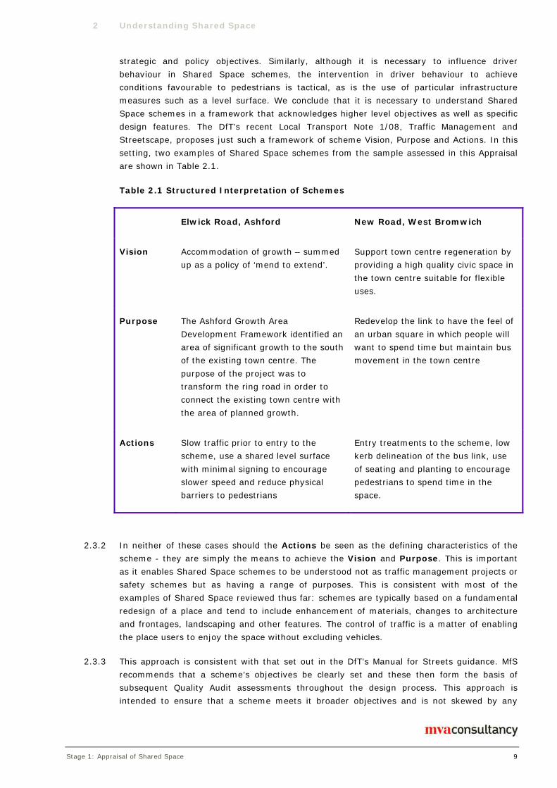
2 Understanding Shared Space
Stage 1: Appraisal of Shared Space 9
strategic and policy objectives. Similarly, although it is necessary to influence driver
behaviour in Shared Space schemes, the intervention in driver behaviour to achieve
conditions favourable to pedestrians is tactical, as is the use of particular infrastructure
measures such as a level surface. We conclude that it is necessary to understand Shared
Space schemes in a framework that acknowledges higher level objectives as well as specific
design features. The DfT’s recent Local Transport Note 1/08, Traffic Management and
Streetscape, proposes just such a framework of scheme Vision, Purpose and Actions. In this
setting, two examples of Shared Space schemes from the sample assessed in this Appraisal
are shown in Table 2.1.
Table 2.1 Structured Interpretation of Schemes
Elwick Road, Ashford New Road, West Bromwich
Vision Accommodation of growth – summed
up as a policy of ‘mend to extend’.
Support town centre regeneration by
providing a high quality civic space in
the town centre suitable for flexible
uses.
Purpose The Ashford Growth Area
Development Framework identified an
area of significant growth to the south
of the existing town centre. The
purpose of the project was to
transform the ring road in order to
connect the existing town centre with
the area of planned growth.
Redevelop the link to have the feel of
an urban square in which people will
want to spend time but maintain bus
movement in the town centre
Actions Slow traffic prior to entry to the
scheme, use a shared level surface
with minimal signing to encourage
slower speed and reduce physical
barriers to pedestrians
Entry treatments to the scheme, low
kerb delineation of the bus link, use
of seating and planting to encourage
pedestrians to spend time in the
space.
2.3.2 In neither of these cases should the Actions be seen as the defining characteristics of the
scheme - they are simply the means to achieve the Vision and Purpose. This is important
as it enables Shared Space schemes to be understood not as traffic management projects or
safety schemes but as having a range of purposes. This is consistent with most of the
examples of Shared Space reviewed thus far: schemes are typically based on a fundamental
redesign of a place and tend to include enhancement of materials, changes to architecture
and frontages, landscaping and other features. The control of traffic is a matter of enabling
the place users to enjoy the space without excluding vehicles.
2.3.3 This approach is consistent with that set out in the DfT’s Manual for Streets guidance. MfS
recommends that a scheme’s objectives be clearly set and these then form the basis of
subsequent Quality Audit assessments throughout the design process. This approach is
intended to ensure that a scheme meets it broader objectives and is not skewed by any
2 Understanding Shared Space
Stage 1: Appraisal of Shared Space 10
single perspective. Quality Audit is described as a flexible process that may include a range
of individual elements including Road Safety Audit and Access Audit.
2.4 Level Surfaces
2.4.1 Shared Space schemes sometimes use what is often referred to as a ‘shared surface’, where
there is no kerb or level difference to segregate pedestrians and vehicles. This is another
example of a tactical intervention designed to help minimise physical and psychological
barriers to pedestrian movement and influence driver behaviour by emphasising the fact that
the street is not a conventional street where drivers tend to assume priority.
2.4.2 However, the term 'shared surface' is not necessarily an accurate description of the way the
space operates. Shared surface schemes often retain some degree of designation of space
using features such as planting, street furniture, surface texture and surface colour, although
not all of these will necessarily be obvious to all users. These can be used to varying extents
to channel vehicle movement and reserve certain areas for pedestrians (see Figure 2.3).
The use of such measures may mean that a shared surface scheme is not intended to be
entirely ‘shared’.
2.4.3 Moreover ‘sharing’ describes a behaviour that designers intend users to exhibit but some
users may be unable or unwilling to share space with vehicles. There may in fact be a
tendency for vehicle and pedestrian flows to remain relatively separate under certain
conditions, for example where vehicle flows are relatively high.
2.4.4 For these reasons we use the term 'level surface' in this report as a description of a physical
feature. Level surface does not imply a behaviour, nor that the surface is undifferentiated. A
level surface is not necessarily a single surface, in terms of materials and texture, nor a
shared surface, in terms of undifferentiated mingling of users, see for example Figure 2.3,
below, which illustrates a street that features a level surface but differentiates those parts of
the streets that are shared from those from which vehicles are excluded by means of surface
differences and physical features. Observation of this street suggests that while pedestrians
do cross freely within the space, they tend to move along the street using the footway areas.

2 Understanding Shared Space
Stage 1: Appraisal of Shared Space 11
Figure 2.3 Chertsey Road, Woking. Level surface with delineation by bollards,
planters and surface differences
2.5 Performance Measurement
2.5.1 In order to assess the operation of Shared Space schemes it is necessary to establish a
suitable set of performance indicators. Given that such schemes need to be understood in
terms of their higher level objectives as well as their specific highway design features, such a
list of indicators is potentially wide-ranging. It is also, in principle, the case that the
appropriate indicators for a given scheme should be bespoke to the specific objectives of that
scheme. Nevertheless, there is a broad commonality between schemes examined that makes
it is possible to propose generic indicators of success or failure. Table 2.2 contains some
suggested generic indicators.

2 Understanding Shared Space
Stage 1: Appraisal of Shared Space 12
Objective Performance Indicator
Economic regeneration Economic activity
Property values
Shop occupancy rates
Ease of pedestrian
movement
Flows of users across the street
Number of people using newly opened pedestrian links.
Reduction in delay to pedestrians moving through the space
Placemaking Opinions of users
Visual amenity
Use of facilities provided, e.g. seating, cycle parking
Reduce traffic
dominance
Traffic flow/speed
Space available to pedestrians
Propensity for vehicles to give way to pedestrians
Pedestrians free to cross at any location
Changes in pedestrian
activity
Pedestrian flows
Nature of pedestrian activity
User comfort
Maintain or improve
safety
Accident/incident rates
Inclusive design Opinions of users and representative groups
Table 2.2 – Suggested Shared Space Performance Indicators
2.5.2 In summary, Shared Space schemes are designed to change the way the public highway can
be used, in order to improve economic vitality, environmental quality, and quality of life.
There are aspects of these aims which can be measured to assess performance. The
available evidence for performance against these indicators is discussed in the next Chapter.

Stage 1: Appraisal of Shared Space 13
3 Evidence
3.1 Introduction
3.1.1 This section considers the generic indicators discussed in Chapter 2. It also summarises the
evidence gathered at this stage of the project regarding the performance of schemes against
these indicators.
3.1.2 Where it has been available we have specifically considered evidence from UK examples of
Shared Space. Additionally we have referred to continental examples where appropriate.
Interpretation of continental examples should be viewed with some caution for two reasons:
The meaning of the term Shared Space may not be directly equivalent to its emerging
use in the UK. For example several of the prominent examples from the Netherlands
involve application of Shared Space principles to major traffic intersections and involve
significant interaction between motorists as well as vulnerable road users. There are
very few examples of this application in the UK. This may be significant as the risk in a
motorist/motorist interaction is less asymmetric than in a motorist/pedestrian
interaction and may thus control driver behaviour more effectively.
There may be different legal and regulatory contexts in other settings that would also
influence road user behaviour. Examples include the ability in Swiss and French law,
which is not currently lawful in the UK, to define and enforce a zone in which
pedestrians have a legal priority and in which traffic speed is restricted to 20kph
(12.4mph).
3.2 Economic activity and Property Values
3.2.1 There is some evidence in the literature that schemes to reduce traffic dominance can
improve local economic performance. This may be related simply to traffic flow, for example
Carley3 refers to evidence from both Leicester and York that shop vacancy rates are, all
other things being equal, positively related to the flow of motorised traffic.
3.2.2 More recent work has assessed the relationship between a multi-variate assessment of
pedestrian friendliness using the Pedestrian Environment Review System (PERS)4 and
economic performance:
A study conducted for CABE5 identified that more pedestrian-friendly environments are
associated with higher rental value of retail premises.
Work carried out by MVA Consultancy for Design for London6 concluded that there is a
statistical relationship between street quality and retail rental value and the value of
private dwellings. The MVA study also considered the value uplift achieved by fourteen
placemaking schemes (which include Shared Space schemes). It found that in twelve
of the schemes the uplift in property value had been greater than the background
3 Carley, M, Sustainable Transport and Retail Vitality, Scottish Historic Burghs Association, 1996
4 http://www.trlsoftware.co.uk/news/detail.asp?pid=51&iid=124, accessed April 2009
5 CABE, Paved With Gold: The Real Value of Street Design, 2007
6 Reid, S and Shore, F, Valuing Urban Realm, Unpublished Project Report, 2008

3 Evidence
Stage 1: Appraisal of Shared Space 14
trend or the growth in value of properties at control sites. The study also tentatively
concluded that the more complete the re-orientation of the street space towards
pedestrian priority, the greater the property value uplift, with properties affected by
pedestrian priority schemes demonstrating an average 12% increase in value over
those of the control sites in the same period.
3.2.3 None of the local authorities contacted in the Appraisal stage collated economic data
specifically around their schemes. However, it was noted by Wiltshire County Council that
shop vacancy rates in the scheme at Station Road in Tidworth had decreased contrary to the
trend for comparable towns in the same area. Similarly, following completion of a historic
core zone scheme in Shrewsbury the local authority identified an increase in shop rental
value and a reduction in vacancy rates.
3.2.4 The evidence suggests that Shared Space schemes which improve the quality of the street
environment can contribute to the economic vitality of a town. However, economic
performance is a complex subject and Shared Space may not be responsible for delivering
increases in value on its own. That said, it could be the catalyst for other aspects of a
scheme to deliver economic benefits.
3.3 Flows of users across the street
3.3.1 A notable problem with many of the schemes assessed is the lack of pedestrian crossing
counts or other analyses of paths taken by pedestrians within the space. For many schemes
there is only anecdotal evidence of changes in pedestrian flow.
3.3.2 From the literature there is evidence from some of the Mixed Priority Route schemes of
increased crossing activity. For example, following the introduction of Liverpool's MPR
scheme, a significant increase in formal crossing movements7 was noted and counts of
pedestrians crossing the road away from signalised crossings either increased or remained
the same. Evidence from some of the Historic Core Zone studies is more variable8, with
pedestrian crossing flows falling at some count points and rising at others, even within the
same town.
3.3.3 The data so far illustrate two important points:
Pedestrian response to Shared Space schemes is complex and likely to be influenced
by a range of factors, including the density and location of trip generators (for example
York9 concluded that the location of trip attractors was the most significant influence
on pedestrian movement patterns); and
Shared Space may redistribute pedestrian movements in a given centre thus making
crossing counts at fixed locations an unsatisfactory method for assessing change.
7 DFT, Mixed Priority Routes Road Safety Demonstration Project –Summary Scheme Report. 2008
8 Wheeler A, Traffic Calming in Historic Core Zones: Bury St Edmunds, TRL 388, Crowthorne, 1999
8 Wheeler, A Traffic Calming in Historic Core Zones: Crossley Street, Halifax, TRL 288, Crowthorne 1997
8 Wheeler, A Traffic Calming in Historic Core Zones: High Street Route, Shrewsbury, TRL 374, Crowthorne 1999
9 York, I, Public Transport in Pedestrian Priority Areas, TRL PR/T/136/03, Crowthorne 2003

3 Evidence
Stage 1: Appraisal of Shared Space 15
3.4 Opinions of users
3.4.1 Most published research focuses entirely on the opinions of pedestrians, with a notable skew
towards the views of disabled people. There is little published information on the views of
drivers or cyclists and such evidence as is available tends to be continental.
3.4.2 A strong theme in the literature is the concerns of disabled people, with an emphasis on
blind or partially sighted people in particular. These concerns are particularly acute with
regard to level surface schemes as a result of some people’s habitual reliance on kerbs.
3.4.3 The main concerns reported among visually impaired people are:
Risk from vehicles because of the difficulty in identifying different parts of the street
Difficulty in navigating through the space in the absence of a line to follow or clear
landmarks
Lack of confidence in appropriate driver behaviour.
Lack of a clearly defined comfort space free from vehicles in which to rest, re-orientate
etc.
3.4.4 Focus group research carried out by the Guide Dogs for the Blind Association (Guide Dogs,
hereafter) suggests that these concerns may be shared by people with reduced hearing,
people with reduced mobility and people with learning difficulties although the specific nature
of the concerns varies from group to group, for example some mobility impaired people are
quoted as being concerned about their ability to evade vehicles10. Conversely it is also the
case that for those mobility impaired people dependent on vehicular access, Shared Space,
while maybe not ideal, is preferable to pedestrianisation11.
3.4.5 The concerns of disabled people in Home Zones in residential low-traffic environments were
researched on behalf of the Disabled Peoples Transport Advisory Committee (DPTAC)12. This
study specifically included comparison of Home Zones (with and without a level surface) with
‘traditional’ residential streets. 73 disabled people took part in the study and 11 Home Zone
sites were reviewed. The study showed that disabled peoples' responses to Home Zones are
extremely mixed - see Figures 3.1 and 3.2 below.
10 The Guide Dogs for the Blind Association, Shared Surface Street Design Research Project The Issues: Report of Focus Groups, 2006
11 Mobilise, contribution to project Sounding Board, 2009
12 JMU Access Partnership, Designing for Disabled People in Home Zones, DPTAC, 2007

3 Evidence
Stage 1: Appraisal of Shared Space 16
Figure 3.1 Disabled people’s responses to: “Do you feel this Home Zone
environment is better or worse than a traditional residential street environment in
terms of overall navigation?”
Figure 3.2 Disabled people’s responses to: “Do you feel this Home Zone
environment is better or worse than a traditional residential street environment in
terms of overall safety?”
3.4.6 This pattern of responses shows a highly diverse reaction among disabled people to non-
standard highway designs, and by implication to standard highway designs. This
heterogeneity was not just found between people with different sorts of disability, for
example the authors note that “Both negative and positive comments were made by
participants in relation to their Guide Dog’s ability to cope with the Home Zone. Some
owners felt that their Guide Dog would adapt and improvise whilst others felt that there was
a lack of cues for the dogs to focus on.”
3.4.7 The nature of people’s responses in the DPTAC study varied according to the specific designs
of the Home Zones, which had a variety of features. Three of the eleven sites were found to
be “easy” or “very easy” to navigate by 100% of participants. These were Magor Village,
Monmouthshire; Morice Town, Plymouth and Duke of Edinburgh Way, Worcestershire. These
Home Zones all feature a level surface but with the use of physical features and surface
differences to differentiate parts of the surface and to restrict the access of vehicles to some

3 Evidence
Stage 1: Appraisal of Shared Space 17
parts of the space. The Worcestershire site had the greatest proportion of people finding the
Home Zone “very easy” to navigate. This site featured a level surface with bollards to
channel vehicle movement. Tactile paving was provided at key crossing points. The Home
Zone with the highest proportion of people finding navigation either “difficult” or “very
difficult” was Albany Street, in Kingston Upon Hull, described as “making use of a kerb
(which restricts free movement). A kerb line with 2m clear distance from the back of the
footway to the kerb was utilised…Conservation kerbs with a 450mm splay and 50mm
upstand were used”. Conversely the scheme with the highest proportion of respondents
finding navigation “very difficult” was Darcy Gardens in the London Borough of Barking and
Dagenham. This scheme is not a Home Zone but is a level surface cul de sac with no
differentiation of the space and with parked cars providing obstacles. Opinion at this scheme
was polarised, with approximately equal proportions of people finding navigation “very easy”
and “very difficult”. This polarisation was not found at the Albany Street Home Zone, where
no users found navigation better than “difficult”.
3.4.8 Based on this limited sample the user responses suggest that a level surface with
differentiated spaces and appropriate tactile information may be a more optimal solution for
navigation by disabled people with a range of disabilities than either a kerbed or an entirely
undifferentiated surface. Nevertheless it must be emphasised that the range of user
responses reinforces the analysis that Shared Space schemes are highly particular to their
setting and in their design. Both general approaches and specific features can have different
effects depending on how they are deployed. It also underlines the diversity of users’ views
and needs and the risk of treating some groups as though their requirements are
homogenous.
3.4.9 Perceptions of safety also varied between schemes. Again the Duke of Edinburgh Way
scheme was rated highly as was the Home Zone at Maryatt Avenue, in the London Borough
of Harrow which featured a 15mm chamfered kerb with a colour contrast. Again the Darcy
Gardens level surface cul de sac led to mixed opinion with approximately two thirds of
respondents believing it “unsafe” or “very unsafe” and around a third finding it “safe”.
3.4.10 DPTAC’s study found that although disabled people found much to criticise in the design of
Home Zones, many of the issues identified were soluble through careful design. Design
recommendations included the provision of clearly defined pedestrian areas and routes; clear
identification of safe crossing points; achieving low vehicle speeds; clear gateways; careful
placement of street furniture; smooth surfaces and good lighting.
3.4.11 There are also concerns expressed in the literature and in our survey about the ability of
younger children to understand how to behave without clear rules for using a redesigned
street as opposed to the simple instruction to ‘stop at the kerb’. It is notable that these
concerns are generally expressed by adults on behalf of children.
3.4.12 One study however directly reports children’s views on safety and the road environment.
This study was qualitative and based on observation of children’s behaviour and group
interviews involving 122 children in North London and Hertfordshire13. The study was based
on typical highway layouts and did not specifically address Shared Space environments but
does identify some relevant issues. Firstly it identified that children frequently believed that
13 Lupton, K and Bayley, M, Children’s Views on the Road Environment and Safety, Proceedings of the Institute of Civil Engineers –
Transport, vol. 159, no.1, pp9-14.

3 Evidence
Stage 1: Appraisal of Shared Space 18
they were at risk because of their own distraction, particularly when travelling with other
children. This may indicate that some children may have difficultly maintaining the necessary
awareness of other street users in Shared Space (although in Shared Space environments
drivers may be expected to be particularly aware of the unpredictability of children and
compensate for this), conversely it may suggest that layouts that provide the illusion of
safety may be associated with lower levels of concentration by all users. Secondly the
research reveals that younger children in the sample (aged 8-9) were “more conscious of the
rules for crossing the road….by age 10 children had become less rule-conscious and were
beginning to base their crossing decisions more on the prevailing traffic conditions.” This
may indicate that younger children could be less comfortable in Shared Space environments
in which there is a deliberate ambiguity about the rules. If the hypothesis about the
negotiated nature of behaviour in Shared Space is true this may disadvantage younger
children: “children are inexperienced at negotiation with adult drivers and often find their
intentions difficult to predict.”
3.4.13 York14 reports an interview survey of a total of just over 100 pedestrians at two sites
described as pedestrian priority areas into which buses are permitted. One, East Ham,
featured a level surface, the other, Hounslow, low kerb delineation. Interestingly a slightly
higher proportion of respondents in Hounslow (84% v. 75%) agreed that crossing the road
was easy while a greater proportion of respondents in East Ham than Hounslow (59% v.
49%) agreed that ‘You treat the centre as a road’. Notably flows of vehicles were
substantially higher in East Ham - 75-98 average hourly traffic flow v. 28-31 average hourly
traffic flow. In both locations some respondents expressed a desire for reductions in vehicle
flow. Despite the level surface, consultation with disability groups at the East Ham scheme
identified few fundamental issues although a number of detailed design suggestions were
made. Traders in Hounslow were positive about the scheme.
3.4.14 MVA interviewed 55 members of the public in Shared Space schemes during the appraisal
stage of this study. This was a random sample of people actually using Shared Spaces and
was designed to provide a snapshot of views in a variety of settings because much of the
attitudinal research in the literature is based on discussion ‘in principle’ of shared space with
people not actually in or using the spaces. The users interviewed were a mixture of visitors
and residents
Characteristic Rounded % Number
Average Age 42
Local Residents 58% 32
Visitors 23% 13
Workers 18% 10
Table 3.1 Characteristics of 55 Respondents
3.4.15 The exercise was not intended to specifically canvass the views of disabled people although
the random sample included 8 people who stated that they had some form of disability (at
14 York, op cit.

3 Evidence
Stage 1: Appraisal of Shared Space 19
14.5% broadly matching the proportion in the national population), as summarised in Table
3.2
Number
Disabled Users 14.5% of total 8
Walking Stick 5
Wheelchair 2
Visually impaired 1
Table 3.2 Disabled People Interviewed
3.4.16 As most in this group were mobility impaired, we draw no conclusion about the views of
visually impaired people, people with hearing impairment or people with learning difficulties.
3.4.17 Across the sample of 55, participants tended to be in favour of the schemes or broadly
neutral, including frail older people and people with mobility impairment. Nevertheless, some
concerns were raised about particular aspects. The interviews revealed a desire for less
ambiguity about the uses of the scheme, with several respondents suggesting full
pedestrianisation would be preferable.
3.4.18 Disabled people, older people, and people with buggies were positive about level surfaces
and the freedom of movement they afforded. Some concerns were expressed about possible
risks to children arising from a lack of awareness of vehicles although, when prompted, no
respondents had experience of any such incident.
3.4.19 An unexpected finding of our qualitative research was the number of respondents who
referred to improved personal security in the area following the implementation of Shared
Space. Reasons cited included the resulting increase in footfall and the reduction in clutter
which made the space more visible.
3.4.20 Drivers questioned in our study were also favourable towards Shared Space and level surface
in particular. Two particular benefits expressed were that:
the more open space allows drivers to negotiate their way around groups of
pedestrians more readily, and
the lack of defined footways mean that delivery drivers can park closer to buildings
without obstructing pedestrian flows.
3.4.21 Drivers reported that their choice of path through the space was broadly the same as it had
been prior to the introduction of the scheme, but they passed through it more slowly.
3.4.22 A number of authorities conducted public attitude surveys after implementing Shared Space
schemes. They found that respondents were generally supportive, although there was some

3 Evidence
Stage 1: Appraisal of Shared Space 20
criticism on detailed design issues. For example, in Shrewsbury cyclists reported concerns
about the granite sett surface being uncomfortable and slippery15.
3.4.23 A number of these studies indicate the importance of good design in Shared Space schemes
to meet the individual needs of users.
3.5 Visual amenity
3.5.1 Visual amenity is not directly quantifiable but evidence suggests that people appreciate the
visual improvement resulting from some placemaking schemes. For example, 73% of
respondents agreed that visual amenity had improved as a result of Home Zone schemes16.
This is to be expected as visual improvement is often an explicit objective.
3.5.2 The qualitative research conducted during this Appraisal stage found that many pedestrian
respondents raised the issue of improved visual amenity without prompting. They referred
to, for example, the “feel and look of new surface materials”, “lights in the seating” [where a
lighting scheme was part of the design], “wider, open space”, “pleasant atmosphere” etc.
3.5.3 In continental schemes the evaluation of the Laweiplein in the Netherlands found that after
implementation of the scheme c.81% of respondents rated the visual amenity as good or
very good compared to 20% in the before period17
3.5.4 At the Skvallertorget scheme in Sweden a survey of users found very strong agreement with
statements that Skvallertorget “is beautiful”, “has improved” and “is a living square”18.
3.5.5 These findings are echoed by van Gurp’s review of five Shared Space schemes in the
Netherlands which noted that “in all of the projects the new planning approach has produced
an attractive environment”19.
3.6 Use of facilities
3.6.1 A theoretical indicator of success would be the extent to which facilities such as seating, or
cycle parking are used. We found no evidence in the existing literature of data on such
usage although as noted in 3.10 below the introduction of seating in Castle Street, Kingston
Upon Thames was noted to change the nature of pedestrian activity in the street.
3.7 Proportion of pedestrians moving freely
3.7.1 A fundamental objective of many Shared Space schemes is to enable the freer movement of
pedestrians. There is little published literature directly on this topic. Pedestrian movement
15 Wheeler, op cit.
16 Webster D, Tilly A, Wheeler A, Nicholls D, Buttress, S Pilot Home Zone schemes: summary of the schemes, TRL 654, Crowthorne
2005
17 Noordelijke Hogeschool Leeuwarden, The Laweiplein, Evaluation of the Reconstruction into a Square with Roundabout, 2007
18 Palmblad, A and Sari, W, Shared Space in Sweden, presentation, 2009
19 Van Gurp, Marc, ‘De veiligheid van mooi’Onderzoek naar de verkeersveiligheid en functionaliteit van nieuwe ontwerpen van de
openbare ruimte., Goudappel Coffeng, unpublished project report, 2007.
3 Evidence
Stage 1: Appraisal of Shared Space 21
patterns in conventional street layouts are generally governed by the infrastructure,
specifically pedestrian barriers and kerbs. These features can present physical and, to some
extent, psychological barriers to pedestrians.
3.7.2 The reduction in such physical barriers is anecdotally reported to have resulted in freer
pedestrian movement at some of our case study sites. For example, in the level surface
scheme at Station Road, Tidworth, pedestrians were reported as crossing on their desire
lines. This physical freedom of movement was also noted by respondents to our own
qualitative research, including mobility impaired pedestrians who liked the absence of kerbs.
3.7.3 There is some evidence that pedestrian freedom of movement is restricted by traffic flow and
speed. York20 identifies a series of thresholds with combinations of vehicle flow and speed
above which pedestrians tended to walk along what would have been the footway area
rather than walking along the central street space:
traffic (other than bus) flow exceeds 50 vehicles per hour with speeds not exceeding
30mph
traffic (other than bus) flow exceeds 100 vehicles per hour with speeds not exceeding
25mph, or
traffic (other than bus) flow exceeds 200 vehicles per hour with speeds not exceeding
20mph.
3.7.4 Where such conditions are achieved, there is evidence that pedestrians move differently
within the space. York’s evidence does not imply that Shared Space approaches cannot
deliver benefits above these thresholds but that the fullest benefits are likely to be achieved
where these conditions are met.
3.8 Delay to pedestrians crossing the space
3.8.1 Delay to pedestrians is a further theoretical indicator of their ease of movement. We have
found no evidence in the literature, or from our case studies, of such data being collected in
the UK.
3.8.2 At the Laweiplein scheme in the Netherlands it was noted that “both cyclists and pedestrians
tend to be almost always granted priority at the junction. As a result these users are very
rarely held up for any significant length of time.”21 It was also noted at the Skvallertorget
scheme in Sweden (described in more detail below) that a high proportion of cars give way
to pedestrians and cyclists22, presumably decreasing delay.
3.9 Pedestrian flow counts
3.9.1 There is little published evidence on changes in footfall in Shared Space schemes. There is
some suggestion that Home Zone schemes were not, of themselves, generating increased
20 York, Op cit.
21 Noordelijke Hogeschool Leeuwarden, The Laweiplein, Evaluation of the Reconstruction into a Square with Roundabout, 2007
22 Palmblad, A and Sari, W, Shared Space in Sweden, presentation, 2009

3 Evidence
Stage 1: Appraisal of Shared Space 22
pedestrian or cycle activity23. Conversely a number of the Mixed Priority Route projects
noted significant increases in footfall, of up to 60%24. Similarly monitoring for TfL of the
Castle Street, Kingston Upon Thames, scheme identified a 12% increase in pedestrian
footfall from 2005-2006 following the implementation of a scheme that introduced a level
surface street with access for pedestrians, cyclists and delivery vehicles25.
3.9.2 In a number of our case studies local authorities cited evidence of increases in pedestrian
flow, but as they mainly comprised regeneration schemes, the cause was often attributed to
changes in land-use.
3.9.3 Some authorities have collected limited footfall data. According to Brighton and Hove
Council, New Road has seen an increase in footfall of 162% following implementation of this
Shared Space scheme.
3.9.4 Exeter High Street’s Shared Space scheme is some thirty years old, hence no meaningful
historical analysis can be conducted. Nevertheless, it is an extremely popular destination
attracting approximately 100,000 pedestrian trips per day, suggesting that Shared Space can
sustain high levels of footfall although clearly other factors such as retail offering will
influence such figures.
3.10 Nature of Pedestrian Activity
3.10.1 As well as changes in the number of pedestrians, it is also appropriate to consider the nature
of their activity, in particular whether they are treating the redesigned highway as a place as
opposed to a movement corridor. Despite the lack of actual count data, there was anecdotal
evidence from our qualitative research that some users respond to Shared Space schemes by
treating them as destinations. This was particularly notable in schemes such as New Road,
Brighton, where active frontages and seating provide opportunities and reasons to spend
time in the space. The TfL monitoring of the Castle Street scheme26 also identified an
increase in pedestrians sitting in the street eating and reading as well as an increase in
pedestrians observed browsing in shop windows.
3.10.2 The attractiveness of a street as a destination is not solely a function of its highway design.
Features within the space are necessary for people to want to use the street, however the
evidence available suggests that the redesign of spaces associated with Shared Space
scheme can facilitate and encourage people to make use of the opportunities that exist
within a given street. This analysis was supported by qualitative research carried out by MVA
Consultancy for Design for London27 into the economic benefits of public realm: retailers and
businesses noted that environmental improvements encouraged footfall with a consequent
economic benefit.
23 Webster et al, op cit.
24 DfT, Mixed Priority Routes Road Safety Demonstration Project Summary Scheme Report, London 2008
25 CBP, BSP 05/06 Walking Outcome Monitoring, TfL, 2007
26 CBP, BSP 05/06 Walking Outcome Monitoring, TfL, 2007
27 Reid, S and Shore, F, Valuing Urban Realm, Unpublished Project Report, 2008

3 Evidence
Stage 1: Appraisal of Shared Space 23
3.11 Space available to pedestrians
3.11.1 Pedestrians will not necessarily use all of the street available to them in principle. Their use
of space depends on their willingness to occupy it, and the impact of vehicular traffic has a
major bearing on this.
3.11.2 Many Shared Space schemes in the literature survey and our case studies increase the
physical space available to pedestrians. Kerbed schemes that widen the footway clearly
increase space for pedestrians, but this is limited by the need to maintain carriageway width.
Evidence from the case studies indicates that additional space is welcomed by pedestrians.
The public survey of attitudes in Shrewsbury High Street found that two thirds of
respondents found the widened and de-cluttered footways easier to use28. Similarly
monitoring for Transport for London of environmental improvements in Long Acre that
included de-cluttering of footways and a wider pedestrian crossing found improved public
perceptions of crowding and ease of movement in 2007 and 2008 against a 2005 baseline
despite increases in footfall over the period29.
3.11.3 The willingness of pedestrians to use a Shared Space as intended depends on a combination
of vehicular speed and flow and possibly on the relative flow of pedestrians to vehicles. The
more favourable the conditions, the greater the tendency for pedestrians to occupy the space
theoretically available to them. As noted above, York30 found that in pedestrian priority areas
the percentage of pedestrians walking along the road reduced as vehicle flow increased. This
study also found that the most influential factor on pedestrians’ willingness to walk in the
road was the speed of motor vehicles. Each 1mph increase in the 85th percentile speed
corresponded with a reduction (of about 3.5%) in the proportion of pedestrians walking in
the road.
3.11.4 Many Shared Space schemes aim to increase the space available to pedestrians. Where this
is done by increasing footway width it is generally successful and welcomed, although limited
by considerations of vehicle manoeuvring. Level surface schemes aim to overcome
manoeuvring issues and make the entirety of a street’s width available to pedestrians
without having to reserve carriageway space for vehicles. The extent to which this is
successful varies with the flow, and most particularly speed, of motorised traffic.
3.12 Propensity for drivers to give way to pedestrians
3.12.1 It is claimed that an objective of Shared Space is to achieve a situation where drivers and
pedestrians determine priority between one another by other (social) rules31. An appropriate
performance indicator here would be how often drivers give way to pedestrians.
3.12.2 Such an indicator is quantifiable in theory but it does not appear to be a common
consideration in scheme assessments in the UK. Examples of schemes where it has been
considered include Shenley Road in Borehamwood and Shrewsbury High Street. Both
schemes included ‘courtesy crossings’ for pedestrians which were monitored. At each site,
there was a marked tendency for drivers to give way to pedestrians at the courtesy
28 Wheeler, op cit.
29 CBP, LIP walking outcome monitoring - 07/08 after surveys, TfL, 2009
30 York, op cit.
31 Shared Space, Final Evaluation and Results, Interreg 2008

3 Evidence
Stage 1: Appraisal of Shared Space 24
crossings. Quemby and Castle32 cite observation studies indicating that most drivers gave
way to pedestrians at the courtesy crossings in Shenley Road. Observations at Shrewsbury
High Street showed that drivers tend to give way to pedestrians at the courtesy crossings
but pedestrians do not always choose to assert priority over vehicles.
3.12.3 A study of the Skvallertorget Shared Space square in Norrkoping, Sweden, did consider the
question of interaction. Skvallertorget is a level surface square in the town centre. It features
a textured level surface accessible to pedestrians and vehicles with a smooth surfaced
perimeter area for pedestrians with a tactile boundary and some use of street furniture to
prevent vehicle ingress. The square is both a civic centre to the town and a four way junction
with approximately 14,000 vehicles per day moving through it. Video surveys were used to
identify the interactions of different types of road user and to estimate the speed of vehicles
in specific encounters. The study indicated that in 90% of encounters between cars and
pedestrians and 61% of encounters with cyclists the driver stopped or adjusted their
behaviour33. The study found that the incidence of pedestrians and cyclists giving way to
motorised vehicles increased with vehicle speed. This tends to reinforce the argument that
the sharing of space is a matter of drivers ameliorating their behaviour, rather than a joint
decision by two road users. It also tends to support the argument that low vehicle speed is a
necessary precondition for drivers to have time to decide to concede priority.
Figure 3.3, Taken from Palmblad, A and Sari, W, Shared Space in Sweden,
presentation, 2009
3. speed on the outcome of their encounters with vulnerable road users
was also observed in site visits. Where vehicles approach a shared area relatively rapidly,
12.4 The influence of driver
pedestrians (if they are aware of the vehicle) tend to give way. Where vehicles approached
slowly, observation suggested drivers were more likely to give way to pedestrians. This
emphasises the importance of achieving low vehicle speeds via the design of Shared Space
schemes.
32 Quemby, A, Castle, C, A Review of Simplified Streetscape Schemes, 2005
33 Palmblad, A and Sari, W, Shared Space in Sweden, presentation, 2009

3 Evidence
Stage 1: Appraisal of Shared Space 25
3.13 Reduction in traffic flow
3.13.1 A reduction in vehicular traffic is often sought by designers of Shared Space schemes as they
attempt to balance the needs of various user groups. This is sometimes achieved via
regulation. For example the Exeter High Street scheme was supported by an order
restricting access to public transport vehicles.
3.13.2 There is some evidence that Shared Space schemes can bring about a reduction in flow even
when access is not restricted. This may be due to wider network changes or possibly as a
result of drivers expecting delay in passing through the space. For example the Shrewsbury
scheme led to a 34% reduction in motor traffic.
3.13.3 Conversely, where a Shared Space scheme forms part of an important link, it can remain
heavily used, even if orders restricting use are in place – both Sandwell MBC and Manchester
City Council report concerns about drivers failing to obey prohibitions at some of their
schemes.
3.14 Reduction in traffic speed
3.14.1 Reduced speed is not necessarily a primary objective of Shared Space schemes, but it is
often considered a prerequisite for placemaking to be achieved - York’s work34 suggests
20mph as a preferred upper threshold. There is mixed evidence that the speed of through-
vehicles is reduced in such schemes. Webster et al report an average reduction in both mean
and 85th percentile speed of approximately a quarter in seven pilot Home Zones35 and that
the effect was particularly marked in parts of the Home Zones with a level surface - those
locations were most likely to have an 85%ile speed of between 15mph and 20mph.
3.14.2 In mixed use locations, the evidence from Historic Core Zone projects is less convincing.
85th percentile speed fell only marginally in the Bury St Edmunds scheme36, with some
suggestion that the fastest drivers were least influenced. At Crossley Street, Halifax, speed
was reduced more significantly (by approximately 50% in one location), but actually rose in
another37. Speed was reduced more notably in the Shrewsbury High Street scheme, with the
number of vehicles exceeding 20mph falling at one location from 50% to 7%38. It should be
noted that in all these instances traffic speeds were relatively low before the interventions
and that the speed reductions were achieved entirely through environmental features with no
level changes or traffic calming.
3.14.3 The literature on driver speed choice suggests that the types of changes introduced by
Shared Space schemes are likely to affect vehicle speeds. For example Kennedy et al
reviewed the evidence on psychological traffic calming39. They reported that more complex
environments tend to be associated with slower driving speeds. The presence of pedestrians,
parking and other forms of ‘side friction’ were also found to encourage lower vehicle speeds.
34 York, Op cit.
35 Webster D, Tilly A, Wheeler A, Nicholls D, Buttress, S Pilot Home Zone schemes: summary of the schemes, TRL 654, Crowthorne
2005
36 Wheeler A, Traffic Calming in Historic Core Zones: Bury St Edmunds, TRL 388, Crowthorne, 1999
37 Wheeler, A Traffic Calming in Historic Core Zones: Crossley Street, Halifax, TRL 288, Crowthorne 1997
38 Wheeler, A Traffic Calming in Historic Core Zones: High Street Route, Shrewsbury, TRL 374, Crowthorne 1999
39 Kennedy, J., Gorell, R., Crinson, L., Wheeler, A. and Elliott, M, ‘Psychological’ Traffic Calming. TRL Report No. 641. Crowthorne, 2005

3 Evidence
Stage 1: Appraisal of Shared Space 26
3.14.4 Kennedy et al also identify the effect of three-dimensional design, with vertical objects such
as trees and buildings in drivers’ peripheral vision likely to affect vehicle speed. Work carried
out by Land Use Consultants et al40 for the Scottish Executive found that indicators of human
activity were most effective in encouraging drivers to slow down. This was consistent with
the findings of our qualitative research where drivers reported travelling more slowly and
acting more cautiously because of the unpredictable nature of pedestrians using the space.
There is, however, less information on driver behaviour in such locations when pedestrian
volumes are lower. We found little evidence of UK local authorities collecting such speed data
in this appraisal stage.
3.14.5 Both Kennedy and the Land Use Consultants studies emphasised the importance of clear
transitions to enable drivers to understand that they were entering a different type of space.
3.14.6 The evidence suggests that some speed reduction can be achieved by Shared Space schemes
and that a level surface in a residential setting appears to be an effective strategy as part of
a more comprehensive scheme. However, there is little published data to show whether
speed reduction can be achieved by a level surface in other settings. Nor is it possible to
determine, on the basis of the limited size of Home Zone schemes, over what distance the
effect of a level surface on driver behaviour might persist.
3.14.7 There is an inconsistent approach to speed monitoring among authorities. Where data has
been provided, it is positive and in some cases shows dramatic speed reductions. However,
in some instances, local authority officers expressed concerns that while speed had reduced
it had not done so to the extent hoped for. This was the case in both kerbed and unkerbed
examples. In one case, with very substantial forward visibility for drivers, the local authority
expressed a desire to retrofit vertical traffic calming at gateway features and within a level
surface scheme. This indicates that site specific factors are highly likely to influence the
speed of vehicles.
3.14.8 It is possible that where speed had not dropped by the amount anticipated this was as a
result of flows of pedestrians being relatively low. However, given the lack of consistent
pedestrian flow and vehicle speed data, this can only be stated tentatively. If the effect is
real, the pattern would be consistent with Kennedy and Land Use Consultants’ work that
identified human presence (actual or anticipated) as an important factor in influencing driver
speed and, by extension the importance of features that draw in pedestrians and encourage
them to linger.
3.15 Casualty Risk
3.15.1 Shared Space schemes are not primarily intended to address road safety issues. The aim is
generally to improve the quality of the local environment while, at the very least, not
increasing the number or severity of collisions.
3.15.2 Risk can be complex to calculate and needs to be assessed in relation to user exposure if
casualty numbers are to be reliably interpreted. As exposure data for pedestrians is
extremely limited, and there is a lack of vehicle flow data for many schemes, it is necessary
to consider recorded casualties in isolation. However these limitations mean that it is not
generally possible to consider changes in risk across a variety of schemes. Nevertheless,
40 Land Use Consultants, JMP and Terence Lee, Natural Traffic Calming, 1999

3 Evidence
Stage 1: Appraisal of Shared Space 27
there are examples of schemes for which exposure data are available and these do tend to
demonstrate a reduction in risk to vulnerable road users. For example monitoring of the
Newlands Avenue Mixed Priority Route scheme in Hull identified an 18% increase in
pedestrian activity at crossings and a 100% reduction in pedestrian casualties. Similarly the
same scheme recorded a 48% increase in cycle use with a reduction in cycle casualties of
21% in the same period41 indicating that at this scheme the risk to vulnerable users had
declined sharply, simultaneous with significant proportional increases in activity.
3.15.3 Data on casualty numbers are available from a range of schemes, including Historic Core
Zones, Mixed Priority Routes, and a variety of schemes in the Netherlands, including both
Shared Space and level surface schemes.
3.15.4 Table 3.3 reproduces casualty data compiled by Quemby and Castle42 for a sample of Dutch
schemes. These data suggest that these schemes are not consistently reducing casualties by
a significant amount but there is no evidence that casualty numbers are increasing following
the Shared Space scheme. (Care needs to be exercised when interpreting the data in this
table due to the differing before and after periods).
41 DfT, Local Transport Note 3/08, Mixed Priority Routes: Practitioners Guide, 2008.
42 Quemby and Castle, op cit.

3 Evidence
Stage 1: Appraisal of Shared Space 28
No. of Collisions Recorded Scheme Area Coverage Before
Period
After
Period Before After
Oosterwolde (de Brick /
Rode Plein) [Netherlands]
A junction and an
extended road
shopping street
93-97 99-01 8 damage only 1 serious
8 damage only
Oosterwolde (Makkinga)
[Netherlands]
Two junctions at
the edge of a
residential area
93-96 98-01 2 damage only 2 slight
3 damage only
Drachten (Kaden-
Torenstraat) [Netherlands]
A central junction 93-98 00-01 4 slight
26 damage only
4 damage only
Drachten (Kaden-
Dwassva) [Netherlands]
A junction 93-99 2001 3 slight
17 damage only
1 slight
6 damage only
Drachten (Torenstraat-
Vogelzang) [Netherlands]
Lightly traffic
residential
93-99 2001 3 slight
7 damage only
3 damage only
Opeinde [Netherlands] A larger area than
a typical junction
scheme
93-97 99-01 1 fatal
7 slight
24 damage only
1 slight
5 damage only
Donkerbroek [Netherlands] A junction 93-97 99-01 1 slight
11 damage only
9 damage only
Olderberkoop
[Netherlands]
Whole village 93-98 00-01 3 slight
14 damage only
5 damage only
Wolvega [Netherlands] A busy junction 93-96 98-01 1 slight
4 damage only
4 damage only
Table 3.3 Casualty Records of a Sample of Dutch Simplified Street Schemes
Sources: Quemby and Castle 2006,
3.15.5 Gerlach et al also provide data for three Shared Spaces (including some of those reported by
Quemby and Castle, although it is not clear that the data collection areas are precisely
comparable) including more years ‘after’ data.

3 Evidence
Stage 1: Appraisal of Shared Space 29
* Year of implementation
Table 3.4 Casualty Performance of Three Shared Space schemes in the
Netherlands, reproduced from Gerlach et al (undated)
3.15.6 The apparent trend in reduction of the number and severity of casualties at the Laweiplein is
particularly interesting given the evidence that motorised traffic has increased by
approximately 30% and cycle traffic by 5% between 2000 and 200543. This exposure data
suggesting that the risk per user has decreased, although Gerlach et al argue that the
43 Noordelijke Hogeschool Leeuwarden, The Laweiplein, Evaluation of the Reconstruction into a Square with Roundabout, 2007
Severity
Year
Fatal Seriously
Injured
Slightly
Injured
Damage Only Total
Drachten - Laweiplein
1997 0 1 3 6 10
1998 0 0 0 9 9
1999 0 1 3 9 13
2000 0 0 0 9 9
2001* 0 0 0 4 4
2002 0 0 2 8 10
2003 0 0 0 3 3
2004 0 0 0 1 1
2005 0 0 0 1 1
2006 0 0 0 2 2
Drachten – De Drift/Torenstraat/Kaden
1994 0 0 0 1 1
1995 0 0 0 8 8
1996 0 0 0 2 2
1997 0 0 1 8 9
1998* 0 0 1 2 3
1999 0 0 1 3 4
2000 0 0 0 0 0
2001 0 0 0 4 4
2002 0 0 2 6 8
2003 0 0 1 3 4
2004 0 0 2 6 8
2005 0 0 1 4 5
2006 0 0 2 2 4
Haren - Rijksstraatweg
1997 0 1 2 10 13
1998 0 0 4 12 16
1999 0 0 0 16 16
2000 0 0 1 8 9
2001 0 1 1 17 19
2002 0 0 0 7 7
2003* 0 0 0 11 11
2004 0 0 0 4 4
2005 0 0 0 6 6
2006 0 0 0 7 7

3 Evidence
Stage 1: Appraisal of Shared Space 30
decrease may result from slower traffic speeds on the approach to the junction as a response
to the change in junction type from signalised to roundabout.
3.15.7 The De Drift/Torenstraat/Kaden junction has seen a less evident decline in casualties and
Gerlach et al note that most slight injuries involve cyclists. This concern is reiterated by the
Dutch Cycling Union who criticise the application of Shared Space in the Netherlands to high
flow junctions, arguing that evidence suggests that Shared Space junctions with high vehicle
flows consistently perform less safely for cyclists44.
3.15.8 Data from the English Historic Core Zones studies (see table 3.5) suggests a lack of
significant change in casualty numbers.
No. of collisions recorded
Scheme Installed
5 Years before 5 Years after
Shrewsbury 1997 13 (9 pedestrian) 14 (9 pedestrian)
Halifax 1996 7 (1 pedestrian) 8 (5 pedestrian – 1 Fatal, 1 Serious)
Bury St. Edmunds
Hatter St.
1996 4 3 (1 pedestrian)
Bury St. Edmunds
Crown St.
1997 4 2 (1 pedestrian, 1 cyclist – serious)
Table 3.5 Casualty Performance of Historic Core Zone Schemes in England Source:
Wheeler
3.15.9 Data from the Mixed Priority Routes schemes was gathered by local highway authorities
participating in the DfT’s Demonstration Project (see table 3.6). At these locations Shared
Space principles were applied to arterial routes here traffic flows are higher and the
delineation of vehicle routes is greater (although some schemes, such as Hull and Walworth
Road, London, incorporate areas of level surface). Evidence indicates a more substantial
reduction in casualties, with up to 60% reduction in some locations even though pedestrian
footfall increased.
44 Zeegers, T, Shared Concerns on Shared Space, Velocity Paper, 2009.

3 Evidence
Stage 1: Appraisal of Shared Space 31
Casualty Reduction (%) Other Benefits
Crewe 21 2-3 mph reduction in average speed
Hull 24
(21 in cycle casualties)
48% increase in cycle flows
16% reduction in NO2 levels
Manchester 30 Number of cyclists more than doubled during
the peak hours
Bus passenger numbers up 9% on both
weekdays and weekends
Norwich 60 (despite the increased night
time activity)
5-7 mph traffic speed reduction
Oxford 36
(Almost 50% reduction in KSIs)
30% increase in the number of cyclists on the
Cowley Road
10% reduction in the number of cars using the
route
Liverpool 57 (slight casualties)
65 (Pedestrian casualties)
Significant increase in formal crossing movements
Number of informal crossings has either
increased or remained static where formal
provision available
Leamington Spa - 14% reduction in average speed
St. Albans 50 (in first 12 months of opening) -
Southwark 42.5 (in first 6 months of opening) -
Wandsworth - 16% reduction in average traffic speed
Table 3.6 Summary of Early Monitoring Results from the Ten Mixed Priority Routes
Source DfT, 2008, Mixed Priority Routes Road Safety Demonstration Project –
Summary Scheme Report
3.15.10 The data presented in the studies above is in the form of before and after analysis. This
longitudinal approach is a way of controlling for the influence of differences between sites
that may influence observations by comparing a site with itself in order to try to isolate the
effects of the change in design. However, without comparison to control sites this approach
cannot isolate the effects of the Shared Space design from other factors that may be
influencing the trend in casualties at the study site. An alternative approach is a comparison
between sites. This latitudinal approach controls for the effect of general trends but does not
allow the influence of differences in the sites other than those of interest to the researcher to
be isolated. Both methods offer benefits and have drawbacks. A latitudinal approach was
used by van Gurp to compare the casualty performance of five Shared Space sites with five
3 Evidence
Stage 1: Appraisal of Shared Space 32
matched traditional sites in the Netherlands45. Van Gurp notes that the sample does not
contain many examples of sites with different levels of traffic flow but argues that:
“One of the conclusions is that the new approach can be applied for traffic volumes of up to
6600 motor vehicles per 24 hours without causing a noticeable difference in the number of
accidents. Objective statistics show that there is no difference in road safety between the
new planning approach and a traditional road layout. The study has shown, however, that
applying the new approach to volumes of 13,7000 vehicles per 24 hours will have an adverse
effect on the number of accidents. There is a grey area for traffic volumes of between 6600
and 13,700 vehicles per day.”46
3.15.11 Van Gurp also notes several of the Shared Space schemes may be considered successes
against criteria of actual and perceived safety and functionality. He argues that:
“The three projects, all of which were based on the shared-space principle, show that this
new approach can be applied to a variety of situations. In all of the projects, residents were
consulted and their wishes were included in the design. Community involvement and the use
of environmental elements have had a positive effect on people’s perceptions and their
willingness to adjust their behaviour.”47
3.15.12 Van Gurp’s conclusions reinforce the principle that Shared Space schemes are all particular
and need to be considered in their social and environmental context. Interestingly his
comments on the link between community involvement and subsequent behaviour
emphasises the importance of process as well as physical features in the development of
such schemes.
3.15.13 Based on the limited casualty data available there is no evidence that Shared Space schemes
result in more casualties than traditional layouts at the types of flow at which they have been
implemented in the UK. Van Gurp’s work indicates that at high traffic flows there may be an
adverse safety impact although it is not clear whether this finding applies primarily to links,
or junction, or both. Neither is there evidence that particular groups, including disabled
people, are injured more frequently, although there is some suggestion that high flow
Shared Space junctions may be more risky for cyclists. Conversely there is little conclusive
evidence that Shared Space schemes consistently achieve significant casualty reduction. The
lack of consistent exposure data means that the effect on casualties of changes in the
numbers of different road users cannot be readily assessed. Nevertheless at the few UK
schemes where exposure data are available there does appear to be a positive effect in
reducing the number of casualties and the level of risk to pedestrians and cyclists.
3.15.14 York48 assessed conflict between pedestrians and vehicles in six pedestrian priority areas in
London. This analysis found that the number of conflicts increased with vehicle flow until
vehicle flow exceeded a threshold above which pedestrians tended to avoid using the
carriageway space. Conflicts were more likely to occur between pedestrians and private
motor vehicles. At the two sites where vehicle flows were highest pedestrians tended to
45 Van Gurp, Marc, ‘De veiligheid van mooi’Onderzoek naar de verkeersveiligheid en functionaliteit van nieuwe ontwerpen van de
openbare ruimte., Goudappel Coffeng, unpublished project report, 2007.
46 Ibid, Translation of key findings by Goudappel Coffeng
47 Ibid
48 York Op cit.
3 Evidence
Stage 1: Appraisal of Shared Space 33
avoid using the carriageway and consequently the number of conflicts was lower, however
the number of recorded accidents was higher. This may indicate that low level conflict is
more frequent when ‘sharing’ of space is achieved but that more traditional configurations
may result in lower frequency but more severe conflict that is more likely to result in injury
to a pedestrian.
3.15.15 In some schemes traffic flows are deliberately diverted from the Shared Space schemes and
there is some evidence that drivers voluntarily divert. We are aware of no evidence however
regarding the alternative routes selected by drivers nor of any evidence of increased risk to
vulnerable users on those alternative routes.
3.16 User comfort
3.16.1 User comfort is heavily dependent on feeling safe. Although from the data so far, Shared
Space schemes where vehicle flows are under 6,800 vehicles per 24 hours appear to be at
least as safe as conventional streets, some people can find them intimidating. The Guide
Dogs49 report on focus groups with disabled people concluded that the ambiguity inherent in
level surface schemes can be a source of anxiety for blind or partially sighted people and
that some concerns were stated by participants with a range of disabilities. Groups
representing visually impaired people consistently oppose the implementation of level
surface schemes that are shared with vehicles. Conversely our qualitative research found
that a range of mobility impaired people appreciated level surfaces that enabled freer
movement
3.16.2 These responses are not incompatible. Within each broad category of disability such as
‘blind or partially sighted’, ‘mobility impaired’ etc, there is a large range of conditions. In
addition, individuals vary widely in their tolerance of perceived risk, uncertainty etc.
3.16.3 The research commissioned by DPTAC is one of the few published reports to benchmark
disabled people’s experience in Shared Spaces against the barriers they face in other
settings. It suggests that a high proportion of disabled people find Home Zone schemes more
satisfactory than conventional streets in terms of navigation, a small majority find them less
satisfactory in terms of safety although as noted above the views of users were very mixed
and were related to the detailed design of the schemes.
3.16.4 The anxiety identified by Guide Dogs was described as debilitating and, at times, people
stated that they would avoid level surface streets. There are two, linked, components to
peoples' anxiety that appear most acute: orientation/navigation and not knowing where
vehicles may be. This disorientation is partly a consequence of the deliberate reduction in
physical demarcation of the space in order that the street can be used by pedestrians more
flexibly.
3.16.5 Visually impaired people require physical and/or tonal cues to orientate themselves and may
prefer to use the open space of a level surface street in a more structured way i.e. moving
along and across the space in a ladder-grid pattern equivalent to the footways and crossings
in a conventional street. Some form of physical guidance that allows them to follow such a
pattern combined with the ability to find a 'comfort zone' free from vehicles, or notification
that they are entering a ‘crossing’, may be necessary.
49 Guide Dogs, op cit.

3 Evidence
Stage 1: Appraisal of Shared Space 34
3.16.6 At the Laweiplein scheme in the Netherlands, Noordelijke Hogeschool Leeuwarden report that
despite the apparent reduction in actual risk the public perception of safety declined
following the implementation of the scheme, with 45% stating that safety was ‘poor’ or ‘bad’
in 2005 compared to 30% in 200050. This perception was particularly notable among older
respondents. It is noted that this perception of risk may be the mechanism by which
objective safety is improved, i.e. a perception of risk may promote more cautious behaviour.
Interestingly, by mode, perceptions of safety had declined among cyclists and drivers but
had remained unchanged among pedestrians.
3.16.7 With regard to personal safety Noordelijke Hogeschool Leeuwarden note that at the
Laweiplein, perceptions have improved with 81% now considering this reasonable, compared
with 71% in 2000. This increase was most notable among pedestrians, cyclists and older
people. This may be linked to the significant improvement in public perception of the quality
of the Laweiplein as a space.
3.16.8 Interestingly at the Laweiplein scheme public perception of traffic flow has substantially
improved, with the proportion of people considering congestion to be bad falling from 60%
before the scheme in 2000 to 5% by 2005. This subjective assessment was supported by
data and observation which found that all modes appeared to cross the junction with less
delay and that the average delay to vehicles had fallen from 50 to 30 seconds despite a 30%
increase in motorised vehicle flow.
3.16.9 At the Skvallertorget scheme 90 pedestrians, 18 cyclists and 31 car drivers were also
surveyed. The majority of pedestrians, cyclists and drivers agreed that they felt safe,
although interestingly this was marginally less common among drivers51. They also tended to
agree that they felt safer than before, although this was more marginal. There was less
agreement that the traffic rules were easy to understand and were followed by other users.
Notably cyclists and pedestrians both agreed that other road users tend to take evasive
action with pedestrians agreeing most strongly. Conversely drivers tended to disagree with
this statement. These perceptions directly match the observed behaviour in the Square.
50 Noordelijke Hogeschool Leeuwarden, The Laweiplein, Evaluation of the Reconstruction into a Square with Roundabout, 2007
51 Palmblad, A and Sari, W, Shared Space in Sweden, presentation, 2009
Stage 1: Appraisal of Shared Space 35
4 Knowledge Gaps
4.1 Introduction
4.1.1 There are significant gaps in the data available on the assessment of Shared Space schemes.
In particular, there is a lack of information available on pedestrian footfall, changes in
pedestrian and vehicle flow over time, and the use of features such as seating.
4.1.2 There are also knowledge gaps concerning some of the underlying principles of Shared
Space. These are discussed below.
4.2 When Do Drivers Give Way?
4.2.1 There is evidence that drivers tend to give way to pedestrians more readily in Shared Space
schemes. There is also limited evidence from the qualitative research undertaken thus far
that drivers report travelling more slowly and being more prepared to stop for pedestrians.
This is important because it has a bearing on the ultimate purpose of Shared Space.
4.2.2 Drivers appear inclined to give way in low speed situations where vehicle flows are low
relative to pedestrian numbers. However the specific speeds and flows below which drivers
are likely to concede priority have not been established and it is not clear how voluntary
speed control varies as pedestrian flows and other environmental factors vary.
4.2.3 Some of the schemes examined in this Appraisal stage suggest that courtesy crossings may
provide trigger points that encourage drivers to give way, particularly when they are
reinforced by vertical deflection. This can however seem to be at odds with some of the
objectives of Shared Space, where the aim is often to enable the free movement of
pedestrians throughout the street. It is not clear how features which provide an opportunity
for less confident pedestrians to negotiate the space affect the willingness of drivers to give
way to them in other parts of a scheme.
4.2.4 A further uncertainty is whether and how driver behaviour varies across different population
segments. Some of the evidence implies that the fastest drivers may be least affected.
Younger male drivers may be less likely to slow down in the presence of pedestrians. This
latter point may be directly relevant to the comfort of some people who require a high level
of certainty that drivers will behave appropriately in the absence of features such as
signalised crossings and kerbs.
4.3 How Does Sharing Work?
4.3.1 The mechanism by which sharing of space by pedestrians and vehicles actually takes place
needs further investigation. York’s52 work suggests that pedestrians will attempt to share
when certain favourable conditions exist and this is reinforced by comments on the
Shrewsbury scheme.
4.3.2 It is often suggested that in Shared Space, interaction between drivers and pedestrians relies
on eye contact. While this may be how some users negotiate their way through the space, it
52 York, Op cit.

4 Knowledge Gaps
Stage 1: Appraisal of Shared Space 36
is not clear that this is how the majority of users are actually behaving. There is no certainty
that drivers and pedestrians are always going to be able to establish eye contact with one
another and logic suggests that driver will not therefore rely on it. Our working hypothesis is
that even where pedestrians are prepared to attempt to share, the decision whether sharing
takes place seems to rest primarily with the driver. Drivers appear to base their intended
actions primarily on actual pedestrian behaviour, rather than relying on direct
communication.
4.3.3 There is no convincing data that eye contact is used predominantly as a means of
communication between drivers and pedestrians. In a number of the schemes reviewed, the
prevailing flow of vehicles and pedestrians is in the same direction making eye contact
unlikely.
4.3.4 Drivers often need to respond to particular situations without any deliberate communication
on the part of pedestrians. Research into psychological traffic calming indicates that drivers
respond to complex situations by behaving more cautiously. Cognitive load and drivers'
assessment of risk possibly underlie their decisions. This interpretation is supported to some
extent by respondents interviewed during the qualitative research who stated that they
tended to drive slowly because of the density of pedestrians and their belief that pedestrians
may behave unpredictably, and may not even realise there are vehicles present.
4.3.5 It is not clear how initial patterns of behaviour based on cognitive load and risk assessment
change as motorists become familiar with schemes. It has been suggested that novelty can
encourage drivers to slow down (see for example Enwight’s53 advocacy of ‘intrigue and
uncertainty’ in the application of speed reduction devices). Assuming the cognitive load/risk
assessment model is correct, then to find out whether novelty is part of its effect, and
whether it changes over time requires further evidence.
4.3.6 These two hypotheses to explain sharing (communication v. driver risk assessment) need not
be mutually exclusive. It is possible to envisage situations where the volume of pedestrians
and the sense of place encourages drivers to slow to an extent where communication
becomes more likely and is used to resolve situations where neither user has chosen to take
priority.
4.4 What Happens to Pedestrian Behaviour?
4.4.1 Although a high-level objective of many Shared Space schemes is to facilitate pedestrian
movement, there is little data on how pedestrians actually move within Shared Spaces.
Some authorities promoting schemes have said they intend to carry out such monitoring but
it is not always seen as a high priority, particularly where a scheme appears to be working
well.
4.4.2 Several key pedestrian behaviours and attitudes need to be better understood to enable
robust guidance to be prepared. Key questions are:
How do pedestrians move within Shared Space? How might their behaviour be related
to factors such as traffic flow, traffic speed, pedestrian type and pedestrian footfall?
53 Enwight, D Street Reclaiming, 1999
4 Knowledge Gaps
Stage 1: Appraisal of Shared Space 37
How do pedestrians evaluate risk when interacting with vehicles? Does this evaluation
translate into awareness or does it give rise to anxiety and a disincentive to use the
street? How does such interpretation vary across different population segments and
how does it compare with more typical street layouts?
Under what conditions are pedestrians willing to cross the space in the expectation
that drivers and cyclists will give way?
4.4.3 A further uncertainty is whether, and how, pedestrian reactions to Shared Space may vary
between segments. It is probable that different people will exhibit different attitudes to risk,
willingness to mingle with motorised vehicles etc. This raises the possibility that sharing of
space may need to be considered as a process whereby, when conditions are favourable,
some pedestrians begin to actively use the space, increasing the complexity for drivers and
hence tending to reduce vehicles’ speed, consequently encouraging more risk averse
pedestrians to use the space more fully too. Within such a model it is also possible that some
individuals may be sufficiently risk averse that they will never voluntarily share space with
motorised vehicles.
4.5 How Can Shared Space Be Made More Navigable?
4.5.1 A typical street with footways and discrete crossing points encourages pedestrians to adhere
to a ladder-grid pattern when moving within the street. In a Shared Space, people tend to
follow desire lines which are likely to bear little resemblance to such conventional patterns of
movement. However, for visually impaired people, maintaining a ladder-grid is likely to be
beneficial. This grid does not have to be explicitly expressed in the layout, but it needs be
detectable by visually impaired people.
4.5.2 The drivers who responded to our survey indicated that they broadly move through the
space where the carriageway used to be, even in a level surface scheme (although this will
require consideration in the next stage of this research).
4.5.3 There is therefore space at the sides of level surface streets equivalent to footways that
appears to be suitable for use by vulnerable users. The unresolved question is how it, and
routes across the vehicle track, can be made legible to those users.
4.6 Next Steps
4.6.1 This summary report has identified a number of knowledge gaps. Further analysis will be
informed by contributions from the Project Board and Sounding Board. The next stage will be
to develop proposals to address knowledge gaps through primary research.

Stage 1: Appraisal of Shared Space 38
5 Summary and Conclusions
5.1.1 This report was commissioned to determine whether a case could be made for Shared Space
highway schemes, including those featuring level surfaces, and to consider whether there is
evidence of value to such schemes in order to inform the Department for Transport’s decision
as to whether to proceed with the development of design guidance.
5.1.2 Based on the evidence discussed in this report, and with due regard to the evidence gaps
already identified, we present in this Chapter our working conclusions following this
Appraisal.
5.1.3 Shared Space schemes can be helpfully seen in the context of the Place and Movement
matrix set out in the Manual for Streets. They are designed to assert the place functions of
streets while accommodating their movement functions. To that extent, and in common with
traffic management design in general, Shared Space represents a compromise between the
needs of a wide range of users and uses.
5.1.4 To understand Shared Space while acknowledging higher level objectives and specific design
features, we have adopted the framework used in DfT’s recent Local Transport Note 1/08,
Traffic Management and Streetscape. The framework headings are Vision, Purpose and
Actions. Given the diversity of intention, appropriate indicators of success need to be
established to reflect those intentions and we have suggested a generic set of indicators in
this report.
5.1.5 Against these generic indicators, the evidence broadly suggests that Shared Space Schemes
can deliver benefits: they appear to support economic activity, improve perceptions of
personal security, be popular generally with the public and traders and increase freedom of
movement for many people including some vulnerable pedestrians. In making these
statements it is acknowledged that the evidence is not always conclusive and appears to
vary from scheme to scheme. These conclusions need to be read in the context of the more
detailed discussion set out in this report.
5.1.6 Shared Space is a design approach rather than a standard type of design, nevertheless the
evidence suggests that some design parameters are likely to be influential in determining
their performance:
Whether they are links or nodes
Whether they are level surface or not
Whether vehicle flows are high
5.1.7 The ambiguity in the evidence and the varying indications among different schemes suggests
that the setting and detailed design of a given scheme are likely to be highly influential in its
performance.
5.1.8 Shared Spaces are not generic, their rationale is that they are particular. In stating a generic
judgement we acknowledge that, like any highway design, specific schemes may be poorly
designed or may fail to deliver clear benefits. Notwithstanding this caveat, the evidence is
that a case can be made for the Shared Space design approach in general.
5 Summary and Conclusions
Stage 1: Appraisal of Shared Space 39
5.1.9 From the data available, there is no evidence that Shared Space schemes, including those
with level surfaces, as implemented in the UK have more casualties than conventional
layouts, or that particular groups, including disabled people, are injured more frequently
following their introduction. However, given the inconsistent availability of data on flows of
pedestrians and vehicles it is not possible to confidently present safety records in terms of
risk exposure.
5.1.10 There is some evidence from the Netherlands that at locations with motorised traffic flow of
greater than c.14, 000 vehicles per day Shared Space layouts may have more casualties,
relative to traditional layouts and that risk to cyclists may be increased in these settings. It is
not presently possible to verify this effect at UK sites as there are no examples of the
application of Shared Space at sites with such vehicle flows and cycle flows in the UK are
currently generally lower than in the Netherlands.
5.1.11 It is clear that in certain situations, Shared Space schemes using level surfaces deliver
practical benefits over those with kerbs. Kerbs reduce flexibility of use of the space because
of the segregation they provide. Where width is limited, level surfaces can make it easier to
accommodate (and balance) the needs of pedestrians and people driving through it and in
some situations a level surface without footways may be necessary to allow large vehicles
such as refuse collectors through a street. Level surface streets can also be more readily
adapted for other uses such as events, markets etc. in accordance with the frequent
objective of such schemes of turning a road into a place. Level surfaces however must be
considered in relation to a scheme’s objectives and context and will not be appropriate in all
situations.
5.1.12 Some categories of mobility-impaired pedestrians (e.g. people using wheelchairs, ambulant
disabled people, people carrying heavy loads, and people with pushchairs) welcome the
ability to travel through a step-free level surface environment.
5.1.13 Fear of using level surfaces can create an aversion to a particular area, regardless of actual
levels of safety and this can be particularly acute among visually impaired people, although
these concerns are not exclusive to them. This will need to be taken into account in design -
if people are to be encouraged to enjoy the space, they need to feel they are safe using it.
They also need to feel comfortable. Navigation can be a particular problem for visually
impaired people and the absence of kerbs can make this more acute. Measures that assist
visually impaired people in navigating streets with a level surface, and feeling safe in them,
are of particular importance and we anticipate a common need to provide forms of guidance
for blind or partially sighted people that allow them to navigate to parts of the street where
vehicles are generally excluded. Many of these measures will use tactile paving, although
other approaches, such as a common design ‘language’ being explored by some local
highway authorities, may offer another way forward.
5.1.14 The reduction in formal rules for behaviour in a Shared Space environment, particularly one
featuring a level surface, may be problematic for people who are particularly reliant on rules
to simplify the complex street environment. Such people are likely to include younger
children and some people with learning difficulties. It is important that designs provide
sufficient cues for those people to use the space safely and comfortably.
5.1.15 In some settings Shared Space may be achieved without the need for a level surface and this
is likely to avoid many of the concerns expressed by blind and partially sighted people,

5 Summary and Conclusions
Stage 1: Appraisal of Shared Space 40
although may limit the flexibility of the space and result in some loss of ease of movement
for other people.
5.1.16 With regard to level surfaces we conclude that while they can create difficulties for some
people, they can confer benefits overall, including improved access for some disabled people
and, possibly, greater vehicle speed reduction. There is some evidence that a level surface
with protected areas and tactile information may be more navigable and feel safer for
disabled people in general compared to either a kerbed or a completely undifferentiated
surface. The problems experienced by some disabled people, particularly those with a visual
impairment, are not necessarily insurmountable. Good design will be important here and an
approach that embraces the vision and purpose of each particular Shared Space scheme will
form an essential framework within which to work. This report therefore concludes that a
case can be made for level surfaces as a valid feature in some settings but that the detailed
design of particular schemes needs to recognise and respond to the needs of all users.

Stage 1: Appraisal of Shared Space 41
Annex A Design
A1. Emerging Issues
A1.1 A number of design issues emerge from the analysis so far. These are summarised in
the following list which is indicative only at this point. The list will be developed alongside
the primary research in the next stage of this study. The emerging issues are that:
there is a need to take a comprehensive approach to the design of Shared Space
schemes, with clear objectives as to what the scheme is meant to achieve;
establishing a multi-disciplinary team at an early stage in scheme development is
important;
there is a need for close and continued engagement with stakeholder groups, including
those representing vulnerable users;
achieving vehicle speeds of under 20mph is likely to be important to achieving the full
potential benefit of schemes;
it may be necessary to consider traffic network design to manage the flow of vehicles
such that pedestrians are willing to use the space as intended;
schemes need to be designed in three dimensions as vertical features and cross
sections can influence driver speed;
Shared Space schemes seem likely to be most effective when they provide a
comprehensive redesign of a space – just adding or removing specific design features
without regard to context or integration of other design elements is unlikely to be
satisfactory;
Transition zones and gateway treatments can be useful for indicating to motorists that
they are entering a place where they need to drive at low speed and with caution and
to allow them time to adjust their behaviour prior to encountering significant numbers
of pedestrians;
tactile features for blind or partially sighted people are required to enable them to
navigate the space;
control of parking needs to be considered in level surface schemes;
with level surfaces designing for drainage needs particular care because of the lack of
conventional carriageway cross falls and kerbs; and
providing surfaces in contrasting tones can assist partially-sighted pedestrians in
orientating themselves within a street - colour fading, dirt, wet weather, low light etc.
may affect the level of contrast.
A1.2 These considerations will be reflected in the final design guidance and will be explored
in more detail in the next stage of this project.

For more information visit www.mvaconsultancy.com
MVA Consultancy provides advice on transport, to central, regional and local government, agencies, developers, operators and financiers. A diverse group of results-oriented people, we are part of a 550-strong team worldwide. Through customer research, strategy development, transport modelling, business planning and operational implementation we create solutions that work for real people in the real world.
Email: [email protected]
Offices also in
Bangkok, Beijing, Hong Kong, Shenzhen and Singapore
Abu Dhabi
AS Business Centre, First Floor, Suites 201-213, Al Ain
Road, Umm al Nar, P.O. Box 129865, Abu Dhabi, UAE
T: +971 2 558 9809 F: +971 2 558 3809
Birmingham
Second Floor, 37a Waterloo Street
Birmingham B2 5TJ United Kingdom
T: +44 (0)121 233 7680 F: +44 (0)121 233 7681
Dubai
Office 402, Building 49, Dubai Healthcare City
PO Box 123166, Dubai, UAE
T: +971 (0)4 433 0530 F: +971 (0)4 423 3613
Dublin
First Floor, 12/13 Exchange Place
Custom House Docks, IFSC, Dublin 1, Ireland
T: +353 (0)1 542 6000 F: +353 (0)1 542 6001
Edinburgh
Stewart House, Thistle Street, North West Lane
Edinburgh EH2 1BY United Kingdom
T: +44 (0)131 220 6966 F: +44 (0)131 220 6087
Glasgow
Seventh Floor, 78 St Vincent Street
Glasgow G2 5UB United Kingdom
T: +44 (0)141 225 4400 F: +44 (0)141 225 4401
London
Second Floor, 17 Hanover Square
London W1S 1HU United Kingdom
T: +44 (0)20 7529 6500 F: +44 (0)20 7529 6556
Lyon
11, rue de la République, 69001 Lyon, France
T: +33 (0)4 72 10 29 29 F: +33 (0)4 72 10 29 28
Manchester
25th Floor, City Tower, Piccadilly Plaza
Manchester M1 4BT United Kingdom
T: +44 (0)161 236 0282 F: +44 (0)161 236 0095
Marseille
76, rue de la République, 13002 Marseille, France
T: +33 (0)4 91 37 35 15 F: +33 (0)4 91 91 90 14
Paris
12-14, rue Jules César, 75012 Paris, France
T: +33 (0)1 53 17 36 00 F: +33 (0)1 53 17 36 01
Woking
Dukes Court, Duke Street, Woking
Surrey GU21 5BH United Kingdom
T: +44 (0)1483 728051 F: +44 (0)1483 755207