devon river authority river erme fisheries survey -...
TRANSCRIPT

DEVON RIVER AUTHORITY
RIVER ERME FISHERIES SURVEY - 1965
The r e p o r t i s a r r a n g e d i n fo u r s e c t i o n s :
A INTRODUCTION
B METHODS
C RESULTS
D RECOMMENDATIONS
A. INTRODUCTION
The su rv e y was c a r r i e d o u t d u r in g A p r i l and May 1965, th e p r i n c i p a l o b j e c t b e in g th e d e te r m in a t io n o f th e abundance and d i s t r i b u t i o n o f sa lm o n id f i s h in th e R iv e r Erme in r e l a t i o n t o th e d is c h a r g e from S to w fo rd P a p e r M i l l s , I v y b r id g e .
The R iv e r Erme - G e n e ra l
The R iv e r Erme r i s e s b e n e a th G reen H i l l on th e g r a n i t e m a s s i f o f th e s o u th w e s t o f D artm o o r. The h e a d w a te rs ru n th ro u g h an e x te n s iv e a r e a o f m arsh and p e a t bog w h ich g iv e th e w a te r a c h a r a c t e r i s t i c brown c o lo u r a t io n , p a r t o f t h i s a r e a b e in g th e Red Lake m ire , one o f a s e r i e s o f h ig h l e v e l b la n k e t bogs o c c u r r in g betw een 1 ,3 0 0 and 1 ,5 0 0 f e e t w h ich fe e d th e R iv e rs D a r t , Avon, Erme and Plym . In i t s u p p e r r e a c h e s th e r i v e r f lo w s r a p i d l y th ro u g h a b o u ld e r s tre w n c h a n n e l w h ich in p la c e s c u ts d e e p ly i n to th e b la n k e t bog w h ich f e e d s i t . The r a p i d d e s c e n t o f th e r i v e r i s d e te rm in e d by th e s h a rp c o n to u rs and in many p la c e s i n th e r i v e r exposed b e d ro c k c a u se s a s e r i e s o f f a l l s o r f a s t ru n s and th e p o o ls te n d to be sm a ll and f i l l e d w ith b o u ld e r s . The r i v e r m a in ta in s i t s open c h a r a c te r u n t i l P i l e s C opse i s r e a c h e d , a b o u t fo u r m ile s below t h e s o u rc e , h e re a n a t u r a l oak wood b o rd e r s th e r i v e r f o r a b o u t h a l f a m ile and th e e f f e c t in p r o v id in g c o v e r and e x t r a - a q u a t i c f e e d in g may be s i g n i f i c a n t . Below P i l e s Wood th e v a l l e y f lo o r w id en s and th e r i v e r b e g in s to change i t s n a t u r e . L a rg e p a tc h e s o f g r a v e l in lo n g p o o ls d iv id e d by a s e r i e s o f b o u ld e r o r b e d ro c k s t i c k l e s become c h a r a c t e r i s t i c . The r i v e r h a s a l e s s t o r r e n t i a l a p p e a ra n c e below P i l e s Wood and th e lo n g p o o ls w i th u n d e rc u t banks p r o v id e good c o v e r . The g r a v e l ly s t i c k l e s and ru n s p r o v id e good spaw ning g round f o r t r o u t , w hereas u p s tre a m th e g r a v e l i s r e s t r i c t e d to sm a ll p o c k e ts w h ich a r e m ore l i a b l e to w a sh in g o u t d u r in g f lo o d s .
W ater m oss b e g in s to make s t r o n g g row th in t h i s a r e a b u t t h e r e a r e no h ig h e r p l a n t s . The r i v e r c o n tin u e s to flow down th e v a l l e y th ro u g h a v e ry s im i l a r ty p e o f c h a n n e l , b e in g com posed o f a s e r i e s o f b e d ro c k f a l l s o r ru n s w i th p o o l s , some q u i t e d e e p s in b e tw e en .
The c o v e r becom es m ore d en se as th e v a l l e y i s d e scen d ed u n t i l th e t r e e s b o r d e r in g th e r i v e r form a c o m p le te canopy betw een H a r t f o r d B rid g e and I v y b r id g e , th e n a t u r a l d ec id u o u s w ood land a t H a r t f o r d g r a d u a l ly b e in g r e p la c e d by p in e p l a n t a t i o n s lo w er down. The amount o f l i g h t w h ich can r e a c h th e r i v e r i s d r a s t i c a l l y c u t down in some p la c e s and th e e f f e c t on th e fa u n a and f l o r a can be n o te d .
- 1 -
The section in Ivybridge was taken just above the weir and conditions therefore were not typical of the rest of the river in that area; the pool being shallow with a gravel bottom and the current being slower.
Below Ivybridge the river becomes more open in appearance and the channel less gorge-like.
The bedrock falls and short pools give way to longer gravelly pools with gravel and boulder stickles. The cover generally is reduced to a line of trees or hedge immediately bordering the river. The river gradually becomes wider and less steep as it flows to the sea, the pools become longer and the stickles less broken.
From Ivybridge to Cleeve Bridge the river bottom is in places choked with brownish slime as a result of pollution but conditions improve considerably downstream. Water moss is re-established strongly near Gleeve but high plants in the form of occasional patches of higher plants, especially Callitriche, do not appear until Fawn's Bridge. Below this there are signs that weed is established in places.
Below Cleeve Bridge the character of the river changes from a series of rocky stickles with short pools to longer pools with gravelly stickles and this pattern becomes more pronounced as the river is descended, especially below Thornham Bridge where the river follows a shallow meandering course allowing the formation of some deep pools in places. Cover from Cleeve Bridge to Fawn's Bridge is generally close and either woodland or dense tall tree growth obscures a good deal of natural light. In the more open valley below Fawn's Bridge cover becomes less dense and there are considerable stretches of bank which have no cover. However, these stretches in the lower reaches have good pools and undercut banks which provide excellent lies for fish.
The course of the River Erme in general is typical of a spate river in that few sections show an established bed pattern, the gravel and sand being constantly on the move, especially in floods; the establishment of dense weed growth being restricted and throughout the majority of the river made impossible by the prevailing conditions.
Chemical
The upper reaches of the River Erme are very acid where the river drains the granite mass of Dartmoor. Under natural circumstances the river would remain quite acid until the Ludbrook river from Bittaford enters the main river above Fawn's Bridge. The Ludbrook is neutral to alkaline and its effect in raising the pH of the river water can be noted.
Sampling Point pH Hardness in the form ofcalcium carbonate
Harford Bridge 5.9 8.0
Sequer’s Bridge 7.3 62.0(just above the Flete estate)
Apart from the brownish colour in the water due to peat, the river generally has a clear appearance, above Ivybridge. The river below Ivybridge is occasionally rather opaque although this situation is less frequent than it used to be.
~2-

Pollution
Above Ivybridge the river is exceptionally clean. However, the introduction of certain industrial effluents has a detrimental effect on the river for some distance before its self-cleansing properties can restore a more normal state of affairs.
A number of small sewage works introduce effluent into the river.These however, with the exception of Bittaford sewage works and a knackers yard near Bittaford, do not cause pollution. The Ludbrook tributary carries a fair amount of pollution as a result of the unsatisfactory effluent mentioned above.
Fisheries
In comparison with other local rivers the River Erme does not carry a large stock of migratory fish and the run of salmon is very small, the majority running late in the season or out of season and consequently spawning in the lower reaches of the river. Migratory trout are more plentiful than salmon but they tend to lie in the lower reaches of the river until the end of the season when they move up to spawn. The run of migratory trout starts in March with the larger fish and continues until August, the later runs being of small 'school peal1. Despite this small size the small peal provide excellent sport.
Brown trout over 8" in length tend to be rather scarce but some pools provide the occasional specimen fish. The trout in the moorland reaches are generally small with slow growth rates, as would be expected from this kind of habitat.
The present open seasons for rod fishing on the River Erme are:
Salmon 15th March - 31st October
Migratory Trout 15th March - 30th September
Brown Trout 15th March - 30th September
Spawning
Very few salmon spawn in the river and being mainly late run fish theytend to spawn in the lower reaches of the river9 below Cleeve Bridge.
Migratory trout spawn throughout the river system, even in Isolated pockets of gravel between boulders in the upper reaches, and evidence of migratory trout spawning was found in the highest section.
Water Abstractions
The Plymouth Water Company have an abstraction point which consists of a weir feeding a gravity fed pipe, just above Tinners Hut, where the second section was taken. A number of small leats take off water from the river in Ivybridge but the majority is returned even though its overall condition may have deteriorated.
There are no reservoirs on the main river and abstraction points on weirs cause no undue obstructions to the passage of fish.
-3-
B. METHODS
Choice of Sections
Sections were chosen which were reasonably accessible for the Land Rover and fishing equipment and which did not contain pools too deep to be fished by a man wearing chest waders. Beyond this no account was taken of the physical nature of the section and a variety of stream bed types was encountered ranging from solid rock to fine sand with embedded boulders. Also in some sections the banks were sheer with no undercutting, whilst in others they overhung the river by as much as two or three feet. There was a wide variety of surrounding catchments ranging from typical Dartmoor moorland in the upper reaches to open pasture land in the lower reaches.
Before leaving this description of sections it should be noted that on the day of the survey at Section 6 the actual river bed was carrying very little flow as almost the entire flow of the river was being diverted down the leat to Stowford Mills.
It should also be noted that at the time of the survey the river bed at Sections 7 and 8 was covered with a thick 'carpet' of sewage fungus and silt. Sewage fungus was also present to a lesser degree at Sections 9 and 10 and on the days of the surveys at Sections 6 - 1 0 the river water had an opaque bluish appearance wherever it was of a depth of over a few inches.
In all, 13 sections of the main River Erme were examined. No sections were fished on tributaries.
Each section has been given a name which relates It as near as possible to a bridge or well-known landmark. Map names where given have been taken from the 2%" ordnance survey map and the number preceding the name of each section is that given to it in Map A of this report. In brackets after the name of each section are the dates on which the section was surveyed and the area of the section.
1. Erme Pound (29th April - 900 sq.yds)A section at map reference 638656.
2. Tinners Hut (7th May - 957 sq.yds)A section 600 yards downstream Plympton St. Mary Rural District Council's water intake weir.
3. Hut Circles Weir (10th May - 800 sq.yds)A section at the confluence of Piles Brook.
4. Harford Bridge (12th May - 602 sq.yds)A section 100 yards upstream the bridge.
5. Pithill Wood (17th May - 765 sq.yds)A section just upstream of the swimming pool in Pithill Wood.
6. Longtimber Wood (17th May - 555 sq.yds)A section immediately downstream 'take-off weir for Stowford Paper Mills leat.
7. Ivybridge Weir (20th May - 513 sq.yds)A section immediately upstream the weir which itself is just upstream the main A.38 road bridge over the River Erme in Ivybridge.

8, Factory Bridge (21st May - 801 sq.yds)A section upstream from a point 50 yards upstream the bridge.
9. Cleeve Bridge (20th May - 680 sq.yds)A section downstream from a point 30 yards downstream the bridge.
10. Keaton Weir (21st May - 1,140 sq.yds)A section upstream from a point 200 yards upstream Keaton Weir.
11. Thornham Bridge (26th May - 1,210 sq.yds)A section downstream a point 100 yards downstream the bridge.
12. Fawns Bridge (27th May - 1,000 sq.yds)A section upstream from a point 20 yards upstream the bridge.
13. Ermington Sewage Works (27th May - 784 sq.yds)A section immediately downstream Ermington sewage works.
Sampling Techniques
For the purpose of the survey it was decided to ignore the "parr of the year"9 i.e. fish hatched in the spring of 1965, since because of their small size they would have been difficult to capture and equally difficult to identify as trout or salmon.
N.B. The following shorthand notation is used in this report to denote the different year classes of fry and parr;
0+ group - fish hatched in 1965
1+ group - fish hatched in 1964
2+ group - fish hatched in 1963, etc.
Each section was isolated by means of stop nets carefully placed and sealed with stones to prevent escapes where the river bed was uneven, and the fish In the section were then removed using the D.C. electric fishing apparatus. The electrodes carrying the current were moved upstream and downstream through the section until the operators were satisfied that few, if any, fish remained. Under the influence of the electric current fish swam helplessly towards the positive electrodes and were picked up by operators with dip nets. The fish were then placed in a 'llve-car1 where they recovered rapidly. The 'live-car' was developed during the 1963 Teign Survey and consisted of a small net-covered cage which could be pushed into position to stand on the river bed with water flowing through it. By using this device it was possible to dispense completely with the traditional keep tanks and keep the captured fish in the river before they were measured, identified for species and set free again. With the improved techniques fish mortalities and injuries were almost non-existent throughout the survey.
Fish were measured from the tip of the snout to the fork of the tail and the results were recorded in centimetres. Since it was not possible to distinguish between the young stages of migratory and non-migratory trout, salmonid fish were recorded as either 'salmon' or 'trout'.
N.B, It is unfortunate that It is not possible in surveys of this nature to distinguish between brown trout parr and those fish which will eventually migrate to sea as sea-trout smolts. Some trout parr were different from others in that they had more slender 'wrists' and more
-5-

gracefully forked tails and it is tempting to speculate that these were destined to become sea-trout. However, they were by no means common enough on a good sea-trout river, such as the Erme, for this to be a complete explanation of the phenomenon and much more needs to be known about the problem In general before any assumption of this kind would be justified.It is possible that the two characters noted above are just variants from the normal shape in the same way as colouration varies in what is, after all* a species which displays a considerable degree of variation throughout its range.
G. RESULTS
Table 1 gives the totals of all salmonid fish found at each section.Table 2 gives the size distribution of the trout population and Table 3 gives the number of trout and salmon parr per sq.yd.
Longtimber Wood is the last section upstream of the pollutive discharge and Ivybridge Weir the first section below It. It is clear from the data that the population present at this last-named section is quite different from those of the sections above the pollution. The total number of fish present is low and the figure for "No.Fish/sq.yd'1 is the lowest of the survey.
However, the most striking point to be made is the erratic size distribution of the population at Ivybridge Weir. All other sections upstream show a good natural distribution of size range with a peak around 12-14 cm. and to a certain extent this pattern is re-established at all the downstream sections also. It can be supposed therefore that the fish at Ivybridge Weir section do not represent a normal population but are either survivors from a previous population which has been partially killed off by pollution or, alternatively, are fish washed down into the area during spates.
The condition of the fish taken on the day of the survey lends support to the theory that fish would be unlikely to thrive at this section, Before the stop nets were put in place trout could be seen cruising lethargically around in the pool above the weir and some were so affected that they could be picked by hand from the shallows at the side of the pool. This condition is quite abnornal and has never been observed at any other section during recent surveys of the Avon, Erme, Torridge, Teign and Dart.
It is clear therefore that at the time of the survey the pollution from Stowford Mills was having, or had had, a deleterious effect on the natural fish population of the river. However, as far as the fish are concerned the effect does not seem to extend far downstream and good numbers were taken at Cleeve Bridge.
It is important to remember however that the pollution has other manifestations, particularly the choking of the gravel with silt and 'sewage fungus1 and it is certain that an abatement of the pollution would produce in due course a corresponding cleaning of the gravel and improvement of the fishery.
Salmon
It is interesting to see from the results that salmon parr were present from Cleeve Bridge downstream through all sections. Clearly at times adult fish penetrate well up the river and find suitable spawning conditions. There are occasional reports of adult salmon being seen in the river and in the 1960 fish mortality one of the victims was a large cock kelt. Also in
-6-
June 1965 a 10k lb small summer fish (2+) was caught in the big pool below Flete Weir.
D. RECOMMENDATIONS
A good proportion of the River Erme is on Dartmoor and it is unlikely that management of such moorland waters would ever be practicable or desirable.
On the other hand, if the pollution at Ivybridge has been or can beabated there is no reason why the middle and lower reaches or the rivershould not be managed as a very good trout fishery with sea-trout as a bonus in the very lower reaches.
It is suggested that because of the small size of the river there should be no attempt to encourage the salmon run. In fact one would go so far as to say that it would probably be worth while as a regular exercise to electric fish the best trout waters and remove the salmon parr from there for planting in another river. This would depend of course on local opinion since it may be felt by some that whilst the Erme could never be a salmon river of note, the presence of these fish even in small numbers adds something to its interest and value.
The great problem in the Erme is acute shortage of water in summer and management of the trout population should begin by considering the possibility of constructing temporary summer weirs, possibly of natural loose stones or brushwood, to retain what flow there is. Improvement of the habitat should, improve the trout fishery and would be an essential first consideration.
It may be that the best way to manage the Erme would be to make regular March plantings of 8" fish on the assumption that these would be taken during the fishing season immediately after planting. Whilst they would possibly not grow much beyond 8" they may find enough food to retain their condition for that season. It may be that enough 8" fish to work this policy could be reared in local stews but the possibility of this has not been investigated. However, at a meeting of the River Erme Riparian Owners' Association, attended by the writer on 29th January 1963, the local interested parties were strongly in favour of doing such work in the area if it was found to be practicable.
There are other ways of approaching the Erme problem but the first essential for any of them is that the Stowford Mills pollution problem should be solved. If and when it is, then the local people may ask the Authority for advice on how to manage the river and it is suggested that the above is a reasonable plan for them to follow.
March 1966
Devon River Authority, County Hall,EXETER, Devon.
F.J. NOTT, C.R.S.H., A.I.S.P. Fisheries & Pollution Prevention Officer
G.H. BIELBY, B.Sc., M.I.Biol.Deputy Fisheries Officer
-7-
References
1. 'The River Teign Fisheries Survey' 1963
'The River Torridge Fisheries Survey' 1964
These reports are based on work done by the Devon River Authority's Fisheries Department.
2. Gilson, H.C. 1961
'The conservation of fish in the light of the Bledisloe Report'Salm, Trout Assn. London Conf., 1961.
3. Grimble - A. 1913
'The Salmon Rivers of England and Wales'. Regan Paul, Trench,Trubner & Co.Ltd., London.
4. Harvey, L.A. and St.Leger-Gordon, D. 1953. 'Dartmoor' New Naturalist Series, Collins, London.
5. Kalleberg, H. 1958
'Observations in a stream tank of territoriality and competition in juvenile salmon and trout (Salmo salar and Salmo trutta). Rep* Inst. Freshw. Res. Drotting, 39, 55 - 98.
6. Mills, D.H, 1964
'The Ecology of the Young Stages of the Atlantic Salmon in the River Bran, Ross-shire'. Sci. Invest. Freshw. Fish. Scot. 32.
-8-
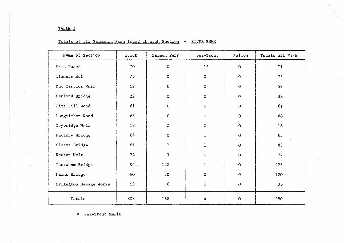
TABLE L
Totals of all Salmonid Fish found at each Section - RIVER ERME
Name of Section Trout Salmon Parr Sea-Trout Salmon Totals all Fish
Erme Pound 70 0 1* 0 71
Tinners Hut 75 0 0 0 75
Hut Circles Weir 52 0 0 0 52
Harford Bridge 32 0 0 0 32
Pitt Hill Wood 61 0 0 0 61Longtimber Wood 68 0 0 0 68
Ivybridge Weir 18 0 0 0 18
Factory Bridge 64 0 1 0 65
Cleeve Bridge 81 1 1 0 83
Keaton Weir 74 3 0 0 77
Thornham Bridge 94 . 128 1 0 223
Fawns Bridge 90 30 0 0 120
Ermington Sewage Works 29 6 0 0 35
Totals 808 168 4 0 980
* Sea-Trout Smolt
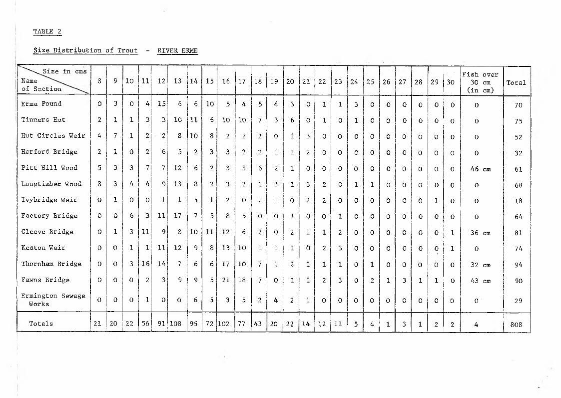
TABLE 2
Size Distribution of Trout - RIVER ERME
^^\Size in cms Nameof Section
8 9 10 11 12 13 14 15 16 17 18 19 20 21 22 23 24 25 26 27 28 29 30Fish over 30 cm (in cm)
Total
Erme Pound 0 3 0 4 15 6 6 10 5 4 5 4 3 0 1 1 3 0 0 0 0 0 0 0 70Tinners Hut 2 1 1 3 3 10 11 6 10 10 7 3 6 0 1 0 1 0 0 0 0 0 0 0 75Hut Circles Weir 4 7 1 2 . 2 8 10 8 2 2 2 0 1 3 0 0 0 0 0 0 0 0 0 0 52Harford Bridge 2 1 0 2 6 5 2 3 3 2 2 1 1 2 0 0 0 0 0 0 0 0 0 0 32Pitt Hill Wood 5 3 3 7 7 12 6 2 3 3 6 2 1 0 0 0 0 0 0 0 0 0 0 46 cm 61Longtimber Wood 8 3 4 4 9 13 8 2 3 2 1 3 1 3 2 0 1 1 0 0 0 0 0 0 68Ivybridge Weir 0 1 0 0 1 1 5 1 2 0 1 1 0 2 2 0 0 0 0 0 0 1 0 0 18Factory Bridge 0 0 & 3 11 17 7 5 8 5 0 0 1 0 0 1 0 0 0 0 0 0 0 0 64
Cleeve Bridge 0 1 3 11 9 8 10 11 12 6 2 0 2 1 1 2 0 0 0 0 0 0 1 36 cm 81Keaton Weir 0 0 1 1 11 12 9 8 13 10 1 1 1 0 2 3 0 0 0 0 0 0 1 0 74Thornham Bridge 0 0 3 16 14 7 6 6 17 10 7 1 2 1 1 1 0 1 0 0 0 0 0 32 cm 94
Fawns Bridge 0 0 0 2 3 9 9 5 21 18 7 0 1 1 2 3 0 2 1 3 1 1 0 43 cm 90Ermington Sewage Works 0 0 0 1 0 0 6 5 3 5 2 4 2 1 0 0 0 0 0 0 0 0 0 0 29
Totals 21 20 22 56 91 108 95 72 102 77 43 20 22 14 12 11 5 4 1 3 1 2 2 4 808
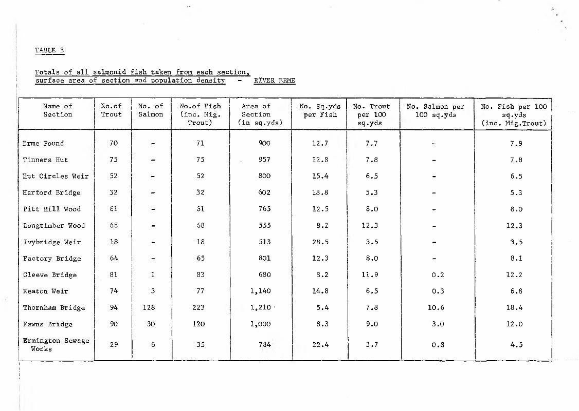
TABLE 3
Totals of all salxaonid fish taken from each section,surface area of section and population density - RIVER EBME
Name of Section
No.of Trout
No. of Salmon
No.of Fish (inc. Mig. Trout)
Area of Section (in sq.yds)
No. Sq.yds per Fish
No. Trout per 100 sq.yds
No. Salmon per 100 sq.yds
No. Fish per 100 sq.yds
(inc. Mig.Trout) j
Erme Pound 70 - 71 900 12.7 7.7 - 7.9
Tinners Hut 75 - 75 957 12.8 7.8 - 7.8
Hut Circles Weir 52 - 52 800 15.4 6.5 - 6.5
Harford Bridge 32 - 32 602 18.8 5.3 - 5.3
Pitt Hill Wood 61 - 61 765 12.5 8.0 - 8.0
Longtimber Wood 68 - 68 555 8.2 12.3 - 12.3
Ivybridge Weir 18 - 18 513 28.5 3.5 - 3.5
Factory Bridge 64 - 65 801 12.3 8.0 - 8.1
Cleeve Bridge 81 1 83 680 8.2 11.9 0.2 12.2
Keaton Weir 74 3 77 1,140 14.8 6.5 0.3 6.8
Thornham Bridge 94 128 223 1,210 5.4 7.8 10.6 18.4
Fawns Bridge 90 30 120 1,000 8.3 9.0 3.0 12.0
Ermington Sewage Works 29 6 35 784 22.4 3.7 0.8 4.5

SURVEY SECTIONS - RIVER ERME