developmental test navfest: a large-scale, multi … · achievable in a gps jamming environment...
TRANSCRIPT
412TW-PA-18036
DEVELOPMENTAL TEST NAVFEST: A LARGE-SCALE, MULTI-AIRCRAFT, GPS
JAMMING TEST EVENT
COLE JOHNSON CHIAWEI LEE
MARCEA ASCENCIO
AIR FORCE TEST CENTER EDWARDS AFB, CA
APRIL 2018
4 1 2TW
Approved for public release; distribution is unlimited. 412TW-PA-18036
412TH TEST WING EDWARDS AIR FORCE BASE, CALIFORNIA
AIR FORCE MATERIEL COMMAND UNITED STATES AIR FORCE
REPORT DOCUMENTATION PAGE Form Approved OMB No. 0704-0188
Public reporting burden for this collection of information is estimated to average 1 hour per response, including the time for reviewing instructions, searching existing data sources, gathering and maintaining the data needed, and completing and reviewing this collection of information. Send comments regarding this burden estimate or any other aspect of this collection of information, including suggestions for reducing this burden to Department of Defense, Washington Headquarters Services, Directorate for Information Operations and Reports (0704-0188), 1215 Jefferson Davis Highway, Suite 1204, Arlington, VA 22202-4302. Respondents should be aware that notwithstanding any other provision of law, no person shall be subject to any penalty for failing to comply with a collection of information if it does not display a currently valid OMB control number. PLEASE DO NOT RETURN YOUR FORM TO THE ABOVE ADDRESS. 1. REPORT DATE (DD-MM-YYYY)
24-04-2018 2. REPORT TYPE Conference proceeding
3. DATES COVERED (From - To) August 2017
4. TITLE AND SUBTITLE Developmental Test NAVFEST: A Large-Scale, Multi-Aircraft, GPS Jamming Test Event
5a. CONTRACT NUMBER N/A 5b. GRANT NUMBER N/A 5c. PROGRAM ELEMENT NUMBER N/A
6. AUTHOR(S) Johnson, Cole Lee, Chiawei Ascencio, Marcea
5d. PROJECT NUMBER N/A 5e. TASK NUMBER N/A 5f. WORK UNIT NUMBER N/A 7. PERFORMING ORGANIZATION NAME(S) AND ADDRESS(ES) AND ADDRESS(ES)
Air Force Test Center, Edwards Air Force Base, CA
8. PERFORMING ORGANIZATION REPORT NUMBER
412TW-PA-18036
9. SPONSORING / MONITORING AGENCY NAME(S) AND ADDRESS(ES) N/A
10. SPONSOR/MONITOR’S ACRONYM(S) N/A
11. SPONSOR/MONITOR’S REPORT NUMBER(S)
12. DISTRIBUTION / AVAILABILITY STATEMENT Approved for public release A: distribution is unlimited. 13. SUPPLEMENTARY NOTES IEEE/ION Position, Location, and Navigation Symposium (PLANS) 23-26 April 2018, Monterey, CA 14. ABSTRACT Edwards Air Force Base (AFB), home of the Air Force Test Center, has a long history of testing aircraft and technologies at the forefront of the aerospace and defense industry. The test unique infrastructure, dedicated airspace, and a deep talent pool of experienced flight testers make it an ideal location to host large scale test events. Developmental Test (DT) Navigation Festival (NAVFEST) was a first-of-its-kind GPS jamming test event held at Edwards AFB, CA in August 2017. Although other GPS jamming test events have occurred around the world, none have been accomplished on such a scale by the developmental test community which provides a disciplined, scripted, and data-rich environment. This paper will cover the necessary planning, safety mitigation, diverse types of test, and the overall jamming ecosystem created by the event. Test results will not be provided in this paper due to security classification but a classified follow-on paper will be submitted to the ION 2018 Joint Navigation Conference (JNC).
15. SUBJECT TERMS GPS, Jamming, Flight Test, Developmental Test, Navfest
16. SECURITY CLASSIFICATION OF: Unclassified
17. LIMITATION OF ABSTRACT
18. NUMBER OF PAGES
19a. NAME OF RESPONSIBLE PERSON 412 TENG/EN (Tech Pubs)
a. REPORT Unclassified
b. ABSTRACT Unclassified
c. THIS PAGE Unclassified None 11
19b. TELEPHONE NUMBER (include area code)
661-277-8615 Standard Form 298 (Rev. 8-98)
Prescribed by ANSI Std. Z39.18

U.S. Government work not protected by U.S. copyright DISTRIBUTION A. Approved for pubic release; distribution unlimited. PA number: 412TW-PA-XXXXX
Developmental Test NAVFEST: A Large Scale, Multi-Aircraft, GPS Jamming Test
Event Cole Johnson, Chiawei Lee, and Marcea Ascencio, US Air Force Test Center, Edwards AFB, CA
IEEE/ION Position, Location, and Navigation Symposium (PLANS)
23-26 April 2018, Monterey, CA
ABSTRACT
Edwards Air Force Base (AFB), home of the Air Force Test Center, has a long history of testing aircraft and technologies at the forefront of the aerospace and defense industry. The test unique infrastructure, dedicated airspace, and a deep talent pool of experienced flight testers make it an ideal location to host large scale test events. Developmental Test (DT) Navigation Festival (NAVFEST) was a first of its kind GPS jamming test event held at Edwards AFB, CA in August 2017. Although other GPS jamming test events have occurred around the world, none have been accomplished on such a scale by the developmental test community which provides a disciplined, scripted, and data-rich environment. This paper will cover the necessary planning, safety mitigation, diverse types of test, and the overall jamming ecosystem created by the event. Test results will not be provided in this paper due to security classification but a classified follow on paper will be submitted to ION Joint Navigation Conference (JNC) 2018.
INTRODUCTION
During the week-long test event, five types of US Air Force platforms including the B-1, B-2, F-16, F-22, and F-35 successfully completed test missions against 14 GPS jammers which created the most intense jamming to signal (J/S) field available. Testing was supported by control rooms staffed with professional test conductors and flight test engineers monitoring data in real-time, allowing for meticulous analysis of the effects of GPS Jamming on military aircraft. In total, eight different instrumented test aircraft flew 13 total test sorties to collect data used to analyze resiliency to jamming, develop future tactics, and guide acquisition decisions. Two university research labs were also afforded the opportunity to flight test experimental small unmanned aerial systems (sUAS) for an additional 21 short-duration sorties.
Each platform involved in the test event was interested in testing anti-jam performance in a dynamic environment as
well as maintaining downstream radar, targeting pods, data-links, sensor fusion, and weapons capabilities which are dependent upon the aircraft navigation solution. Some specific tests performed on the sub-systems include: simulated weapon releases, synthetic aperture radar (SAR) mapping, tactical datalink transmit/receive, ground targeting, and multi-ship communication exercises. In addition, participating aircraft were able to test new capabilities only achievable in a GPS jamming environment such as GPS jamming detection and the accompanying warnings displayed to the pilot. The specific test results remain classified but the test methodology are included in this paper. The authors of this paper intend to submit a follow-on presentation and paper containing a subset of the test results to the classified session of the ION JNC in July 2018.
DT NAVFEST significantly reduced costs by splitting jammer setup and execution fees, on the order of hundreds of thousands of dollars, between multiple participating organizations. It also created an eco-system of test and training that allowed smaller organizations to participate in an event that otherwise would have been cost prohibitive to create on their own. These included KC-10 aerial refueling tanker training, Army Special Operations Command (SOCOM) training, Emerging Technologies Combined Test Force (ET-CTF) testing, and academic research testing conducted by Stanford University and the University of Illinois at Urbana-Champaign (UIUC).
Through the Air Force Test Center’s Educational Partnership program, an agreement was drafted between the Test Center and the academic research labs. This allowed the labs to take advantage of the jamming field provided by the DT NAVFEST event, dedicated sUAS airspace (including night flying), frequency deconfliction, and support assets from Edwards Air Force Base without cost. This first of its kind partnership falls in line with the Air Force’s overall support of cutting edge academic research and will further mature technologies and algorithms that can support both military and civilian navigation.

U.S. Government work not protected by U.S. copyright DISTRIBUTION A. Approved for pubic release; distribution unlimited. PA number: 412TW-PA-XXXXX
Although GPS jamming is not new to the Southwestern US, serious consideration was taken to mitigate the effects on the public and other agencies who rely on GPS. Over a hundred organizations were contacted to determine the scope of impact and mitigate any possible risk. Early coordination with the Federal Aviation Administration (FAA) enabled proper deconfliction with large scale Marine and Navy events while identifying time-windows that minimized impact to commercial air traffic. In addition, the DT NAVFEST team contacted many agencies including but not limited to emergency services, public utilities, cell-phone providers, railroads, and local industries such as mining companies that may be affected. A large effort was expended to ensure the first of what will hopefully become an annual DT NAVFEST was safe and effective. These efforts resulted in a successful and safely executed DT NAVFEST test event. The test community is already in planning for a follow-on DT NAVFEST tentatively scheduled for late 2018/early 2019 to expand on the number of participants and the types of test and training first conducted in 2017.
VALUE OF DEVELOPMENTAL FLIGHT TEST
Multi-tiered laboratory testing of Air Force aircraft components is commonplace. The intent is to integrate low level sub-systems such as a GPS antenna to an increasingly complex air platform while maintaining high visibility of hardware and software performance and stability. Often, labs cannot reproduce the complexity of an actual aircraft flying in the outside world or the physical forces they encounter. Despite every effort (e.g., flying test beds), errors can and do escape the labs. These “escapes” are typically revealed during developmental flight tests at Edwards AFB.
Air Force DT typically consists of an Air Force Test Pilot School graduate flying a recently upgraded or entirely new aircraft in the skies over the southwestern United States while a team of control room engineers monitor telemetered (TM) performance data in real-time. Real-time data aids completion of pre-determined test points designed to verify performance or stress the system. Although TM data can be analyzed to score performance, most engineers wait for a larger dataset retrieved from onboard data recorders after landing. Depending on the sub-system being analyzed (e.g., weapons, radar, navigation) data encompassing one run or an entire multi-hour flight may be processed through locally developed analysis routines. There, performance may be evaluated and problems identified well enough to aid a contractor in locating and fixing the flaw.
At the end of a test program comprised of anywhere from a single upgrade (e.g., radar) to an entirely new aircraft (e.g., F-35), a test report is written by pilots and engineers to grade the performance and make judgements regarding its military utility. The test report is then provided to high level decision makers in an effort to aid acquisition decisions.
Operational Testing (OT) is a follow-on to DT flight testing and is designed to offer a near-final assessment of the
airborne platform’s operational effectiveness. In OT, more focus is placed on questions such as “can it perform the mission?” as opposed to “did it meet performance requirements?” A military aircraft may meet all contractual performance specifications but then fail at completing the mission it was designed to accomplish. Therefore, in OT engineering involvement is typically replaced with pilots and other operators enabling a better judgement of operational effectiveness but lessening insight into the performance of the system.
Therefore, when searching for a GPS jamming test venue that offers an optimal combination of lab-like insight to system performance coupled with an actual aircraft with all sub-systems integrated and dynamically flying through a controlled environment, DT flight test seemed ideal.
Navigation system performance for a fighter such as the F-22 or a bomber such as the B-1 are more heavily focused on weapons employment than guidance and navigation. Although GPS-denied navigation is very important for all aircraft, where infringement of a hostile nation’s airspace could result in a shoot down as demonstrated by Korean Airlines Flight 007 [01], the position error bounds required for such a scenario are much looser than that of destroying a target with a Small Diameter Bomb (SDB). Therefore, DT NAVFEST considered testing downstream effects of GPS-jamming on the entire integrated weapon system (e.g., radar, targeting pods, weapons).
Currently, direct injection of GPS-jamming signals is unavailable to most military platforms. The Simulated Programmable Aircraft-Embedded Jammer (SPACE JAM) is an Air Force project designed to rectify this problem, but this direct injection system is only compatible with a select few of GPS antennas and AEUs and requires a cockpit interface to upload and control jamming scenarios [02]. Modifications to achieve compatibility and the necessary flight testing required to validate the system would likely be cost prohibitive.
To achieve the desired low cost, yet operationally representative GPS-jamming test scenario, open air testing was required.
JAMMER LAYDOWN
The most intense jamming to signal ratio (J/S) possible was desired to stress navigation and downstream subsystems (e.g., radar, targeting pod, weapons) as opposed to creating a training environment where medium power jamming was sufficient. Doing so provided a rare opportunity to monitor and analyze aircraft performance in a data-rich GPS-degraded environment.

U.S. Government work not protected by U.S. copyright DISTRIBUTION A. Approved for pubic release; distribution unlimited. PA number: 412TW-PA-XXXXX
Figure 01: High Powered Jammer at DT NAVFEST
The GPS jammers provided by the 746th Test Squadron (746 TS) consisted of eight portable box jammers (PBJ) with an effective radiated power (ERP) of approximately 1.3 kW and six high powered jammers (HPJ) as shown in Figure 01 with an ERP of approximately 165 kW.
The 746 TS’s entire arsenal of GPS jammers was requested with hopes of producing the most intense jamming laydown possible. Jammers were spread over an approximately 40 NM oval in the sparsely populated region just north of Edwards AFB as shown in Figure 02. The term “Hx” signifies an HPJ and “Nx” a PBJ.
To model the intensity and range of the GPS jamming fields, the GPS Interference and Navigation Tool (GIANT) was used both before and after the test. Figure 03 shows an example of an early un-validated DT NAVFEST model. The GIANT plots aided test planning before the test and enabled estimates of anti-jam performance after. An instrumented C-12 aircraft flew through the jamming field during DT NAVFEST to act as a J/S truth source, enabling adjustment
Figure 02: GPS Jammer Locations
and validation of the model. After flight testing ended, an engineer was able to feed the aircraft’s flight path into GIANT, which in turn would associate a J/S value for each latitude, longitude, and altitude measurement. Unfortunately, a high-fidelity measurement of aircraft body masking at GPS frequencies as well as the antenna pattern of an aircraft’s GPS antenna would be needed to eliminate their effects and truly judge the antenna’s anti-jam capability. Although easily achievable in lab testing, where jammers can be mounted above a static antenna, flight testing with real maneuvering aircraft makes it tremendously difficult to confidently make an assessment. However, knowing the J/S field an aircraft can fly through while retaining sub-system performance is still tactically valuable.
The HPJ’s and PBJs were angled in such a way to converge into one continuous GPS L1 and L2 jamming field between 20k–30k feet Mean Sea Level (MSL). Doing so created a single hotspot in the center of convergence that reached an approximate jamming to signal (J/S) ratio of 95 dB on the GPS L1 frequency, which dissipated with distance as shown in Figure 04. The GPS L2 frequency received the same jamming power as L1.
A large oval shaped jamming field was desired to stress aircraft sub-systems as they flew in from the East to capture a standard set of radar reflectors within SAR maps. These reflectors have supported thousands of SAR map collections and Target Location Error (TLE) measurements in a clean GPS environment. Test runs under the same conditions, except now in a GPS-jamming environment, enabled a historical comparison and true judge of system degradation. Targeting pod TLE was measured with similar techniques, except surveyed targets more easily seen with infra-red cameras were used (e.g., burning barrels).
Table 01 list the specifications of the jammers used in DT NAVFEST. The tight HPJ 3 dB beamwidth was necessary to achieve a high ERP. The ERP factors in line-loss.
Figure 03: Un-validated GIANT Model of DT NAVFEST Covering the American Southwest

U.S. Government work not protected by U.S. copyright DISTRIBUTION A. Approved for pubic release; distribution unlimited. PA number: 412TW-PA-XXXXX
Figure 04: Validated Jamming Laydown, 25k feet MSL
Table 01: DT NAVFEST GPS Jammer Specifications
Jammer Type
Antenna Style
Beamwidth L1
Beamwidth L2
ERP (kW)
HPJ Dish 6° × 6° 8° × 8° 165 PBJ Helix 30° × 30° 40° × 40° 1.3
DECONFLICTION WITH EXTERNAL AGENCIES
Each year, the southwestern United States typically has multiple “GPS unreliable” advisories due to interference testing (i.e., GPS jamming). In 2016, an event schedule for the late afternoon and evening was canceled, likely due to public outcry [03]. Commercial aircraft rely on clear GPS signals to travel through congested airspace with increasing efficiency. GPS allows Air Traffic Controllers (ATC) to safely pack more aircraft into a smaller region. Without GPS, to retain the same level of safety ATC may revert back to legacy separation distances common before the advent of GPS. This could potentially reduce airspace density and cause delays.
The DT NAVFEST team was well aware of Southern California’s dense population and density of air traffic, which benefits from the efficiency provided by GPS. The FAA actively works with the Department of Defense (DOD) to facilitate and help balance open air GPS jamming testing, required to ensure our nation’s defense is prepared to face future threats, with the needs of the commercial aviation industry. The deconfliction process begins no later than 150 days before the start of open air GPS jamming tests. The FAA coordinates with several agencies to ensure all necessary parties are aware. In addition to the official process, a meeting was held with the FAA, the 746 TS, and the DT NAVFEST team to identify any gaps. A deconfliction coverage gap was found with a large force exercise planned to execute near the 29 Palms Marine Corps Air Ground Combat Center. Contact
was made with the Marine event planners to deconflict. GIANT models found the Marine’s would remain free of GPS jamming if airborne units stayed below approximately 15k feet MSL, which was originally planned.
ATCs also provided key insight regarding optimal GPS jamming windows. These were originally identified to be 0000-0600 local time. The ATCs suggested delaying jamming by 1 hour for a 0100 start time. Due to August thunderstorms over the central part of the US, air traffic departing from the East Coast may encounter delays and arrive in the Southwest late. Therefore, DT NAVFEST jamming times were conservatively scheduled for 0100-0600 local time, a 5 hour block in the middle of the night when GPS jamming would have the least impact to commercial air traffic.
The general public also utilizes GPS on their smartphones to enable things like navigation applications. Fortunately, many modern smartphones incorporate several Global Navigation Satellite Systems (GNSS) at different carrier frequencies into their navigation solutions, creating a natural resiliency to jamming of U.S. GPS signals. In addition, GIANT was utilized to predict J/S levels on the communities that surround Edwards AFB as shown in Figure 05. The model suggested little jamming power would spill onto ground level, likely due to the upward antenna pointing angle and narrow beamwidth of the jammers. During DT NAVFEST testing, a vehicle drove around the surrounding communities to measure jamming levels. Jamming power was found to be less than the model predicted and was often unmeasurable.
Figure 05: GIANT Model at 6 feet Above Ground Level
The 746 TS typically submits a GPS interference Notice to Airman (NOTAM) 48-96 hours before GPS jamming commences. All pilots are required to research NOTAMs before taking off. For example: if an airfield was closed due to maintenance and a pilot landed their despite NOTAMs listing it as closed, the pilot would be held responsible. In a similar way, pilots are responsible for taking appropriate action if pre-flight planning reveals they may traverse through the GPS unreliable zone listed in the NOTAM. Despite no requirement to do so, the DT NAVFEST team took the extra precaution of creating a press release and

U.S. Government work not protected by U.S. copyright DISTRIBUTION A. Approved for pubic release; distribution unlimited. PA number: 412TW-PA-XXXXX
submitting them to airfield managers and staff of 10 civilian airfields in the affected regions.
Another concern was emergency services in the communities surrounding Edwards AFB. Police, firefighters, search and rescue, air medical, and others emergency services may rely on GPS to quickly respond to an emergency call or transport a patient to the hospital. Research was conducted by speaking with police officers and firefighters to gauge any possible impact if they lost GPS. Police said they would revert back to legacy methods, but were not heavily dependent on GPS. Firefighters said they could use a special book for navigation and could navigate just as quickly without GPS. However, to ensure DT NAVFEST did not affect public safety, a press release that included a “Jam Off” number was provided to over 120 emergency services in the affected areas. Similarly, four Air Route Traffic Control Centers (ARTCC) were provided a special number. If called, the number would directly connect to the Joshua Air Traffic Control Facility where 746 TS officers were standing by. The jammers were guaranteed to turn completely off within one minute with actual times being much quicker. “Cease Buzzer” calls are similar to “Jam Off” but are reserved for the FAA. “Cease Buzzer” calls are reportable to the FAA and their number help judge the effects on air traffic. Only one “Cease Buzzer” call and one “Jam Off” call was made throughout the three nights of GPS jamming. The latter is not reportable to the FAA and was a voluntary call made by the DT NAVFEST team.
The first night of jamming testing, Los Angeles Air Traffic Control Center asked for a “Jam Off” due to a complaint from a commercial aircraft on final approach. They were off course but still within typical error bounds. This occurred after 0530 local so had little effect on testing which had nearly wrapped up for the night. The second night of jamming, the DT NAVFEST team called a voluntary “Jam Off.” An air medical helicopter transporting a patient from one hospital to another appeared to not have read the NOTAMs and informed ATC their GPS wasn’t working. The pilot did not ask for the jammers to be turned off when ATC notified them of GPS jamming testing, but the DT NAVFEST team felt it may be safety critical so the decision was made to stop jamming until they safely landed at their destination hospital.
To mitigate the potential impact on the general public, several civilian companies were contacted to ensure DT NAVFEST had little to no impact. Multiple cell phone providers said their current generation of cell-towers did not require GPS signals to maintain service. The two railway companies who transit the local area were notified of potential GPS disturbances, but were not concerned. The nearby Rio Tinto mines were also notified. Their mining trucks rely on GPS for some methods of work. Since they are below ground in the mine, they were not expected to feel any interference, but further questioning revealed a reliance on GPS dependent reference antennas at the surface. With this knowledge, the company shifted their mining trucks to other parts of the
mining operation that did not require GPS during the hours of jamming.
SYSTEM DESCRIPTIONS
Each participant in the event brought a unique navigation system to be evaluated in the GPS-denied environment. These varying configurations were designed to best suit the need of the platform, including tailored hardware/software design and special input/output requirements. The evaluation of these navigation systems begins with the GPS antenna, trickles down through the Antenna Electronics Unit (AEU), and into the GPS receiver. Depending on the platform, the GPS receivers were either federated entirely or embedded into an on-board navigation system. The GPS output and post-navigation system output are utilized across the entire aircraft. Though the configurations varied, all military participants utilized GPS coarse acquisition (C/A) and precision encrypted (P(Y)) code for the duration of their tests.
Despite being a legacy platform, the F-16 used a resilient, anti-jam navigation system for the series of testing. The system included a 7-element Controlled Reception Pattern Antenna (CRPA), GAS-1 Antenna Electronics Unit (AEU) and a 24-channel Selective Availability Anti-Spoofing Module (SAASM) GPS receiver. Figure 06 shows the CRPA and GAS-1 AEU. The GPS receiver is embedded into an Embedded GPS/INS (EGI), providing a tightly coupled navigation solution to the aircraft’s avionics systems. This “blended” solution is utilized across the aircraft’s radar, datalinks and weapons systems. For the duration of the flight testing, the F-16 used a Joint Direct Attach Munition (JDAM) that provided its own GPS Position, Velocity, and Time (PVT) solution from the internal 24-channel SAASM receiver.
Figure 06: CRPA with GAS AEU

U.S. Government work not protected by U.S. copyright DISTRIBUTION A. Approved for pubic release; distribution unlimited. PA number: 412TW-PA-XXXXX
The fifth generation fighters such the F-22 stealth fighter and F-35 Joint Strike Fighter utilized a slightly different configuration in their navigation systems. The F-22 navigation system included a Fixed Reception Pattern Antenna (FRPA), which does not have the same anti-jam capabilities that a CRPA does (beam steering, nulling, etc.) The GPS signal feeds through an antenna pre-amplifier and is then sent to two independent EGIs, commonly known as the Global Inertial Navigation Systems (GINS), as shown in Figure 07. More similar to the F-16, the F-35’s navigation system provides anti-jam capabilities with its configuration. The F-35 uses a 7-element CRPA and 24-channel SAASM GPS receiver. The GPS receiver is not embedded, but feeds into a software defined navigation filter, the Ownship Kinematic Model (OKM). The GPS PVT solution is utilized by systems such as the aircraft’s Datalinks system. Additionally, the GPS solution is blended with other inputs in the OKM and the solution is utilized by the sensor fusion engine, radar and weapons integration systems.
Figure 07: F-22 Navigation System
The two participating bomber aircraft used two very different navigation system set-ups. The B-1 used a CRPA with a Miniature Airborne GPS Receiver (MAGR). The GPS signals were then utilized by the two independent EGIs, one acted as a primary and the other as secondary. The B-2, tested a prototype configuration without CRPA functionality enable, and performed as a FRPA instead. Additionally, the GPS signal fed into a prototype M-Code MAGR 24-channel GPS receiver. Unlike the other aircraft, the B-2’s GPS inputs had very little impact to the combined navigation solution, benefitting from a loosely coupled solution that also incorporated an astro-inertial navigation system. The performance of these different navigation systems were truly put to the test, yielding hours of invaluable flight data.
Each aircraft was fitted with onboard special instrumentation to capture the data within and across the subsystems. This not only provided a live-feed of TM data to the mission control rooms, but a large amount of post-test data for meticulous review. The data capture included detailed performance and
stability parameters of the GPS receiver and the downstream effects on the various subsystems. To characterize the J/S levels, the 746th TS operated a C-12 aircraft with their Central Inertial and GPS Test Facility’s (CIGTF) Reference System (CRS) Reference Pallet (CRSP) and multiple spectrum analyzers. The C-12 flew in a grid-like pattern over the airspace at multiple altitudes to best characterize the air, producing a log of latitude, longitude, altitude and corresponding J/S level (dB). Figure 08 shows the configuration of the C-12.
Figure 08: C-12 Test Aircraft with CSRP
For a standard test with nominal GPS conditions, an independent time, space, and position information (TPSI) solution is obtained and compared against the aircraft or the system under test for accuracy. The standard TSPI system at Edwards AFB was dependent on a GPS-clear environment for optimal accuracy, therefore GPS jamming made it very difficult to rely on. Besides using Identify Friend or Foe (IFF) Mode 3/C position information or the aircraft’s free inertial output, two other methods of higher fidelity tracking were used. The first was a C-band beacon tracking radar that followed a single aircraft for each test block. The aircraft installed beacon enabled a strong signal for the radar to lock onto. Without a functioning beacon the radar switched to a less accurate “skin track” mode. Another method for providing “truth” data was derived from some aircraft’s electro-optics system. This method consisted of initiating a point track with the aircraft’s laser against known ground coordinates in a way the aircraft’s position could be back calculated. This method is outlined in the paper Targeting Pod Derived Aircraft Position by Karapet Gyurjyan [04]. These different capabilities allowed each participant to collect data to further understand the effects of GPS-jamming on these aircraft.
TYPES OF TEST
Each participating aircraft had their own set of test objectives. Most could be broken into two categories: navigation performance and downstream effects. Navigation performance could be described as GPS anti-jam resiliency and coasting performance. Downstream effects are simply the measurable degradation of sub-systems that rely on a high quality navigation solution such as radar, targeting pods, and weapons. All missions were successful in completing most if not all of their test objectives.
The B-1 flew their entire five hour jamming block across most of the R-2508 airspace. They performed SAR maps and worked their targeting pod to measure TLE in later data

U.S. Government work not protected by U.S. copyright DISTRIBUTION A. Approved for pubic release; distribution unlimited. PA number: 412TW-PA-XXXXX
analysis. They also monitored their navigation systems resiliency to the jamming field.
Since the B-2 had a prototype GPS without anti-jam features enabled, they were primarily concerned with measuring downstream system performance.
The F-16 focused on testing a new Heads Up Display (HUD) data block that fed J/S values from a wing carried Joint Direct Attack Munition (JDAM).
F-22 engineers were concerned with both navigation system performance and downstream effects of jamming. Both GPS-clear and GPS-jamming SAR maps were executed to compare performance. Simulated weapons tests were also executed. Post-test data analysis attempted to extract body masking measurement from collected data, but numerous dynamic variables could not be eliminated and values could not be calculated with an appropriate amount of confidence to report. Pole model testing is likely the best method for determining body masking.
F-35 engineers were concerned with GPS anti-jam, receiver initialization performance, and downstream resiliency. In addition, the multi-ship test exercised Enhanced Geo-Location functionality and performed simulated weapon releases with a JDAM. SAR maps were completed in the GPS-denied and GPS-clear environment as well as electro-optical point tracks. TLE was computed for each in post-flight analysis.
TEST RESULTS
Every platform that participated collected enough valuable data to declare mission success. The true performance of the aircraft remain classified. The authors of this paper intend to submit a separate paper to the classified section of the ION JNC in July 2018 which will present more detail regarding test results.
ECOSYSTEM OF TEST AND TRAINING
Due to the large amount of effort in deploying GPS-jamming assets, coordinating with the FAA, and deconfliction with nearby military organizations, the DT NAVFEST event created its own GPS jamming ecosystem of test and training events. Edwards AFB acts as a hub for various types of test and training throughout the year. The Army Special Operations Command (SOCOM), combat and training Air Force organizations, the recently established Emerging Technologies Combined Test Force (ET-CTF), and university research laboratories participated in an effort to maximize opportunities. Future DT NAVFEST events plan to incorporate a wider audience of participants and the authors are actively fielding participation requests.
The combined R-2508 restricted airspace and military operations areas (MOAs) are shared by three primary organizations: 1) Edwards AFB, 2) China Lake Naval Air Station, and 3) Ft. Irwin Army Base. Army Special
Operations Command was able to conduct a rare training opportunity during the GPS jamming events. Soldiers practiced special operations mission scenarios that included real GPS jamming. This rare opportunity afforded soldiers a chance to learn the effects of GPS jamming on their current tactics, techniques, and procedures (TTPs). Several of the fighter test teams from Edwards AFB requested aerial refueling tanker support during the test events in order to extend their sortie endurance and better utilize the limited GPS jamming time windows. This also afforded the tanker aircrews a unique opportunity to conduct training and refine tanker TTPs in a GPS jamming environment.
Edwards AFB recently created the Emerging Technologies Combined Test Force (ET-CTF) in order to better leverage the base’s unique test capabilities for rapidly changing technologies such as autonomy, sUAS, counter sUAS, directed energy, etc. The DT NAVFEST GPS jamming radio frequency authorization (RFA) contained permission to jam from the FAA for a two week window. Though only three actual nights of GPS jamming tests were planned for the main DT NAVFEST event, the two week window allowed ET-CTF to conduct a lower power sUAS flight test utilizing the RFA.
Finally, two university research labs were invited to conduct testing and data collection during the DT NAVFEST event. This is discussed in dedicated sections later in this paper. The aforementioned opportunities are some examples of the test and training events that could only have existed because of the greater DT NAVFEST event. Smaller test teams would normally not have the resources or influences necessary to coordinate GPS jamming activities on their own but their footprint can easily be accommodated by Edwards AFB infrastructure and under the ecosystem of GPS jamming test and training created by DT NAVFEST.
CHALLENGES AND LIMITATIONS
Throughout the planning, execution and analysis of the event, several external factors created unforeseen challenges. The 746th TS lead the effort to get all of the required RFAs in place for the GPS jamming; a process that started almost 10 months before the actual event. The predicted impact to the local air traffic drove the need to radiate at night; however, inputs from the FAA changed the original planned time of 2300-0600 to a final time of 0100-0600. In addition to the coordination with the FAA, other outside entities further limited the planned times for the event schedule. Nearby US Navy (USN) and US Marine Corps (USMC) agencies had large-scale integrated training exercises during the weeks of the planned testing. The extent of their exercises required nominal-GPS for the safety and efficiency of the mission. To de-conflict with the USMC, the original two weeks of flight test was reduced to one week of flight test. The USN also claimed two of the five days remaining in the week of planned testing. Despite the reduced amount of time to test, all of the participants were able to perform their required amount of flight testing.
U.S. Government work not protected by U.S. copyright DISTRIBUTION A. Approved for pubic release; distribution unlimited. PA number: 412TW-PA-XXXXX
Due to the first-time nature of this type of event at Edwards Air Force Base (EAFB), there were also internal limitations that influenced the project initiation and execution of the large-scale event. The largest hurdle was re-purposing the existing structure of the base personnel and assets to best suit the needs of a DT NAVFEST event. Typically, Edwards AFB flight operations occur throughout the day, with only a handful of weeks in the calendar year dedicated to night operations. The occurrence of this event did not fall under the dedicated night operations timeframe, thus creating a challenge for manpower across the various organizations to provide support for the high-priority day operations and the high-priority DT NAVFEST night operations. This not only affected the engineering team support, but the aircrew, maintenance, airfield management and local air traffic control personnel. Additionally, 412 TW project teams are usually comprised of team members from the same flight test squadron. For this event, multiple Edwards AFB platforms were involved leading to a team comprised of members from across the different flight test squadrons. These unique requirements lead to the need for innovative solutions, and through trial and error, forged the path for the next DT NAVFEST-type event at Edwards AFB.
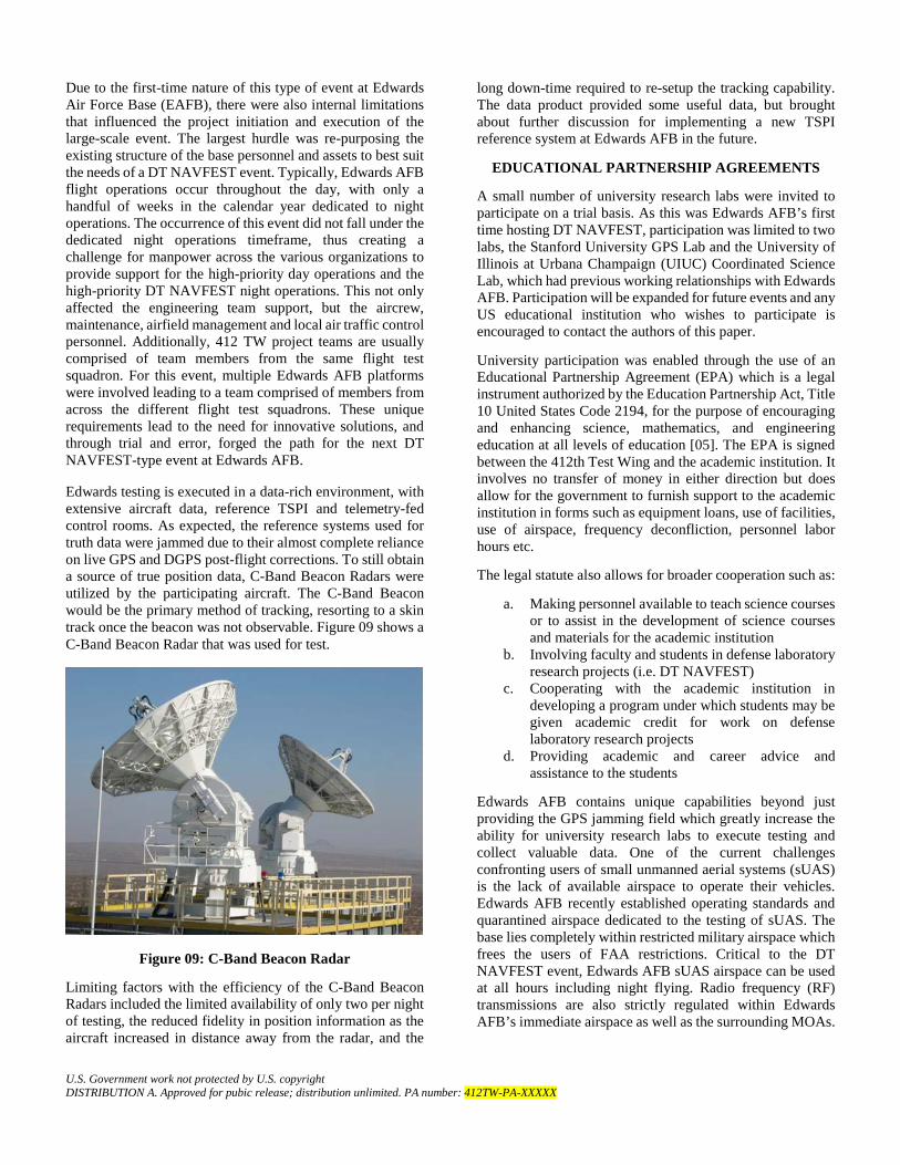
Edwards testing is executed in a data-rich environment, with extensive aircraft data, reference TSPI and telemetry-fed control rooms. As expected, the reference systems used for truth data were jammed due to their almost complete reliance on live GPS and DGPS post-flight corrections. To still obtain a source of true position data, C-Band Beacon Radars were utilized by the participating aircraft. The C-Band Beacon would be the primary method of tracking, resorting to a skin track once the beacon was not observable. Figure 09 shows a C-Band Beacon Radar that was used for test.
Figure 09: C-Band Beacon Radar
Limiting factors with the efficiency of the C-Band Beacon Radars included the limited availability of only two per night of testing, the reduced fidelity in position information as the aircraft increased in distance away from the radar, and the
long down-time required to re-setup the tracking capability. The data product provided some useful data, but brought about further discussion for implementing a new TSPI reference system at Edwards AFB in the future.
EDUCATIONAL PARTNERSHIP AGREEMENTS
A small number of university research labs were invited to participate on a trial basis. As this was Edwards AFB’s first time hosting DT NAVFEST, participation was limited to two labs, the Stanford University GPS Lab and the University of Illinois at Urbana Champaign (UIUC) Coordinated Science Lab, which had previous working relationships with Edwards AFB. Participation will be expanded for future events and any US educational institution who wishes to participate is encouraged to contact the authors of this paper.
University participation was enabled through the use of an Educational Partnership Agreement (EPA) which is a legal instrument authorized by the Education Partnership Act, Title 10 United States Code 2194, for the purpose of encouraging and enhancing science, mathematics, and engineering education at all levels of education [05]. The EPA is signed between the 412th Test Wing and the academic institution. It involves no transfer of money in either direction but does allow for the government to furnish support to the academic institution in forms such as equipment loans, use of facilities, use of airspace, frequency deconfliction, personnel labor hours etc.
The legal statute also allows for broader cooperation such as:
a. Making personnel available to teach science courses or to assist in the development of science courses and materials for the academic institution
b. Involving faculty and students in defense laboratory research projects (i.e. DT NAVFEST)
c. Cooperating with the academic institution in developing a program under which students may be given academic credit for work on defense laboratory research projects
d. Providing academic and career advice and assistance to the students
Edwards AFB contains unique capabilities beyond just providing the GPS jamming field which greatly increase the ability for university research labs to execute testing and collect valuable data. One of the current challenges confronting users of small unmanned aerial systems (sUAS) is the lack of available airspace to operate their vehicles. Edwards AFB recently established operating standards and quarantined airspace dedicated to the testing of sUAS. The base lies completely within restricted military airspace which frees the users of FAA restrictions. Critical to the DT NAVFEST event, Edwards AFB sUAS airspace can be used at all hours including night flying. Radio frequency (RF) transmissions are also strictly regulated within Edwards AFB’s immediate airspace as well as the surrounding MOAs.

U.S. Government work not protected by U.S. copyright DISTRIBUTION A. Approved for pubic release; distribution unlimited. PA number: 412TW-PA-XXXXX
This helps to ensure data are collected in a clean RF environment.
Both Stanford and UIUC are leading research institutions in the field of satellite navigation. For the DT NAVFEST event, both universities conducted test flights with small unmanned aerial systems (sUAS) and UIUC also conducted ground testing from vehicle mounted test setups. A brief system description, summary of types of tests, and overview of test results are provided in the following sections. As this is not the primary objective of this paper, more details can be included in the referenced materials
sUAS SYSTEM DESCRIPTIONS
Stanford University’s ground and flight tests centered on their Jammer Acquisition with GPS Exploration & Reconnaissance (JAGER) octocopter platform whose primary mission is to localize jamming signals. The two main objectives of their experiments were to test algorithms for 1) faster localization and 2) robust navigation [06]. The JAGER octocopter is based on the DJI S1000 platform and has been heavily modified with custom antennas, receivers, and telemetry electronics. The maximum weight is approximately 23 pounds, maximum speed of 45 miles per hour, and maximum endurance of approximately 15 minutes depending on payload weight.
Figure 10: Stanford University’s JAGER Octocopter Prior to Late Night Flight Tests
The goal of Stanford’s work during DT NAVFEST was to test the new compact and steerable three-element beam steering antenna which was designed to increase the observation rate and localization effectiveness of the JAGER. The electronically rotated antenna was a significant improvement over the previous direction antenna which required the vehicle to be physically rotated. The new capability enables the development of new localization algorithms and navigation techniques. In addition, the increased observation rate give JAGER the ability to localize and track moving sources and to incorporate simultaneous localization and mapping (SLAM) techniques to both localize the interference source and navigate successfully without GPS by using that same source as a beacon, or signal of opportunity [07].
UIUC’s ground and flight test had three separate phases: 1) fixed ground tests, 2) vehicle mounted moving ground tests, and 3) sUAS based flight tests. Ground testing consisted of four stationary GPS receivers and antenna. The technology under test included multi-receiver direct timing estimation and multi-receiver vector tracking for time [08]. A similar hardware setup was mounted to the roof of a UIUC vehicle to test multi-receiver direct position estimation (DPE) and multi-receiver vector tracking for positioning.
Both technologies were previously tested in non-GPS jamming environments including a Test Management Program (TMP) with the US Air Force Test Pilot School (USAF TPS) [09]. Under the TPS Project GRIFFIN TMP, UIUC’s antennas, receivers, and electronics were installed and flown on an Air Force C-12 aircraft.
Figure 11: UIUC Pseudolite
Finally, UIUC also operated a custom quadcopter during the GPS jamming combined with pseudolites in order to further mature their multi-receiver vector tracking for positioning and multi-receiver DPE technologies. Unfortunately, due to hardware damage during shipping, actual flight tests were limited.
Figure 12: UIUC Quadcopter Multipath Ground Tests in Front of Edwards AFB Test Wing Headquarters
sUAS TYPES OF TEST
University research lab testing during DT NAVFEST was broken down into three primary types: 1) static ground testing, 2) moving vehicle ground tests, and 3) sUAS flight tests. Careful coordination and planning was done months in advance between the labs and an Edwards AFB university

U.S. Government work not protected by U.S. copyright DISTRIBUTION A. Approved for pubic release; distribution unlimited. PA number: 412TW-PA-XXXXX
liaison to ensure that the technical, safety, and legal framework was in place for successful data collection.
Static ground testing was done at three primary locations to capture various environmental conditions and jamming signal strengths. The first location was the North Rosamond Lakebed, which was not used for primary flight operations due to its relatively small size. During normal use, the North Rosamond Lakebed is used by the Model Masters Remote Control Aircraft Flight Club. The Lakebed has level terrain in three directions and low hills to the North which provided some level of terrain masking. Due to the topography, this location provided excellent “open sky” data collection.
UIUC also expressed a desire to collect multipath data utilizing reflections off a tall building. Edwards AFB contains numerous large aircraft hangars which could not be utilized for university testing due to access restrictions for non-military organizations. The tallest building on the accessible parts of base was the headquarters of the 412th Test Wing. The three story high building is shaped like a B-2 when viewed from above and contains static displays of two F-16 and F-86 fighter jets. Static data collection tests were accomplished at both locations and UIUC also collected slow moving multipath tests by walking their quadcopter around the building in order to change the geometry relative to the nearest jammer.
UIUC mounted its multi-antenna, multi-receiver set up to a custom roof rack on top of a vehicle. This setup was used in order to collect data while changing the relative bearing to the fourteen jammers. Driving towards the primary jamming field from over 30 miles away allowed the UIUC team to vary the received signal strength of the GPS jamming.
The North Rosamond Lakebed is also one of several sUAS Working Areas that Edwards AFB created in 2016 to support new types of test utilizing sUAS. This location was chosen due to its open airspace over level terrain, ease of access just off a major base access road, and relatively low jamming level due to terrain masking from nearby hills. The airspace was reserved from surface to 500 feet above ground level (AGL) during the first night of testing. Stanford completed six flights up to 400 feet to characterize the jamming signal strength level. Unfortunately, though predictions showed approximately 30-40 dBW J/S, actual received jamming strength was found to be too weak for meaningful data collection so the decision was made to move sUAS flight operations to the North Base sUAS Working Area. The discrepancy between predicted and real world J/S is a known limitation of the GIANT prediction tool, which is not optimized for performance near ground level.
The North Base sUAS Working Area is the primary sUAS airspace used by Edwards AFB test teams. It spans approximately 3 NM × 3 NM and can be utilized from surface to unlimited altitude (though it is typically only used up to 500–1000 feet AGL). For this test, predictions showed the North Base area would have between 60–70 dBW J/S and the
location was used for flying during the second and third nights of testing. Stanford continued data collection flights using JAGER, swapping out three different antenna configurations to compare relative performance. UIUC also conducted test flights with their quadcopter and three pseudolites set up on tripods to assist in positioning. In total both universities combined for 20 test flights.
Figure 13: North Rosamond and North Base sUAS Working Areas with Predicted J/S
sUAS TEST RESULTS
This paper contains only a brief summary of results from the university tests. More detailed information can be found in the referenced paper and by contacting the research labs directly.
The Stanford GPS Lab successfully flight tested the new beam steering antenna setup on the JAGER octocopter. The bearing observation rate was reduced to every 0.5 seconds compared 30 seconds from the previous directional antenna. Flight testing also showed significant range performance results, demonstrating the antenna’s ability to measure power from a jammer signal up to 20 kilometers away. Of the three different antenna hardware setups tested, two showed measurable capability to determine signal bearing. Unfortunately, the third antenna type did not provide sufficient sensitivity to pick up jamming signals at the distances tested.
For future testing, the lab would like to fly the JAGER closer to the GPS jammers in order to generate stronger received signal strengths and higher bearing rates as the vehicle flies. In addition, an infrared (IR) imaging sensor can also be integrated with the bearing determination system to form a tightly coupled solution for jammer localization.
The UIUC Coordinated Science Lab automobiles were driven on a planned path including Edwards Air Force Base and the nearby towns. These paths were optimized in order to provide variation in jammer bearing and signal strength over time. The collected datasets will be used for studying how mobile multi-GPS receiver setups can be used to mitigate the effects of signal jamming.

U.S. Government work not protected by U.S. copyright DISTRIBUTION A. Approved for pubic release; distribution unlimited. PA number: 412TW-PA-XXXXX
The custom quadcopter utilized the ground based ultra-wide band (UWB) pseudolites to transmit pseudoranges to a mobile workstation. As the UWB transceivers broadcasted low power over a particularly wide frequency range, the transceivers were immune to jamming on the GPS L1 band. This setup will allow for the study of cooperative localization of a mobile receiver assisted by stationary receivers under GPS jamming conditions.
For future testing, the UIUC lab would also like to see higher jamming intensity at ground level in order to better replicate an adversarial environment.
FUTURE WORK
As a result from the successful execution of the first DT NAVFEST at Edwards AFB, there are plans to host another similar event in the near future. The next DT NAVFEST is planned for the end of 2018, possibly into 2019. Unlike the first iteration, the next event would utilize multiple jamming waveforms and geometries. As familiarization with this large-scale event grows with nearby external military organizations and the FAA, the event can be better scheduled so that it does not conflict with other important activities and exercises. Ultimately, the 412th TW would like to host more days of ground and flight testing so that it may accompany more participation from outside organizations such as universities and other service agencies. Unmanned systems (sUAS) and other ground participants will also be encouraged to participate so as to further the ecosystem created by this type of event. Furthermore, the 412th TW is looking to combine an Interoperability Exercise (Orange Flag) with the GPS-denied environment to strain the capabilities of the platforms and collect invaluable data from these scenarios. In summary, DT NAVFEST is expected to be a regular event, continuing the advanced testing capabilities of the Air Force Test Center.
ACKNOWLEDGEMENTS
The authors of this paper wish to thank the following organizations whose support made the DT NAVFEST 2017 event a resounding success.
• The leadership and members of the 746th Test Squadron, Holloman AFB, NM
• Edwards Air Force Base leadership and members of the 775th Test Squadron, Test Engineering Group, 412th Operations Group, and 412th Test Wing
• The faculty and students from the Stanford University GPS Lab and University of Illinois at Urbana Champaign Coordinated Science Lab
REFERENCES
[01] A. Degani. Taming HAL: Designing Interfaces Beyond 2001. New York City: Palgrave MacMillan, 2004, p. 49-65 [Online]. Available: https://ti.arc.nasa.gov/m/profile/adegani/Crash%20of%20Korean%20Air%20Lines%20Flight%20007.pdf. [Accessed: 15- Jan- 2018]
[02] R. Amber, ‘TPS students test injection-jamming software on F-16’, 2013. [Online]. Available: http://www.edwards.af.mil/News/Article/829439/tps-students-test-injection-jamming-software-on-f-16/. [Accessed: 15- Jan- 2018].
[03] E. Tennyson, ‘NAVY CANCELS PLANNED GPS OUTAGE IN SOUTHERN CALIFORNIA’, 2016. [Online]. Available: https://www.aopa.org/news-and-media/all-news/2016/june/08/navy-cancels-planned-gps-outage-in-southern-california. [Accessed: 15- Jan- 2018].
[04] K. Gyurjyan, ‘Targeting Pod Derived Aircraft Position’, March 2015.
[05] Public Law 106-25, “Education Partnership Act”, Title 10 United States Code 2194, April 1999.
[06] Stanford GPS Lab, “Edwards AFB Flight Test Proposal,” January 2017.
[07] A. Perkins, Y. Chen, C. Lee, S. Lo, P. Enge, “RFI Localization with a Beam Steering Antenna Onboard a UAV,” Stanford Center for Position, Navigation, and Time, 11th Annual PNT Symposium, Stanford, CA, November 2017.
[08] UIUC Coordinated Sciences Lab, “Edwards AFB Flight Test Proposal,” January 2017.
[09] United States Test Pilot School, “Demonstration of Aircraft State Determination with Blended Solution of Multiple GPS Receivers: Project GRIFFIN,” Test Report, June 2017.
AUTHOR BIOGRAPHIES
Cole Johnson is a Guidance and Navigation Engineer at the 412th Test Engineering Group, Edwards Air Force Base, CA. Cole led the planning and execution of DT NAVFEST, a first of its kind GPS jamming test event. Currently a project engineer, Cole is managing preparations to test and evaluate future capabilities of the F 22 Raptor. He spent the previous five years as one of the first engineers to test and evaluate the new F-35 Lightning II. Cole received his Bachelor of Science in Mechanical Engineering from Northern Arizona University (NAU), and his Master of Science in Electrical Engineering from the Naval Postgraduate School (NPS). Chiawei (Wei) Lee is an Electronic Warfare Engineer with the 412th Electronic Warfare Group, Edwards Air Force

U.S. Government work not protected by U.S. copyright DISTRIBUTION A. Approved for pubic release; distribution unlimited. PA number: 412TW-PA-XXXXX
Base, CA. He was recently selected for a rotational assignment to the 412th Test Wing Test Safety Office where he is responsible for conducting independent safety review on all projects executing at Edwards AFB. His previous experience includes electronic warfare and weapons testing on F-16, F-22, F-35, B-1, and B-2 platforms. He received his Bachelor of Science in Aerospace Engineering from the University of California Los Angeles (UCLA) and his Master of Science in Aeronautics and Astronautics from Stanford University.
Marcea Ascencio is a Guidance and Navigation Engineer with the 412th Test Engineering Group, Edwards Air Force Base, CA. She is currently an engineer testing Communication, Navigation and Identification capabilities on the F-35 Developmental Test Program and is the lead engineer for the next DT NAVFEST event. Her previous experience includes testing navigation and core avionics capabilities for the F-16 USAF and EPAF programs. She received her Bachelor of Science in Electrical Engineering from California State University of Long Beach.