development of gis-based road transport information
TRANSCRIPT

Journal of Information Engineering and Applications www.iiste.org
ISSN 2224-5782 (print) ISSN 2225-0506 (online)
Vol.5, No.5, 2015
56
Development of GIS-Based Road Transport Information
Management System for Adamawa Central, Adamawa State,
Nigeria
Thlakma Sunday Richard Dr. Ibrahin Jaro Musa Prof. E. O. Iguisi
Geography Department, Ahmadu Bello University, Zaria, Kaduna State, Nigeria
Abstract
This study was conducted on the Development of Gis-Baesd Road Transport Information Mamagenmet System
for Adamawa Central, Adamawa State, Nigeria. The study covered Adamawa central which comprises of seven
local government areas nanell; Yola North (Jimeta), Yola South, Fufore, Gerei, Song, Gombi and Hong. Satellite
images, road transport map, road transport documents, as well as the bridges and the roundabout coordinate were
all used to obtain the final results for the study. The satellite images were Spot image of 2012 and Geogle Earth
image of 2013. The satellite images and road map were used in updating the road transport map, the road
transport documents as well the road, bridge and roundabout picture were used as an inventory in building the
geodatabase for the development of the GIS-Based road transport iformation management system and some of
the roads, bridge and roundabout coordinates were used for hyperlinking the pictures to the spatial
reference.ArcGIS 10.1, Microsoft 2013 and AO scanner was used for the entire thesis work, the thesis critically
observed the process involved in Developing a GIS-Based road transport information Management system for
the various road transport Infrastructures for Adamawa central, analysis were performed for proper decision-
making on how to manage the road transport infrastructures. The result reveals that Geographic Information
System as a very important system can be used in data collection, entry, development, management and analysis.
The research also show that the process of converting the traditional database system to a Geographical
Information System (GIS) does not require the hi-tech knowledge and equipment common in science fictions
and movies, but what is required in the planning will and commitment. It is recommended that government
should establish GIS unit in the federal and state ministry of transports board and also encourage the local
government areas to do the same for proper planning and development of road transport infrastructure and
management for easy management and control of its facilities.
Keywords: ArcGIS 10.1, GIS, Road Transport, Road Transport Inventory, Road Transport Map, Road Transport
Documents, Geodatabase. Sport Image, Google Earth Image
INTRODUCTION
Geographic information systems for road transport information management system can be defined as
interconnected hardware, software, data, people, organizations and institutional arrangements for collecting,
storing, analysing, communicating and managing particular types of information (i.e., transportation systems and
geographic regions) about the Earth (Vonderohe, 1993). They went on to say, GIS based road transport
information can be viewed as the product of the interaction between improved concepts of both geographic
information system (GIS) and transportation information system (TIS).
GIS based road information management system applications are currently used broadly by
transportation analysts and decision makers in different areas of transportation planning and engineering, from
infrastructure planning, design and management, traffic safety analysis, transportation impact analysis, public
transit planning and operations to intelligent transportation systems (ITS) such as Advanced Traveller
Information Systems (ATIS) and Commercial Vehicle Operations (CVO) (Vonderohe et al, 1993).
Road transport information system is the system that collects, organise and store data about the road
network, and provide facilities for reports to be produced on these data, in a variety of formats (Robinson, R.,
Danielson, U. and Snaith, M., 1998). Road Transport information which include: road inventory, traffic
statistics, construction, maintenance data, etc. could be organized and integrated properly by using GIS
techniques. Roads transport are networks that connect infrastructure facilities and accommodates lifeline
facilities. The provision, operation and maintenance of the physical infrastructure of a transportation sector and
its related social services require a prior knowledge and manipulation of GIS (Hassanain, et al, 2003).
Road transport is by far the most dominant mode of transport in the country, carrying well over 90% of
passenger and freight traffic and serving as a true backbone for Nigeria’s economy (Transport Research Board,
2004). Because a well maintained road transport asset is very important for the economic development of the
nation, Road Management Information System is a prerequisite for the successful management of road transport.
Geospatial data are foundation for relevant and critical information for planning, engineering, asset management,
and operations associated with every transportation mode at all levels of government and administration, (TRB,
2004).

Journal of Information Engineering and Applications www.iiste.org
ISSN 2224-5782 (print) ISSN 2225-0506 (online)
Vol.5, No.5, 2015
57
Transportation is one of the fastest growing of many fields in which GIS is used Rodrigue et al (2006).
Diverse areas of transportation, including high way and rail way infrastructure management, international
shipping, airport management, fleet logistics, traffic management and intelligent transportation systems (ITS),
transit bus and rail service planning, transportation modeling, supply chain modeling, and others, are applying
GIS to their work, ESRI (2003). The breadth of the field of integration of GIS and transportation system
provides large opportunities for the development of new and innovative applications in transportation system of
different transportation organizations Curtin (2003). Since GIS have a seamless relation with space and location,
given that their main objective as a tool is to store, retrieve, and facilitate the analysis of spatial data (Goodchild
and Janelle, 2004), they have become one of the most powerful tools to support transportation studies and
applications. The liaison between GIS and transportation is indeed quite natural, given that transportation itself is
linked to space organization on the development of networks in space and time, just like geography itself
(Haggett, 1965). Capitalizing on this relationship both academics and practitioners have focused their attention
on research/work that makes use of GIS in transportation applications. “GIS and Transport” has been of
importance in the academic world since the early 1990s (Miller, 1991; Kamal et al., 1994). However, besides
some early contributions, which aimed at explaining the role of GIS in transportation planning (Sutton, 1996), no
major efforts were made. A relevant attempt to collect and organize studies about GIS and Transport was made
in 2000 by the academic journal Transportation Research C (reviewed by Fotheringham, 2002, Shaw, 2002). In
several cases, it is sometimes formally required that public authorities with an interest in transportation build a
GIS framework to handle and manage transportation data and projects. For example, the American Association
of State Highways and Transportation Officials, together with the US Department of Transportation (DoT) have
been organizing a GIS-T symposium for the past 22 years, in order to give practical support to government and
private industry organizations interested in the use of GIS for transportation purposes. This shows that in
transportation science the spatial approach is naturally integrated, contrary to other disciplines where there is a
need to identify the particular role of “geographically oriented sub disciplines” in a distinct way. As an example,
transportation scientists have been key players in the application of GIS (Goodchild, 2000; Thill, 2000). GIS
have influenced a variety of aspects of transportation science. Goodchild (1998), after recognizing in the discrete
entity model and in the network model the GIS data models that are most interesting for transportation purposes,
identifies the paradigms leading to their extensive use in transportation modelling. These are: digital map
production, inventory and data management, integration of data, spatial analysis, and dynamic modelling, we
adopted this simple paradigms. He continues (Goodchild, 2000) by differentiating three stages in the evolution of
GIS-T: the map view (mainly concerning network visualization and interoperability issues); the navigational
view (connected with network modelling and algorithm resolution); and the behavioural view (linked to the use
of the network by people and vehicles, which implies the dynamic modelling of transportation phenomena).
The understanding of GIS based Road Transport management Information System, effective use of
geographical information and the knowledge of their advantages is critical to the planning and decision making
process for asset management and transport departments.
This study is important and timely because Adamawa central still faces problems of traffic congestion,
high road accidents, lack of road transport geospatial database, weak institutional support leading to poor
definition of the problem at hand and differing technology transfer priorities in problem resolution. This could be
linked to the non-availability of adequate information on road transport due to increase urbanization, growth of
commercial activities and increase road development that is spatially integrating activities. This development
comes up with different characterisation of transport infrastructure, operation methods, ownership, peak period
moments and capacity volume ratio and even pollutant and environmental problems. This study will provide
decisions makers with a system which could be used for road transport inventory, physical road maintenance,
road traffic management as well as any other road-related management issues. The focus of this study is to
develop a GIS based road transport information management system in Adamawa central, as support to the
traditional pattern matching (majorly based on human judgement), that has been used over time. This is the gap
in research and knowledge this study intend to fill.
The aim of this study is to develop a GIS based Road Information Management System for Adamawa
Central, Nigeria. This were achieved through the following objectives which include to: Mapping the existing
roads infrastructures in Adamawa Central, Build Geodatabase for the roads infrastructures in Adamawa Central
and Use the Geodatabase to analyse and queries road characteristics and Characterise in form of road transport
document, road transport map, table, statistic graphs, charts and ArcMap Documents.
THE STUDY AREA
The study area (Adamawa central) is located between latitude 8o30’N and 13
o00’N of the equator and between
longitude 10°30‘E and 13°00’E of the Green meridian with an elevation of 135 metres. Adamawa central is
bordered by Borno State and Shelleng LGA to the northwest, Demsa, Mayo-Belwa and Jada LGA to the
southwest, Mubi north and Maiha LGA to the northeast, its eastern border also forms the national eastern border

Journal of Information Engineering and Applications www.iiste.org
ISSN 2224-5782 (print) ISSN 2225-0506 (online)
Vol.5, No.5, 2015
58
with Cameroon. Adamawa central is one of the largest central of Nigeria and occupies about 12,914 square
kilometres respectively. See figure 1.1 for study area map.The Adamawa central which is the study area consists
of seven Local Government Areas namely; Yola North, Yola South, Fufure, Gerie, Song, Hong and Gombi. The
relief of Adamawa central is that of the cretaceous rocks overlying Bima Sandstone underlies restricted area of
low-lying plains, (Carter et al, 1963).
Drainage nearly all water supplies are at present obtained from rivers and streams. Yola is drained by the Benue
River which rises from the Cameroon Republic and flows from east to west along the northern borders of the
area to join the River Niger at Lokoja. The climate of the study area is typical of the West African Savanna
climate. Temperature in this climatic region is high because of the radiation income. A slight increase after the
cessation of rain (October to November) is common before the onset of harmattan in December when the
temperature in Yola reach 40oC particularly in April (Adebayo et al, 1999).
Vegetation falls in the Sudan Savannah zone of Nigerian, most of which is subjected to regular
cultivation. Restricted areas of anogeissus /combertum/ propopsdis woodland occurred but the farmland carry a
mixed shrub dominated by pilostigma reticulation. Soils like most areas of northern Nigeria, most of the soils of
the area have sub-surface horizons with high content of iron concretions and fissile iron stone occurring in many
areas (Helen, 1994).
MATERIALS AND METHODS
The research methodology workflow is presented in figure 1.2

Journal of Information Engineering and Applications www.iiste.org
ISSN 2224-5782 (print) ISSN 2225-0506 (online)
Vol.5, No.5, 2015
59
Materials used for the Study
Hardware The hardware used are show on table 1.1
Table 1.1 shows the hardware required and the usage
Hardware Usage
A hand-held Garmin
76CSX GPS
Used for capture of control points of the road transport junctions (Y and T)
A digital camera Used for capture picture of some road infrastructures
An A0 scanner Used for scanning hardcopy topographic map of the study area in order to convert it
in to digital format in ArcGIS 10.1 environment.
An A0 scanner Used to print out hardcopy maps of the GIS based RTIMS
A digital electronic
Laptop computer
Used for processing all the information gathered in this study
Software The software to be used are show on table 1.2
Table 1.2 shows the software required and the usage
Software Usage
Microsoft Word 2013 Used for compiling and documentation of the research document
ESRI ArcGIS 10.1 Used as for mapping, designing and creation of geosdatabase analysis, querying,
and production of road transport maps, chart and tables of the Adamawa central.
Types and Sources of Data
In order to achieve the stated objectives, the following data were obtaind; Spot5 satellite images of 2012, with
1m resolution, road transport map of Adamawa state, documents on road information and attributes, GPS
coordinates of the junctions (T and Y) and culvert of Adamawa central. See Table 1.3 for types, sources and
usage.
Table 1.3 shows Data type, sources and usage
Dada required Sources Usage
Road transport base map Ministry of Urban and
Regional Planning Yola
Serve as base map from which to be digitize and
delineate the roads for geospatial database
creation.
Spot5 satellite images
(2012) of 1m resolution
National Centre of Remote
Sensing Jos
The base road map will be overlay on the image
in order to update the road map.
Road information
Documents (attribute data)
Ministry of Works, Yola. It provide attribute data to be used as an inventory
for creation and populating database
GPS Data (Spatial data) Field survey For taking coordinates points of the roundabout
that were used for hyperlinking.
Digital camera data (picture) Field survey Provide road pictures for hyperlinking in order to
see the nature of some of the roads and
roundabout.
Method and Technique of Data Collection
Spatial data collection
Road map, is obtained from Ministry of Urban and Regional Planning Yola. Spot5 image of 2012 will be acquire
from National Centre of Remote Sensing JOS and field work was carryout in order to take the coordinates of the
roundabout GPS as well as snapping some of the road picture using digital camera.
Attribute data collection
Field work, these include the collection of road transport information documents from Ministry of Urban and
Regional Planning Yola and Ministry of Works.
Methods of Data Analysis and Presentation of results.
Methods of data analysis and presentation of result adopted in this research work formed the basis for the
mapping, building, creation and the development of a GIS based road information management system in
Adamawa central.
Mapping the existing road infrastructures in Adamawa Central (Objective I).
In achieve that, Remote Sensing Data: Road base map will be scan, georeference, digitise to delineate
the roads map and together with Sport5 (2012) with 1m resolution satellite images will be used to overlay the

Journal of Information Engineering and Applications www.iiste.org
ISSN 2224-5782 (print) ISSN 2225-0506 (online)
Vol.5, No.5, 2015
60
two map in order to updating the roads transport map for Adamawa central so as to generate an up-to-date road
map . Necessary spatial layers of road transport network will be generated from the sport5 image and road maps.
Designing and Building Geodatabase of road infrastructures in Adamawa Central (Objective II).
This is achieving through the use of ArcCatalog Tool. Designing and Building Geodatabase involve
three stages; conceptual, logical and physical design.
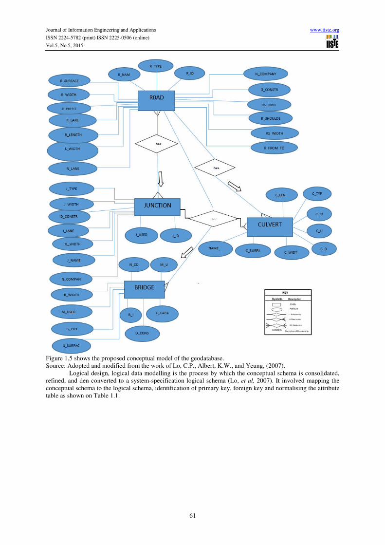
Conceptual design; is the starting point of database design, the purpose of conceptual data modelling is
to define in broad and generic terms the scope of a database (Lo, et al, 2007).
The approaches to conceptual data modelling involve; Entity Relation (E-R) model (see fig 1.3), Entity Relation
(E-R) schema (see fig 1.4), identification of attributes, determination of relationships and the drawing of an E-R
diagram, as shows on Figure 1.5.
Journal of Information Engineering and Applications www.iiste.org
ISSN 2224-5782 (print) ISSN 2225-0506 (online)
Vol.5, No.5, 2015
61
Figure 1.5 shows the proposed conceptual model of the geodatabase.
Source: Adopted and modified from the work of Lo, C.P., Albert, K.W., and Yeung, (2007).
Logical design, logical data modelling is the process by which the conceptual schema is consolidated,
refined, and den converted to a system-specification logical schema (Lo, et al, 2007). It involved mapping the
conceptual schema to the logical schema, identification of primary key, foreign key and normalising the attribute
table as shown on Table 1.1.

Journal of Information Engineering and Applications www.iiste.org
ISSN 2224-5782 (print) ISSN 2225-0506 (online)
Vol.5, No.5, 2015
62
Physical design, the physical data modelling is concerned with defining specific storage structure and access
paths to the database (Lo, C.P., Albert, K.W., and Yeung, 200)

Journal of Information Engineering and Applications www.iiste.org
ISSN 2224-5782 (print) ISSN 2225-0506 (online)
Vol.5, No.5, 2015
63
Table 1.5 showing proposed characteristics of fields and attribute in the physical design of the
Road Transport database. Created in ArcGIS environment.
The GIS techniques were used in integrate the spatial and non-spatial data by linking the attribute data
to created road layers so as to develop the GIS-based RTIMS.
Use the Geodatabase to analyse and queries road characteristics (Objective III).
This is achieve through the use Standard GIS functions tools such as (query, geocoding, selection by
attributes and by location, identify tools, network analysis tool, Hyperlink tool, measurement tool etc.) will be to
support data management, analysis and visualization needs.
Query tool: This tool applies an SQL query to a database and the results are represented in a layer or
table view. It will be used for based services based on buffering and proximity analysis, shortest route, alternate
route etc. based on network analysis during emergency situation like natural disaster, movement of civil
authorities during election, shows kilometre sections of Adamawa Federal highway, State highway and local
government road etc.
Identify tool: is used to identify the road system information like, picture showing the nature of the
roads, type of the road, length, width etc.
Hyperlink tool: will be used to display a picture showing the nature of the road for proper management
of the system once a road is click using the tool.

Journal of Information Engineering and Applications www.iiste.org
ISSN 2224-5782 (print) ISSN 2225-0506 (online)
Vol.5, No.5, 2015
64
The Network Analyst toolbox: will be used to model transportation networks and perform route, and
location-allocation network analyses on transportation networks. The tools will be used to perform an analysis
on a transportation network.
RESULTS AND DISCUSSIONS
Research shows that about 70% of GIS task lies on editing and data compilation, starting from coordinate
registration, mapping and geo-processing of spatial data, to attribute database development. The establishment of
robust database is the cornerstone of every successful GIS, therefore, this chapter seeks to establish database
manipulation for theme attributes, the information will however be used for query and analysis in the later part of
this chapter. This chapter examines the objectives of the study by analysing the primary and secondary data
collected. The primary data were collected using GPS and digital camera while the secondary data were
collected using satellite imageries and road documents from the federal and state ministry of works and land and
survey.
Mapping the existing road infrastructure in adamawa central. Figure 1.2 below shows the digitized up-
to-date road transport map of Adamawa central at 1:800,000 scale which is updated from the Spot-5 image of
2012 and Google Earth images of 2013. The final output of the road map is printed in using AO scanner.
Figure 1.1 showing the up-to-date Road Transport map of Adamawa Central
Source: Author’s analysis
Geodatabase of road infrastructures in Adamawa central. This involves all the design and building of

Journal of Information Engineering and Applications www.iiste.org
ISSN 2224-5782 (print) ISSN 2225-0506 (online)
Vol.5, No.5, 2015
65
Database of road infrastructures in ArcCataloge environment in ArcGIS software. Table 1.5(a,b,c,d) below
shows some of the database attribute information of road infrastructures with an attribute table; attribute of each
theme interrelates with the themes once the theme is active as shown below in the table:
Table 5.1a showing some of the attributes of Adamawa central road transport geodatabase.
Source: Author’s Analysis
Table 1.5b showing some of the attributes of Adamawa central road transport geodatabase.
Source: Author’s Analysis

Journal of Information Engineering and Applications www.iiste.org
ISSN 2224-5782 (print) ISSN 2225-0506 (online)
Vol.5, No.5, 2015
66
Table 1.5c showing some of the attributes of Adamawa central road transport geodatabase.
Source: Author’s Analysis

Journal of Information Engineering and Applications www.iiste.org
ISSN 2224-5782 (print) ISSN 2225-0506 (online)
Vol.5, No.5, 2015
67
Table 1.5c showing some of the attributes of Adamawa central roundabout geodatabase.
Source: Author’s Analysis
Using the Geodatabase to analyse and queries road characteristics. Since a comprehensive geodatabase
is developed, it becomes easier to make decision as regards managing the road transport infrastructure in map. In
this regard, the QUERY TOOLS, IDENTIFY TOOL, HYPERLINK TOOL, LOCATION ADDRESS TOOLS
and FIND TOOLS, were used for the analysis.
This analysis seems to answer the following questions:
• How do I locate a roads, roundabout and bridges?
• How do I assess the quality of a road, roundabout and bridge in respect of their surfaces and remarks?
• How do I know roads that are single or dual carriage?
• How get informatio the roads surface that are not tired.
• How do I know the nearest roads that is 150m from a roundabout?
• How do I identify information on a particular road, bridge and junctions?
• Measurement of a road distances? Etc.
Analysis on the above questions, were carried out.

Journal of Information Engineering and Applications www.iiste.org
ISSN 2224-5782 (print) ISSN 2225-0506 (online)
Vol.5, No.5, 2015
68
Analysis 1: locating of roads, roundabout and bridges address using SELECTION TOOL?
Figure 1.2. showing all the federal roads in Adamawa central.
Source: Author’s analysis
Discussion of Results: The lines beryl green colour on map in the figure automatically found the location and
attribute of the federal roads in the Adamawa central. Same processes can be used for the state and local
government roads in order to know the extent of road for developments.
ANALYSIS 2. Showing the road surfaces that are not tired.
Figure 1.3. Showing the roads surface that are not tired.
Source: Author’s analysis

Journal of Information Engineering and Applications www.iiste.org
ISSN 2224-5782 (print) ISSN 2225-0506 (online)
Vol.5, No.5, 2015
69
Discussion of Results: By using the QUERY TOOL, the road surfaces that are not tired highlighted
beryl green colour on the map and on the geodatabase table, while those that are tired are black and ultramarine
colour on map and white colour on the geodatabase table. This analysis was carried out to provide necessary
information on road surfaces that are not yet tired before allocating a contracts and for proper road transport
information managements.
ANALYSIS 3. Identify information on a particular road, bridge and junctions using IDENTIFY TOOL.
Figure 1.4. Showing information about a particular road (Mubi road).
Source: Author’s analysis
Discussion of Results: As showing from figure 4.4.9 above, IDENTIFY TOOL was used in order to
identify information’s on Mubi road and the beryl green line on the map is the Mubi road while the geodatabase
table beside it is the information about the road. This analysis will give information on how to manage and
develop the road. The same analysis can be applicable to bridges and roundabouts.

Journal of Information Engineering and Applications www.iiste.org
ISSN 2224-5782 (print) ISSN 2225-0506 (online)
Vol.5, No.5, 2015
70
ANALYSIS 4. Measure a road distances using MEASUREMENT TOOL.
Figure 1.5. Showing the length of a Bishop road.
Source: Author’s analysis
Discussion of Results: from the figure 1.5 above, measurement tool was to measure the Bishop road
and this analysis shows the distance of the road which is about 1,795.200743 meters. This give measurement
information on the road without going to the field for surveying in terms of development and allocation of found
for the road infrastructure management when developing the road.
ANALYSIS 5. Selecting roads that are single or dual carriage?
Figure 1.6 Showing the federal roads that are single and dual carriage capacity.
Source: Author’s analysis

Journal of Information Engineering and Applications www.iiste.org
ISSN 2224-5782 (print) ISSN 2225-0506 (online)
Vol.5, No.5, 2015
71
Discussion of Results: The beryl green colour line on the map and geodatabase table in figure 4.4.7
showing the federal roads that has single carriage capacity, this query can help the road transport authorities,
managers and decisions maker in terms of development in order to expand the road to dual carriage and the
geodatabase table can help in showing the information and the number of federal roads that need to be expanded.
The same analysis can be applicable to state and federal roads transports as the case may be. From the
geodatabase table, the attribute in white colour is showing the dual carriage roads.
ANALYSIS 6: Finding the nearest roads that is 150m from a roundabout using BUFFERING
Figure 1.7 Showing the area that fall within a radius of 150m around roundabout.
Source: Author’s analysis
Discussion of Results: By using the BUFFER TOOL, in the first figure, the roundabout that was
highlighted red was the one selected for the analysis. The analysis was carried out to show how powerful GIS is
in selecting features that are within a specific range for any decision pertaining road infrastructure development
and management. This analysis was carried out to provide necessary information on the nearest roads and
building around the roundabout within a distance of 150m which will help road transport planner with
management information to know the various houses that will be affected within the 150 radius when allocating
a contracts on expanding the roundabout for proper development and management.
SUMMARY
GIS could provide a mechanism for data integration, management and output generation in its spatial
environment. In this study, federal roads, state roads, local government roads, bridges and roundabout depicting
the availability, distribution and extent or abundant of physical features in the Adamawa central were derived
using GIS technology, various maps, design and layer designed for the Adamawa central provide valuable
records (information) for the assessment, management, monitoring and development of the physical features on
the map. To start with, it can be used for making queries on the Geodatabase in a series of what lies here or there
is this mode. A logical query has been translated into a series of what lies here and/or what lies there. The results
received descriptive and analytical answers which are for road planners, managers and decision-making because
the types of inference, deduction and conclusion made is left entirely with the road transport authorities. Since
the geodatabase has not been officially implemented in the state planning board, it is difficult to ascertain the
likely problem that may arise during the implementation.
Within this gedatabase, it is possible to compare themes without overcrowding screen with too much
Journal of Information Engineering and Applications www.iiste.org
ISSN 2224-5782 (print) ISSN 2225-0506 (online)
Vol.5, No.5, 2015
72
information. For instance, the roundabout themes would be compared with the road themes and a simple result
would be given unlike the present analogue system in use where for each theme, there is a separate map sheet,
and the map sheets are not on the same scale. The identifier tool; in the GIS allows the attribute data for any
spatial data to be displayed on the screen immediately the spatial data is clicked with the mouse.
With the use of find tool, the roads of any type could be located by nearly typing the road name. The GIS finds
the road bringing it to the centre of the screen and changing its colours so that it appears different from the rest.
The geodatabase could be queried and the query result displayed on the screen. Thus, if federal and state road of
the Adamawa central were selected, then only the federal and state roads would be displayed. The Measurement
tool lets you measure lines on the map. You can use the measurement tool to draw a line or polygon on the map
and get its length or area, or you can click directly on a feature and get measurement information about it.
Database is an important way of organizing large amount of information. Computers are very power
tool which facilitate decision-making process. Development of GIS-Based Road Transport Information
Management System requires information on geo-physical features around specific areas. The most pressing
problem faced by the road transport managers and authorities is the lack of reliable geodatabase informations,
lack of funds, and insufficient qualified staff to process whatever information is available (Yonzon et al, 1991).
For effective planning, management and development of road infrastructures, Geodatabase are required for
analysis and updating spatial information quickly and efficiently.
CONCLUSION
Development of GIS-Based Road Information Management system could be viewed as integrated computer
software and hardware package, in spatial context, using Geographical Information System (GIS) and Road
Transport Information System (RTIMS), its functionality on geodatabase development and management, its
analytical modelling, mapping and spatial tabular display together with a framework for the decision-makers and
expert, it has certain characteristics (listed below) which differentiate it from any other software system.
a. It is designed to solve ill-structured or semi-structured problem i.e. where objectives, Geo-Spatial
analysis cannot be fully defined or modelled.
b. It provides an interface, which is powerful and easy to use.
c. It enables the user (road managers, planners and decision-maker) to combine models and data into a
flexible manner.
d. It helps the user and (road managers, planners and decision-maker) to explore the solution space (the
various problems) by using the models in the system to generate series and feasible solution for
decision-making.
e. It provides an interactive recursive problems solving environment (process) in which users (road
managers, planners and decision-maker) proceed by multi proposed and also making use of his
experience, knowledge and intuition.
The research has tried to show that the process of converting the traditional database system to a
Geographical Information System (GIS) does not require the hi-tech knowledge and equipment common in
science fictions and movies, but what is required in the planning will and commitment.
RECOMMENDATION
a. The government should establish GIS unit in the federal and state ministry of transports board and also
encourage the local government areas to do the same for proper planning and development of road
transport infrastructure and management for easy management and control of its facilities.
b. The government should encourage its ministries and other parastatals to use GIS for its decision-making
tool because the system provides easy and flexible way of handling Geodatabase.
c. With the increase in population, there is the need to improve on the present way of planning and
managements to a new digital format which is based on the use of GIS and remote sensing.
d. There is the need for a research like this to be carried out on areas such as pavement information
system, roads accident information system, etc. for proper and adequate development of their
Geodatabase for quick decision-making in the areas mentioned.
e. Development of a national Geo-spatial data clearing board in the federal, state and local government
levels of the country.
REFERENCE Andre, M., and Villanova, A. (2004). Characterisation of an urban bus network for environmental purposes.
Science of the Total Environment, PP. 334-335, PP. 85-99.
Cheng, M.Y., and Chang, G.L. (2001). Automating Utility Route Design and Planning Through GIS.
Automation in Construction, 10(4), PP. 507-516.
Curtin, K., Noronham, V., Goodchild, M. and Grise, S., (2003). “ArcGIS Transportation GIS Model”, ESRI.

Journal of Information Engineering and Applications www.iiste.org
ISSN 2224-5782 (print) ISSN 2225-0506 (online)
Vol.5, No.5, 2015
73
Etches, A. (2002). An integrated database in support of a collaborative Network Information System:
Application to transportation, University of Newcastle, Ph.D. Thesis.
ESRI (1990). Understanding GIS – The Arc-Info Method. A Workbook on GIS by Environmental System
Research Institute Redlands CA, USA.
ESRI.Com Geography Network, GIS Today –Remote Sensing for Data Generation.
Goodchild, M.F. (1998). Geographic information systems and disaggregate transportation modeling.
Hassanain, M. A., Froese, T. M. and Vanier, D. J. (2003). Framework Model for Assets Maintenance
Managements, j. perf. Constr. Fac., ASCE, Vol.17, No.1, PP. 51-64.
Haggett, P. and R.J. Chorley (1969) Network Analysis in Geography, London: Edward Arnold.
Khali, P., Walton, M. C., and Hussain, S. (2007). Electronic Vehicle Identification: Industry Standards,
Performance, and Privacy Issues”,http:// www.utexas.edu/ research/ctr/pdf_reports/ 0_5217_P2.pdf.
Larsen, A., Madsen, O.B.G., and Solomon, M. (2002). Partially Dynamic Vehicle Routing – Models and
Algorithms. Journal of the Operational Research Society, 38, PP. 637-646.
Lazar Spasovic, Steven Chien, Cecilia Kelnhofer-Feeley, Ya Wang, and Qiang Hu. (2001). A Methodology for
Evaluating of School Bus Routing - A Case Study of Riverdale, New Jersey. Transportation Research
Board 80th Annual Meeting January 7-11, 2001. Washington, D.C.
Miller H J (1996) GIS and geometric representation in facility location problems. International Journal of
Geographical Information Systems 10: pp 791–816
Mohammad Reza Jelokhani-Niaraki, Ali Asghar Alesheikh, Abbas Alimohammadi and Sadeghi-Niaraki, A.
(2009). Designing Road Maintenance Data Model Using Dynamic Segmentation Technique. ICCSA,
5592, PP. 442 - 452.
Transport Research Laboratory (1998). Guidelines for the designing and operation of road management systems.
Overseas Road Note 15. Department for Information Development 94 Victoria Street. London, SWIE
5JL.
Rao, P., Kanchan P., and Nanda P., (2006). GIS Based Maintenance Management System (GMMS) For Major
Roads of Delhi, In Proc
Robinson, R., Danielson, U. and Snaith, M. (1998). Road Maintenance Management, Concepts and Systems. The
University of Birmingham and the Swedish National Road Administration, Macmillan Press ltd.
London.
Rodrigue, J. P., Comtois, C,and B. Slack, B. (2006). “The Geography of Transport Systems”,P 362
Shaw, S.L. (2002) Book Review: Geographic Information Systems in Transportation Research,Journal of
Regional Science, 42(2), PP.418-421.
Sutton, J. C. (1996). Role of Geographic Information Systems in Regional Transportation Planning.
Transportation Research Record, 1518, PP.25-31
Thill, Jean-Claude (2000). “Geographic Information Systems for Transportation in Perspective”,
Transportation Research, Part C 8, Elsevier Science Ltd., Oxford, UK
Vonderohe, A. P., L. Travis, R. L. Smith and V. Tsai (1993). Adaptation of Geographic Information Systems for
Transportation, NCHRP Report 359, Transportation Research Board, Washington, D.C.