development management committee 17 october …
TRANSCRIPT

DEVELOPMENT MANAGEMENT COMMITTEE 17 OCTOBER 2018 Case No: 17/01706/FUL (FULL PLANNING APPLICATION) Proposal: ERECTION OF FOOD STORE (USE CLASS A1) WITH
ASSOCIATED PARKING, LANDSCAPING, ACCESS AND ASSOCIATED WORKS.
Location: LAND AT JUNCTION OF STOCKS BRIDGE WAY AND
NEEDINGWORTH ROAD ST IVES Applicant: ALDI STORES LTD C/O THE AGENT Grid Ref: 532323 272214 Date of Registration: 04.09.2017 Parish: ST IVES
RECOMMENDATION - APPROVE This application is referred to the Development Management Committee in accordance with the Scheme of Delegation as it is a Departure from the Development Plan. 1. DESCRIPTION OF SITE AND APPLICATION 1.1 The application site consists of generally level, vacant land which
forms part of Compass Point Business Park, St Ives. The site is brownfield, having previously formed part of the site of The English Chicory Ltd Factory. This site extends to approximately 0.79 hectares.
1.2 The site is located on the eastern edge of St Ives, wholly within the
administrative area of St Ives Town Council. The site is approximately 2 kilometres to the north-east of St Ives Town Centre. Development in the locality consists of a variety of uses. The site is bounded by the A1123 Needingworth Road to the south, beyond which is retail development including Morrisons with petrol filling station. Further retail units are situated to the south-west of the application site hosting McDonalds with Subway, Costa, and a further unit currently under construction. To the north, east and west of the site are the buildings forming Compass Point Business Park, generally falling within office and light industrial uses.
1.3 The site is accessed by Stocks Bridge Way; an unadopted road
serving Compass Point Business Park. To the south-west of the site, a roundabout controls traffic flows at the junction of the A1123 Needingworth Road, A1096 Harrison Way and Stocks Bridge Way. A pedestrian footway runs along the western boundary of the site, along Stocks Bridge Way, to the roundabout which has uncontrolled pedestrian crossing points with refuge islands on all arms. Pedestrian footpaths then extend along the A1123 to the east and west.
1.4 The southern boundary of the site, along the A1123 Needingworth
Road is defined by a belt of trees and vegetation, with timber post

and rail fence interwoven. The northern, eastern and western boundaries are defined by post and chain link fencing. A number of the trees along the southern boundary of the site and across the centre of the site (running from west to east) are subject to Tree Preservation Orders. A wooden shed is the sole structure present on the site.
1.5 The southern extent of the site, approximately a quarter of the site, is
located within Flood Zone 2 as designated by the Environment Agency Flood Zone Maps. The same extent of the site is also identified as Flood Zone 2 within the Council's Strategic Flood Risk Assessment 2017. The remainder of the site is designated as Flood Zone 1.
The Application: 1.6 This is an application for full planning permission for the erection of a
new food store (use class A1), with associated parking, landscaping, access and associated works, to be operated by ALDI Stores Ltd.
Food Store: 1.7 The Gross Internal Area (the combined internal sales and non-sales
area) of the proposed food store is 1,734 square metres. The proposed retail sales area of the store is 1,254 square metres, with some 80% of this dedicated to food and other convenience goods, and the rest used for the sale of related comparison goods.
1.8 The proposed food store building is essentially a modern 2 storey
rectangular building with an asymmetrical flat roof with its elevations designed in a combination of a smooth black brick plinth, glazing with grey frames, metallic silver cladding (RAL9006), metallic grey cladding (RAL7016) and Aldi corporate signage. Along the western side elevation of the building a grey (RAL7016) powder coated aluminium projecting canopy is proposed.
1.9 The dimensions of the proposed store are:
* Height: 16.45 metres maximum extent * Depth: 33.67 metres (excluding canopy projection to western elevation) * Width: 64.60 metres
Operational Arrangements: 1.10 It is proposed that the store would be open within the hours of 7am to
11pm from Monday to Saturday, and 10am to 5pm on Sunday. The proposed Sunday hours would enable trade from 10am to 4pm or 11am to 5pm, to stay within the six hour Sunday trading restriction.
1.11 A service yard is proposed adjacent to the northern elevation of the
food store building, close to the northern site boundary. A single vehicular access is proposed from Stocks Bridge Way which would be used by all vehicles. Deliveries to the service yard will enter the site and manoeuvre within the site such to then enable them to exit onto Stocks Bridge Way in a forward moving gear.

Car parking and accessibility within the site: 1.12 A single vehicular access into the site is proposed from Stocks Bridge
Way. The proposal includes 126 car parking spaces, of which 12 are parent and child spaces and a further 6 are spaces for disabled people. In addition, it is proposed to provide 8 cycle parking spaces for use by customers. The cycle stands are to be located to the western side of the store, to the north of the store entrance. Pedestrian walkways are proposed along the western site boundary from Stocks Bridge Way and the southern site boundary from the A1123.
Employment opportunities: 1.13 It is proposed that the store will employ the equivalent of 50 full time
positions. Supporting Information: 1.14 The supporting information submitted includes:
* Design and Access Statement * Planning, Economic and Retail statement * Transport assessment (including addendum pack and additional transport and highway information submitted during the lifetime of the application) * Travel Plan * Geotechnical Site Assessment and Preliminary Waste Classification * Supplementary Asbestos in Soil Report * Sustainability Statement * Heritage Assessment * Desk Study Assessment Report * Arboricultural Assessment and Method Statement * Preliminary Ecological Appraisal * Reptile and Great Crested Newt Assessment * Flood risk assessment and Outline Drainage Strategy. * Statement of community involvement * Noise Assessment * Ecological Briefing Note (submitted during the lifetime of the application) * Ecological Mitigation and Management Plan (submitted during the lifetime of the application)) * Supplementary Retail Impact Assessment (submitted during the lifetime of the application) * Letter dated 19 December 2017 providing further information relating to: Employment Land, Retail Impact, Sequential Test for Town Centre Uses and Sequential Test for Flood Risk.
1.15 Additional and amended plans and supporting information have been
submitted during the lifetime of the application. Following the submission of these, periods of re-consultation have been undertaken accordingly.
2. NATIONAL GUIDANCE 2.1 The National Planning Policy Framework (24th July 2018) (NPPF
2018) sets out the three economic, social and environmental objectives of the planning system to contribute to the achievement of sustainable development. The NPPF confirms that 'So sustainable

development is pursued in a positive way, at the heart of the Framework is a presumption in favour of sustainable development. The NPPF sets out the Government's planning policies for: * delivering a sufficient supply of homes; * achieving well-designed places; * conserving and enhancing the natural environment; * conserving and enhancing the historic environment.
2.2 Whilst the NPPF 2018 has now been published and replaces the
NPPF 2012, transitional arrangements are in place for authorities who have submitted Local Plans submissions prior to the 29 January 2019 and to ensure consistency, the 2012 framework policies will continue to be relevant. For clarity HDC submitted their Local Plan on 29 March 2018.
2.3 The National Planning Policy Framework (NPPF 2012) sets out the
three dimensions to sustainable development - an economic role, a social role and an environmental role - and outlines the presumption in favour of sustainable development. Under the heading of Delivering Sustainable Development, the Framework sets out the Government's planning policies for: * promoting sustainable transport; * delivering a wide choice of high quality homes; * requiring good design; * conserving and enhancing the natural environment; * conserving and enhancing the historic environment.
2.4 Planning Practice Guidance is also relevant. For full details visit the government website:
http://www.communities.gov.uk and follow the links to planning, Building and Environment, Planning, Planning Policy.
For full details visit the government website
https://www.gov.uk/government/organisations/department-for-communities-and-local-government
3. PLANNING POLICIES 3.1 Saved policies from the Huntingdonshire Local Plan (1995):
• S2: "Individual Shopping Proposals" • S10: "Shopping Environment" • E2: "Provision of Land" • E3: "Provision of Land" • E5: "Phasing" • T18: "Access requirements for new development" • T19: "Pedestrian Routes and Footpath" • En12: "Archaeological Implications" • En18: "Protection of countryside features" • En20: "Landscaping Scheme" • En22: "Conservation" • En24: "Access for the disabled" • En25: "General Design Criteria" • En27: "Shopfront design" • En30: "Advertisements" • CS8: "Water"

• CS9: "Flood water management" 3.2 Saved policies from the Huntingdonshire Local Plan Alterations
(2002): • None relevant.
3.3 Adopted Huntingdonshire Local Development Framework Core
Strategy (2009): • CS1: "Sustainable Development in Huntingdonshire" • CS3: "The Settlement Hierarchy" • CS7: "Employment Land" • CS8: "Land for Retail Development" • CS10: "Contributions to Infrastructure Requirements"
3.4 Huntingdonshire's Local Plan to 2036: Proposed Submission 2017
(as amended March 2018 for submission) • LP 1: Amount of development • LP 2: Strategy for development • LP 4: Contributing to Infrastructure Delivery • LP 5: Flood Risk • LP 6: Waste Water Management • LP 7: Spatial Planning Areas • LP 12: Design Context • LP 13: Design Implementation • LP 15: Amenity • LP 16: Surface Water • LP 17: Sustainable Travel • LP 18: Parking Provision and Vehicle Movement • LP 19: Established Employment Areas • LP 22: Town Centre Vitality and Viability • LP 32: Biodiversity and Geodiversity • LP 33: Trees, Woodland, Hedges and Hedgerows • LP 36: Heritage Assets and their Settings • LP 37: Renewable and Low Carbon Energy • LP 39: Ground Contamination and Groundwater Pollution
3.5 Paragraph 213 of the NPPF (2018) advises that due weight should be
given to Development Plan policies which pre-date the NPPF according to their degree of consistency with the Framework.
3.6 Paragraph 48 of the NPPF (2018) advises that Local Planning
Authorities may give weight to relevant policies in emerging plans according to: a) the stage of preparation of the emerging plan (the more advanced its preparation, the greater the weight that may be given); b) the extent to which there are unresolved objections to relevant policies (the less significant the unresolved objections, the greater the weight that may be given); and c) the degree of consistency of the relevant policies in the emerging plan to this Framework (the closer the policies in the emerging plan to the policies in the Framework, the greater the weight that may be given).
3.7 The LPA consider the Local Plan to 2036 to be a sound plan and it
was submitted for examination on the 29th March 2018. Footnote 22 of NPPF (2018) states during the transitional period for emerging

plans submitted for examination (set out in paragraph 214 of NPPF 2018), consistency should be tested against the previous Framework published in March 2012. The plan has therefore reached an advanced stage and is consistent with the policies set out within the NPPF 2012. Given the transitional arrangements in place it is considered that if there is any tension between emerging policies and NPPF (2018) the previous framework policies will prevail.
3.8 Supplementary Planning Documents:
• Huntingdonshire Design Guide Supplementary Planning Document (2017)
• Developer Contributions Supplementary Planning Document (2011)
• Cambridgeshire Flood and Water Supplementary Planning Document (2017)
• Huntingdonshire District Retail and Commercial Leisure Needs Assessment (2017)
• Huntingdonshire Employment Land Study (2014) Local policies are viewable at https://www.huntingdonshire.gov.uk 4. PLANNING HISTORY This site has an extensive planning history, which includes: 4.1 Compass Point Business Park:
*8901257OUT - Industrial/Commercial redevelopment; Type B1, B2 & B8 uses. Permission Granted, 20.09.1989. *9000678REM - Industrial/Commercial Redevelopment - Phase 1. Details Approved, 20.07.1990. *9001314REM - New Office development. Details Approved, 27.12.1990. *9400400S73 - Renewal of planning permission for industrial/commercial redevelopment. Permission Granted, 09.06.1994 *9700154S73 - Renewal of permission for industrial/commercial redevelopment. Permission Granted, 16.04.1997. *9800960FUL - Removal of condition relating to accesses imposed on consent ref: 97/0154. Permission Granted, 13.10.1998. *0001026S73 - Variation of condition 1 of 97/0154 to extend the period of time for industrial/commercial redevelopment. Permission Granted, 15.08.2000. *9800747REM - Approval of construction of roads & access for industrial/commercial development. Details Approved, 14.10.1998. *0001480REM - Approval of layout, number, siting, design and means of access for 4 office buildings with parking (phase 1). Details Approved, 29.09.2000.

*0001800REM - Approval of landscaping scheme for business park. Details Approved, 13.12.2000. *0102760REM - Approval of siting, design, external appearance and access for the erection of an office building with parking. Details Approved, 24.01.2002. *0100129REM - Approval of siting, design, external appearance and access for the erection of 4 office buildings with car parking. Details Approved, 09.03.2001. *0102564REM - Approval of siting, design, external appearance and landscaping for the erection of office building with associated car parking. Details Approved, 15.01.2002. *0200523REM - Approval of siting, design, landscaping and external appearance for the erection of office/production unit with associated car parking and external works. Details Approved, 09.04.2002. *0213043FUL - Erection of day nursery building to include parking and landscaping provision. Permission Granted, 20.01.2003. *0301264REM - Approval of landscaping relating to units S5, S6, S7 and S8. Details Approved, 26.09.2003. *0401029FUL - Erection of nursery building with ancillary structures and car parking. Permission Granted, 05.05.2004.
4.2 Application site:
*0213111REM - Approval of siting, design, external appearance and landscaping for erection of office units with associated parking and ancillary structures. Details Approved, 10.01.2003. *0201751REM - Approval of siting, design, external appearance and landscaping for the erection of an office building. Details Approved, 07.01.2004.
It should be noted that outline planning permission 8901257OUT remains extant.
5. CONSULTATIONS 5.1 St Ives Town Council - APPROVAL - Would support the County
Council's observations about traffic (COPY ATTACHED). 5.2 Holywell-cum-Needingworth Parish Council - OBJECTS - The
Parish Council considers that the additional traffic survey information provided (24.07.2018) is somewhat confusing. The data does not reflect the additional development already approved and in process of being built or the associated traffic impact. CCC Highways agreed to reinstate a school bus service from Needingworth to St Ives as the road network was not considered safe approx. 5 years ago. The situation in this location continues to deteriorate and therefore in the interests of road safety the Parish Council consider that safety measures in this location are required (COPY ATTACHED).

5.3 County Council Transportation Assessment Team - NO OBJECTION - CCC is of the view that the impact of the Aldi traffic is significant enough to warrant mitigation measures. The proposal is acceptable in respect of the transport related impacts subject to a Section 106 Planning Agreement requiring a contribution of £170,000, allowing the provision of a Toucan Crossing and associated ancillary footway/cycleway works. The Travel Plan is acceptable.
5.4 County Council Highways - NO OBJECTION - The site is located
on a private development with the infrastructure not maintained by the public authority. The impact has been assessed by our transport assessment team. Conditions are requested requiring details of temporary parking/turning/loading/unloading facilities clear of the highway during construction; requiring the access to be a minimum width of 6m for a distance of 15m from the carriageway; requiring 10m radius kerbs to be installed at the junction of the access with the carriageway; and requiring the on-site parking/servicing/loading/unloading/turning/waiting area to be laid out, demarcated, levelled, surfaced and drained in accordance with the approved plan and thereafter retained for that specific use.
5.5 Highways England - NO OBJECTION. 5.6 Lead Local Flood Authority (LLFA) - NO OBJECTION - Initially the
LLFA objected to the application. However, following the submission of additional information including plans of the wider site drainage network and photographs of the proposed connection points, as wells as confirmation that a twin pump arrangement will be used on a 'duty/standby' basis and these will be subject to a maintenance agreement, the LLFA has removed their objection. Conditions are requested to secure submission of a detailed surface water drainage scheme and details of maintenance arrangements for the surface water drainage system.
5.7 County Council Archaeology - NO OBJECTION - The
archaeological assessment submitted demonstrates the presence of known prehistoric activity and Roman period settlement in the vicinity of the site. Due to this, the site should be subject to a programme of archaeological investigation, to be secured by condition.
5.8 HDC Environmental Health (Contamination) - NO OBJECTION - In
light of the recommendations contained within the Desk Study Assessment Report written by Brownfield Solutions Ltd (report reference TH/C3193/6003, dated June 2016), a condition is requested requiring a site investigation to be undertaken; submission of a remediation strategy where necessary; the implementation of the remediation strategy and submission of a verification report.
5.9 HDC Environmental Health (Noise) - NO OBJECTION - If you are
minded to grant permission to this application, I recommend the following noise condition: The rating level of sound emitted from any fixed plant and/or machinery associated with the development shall not exceed 45dB LAeq1hr between the hours of 0700-2300 and shall not exceed 40dB LAeq15min between 2300-0700 at the nearest sound sensitive premises (Burgess Place). All measurements shall be made in accordance with the methodology of BS4142:2014 (Methods for rating and assessing industrial and commercial sound) and/or its

subsequent amendments. Where access to the nearest sound sensitive property is not possible, measurements shall be undertaken at an appropriate location and corrected to establish the noise levels at the nearest sound sensitive property.
5.10 Environment Agency - NO OBJECTION - This development is
within FZ2 please use EA Flood Risk Standing Advice. 5.11 Wildlife Trust - NO OBJECTION - Should permission be granted,
provided there is appropriate ongoing management, the planting and enhancements proposed and detailed in the Ecological Mitigation and Management Plan should be suitable.
5.12 Police Architectural Liaison Officer - NO OBJECTION - Further to
the submission of amended plans, I am happy to support and have no other comments, objections or recommendations regarding community safety and vulnerability to crime with the proposed development.
5.13 Historic England - NO OBJECTION - does not wish to offer any
comments. We suggest that you seek the views of your specialist conservation and archaeological advisers, as relevant.
5.14 Anglian Water - NO OBJECTION - With regards to surface water,
the Applicant has decided that this pipework is going to remain private and they will be withdrawing their S104 application for us to adopt it. This means that it's not within our jurisdiction to comment on surface water conditions for this site and permission would have to be sought by the owner. The foul drainage from this development is in the catchment of St Ives Water Recycling Centre that will have capacity for these flows. The sewerage system at present has capacity for these flows via gravity connection.
5.15 Health, Safety and Resilience Officer - NO OBJECTION - From an
emergency planning perspective I cannot see any reason to object to this application.
6. REPRESENTATIONS 6.1 38 representations have been received, of which 22 are in support of
the granting of planning permission, 15 are opposed to the proposal and 1 is neutral.
6.2 Representations in support of the proposal
The points raised in support of the proposal are summarised as follows: * Options for food shopping in St Ives are limited and costly. * The proposal would be convenient and would prevent the need for people to travel to other places to access a choice of supermarkets. * It will reduce the need for home deliveries. * The two small outlets at the junction of the Somersham Road are expensive and have a limited offer. * A big name store is needed to keep people local for shopping. * Will give people more choice and options. * It would provide a more finically viable option for food shopping. * Aldi offers good prices and quality. * New services are needed to cater for the expansion of St Ives.

* The existing Waitrose and Co-op are far too little for the size of the town. * Even with Morrisons St Ives still needs more supermarket space * This development may pave the way for others such to support the growing community. * It will benefit St Ives * The sooner the better * It will provide jobs * It will bring custom to the area * Is unlikely to pull people away from town centre and may even help rejuvenate town centre * Will provide an option with free parking * Infrastructure will not be vastly affected. * May ease transport problems as less people will be forced to commute out of St Ives for jobs as jobs created will provide more options to remain. * It will reduce traffic as it will cut down on the need to travel to Huntingdon. * Competition is welcomed * Would prevent the need to travel to Huntingdon or Ely to access and Aldi * Would offer choice for those who would not shop at Morrisons * The junction is always busy with customers going to Tesco and M&S, showing a need for a further grocery shop nearby. * People working nearby could go there at lunchtime or on their way home. * There may be an increase in traffic, however the only times this area is congested is during rush hour times and not many people shop at these times. Therefore it will not cause too much of a problem.
6.3 Within the representations received in support of the proposal, some
concerns are raised. The concerns expressed are summarised as follows: * Concerned regarding traffic logistics due to proximity to new Morrison store * Increased traffic along Harrison Way. With additional development (Morrisons, the new petrol station, McDonalds, Costa, Subway, Tesco) there is potential for constant snarl-ups at the junction of Harrison Way and the A1123. (Jacobs)'
6.4 Representations neither for nor against The points raised are summarised as follows:
*Until Morrison's is operational, the impact of the traffic in and out of that site and its subsequent impact on congestion will not be known. *Traffic and congestions concerns.
6.5 Representations opposed to the proposal
The points raised in opposition to the proposal are summarised as follows: * Would create additional traffic at Compass Point Business Park. * Would exacerbate existing congestion at Stocks Bridge Way roundabout; which will only continue to increase with the opening of Morrisons, McDonald's and Costa. * Additional traffic will prevent easy exit from the estate for goods vehicles and staff members; negatively affecting the ability for businesses within Compass Point Business Park to operate.

* Additional traffic created from the development will increase the risk of an accident to staff members leaving the park via the existing pedestrian access routes to visit the existing Tesco and M&S stores and town centre. * CCC should upgrade the roads around St Ives. *Traffic issues at the Silvaco roundabout have intensified since the opening of the Morrison's store and the proposed development would add to this. *The Silvaco roundabout is already dangerous and the proposed development would make this worse. * Another food store is note needed when St Ives has Morrisons, Waitrose, Co-op and Tesco Express all within a mile of each other. The proposal could put other food stores out of business. * The proposal would threaten shops in town centre by taking people away from the town centre. * People already come from other towns for the Morrisons and will do so for Aldi, too much traffic could cripple the network with no solution have been identified. *The traffic surveys undertaken were prior the opening of the Morrison's and McDonalds and are therefore already out of date. *The cycle crossing at the Compass Point roundabout is unsafe. *If the scheme goes ahead, the road should be widened.
6.6 Eight representations have been received on behalf of Morrison’s:
1. Representation by Bryan G Hall dated 11.10.2017. Concerns expressed regarding the robustness of the Transport Assessment (TA) undertaken. The following specific points are raised: - The inconsistency between the Ratio of Flow to Capacity's presented for the Harrison Way/A1123 Needingworth Road/Stocks Bridge Way junction in comparison to those identified within the TA for recently permitted nearby developments, resulting in potential underestimation of queuing. - Across the network, the operation assessment shows less queuing than is currently experienced. Queue and delay surveys should be undertaken to validate the base year models - The TA is not supported by a Retail Impact Assessment resulting in the assignment of development traffic onto the network being unclear and unsubstantiated. - The TA does not present a qualitative assessment of the level of public transport services to the site but concludes that the level of public transport provision is satisfactory without enhancement; at odds with the findings of the TAs for nearby recently permitted developments - The proposed car parking provision far exceeds anticipated parking requirements, suggesting that the adopted trip rates are an underestimation. - The trip rates are extracted from TRICS for discount food retail stores dating from 2001 to 2011. This is not up to date, therefore more representative trip generation data is required to confirm trip generation and ensure the impact of the proposal has been accurately assessed and also to substantiate the level of car parking proposed. - The TA incorrectly identifies the speed limits on nearby roads. - The TA does not refer to the extensive shared use footways/cycleways or make provision for pedestrian/cycle access improvements

- The TA is not explicit with regards to the floor area (gross or retail) used to derive trip generation rates which may lead to underestimation. - Difficult to determine whether the impact of development related traffic on the A1123/Ramsey Road crossroads has been fully assessed.
2. Representation by Bryan G Hall dated 31.11.2017 (Following submission of additional information on 18.10.17). The additional transport evidence submitted is inadequate to enable the impact of the development on the road network to be fully assessed. As a result, the likely impact of the proposed development on the local highway network could currently be underestimated. The following specific points are raised: - The use of google mapping for assessing existing queues for model validation purposes is inadequate. A micro simulation model should be used to fully assess the impact of the development. - The assertion that much of the traffic visiting Aldi will result from pass by, diverted and transfer trips is not supported by a Retail Impact Assessment. - A reduction in traffic flows through the A1123/Harrison Way/St Audrey Lane/Stocks Bridge Way roundabout is identified which is counterintuitive and further surveys should be undertaken to validate traffic flows. - The most recent accident data should be used. - Further evidence and justification of parking provision and correlation with trip generation figures required. - Reduction in traffic movements in comparison to Huntingdon Store requires justification. - Higher trip rates have not been used in updated traffic modelling work. - ARCADY modelling assessment outputs not supplied. - More recent versions of PICADY should be used as results from these are more reliable. 3. Representation by Peacock and Smith dated 06.11.2017. Concerns raised regarding the loss of employment land and the retail impact of the proposal on St Ives Town Centre. The following specific concerns are raised: - Loss of allocated employment land - The application places an emphasis on the approved Morrisons store to establish the principle of development/justify loss of employment land, however each application should be considered on its own merits. - The Council's evidence base identifies an undersupply of industrial floorspace. Smaller, high quality units should be given opportunity to come forward. - Application not supported by detailed assessment of the site in terms of its viability for employment use or analysis of available office and industrial floorspace to justify loss or employment land. - Not all sequentially preferable sites in St Ives have been considered. - Implications of proposal on retail allocations have not been considered. - The information submitted does not qualify that the site is in a sustainable location, fails to properly assess the accessibility of the site and fails to maximise the use of sustainable transport modes.

4. Representation by Peacock and Smith dated 22.01.2018 (following submission of additional information on 19 December 2017). Concerns raised regarding the accuracy of the information submitted and the retail impact of the proposal on St Ives Town Centre. The following specific concerns are raised: - The projected turnover of the store is an underestimation; evidenced by Aldi's company accounts and from the performance of existing stores in the surrounding area. - Consider that a more realistic turnover figure would be £18.9 million. The impact upon the town centre is therefore underestimated. - Within their application submission, the impact upon St Ives Town Centre is underestimated. - Shoppers at Waitrose use their car park, but due to the proximity to the town centre, shoppers at Waitrose will also undertake linked-trips. The loss of trade to Aldi will lead to a reduction in the number of linked-trips being made into the town centre, and therefore an overall loss in expenditure in town centre stores. - The trade diversion figures provided by Aldi overestimate the draw that would be drawn from Morrisons. This figure would be lower, with the draw from St Ives Town Centre being greater; thus the impact upon St Ives Town Centre would be greater than identified. - The Sequential Test for town centre uses has not been satisfactorily demonstrated/addressed. 5. Representation by Bryan G Hall dated 23.01.2018 (following submission of additional information on 19 December 2017) Concerns raised that the modelling undertaken is inadequate to determine the likely impact of the proposal on the local highway network and the likely impact of the development on the local highway network has been underestimated. The following specific points are raised: - The transport evidence submitted is inadequate and underestimates the likely impact of the development on the local highway network. - The robustness of the operation assessments on the road network is questioned. Further surveys are required to validate the surveys undertaken and to address the likely trade draw from competing stores. County Highways and Exigo acknowledge the shortfalls in the modelling undertaken. A Micro Simulation traffic model should be undertaken to allow a full understanding of the interaction between junctions to be determined. - Improvements to the network are identified. It is considered that these improvements should be undertaken in advance of Morrisons opening. - Any decision on further development in the area should be deferred until modelling has been undertaken following the opening of the Morrisons Store and once the changes in traffic flows have settled down. - The submitted Transport Assessment identifies that much of the new store related traffic would already be on the highway network to access other competing stores. However, it should be clearly identified where trade at the new store would be drawn from; such to evidence the discount in the overall traffic impact arising from the development. - Within the submitted Transport Assessment, the St Ives traffic movements are reduced by 25% from the traffic movements associated with the Huntingdon store, based on the lower turnover of the proposed store. Given the higher turnover figures of stores within

the vicinity, and arguably the proposed store, the traffic movement figure should not be reduced. The trip rates from the Huntingdon Store should therefore be used to fully reflect the traffic impact of the proposal. - Aldi has rejected the request for funding for the installation of a signalised crossing. Exigo (on behalf of Aldi) argue that the impact upon the highway network as a result of the development has been demonstrated to be negligible. In responding, CCC Highways outline that "there will clearly be an impact on Harrison Way and the westbound stretch of St Audrey Land between the two roundabouts which will exacerbate existing problems". This demonstrates that the evidence submitted is insufficient to demonstrate that the impact of the development on the highway network would be negligible. 6. Representation by Bryan G Hall dated 13.04.2018 Concerns are raised that as a consequence of deficiencies in the transport evidence submitted, the likely impact of the proposed development on the local highway network would be under-estimated. The following specific points are raised: - Due to concerns regarding the validity of the traffic data submitted, independent traffic surveys (commissioned on behalf of Morrisons) have been undertaken (on Friday 16th and Saturday 17th March 2018). The findings of these are compared with the data submitted on behalf of Aldi. - The new Morrisons store opened on 8 March 2018. Morrisons commissioned traffic surveys undertaken at the A1123/A1096 Harrison Way/Stocks Bridge Way roundabout and the A1123/B1404 Somersham Road roundabout, including queue length surveys and journey time surveys, such to understand conditions on the road network following the opening of the store. - The traffic count data shows that the peak hours for traffic movement through these junctions are 4:15-5:15 on Friday evenings and 12:00-13:00 pm Saturdays. - Through the queue length surveys significant queuing was recorded on some approaches at both of the surveyed junctions. The surveys show a significant disparity on the predications within the information submitted by the Applicant and the conditions which are currently experienced on site. For example, in the Friday evening peak, the maximum queue length observed on the A1123 (E) arm of the A1123/A1096/Stocks Bridge Way Roundabout (approaching from Needingworth) was 199 vehicles. In contrast the Transport Assessment (TA) Addendum by Exigo predicts that the queue on this approach would not exceed 2 vehicles in a 2022 Base Year plus committed development. The disparity between the figures within the submitted TA Addendum and observed through the surveys by Morrison's is noted to be less within the Saturday peak. - The journey time surveys correlate with the queue length survey data and demonstrate that there are significant delays for vehicles travelling through the junction. - The queue and journey time surveys data collected following the opening of the Morrison's store show that the highway network is experiencing much greater queueing and delays that those presented within the submitted TA and TA Addendum. The survey data collected does not include traffic movements associated with the McDonalds development on Harrison Way. The TA and TA Addendum by Exigo claim to have taken account of this traffic; which reinforces the deficiencies in the information submitted.

- The traffic models within the submitted TA and TA Addendum should be re-validated based on the surveyed queue data to allow them to accurately re-assess the impact of the proposed development. - Concerns about the TA work submitted by Exigo therefore remain - in particular about the robustness of the operational assessments of the road network in the vicinity of the store. 7. Representation by Bryan G Hall dated 10.08.2018 (following submission of additional Technical note dated 20 July 2018) Concerns are raised that as a consequence of deficiencies in the transport evidence submitted, the likely impact of the proposed development on the local highway network would be under-estimated. The following specific points are raised: - The Technical Note advances a wholly different approach to assessing the impact of the proposed development. Rather than focussing on what conditions are currently like on the highway network, the Technical Note advances an argument that the impacts arising from the Aldi/Morrison's Traffic is less than that estimated in relation to the original Morrison's consent, then the impact of the proposed development, whatever that may be, is acceptable. - This approach is disagreed with as it completely ignores the prevailing conditions on the highway network and ignores the opening of Morrisons and forthcoming opening of further retail units. -Concerns are raised regarding the traffic surveys and the peak period calculated. -The proportion of linked trips should be based on the Retail Impact Assessment. - The data used to determine the portion of linked trips is unjustified - The impact of the proposed development on the operation of the local highway network has not been fully assessed and a fully validated and calibrated Micro Simulation traffic model should be produced in order to enable this. 8. Representation by Bryan G Hall dated 07.09.2018 (following submission of traffic survey data) Concerns are raised that as a consequence of deficiencies in the transport evidence submitted, the likely impact of the proposed development on the local highway network would be under-estimated. The following specific points are raised: - For a weekday, a Friday should be used to assess the peak hour movements to and from the store, to ensure a robust assessment of the week day peak hour generation. If only the Friday traffic flows are considered, the observed flows are much higher than those reported by Connect. -The Technical Note by Connect (new Highways Consultants) concludes that given the latest surveys of the Morrison's Store traffic, the combined proposals would result in 86 less vehicle trips in the Friday evening peak period when compared to the original (larger) Morrison's Scheme. However, when using the figures observed during the Friday evening peak period, the net impact would be an additional 57 trips when compared to the original Morrison's Scheme. Evidently the combined impact would be higher than the previously consented traffic associated with the original Morrison's. - Morrison's maintains that a full and proper operational assessment of the impact of the traffic arising from the proposed development need to be undertaken. A fully validated and calibrated Micro Simulation traffic model should be produced in order to enable this.

-The argument advanced by Connect that demonstrating the combined traffic generation of the two stores (proposed Aldi and smaller Morrison's) is less than that previously consented for Morrison's is flawed.
6.7 Two representations have been received on behalf of Waitrose: 1. Representation by Firstplan dated 11.10.17: -Concerns raised that insufficient information provided to determine the likely impact of the proposal on the vitality and viability of St Ives Town Centre. Insufficient information provided to determine the highways impacts of the proposal. The following specific points are raised: - Any detrimental impact on Waitrose's trade will impact on the health of the wider town centre. - The applicant has not demonstrated that the proposal will not have a significant adverse impact on the vitality or viability of St Ives Town Centre. - Reliance on the Council's Retail Study to justify the proposed foodstore does not take account of Morrisons new store. - A full retail impact assessment is required to take account of the jointed impact of Aldi and Morrisons on St Ives Town Centre. - Additional traffic generated by the proposal will add to congestion on Harrison Way and may deter shoppers going into the town centre; impact its vitality and viability. - The traffic growth figures used underestimate the growth in background traffic. Appropriate growth rates should be used. - The base models in the TA have not been validated by queue length surveys and may underestimate the impact of the proposal. - The traffic models within the TA incorrectly identify that the junctions in the study area are operating within their capacity. 2. Representation by Firstplan dated 02.11.2017 (Following submission of additional information dated 18.10.17). Concerns raised that the submission fails to provide sufficient evidence to demonstrate that the proposed development would not have a detrimental impact upon the local highway network. The following specific points are raised: - Result of queue length surveys have not been used to validate the base traffic models. The impact of the development on the operation of the local road network cannot be fully assessed. - Lack of evidence to substantiate trip rates and lack of acknowledgement that all vehicles would use the A1123/Harrison Way/Stocks Bridge Way junction. The TA therefore significantly underestimates the level of traffic generated by the development and underestimates the impact on this junction. - The applicant fails to demonstrate that the proposals would not result in a severe highways impact. - There is a discrepancy between the car parking survey results from the Huntingdon Store and the parking levels proposed. Either the car park is larger than required or more vehicles will be attracted than the trip rates suggest.
7. ASSESSMENT 7.1 When determining planning applications it is necessary to establish
what weight should be given to each plan's policies in order to come

to a decision. The following legislation, government policy and guidance outline how this should be done.
7.2 As set out within the Planning and Compulsory Purchase Act 2004
(section 38(6)) and the Town and Country Planning Act 1990 (section 70(2)) in dealing with planning applications the Local Planning Authority shall have regard to the provisions of the development plan, so far as material to the application, and to any other material considerations. This is reiterated within paragraph 47 of the NPPF (2018). The development plan is defined in section 38(3)(b) of the 2004 Act as "the development plan documents (taken as a whole) that have been adopted or approved in that area".
7.3 In Huntingdonshire the Development Plan consists of:
-Saved policies from the Huntingdonshire Local Plan 1995 (Parts 1 and 2) -Saved policies from the Huntingdonshire Local Plan Alteration 2002 -Adopted Core Strategy 2009 -Huntingdon West Area Action Plan 2011 -Cambridgeshire & Peterborough Minerals and Waste Development Plan Core Strategy -St Neots Neighbourhood Plan -Godmanchester Neighbourhood Plan -Houghton and Wyton Neighbourhood Plan
7.4 The statutory term 'material considerations' has been broadly
construed to include any consideration relevant in the circumstances which bears on the use or development of land: Cala Homes (South) Ltd v Secretary of State for Communities and Local Government & Anor [2011] EWHC 97 (Admin); [2011] 1 P. & C.R. 22, per Lindblom J. Whilst accepting that the NPPF does not change the statutory status of the Development Plan, para. 2 confirms that it is a material consideration and significant weight is given to this in determining applications.
7.5 The main issues to consider in assessing this application are whether
there is any conflict with Development Plan policies. If there is any conflict, whether the application can be considered to be in accordance with the Development Plan when taken as a whole. If the application is not in accordance with the Development Plan, whether there are any material considerations, including emerging policies in the Local Plan to 2036 and the NPPF, which indicate that planning permission should be granted. With this in mind the following issues are assessed below:
• Principle of Development, • Impact on Visual Amenity, • Impact on Amenity, • Access, Transport and Parking Matters, • Flood Risk, Drainage, Ground Conditions and Contamination, • Heritage Assets, • Ecology and Biodiversity.
The Principle of Development. 7.6 Applications for planning permission must be determined in
accordance with the Development Plan unless material considerations indicate otherwise. The proposed development forms

a Departure from Development Plan as the application site is allocated for B1/B2/B8 Use within the Huntingdonshire Local Plan (1995) but the proposal is for a retail store falling within Use Class A1. The application has been advertised as a Departure from the Development Plan accordingly. The main issue is whether there are any material considerations that outweigh the proposal's conflict with policy E3 of the Huntingdonshire Local Plan (1995) and CS7 of the Core Strategy (2009).
7.7 The NPPF (2018) sets out that there are three objectives to
sustainable development: an economic objective, a social objective and an environmental objective. Paragraph 80 of the NPPF (2018) sets out that "Planning policies and decisions should help create the conditions in which businesses can invest, expand and adapt. Significant weight should be placed on the need to support economic growth and productivity, taking into account both local business needs and wider opportunities for development".
7.8 The proposed development site is part of Compass Point Business
Park, benefitting from an extant planning permission for business uses (falling within Use Classes B1, B2 & B8) and is identified as an Established Employment Area within both adopted and emerging local policy. The development of the site for retail use would result in the loss of a quantum of designated employment land.
7.9 Policy E3 of the Local Plan (1995) allocates the 7.1 hectares of land
at the Chicory Factory site for B1, B2 and B8 Use. Policy CS7 of the Core Strategy (2009) reaffirms this direction of employment growth and sets out that "about 85 hectares of new land for employment will be provided before 2026" and that "the re-use of previously developed land will be promoted especially within the Market Towns". The policy advises that within the St Ives Spatial Planning Area, strategic employment growth will be located "on existing commitments which might come forward during the plan period"; of which the application site is considered an existing commitment, given the allocation of the site for B1, B2 and B8 uses within the Local Plan (1995) and the granting of outline planning permission for these uses. Adopted policies therefore seek to protect the site for use as employment land; namely falling within use classes B1, B2 or B8.
7.10 However, paragraph 120 of the NPPF (2018) sets out that "Planning
policies and decisions need to reflect changes in the demand for land. They should be informed by regular reviews of both the land allocated for development in plans, and of land availability. Where the local planning authority considers there to be no reasonable prospect of an application coming forward for the use allocated in a plan: a) they should, as part of plan updates, reallocate the land for a more deliverable use that can help to address identified needs (or, if appropriate, deallocate a site which is undeveloped); and b) in the interim, prior to updating the plan, applications for alternative uses on the land should be supported, where the proposed use would contribute to meeting an unmet need for development in the area".
7.11 With regards to the application site, it is acknowledged that outline
consent for the development of a Business Park on the Chicory Factory site was granted approximately 28 years ago. Following the granting of outline planning permission for the redevelopment of the

Chicory Factory site for B1, B2 & B8 uses (8901257OUT), reserved matters applications for site wide infrastructure and many of the individual plots were submitted between 2000 and 2004. Despite this, the application site remains vacant. In addition to the extant outline planning permission for development on the site, the application site has been allocated for uses falling within classes B1, B2 and B8 since the publication of the Huntingdonshire Local Plan (1995); promoting the site for employment generating uses. However, since 2002, when detailed approval for development on the application site was last granted, proposals for employment generating uses within the 'B' Use Classes has not come forward. A further single plot within Compass Point Business Park also remains undeveloped.
7.12 Whilst the application site remains vacant, it is noted that the
redevelopment of a number of units within Somersham Road Industrial Area, approximately 500m north-west of the application site, is underway. Within Somersham Road Industrial Area, planning permission has been granted for the redevelopment of a number of buildings, including the demolition of several buildings and replacement with modern buildings, for uses falling within classes B1, B2 and B8. As such, despite the application site being available for development for employment use and allocated for B1, B2 and B8 uses, commercial development is focusing on alternative existing commercial areas within St Ives.
7.13 In considering market signals, the Huntingdonshire Employment Land
Study (2014) identified "an oversupply of office floorspace in Huntingdonshire, notably within St Ives". The Employment Land Study (2014) identified that of the 27,413 sqm of vacant office floorspace across the District being marketed at that time (comprising 94 premises), the greatest share of floorspace (52 percent) and premises (38 percent) was associated with locations within the St Ives Spatial Planning Area; mostly in Compass Point and Parsons Green Business Parks. Within these two business parks, it was noted that a total of 12,780sqm of high quality office space, across 25 units was vacant; highlighting "a significant vacancy issue". Since the publication of the Huntingdonshire Employment Land Study (2014), many of the office buildings at Meadow Lane Business Park and Parsons Green have obtained consent for change of use from office use to residential use under the relevant class of The Town and Country Planning (General Permitted Development) (England) Order; reducing the office stock within St Ives and the District. Despite this, the LPA has not received any planning applications such to show interest in the development of the application site for 'B1' uses.
7.14 In addition to identifying an oversupply of office floorspace within St
Ives, the Huntingdonshire Employment Land Study (2014) identified that St Ives Spatial Planning Area had 9,854 sqm of vacant industrial and warehousing floorspace within the Somersham Road Industrial Area. More recently than the Employment Land Study, the Applicant reviewed vacancy levels within Somersham Road Industrial Area. This identifies that in December 2017, there was 5,675 sqm of vacant floorspace within Somersham Road Industrial Area; with units of various sizes available, ranging from 89 sqm to 2,540 sqm. Whilst the level of vacant industrial and warehousing floorspace within Somersham Road Industrial Area has reduced since the Employment Land Study (2014), a notable amount of floorspace remains available.

Despite the apparent reduction in vacant industrial and warehouse floorspace within the Industrial Area between 2014 and 2017, the LPA has not received a planning application such to show interest in the development of the application site for commercial use, or any use other than the current proposal for retail being considered.
7.15 In relation to the future provision of employment development within
St Ives, Huntingdonshire's Local Plan to 2036: Proposed Submission 2017 (as amended March 2018 for submission) identifies 5.6 hectares of land at Giffords Farm for allocation for employment development (site allocation SI 3) to comprise of any class 'B' uses except B1a Offices and B8 Storage Distribution. Within the 'Development Guidance' associated with this allocation, it is outlined that "Land and buildings available for employment uses other than offices (B1a use) in and around St Ives are currently limited. Storage and distribution uses are considered to be well provided for in other locations that are more accessible to the strategic road network. This site is therefore allocated for employment uses other than offices and storage and distribution". The intention to allocate this land at Giffords Farm, immediately the north of Compass Point Business Park, for employment uses but excluding Office and Storage and Distribution uses, highlights that the Local Planning Authority does not consider that further floorspace for B1a or B8 uses is required within the immediate locality during the plan period.
7.16 In light of the lack of interest in development of the application site
since 2002, despite decreases in vacant office floorpsace and industrial and warehouse floorspace within St Ives, it is concluded that there is no reasonable prospect of the application site being used for B1, B2 or B8 purposes in the short term; such to accord with site allocation within the Local Plan (1995). The Local Planning Authority's position regarding the uses which should be supported through the allocation of the land to the north at Giffords Farm (SI 3) within the emerging Local Plan to 2036 reiterates this point. It is therefore necessary for the proposal to be considered on its own merits, having regard to market signals and the relative need for different land uses to support sustainable local communities.
7.17 No detailed marketing information has been provided as part of the
application. However, it is noted that the application site has been marketed, and continues to be marketed, by local land agent Barker Storey Mathew in conjunction with Artisan (UK) Developments for 'Design and Build Opportunities'. To this extent, the LPA is not aware of any interest in development of the site for B1, B2 or B8, employment generating uses.
7.18 In considering the relative need for different land uses, Policy CS8 of
the Adopted Core Strategy (2009) relates to Retail and Town Centre Uses and sets out that across the District "At least 20,000m2 of comparison floorspace and 4,000m2 of convenience floorspace will be provided before 2026". With regards to St Ives, policy CS8 of the Adopted Core Strategy (2009) outlines "at least 2000m2 of comparison floorspace will be located in St Ives concentrated in the town centre" and proposes to locate "at least 4,000m2 of convenience floorspace primarily in town centres across the District".

7.19 Most recently the Huntingdonshire Retail and Commercial Leisure Needs Study (2017) demonstrates that at that time, 44% of households in St Ives were undertaking their main food shopping in the town and 56% were shopping elsewhere. This highlights that over half of households in St Ives were undertaking their main food shop outside of St Ives. Evidence presented in the Huntingdonshire Retail Study (2013) and more recently within the Huntingdonshire Retail and Commercial Leisure Needs Study (2017) indicated that at that time, there was limited competition in the convenience food store shopping sector in St Ives; with this sector represented primarily by Waitrose in the town centre, and Co-Op outside of the town centre. Convenience goods provision, in terms of the number of units and floor space, was below the national averages. Consequently, local residents travelled to other towns to supermarkets in Huntingdon (Sainsbury's in St Germain Walk, Tesco Extra in Sapley and Lidl in Stukely Road) and, also, out of the District to supermarkets further afield; for example Tesco Extra at Bar Hill and Morrison’s in Camborne. The Retail Study recognises the potential for increasing local competition and retaining higher levels of convenience food store shopping in St Ives through the consideration of a new food store in an appropriate location and of an appropriate size. At the time of publication of the Huntingdonshire Retail and Commercial Leisure Needs Study (2017), planning permission had been granted for a supermarket on Land West of Five Acres Farm (ref: 1301918FUL) and a further application for a revised scheme had been submitted to the LPA. Based on projected residual expenditure over the period of the emerging Local Plan to 2036, the Huntingdonshire Retail and Commercial Leisure Needs Study (2017) calculates that St Ives Town Centre would have capacity for a medium sized convenience retailer of between 900 sq m and 1,100 sq m by 2036. These calculations took account of the 2,304 sq m of convenience floorspace granted planning permission on Land West of Five Acres Farm, Harrison Way; to provide a Morrisons foodstore. Planning permission was subsequently granted for a smaller foodstore, comprising 1,995 sq m of convenience floorspace. Without the provision of further convenience shopping / supermarket choice in St Ives it is considered that the outward shopping trend acknowledged could continue; albeit to a lesser extent than identified at the time of publication of the Huntingdonshire Retail and Commercial Leisure Needs Study (2017), given the opening of a Morrisons Store. The Huntingdonshire Retail and Commercial Leisure Needs Study (2017) therefore highlights the opportunity for between 900 sq m and 1,100 sq m of new convenience floorspace within the town centre in order to increase choice and competition, as well as helping to 'claw back' convenience store expenditure that is currently attracted to supermarkets outside of St Ives. The current application seeks consent for a food store comprising 1734 sq m of retail floor space; 1,003 sq m convenience and 251 sq m comparison and occupation of the store by Aldi would bring a 'Local Assortment Discount' foodstore to St Ives. The extent of convenience floorspace proposed therefore accords with the findings of the Huntingdonshire Retail and Commercial Leisure Needs Study (2017) and would seek to 'claw back' convenience trade to St Ives by offering greater choice and competition; constituting a land use which would support sustainable local communities by reducing the need to travel to alternative destinations to undertake their main food shop and facilitate access to a Local Assortment Discount retailer.

7.20 With regards to emerging local policy, within Huntingdonshire's Local Plan to 2036: Proposed Submission 2017, the application site is designated as an 'Established Employment Area', where proposals for business development (class 'B') are expressly preferred to development falling within other use classes. However, Policy LP19 within Huntingdonshire's Local Plan to 2036 is less restrictive than adopted local policies and provides some flexibility with regards to the provision of uses, other than business (class 'B') uses, within Established Employment Areas. Policy LP19 sets out that: "A proposal for a use other than business (class 'B') within an Established Employment Area will only be supported where it demonstrates that: a. it will be compatible with surrounding employment uses taking account of amenity and public safety issues; b. it will not adversely affect the role and continuing viability of the Established Employment Area as an attractive and suitable location for employment uses; c. it will not significantly reduce the range, availability and suitability of land and buildings for employment uses in the nearest Spatial Planning Area or Key Service Centre; and d. the sequential approach to site selection, as set out in the National Planning Policy Framework, has been followed if the proposal includes main town centre uses".
7.21 It is therefore necessary to consider the proposed development
against each of the criterion of Policy LP19 of Huntingdonshire's Local Plan to 2036: Proposed Submission 2017.
7.22 a) it will be compatible with surrounding employment uses taking
account of amenity and public safety issues; The majority of the units within Compass Point Business Park are used for purposes falling within Use Class B1; consisting of offices and light industrial use. It is however noted that other uses take place, with one of the buildings hosting a nursery. To the south of the site on the opposite side of the A1123, is a Morrisons food store, to the east of which is The Marsh Harrier Public House. The impact of the proposal on the amenities of neighbouring properties is considered in detail within the proceeding section entitled 'impact on neighbour amenity', and concludes that the proposal would not have an unacceptable impact upon the amenities of neighbouring properties. With regards to compatibility, it is acknowledged that the existing surrounding employment uses may generate some noise and disturbance. However, it is considered that any such noise would be compatible with the proposed development and would not lead to undue conflict. The proposal would form part of a small cluster of retail uses emerging on the eastern edge of St Ives, including Morrisons, McDonalds, Costa, as well as a Tesco express store. Further retail units are currently being constructed to the south-west of the site. It is considered that these uses would be compatible with one another. Given the nature of the surrounding employment uses, being primarily uses falling within Use Class B1 or A1, but with the potential for uses also falling within Classes B2 and B8, it is considered that the proposal for retail would be compatible with surrounding employment uses and would not give rise to public safety issues. The proposal is therefore acceptable when taking account of criterion 'a' of Policy LP19 of the emerging Local Plan to 2036.

7.23 b) it will not adversely affect the role and continuing viability of the Established Employment Area as an attractive and suitable location for employment uses; The application site is one of two undeveloped plots within Compass Point Business Park, with all other plots have been developed; predominantly for uses falling within Use Class B1. Whilst the proposed development would establish a use falling outside of Use Class B as preferred for Established Employment Areas by policies within the Development Plan and emerging Local Plan to 2036, the proposal would improve the visual appearance of a long-term vacant site and would provide for approximately 50 full time equivalent jobs; contributing to the viability of the Establish Employment Area. As highlighted with regards to criterion 'a' above, the proposed use would be compatible with the surrounding employment uses within the Establish Employment Area and the wider locality and would not prejudice development of the final vacant plot within Compass Point Business Park. As a result, it is considered that the proposal is acceptable with regards to criterion 'b' of Policy LP19 of the emerging Local Plan to 2036.
7.24 c) it will not significantly reduce the range, availability and suitability of land and buildings for employment uses in the nearest Spatial Planning Area or Key Service Centre; The Employment Land Study (2014) identified a total of 14,334 sq m of vacant office floor space in St Ives. As highlighted within the preceding paragraphs, the change of use of a number of vacant office units to residential use utilising permitted development rights has decreased overall office stocks within St Ives and the District. To provide an update to the review undertaken by the Applicant of vacant office floorspace within St Ives, HDC Officers have undertaken a recent review (October 2018) of available office floorspace. Officers note that a number of buildings for office use remain 'to let' or 'for sale' within St Ives; including 14B Raleigh House (approx. 176 sq m) and Andros House (approx. 620 sq m) at Compass Point Business Park.
7.25 With regards to Industrial and Warehousing floorspace, the
Employment Land Study (2014) identified a total of 9,854 sq m vacant Industrial and Warehousing floorspace in Established Employment Areas within St Ives; all within Somersham Road Industrial Area. The Applicant's more recent review (December 2017) of availability at Somersham Road Industrial Area identified 5,675 sq m of vacant floorspace for lease, comprised of units ranging from 89 sqm to 2,540 sqm. Officers have undertaken a more recent review (October 2018) and note that vacant floorspace remains available within Somersham Road Industrial Area; including units at Burrel Road (approx. 1063.55 sq m and 1007 sq m) and Caxton Road (approx. 286 sq m).
7.26 With regards to land available within the St Ives Spatial Planning
Area, in addition to the application site, a single plot (approx. 0.49 hectares) remains undeveloped within Compass Point Business Park and is currently being marketed for sale. In addition, approximately 500m north-west of the site, land comprising 0.24 hectares is for sale at 11 Caxton Road.
7.27 The application site has been allocated for employment falling within
Use Classes B1, B2 or B8 use for over 22 years. Despite this

availability, the site remains undeveloped. Within the application submission, it is suggested that part of the reason for this is the remediation costs associated with development of the application site; due to the presence of asbestos containing materials. This suggestion is substantiated by the findings of the 'Desk Study Assessment Report' produced by Brownfield Solutions Ltd.', the 'Geotechnical site assessment and preliminary waste classification' produced by RSK and the 'Supplementary asbestos in soil report' produced by RSK. On this basis, given the historic and current vacancy levels within St Ives for uses falling within Use Class B, it is considered that employment generating uses falling within Use Class B are unlikely to come forward in a reasonable period on the application site.
7.28 In light of the vacancy levels identified for office, industrial and
warehouse floorspace within St Ives, the availability of other sites within Established Employment Areas (albeit smaller than the application site at approx. 0.24 hectares) and the limited scale of the application site (comprising approximately 0.79 hectares), it is considered that the proposed development would not significantly reduce the range, availability or suitability of land and buildings for employment uses within the St Ives Spatial Planning Area. It is considered that there is sufficient employment land available within St Ives to off-set the loss of the 0.79 hectare portion of the Established Employment Area at the Compass Point Business Park.
7.29 d. the sequential approach to site selection, as set out in the National Planning Policy Framework, has been followed if the proposal includes main town centre uses. The proposal is for retail which is a main town centre use. In accordance with this criterion of Policy LP19 and Paragraph 86 of the NPPF (2018), a sequential approach to site selection has been adopted. This is discussed in detail within the proceeding section of the report; with it concluded that the sequential approach to site selection has been followed.
7.30 Overall, whilst the site is allocated for employment uses falling within
classes B1, B2 and B8 within the Local Plan (1995) and is identified as an Established Employment Area within the emerging Local Plan to 2036, it is considered that following assessment against the criterion of policy LP 19 of the emerging Local Plan to 2036, it has been demonstrated that each of these would be satisfied. As such, Policy LP 19 of the emerging Local Plan to 2036 provides 'in principle' support for the proposed development.
The Sequential Test and Impact Assessment 7.31 The National Planning Policy Framework (2018) seeks to ensure the
viability and vitality of town centres by promoting competitive town centre environments that promote the role of town centres at the heart of their communities. The Huntingdonshire Retail Study (2013) states that St Ives town centre has strong vitality and viability, with good provision of comparison goods retailers, a reasonable provision of restaurants and similar leisure uses (with scope for further improvement), an attractive though physically constrained historic town centre environment, but a limited convenience store sector choice available to local residents.

7.32 Paragraph 86 of the NPPF (2018) advises that Local Planning
Authorities should apply a sequential test to planning applications for main town centre uses which are neither in an existing centre nor in accordance with an up-to-date plan. In addition, paragraph 89 of the NPPF (2018) advises that applications for retail and leisure development outside town centres, which are not in accordance with an up-to-date plan, should be subject to an impact assessment if the development is over a proportionate, locally set floorspace threshold. It is specified that if there is no locally set threshold, the default threshold is 2,500m2 of gross floorspace. The sequential test sets out that main town centre uses should be located in town centres, then in edge of centre locations; and only if suitable sites are not available (or expected to become available within a reasonable period) should out of centre sites be considered. In summary, the Sequential Approach test gives strong preference to locating new main town centre / retail uses within town centres, but if no suitable sites are available it then allows consideration of such development firstly on edge of centre sites, and then - in sequence - on out of centre sites that are, or can be made, accessible and well connected to the town centre.
7.33 The sequential approach is intended to achieve two important
outcomes: - To locate main town centre uses generating many trips inside centres (or failing that well connected edge of centre sites). These locations are likely to be the easiest locations to access by non-car means of transport and will be centrally located to the catchments established centres serve, thereby reducing the need to travel. - To accommodate these uses in centres whenever possible in order to enable people to undertake linked trips; which enable increased competition and customer choice.
7.34 Paragraph 89 of the NPPF (2018) refers to the retail impact test. It
states that: "When assessing applications for retail and leisure development outside town centres, which are not in accordance with an up-to-date plan, local planning authorities should require an impact assessment if the development is over a proportionate, locally set floorspace threshold (if there is no locally set threshold, the default threshold is 2,500m2 of gross floorspace). This should include assessment of: a) the impact of the proposal on existing, committed and planned public and private investment in a centre or centres in the catchment area of the proposal; and b) the impact of the proposal on town centre vitality and viability, including local consumer choice and trade in the town centre and the wider retail catchment (as applicable to the scale and nature of the scheme)".
7.35 Paragraph 90 of the NPPF (2018) goes on to advise that "Where an
application fails to satisfy the sequential test or is likely to have significant adverse impact on one or more of the considerations in paragraph 89, it should be refused".
7.36 The application site is located on the eastern side of St Ives within an
area identified within adopted and emerging policies for employment (B1, B2 and B8) uses. It lies approximately 2 kilometres from St Ives town centre and is therefore an 'out-of-centre' location in planning

policy terms. Due to the location of the proposal, and national and local planning policy and guidance, the application needs to be determined with reference to the 'Sequential Test'.
7.37 Based on the threshold set out within the NPPF (2018), the proposed
development is not of a scale that requires the submission of a Retail Impact Assessment. Policy LP7 of Huntingdonshire's Local Plan to 2036: Proposed Submission 2017 (as amended) sets out that "Outside a defined town centre a proposal including more than 600m2 of net internal retail floorspace will need to be accompanied by a proportionate and locally appropriate impact assessment as set out in the National Planning Policy Framework". Accordingly, a Retail Impact Assessment was submitted during the lifetime of the application.
Sequential Test - Alternative Sites 7.38 In agreement with the Local Planning Authority, the Applicant has
identified two alternative potential sites for the proposed food store. The two potential sites identified and assessed are the Cattle Market Car Park / Bus Station, St Ives and Globe Place Car Park, St Ives. An assessment of existing buildings was also undertaken.
Cattle Market Car Park/Bus Station 7.39 The Cattle Market Car Park/Bus Station site is located on the eastern
edge of the town centre and extends to approximately 2.5 hectares. The land operates as a car park, bus station and hosts existing businesses at the junction of Market Road. The car park, forming the majority of the site, is within freehold ownership of the District Council. However, the wider site is within multiple uses and ownerships.
7.40 The Cattle Market Car Park/Bus Station site hosts the largest town
centre car park within St Ives, providing approx. 400 car parking spaces and also accommodating the Octagon and Girl Guide Head Quarters. Within the car park are a number of mature trees and areas of soft landscaping and along the western site boundary are the Entrance Gates and Lodges to the Cattle Market that are Grade II listed.
7.41 It is considered that the existing extensive ground level parking does
not maximise the potential of the site. Redevelopment of the site for main town centre uses, including retail use, would provide support for the town centre and could be more appropriate uses. Such uses could include community, social and entertainment uses, as well as smaller shop units and services.
7.42 It is noted that the size of the site at 2.5 hectares is of a scale that
could accommodate the proposed development. 7.43 However, there are no current plans between the landowning
interests in this area to make land holdings available for anything other than committed uses. Development of the site may necessitate the loss of existing areas of landscaping and mature trees which currently contribute to the character and appearance of the Conservation Area. The current use of the land as a car park also

provides a positive contribution through providing space for appreciation of the morphology of the town; making a positive contribution to the Conservation Area. Furthermore, the development would result in a loss of approximately 100-150 spaces within this town centre car park, whilst increasing the need for car parking. In addition, the Girl Guide Head Quarters is still in use. The feasibility of retaining the bus terminus facilities within the site and retention of the existing bus terminus or existing community facilities would reduce the extent of the site. Provision of a new food store with shared car parking, alongside retention of these facilities would require more detailed examination. This would include detailed consideration of the value of having a further food store immediately adjacent to the town's largest food store. There is potential to relocate the existing bus station, however the bus station and existing car parking serve a valuable function within the town centre. Proposals for the relocation of the bus station have not emerged to date and as such, the site is not considered to be available.
7.44 Overall, it is considered that the site is not currently available and is
unlikely to be available within a reasonable timeframe. In addition, whilst the site is of a suitable size to accommodate the proposed development, concerns are raised with regards to deliverability/viability, given the loss of car parking which would arise from the development.
Globe Place Car Park 7.45 Globe Street Car Park is located to the north-west of the town centre
and extends to approximately 0.5 hectares. The site operates as a car park with public toilets, providing approximately 170 car parking spaces. The land is within the ownership of Huntingdonshire District Council. The site is situated within a predominantly residential area.
7.46 Within the submitted Sequential Analysis of the site, it is outlined that
when surveyed, the car park was approximately 80% occupied. 7.47 It is noted that the proposed development would occupy a site
extending to 0.79 hectares, whilst the Globe Place Car Park site is somewhat smaller; extending to approximately 0.5 hectares. With regards to the suitability of a site, it has been established within case law that: - if a site is not suitable for the commercial requirements of the developer in question, then it is not a suitable site for the purposes of the sequential approach; - in terms of the size of the alternative site, provided that the Applicant has demonstrated flexibility with regards to format and scale, the question is whether the alternative site is suitable for the proposed development, not whether the proposed development could be altered or reduced so that it can be made to fit the alternative site.
7.48 In assessing the site, it has been identified that given the highly
constrained urban grain around the site and restricted road network, the site is poorly located in terms of linkages with the town centre and visibility. In addition, it has been identified that the site would be too small to accommodate the proposed foodstore and required level of parking; which requires a site area of approximately 0.79 hectares. Aldi have set out that they have consistent store layouts and formats

across their portfolio and that this is key to their business model and essential for them to provide their retail offer (as a Limited Assortment Discounter). It is therefore concluded that Globe Place Car Park is not suitable for the commercial requirements of the developer in question and therefore does not constitute a suitable site for the purposes of the sequential approach.
7.49 Based on the information submitted, the car park is frequently used.
Therefore, given the use of the site as an active car park, the site is not currently available and is unlikely to be available within a reasonable timeframe. In addition, concerns are raised with regards to deliverability/viability, given the limited scale of the site and the loss of car parking which would arise from the development.
Existing Buildings 7.50 As part of the sequential assessment, a review of existing commercial
buildings within St Ives has been undertaken. This assessment concludes that there are no available commercial properties within St Ives in a more accessible location than the application site which could be considered as a suitable alternative. It is identified that the existing available commercial buildings within St Ives Town Centre are small retail or small commercial units which could accommodate a high street occupier or limited office space but are not of adequate size to accommodate Aldi's requirements.
Proposed development: Application site 7.51 As set out above, the site lies approximately 2 kilometres from the
town centre and is therefore an 'out-of-centre' location in planning policy terms. Paragraph 87 of the NPPF (2018) sets out that: "When considering edge of centre and out of centre proposals, preference should be given to accessible sites which are well connected to the town centre".
7.52 In terms of accessibility and connections to St Ives Town Centre, the
application site is located in an area currently experiencing a shift away from traditional employment uses falling within use class 'B', to a variety of employment generating uses; most notably retail use. To the south of the site, on the opposite side of the A1123, a new foodstore (Morrisons) has recently opened. To the south-west of the application site, to the west of Harrison Way, permission has been granted for the erection four retail units (two with consent for A3/A5 use and two with consent for A1/A3/A5 mixed use), and construction of these units is underway. As such, whilst the application site is not centrally located within the established town centre of St Ives, it is located within an area where retail is currently emerging, which will enable people to undertake linked trips, whilst enabling increase competition and customer choice.
7.53 With regards to non-car modes of transport, the site is within a 1
mile/1.6km of the bus station within St Ives Town Centre (although it is acknowledged that there are bus stops closer to the site than the Bus Station). This is approximately a 19 minute walk time using footpaths alongside the highway (based upon a walking speed of 1.4m/s (3.2mph)) or 7 minute cycle (based upon a cycle speed of 4m/s (9mph)). The roundabout to the south of the site (at the junction

of the A1123 Needingworth Road, A1096 Harrison Way and Stocks Bridge Way) has uncontrolled pedestrian crossing points with refuge islands on all arms; facilitating the crossing of the highway, by those walking to the site, or those crossing from the Morrisons Store to the south, or the retail units to the south-west as part of a linked trip.
7.54 With regards to public transport, the nearest currently operation bus
stops are located on St Audrey Lane, approximately 300 metres from the proposed site, on both flanks. These stops are served by:
• Stagecoach East Route 22 which runs hourly from St Ives Bus Station from 0955-1355 Monday - Friday (no services on Saturday or Sunday). This service is a circular route departing and returning to St Ives Bus Station.
• Dews Coaches Route 22 which departs from St Ives Bus Station at 11:00 and 13:00 Monday - Friday providing services to Warboys, with inbound journeys at 09:47 and 11:47 from Warboys. Similar services operate on a Saturday (two outbound and two inbound journeys), but no services operate on Sundays.
7.55 The bus frequencies would facilitate movements to and from the local
residential areas in St Ives to within walking distance (300 metres) of the application site.
7.56 In addition to these existing bus services, it is noted that as part of the
mitigation in relation to the recently constructed Morrisons Supermarket, improvements to bus services have been agreed within the associated S106 Agreement. These improvements are anticipated to provide bus services to connect the nearby Morrisons foodstore and retail development with St Ives Town Centre. As such, these improvements will also improve connections to the application site, given the proximity of the site to the Morrisons foodstore.
7.57 It is also noted that the site is within 1.1 mile/1.7km, a 22 minute walk
time, of the St Ives Park and Ride via Needingworth Road. The Busway provides links to Cambridge. As such, there is also opportunity for users of the Busway to access the proposals utilising the existing footpath network.
7.58 Overall, whilst the site constitutes an out of centre location, in the
context of paragraph 87 of the NPPF (2018), the site is considered to be relatively well connected to the town centre with opportunities for the site to be accessed by residents of St Ives on foot, by cycle or using public transport. There will also be opportunities for linked trips due to the foodstore being erected to the opposite side of the A1123 and permissions granted for retail units to the western side of Harrison Way.
Impact Test 7.59 As set out above, the proposed development falls below the default
threshold identified within the NPPF for requiring a retail impact assessment. Notwithstanding this, an assessment of the proposal is still required against paragraph 89 of the NPPF (2018). To enable the impact of the development to be assessed, the original submission was supported by a Retail Statement and subsequently a 'Supplementary Retail Impact Assessment' was submitted.

7.60 The District Council appointed WYG to provide specialist professional
retail advice on this proposal, specifically related to the Impact Assessment required in relation to the NPPF ('Ensuing the Vitality of Town Centres', paragraphs to 85 to 90) and associated guidance. The independent appraisal undertaken by WYG considers the proposed development in terms of: *The impact of the proposal on existing, committed and planned public and private investment in a centre or centres in the catchment area of the proposal; and *The impact of the proposal on town centre vitality and viability, including local consumer choice and trade in the town centre and wider area.
7.61 The findings of the WYG Appraisal are summarised as:
*Having regard to the size/scale of the proposed foodstore, the submitted retail impact assessment is proportionate and has been undertaken in a locally appropriate way. *In accordance with the view put forward by Planning Potential, having regard to the catchment that the proposed Aldi foodstore is seeking to serve, the retail impact should be focused on St Ives Town Centre. *In the absence of any existing, planned or committed investment, the proposed store would not have a significant adverse impact on in-centre investment in St Ives Town Centre. *Given the ancillary nature and minimal level of comparison goods floorspace proposed, no significant adverse impacts are likely to arise from the comparison goods floorspace proposed in the Aldi store. *The convenience goods turnover figure adopted (£9.3 million) is an average turnover figure for Aldi foodstores in the UK and is informed by data published by Mintel Retail Rankings (a widely adopted retail data source). The turnover figure is considered reasonable. *The general pattern of trade draw assessed by Planning Potential (on behalf of Aldi) is considered to be reasonable (with sensitivity testing undertaken). WYG considered that the level of trade drawn from the town centre is likely to be relatively limited. *WYG consider that the existing Waitrose store within the town centre would continue to trade healthily should the Aldi foodstore be developed (i.e. even if it is unrealistically assumed that 50% of Aldi's trade draw would be from Waitrose in the town centre, Waitrose would still continue to trade healthily and above company average levels). *Given the nature and type of the small convenience outlets in the town centre and the limited overlap with the proposed Aldi store, WYG consider it unlikely that any of these stores would close as a direct result of the Aldi store. Have regard to the current health of St Ives Town Centre and other retail and service provision in the town centre even if, in the unlikely event, a small convenience outlet were to close, WYG consider it unlikely that significant impacts on the vitality and viability of the town centre would arise. *WYG conclude that having regard to: the healthy levels of vitality and viability of the centre; and their appraisal of quantitative impact; and the absence of existing, planned or committed investment, the proposed Aldi store would not result in a significant adverse impact on the vitality and viability of St Ives Town Centre. *Overall, having considered the planning application against the impact tests set out, in the NPPF, WYG consider that the proposal is

acceptable in relation to the two retail impact tests, with no significant adverse impacts arising.
7.62 Overall, given the physical attributes, constraints, limited potential to
realise other opportunities within the town centre within a reasonable period, the lack of other potential suitable sites and the relatively limited impacts identified within the independent retail appraisal by WYG, it is considered that these impacts would be acceptable and that the proposal passes the requirements of the Impact Test. There would be benefits in terms of consumer choice that would arise from having an additional foodstore and it is likely that the proposal will seek to assist in the retention of convenience store expenditure that is currently leaked to supermarkets, including LAD retailers outside of St Ives.
7.63 Whilst the points raised within the letters of objection received on
behalf of Morrison's and Waitrose, with regards to the impacts the development would have upon town centre vitality and viability are noted, independent retail advice on behalf of the Council has been sought from WYG and the impacts arising from the development fully assessed.
7.64 Overall, whilst the proposed development is contrary to policy E3 of
the Local Plan (1995) and CS7 of the Core Strategy (2009), it has been demonstrated that the proposed development would satisfy each of the criterion of policy LP 19 of the Emerging Local Plan to 2036. As such, Policy LP 19 of the emerging Local Plan to 2036 provides 'in principle' support for the proposed development. The proposed development is also considered to have followed the necessary Sequential Approach and passes the Impact Test. In taking account of the above, the proposal is considered to make best use of land in accordance with policy CS1 of the Core Strategy (2009). In addition, it is considered that proposed development would accord with criterion b) of paragraph 120 of the NPPF (2018) through contributing towards meeting an unmet need for additional convenience floorspace within St Ives.
7.65 In terms of policy weighing, policies E3 of the Local Plan (1995) and
CS7 Core Strategy (2009) provide for longstanding allocation or identification of the land for employment purposes, without providing a degree of flexibility such to reflect changes in the demand for land. As such, these policies are not considered to be wholly consistent with the NPPF and the weight to be attributed to these policies should be reduced accordingly. Policy CS1 of the Core Strategy (2009) is broadly consistent with the NPPF (2018). Therefore, in taking account of paragraphs 47 and 213 of the NPPF (2018), this policy can be afforded full weight. Policies LP7 and LP19 of Huntingdonshire's Local Plan to 2036: Proposed Submission 2017 (as amended March 2018 for submission) are also considered to be broadly consistent with the NPPF, however, due to the presence of unresolved objections and as they are yet to be subjected to Examination, when taking account of paragraph 48 and footnote 22 of the NPPF (2018); it is considered that these policies can be afforded moderate weight.

Design and Landscaping 7.66 Section 12 of the NPPF (2018) relates to achieving well-designed
spaces, with paragraph 124 stating that "Good design is a key aspect of sustainable development, creates better places in which to live and work and helps make development acceptable to communities". Paragraph 127 of the NPPF (2018) goes on to advise that planning decisions should ensure that developments "are sympathetic to local character and history, including the surrounding built environment and landscape setting, while not preventing or discouraging appropriate innovation or change". Section 15 of the NPPF (2018) seeks to ensure the conservation and enhancement of the natural environment.
7.67 Policy En18 of the Local Plan (1995) offers protection for important
site features including trees, woodlands, hedges and meadowland. Policy En25 of the Local Plan (1995) outlines that it is expected that "new development will generally respect the scale, form, materials and design of established buildings in the locality of the application site and where appropriate will make adequate provision for landscaping and amenity areas". The subtext associated with this policy advises that "The prime aim of this policy is to encourage good and well-mannered design without stifling experiment, originality or initiative". Policy S2 of the Local Plan (1995) also requires shopping proposals to be of a good design.
7.68 Policy CS1 of the Core Strategy (2009) promotes "sustainable, well
designed and accessible places that respect the setting and character of the surrounding area, that are adaptable to meet changing needs and reduce crime, antisocial behaviour and the fear of crime". Policy CS1 also sets out that development should (amongst others) preserve and enhance the diversity and distinctiveness of Huntingdonshire's towns, villages and landscapes including the conservation and management of buildings, sites and areas of architectural, historic or archaeological importance and their setting.
7.69 Policies LP12 and LP13 of Huntingdonshire's Local Plan to 2036:
Proposed Submission 2017 (as amended March 2018 for submission) set out the high standards of design expected from new development and states that proposals should respond positively to its context. Policy LP33 of the emerging Local Plan advises that a proposal will be required to demonstrate that the potential for adverse impacts on trees, woodland, hedges and hedgerows has been investigated and that a proposal will only be supported where it seeks to conserve and enhance any existing tree, woodland, hedge or hedgerow of value that would be affected by the proposed development.
7.70 The foodstore building proposed is a modern two storey rectangular
building with an asymmetrical flat roof. The elevations of the building would consist of a smooth black brick plinth, glazing with grey frames, metallic silver cladding (RAL9006) and metallic grey cladding (RAL7016). Along the western side elevation of the building a grey (RAL7016) powder coated aluminium projecting canopy is proposed. The southern elevation of the building would consist mostly of glazing, enabling the façade of the building to address the A1123.

The proposed development seeks to incorporate solar panels to the roof of the proposed building.
7.71 The building has been situated such to take account of the
constraints of the site; with the southern third of the site being liable to flooding and many of the trees along the southern site boundary being subject to a tree preservation order. Taking into account the constraints of the site, it is considered that the siting of the food store, alongside the built form of the existing buildings at Compass Point Business Park and being located within the northern extent of the site, with its main frontage facing westwards, is appropriate for the site. The proposed siting and design of the building would enable the proposal to address the frontage of the site onto Stocks Bridge Way; whilst providing an active façade towards the A1123. The scheme would also incorporate secure, covered cycle parking close to the entrance of the store and demonstrates the inclusion of appropriate footways within the site, such to link with the existing footpaths along Stocks Bridge Way and the A1123. The proposed location of the cycle parking and footways shown would successfully integrate the proposed development with the surrounding area whilst ensuring the efficient operation of the proposed development, and are therefore considered acceptable. It is noted that the submitted plans do not incorporate details of lighting. It is therefore considered that the submission of an external lighting scheme should be secured by condition. The scheme seeks to incorporate solar panels to the roof. These would not be readily visible, given their position to the roof of the proposed foodstore but the incorporation of energy efficiency measures would contribute towards the sustainable design of the proposals.
7.72 To the north, east and west of the application site are a range of
commercial buildings predominantly used as offices. These adjacent buildings are consistently two storeys in height but vary in terms of design. The buildings to the north-west are typical office style buildings, being rectangular with pitched roofs finished in buff brick, limited areas of cream cladding and grey roof tiles. The buildings north of the site are also rectangular and finished with buff brick but feature large expanses of glazing at their corners and curved roofs. The buildings to the east and west of the site are more contemporary in their design. The building to the west is a circular shape with a flat roof and large canopy with an expanse of glazing to its façade. The building is finished in grey/silver cladding. The building to the east of the application site is rectangular with a flat roof and finished with buff brick and grey cladding. Given the variation in the designs of the buildings within Compass Point Business Park, and the contemporary designs of the approved retail units to the southern side of the A1123 currently being constructed, it is considered that the proposed building, when viewed in context, would not appear out of place but would contributed positively to the area's character and identity. The plant area and service yard would be situated to the northern side of the building, reducing the prominence of these functional aspects of the development within views from public vantage points from along the A1123 and Harrison Way.
7.73 The landscaping scheme has been designed to complement and
strengthen the existing landscaping; including the TPO protected trees, along the southern and western boundaries of the application

site. The new landscaping consists of additional shrub and tree planting around the perimeters of the site which would soften the overall appearance of the development and align with the landscaping to other plots within the Business Park. Areas of planting are also proposed within the car park; breaking up the overall appearance of the area of hardstanding. It is considered that the proposed soft landscaping scheme is acceptable and the mix of plant species identified would provide sufficient visual interest and be appropriate to the planting locations proposed. It is however considered that a landscape management plan should be secured by condition; such to satisfactorily accommodate the planting proposed and support the long term maintenance of the soft landscaping proposed. A condition is also recommended requiring the existing trees to be protected during the construction process; in accordance with the submitted Arboricultural Assessment and Method Statement by Barrell Tree Consultancy.
7.74 It is considered that notwithstanding the details of hard landscaping
shown on the plans submitted, revised details of hard landscaping, such to include higher quality finishes should be secured by condition. The details to be secured should include the means of defining park spaces, walkways and boundary treatments.
7.75 Overall, subject to the imposition of conditions, it is considered that
the proposed development would not have a significant detrimental impact upon visual amenity but would make a positive contribution towards the character of the area through the development of this vacant site. In this regards, the proposed development is considered to be compliant with the NPPF (2018), policies En18, En20, En25 and S2 of the Local Plan 1995, policy CS1 of the Core Strategy (2009) and policies LP12, LP13 and LP33 of Huntingdonshire's Local Plan to 2036: Proposed Submission 2017 (as amended March 2018 for submission).
7.76 In terms of policy weighing, policies En18, En20, En25 and S2 of the
Local Plan 1995 and policy CS1 of the Core Strategy 2009 are all broadly consistent with the NPPF (2018). Therefore, in taking account of paragraphs 47 and 213 of the NPPF (2018), these policies can be afforded full weight. Policies LP12, LP13 and LP33 of Huntingdonshire's Local Plan to 2036: Proposed Submission 2017 (as amended March 2018 for submission) are also considered to be broadly consistent with the NPPF, however, due to the presence of unresolved objections and as they are yet to be subjected to Examination, when taking account of paragraph 48 and footnote 22 of the NPPF (2018); it is considered that these policies can be afforded moderate weight.
Impact on Neighbour Amenity: 7.77 The NPPF (2018) and policy S2 of the Local Plan (1995) seek to
ensure developments do not have an unacceptable impact upon the amenities of neighbouring properties. Policy LP15 of Huntingdonshire's Local Plan to 2036: Proposed Submission 2017 (as amended March 2018 for submission) also seeks to protect amenity of neighbouring occupiers and ensure a high standard of amenity for future occupiers of new developments.

7.78 The site is bounded to the south by a principal highway route serving the town (A1123) whilst immediately adjacent to the other boundaries are properties used for commercial uses; predominantly within office (B1a) and light industrial (B1c) use. The closest residential properties are situated approximately 140m south-west of the application site along Elsworth Close. The closest properties along Needingworth Road are situated approximately 160m west of the application site. Five Acre Farm is located approximately 250m south-east of the application site.
7.79 Given the separation distances to neighbouring properties and based
on the proposed layout of the proposed food store and various associated ancillary structures, including boundary enclosures, it is considered that the proposed development would not have an unacceptably overbearing or oppressive effect on neighbouring properties. In addition, given the layout and scale of the proposed building and various associated ancillary structures proposed, it considered that the proposed development would not have a significant detrimental impact upon the amenities of neighbouring properties through overshadowing or loss of light.
7.80 It is noted that details of external lighting have not been provided and
illumination of the development has the potential to impact upon the amenities of neighbouring properties. It is therefore considered that details of external lighting should be secured by condition.
7.81 It is acknowledged that the proposed development would generate
noise. Accordingly, the application is supported by a Noise Assessment. It is identified that the existing noise climate is dominated by road traffic with relatively high background noise levels. The Noise Assessment identifies that the closest noise sensitive property to the proposed mechanical services plant area associated with the food store is Five Acres Farm; situated approximately 250m south-east of where the plant area is to be located.
7.82 Within the submitted Noise Assessment, the noise impacts arising
from all elements of the development have been assessed, including fixed plant (such as air-conditioning and fridge units), delivery vehicles and loading equipment, activity within the car park and changes to road traffic. The Noise Assessment concludes that: * Noise from mechanical plant will be out of character with the existing noise climate and therefore taking into context of the site, it is recommended that noise from plant is designed not to exceed existing background noise levels. As a result, it is outlined that the design criteria for mechanical plant services at the nearest noise sensitive receptors should not exceed 45 dB LAeq1hr in the daytime and 40 dB LAeq15min at night-time. * With regards to noise from car parking, taking into account a series of worst case assumptions, the predicted car park noise would be within the WHO daytime and night time guideline values. In addition, the predicted noise levels are below the existing daytime and night time ambient noise climate measured during the survey. Consequently, the impact of noise from car parking will not have a significant adverse effect the residential amenity of nearby noise sensitive receptors at any time. * In terms of noise the loading bay is in the optimum position at the farthest point away from any residential properties and screened by

the store itself. The delivery pod is located in the optimum position on the eastern side of the building and as a result is significantly screened by the store itself. Noise from delivery activity will be below both the day time and night time WHO Guideline Values. Predicted noise levels are significantly below the existing ambient levels and therefore the increase in noise level will be negligible. With regards to the existing noise climate, the main impact will be from the delivery vehicle arriving and manoeuvring onto the loading bay. The noise from the lorry arriving will not be out of character with the existing noise climate which is dominated by localised road traffic, including HGV movements to and from the existing business park. Overall, noise from delivery activity at the store when considered in context of the existing noise levels will not cause significant impact to local residents. * The development would lead an increase in road traffic noise. However, to increase the noise level by 3 dBA, the minimum perceptible, the future traffic flow would need to be at least twice the existing traffic flow. Taking into account existing noise levels which are dominated by road traffic on Needingworth Road, the level of traffic from the proposed store will be negligible compared to existing traffic levels even during peak times.
7.83 The Council's Environmental Health Officer concurs with these
findings and recommends that the mitigation measures and noise control limits are secured by condition.
7.84 Within the submitted documentation, the timings of deliveries and
collections to / from the retail food store are not specified. The Council's Environmental Health Officer has considered the impact of night time deliveries on the amenities of neighbouring occupiers and is satisfied that a noise limit restriction of 60dB L(A)max measured in free field conditions outside any dwelling between 11.00 pm and 7.00 am hours is sufficient to control the impact of noise and disturbance on neighbouring occupiers to a satisfactory level. Operating within this noise limit is realistic and achievable on the basis that the service yard where deliveries and collections will be loaded / unloaded is enclosed by a tall (approximately 4 metres high) brick wall which will attenuate noise levels. As such, it is recommended that conditions are imposed to require the submission of noise mitigation measure and to impose noise limit restrictions.
7.85 It is acknowledged that a number of commercial buildings are situated
immediately adjacent to the application site. The proposed development would have an impact upon the amenities of the users of the nearby commercial units as a result of an increase in noise levels. However, it is considered that any resultant impact would not be significant such to have an unacceptable adverse impact upon the amenities of the occupiers of the nearby commercial units.
7.86 Overall, the proposed development is considered acceptable within
this location and subject to the imposition of conditions, would not have a significant detrimental impact upon the amenities of neighbouring properties. The proposal therefore complies with the NPPF (2018) in this regard, policy S2 of the Local Plan (1995) and policy LP15 of Huntingdonshire Local Plan to 2036: Proposed Submission 2017 (as amended March 2018 for submission). Policy S2 of the Local Plan (1995) is broadly consistent with the NPPF

(2018), therefore when taking account of paragraphs 47 and 213 of the NPPF, can be afforded full weight. Policy LP15 of Huntingdonshire's Local Plan to 2036: Proposed Submission 2017 (as amended March 2018 for submission) has unresolved objections and is yet to be subjected to Examination, however when taking account of paragraph 48 and footnote 22 of the NPPF (2018), it is considered that this policy can be attributed moderate weight.
Heritage Assets: 7.87 The application site is sufficiently far from Listed Buildings and the
Conservation Areas, such that it would not have impacts upon designate Heritage Assets.
7.88 The application is accompanied by an Archaeological Desk Based
Assessment. This concludes that on the basis of current evidence, the application site can be assumed to have some potential for the recovery of archaeological remains, most likely buried agricultural features. Cambridgeshire County Council has advised that the Desk Based Assessment uses evidence from the Cambridgeshire Historic Environment Record, which demonstrates the presence of known prehistoric activity and Roman period settlement in the vicinity of the site (cf Heritage DBA: Proposed ALDI Store, Stocks Bridge Way, St Ives, Huntingdonshire Cotswold Archaeology report 17070). Furthermore, a brick and tile works was established in the late 19thC on a plot to the west, and the site itself became the English Chicory Factory in the mid 20thC.
7.89 The Cambridgeshire County Council Archaeological Officer has
therefore advised that they do not object to the proposed development subject to a programme of archaeological investigation and historic building recording being secured by condition. This is considered reasonable and necessary and should therefore be secured by condition.
7.90 Taking the above into account, subject to the imposition of conditions,
the proposed development is considered to be acceptable with regards to archaeological impacts and would not have an impact upon designated heritage assets. In this regards, the proposed development is considered to be compliant with the NPPF (2018), policies En12 and En13 of the Local Plan 1995, policy CS1 of the Core Strategy (2009) and policy LP36 of Huntingdonshire's Local Plan to 2036: Proposed Submission 2017 (as amended March 2018 for submission).
7.91 In taking account of paragraphs 47 and 213 of the NPPF (2018), it is
noted that policies En12 and En13 of the Local Plan 1995 and policy CS1 of the Core Strategy 2009 do not allow for the balancing exercise to be undertaken, therefore the weight that can be attributed to these policies with regards to conserving and enhance the historic environment, is slightly reduced. Policy LP36 of Huntingdonshire's Local Plan to 2036: Proposed Submission 2017 (as amended March 2018 for submission) is also considered to be broadly consistent with the NPPF, however, due to the presence of unresolved objections and as the policy is yet to be subjected to Examination, when taking account of paragraph 48 and footnote 22 of the NPPF (2018); it is

considered that this emerging policy can be afforded moderate weight.
Biodiversity and Ecology: 7.92 With regards to biodiversity, paragraph 170 of the NPPF (2018)
outlines that "Planning policies and decisions should contribute to and enhance the natural and local environment by: a) protecting and enhancing valued landscapes, sites of biodiversity or geological value and soils (in a manner commensurate with their statutory status or identified quality in the development plan); b) recognising the intrinsic character and beauty of the countryside, and the wider benefits from natural capital and ecosystem services - including the economic and other benefits of the best and most versatile agricultural land, and of trees and woodland; …" …"d) minimising impacts on and providing net gains for biodiversity, including by establishing coherent ecological networks that are more resilient to current and future pressures;".
7.93 Policy En22 of the Local Plan (1995) requires appropriate account to
be taken of nature and wildlife conservation. Policy CS1 of the Adopted Core Strategy (2009) seeks to protect, maintain and enhance the range and vitality of characteristic habitats and species and policy LP32 of Huntingdonshire's Local Plan to 2036: Proposed Submission 2017 (as amended March 2018 for submission) aims to conserve and enhance biodiversity and advises that opportunities should be taken to achieve beneficial measures within the design and layout of development and that existing features of biodiversity value should be maintained and enhanced.
7.94 A Preliminary Ecological Appraisal (PEA) and Ecological Mitigation
and Management Plan have been submitted as part of the application. The PEA identifies that the site is of low ecological value and sets out that the site hosts common and widespread habitats and species. The PEA assessed the site as having potential to support foraging/commuting bats, nesting birds, reptiles and great crested newt in its terrestrial stage.
7.95 The PEA identifies the site as having medium potential for foraging
and commuting bats. Due to this, recommendations are made regarding the lighting to be installed as part of the development. To minimise the potential impact on bats, details of external lighting to be installed, to follow the recommendations set out within the PEA, will be secured by condition.
7.96 With regards to nesting birds, the site is assessed as having medium
potential for supporting breeding birds. To minimise the potential impact upon nesting birds, it is recommended that the clearance of vegetation be undertaken outside of the main breeding bird period of March to August. If this is not possible, an ecologist will check for breeding birds immediately prior to removal of vegetation. If evidence of nesting is found, buffer zones will be set up and maintained until the nesting cycle has concluded naturally. This is a fairly standard requirement that can be secured by condition.

7.97 The site is assessed as having high potential to support reptiles. The PEA therefore recommended that a Phase 2 Reptile Survey be carried out in order to determine the presence or absence of common species of reptile at the site. Accordingly, a Reptile and Great Crested Newt Assessment has been undertaken and submitted as part of this planning application. The Reptile and Great Crested Newt Assessment outlines that no reptiles were recorded during the reptile survey. It is therefore concluded that reptiles are likely absent from the site and no further recommendations are required for this species group.
7.98 The PEA identifies the site as being of low potential for supporting
great crested newts. Within a 500m radius of the site four ponds were identified. The PEA therefore recommended that eDNA analysis of the ponds within 250m of the site be undertaken. A Reptile and Great Crested Newt Assessment was subsequently undertaken. Due to access limitations, eDNA analysis of the ponds was not possible. A Habitat Suitability Index survey was instead undertaken of the two ponds within 250m of the site and records of great crested newts within a 1km radius of the site obtained. The Habitat Suitability Index survey identified one of the ponds to be desiccated and therefore unsuitable for Great Crested Newts. The second pond was assessed as being of below average suitability to support Great Crested Newts. The Biological Record Centre did not return records of Great Crested Newts within dispersal range from the site. Consequently, the Reptile and Great Crested Newt Assessment concludes that Great Crested Newts are likely absent from the site, and no further surveys are therefore required.
7.99 An Ecological Mitigation and Management Plan (EMMP) has been
submitted identifying mitigation measures to minimise potential adverse impacts during the construction phase of the development and during the long-terms operation of the development. It also includes details of enhancement measures to be incorporated within the development, such to achieve net gains in biodiversity. The Wildlife Trust has advised that provided that appropriate ongoing management is undertaken, the planting and enhancements proposed and detailed in the EMMP would be suitable.
7.100 Overall, subject to the imposition of conditions, it is considered that
the impacts on biodiversity would be minimised, such that the proposed development would not have a significant adverse impacts on biodiversity and would ensure the provision of measures to achieve net gains in biodiversity; in accordance with paragraph 170 of the NPPF (2018), policies En22 and S2 of the Local Plan (1995), policy CS1 of the Core Strategy 2009 and policy LP 32 of Huntingdonshire's Local Plan to 2036: Proposed Submission 2017 (as amended March 2018 for submission).
7.101 In taking account of paragraphs 47 and 213 of the NPPF (2018),
policies En22 and S2 of the Local Plan 1995 and CS1 of the Core Strategy 2009 are broadly consistent with the NPPF (2018) and can be afforded full weight. Policy LP32 of Huntingdonshire's Local Plan to 2036: Proposed Submission 2017 (as amended March 2018 for submission) is also considered to be broadly consistent with the NPPF, however, due to the presence of unresolved objections and as it is yet to be subjected to Examination, when taking account of

paragraph 48 and footnote 22 of the NPPF (2018); it is considered that this policy can be afforded moderate weight.
Flood Risk, Drainage, Ground Conditions and Contamination: Flood Risk: 7.102 The southern extent of the site, approximately a quarter of the site, is
located within Flood Zone 2 as designated by the Environment Agency Flood Zone Maps. The same extent of the site is also identified as Flood Zone 2 within the Council's Strategic Flood Risk Assessment 2017. The remainder of the site is designated as Flood Zone 1 on the Environment Agency Flood Zone Maps and the Council's Strategic Flood Risk Assessment 2017. The southern half of the site is also liable to surface water flooding (including 1 in 30 year extent).
7.103 The application is supported by a site-specific Flood Risk Assessment
which explains that the proposed food store is to be located towards the northern part of the site within Flood Zone 1, where there is a low probability of river and sea flooding. The southern extent of the site, falling within Flood Zone 2 is to be used for car parking. Levels within the southern extent of the site are to remain relatively unaltered to prevent the displacement of flood waters within Flood Zone 2.
7.104 Paragraphs 155-159 of the NPPF (2018) set out the Government's
guidance in relation to development within flood zones and that advice is reinforced by Planning Practice Guidance (PPG). The proposed storage use falls within the 'less vulnerable' category in accordance with para. 66 and Table 2 of the PPG. Table 3 confirms that less vulnerable uses are acceptable in principle in flood zone 2 and therefore an Exceptions Test would not need to be passed, but the Sequential Test should as new development should be steered to areas with the lowest probability of flooding i.e. flood zones 1 and 2.
7.105 The PPG confirms that the area to apply the Sequential Test across
will be defined by local circumstances relating to the catchment area for the type of development proposed, and that when applying the Sequential Test, a pragmatic approach on the availability of alternatives should be taken. The Cambridgeshire Flood and Water SPD (2017) builds upon this approach and outlines that the geographical area over which the sequential test is to be applied is usually the entire LPA area and may only be reduced in discussion with the LPA because of the functional requirements and objectives of the proposed development and because there is an identified local need for that type of development. Due to the functional requirement and objective of the proposed development, in this instance, the LPA agreed that the geographical area to which the sequential test should be applied should be limited to St Ives Town Centre. Having regard to sequentially preferable sites for retail purposes, only two sites were identified within St Ives Town Centre; Cattlemarket Car Park/Bus Station and Globe Place Car Park. The Cattlemarket Car Park/Bus Station site is identified as falling within Flood Zone 2 and Flood Zone 3a as identified within the Strategic Flood Risk Assessment for Huntingdonshire (2017). Globe Place Car Park is located wholly

within Flood Zone 3a as identified within the Strategic Flood Risk Assessment for Huntingdonshire (2017).
7.106 In this instance, the lack of available and appropriate sites within St
Ives Town Centre that are at a lower risk of flooding is acknowledged and therefore the proposal is considered to have passed the Sequential Test. Therefore the principle of development in flood risk terms is acceptable. As the proposal is considered to have passed the Sequential Test, it is necessary to assess the proposed development against the provisions of Paragraph 163 of the NPPF (2018). In considering the proposals, the scheme has been designed to locate the most vulnerable development (the food store) within the part of the site that is at lowest risk of flooding. Due to this, the food store would be situated within Flood Zone 1 and as such is considered to be appropriately flood resilient and resistant. The point of access into the proposed foodstore is situated within Flood Zone 1, enabling safe access to be achieved. Car parking associated with the store is to be situated within the part of the site falling within Flood Zone 2. This area would be at levels lower than the proposed food store and beneath the car park would be an attenuation tank. The Environment Agency has advised that their Standing Advice should be applied to the development. This would require the Finished Floor Level of the development to be set no lower than 300mm above the existing ground levels. The indicative floor level outlined within the FRA is 7.75m AOD. It is acknowledged that the finished floor level of the proposed foodstore may need to vary from this following development of the detailed surface water drainage strategy and to accord with the Environment Agency Standing Advice. Given the two storey heights of the surrounding buildings within Compass Point Business Park and the height of the approved foodstore building currently under construction to the southern side of the A1123, some variation to the height of the proposed building to the extent required such to safely manage residual flood risk would not have a significant detrimental impact upon visual amenity or the character of the locality. As such, the securing of the building level by condition will ensure that the residual risk can be safely managed in accordance with paragraph 163 of the NPPF (2018).
7.107 Overall subject to conditions, it considered that that flood risk can be
appropriately mitigated such to make the development safe whilst not increasing flood risk elsewhere. It is therefore considered that the proposed development would accord with the requirements of paragraph 163 of the NPPF 2018.
Drainage: 7.108 The NPPF and PPG outline a hierarchy of drainage options with
preference being given to infiltration over discharge to a water course, which in turn is preferable to discharge to surface water sewer. In accordance with the NPPF and PPG, the scheme has had regard to the hierarchy of drainage options; however, in this instance the use of SuDS is impractical due to the geology of the site.
7.109 The whole of Compass Point Business Park benefits from a site wide
surface water drainage system with drains which were sized to accommodate all phases of development. Near to the western boundary of the application site is a manhole which forms an existing

spur of the site wide drainage system. In turn, this connects to the drain in Stock's Bridge Way. The intention is for the development to link to the site wide drainage system. However, a pumped solution is proposed as a gravity connection is not considered to be feasible. Attenuation storage is also proposed in the form of buried tanks. Runoff from external paved areas is to be collected via trapped gullies, channel drains and catchpits, and new petrol/oil interceptors are to be provided to minimise the risk of hydrocarbon contamination leaving the site. The LLFA has requested a condition to secure the submission of a detailed surface water drainage scheme, which would take account of the flood levels to be experienced should the pumps fail during a storm event. The LLFA has also requested a condition to require details for the long term maintenance arrangements for the surface water drainage system to be provided. These conditions are considered to meet the statutory tests and are therefore acceptable.
7.110 With regards to foul drainage, Anglian Water has advised that the foul
drainage from this development is in the catchment of St Ives Water Recycling Centre that will have capacity for flows arising from the development. Anglian Water has also advised that at present, the sewerage system has capacity for these flows via gravity connection.
Ground conditions and contamination: 7.111 Paragraph 170 of the NPPF (2018) outlines that planning policies and
decisions should contribute to and enhance the natural and local environment by: "b) preventing new and existing development from contributing to, being put at unacceptable risk from, or being adversely affected by, unacceptable levels of soil, air, water or noise pollution or land instability. Development should, wherever possible, help to improve local environmental conditions such as air and water quality, taking into account relevant information such as river basin management plans;" and "f) remediating and mitigating despoiled, degraded, derelict, contaminated and unstable land, where appropriate".
7.112 The site previously hosted the Chicory Factory and more recently has
been used as an area for storage during the development of other plots within Compass Point Business Park. The application is supported by a 'Desk Study Assessment Report' produced by Brownfield Solutions Ltd.', a 'Geotechnical site assessment and preliminary waste classification' produced by RSK and a 'Supplementary asbestos in soil report' produced by RSK.
7.113 The Desk Study Assessment Report concludes that based on the
previous uses of the land, the contaminants likely to be present are metals, PAHs and asbestos. It is also outlined that hydrocarbon contamination may be present if any fuel has been stored on site whilst it was operating as a factory. Another potential contaminant is ground gas from any deep made ground and backfilled ponds. With regards to the various potential off site sources of contamination, the likely contaminants identified include polychlorinated biphenyls, associated with the electricity substation, PAHs, metals, solvents, hydrocarbons and asbestos associated with demolished structures.

7.114 As part of the investigations undertaken to date, intrusive ground investigations consisting of shallow trial pits have been undertaken. The investigations established the presence of asbestos containing materials within the ground forming the application site.
7.115 The Council's Environmental Health Team has reviewed the reports
and concurs with the conclusions of the Desk Study Assessment Report but have requested that a condition is imposed requiring a phase 2 land contamination risk assessment to be undertaken and the submission of a remediation strategy and verification report if necessary. Such a condition would meet the statutory tests and is therefore acceptable.
7.116 Overall, subject to the imposition of conditions, the proposed
development is therefore considered acceptable with regards to drainage arrangements, flood risk and contamination, and accords with the NPPF (2018), Planning Practice Guidance and local policies in this regard. The relevant Development Plan policies relating to flooding, drainage and contamination impacts of the proposal are S2, CS8 and CS9 of the Local Plan 1995, policy CS1 of the Core Strategy 2009 and policies LP5, LP16 or LP39 of the Huntingdonshire Local Plan to 2036 Proposed Submission 2017 (as amended).
7.117 In terms of policy weighting, policies S2, CS8 and CS9 of the Local
Plan 1995 and policy CS1 of the Core Strategy 2009 are broadly consistent with the NPPF (2018) and when taking account of paragraphs 47 and 213 of the NPPF (2018), can be afforded full weight. Policies LP5, LP16 and LP39 of the Huntingdonshire Local Plan to 2036: Proposed Submission 2017 (as amended March 2018 for submission) are considered to be consistent with the NPPF (2018). Policy LP16 and Policy LP39 of the emerging Local Plan to 2036 have no unresolved objections and therefore when taking account of paragraph 48 and footnote 22 of the NPPF (2018), it is considered that these policies can be attributed significant weight. Policy LP5 of the emerging Local Plan to 2036 has unresolved objections and therefore when taking account of paragraph 48 and footnote 22 of the NPPF (2018) it is considered that this policy can be afforded moderate weight.
Access, Transport and Parking Matters 7.118 Paragraph 108 of the NPPF (2018) advises that in assessing
applications for development, it should be ensured that 'appropriate opportunities to promote sustainable transport modes can be - or have been - taken up, given the type of development and its location' and that 'safe and suitable access to the site can be achieved for all users', and that any significant impacts from the development on the transport network (in terms of capacity and congestion), or on highway safety, can be cost effectively mitigated to an acceptable degree. Paragraph 109 goes on to state that development should only be prevented or refused on highways grounds if there would be an unacceptable impact on highway safety, or the residual cumulative impacts on the road network would be severe.
7.119 Policies T18 and T19 of the Local Plan (1995) seek to ensure all new
development would be accessed by highways of an acceptable design and construction, and that safe and convenient pedestrian

routes would be provided, having due regard to the existing and planned footpath routes in the area.
7.120 Policies LP17 and LP18 of Huntingdonshire's Local Plan to 2036:
Proposed Submission 2017 (as amended March 2018 for submission) seek to promote sustainable travel and ensure that development proposals incorporate appropriate space for vehicle movements, facilitate accessibility for service and emergency vehicles and incorporate adequate parking for vehicles and cycles.
7.121 The original application submission included a Transport
Assessment. Following comments received from the CCC Transportation Team further information has been submitted including an Addendum to the Transport Assessment, the Full Input Data and Results of the Linsig Modelling, a Summary of the Traffic Survey Footage, Traffic Survey Data and Technical Notes.
7.122 The proposed layout includes vehicular, pedestrian and cycle access
from Stocks Bridge Way. A pedestrian link would also be provided along the southern boundary from the A1123 into the site. Cambridgeshire County Council as Local Highways Authority has reviewed the proposed access and parking arrangements and has raised no objections to the proposals but has requested that conditions be appended. Conditions are requested requiring details of temporary parking/turning/loading/unloading facilities clear of the highway during construction; requiring the access to be a minimum width of 6m for a distance of 15m from the carriageway; requiring 10m radius kerbs to be installed at the junction of the access with the carriageway; and requiring the on-site parking/servicing/loading/unloading/turning/waiting area to be laid out, demarcated, levelled, surfaced and drained in accordance with the approved plan and thereafter retained for that specific use. These conditions are considered to meet the statutory tests and are therefore acceptable.
7.123 A total of 126 car parking spaces are proposed to serve the food
store. Of these spaces, 12 spaces would be parent and child spaces and a further 6 would be disabled spaces. The proposed development includes the provision of 4 stands providing 8 cycle parking spaces for use by customers. The cycle stands are to be located to the western side of the store, to the north of the store entrance. Cambridgeshire County Council Highways requested that to evidence the number of car parking spaces proposed, surveys of at other Aldi stores within Cambridgeshire should be undertaken. Accordingly, car parking surveys were undertaken at the Huntingdon Store on Friday 27th and Saturday 28th January 2017. Cambridgeshire County Council has advised that the surveys are considered to be acceptable for the purpose of calculating the required number of parking spaces and the results show that the car parking provision of 126 spaces is considered to be adequate to serve the proposed development. The level of cycle parking proposed is also considered acceptable, given the nature of the use proposed and the location of the site.

Traffic Surveys and Junction Analysis 7.124 The industry standard junction modelling software: PICADY,
ARCADY and LINSIG have been used for the junction modelling. The modelling undertaken, where relevant, takes account of 'committed developments'. The committed developments referenced are 16/01924/FUL / 1301918FUL Food and non-food store (to be operated by Wm Morrisons Supermarkets plc.), and 16/02448/FUL A3/A5 & Mixed retail (McDonalds/Costa/Subway etc.).
7.125 The impact of the proposed development on the highway network
was assessed at the following junctions with traffic surveys being undertaken at:
* Site Access / Stocks Bridge Way - Priority Junction * Stocks Bridge Way / A1123 / Harrison Way - Roundabout * Parsons Green / Harrison Way - Roundabout * A1123 / B1040 - Roundabout * Harrison Way / Meadow Lane - Roundabout * B1040 / Marley Road - Roundabout * A1123 / Ramsey Road - Signal Controlled Junction
7.126 Traffic surveys were undertaken on 3rd and 4th May 2017. CCC TA
Team has advised that these are acceptable for use within the Transport Assessment. The peak hours were identified as being 17:00 - 18:00 on Fridays and 11:00 - 12:00 on Saturdays.
7.127 In respect of the A1123/Harrison Way/Stocks Bridge Way
roundabout, CCC Highways originally expressed concerns about the disparity between the queue lengths on Harrison Way shown within the modelling results and observations on site. Video surveys at the junction were requested to enable the situation to be investigated and these were submitted by the applicant's consultant. The video surveys established that there is significant slow moving/queueing traffic on the Harrison Way arm of the roundabout. Cambridgeshire County Council Transport Assessment Team has advised the video surveys demonstrate that the majority of the queuing identified on Harrison Way at the Harrison Way/Stocks Bridge Way roundabout is the result of queues back on St Audrey Lane (East) from the Somersham Road/St Audrey Lane roundabout. This is caused by a steady (but not necessarily heavy) flow of vehicles undertaking a right turn from Somersham Road to St Audrey Lane (west). The video surveys show that the situation was compounded on occasions by vehicles exiting westbound from the Somersham Road/St Audrey Lane roundabout and stopping to turning right into the petrol filling station on St Audrey Lane (west); which then blocks the roundabout.
7.128 Cambridgeshire County Council TA Team advises that in respect of
the impact of the new development, there would clearly be an impact on Harrison Way and the westbound stretch of St Audrey Lane between the two roundabouts, which will exacerbate the existing problems. The 'Huntingdonshire Strategic Transport Study' and the 'St Ives Market Town Strategy' have shown that the area in which this development lies has been identified as requiring both improvements in terms of junction capacity (the two roundabouts and St Audrey Lane) and also improvements to walking and cycling facilities.

Trip Generation 7.129 The following percentages of trip types associated with the proposed
development are utilised within the Transport Assessment - • 50% Primary Transfer - (Traffic with the specific purpose of
visiting the site in question. For the purposes of this assessment, primary transfer trips have been assumed to be new to the network).
• 30% Pass-by - (Traffic already on the way from an origin to a primary trip destination that will make an intermediate stop at the site in question, without a route diversion.)
• 20% Diverted - (Traffic attracted to the site in question, from adjacent facilities without direct access to the site. An example includes a vehicle trip on an existing highway that diverts from other developments, adding traffic to the local road but removing traffic from the surrounding transport routes.
7.130 Cambridgeshire County Council agreed that these percentages are
suitable. 7.131 The trip generation of the proposed Aldi Store was determined using
representative traffic surveys contained with the TRICS database. In response to comments from CCC Highways, car park surveys undertaken at the recently opened Huntington store were utilised for comparison; improving the accuracy of the trip generation figures. A summary of the Net Impact of Development Trips is shown below:
Junction Weekday (PM Peak) Saturday Stocks Bridge Way / A1123 / Harrison Way – Roundabout
+115 +228
Parsons Green / Harrison Way
+50 +99
A1123 / B1040 – Roundabout
+41 +87
Harrison Way / Meadow Lane - Roundabout
+27 +48
B1040 / Marley Road – Roundabout
+14 +30
A1123 / Ramsey Road – Signal Controlled Junction
+26 +52
7.132 Overall, in respect of the impact of the proposed development, CCC
Transport Assessment Team concludes that based on the information submitted, the proposed development would have a significant impact on the local highway network. To mitigate the impacts arising from the development, CCC Transport Assessment Team has advised that the implementation of a Toucan Crossing on St Audrey Lane including associated pedestrian and cycle paths to link into existing facilities is required; the cost of which would be up to £170,000. Subject to implementation of this mitigation scheme, the CCC Transport Assessment Team has advised that they raise no objection to the proposed development.
7.133 Paragraph 109 of the NPPF (2018) states that development should
only be prevented or refused on transport grounds where the residual cumulative impacts of development are severe. Subject to the

implementation of a Toucan Crossing on St Audrey Lane including associated pedestrian and cycle paths to link into existing facilities, it is considered that the residual cumulative impacts of the development would not be severe. As such, subject to the completion of a S106 Agreement requiring a contribution of up to £170,000 such to implement a Toucan Crossing on St Audrey Lane including associated pedestrian and cycle paths to link into existing facilities, the proposed development is considered acceptable on transport grounds. A Travel Plan should also be implemented such to promote the use of sustainable transport modes and minimise single occupancy private car journeys.
Travel Plan: 7.134 A Travel Plan has been submitted as part of the application and has
the stated that the principal aims are to increase awareness of the advantages and potential for travel on sustainable modes and to introduce a package of measures that will facilitate travel by sustainable modes to access the site. These aims indirectly seek to reduce the number of trips made to and from the site by single occupancy private cars through delivering a shift to alternative modes including walking, cycling and the use of public transport.
7.135 While the primary focus of the Travel Plan will be the proposed food
store's staff, it will also have the potential to influence the travel behaviour of customers by promoting the different sustainable transport options in accessing the store. The Travel Plan will be managed by a Travel Plan Co-ordinator who will be responsible for developing, monitoring and managing the implementation of the Travel Plan. An initial staff survey will be carried out within 1 month of the store opening which will be used as a baseline by which targets for staff travel are set. The Travel Plan would then be submitted to Cambridgeshire County Council within 2 months of occupation of the store, with a view the Travel Plan being implemented within 3 months of occupation.
7.136 The Travel Plan sets out measures to be implemented to reduce the
need to travel by single occupancy private car journeys, but it is outlined that other potential initiatives may be included further to the results of staff and customer travel surveys. The Travel Plan sets out the following details of initiatives to be implemented: - Displaying information and advice discussing safe pedestrian routes to the store in a location accessible to staff and customers. - The staff toilet and/or staff room will be provided with coat hooks and a seat to enable staff to get changed. - Displaying information on the occupier's website offering links to www.transportdirect.info
- A walkers group would be set up to encourage pedestrian trips - Displaying information and advice concerning safe cycle routes to the store in a location accessible to staff and customers. - Staff that cycle to work will be able to store their cycles in the store's storage area providing a secure environment; - Displaying up-to-date details of bus and rail services, including bus stop and station locations, route information and service frequencies, within the store in a location accessible to staff and customers.
- Providing details of ticketing options to both staff and customers.

- Displaying route disruption notices and alternative routes, when essential maintenance takes place
- Provision of up to date removable timetables and rail maps - Taxis have an important role in providing for staff trips when other modes of transport may not be available. It is also usual practice for a store to provide a free phone service to enable customers to call a taxi when leaving the store. This enables the use of a sustainable mode for at least part of the journey. This facility could also be used by staff if necessary. - For staff, car sharing can represent convenient alternative form of travel and would be promoted as part of the Travel Plan. This would include promotion of car sharing websites such as www.liftshare.com. - The Travel Plan Co-Ordinator will encourage 'mutual assistance' between members of staff living in similar areas by identifying other car sharers who may live reasonably close by to ensure a guaranteed ride home. This will help to reduce concern of being stranded if a lift falls through due to an emergency.
7.137 Monitoring and Annual Review of the Travel Plan is proposed such to
consider improvements or alterations necessary to achieve or improve on targets.
7.138 The Cambridgeshire County Council Transport Assessment Team
has received the submitted Travel Plan and has advised that it is acceptable. Adherence to the submitted Travel Plan, including timescales for implementation, should be secured by condition.
7.139 Whilst the points raised within the letters of objection received on
behalf of Morrison's and Waitrose, with regards to the acceptability and adequacy of the transport evidence submitted, are noted. The comments received from users of nearby properties with regards to concerns in relation to the transport impacts arising from the development are also noted. Cambridgeshire County Council Transport Assessment Team has assessed the information submitted and has deemed it to be satisfactory such to assess the impact of the proposal. The submission of additional information is not therefore considered necessary.
7.140 Taking all the above into account, it is considered that a safe means
of access could be achieved for vehicles, pedestrian and cycles and that the traffic generated by the proposal would not have a severe impact upon the highway network subject to the provision of a Toucan Crossing to St Audrey Lane including associated pedestrian and cycle paths to link into existing facilities. Therefore, in accordance with paragraph 109 of the NPPF (2018), the development should not be refused on transport grounds.
7.141 The proposed development would therefore accord with policies T18,
T19 and S2 of the Local Plan (1995), policy CS1 of the Core Strategy (2009) and policies LP17 and LP18 of Huntingdonshire's Local Plan to 2036: Proposed Submission 2017 (as amended March 2018 for submission). Policies S2, T18 and T19 of the Local Plan (1995) and CS1 of the Core Strategy (2009) are broadly consistent with the aims of the NPPF (2018). In taking account of paragraphs 47 and 213 of the NPPF (2018), it is considered that these policies can therefore be afforded full weight in this regard. Policies LP17 and LP18 of Huntingdonshire's Local Plan to 2036: Proposed Submission 2017

(as amended March 2018 for submission) are also considered to be broadly consistent with the NPPF. However, due to the presence of unresolved objections and as they are yet to be subjected to Examination, when taking account of paragraph 48 and footnote 22 of the NPPF (2018); it is considered that these emerging policies can be afforded moderate weight.
Conclusion and Planning Balance: 7.142 The Town and Country Planning Act states that applications must be
determined in accordance with the development plan unless material considerations indicate otherwise.
7.143 The NPPF (2018) has at its heart the presumption in favour of
sustainable development. To be sustainable, development must, as noted in paragraph 6 of the NPPF, strike a satisfactory balance between the economic, environmental and social considerations.
7.144 In terms of the economic and social objectives of sustainable
development, the proposal would contribute towards economic growth, including job creation through creating 50 full time equivalent posts, without undue adverse impacts upon vitality of St Ives Town Centre. The proposal would also assist in retaining convenience expenditure within St Ives, assisting the local economy, whilst providing consumers with increased shopping choice. As such, whilst the proposal would lead to a loss of land allocated for employment (for uses falling within Use Class B1, B2 and B8) within Policy E3 of the Local Plan 1995 and CS7 of the Core Strategy 2009, development of this site has not come forward despite long term allocation. Development of the site for the use proposed would bring forward economic, social and environmental benefits in accordance with the objectives of sustainable development as outlined within the NPPF (2018).
7.145 In terms of the environmental dimension of sustainable development,
the proposal offers opportunity for the incorporation of energy efficiency measures as well as the inclusion of ecological enhancement measures, such to deliver a net gain in biodiversity. The visual impacts of the development are considered to be acceptable and the proposal would make a positive contribution to character and appearance of the area through the development of this vacant site. Given the historic use of the site, the proposals provide opportunity for remediation of the site; improving the condition of the land. The residual cumulative impacts on the road network would not be severe, with the use of sustainable transport modes promoted through provision of a toucan crossing across the A1123. Noise impacts arising from the development could be made acceptable through the imposition of conditions.
7.146 Having fully assessed all three dimensions of sustainable
development; economic, environmental and social within this report it is concluded that the development of this site would: - Provide a new employment source within the built up area of a Market Town which is reasonably well connected to the Town Centre,
- Make efficient use of vacant brownfield land,

- Not have a significant and demonstrable impact upon visual amenity but contribute to the character of the area through development of this long term vacant site, - Not have severe transport impacts through provide the provision of appropriate infrastructure improvements and maximising opportunities for use of public transport, walking and cycling, - Not have a significant detrimental impact to residential/neighbour amenity
- Satisfactorily safeguard impacts upon archaeological assets, - Have no significant adverse impacts on features of landscape or ecological value whilst enabling net gains in biodiversity to be achieved,
- Have no significant adverse impacts on flood risk or drainage. 7.147 For these reasons, when considered in the round, the proposal would
contribute significantly to the economic, environmental and social dimensions of sustainability. As such the proposal is considered to constitute sustainable development and accords with the Development Plan; with the exception of the provisions of policy E3 of the Local Plan 1995 and CS7 of the Core Strategy 2009. However, in this instance, it is considered that there are material considerations (as outlined above and in the main body of the report) which indicate that despite the proposed development being contrary to policies En3 and CS7, and emerging policy LP 19 of the Huntingdonshire Local Plan to 2036: Proposed Submission 2017 (as amended March 2018 for submission) planning permission should be grated in this instance.
7.148 The proposed development accords with all other relevant policies
within the Development Plan, with relevant national guidance and with relevant policies within the emerging Local Plan to 2036. The proposed development would make efficient use of brownfield land which would deliver economic, environmental and social benefits as aforementioned within this report.
7.149 Overall, it is considered that there are material considerations as set
out in this report that indicate that the application should be approved as a departure from policy E3 of the Local Plan 1995 and CS7 of the Core Strategy 2009. It is therefore recommended that planning permission should be granted subject to the imposition planning conditions, to include those set out below.
8. RECOMMENDATION - APPROVAL Subject to
the prior completion of a Section 106 agreement to secure provision of a toucan crossing across the A1123 and subject to conditions to include the following:
• Time Limit (3 years) • Development to be carried out in accordance with approved
plans • Limit on net internal sales area to no less than 80%
convenience goods retail and no more than 20% other comparison goods retail.
• Tree protection • Archaeology • External lighting

• Noise limits from fixed plant and night time deliveries / collections.
• Store opening times • Implementation and maintenance of landscaping • Hard landscape details • Travel Plan • Compliance with submitted Ecology Details • FFL no lower than 300mm above existing ground level -
details to be secured • Construction traffic management plan • Contaminated Land Investigation and Remediation • Surface Water Drainage details and future maintenance • Temporary parking and turning facilities clear of the highway • Access details (dimension and geometry) • Long term retention of approved parking
Or RECOMMENDATION - REFUSAL in the event
that the obligation referred to above has not been completed and the applicant is unwilling to agree to an extended period for determination, or on the grounds that the applicant is unwilling to complete the obligation necessary to make the development acceptable.
If you would like a translation of this document, a large text version or an audio version, please contact us on 01480 388388 and we will try to accommodate your needs. CONTACT OFFICER: Enquiries about this report to Laura Nuttall Senior Development Management Officer 01480 388331

Page 1 of 3
ST IVES TOWN COUNCIL PLANNING COMMITTEE: 26 September 2018 APPLICATIONS FOR PERMISSION FOR DEVELOPMENT
App No & Date Reg
Proposal and Location
Recommendation
18/01158/FUL 07/09/2018
Extension to open storage area with surfacing, drainage/flood mitigation works and landscape planting Needingworth Industrial Estate PE27 4NB
APPROVAL These works tidy up the existing site
18/01882/OUT 12/09/2018
Outline planning (with all matters reserved except for means of site access) for the erection of up to 325 dwellings, provision of new roundabout access, internal roads and footpaths, public open space and landscaping, surface water attenuation and associated infrastructure Land east of Houghton Hill Farm Houghton Road St Ives
REFUSAL This application is considered premature until more is known about the Local Plan. The Committee has concerns about infrastructure, transport strategy, education etc and would prefer to await the findings of the Inspector’s report. Re HDC Local Plan Policy P14 – Placemaking If the site is to be considered as part of St Ives West there should be a combined plan as some facilities would be shared Concerns over site contributing to merger between St Ives and adjacent settlements Requires a master planning process with a need to demonstrate and co-ordinate other possibilities. HDC Local Plan Policy LP15 – Amenities Need s106 agreement in place for play equipment and allotment allocation HDC Local Plan Policy LP131 – Health Assessment, not provided. HDC Local Plan Policy LP36 – Heritage Noted that the site is adjacent to Houghton Conservation area and gatehouse and there are listed buildings, although this is not a major concern. Schools Will traffic have knock-on effect? S106 funding to be agreed. Concerns that St Ivo School is fully subscribed already.

Page 2 of 3
Roads Traffic infrastructure needs to be addressed. Sequencing to be agreed. S106 funding to be agreed New roundabout to be installed before the first house is occupied. The impact of installing the new roundabout and the loss of right of way for the traffic going up Houghton Hill should be assessed, especially in the event of queueing on the slope. Investigative measures to be undertaken to confirm no significant increase in traffic. Consideration should be given to dual carriageway. No new bus stop on south side towards Huntingdon
17/01706 14/09/2018
Erection of food store (use class A1) with associated parking, landscaping, access and associated works Land At Junction Of Stocks Bridge Way And Needingworth Road Needingworth
APPROVAL Would support the County Council’s observations about traffic.
18/01881 14/09/2018
Rear single storey extension 16 Ouse Road St Ives
APPROVAL Subject to check on whether light from adjacent property is obstructed. Storage of bins to be in accordance with Huntingdonshire Design Guide.
18/01873/FUL 18/09/2018
Proposed rear extensions and front entrance porch 10 St Audrey Lane St Ives
APPROVAL Appropriate scale of development No significant impact on street scene
18/01895/FUL 18/09/2018
Extension to dwelling to form additional dwelling
122 Hill Rise St Ives PE27 6SG
REFUSAL Overdevelopment of the site Design not in keeping with street scene Overlooking of adjacent property Fence will restrict view Concern that this development removes the off-road parking for the existing dwelling. Loss of bin storage for existing property
18/01778/FUL 19/09/2018
Move garden shed to new location in garden 37A The Broadway St Ives
APPROVAL No further comment to make

1
Huntingdonshire DC Public Access
From: [email protected]
Sent: 22 August 2018 14:12
To: DevelopmentControl
Subject: Comments for Planning Application 17/01706/FUL
Planning Application comments have been made. A summary of the comments is provided below.
Comments were submitted at 2:11 PM on 22 Aug 2018 from Miss Jane Bowd - Needingworth PC.
Application Summary
Address:Land At Junction Of Stocks Bridge Way And Needingworth Road St Ives
Proposal:Erection of food store (use class A1) with associated parking, landscaping, access and associated works.
Case Officer: Laura Nuttall
Click for further information
Customer Details
Name: Miss Jane Bowd - Needingworth PC
Email: [email protected]
Address:Village Hall Overcote Lane, Needingworth, Cambridgeshire PE27 4TU
Comments Details
Commenter Type:
Town or Parish Council
Stance: Customer objects to the Planning Application
Reasons for comment:
Comments: reference the additional documents- traffic surveys received 24/7/18.
Council consider that the information provided is somewhat confusing. The data does not reflect the additional development already approved and in process of being built or the associated traffic impact.
CCC Highways agreed to reinstate a school bus service from Needingworth to St Ives as the road network was not considered safe approx. 5 years ago. The situation in this location continues to deteriorate and therefore in the interests of road safety the Parish Council consider that safety measures in this location are required.

Armstrong House
7
1
SM
Compass Point
El Sub Sta
Bridge
BRID
GE14a
18b
Gas Gov
(PH)
SD
Pond
Mere
House
5
Speke House
16
Def
The Marsh Harrier
Co Const Bdy
A 1123
11
Magdalene House
ESS
18a
ESS
Stock's
Willow
Silvaco House
Magellan House
A 1096
Business Park
LB
Shelter ESS
Drain
3
17
WAY
14c
Tank
10
18
House
Endeavour
Cabot House1
STOC
KS
Raleigh House
Filling Station
Application Ref:17/01706/FULo © Crown copyright and database rights 2018 Ordnance Survey HDC 100022322
1:1,500Scale = Date Created: 26/09/2018
Development Management Committee
Location: St Ives
!
KeyListed Building
The Site
Conservation Area
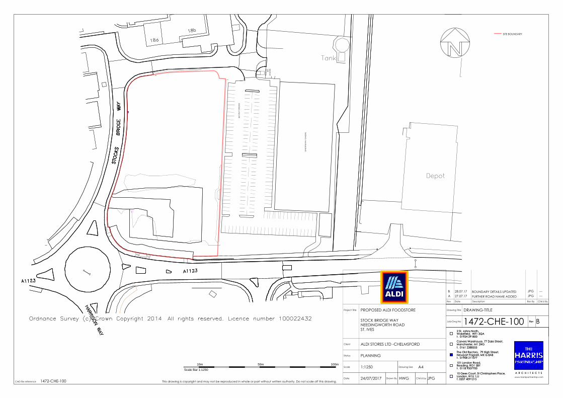
PB
BOX
EXISTING
LYNX BUILD
ING
EXISTING
LYNX SITE
EXISTING
SUBSTA
TION
SITE BOUNDARY
This drawing is copyright and may not be reproduced in whole or part without written authority. Do not scale off this drawing.
A 27.07.17Rev Date Description Rev By Chk'd By
JPG ---FURTHER ROAD NAME ADDED
CAD file reference
Status
Project Title
Scale
A R C H I T E C T S
A4
Client
Rev
Drawing Size
A R C H I T E C T S
Drawing Title
Job-Dwg No
www.harrispartnership.com
Rev
Drawn By Chk'd by Date
Reading, RG1 5BY 101 London Road,
t. 01908 211577 Newport Pagnell, MK16 8AB
Wakefield, WF1 3QA 2 St. Johns North,
The Old Rectory, 79 High Street,t. 0161 2388555 Manchester, M1 2HGCarvers Warehouse, 77 Dale Street,
London, W1U 1JJ 10 Gees Court, St Christophers Place,
t. 01924 291800
t. 0118 9507700
t. 0207 4091215
ALDI STORES LTD -CHELMSFORD
DRAWING-TITLEPROPOSED ALDI FOODSTORE
STOCK BRIDGE WAYNEEDINGWORTH ROADST. IVES
1472-CHE-100 B
1:1250
PLANNING
24/07/2017 HWG JPG1472-CHE-100
Scale Bar 1:1250
10m 50m 100m
B 28.07.17 JPG ---BOUNDARY DETAILS UPDATED

8 CYCLEPARKINGSPACES
KNEE RAILS TO
PROTECTLANDSCAPING
This drawing is copyright and may not be reproduced in whole or part without written authority. Do not scale off this drawing.
Rev Date Description Rev By Chk'd By
A PROPOSED LEVELS UPDATED TO ALIGN WITH ENGINEERS PROPOSALS JPG ---27.07.17
CAD file reference
Status
Project Title
Scale
A R C H I T E C T S
Client
Rev
Drawing Size
A R C H I T E C T S
Drawing Title
Job-Dwg No
www.harrispartnership.com
Rev
Reading, RG1 5BY 101 London Road,
t. 01908 211577 Newport Pagnell, MK16 8AB
Wakefield, WF1 3QA 2 St. Johns North,
The Old Rectory, 79 High Street,t. 0161 2388555 Manchester, M1 2HGCarvers Warehouse, 77 Dale Street,
London, W1U 1JJ 10 Gees Court, St Christophers Place,
t. 01924 291800
t. 0118 9507700
t. 0207 4091215
Reading, RG1 5BY 101 London Road,
t. 01908 211577 Newport Pagnell, MK16 8AB
Wakefield, WF1 3QA 2 St. Johns North,
The Old Rectory, 79 High Street,t. 0161 2388555 Manchester, M1 2HGCarvers Warehouse, 77 Dale Street,
London, W1U 1JJ 10 Gees Court, St Christophers Place,
t. 01924 291800
t. 0118 9507700
t. 0207 4091215Drawn ByDate Checked
A1
ALDI STORES LTD - CHELMSFORD
PROPOSED SITE PLANPROPOSED ALDI FOODSTORE
STOCKS BRIDGE WAYNEEDINGWORTH ROADST. IVES
1472-CHE-102 G
1:200
PLANNING
25/07/2017 HWG JGP1472-CHE-103
SUBJECT TO SITE SURVEY, CONFIRMATION OF LEGALBOUNDARIES, SITE CONSTRAINTS, HIGHWAYS &PLANNING
ALDI RETAIL AREA 22.8m x 55m
WAREHOUSE 7m
PARKING AISLES 6m
PARKING SPACES 2.5m x 5m (126)
TPO's TREES TO BE REMOVED INCLUDE
G2
Scale Bar 1:200
1m 10m5m 15m
B TREES RETAINED, LANDSCAPE UPDATED, CYCLE STORE MOVED HWG ---04.10.17
C LANDSCAPE UPDATED HWG ---12.10.17
D PARKING SPACES REMOVED FROM TREE ROTT PROTECTION AREA HWG ---14.11.17
E ANNOTATION AMENDED HWG ---22.11.17
F CYCLE STORE MOVED HWG ---05.01.18
G ADDITIONAL DETAIL AND UPDATE TO HARD LANDSCAPING HWG JPG26.01.18


This drawing is copyright and may not be reproduced in whole or part without written authority. Do not scale off this drawing.
Rev Date Description Rev By Chk'd By
A Solar panel detail added HWG ---18.01.18
CAD file reference
Status
Project Title
Scale
A R C H I T E C T S
Client
Rev
Drawing Size
A R C H I T E C T S
Drawing Title
Job-Dwg No
www.harrispartnership.com
Rev
Reading, RG1 5BY 101 London Road,
t. 01908 211577 Newport Pagnell, MK16 8AB
Wakefield, WF1 3QA 2 St. Johns North,
The Old Rectory, 79 High Street,t. 0161 2388555 Manchester, M1 2HGCarvers Warehouse, 77 Dale Street,
London, W1U 1JJ 10 Gees Court, St Christophers Place,
t. 01924 291800
t. 0118 9507700
t. 0207 4091215
Reading, RG1 5BY 101 London Road,
t. 01908 211577 Newport Pagnell, MK16 8AB
Wakefield, WF1 3QA 2 St. Johns North,
The Old Rectory, 79 High Street,t. 0161 2388555 Manchester, M1 2HGCarvers Warehouse, 77 Dale Street,
London, W1U 1JJ 10 Gees Court, St Christophers Place,
t. 01924 291800
t. 0118 9507700
t. 0207 4091215Drawn ByDate Checked
A1
ALDI STORE LTD- CHELMSFORD
PROPOSED ROOF PLANPROPOSED ALDI FOODSTORE
STOCKBRIDGE WAYNEEDINGWORTH ROADST. IVES
1472-CHE-104 A
1:100
PLANNING
24/07/2017 HWG JPG1472-CHE-101 Scale Bar 1:100
1m 5m 7m2m 3m 4m 6m

7.905
7.630
5.000 DATUM
FFL 7.750 FFL 7.750
7.685
8.000
SIT
E B
OU
ND
AR
Y
7.830
7.710
7.830
7.710
7.755
7.285
6.914
7.025
7.210
PROPOSED SITE SECTION AA
8.330
5.000 DATUM
8.000
SIT
E B
OU
ND
AR
Y
7.830
7.710
7.830
7.710 7.050
7.210
EXISTING SITE SECTION AA
8.450
8.330
8.210
7.910
7.580
7.210
6.870
7.040
7.200
7.100
FFL 7.750
7.600
7.715
8.270
SIT
E B
OU
ND
AR
Y
8.190
7.695
7.600
7.450
7.600
7.450
7.565
7.415
7.520
7.370
SIT
E B
OU
ND
AR
Y
PROPOSED SITE SECTION BB
5.000 DATUM
8.270
SIT
E B
OU
ND
AR
Y
7.520
7.370
SIT
E B
OU
ND
AR
Y
EXISTING SITE SECTION BB
5.000 DATUM
7.430
7.400
7.310
7.050
7.100
7.270
This drawing is copyright and may not be reproduced in whole or part without written authority. Do not scale off this drawing.
Rev Date Description Rev By Chk'd By
A EXISTING SECTIONS ADDED JPG ---28.07.17
CAD file reference
Status
Project Title
Scale
A R C H I T E C T S
Client
Rev
Drawing Size
A R C H I T E C T S
Drawing Title
Job-Dwg No
www.harrispartnership.com
Rev
Reading, RG1 5BY 101 London Road,
t. 01908 211577 Newport Pagnell, MK16 8AB
Wakefield, WF1 3QA 2 St. Johns North,
The Old Rectory, 79 High Street,t. 0161 2388555 Manchester, M1 2HGCarvers Warehouse, 77 Dale Street,
London, W1U 1JJ 10 Gees Court, St Christophers Place,
t. 01924 291800
t. 0118 9507700
t. 0207 4091215
Reading, RG1 5BY 101 London Road,
t. 01908 211577 Newport Pagnell, MK16 8AB
Wakefield, WF1 3QA 2 St. Johns North,
The Old Rectory, 79 High Street,t. 0161 2388555 Manchester, M1 2HGCarvers Warehouse, 77 Dale Street,
London, W1U 1JJ 10 Gees Court, St Christophers Place,
t. 01924 291800
t. 0118 9507700
t. 0207 4091215Drawn ByDate Checked
A1
ALDI STORE LTD- CHELMSFORD
EXISTING & PROPOSED SITE SECTIONSPROPOSED ALDI FOODSTORE
STOCKBRIDGE WAYNEEDINGWORTH ROADST. IVES
1472-CHE-106 B
1:200
PLANNING
24/07/2017 HWG JPG1472-CHE-101
Scale Bar 1:200
1m 10m5m 15m
B PROPOSED ELEVATIONS UPDATED HWG ---12.01.18

