development land allocations - tonbridge and malling · the development land allocations...
TRANSCRIPT
LDF: Development Land Allocations DPD – April 2008
Tonbridge and Malling Borough Council
LOCAL DEVELOPMENT FRAMEWORK
Development Land Allocations
Development Plan Document
As adopted by the Council
April 2008
LDF: Development Land Allocations DPD – April 2008
LDF: Development Land Allocations DPD – April 2008
CONTENTS Page
1. Introduction 1 1.1 Purpose of this Development Plan Document 1 1.2 Saved Policies 1
2. Housing 5 2.1 Housing Land Requirements 5 2.2 Firm Housing Allocations 5 2.3 Isles Quarry West, Borough Green 9 2.4 Preston Hall and Royal British Legion Village 11 2.5 Constrained Housing Sites 13
3. Employment 21 3.1 Employment Land Requirements 21 3.2 Land Safeguarded for Employment Development 21 3.3 Other Employment Land 23 3.4 Vacant Sites Allocated for Employment Development 24
4. Retail 27 5. Major Developed Sites in the Green Belt 29 6. Safeguarding 35
6.1 Safeguarding Public Utilities Infrastructure 35 6.2 Development-related Infrastructure 36 6.3 West Malling Station 36 6.4 Travelling Showpeople Site 37
7. Monitoring and Implementation 39 7.1 Monitoring 39 7.2 Implementation 39
Annexes Annex A List of sites with planning permission as at 31 March 2006 43 Annex B Housing Trajectory 47 Annex C Performance Indicators 57
LDF: Development Land Allocations DPD – April 2008
INDEX TO POLICIES Page Policy H1 Firm Housing Allocations 6
Policy H2 Isles Quarry West, Borough Green 10
Policy H3 Preston Hall and Royal British Legion Village 11
Policy H4 Constrained Housing Sites 13
Policy E1 Safeguarded Employment Land 22
Policy E2 Other Employment Land 23
Policy E3 Employment Allocations 25
Policy R1 Retail Centres 27
Policy M1 Major Developed Sites in the Green Belt 30
Policy S1 Safeguarding Public Utilities and Infrastructure 35
Policy S2 Commuter Car Park at West Malling Station 36
Policy S3 Travelling Showpeople Site 37
LDF: Development Land Allocations DPD – April 2008
1
1. Introduction 1.1 Purpose of this Development Plan Document
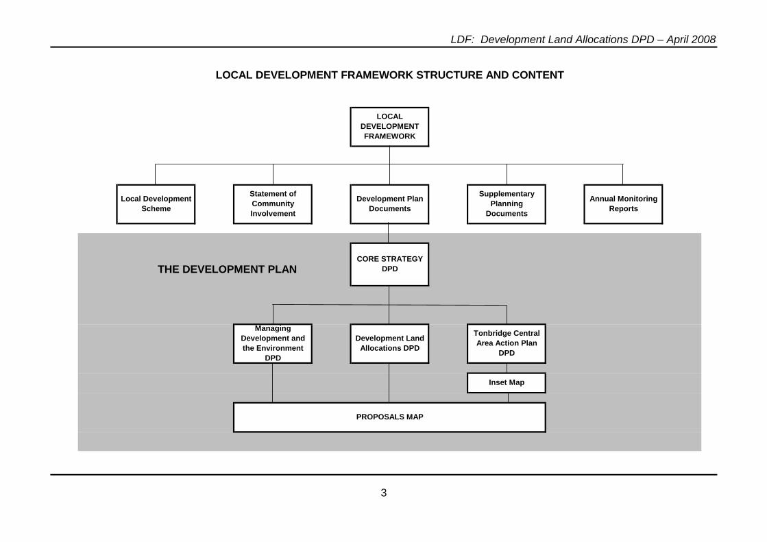
1.1.1 The Development Land Allocations Development Plan Document is one of a suite of documents that together make up the Local Development Framework (LDF) for Tonbridge and Malling Borough as illustrated on Page 3. The Core Strategy is the over-arching document that sets out the Council’s vision, aims and objectives which will determine the pattern of development in the Borough up to 2021 and the way in which the social, economic and environmental needs of the Borough can be met in the most sustainable way. It includes a series of high level Core Policies which are mainly illustrated diagrammatically on a Key Diagram.
1.1.2 The Development Land Allocations Development Plan Document is a document which lists, and specifically identifies on the Proposals Map, all development sites necessary to meet the needs of the area as identified in general terms in the Core Strategy. It identifies:
• Housing Sites in line with Core Policy CP15;
• Major Developed Sites in the Green Belt pursuant to Core Policy CP14(f);
• Sites for new employment development and existing employment areas to be safeguarded from alternative uses pursuant to Core Policy CP21;
• The extent of the retail areas referred to in Core Policy CP22; and
• Land safeguarded mainly for public authority uses including land required for highway and transport improvements pursuant to Core Policy CP26.
The Development Land Allocations Development Plan Document will be kept up-to-date by regular reviews in the light of the results of monitoring as set out in the Annual Monitoring Reports.
1.2 Saved Policies
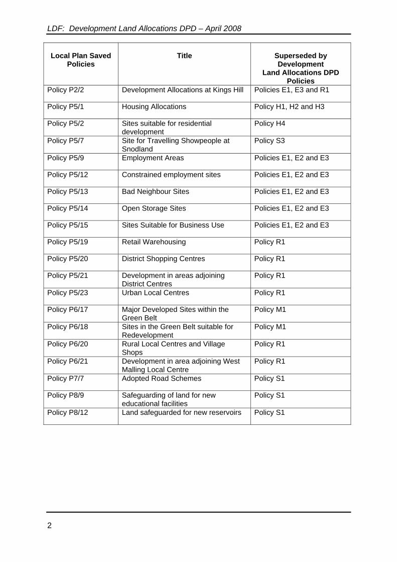
1.2.1 On the 28 September 2007 a Direction issued by the Secretary of State came into effect indicting which of the polices in the adopted Tonbridge and Malling Borough Local Plan could be saved. Regulation 13(5) of the Town and County Planning (Local Development) Regulations 2004 indicates that where a Development Plan Document contains a policy that is intended to supersede another policy it must sate that fact and identify the superseded policy.
1.2.2 The following saved Local Plan policies are superseded by policies in this
Development Plan Document.
LDF: Development Land Allocations DPD – April 2008
2
Local Plan Saved
Policies
Title
Superseded by Development
Land Allocations DPD Policies
Policy P2/2 Development Allocations at Kings Hill Policies E1, E3 and R1
Policy P5/1 Housing Allocations Policy H1, H2 and H3
Policy P5/2 Sites suitable for residential development
Policy H4
Policy P5/7 Site for Travelling Showpeople at Snodland
Policy S3
Policy P5/9 Employment Areas Policies E1, E2 and E3
Policy P5/12 Constrained employment sites Policies E1, E2 and E3
Policy P5/13 Bad Neighbour Sites Policies E1, E2 and E3
Policy P5/14 Open Storage Sites Policies E1, E2 and E3
Policy P5/15 Sites Suitable for Business Use Policies E1, E2 and E3
Policy P5/19 Retail Warehousing Policy R1
Policy P5/20 District Shopping Centres Policy R1
Policy P5/21 Development in areas adjoining District Centres
Policy R1
Policy P5/23 Urban Local Centres Policy R1
Policy P6/17 Major Developed Sites within the Green Belt
Policy M1
Policy P6/18 Sites in the Green Belt suitable for Redevelopment
Policy M1
Policy P6/20 Rural Local Centres and Village Shops
Policy R1
Policy P6/21 Development in area adjoining West Malling Local Centre
Policy R1
Policy P7/7 Adopted Road Schemes Policy S1
Policy P8/9 Safeguarding of land for new educational facilities
Policy S1
Policy P8/12 Land safeguarded for new reservoirs Policy S1
LDF: Development Land Allocations DPD – April 2008
3
THE DEVELOPMENT PLAN
LOCAL DEVELOPMENT FRAMEWORK STRUCTURE AND CONTENT
LOCAL DEVELOPMENT FRAMEWORK
Local Development Scheme
Statement of Community Involvement
Development Plan Documents
Managing Development and the Environment
DPD
Development Land Allocations DPD
Tonbridge Central Area Action Plan
DPD
Supplementary Planning
Documents
Annual Monitoring Reports
CORE STRATEGY DPD
Inset Map
PROPOSALS MAP

LDF: Development Land Allocations DPD – April 2008
4
LDF: Development Land Allocations DPD – April 2008
5
2 Housing 2.1 Housing Land Requirements
2.1.1 In line with the submitted version of the South East Plan, Core Policy CP15 indicates that provision should be made for the development of 6,375 dwellings by 2021. It identifies four major development sites which are planned for implementation during the plan period which all have planning permission.
2.1.2 As at 31 March 2006, planning permission existed for 4,606 dwellings that are likely to be implemented within the 2006-2021 period (see Annex A). These sites are shown on the Proposals Map for information only. The yield on these sites may vary if revised planning permissions are granted. Significant planning permissions have been granted since 31 March 2006. All of these are windfalls apart from the 1,000 dwellings at Peters Pit which is an allocated site granted planning permission in May 2006. In addition to these sites with permission there is now just one unimplemented housing allocation in the Tonbridge and Malling Borough Local Plan at Kings Hill which is to be carried forward into the LDF. This could accommodate some 65 dwellings. It is anticipated that the shortfall of 704 dwellings (not counting the permissions granted since 31 March 2006) will be easily met by the projected level of windfalls. At a conservative estimate, these could provide another 2,330 dwellings over this period.
2.1.3 PPS3 requires planning authorities to allocate sufficient land to meet the housing trajectory for a period of 10 years following the adoption of the Local Development Framework, without reliance on windfalls unless there is robust evidence of genuine local circumstances that prevent specific sites from being identified. This should only take account of windfalls if it is not possible to allocate sufficient land. Assuming that this Development Plan Document is adopted by April 2008, sufficient land needs to be identified for development to 31 March 2018. The sites with planning permission (including Peters Pit) are expected to yield approximately 5,506 dwellings by 31 March 2018. The South East Plan requirement for the period up to 31 March 2018 on the basis of 425 dwellings per year, would be 5,100 dwellings. There is therefore no need to allocate fresh land outside the urban confines or release any reserve sites to meet this requirement. If these committed sites do not come forward as anticipated, any shortfall will be met by windfall development over this period. However, in accordance with PPS3, supplies of identified housing land to meet the trajectory will need to be maintained on a rolling basis and the progress of committed sites will be monitored in case any action needs to be taken to increase supply.
2.2 Firm Housing Allocations
2.2.1 Policy H1 allocates land for housing which contributes towards meeting the housing requirement identified above. The sites are those with a capacity of 5 or more dwellings within the urban areas identified through the Urban Capacity Study, together with the unimplemented housing allocation at Kings Hill carried forward from the Tonbridge and Malling Borough Local Plan. The policy includes an indicative dwelling yield based on a crude density multiplier having regard to the nature of the locality. However, it must be emphasised that the actual
LDF: Development Land Allocations DPD – April 2008
6
dwelling yield that might be achieved on each site could vary from that indicated. This depends upon the character and detail of the actual scheme submitted for planning permission.
2.2.2 Policy H1 does not include sites for which a master plan will be required. A master plan will be required for the sites at Isles Quarry West, Borough Green, and Preston Hall / Royal British Legion Village, Aylesford. These two sites are covered by policies H2 and H3 respectively. However, their dwelling yield will also contribute towards the housing requirements identified above.
2.2.3 Policy H1 also does not include any housing sites within the limits of the Tonbridge Central Area Action Plan. It is anticipated that the Area Action Plan will confidently yield at least 1,000 dwellings above existing commitments within the plan period. Annex B sets out a revised Housing Trajectory having regard to the implementation of the sites allocated for development in Policy H1, as well as Isles Quarry, Preston Hall and the potential yield from the Tonbridge Central Area Action Plan. This indicates that the housing requirements of the Borough will comfortably be met by the allocated housing sites (including those in the Area Action Plan). If any of the sites do not come forward as expected, any shortfall will be met by the anticipated rate of windfalls. This flexibility also allows for the possibility that the final approved housing figures for the Borough in the South East Plan might be higher than in the submitted version.
POLICY H1. The following sites, as shown on the Proposals Map, are allocated for housing and should be developed in accordance with the criteria identified in respect of each site and all general policy requirements, including any necessary contributions towards the provision of recreation, education and other community and cultural facilities, pursuant to Core Policy CP25. They will be developed at the highest density compatible with the character and amenity of the surrounding area but not normally at a density of less than 30 dwellings per hectare:
(a) 109 Hall Road, Aylesford (5 dwellings), subject to:
• investigation and remediation of any land contamination;
• any necessary mitigation measures identified as a result of an archaeological assessment; and
• the need to improve the access onto Hall Road including the footway.
(b) Oil Depot, Station Road, Aylesford (21 dwellings), subject to:
• provision of affordable housing in accordance with Core Policy CP17(1);
• any necessary mitigation measures identified
LDF: Development Land Allocations DPD – April 2008
7
through a Flood Risk Assessment; • investigation and remediation of any land
contamination; • achievement of a satisfactory noise climate in
accordance with saved Policy P3/17 (or its successor Policy) having regard to the proximity of the railway line;
• respecting the character of the adjacent Conservation Area;
• any necessary mitigation measures identified as a result of an archaeological assessment; and
• provision of access via Bridge Place, footway improvements to the frontage and the closure of the existing access.
(c) Nu-Venture Coaches, Mill Hall, Aylesford (8 dwellings), subject to:
• any necessary mitigation measures identified through a Flood Risk Assessment;
• achievement of a satisfactory noise climate in accordance with saved Policy P3/17 (or its successor Policy) having regard to the proximity of existing business to the east;
• investigation and remediation of any land contamination;
• provision of a riverside path; • respecting the setting of the grade I listed
Aylesford Friary; • any necessary improvements to the Station Road
junction having regard to the adjacent level crossing; and
• preferably being accessed via the site to the east once this is developed.
(d) Castledene Transport and Pickfords Removals, Mill Hall, Aylesford (58 dwellings), subject to:
• provision of affordable housing in accordance with Core Policy CP17(1);
• any necessary mitigation measures identified through a Flood Risk Assessment;
• achievement of a satisfactory noise climate in accordance with saved Policy P3/17 (or its successor Policy) having regard to the proximity of the railway line;
• respecting the setting of the listed building to the south east of the site;
LDF: Development Land Allocations DPD – April 2008
8
• investigation and remediation of any land contamination;
• a possible contribution towards open playing space provision;
• provision of a safe pedestrian access to the Maidstone-bound platform of Aylesford Station;
• any necessary mitigation measures identified as a result of an archaeological assessment; and
• any necessary improvements to the Station Road junction having regard to the adjacent level crossing.
(e) Park House, 110-112 Mill Street, East Malling (5 dwellings), subject to:
• provision of affordable housing in accordance with Core Policy CP17(2);
• the retention of Park House; • protection and enhancement of the character of
the Conservation Area; • any necessary mitigation measures identified
through a Flood Risk Assessment; and • any necessary mitigation measures identified as
a result of an archaeological assessment.
(f) Kings Hill - remainder (65 dwellings), subject to:
• provision of affordable housing in accordance with Core Policy CP17(1);
• provision of on-site open playing space or a contribution to the provision or enhancement of open space provision elsewhere at Kings Hill;
• provision of footpaths, cycle and bridle routes linking with existing and/or proposed routes at Kings Hill;
• a contribution towards community and leisure facilities at Kings Hill;
• the retention of important trees on the site and a substantial woodland margin adjacent to the countryside to preserve the landscape setting and screen the development area; and
• any necessary mitigation measures identified as a result of an archaeological assessment.
LDF: Development Land Allocations DPD – April 2008
9
(g) Land adjacent to Snodland Station (24 dwellings), subject to:
• provision of affordable housing in accordance with Core Policy CP17(1);
• respecting the setting of the listed station building to the east;
• protection and enhancement of the character of the Conservation Area;
• protection of trees subject to a Tree Preservation Order;
• achievement of a satisfactory noise climate in accordance with saved Policy P3/17 (or its successor Policy) having regard to the proximity of the railway line;
• a possible contribution towards open playing space provision;
• provision of additional car and cycle parking at the station; and
• improvements to footways and the existing vehicular access including access to the station, preferably in conjunction with the development of the former playing fields.
(h) Land to the rear of Brionne Gardens/68 Lodge Oak Lane, Tonbridge (5 dwellings), subject to:
• satisfactory access.
2.3 Isles Quarry West, Borough Green
2.3.1 Core Policy CP18 identifies land at Isles Quarry West, Borough Green, as a strategic housing location. This arises from the Council’s view that the best way of meeting general affordable housing needs within the more remote parts of the Malling Rural area is to concentrate such development at the rural service centre of Borough Green. Its development will also have the environmental benefits of removing at least some of the industrial activities from the site and bringing forward its comprehensive restoration and enhancement. Development would include new housing, leisure and recreation facilities. Such a development could not be expected to provide 100% affordable housing due to the high cost of restoration and the wider benefits to the local community. Therefore, an element of market housing will be necessary to ensure viability of the project. In order to ensure that the development leads to wider benefits to the community and that a comprehensive approach is adopted, a Master Plan will need to be prepared and approved. This Master Plan encompasses land to the west and south of the allocation including the nearby Site of Nature Conservation Interest (SNCI). The Master Plan will need to incorporate provision for a public amenity area to the east of the development site and a requirement for the long-term management of the SNCI.
LDF: Development Land Allocations DPD – April 2008
10
POLICY H2 The site at Isles Quarry West, Borough Green, as shown on the Proposals Map, is allocated for housing development with a capacity of 200 dwellings. The site should be developed in accordance with an approved Master Plan encompassing land to the west and south of the allocation up to and including the Site of Nature Conservation Interest as shown on Annex D. It will need to take into account the criteria listed below and any other general policy requirements including any necessary contributions towards the provision of education and other community and cultural facilities pursuant to Core Policy CP25:
(a) pursuant to Core Policy CP17(2), phased provision of
affordable housing in line with projected needs; (b) reduction of the ground levels and integration with the
housing development at the lower level of any part of the higher-level platform that is to be developed for housing;
(c) regard to the potential environmental impact of any
continuing employment use of the upper platform if all or part of it is not to be incorporated in the housing area, including the achievement of a satisfactory noise climate in accordance with saved Policy P3/17 (or its successor Policy);
(d) provision of satisfactory access to any continuing
employment use of the upper platform if all or part of it is not incorporated in the housing area;
(e) provision of a landscaped public amenity area to the
west of the housing site, including appropriate provision for the open playing space needs of the development;
(f) provision for the long-term management of the Site of
Nature Conservation Interest; (g) investigation and remediation of any land contamination;
(h) upgrading to an adoptable standard of the private access
road connecting with the Dark Hill roundabout; (i) retention of the landscaped bank to the north; (j) general respect for the setting of the site within the
AONB, including landscape enhancement;
LDF: Development Land Allocations DPD – April 2008
11
(k) provision of footpaths and cycle routes to link with the existing public rights-of-way network and the retail centre of Borough Green;
(l) a traffic impact assessment and provision for any
necessary mitigation measures, including contributions to public transport; and
(m) contributions towards the improvement of off-site
sewerage capacity.
2.4 Preston Hall and Royal British Legion Village
2.4.1 Parts of the site of Preston Hall Hospital are likely to become surplus to the requirements of the Strategic Health Authority in the short to medium term. It adjoins land forming part of the Royal British Legion Village. There is already a significant amount housing within the original grounds of Preston Hall. It is considered that, if carefully planned, the combined site could accommodate some further development. Any development of the site is likely to be predominantly residential but with some opportunities for mixed uses, particularly in the converted Listed Building which could include, for example, offices, hotel, or private health, training or education facilities.
2.4.2 Preston Hall is a Grade II Listed Building, originally built as a country house in a landscaped park. The site lies within the confines of the urban area. The strategic gap lies immediately to the east and there are long distance views towards the North Downs. The main access is from the A20. It is considered that a comprehensive approach to development should be taken. A Master Plan should be prepared for the whole site as identified on the Proposals Map including existing buildings to be retained. The Master Plan should show how the area could be developed taking into account all the site constraints, the preservation of the Listed Building, integration with existing uses to remain and other policy criteria set out below. It will be a requirement that land outside the confines of the built-up area within the Strategic Gap but within the control of the landowners should be subject to positive management, including landscape reinforcement. It is considered that the development site could accommodate in the order of 180 dwellings, though this is a purely indicative figure and depends upon the details of the Master Plan and the ultimate mix of uses on the site.
POLICY H3 The site at Preston Hall and Royal British Legion Village, Aylesford, as shown on the Proposals Map, is considered appropriate for mixed-use, but predominantly residential, development with a capacity in the order of 180 dwellings. It should be developed in accordance with an approved Master Plan which should aim to maximise the opportunities for development, taking into account the following considerations and any other general policy requirements including any necessary contributions
LDF: Development Land Allocations DPD – April 2008
12
towards the provision of education and other community and cultural facilities, pursuant to Core Policy CP25:
a) the provision of affordable housing in accordance with Core Policy CP17(1);
b) respect for the character and setting of the grade II
Listed Building, which should be guided by an historic buildings and archaeological assessment;
c) achievement of a satisfactory noise climate in
accordance with saved Policy P3/17 (or its successor Policy) having regard to noise from nearby roads and motorway;
d) consideration of traffic impact on the A20/
Hermitage Lane and A20/Hall Road junctions, the Coldharbour roundabout and junction 5 on the M20 with provision for any necessary mitigation measures including junction improvements (subject to the preservation of the Lodge), the possible provision of a secondary point of access onto Hall Road and a contribution towards the A20 multi-modal improvement scheme;
e) provision of adequate open playing space within
the site, footpaths, and cycle routes linking with the A20 cycle route;
f) respect for the landscape of the site, including the
retention of important mature trees and, in particular, the avenue approach to the Listed Building, which should be informed by a landscape assessment and tree survey;
g) respect for the wider setting of the site including
views to and from the surrounding countryside. A scheme of positive landscape management will be required for land within the Strategic Gap adjacent to the Master Plan area which should include landscape enhancement and reinforcement;
h) investigation and remediation of any land contamination; and
i) consideration of the potential impact of air quality
close to the A20 and M20 on the design and layout of development.
LDF: Development Land Allocations DPD – April 2008
13
2.5 Constrained Housing Sites
2.5.1 The Urban Capacity Study identified a number of other sites which are considered potentially suitable for housing but which are currently in another use. There can be no certainty that they will come forward for housing development and, therefore, they are not firmly allocated for housing and will not be counted against the housing requirements of the South East Plan unless planning permission is granted. If they do come forward for development they will be counted as windfalls. Many of these sites are existing employment uses which the Employment Land Review has confirmed are not high quality and do not need to be protected. Sites which fall into this category are regarded as constrained housing sites.
2.5.2 It must be emphasised that the Borough Council has no intention of discontinuing these uses or revoking their permissions. It is indicating its preference for these sites to be redeveloped for housing should the opportunity arise. Whilst the sites do not count towards housing land supply unless planning permission is granted, it is considered helpful to recognise the housing potential of such sites in policy terms to clarify the Council’s position if they become available for development. The following Policy applies to such sites.
POLCY H4 The following sites, as shown on the Proposals Map, are not specifically allocated for housing but are considered to be suitable for residential development. If they come forward for housing, they should be developed in accordance with the criteria identified in respect of each site and all general policy requirements including any necessary contributions towards the provision of recreation, education and other community and cultural facilities, pursuant to Core Policy CP25. They will be developed at the highest density compatible with the character and amenity of the surrounding area but not normally at a density of less than 30 dwellings per hectare:
a) Scott Bros, Mill Hall Aylesford (13 dwellings) subject to: • any necessary mitigation measures identified
through a Flood Risk Assessment; • investigation and remediation of any land
contamination; • achievement of a satisfactory noise climate in
accordance with saved Policy P3/17 (or its successor Policy) having regard to the industrial uses to the south and west;
• provision of a riverside path; • respect the setting of The Friars, Aylesford which
is a Grade I Listed Building; and • any necessary improvements to the Station Road
junction having regard to the adjacent level crossing.
LDF: Development Land Allocations DPD – April 2008
14
b) West of Maidstone Road, Blue Bell Hill (9 dwellings), subject to: • provision of affordable housing in accordance
with Core Policy CP17(2); • achievement of a satisfactory noise climate in
accordance with saved Policy P3/17 (or its successor Policy) having regard to the proximity of the A229 and its junction with the link road;
• consideration of the potential impact of air quality on the design and layout of development;
• consideration of the potential impact of vibration from the Channel Tunnel Rail Link tunnel on the detailed design of development; and
• investigation and remediation of any land contamination.
c) 242 London Road, West Malling (8 dwellings),
subject to: • provision of affordable housing in accordance
with Core Policy CP17(2); • consideration of the potential impact of air quality
on the design and layout of development; • minimisation of noise disturbance from the road; • investigation and remediation of any land
contamination; and • provision of a single point of access onto the
A20. d) 263-265 London Road, West Malling (8 dwellings),
subject to: • provision of affordable housing in accordance
with Core Policy CP17(2); • consideration of the potential impact of air quality
on the design and layout of development; • achievement of a satisfactory noise climate in
accordance with saved Policy P3/17 (or its successor Policy) having regard to noise from the A20;
• investigation and remediation of any land contamination;
• any necessary mitigation measures identified as a result of an archaeological assessment;
• provision of a single point of access onto the A20.
LDF: Development Land Allocations DPD – April 2008
15
e) TA Centre, London Road, Ditton (51 dwellings), subject to: • provision of affordable housing in accordance
with Core Policy CP17(1); • achievement of a satisfactory noise climate in
accordance with saved Policy P3/17 (or its successor Policy) having regard to noise from the A20;
• consideration of the potential impact of air quality on the design and layout of development;
• a possible contribution towards open playing space provision;
• investigation and remediation of any land contamination;
• a contribution to the A20 multi-modal improvements and the provision of a right turning lane and crossing facilities; and
• contributions towards the improvement of off-site sewerage capacity.
f) 613 London Road, Ditton (6 dwellings), subject to:
• achievement of a satisfactory noise climate in accordance with saved Policy P3/17 (or its successor Policy) having regard to noise from the road;
• consideration of the potential impact of air quality on the design and layout of development;
• overcoming local flooding issues; • protection of the trees subject to a TPO within the
site; • investigation and remediation of any land
contamination; and • rationalisation of existing accesses onto the A20,
but preferably the closure of all existing accesses and obtaining access via Ditton Place.
g) Ditton Service Station, 675 London Road, Ditton (20
dwellings), subject to: • provision of affordable housing in accordance
with Core Policy CP17(1); • achievement of a satisfactory noise climate in
accordance with saved Policy P3/17 (or its successor Policy) having regard to noise from the road;
• consideration of the potential impact of air quality on the design and layout of development;
• protection of the trees subject to a TPO to the
LDF: Development Land Allocations DPD – April 2008
16
north east of the site; • investigation and remediation of any land
contamination; • a possible contribution towards open playing
space provision; • any necessary mitigation measures identified as a
result of an archaeological assessment; and • the closure of the existing vehicular accesses
onto the A20 and obtaining access via Bradbourne Lane which should preferably be improved; and
• contributions towards the improvement of off-site sewerage capacity.
h) Industrial Site, Blacklands, East Malling (11
dwellings), subject to: • provision of affordable housing in accordance
with Core Policy CP17(2); • respecting the character of the adjacent
Conservation Areas; • investigation and remediation of any land
contamination; • mitigation of any local flooding issues; • any necessary mitigation measures identified as a
result of an archaeological assessment; and • preferably provision of access via Middle Mill
Road with a pedestrian link to the local schools. i) Millbrook House, 114 Mill Street, East Malling (10
dwellings), subject to: • provision of affordable housing in accordance
with Core Policy CP17(2); • respecting the character of the adjacent
Conservation Area and Listed Buildings; • any necessary mitigation measures identified as a
result of an archaeological assessment; and • any necessary mitigation identified through a
Flood Risk Assessment. j) Builders Yard, Brunswick Square, East Peckham (14
dwellings), subject to: • provision of affordable housing in accordance
with Core Policy CP17(2); • investigation and remediation of any land
contamination;
LDF: Development Land Allocations DPD – April 2008
17
• any necessary mitigation measures identified through a Flood Risk Assessment;
• retention or replacement of existing lock-up garages on the site;
• a possible contribution towards open playing space provision; and
• retention of access onto Old Road for pedestrians only with improvement of Pound Road to provide road access with such improvements to the footway as are necessary.
k) 140-142 Tonbridge Road, Hildenborough (14
dwellings), subject to: • provision of affordable housing in accordance
with Core Policy CP17(2); • respect for the character of the adjacent
Conservation Area; • achievement of a satisfactory noise climate in
accordance with saved Policy P3/17 (or its successor Policy) having regard to noise from Tonbridge Road;
• consideration of the potential impact of air quality on the design and layout of development;
• investigation and remediation of any land contamination;
• a possible contribution towards open playing space provision; and
• provision of a single point of access onto Tonbridge Road.
l) Clare Park Service Station and B&Q Store, London
Road, Larkfield (59 dwellings), subject to: • provision of affordable housing in accordance
with Core Policy CP17(1); • achievement of a satisfactory noise climate in
accordance with saved Policy P3/17 (or its successor Policy) having regard to noise from the A20;
• consideration of the potential impact of air quality on the design and layout of development;
• a possible contribution towards open playing space provision;
• investigation and remediation of any land contamination;
• any necessary mitigation measures identified as a result of an archaeological assessment;
• a detailed technical assessment of access
LDF: Development Land Allocations DPD – April 2008
18
arrangements with the possible provision of a single point of access at the western end; and
• contributions towards the improvement of off-site sewerage capacity.
m) Garage, 2 London Road, Leybourne (20 dwellings),
subject to: • provision of affordable housing in accordance
with Core Policy CP17(1); • achievement of a satisfactory noise climate in
accordance with saved Policy P3/17 (or its successor Policy) having regard to the proximity of the A20;
• consideration of the potential impact of air quality on the design and layout of development;
• investigation and remediation of any land contamination;
• a possible contribution towards open playing space provision;
• any necessary mitigation measures identified as a result of an archaeological assessment; and
• provision of a single point of access to the A20. n) 294 Malling Road and Land adjacent, Snodland (17
dwellings), subject to: • provision of affordable housing in accordance
with Core Policy CP17(1); • investigation and remediation of any land
contamination; • protection of the historic building and its
sympathetic incorporation into the design of the development; and
• avoidance of a direct vehicular access onto Malling Road.
o) Farm Ground Allotments, Gorham Drive, Tonbridge
(23 dwellings), subject to: • provision of affordable housing in accordance
with Core Policy CP17(1); • demonstration that the land is surplus to
requirements for allotments or adequate provision of alternative facilities;
• possible contribution towards open playing space provision;
• any necessary mitigation measures identified as a
LDF: Development Land Allocations DPD – April 2008
19
result of an archaeological assessment; • a contribution towards improvement of the
adjacent footpath; and • contributions towards the improvement of off-site
sewerage capacity. p) 159-159a Pembury Road, Tonbridge (5 dwellings),
subject to: • investigation and remediation of any land
contamination; • achievement of a satisfactory noise climate in
accordance with saved Policy P3/17 (or its successor Policy) having regard to noise from Pembury Road and from the railway;
• preference for a single point of access; and • contributions towards the improvement of off-site
sewerage capacity. q) 17 Preston Road, Tonbridge (5 dwellings), subject to:
• achievement of a satisfactory noise climate in accordance with saved Policy P3/17 (or its successor Policy) having regard to noise from the railway;
• investigation and remediation of any land contamination; and
• contributions towards the improvement of off-site sewerage capacity.
r) 60A Priory Street and 31 Pembury Road, Tonbridge
(18 dwellings), subject to: • provision of affordable housing in accordance
with Core Policy CP17(1); • achievement of a satisfactory noise climate in
accordance with saved Policy P3/17 (or its successor Policy) having regard to noise from Pembury Road;
• investigation and remediation of any land contamination;
• a possible contribution towards open playing space provision;
• any necessary mitigation measures identified as a result of an archaeological assessment;
• preferably provision of an improved access from Priory Street; and
• contributions towards the improvement of off-site sewerage capacity.
LDF: Development Land Allocations DPD – April 2008
20
s) 54 Quarry Hill Road, Tonbridge (10 dwellings), subject to: • respecting the character of the adjacent
Conservation Area; • achievement of a satisfactory noise climate in
accordance with saved Policy P3/17 (or its successor Policy) having regard to noise from the Quarry Hill Road;
• consideration of the potential impact of air quality on the design and layout of development;
• investigation and remediation of any land contamination;
• rationalisation of existing accesses onto Quarry Hill Road; and
• any necessary mitigation measures identified as a result of an archaeological assessment.
t) 20 Bow Road, Wateringbury (7 dwellings), subject to:
• provision of affordable housing in accordance with Core Policy CP17(2);
• investigation and remediation of any land contamination;
• achievement of a satisfactory noise climate in accordance with saved Policy P3/17 (or its successor Policy) having regard to noise from Bow Road and the nearby village hall and car park; and
• any necessary footway improvements.
LDF: Development Land Allocations DPD – April 2008
21
3. Employment 3.1 Employment Land Requirements
3.1.1 Policy CP21 of the Core Strategy sets out the Council’s overarching policy for the provision of employment land. The Council recognises that some of the areas identified as Employment Areas in the adopted Tonbridge and Malling Borough Local Plan are no longer suitable for employment uses. However, most sites are well located and capable of accommodating a range of employment uses. These have been carried forward and safeguarded for employment use.
3.1.2 New employment development is to be located within the areas specifically identified for this purpose, principally at Kings Hill and on vacant or redevelopment sites within the main employment areas. Proposals for new employment uses on other sites will be considered on their merits in accordance with Core Policy CP21.3.
3.1.3 The broad conclusions of the Employment Land Review (July 2005) are that:
• Business (office) requirements (Use Class B1) are expected to increase but existing supply already exceeds this need (although this is concentrated at Kings Hill which performs a regionally important role).
• General industrial requirements (Use Class B2) are set to decline. There will be a surplus of land for this sector across the Borough.
• On the other hand, warehousing requirements (Use Class B8) are predicted to increase. The land required to support this increase can be accommodated on sites or in buildings that become vacant as industrial land requirements decrease.
3.1.4 The development of existing employment sites needs to be carefully managed. It is important that the right balance is achieved between maintaining an appropriate level of employment land to meet the needs of the Borough and redeveloping for other purposes employment sites that are no longer able to meet the requirements of modern businesses. The conclusion is that there is no need to identify further sites for employment purposes.
3.2 Land Safeguarded for Employment Development
3.2.1 The objective of the following employment policy is to secure and retain a variety of employment sites within the Borough to meet the needs of local employers and to attract investment. It is important that a variety of sites are safeguarded for employment purposes to achieve a balanced and sustainable local economy and to provide opportunity for sustainable economic growth. The Council is committed to supporting and creating sustainable communities and recognises that this can only be achieved where there is a balance of all land uses, including employment areas.
3.2.2 However, it is also important to recognise that some existing employment areas may no longer be best suited for this purpose, and that subject to meeting a
LDF: Development Land Allocations DPD – April 2008
22
number of criteria, alternative uses may be permitted. Allowing for such changes, the current picture for the Borough’s employment land supply achieves the right balance, but to lose any further employment sites could weaken the economic prospects of the Borough as a whole.
3.2.3 Pursuant to Core Policy CP21.2, the following Policy identifies land to be safeguarded for employment purposes. The extent of these employment areas is shown on the Proposals Map.
Policy E1 The areas listed below and shown on the Proposals Map will be safeguarded for employment purposes. Except where otherwise specified, proposals for non-employment uses, i.e. uses other than General Industrial Use (B2), Business Use (B1) or Storage and Distribution Uses (B8), will not be permitted. Any new development or redevelopment (including change of use) within these areas for employment purposes must not result in unacceptable impact on residential or rural amenity by virtue of noise, dust, smell, vibration or other emissions, or by visual intrusion, or the nature and scale of traffic generation. This means that parts of these areas close to residential properties may be suitable only for Business Use (B1).
Areas suitable for business (B1), general industrial (B2) and warehousing/distribution (B8) use:
(a) Holborough, Snodland, with a quality of development reflecting the gateway status of the site
(b) Land east of the bypass, Snodland (c) Ham Hill, Snodland (d) New Hythe area, Larkfield (e) Forstal Road, Aylesford (part) (f) Quarry Wood (west of Mills Road) including Priory Park (g) Barming Depot, Aylesford (h) 20/20 Estate, Aylesford (part) (i) Branbridges, East Peckham (j) Bourne Enterprise Centre, Borough Green (k) Land West of Woodgate Way, Tonbridge, with a quality of
development reflecting the gateway status of the site (l) Tonbridge Industrial Estate, (outside the area within the
Central Tonbridge Area Action Plan) (m) Laker Road, Bridgewood Areas suitable for Business Use (B1) only:
(n) North of Station Approach, Borough Green (o) North of Fairfield Road, Borough Green (p) Hermitage Lane, Aylesford, to be accessed only from
Hermitage Lane (q) Rockfort Road, Snodland
LDF: Development Land Allocations DPD – April 2008
23
Mixed Use Sites:
(r) Kings Hill - high quality, campus style Business Park suitable for offices, research and development and light industrial use (B1) including also hotel, conference, education and training and commercial leisure uses as part of the wider Kings Hill mixed-use development.
(s) East Malling Research Station (main site) – suitable for offices, research and development and light industrial manufacturing (B1) including conference, education and training and any other uses that can be demonstrated to be related to, or support the operation of, the Research Station.
(t) Bradbourne, East Malling – suitable for offices, research and development (B1), conference, education and training.
3.3 Other Employment Land
3.3.1 The following Policy applies to all other employment areas that are not specifically allocated for any other purpose. Whilst not safeguarded for employment use, their loss for other purposes would have to pass a series of strict tests. The extent of these employment areas is shown on the Proposals Map. Some of these are identified as Major Developed Sites in the Green Belt which means that they would also have to meet the tests set out in Policy M1.
Policy E2 1. The areas listed below and shown on the Proposals Map are considered suitable for continued employment use subject to new development creating no unacceptable impact on residential or rural amenity by virtue of noise, dust, smell, vibration or other emissions, or by visual intrusion, or the nature and scale of traffic generation.
2. Proposals for uses other than General Industrial (B2), Business Use (B1) or Storage and Distribution Uses (B8) will not be permitted within these areas unless all of the following requirements are met.
(1) proposals must be able to demonstrate no significant adverse impact on the quality and quantity of employment land supply in the market area;
(2) applicants must demonstrate that they have actively marketed the site for employment purposes on realistic terms and for a reasonable period, including consideration of sub-dividing a larger site;
LDF: Development Land Allocations DPD – April 2008
24
(3) applicants must be able to demonstrate that continued use or redevelopment of the existing buildings for employment purposes is not viable; and
Any proposal that is permitted having regard to the above requirements must be able to demonstrate that the amenity benefits of redevelopment outweigh the benefits of retaining the site in employment use.
(a) Millhall, Aylesford (b) Little Preston, Aylesford (c) Lower Bell, Aylesford (d) Hall Road, Aylesford (e) Quarry Wood, east of Mills Road, (f) Ditton Laboratories, Kiln Barn Lane, Dittton (g) Drayton Road, Tonbridge The following sites, which are Major Developed Sites in the Green Belt, are also subject to Policy M1: h) Platt Industrial Estate, Platt i) Long Pond Works, Borough Green j) Works, south of Cricketts Farm, Ightham k) Former Ryarsh Brickworks, Ryarsh l) The Alders, Mereworth m) East of Tonbridge Road, Little Mill, East Peckham n) Nepicar Area West, London Road. Wrotham o) Winsor Works, London Road, Addington p) Salts Yard, Redwell Lane, Ightham q) Roughway Mill, Plaxtol r) Tower Garage, Wrotham Hill, Wrotham
Proposals for retail development at site (e) which are fully justified under the provisions of Core Policy CP 22(1)(c) and are in accordance with Government guidance on the identification of need and the sequential selection of sites for retail development, will not be expected to meet the requirements of this Policy.
3.4 Vacant Sites Allocated for Employment Development 3.4.1 The Employment Land Review (July 2005) sets out a baseline for employment
land provision in the Borough. This situation will be monitored on an annual basis in conjunction with Kent County Council and set out in the Council’s Annual Monitoring Report. The following Policy identifies large vacant sites (in excess of 0.5 ha) potentially available for employment development within the areas identified for employment use under Policies E1 and E2. Some of these already have outline planning permission. Other opportunities will arise from the redevelopment or intensification of use on existing employment sites. The
LDF: Development Land Allocations DPD – April 2008
25
availability of these sites will be monitored in the Annual Monitoring Report and kept under review.
POLICY E3 The following vacant sites within the areas identified for employment use under Policies E1 and E2 are allocated for employment development:
(a) North of Gibson Drive, Kings Hill (1.55 ha) (b) Off Kings Hill Avenue, Kings Hill (1.34 ha) (c) North of Kings Hill Avenue, Kings Hill (1.16 ha) (d) South of Kings Hill Avenue, Kings Hill (7.41 ha) (e) East of Tower View, Kings Hill (22.5 ha) (f) Alexander Grove, Kings Hill (1.4 ha) (g) Priory Park, Quarry Wood, Aylesford (3.46 ha) (h) Hermitage Lane, Aylesford (1.55 ha) (i) Former Mill Hall Centre, New Hythe (4.13 ha) (j) Former Playing Fields, New Hythe (2.16 ha) (k) North of Vantage Point, Holborough (4.73 ha) (l) Platt Industrial Estate, Platt (1.36 ha) (m) West of Woodgate Way, Tonbridge (7.65 ha) (n) Land off Cannon Lane, Tonbridge, subject to any
mitigation measures identified through a Flood Risk Assessment (1.41 ha)
(o) Branbridges, East Peckham, subject to any mitigation measures identified through a Flood Risk Assessment (0.76 ha)
3.4.2 Employment development opportunities are also identified in the Tonbridge Central Area Action Plan.

LDF: Development Land Allocations DPD – April 2008
26
LDF: Development Land Allocations DPD – April 2008
27
4. Retail 4.1.1 Retail policy is set out in PPS6 and Core Policy CP22. This establishes the retail
hierarchy. The purpose of the following policy is to identify on the Proposals Map the extent of the retail centres to which the Core Policy applies and the more detailed policy applying to some of these areas. Policies relating to Tonbridge Town Centre are set out in the Tonbridge Central Area Action Plan.
4.1.2 The extent of these areas includes within the definition of the retail centres those peripheral areas formerly included in the Local Plan under Policies P5/21 and P6/21 as areas suitable for business and other town centre uses (use classes B1, A1, A2 ,A3, A4 and A5).
POLICY R1 1. Core Policy CP22 applies to the following retail centres as defined on the Proposals Map:
District Centres:
(a) Borough Green (b) Kings Hill (c) Martin Square/Larkfield (d) Snodland (e) West Malling Tonbridge Urban Local Retail Centres:
(f) Martin Hardie Way (g) York Parade Medway Gap Urban Local Retail Centres:
(h) Twisden Road, East Malling (i) Premier Parade, Aylesford (j) Woodlands parade, Ditton (k) Little Market Row, Leybourne Out-of-Centre Retail Facilities: (l) Lunsford Park (m) Quarry Wood, Aylesford (n) Cannon Lane, Tonbridge
2. Within the defined District and Local Retail Centres a change of use at ground floor level to a use which does not justifiably require a shopping centre location or does not provide an appropriate service for the day-to-day needs of the local community will not be permitted.
3. Within the defined District and Local Retail Centres proposals for residential use of upper floors will be
LDF: Development Land Allocations DPD – April 2008
28
permitted, subject to no adverse affect on the functioning of the centre or the retail unit.
4. Within the defined District and Local Retail Centres the use of upper floors for business (B1) or town centre office use (A2) or other local service uses will be permitted except where this would involve the loss of residential accommodation which is suitable for continued residential use.
4.1.3 The character of the Rural Local Centres referred to in Core Policy CP22 is such that it is not possible to identify their extent on the Proposals Map. Nevertheless, the same principles apply as to any other local centre. Likewise, it is not practicable to identify the extent of the new local centres to be provided as part of the comprehensive developments at Leybourne Grange and Peters Pit because their precise location will be determined by the detailed planning of these sites. Nevertheless, once built the above policy and Core Policy CP22 will apply.
LDF: Development Land Allocations DPD – April 2008
29
5. Major Developed Sites in the Green Belt 5.1.1 PPG2 advises that where major development exists within the Green Belt, the
Local Plan may identify such sites and apply appropriate policies to them. There are a number of major developed sites within the Green Belt in the Borough that it is appropriate to treat in this way. These are listed in Policy M1 below. On such sites, infilling or redevelopment may be appropriate. As indicated in Annex C to PPG2, the infilling or redevelopment of such sites should not give rise to specific harm to the openness of the Green Belt provided that:-
• development is limited in height to that of existing buildings; • no major increase in the developed proportion of the site is proposed; • any increase in footprint or change in location of the buildings is beneficial in
reducing the height and overall impact of the relevant buildings. Indeed, the development or redevelopment of such sites should lead to positive environmental benefits in terms of reduced visual intrusion, traffic generation and noise levels.
5.1.2 Some of the sites give rise to, or have the potential to give rise to, significant
conflict with rural amenity, particularly in terms of visual intrusion, traffic generation (especially heavy goods vehicles) and noise levels. Therefore, the redevelopment of such sites is favoured for an environmentally beneficial use. It must be emphasised that the Borough Council has no intention of statutorily discontinuing these uses or revoking their permissions. It is merely indicating their suitability in principle for redevelopment should the opportunity arise. Any proposal for the redevelopment of a site which does not achieve environmental improvement without causing harm to the Green Belt will be treated as a Departure.
5.1.3 Given that many of the sites are relatively remote from existing settlements and
services, there will be a presumption in the first instance against the redevelopment of the sites for housing. Residential redevelopment will only be acceptable if it can be shown that uses appropriate to the Green Belt listed in PPG2 cannot be provided on the site and the buildings or site cannot continue to be used for their existing purpose unless such use is, in itself, detrimental to the purposes of the Green Belt. Some of the sites are in employment use and their loss to other uses will also need to be judged against the criteria in Policy E2.
5.1.4 Notwithstanding the normal minimum density requirements of PPS3, any
redevelopment for housing should provide as few dwellings as possible having regard to the viability of redevelopment. This reflects the fact that the sites are not in sustainable locations but takes into account the fact that redevelopment for residential use could make a positive contribution to the Green Belt, e.g. by reducing visual impact, by improving its openness, or by removing HGV traffic on unsuitable roads. However, this does not necessarily mean a low density form of development. On the contrary, it may provide the opportunity to consolidate development within the least conspicuous part of the site to the benefit of the Green Belt.
LDF: Development Land Allocations DPD – April 2008
30
POLICY M1 1. Within the Major Developed Sites in the Green Belt, as defined on the Proposals Map, infill development or redevelopment will be permitted where all of the following criteria are met:
(1) it does not lead to any greater impact on the openness of the Green Belt and the purposes of including land within it;
(2) it leads to an overall improvement in the environment, does not harm the landscape setting, includes provision for the maintenance of landscaped areas and appropriately integrates with its surroundings;
(3) any changes to traffic generated can be satisfactorily accommodated without conflict with rural amenity and without prejudice to highway safety and if possible bring beneficial changes;
(4) it does not exceed the height of existing buildings;
(5) for infill development, it does not result in an extension to the currently developed extent of the site; and
(6) for redevelopment, the proposed coverage of the site by buildings (i.e. the footprint) is no larger than the ground floor extent of the original buildings unless occupying a larger footprint would achieve a reduction in height which would benefit visual amenity and reduce impact on the wider Green Belt.
2. There will be a presumption against housing redevelopment unless it can be demonstrated that: (1) uses appropriate to the Green Belt can not be achieved
on the site and the site can not continue to be used for its existing purpose (provided the existing use is not, in itself, detrimental to the purposes of the Green Belt); or
(2) residential redevelopment or reuse of the site will bring
significant environmental benefits. Any proposals for housing redevelopment must be accompanied by a comparative sustainability assessment and by an open book viability assessment that
LDF: Development Land Allocations DPD – April 2008
31
demonstrates that the proposed development is the minimum necessary to secure the redevelopment of the site.
3. In addition to the above criteria, the site specific caveats identified below will apply:
a) South of London Road, Addington, subject to:
• rationalisation of the accesses onto the A20; • achievement of a satisfactory noise climate in
accordance with saved Policy P3/17 (or its successor Policy) having regard to the proximity of the A20 and the railway line; and
• investigation and remediation of any land contamination.
b) Winsor Works, London Road, Addington, subject to:
• rationalisation and improvement of accesses onto the A20;
• achievement of a satisfactory noise climate in accordance with saved Policy P3/17 (or its successor Policy) having regard to the proximity of the A20;
• any necessary mitigation measures identified through a Flood Risk Assessment; and
• investigation and remediation of any land contamination.
c) Platt Industrial Estate, Platt, subject to:
• protection of the trees subject to Tree Preservation Orders within the site;
• achievement of a satisfactory noise climate in accordance with saved Policy P3/17 (or its successor Policy) having regard to the proximity of the railway line;
• minimisation of potential conflicts with mineral operations in the vicinity (i.e. noise, dust);
• investigation and remediation of any land contamination;
• any necessary mitigation measures identified as a result of an archaeological assessment; and
• any necessary improvements to the access. d) Long Pond Works, Borough Green, subject to:
• investigation and remediation of any land contamination; and
• any necessary mitigation measures identified as a result of an archaeological assessment.
LDF: Development Land Allocations DPD – April 2008
32
e) Works, south of Cricketts Farm, Borough Green / Ightham, subject to: • respecting the setting of the site within the AONB; • any necessary mitigation measures identified
through a Flood Risk Assessment; • achievement of a satisfactory noise climate in
accordance with saved Policy P3/17 (or its successor Policy) having regard to the proximity of the A25, the proposed bypass and the railway line;
• investigation and remediation of any land contamination; and
• any necessary mitigation measures identified as a result of an archaeological assessment.
f) East of Tonbridge Road, Little Mill, East Peckham
subject to: • any necessary mitigation measures identified
through a Flood Risk Assessment; • protection and enhancement of the character of the
Conservation Area; • investigation and remediation of any land
contamination; and • any necessary mitigation measures identified as a
result of an archaeological assessment. g) Hadlow College, Hadlow, subject to:
• any necessary mitigation measures identified through a Flood Risk Assessment.
h) Salts Yard, Redwell Lane, Ightham, subject to: • compatibility of scale and density with the residential
character of the area; • minimisation of impact on the woodland setting; • investigation and remediation of any land
contamination; • protection of the trees subject to a TPO to the north,
east and south of the site; and • any necessary mitigation measures identified as a
result of an archaeological assessment. (i) The Alders, Mereworth, subject to:
• achievement of a satisfactory noise climate in accordance with saved Policy P3/17 (or its successor Policy) having regard to the proximity of the A228
LDF: Development Land Allocations DPD – April 2008
33
and B2016; • investigation and remediation of any land
contamination; and • any necessary mitigation measures identified as a
result of an archaeological assessment. j) Roughway Mill, Plaxtol, subject to:
• retention of important features of industrial archaeological interest, guided by an historic buildings and archaeological assessment;
• a reduction of traffic movements; • investigation and remediation of any land
contamination; and • any necessary mitigation measures identified
through a Flood Risk Assessment. k) Former Ryarsh Brickworks, subject to:
• respecting the setting of the site within the AONB; • achievement of a satisfactory noise climate in
accordance with saved Policy P3/17 (or its successor Policy) having regard to the proximity of the M20 motorway;
• investigation and remediation of any land contamination;
• any necessary mitigation measures identified as a result of an archaeological assessment; and
• restoration of the remainder of the quarry area for public benefit.
l) Old Holborough, Snodland subject to:
• retention and enhancement of the Listed Buildings and other buildings of importance to the Conservation Area and their sensitive integration into the development;
• protection and enhancement of the character of the Conservation Area including the restoration of historic water features;
• achievement of a satisfactory noise climate in accordance with saved Policy P3/17 (or its successor Policy) having regard to the proximity of the A228;
• any necessary mitigation measures identified through a Flood Risk Assessment; and
• any necessary mitigation measures identified as a result of an archaeological assessment.
LDF: Development Land Allocations DPD – April 2008
34
m) Nepicar Area East, London Road, Wrotham, subject to: • respecting the setting of the site within the AONB; • integration of development into the area; • inclusion of a high quality roofscape to protect long
distance views; • provision of satisfactory access to the A20; • achievement of a satisfactory noise climate in
accordance with saved Policy P3/17 (or its successor Policy) having regard to the proximity of the A20 and the M20 and M26 motorways;
• investigation and remediation of any land contamination; and
• any necessary mitigation measures identified as a result of an archaeological assessment.
n) Nepicar Area West, London Road, Wrotham, subject to:
• respecting the setting of the site within the wider landscape;
• integration of development into the area; • inclusion of a high quality roofscape to protect long
distance views; • provision of a satisfactory access; • achievement of a satisfactory noise climate in
accordance with saved Policy P3/17 (or its successor Policy) having regard to the proximity of the A20;
• investigation and remediation of any land contamination;
• respecting the setting of the listed building to the south east of the site; and
• any necessary mitigation measures identified as a result of an archaeological assessment.
o) Tower Garage, Wrotham Hill, Wrotham, subject to:
• rationalisation of uses; • achievement of a satisfactory noise climate in
accordance with saved Policy P3/17 (or its successor Policy) having regard to the proximity of the A20;
• investigation and remediation of any land contamination;
• respecting the setting of the site within the AONB; and
• any necessary mitigation measures identified as a result of an archaeological assessment.
LDF: Development Land Allocations DPD – April 2008
35
6. Safeguarding 6.1 Safeguarding Public Utilities Infrastructure
6.1.1 There are various public uses, for example schools and road schemes, for which land needs to be safeguarded. It must be emphasised that the Borough Council is not itself making these proposals. They are the proposals of the various implementing agencies and it will be those agencies which will be expected to accept any Blight Notice that might be served in respect of any of these proposals. The Borough Council’s role, as planning authority, is to ensure that no development is allowed within these areas that might prejudice the implementation of the proposals.
POLICY S1 The following sites and areas of land, as shown on the Proposals Map, are safeguarded for the essential infrastructure as described in the list. The use of these sites for any other purpose will not be permitted:
Transport a) A227 (A25) Borough Green and Platt Bypass – new
road b) A228 Snodland Bypass dualling c) A21 Tonbridge to Pembury dualling d) London Road to Hadlow Road Link, Tonbridge Education e) Pratling Street, Aylesford – site for new primary
school and playing fields f) School Lane, Wouldham (for Wouldham Church of
England Primary School) – site for new playing field g) Rear of Foxbush, Hildenborough – new playing
fields (for Hildenborough Church of England Primary School)
h) Tudeley Lane, Tonbridge - additional playing fields for Weald of Kent School)
i) Upper Haysden Lane, Tonbridge – additional playing fields (for the Judd School)
j) Platt - Site for new primary school Water Services k) Burham Reservoir extension l) Baltic Road, Tonbridge – new reservoir
LDF: Development Land Allocations DPD – April 2008
36
6.2 Development-related Infrastructure
6.2.1 There are a number of transport and education facilities which will be required in association with the major new housing developments proposed under Core Policy CP15. The provision and safeguarding of these facilities has been secured through the granting of planning permission.
6.2.2 A new bridge across the River Medway is proposed to serve the development at Peters Pit. A new and improved road link from Peters Pit to the A229 at Lower Bell is also proposed, as is a “Greenway” linking Peters Pit with Wouldham giving priority to buses and cycles. Planning permission has been granted for the Peters Pit development incorporating these highway links. They are shown on the Proposals Map for information only. In addition, there is a proposal for a new connection from the Leybourne Grange development to the A20 as well an improvement to the existing access from Birling Road which is also shown on the Proposals Map for information.
6.2.3 The Peters Pit, Holborough and Leybourne Grange developments are all planned to include new primary schools. These were specific proposals in the Tonbridge and Malling Borough Local Plan. Their provision, or alternative contributions towards education provision, has been secured through the granting of planning permission. The precise location of the new schools within the development sites will be a matter of detailed design. The need to provide these schools on site will be kept under continuous review by the Education Authority during the course of development.
6.3 West Malling Station
6.3.1 West Malling Station is one of the fastest growing stations, in terms of passenger numbers, on the South East Network. It serves Kings Hill and much of the Medway Gap urban area and will also serve the Leybourne Grange, Holborough and Peters Pit developments since it provides the best train services to London.
6.3.2 In April 2005 the Borough Council adopted a Planning Brief for the station area which sought to maximise the benefits of the bus link to the station constructed in association with the widening of the West Malling Bypass. The Planning Brief proposes improving the forecourt and bus turning and waiting facilities in front of the station as well as making provision for a new commuter car park to be provided on land enclosed by the new link road. Planning permission has been granted for the new car park. It is the purpose of the following policy to make sure that this area continues to be safeguarded for the provision of the car park.
POLICY S2 Land to the south of West Malling Station, as identified on the Proposals Map, is safeguarded for the construction of a commuter car park. The use of this land for any other purpose will not be permitted.
LDF: Development Land Allocations DPD – April 2008
37
6.4 Travelling Showpeople Site
6.4.1 Core Policy CP20 deals with sites for Gypsies, Travellers and Travelling Showpeople and establishes criteria for the identification of new sites if the need exists. A site used by Travelling Showpeople exists at Constitution Hill, Snodland. Development of this site for another use could result in the need to find a replacement facility which may require development in the countryside. In order to protect the countryside and ensure the continuing availability of a site in the Borough for Travelling Showpeople, the site at Snodland is to be safeguarded against development proposals that would result in its loss.
POLICY S3 The site for Travelling Showpeople at Snodland, as identified on the Proposals Map, will be safeguarded against any proposal that would result in the loss of the facility unless there is demonstrably no demand or an appropriate replacement facility is provided in accordance with Core Policy CP20.

LDF: Development Land Allocations DPD – April 2008
38
LDF: Development Land Allocations DPD – April 2008
39
7. Monitoring and Implementation 7.1 Monitoring 7.1.1 The purpose of the Development Land Allocations DPD is to bring forward specific
proposals and to identify on the Proposals Map specific policy areas aimed at achieving the objectives of the Core Strategy. In order to ensure that these objectives are met the Council will monitor the performance of the policies in the DPD and the implementation of its proposals. The monitoring process will be reported in the Annual Monitoring Report which is published at the end of December each year.
7.1.2 The aim of monitoring is to establish whether the policies in the DPD are
continuing to be appropriate, whether the development proposals are being implemented as planned and consequently whether it is still providing an adequate framework for development. Monitoring is important because the Development Land Allocations DPD is more likely than other DPDs to require regular review. It is anticipated that it will require review on a 5 yearly cycle with particular regard to ensuring a 5 year supply of readily developable housing land in accordance with the requirements of PPS3.
7.1.3 To monitor performance, a number of specific Core Output and Local Performance
Indicators are included in Annex E to the Core Strategy. Those relevant to the monitoring of the Development Land Allocations DPD are reproduced under Annex C to this DPD together with some additional Local Indicators relating to specific policies. Performance indicators provide a consistent basis for monitoring performance against the objectives of the Development Strategy. Where practicable, targets have been set. In some cases the target is simply to match or improve upon the previous year’s performance or to maintain the current situation by ensuring no net change.
7.1.4 In addition, the Annual Monitoring Report will record the implementation status of
each specific development proposal contained in Policies H1, H2, H3, H4, E3 and M1. It will also monitor the effectiveness of safeguarding employment land under Policy E1 and safeguarding the proposals contained in Policies, S1, S2 and S3 and report on their implementation status.
7.2 Implementation 7.2.1 The main development agency for most of the proposals contained in the
Development Land Allocations DPD is the private sector, including housebuilders and commercial developers. As a result, the Council is not in direct control of the implementation of the DPD. However, through its contact with the industry and its local knowledge, it is confident that the proposals of the DPD are deliverable within the timescales indicated. If monitoring indicates that proposals are not coming forward as expected, the Council will liaise with the implementing agency and seek to understand, and if possible resolve, any problems that are identified.
LDF: Development Land Allocations DPD – April 2008
40
Failing which, it will consider whether the proposal needs to be revised, or even deleted, at the next review of the DPD.
7.2.2 The following indicates the way in which each of the proposals and policies in the
Development Land Allocations DPD will be implemented and monitored. 7.2.3 Policy H1 – Firm Housing Allocations: These are proposals to be implemented
by private housebuilders and/or Registered Social Landlords. The anticipated phasing of development for each site is indicated in Figure B1 of Annex B. Their implementation will be monitored through the annual Housing Information Audit carried out jointly with Kent County Council as an integral part of a Strategic Housing Land Availability Assessment pursuant to PPS3. The Council adopts a highly active approach to pre-application discussion and consultation and will be in a position to facilitate these schemes through the planning system subject to all material Development Control considerations.
7.2.4 Policy H2 – Isles Quarry West: The development of this site is to be promoted
by the landowner who will prepare the Master Plan for approval by the Borough Council following public consultation. It is anticipated that this will be progressed as an integral part of the planning application, the submission of which is expected during the summer of 2008. Subject to planning permission, the site will be marketed to a house builder who will then bring forward detailed proposals for implementation starting in 2009. The implementation status of the proposal will be monitored through the Annual Monitoring Report.
7.2.5 Policy H3 – Preston Hall: The availability of this site depends upon its being
declared progressively surplus to Health Authority requirements. This is partly dependent upon the timing of the redevelopment of the hospital at Pembury. The Strategic Health Authority has indicated that the site will be available for development within the first 5 years of the plan period. Because of the complex ownership of the site the Master Plan will need to be promoted jointly by the Strategic Health Authority and Royal British Legion Industries Ltd and submitted to the Borough Council for approval following public consultation. Land will then be disposed of and detailed proposals brought forward in accordance with the approved Master Plan. It is anticipated that the first completions will be in 2009/10. The implementation status of the proposal will be monitored through the Annual Monitoring Report.
7.2.6 Policy H4 – Constrained Housing Sites: As the preamble to this policy makes
clear, these sites are not allocated for development. It is a policy that makes clear the Borough Council’s requirements should they come forward for development. There is therefore no certainty that they will come forward for development during the plan period. Their implementation status will be monitored through the Annual Monitoring Report. If they come forward they will be included in the annual Housing Information Audit and become part of the Housing Trajectory.
7.2.7 Policy E1 – Land Safeguarded for Employment Development: This is a
development control policy the success of which will be monitored in the Annual Monitoring Report by the absence of loss of employment land within these defined
LDF: Development Land Allocations DPD – April 2008
41
areas. However, these areas also provide the potential for a net gain in employment use through the development of the new sites identified under Policy E3, and through redevelopment and new development within existing sites. The net change in floorspace within these areas will be monitored through the annual Commercial Information Audit.
7.2.8 Policy E2 – Other Employment Land: Whilst land within these areas is not
safeguarded, there is still a presumption against its development for other purposes unless certain strict criteria are met. The net change in employment on these sites will be monitored as part of the annual Commercial Information Audit with the aim overall of their being no net loss in employment land on a year on year basis, having regard to the projected net increases within the Policy E1 areas.
7.2.9 Policy E3 – Vacant Sites allocated for Employment Development: These are
development allocations the implementation status of which will be monitored through the Annual Monitoring Report. Gains in floorspace will be recorded through the annual Commercial Information Audit. They will be implemented by private sector developers according to the needs of individual occupiers and market demand. Whilst there is no phasing proposed, there is no planning reason why they should not all be developed during the plan period.
7.2.10 Policy R1 – Retail Centres: This policy indicates the area of application of Core
Strategy Policy CP22. No new land is allocated for retail development outside Tonbridge Town Centre. The aim of the policy is essentially to ensure no inappropriate development within the defined retail areas. Performance Indicators 4.1(a) and 4.7 are aimed at monitoring the effectiveness of this policy.
7.2.11 Policy M1 – Major Developed Sites in the Green Belt: These sites are not
allocated for development. It is a policy that makes clear the Borough Council’s requirements should they come forward for development. There is therefore no certainty that they will come forward for development during the plan period. Their implementation status will be monitored through the Annual Monitoring Report. If they come forward for housing they will be included in the annual Housing Information Audit and become part of the Housing Trajectory.
7.2.12 Policy S1 – Safeguarding Public Utilities and Infrastructure: This is a
Development Control policy aimed at preventing any development on land required by various public bodies and statutory undertakers in order to enable them to implement their proposals. The implementation status of each element of the policy will be reported in the Annual Monitoring Report. The transport proposals will be brought forward, as funding permits, by the Highway Authority. The education proposals will be brought forward by the Education Authority or individual schools, as funding permits. The extension to the reservoirs will be implemented by the relevant water companies when needed.
7.2.13 Policy S2 – Commuter Car Park at West Malling Station: This is a
Development Control policy aimed at preventing any prejudicial development on the site of the proposed car park that has planning permission. The proposal itself will be implemented by the land owner as funding permits. The Council has
LDF: Development Land Allocations DPD – April 2008
42
already played a facilitating role through the publication of a Planning Brief and discussions with landowners. The proposal is expected to be implemented within the first 5 years of the plan period. Its implementation status will be reported in the Annual Monitoring Report.
7.2.14 Policy S3 – Travelling Showpeople Site: This is a Development Control policy
aimed at preventing any prejudicial development on this existing travelling showpeople site. The success of the policy will be judged by whether the site is still in existence at the end of each monitoring period and, if not, whether an equivalent replacement has been made. The status of the site will be recorded in the Annual Monitoring Report.
LDF: Development Land Allocations DPD – April 2008
43
ANNEX A
SITES WITH PLANNING PERMISSION 31 MARCH 2006

LDF: Development Land Allocations DPD – April 2008
44
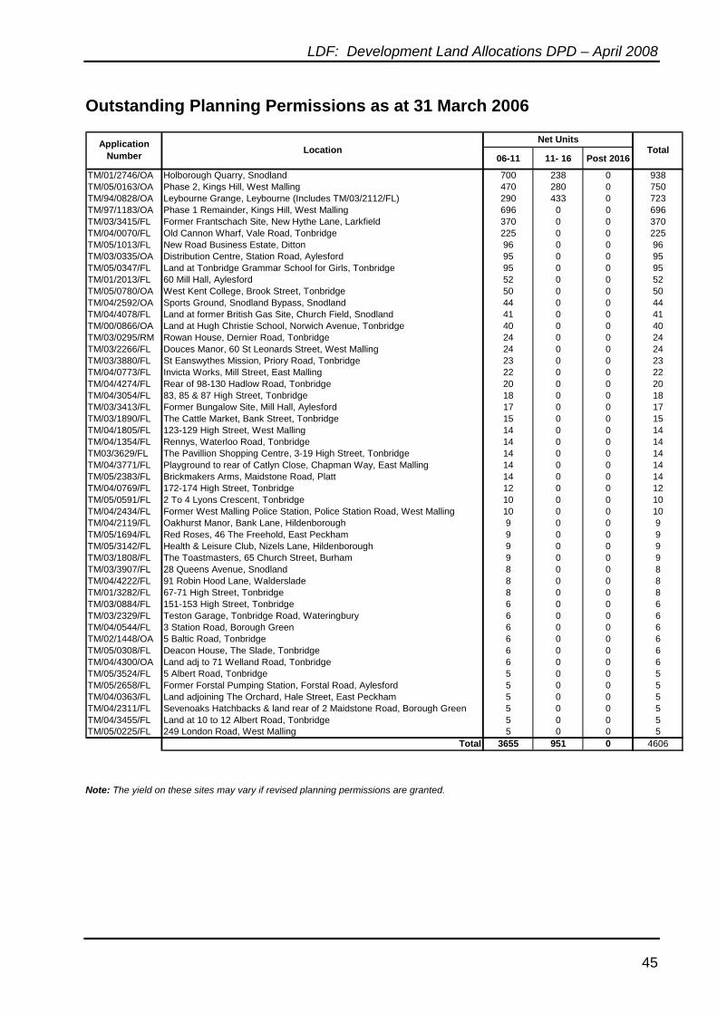
LDF: Development Land Allocations DPD – April 2008
45
Outstanding Planning Permissions as at 31 March 2006
06-11 11- 16 Post 2016
TM/01/2746/OA Holborough Quarry, Snodland 700 238 0 938TM/05/0163/OA Phase 2, Kings Hill, West Malling 470 280 0 750TM/94/0828/OA Leybourne Grange, Leybourne (Includes TM/03/2112/FL) 290 433 0 723TM/97/1183/OA Phase 1 Remainder, Kings Hill, West Malling 696 0 0 696TM/03/3415/FL Former Frantschach Site, New Hythe Lane, Larkfield 370 0 0 370TM/04/0070/FL Old Cannon Wharf, Vale Road, Tonbridge 225 0 0 225TM/05/1013/FL New Road Business Estate, Ditton 96 0 0 96TM/03/0335/OA Distribution Centre, Station Road, Aylesford 95 0 0 95TM/05/0347/FL Land at Tonbridge Grammar School for Girls, Tonbridge 95 0 0 95TM/01/2013/FL 60 Mill Hall, Aylesford 52 0 0 52TM/05/0780/OA West Kent College, Brook Street, Tonbridge 50 0 0 50TM/04/2592/OA Sports Ground, Snodland Bypass, Snodland 44 0 0 44TM/04/4078/FL Land at former British Gas Site, Church Field, Snodland 41 0 0 41TM/00/0866/OA Land at Hugh Christie School, Norwich Avenue, Tonbridge 40 0 0 40TM/03/0295/RM Rowan House, Dernier Road, Tonbridge 24 0 0 24TM/03/2266/FL Douces Manor, 60 St Leonards Street, West Malling 24 0 0 24TM/03/3880/FL St Eanswythes Mission, Priory Road, Tonbridge 23 0 0 23TM/04/0773/FL Invicta Works, Mill Street, East Malling 22 0 0 22TM/04/4274/FL Rear of 98-130 Hadlow Road, Tonbridge 20 0 0 20TM/04/3054/FL 83, 85 & 87 High Street, Tonbridge 18 0 0 18TM/03/3413/FL Former Bungalow Site, Mill Hall, Aylesford 17 0 0 17TM/03/1890/FL The Cattle Market, Bank Street, Tonbridge 15 0 0 15TM/04/1805/FL 123-129 High Street, West Malling 14 0 0 14TM/04/1354/FL Rennys, Waterloo Road, Tonbridge 14 0 0 14TM03/3629/FL The Pavillion Shopping Centre, 3-19 High Street, Tonbridge 14 0 0 14TM/04/3771/FL Playground to rear of Catlyn Close, Chapman Way, East Malling 14 0 0 14TM/05/2383/FL Brickmakers Arms, Maidstone Road, Platt 14 0 0 14TM/04/0769/FL 172-174 High Street, Tonbridge 12 0 0 12TM/05/0591/FL 2 To 4 Lyons Crescent, Tonbridge 10 0 0 10TM/04/2434/FL Former West Malling Police Station, Police Station Road, West Malling 10 0 0 10TM/04/2119/FL Oakhurst Manor, Bank Lane, Hildenborough 9 0 0 9TM/05/1694/FL Red Roses, 46 The Freehold, East Peckham 9 0 0 9TM/05/3142/FL Health & Leisure Club, Nizels Lane, Hildenborough 9 0 0 9TM/03/1808/FL The Toastmasters, 65 Church Street, Burham 9 0 0 9TM/03/3907/FL 28 Queens Avenue, Snodland 8 0 0 8TM/04/4222/FL 91 Robin Hood Lane, Walderslade 8 0 0 8TM/01/3282/FL 67-71 High Street, Tonbridge 8 0 0 8TM/03/0884/FL 151-153 High Street, Tonbridge 6 0 0 6TM/03/2329/FL Teston Garage, Tonbridge Road, Wateringbury 6 0 0 6TM/04/0544/FL 3 Station Road, Borough Green 6 0 0 6TM/02/1448/OA 5 Baltic Road, Tonbridge 6 0 0 6TM/05/0308/FL Deacon House, The Slade, Tonbridge 6 0 0 6TM/04/4300/OA Land adj to 71 Welland Road, Tonbridge 6 0 0 6TM/05/3524/FL 5 Albert Road, Tonbridge 5 0 0 5TM/05/2658/FL Former Forstal Pumping Station, Forstal Road, Aylesford 5 0 0 5TM/04/0363/FL Land adjoining The Orchard, Hale Street, East Peckham 5 0 0 5TM/04/2311/FL Sevenoaks Hatchbacks & land rear of 2 Maidstone Road, Borough Green 5 0 0 5TM/04/3455/FL Land at 10 to 12 Albert Road, Tonbridge 5 0 0 5TM/05/0225/FL 249 London Road, West Malling 5 0 0 5
Total 3655 951 0 4606
Net UnitsApplication Number Location Total
Note: The yield on these sites may vary if revised planning permissions are granted.

LDF: Development Land Allocations DPD – April 2008
46
LDF: Development Land Allocations DPD – April 2008
47
ANNEX B
HOUSING TRAJECTORY
LDF: Development Land Allocations DPD – April 2008
48
LDF: Development Land Allocations DPD – April 2008
49
Housing Trajectory - Explanatory Notes
B.1. Figure B1 sets out the estimated phasing of the sites allocated under Polices H1, H2 and H3. Figure B2 illustrates how this fits in with the 5 year phasing of all housing sites in the Borough including an estimated annual yield from the sites allocated in the Tonbridge Central Area Action Plan. Whilst it identifies the potential annual yield from small and large site windfalls, in accordance with PPS3 these are not counted for the first 10 years following adoption of the DPD (ie up until 2018)
B.2. Figures B3, B4 and B5 set out the housing trajectory for the Borough. The
trajectory tracks the provision of housing supply over the lifespan of the Local Development Framework (2006 - 2021). The purpose of the trajectory is to highlight the robustness and soundness of the overall housing strategy in the submitted version of the Development Land Allocations DPD and how it is performing in relation to the housing requirements identified in the submitted version of the Regional Spatial Strategy (RSS) for the South East. The trajectory highlights the following information: • Projected future dwelling completion rates • Dwelling requirement - annual net additional dwelling requirement from the
submitted version of the RSS. B.3. The trajectory also includes data on monitoring and managing. The monitor line
demonstrates how many dwellings above or below the planned rate the submitted version of the Development Land Allocations DPD is at any point in time. This is calculated by subtracting the projected completions from the annualised allocation from the submitted version of the RSS for the South East. The manage line indicates the under or oversupply of dwellings at any one point. This is calculated by subtracting the projected completions to date from the total allocation and then dividing the answer by the number of years remaining in the Local Development Framework period.

LDF: Development Land Allocations DPD – April 2008
50
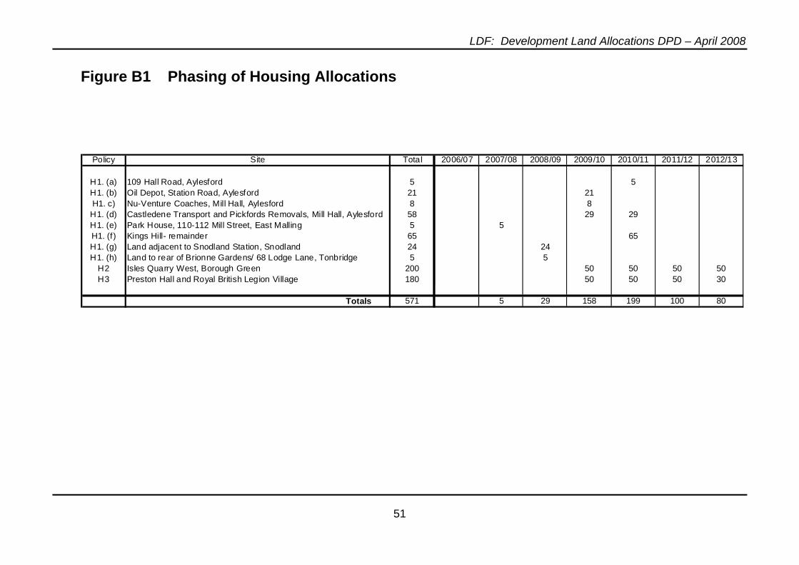
LDF: Development Land Allocations DPD – April 2008
51
Figure B1 Phasing of Housing Allocations
Policy Site Total 2006/07 2007/08 2008/09 2009/10 2010/11 2011/12 2012/13
H1. (a) 109 Hall Road, Aylesford 5 5H1. (b) Oil Depot, Station Road, Aylesford 21 21H1. c) Nu-Venture Coaches, Mill Hall, Aylesford 8 8H1. (d) Castledene Transport and Pickfords Removals, Mill Hall, Aylesford 58 29 29H1. (e) Park House, 110-112 Mill Street, East Malling 5 5H1. (f) Kings Hill- remainder 65 65H1. (g) Land adjacent to Snodland Station, Snodland 24 24H1. (h) Land to rear of Brionne Gardens/ 68 Lodge Lane, Tonbridge 5 5
H2 Isles Quarry West, Borough Green 200 50 50 50 50H3 Preston Hall and Royal British Legion Village 180 50 50 50 30
Totals 571 5 29 158 199 100 80
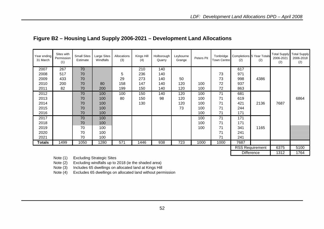
LDF: Development Land Allocations DPD – April 2008
52
Figure B1 Housing Land Supply 2006-2021 - Development Land Allocations
Year ending 31 March
Sites with Permission
(1)
Small Sites Estimate
Large Sites Windfalls
Allocations (3)
Kings Hill (4)
Holborough Quarry
Leybourne Grange Peters Pit Tonbridge
Town CentreCompletions
(2)5 Year Totals
(2)
Total Supply 2006-2021
(2)
Total Supply 2006-2018
(2)
2007 267 70 210 140 6172008 517 70 5 236 140 73 9712009 433 70 29 273 140 50 73 998 43862010 200 70 80 158 147 140 120 100 72 9372011 82 70 200 199 150 140 120 100 72 8632012 70 100 100 150 140 120 100 71 6812013 70 100 80 150 98 120 100 71 619 68642014 70 100 130 120 100 71 421 2136 76872015 70 100 73 100 71 2442016 70 100 100 71 1712017 70 100 100 71 1712018 70 100 100 71 1712019 70 100 100 71 341 11652020 70 100 71 2412021 70 100 71 241
Totals 1499 1050 1280 571 1446 938 723 1000 1000 76876375 51001312 1764
Note (1) Excluding Strategic SitesNote (2) Excluding windfalls up to 2018 (ie the shaded area)Note (3) Includes 65 dwellings on allocated land at Kings HillNote (4) Excludes 65 dwellings on allocated land without permission
RSS RequirementDifference
Figure B2 – Housing Land Supply 2006-2021 – Development Land Allocations
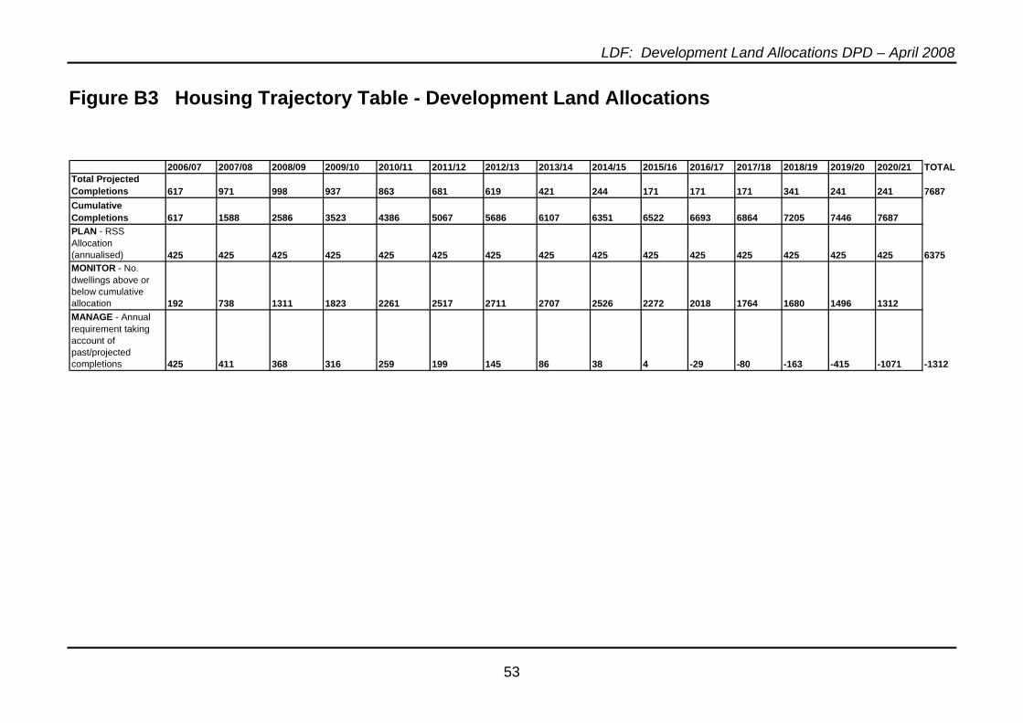
LDF: Development Land Allocations DPD – April 2008
53
Figure B3 Housing Trajectory Table - Development Land Allocations
2006/07 2007/08 2008/09 2009/10 2010/11 2011/12 2012/13 2013/14 2014/15 2015/16 2016/17 2017/18 2018/19 2019/20 2020/21 TOTALTotal Projected Completions 617 971 998 937 863 681 619 421 244 171 171 171 341 241 241 7687Cumulative Completions 617 1588 2586 3523 4386 5067 5686 6107 6351 6522 6693 6864 7205 7446 7687PLAN - RSS Allocation (annualised) 425 425 425 425 425 425 425 425 425 425 425 425 425 425 425 6375MONITOR - No. dwellings above or below cumulative allocation 192 738 1311 1823 2261 2517 2711 2707 2526 2272 2018 1764 1680 1496 1312MANAGE - Annual requirement taking account of past/projected completions 425 411 368 316 259 199 145 86 38 4 -29 -80 -163 -415 -1071 -1312
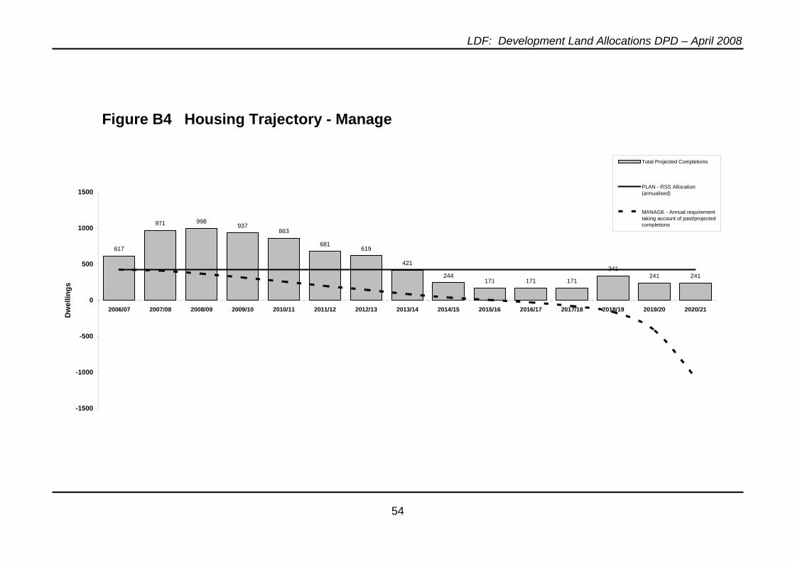
LDF: Development Land Allocations DPD – April 2008
54
Figure B4 Housing Trajectory - Manage
617
971 998937
863
681619
421
244171 171 171
341241 241
-1500
-1000
-500
0
500
1000
1500
2006/07 2007/08 2008/09 2009/10 2010/11 2011/12 2012/13 2013/14 2014/15 2015/16 2016/17 2017/18 2018/19 2019/20 2020/21
Dw
ellin
gs
Total Projected Completions
PLAN - RSS Allocation(annualised)
MANAGE - Annual requirementtaking account of past/projectedcompletions
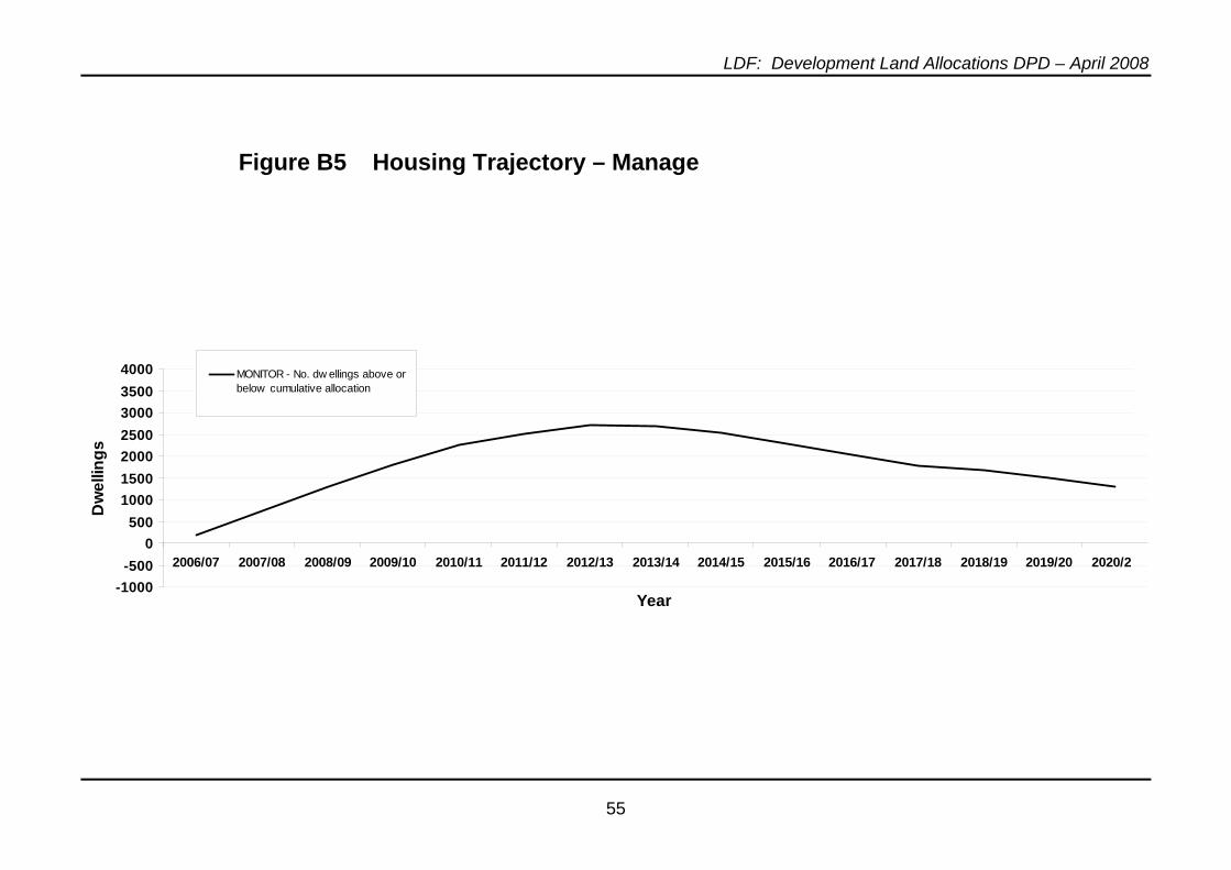
LDF: Development Land Allocations DPD – April 2008
55
Figure B5 Housing Trajectory – Manage
-1000-500
0500
1000150020002500300035004000
2006/07 2007/08 2008/09 2009/10 2010/11 2011/12 2012/13 2013/14 2014/15 2015/16 2016/17 2017/18 2018/19 2019/20 2020/21
Year
Dw
ellin
gs
MONITOR - No. dw ellings above orbelow cumulative allocation

LDF: Development Land Allocations DPD – April 2008
56
LDF: Development Land Allocations DPD – April 2008
57
ANNEX C
PERFORMANCE INDICATORS

LDF: Development Land Allocations DPD – April 2008
58
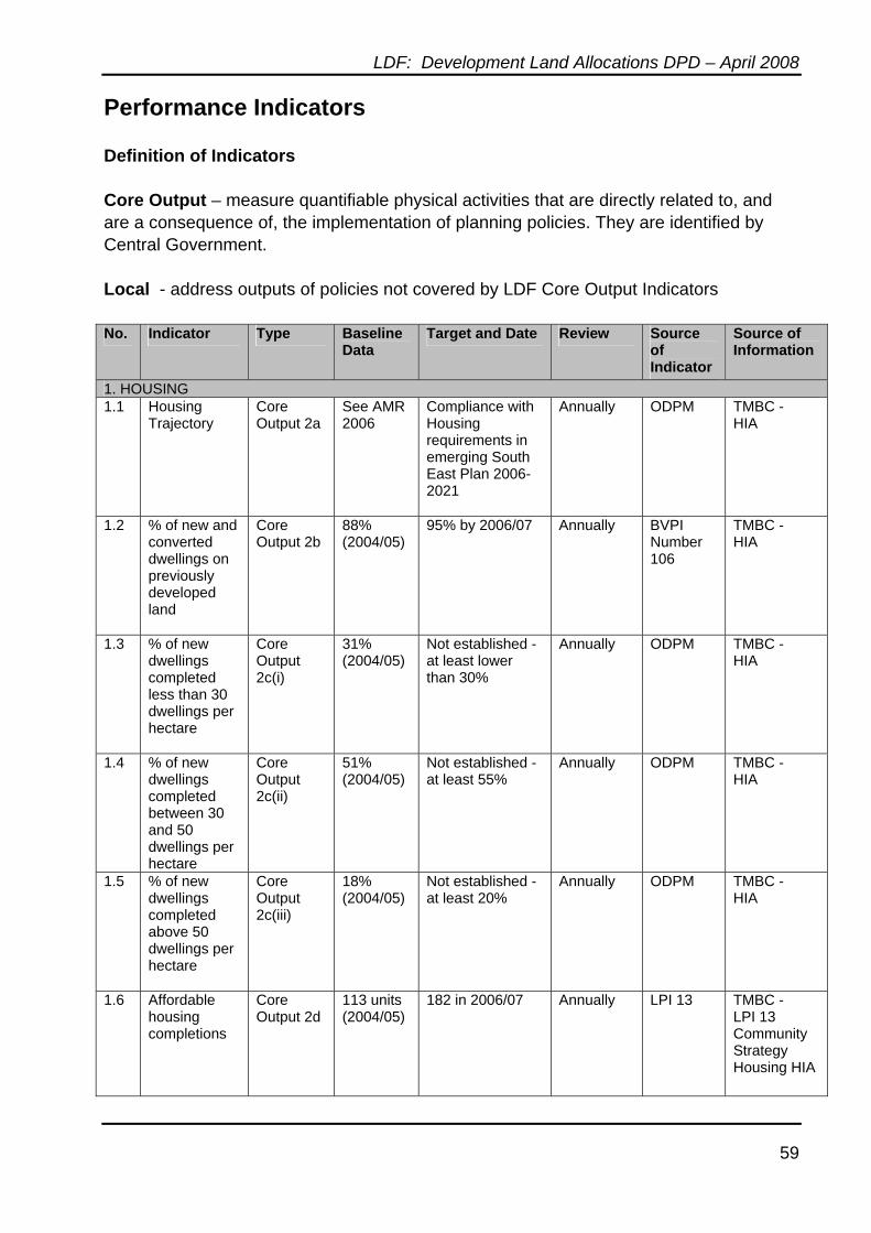
LDF: Development Land Allocations DPD – April 2008
59
Performance Indicators Definition of Indicators Core Output – measure quantifiable physical activities that are directly related to, and are a consequence of, the implementation of planning policies. They are identified by Central Government. Local - address outputs of policies not covered by LDF Core Output Indicators No. Indicator Type Baseline
Data Target and Date Review Source
of Indicator
Source of Information
1. HOUSING 1.1 Housing
Trajectory Core Output 2a
See AMR 2006
Compliance with Housing requirements in emerging South East Plan 2006-2021
Annually ODPM TMBC - HIA
1.2 % of new and converted dwellings on previously developed land
Core Output 2b
88% (2004/05)
95% by 2006/07 Annually BVPI Number 106
TMBC - HIA
1.3 % of new dwellings completed less than 30 dwellings per hectare
Core Output 2c(i)
31% (2004/05)
Not established - at least lower than 30%
Annually ODPM TMBC - HIA
1.4 % of new dwellings completed between 30 and 50 dwellings per hectare
Core Output 2c(ii)
51% (2004/05)
Not established - at least 55%
Annually ODPM TMBC - HIA
1.5 % of new dwellings completed above 50 dwellings per hectare
Core Output 2c(iii)
18% (2004/05)
Not established - at least 20%
Annually ODPM TMBC - HIA
1.6 Affordable housing completions
Core Output 2d
113 units (2004/05)
182 in 2006/07 Annually LPI 13 TMBC - LPI 13 Community Strategy Housing HIA
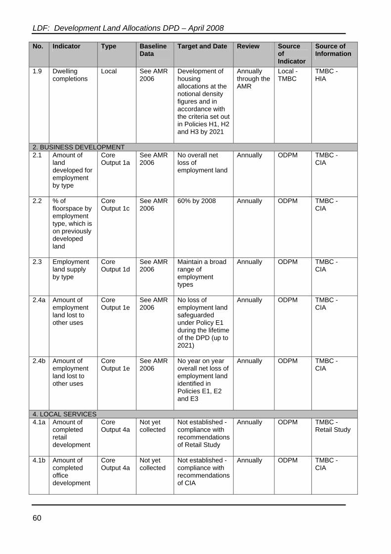
LDF: Development Land Allocations DPD – April 2008
60
No. Indicator Type Baseline Data
Target and Date Review Source of Indicator
Source of Information
1.9 Dwelling completions
Local See AMR 2006
Development of housing allocations at the notional density figures and in accordance with the criteria set out in Policies H1, H2 and H3 by 2021
Annually through the AMR
Local - TMBC
TMBC - HIA
2. BUSINESS DEVELOPMENT 2.1 Amount of
land developed for employment by type
Core Output 1a
See AMR 2006
No overall net loss of employment land
Annually ODPM TMBC - CIA
2.2 % of floorspace by employment type, which is on previously developed land
Core Output 1c
See AMR 2006
60% by 2008 Annually ODPM TMBC - CIA
2.3 Employment land supply by type
Core Output 1d
See AMR 2006
Maintain a broad range of employment types
Annually ODPM TMBC - CIA
2.4a Amount of employment land lost to other uses
Core Output 1e
See AMR 2006
No loss of employment land safeguarded under Policy E1 during the lifetime of the DPD (up to 2021)
Annually ODPM TMBC - CIA
2.4b Amount of employment land lost to other uses
Core Output 1e
See AMR 2006
No year on year overall net loss of employment land identified in Policies E1, E2 and E3
Annually ODPM TMBC - CIA
4. LOCAL SERVICES 4.1a Amount of
completed retail development
Core Output 4a
Not yet collected
Not established - compliance with recommendations of Retail Study
Annually ODPM TMBC - Retail Study
4.1b Amount of completed office development
Core Output 4a
Not yet collected
Not established - compliance with recommendations of CIA
Annually ODPM TMBC - CIA
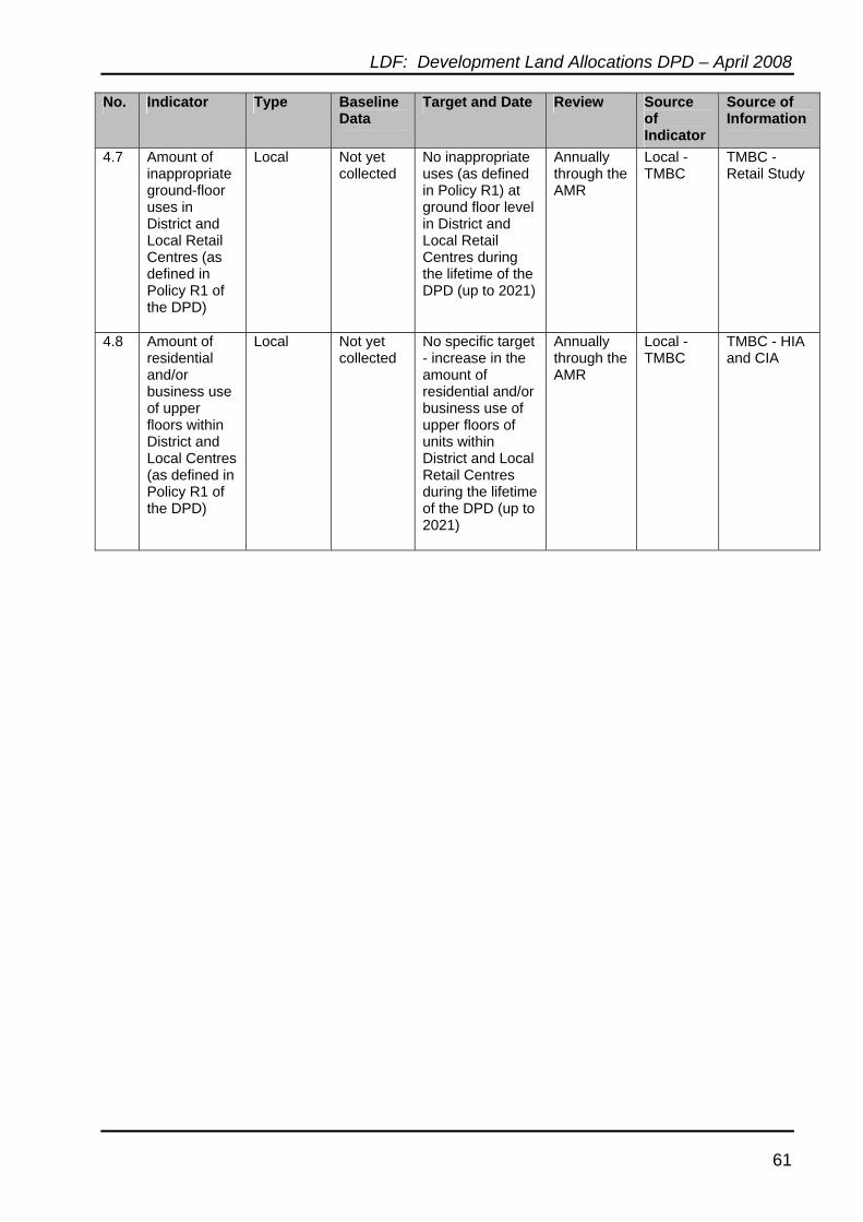
LDF: Development Land Allocations DPD – April 2008
61
No. Indicator Type Baseline Data
Target and Date Review Source of Indicator
Source of Information
4.7 Amount of inappropriate ground-floor uses in District and Local Retail Centres (as defined in Policy R1 of the DPD)
Local Not yet collected
No inappropriate uses (as defined in Policy R1) at ground floor level in District and Local Retail Centres during the lifetime of the DPD (up to 2021)
Annually through the AMR
Local - TMBC
TMBC - Retail Study
4.8 Amount of residential and/or business use of upper floors within District and Local Centres (as defined in Policy R1 of the DPD)
Local Not yet collected
No specific target - increase in the amount of residential and/or business use of upper floors of units within District and Local Retail Centres during the lifetime of the DPD (up to 2021)
Annually through the AMR
Local - TMBC
TMBC - HIA and CIA