development application assessment report · winter (non-daylight saving): seven (7) days a week,...
TRANSCRIPT

Rose Bay Marina Sydney East Joint Regional Planning Panel
DA 136/2012/1 13th September 2012
G:\Authority\authdoc\documents\DD\100\FROM000\100-2012-00000136-001\0463DAREP2011.doc 1
DEVELOPMENT APPLICATION ASSESSMENT REPORT
FILE No. DA 136/2012/1
ADDRESS 594-596 New South Head Road ROSE BAY
SITE AREA 3607m2
ZONING W5 – Water Recreation (SREP (Sydney Harbour Catchment) 2005)
PROPOSAL Extension to Rose Bay Marina comprising of:
- An additional 9 x 10m berths on Arm A
- The addition of a new marina arm (Arm C) which is proposed to be a
floating pontoon system that incorporates 37 x 15m berths. The height
of vessels to be berthed on the new Arm C is proposed to be limited to
3.5m in height
- A new walkway connecting Arms B and C incorporating a viewing
platform and bench seat
- Retention of 24 commercial swing moorings
TYPE OF CONSENT Local/Integrated development
COST OF WORKS $2,408,774.00
DATE LODGED 02/04/2012
APPLICANT Rose Bay Marina Pty Ltd
OWNER Rose Bay Marina Pty Ltd
AUTHOR Mrs L Holbert

Rose Bay Marina Sydney East Joint Regional Planning Panel
DA 136/2012/1 13th September 2012
G:\Authority\authdoc\documents\DD\100\FROM000\100-2012-00000136-001\0463DAREP2011.doc 2
EXECUTIVE SUMMARY
1. LOCALITY PLAN
Aerial Photo (Source: EIS)
subject site
north

Rose Bay Marina Sydney East Joint Regional Planning Panel
DA 136/2012/1 13th September 2012
G:\Authority\authdoc\documents\DD\100\FROM000\100-2012-00000136-001\0463DAREP2011.doc 3
2. DELEGATIONS SUMMARY
Level of Delegation Recommendation of
Report
The application is to be determined by the Joint Regional Planning
Panel as the proposed development is designated development.
Refusal because of
visual/view impacts
3. PROPOSAL SUMMARY
The proposed development is for alterations and additions to the Rose Bay Marina (refer to figure
1). The proposal involves the following works:
Construction of a new marina arm to the east of the existing marina arms. The new arm
(Arm C) consists of 37 berths capable of mooring boats up to 15m in length. The height of
vessels to be berthed on the new Arm C is proposed to be limited to 3.5m.
Nine additional berths are proposed to the existing western arm (Arm A). The nine new
berths on Arm A could accommodate boats up to10m in length.
A new walkway connecting Arms B and C incorporating a viewing platform and bench seat.
Figure 1: Proposed plan of the marina. (Source: EIS)
The proposed new marina arm (Arm C) will be linked to the existing marina arm (Arm B) by a
curved walkway, running parallel to the shoreline. Arm C (eastern arm) includes 37 berths with

Rose Bay Marina Sydney East Joint Regional Planning Panel
DA 136/2012/1 13th September 2012
G:\Authority\authdoc\documents\DD\100\FROM000\100-2012-00000136-001\0463DAREP2011.doc 4
services pedestals located at the junction of the marina arm and at each finger. The 5 berths at the T-
head will accommodate boats perpendicular to the shore.
The marina extension has been designed in accordance with the Australian Standard AS 3962-2001
“Guideline for the Design of Marinas” and the NSW Maritime Guidance Note 8.3.02 (see Table 1).
Element Design
Walkway width
3.2m
Width of fingers 1.4m to 2.08m
Length of fingers
15m
Minimum clear width of
double berths
11.4 to 11.5m
Minimum width of fairways
35m (west side of Arm C)
30m (east side of Arm C)
Table 1 – Arm C Proposed Marina Design
The 9 additional berths proposed to Arm A are to be incorporated into an area previously approved
for refuelling. The additional berths on Arm A will accommodate boats up to 10m in length. The
clear width of the double berths ranges from 9m to 10.5m and the length of the fingers are 9.7m.
The marina berths will comprise a floating system of walkways, with finger units at right angles to
the walkways creating the berthing pens and providing access alongside the craft. The floating
berths would be located in place by vertical piles driven into the harbour bed. These piles are
proposed to comprise circular steel piles with HOPE plastic sleeves. Mooring piles would be
provided between the majority of double berths for ease of berthing and additional mooring security
(with the exception of the new berths to Arm A). This is consistent with AS 3962-2001 which
recommends mooring piles in double berths where wind generated waves or boat wake exceed
300mm in height. The width of the double berths is increased by the width of the pile.
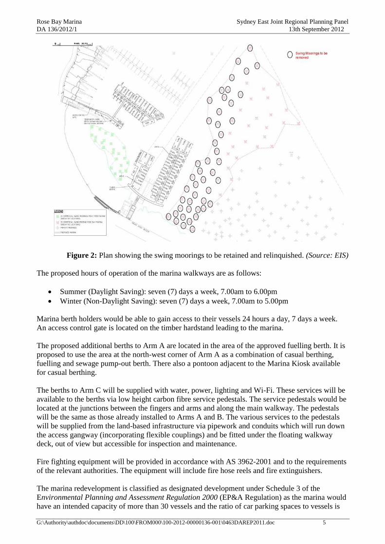
The proposal involves the marina relinquishing 46 of its existing commercial swing moorings and
for the retention of the remaining 24 moorings. As a result of the proposed development the total
number vessels moored at the marina would remain unchanged. However, there would be an
increase in the number of floating berths from 49 to 95 and a decrease in the number of swing
moorings from 70 to 24 (see figure 2).
Rose Bay Marina Sydney East Joint Regional Planning Panel
DA 136/2012/1 13th September 2012
G:\Authority\authdoc\documents\DD\100\FROM000\100-2012-00000136-001\0463DAREP2011.doc 5
Figure 2: Plan showing the swing moorings to be retained and relinquished. (Source: EIS)
The proposed hours of operation of the marina walkways are as follows:
Summer (Daylight Saving): seven (7) days a week, 7.00am to 6.00pm
Winter (Non-Daylight Saving): seven (7) days a week, 7.00am to 5.00pm
Marina berth holders would be able to gain access to their vessels 24 hours a day, 7 days a week.
An access control gate is located on the timber hardstand leading to the marina.
The proposed additional berths to Arm A are located in the area of the approved fuelling berth. It is
proposed to use the area at the north-west corner of Arm A as a combination of casual berthing,
fuelling and sewage pump-out berth. There also a pontoon adjacent to the Marina Kiosk available
for casual berthing.
The berths to Arm C will be supplied with water, power, lighting and Wi-Fi. These services will be
available to the berths via low height carbon fibre service pedestals. The service pedestals would be
located at the junctions between the fingers and arms and along the main walkway. The pedestals
will be the same as those already installed to Arms A and B. The various services to the pedestals
will be supplied from the land-based infrastructure via pipework and conduits which will run down
the access gangway (incorporating flexible couplings) and be fitted under the floating walkway
deck, out of view but accessible for inspection and maintenance.
Fire fighting equipment will be provided in accordance with AS 3962-2001 and to the requirements
of the relevant authorities. The equipment will include fire hose reels and fire extinguishers.
The marina redevelopment is classified as designated development under Schedule 3 of the
Environmental Planning and Assessment Regulation 2000 (EP&A Regulation) as the marina would
have an intended capacity of more than 30 vessels and the ratio of car parking spaces to vessels is

Rose Bay Marina Sydney East Joint Regional Planning Panel
DA 136/2012/1 13th September 2012
G:\Authority\authdoc\documents\DD\100\FROM000\100-2012-00000136-001\0463DAREP2011.doc 6
less than 0.5:1. The proposal is also Integrated Development, as a license from the Office of
Environment and Heritage under the Protection of the Environment Operations Act 1997 and a
permit from the Department of Primary Industries under the Fisheries Management Act 1994 are
required.
4. ISSUES SUMMARY
Issue Conclusion Section View loss/visual impact The visual impact of the new berths to Arm A are considered acceptable
however the visual impact and view loss created by the new Arm C are
unacceptable. This is further discussed in section 16.1 of this report.
16.1
Traffic & Parking The parking and traffic impacts are considered satisfactory. These
impacts are further discussed in section 16.2.1 of this report.
16.2.1
Heritage The heritage impacts of the proposal are considered satisfactory. These
impacts are discussed in section 16.2.3 of this report.
16.2.3
Cumulative impact The proposed Arm C is considered to create unacceptable cumulative
impacts on views. This is further discussed in section 16.1 of this report.
16.1
Noise The noise impacts of the proposal are considered satisfactory and could
be conditioned to ensure both construction and operational noise impacts
are minimised. These impacts are discussed in section 16.2.5 of this
report.
16.2.5
Navigation/Safety The proposed navigation and safety impacts are generally considered to
be acceptable. This is further discussed in section 16.4 of this report.
16.2.4
Ecology The proposed ecology impacts are considered to be acceptable and are
discussed in section 16.2.2 of this report.
16.2.2
4.1 SEPP 1 Objections
None.
4.2 Submissions
Issue No. of
Objectors
Conclusion Section
No demonstrated
demand for the
facility
12
The previous court case involving a similar amount of marina
berths demonstrated demand for the facility. Further to this the
applicant has stated that:
all of the 10m and 15m berths at the marina are occupied and
have a wait list for those berths.
demand for 10m and 15m boats is the greatest out of any size
category.
the marina was due for completion in December 2011 but due
to delays with the connection of power and water the marinas
did not fully open until April 2012 (this meant a lot of our
target customers deferred coming to the marina until Summer
2012/13).
It is considered that there is a demonstrated demand for the
facility.
Pollution/marine
ecology 69
Pollution and marine ecology impacts are considered satisfactory.
These impacts are discussed in section 16.2.2 of this report.
16.2.2
View loss/visual
impact
1419
The visual impact of the new berths to Arm A is considered
acceptable however the visual impact and view loss created by the
new Arm C are unacceptable. This is discussed in section 16.1 of
this report.
16.1
Safety and
navigation 227
Safety and navigation issues are considered satisfactory. These
impacts are discussed in section 16.2.4 of this report.
16.2.4
Privatisation of
public assets 825
The proposed extension of is Arm C not supported.
Rose Bay Marina Sydney East Joint Regional Planning Panel
DA 136/2012/1 13th September 2012
G:\Authority\authdoc\documents\DD\100\FROM000\100-2012-00000136-001\0463DAREP2011.doc 7
Issue No. of
Objectors
Conclusion Section
Parking/traffic 1136
The parking and traffic impacts are considered satisfactory. These
impacts are discussed in section 16.2.1 of this report.
16.2.1
Cumulative
impact/previous
refusal 779
The proposed Arm C is considered to create unacceptable
cumulative impacts on views. This is discussed in section 16.1 of
this report. The reinstatement of an eastern arm has not been
supported for similar reasons to the previous development.
16.1
Noise/Lights
235
The noise impacts of the proposal are considered satisfactory and
could be conditioned to ensure both construction and operational
noise impacts are minimised. These impacts are discussed in
section 16.2.5 of this report.
16.2.5
Heritage impacts 705
The heritage impacts of the proposal are considered satisfactory
and are discussed in section 16.2.3 of this report.
16.2.3
Scale of
development. 520
The proposed extension of Arm C is not considered to be
acceptable.
5. SITE AND LOCALITY
Physical features Rose Bay Marina is located at the western end of Rose Bay. Rose Bay is a wide, open bay on the southern foreshore
of Sydney Harbour. The main sweep of the bay extends from Dumeresq Reserve in the east to Rose Bay Park in the
west. The wider bay extends from Neilson Park in the east to Point Piper in the west. The main sweep of the bay is
broken by Lyne Park which forms a physical division between east and west Rose Bay.
Rose Bay Park is located in the south west corner of the bay. The park is bounded by New South Head Road to the
south, Wunulla Road to the west and the waters of the Harbour. Rose Bay marina is at the eastern end of Rose Bay
Park.
Topography
The land adjoining Rose Bay to the south is generally low lying. To the west of the bay, in the vicinity of the marina,
the land rises to form the Point Piper peninsula. To the east of the Rose Bay marina New South Head Road is fairly
level being RL2.75 AHD (approx.) and approximately 2.2m above the MHWM (RL0.517 AHD). To the west it
grades up and at the intersection of Wunulla Road is RL13.5 AHD (approx.). Wunulla Road is at a fairly consistent
level.
Existing buildings and structures
Rose Bay marina consists of a 2 storey building on the northern side of New South Head Road to the east of Rose
Bay Park, floating marina berths and swing moorings. The 2 storey building abuts the alignment of New South Head
Road. The building is supported on piers over the water. The upper floor, which is located at the New South Head
Road level, accommodates a restaurant (the „Pier Restaurant‟). The lower level accommodates marina related
facilities (offices, workshop, and brokerage) and a kiosk on the north western corner with a seating area on an
adjoining deck. Pedestrian access to the marina facilities is by steps and walkways from New South Head Road on
both sides of the building.
The redevelopment of Rose Bay marina was completed in April 2012 and comprises of 49 floating marina berths and
70 registered swing moorings. The marina incorporates fuelling and sewage pump-out facilities. The Rose Bay
marina is located on land which is below the MHWM and leased from NSW Maritime, occupying an area of 3,607m²
(lot 1 DP 1014928). A small portion at the southern end of the building is located above the MHWM. The swing
moorings associated with the marina are spread over a larger area of waterway to the north east and west of the
leased area.
Environment
Rose Bay Park consists of a vegetated embankment which slopes down from New South Head and Wunulla Roads to
a sandy beach. There are pedestrian paths and steps intersecting the park and a service vehicle access ramp. The
beach is used for passive recreation and the informal storage of small craft, e.g. dinghies, kayaks and the like. The
Rose Bay Police Station is located in the south western corner of the park at the intersection of New South Head and
Wunulla Roads.
Cranbrook School is located in New South Head Road, opposite Wunulla Road. The majority of development in the
vicinity is residential, consisting of detached dwellings and low and medium rise apartment buildings. Immediately
to the north of the Point Piper marina are Harbour frontage properties occupied by detached dwellings, most of which
have private jetties.

Rose Bay Marina Sydney East Joint Regional Planning Panel
DA 136/2012/1 13th September 2012
G:\Authority\authdoc\documents\DD\100\FROM000\100-2012-00000136-001\0463DAREP2011.doc 8
To the west of the Rose Bay Marina is the Point Piper marina and Royal Motor Yacht Club. Point Piper marina has a
capacity of 58 boats comprising of 34 floating berths and 24 swing moorings. The land based facilities of the Point
Piper marina consist of offices, boat brokerage and toilets. The Royal Motor Yacht Club has a total of 90 floating
berths and 18 swing moorings. The land based facilities include a club and car parking adjacent to Wunulla Road.
Between the Rose Bay marina and Lyne Park is Rose Bay promenade, sea wall and concrete balustrade. There is a
series of stormwater pipes at the base of the sea wall and small sandy areas, subject to tidal influences. Access points
to the Harbour waters, consisting of openings in the balustrade and steps are located along the promenade. The
promenade consists of paving and grassed nature strip with isolated indents for on-street parking spaces for use by
the general public. Large fig trees within the nature strip are a feature of the promenade.
The western side of this section of New South Head Road is occupied mainly by medium rise apartment buildings of
various styles and ages. An exception is shops at the intersection of O‟Sullivan Road.
Lyne Park supports a number of different uses including the Urban Transit Ferry Wharf, Catalina Restaurant, flying
boat base, Woollahra Sailing Club, Rose Bay RSL Club, playing fields, tennis courts and café.
To the north east of Lyne Park is Tingira Reserve, a vegetated park with a sandy beach. Kayak and dinghy hire
businesses operate from the beach. Beyond Tingira Reserve are residential, water front properties behind which is the
Rose Bay commercial area.
6. RELEVANT PROPERTY HISTORY
Current use Marina
Previous Relevant Applications
DA766/2006 proposed the redevelopment of both the Rose Bay and Point Piper marinas. It proposed 35 floating
pontoon marina berths at Point Piper marina and the relinquishment of all swing moorings. In relation to the Rose
Bay marina it proposed 124 floating pontoon marina berths and the relinquishment of all swing moorings.
On 5/12/07, at an extra ordinary meeting, the council resolve to resist a „deemed refusal‟ appeal by the applicant to
the Land & Environment Court in relation to DA766/2066. The appeal was heard by Biscoe J (assisted by
Commissioner Tuor) in April 2008. On 13/6/08 Biscoe J ruled that the appeal be dismissed. This is discussed below
(Addenbrooke Pty Ltd v Woollahra Municipal Council [2008] NSWLEC 190) (the 2008 judgement).
In October 2008, two separate DAs for the redevelopment of the Rose Bay Marina (DA 682/2008) and Point Piper
Marina (DA706/2008) were lodged. The Rose Bay Marina proposal included the removal of the 29 existing fixed
marina berths and the construction of 82 floating marina berths on three marina arms. Also, 37 commercial swing
moorings were proposed to be retained. The DA was recommended for approval by Council‟s staff, subject to a
range of conditions and amendments. However, the application was refused by Council for a number of reasons
including visual impact, traffic and parking impacts and residential amenity impacts.
The applicant, Addenbrooke Pty Ltd, lodged appeals with the LEC in relation to both applications. On 18 August
2009, the LEC approved the redevelopment of the Rose Bay marina with the exception of the eastern arm (Arm C)
and the associated walkway providing access to the eastern arm, 4 x 20m berths on the middle arm (Arm B) and 2 x
20m berths on the western arm (Arm A). This is discussed below (Addenbrooke Pty Ltd v Woollahra Municipal
Council (No 2)[2009] NSWLEC 134) (the 2009 judgement).
In October 2009 a s96 application was lodged seeking to modify the consent granted by the Court by increasing the
width of Arm B and the walkway to 3.2m. Condition C.1(a) of the development consent requires that Arm B be
reduced in width to 1.8m and the walkway be reduced in width to 2.4m. The original development application
indicated Arm B (the middle arm) to be 3.25m wide and for the walkway to be 4.2m wide. This S96 application was
approved by Council‟s Development Control Committee on 7/12/2009.
Pre-DA
N/A
Requests for Additional Information
The following additional information was requested:
The applicant was requested to respond to all of the Director General‟s requirements on 17/04/2012. The
information was provided by the applicant on 26/04/2012.
Additional information relating to the ecology that was requested on 15/06/2012 and was submitted on
19/06/2012.

Rose Bay Marina Sydney East Joint Regional Planning Panel
DA 136/2012/1 13th September 2012
G:\Authority\authdoc\documents\DD\100\FROM000\100-2012-00000136-001\0463DAREP2011.doc 9
The applicant was asked to provide information which supported that there was a demonstrated demand for the
new berths on 10/7/2012. This information was received on the same day.
Amended Plans/Replacement Application
N/A
Land and Environment Court Appeal
There is no LEC appeal in respect of the current development application.
In relation to DA766/2006 the primary reason for the appeal being dismissed related to the adverse visual impact the
proposed Rose Bay marina berths would have on the promenade and New South Head Road.
In relation to DA682/2008 (Rose Bay Marina) the LEC conditionally approved the redevelopment of the Rose Bay
marina with the exception of the eastern arm (Arm C), the associated walkway providing access to the eastern arm, 4
x 20m berths on the middle arm (Arm B) and 2 x 20m berths on the western arm (Arm A). A maximum height of 7m
was imposed for the 4 x 30m berths and a 6m height limit was imposed for all other berths. The LEC considered that
the removal of the eastern arm and shortening of the middle arm would reduce the loss of views to Manly from the
Promenade. In addition the shortening of the middle arm was also considered to achieve visual separation between
the RBM and the RMYC when viewed from the Promenade, and reduced the visual impact on Rose Bay beach.
7. REFERRALS
Referral Summary of Comment Annexure Traffic Engineer Satisfactory. „Council‟s Traffic and Transport section have reviewed
the development application and have no objection to the proposal‟.
2
Heritage Officer The application is not acceptable as it does not comply with all the
provisions of the relevant statutory and policy documents and would
have an unsatisfactory heritage impact.
3
Urban Design Officer That the additional berths on Arm A are supported and that Arm C is
recommended for refusal for the following reasons:
Although relatively few additional boats are to be berthed on Arm C
in comparison to those existing in this part of Rose Bay, they will
have a disproportionality large visual impact. The unique experience
of the view opening up to reveal the whole extent of the bay and
harbour beyond will be lost.
The SHREP allows marina development only if it results in a visual
outcome that harmonises with the planned character of the locality.
Arm C does not harmonise with the character of the locality. In
particular the final objective of zone W5 in the SHREP;
(g) „to ensure that the scale and size of development are appropriate
to the locality, and protect and improve the natural assets and
natural and cultural scenic quality of the surrounding area,
particularly when viewed from waters in this zone or from areas of
public access‟ is not achieved.
4
Environmental Health Officer Satisfactory.
Site Contamination:
The Auditor considers that the EMPs will provide an adequate
framework for the management of the remnant sediment
contamination at the site. The results of the sediment testing and the
Site Audit have concluded that remediation of sediments at the site is
not required; accordingly, the „land‟ is suitable for the purpose of the
proposed development.
Noise:
With regards to noise arising from construction activities, Rose Bay
Marina Pty Ltd will abide by the same conditions for the proposed
extension. Impact pile driving is not proposed to be used for the
installation of piles. The piles will be installed using a screwing
5
Rose Bay Marina Sydney East Joint Regional Planning Panel
DA 136/2012/1 13th September 2012
G:\Authority\authdoc\documents\DD\100\FROM000\100-2012-00000136-001\0463DAREP2011.doc 10
Referral Summary of Comment Annexure method, with the steel piles screwed into the seabed.
With regards to noise arising from operational activities, a Noise
Management Plan (NMP), which is at Appendix D of the marina
Environmental Management Plan (refer to Appendix L of the EIS)
has been prepared in accordance with the Conditions of Consent for
DA 682/2008. The NMP seeks to ensure that amenity is preserved for
local residents and marina users by controlling noise emissions and
other disturbing influences and incorporates the Conditions of
Consent imposed by the LEC. The marina operations will be
undertaken in accordance with the Environmental Management Plan.
Fire Safety Officer Satisfactory, subject to conditions. 6
Public Open Space Public toilet access for Rose Bay Park users should be provided.
Public access to the marina toilet is available.
Inclusion of Dinghy Storage Racks within the Rose Bay Marina.
This has not been proposed as part of the development.
Separate approval is required if construction access across Rose
Bay Park is required. A condition of consent could be imposed.
7
Environmental Sustainability Further information was sought from the application in relation to the
following:
Environmental construction impacts created by the redeveloped
marina
Updated sea grass study
Implementation of the Caulerpa Taxifolia Management Plan
Location of fuel tanks
Location of waste and recycling facilities.
The applicant has responded to the issues identified. Council‟s
Environmental Sustainability Team Leader is satisfied with the
applicant‟s response.
8
NSW Primary Industries
(Approval Body s.205 of the
Fisheries Management Act
1994)
No objections subject to general terms of approval. 9
NSW EPA (Approval Body,
Protection of the Environment
Operations Act 1997)
In assessing the proposal the EPA has also identified a number of
environmental issues that Woollahra Municipal Council may wish to
consider in its overall assessment of the application. These include:
Construction noise from piling works;
Operational noise once extension is completed.
To ensure the EPA is satisfied that the operational noise from the
marina. The development will need to comply with the limits set out
in Table 3.1. The EPA intends to include a Special Condition on the
applicants scheduled activity licence to undertake and provide a
noise assessment report. If the development is approved the applicant
will also need to apply to vary its scheduled development works
licence to a scheduled activity licence once the development is
completed. General Terms of Approval should be applied.
10
Heritage Council of NSW „It is requested that Council assesses the visual impact of the
proposal on the significance of other heritage items which have views
to this part of Rose Bay. Particular consideration would include the
following issues:
Retention of view corridors from heritage items such as Dunara;
Retention of characteristic setting of this part of Rose Bay
Design style and character of the existing and the proposed
Exterior materials, finishes and colour schemes of the existing
and proposed;
Signage of the existing and proposed;
11

Rose Bay Marina Sydney East Joint Regional Planning Panel
DA 136/2012/1 13th September 2012
G:\Authority\authdoc\documents\DD\100\FROM000\100-2012-00000136-001\0463DAREP2011.doc 11
Referral Summary of Comment Annexure Landscaping of the existing and proposed.
The Heritage Council recommends that Council ensures that the
above water elements of the alterations do not visually dominate the
local area, but remain recessive elements in the area.
The Heritage Council recommends that Council:
(a) Reconsiders the cumulative impact of the proposed works on the
subject property and surrounding similar properties.
Takes into account the recommendations of Council‟s Heritage
adviser in relation to the proposal.‟
Foreshores and Waterways
Planning and Development
Advisory Committee (cl. 29 of
the Sydney Harbour Regional
Environmental Plan (Sydney
Harbour Catchment) 2005)
The Committee recommends that:
(a) the consent authority takes into account the relevant provisions
of Part 6-Wetland Protection of the Sydney Regional
Environmental Plan (Sydney Harbour Catchment) 2005
(Deemed SEPP)
(b) The consent authority takes into account the other relevant
provisions of the Sydney Regional Environmental Plan (Sydney
Harbour Catchment) 2005 (Deemed SEPP) in particular Clause
25, Clause 26 and Clause 27 as they relate to visual impact,
scenic quality, environmental protection and boat storage
considerations.
The consent authority takes into account the other relevant
provisions of the Sydney Harbour Foreshores and Waterways Area
DCP 2005, in particular Section 4.7 and Appendix D- How to
undertake a visual impact assessment for marinas.
12
NSW Office of Water Works as shown, below the mean high water mark, require the
consent of the property owner. They do not require assessment under
IDAS or a Controlled Activity Approval‟.
13
NSW Fire Brigades (cl. 77 of
the Environmental Planning
and Assessment Regulation
2000)
The following comments have been provided:
1. Fires involving marine vessels tend to burn fiercely and
propagate quickly due to the nature of the composite material
used in their construction. It is the opinion of the FRNSW that
due to the size of the marina, the number and size of the marine
craft moored alongside, the potential fire risk is significant. An
effective hydrant system will assist in the extinguishment and
control of potential fires and mitigate fire spread within the
facility.
2. Section 5.12 of the EIS provided states that the hydrant system
has been designed in accordance with AS3962-2001 “Guidelines
for design of marinas”. FRNSW believes a hydrant system
should be installed to the requirements of Clause 3.4 of
AS2419.1-2005 “Fire hydrant installations Part 1: System
design, installation and commissioning.
3. In addition it is noted that Section 5.12 of the EIS, does not
reference fire hose reel foam making capability or isolation/shut-
off valves at the existing and proposed refuelling facility along
Arm A.
4. To ensure the storage and handling of flammable liquids is
satisfactory, it is the recommendation of FRNSW that the
refuelling facility is installed to the requirements of Clause
11.9.2 & Clause 7.5 of AS1940-2004.
14
Roads and Maritime Services No objection, however the following comments are provided for
Council‟s consideration:
The existing development provides opportunities for casual
15

Rose Bay Marina Sydney East Joint Regional Planning Panel
DA 136/2012/1 13th September 2012
G:\Authority\authdoc\documents\DD\100\FROM000\100-2012-00000136-001\0463DAREP2011.doc 12
Referral Summary of Comment Annexure berthing. Casual berthing facilitates access between the
waterway and foreshore. Any extension should ensure that at a
minimum, a berthing area of 20m should be provided for the
purpose of short term drop-off and pick-up only
No permanent berthing being allowed at North West Corner of
Arm A where the Fuel and Sewage Pump out are to be located.
The applicant should ensure that reasonable access to the site is
available during construction.
The applicant must notify the Maritime Division of Roads and
Maritime prior to the removal of any commercial moorings.
Sydney Ports No objection subject to the applicant applying for Harbour Master
Approval after the issue of development consent.
16
NSW Police No response -
CASA No response -
Sydney Ferries No response -
Energy Australia No response -
ENVIRONMENTAL ASSESSMENT UNDER SECTION 79C
The relevant matters for consideration under Section 79C of the Environmental Planning and
Assessment Act 1979 include the following:
1. The provisions of any environmental planning instrument
2. The provisions of any proposed instrument that is/has been the subject of public consultation
3. The provisions of any development control plan
4. Any planning agreement that has been entered into
5. Any draft planning agreement that a developer has offered to enter into
6. The regulations
7. Any coastal zone management plan
8. The likely impacts of that development:
9. Environmental impacts on the natural and built environments
10. Social and economic impacts
11. The suitability of the site
12. Any submissions
13. The public interest
8. PUBLIC EXHIBITION
8.1 Submissions
In accordance with the relevant provisions of the EPA Act and EPA Regs relating to designated
development, the application was publicly exhibited from 03/05/2012 to 01/06/2012. As a result
1,475 objections were received. See Annexure 19 for a full list of the names and addresses of these
objectors.
The issues raised in the objections can be summarised as follows:
No demonstrated demand for the facility
Pollution/marine ecology
View loss/visual impact
Safety and navigation
Privatisation of public assets

Rose Bay Marina Sydney East Joint Regional Planning Panel
DA 136/2012/1 13th September 2012
G:\Authority\authdoc\documents\DD\100\FROM000\100-2012-00000136-001\0463DAREP2011.doc 13
Parking/traffic
Cumulative impact
Noise
Heritage impacts
Scale of development.
8.2 Statutory Declaration
The applicant has completed a statutory declaration dated 19/06/2012 declaring that the site notice
for DA 136/2012/1 was erected and maintained during the exhibition period.
9. PLANNING FRAMEWORK
9.1 Designated development
Section 77A of the EPA Act provides that development is designated development if it is declared
to be designated development under an environmental planning instrument or the Environmental
Planning and Assessment Regulation 2000 (EPA Reg). Schedule 3 of the EPA Reg includes certain
categories of marinas as being designated development. Alterations and additions are not designated
development if, in the opinion of the consent authority, they do not significantly increase the
environmental impacts of the total development.
The DA has been submitted on the basis that the development is designated development and it is
being processed accordingly.
An application for designated development is required to be:
Publicly exhibited in accordance with s.79 of the EPA Act which provides for a notice to be
placed on the land in addition to notification of adjoining land owners and advertising in the
local newspaper
Exhibited for 30 days (cl.78(2) of the EPA Reg)
Notified to public authorities, other than approval and concurrence authorities who, in the
opinion of the consent authority, may have an interest in the determination of the DA (cl.77
of the EPA Regs)
Accompanied by an environmental impact statement (EIS) (schedule 1, part 1, 2(1)(e) of the
EPA Regs)
The EPA Reg contains provisions for the form and content of an EIS (cl.71 & 72) and for the
applicant to consult with the Director General and have regard to the Director General‟s
requirements (cl.73).
A copy of submissions received during the public exhibition must be forwarded to the Director
General (cl.81 of the Regulations).
The DA has been publicly exhibited as required. The form and contents of the EIS are satisfactory
with regard to the EPA Reg. A letter dated 30/9/11 was received from the Director General with a
copy of his requirements for the preparation of the EIS. The letter also advised that the Council
should forward 3 copies of the DA & EIS to the Department for concurrent exhibition. Also, at the
end of the exhibition we should send a copy of all submissions received to the Department (as
required by cl.81 of the EPA Reg) and noted that …the Department will only respond during the 21
day statutory period if there is an issue of major significance involved.

Rose Bay Marina Sydney East Joint Regional Planning Panel
DA 136/2012/1 13th September 2012
G:\Authority\authdoc\documents\DD\100\FROM000\100-2012-00000136-001\0463DAREP2011.doc 14
The EIS has regard to the Director General‟s requirements. Copies of submissions were sent to the
Department on 24/07/2012. No response was received.
9.2 Integrated development
Section 91 of the EPA Act provides that development is integrated development if it requires
consent and it requires approval under certain other Acts. The proposed development is integrated
as it requires approval under the following Acts which are listed in s.91:
Protection of the Environment Operations Act 1997 (POEO) as marinas which can
accommodate 80 or more vessels are scheduled activities and the work required to construct
the marinas would involve scheduled activity work and therefore environmental licenses are
required. The approval body under the POEO is the Office of Environment and Heritage
(EPA).
Fisheries Management Act 1994 (FMA) as a permit is required to harm marine vegetation in
a protected area. The Department of Primary Industries (DPI) is the approval body under the
FMA.
Submissions were forwarded to the approval bodies on 24/07/2012. The Office of Environment and
Heritage (EPA) and the Department of Primary Industries have furnished their general terms of
approval. If consent is to be granted it will need to incorporate the general terms of approval, refer
Annexures 9 & 10 respectively.
10. STATE ENVIRONMENTAL PLANNING POLICY 55 - REMEDIATION
OF LAND
Clause 7(1) (b) and (c) of SEPP 55 requires that where land is contaminated, Council must be
satisfied that the land is suitable in its contaminated state or will be suitable after remediation for
the purpose for which the development is proposed. If the land requires remediation Council must
be satisfied that the land will be remediated before the land is used for that purpose.
The sediment sampling and testing program that has been carried out has demonstrated that
remediation of the sediments at the Rose Bay Marinas was not required. In addition, the sediment
testing and testing of the harbour water have shown that there is unlikely to be any impacts on
aquatic organisms due to the disturbance of sediments from vessel movements and the proposed
construction activities as part of the marina development, having regard to the expected dilution in
the overlying harbour water.
In November 2007, a Site Audit Report (Site Audit Report Ref: AS 120699 of 8 November 2007;
Michael Hayter, NSW EPA Accredited Site Auditor of Environ Australia Pty Ltd) was prepared for
the redevelopment of the Rose Bay and Point Piper Marinas as proposed under DA 766/2006. The
Site Audit found:
The information on the site history and activities provides a satisfactory basis for identifying
potential sources of contamination and chemicals of concern.
The potential contaminants assessed were appropriate.
There is a satisfactory degree of confidence in the sample data and sufficiently complete
data set to draw reliable conclusions.
TBT is the critical contamination in the sediments near the slipway. The source of
contamination is historical and has now ceased.

Rose Bay Marina Sydney East Joint Regional Planning Panel
DA 136/2012/1 13th September 2012
G:\Authority\authdoc\documents\DD\100\FROM000\100-2012-00000136-001\0463DAREP2011.doc 15
The risks to human health and the environment posed by the contaminated sediments are
low.
The site can be made suitable for use as a marina subject to implementation of the
Environmental Management Plan (EMP).
The Site Auditor has reviewed the subsequent redesign of the Rose Bay Marina and stated that the
conclusions of the Site Audit Report and validity of the Site Audit remain and are not affected by
the redesign.
The risks to human health and the environment posed by the contaminated sediments are low and
the risks associated with the sediment disturbance can be appropriately managed through the
implementation of Environmental Management Plan. In the Auditor‟s opinion the site can be made
suitable for use as a marina subject to implementation of the EMP.
Therefore Council‟s Environmental Health Officer has concluded the following:
„Based on the above, the Auditor considers that the EMPs will provide an adequate
framework for the management of the remnant sediment contamination at the site. The
results of the sediment testing and the Site Audit have concluded that remediation of
sediments at the site is not required; accordingly, the „land‟ is suitable for the purpose of
the proposed development.‟
In terms of SEPP 55 the proposal is considered to be satisfactory.
11. SYDNEY REGIONAL ENVIRONMENTAL PLAN (SYDNEY HARBOUR
CATCHMENT) 2005 (SHREP) (deemed State Environmental Planning
Policy)
The SHREP aims to establish a balance between promoting a prosperous working harbour,
maintaining a healthy and sustainable waterway environment and promoting recreational access to
the foreshore and waterways.
Clause 2 sets out the aims of the plan, these are as follows:
(1) This plan has the followings aims with respect to the Sydney Harbour Catchment:
(a) to ensure that the catchment, foreshores, waterways and islands of Sydney Harbour are
recognised, protected, enhanced and maintained:
(i) as an outstanding natural asset, and
(ii) as a public asset of national and heritage significance, for existing and future
generations,
(b) to ensure a healthy, sustainable environment on land and water,
(c) to achieve a high quality and ecologically sustainable urban environment,
(d) to ensure a prosperous working harbour and an effective transport corridor,
(e) to encourage a culturally rich and vibrant place for people,
(f) to ensure accessibility to and along Sydney Harbour and its foreshores,
(g) to ensure the protection, maintenance and rehabilitation of watercourses, wetlands,
riparian lands, remnant vegetation and ecological connectivity,
(h) to provide a consolidated, simplified and updated legislative framework for future
planning.

Rose Bay Marina Sydney East Joint Regional Planning Panel
DA 136/2012/1 13th September 2012
G:\Authority\authdoc\documents\DD\100\FROM000\100-2012-00000136-001\0463DAREP2011.doc 16
(2) For the purpose of enabling these aims to be achieved in relation to the Foreshores and
Waterways Area, this plan adopts the following principles:
(a) Sydney Harbour is to be recognised as a public resource, owned by the public, to be
protected for the public good,
(b) the public good has precedence over the private good whenever and whatever change is
proposed for Sydney Harbour or its foreshores,
(c) protection of the natural assets of Sydney Harbour has precedence over all other
interests.
The principles which enable the aims to be achieved are relevant to the assessment of this DA as the
development is proposed to be carried out in the foreshores and waterways area. They are
fundamental to properly understanding the weight which needs to be given to competing interests in
respect to development and use of the waterway and foreshore area.
The principles clearly state that protection of the Harbour‟s natural assets is paramount. Therefore,
to properly assess a DA under the SHREP a proper understanding of the impacts of the proposed
development on the natural assets is fundamental. The principles also stress the strong public
affinity with the Harbour expressed in terms of its public ownership. There is an obligation for a
consent authority to uphold the public good over private interests if and whatever changes to the
Harbour may be proposed. Consequently the public is entitled to have high expectations that its
rights as owner of the Harbour will not be compromised by inappropriate developments.
The proposed development, being for a commercial marina, is defined as land/water interface
development.
Cl.16 sets out zonings which apply to the Harbour. The proposed development is to be carried out
in Zone No W5 – Water Recreation. Cl.17 contains the objectives of the zones. The objectives for
the W5 zone are:
(a) to give preference to and increase public water-dependent development so that people
can enjoy and freely access the waters of Sydney Harbour and its tributaries,
(b) to allow development only where it is demonstrated that the public use of waters in this
zone is enhanced and will not be compromised now or in the future,
(c) to minimise the number, scale and extent of artificial structures consistent with their
function,
(d) to allow commercial water-dependent development, but only where it is demonstrated
that it meets a justified demand, provides benefits to the general and boating public and
results in a visual outcome that harmonises with the planned character of the locality,
(e) to minimise congestion of and conflict between people using waters in this zone and the
foreshore,
(f) to protect and preserve beach environments and ensure they are free from artificial
structures,
(g) to ensure that the scale and size of development are appropriate to the locality, and
protect and improve the natural assets and natural and cultural scenic quality of the
surrounding area, particularly when viewed from waters in this zone or from areas of public
access.
Cl.17(2) provides that a consent authority must not grant development consent to any development
unless it is satisfied that the development is consistent with the aims of the plan (i.e. as contained in
cl.2) and the zone objectives.

Rose Bay Marina Sydney East Joint Regional Planning Panel
DA 136/2012/1 13th September 2012
G:\Authority\authdoc\documents\DD\100\FROM000\100-2012-00000136-001\0463DAREP2011.doc 17
11.1 Matters requiring consideration
Cl.18 provides that commercial marinas are development permissible only with development
consent in the W5 zone. Matters to be considered in the assessment of a DA are in Part3, Division 2
under the following headings:
cl.21 – biodiversity, ecology and environment protection
cl.22 – public access to and use of, foreshores and waterways
cl.23 – maintenance of a working harbour
cl.24 – interrelationship of waterway and foreshore uses
cl.25 – foreshore and waterways scenic quality
cl.26 – maintenance, protection and enhancement of views
cl.27 – boat storage facilities
11.2 Foreshores and Waterways Planning and Development Advisory
Committee (Advisory Committee)
Clause 29 provides that consent cannot be granted to development referred to in schedule 2 on land
that is within the foreshore and waterway area unless the DA has been referred to the Advisory
Committee. Commercial marinas are referred to in schedule 2 and the land is within the foreshores
and waterways area. The DA was considered by the Advisory Committee on 15/06/12 and it
commented as follows:
a) the consent authority takes into account the relevant provisions of Part 6-Wetland
Protection of the Sydney Regional Environmental Plan (Sydney Harbour Catchment)
2005 (Deemed SEPP)
b) The consent authority takes into account the other relevant provisions of the Sydney
Regional Environmental Plan (Sydney Harbour Catchment) 2005 (Deemed SEPP) in
particular Clause 25, Clause 26 and Clause 27 as they relate to visual impact, scenic
quality, environmental protection and boat storage considerations.
c) The consent authority takes into account the other relevant provisions of the Sydney
Harbour Foreshores and Waterways Area DCP 2005, in particular Section 4.7 and
Appendix D- How to undertake a visual impact assessment for marinas.
These matters are discussed in part 16.1 of this report.
11.3 Other relevant SHREP provisions
Other provisions of the SHREP relevant to this proposal are:
part 5 – Heritage provisions
part 6 – Wetlands protection
Annexure 17 is a table which summarises the proposal in relation to each of the relevant matters for
consideration under the SHREP. Issues arising are further discussed in part 16 of this report.

Rose Bay Marina Sydney East Joint Regional Planning Panel
DA 136/2012/1 13th September 2012
G:\Authority\authdoc\documents\DD\100\FROM000\100-2012-00000136-001\0463DAREP2011.doc 18
12. WOOLLAHRA LOCAL ENVIRONMENTAL PLAN 1995 (WLEP)
12.1 Clause 1.1(2): Aims and Objectives of Woollahra LEP 1995
WLEP applies to all land within the area of Woollahra and under cl.3(1) includes land taken to be
within the area by virtue of s.205 of the Local Government Act 1993. Section 205(1) includes land
and water between the high-water mark and the low-water mark (commonly referred to as the inter-
tidal zone).
However, this proposal is located beyond the low-water mark, thus WLEP, 1995 does not apply to
the development.
12.2 Clause 27: Development in the Vicinity of a Heritage Item
Clause 27 relates to development in the vicinity of heritage items, heritage item groups, heritage
conservation areas, archaeological sites or potential archaeological sites. Council‟s Heritage
Officer recommends refusal of the proposal due to its impact upon the visual setting of the Rose
Bay esplanade and sea wall. Council‟s Heritage Officer considers that:
there is an important connection with Sydney Harbour and the Promenade and sea wall
this connection is already compromised by the existing marina
views from the promenade will be obscured for a greater portion of the promenade by
the proposal
Council‟s Heritage Officer also commented that the proposal will partially obstruct views to Item
number 82 of the Sydney REP (Sydney Harbour Catchment) 2005, (Shark Island). Views from the
foreshore to the island and from the island to the foreshore will be partially obstructed in places due
to the proposed expansion of the existing marina. This issue is further discussed in part 16.1 of this
report.
Council‟s Heritage Officer identified the following heritage items in vicinity of the proposed
development, which were not considered to be adversely impacted:
Rose Bay Police Station
1 Rose Bay Avenue, Bellevue Hill
593 New South Head Road „The Chilterns‟
Site of public baths at Lyne Park (SHREP)
Remains of the Rose Bay ferry wharf (SHREP)
Dunara Gardens (State and locally listed heritage item).
The impacts identified by our Heritage Officer occur outside of the area to which WLEP 1995
applies. Therefore it is more appropriate to consider those impacts in the context of the heritage
provisions of the SHREP rather than under WLEP, refer to part 16.2.3 – heritage, of this report.

Rose Bay Marina Sydney East Joint Regional Planning Panel
DA 136/2012/1 13th September 2012
G:\Authority\authdoc\documents\DD\100\FROM000\100-2012-00000136-001\0463DAREP2011.doc 19
13. DEVELOPMENT CONTROL PLANS
13.1 Sydney Harbour Foreshores & Waterways Area Development Control Plan
(SHDCP)
The SHDCP applies to the proposed development as it applies to all development within the
foreshores and waterways area as identified in the SHREP. All of the proposed development is
within such area.
The SHDCP contains provisions for assessing the impact of developments on the ecology (part 2)
and landscape (part 3). It also contains general design guidelines for various types of development
(part 4) and guidelines for specific developments including marinas (both commercial and private)
(part 4.7). Appendix D of the SHDCP contains specific guidelines for assessing the visual impact of
marinas.
Annexure 18 is a table which summarises how the proposal relates to the various provisions of the
SHDCP. The provisions of the SHDCP are also discussed under parts of part 16 of this report.
13.2 Car parking DCP
Based on the DCP‟s rates for parking the generation rates for the existing and proposed marinas are
as follows:
Existing:
49 wet berths x 0.6 = 29.4
70 swing moorings x 0.2 = 14
Total = 43.4
Proposed:
95 wet berths x 0.6 = 57
24 swing moorings x 0.2 = 4.8
Total = 61.8
Based on parking generation rates in the DCP the proposed marina will generate an additional
parking demand of 18.4 spaces.
Parking and traffic impacts are discussed in detail under part 16.2.1 – traffic & parking, of this
report.
13.3 Access for people with a disability
The previously approved development DA682/2008 involved the provision of upgrades to the
existing pedestrian pathway in Rose Bay Park, to the west of the existing marina building and the
provision of a person hoist to allow access to and from the water. In addition the ramped section
gradients of the link between the fixed and floating portions of the access way were constructed in
accordance with the requirements of the Disability Discrimination Act 1992 (DDA). A condition of
consent could be imposed to ensure the new walkways comply with the DDA requirements.
Currently the is only assisted disabled access to the marina as the upgrades to the ramp in Rose Bay
Park have yet to be undertaken, as the applicant is awaiting final details from the Council relating to

Rose Bay Marina Sydney East Joint Regional Planning Panel
DA 136/2012/1 13th September 2012
G:\Authority\authdoc\documents\DD\100\FROM000\100-2012-00000136-001\0463DAREP2011.doc 20
the materials to be used. The person hoist is stored at Point Piper Marina and is transferred when
required.
The proposal is considered to make suitable provision for access for people with disabilities.
14. OTHER DCPS, CODES AND POLICIES
14.1 Boat Storage Policy for Sydney Harbour
The policy was prepared by the former Department of Infrastructure, Planning and Natural
Resources and the Waterways Authority in June 2004. It aims to provide a more strategic and
certain approach to regulating boat storage facilities and to provide a balance between promoting a
prosperous working harbour, maintaining a healthy and sustainable waterway environment and
promoting recreational access to the foreshores and waterways.
Critical issues are contained in Part 4 of the Policy. Part 4.1 relates to a „moratorium‟ on marina
development which resulted from concerns about visual impacts of boat storage facilities,
environmental impacts and public access to the foreshore and waterway.
Part 4.2 discusses changing demands. It relevantly states that there is a clear trend towards larger
motorised boats which are more likely to be stored on marina berths. Consequently, marina
operators are looking to convert swing moorings to marina berths. In relation to precincts such as
Rose Bay the following statement is made, „…there are a number of precincts in the harbour, such
as The Spit and Rose Bay … in which demands for growth and change may be most pronounced. A
more detailed and localised understanding of such precincts would assist all stakeholders in
working together to ensure that growth and change in these areas occurs in the most appropriate
manner.‟
The Rose Bay West Framework Plan, which is discussed later in this report, is the outcome of
stakeholders input regarding the growth and change in Rose Bay.
Part 5, Boat storage policy statement, outlines the State Government‟s policy for effective boat
storage. Part 5.1 relates to commercial marinas. It states that commercial marinas will generally be
allowable in certain locations where:
Foreshores are already modified through development , including existing maritime
commercial and recreational activities
Conflicts with other land and water uses are minimised
Public access to and use of the foreshores and waterways is not reduced
The visual impacts of the development are acceptable, and
There are no adverse impacts on wetland or flora and fauna habitats
These matters are discussed in part 16 of this report.
Part 5.3, Single moorings, states „Single moorings generally have a lower visual impact than fixed
berth storage „… However, as boats are able to move more freely on single moorings, they can also
impede navigation by other vessels. … The Government therefore supports the retention of private
single mooring areas at their current levels. … As a means of freeing up water space for
navigation, the Government also considers the conversion of commercial single moorings
(associated with commercial marinas) to marina berths to be appropriate in suitable locations. This
will also potentially facilitate greater public access to the waterway for recreational boating.‟

Rose Bay Marina Sydney East Joint Regional Planning Panel
DA 136/2012/1 13th September 2012
G:\Authority\authdoc\documents\DD\100\FROM000\100-2012-00000136-001\0463DAREP2011.doc 21
The visual impact of the proposal is discussed under part 16.1 – visual impacts, of this report.
Part 6, Implementing the policy, states the moratorium will be lifted by gazettal of SHREP and the
release of the land owner‟s consent manual. The REP and manual are both now effective.
In Part 6.2, Simplifying the planning framework, the following comments are included regarding
the SHREP … The development of new commercial marinas and the conversion of single moorings
to fixed marina berths will be permissible in four separate zones … These zones reflect the primary
areas of the harbour used for … public recreation (such as The Spit, Rose Bay and Rushcutters
Bay)… . Also, Private single moorings are permissible without the requirement for development
consent in all waterway zones. Such facilities are licensed by the Waterways Authority (Roads and
Maritime Services) and numbers will remain at about current levels.
The proposal includes the reduction of swing moorings and an increase in fixed marina berths. The
proposal is considered satisfactory with regard to part 6.2 of the Policy.
Part 6.3, Improving development controls for marinas, states … The Harbour DCP…. provides a
stronger and comprehensive assessment tool for marinas, which will contribute to improved scenic
quality and other environmental outcomes for the harbour.
Relevant provisions of the DCP are considered under part 16.1 of this report.
Part 6.5, Planning for high usage precincts, provides:
The Waterways Authority will prepare „Framework Plans‟ for some high usage boating precincts of
the harbour. Such a plan is currently being prepared for the Rose Bay West boating precinct.
These plans are not statutory documents, however they are used by the Authority to help guide its
decisions as land owner in areas of the harbour where there are competing demands for water-
based development and particular environmental issues are to be addressed. The plans are
prepared in consultation with local councils, relevant state agencies, boating groups and the local
community.
14.2 Rose Bay West Framework Plan (RBWFP)
The RBWFP summarises the land and water use issues and future opportunities relating to Rose
Bay West. It is not statutory and has been produced to assist the Roads and Maritime Service in
developing policy and planning controls in its role as land owner for the bed of Sydney Harbour. It
was adopted in 2004.
The following points are included under The site and its context, Water use issues:
As a recreational boating hub, this Bay offers the opportunity to provide a higher level of
service to the general public, including fuel, sewage pump-out and provisioning.
The following point is included under Marina issues:
Any conversion to fixed berths results in a change in the views from both the land and
water. A marina based largely on fixed berths presents a more congested picture and in
some circumstances results in blocking views.
The following point is included under Land use issues:
Rose Bay Marina Sydney East Joint Regional Planning Panel
DA 136/2012/1 13th September 2012
G:\Authority\authdoc\documents\DD\100\FROM000\100-2012-00000136-001\0463DAREP2011.doc 22
New South Head Road carries heavy traffic and parking is limited on this road and in
Wunulla Road. The Council plan (public domain improvements between Rose Bay and
Lyne Park) removed approximately 20 spaces on New South Head Rd as part of the
pedestrian and cycle access improvements.
Under Future uses and development opportunities there are 12 factors which any development
proposal should take into consideration. The factors cover:
the consideration of land and water uses in conjunction
retention of commercial marinas and provision of a range of boating services
public access to marinas
vessel manoeuvrability
protection of seagrass beds
facilitation of cycle and pedestrian access improvements above the mean high water mark
and the possibility of boating facilities and dinghy storage below the mean high water mark
intertidal access opportunities
retention of boat repair facilities at Holme Port (Point Piper) marina
dinghy storage rack in Rose Bay Park.
In particular the following factors are also included:
Significant views from Rose Bay Park (near and far), including views of the open water and
the eastern shore of Rose Bay, should not be obstructed by marina berthing structures and
associated vessels. In order to maximise views from all public vantage points, smaller
vessels should be berthed or moored closest to the shore while larger vessels should be
further from the shore.
Boat storage in this section of Rose Bay should be limited to the current number of vessels.
The configuration of fixed berths, private and public swing moorings can be varied within
this maximum. There will be no decrease in the number of mooring spaces available to the
general public.
The outer limit of vessel moorings is identified on the map. A maximum vessel size of 15-18
metres is considered appropriate to permit safe and adequate manoeuvring in the Bay to
ensure views of the Bay are not impeded.
The proposed development does not involve any increase to the number of boats to be moored at
the marina or any new boats above 15m in size. However the proposed new eastern arm (Arm C)
would adversely impact open water views and views of the eastern shore of Rose Bay. This has
been further discussed in part 16.1 of this report.
As the RBWFP reflects the result of consultation with various stakeholders, including the local
council, relevant state agencies, boating groups and the local community, it is a useful document for
considering the likely impacts of the development.
It is considered that the proposal does not satisfy relevant matters under the RBWFP with particular
regard to the impact on the open water views and views of the eastern shore of Rose Bay.
14.3 AS 3962-2001 Guidelines for design of marinas (AS 3962)
AS 3962 contains guidelines for marina designers, manufacturers and operators in relation to
recreational marinas and small commercial vessels up to 50m in length. The standard covers

Rose Bay Marina Sydney East Joint Regional Planning Panel
DA 136/2012/1 13th September 2012
G:\Authority\authdoc\documents\DD\100\FROM000\100-2012-00000136-001\0463DAREP2011.doc 23
investigations, dimensional criteria, loading & stability, design considerations, services, onshore
boat facilities and traffic & parking.
The EIS states that AS 3962 was utilised to assist in the design of the marina extension.
Section 3 – Dimensional Criteria of AS 3962 sets out minimum dimensions for various aspects of
marinas, including channel widths (3.1), berth sizes (3.3) and walkways, fingers and mooring points
(3.5).
Based on this criteria, there is scope to reduce the extent of the floating pontoons by minimising the
dimensions of walkways, arms, mooring pen fingers and the eastern fairway. However the width of
the eastern walkway will match the width of the other two walkways to Arms A & B. The proposed
walkway width of 3.2m is thereby acceptable. The mooring pen fingers that have been proposed to
Arm C are 1.4m, which are wider than the approved mooring pen fingers to Arms A and B (1.2m in
width). A condition could be imposed to reduce the width of the mooring pen fingers. Reducing the
width of the fingers to 1.2m would allow the overall length of the Arm C (which contains 7 fingers)
to be reduced by 1.4m. The proposed new mooring pen fingers to Arm A are 1.05m in width and
are acceptable.
The width of the eastern fairway is shown to be 35m. However, based on the maximum boat length,
AS 3962 allows a minimum width of 30m. This fairway breaks the „wall of boats‟ as viewed from
the promenade and permits views to the north. The eastern extent of the marina could be reduced by
5m which would be beneficial for views to the east and north east from the promenade. A 30m
fairway would still break the „wall of boats‟ and provide some vistas from the promenade.
However, reducing the fairway width and the size of the mooring pen fingers would not overcome
the issue of visual impact created by the proposed eastern arm (Arm C).
Section 8 – Traffic and parking of AS 3962 applies the same car parking rates for marina berths and
swing moorings, i.e. 0.3 spaces per commercial berth/mooring. It states that these rates have been
found to be acceptable in the absence of traffic and parking studies. Applying these rates to the
existing and proposed marinas produces the following outcome.
Parking generation based on existing boat storage capacity 119 x 0.3 = 35.7
Parking generation based on proposed boat storage capacity 119 x 0.3 = 35.7
Based on these parking generation rates the proposed development would not generate any
additional demand for car parking. This is further discussed in part 16.2.1 – traffic & parking, of
this report.
14.4 Land owner’s consent
The EPA Regs, cl.49, provides that a DA may be made by the owner of the land or a person with
the written consent of the owner. In the case of Sydney Harbour, the Roads and Maritime Services
is the authority which owns the Harbour bed. Therefore the applicant, Addenbrooke Pty Ltd,
required the consent of Roads & Maritime Service for this DA.
Roads & Maritime Service issued a Land Owner‟s Consent Statement dated 14/11/2011. The
application for Land Owner‟s Consent was assessed against its Obtaining Permission to Lodge a
Development Application Policy.

Rose Bay Marina Sydney East Joint Regional Planning Panel
DA 136/2012/1 13th September 2012
G:\Authority\authdoc\documents\DD\100\FROM000\100-2012-00000136-001\0463DAREP2011.doc 24
14.5 Waste Not Development Control Plan 2010
The Waste Not DCP is applicable to all development and seeks to establish waste minimisation and
sustainable waste management during demolition and construction phases and throughout the on-
going use of the building. Conditions of consent could be recommended to address the
requirements of this DCP.
15. APPLICABLE REGULATIONS
N/A
16. IMPACTS
S.79C(1)(b) requires the likely impacts of the development (including environmental impacts on
both the natural and built environments) and social and economic impacts in the locality to be taken
into consideration.
The impacts of redeveloping the Rose Bay marina have been considered by two previous Land and
Environment Court decisions, these cases are as follows:
The deemed refusal of DA766/06 for the redevelopment of both Point Piper and Rose Bay
marinas, was considered by Biscoe J in the Land & Environment Court, see Addenbrooke
Pty Ltd v Woollahra Municipal Council [2008] NSWLEC 190. Biscoe J concluded that the
visual impact of that proposal would have been unacceptable in the context of the planning
controls that apply to development in Sydney Harbour. Accordingly the appeal against
Council‟s „deemed refusal‟ of that DA was dismissed.
The impact of redeveloping the Rose Bay marina, as proposed by DA682/08, was also
considered by Biscoe J in the Land & Environment Court, see Addenbrooke Pty Ltd v
Woollahra Municipal Council (No 2)[2009] NSWLEC 134. Biscoe J concluded that the
visual impact of that proposal was acceptable in the context of the planning controls that
apply to development in Sydney Harbour subject to the removal of the eastern arm (Arm C)
and 4 x twenty metre berths on the middle arm (Arm B) and two x twenty metre berths on
the western arm (Arm A). Accordingly the appeal was upheld.
Both Addenbrooke judgments are considered to be important documents in assessing the impact of
marina development in Rose Bay and for interpreting the provisions of the SHREP and SHDCP.
The following is an assessment of the impacts of the current proposal.
16.1 Visual Impact
Visual impact is the most critical impact in the assessment of this proposal.
16.1.1 Planning controls
The most relevant planning controls and guidelines are SHREP and SHDCP.
SHREP cl.2(1) includes the following aim:
(a) to ensure that the catchment, foreshores, waterways and islands of Sydney Harbour
are recognised, protected, enhanced and maintained:

Rose Bay Marina Sydney East Joint Regional Planning Panel
DA 136/2012/1 13th September 2012
G:\Authority\authdoc\documents\DD\100\FROM000\100-2012-00000136-001\0463DAREP2011.doc 25
(i) as an outstanding natural asset, and
(ii) as a public asset of national and heritage significance for existing and future
generations
The W5 zone includes the following objectives in cl.17 that relate to visual impact:
(d) to allow commercial water-dependent development, but only where it is
demonstrated that it meets a justified demand, provides benefits to the general and
boating public and results in a visual outcome that harmonises with the planned
character of the locality,
(g) to ensure the scale and size of development are appropriate to the locality, and protect
and improve the natural assets and natural and cultural scenic quality of the
surrounding area, particularly when viewed from the waters in this zone or from
areas of public access
As discussed earlier, cl.17(2) precludes the granting of consent unless the consent authority is
satisfied that the development is consistent with the aims of the plan and the objectives of the zone.
Cl.25 – Foreshore and waterways scenic quality, provides that the following matters be taken into
consideration:
(a) the scale, form, design and siting of any building should be based on an analysis of:
(i) the land on which it is to be erected, and
(ii) the adjoining land, and
(iii) the likely future character of the locality,
(b) development should maintain, protect and enhance the unique visual qualities of
Sydney Harbour and its islands, foreshores and tributaries,
(c) the cumulative impact of water-based development should not detract from the
character of the waterways and adjoining foreshores.
Cl.26 – Maintenance, protection and enhancement of views, provides that the following matters be
taken into consideration:
(a) development should maintain, protect and enhance views (including night views) to
and from Sydney Harbour,
(b) development should minimise any adverse impacts on views and vistas to and from
public places, landmarks and heritage items,
(c) the cumulative impact of development on views should be minimised.
Part 3 of the SHDCP – Landscape assessment, makes reference to requirements in the SHREP
which a consent authority must consider when assessing the visual impact of development from the
waterway and foreshores. Also, that visual impact will depend on:
the nature of the proposal – its height, width, siting, scale, colour, reflectivity and
function;
the landscape setting in which it is proposed;
the degree of change created – whether it will be minimal or not; and
the ability of the proposal to integrate with the landscape character.
To assist in considering the landscape characteristics where a development is proposed, the area
has been divided into a number of different landscape character types. Performance criteria have
been devised for each area. (cl.3.1)

Rose Bay Marina Sydney East Joint Regional Planning Panel
DA 136/2012/1 13th September 2012
G:\Authority\authdoc\documents\DD\100\FROM000\100-2012-00000136-001\0463DAREP2011.doc 26
Cl.3.2 – General aims, provides:
All development should aim to:
minimise any significant impact on views and vistas from and to:
- public places,
- landmarks identified on the maps accompanying the DCP, and
- heritage items;
protect the integrity of foreshores with rock outcrops, dramatic topography or
distinctive visual features;
provide a high quality of built and landscape design; and
contribute to the diverse character of the landscape.
Cl.3.4 – Performance criteria, categorises Rose Bay as landscape character type 10. Under the
Statement of Character and intent it provides:
Development is suitable for these areas providing consideration is given to:
Preserving the special natural features that form an integral part of the character
and vitality of the landscape including the natural shorelines, beaches, rock
platforms and outcrops; and
The role of commercial activities within these areas is recognised as providing an
important recreational resource and improving public enjoyment of the harbour.
The Performance criteria for landscape character type 10 is:
Any development within this landscape is to satisfy the following criteria:
It does not obscure, detract from or destroy special natural elements that are
significant within the local context of the area;
The open nature of the bays is not lost by overdevelopment of the foreshores; and
It has been demonstrated that the commercial activities proposed within and
adjacent to the foreshores are necessary and that their proposed use is compatible
with existing and likely future land uses.
Part 4 of the SHDCP – Design guidelines for water-based and land/water interface developments,
includes at cl.4.2 – General requirements, objectives and requirements that must be considered for
land/water interface developments. In relation to visual considerations it includes:
Development does not dominate its landscape setting
Cl.4.7 – Marinas (commercial and private) sets out objectives and principles which must be
considered where marinas are permissible and are to be provided. In relation to visual impact the
objectives and guiding principles are:
Note: For detailed provisions on how to undertake a visual impact analysis see Appendix D
in this DCP
the visual contrast (derived from an analysis of form, line, colour and texture) between
the marina and the existing or planned future character of its setting is to be minimised;

Rose Bay Marina Sydney East Joint Regional Planning Panel
DA 136/2012/1 13th September 2012
G:\Authority\authdoc\documents\DD\100\FROM000\100-2012-00000136-001\0463DAREP2011.doc 27
the visual impact of the marina on people in the visual catchment (derived from an
analysis of the potential number of viewers, their location within the landscape, distance
from the marina, and duration of view) is to be minimised;
any visual analysis shall consider the impact of the largest motor vessel(s) capable of
being berthed at the marina;
the largest vessels (motorised or otherwise) to be berthed at the marina are to be
located as far from shore as possible;
waterside structures and berthed vessels associated with marinas are not to block views
from foreshore public open space or views to foreshore public open space from the
waterway;
the bulk and scale of buildings and other structures on land is to be minimised through
appropriate mitigation measures including landscaping, articulated walls, detailing of
surfaces and by using smaller elements (see also Section 4.5 of this DCP);
the visual impact of car parking from the waterway is to be minimised; and
all signage is to be located on dry land below the roofline (or parapet) of buildings.
Advertising signs are not to detract from the visual quality or amenity of the foreshores
and waterways when viewed from the waterways.
Appendix D – How to undertake a visual impact assessment for marinas starts with Known
characteristics of various types of boat storage facilities. These are key findings of a study
undertaken by URS consulting engineers of 60 existing boat storage facilities within Sydney
Harbour. These key findings are summarised in Figure D1. Indicative potential visual impact of
various development scenarios see figure 3 below:
Figure 3: Indicative Potential Visual Impact of Various Development Scenarios (SHDCP)
Cl.1.4 – How to undertake a visual impact assessment, Carrying out a view analysis, sets out a
number of steps, including the preparation of a matrix. The purpose of the matrix is to assist in
determining the potential visual impact for individual viewing locations and an overall potential
visual impact. The suggested matrix format includes rating factors that influence visual impact for a
viewing location. The factors referred to in Appendix D which influence visual impact are:
1. location of viewer
2. distance of view
3. period of view
4. scale or relative size (boat numbers and mix of vessel types)
5. boat storage type/spatial relationships
Swing
Moorings
LOWER IMPACT New or
extended marina
in front of
existing
industrial or
commercial
development
New or extended
marina in front of
new urban
development
New or
extended marina
in front of
existing
residential
development
HIGHER IMPACT
New or extended
marina in front of
public open spaces

Rose Bay Marina Sydney East Joint Regional Planning Panel
DA 136/2012/1 13th September 2012
G:\Authority\authdoc\documents\DD\100\FROM000\100-2012-00000136-001\0463DAREP2011.doc 28
Another factor is motion of objects. It has not been used in the matrix examples contained in
Appendix D. Each factor is rated either 1, 2 or 3 for each viewing location. The factor ratings are
then averaged to give a degree of impact for each viewing location, 1 (1.000 – 1.666) = low, 2
(1.667 – 2.333) = medium and 3 (2.334 – 3.000) = high.
There are references in SHREP, cl.17 W5 zone objective (d) and cl.25(a)(iii), to the planned and
likely future character of the locality. The landscape character type under the SHDCP, cl.3.4,
includes a statement of character and intent. It provides some guide as to the planned/likely future
character of the locality. The Woollahra Residential Development Control Plan (WRDCP) is also of
relevance as it relates to land in the locality. The relevance of the RDCP in this regard is made in
the (2008) Addenbrooke judgement at p.99, referred to below.
Under the WRDCP the Bellevue Hill North precinct desired future character objectives include:
O 4.5.7 To protect important views from the public spaces of the precinct to the harbour, the city
skyline and to the surrounding districts;
The following map shows the Bellevue Hill north precinct and in particular significant views and
significant vistas (RDCP figure 4.7.1).
Figure 4: Bellevue Hill North Precinct Map (RDCP, 2003)
The RDCP identifies significant vistas from New South Head Road and the promenade in a
northerly direction from the intersections of Rose Bay Avenue, Cranbrook Road, Beresford Road
Rose Bay Marina Sydney East Joint Regional Planning Panel
DA 136/2012/1 13th September 2012
G:\Authority\authdoc\documents\DD\100\FROM000\100-2012-00000136-001\0463DAREP2011.doc 29
and Salisbury Road (highlighted on the Bellevue Hill north map). The identification of these
locations is considered relevant in assessing the impact on the planned character of the locality.
The information contained in the following documents is relevant to assessing the visual impact of
this proposal:
EIS and in particular Appendix H, Rose Bay Marina- Eastern Arm Visual assessment, by
Environmental Resources Management Australia dated March 2012 (ERM report)
Referral comment by our Urban Design Planner (refer Annexure 4)
Addenbrooke judgments, particularly the 2009 judgment.
16.1.2 ERM report
This report, submitted as part of the applicant‟s EIS, evaluates the visual impact from 5 locations
along the Rose Bay promenade.
The promenade locations range from the eastern side of the marina kiosk (ERM ref. A15) to
approximately 100m to the east of the existing marina (ERM ref. A11). Photomontages have been
prepared for viewing points A11 (100m east) and A13 (50m east).
The ERM report has undertaken a visual assessment based on Appendix D of the SHDCP. The
results of this assessment are summarised in the table below, (refer to Table 2).

Rose Bay Marina Sydney East Joint Regional Planning Panel
DA 136/2012/1 13th September 2012
G:\Authority\authdoc\documents\DD\100\FROM000\100-2012-00000136-001\0463DAREP2011.doc 30
Factor
View Situation
Location of
viewer
Distance
of view
Period of
view
Scale or
relative size
Boat Storage
Type / Spatial
relationship
Overall
potential
visual impact
Appendix D
Previous
viewpoint
assessment
(Chapter 4)
Viewpoint A11
Appendix D
Clear view
past marina
1
95m
3
Few
Minutes Up
to half a
day
2
10-30m long
2
Marina
adjoining
relatively
straight
shoreline
2
2
Low
Viewpoint A12
Appendix D
Clear view
past marina
1
65m
3
Few
Minutes Up
to half a
day
2
10-30m long
2
Marina
adjoining
relatively
straight
shoreline
2
2
Low
Viewpoint A13
Appendix D
Slightly
elevated
with partial
view over
marina
2
65m
3
Few
Minutes Up
to half a
day
2
10-30m long
2
Marina
adjoining
relatively
straight
shoreline
2
2.2
Medium
Viewpoint A14
Appendix D
Existing
view
relatively
unchanged
1
65m
3
Few
Minutes Up
to half a
day
2
10-30m long
2
Marina
adjoining
relatively
straight
shoreline
2
2
Low
Viewpoint A15
Appendix D
Existing
view
relatively
unchanged
1
65m
3
Few
Minutes Up
to half a
day
2
10-30m long
2
Marina
adjoining
relatively
straight
shoreline
2
2
Low
Table 2: ERM Visual Assessment against the SHDCP Criterion in Appendix D (Source: EIS)
This report also discusses the visual issues that were raised in the 2009 Addenbrooke judgment and
discusses the changes that have been made in response to these issues. It states as follows about the
changes to Arm C as proposed by DA682/2009 and the current proposal:
A reduction in the size of boats and a reduction in the height limit of boats that can be berthed
in the proposed eastern arm will provide a different proposal than that which was previously
considered by the Land and Environment Court of New South Wales. The maximum berth size has
been reduced by 50% from 30 m to 15 m and the maximum boat height has been reduced by 50%
from 7m to 3.5m.
The ERM Report makes the following responses to the visual issues raised in the 2009
Addenbrooke judgment:
Paragraph 5 of the judgment states the following: ... “The view impact issue now focuses mainly on
three aspects: loss of Harbour views from the Rose Bay Promenade as far as Manly caused by the
proposed RBM…”
This is acknowledged for the previous application, however the revised proposal does not
have a significant impact on the harbour views from the Rose Bay Promenade as far as
Manly.

Rose Bay Marina Sydney East Joint Regional Planning Panel
DA 136/2012/1 13th September 2012
G:\Authority\authdoc\documents\DD\100\FROM000\100-2012-00000136-001\0463DAREP2011.doc 31
Paragraph 85 of the judgment states the following: “The other important view is immediately east of
the existing RBM where a view line approximately eight kilometres in length is available across the
Harbour to Manly. This view line is substantially diminished by the proposed RBM,
notwithstanding a view corridor between the middle and eastern arms and a public viewing
platform and seating area incorporated into the walkway. This loss of view is the main controversy
concerning the RBM proposal.”
The revised eastern arm with its boat length and boat height restrictions does not
substantially diminish views from the Rose Bay Promenade as far as Manly.
Paragraph 87 of the judgment states the following: “The substantial loss of Harbour views to Manly
is largely caused by the eastern arm of the proposed RBM. Notwithstanding a viewing channel
between the middle and eastern arms, the loss can be measured as somewhere around 31 per cent
of those existing views from various points on the Promenade and as a higher percentage of the
more complete views. Therefore, the proposed RBM does not maintain views to and from the
Harbour, which is a consideration under cl 26(a) of the Harbour REP.
Given that the Promenade is a much used public asset of considerable aesthetic and heritage
importance, the loss of these views is a considerable public detriment.”
The revised eastern arm does maintain views to and from the harbour. The new arm with
a
publicly accessible viewing platform and seating creates new views to and from the
harbour.
These new viewing locations are a public benefit.
Paragraph 89 of the judgment states the following: “... what is important, in my opinion, is the
expansive view of the Harbour and its headlands as far as Manly, rather than a view specifically of
particular features of Manly, however Manly is precisely defined.”
The revised eastern arm with its boat length and boat height restrictions maintains and
preserves views from the Rose Bay Promenade as far as Manly.
The ERM report does not include any viewpoints from Rose Bay Park and beach. However the
proposed development is not considered to adversely affect the visual amenity of Rose Bay Park
and beach, this has been further discussed in part 16.1.5 of this report.
The ERM report concludes as follows:
In the view from most locations the proposed marina arm would be set within a backdrop
of boats already berthed within existing marinas including the Rose Bay and Point Piper
Marinas as well as within the Royal Motor Yacht Club.
The length of the proposed eastern marina arm has been determined so that the view line
from the Promenade to open water is preserved at the point where Shark Island separates
from Woollahra Point and views are obtained past the Royal Motor Yacht Club.
Height controls for boats moored at the eastern marina arm also minimises the visual
impact on views from the Promenade by allowing views over the boats, even at high tide,
to the open water of Sydney Harbour and distant views to Manly.
It should be noted that this report has only submitted photomontages for viewpoints 11 and 13.
Ideally photomontages for the remaining viewpoints should have been provided, however the
proposal could be adequately assessed with the submitted information.
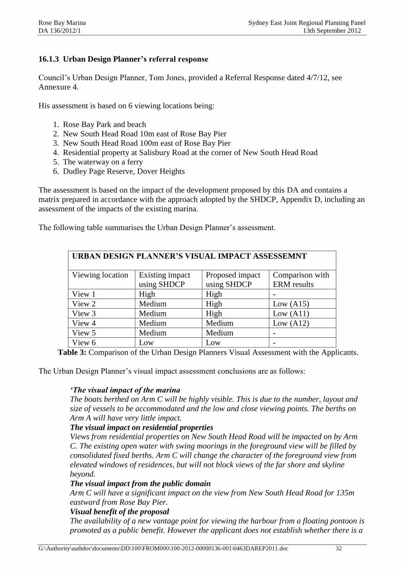
Rose Bay Marina Sydney East Joint Regional Planning Panel
DA 136/2012/1 13th September 2012
G:\Authority\authdoc\documents\DD\100\FROM000\100-2012-00000136-001\0463DAREP2011.doc 32
16.1.3 Urban Design Planner’s referral response
Council‟s Urban Design Planner, Tom Jones, provided a Referral Response dated 4/7/12, see
Annexure 4.
His assessment is based on 6 viewing locations being:
1. Rose Bay Park and beach
2. New South Head Road 10m east of Rose Bay Pier
3. New South Head Road 100m east of Rose Bay Pier
4. Residential property at Salisbury Road at the corner of New South Head Road
5. The waterway on a ferry
6. Dudley Page Reserve, Dover Heights
The assessment is based on the impact of the development proposed by this DA and contains a
matrix prepared in accordance with the approach adopted by the SHDCP, Appendix D, including an
assessment of the impacts of the existing marina.
The following table summarises the Urban Design Planner‟s assessment.
URBAN DESIGN PLANNER’S VISUAL IMPACT ASSESSEMNT
Viewing location Existing impact
using SHDCP
Proposed impact
using SHDCP
Comparison with
ERM results
View 1 High High -
View 2 Medium High Low (A15)
View 3 Medium High Low (A11)
View 4 Medium Medium Low (A12)
View 5 Medium Medium -
View 6 Low Low -
Table 3: Comparison of the Urban Design Planners Visual Assessment with the Applicants.
The Urban Design Planner‟s visual impact assessment conclusions are as follows:
‘The visual impact of the marina
The boats berthed on Arm C will be highly visible. This is due to the number, layout and
size of vessels to be accommodated and the low and close viewing points. The berths on
Arm A will have very little impact.
The visual impact on residential properties
Views from residential properties on New South Head Road will be impacted on by Arm
C. The existing open water with swing moorings in the foreground view will be filled by
consolidated fixed berths. Arm C will change the character of the foreground view from
elevated windows of residences, but will not block views of the far shore and skyline
beyond.
The visual impact from the public domain
Arm C will have a significant impact on the view from New South Head Road for 135m
eastward from Rose Bay Pier.
Visual benefit of the proposal
The availability of a new vantage point for viewing the harbour from a floating pontoon is
promoted as a public benefit. However the applicant does not establish whether there is a

Rose Bay Marina Sydney East Joint Regional Planning Panel
DA 136/2012/1 13th September 2012
G:\Authority\authdoc\documents\DD\100\FROM000\100-2012-00000136-001\0463DAREP2011.doc 33
demand from the non-boating public to access pontoon mooring arms. The proposed
viewing platform provides little viewing advantage over being on the promenade. It is
unlikely to be used for casual visits‟.
16.1.4 Addenbrooke judgements
As discussed previously there are two judgements relating to the redevelopment of Rose Bay
Marina. The most relevant judgement to this application is the 2009 judgment as it relates to a
similar form of development. This judgment contains a detailed visual impact assessment
concerning the previous proposal to redevelop the Rose Bay marina. Notwithstanding this, the 2008
judgment is of relevance, in particular as it set outs the importance of Rose Bay. The 2008 judgment
states:
„Rose Bay …… extends from Woollahra Point in the west to Steele Point in the east.
However, the principle catchment is West Rose Bay, between Lyne Park and Woollahra
Point. (p.68)
The views within this catchment are primarily from users of the Esplanade and New South
Head Road and from the residential development which fronts New South Head Road
west of Lyne Park. There are of course other views, including those from Rose Bay Beach,
Lyne Park and Wunulla Road. However, the views of greatest significance are those
where the full expanse of Rose Bay is viewed from the public domain. This full expanse
includes the foreshore, the water, the land/water interface, the land mass of Point Piper
and Lyne Park and the extensive views of the harbour to the bush reserves on the north
side, including landmarks such as Shark Island. …… Its importance is emphasised not
only by the wideness of the bay and the expansiveness of the view to the harbour but also
because it is the only location when one travels from the city to Watsons Bay that the
harbour can be appreciated in this manner. (p.69)
Boats on swing moorings and the existing marina structures and private jetties are
important elements within this view. …… (p.70)
The visual impact conclusions of the 2009 judgment are as follows:
„The perpendicular arms design of the RBM has been driven by two important views from
the Promenade across Rose Bay and the Harbour and by the avoidance of a continuous
line of boats parallel to the foreshore. One important view is from the Promenade towards
Shark Island, where the form of Shark Island separates from Woollahra Point. This view
line is preserved as the eastern arm of the RBM does not interrupt it. Its preservation
represents a considerable improvement in design compared with the horizontal arms
design the subject of the previous appeal under which that view line was lost. (p.84)
The other important view is immediately east of the existing RBM where a view line
approximately eight kilometres in length is available across the Harbour to Manly. This
viewline is substantially diminished by the proposed RBM, notwithstanding a view
corridor between the middle and eastern arms and a public viewing platform and seating
area incorporated into the walkway. This loss of view is the main controversy concerning
the RBM proposal. (p.85)
There are also some adverse visual impacts on parts of the adjacent New South Head
Road and ground floor units on the opposite side of that road, but the expert evidence and
submissions do not suggest refusal of the proposal on that ground alone. (p.86)

Rose Bay Marina Sydney East Joint Regional Planning Panel
DA 136/2012/1 13th September 2012
G:\Authority\authdoc\documents\DD\100\FROM000\100-2012-00000136-001\0463DAREP2011.doc 34
The substantial loss of Harbour views to Manly is largely caused by the eastern arm of the
proposed RBM. Notwithstanding a viewing channel between the middle and eastern arms,
the loss can be measured as somewhere around 31 per cent of those existing views from
various points on the Promenade and as a higher percentage of the more complete views.
Therefore, the proposed RBM does not maintain views to and from the Harbour, which is
a consideration under cl 26(a) of the Harbour REP. Given that the Promenade is a much
used public asset of considerable aesthetic and heritage importance, the loss of these
views is a considerable public detriment. (p.87)
It is an insufficient answer to say that at present there is some loss of the same views
caused by boats on swing moorings which the proposed RBM will replace. Berths tend to
be occupied by larger, higher profile motorboats and are densely grouped, whereas boats
on swing moorings present a moving spectacle and have a substantially less visual
impact. (p.88)
There was debate as to how Manly should be defined and as to whether particular
features of Manly could be identified from the Promenade. I do not think that those
matters are of much significance. However Manly is defined, particular features may not
be apparent from the Promenade by day (at night when there are lights in buildings
particular features might be more identifiable). What is important, in my opinion, is the
expansive view of the Harbour and its headlands as far as Manly, rather than a view
specifically of particular features of Manly, however Manly is precisely defined. (p.89)
In my opinion, the loss of these important views to the large extent proposed, is
unreasonable. Consequently, consent should not be granted to the proposal in its current
form. (p.90)
The Committee (Sydney Harbour Foreshore Committee, the second respondent in the
proceedings) suggested that the views to Manly could be improved if the eastern arm were
to be rotated some degrees. That was described by Mr Wyatt (the applicant‟s visual
expert) as a minor improvement and by Mr Moody (Council‟s visual expert) as a very
minor improvement. I do not think that it is a sufficient answer to the problem of loss of
such views. (p.91)
Mr Moody proposed a solution to maintain views to Manly: remove the eastern arm or
shift the proposed RBM further westward. The council submits that, assuming this has
acceptable impacts on other matters, including the view from Rose Bay beach, it
demonstrates that the applicant has not done everything to maintain, protect and enhance
views with its current proposal. I disagree that the proposed RBM should be moved
further westward because I think that would unacceptably enclose the waterway in front
of Rose Bay beach. (p.92)
In my opinion, subject to consideration of the impact on Rose Bay beach and conditions,
the RBM proposal would be acceptable if the eastern arm (including the portion of the
walkway in front of it) were removed, the middle arm shortened by four twenty metre
berths (i.e two on each side of that arm), the western arm shortened by two twenty metre
berths, and a maximum height imposed for berthed boats as discussed at [135] – [140]
below. The removal of the eastern arm reduces the loss of views to Manly from the
Promenade to about 14.5 per cent, which is further reduced by the shortening of the
middle arm as I have indicated. The shortening of the middle arm also assists in achieving
visual separation between the RBM and the RMYC viewed from the Promenade, and
reduces the visual impact of the RBM on the Wunulla Residences. The shortening of the

Rose Bay Marina Sydney East Joint Regional Planning Panel
DA 136/2012/1 13th September 2012
G:\Authority\authdoc\documents\DD\100\FROM000\100-2012-00000136-001\0463DAREP2011.doc 35
middle and western arms reduces the visual impact on Rose Bay beach, as discussed
below‟. (p.93)
16.1.5 Assessment of visual impact
The proposed extended marina provides an additional marina arm that extends about 68m to the
east of the existing Arm B, i.e. across the New South Head Road promenade. The extended marina
also provides an additional 9 berths on the western side of existing Arm A. Currently there are no
permanent berths on the western side of Arm A as this area accommodates casual and fuelling
berths.
Promenade impacts
The existing marina consists of two berthing arms separated by a central fairway, which lies
perpendicular to the promenade. The central fairway is 30m wide and approximately 90m long
(measured from the main walkway to the end of the western arm). The proposed development
involves the provision of a new marina arm (Arm C) located directly to the east of the existing
marina consisting of 37 x 15m berths. This marina arm is to be separated by a fairway that is 35m in
width and 120m in length. A further 9x 10m berths are proposed to be added to the western side of
Arm A.
The existing fairway allows for harbour views in a northerly direction to be obtained from the
promenade through the berths (views of the open harbour are obstructed by the existing Royal
Motor Yacht Club, see photo 1). The proposed new fairway between Arm B and the proposed Arm
C will also allow for views to be obtained in a northerly direction from promenade. The views
obtained are harbour views that extend up to Manly. However these views are between the fairways
and from the proposed new public viewing platform located at the junction of the existing and
proposed walkway. They are therefore constricted views that do not allow the viewer to appreciate
the wide open expanse of Rose Bay and the Harbour beyond.
Photo 1: Existing marina fairway between Arms A & B

Rose Bay Marina Sydney East Joint Regional Planning Panel
DA 136/2012/1 13th September 2012
G:\Authority\authdoc\documents\DD\100\FROM000\100-2012-00000136-001\0463DAREP2011.doc 36
This view line from the Rose Bay promenade across the Harbour to Manly was the central visual
issue in the 2009 judgment. The applicant has attempted to address the concerns raised in the 2009
judgment by limiting the length of the boats to 15m and the height to 3.5m. The previous eastern
arm proposed in DA682/2008 contained 15m boats on its eastern side, 20m boats on its western
side (other than the 3 berths closest to the main walkway) and 30m (x2) and 20m (x2) boats at its
northern end. No height limit was proposed. The applicant has stated in the submitted visual
assessment that the reduction to the length and height of the boats will maintain and preserve views
from the Rose Bay promenade as far as Manly. However, the proposed development is not
considered to maintain and preserve views from the promenade as far as Manly as the proposal will
block a substantial amount of the foreground harbour view. The proposed Arm C will occupy a
similar footprint as the proposed Arm C that was previously proposed by DA682/2008, thus
essentially the same amount of foreground views will lost from the promenade (refer to Figure 3).
Therefore, whilst views of Manly over the top of the boats will be maintained (only from an eyeline
height of 1.55m) from the promenade, the waterway views up to Manly will be highly obstructed by
the new arm. Biscoe J states in the 2009 judgement that:
„What is important, in my opinion, is the expansive view of the Harbour and its headlands
as far as Manly, rather than a view specifically of particular features of Manly, however
Manly is precisely defined.‟
Further, views of Manly and a small amount of the waterway are perceptible above the top of the
boats (see photomontage 1) only if the viewer has an eyeline height of 1.55m or greater. Whilst an
eyeline of 1.55m is average adult height, any person with an eyeline less than 1.55m, e.g. children
and disabled persons, would not be able to see over the boats to Manly. Therefore the proposal not
only obstructs substantial foreground Harbour views from the Promenade, the proposal blocks
views of Manly to a significant number of people within the community. This is considered to make
the proposal unacceptable given the importance of the views from the promenade.
Photo 2: Existing view from Rose Bay promenade from view point A13. (Source: EIS)
Photomontage 1: Proposed Arm C from the promenade from view point A13. (Source: EIS)

Rose Bay Marina Sydney East Joint Regional Planning Panel
DA 136/2012/1 13th September 2012
G:\Authority\authdoc\documents\DD\100\FROM000\100-2012-00000136-001\0463DAREP2011.doc 37
Figure 5: Layout plan of the proposed marina showing the previously proposed Arm C
The applicant has stated that the proposed new public viewing platform and seating to be located
between Arms B and C would create new views to and from the harbour and would be of public
benefit. It is acknowledged that the new viewing platform would create new views to and from the
harbour, however the viewing platform is considered to be of limited public benefit as the views
towards Manly are constricted views and given its location it would be unlikely to be highly used in
comparison to the level of usage of the promenade. Therefore the provision of this viewing platform
is not considered to provide sufficient public benefit to outweigh the view loss and loss of visual
amenity from the promenade.
The applicant has stated that the proposed development would have a medium impact on views
from the promenade at view point A13 and the impact is for a relatively short distance compared
with the length of the promenade. It is considered that the proposed development would have a high
impact on the views from the promenade at this point. In addition Council‟s Urban Design Planner
has considered that the proposed development would have a high impact at viewpoints A11 and
A15. Whilst it is acknowledged that view impact is for short distance in comparison to the overall
length of the promenade, the impact extends over a distance of approximately 150 metres, which is
a significant distance particularly given the high significance of the promenade.
Further, it is important to acknowledge the cumulative impact on views obtained from the
promenade as the proposal adds additional berths to the recently redeveloped marina. The

Rose Bay Marina Sydney East Joint Regional Planning Panel
DA 136/2012/1 13th September 2012
G:\Authority\authdoc\documents\DD\100\FROM000\100-2012-00000136-001\0463DAREP2011.doc 38
redeveloped marina already compromises the visual connection between the promenade and the
harbour (see photo 3). The additional disruption to this visual connection, as proposed, is
considered to be unacceptable. It should be noted that the full visual impacts of the redeveloped
marina cannot be fully established until all berths are occupied.
Photo 3: Existing Rose Bay Marina as viewed from the promenade.
Views to the north-east from the promenade will be impacted by the proposed reinstatement of Arm
C. The existing views are characterised by the tree covered headland of Vaucluse which includes
the Sydney Harbour National Park, Hermit Bay, Strickland House and the beach to the east of Lyne
Park. Much of the headland from the shoreline to the ridgeline is presently visible. The ridgeline
and upper hillside will still be visible beyond the proposed moored boats but the shoreline will be
lost from most locations on the promenade between the existing marina building and Cranbrook
Road (about 90m). Further along the promenade to the east of Cranbrook Road the view, including
the shoreline, increases until at a point to the east of Beresford Road (about 150m east of the marina
building) the existing north-easterly view is maintained. Views of the Steele Point headland will be
maintained by the proposed development.
The proposed development would retain the views from the promenade to Shark Island and views
of the point where Shark Island and Woollahra Point separates. This view line was an important
consideration in the 2008 judgement. The proposed removal of swing moorings within this location
will make a slight improvement to the water break between Shark Island and Woollahra Point.
However this does not compensate for the other visual impacts of the proposal as the visual impact
of swing moorings have been considered to be either positive or, at worst, neutral.
In the 2009 judgement Biscoe J deleted Arm C in its entirety to overcome visual impact concerns,
whereas the visual impacts of the approved arms were overcome by shortening the length of the
arms and imposing height limits on the berths. Biscoe J had the opportunity to limit the length and
height of the boats to Arm C, however the visual impacts of this arm were considered severe
Rose Bay Marina Sydney East Joint Regional Planning Panel
DA 136/2012/1 13th September 2012
G:\Authority\authdoc\documents\DD\100\FROM000\100-2012-00000136-001\0463DAREP2011.doc 39
enough to warrant the deletion of the arm in its entirety. Whist the proposed reinstatement of Arm C
has reduced the length and the height of the boats on this arm this is not considered to overcome the
visual impact concerns raised in the 2009.
The Sydney Harbour Foreshore Committee, the second respondent in both of the LEC proceedings,
have made a number of suggested changes to the proposed development including:
the rotation of Arm C
reduction to the height of the boats on the eastern side of Arm C
the relocation of the viewing platform to the end of this arm
Whilst, these changes would further reduce the visual impacts of the proposal they would not
overcome the visual impacts referred to above.
Rose Bay Park and Beach impacts
An assessment of the visual impact on Rose Bay Park and Beach needs to consider the cumulative
impact of the proposed development, the redeveloped Rose Bay and Point Piper marinas and the
existing RMYC marina.
Existing views from Rose Bay Park and Beach are characterised by boats on marina berths at the
RMYC, Rose Bay and Point Piper marinas and boats on swing moorings. The RMYC has a total of
90 floating berths with boats up to 20m in length. The redeveloped Point Piper Marina has 34
floating berths with boats up to 30m in length and the redeveloped Rose Bay Marina has total of 49
floating berths with boats up to 30m in length. The boats on marina berths are highly visible from
Rose Bay Beach, and the outer ends of the Point Piper and Rose Bay marina berths are separated by
a distance of approximately 80m. From parts of the park and beach this gap between the marinas
allows views in a north-easterly direction towards Vaucluse, including parts of the shoreline,
between swing moored boats. From the beach and park Shark Island is not visible and neither is
Woollahra Point, Steele Point, the main Harbour channel or northern shoreline. While there is an
appreciation that the bay is a large bay, its context in relation to the Harbour is not apparent. This is
in contrast to views from the promenade where the full extent of bay can be appreciated including
views to the Harbour beyond. This is supported by the comments from the 2008 judgement at p.69
referred to earlier in this report.
By comparison, the visual amenity from the promenade is vastly superior to that from the beach and
park. The number of people who use the beach and park is also significantly less than the number of
people who use the promenade. Therefore, it may be appropriate to allow a level of intervention in
relation to visual amenity from the park and beach which may not be acceptable from the
promenade.
The proposed marina expansion will not result in any further narrowing of the gap between Rose
Bay and Point Piper marinas, therefore the existing north-easterly views toward Vaucluse including
parts of the shoreline, the treed hillside and the ridge will be maintained. The proposed 9 new berths
to Arm A will add a degree of visual clutter to the view obtained from Rose Bay Beach and Park.
However, the new berths to Arm A only allow for small boats (up to 10m in length) and do not
require any mooring piles. Further these berths do not extend beyond the alignment of the existing
T-head to Arm A and are located directly in front of existing marina berths that can accommodate
boats upto 20m in length. Council‟s Urban Design Planner was also of a view that these berths
would be acceptable in relation to visual impact on Rose Bay Beach and Park.

Rose Bay Marina Sydney East Joint Regional Planning Panel
DA 136/2012/1 13th September 2012
G:\Authority\authdoc\documents\DD\100\FROM000\100-2012-00000136-001\0463DAREP2011.doc 40
The proposed Arm C will not be visible from Rose Bay Beach or Park and will therefore not affect
their visual amenity. No changes to the swing moorings in the foreground view from the park and
beach have been proposed.
Lighting
An assessment of the impact of the proposed lighting to the marina pontoons and fingers was
prepared by Basset Consulting Engineers Assessment of the impact of the proposed new lighting,
dated 5 September 2008 for the previous development application (DA682/2008). This report is
considered relevant and applicable to the proposed marina extension as the previous development
application included a third marina arm in the approximate location of the proposed Arm C. The
report is based on:
field measurements of existing lights on the marina, promenade and streets
a technical assessment of the proposed lighting
computer modelling
This report concluded that the lighting to the pontoons and fingers to the redeveloped marina will
provide less light spill than the lighting that existed at the previous marina. It recommends the use
of warm white colour temperature compact fluorescent energy saving lamps as warm white light is
perceived to be less bright than neutral white or cool light.
The EMP includes specific provisions to reduce the need for permanent lighting on boats and for
lighting to be designed and installed to comply with AS4282 – 1997: Control of the obtrusive
effects of outdoor lighting.
The expanded marina is proposed to be illuminated from low level (approximately 1000mm high)
service pedestals. The pedestals are fitted with light diffusers and are to be located at the junctions
of the fingers and walkways and at approximately 10m intervals on the main the walkways and on
the viewing platform. The pedestal units proposed are the same as those installed on the recently
constructed Point Piper Marina and Rose Bay Marina and are considered acceptable.
No objections from internal or external bodies were received in relation to lighting impacts.
Therefore based on the available information the proposal could be suitably conditioned to ensure
the lighting impacts of the proposal are minimised.
Private views
Private properties in New South Head Road, between Salisbury Road and the marina building and
in Wunulla Road between New South Head Road and the RMYC have views across the area of
waterway to be occupied by the proposed marina. This represents some14 residential properties in
New South Head Road and 9 in Wunulla Road.
The New South Head Road properties are on the opposite side of the road to the marina. The
ground level is level with the road and buildings generally comprise medium rise (3 storey)
apartment buildings. The private views from these properties to the north includes New South Head
Road (a main arterial road), the promenade, including substantial street trees and the concrete
balustrade, in some instances the existing marina building and the waterway including moored
boats. From ground floor apartments some views of the waterway will be affected by the proposal.
This will mainly be a consequence of the upper portion of boats on the proposed marina berths
being visible above the promenade balustrade. However, views of the waterway are presently
compromised by the intermediate trees and balustrade of the promenade. Most of these buildings

Rose Bay Marina Sydney East Joint Regional Planning Panel
DA 136/2012/1 13th September 2012
G:\Authority\authdoc\documents\DD\100\FROM000\100-2012-00000136-001\0463DAREP2011.doc 41
have ground level parking. The apartments on the upper levels are sufficiently elevated so as to
maintain their substantial views of the harbour. The marina will occupy the foreground and the
appearance of that section of the waterway, which presently is characterised by boats on swing
moorings, will be different. However, view loss is not considered to be unreasonable. Further in the
2009 Judgement the following was concluded in relation to visual impact of the previous proposal
on views obtained from the ground floor units in New South Head Road:
„There are also some adverse visual impacts on parts of the adjacent New South Head
Road and ground floor units on the opposite side of that road, but the expert evidence and
submissions do not suggest refusal of the proposal on that ground alone.‟ (p.86)
The Wunulla Road properties have a water frontage to Rose Bay and are generally occupied by
detached dwellings on steeply sloping land. The dwellings are sufficiently elevated in relation to the
waterway to maintain views. The relatively small increase to marina berths located on this western
side of Rose Bay Marina would have a negligible impact on views obtained from these properties.
It should also be noted that the views from individual private properties are private views and the
objections from the owners represent private, rather than public, interests. Private interests are
important but in the planning context, particularly considering the aims of the SHREP, are of less
importance than the public good. This issue is discussed in more detail in part 17 of this report.
It is considered that the extent of view affectation on adjoining private properties is not such as to
justify refusal of the DA.
Conformity with planning controls
Provisions of the SHREP relevant to visual impact considerations are set out in part 16.1.1 of this
report. The consent authority must not grant development consent to any development unless it is
satisfied that it is consistent with the aims of the plan and the objectives of the zone.
As stated above the proposed reinstatement of Arm C is considered to have an unacceptable visual
impact on the Rose Bay Promenade the proposed development is therefore considered to be
contrary to aim 2(1)(a) and objectives (d) and (g) of the W5 zone.
Clauses.25 and 26 of the SHREP are matters to be taken into consideration in the assessment of
scenic quality and views. The proposed development does not maintain views to and from the
harbour from the promenade which is a highly used public asset of considerable aesthetic and
heritage importance. The proposal will also result in an unacceptable cumulative impact on views to
and from the harbour. The proposed development is therefore considered to be contrary to cls.25(b)
and (c) and cls.26 (a), (b) and (c).
Clauses 3.2 and 3.3 of the SHDCP set out criteria for protecting and enhancing identified landscape
characteristics. Part 4 of the SHDCP contains guidelines for the visual impact of marinas and
Appendix D sets out a specific methodology for gauging that visual impact and which includes the
preparation of a visual assessment matrix.
The EIS submitted by the applicant contains a visual assessment matrix based on the applicant‟s
interpretation of Appendix D as does Council‟s Urban Design Planner‟s referral response. The
applicant concluded that the proposal would have a medium to low impact on views from the
promenade, whereas Council‟s Urban Design Planner has concluded that the proposed development
would have a high visual impact on views from the promenade.
Rose Bay Marina Sydney East Joint Regional Planning Panel
DA 136/2012/1 13th September 2012
G:\Authority\authdoc\documents\DD\100\FROM000\100-2012-00000136-001\0463DAREP2011.doc 42
The proposed development is considered to create unacceptable impacts on the visual amenity of
the highly used and significant public promenade and would therefore be contrary to:
part 3.2 - the 1st and 2
nd dot points:
o Minimise any significant impact on views and vistas from and to:
- Public places
- Landmarks identified on the maps accompanying the DCP, and
- Heritage items
o Ensure it complements the scenic character of the area
part 4.2 - the 8th dot point
o development does not dominate its landscape setting
part 4.7 - Marinas (Private and Commercial), Visual Impact - 2nd
and 5th
dot points
o the visual impact of the marina on people in the visual catchment (derived from
an analysis of the potential number of viewers, their location within the
landscape, distance from the marina, and duration of view) is to be minimised;
o waterside structures and berthed vessels associated with marinas are not to
block views from foreshore public open space or views to foreshore public open
space from the waterway;
[NOTE: Compliance tables for all of the relevant provisions of the SHREP and the SHDCP are
included in Annexures 17 and 18 respectively of this report]
Conclusion
The proposed eastern arm to the marina has made improvements to the visual impact from the
promenade from the previously proposed eastern arm that was deleted by the Land and
Environment Court. Views of Manly and some waterway view will be maintained over the top of
the boats to be moored on Arm C. However, the foreground ground views up to Manly will still be
obstructed. Therefore the proposal is not considered to overcome the central visual issue in 2009
judgment as stated by Biscoe J:
„What is important, in my opinion, the expansive view of the Harbour and its headlands as
far as Manly, rather than a view specifically of particular features of Manly‟.
Further these views of Manly will be obstructed when the viewer has an eyeline less than 1.55m.
The proposed eastern arm is therefore considered to have an unacceptable visual impact on the Rose
Bay Promenade, and be contrary to the aims of the SHREP and objectives of the W5 zone.
The proposed development does not maintain views to and from the harbour from the promenade
which is a highly used public asset of considerable aesthetic and heritage importance. The proposal
will also result in an unacceptable cumulative impact on views to and from the harbour. The
proposed development is therefore contrary to cls.25(b) and (c) and cls.26(a), (b) and (c) of the
SHREP and the provisions of the SHDCP as mentioned earlier.
The additional berths to Arm A do not have an adverse visual impact on Rose Bay Park and Beach
and the promenade.

Rose Bay Marina Sydney East Joint Regional Planning Panel
DA 136/2012/1 13th September 2012
G:\Authority\authdoc\documents\DD\100\FROM000\100-2012-00000136-001\0463DAREP2011.doc 43
16.2 Other Impacts
16.2.1 Traffic and parking
The EIS includes an assessment by Christopher Hallam & Associates Pty Ltd, dated 27th
October
2011. The report makes reference to findings of the 2008 Addenbrooke proceedings and the
following previous studies undertaken by Christopher Hallam & Associates including:
The Traffic and Parking Assessment of Proposed Modifications to Rose & Point Piper
Marinas (September 2006);
Supplementary Report on Traffic and Parking Implications of Proposed Modifications to
Rose Bay & Point Piper Marinas (May 2007)
Review of Large Boat Operations and Implications for Traffic & Parking (September 2007)
It should be noted that a further traffic and parking report was prepared on behalf of Woollahra
Council for the 2008 LEC proceedings by Sinclair Knight Merz (SKM).
The traffic and parking implications of the marina extension have been assessed based upon the
boat usage and parking rates agreed in the LEC appeal of DA766/2006. These rates were based on
extensive research into the parking demands generated by marinas. The experts agreed that the
parking demand rates for peak summer weekend boat usage, for boats up to 20m in length are:
Marina Berths: 0.166
Swing moorings: 0.224
The proposed marina extension proposes to construct an additional 46 marina berths and relinquish
46 swing mooring. Based on the above car parking generation rates the proposed development
would result in the following car parking demand:
Existing:
Marina Berths: 0.166 x 49 = 8.134
Swing moorings: 0.224 x 70 = 15.68
Total = 23.814
Proposed:
Marina Berths: 0.166 x 95 = 15.77
Swing moorings: 0.224 x 24 = 5.376
Total = 21.147
Therefore based on the above the proposed development will result in a net reduction to the demand
for car parking by 2.66 spaces.
The 2008 judgment concluded the following in relation to car parking impacts:
„Based on the evidence of the traffic experts, the proposal will not generate an unacceptable
demand for parking which cannot be met by the availability of on street parking‟.

Rose Bay Marina Sydney East Joint Regional Planning Panel
DA 136/2012/1 13th September 2012
G:\Authority\authdoc\documents\DD\100\FROM000\100-2012-00000136-001\0463DAREP2011.doc 44
NOTE: The parking rates used by the traffic consultants differ from those used earlier in the
assessment of parking under our car parking DCP and AS 3962, refer to parts 13.2 and 14.3 The
rates used earlier for AS 3962 are those which are referred to as having been found to be acceptable
in the absence of traffic and parking studies. It is considered that, in this situation, the use of the
results from the surveys undertaken on behalf of the applicant and by Woollahra Council are a more
appropriate assessment of parking impacts.
The applicant has stated that the proposal will not have adverse traffic implications. As the
development essentially replaces swing moorings with an equivalent number of fixed marina berths
there is not anticipated to be any substantial increase to traffic to the Marina.
Servicing
There is an existing 11.6m loading zone located on the northern side of New South Head Road, in
front of the Pier Restaurant that was installed as part of the previous development DA682/2008.
This loading zone operates between the hours of 7am to 5pm Monday to Friday. This existing
loading zone is considered to be sufficient to accommodate the servicing demands of the proposed
development.
Construction
The applicant has stated that the construction program is estimated to take 18 weeks and that the
majority of the works will be undertaken from barges, work boats and barge mounted cranes. The
deliveries of materials will be also be mostly delivered by water. The applicant anticipates that there
will be some materials delivered by road via light commercial vehicles and some specialist
contractors will also travel to the site by vehicle.
Council‟s Traffic Department did not consider that the previous works in connection with
DA2008/682 to create any substantial interruption to the surrounding traffic and parking conditions.
The application of the standard condition of consent relating to the submission of a construction
management plan and compliance with this plan could be imposed to address construction
management issues.
Traffic and Transport Planner’s comments
Council‟s Traffic and Transport Planner has not raised any objection to the proposed development
and has provided the following comments in relation to the parking impact of the proposal:
The applicants Traffic Report has presented parking demand rates deduced from studies
undertaken in association with the previous development application. The report states
that both the applicant and Council‟s engaged traffic consultant both agreed in the LEC
court proceedings on the resulting parking demand rates from swing moorings and
marina berths for boats under 20m.
Applying these rates (0.224 cars/ swing mooring and 0.166 cars / berth) to the proposed
development produces a parking demand of -2.7 car spaces (ie a reduced parking
demand) in comparison to the existing use.
As Council‟s Traffic and Transport section has no further data to counter the validity of
these rates, their use in the analysis is accepted.

Rose Bay Marina Sydney East Joint Regional Planning Panel
DA 136/2012/1 13th September 2012
G:\Authority\authdoc\documents\DD\100\FROM000\100-2012-00000136-001\0463DAREP2011.doc 45
Council‟s Traffic and Transport Planner has provided the following comments in relation to the
traffic impacts of the proposal:
Given the proposed development does not have a allocated parking area, traffic resulting
from the proposal will be dispersed over the surrounding area and therefore no adverse
traffic effects are anticipated.
Council‟s Traffic and Transport Planner has provided the following comments in relation to the
service, loading and delivery impacts of the proposal:
The applicant has not provided details regarding service requirements resulting from the
proposal. Notwithstanding this, the development essentially replaces swing moorings with
an equivalent number of berths and so there is not anticipated to be any substantial
increase to traffic to service the Marina.
Council‟s Traffic and Transport Planner has provided the following comments in relation to the
construction management impacts of the proposal:
The application does not contain any construction management details. Despite this, the
applicant is currently undertaking works in association with the previous Development
Application and Council‟s Traffic and Transport section is aware the construction
management of this has not caused any substantial interruption to the surrounding traffic
and parking conditions. The application of the standard condition of consent regarding
submission of a construction management plan and compliance with this plan is advised.
Conclusion
Based on the above, the survey information commissioned by the applicant and by Woollahra
Council and having regard to comments contained in the 2008 judgment it is considered that the
existing street network has sufficient capacity to accommodate parking demand generated by the
proposal. It is also considered that the street network can accommodate traffic movements
generated by the proposal. There is an existing loading zone in respect to servicing needs.
16.2.2 Ecology
The EIS includes (at Appendix I) a report by WorleyParsons, Proposed Rose Bay Marina Aquatic
Ecology, dated 16 October 2008 (WP ecology report). This report is the same report that was
submitted for DA682/2008. The reuse of this report for this new development application is
considered acceptable as the proposed development occupies a similar area the previous
development application (DA682/2008). This report and the proposed plans were reviewed by
Council‟s Environmental Sustainability Team Leader on 15/06/2012 and was generally found to be
acceptable, refer to Annexure 8.
The Department of Primary Industries (DPI) is an integrated approval body for the development and
accordingly the proposal was referred to it. The DPI responded with its general terms of approval
by letter dated 16/05/2012, see Annexure 9 of this report. If consent is granted to the DA, DPI‟s
general terms of approval need to be included as conditions. The proposal was also referred to
Office of Environment and Heritage (EPA) as an integrated approval body. The EPA responded
with its general terms of approval by letter dated 13/07/2012, see Annexure 10 of this report. If
consent is granted to the DA, the EPA‟s general terms of approval also need to be included as
conditions.

Rose Bay Marina Sydney East Joint Regional Planning Panel
DA 136/2012/1 13th September 2012
G:\Authority\authdoc\documents\DD\100\FROM000\100-2012-00000136-001\0463DAREP2011.doc 46
The 2008 judgement also discusses the ecological implications of the redevelopment proposal
(DA766/06) based on evidence produced as part of those proceedings.
Both the SHREP and SHDCP include provisions which are relevant to assessing the ecological
impacts of the proposal. Other relevant legislation is the Fisheries Management Act 1994 (FMA) &
the Environmental Protection and Biodiversity Conservation Act, 1999 (EPBC).
WP report
The WP ecology report was prepared and submitted as part of the previous development application
(DA2008/682). The report draws from reports prepared for DA766/06 by Marine Pollution
Research, peer review literature and additional field work. It includes a threatened species
assessment in accordance with the „7 part test‟ under s.94 of the Threatened Species Conservation
Act regarding the impact on black cod. Black cod is a fish species listed as vulnerable under the
FMA. Findings of the WP ecology report‟s impact assessment are summarised as follows:
fish assemblages will benefit from additional piles and pontoons while turbidity from
construction activity and propeller action from operational activities are not considered
likely to result in any measurable or ecologically meaningful impacts
impacts on soft sediment macrobenthic assemblages is considered to be minor
seagrass beds are not predicted to be impacted as there is no spatial overlap with proposed
marine infrastructure. Construction mitigation measures will be employed to prevent
turbidity from seagrass beds and the impact is considered to be negligible. Vessel induced
turbidity is not predicted to impact on seagrass beds as the proposed conditions will be
similar to existing.
epibenthic assemblages on hard substrata are considered to benefit as the addition of piles
and pontoons will provide an additional area of novel habitat
recreational fishing access is not predicted to be impacted
water quality is expected to benefit because of the provision of sewage pump-out facilities
and improved fuel dispensing arrangements. Increased copper concentrations are expected
to have negligible impacts having regard to ANZECC/ARMCANZ trigger values for
protection of aquatic ecosystems. Subject to appropriate measures being put in place (e.g.
turbidity curtains and a construction monitoring program) water quality impacts during
construction are considered to be negligible
Caulerpa taxifolia mapping shows that the area where it occurs will not be disturbed. An
action plan will be implemented in accordance with DPI guidelines. Potential impacts
during construction and operational phases are considered to be negligible
The protected species, sygnathformes (pipefish and seahorses), habitat will not be disturbed
threatened species – black cod, habitats will not be reduced. Applying the 7-part test under
the TSCA indicates that the proposal will be satisfactory
cumulative impacts, from the proposed redevelopment of the Point Piper marina, are
considered to be limited.
Council‟s Environmental Sustainability Team Leader has reviewed this report and the proposed
plans and has not raised any objections to the proposal, however the following concerns were
raised:
Impacts during the construction of the new marina arms - were there any
environmental impacts during construction of the rose bay marina upgrade. Were the
sediment control measures successful? Has there been any impacts on the
surrounding sea grass beds since construction?

Rose Bay Marina Sydney East Joint Regional Planning Panel
DA 136/2012/1 13th September 2012
G:\Authority\authdoc\documents\DD\100\FROM000\100-2012-00000136-001\0463DAREP2011.doc 47
The applicant provided the following response to this issue:
We originally proposed to use a hammer pile technique but eventually used a contractor
that used a spinning pile rig. This means the turbidity and noise generated during the
piling was greatly reduced. We used sediment controls such as turbidity curtains during
the piling and our post completion inspection of the seabed showed no impacts on the
surrounding sea grass beds.
Council‟s Sustainability Department is satisfied with the applicant‟s response to this issue.
The Seagrass study has not been updated since 2008. Sea grass beds may have moved
or changed. Are the sea grass beds in the same condition/locations?
The applicant provided the following response to this issue:
Our post completion seabed inspection used the previous sea grass bed mapping as a
reference and the inspection showed that sea grass beds remained in approximately the
same locations. There was no new or additional areas identified and the sea grass beds
adjacent to the promenade seemed in good condition.
Council‟s Sustainability Department is satisfied with the applicant‟s response to this issue.
Caulerpa Taxifolia Management Plan - has this been implemented ? What data is
being collect at the marina? How much Caulerpa Taxifolia has been collected?
The applicant provided the following response to this issue:
There has been no evidence of Caulerpa Taxifola on the boats currently berthed within
the marinas. The marina actively encourages customers firstly not to berth in areas where
seagrass is found and secondly to check anchors and anchor wells for any sea grass
(including caulerpa taxifola) when using their vessels. Compliance with this plan is part
of the marina berthing agreement and a full copy of the EMP is available at the marinas
for review in both digital and hard copy.
Council‟s Sustainability Department is satisfied with the applicant‟s response to this issue.
EMP - The location of fuel tanks and fuel storage is not marked on plans. The plan
(Appendix A) in the EMP was approved by Council as part of the deferred
commencement conditions.
The applicant provided the following response to this issue:
We are happy to update this Appendix to include clear labelling of the fuel tanks.
The plan that has been submitted shows the location of the fuel tanks and is considered suitable by
Council‟s Sustainability Department.
EMP - The location of waste management and recycling facilities is not marked on
plans. The plan (Appendix A) in the EMP was approved by Council as part of the
deferred commencement conditions.
The plan that has been submitted shows the location of the waste management and recycling
facilities and is considered suitable by Council‟s Sustainability Department.

Rose Bay Marina Sydney East Joint Regional Planning Panel
DA 136/2012/1 13th September 2012
G:\Authority\authdoc\documents\DD\100\FROM000\100-2012-00000136-001\0463DAREP2011.doc 48
Addenbrooke judgement
The 2008 judgment includes the following comments in relation to ecological impacts:
The council submits that the application is inconclusive in that it is not established that
the proposed development either protects or enhances aquatic species.
The ecology experts Mr Anink (representing Addenbrooke) and Dr Lincoln Smith
(representing council) agreed that:
[S]ome quantitative data provided in the Marine Ecology Report (Appendix L of EIS –
Marine Pollution Research 2006 in Appendix B) could not be used to provide statistically
valid conclusions for impact assessment and that these data are not suitable as baseline
data for future monitoring.
Nevertheless, Mr Anink maintained that the data that had been provided to council in the
Supplementary Report (Marine Pollution Research 2007) dealt satisfactorily with marine
ecology issues. The Marine Pollution Research 2007 report concluded:
The marina as proposed would not have any significant impact on aquatic ecology of the
locality.
This report was not addressed by the council or Dr Lincoln Smith. It seems to me that it
should lead to rejection of the council‟s submission. (p.152-154)
It is noted that the WP report refers to the Marine Pollution Research 2007 supplementary report as
a source of existing information utilised in its preparation.
DPI
The DA, including the EIS, was referred to the DPI as an integrated approval body. This is because,
in addition to the granting of development consent, DPI approval would be required under the FMA
to harm marine vegetation before the work could be carried out. The DPI wrote to Council on
16/05/2012 saying it has reviewed the proposal in light of policies and provisions under the FMA
and has no objections, subject to 4 provisions, refer to Annexure 9 of this report. The provisions
need to be imposed as conditions if development consent is granted.
EPA
The DA was also referred to Office of Environment and Heritage (EPA) as an integrated approval
body. This is because EPA needs to issue an Environmental Protection License under the Protection
of the Environment Operations Act. The EPA commented by letter dated 13/07/2012 and has no
objections, subject to provisions, referred to Annexure 10 of this report. These provisions need to
be imposed as conditions if development consent is granted.
EPBC Act
Referral to the Commonwealth Department of the Environment is not a pre-requisite to the granting
of development consent. It is the proponent‟s responsibility to ensure that any approvals which may
be required under the EPBC are obtained prior to the development proceeding.

Rose Bay Marina Sydney East Joint Regional Planning Panel
DA 136/2012/1 13th September 2012
G:\Authority\authdoc\documents\DD\100\FROM000\100-2012-00000136-001\0463DAREP2011.doc 49
Site Audit Report/Environmental Health Officer’s comments
The site audit report was prepared for the previous redevelopment proposal for Rose Bay and Point
Piper marinas, DA766/06. The EIS includes a letter dated 9/07/2008 from Mike Hayter, the
accredited site auditor, which states:
The conclusions of the Site Audit Report and the validity of the Site audit Statement are
not affected by minor redesign of the marinas and the submission of separate DAs for
each marina.
This letter was prepared for the previous development application (DA682/2008), however it is
relevant to the current proposal given that the previous development occupies essentially the same
area as this development.
The EIS also includes a Site Audit Report by an EPA accredited site auditor, Mike Hayter of
Environ. It identifies existing contaminants and acknowledges their potential to cause localised
adverse effects on benthic communities. The main contaminant is TBT (Tributyltin), used for
maintenance of vessels, with highest concentrations in the vicinity of the slipway that previously
existed at the site. This slipway was removed as part of the previous approved works under
DA682/2008, and subject to the provisions of the EMP that was submitted with this application
(which can be made legally enforceable through conditions of development consent), the auditor
concludes that remnant contamination is not considered to pose an unacceptable risk to onsite or
offsite environments.
Council‟s Senior Environmental Health Officer‟s referral comment (refer Annexure 5 of this report)
has reviewed the above documentation and has provided the following comment:
Based on the above, the Auditor considers that the EMPs will provide an adequate
framework for the management of the remnant sediment contamination at the site. The
results of the sediment testing and the Site Audit have concluded that remediation of
sediments at the site is not required; accordingly, the „land‟ is suitable for the purpose of
the proposed‟.
Conclusion
The SHREP, cl.21 contains matters to be taken into consideration in relation to biodiversity,
ecology and environment protection. These include:
(b) Development should protect and enhance terrestrial an aquatic species, populations
and ecological communities and, in particular, should avoid physical damage and
shading of aquatic vegetation (such as seagrass, saltmarsh and algal and mangrove
communities),
There are specific matters for consideration in part 6 of the SHREP for development within a
wetlands protection area. These include cl.63(2)(b)(i):
(b) The environmental effects of the development , including effects on:
(i) The growth of native plant communities,
Under the SHREP the area to be occupied by the proposed marina is mostly in a wetlands
protection area. The SHDCP identifies sea grass communities in the area. Sea grass has a high

Rose Bay Marina Sydney East Joint Regional Planning Panel
DA 136/2012/1 13th September 2012
G:\Authority\authdoc\documents\DD\100\FROM000\100-2012-00000136-001\0463DAREP2011.doc 50
conservation status. It also identifies sandy beaches in the area, which have a medium conservation
status. The performance criteria for development within or adjoining high conservation
communities mainly relates to controlling shading/maintaining light penetration.
The proposal does not involve dredging. The slipway that existed on the eastern side of the marina
building has been removed. This removed slipway was an identified source of contamination
associated with boat repair/maintenance with the potential to harm marine ecology. The number of
swing moorings are also to be reduced. This reduces the cause of chain drag damage to sea grass
beds. The CMP and EMP submitted as part of the EIS include measures to protect the ecology
during both the construction and operational phases of the development.
Having regard to:
- the information contained in the EIS, including the WP ecology report, the CMP, EMP and
the Site Audit Report
- the comments relating to ecology contained in the 2008 judgment
- the integrated referral response from DPI
- the integrated referral response from the EPA and
- the relevant provisions of the SHREP and SHDCP
It is considered that the ecological impacts of the proposal will be acceptable and conditions of
consent could be imposed to ensure the ecological impacts are minimised.
NOTE: Ecology related matters are also discussed in part 19 of this report.
16.2.3 Heritage
The impact on the significance of heritage items listed under WLEP 95 has been discussed earlier in
this report, refer to part 12.2.
The principle matter for consideration regarding heritage items under SHREP is the impact on
Shark Island. Shark Island is identified as a heritage item under the SHREP. The SHREP, part 5,
contains heritage provisions. Cl.59 provides as follows:
(1) Before granting development consent to development in the vicinity of a heritage item,
the consent authority must assess the impact of the proposed development on the
heritage significance of the heritage item.
(2) This clause extends to development:
(a) That may have an impact on the setting of a heritage item, for example, by
affecting a significant view to or from the item or by overshadowing, or ……
Council‟s Heritage Officer‟s referral comment (see Annexure 3 of this report) states that although
the proposal seeks to limit the visual impact of the new wing by placing a size limit on the boats
moored there, the additional boats and structure will have a negative impact on the appreciation of
the harbour. The provision of a public viewing platform is positive; however the overall impact of
the new development and additional boats will adversely impact on the significance of the place. An
additional fixed berth arm will create an unacceptable amount of visual bulk that will adversely
affect the exceptionally significant character and open waters of Sydney Harbour. Council‟s
Heritage Officer also has stated that the proposal will adversely impact views from the foreshore to
the heritage listed Shark Island. The Heritage Officer concludes that the proposal is not acceptable
as it does not comply with relevant statutory and policy documents and recommends refusal.
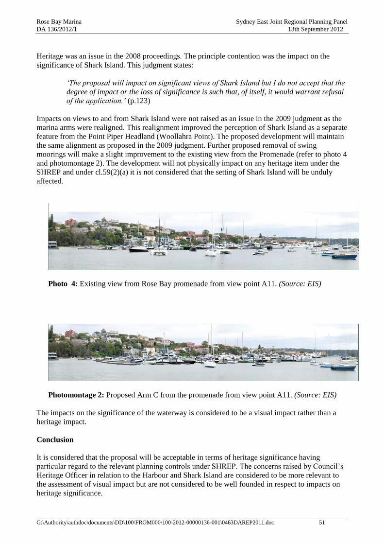
Rose Bay Marina Sydney East Joint Regional Planning Panel
DA 136/2012/1 13th September 2012
G:\Authority\authdoc\documents\DD\100\FROM000\100-2012-00000136-001\0463DAREP2011.doc 51
Heritage was an issue in the 2008 proceedings. The principle contention was the impact on the
significance of Shark Island. This judgment states:
„The proposal will impact on significant views of Shark Island but I do not accept that the
degree of impact or the loss of significance is such that, of itself, it would warrant refusal
of the application.‟ (p.123)
Impacts on views to and from Shark Island were not raised as an issue in the 2009 judgment as the
marina arms were realigned. This realignment improved the perception of Shark Island as a separate
feature from the Point Piper Headland (Woollahra Point). The proposed development will maintain
the same alignment as proposed in the 2009 judgment. Further proposed removal of swing
moorings will make a slight improvement to the existing view from the Promenade (refer to photo 4
and photomontage 2). The development will not physically impact on any heritage item under the
SHREP and under cl.59(2)(a) it is not considered that the setting of Shark Island will be unduly
affected.
Photo 4: Existing view from Rose Bay promenade from view point A11. (Source: EIS)
Photomontage 2: Proposed Arm C from the promenade from view point A11. (Source: EIS)
The impacts on the significance of the waterway is considered to be a visual impact rather than a
heritage impact.
Conclusion
It is considered that the proposal will be acceptable in terms of heritage significance having
particular regard to the relevant planning controls under SHREP. The concerns raised by Council‟s
Heritage Officer in relation to the Harbour and Shark Island are considered to be more relevant to
the assessment of visual impact but are not considered to be well founded in respect to impacts on
heritage significance.

Rose Bay Marina Sydney East Joint Regional Planning Panel
DA 136/2012/1 13th September 2012
G:\Authority\authdoc\documents\DD\100\FROM000\100-2012-00000136-001\0463DAREP2011.doc 52
16.2.4 Navigation
The following documents are relevant to the assessment of navigation impacts and are discussed
below:
letter from Greg Britton, director of Royal Haskoning, Rose Bay Marina Expansion-
Navigation and Related Aspects, dated 24 January 2012
report by Worley Parsons, Rose Bay Marina Redevelopment vessel navigation report,
dated October 2008 (WP navigation report) submitted as part of the EIS
response from Roads and Maritime Services
response from Sydney Ports
the 2008 judgment
Royal Haskoning letter
This letter reviews the potential navigation and other related issues of the proposed marina
extension. This letter also reviewed the WP navigation report. This letter has stated the following:
The proposed marina expansion would not impact on the “The runway”, the waterway
area between the seawall and the inner most swing moorings (a popular clear straight
section of waterway used by small craft)
The proposed new arm would not further impact the navigation routes of dragon boats
The risk associated with interaction between larger vessels using the marina and small
craft was reviewed extensively during the both 2008 and 2009 court cases. The Joint
Maritime Experts Report for the revised Rose Bay Marina (DA2008/682) included an
eastern arm with boats up to 30m in length concluded that the navigation risks could be
adequately addressed thought the preparation of an Emergency Management and
Resource Strategic Plan. Note: the applicant has prepared an Emergency Evacuation
Plan, and an EMP and berth and mooring holders are required a Marine Craft Berthing
& Mooring Agreement. These plans are in operation.
The deletion of the eastern arm from DA682/2008 was not due to any adverse
navigation or safety issues.
The proposed relocation of the fuelling, sewage pump-out to the north-western corner of
the western arm (Arm A) would provide better isolation of the fuel berth reducing the
risk that fire or explosion could spread to the marina berths or vice versa
The relocation of the casual berthing to the pontoon in front of the marina café where
approximately 20m berthing is available would provide a more suitable location as the
most demand for casual berthing is created by the marina café and the upstairs
restaurant. Note only 12m of casual berthing is available in this location.
WP navigation report
The WP navigation report was prepared and submitted as part of the previous development
application (DA682/2008), however this report is considered to be relevant to this application as the
previous application included a new eastern arm to the marina in a similar location. This report
identifies boat users of Rose Bay as rowing boats (Cranbrook School & Cranbrook Master Rowers),
surf club crews, dragon boats, kayaks, paddle boards, sailing dinghies and boats on existing marina
berths and swing moorings and commercial vessels (including Sydney Ferry services). Rowing
boats are said to use the „runway‟, the area adjacent to the promenade sea wall, particularly during
adverse conditions.

Rose Bay Marina Sydney East Joint Regional Planning Panel
DA 136/2012/1 13th September 2012
G:\Authority\authdoc\documents\DD\100\FROM000\100-2012-00000136-001\0463DAREP2011.doc 53
The WP navigation report recommended that a Plan of Management be developed, with reference
to the joint experts report prepared as part of the 2008 proceedings. The applicant has prepared an
Emergency Evacuation Report, and an EMP and berth and mooring holders are required to sign a
Marine Craft Berthing & Mooring Agreement. These plans are in operation.
Roads and Maritimes Services
Roads and Maritimes letter dated 14/05/2012 advises the following:
No objection, however the following comments are provided for Council‟s consideration:
The existing development provides opportunities for casual berthing. Casual berthing
facilitates access between the waterway and foreshore. Any extension should ensure that
at a minimum, a berthing area of 20m should be provided for the purpose of short term
drop-off and pick-up only
No permanent berthing being allowed at North West Corner of Arm A where the Fuel
and Sewage Pump out are to be located.
The applicant should ensure that reasonable access to the site is available during
construction.
The applicant must notify the Maritime Division of Roads and Maritime prior to the
removal of any commercial moorings.
There is an area that is 38m in length to the north-west of the proposed new berths available for
casual berthing facilities. This is a shared zone for both casual berthing and refueling and sewage
pump-out. There is an additional area of casual berthing available for vessels up to 12m in length at
the pontoon adjacent to the Marina Café. Conditions of consent could be recommended that
required the applicant to notify the RMS prior to the removal of any commercial moorings and to
ensure that no permanent berthing is permitted at the north western corner of Arm A.
Sydney Ports
The Sydney Ports letter dated 16/05/2012 advises the following:
Written approval of the Harbour Master is required for any proposed works that will
disturb the bed of the special port areas of Botany Bay and Sydney Harbour under Clause
67 of the Management of Waters and Waterside Land Lands Regulations‟
It should be noted that Sydney Ports have advised that Harbour Master Approval is sought after
consent is issued.
Addenbrooke judgement
Marine safety and navigation issues were discussed in the 2008 judgment. Biscoe J concluded this
discussion as follows:
„I consider that a plan of management, including a code of conduct, should be finalised
prior to any approval of an application such as this to ensure that the measures required
to ensure navigation safety and mitigate conflict are reasonably achievable. In the
absence of more research on the extent of the existing and proposed users of the Bay, it
maybe insufficient to assume that all boat owners will “do the right thing”.‟ (p.170)
Rose Bay Marina Sydney East Joint Regional Planning Panel
DA 136/2012/1 13th September 2012
G:\Authority\authdoc\documents\DD\100\FROM000\100-2012-00000136-001\0463DAREP2011.doc 54
The Joint Maritime Experts Report for the revised Rose Bay Marina (DA2008/682), which included
an eastern arm with boats up to 30m in length, concluded that the navigation risks could be
adequately addressed though the preparation of an Emergency Management and Resource Strategic
Plan. Whilst the applicant has not prepared an Emergency Management and Resource Strategic Plan
an Emergency Evacuation Report, and an EMP has been prepared and berth and mooring holders
are required to sign a Marine Craft Berthing & Mooring Agreement. These plans are in operation to
address navigation and safety issues. These plans require, among other things, that marina
customers have a current valid NSW Boat License (or equivalent) and for marina users to be
instructed not to exceed 4 knots around the marina and to navigate with caution in the main
shipping lanes. The Marine craft berthing, storage and mooring agreement covers a broad range of
matters relating to the responsibilities of the parties. Licencee obligations cover the mooring,
operation and storage of vessels. A condition of consent could be imposed that requires the
proposed marina expansion to be operated in accordance with these plans and agreement.
Another important user of the Rose Bay waterway is the seaplanes. The seaplane base is located at
Lyne Park. Council referred the proposal to the Civil Aviation Safety Authority (CASA) for
comment. No response was received. In relation to the 2008 proposal CASA advised that the
seaplanes are required to operate under a manual which places the responsibility for safety on the
operator.
Conclusion
The proposed reinstatement of Arm C would not result in any adverse navigational impacts and the
proposed relocation of the fuelling and sewage pump-out would be in an improved more isolated
location. Whilst the casual berthing will be reduced by the proposed development as 9 additional
berths are to be located to Arm A, sufficient casual berthing will be available at Rose Bay Marina.
Particularly as the majority of vessels that utilise the casual berthing facilities at the marina are 10m
or less in length.
16.2.5 Noise
Council‟s Environmental Health Officer has reviewed the proposed development and has
considered the proposed development would be acceptable in terms of construction noise as piling
will be installed using a screwing method and similar conditions of consent that were imposed for
the previous approved development (DA682/2008) could be imposed to further minimise
construction noise.
Council‟s Environmental Health Officer has considered the proposed development would be
acceptable in terms of noise from operational activities of the extended marina, subject to the
imposition of a condition of consent that requires the development to be operated in accordance
with the Noise Management Plan (NMP), Appendix D of the Environmental Management Plan.
This EMP was prepared in accordance with the conditions of consent of the previous approved
development for the redevelopment of Rose Bay Marina (DA 682/2008). The NMP seeks to ensure
that the amenity is preserved for local residents and marina users by controlling noise emissions and
other disturbing influences.
Appendix D to the EMP is a noise management plan. It contains specific rules for the
conduct/behavior of marina users and was developed from work done by the joint experts for the
Addenbrooke proceedings. However, it appears that a couple of the rules have been altered. These
pertain to the times of use of hand operated tools and the time for vessels to be vacated each night.
It is considered that these rules should be reinstated. The vacation of vessels is a potentially noisy
activity and it is not intended to prevent 24 hour access to vessels by their owners.

Rose Bay Marina Sydney East Joint Regional Planning Panel
DA 136/2012/1 13th September 2012
G:\Authority\authdoc\documents\DD\100\FROM000\100-2012-00000136-001\0463DAREP2011.doc 55
The EPA‟s integrated referral response identifies construction and operational noise as key
environmental issues. In relation to noise mitigation the EPA comments that the proponent is to
comply with the limits specified in Table 3.1 of the general terms of approval and that the EPA
intends to include a special condition on the applicants scheduled activity licence to undertake and
provide a noise assessment report if the development is approved.
The SHDCP, cl.4.7 provides as follows in relation to noise associated with marinas:
the adverse impacts of noise (considering hours of operation existing background noise,
expected departure/arrival times for vessels, noise level of marina patrons, noise level from
repair and testing of vessels and motors) are to be minimized through appropriate design
and management measures, and ……
Conclusion
The adjoining land use is predominantly residential. Noise impacts in this situation will be primarily
influenced by the noise source, the ambient noise and the distance to adjoining properties. Based on
the available information the construction and operation of the proposed development will not
unreasonably impact on the amenity of neighbouring properties and accord with the relevant criteria
under the SHDCP, subject to appropriate conditions that could be imposed.
17. THE SUITABILITY OF THE SITE
Site suitability issues have been addressed under part 16.2.2 of this report. The conclusion that the
site can be made suitable for marina purposes usage is supported by the site audit report prepared by
Environ. The site audit report states that the site can be made suitable for use as a marina subject to
the implementation of the EMP.
The area to be developed has a history of marina and boat storage use and marinas are a permissible
use under the SHREP zoning, i.e. W5 – Water Recreation. However the visual impacts of the
proposed eastern arm have been considered to be unacceptable. The subject site is therefore
considered to be unsuitable for the proposed development.
18. THE PUBLIC INTEREST
In the Land & Environment Court judgement, Double Bay Marina v Woollahra Council [2009]
NSWLEC 1001, (Double Bay Marina) Roseth SC set out a planning principle for discerning the
public interest. Although the planning principle was intended to apply to the assessment of all DAs,
it is particularly relevant to this proposal as it also related to a proposed marina development.
It is noted that the planning principle set out in the Double Bay Marina judgement has not been
adopted by the Land & Environment Court as a planning principle. Advice from the Court suggests
it will not be adopted as a planning principle. Nevertheless, the judgement does set out a
methodology for assessing public interest that is considered to be of some relevance and is therefore
discussed below. However, caution needs to be exercised in drawing conclusions from application
of the process considering it has no formal status as an adopted Land and Environment Court
planning principle.
There are also matters contained in the 2008 judgment which assist in assessing public interest
issues relating to the current DA. These are also discussed in this assessment.

Rose Bay Marina Sydney East Joint Regional Planning Panel
DA 136/2012/1 13th September 2012
G:\Authority\authdoc\documents\DD\100\FROM000\100-2012-00000136-001\0463DAREP2011.doc 56
The Double Bay Marina judgement sets out 3 steps for discerning the public interest in the
assessment of a development proposal:
1. define the public whose interest is being invoked
2. define the benefit towards which a proposal claims to make a contribution (or from which it
is claimed to detract)
3. make explicit the weight given to the public interest relative to other considerations
Who is the public?
In Double Bay Marina the Senior Commissioner stated that „the public‟ requires redefinition in
every case.
……the public may be all people in the world. At its narrowest, the public may be the
people who live or work in a locality or a business centre or use a public facility, such as
a park or a beach. (p.48)
Councils often confuse the public interest with the complaints of individual objectors. In
most cases the interest of objectors is a private interest. The fact that the number of
objectors is large does not, by itself, render their interest public. For the interest of
objectors to be equated with the public interest, the objectors must be identifiable as a
section of the public as described above. The fact that their number may be small (for
example the users of a park), does not deny the public nature of their interest. (p.49)
In applying this step in Double Bay Marina the Senior Commissioner states:
In my opinion, the loss of these views (from the ground floor of some 10-20 dwellings) is
a private detriment. The owners or occupants of those dwellings do not constitute the
“public” or even a “section of the public”. They are a collection of private interests. (p.54)
In support of its contention that the renewal of the marina represents a private interest,
the council tendered the Articles of Association of the applicant company. Even without
the Articles of Association (which seem little different from those of other private business
organisation) it seems clear that the application serves a private rather than the public
interest. The berths will be available for purchase under Strata title. This is no different
from an apartment building. …… (p.56)
Applying the Senior Commissioner‟s approach to the current proposal, the public is considered to
be the users of the nearby public domain areas. These areas are specifically considered to be New
South Head Road between Lyne Park and Wunulla Road, Wunulla Road between New South Head
Road and the Point Piper marina, the promenade, Rose Bay Park and Beach, Lyne Park and the
waters of Rose Bay.
The people who made submissions opposing the DA are considered to be the public only if they are
also users of the public domain areas referred to above. However, some of the issues raised in some
of the submissions relate to matters of public interest, e.g. the loss of Harbour views from areas of
the promenade. Similarly the holders of marina berths and moorings are considered to be the public
only if they are also users of the public domain areas. Otherwise those people who made
submissions or are holders of marina berths or moorings are considered to represent private
interests.

Rose Bay Marina Sydney East Joint Regional Planning Panel
DA 136/2012/1 13th September 2012
G:\Authority\authdoc\documents\DD\100\FROM000\100-2012-00000136-001\0463DAREP2011.doc 57
What is the benefit/detriment?
The Double Bay Marina judgement states:
The next step is to make explicit the benefit to which a proposal contributes or from which
it detracts. Where the detriment or benefit can be quantified, this should be done;
however, not all benefits lend themselves to accurate measurement. Moreover, not all
benefits are universally recognised as benefits. In the case of some benefits there is likely
to be general agreement that they are benefits. …… When it comes to changing a view
composed of natural elements of the landscape into one dominated by man-made
elements, the benefit-detriment debate becomes less clear-cut, though most people would
prefer natural landscapes. …… Where there are competing and feasible claims whether a
proposal contributes to or detracts from the public interest, there is no option for the
decision-maker but to make a subjective choice between them. (p. 50)
In applying this step in Double Bay Marina the Senior Commissioner referred to the loss of view
from the beach as follows:
…… the loss of views from the intertidal beach between the marina and the private jetty at
the end of Beach Street constitutes a diminution of the public interest, in other words it is
a public detriment. (p.53)
He considered that provision of the proposed marina facilities …… serves a private rather than the
public interest. This followed an acknowledgement of the Double Bay Marina‟s Articles of
Association although they did not seem to significantly influence the Senior Commissioner‟s
opinion, refer to the earlier quote from p. 56.
At the conclusion of p.56 the Senior Commissioner goes on to say:
…… I accept, however, that a minor part of the application, the provision of disabled
facilities (that proposal included alterations to create a disabled toilet, installation of
approved lifting devices for transferring disabled people to and from vessels and access
for Sailability Australia activities), is in the public interest.
It should be noted that the Double Bay marina proposal also included sewage pump out and fuel
and water available to the public, tender service available for public use and public access onto the
marina. These proposed features are not specifically referred to in the judgement. It is presumed
that they were considered to be benefits for the marina users rather than for the general public. This
presumption is considered to be supported by the following comment:
the provision of improved mooring facilities for the future users of the existing marina,
which is a private benefit. (p. 58)
In relation to the inclusion of swing moorings into marina berths the Senior Commissioner
commented as follows:
The conversion of swing moorings into marina berths therefore increases the area of
water available for navigation. Against this is the consideration that the visual impact of a
swing-moored boat is much less than that of a boat berthed in a marina …… . Therefore if
one considers ease of navigation more important than visual impact, the conversion of
swing moorings to marina berths is a public benefit; while, if one adopts the opposite
position, it becomes a public detriment. (p.57)
Rose Bay Marina Sydney East Joint Regional Planning Panel
DA 136/2012/1 13th September 2012
G:\Authority\authdoc\documents\DD\100\FROM000\100-2012-00000136-001\0463DAREP2011.doc 58
The competing public and private interests were summarised as:
view loss from the intertidal beach, which is a public detriment;
the provision of disabled facilities in the renewed marina, which is a public benefit;
the significant loss of views of ten to twenty dwellings behind the intertidal beach, which
is a private detriment;
the provision of improved mooring facilities for the future users of the existing marina,
which is a private benefit. (p. 58)
Applying the Senior Commissioner‟s approach to the current proposal, the impact on the outlook of
people using New South Head Road, the promenade and Rose Bay Park and beach is a public
detriment. Provision of a public viewing platform and seating would be a public benefit. The loss of
amenity, including views, from properties on the southern side of New South Head Road and
Wunulla Road would represent a private detriment. The improved mooring facilities would be a
private benefit.
Weighing up the public interest
In Double Bay Marina the Senior Commissioner discussed this step as follows:
The final and most difficult step is the ranking of the various interests. This may require
weighting one public interest against another or balancing the public interest against private
interests. Although only few planning instruments contain a statement that the public interest is
paramount, in planning decisions, other things being equal, the public interest overrides the
private interest. However, other things are rarely equal, and where a public detriment is minor,
a major private benefit may take precedence over it. (p. 51)
The hardest conundrum occurs when the decision-maker must choose between competing
public interests. …… In these cases the decision makers cannot avoid making value judgements
but they owe it to the readers of their judgement to make the value judgements explicit. (p. 52)
In applying this step the Senior Commissioner said:
It seems to me that the two matters that determine the fate of this application are the weight one
gives to the loss of views from the intertidal beach and the balancing of the private benefit of
better boat accommodation against the private detriment of view loss from the dwellings behind
the intertidal beach. (p. 59)
In my opinion, the public interest of preserving the views from the intertidal beach, because of
its low accessibility, should be given moderate weight. Even so, it outweighs the public benefit
of providing disabled facilities in the new marina, which is likely to be used by a very small
number of people. (p. 60)
The nature of the benefit and detriment greatly influences the balancing of the private interest
of boat owners against the private detriment of the occupants of the affected dwellings. The
interest of boat owners is to have more up-to-date accommodation for their boats. The
detriment to the occupants of the dwellings is to deprive them of their water view, which is
probably the amenity they value the highest in their dwelling. It seems to me the loss of water
views is a devastating (and, in a waterfront dwelling, unexpected) experience. (p.61)
In weighting the public interest in the current application, the SHREP, cl.2(2) under Aims of the
plan, relevantly provides:
Rose Bay Marina Sydney East Joint Regional Planning Panel
DA 136/2012/1 13th September 2012
G:\Authority\authdoc\documents\DD\100\FROM000\100-2012-00000136-001\0463DAREP2011.doc 59
(2) For the purpose of enabling these aims to be achieved in relation to the Foreshores and
Waterways Area, this plan adopts the following principles:
(a) Sydney Harbour is to be recognised as a public resource, owned by the public, to be
protected for the public good,
(b) the public good has precedence over the private good whenever and whatever change
is proposed for Sydney Harbour or its foreshores,
(c) protection of the natural assets of Sydney Harbour has precedence over all other
interests.
It is clear that this provision strongly underpins the Senior Commissioner‟s view that …… the
public interest overrides the private interest.
The impact on views from the promenade and New South Head Road must rate higher than the
intertidal beach at Double Bay (considered by the Senior Commissioner to be moderate) because
the promenade and New South Head Road are highly accessible to the public. Similarly Rose Bay
Beach and Park are comparatively more accessible than the intertidal beach although not used by
the same volumes of people who use the promenade and New South Head Road.
North-westerly views from the promenade of Woollahra Point and Shark Island will be maintained
by the proposed reinstatement of the eastern arm (Arm C).
The proposed Arm C under this proposal has reduced the length of the boats from a maximum of
30m and has reduced the height of the boats from a maximum of 7m to 3.5m. These reductions to
the size and height of the boats has a reduced visual impact than the visual impact of the Arm C
previously proposed under DA682/2008 as views of Manly and some waterway views will be
maintained over the top of the boats. However the foreground views up to Manly will still be
obstructed. Further these views of Manly will be obstructed when the viewer has an eyeline less
than 1.55m. Therefore the proposal is not considered to overcome the central visual issue as stated
by Biscoe J in his 2009 judgment as Biscoe J:
„What is important, in my opinion, is the expansive view of the Harbour and its headlands
as far as Manly, rather than a view specifically of particular features of Manly‟.
Views from the promenade and New South Head Road in a north easterly direction presently
include the expanse of the Vaucluse headland, including the shoreline, from Steele Point to Lyne
Park. Impacts on these views were not raised as an issue in the 2009 LEC proceedings. The
proposed reduction to the length and height of the boats to the proposed Arm C will have a reduced
visual impact than the Arm C that was proposed under DA682/2008.
The proposed marina expansion will not result in any further narrowing of the gap between Rose
Bay and Point Piper marinas, therefore the existing north-easterly views toward Vaucluse including
parts of the shoreline, the treed hillside and the ridge will be maintained. The additional 10m berths
to existing Arm A do not extend beyond the alignment of the existing T-head to Arm A and are
located directly in front of existing marina berths that can accommodate boats up 20m in length.
Therefore these berths would not adversely affect the visual amenity of Rose Bay Beach and Park.
This final step for discerning public interest as set out in the Double Bay marina judgement is to
weigh the public disbenefits, as described above, against the public benefits. The public benefit in
the case of Double Bay Marina was considered by the Senior Commissioner to be limited to the
provision of facilities for use by people with a disability. The current proposal includes the

Rose Bay Marina Sydney East Joint Regional Planning Panel
DA 136/2012/1 13th September 2012
G:\Authority\authdoc\documents\DD\100\FROM000\100-2012-00000136-001\0463DAREP2011.doc 60
provision of a public view platform and seating. The previous development application for the
redevelopment of the marina included the provision of unassisted disabled access.
Other proposed public benefits referred to in the EIS are:
public access to marina walkways during business hours
better access to the Harbour for small craft
casual berthing for public use
facilities will be clear of seagrass beds
removal of swing moorings will have a benefit to the marine ecology
Essentially these other „public benefits‟, as they are referred to in the EIS, were features of the
Double Bay proposal. However, they were not referred to by the Senior Commissioner as public
benefits. This is presumably because they were seen to benefit the marina users or other private
interests or perhaps because they were benefit neutral.
The 2009 judgment makes references to general benefits of facilities intended by that proposal:
General benefits of the proposals include public access to the walkways of the marinas
during normal business hours; a public viewing platform at the RBM; casual berthing for
the general boating public; toilets available to the general public during business hours;
fuelling and pump-out facilities for the general boating public; upgraded boating
facilities; the provision of a navigation channel between the marinas; a reduced marina
“footprint” through a reduction in swing moorings (although there is a greater
concentration of boats creating a greater visual mass), and reduction in the ecological
impact of swing moorings (chain drag impact on sea grasses). For the RBM only, the
development will also provide benefits for improved (unassisted) disabled access
including to Rose Bay Park and disabled access to vessels through the provision of a
person hoist. (p.72)
Out of the features referred to above the proposed development will provide the benefit of a reduced
marina footprint and improved ecological impacts due to the reduction to the amount of swing
moorings. However the proposed development will have an unacceptable visual impact on the Rose
Bay Promenade which is a highly used and significant area.
The private disbenefits relate primarily to view loss from properties on the southern side of New
South Head Road between the marina building and Salisbury Road. These view impacts are, at their
worst, moderate. It is not considered that view impacts on private properties would be unacceptable.
Conclusion
Although this assessment has endeavoured to quantify the benefits and disbenefits, in the words of
Roseth SC, in this case it is considered that …… there is no option for the decision-maker but to
make a subjective choice. However, the foregoing discussion is considered to make the benefits and
disbenefits explicit.
Even though the viewing platform would create new views to and from the harbour the viewing
platform is considered to be of limited public benefit as the views towards Manly are constricted
views. Also given its location, the viewing platform would be unlikely to be highly used,
particularly, in comparison to the level of usage of the promenade. However the proposed public
disbenefit associated with loss of visual amenity from the promenade and New South Head Road is
not considered to outweigh the public benefit of providing public viewing platform and seating to

Rose Bay Marina Sydney East Joint Regional Planning Panel
DA 136/2012/1 13th September 2012
G:\Authority\authdoc\documents\DD\100\FROM000\100-2012-00000136-001\0463DAREP2011.doc 61
be located between Arms B and C. Therefore the provision of this viewing platform is not
considered to provide sufficient public benefit to outweigh the view loss and loss of visual amenity
from the promenade.
Likewise the public disbenefit of view loss from the promenade and New South Head Road would
not be offset by the public benefits associated with a reduced marina footprint and improved
ecological impacts due to the reduction to the amount of swing moorings. Also swing moorings are
considered to contribute to the character of the views obtained from these areas.
The private benefits to boat owners, through improved boating facilities, is not of sufficient weight
to justify the introduction of an eastern arm to the marina nevertheless, the private disbenefits to the
owners of individual properties in terms of loss of amenity/views is not considered to be of
sufficient weight to justify rejection of the DA.
The proposal is not considered to be satisfactory in terms of the public interest.
19. ECOLOGICALLY SUSTAINABLE DEVELOPMENT (ESD)
Section 5(a)(vii) of the EPA Act provides that an objective of the Act is to encourage ESD. Under
s.79C(1)(e) of the EPA Act consideration of the public interest is required if it is relevant to the
development. Whether this development is ESD is a matter for consideration.
Section 8 of the Local Government Act 1993 contains a charter for Councils, i.e. a set of principles
that are to guide a council in the carrying out of its functions. S.8(1) includes:
8 The council‟s charter
(1) A council has the following charter:
……
• to properly manage, develop, protect, restore, enhance and conserve the environment of
the area for which it is responsible, in a manner that is consistent with and promotes the
principles of ecologically sustainable development (emphasis added)
There are a number of Land & Environment Court cases involving ESD principles. BGP Properties
Pty Limited v Lake Macquarie City Council [2004] NSWLEC399 (12 August 2004) and Telstra
Corporation v Hornsby Shire Council [2006] NSWLEC 133 are among those more frequently
referenced. These judgements explain the concept of the precautionary principle, its constituent
elements and an analytical framework for its application, including in NSW environmental and
planning laws.
ESD in its most basic formulation is “development that meets the needs of the present without
compromising the ability of future generations to meet their own needs” (World Commission on
Environment and Development, Our Common Future, 1987 p.44, also known as the Brundtland
Report).
Mandatory issues for an EIS are included in schedule 2 of the EPA Reg. They include reasons
justifying the development including the following principles of ESD:
a. precautionary principal
b. inter-generational equity
c. conservation of biological diversity and ecological integrity
d. improved valuation, pricing and incentive mechanisms

Rose Bay Marina Sydney East Joint Regional Planning Panel
DA 136/2012/1 13th September 2012
G:\Authority\authdoc\documents\DD\100\FROM000\100-2012-00000136-001\0463DAREP2011.doc 62
Part 9.4 of the EIS comments on these ESD principles. Each of the ESD principles is discussed
below. The comments rely on assessments and conclusions reached earlier in the report. They have
not been reproduced in this part to avoid repetition.
Precautionary principle
Meaning
This means if there are threats of serious or irreversible environmental damage, lack of full
scientific certainty should not be used as a reason for postponing measures to prevent environmental
degradation.
EIS
The applicant maintains that:
the environmental impacts associated with the development can be identified and quantified
to an adequate degree
the impacts can be mitigated and are reversible
redevelopment of the site will have a beneficial outcome
there are no significant risks arising to community health.
Comment
Various scientifically based documents have been used to assess the environmental impacts of the
proposal, e.g. aquatic ecology, sediment quality, noise/vibration. These have established the likely
environmental impacts of the development. It is concluded that the proposal does not pose a threat
of serious or irreversible environmental damage. Precautions to avoid environmental damage can
effectively be implemented through the imposition of consent conditions.
Inter-generational equity
Meaning
This means that the present generation should ensure that the health, diversity and productivity of
the environment are maintained or enhanced for the benefit of future generations.
EIS
The applicant maintains the marina, which aims to provide boat storage facilities and services to
meet demand and incorporate best practice environmental controls, is consistent with the
objectives of social equity including intergenerational equity. In particular the development aims to
ensure that the environment of Rose Bay is maintained or enhanced for the benefit of future
generations.
Comment
The applicant‟s reference to the provision of boat storage facilities in noted. However, the
incorporation of best practice controls is more appropriately associated with environmental
considerations. The proposal will continue historical use of west Rose Bay for marina purposes. It
has been concluded that biological impacts are either satisfactory or manageable.
The change in the visual appearance of Rose Bay from sections of the promenade would impact on
future (and current) generation‟s perception and appreciation of the Bay‟s aesthetic qualities.
Although this raises inter (and intra)-generational equity issues it does not go to the health, diversity
and productivity of the environment.
Inter-generational principles are considered to be satisfactory.

Rose Bay Marina Sydney East Joint Regional Planning Panel
DA 136/2012/1 13th September 2012
G:\Authority\authdoc\documents\DD\100\FROM000\100-2012-00000136-001\0463DAREP2011.doc 63
Conservation of biological diversity and ecological integrity
Meaning
Conservation of biological diversity and ecological integrity should be a fundamental consideration.
EIS
The applicant maintains that impacts on flora and fauna will be minimal and in some cases positive.
The proposal should enhance biological diversity and ecological integrity through provision of
additional habitat (on floating marine pontoons) and reduced seagrass damage through the
relocation of swing moorings.
Comment
It is agreed that the proposal will conserve biological diversity and ecological integrity. Biological
and ecological impacts are discussed under part 16.2.2, Ecology.
Improved valuation, pricing and incentive mechanisms
Meaning
Environmental factors should be included in the valuation of assets and services, e.g. polluter pays.
Environmental goals should be pursued in the most cost effective way.
EIS
The applicant maintains that the value of the environmental resources affected by the proposal has
been acknowledged and provided for through the examination of environmental consequences of
the proposal and identification of mitigation measures to address potential impacts, including any
short term construction impacts.
Comment
Pricing mechanisms in relation to matters such as waste disposal, electrical power and fuel
consumption factor environmental levies. The cost of managing environmental protection can be
transferred to the applicant through consent conditions.
Conclusion
The proposal is considered to be satisfactory when assessed against the principles of ESD.
20. CONCLUSION
The principle planning instrument for the assessment of this proposed development is the SHREP.
It was prepared by the Department of Planning, rather than by Council, in accordance with the
provisions of part 3 of the EPA Act. Its objectives reflect the State Government‟s aspirations for
Sydney Harbour. The SHREP applies to development throughout Sydney Harbour and not just that
part of the Harbour which for which Woollahra Council is the consent authority. It therefore needs
to be applied by a number of Harbour councils which have control over different parts of the
waterway.
In relation to boat storage, the zonings under the SHREP permit commercial marinas in most of the
waterway. The W5 zoned waterway areas, which applies to most of Rose Bay west, represents the
main areas where commercial marina development is likely to occur. However, land uses adjacent
to the W5 zoned areas vary, e.g. adjacent land use in Rose Bay west is primarily residential whereas
in an area such as Rozelle Bay it is industrial. Impacts of commercial marina development on
adjacent areas will therefore vary. The matters for consideration under the SHREP acknowledge

Rose Bay Marina Sydney East Joint Regional Planning Panel
DA 136/2012/1 13th September 2012
G:\Authority\authdoc\documents\DD\100\FROM000\100-2012-00000136-001\0463DAREP2011.doc 64
this and it is clear that what may be an acceptable form of development in a particular area of the
waterway zoned W5 may not be acceptable in another area with the same zoning.
In relation to this proposal we have the benefit of the both judgments handed down by Biscoe J in
the Addenbrooke cases for redevelopment schemes for both the Rose Bay and Point Piper marinas.
This report finds that the proposed additional Arm C is not consistent with, and is unacceptable
having regard to, the provisions of the SHREP and its related DCP (SHDCP) that concern visual
impact.
There are other matters relating to protection of the environment and the amenity of neighbouring
properties which could be overcome by imposing specific conditions.

Rose Bay Marina Sydney East Joint Regional Planning Panel
DA 136/2012/1 13th September 2012
G:\Authority\authdoc\documents\DD\100\FROM000\100-2012-00000136-001\0463DAREP2011.doc 65
21. RECOMMENDATION
THAT the Joint Regional Planning Panel, as the consent authority, refuse development consent to
DA 136/2012/1 for extension to Rose Bay Marina comprising of:
- An additional 9 x 10m berths on existing Arm A
- The addition of a new marina arm (Arm C) which is proposed to be a floating pontoon
system accommodating 37 x 15m berths. The height of vessels to be berthed on the new
Arm C is proposed to be limited to 3.5m in height
- A new walkway connecting Arms B and C incorporating a viewing platform and bench
seat
- Retention of 24 commercial swing moorings
on land at 594-596 New South Head Road ROSE BAY, for the following reasons:
1. The proposal is inconsistent with and unacceptable having regard to the aims of the
Sydney Regional Environmental Plan (Sydney Harbour Catchment) 2005 (deemed State
Environmental Planning Policy), contained in clause 2(1)(a), having particular regard to
the principles set out in clause 2(2).
2. The proposal is inconsistent with and unacceptable having regard to objectives (d) and (g)
of the W5 – Water Recreation zone of the Sydney Regional Environmental Plan (Sydney
Harbour Catchment) 2005 (deemed State Environmental Planning Policy).
3. The proposal is inconsistent with and unacceptable having regard to clauses 25(b) and (c) -
Foreshore and waterways scenic quality of the Sydney Regional Environmental Plan
(Sydney Harbour Catchment) 2005 (deemed State Environmental Planning Policy).
4. The proposal is inconsistent with and unacceptable having regard to Clause 26 -
Maintenance, protection and enhancement of views of the Sydney Regional Environmental
Plan (Sydney Harbour Catchment) 2005 (deemed State Environmental Planning Policy).
5. The proposal is inconsistent with and unacceptable having regard to part 3.2 (1st and 2
nd
dot points), part 4.2 (8th
dot point) and part 4.7 – Marinas (Private and Commercial);
Visual Impact (2nd
and 5th
dot points) of the Sydney Harbour and Waterways Area
Development Control Plan 2005.
6. The proposal is not in the public interest.
Mrs L Holbert Mr P Kauter
ASSESSMENT OFFICER EXECUTIVE PLANNER

Rose Bay Marina Sydney East Joint Regional Planning Panel
DA 136/2012/1 13th September 2012
G:\Authority\authdoc\documents\DD\100\FROM000\100-2012-00000136-001\0463DAREP2011.doc 66
ANNEXURES
1. Plans
2. Traffic Engineer Referral Response
3. Heritage Officer Referral Response
4. Urban Design Officer Referral Response
5. Environmental Health Officer Referral Response
6. Fire Safety Officer Referral Response
7. Public Open Space Referral Response
8. Environmental Sustainability comments
9. NSW Primary Industries-general terms of approval
10. NSW EPA- general terms of approval
11. Heritage Council of NSW comments
12. Foreshore & Waterways Planning & Development Advisory Committee comments
13. NSW Office of Water comments
14. NSW Fire Brigades comments
15. Roads & Maritime Services comments
16. Sydney Ports comments
17. Compliance Table SHREP
18. Compliance Table SHDCP
19. Names and address of objectors