development and application of a general-use mapping tool for relief and reconstruction activities...
TRANSCRIPT

NIE
D B
OSA
I-D
RIP
Na
tion
al R
ese
arc
h In
stitu
te fo
r Ea
rth
Sc
ien
ce
an
d D
isast
er P
reve
ntio
n, D
isast
er R
isk In
form
atio
n P
latf
orm
Pro
jec
t
BOSAI-DRIP
Hitoshi Taguchi, Yuichiro Usuda, Tai-young Yi, Yohei Sunaga, Hiroaki Tsubokawa, Toshinari Nagasaka
National Research Institute for Earth Science and Disaster Prevention (NIED)
Tsukuba, Japan
Development and applica/on of a general-‐use mapping tool for relief and reconstruc/on
ac/vi/es a6er March 11
1
Geoinformatics 2012

NIE
D B
OSA
I-D
RIP
Na
tion
al R
ese
arc
h In
stitu
te fo
r Ea
rth
Sc
ien
ce
an
d D
isast
er P
reve
ntio
n, D
isast
er R
isk In
form
atio
n P
latf
orm
Pro
jec
t
BOSAI-DRIP 0. Outline 1. Introduc1on 2. Requirements of GIS for Disaster Relief 3. Case study: the Great East Japan
Earthquake in 2011 » Used GIS and Data » Disaster Volunteer Center (Miyagi Pref.)
4. Discussions 5. Conclusions and Future works
2

NIE
D B
OSA
I-D
RIP
Na
tion
al R
ese
arc
h In
stitu
te fo
r Ea
rth
Sc
ien
ce
an
d D
isast
er P
reve
ntio
n, D
isast
er R
isk In
form
atio
n P
latf
orm
Pro
jec
t
BOSAI-DRIP 1. Introduc1on
n History of GIS for disaster relief in Japan
n How to have people on disaster site u1lize various geo-‐spa1al data and GIS for disaster relief? » We propose two technical requirements.
3
Southern Hyogo Prefecture Earthquake (1995) -‐ Start of GIS for visualiza1on
The Mid Niigata Pref. Earthquake (2004) -‐ Aggregated various GIS data
The Niigata Pref. Chuetsu-‐oki Earthquake (2007) -‐ Created thema1c maps by GIS experts on disaster site

NIE
D B
OSA
I-D
RIP
Na
tion
al R
ese
arc
h In
stitu
te fo
r Ea
rth
Sc
ien
ce
an
d D
isast
er P
reve
ntio
n, D
isast
er R
isk In
form
atio
n P
latf
orm
Pro
jec
t
BOSAI-DRIP 2. Requirements of GIS for Disaster Relief 1. Interoperability of GIS data
» Sharing of Geo-‐spa1al data, both within and across organiza1ons, depends on accepted standard I/F.
» If agencies, ins1tu1ons and companies share maps on interna1onal standard I/F, users on disaster site can overlay many kind of shared maps on their GIS.
4
Internet
GIS client
Standard I/F of GIS data services
…WMS: Web Mapping Service (ISO-19128)
…WFS: Web Feature Service
(ISO-19142)
…WCS: Web Coverage Service (ISO-191xx)
International Standard I/F for GIS Data Image data (jpg, png, gif,)
Vector data (point, line, polygon)
Mesh data
Disaster site

NIE
D B
OSA
I-D
RIP
Na
tion
al R
ese
arc
h In
stitu
te fo
r Ea
rth
Sc
ien
ce
an
d D
isast
er P
reve
ntio
n, D
isast
er R
isk In
form
atio
n P
latf
orm
Pro
jec
t
BOSAI-DRIP 2. Requirements of GIS for Disaster Relief 2. Web-‐GIS as a mapping tool
» Any PC ,which is linked to the internet, can immediately start to use GIS. » Easy to remote enhancement and maintenance, from non-‐disaster site. » General func1ons such as registra1on, spa1al or a_ribute query and
prin1ng are required.
» The users can obtain GIS data from the Internet on standard I/F, create thema1c maps by overlaying shared map using Web-‐GIS.
5
……………………………..………….
Internet
Web-GIS Server
A user on disaster site
Remote Supporter
WMS
KML
WMS
GIS on web browser

NIE
D B
OSA
I-D
RIP
Na
tion
al R
ese
arc
h In
stitu
te fo
r Ea
rth
Sc
ien
ce
an
d D
isast
er P
reve
ntio
n, D
isast
er R
isk In
form
atio
n P
latf
orm
Pro
jec
t
BOSAI-DRIP 3. Case study: Great East Japan Earthquake (March 11, 2011)
n h_p://www.flickr.com/photos/rinkratz/5517580640/in/photostream/ 6

NIE
D B
OSA
I-D
RIP
Na
tion
al R
ese
arc
h In
stitu
te fo
r Ea
rth
Sc
ien
ce
an
d D
isast
er P
reve
ntio
n, D
isast
er R
isk In
form
atio
n P
latf
orm
Pro
jec
t
BOSAI-DRIP Web-‐GIS n “e-‐Community Map” developed by NIED (2009).
» Developed based on Free and Open Source Software for Geospatial (FOSS4G).
» Provides the basic func1ons of GI and Uses interna1onal standard system interfaces for GIS data, including WMS, WFS, and KML.
7
Users - Mapping
Internet
Government,
Institutes,
Companies,
WMS, WFS, KML
e-Community Map

NIE
D B
OSA
I-D
RIP
Na
tion
al R
ese
arc
h In
stitu
te fo
r Ea
rth
Sc
ien
ce
an
d D
isast
er P
reve
ntio
n, D
isast
er R
isk In
form
atio
n P
latf
orm
Pro
jec
t
BOSAI-DRIP GIS Data n Searched the GIS data and base maps for thema1c maps. n Some agencies and companies provided raw data, while other data was
obtained in WMS or KML format.
n Many kinds of maps were published that users could access immediately through an interoperable Web-‐GIS 8
GSI • Post disaster Aerial Photo
AIST(GEO Grid) ・Satellite imagery “ASTER” ・Earth Quake intensity map
JAXA(ALOS) ・Sa_ellite Imagery
NTT ・Pre-‐disaster road map and aerial map
Road Traffic ・HONDA ・Toyota ・Miyagi Pref.
・OpenStreetMap ・Google MyMap -‐food spot -‐evacua1on map
Standard I/F of GIS data on Web (WMS, WFS, KML)
Zenrin ・Residen1al map
NIED ・J-‐SHIS
JMA ・Weather informa1on
The Associa/on of Japanese Geographers ・Tsunami damaged area map
GIS
Geospatial information Authority
Japan Meteorological Agency
The raw data was published on WMS by authors.

NIE
D B
OSA
I-D
RIP
Na
tion
al R
ese
arc
h In
stitu
te fo
r Ea
rth
Sc
ien
ce
an
d D
isast
er P
reve
ntio
n, D
isast
er R
isk In
form
atio
n P
latf
orm
Pro
jec
t
BOSAI-DRIP GIS Data: Residen1al map & Aerial photo
9

NIE
D B
OSA
I-D
RIP
Na
tion
al R
ese
arc
h In
stitu
te fo
r Ea
rth
Sc
ien
ce
an
d D
isast
er P
reve
ntio
n, D
isast
er R
isk In
form
atio
n P
latf
orm
Pro
jec
t
BOSAI-DRIP GIS Support at Volunteer Center in Miyagi Pref. (1/2)
n Disaster volunteer center (VC) in Japan: » Run by local governmental social welfare council. » Dispatch individual volunteers to places of the ci1zens' needs.
n Timeline
» Authors went to Miyagi Prefectural social welfare council at 14th March. • Start to set up Web-‐GIS and CMS, recruit volunteers who support to trea1ng Web-‐GIS and CMS.
» Started to use since 16th March
10
Accepting citizen’s needs, and volunteers. Showing a volunteer the place to go by map.

NIE
D B
OSA
I-D
RIP
Na
tion
al R
ese
arc
h In
stitu
te fo
r Ea
rth
Sc
ien
ce
an
d D
isast
er P
reve
ntio
n, D
isast
er R
isk In
form
atio
n P
latf
orm
Pro
jec
t
BOSAI-DRIP
Miyagi Pref. VC
Kesen-numa VC
Minami-SanrikuVC
Ishinomaki VC
Shichigahama VC
Natori VC
Higashi-Matsushima VC
Sendai VC
Iwanuma VC
Tagajou VC
Shiogama VC
Watari VC
Yamamoto VC
Note-‐PCs and data communica1on terminals � Plo_ers and Printers �The CMS (e-‐community group
ware) has group web pages.
GIS Support at Volunteer Center in Miyagi Pref. (2/2)
Each VC has group page for publicity.
← Web page
↓Web-‐GIS e-‐Community Map
11
http://msv3151.c-bosai.jp/
Each municipality’s VC has …
NIE
D B
OSA
I-D
RIP
Na
tion
al R
ese
arc
h In
stitu
te fo
r Ea
rth
Sc
ien
ce
an
d D
isast
er P
reve
ntio
n, D
isast
er R
isk In
form
atio
n P
latf
orm
Pro
jec
t
BOSAI-DRIP
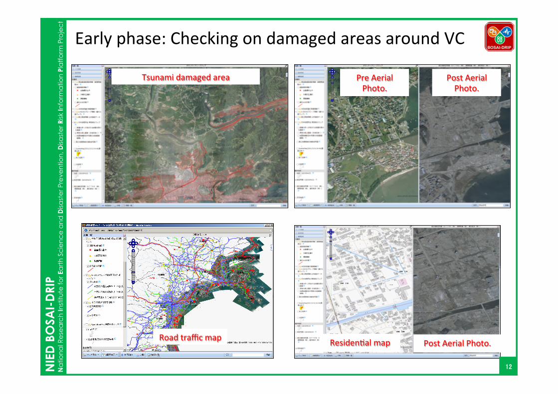
Pre Aerial Photo.
Post Aerial Photo.
Tsunami damaged area
Residen1al map Post Aerial Photo.
Early phase: Checking on damaged areas around VC
12
Road traffic map

NIE
D B
OSA
I-D
RIP
Na
tion
al R
ese
arc
h In
stitu
te fo
r Ea
rth
Sc
ien
ce
an
d D
isast
er P
reve
ntio
n, D
isast
er R
isk In
form
atio
n P
latf
orm
Pro
jec
t
BOSAI-DRIP Thema1c Maps Created by Each VC No VCs Created Maps on e-‐Community map
1 Miyagi Pref. Delivery of large printed maps to coastal VCs, management of Web-‐GIS
2 Ishinomaki Evacua1on center map, Meal service map, Temporary housing map, Ra1oning(food) service map, Volunteer-‐assistance request map
3 Shiogama Volunteer-‐assistance request map
4 Kesen-‐numa Evacua1on center map, Meal service map, Temporary housing map, Ra1oning(food) service map, Volunteer-‐assistance request map
5 Tagajou -‐ 6 Iwanuma Volunteer-‐assistance request map, Temporary housing map
7 Higashi-‐matsushima Landmark map, Volunteer-‐assistance request map
8 Watari Landmark map, Volunteer-‐assistance request map 9 Yamamoto Safe-‐areas map
10 Shichigahama Evacua1on center support map, Volunteer-‐assistance request map
11 Minami-‐sanriku Evacua1on center map
13

NIE
D B
OSA
I-D
RIP
Na
tion
al R
ese
arc
h In
stitu
te fo
r Ea
rth
Sc
ien
ce
an
d D
isast
er P
reve
ntio
n, D
isast
er R
isk In
form
atio
n P
latf
orm
Pro
jec
t
BOSAI-DRIP Volunteer-‐assistance request map n Plo_ed points show the loca1ons of residents that have requested the
assistance of a volunteer. n Managed by a_ribute table and printed map for non-‐local volunteers.
14
Accepted
Finished
Continue
Cancel
Request
Showing a volunteer the place to go.

NIE
D B
OSA
I-D
RIP
Na
tion
al R
ese
arc
h In
stitu
te fo
r Ea
rth
Sc
ien
ce
an
d D
isast
er P
reve
ntio
n, D
isast
er R
isk In
form
atio
n P
latf
orm
Pro
jec
t
BOSAI-DRIP Meal service map n Plo_ed points show the loca1ons of meal services n Meal service spots had been adjusted by various support groups.
15 self-defense force

NIE
D B
OSA
I-D
RIP
Na
tion
al R
ese
arc
h In
stitu
te fo
r Ea
rth
Sc
ien
ce
an
d D
isast
er P
reve
ntio
n, D
isast
er R
isk In
form
atio
n P
latf
orm
Pro
jec
t
BOSAI-DRIP Maps at VCs and evacua1on centers
16

NIE
D B
OSA
I-D
RIP
Na
tion
al R
ese
arc
h In
stitu
te fo
r Ea
rth
Sc
ien
ce
an
d D
isast
er P
reve
ntio
n, D
isast
er R
isk In
form
atio
n P
latf
orm
Pro
jec
t
BOSAI-DRIP
Difficult to link between Excel table and plots on the map. Copy -‐> Join -‐> Copy
If they can not use interoperable GIS…
n Not only non-‐usable various kind of maps, such as post disaster aerial photo, but also…
17

NIE
D B
OSA
I-D
RIP
Na
tion
al R
ese
arc
h In
stitu
te fo
r Ea
rth
Sc
ien
ce
an
d D
isast
er P
reve
ntio
n, D
isast
er R
isk In
form
atio
n P
latf
orm
Pro
jec
t
BOSAI-DRIP 4. Discussion
n Effec1veness of interoperability (standard I/F for GIS data) » E.G 1: Star1ng to use GIS data easily and immediately.
• No necessity to data conver1ng, re-‐projec1on and layer styling. » E.G 2: Changed aerial photos shielded by fire smoke to non-‐smoke aerial
photos. • Easily and immediately added another GIS data layer and switched.
» E.G 3: Overlaying Tsunami damaged area map on Residen1al map to check on ci1zen’s needs for the volunteer center. • Easily overlaying GIS data which are provided by different sources.
n Effec1veness of Web-‐GIS » The PC was pre-configured for connecting to the internet. The volunteer
center could immediately start to use Web-GIS about 30min. • Easy to start
» Additional requests of Web-‐GIS functions were developed and incorporated into the Web-GIS immediately and remotely by supporters. • Easy to support
18

NIE
D B
OSA
I-D
RIP
Na
tion
al R
ese
arc
h In
stitu
te fo
r Ea
rth
Sc
ien
ce
an
d D
isast
er P
reve
ntio
n, D
isast
er R
isk In
form
atio
n P
latf
orm
Pro
jec
t
BOSAI-DRIP Future Research & Task n Integra1on for one package
» Not only a Web-‐GIS with the requirements proposed in this study, but also PC, data communica1on terminals, and a printer, volunteer and a programmer should be integrated for one package.
n Establishment and opera1ng of clearing house » Various kinds of GIS data were published on the Internet. But, meta-‐data of the GIS data were not aggregated.
n Sharing created thema1c maps on standard I/F » If created thema1c map was shared by VCs, Support group from outside of disaster site could easily u1lize the map on their GIS for their support.
19

NIE
D B
OSA
I-D
RIP
Na
tion
al R
ese
arc
h In
stitu
te fo
r Ea
rth
Sc
ien
ce
an
d D
isast
er P
reve
ntio
n, D
isast
er R
isk In
form
atio
n P
latf
orm
Pro
jec
t
BOSAI-DRIP 5. Conclusions n We proposed “Web-‐GIS with interoperability”
» A web-‐based general mapping tool & interna1onal standardized I/F
n The usefulness of the proposed technical requirements were proved through the Great East Japan Earthquake. Future task & research were discussed.
n We want to offer suggestions to various relevant agencies that technical requirements become common, before the next disaster strikes.
20

NIE
D B
OSA
I-D
RIP
Na
tion
al R
ese
arc
h In
stitu
te fo
r Ea
rth
Sc
ien
ce
an
d D
isast
er P
reve
ntio
n, D
isast
er R
isk In
form
atio
n P
latf
orm
Pro
jec
t
BOSAI-DRIP
Email: [email protected]
Thank you for your attention!!
21