detection and tracking of small objects in sparse 3d laser
TRANSCRIPT

Detection and Tracking of Small Objectsin Sparse 3D Laser Range Data
Jan Razlaw, Jan Quenzel, and Sven Behnke
Abstract— Detection and tracking of dynamic objects is a keyfeature for autonomous behavior in a continuously changingenvironment. With the increasing popularity and capability ofmicro aerial vehicles (MAVs) efficient algorithms have to beutilized to enable multi object tracking on limited hardwareand data provided by lightweight sensors. We present a novelsegmentation approach based on a combination of medianfilters and an efficient pipeline for detection and trackingof small objects within sparse point clouds generated by aVelodyne VLP-16 sensor. We achieve real-time performance ona single core of our MAV hardware by exploiting the inherentstructure of the data. Our approach is evaluated on simulatedand real scans of in- and outdoor environments, obtainingresults comparable to the state of the art. Additionally, weprovide an application for filtering the dynamic and mappingthe static part of the data, generating further insights into theperformance of the pipeline on unlabeled data.
I. INTRODUCTION
As robotics is getting more and more popular, autonomousrobots are utilized in a growing variety of environments andsituations. One basis for the safe deployment of autonomousmachines is a robust perception and anticipation of con-tinuous changes in the world. This problem is addressedby detection and tracking algorithms. Detection consists ofidentifying or perceiving objects of interest, while trackingis the task of monitoring the objects’ states over time.Knowledge about their temporal history allows to anticipatefuture behavior.
Recent developments in the field of lightweight lightdetection and ranging (LiDAR) sensors facilitate their useon micro aerial vehicles (MAVs). These MAVs are utilizedin an increasing number of applications, like mapping [1],inventory [2], or even health care [3]. For those, collisionavoidance and dynamic path planning ensure safety and en-able the efficient usage of restricted resources with regards toenergy consumption and flight time. Detection and trackingof dynamic objects is a key feature for these tasks andinteraction with the environment in general.
Another beneficiary of improvements in this field isautonomous driving. The cars are usually equipped withpowerful computers and a variety of different sensors. MAVs,on the contrary, are constrained by their lifting capacity—hence, providing limited computational power and allowinglightweight sensors only.
Our goal is detecting and tracking multiple objects ofa specific size—e.g. humans—in sparse point clouds as
All authors are with the Autonomous Intelligent SystemsGroup, University of Bonn, Germany {razlaw, quenzel,behnke}@ais.uni-bonn.de
Fig. 1: An exemplary point cloud generated from one scan ofthe courtyard of the Landesbehordenhaus in Bonn, projectedinto an aerial photography [4]. Points are colored by height.
depicted in Fig. 1. These point clouds are generated by aVelodyne VLP-16 sensor mounted underneath a DJI Matrice600 MAV. Due to the limited compute power of the MAV,efficient algorithms have to be utilized for detection andtracking to achieve real-time performance.
II. RELATED WORK
Object tracking algorithms in general can be subdividedinto two categories. In the first category are model-basedtracking algorithms that utilize a detector to discriminatetarget objects from others based on a model description.The second category covers model-free tracking comparingconsecutive scans of the environment to distinguish dynamicobjects from the static background.
The challenge for the former lies in the creation of aprecise object model able to discriminate targets from non-targets while accounting for different settings and specialcases. Numerous works investigated the usage of trainedclassifiers [5], [6], [7], [8] on a variety of features anddescriptors. Others utilized convolutional or recurrent neuralnetworks [9], [10], [11] with promising results, but mostlyon camera images.
Model-free tracking on the contrary is independent of apredefined model. Objects are detected either by searchingfor similar regions in consecutive scans implicitly buildingand updating a model [12] or, as usually applied for multiobject tracking (MOT), by extracting the background andtracking the remaining measurement groups [13], [14]. Suchmethods rely on the dynamics of objects as static or tem-porarily static objects are not tracked.
MOT algorithms additionally need to provide an as-signment method capable of matching detections to corre-

sponding tracked objects. Such assignment methods rangefrom simple approaches minimizing pairwise distances ofmatches [7] to sophisticated but computationally more de-manding joint probabilistic data association filters [15]or likelihood-based sampling based methods [16]. Recentworks [11], [17], [8] investigated the capability of recur-rent neural networks, such as Long Short-Term Memorynetworks [18], for assignment and tracking.
In this work, we attempt to combine the best of bothworlds by relying on a simple, thus general, object model tonot only preserve the ability of tracking static or temporarystatic targets but also to reduce parametrization effort andgeneralize to different settings. Additionally, we utilize thetracker’s temporal information in the detector to reduce therate of missed detections and concentrate on the usage ofefficient algorithms to process data on limited hardware inreal-time.In summary, the key features of our method are:
• A novel approach to segment point groups of a specifiedwidth range,
• a detector utilizing segments, temporal information andthe inherent structure of the data,
• an efficient multi object tracker able to maintain tracksthrough short occlusions characteristic to the data,
• real-time capability on a single CPU core of our MAVhardware,
• and a practical application for filtering the dynamic andmapping the static part of the world.
III. METHOD
In the following, we provide a step-by-step description ofthe implemented MOT pipeline depicted in Fig. 2. Startingwith the point cloud generated by the sensor, we preprocessthe data by segmenting foreground point groups of a spec-ified width range. This segmented cloud is used to createobject detections that are fed to the MOT algorithm. Theestimated tracks are then returned to the detector aidingthe detection in following scans. We estimate the objectstates in the world frame. For this purpose, we utilize MultiResolution Surfel Mapping [19] to estimate the sensorsposition in the world. This mapping algorithm was explicitlydeveloped to work in real-time on sparse laser range data.
A. Point Cloud Generation
The chosen sensor to detect small objects in a long rangeis the Velodyne VLP-16. The sensor has 16 laser-detectorpairs placed on a vertical axis and oriented with an angleof 2◦ to each other resulting in a 30◦ vertical field of view(FoV). This setup allows getting 16 measurements at a time.Spinning the laser-detector pairs around the sensor’s verticalaxis generates a 360◦ horizontal scan of the environmentconsisting of 16 scan rings. Fig. 1 shows an example scan.
We exploit the configuration of 16 × n measurementsto generate one organized point cloud per full rotation,preserving the grid-like structure of the scan.
LiDAR
point cloud
segmented point cloud
transformdetections
Segmentation
Mapping
Detection
Tracking
tracks
Fig. 2: Overall concept of the MOT pipeline.
B. Segmentation
The scan rings generated by the sensor are deformed byobjects in the environment, resulting in grouped measure-ments closer to the sensor than their neighboring measure-ments from the background. Due to the sensors low verticalresolution, especially small or distant objects raise the risk oflaying in between scan rings or corresponding to only veryfew measurements. Training of sophisticated object modelsunder these circumstances is hard if not impossible. Hence,we segment objects according to their width, as this is themost distinct feature we can compute even for distant targets.Our goal is to find all points belonging to foreground groupsof a specified width range.
We utilize the segmentation method we presented in [20]consisting of two median filters—one for noise, one forbackground—with different kernel sizes applied to the dis-tance readings of single scan rings. This method segmentsforeground point groups of a specified width, by filteringall narrower objects utilizing the noise filter with a smallerkernel size and additionally filtering the target objects them-selves using a slightly bigger kernel size in the backgroundfilter. Points for which the filters return different results areclassified as target points. This approach naturally extendsto segmenting groups of a specified width range by definingthe minimal and maximal width explicitly through the noiseand background filter kernel sizes.
By exploiting the organized structure of the data, we in-troduce points with invalid distance readings—e.g. measure-ments in the direction of the sky or on absorbing surfaces.We automatically classify these as background points andreplace the invalid distance by a fixed value exceeding themaximal measuring range. This way, invalid points can stillbe utilized by neighboring valid measurements during themedian computation and allow segmenting objects in the sky,e.g. other MAVs.
C. Detection
Detection generation is split up into clustering of seg-mented points and subsequent filtering. For clustering, weutilize region growing on the organized structure of the pointcloud. The region growing algorithm connects a seed point toits neighboring segment points and those successively to their

Algorithm 1: Region Growing Clustering (RGC)
1: function RGC(Organized grid of segmented points P )2: C : empty list of clusters3: Q : empty queue of points to process4: cmin : minimal number of points within valid cluster5: for each not visited segment point pi ∈ P do6: c : empty cluster7: add pi to Q and c8: mark pi as visited9: while Q not empty do
10: dequeue pj from Q11: for each neighbor pn : ‖pn − pj‖1 ≤ r do12: if pn not visited and a segment point and
‖pn − pj‖2 < θ then13: add pn to Q and c14: mark pn as visited15: if |c| ≥ cmin then16: add c to C17: return C
a) b) distance
Fig. 3: Two persons scanned behind each other with greensegment points and red background points. a) Sensor per-spective: Simply connecting the direct neighbors would resultin wrong clusters. b) Shifted perspective: Accounting forthe distance between neighboring points helps to distinguishsegment points corresponding to different objects.
neighboring segment points. The neighborhood is defined onthe grid structure of the cloud. We apply Alg. 1 to eachunclustered segment point.
We adapt the clustering at two points to work morerobustly on the special structure of our data. Due to thesparsity of the data, the neighborhood search radius in line11 is extended to check more than just the direct neighborson the grid (Fig. 3a). Additionally, in line 12 the Euclideandistance of the current point to its neighbors has to be takeninto account to prevent under-clustering of several distinctbut partially occluding objects (Fig. 3b).
One drawback of the organized grid for this clusteringmethod is a potential overlap of the start and end of a circularscan. We need to handle this case explicitly by computingthe approximate overlap, finding the clusters lying within andfusing those corresponding to the same objects in the world.
After clustering the segment points, we need to filter thoseclusters not matching our simple object model consisting
of a height range and a maximal diagonal width. Due tothe sensor’s limited vertical FoV, objects might be scannedpartially. Consequently, we refrain from testing for a minimalheight for clusters containing at least one point from the topand bottom scan rings. Additionally, we exploit the tracker’stemporal information by relaxing the object model—omittingthe minimal height and increasing the maximal width—forclusters in the vicinity of already tracked objects. Clustersfitting this description are considered valid detections.
D. Multi Object TrackingMulti Object Tracking in general is the task of monitoring
the states of several objects simultaneously. For this purpose,the algorithm maintains a set of object hypotheses. Theseare represented by an axis aligned bounding box and a stateconsisting of a 3D position and velocity. The hypotheses areupdated using points corresponding to valid detections in themost current scan. One Kalman filter with a constant velocitymodel is deployed for each hypothesis.
For tracking multiple objects, it is essential to knowwhich detection corresponds to which object hypothesis. Wesolve this classical assignment problem in polynomial timeutilizing the Hungarian method [21]. The algorithm finds aone-to-one assignment for a given cost matrix minimizingthe total assignment costs. Hence, we model our problemas an adjacency matrix between detections and hypothesesutilizing the Bhattacharyya distance as a proximity measure.We forbid individual assignments that exceed a distancethreshold.
Each assigned detection is used to correct the matchedhypothesis state. We prevent velocities induced by sensornoise and varying amounts of partial occlusions by truncatingvelocity estimates of up to 1 km/h to zero. Additionally,we truncate estimated velocities to a maximum of 10 km/hto reduce the effect of volatile detections, due to sparsemeasurements on altering object parts.
A detection without a matching hypothesis might be corre-spondent to an object entering the FoV and thus creates a newhypothesis. Detections generated using the relaxed objectmodel implicitly correspond to already tracked objects—hence do not create new hypotheses. Unassigned hypothesesmight correspond to objects that left the FoV and thus need tobe tested for validity. As unassigned hypotheses’ covariancesgrow with each prediction step, we declare those with a highcovariance as non-valid and initiate deletion. For this, wecompute the eigenvalues of the Kalman filter’s covariancematrix and test if at least one value exceeds a threshold.To account for oversegmentation or misassignments, wedelete the younger hypotheses being in the vicinity of olderhypotheses.
Additionally, we classify tracked objects into the classesstatic and dynamic. Each hypothesis is generated static andbecomes dynamic once its current bounding box does notintersect with its initial bounding box.
E. Dynamic Objects FilterAs a practical application, we filter out tracked dynamic
objects from all point clouds and generate a map of the static
part of the scene. For this, we discard every detected pointcorresponding to a dynamic hypothesis from each currentlyprocessed point cloud. These filtered clouds are stored in alog. Once a hypothesis becomes dynamic, all its previousbounding boxes—from the time it was static—are utilized toremove corresponding points from these logged clouds. If adynamic hypothesis loses track of an object but recovers, wefilter points corresponding to the predicted bounding boxesfrom intermediate steps similarly. The result is a log of pointclouds corresponding to the static part of the world.
IV. EVALUATION
We evaluate efficacy and efficiency of our proposed MOTapproach as follows. We start by giving an overview of twometrics commonly used to evaluate MOT algorithms againstground truth annotations. These annotations are providedin two data sets we inspect afterwards. We utilize bothfor evaluation and parameter optimization and discuss ourachieved results.
A. Evaluation Metrics
The first metric is the CLEAR MOT metric [22]. It utilizesthe Hungarian method to assign hypotheses to ground truthlabels in each time step. Valid matches have a Euclideandistance below a threshold—0.5 m are suggested by theauthors for visual people tracking. Matched hypothesis-labelpairs from the previous time step are not reassigned to othersif both are still present and close to each other. Using thesum of distances dt between each hypothesis and matchedlabel for time t and the number of matches ct it computesthe Multi Object Tracking Precision (MOTP) as
MOTP =
∑t dt∑t ct
. (1)
Additionally, it counts the number of missed labels mt,false positives fpt, mismatch errors mmet and labels gt foreach time t to compute the Multi Object Tracking Accuracy(MOTA) as
MOTA = 1−∑
t(mt + fpt +mmet)∑t gt
. (2)
The MOTA is a measure for the consistency of the generatedtracks.
Another way to evaluate the performance of an MOTalgorithm is to inspect how much of the object tracks werecovered by the hypotheses [23]. This metric is split up intothree ratios: Mostly Tracked (MT), Partially Tracked (PT),and Mostly Lost (ML). An object trajectory is mostly trackedif at least 80% of it is covered by hypotheses. It is mostlylost if less than 20% is covered and partially tracked for theremaining cases. We apply the same constraints as for theCLEAR MOT for an object to be classified as tracked.
This metric does not account for identity switches, falsepositives or precision. It can be seen as an addition to theCLEAR MOT metric, providing a more detailed insight tothe ratio of misses.
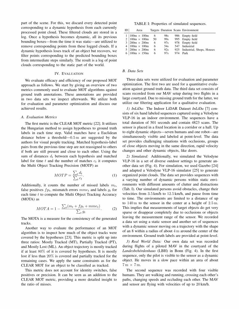
TABLE I: Properties of simulated sequences.
ID Area Targets Duration Scans Environment
1 100m × 100m 6 98s 986 Empty field2 100m × 100m 50 99s 995 Empty field3 200m × 200m 6 97s 978 Empty field4 100m × 100m 6 54s 547 Industrial5 200m × 200m 6 92s 925 Industrial, Shops, Houses6 100m × 150m 6 97s 974 Park
B. Data Sets
Three data sets were utilized for evaluation and parameteroptimization. The first two are used for a quantitative evalu-ation against ground truth data. The third data set consists ofscans recorded from our MAV setup during two flights in alarge courtyard. Due to missing ground truth for the latter, weutilize our filtering application for a qualitative evaluation.
1) InLiDa: The Indoor LiDAR Dataset InLiDa [7] con-sists of six hand labeled sequences captured using a VelodyneVLP-16 in an indoor environment. The sequences have atotal duration of 501 seconds and contain 4823 scans. Thesensor is placed in a fixed location in a corridor or a hall. Upto eight dynamic objects—seven humans and one robot—aresimultaneously visible and labeled at point-level. The dataset provides challenging situations with occlusions, groupsof close objects moving in the same direction, rapid velocitychanges and other dynamic objects, like doors.
2) Simulated: Additionally, we simulated the VelodyneVLP-16 in a set of diverse outdoor settings to generate an-other data set (Fig. 4). For simulation, we used Gazebo [24]and adapted a Velodyne VLP-16 simulator [25] to generateorganized point clouds. The data set provides sequences witha varying number of dynamic persons within static envi-ronments with different amounts of clutter and distractions(Tab. I). Our simulated persons avoid obstacles, change theirvelocities from 3.5 km/h to 12.5 km/h, and pause from timeto time. The environments are limited to a distance of upto 140 m to the sensor in the center at a height of 2.5 m.This implies that measurements of target objects do get verysparse or disappear completely due to occlusions or objectsleaving the measurement range of the sensor. We recordeda data set using a static sensor and another set of sequenceswith a dynamic sensor moving on a trajectory with the shapeof an 8 within a radius of about 4 m around the center of theenvironment. Ground truth labels are provided at point-level.
3) Real World Data: Our own data set was recordedduring flights of a piloted MAV in the courtyard of theLandesbehordenhaus (LBH) in Bonn (Fig. 4). In the firstsequence, only the pilot is visible to the sensor as a dynamicobject. He moves in a slow pace within an area of about7 m × 7 m.
The second sequence was recorded with four visiblehumans. They are walking and running, crossing each other’spaths, changing speeds and occluding each other. The MAVand sensor are flying with velocities of up to 20 km/h.

Fig. 4: Exemplary views on environments the data sets were recorded in. Left to right: Real-World: Aerial photo [4]of the LBH in Bonn, Germany. Simulated: Empty field sequences serve as a baseline providing easier circumstances.Industrial setting with six dynamic persons and nine static distractors in red. Apartments, industry and shops containingmore natural distractors and occluders on a wider field. Park with buildings, fountains and a variety of trees providingnumerous possibilities for short-term occlusions.
C. Parameter Optimization
For parameter optimization, we used hyperopt [26], a dis-tributed asynchronous hyperparameter optimization library.It utilizes the Tree of Parzen Estimators [27] to optimizeparameters in a specified search space by minimizing a costfunction depending on the given parameters—e.g. object sizeand covariance threshold.
The cost function we utilized is defined by
costs = 1−MOTA. (3)
The costs are equal to zero for a perfect MOTA (Eq. 2) of1.0 and rising as the MOTA decreases.
D. Quantitative Results
For quantitative evaluations, we start by comparing theresults of our approach to the results reported in [7]. Forall evaluations of our method, we only use those hypothesesclassified as dynamic at least once.
The InLiDa Tracking approach concentrates on multiperson tracking. It utilizes global Ensemble of Shape Func-tions (ESF) descriptors [28] on extracted point clusters andclassifies them using random forests into the classes Personand Not person to generate person detections. For tracking,existing hypotheses are matched to their closest detectionswithin a search radius of 0.5m and propagated utilizing acircular velocity buffer.
The task for evaluation was to track humans only, distin-guishing them from the dynamic robot present in four ofsix sequences. They evaluated their approach by trainingparameters on one InLiDa sequence and testing on theremaining. Each sequence was used for training once.
The InLiDa Tracking achieves a total MOTA of −0.213,our approach evaluated in the same way achieves a totalMOTA of 0.071. The resulting MOTAs are rather low,considering that using no tracker at all results in a MOTAof zero. One possible reason is the utilized evaluation pro-cedure. Training on one sequence only increases the risk ofoverfitting the parameters. Additionally, the methods havedifficulties to distinguish between the robot and humans, ifthere is no robot present in the training sequence. Applyingthe methods to other unseen sequences, with an attendantrobot, yields bad results.
TABLE II: Results of quantitative evaluation.
Data Set MOTA MOTP MT PT ML
InLiDa 0.562 0.108m 0.49 0.43 0.08Simulated static sensor 0.677 0.044m 0.75 0.25 0.0Simulated dynamic sensor 0.533 0.033m 0.57 0.40 0.03
−1 −0.5 0 0.5 1−1
−0.5
0
0.5
1
MOTA Training Set
MO
TATe
stSe
t
InLiDa Seq. 2 : r = 0.78
−1 −0.5 0 0.5 1−1
−0.5
0
0.5
1
MOTA Training Set
MO
TATe
stSe
t
Simulated Seq. 3 : r = 0.88
Fig. 5: Plots visualizing the MOTA on the training setagainst the MOTA on the test sequence during parameteroptimization. The titles report the sequence utilized as thetest set and the Pearson correlation coefficient r.
We evaluated our method a second time on the InLiDa.Due to the limited size of the data set, we perform a Leave-one-out cross-validation (LOOCV). For this, we split the dataset containing n sequences into a training set of size n−1 forparameter optimization and a test set consisting of the leftout sequence. The test set serves the purpose of evaluatingthe method’s performance and ability to generalize on unseendata. This process is successively repeated n-times, each timeleaving another sequence out. Table II presents the results ofthis evaluation on the InLiDa and the simulated data sets.
To get a better insight into the method’s ability to general-ize to unseen data, we plot the MOTAs {x1, . . . , xn} on thetraining set against the MOTAs {y1, . . . , yn} on the test setcomputed during n runs of the optimization process. For eachsequence, we additionally compute the Pearson correlationcoefficient r defined by
r =
∑ni=1(xi − x)(yi − y)√∑n
i=1(xi − x)2√∑n
i=1(yi − y)2(4)
with x and y as the means of the MOTAs on the training

Fig. 6: Top down views of two mapped sequences. Colorencodes height (yellow low, red high). Left: Raw measure-ments mapped into one coordinate frame. Measurements ondynamic objects result in artifacts visible as orange lines onthe yellow ground. Right: Same scans with dynamic objectsfiltered out. Top: Pilot only. Bottom: Four persons.
and test set, respectively. The correlation coefficients duringthe optimizations on the InLiDa sequences range from 0.68to 0.83, on the simulated sequences from 0.47 to 0.90. Wepresent the plots corresponding to the test sequences withthe median correlation coefficient per data set in Fig. 5.
E. Qualitative Results
For a qualitative evaluation, we filter the sequencesrecorded in the courtyard of the LBH as described in Sec. III-E. Measurements on dynamic objects create artifacts. Ourmethod is able to filter out most points corresponding tothose objects, even for noisy mapping results present in thefirst sequence (Fig. 6).
F. Run Time
Finally, we inspect the real-time capability of our methodby plotting the run time per scan for two example se-quences (Fig. 7). We measured the time for each module—Segmentation, Detection and Tracking—to process incomingdata. We assume a sequential procession of the data on oneCPU core. In practice, all modules are able to process thedata of the next time step directly after processing the currentdata. The method was executed on the hardware of our MAVconsisting of an Intel Core i7-6770HQ CPU and 32 GB ofRAM.
We chose the most demanding sequences from the InLiDaand the simulated data set: a sequence in the hall with awall close to the sensor resulting in large kernel sizes duringsegmentation and the simulated sequence with 50 personspresent. Our method processes the data before the next scanis available after 100 ms.
0 20 40 60 800
20
40
60
80
Time within Sequence in s
Run
Tim
ein
ms
InLiDa Sequence 1
Total TrackingDetection Segmentation
0 20 40 60 80 1000
10
20
30
Time within Sequence in s
Run
Tim
ein
ms
Simulated Sequence 2
Fig. 7: Run time in milliseconds of method and modules perscan on exemplary sequences.
G. Discussion
For better results, the application of a more sophisticatedbut still efficient tracking approach should be investigated.Complex movement patterns of humans can only be trackedto a limited extent by the utilized Kalman filter.
Furthermore, the information about occlusions could helpto adjust the time an occluded hypothesis is retained. Thesame information can be utilized to more robustly distin-guish between static and dynamic objects. During partialocclusions, the bounding box of the occluded object changesits shape and size, as the object is only partially visible tothe sensor. In some instances this is interpreted as a move-ment of the occluded object. Incorporating this informationwould counteract false classifications and, hence, enable theapproach to filter dynamic objects more precisely.
Lastly, the run time of the proposed segmentation methoddepends on the distance to the environment. Close objectscombined with a large specified target width increase therun time. Replacing the median filters by an approach thatcompares the measured distance of a point to the distances oftwo neighboring background points could generate a similarsegmentation while being computationally more efficient.
V. CONCLUSION
We implemented a method for real-time multi objecttracking of small objects in the sparse point clouds generatedby a Velodyne VLP-16 on the limited hardware of a MAV.For this, we proposed a novel segmentation approach tosegment point groups of a specified width range in singlescan rings and implemented efficient algorithms for detectionand tracking utilizing the structure of the data. We evaluatedour approach on simulated and real in- and outdoor data setsachieving results comparable to the state of the art. As apractical application, we filter data corresponding to dynamicobjects and map the static part of the scene.

REFERENCES
[1] D. Droeschel and S. Behnke, “Efficient continuous-time SLAM for3D lidar-based online mapping,” in Proc. of the IEEE Int. Conferenceon Robotics and Automation (ICRA), 2018.
[2] M. Beul, D. Droeschel, M. Nieuwenhuisen, J. Quenzel, S. Houben,and S. Behnke, “Fast autonomous flight in warehouses for inventoryapplications,” IEEE Robotics and Automation Letters, vol. 3, no. 4,pp. 3121–3128, 2018.
[3] S. J. Kim, G. J. Lim, J. Cho, and M. J. Cote, “Drone-aided healthcareservices for patients with chronic diseases in rural areas,” Journal ofIntelligent & Robotic Systems (JINT), vol. 88, no. 1, pp. 163–180,2017.
[4] Google. Landesbehordenhaus Bonn. [Online]. Available:https://goo.gl/maps/3tNpQEdmqTy
[5] L. Spinello, K. O. Arras, R. Triebel, and R. Siegwart, “A layeredapproach to people detection in 3D range data.” in AAAI, vol. 10,2010.
[6] L. Breiman, “Random forests,” Machine learning, vol. 45, no. 1, pp.5–32, 2001.
[7] C. Romero-Gonzalez, A. Villena, D. Gonzalez-Medina, J. Martınez-Gomez, L. Rodrıguez-Ruiz, and I. Garcıa-Varea, “InLiDa: A 3D lidardataset for people detection and tracking in indoor environments,”in Proc. of the Int. Conference on Computer Vision Theory andApplication (VISSAPP), 2017.
[8] H. Farazi and S. Behnke, “Online visual robot tracking and iden-tification using deep LSTM networks,” in Proc. of the IEEE/RSJInt. Conference on Intelligent Robots and Systems (IROS), 2017.
[9] D. Maturana and S. Scherer, “3D convolutional neural networks forlanding zone detection from lidar,” in Proc. of the IEEE Int. Confer-ence on Robotics and Automation (ICRA), 2015.
[10] P. Ondruska and I. Posner, “Deep tracking: Seeing beyond seeing usingrecurrent neural networks,” arXiv preprint arXiv:1602.00991, 2016.
[11] A. Milan, S. H. Rezatofighi, A. R. Dick, I. D. Reid, and K. Schindler,“Online multi-target tracking using recurrent neural networks.” inAAAI, 2017.
[12] H. Possegger, T. Mauthner, and H. Bischof, “In defense of color-basedmodel-free tracking,” in Proc. of the IEEE Conference on ComputerVision and Pattern Recognition (CVPR), 2015.
[13] F. Moosmann and C. Stiller, “Joint self-localization and tracking ofgeneric objects in 3D range data,” in Proc. of the IEEE Int. Conferenceon Robotics and Automation (ICRA), 2013.
[14] A. Dewan, T. Caselitz, G. D. Tipaldi, and W. Burgard, “Motion-based detection and tracking in 3D lidar scans,” in Proc. of the IEEEInt. Conference on Robotics and Automation (ICRA), 2016.
[15] D. Schulz, W. Burgard, D. Fox, and A. B. Cremers, “People trackingwith mobile robots using sample-based joint probabilistic data associ-ation filters,” The International Journal of Robotics Research, vol. 22,no. 2, pp. 99–116, 2003.
[16] K. Granstrom, L. Svensson, S. Reuter, Y. Xia, and M. Fatemi,“Likelihood-based data association for extended object tracking usingsampling methods,” IEEE Transactions on Intelligent Vehicles, vol. 3,no. 1, pp. 30–45, 2018.
[17] J. Dequaire, P. Ondruska, D. Rao, D. Wang, and I. Posner, “Deeptracking in the wild: End-to-end tracking using recurrent neuralnetworks,” The International Journal of Robotics Research, 2017.
[18] S. Hochreiter and J. Schmidhuber, “Long short-term memory,” Neuralcomputation, vol. 9, no. 8, pp. 1735–1780, 1997.
[19] D. Droeschel, J. Stuckler, and S. Behnke, “Local multi-resolutionsurfel grids for MAV motion estimation and 3D mapping,” in Proc. ofthe Int. Conference on Intelligent Autonomous Systems (IAS), 2014.
[20] M. Schwarz, D. Droeschel, C. Lenz, A. S. Periyasamy, E. Y. Puang,J. Razlaw, D. Rodriguez, S. Schuller, M. Schreiber, and S. Behnke,“Team NimbRo at MBZIRC 2017: Autonomous valve stem turningusing a wrench,” Journal of Field Robotics, vol. 36, no. 1, pp. 170–182, 2019.
[21] J. Munkres, “Algorithms for the assignment and transportation prob-lems,” Journal of the Society for Industrial and Applied Mathematics,vol. 5, no. 1, pp. 32–38, 1957.
[22] K. Bernardin and R. Stiefelhagen, “Evaluating multiple object trackingperformance: the CLEAR MOT metrics,” Journal on Image and VideoProcessing, vol. 2008, p. 1, 2008.
[23] Y. Li, C. Huang, and R. Nevatia, “Learning to associate: Hybrid-boosted multi-target tracker for crowded scene,” in Proc. of the IEEEConference on Computer Vision and Pattern Recognition (CVPR),2009.
[24] N. P. Koenig and A. Howard, “Design and use paradigms for Gazebo,an open-source multi-robot simulator.” in Proc. of the IEEE/RSJInt. Conference on Intelligent Robots and Systems (IROS), 2004.
[25] Dataspeed, “Velodyne simulator,” 2018. [Online]. Available:https://bit.ly/2x9ybfm
[26] J. Bergstra, D. Yamins, and D. D. Cox, “Hyperopt: A Python libraryfor optimizing the hyperparameters of machine learning algorithms,”in Proceedings of the 12th Python in Science Conference, 2013.
[27] J. S. Bergstra, R. Bardenet, Y. Bengio, and B. Kegl, “Algorithmsfor hyper-parameter optimization,” in Advances in Neural InformationProcessing Systems, 2011, pp. 2546–2554.
[28] W. Wohlkinger and M. Vincze, “Ensemble of shape functions for 3Dobject classification,” in Proc. of the IEEE International Conferenceon Robotics and Biomimetics (ROBIO), 2011.