detailed analysis -...
TRANSCRIPT

EFFECTIVELY MANAGING NATURAL RESOURCES AND FUNDS FOR CURRENT AND FUTURE GENERATIONS
WYOMING OFFICE OF STATE LANDS AND INVESTMENTS
122 West 25th Street Cheyenne, WY 82002 Phone: 307.777.7331 Fax: 307.777.2980 [email protected]
MATTHEW H. MEAD Governor BRIDGET HILL Director
DETAILED ANALYSIS
Wyoming Board of Land Commissioners Consideration for Exchange of State Trust Land
Bonander Ranches, LLC
1,040.67± ACRES OF STATE TRUST LAND 295± ACRES OF DEEDED LAND
In ALBANY and CROOK COUNTIES, WYOMING
Prepared on
August 3, 2016
by
Office of State Lands and Investments Herschler Building, 3 West
122 West 25th Street Cheyenne, WY 82002

2
TABLE OF CONTENTS PAGEE AUTHORITY 3
PROPOSAL 3
SUBJECT PROPERTY DESCRIPTIONS 4
PROPERTY INFORMATION 5
IMPROVEMENTS 6
WATER RIGHTS 6
GRAZING AND AGRICULTURAL LEASES 7
MINERAL RIGHTS AND LEASES 7
ANNUAL TAX LOAD 8
EASEMENTS, ACCESS, HAZARDS 9
SPECIAL USE LEASES 10
TEMPORARY USE PERMITS 10
FLOOD ZONE AND ZONING DESIGNATIONS 11
FOREST PRODUCTS 11
WILDLIFE HABITAT AND WILDLIFE ORIENTED-RECREATIONAL OPPORTUNITIES LOCATED ON THE PARCELS
11
CULTURAL RESOURCES AND PUBLIC RECREATIONAL OPPORTUNITIES LOCATED ON THE PARCELS
12
APPRAISED VALUE 13
INCOME GENERATING POTENTIAL 14
ANTICIPATED APPRECIATION OF THE PARCELS AS REAL ESTATE ASSETS 14
TRUST LAND MANAGEMENT OBJECTIVES 15
CONCLUSION 16
LIST OF EXHIBITS 17

3
DETAILED ANALYSIS PROPOSED LAND EXCHANGE
ALBANY AND CROOK COUNTIES, WYOMING
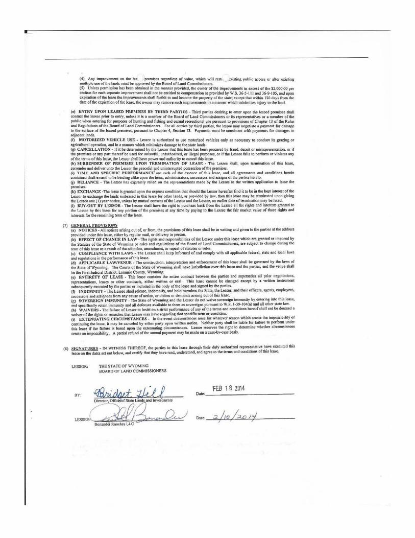
AUTHORITY: W.S. §§ 36-1-107; 36-1-110; 36-1-111 Wyoming Board of Land Commissioners’ Rules and Regulations, Chapter 26, Section 5 Trust Land Management Objectives adopted by the Wyoming Board of Land Commissioners, August 11, 2005. PROPOSAL: The Director of the Office of State Lands and Investments (OSLI) has determined the subject parcels of State Trust Land may be suitable for exchange. The land was nominated by Bonander Ranches, LLC (Bonander) on December 1, 2015. On December 21, 2015, the Director moved the parcels to the Category II Disposal List and the Category II Acquisition List in accordance with Wyoming Board of Land Commissioners’ Rules and Regulations (Board’s Rules). On April 7, 2016, the Board of Land Commissioners (Board) directed OSLI to continue analysis of the proposed exchange by completing a Detailed Analysis and soliciting public comments. Bonander proposes the disposal of 1,040.67± acres of State Trust Land (State Parcels) located in Albany County, Wyoming in exchange for acquisition of 295± acres of Bonander’s deeded land (Moskee Land) in Crook County, Wyoming. As further described in the appraisal section below, the parcels proposed in this exchange represent a value for value exchange with the need of a cash equalization payment. Should the exchange be approved, Bonander will submit to the Board the difference in value between the State Parcels and the Moskee Lands. Existing rights held by the State of Wyoming are 100% of the surface estate and 100% of the mineral estate of the State Parcels proposed for disposal. The proposed transaction will dispose of the surface estate only. The State of Wyoming will retain all mineral rights. Additionally, all mineral rights held by Bonander with regard to the Moskee Land will be transferred to the State of Wyoming. The application letter is attached as Exhibit “A”.
4
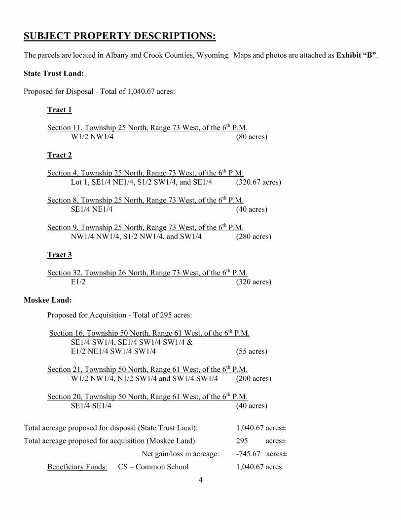
SUBJECT PROPERTY DESCRIPTIONS: The parcels are located in Albany and Crook Counties, Wyoming. Maps and photos are attached as Exhibit “B”. State Trust Land: Proposed for Disposal - Total of 1,040.67 acres:
Tract 1 Section 11, Township 25 North, Range 73 West, of the 6th P.M. W1/2 NW1/4 (80 acres) Tract 2 Section 4, Township 25 North, Range 73 West, of the 6th P.M. Lot 1, SE1/4 NE1/4, S1/2 SW1/4, and SE1/4 (320.67 acres) Section 8, Township 25 North, Range 73 West, of the 6th P.M.
SE1/4 NE1/4 (40 acres)
Section 9, Township 25 North, Range 73 West, of the 6th P.M. NW1/4 NW1/4, S1/2 NW1/4, and SW1/4 (280 acres)
Tract 3
Section 32, Township 26 North, Range 73 West, of the 6th P.M. E1/2 (320 acres)
Moskee Land:
Proposed for Acquisition - Total of 295 acres:
Section 16, Township 50 North, Range 61 West, of the 6th P.M. SE1/4 SW1/4, SE1/4 SW1/4 SW1/4 & E1/2 NE1/4 SW1/4 SW1/4 (55 acres) Section 21, Township 50 North, Range 61 West, of the 6th P.M.
W1/2 NW1/4, N1/2 SW1/4 and SW1/4 SW1/4 (200 acres)
Section 20, Township 50 North, Range 61 West, of the 6th P.M. SE1/4 SE1/4 (40 acres)
Total acreage proposed for disposal (State Trust Land): 1,040.67 acres±
Total acreage proposed for acquisition (Moskee Land): 295 acres±
Net gain/loss in acreage: -745.67 acres±
Beneficiary Funds: CS – Common School 1,040.67 acres

5
PROPERTY INFORMATION: State Trust Land: The State Parcels are located in northern Albany County, within the Laramie Mountains. The State Parcels lie between Bear Creek Road to the south and Esterbrook Road to the north, approximately sixty (60) miles southwest of Douglas, Wyoming. Access to the area is provided via Bear Creek Road and Esterbrook Road, both gravel surfaced and seasonally maintained county roads. The State Parcels are high mountain land with elevations primarily in the 7,000-foot and 8,000-foot range. The topography is rolling to extremely rough. The vegetative cover is native grasses, sagebrush and both evergreen and deciduous trees. Tree cover in the higher elevations varies from sparse to very dense. Tract 1 All of Tract 1 was granted to the State of Wyoming by the Federal Government under the Act of Admission of July 10, 1890, and Section 2275 and 2276 of the Revised Statutes of the United States as shown in Clear List 54 of the Cheyenne Land District. Tract 2 All of Tract 2 was granted to the State of Wyoming by the Federal Government under the Taylor Grazing Act of 1934, in United States Patent number 1113465 on March 19, 1942. Tract 3 All of Tract 3 was granted to the State of Wyoming by the Federal Government under the Act of Admission of July 10, 1890, and Sections 2275 and 2276 of the Revised Statutes of the United States as shown in Clear List 1 of the Cheyenne Land District. Moskee Land: The Moskee Land is located approximately twelve (12) miles southeast of Sundance, Wyoming in eastern Crook County. The current use is agriculture and recreation. Terrain varies from rolling fields to wooded hills with pine, cedar, and bur oak trees. Elevation for this area is 5,342 feet. The Black Hills National Forest surrounds a majority of the Moskee Land and offers year round recreational amenities. Maps and photos are attached as Exhibit “B”.
6
IMPROVEMENTS: State Parcels: There are no dwellings, buildings, or shops on the State Parcels. The improvements on the State Parcels consist of post and wire fencing and cross fencing. Moskee Land: There are no dwellings, buildings, shops, or fencing on the Moskee Land. WATER RIGHTS: A review of the records maintained by the Wyoming State Engineer’s Office reflect water rights appurtenant to specific parcels proposed in the exchange. Specific parcel water right information is available for public review at the Wyoming State Engineer's Office or on the Wyoming State Engineer's Office website. State Trust Land: Section 32, Township 26 North, Range 73 West, of the 6th P.M.
East Side Ditch (P3517.0D), Irrigation-Surface Water, 35 acres Irrigated, Priority Date-October 22, 1901 T.S. Garrett
Moskee Land: No water rights found. Any existing water rights are to be conveyed in the proposed transaction. Surface ownership of this property is subject to W.S. § 36-9-119: "Nothing in this act [Sale of State Lands] shall be construed so as to impair the rights of any ditch company, or any person owning any ditch or ditches, on or passing through any of the lands included herein." All water rights or permits on these parcels should be verified with the Wyoming State Engineer’s Office for final verification of allowed use. Failure to exercise a water right, for five (5) years, when water is available, may constitute grounds for forfeiture of said water right.
7
GRAZING AND AGRICULTURAL LEASES: State Trust Land: Grazing and Agricultural Lease 1-8242
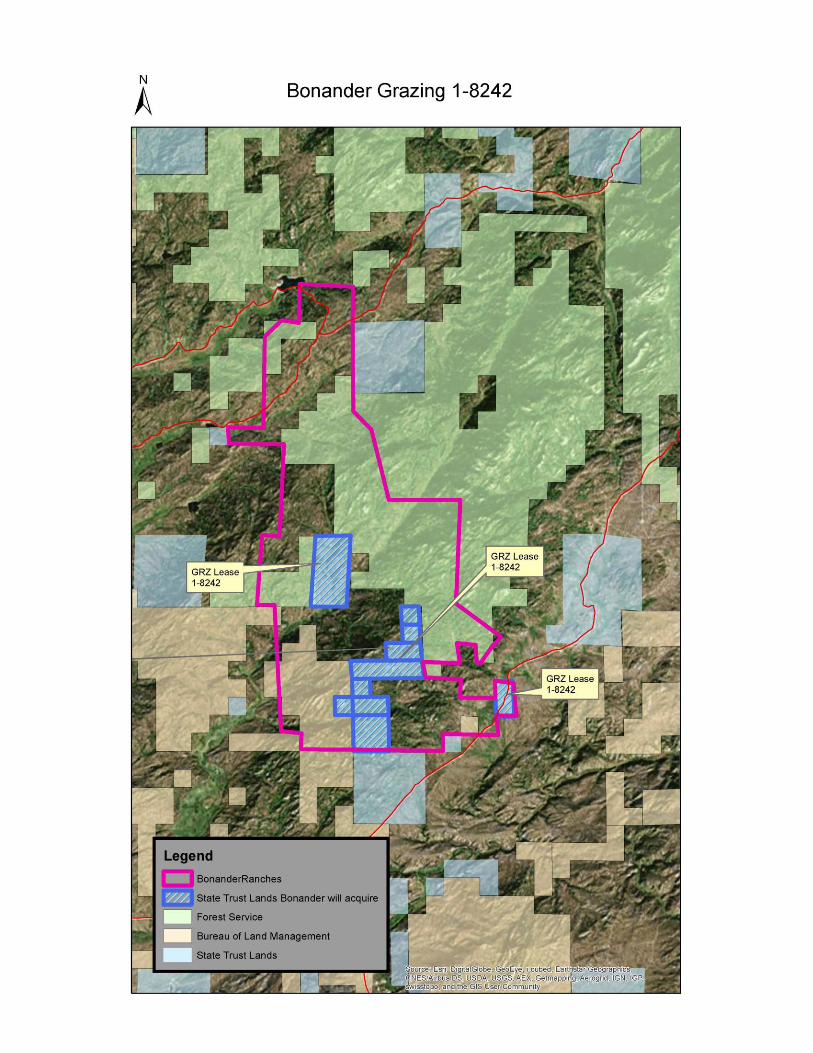
The current Grazing and Agricultural Lease (No. 1-8242) is issued to Bonander Ranches LLC, (Lot 1, SE1/4 NE1/4, S1/2 SW1/4 and SE1/4, Section 4; SE1/4 NE1/4, Section 8; NW1/4 NW1/4 , S1/2 NW1/4, and SW1/4, Section 9; W1/2 NW1/4, Section 11; all in Township 25 North, Range 73 West, and the E1/2, Section 32; in Township 26 North, Range 73 West of the 6th P.M.) and is set to expire on January 1, 2024. Lease No. 1-8242 consists of 1,040.67 acres and a rated carrying capacity of one hundred twenty-four (124) Animal Unit Months (AUMs). Lease No.1-8242 returns an annual consideration of $761.36 ($6.14/AUM x 124 AUMs = $761.36).
Moskee Land: There are no grazing and agricultural leases on the Moskee Land. See Exhibit "C" for lessee comments and Exhibit “D” for associated grazing and agricultural leases. All exchanged parcels are subject to any existing State of Wyoming grazing and agricultural leases; these leases shall be assigned to each respective new owner of the property after the exchange. MINERAL RIGHTS/LEASES: State Trust Land: The State of Wyoming owns all mineral rights on Tracts 1 and 3 of the State Parcels and will retain these mineral rights upon surface disposal. No mineral rights were conveyed to the State of Wyoming on Tract 2. There are no mineral leases associated with the State Parcels. Moskee Land: OSLI did not research exact ownership of the mineral rights related to the Moskee Land. All mineral rights held by Bonander with regard to the Moskee Land will be transferred to the State of Wyoming. There appear to be no mineral leases associated with the Moskee Land.

8
ANNUAL TAX LOAD: The State Parcels are owned by the State of Wyoming, and are not currently subject to ad valorem taxation. Upon disposal, the property will be assessed and taxed by Albany County. The grantee shall be responsible for all tax assessments. According to both the Albany and Crook County Assessor's Office, real estate is valued using a market value system and taxes are calculated based on nine and one-half percent (9.5%) of the assigned value of the property times each specific district’s mill levy. The Moskee Land has been classified as Agricultural Range Lands pursuant to the Crook County Assessor’s Office definition. State Parcels (added to tax rolls, Albany County):
Market Value $1,034,000.00 Assessed Value $98,230.00 9.5% assessment
Estimated Tax $6,384.00 0.065 mill levy Agriculture Land
Moskee Land (removed from tax rolls, Crook County):
Market Value $1,032,500.00 Assessed Value $98,087.50 9.5% assessment
Estimated Tax $6,669.95 0.0695 mill levy Agriculture Land
Agricultural land may be valued by the County Assessor on a productivity basis rather than actual market price. In that case, the taxes would be significantly less, but that decision is left to the County Assessor.

9
EASEMENTS, ACCESS, HAZARDS: EASEMENTS: State Trust Land: ●Tract 1 Easement 677N –Rural Electric Power Line Wheatland Rural Electric Association Pt in W1/2 NW1/4 of Section 11, Township 25 North, Range 73West, of the 6th P.M. Easement 841N-A –Roadway Easement Board of County Commissioner’s Albany County Pt in W1/2 NW1/4 of Section 11, Township 25 North, Range 73West, of the 6th P.M. ●Tract 2 No easements found. ●Tract 3 No easements found.
Moskee Land: Right of Way Easement recorded in Book 312, at page 347 in the office of the Recorder of Deeds, Crook County, Wyoming. Granted to the United States of America.
Right of Way Easement for Crook County Road No. 207. ACCESS: State Trust Land: ●Tract 1 Tract 1 has direct legal access via Albany County Road 77 (aka Bear Creek Road), a gravel and seasonally maintained road.
●Tract 2 and 3 Tracts 2 and 3 do not have direct access from a public road. These tracts do have legal “walk-in” access from adjacent state and federal land. There are no roads that traverse these tracts that would allow for vehicular access. Moskee Land: The Moskee Land has direct legal access via Crook County Road 207 (aka Moskee Road), a gravel road.

10
HAZARDS: No obvious hazardous materials or environmental concerns were noted during inspections of the properties by the appraiser. The lands have not been developed, nor are there any historical documented use that would knowingly subject the lands to hazardous materials or create environmental concerns. SPECIAL USE LEASES: State Trust Land: No special use leases found. Moskee Land: No special use leases found. TEMPORARY USE PERMITS: State Trust Land: No temporary use permits found. Moskee Land: No temporary use permits found. FLOOD ZONE AND ZONING DESIGNATIONS: Flood Zone State Trust Land: The State Parcels are located in a Flood Insurance Rating Mapping area, however upon review of the Flood Maps 56001C0625E and 56001C0450E, there appear to be no identified flood zones. Moskee Land: The Moskee Land is not located in a Flood Insurance Rating Mapping area, and therefore, flood zone risks are unknown. The Moskee Land exhibits some seasonal drainage flooding, which is common to properties in the Black Hills region.

11
Planning and Zoning: State Trust Land: The State Parcels are zoned Agricultural. Albany County’s adopted Land Use Plan identifies preferred growth areas and discourages development outside of such areas. The State Parcels are situated well outside of any growth area. Key priorities for the area containing the State Parcels are conservation and protection of agricultural operations, habitat, and open space. Moskee Land: Unincorporated land in Crook County is not subject to zoning. The Moskee Land’s current use is as agricultural range land. Crook County’s adopted Land Use Plan does not include zoning. FOREST PRODUCTS: An evaluation letter from the Wyoming State Forestry Division is attached as part of Exhibit "F." State Trust Land: The Wyoming State Forestry Division evaluated the State Parcels in terms of forest resources. They have no recommendations at this time. Moskee Land: The Wyoming State Forestry Division evaluated the Moskee Land in terms of forest resources. The Moskee lands have been previously managed for timber resources and have high potential to continually produce forest products. The Moskee area as a whole has been identified as a high priority for acquisition by the State of Wyoming under the United States Forest Service’s Forest Legacy Program. Acquisition of the Moskee Land helps secure these lands in any future approvals within this program. WILDLIFE HABITAT AND WILDLIFE-ORIENTED RECREATIONAL OPPORTUNITIES LOCATED ON THE PARCELS: An evaluation letter from the Wyoming Game and Fish Department (WGFD) is attached as part of “Exhibit F.” State Trust Land: According to the WGFD, the State Parcels provide public access to over 6,400 acres of National Forest Lands and 1,600 acres of state trust lands, and are important for public hunting opportunities including elk, mule deer, black bear, mountain lion, and blue grouse hunting. Disposal of these parcels would reduce public hunting access. Access in this area is influenced by the lack of existing roads, which results in a lower density of hunters, but may contribute to higher quality hunts and increased harvest. These parcels fall within the Laramie Peak Elk Herd Unit (hunt Area 7), which is above population objective. Disposal of these parcels would inhibit the WGFD’s ability to manage this elk herd.

12
The State Parcels are in winter yearlong and spring/summer/fall habitat for mule deer and elk, and winter yearlong habitat for pronghorn. These parcels are comprised of xeric forests, mixed mountain shrubs, mountain and prairie grasslands, wetlands, and aspen stands that provide habitat for fifteen (15) Species of Greatest Conservation Need (SGCN). WGFD has no aquatic concerns pertaining to the land exchange. Moskee Land: According to the WGFD, the Moskee Land is bordered by publicly accessible Forest Service Land. Acquisition of the Moskee Parcel would augment public access points to the Black Hills National Forest for wildlife related recreation. Acquisition of the Moskee Land has the potential to improve hunting opportunities for big game and turkey in the Black Hills area by blocking up publicly accessible lands. The Moskee Land is in crucial winter yearlong and spring/summer/fall habitat for mule deer, winter yearlong habitat white-tailed deer, and yearlong habitat for elk. The Moskee Land is comprised of xeric forests, prairie grasslands, wetlands, and aspen/deciduous forest that provides habitat for twenty (20) SGCN. WGFD also notes they have no aquatic concerns pertaining to the land exchange. Lastly, the proposed exchange would be a direct loss of approximately 720 acres, and an indirect loss of public access to over 8,000 acres of state and federal lands in the Laramie Range, which would reduce overall hunting opportunity with impacts to sportsman and wildlife management. CULTURAL RESOURCES AND PUBLIC RECREATIONAL OPPORTUNITIES LOCATED ON THE PARCELS: An evaluation letter from The Department of State Parks and Cultural Resources (SPCR) is attached as part of “Exhibit F.” SPCR evaluated the State Parcels and Moskee Land in terms of public recreation, cultural resources, and historical significance. There has been little investigation done in the area regarding any cultural attributes, and a review of the documentation within the State Historic Preservation Office, Cultural Records Office in Laramie, Wyoming yielded no evidence of anything ever being recorded. A lack of evidence is not an indication of cultural resources not being present, but rather a lack of detailed investigations in the area.

13
APPRAISED VALUE: Deborah A. Gillihan, of Hilston Appraisals, LLC, a Wyoming Certified General Appraiser has completed an appraisal of the State Parcels per instructions from OSLI. The effective date of the appraisal was January 29, 2016. John Widdos, of Hall-Widdoss & Co., Inc., a Wyoming Certified General Appraiser has completed an appraisal of the Moskee Land per instructions from OSLI. The effective date of the appraisal was April 20, 2016. The appraisers were instructed to estimate the current market value of the fee simple interest for the parcels, excluding the mineral estate and assuming legal public access. OPINION OF VALUE: The Board will use the appraised values below, with the acreages as granted by Patent at the Act of Admission of 1890 and indicated on any Title Commitment. Based on the inspection, available market data and analyses, assumptions, limiting conditions, and the certifications, the appraiser's estimated opinion of market value for the defined property rights are as follows with an effective date noted above: OSLI has reviewed the appraisals and concurs with the methods used and estimated market values. The appraisals, comparable sales information, maps, photographs and related information as well as the appraisal reviews completed by OSLI, are available upon request.
State Trust Land $1,034,000
Tract 1
80 Acres of State Trust Land at $2,000.00 Per Acre $160,000.00
One Hundred Sixty Thousand Dollars
Tract 2 640.67 Acres of State Trust Land at $909.98 Per Acre
$583,000.00 Five Hundred Eighty-Three Thousand Dollars
Tract 3 320 Acres of State Trust Land at $909.38 Per Acre
$291,000.00 Two Hundred Ninety-One Thousand Dollars
Moskee Land
295 Acres of land owned by Bonander Ranches, LLC at $3,500.00 Per Acre
$1,032,500.00 One Million Thirty-Two Thousand and Five Hundred Dollars

14
INCOME GENERATING POTENTIAL: State Trust Land: Grazing and Agricultural Leasing: The State Parcels have one (1) grazing and agricultural lease rated at a total of 124 AUM’s or an average of .12 AUM’s/Acre as detailed above. In 2016, the revenue generated from those leases and deposited into the Permanent Land Income Fund was $761.36.
The State Parcels are largely surrounded by Bonander’s deeded land or federal land it holds the grazing permits on, rendering any competitive bidding on the grazing and agricultural rights, as well as any additional uses, limited. Outfitting is not a current use of the State Parcels, but is a logical compatible use with other existing uses. Should a temporary use permit for outfitting be approved, annual revenue would be up to $156.10. Total annual revenue from the State Parcels - $917.46
Moskee Land: OSLI has conducted a preliminary analysis of the grazing and agricultural potential regarding the Moskee Land. The preliminary analysis shows there to be an estimated one hundred eighteen (118) AUM’s available. If the minimum Board approved grazing fee is applied (the minimum Board approved grazing fee for 2016 is $6.14 per AUM per year), the expected annual revenue is $724.52. OSLI anticipates leasing the grazing and agricultural rights in a competitive nature that is expected to return revenues in excess of the minimum Board approved grazing fee. The Moskee Land abuts additional deeded land currently under consideration by the Board for acquisition. Should this exchange be approved, as well as the other transactions under consideration, the Board would increase and consolidate its ownership in an area with high potential to continually produce timber products. ANTICIPATED APPRECIATION OF THE PARCELS AS REAL ESTATE ASSETS: Appreciation of any real estate asset is largely speculative and can only be realized upon sale of the asset. A combination of the 2015 Wyoming Agricultural Statistics and Land Values 2015 Summary, both published in 2015, show that the farm real estate average value per acre for the period of 2005 to 2015 increased 3.9% per year with a 4.8% increase between 2014 and 2015. Looking at pasture land value over that same ten (10) year period, Wyoming experienced an average increase of 6.9% per year with 4.1% increase between 2014 and 2015. There was significant increase in pasture land values between 2005 and 2008 with a down turn in 2009 through 2010 with land value once again showing a steady increase between 2011 and 2015. OSLI has concluded, from all available data, that the Moskee Land exhibits good appreciation potential. Appreciation would likely be in the mid-range of the USDA Agricultural Land Values, Pasture Values per acre, and will likely appreciate between 3% and 5% per year.

15
TRUST LAND MANAGEMENT OBJECTIVES: In 1997, Wyoming Session Laws Chapter 200, Section 3(a)(i), the Wyoming Legislature declared that trust land should remain a substantial component of the trust portfolio, managed under a total asset management policy, and with a focus on protecting the corpus for multiple generations. Subsequently, the Board adopted criteria for evaluation of land exchanges, sales, acquisitions, and long-term leases--collectively called Trust Land Management Objectives (TLMO), on August 10, 2005. A proposal need not meet all objectives, but all objectives are considered by the Board which has the sole discretion in determining how to best manage state trust lands. Trust Land Management Objectives:
To better meet the beneficiaries short and/or long term needs Improve the manageability of land assets Meet a specific school and/or community need
A summary of key points considered in this transaction evaluation are outlined below: Better meet the beneficiaries’ short and/or long term objectives: The proposed exchange is expected to benefit the State’s trust beneficiaries’ long-term objectives by transitioning ownership from a lower appreciating market to higher one, thereby increasing the value of the land asset at a greater rate than what is currently realized. The proposed exchange is expected to benefit the State’s trust beneficiaries’ short-term objectives by increasing the potential for compatible, revenue generating uses. Currently, the identified revenue generating uses include grazing and timber production. OSLI anticipates the revenue from those sources to increase based on the Moskee Land’s proximity to existing state trust land, other lands under consideration by the Board for acquisition, and its close proximity to public access roads and utilities. Improve the manageability of the land asset: OSLI does not anticipate a reduction in leases or administrative costs as a result of the proposed exchange. OSLI does anticipate broader opportunities for compatible uses and revenue generating potential as a result of acquiring land with enhanced accessibility. Meet a specific school and/or community need: Disposal of the State Parcels will isolate approximately 3,000 acres of adjacent state and federal lands from public access. It will also limit the points of access to approximately 10,000 acres of adjacent state and federal lands. Currently this block can be accessed from both the south (Bear Creek Road) and north (Cow Creek Road). Should the exchange be approved, public access will be from the north. Acquisition of the Moskee Land augments public access currently available in the Moskee area. The Moskee Land is publically accessible via the Moskee Road. Recreational access in the Moskee area has been well managed with the establishment of County and Forest Service roads. Should this exchange be approved, additional acreage would be available to the public for hunting and general recreation.

16
CONCLUSION: This proposed exchange meets the Trust Land Management Objectives by improving the asset’s long-term appreciation potential and its availability for multiple, compatible uses. Further, it consolidates the Board’s land ownership pattern into a larger, contiguous block.
This Detailed Analysis has been prepared and distributed to the public in accordance with the Board’s Rules. It is electronically available on OSLI’s website as well as in hard copy within the Office of State Lands and Investments in Cheyenne, Wyoming. Hard copies are also available for public viewing at the Albany County Libraries in Laramie, and Centennial, the Crook County Libraries in Sundance, Moorcroft, and Hulett, as well as the Albany and Crook County Clerks’ Offices.
As required by the Board Rules, a public hearing will be conducted during the sixty (60) day public comment period. The date, time and location of the public hearing will be advertised on OSLI’s website for thirty (30) days prior to the hearing.

17
LIST OF EXHIBITS: “A” Cover Letter and Land Sale Application “B” Subject Property Photos, Maps, and Legal Description “C” Lessee Comment Forms “D” Grazing Lease “E” Easements “F” State Agency Evaluation Letters

18
EXHIBIT “A”

19

20

21

22

23

24

25
EXHIBIT “B”

26
27

28
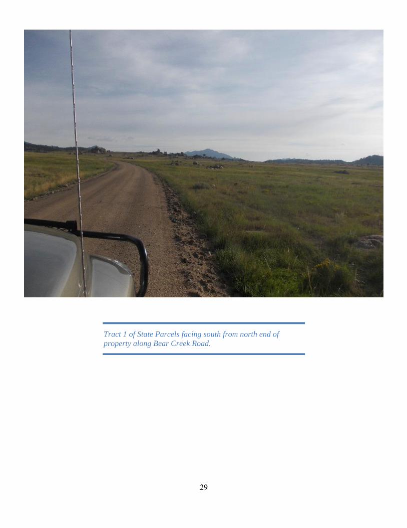
29
Tract 1 of State Parcels facing south from north end of
property along Bear Creek Road.

30
Tract 1 of State Parcels facing north from center of property
along Bear Creek Road.

31
Tract 2 of State Parcels facing southeast from northern part
of property.

32
Tract 2 of State Parcels facing northeast from south-central
part of property.

33
Tract 3 of State Parcels facing north from southern part of the
property.

34
Tract 3 of State Parcels facing northeast from central part of
the property with Deer Creek.

35
View south at the north boundary of the Bonander Lands.
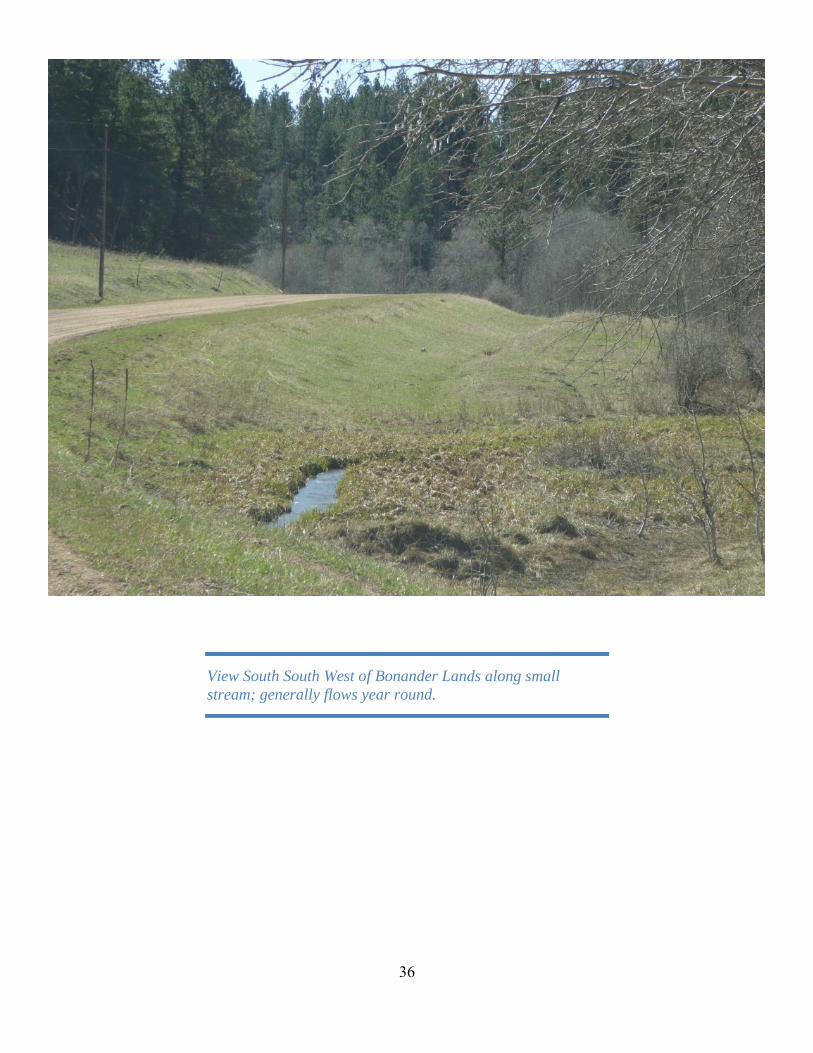
36
View South South West of Bonander Lands along small
stream; generally flows year round.

37
View South South East of Bonander Lands at the road
meandering through canyon.

38
View south of Bonander Lands near NE corner of NW1/4
SW1/4 of Section 21.

39
EXHIBIT “C”

40

41
EXHIBIT “D”

42

43
44

45
EXHIBIT “E”

46

47

48

49
EXHIBIT “F”

50

51

52

53

54

55