designing a web-based geotechnical database for the st ...rogersda/gis/geotechnical...
TRANSCRIPT

Designing a WebDesigning a Web--Based Based Geotechnical Database for Geotechnical Database for the St. Louis Metro Area the St. Louis Metro Area
J. David Rogers, J. David Rogers, Ph.D., P.E., R.G.Ph.D., P.E., R.G.
Karl F. Karl F. HasselmannHasselmann Chair Chair Department of Geological Sciences and Department of Geological Sciences and
EngineeringEngineeringUniversity of Missouri University of Missouri -- RollaRolla

COSMOSCOSMOSConsortium of Organizations for Consortium of Organizations for Strong Motion Observation SystemsStrong Motion Observation SystemsFormed in Oakland, CA in Dec 1997Formed in Oakland, CA in Dec 1997Core Members are the USGS, CGS, Core Members are the USGS, CGS, USCOE, USBR, Puerto Rico Strong USCOE, USBR, Puerto Rico Strong Motion Program, PG&E, Motion Program, PG&E, CaltransCaltrans, , MCEERMCEER--Buffalo, PEERBuffalo, PEER--Berkeley, Berkeley, SCECSCEC--Los Angeles, and the World Los Angeles, and the World Seismic Safety Initiative Seismic Safety Initiative

Purpose of this briefingPurpose of this briefing
Summarize what COSMOS has accomplished in CA, NV, OR and WA Summarize what kinds of geodataexists for the greater St Louis metro areaSummarize what kind of architecture we might use to establish an information gateway for geo-professionals in the Midwestern USA

Needs and MotivationNeeds and MotivationCurrently, there is no over-arching organization for geotech data in the St Louis Metro areaIn the next 5 years a state-of-the-art geotech database needs to be developedNeed for easy access of existing geologic Need for easy access of existing geologic and geotechnical data useful for assessing and geotechnical data useful for assessing potential site response and preparing potential site response and preparing seismic hazards maps of Midwestern USAseismic hazards maps of Midwestern USANeed for upNeed for up--toto--date information sharingdate information sharingNeed for easy updating with new Need for easy updating with new information information

Broader MotivationBroader MotivationGeo-Professional Community • Want access to data in other organizations
Assist in design
• Conduct research to advance thestate-of-practice
Larger data sets
Government AgenciesGovernment Agencies•• Need accurate Need accurate geodatageodata for regulatory for regulatory
review, facilities evaluation, hazard/risk review, facilities evaluation, hazard/risk assessment and research assessment and research

COSMOS used Electronic COSMOS used Electronic Surveys to Evaluate the Needs Surveys to Evaluate the Needs and Expectations of End Usersand Expectations of End UsersThe two primary goals of the survey The two primary goals of the survey were:were:
1)1) Establish a baseline of current Establish a baseline of current practicespractices
2)2) Identify desired functional Identify desired functional requirements of a geotechnical requirements of a geotechnical information management systeminformation management system

Ascertaining the Needs of End UsersAscertaining the Needs of End Users
-- Goal 1:Goal 1:* Users and providers of geotechnical data* Users and providers of geotechnical data* Types of geotechnical data of interest* Types of geotechnical data of interest* Lifecycle of the geotechnical data* Lifecycle of the geotechnical data* Patterns of use* Patterns of use
-- Goal 2:Goal 2:* User interface* User interface* Method of access* Method of access* Availability of data* Availability of data* Type and format of data * Type and format of data

COSMOS Survey Responses COSMOS Survey Responses by State (2001)by State (2001)

Primary Areas of Practice of Primary Areas of Practice of Survey ContributorsSurvey Contributors

Types of Organizations that Types of Organizations that Expressed InterestedExpressed Interested

Data Routinely Used in the Work Place
87%
55%
73%69%
15%
51%
11%
0%
10%
20%
30%
40%
50%
60%
70%
80%
90%
100%
GeotechnicalBorehole Data
GeologicalBorehole Data
Lab Test Data In-Situ EngineeringTest Data
In-SituHydrogeologic Data
Geophysical TestData
Other

Main Uses of Geotechnical Data
11%
69%
35%
18%
11%
0%
10%
20%
30%
40%
50%
60%
70%
80%
EnvironmentalInvestigations
Geotechnical Designs Regional Scale Studies orHazard Mapping
Calibration or Validation ofConstitutive Models
Other

Virtual Database TasksVirtual Database TasksTASK 1:TASK 1: Development of Development of User ScenariosUser Scenarios for the for the purpose of defining the functional requirements purpose of defining the functional requirements of the pilot webof the pilot web--based system. based system.
TASK 2:TASK 2: Develop Develop data dictionarydata dictionary and and formatting standardsformatting standards for archiving and web for archiving and web dissemination of geotechnical data , review the dissemination of geotechnical data , review the draft standard in a workshop, and obtain draft standard in a workshop, and obtain consensus of the impacted geotechnical consensus of the impacted geotechnical community for a standard dictionary. community for a standard dictionary.
TASK 3:TASK 3: Develop a Develop a Pilot Virtual Geotechnical Pilot Virtual Geotechnical Data Center SystemData Center System which can be expanded to which can be expanded to incorporate a broad range of geotechnical data incorporate a broad range of geotechnical data sets. sets.

The Web Database SystemThe Web Database SystemPartners become the “Information Gateway” Data ProvidersData Dictionary & StandardsElectronic Data Entry & Collection Data WarehousingData AccessWeb-based Dissemination

Database MaintenanceDatabase MaintenanceCOSMOS is encouraging their partners COSMOS is encouraging their partners to:to:•• Put Put geodatageodata and metadata into acceptable and metadata into acceptable
electronic formatelectronic format•• Post their respective Post their respective geodatageodata on their own on their own
serversservers•• Maintain quality control on Maintain quality control on geodatageodata and and
metadatametadata•• Periodically update with new data as it Periodically update with new data as it
becomes available becomes available

Resolve Policy IssuesResolve Policy IssuesData ownership & maintenance• Individual organizations• Information gateway• Proper data attributesAccess (and fees?)Liabilities?Quality ratingsEstablish MoU’sCOSMOS has dealt with these issues

Facilitate Data Access and Facilitate Data Access and Sharing for St Louis Metro AreaSharing for St Louis Metro AreaAccess Data from Access Data from Multiple ProvidersMultiple Providers
Geotechnical ConsultantEngineering Firms
Other Universities

Scope of Data DictionaryScope of Data DictionaryProject description, borehole location, drilling methods, and toolsGeotechnical logs of soils and geologic logs of rock with depthLab test dataIn-situ test dataGeophysical test data

Major Issues with Major Issues with Standardization of Standardization of GeodataGeodataScope of standards• Reflect realistic needs of end users and
providers.• Capture only the most relevant data.
Use of standards• No need for all to adopt as an internal
standards.• Standardize data exchange methods.

The PlanThe PlanTechnical Approach• Define content• Identify architecture• Create data dictionary
Establish Policies and/or MOUs for sharing of dataEstablish MOUs between partners for upkeep of the database

Define Content of the Define Content of the Data DictionaryData Dictionary
Identify users and providers.Define the content of the datadictionary.• Guided by user needs• Metadata to assess quality (data source,
methods, calibrations, etc.)• Flexibility for growth

ID ArchitectureID ArchitectureSystem infrastructure• Physical network
System redundancySecurity
Data transfer methods• Translators (e.g. RDBMS to XML; may all
be in XML if we have to start from scratch)
• Protocols (e.g. ftp, ip)• ID Interchange format (e.g. AGS)

Create Data DictionaryCreate Data DictionaryDefine the data structure and format.• Parameter name, type, units, etc.• Relational Database Management
System (RDBMS): Tables, relationships, attributes, structure, etc.
• Excel Spreadsheet Format (XML): Document type definition (DTDs), tags, etc.
• Syntax• Guidelines for usage

COSMOS FormatCOSMOS FormatWorking group activities:• Data dictionary content & structure• System architecture• Establish MoUs among providers
Technical development contractsHosting of information gateway• Funding clearinghouse• Long-term maintenance

Importance of MetadataImportance of MetadataProvides Point of Reference and Point Provides Point of Reference and Point of Originof OriginProvides Calibration and Equipment Provides Calibration and Equipment specsspecsProvides Methods for Obtaining DataProvides Methods for Obtaining DataProvides Site Specific InformationProvides Site Specific InformationVery important for older borehole Very important for older borehole datadata

So, what kind of So, what kind of geotechnical data do geotechnical data do
we already have? we already have? andand
What form is it in? What form is it in?

Missouri DOT DataMissouri DOT DataScanned Boring LogsScanned Boring Logs
An analog systemAn analog system


Illinois Geological Illinois Geological Survey DataSurvey Data
Shear Wave VelocitiesShear Wave VelocitiesXML formatXML format
No locations or depthsNo locations or depths

SUMMARY - Shear Wave Velocities
Alluvium
173.87 570.43 Cache Valley Illinois
174.53 572.60 Cache Valley Illinois
199.33 653.96 Wabash Valley Illinois
237 777.55 Indiana
235 770.99 Indiana
261 856.29 Indiana
206 675.84 Indiana
266 872.69 Indiana
261 856.29 Indiana
255 836.60 Indiana
251 823.48 Indiana
261 856.29 Indiana
250 820.20 Indiana
253.94 833.13 New Harmony Indiana
189 620.07 Kentucky
Avg. 231.58 m/s 759.76 ft/sec
Minimum 173.87 m/s 570.43 ft/sec
Maximum 266 m/s 872.69 ft/sec

Ordovician age
Dolomite 2,686 8,811 Illinois
2,692 8,832 Illinois
2,869 9,411 Illinois
3,068 10,065 Illinois
2,894 9,496 Illinois
2,984 9,789 Illinois
2,987 9,801 Illinois
2,952 9,686 Illinois
2,909 9,543 Illinois
Avg. 2,893 m/s 9,493 ft/sec
Minimum 2,686 m/s 8,811 ft/sec
Maximum 3,068 m/s 10,065 ft/sec

Pennsyl-vanian age
Limestone 1,634 5,361 Illinois
1,627 5,337 Illinois
2,737 8,980 Illinois
3,156 10,354 Illinois
2,041 6,696 Illinois
2,926 9,600 Illinois
1,611 5,284 Illinois
2,655 8,712 Illinois
2,526 8,289 Illinois
Avg. 2,324 m/s 7,624 (ft/sec)
Minimum 1,611 m/s 5,284 (ft/sec)
Maximum 3,156 m/s 10,354 (ft/sec)

Tennessee DataTennessee DataShear Wave VelocitiesShear Wave Velocities
from publicationsfrom publicationsXML spreadsheetsXML spreadsheets


Corrected SPT versus Vs for Tennessee Sand
0
200
400
600
800
1000
1200
1400
1600
1800
2000
0 50 100 150 200 250 300Corrected SPT (Blow Counts)
Shea
r Wav
e Ve
loci
ty (F
t/Sec
)

Database Descriptors for Database Descriptors for COSMOS Database COSMOS Database
DictionaryDictionary

Database Descriptors Used by Database Descriptors Used by COSMOS COSMOS –– e.g. SPT datae.g. SPT data
The standard penetration test (SPT) involves driving a split-spoon sample barrel into the ground from the bottom of a borehole by dropping a 140 lb (63.5 kg) hammer a height of 30 inches (0.76 m). From the test, a penetration resistance or blowcount (N) is obtained which equals the number of blows to drive the sampler over the depth interval between 6 and 18 inches (150 to 450 mm). The N-value is reported in blows per foot (blows per 300 mm). Standard testing procedures are described in ASTM D 1586. Relevant testing parameters are described in this table.
Definition Type DB name XML Path
A code or simple name for Standard Penetration Test Parameters. This value is intended to be a foreign key for referencing this data instance. code ID SPT/Id
A value that describes the context for the development of the Id value. The Id is unique within this context text CODESPACE SPT/CodeSpace
The length of the split-spoon sampler barrel. Standard lengths are 18 inches (450 mm) and 24 inches (600 mm). quantity
SAMPLER LENGTH SAMPLER LENGTH_UOM SPT/Length[@uom]
The inside diameter of the split-spoon sampler. quantity
SAMPLER INSIDE DIAMETER SAMPLER INSIDE DIAMETER_UOM SPT/InsideDiameter[@uom]
The use of a liner to produce a constant inside diameter is permitted and should be noted. boolean LINER SPT/Liner
The use of a basket retainer is permitted and should be noted. boolean BASKET SPT/Basket
The hammer mass used to drive the split-spoon sampler. The standard mass is 140 lb (63.5 kg). quantity
HAMMER_MASS HAMMER_MASS_UOM SPT/HammerMass[@uom]
The type of hammer or drive-weight assembly used for the sampling and penetration. Typical hammer types include the following: a) donut, b) safety, or c) other. text HAMMER_TYPE SPT/HammerType

Definition Type DB name XML Path
The mechanism used to lift and drop the hammer or drive-weight assembly. Typical hammer release mechanisms include the following: a) rope and cathead, b) trip, c) semi-automatic, d) automatic, or e) other. text HAMMER_RELEASE SPT/HammerRelease
The hammer drop height for SPT penetration. The standard procedure requires a drop of 30 inches (0.76 m). quantity
HAMMER DROP HEIGHT HAMMER DROP HEIGHT_UOM SPT/HammerDropHeight[@uom]
The type of sampling rods used for SPT penetration. Standard nomenclature can be used such as A-rod or N-rod. text ROD TYPE SPT/RodType
The external diameter of the sampling rods used for SPT penetration. quantity
ROD EXTERNAL DIAMETER ROD EXTERNAL DIAMETER_UOM SPT/RodExternalDiameter
The drive rod weight per unit length (typically given per meter or per foot). quantity
ROD WEIGHT ROD WEIGHT_UOM SPT/RodWeight
The diameter of the cathead used to pull the rope attached to the hammer. Typical diameters range from 6 to 10 inches (150 to 250 mm). quantity
CATHEAD DIAMETER CATHEAD DIAMETER_UOM SPT/CatheadDiameter[@uom]
The number of rope turns on the cathead for performing the SPT. Maximum allowed number of turns is 2 1/4. quantity ROPE TURNS SPT/RopeTurns
A description of the equipment used to measure energy during the SPT penetration. text ENERGY SPT/Energy
A text descriptor providing additional information relevant to the SPT parameters and equipment especially if those differ from standard requirements. text REMARKS SPT/Remarks
The date of the last update to the data in this table date UPDATE SPT/Update

Example of Additional DB Example of Additional DB DescriptorsDescriptors-- e.g. e.g. AtterbergAtterberg LimitsLimits
Atterberg LimitsThe consistency of plastic soils defined in terms of shrinkage, plastic and liquid limits.
Name Definition Type DB name XML Path
Id
A code or simple name for Atterberg limits. This value is intended to be a foreign key for referencing this data instance. code ID Atterberg/Id
Code Space
A value that describes the context for the development of the Id value. The Id is unique within this context text CODESPACE Atterberg/CodeSpace
Specimen
The specimen, of which these Atterberglimits test results are a part. The Atterberglimits test results must be related to a Specimen. This value is a foreign key that should select an instance of Specimen based on the Id value of the Specimen. code SPECIMEN_ID Atterberg/PartOfSpecimen
Liquid Limit
The water content of a soil at the arbitrary boundary between the semi-liquid and plastic states, generally expressed in percent. quantity
LIQUIDLIMIT LIQUID_UOM Atterberg/LiquidLimit[@uom]
Liquid Limit Method
The name of the method used to determine the liquid limit. Methods include the Liquid Limit Device and the Fall Cone. text LIQUIDLIMIT_METHOD Atterberg/LiquidLimitMethod
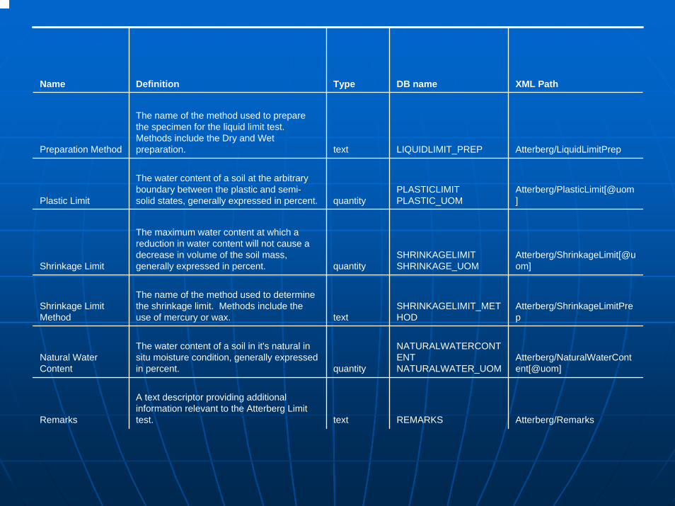
Name Definition Type DB name XML Path
Preparation Method
The name of the method used to prepare the specimen for the liquid limit test. Methods include the Dry and Wet preparation. text LIQUIDLIMIT_PREP Atterberg/LiquidLimitPrep
Plastic Limit
The water content of a soil at the arbitrary boundary between the plastic and semi-solid states, generally expressed in percent. quantity
PLASTICLIMIT PLASTIC_UOM
Atterberg/PlasticLimit[@uom]
Shrinkage Limit
The maximum water content at which a reduction in water content will not cause a decrease in volume of the soil mass, generally expressed in percent. quantity
SHRINKAGELIMIT SHRINKAGE_UOM
Atterberg/ShrinkageLimit[@uom]
Shrinkage Limit Method
The name of the method used to determine the shrinkage limit. Methods include the use of mercury or wax. text
SHRINKAGELIMIT_METHOD
Atterberg/ShrinkageLimitPrep
Natural Water Content
The water content of a soil in it's natural in situ moisture condition, generally expressed in percent. quantity
NATURALWATERCONTENT NATURALWATER_UOM
Atterberg/NaturalWaterContent[@uom]
Remarks
A text descriptor providing additional information relevant to the Atterberg Limit test. text REMARKS Atterberg/Remarks


Example CPT Data on NGES siteExample CPT Data on NGES site
IDIDCode SpaceCode SpaceCPT IDCPT IDDepthDepthTip ResistanceTip ResistanceFriction ResistanceFriction ResistancePore PressurePore PressureInclinationInclinationRemarksRemarksUpdatesUpdates


SPT Data at the same NGES siteSPT Data at the same NGES site

CPT Data in Database FormCPT Data in Database FormCPT ID DEPTH TIP RESISTANCE
FRICTIONRESISTANCE
POREPRESSURE
INCLINATIONDEGREES REMARKS
731 TC 0.05 ft 893.87 ton 2.3355 na 0.45
731 TC 0.1 ft 594.47 ton 4.4059 na 0.6
731 TC 0.15 ft 415.73 ton 3.4361 na 0.1
731 TC 0.2 ft 265.97 ton 2.5304 na 0.09
731 TC 0.25 ft 223.64 ton 2.0594 na 0.06
731 TC 0.3 ft 207.76 ton 1.9412 na 0.12
731 TC 0.35 ft 158.67 ton 1.6396 na 0.07
731 TC 0.4 ft 121.87 ton 0.9642 na 0.22
731 TC 0.45 ft 88.03 ton 0.859 na 0.22

Sieve AnalysisSieve Analysis


ESRI ESRI ArcIMSArcIMS -- Front DoorFront DoorXML (Excel) and COSMOS Database XML (Excel) and COSMOS Database File SystemFile SystemJava Script Java Script -- Back endBack end
COSMOS Virtual COSMOS Virtual Geotechnical Database Geotechnical Database
ArchitectureArchitecture

LongLong--Term ObjectiveTerm ObjectiveExtend the pilot system and develop Extend the pilot system and develop a weba web--based system linking multiple based system linking multiple data setsdata setsCapable of serving the broad needs Capable of serving the broad needs of practicing geotechnical and of practicing geotechnical and earthquake hazards professionals for earthquake hazards professionals for efficient access to geotechnical dataefficient access to geotechnical dataCreate GIS based hazard maps that Create GIS based hazard maps that can be incorporated into the can be incorporated into the geotechnical data set geotechnical data set

Virtual Geotechnical Virtual Geotechnical DatabaseDatabase
ArcIMSArcIMS / XML System/ XML System
Example InquiryExample Inquiry

Virtual Geotechnical DatabaseVirtual Geotechnical Database


CPT Data in Database FormCPT Data in Database FormCPT ID DEPTH TIP RESISTANCE
FRICTIONRESISTANCE
POREPRESSURE
INCLINATIONDEGREES REMARKS
731 TC 0.05 ft 893.87 ton 2.3355 na 0.45
731 TC 0.1 ft 594.47 ton 4.4059 na 0.6
731 TC 0.15 ft 415.73 ton 3.4361 na 0.1
731 TC 0.2 ft 265.97 ton 2.5304 na 0.09
731 TC 0.25 ft 223.64 ton 2.0594 na 0.06
731 TC 0.3 ft 207.76 ton 1.9412 na 0.12
731 TC 0.35 ft 158.67 ton 1.6396 na 0.07
731 TC 0.4 ft 121.87 ton 0.9642 na 0.22
731 TC 0.45 ft 88.03 ton 0.859 na 0.22

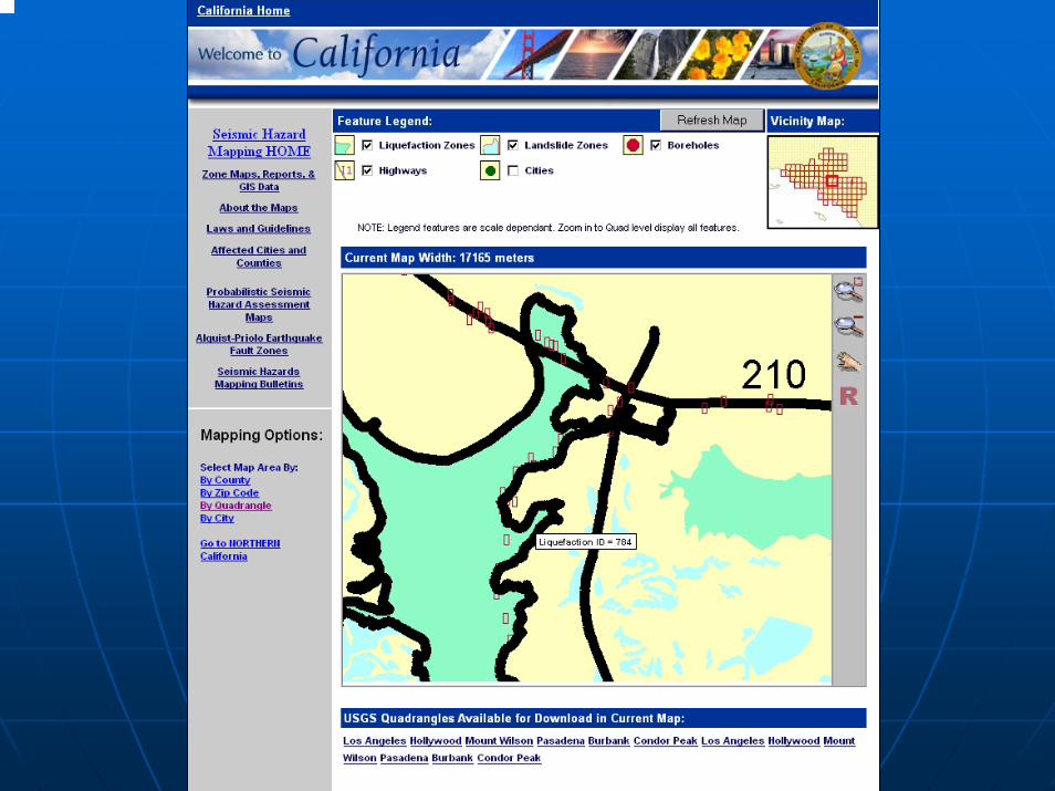
California Geological California Geological Survey Survey
Seismic Hazard Mapping Seismic Hazard Mapping ArcIMSArcIMS SystemSystem
Example InquiryExample Inquiry