designated airspace handbook
TRANSCRIPT

TP 1820E
DESIGNATED AIRSPACE HANDBOOK(Aussi disponible en français)
PUBLISHED UNDER THE AUTHORITY OF THEMINISTER OF TRANSPORT
ISSUE NO 289EFFECTIVE 0901Z 17 JUNE 2021
(Next Issue: 12 AUGUST 2021)
CAUTIONTHE INFORMATION IN THIS PUBLICATION
MAY BE SUPERSEDED BY NOTAM
SOURCE OF CANADIAN CIVIL AERONAUTICAL DATA:NAV CANADA
SOURCE OF CANADIAN MILITARY AERONAUTICAL DATA:HER MAJESTY THE QUEEN IN RIGHT OF CANADA
DEPARTMENT OF NATIONAL DEFENCE
PRODUCED BYDEPARTMENT OF NATIONAL DEFENCE
PUBLISHED BYNAV CANADA

TRANSPORT CANADA
DESIGNATED AIRSPACE HANDBOOK
Table of Contents
Foreword........................................................................................................................................................................................1
1.) General...............................................................................................................................................................................21.1) Standards........................................................................................................................................................21.2) Abbreviations & Acronyms..............................................................................................................................31.3) Glossary of Aeronautical Terms and Designations of Miscellaneous Airspace ..............................................4
2.) Navigation Aid and Intersection/Fix Coordinates Used to Designate Airspace .......................................................152.1) Navigation Aid Coordinates ..........................................................................................................................152.2) Intersection/Fix Coordinates .........................................................................................................................16
3.) Designation of Class A, B, C, D, E Airspace and Transponder Airspace by Flight Information Region................203.1) Vancouver Flight Information Region............................................................................................................203.2) Edmonton Flight Information Region ............................................................................................................433.3) Winnipeg Flight Information Region..............................................................................................................593.4) Toronto Flight Information Region ................................................................................................................723.5) Montreal Flight Information Region...............................................................................................................843.6) Moncton Flight Information Region .............................................................................................................1023.7) Gander Flight Information Region...............................................................................................................107
4.) Designation of Low Level Airways and Fixed Area Navigation Routes...................................................................1134.1) LF/MF Low Level Airways...........................................................................................................................1134.2) VHF/UHF Low Level Airways......................................................................................................................1144.3) Low Level Fixed RNAV Routes...................................................................................................................118
5.) Designation of Class F Airspace .................................................................................................................................1235.1) Danger Areas..............................................................................................................................................1235.2) Restricted Areas .........................................................................................................................................1295.3) Advisory Areas............................................................................................................................................167
M1: Canadian Domestic Airspace............................................................................................................................................192
M2: Arctic, Northern and Southern Control Areas ...................................................................................................................193
M3: Altimeter Setting and Standard Pressure Regions ...........................................................................................................194
M4: Designated Mountainous Regions in Canada...................................................................................................................195
M5: Flight Information Regions................................................................................................................................................196
M6: Air Defence Identification Zone (ADIZ) .............................................................................................................................197
M7: Canadian Minimum Navigation Performance Specifications (CMNPS) Airspace andCanadian Minimum Navigation Performance Specifications (CMNPS) Transition AreaRequired Navigation Performance Capability (RNPC) Airspace.....................................................................................199
M8: Emergency Security Control of Air Traffic (ESCAT) .........................................................................................................200

DE
SIG
NA
TE
D A
IRS
PA
CE
HA
ND
BO
OK
Effe
ctiv
e 090
1Z
17
JU
NE
20
21 to
09
01Z
12 A
UG
US
T 20
21
1 DAH May 3, 2021 9:49 am
© 2
021
He
r Ma
jesty the Q
ue
en in R
ight o
f Can
ad
aS
ou
rce o
f Ca
nad
ian A
irspa
ce D
ata
© 2
021
Tra
nsp
ort C
an
ada
FOREWORD
1. The Designated Airspace Handbook (DAH) is available free of charge, in digital format, on the internet athttps://www.navcanada.ca under the Aeronautical Publications/Canadian Aeronautical Information Products section on theNAV CANADA website. It will be updated every 56 days in its entirety.
2. A vertical line alongside an entry indicates new or revised information since the last issue of the manual.
3. This issue cancels and replaces all previous issues.

DE
SIG
NA
TE
D A
IRS
PA
CE
HA
ND
BO
OK
Effe
ctiv
e 090
1Z
17
JU
NE
20
21 to
09
01Z
12 A
UG
US
T 20
21
© 2
021
He
r Ma
jesty the Q
ue
en in R
ight o
f Can
ad
aS
ou
rce o
f Ca
nad
ian A
irspa
ce D
ata
© 2
021
Tra
nsp
ort C
an
ada
1. GENERAL
1.0.0-1 In accordance with the Canadian Aviation Regulations (CARs), Part VI, Subpart 1, airspace may be designated orchanged by amendment of the Designated Airspace Handbook under the authority delegated to the Chief of FlightStandards, by the Minister of Transport.
1.0.0-2 It is requested that proposed changes, errors or omissions be brought to the attention of the Chief of FlightStandards, AARTA, Transport Canada, Ottawa ON, K1A 0N8. Military users should contact Air TrafficManagement Coordination Office (ATM COORD), NAV CANADA, 4th Floor, WS421, 77 Metcalfe Street, OttawaON, K1P 5L6, tel 613-996-1418.
1.0.0-3 Requests for the designation of Class F Advisory or Restricted airspace for short duration use may be approvedby NOTAM (Notice to Airmen) if time limitations preclude the normal 56-day publication cycle and the need for theairspace is adequately justified. Requests shall be forwarded to the Chief of Flight Standards, who will approve therequest and coordinate the issuance of a NOTAM with the NAV CANADA International NOTAM Office.
1.1 STANDARDS
1.1.0-1 Abbreviations, acronyms and terminology used shall conform to the extent possible with abbreviations andacronyms published in TP14371E Transport Canada Aeronautical Information Manual (TC AIM) and in theTransport Canada Advisory Circular (AC) 100-001 Glossary for Pilots and Air Traffic Services Personnel at link:(https://www.tc.canada.ca/en/aviation/reference-centre/advisory-circulars/advisory-circular-ac-no-100-001).
Where airspace is designated by reference to the Can/USA bdry or to any portion of this boundary, the Definitionof Boundary between Canada and the United States NAD 83, as published by the International BoundaryCommission, shall be used.
1.1.0-2 The designation of airspace within this document applies to those portions overlying Canadian territory.Therefore, any portions of airspace overlying USA territory are excluded from the designations in this document.
1.1.0-3 All airspace designated in Part 3 is excluded from within airway or fixed RNAV boundaries.
1.1.0-4 Control Zones, as defined in Part 3, are excluded from all Transition Areas, Control Area Extensions and TerminalControl Areas as defined in Part 3.
1.1.0-5 Class F airspace, as designated in Part 5, when active, is excluded from all airspace designated in Part 3. Unlessotherwise specified, when areas of Class F airspace are inactive, the rules for the appropriate airspace apply.
1.1.0-6 Where airspace, airways and fixed RNAV routes are designated by reference to a NAVAID, or to an Intxn or Fix,the coordinates used shall be listed in Part 2.
1.1.0-7 When a segment of airspace has a coordinate that is located close to a Navaid, Intersection or Aerodrome alocation key for the point will be added to assist users of the DAH, to plot the airspace. Where multiple locationkeys could be chosen only one will be selected. Ex. (Sault Ste. Marie, ON-AD) or (Yellowknife, NT-NDB)
1.1.0-8 All segments between points defining airspace boundaries are calculated as Great Circles, unless otherwisespecified.
1.1.0-9 Unless otherwise specified, whenever the word "mile(s)" is used in this document, it shall mean nautical mile(s).
1.1.0-10 All radials used shall be in degrees magnetic, unless otherwise specified in degrees true.
1.1.0-11 All coordinates shall be expressed in degrees/minutes/seconds, using the North American Datum 1983 (NAD 83).Canada has deemed NAD 83 coordinates to be equivalent to the World Geodetic System 1984 (WGS 84) foraeronautical purposes. All coordinate values are derived from the best source available. Coordinates obtained in
2 DAH May 3, 2021 9:49 am

DE
SIG
NA
TE
D A
IRS
PA
CE
HA
ND
BO
OK
Effe
ctiv
e 090
1Z
17
JU
NE
20
21 to
09
01Z
12 A
UG
US
T 20
21
ABBREVIATIONS & ACRONYMS
© 2
021
He
r Ma
jesty the Q
ue
en in R
ight o
f Can
ad
aS
ou
rce o
f Ca
nad
ian A
irspa
ce D
ata
© 2
021
Tra
nsp
ort C
an
ada
decimal seconds are rounded, to two decimal places in Chapter 3 and one decimal in Chapter 2, by roundingvalues of 5 or greater up and values of less than 5 down.
1.1.0-12 All altitudes are above sea level (ASL) and will be inclusive unless otherwise indicated e.g. 5000´ to 10,000´. Toindicate when either the bottom or upper altitude is not included, the words below and above are to be placedbefore the appropriate altitude e.g. above 5000´ to 10,000´ or 5000´ to below 10,000´.
1.1.0-13 Non-continuous segments in airways or air routes and some segments within US airspace are marked with anellipsis (. . .).
1.2 ABBREVIATIONS & ACRONYMS
Abbreviations and acronyms used in this Part shall conform to the extent possible with abbreviations andacronyms published in TP14371E Transport Canada Aeronautical Information Manual (TC AIM) and in TP11958EGlossary for Pilots and Air Traffic Services Personnel.AAE ............................Above Aerodrome ElevationAB ..............................AlbertaACA............................Arctic Control AreaACC............................Area Control CentreAD ..............................AerodromeADIZ ...........................Air Defence Identification ZoneAGL ............................Above Ground LevelAIP .............................Aeronautical Information PublicationAK ..............................Alaska, USAARTCC.......................Air Route Traffic Control Centre (USA)ASL ............................Above Sea LevelASU............................Area Support UnitATIS ...........................Automatic Terminal Information ServiceBC ..............................British Columbiabdry ............................BoundaryBrg..............................BearingCAE............................Control Area ExtensionCan.............................CanadaCARs..........................Canadian Aviation RegulationsCDA............................Canadian Domestic AirspaceCFB ............................Canadian Forces BaseCMNPS ......................Canadian Minimum Navigation Performance SpecificationsCont............................ContinuousCrs..............................CourseCSN............................Canadian Switched NetworkCTA ............................Control AreaCZ ..............................Control ZoneDist .............................DistanceDME ...........................Distance Measuring EquipmentDND ...........................Department of National DefenceDT ..............................Daylight Saving TimeESCAT .......................Emergency Security Control of Air TrafficFIR .............................Flight Information RegionFL ...............................Flight LevelFSS ............................Flight Service StationIntl ..............................InternationalIntxn ...........................IntersectionLF/MF.........................Low Frequency/Medium FrequencyMA..............................Massachusetts, USAMB..............................ManitobaME..............................Maine, USAMEA ...........................Minimum Enroute AltitudeMI ...............................Michigan, USAMN..............................Minnesota, USAMTCA .........................Military Terminal Control AreaMuni ...........................Municipal
3 DAH May 3, 2021 9:49 am

DE
SIG
NA
TE
D A
IRS
PA
CE
HA
ND
BO
OK
Effe
ctiv
e 090
1Z
17
JU
NE
20
21 to
09
01Z
12 A
UG
US
T 20
21
GLOSSARY OF AERONAUTICAL TERMS AND DESIGNATIONS OF MISCELLANEOUS AIRSPACE
© 2
021
He
r Ma
jesty the Q
ue
en in R
ight o
f Can
ad
aS
ou
rce o
f Ca
nad
ian A
irspa
ce D
ata
© 2
021
Tra
nsp
ort C
an
ada
NAVAID......................Navigation AidNB ..............................New BrunswickNCA............................Northern Control AreaND ..............................North Dakota, USANDA............................Northern Domestic AirspaceNDB............................Non-directional BeaconNL...............................Newfoundland & Labrador NS ..............................Nova ScotiaNT ..............................Northwest TerritoriesNU ..............................NunavutNY ..............................New York, USAOcsl ............................OccasionalOH..............................Ohio, USAON..............................OntarioO/T .............................Other timesPA ..............................Pennsylvania, USAPE ..............................Prince Edward IslandPN ..............................Prior notice requiredQC..............................QuebecRNAV .........................Area NavigationRNPC .........................Required Navigation Performance CapabilityRVSM.........................Reduced Vertical Separation MinimumRwy ............................RunwaySCA............................Southern Control AreaSDA............................Southern Domestic AirspaceSK ..............................SaskatchewanTACAN .......................Tactical Air NavigationTCA ............................Terminal Control AreaUSA............................United States of AmericaVHF/UHF....................Very High Frequency/Ultra High FrequencyVOR ...........................VHF Omnidirectional RangeVORTAC ....................Combination of VOR and TACANVT...............................Vermont, USAYT...............................Yukon TerritoryZ .................................Zulu, Co-ordinated Universal Time
1.3 GLOSSARY OF AERONAUTICAL TERMS AND DESIGNATIONS OF MISCELLANEOUS AIRSPACE
ADVISORY AREA:Airspace of defined dimensions within which a high volume of pilot training or an unusual type of aerial activity maybe carried out.
AIR DEFENCE IDENTIFICATION ZONE (See map page M6):Airspace of defined dimensions extending upwards from the surface of the earth within which certain rules for thesecurity control of air traffic apply.
AIRSPACE CLASSIFICATION:Canadian Domestic Airspace has seven classifications. The application of any classification to an airspacestructure determines the operating rules, the level of ATC service provided within the structure, and in someinstances, communications and equipment requirements.
1. Class A
High level controlled airspace within the SCA, NCA and ACA. The horizontal and vertical dimensions ofhigh level controlled airspace within these CTAs are illustrated on page M2 (Arctic, Northern and SouthernControl Areas). The vertical dimensions of Class A high level controlled airspace within these areas areas follows:
SCA : 18,000´ ASL or from 700´ AGL, whichever is higher, to FL600NCA : FL230 to FL600
4 DAH May 3, 2021 9:49 am

DE
SIG
NA
TE
D A
IRS
PA
CE
HA
ND
BO
OK
Effe
ctiv
e 090
1Z
17
JU
NE
20
21 to
09
01Z
12 A
UG
US
T 20
21
GLOSSARY OF AERONAUTICAL TERMS AND DESIGNATIONS OF MISCELLANEOUS AIRSPACE
© 2
021
He
r Ma
jesty the Q
ue
en in R
ight o
f Can
ad
aS
ou
rce o
f Ca
nad
ian A
irspa
ce D
ata
© 2
021
Tra
nsp
ort C
an
ada
ACA : FL270 to FL600
2. Class B*
All low level controlled airspace above 12,500´ ASL or from the MEA, whichever is higher, to below18,000´ ASL. TCAs and associated primary CZs may also be classified Class B airspace.
3. Class C*
TCAs and associated primary CZs may be classified Class C airspace.
4. Class D*
TCAs and associated primary CZs may be classified Class D airspace.
5. Class E*
All high level controlled airspace above FL600 within the SCA, NCA and ACA. Also, low level airways, lowlevel fixed RNAV routes, CAEs, Transition Areas or CZs established without an operating control towermay be classified Class E airspace.
6. Class F
Class F airspace is described in terms of horizontal and vertical dimensions, effective for a specifiedperiod of time. Class F airspace may be restricted airspace, advisory airspace, military operations areasor danger areas, and can be controlled airspace, uncontrolled airspace or a combination of both.
7. Class G
Airspace shall be classified G if it has not been designated A, B, C, D, E or F.
* The terminology "Class B, C, D or E equivalent" used for the designations of MTCAs describes theequivalent level of service and operating rules for civilian aircraft operating within the MTCA andunder military control.
ALTIMETER SETTING REGION:All low level airspace within the SDA.
ARCTIC CONTROL AREA (See map page M2): The Controlled airspace within the NDA from FL270 north of a line beginning at:
N69°00'00.00" W141°00'00.00" toN72°00'00.00" W129°00'00.00" thence easterly along latitude N72°00'00.00" \ toN72°00'00.00" W092°05'00.00" toN73°56'39.00" W070°24'58.00"
CANADIAN DOMESTIC AIRSPACE (See map page M1): All navigable airspace within the area bounded by a line beginning at:
N90°00'00.00" W060°00'00.00" Geographic North Pole \ toN82°00'00.00" W060°00'00.00" toN78°00'00.00" W075°00'00.00" toN76°00'00.00" W076°00'00.00" toN65°00'00.00" W057°45'00.00" toN65°00'00.00" W060°00'00.00" toN64°00'00.00" W063°00'00.00" toN61°00'00.00" W063°00'00.00" toN57°00'00.00" W059°00'00.00" toN53°00'00.00" W054°00'00.00" toN49°00'00.00" W051°00'00.00" toN45°00'00.00" W051°00'00.00" toN45°00'00.00" W053°00'00.00" toN44°40'00.00" W054°53'00.00" toN43°36'00.00" W060°00'00.00" to
5 DAH May 3, 2021 9:49 am

DE
SIG
NA
TE
D A
IRS
PA
CE
HA
ND
BO
OK
Effe
ctiv
e 090
1Z
17
JU
NE
20
21 to
09
01Z
12 A
UG
US
T 20
21
GLOSSARY OF AERONAUTICAL TERMS AND DESIGNATIONS OF MISCELLANEOUS AIRSPACE
© 2
021
He
r Ma
jesty the Q
ue
en in R
ight o
f Can
ad
aS
ou
rce o
f Ca
nad
ian A
irspa
ce D
ata
© 2
021
Tra
nsp
ort C
an
ada
N41°52'00.00" W067°00'00.00" toN44°30'00.00" W067°00'00.00" toN44°30'00.00" W067°07'00.00" toN44°46'36.00" W066°54'09.00" thence along the Can/USA bdry \ toN48°30'00.00" W125°00'00.00" toN48°20'00.00" W128°00'00.00" toN51°00'00.00" W133°45'00.00" toN54°00'00.00" W136°00'00.00" toN54°13'00.00" W134°57'00.00" toN54°30'00.00" W132°30'00.00" toN54°42'27.00" W130°36'56.00" thence along the Can/USA bdry \ toN69°39'00.00" W141°00'00.00" toN90°00'00.00" W060°00'00.00" point of beginning
CANADIAN MINIMUM NAVIGATION PERFORMANCE SPECIFICATIONS (CMNPS) AIRSPACE (See map page M7): That airspace within the CDA FL330 to FL410 within the area bounded by a line beginning at:
N90°00'00.00" W141°00'00.00" Geographic North Pole \ then southerly along the 141°W meridian of longitude \ to
N70°00'00.00" W141°00'00.00" thence easterly along latitude N70°00'00.00" \ toN70°00'00.00" W130°00'00.00" toN67°00'00.00" W088°00'00.00" toN65°30'00.00" W060°00'00.00" toN65°00'00.00" W060°00'00.00" toN65°00'00.00" W057°45'00.00" toN76°00'00.00" W076°00'00.00" toN78°00'00.00" W075°00'00.00" toN82°00'00.00" W060°00'00.00" thence northerly along longitude W060°00'00.00" \ toN90°00'00.00" W141°00'00.00" point of beginning
CANADIAN MINIMUM NAVIGATION PERFORMANCE SPECIFICATIONS (CMNPS) TRANSITION AREA (See map page M7):Airspace within the CDA extending upwards from FL270, underlying the designated CMNPS airspace.
CHANGEOVER POINT:A point along the route or airway segment between two adjacent NAVAIDS where changeover in navigationguidance should occur.
CONTROL AREA EXTENSION:Controlled airspace of defined dimensions within the low level airspace extending upwards from 2200 feet abovethe surface of the earth unless otherwise specified. CAEs extend to the base of overlying controlled airspace. Evenif described with an ASL floor, the base of a Control Area Extension shall not extend lower than 700 feet AGL.
CONTROL ZONES:Controlled airspace of defined dimensions extending upwards from the surface of the earth to 3000´ AAE roundedto the nearest 100 feet, unless otherwise specified.
CONTROLLED AIRSPACE:Airspace of defined dimensions within which Air Traffic Control service is provided.
CONTROLLING AGENCY:The air traffic control unit which normally exercises air traffic control or provides advisory service in a givenairspace.
DANGER AREA:Airspace of defined dimensions above international waters within which activities dangerous to the flight of non-participating aircraft could take place at specified times.
6 DAH May 3, 2021 9:49 am

DE
SIG
NA
TE
D A
IRS
PA
CE
HA
ND
BO
OK
Effe
ctiv
e 090
1Z
17
JU
NE
20
21 to
09
01Z
12 A
UG
US
T 20
21
GLOSSARY OF AERONAUTICAL TERMS AND DESIGNATIONS OF MISCELLANEOUS AIRSPACE
© 2
021
He
r Ma
jesty the Q
ue
en in R
ight o
f Can
ad
aS
ou
rce o
f Ca
nad
ian A
irspa
ce D
ata
© 2
021
Tra
nsp
ort C
an
ada
ESCAT ZONES (See map page M8)Canadian Domestic Airspace that has been divided into seven zones for the purpose of implementing ESCATwhich may be activated by one or more zones or portions of zones.
a) ZONE 1The airspace within the area bounded by a line beginning at:
N49°00'01.74" W115°29'59.83" thence westerly along the Can/USA bdry \ toN48°29'36.40" W124°43'38.10" toN48°30'00.00" W125°00'00.00" toN48°20'00.00" W128°00'00.00" toN51°00'00.00" W133°45'00.00" toN54°00'00.00" W136°00'00.00" toN54°13'00.00" W134°57'00.00" toN54°39'44.00" W132°41'03.00" thence along the Can/AK bdry \ toN56°59'59.96" W132°03'57.55" toN56°00'00.00" W123°15'00.00" toN53°24'00.00" W119°00'00.00" toN50°19'35.06" W116°05'03.20" thence clockwise along the arc of a circle of25 miles radius centred onN49°57'18.00" W115°47'32.00" (Skookum, BC - NDB) \ toN49°57'45.05" W115°08'49.61" toN49°30'00.00" W115°08'15.00" toN49°00'01.74" W115°29'59.83" point of beginning
b) ZONE 2AThe airspace within the area bounded by a line beginning at:
N61°00'00.00" W141°00'00.00" thence northerly along the Can/AK bdry \ toN69°38'47.81" W141°00'02.13" thence northerly along longitude W141°00'00.00" \ toN90°00'00.00" W141°00'00.00" Geographical North Pole \ thence southerly along longitude
W110°00'00.00" \ toN61°00'00.00" W110°00'00.00" thence westerly along latitude N61°00'00.00" \ toN61°00'00.00" W141°00'00.00" point of beginning
c) ZONE 2BThe airspace within the area bounded by a line beginning at:
N53°25'15.00" W110°00'00.00" thence northerly along longitude W110°00'00.00" \ toN90°00'00.00" W110°00'00.00" thence southerly along longitude W080°00'00.00" \ toN64°24'30.00" W080°00'00.00" toN54°46'00.00" W108°25'00.00" toN54°46'00.00" W108°41'40.00" thence clockwise along the arc of a circle of60 miles radius centred onN54°24'31.00" W110°17'45.00" (Cold Lake, AB - TACAN) \ toN53°25'15.00" W110°00'00.00" point of beginning
d) ZONE 2CThe airspace within the area bounded by a line beginning at:
N62°45'00.00" W080°00'00.00" thence northerly along longitude W080°00'00.00" \ toN90°00'00.00" W080°00'00.00" toN82°00'00.00" W060°00'00.00" toN78°00'00.00" W075°00'00.00" toN76°00'00.00" W076°00'00.00" toN65°00'00.00" W057°45'00.00" toN65°00'00.00" W060°00'00.00" thence westerly along latitude N65°00'00.00" \ toN65°00'00.00" W068°00'00.00" toN62°45'00.00" W080°00'00.00" point of beginning
e) ZONE 2DThe airspace within the area bounded by a line beginning at:
N56°59'59.96" W132°03'57.55" thence northerly along the Can/AK bdry \ toN61°00'00.00" W141°00'00.00" thence easterly along latitude N61°00'00.00" \ toN61°00'00.00" W110°00'00.00" toN48°59'58.61" W110°00'00.00" thence westerly along the Can/USA bdry \ to
7 DAH May 3, 2021 9:49 am

DE
SIG
NA
TE
D A
IRS
PA
CE
HA
ND
BO
OK
Effe
ctiv
e 090
1Z
17
JU
NE
20
21 to
09
01Z
12 A
UG
US
T 20
21
GLOSSARY OF AERONAUTICAL TERMS AND DESIGNATIONS OF MISCELLANEOUS AIRSPACE
© 2
021
He
r Ma
jesty the Q
ue
en in R
ight o
f Can
ad
aS
ou
rce o
f Ca
nad
ian A
irspa
ce D
ata
© 2
021
Tra
nsp
ort C
an
ada
N49°00'01.74" W115°29'59.83" toN49°30'00.00" W115°08'15.00" toN49°57'45.05" W115°08'49.61" thence counter-clockwise along the arc of a circle of25 miles radius centred onN49°57'18.00" W115°47'32.00" (Skookum, BC - NDB) \ toN50°19'35.06" W116°05'03.20" toN53°24'00.00" W119°00'00.00" toN56°00'00.00" W123°15'00.00" toN56°59'59.96" W132°03'57.55" point of beginning
f) ZONE 3The airspace within the area bounded by a line beginning at:
N47°46'31.29" W087°00'00.00" thence westerly along the Can/USA bdry \ toN48°59'58.61" W110°00'00.00" toN53°25'15.00" W110°00'00.00" thence counter-clockwise along the arc of a circle of60 miles radius centred onN54°24'31.00" W110°17'45.00" (Cold Lake, AB - TACAN) \ toN54°46'00.00" W108°41'40.00" toN54°46'00.00" W108°25'00.00" toN64°24'30.00" W080°00'00.00" toN53°28'00.00" W080°00'00.00" toN52°00'00.00" W083°08'30.00" toN50°00'00.00" W086°16'00.00" toN49°32'00.00" W087°00'00.00" toN47°46'31.29" W087°00'00.00" point of beginning
g) ZONE 4The airspace within the area bounded by a line beginning at:
N44°13'17.10" W076°11'30.20" thence westerly along the Can/USA bdry \ toN47°46'31.29" W087°00'00.00" toN49°32'00.00" W087°00'00.00" toN50°00'00.00" W086°16'00.00" toN52°00'00.00" W083°08'30.00" toN53°28'00.00" W080°00'00.00" toN49°00'00.00" W079°00'00.00" toN48°35'13.37" W079°00'00.00" thence counter-clockwise along the arc of a circle of25 miles radius centred onN48°10'22.44" W078°56'18.90" (Rouyn, QC - NDB) \ toN47°50'24.23" W078°33'56.54" toN47°33'15.33" W078°07'03.25" toN47°06'39.97" W077°32'45.11" toN46°56'48.77" W077°15'00.00" toN46°08'00.00" W077°15'00.00" toN45°57'40.00" W076°55'40.00" toN45°50'15.00" W076°16'00.00" toN44°13'17.10" W076°11'30.20" point of beginning
h) ZONE 5AThe airspace within the area bounded by a line beginning at:
N55°00'00.00" W080°00'00.00" toN62°45'00.00" W080°00'00.00" toN65°00'00.00" W068°00'00.00" thence easterly along latitude N65°00'00.00" \ toN65°00'00.00" W060°00'00.00" toN64°00'00.00" W063°00'00.00" toN61°00'00.00" W063°00'00.00" toN58°28'16.00" W060°21'04.00" toN57°33'00.00" W064°00'00.00" thence southerly along longitude W064°00'00.00" \ toN55°21'20.00" W064°00'00.00" toN55°05'00.00" W065°05'00.00" toN55°00'00.00" W065°06'54.00" thence westerly along latitude N55°00'00.00" \ toN55°00'00.00" W080°00'00.00" point of beginning
8 DAH May 3, 2021 9:49 am

DE
SIG
NA
TE
D A
IRS
PA
CE
HA
ND
BO
OK
Effe
ctiv
e 090
1Z
17
JU
NE
20
21 to
09
01Z
12 A
UG
US
T 20
21
GLOSSARY OF AERONAUTICAL TERMS AND DESIGNATIONS OF MISCELLANEOUS AIRSPACE
© 2
021
He
r Ma
jesty the Q
ue
en in R
ight o
f Can
ad
aS
ou
rce o
f Ca
nad
ian A
irspa
ce D
ata
© 2
021
Tra
nsp
ort C
an
ada
i) ZONE 5BThe airspace within the area bounded by a line beginning at:
N47°27'35.00" W069°13'28.00" thence westerly along the Can/USA bdry \ toN44°13'17.10" W076°11'30.20" toN45°50'15.00" W076°16'00.00" toN45°57'40.00" W076°55'40.00" toN46°08'00.00" W077°15'00.00" toN46°56'48.77" W077°15'00.00" toN47°06'39.97" W077°32'45.11" toN47°33'15.33" W078°07'03.25" toN47°50'24.23" W078°33'56.54" thence clockwise along the arc of a circle of25 miles radius centred onN48°10'22.44" W078°56'18.90" (Rouyn, QC - NDB) \ toN48°35'13.37" W079°00'00.00" toN49°00'00.00" W079°00'00.00" toN53°28'00.00" W080°00'00.00" toN55°00'00.00" W080°00'00.00" thence easterly along latitude N55°00'00.00" \ toN55°00'00.00" W065°06'54.00" toN54°25'00.00" W065°20'00.00" toN53°42'00.00" W064°55'00.00" toN51°25'00.00" W064°00'00.00" toN50°50'00.00" W062°05'00.00" toN50°50'00.00" W060°00'00.00" toN51°20'00.00" W059°30'00.00" toN51°38'00.00" W059°30'00.00" toN52°11'47.00" W058°08'34.00" toN51°44'06.00" W057°00'00.00" thence southerly along longitude W057°00'00.00" \ toN51°17'00.00" W057°00'00.00" toN51°00'00.00" W058°00'00.00" toN49°32'00.00" W061°00'00.00" thence southerly along longitude W061°00'00.00" \ toN49°18'00.00" W061°00'00.00" toN48°30'00.00" W062°00'00.00" toN47°50'54.00" W064°37'20.00" toN48°00'00.00" W065°56'28.00" thence counter-clockwise along the arc of a circle of20 miles radius centred onN48°00'32.00" W066°26'13.00" toN47°53'00.00" W066°53'48.00" toN47°44'00.00" W067°57'00.00" toN47°31'30.36" W068°00'00.15" thence counter-clockwise along the arc of a circle of34.759 miles radius centred onN46°57'05.00" W067°53'10.00" toN47°17'15.07" W068°34'35.40" thence westerly along the Can/USA bdry \ toN47°27'35.00" W069°13'28.00" point of beginning
j) ZONE 6The airspace within the area bounded by a line beginning at:
N44°26'48.00" W056°03'06.00" toN43°36'00.00" W060°00'00.00" toN41°52'00.00" W067°00'00.00" toN44°30'00.00" W067°00'00.00" toN44°30'00.00" W067°07'00.00" toN44°46'35.60" W066°54'09.20" thence northerly along the Can/USA bdry \ toN47°17'15.07" W068°34'35.40" thence clockwise along the arc of a circle of34.759 miles radius centred onN46°57'05.00" W067°53'10.00" toN47°31'30.36" W068°00'00.15" toN47°44'00.00" W067°57'00.00" toN47°53'00.00" W066°53'48.00" thence clockwise along the arc of a circle of20 miles radius centred on
9 DAH May 3, 2021 9:49 am

DE
SIG
NA
TE
D A
IRS
PA
CE
HA
ND
BO
OK
Effe
ctiv
e 090
1Z
17
JU
NE
20
21 to
09
01Z
12 A
UG
US
T 20
21
GLOSSARY OF AERONAUTICAL TERMS AND DESIGNATIONS OF MISCELLANEOUS AIRSPACE
© 2
021
He
r Ma
jesty the Q
ue
en in R
ight o
f Can
ad
aS
ou
rce o
f Ca
nad
ian A
irspa
ce D
ata
© 2
021
Tra
nsp
ort C
an
ada
N48°00'32.00" W066°26'13.00" toN48°00'00.00" W065°56'28.00" toN47°50'54.00" W064°37'20.00" toN48°30'00.00" W062°00'00.00" toN45°36'43.00" W056°28'25.00" toN44°26'48.00" W056°03'06.00" point of beginning
k) ZONE 7AThe airspace within the area bounded by a line beginning at:
N45°00'00.00" W051°00'00.00" toN45°00'00.00" W053°00'00.00" toN44°26'48.00" W056°03'06.00" toN45°36'43.00" W056°28'25.00" toN48°30'00.00" W062°00'00.00" toN49°18'00.00" W061°00'00.00" thence northerly along longitude W061°00'00.00" \ toN49°32'00.00" W061°00'00.00" toN51°00'00.00" W058°00'00.00" toN51°17'00.00" W057°00'00.00" thence northerly along longitude W057°00'00.00" \ toN51°44'06.00" W057°00'00.00" toN52°11'47.00" W058°08'34.00" toN53°00'00.00" W054°00'00.00" toN49°00'00.00" W051°00'00.00" toN45°00'00.00" W051°00'00.00" point of beginning
l) ZONE 7BThe airspace within the area bounded by a line beginning at:
N52°11'47.00" W058°08'34.00" toN51°38'00.00" W059°30'00.00" toN51°20'00.00" W059°30'00.00" toN50°50'00.00" W060°00'00.00" toN50°50'00.00" W062°05'00.00" toN51°25'00.00" W064°00'00.00" toN53°42'00.00" W064°55'00.00" toN54°25'00.00" W065°20'00.00" toN55°05'00.00" W065°05'00.00" toN55°21'20.00" W064°00'00.00" thence northerly along longitude W064°00'00.00" \ toN57°33'00.00" W064°00'00.00" toN58°28'16.00" W060°21'04.00" toN57°00'00.00" W059°00'00.00" toN53°00'00.00" W054°00'00.00" toN52°11'47.00" W058°08'34.00" point of beginning
FLIGHT INFORMATION REGION (See map page M5):Airspace of defined dimensions extending upwards from the surface of the earth, within which flight informationservice and alerting service are provided.
HIGH LEVEL AIR ROUTE:In high level airspace, a prescribed track between specified radio aids to navigation.
HIGH LEVEL AIRSPACE:All airspace within the CDA 18,000´ ASL and above.
HIGH LEVEL AIRWAY:In controlled high level airspace, a prescribed track between specified radio aids to navigation.
HIGH LEVEL FIXED RNAV ROUTE:In high level airspace, a prescribed Area Navigation track between specified fixes.
INTERSECTION:As the circumstances require, this may be:
10 DAH May 3, 2021 9:49 am

DE
SIG
NA
TE
D A
IRS
PA
CE
HA
ND
BO
OK
Effe
ctiv
e 090
1Z
17
JU
NE
20
21 to
09
01Z
12 A
UG
US
T 20
21
GLOSSARY OF AERONAUTICAL TERMS AND DESIGNATIONS OF MISCELLANEOUS AIRSPACE
© 2
021
He
r Ma
jesty the Q
ue
en in R
ight o
f Can
ad
aS
ou
rce o
f Ca
nad
ian A
irspa
ce D
ata
© 2
021
Tra
nsp
ort C
an
ada
1. A point on the surface of the earth over which two or more position lines intersect. The position lines maybe true bearings from NDBs (magnetic bearings shown on charts for pilot usage); radials from VHF/UHFNAVAIDs; centrelines of airways; fixed RNAV routes or air routes; localizers or DME distances; or
2. The point where two runways, a runway and taxiway, or two taxiways cross or meet.
LOW LEVEL AIRSPACE:All airspace within the CDA below 18,000´ ASL.
LOW LEVEL AIRWAY:Controlled low level airspace, extending upwards from 2200 feet above the surface of the earth within the followingspecified boundaries:
1. VHF/UHF airways based on VORs/VORTACs
a) The primary airway width is 4 miles on each side of the centre line prescribed for such an airway
b) Where applicable, the primary airway width shall be increased between the points where lines,diverging 4.5° on each side of the centre line from the designated facility, intersect the primary widthboundary and where they meet similar lines projected from the other designated facility.
2. LF/MF airways based on NDBs or VHF/UHF airways based on VOR/VORTAC and NDB
a) The primary airway width is 4.34 miles on each side of the centre line prescribed for such an airway.
b) Where applicable, the primary airway width shall be increased between the points where lines,diverging 5° on each side of the centre line from the designated facility, intersect the primary widthboundary and where they meet similar lines projected from the other designated facility.
Where the changeover point is not midway between the NAVAIDS, the airway includes the airspace between thesystem accuracy lines which extend from the farthest facility, at angles of 4.5° for VHF/UHF airways, 5° for LF/MFairways and 5° for VHF/UHF airways based on a VOR/VORTAC and NDB, to the changeover point and are joinedby lines from the nearer facility.
LOW LEVEL AIR ROUTE:Class G Airspace, extending upwards form the surface of the earth, within the following specified boundaries:
1. Air routes based on VORs/VORTACs
a) The primary air route width is 4 miles on each side of the centre line prescribed for such an air route.
b) Where applicable, the primary air route width shall be increased between the points where lines,diverging 4.5° on each side of the centre line from the designated facility, intersect the primary widthboundary and where they meet similar lines projected from the other designated facility.
2. Air routes based on NDBs or a VOR/VORTAC and NDB
a) The primary air route width is 4.34 miles on each side of the centre line prescribed for such an airroute.
b) Where applicable, the primary air route width shall be increased between the points where lines,diverging 5° on each side of the centre line from the designated facility, intersect the primary widthboundary and where they meet similar lines projected from the other designated facility.
Where the changeover point is not midway between the NAVAIDS, the air route includes the airspace between thesystem accuracy lines which extend from the farthest facility, at angles of 4.5° for VHF/UHF air route, 5° for LF/MFair route and 5° for VHF/UHF air route based on a VOR/VORTAC and NDB, to the changeover point and are joinedby lines from the nearer facility.
LOW LEVEL FIXED RNAV ROUTE:In low level airspace, a prescribed Area Navigation track between specified fixes. For routes in controlled low levelairspace, the airspace extending upwards from 2200 feet above the surface of the earth within the followingspecified boundaries:
11 DAH May 3, 2021 9:49 am

DE
SIG
NA
TE
D A
IRS
PA
CE
HA
ND
BO
OK
Effe
ctiv
e 090
1Z
17
JU
NE
20
21 to
09
01Z
12 A
UG
US
T 20
21
GLOSSARY OF AERONAUTICAL TERMS AND DESIGNATIONS OF MISCELLANEOUS AIRSPACE
© 2
021
He
r Ma
jesty the Q
ue
en in R
ight o
f Can
ad
aS
ou
rce o
f Ca
nad
ian A
irspa
ce D
ata
© 2
021
Tra
nsp
ort C
an
ada
1. The primary route width is 10 miles on each side of the centre line prescribed for such a route.
2. The primary route boundary lines do not splay.
MILITARY OPERATIONS AREA:Airspace of defined dimensions established to segregate certain military activities from IFR traffic and to identify forVFR traffic where these activities are conducted.
MILITARY TERMINAL CONTROL AREA:Controlled airspace of defined dimensions normally established in the vicinity of a military aerodrome and withinwhich special procedures and exemptions exist for military aircraft. The terminology "Class B, C, D or E equivalent"used for the designations of MTCAs describes the equivalent level of service and operating rules for civilian aircraftoperating within the MTCA and under military control.
MINIMUM ENROUTE ALTITUDE:The published altitude above sea level between specified fixes on airways or air routes which assures acceptablenavigational signal coverage, and which meets the IFR obstruction clearance requirements.
MINIMUM OBSTRUCTION CLEARANCE ALTITUDE:The published altitude above sea level between specified fixes on airways or air routes which meets the IFRobstruction clearance requirements for the route segment.
MINIMUM RECEPTION ALTITUDE:Minimum reception altitude when applied to a specific VHF/UHF intersection, is the lowest altitude above sea levelat which acceptable navigational signal coverage is received to determine the intersection.
MOUNTAINOUS REGIONS (See map page M4):An area of defined lateral dimensions above which special rules concerning minimum enroute altitudes apply.
NORTHERN CONTROL AREA (See map page M2):Controlled airspace within the NDA from FL230 south of a line beginning at:
N72°00'00.00" W129°00'00.00" thence easterly along latitude N72°00'00.00" \ toN72°00'00.00" W092°05'00.00" toN73°56'39.00" W070°24'58.00"
NORTHERN DOMESTIC AIRSPACE (See map page M1):All airspace within the CDA north of a line beginning at:
N69°00'00.00" W141°00'00.00" toN72°00'00.00" W129°00'00.00" toN67°40'22.00" W129°29'34.00" toN63°11'21.00" W115°19'22.00" thence clockwise along the arc of a circle of50 miles radius centred onN62°27'52.00" W114°26'12.00" (Yellowknife, NT - VOR) \ toN62°10'55.00" W112°45'20.00" toN59°00'30.00" W095°29'15.00" thence clockwise along the arc of a circle of50 miles radius centred onN58°45'45.00" W093°57'14.00" toN58°46'00.00" W092°21'00.00" toN62°06'47.00" W079°11'59.00" thence clockwise along the arc of a circle of40 miles radius centred onN62°24'49.00" W077°55'38.00" (Ivujivik, QC - NDB) \ toN62°34'13.00" W076°31'52.00" toN63°26'30.00" W069°53'30.00" thence clockwise along the arc of a circle of40 miles radius centred onN63°44'00.00" W068°32'53.00" (Frobay, NU - NDB) \ toN64°14'23.00" W067°34'28.00" toN67°31'57.00" W060°18'13.00"
12 DAH May 3, 2021 9:49 am

DE
SIG
NA
TE
D A
IRS
PA
CE
HA
ND
BO
OK
Effe
ctiv
e 090
1Z
17
JU
NE
20
21 to
09
01Z
12 A
UG
US
T 20
21
GLOSSARY OF AERONAUTICAL TERMS AND DESIGNATIONS OF MISCELLANEOUS AIRSPACE
© 2
021
He
r Ma
jesty the Q
ue
en in R
ight o
f Can
ad
aS
ou
rce o
f Ca
nad
ian A
irspa
ce D
ata
© 2
021
Tra
nsp
ort C
an
ada
REDUCED VERTICAL SEPARATION MINIMUM (RVSM) AIRSPACE - All airspace within the CDA extending from FL290 up to and including FL410.
REQUIRED NAVIGATION PERFORMANCE CAPABILITY (RNPC) AIRSPACE (See map page M7):The controlled airspace within CDA within the area bounded by a line beginning at:
N58°28'16.00" W060°21'04.00" toN57°00'00.00" W059°00'00.00" toN53°00'00.00" W054°00'00.00" toN49°00'00.00" W051°00'00.00" toN45°00'00.00" W051°00'00.00" toN45°00'00.00" W053°00'00.00" toN44°40'00.00" W054°53'00.00" toN43°36'00.00" W060°00'00.00" toN41°52'00.00" W067°00'00.00" toN44°30'00.00" W067°00'00.00" toN44°30'00.00" W067°07'00.00" toN44°46'36.00" W066°54'09.00" thence along the Can/USA bdry \ toN48°30'00.00" W125°00'00.00" toN48°20'00.00" W128°00'00.00" toN51°00'00.00" W133°45'00.00" toN54°00'00.00" W136°00'00.00" toN54°13'00.00" W134°57'00.00" toN54°30'00.00" W132°30'00.00" toN54°42'27.00" W130°36'56.00" thence along the Can/USA bdry \ toN70°00'00.00" W141°00'00.00" thence easterly along latitude N70°00'00.00" \ toN70°00'00.00" W130°00'00.00" toN67°00'00.00" W088°00'00.00" toN65°30'00.00" W060°00'00.00" toN65°00'00.00" W060°00'00.00" toN64°00'00.00" W063°00'00.00" toN61°00'00.00" W063°00'00.00" toN58°28'16.00" W060°21'04.00" point of beginning
RESTRICTED AREA:Airspace of defined dimensions above the land areas or territorial waters within which the flight of aircraft isrestricted in accordance with certain specified conditions.
SOUTHERN CONTROL AREA (See map page M2):Controlled airspace within the SDA at 18,000´ ASL and above.
SOUTHERN DOMESTIC AIRSPACE (See map page M1): All airspace within the CDA south of a line beginning at:
N69°00'00.00" W141°00'00.00" toN72°00'00.00" W129°00'00.00" toN67°40'22.00" W129°29'34.00" toN63°11'21.00" W115°19'22.00" thence clockwise along the arc of a circle of50 miles radius centred onN62°27'52.00" W114°26'12.00" (Yellowknife, NT - VOR) \ toN62°10'55.00" W112°45'20.00" toN59°00'30.00" W095°29'15.00" thence clockwise along the arc of a circle of50 miles radius centred onN58°45'45.00" W093°57'14.00" toN58°46'00.00" W092°21'00.00" toN62°06'47.00" W079°11'59.00" thence clockwise along the arc of a circle of40 miles radius centred onN62°24'49.00" W077°55'38.00" (Ivujivik, QC - NDB) \ toN62°34'13.00" W076°31'52.00" to
13 DAH May 3, 2021 9:49 am

DE
SIG
NA
TE
D A
IRS
PA
CE
HA
ND
BO
OK
Effe
ctiv
e 090
1Z
17
JU
NE
20
21 to
09
01Z
12 A
UG
US
T 20
21
GLOSSARY OF AERONAUTICAL TERMS AND DESIGNATIONS OF MISCELLANEOUS AIRSPACE
© 2
021
He
r Ma
jesty the Q
ue
en in R
ight o
f Can
ad
aS
ou
rce o
f Ca
nad
ian A
irspa
ce D
ata
© 2
021
Tra
nsp
ort C
an
ada
N63°26'30.00" W069°53'30.00" thence clockwise along the arc of a circle of40 miles radius centred onN63°44'00.00" W068°32'53.00" (Frobay, NU - NDB) \ toN64°14'23.00" W067°34'28.00" toN67°31'57.00" W060°18'13.00"
STANDARD PRESSURE REGION (See map page M3):All CDA that is not designated as the Altimeter Setting Region.
TERMINAL CONTROL AREA:Controlled airspace of defined dimensions normally established in the vicinity of one or more major aerodromesand within which air traffic control service is provided based on the airspace classification. The floor of a TCA shallnot extend lower than 700 feet AGL.
TRACK:The projection on the earth’s surface of the path of an aircraft, the direction of which at any point is usuallyexpressed in degrees from North (True, Magnetic or Grid).
TRANSITION AREA:Controlled airspace of defined dimensions extending upwards from 700´ AGL unless otherwise specified, to thebase of overlying controlled airspace. Even if described with an ASL floor, the base of a Transition Area shall notextend lower than 700 feet AGL.
TRANSPONDER AIRSPACE:Controlled airspace of defined dimensions within which a functioning transponder incorporating an automaticpressure-altitude reporting device is required.
USER AGENCY:The agency, organization or military command responsible for the activity for which Class F airspace has beenprovided. The User Agency shall be identified for Class F restricted airspace, and where possible, should beidentified for Class F advisory airspace.
14 DAH May 3, 2021 9:49 am

NAVIGATION AID COORDINATES
DE
SIG
NA
TE
D A
IRS
PA
CE
HA
ND
BO
OK
Effe
ctiv
e 090
1Z
17
JU
NE
20
21 to
09
01Z
12 A
UG
US
T 20
21
© 2
021
He
r Ma
jesty the Q
ue
en in R
ight o
f Can
ad
aS
ou
rce o
f Ca
nad
ian A
irspa
ce D
ata
© 2
021
Tra
nsp
ort C
an
ada
2. NAVIGATION AID AND INTERSECTION/FIX COORDINATES USED TODESIGNATE AIRSPACE
Note: For navigation aids or intersection/fix coordinates listed in Part 4 that are not published under the authorityof Canada, please consult the appropriate AIS supplier to acquire accurate data.
2.1 NAVIGATION AID COORDINATES
Where airspace is designated in Part 4 by reference to a NAVAID, the following coordinates shall be used:
NAVAID Name NAVAID Coordinates NAVAID Name NAVAID Coordinates
Abbotsford, BC, NDB.............................N49°00'55.1" W122°29'16.7"Active Pass, BC, NDB ...........................N48°52'26.0" W123°17'24.0"Ashcroft, BC, NDB.................................N50°42'06.6" W121°19'13.0"Atikokan, ON, NDB................................N48°49'28.3" W091°34'39.3"Baie-Comeau, QC, VOR .......................N49°08'02.5" W068°13'19.3"Beauce, QC, VOR .................................N45°55'30.2" W070°50'45.9"Beaver Creek, YT, NDB ........................N62°24'31.6" W140°51'40.2"Beechy, SK, NDB ..................................N50°50'31.7" W107°27'36.6"Bella Bella, BC, NDB .............................N52°11'06.8" W128°06'48.7"Brandon, MB, NDB ................................N49°54'29.3" W100°04'24.2"Brandon, MB, VOR................................N49°54'35.6" W099°56'44.4"Broadview, SK, VOR .............................N50°21'46.6" W102°32'25.1"Calgary, AB, VOR..................................N51°06'54.1" W113°52'55.3"Champlain, QC, NDB ............................N46°52'16.2" W071°16'52.9"Charlevoix, QC, NDB.............................N47°37'24.3" W070°19'27.9"Charlottetown, PE, VOR........................N46°17'51.5" W063°07'10.9"Churchill, MB, VOR ...............................N58°44'30.3" W094°08'07.1"Churchill Falls, NL, NDB........................N53°35'26" W064°14'08"Coehill, ON, VOR ..................................N44°39'39" W077°53'17"Comox, BC, NDB...................................N49°45'14.4" W124°57'29.2"Cranbrook, BC, NDB .............................N49°40'57.4" W115°46'58.7"Cranbrook, BC, VOR .............................N49°33'15.4" W116°05'17.9"Cultus, BC, NDB....................................N49°01'16" W122°02'59"Dafoe, SK, NDB.....................................N51°52'23" W104°34'11"Dauphin, MB, NDB ................................N51°05'51.0" W100°03'39.1"Dauphin, MB, VOR ................................N51°06'17.8" W100°03'08.4"Deer Lake, NL, VOR..............................N49°13'56.5" W057°12'47.8"Delta, MB, NDB .....................................N50°09'59" W098°18'26"Dryden, ON, NDB ..................................N49°51'52.0" W092°50'57.1"Edmonton, AB, NDB..............................N53°38'37.2" W113°30'46.3"Edmonton, AB, VOR..............................N53°11'08.1" W113°52'00.6"Elliot Lake, ON, NDB .............................N46°22'19.3" W082°37'43.2"Empress, AB, VOR................................N50°55'34.1" W109°59'22.4"Flin Flon, MB, NDB................................N54°40'31.0" W101°40'09.3"Fort Chipewyan, AB, NDB .....................N58°45'41.6" W111°06'29.8"Fort McMurray, AB, NDB.......................N56°39'11.4" W111°20'10.2"Fort McMurray, AB, VOR.......................N56°38'50" W111°07'20"Fort Nelson, BC, NDB ...........................N58°47'45" W122°43'21"Fort Nelson, BC, VOR ...........................N58°53'30.9" W123°00'57.6"Fort Resolution, NT, NDB......................N61°09'15.0" W113°38'20.5"Fort St. John, BC, NDB .........................N56°17'03.2" W120°50'41.4"Fort St. John, BC, VOR .........................N56°17'03" W120°53'44.0"Fort Simpson, NT, NDB.........................N61°47'09.3" W121°15'39.2"Fort Simpson, NT, VOR.........................N61°46'25.9" W121°17'55.6"Fort Smith, NT, NDB..............................N59°58'16.5" W111°51'24.9"Fort Smith, NT, VOR .............................N60°01'12.3" W111°58'09.7"Fredericton, NB, NDB............................N45°55'02.4" W066°35'59.5"Gander, NL, NDB ..................................N48°57'52.0" W054°40'12.9"Gander, NL, VOR ..................................N48°53'58.7" W054°32'06.0"
Gaspe, QC, NDB...................................N48°46'05.0" W064°23'06.6"Gaspe, QC, VOR ..................................N48°45'47.3" W064°24'16.8"Geraldton, ON, VOR .............................N49°46'11.0" W086°59'03.6"Gillam, MB, NDB ...................................N56°21'11.7" W094°42'00.1"Goose, NL, NDB ...................................N53°20'16" W060°21'57"Goose, NL, VOR ...................................N53°19'11" W060°17'41"Grande Prairie, AB, NDB ......................N55°08'14.7" W118°48'46.4"Grande Prairie, AB, VOR ......................N55°10'27.2" W119°01'48.7"Greenwood, NS, NDB ...........................N44°55'22" W065°06'07"Halifax, NS, VOR ..................................N44°55'23" W063°24'07"Hay River, NT, VOR..............................N60°50'10.6" W115°48'11.8"High Level, AB, NDB.............................N58°33'12.4" W117°07'15.6"High Level, AB, VOR.............................N58°33'15.3" W117°05'34.9"Hope, BC, NDB .....................................N49°23'11.5" W121°25'27.0"Houston, BC, VOR ................................N54°27'08.5" W126°39'03.1"Kelowna, BC, NDB................................N50°03'39.1" W119°24'59.0"Kenora, ON, NDB..................................N49°47'32.8" W094°25'28.0"Killaloe, ON, VOR .................................N45°39'46.8" W077°36'08.6"Kingston, ON, NDB ...............................N44°17'48.5" W076°36'16.3"Kitimat, BC, NDB...................................N54°03'15.3" W128°40'12.3"Langruth, MB, VOR...............................N50°25'20.5" W098°43'25.3"La Ronge, SK, NDB ..............................N55°05'09.6" W105°19'08.1"La Ronge, SK, VOR ..............................N55°09'29.8" W105°16'00.5"La Tuque, QC, NDB ..............................N47°24'58.1" W072°47'11.4"Lethbridge, AB, VOR.............................N49°38'03.8" W112°40'04.0"Lloydminster, AB, NDB .........................N53°18'47.5" W110°04'56.2"London, ON, VOR .................................N43°02'16.5" W081°08'56.1"Lumsden, SK, VORTAC........................N50°40'01.2" W104°53'23.0"Lynn Lake, MB, NDB.............................N56°49'51" W101°04'13"Lynn Lake, MB, VOR ............................N56°51'50.2" W101°04'31.2"Maniwaki, QC, NDB ..............................N46°12'27.4" W075°57'22.8"Mans, ON, VOR ....................................N44°08'35.2" W080°08'46.4"Marathon, ON, VOR..............................N48°44'36.3" W086°19'39.3"Matane, QC, NDB .................................N48°50'00" W067°32'58"Medicine Hat, AB, NDB.........................N50°00'47" W110°47'57"Midland, ON, VOR ................................N44°34'54.5" W079°47'35.6"Miramichi, NB, NDB ..............................N47°00'36" W065°28'03"Moncton, NB, NDB................................N46°06'38.3" W064°34'55.4"Moncton, NB, VOR................................N46°11'19.8" W064°34'16.6"Mont-Joli, QC, NDB...............................N48°34'00.1" W068°15'30.8"Mont-Joli, QC, VOR ..............................N48°36'43.7" W068°12'31.9"Montreal, QC, VOR ...............................N45°36'56.7" W073°58'15.3"Moosonee, ON, VOR ............................N51°17'29" W080°36'26"Muskoka, ON, NDB...............................N45°02'16.9" W079°17'00.2"Nanaimo, BC, NDB ...............................N49°07'40.4" W123°52'17.9"Naramata, BC, NDB..............................N49°35'49.8" W119°36'09.5"North Battleford, SK, NDB.....................N52°48'13.5" W108°20'06.4"North Bay, ON, VOR .............................N46°21'50.1" W079°26'11.1"Norway House, MB, NDB......................N53°58'20.4" W097°50'24.7"
15 DAH May 3, 2021 1:43 pm

INTERSECTION/FIX COORDINATES
DE
SIG
NA
TE
D A
IRS
PA
CE
HA
ND
BO
OK
Effe
ctiv
e 090
1Z
17
JU
NE
20
21 to
09
01Z
12 A
UG
US
T 20
21
© 2
021
He
r Ma
jesty the Q
ue
en in R
ight o
f Can
ad
aS
ou
rce o
f Ca
nad
ian A
irspa
ce D
ata
© 2
021
Tra
nsp
ort C
an
ada
Oshawa, ON, NDB ................................N43°55'15.0" W078°53'59.9"Ottawa, ON, VOR ..................................N45°26'30.3" W075°53'48.7"Peace River, AB, VOR ..........................N56°12'24.9" W117°30'42.5"Pembroke, ON, NDB .............................N45°48'11.5" W077°13'05.6"Penticton, BC, NDB ...............................N49°29'15.7" W119°36'06.2"Pitt Meadows, BC, VOR ........................N49°12'57.4" W122°42'53.6"Port Hardy, BC, NDB.............................N50°41'57.1" W127°25'37.2"Port Hardy, BC, VOR.............................N50°41'02.9" W127°21'55.1"Powell River, BC, NDB ..........................N49°50'12" W124°30'05"Prince Albert, SK, NDB..........................N53°13'05" W105°47'43"Prince Albert, SK, VOR .........................N53°12'59.1" W105°39'59.3"Prince George, BC, NDB.......................N53°49'41.7" W122°39'14.5"Prince George, BC, VOR.......................N53°53'39.4" W122°27'19.9"Prince Rupert, BC, NDB ........................N54°15'48.0" W130°25'26.2"Princeton, BC, NDB...............................N49°28'10" W120°31'00.3"Princeton, BC, VOR...............................N49°22'53.5" W120°22'25.6"Quebec, QC, NDB .................................N46°44'59.4" W071°27'45.1"Quebec, QC, VORTAC..........................N46°42'19.1" W071°37'34.5"Red Deer, AB, NDB...............................N52°07'41.9" W113°53'57.8"Red Lake, ON, NDB ..............................N51°03'39.7" W093°47'05.7"Red Lake, ON, VOR ..............................N51°04'17.6" W093°45'43.3"Regina, SK, NDB...................................N50°22'10.3" W104°34'22.0"Rimouski, QC, NDB...............................N48°28'39.8" W068°30'10.6"Riviere-du-Loup, QC, NDB ....................N47°45'49.1" W069°34'41.2"Riviere-du-Loup, QC, VOR....................N47°45'23.3" W069°35'19.3"Roberval, QC, NDB ...............................N48°32'41.3" W072°17'39.9"Robinson, YT, NDB ...............................N60°26'22.2" W134°51'40.4"Rocky Mtn. House, AB, VOR.................N52°30'07.9" W115°19'24.8"Rouyn, QC, NDB ...................................N48°10'22.5" W078°56'19.1"Saint John, NB, NDB .............................N45°23'29.8" W065°49'07.7"Saint John, NB, VOR.............................N45°24'26" W065°52'15"St. Anthony, NL, NDB............................N51°23'12.3" W056°05'42.0"St. Anthony, NL, VOR............................N51°23'38.1" W056°05'01.5"St. Catharines, ON, NDB.......................N43°08'49.8" W079°15'17.9"St-Felix-de-Valois, QC, NDB .................N46°11'32.7" W073°25'08.9"Saguenay, QC, VOR .............................N48°01'01.7" W071°16'09.4"Sandspit, BC, VOR................................N53°15'07.9" W131°48'25.7"Sarnia, ON, NDB ...................................N42°56'25.7" W082°14'01.8"Saskatoon, SK, NDB .............................N52°11'23.1" W106°48'49.7"Saskatoon, SK, VORTAC......................N52°10'52.4" W106°43'11.3"Sept-Iles, QC, VOR ...............................N50°13'55.6" W066°16'25.4"
Sioux Lookout, ON, NDB ......................N50°07'05.8" W091°53'52.1"Sioux Narrows, ON, VOR......................N49°28'36.9" W094°02'48.2"Skookum, BC, NDB...............................N49°57'17.7" W115°47'32.3"Stephenville, NL, VOR ..........................N48°34'56.9" W058°40'09.1"Sudbury, ON, VOR................................N46°37'44.9" W080°47'53.6"Swift Current, SK, VOR.........................N50°17'49.4" W107°41'27.2"Sydney, NS, NDB..................................N46°12'41" W059°58'32"Sydney, NS, VOR .................................N46°09'12.2" W060°03'20.2"Terrace, BC, NDB .................................N54°22'26.5" W128°35'04.3"The Pas, MB, NDB................................N53°58'42.7" W101°04'51.2"The Pas, MB, VOR................................N53°58'24.5" W101°05'59.7"Thompson, MB, NDB ............................N55°47'40.2" W097°51'15.0"Thompson, MB, VOR ............................N55°48'39.6" W097°49'30.7"Thunder Bay, ON, NDB.........................N48°20'46.8" W089°26'01.9"Thunder Bay, ON, VOR ........................N48°15'13.6" W089°26'14.6"Timmins, ON, VOR ...............................N48°34'19.5" W081°22'12.2"Tofino, BC, NDB....................................N49°02'48.6" W125°42'15.1"Torbay, NL, VOR...................................N47°29'07.3" W052°51'08.1"Toronto, ON, VOR.................................N43°39'28.9" W079°37'53.2"Trois-Rivieres, QC, NDB .......................N46°22'09.6" W072°39'53.1"Val-d'Or, QC, VOR ................................N48°10'31.0" W077°49'13"Vancouver, BC, NDB ............................N49°10'22.3" W123°03'25.8"Vancouver, BC, VOR ............................N49°04'38.4" W123°08'56.6"Victoria, BC, NDB..................................N48°38'39" W123°23'58.1"Victoria, BC, VOR .................................N48°43'37.4" W123°29'04.2"Wabush, NL, VOR.................................N52°57'36.3" W066°51'12.7"Watson Lake, YT, NDB .........................N60°10'36.0" W128°50'41.8"Watson Lake, YT, VOR......................... N60°05'11.5" W128°51'27.3"Wawa, ON, VOR ...................................N47°57'02.4" W084°49'22.1"Whitecourt, AB, VOR ............................N54°08'44.4" W115°47'49.9"Whitehorse, YT, VOR............................N60°37'08" W135°08'20"White Rock, BC, NDB ...........................N49°00'12" W122°45'01"Wiarton, ON, VOR.................................N44°44'41.4" W081°06'18.0"Williams Lake, BC, VOR .......................N52°14'13.6" W122°10'06.9"Winnipeg, MB, NDB ..............................N49°53'57" W097°20'57"Winnipeg, MB, VORTAC.......................N49°55'39.8" W097°14'21.5"Yarmouth, NS, NDB ..............................N43°47'36.6" W066°07'33.5"Yarmouth, NS, VOR..............................N43°49'30.4" W066°04'56.9"Yellowknife, NT, NDB............................N62°24'39.4" W114°26'03.9"Yellowknife, NT, VORTAC ....................N62°27'51.4" W114°26'11.9"Yorkton, SK, VOR .................................N51°15'50.6" W102°28'07.4"
2.2 INTERSECTION/FIX COORDINATES
Where airspace is designated in Part 4 by reference to an Intxn or Fix, the following coordinates shall be used:
Intxn/Fix Name Intxn/Fix Coordinates Intxn/Fix Name Intxn/Fix Coordinates
Advox, AB..............................................N51°34'40.8" W114°35'15.0"Agdut, ON..............................................N44°00'29.0" W080°12'49.0"Aglin, ON ...............................................N48°15'13.5" W089°26'14.5"Agluk, QC ..............................................N46°12'34.0" W073°22'12.0"Agmak, AB.............................................N51°13'01.0" W114°34'42.0"Agnex, ON .............................................N45°36'03.7" W077°06'11.1"Airie, BC ................................................N52°46'48" W123°11'47"Alido, QC ...............................................N45°44'26.0" W075°40'46.0"Alkik, AB ................................................N52°47'35.0" W113°07'40.0"Aloni, ON ...............................................N44°38'54.0" W075°39'10.0"Alses, SK ...............................................N54°13'30" W105°54'30"Alsiv, AB ................................................N51°54'22.8" W114°57'19.8"Altag, BC ...............................................N51°53'07.5" W121°44'23.3"Ambro, BC .............................................N49°59'24.0" W120°21'26.0"
Amuno, AB ............................................N51°41'15.0" W114°42'34.2"Andie, AB ..............................................N52°59'12.0" W114°23'14.0"Antak, BC ..............................................N49°21'01.0" W115°51'28.0"Antid, AB ...............................................N52°53'00.0" W114°15'19.0"Antov, QC..............................................N45°22'35.0" W071°02'15.0"Antus, QC..............................................N45°39'26.4" W072°13'12.9"Aplak, QC..............................................N46°27'35.5" W071°54'33.6"Aplig, BC ...............................................N53°00'00.0" W134°00'00.0"Arvie, ON...............................................N45°07'03.7" W074°37'03.4"Athur, BC...............................................N50°00'34.9" W117°12'18.7"Avvon, ON.............................................N45°10'08.0" W075°02'16.0"Axobu, ON.............................................N42°56'39.5" W082°23'42.3"Bajol, BC ...............................................N49°18'33.6" W123°28'09.1"Basra, BC..............................................N49°15'09.6" W123°00'23.6"
16 DAH May 3, 2021 1:43 pm

INTERSECTION/FIX COORDINATES
DE
SIG
NA
TE
D A
IRS
PA
CE
HA
ND
BO
OK
Effe
ctiv
e 090
1Z
17
JU
NE
20
21 to
09
01Z
12 A
UG
US
T 20
21
© 2
021
He
r Ma
jesty the Q
ue
en in R
ight o
f Can
ad
aS
ou
rce o
f Ca
nad
ian A
irspa
ce D
ata
© 2
021
Tra
nsp
ort C
an
ada
Bemek, NB ............................................N46°05'00.0" W066°27'13.0"Bemog, QC............................................N46°09'02.6" W075°34'21.3"Bepup, ON.............................................N46°42'00.9" W082°33'22.3"Bigbe, ON ..............................................N44°08'00" W080°36'58"Bilii, ON..................................................N49°01'15.4" W088°15'42.1"Bimro, ON..............................................N43°01'41.0" W080°19'00.0"Bipko, QC ..............................................N45°43'24.0" W074°21'39.0"Birko, AB................................................N51°28'33.0" W113°15'49.2"Bisno, AB...............................................N52°30'32.0" W113°45'12.0"Bispo, AB...............................................N56°56'16.1" W115°54'01.1"Bitga, AB................................................N51°29'31.0" W113°58'25.0"Boklu, QC ..............................................N45°50'21.9" W074°35'40.6"Bokma, BC ............................................N54°31'10.5" W131°38'56.2"Bolmo, ON .............................................N43°54'36.0" W080°03'09.0"Bomet, ON.............................................N44°10'12.0" W077°58'59.0"Boopy, BC .............................................N50°05'57" W124°35'31"Booth, BC ..............................................N49°31'20.5" W122°02'42.5"Borix, AB................................................N51°53'35.0" W110°00'00.0"Bosep, ON .............................................N43°06'16.0" W082°00'30.0"Boxon, BC .............................................N49°26'49.4" W117°34'30.0"Brokk, ON ..............................................N42°19'53.0" W081°34'55.0"Bubix, QC ..............................................N49°19'39.3" W067°22'29.4"Bulie, BC................................................N50°16'14.0" W120°07'38.0"Cally, AB................................................N55°07'54.5" W113°23'22.1"Camra, AB .............................................N53°01'51.6" W112°30'29.7"Cassl, BC...............................................N52°32'34.6" W122°44'55.2"Catog, QC..............................................N45°55'01.8" W072°53'01.5"Chapt, BC ..............................................N50°28'52.4" W120°20'29.1"Chite, BC ...............................................N50°02'34.8" W116°09'07.2"Cilli, BC..................................................N49°03'50" W121°23'43"Citop, AB ...............................................N50°10'13" W114°30'19.2"Cogle, BC ..............................................N49°04'36" W122°33'54"Comau, ON............................................N45°21'38.4" W074°03'22.7"Condi, BC ..............................................N48°34'20" W123°20'19.6"Dasmu, BC ............................................N48°57'20.0" W124°34'36.8"Datab, QC..............................................N46°27'46.8" W074°27'29.4"Davsi, ON ..............................................N43°42'18.0" W079°13'08.0"Daxex, BC .............................................N54°14'08.4" W132°07'25.5"Debum, ON............................................N44°38'32.0" W077°45'18.0"Derdo, QC .............................................N45°40'49.0" W070°48'12.0"Derlo, ON...............................................N43°03'59.0" W081°05'43.0"Deski, ON ..............................................N45°22'45.0" W076°20'48.0"Dicen, QC ..............................................N46°48'00.3" W072°17'20.2"Drome, ON ............................................N42°43'29.5" W082°23'51.1"Dugbu, ON.............................................N45°07'02.0" W077°03'47.0"Dulba, NB ..............................................N46°13'09.0" W066°28'01.0"Dumra, AB .............................................N50°38'43.0" W114°14'42.0"Dunup, QC.............................................N45°17'34.9" W073°35'21.9"Durak, BC ..............................................N50°08'41.9" W120°25'00.8"Ebdot, QC..............................................N45°05'25.2" W073°34'01.3"Ebgal, AB...............................................N50°41'49.2" W113°22'19.2"Ebgix, QC ..............................................N45°43'32.7" W070°23'50.9"Elidi, BC.................................................N50°00'26.0" W123°36'55.0"Elinu, QC ...............................................N51°53'00.6" W065°42'59.6"Empek, QC ............................................N45°54'59.1" W074°20'41.2"Endby, BC .............................................N50°40'40.2" W118°56'19.6"Epmok, ON ............................................N44°59'05.1" W074°57'07.3"Eptos, ON ..............................................N49°46'11.0" W086°59'03.6"Eptul, QC ...............................................N45°04'37.0" W073°54'26.0"Eskie, AB ...............................................N53°16'25.0" W114°41'08.0"Estel, QC ...............................................N45°57'56.4" W074°11'01.2"Estit, BC.................................................N51°16'07.7" W128°18'30.8"Farns, AB...............................................N50°45'14.7" W115°23'43.7"Felko, BC...............................................N50°34'24.4" W119°41'59.3"
Figgi, BC ...............................................N54°16'14.0" W121°59'14.0"Firni, BC ................................................N49°35'12" W115°08'22"Fleur, QC...............................................N46°59'18" W070°27'46"Floon, BC ..............................................N51°00'18.0" W120°42'18.0"Frase, BC ..............................................N49°13'30.2" W122°47'12.2"Frend, BC..............................................N55°17'37.0" W122°29'54.0"Frenn, NB..............................................N45°58'18.3" W066°12'53.2"Fried, BC ...............................................N54°13'18.8" W133°37'56.8"Gabin, BC..............................................N49°56'43.0" W120°57'52.0"Gadki, AB ..............................................N50°39'49.0" W113°41'25.0"Garre, BC ..............................................N49°54'21" W122°27'57"Gotip, ON ..............................................N44°57'51" W076°57'53"Griby, ON ..............................................N47°45'18" W086°15'36"Guchy, BC.............................................N50°27'10.0" W120°32'02.5"Gudog, AB.............................................N51°30'59.0" W110°00'00.0"Habbs, ON ............................................N45°12'19.0" W074°25'02.0"Havok, ON.............................................N43°01'15.0" W081°36'12.0"Heire, BC...............................................N50°54'01.7" W123°03'52.8"Howzr, BC .............................................N50°32'04.1" W116°16'03.9"Humek, BC............................................N50°21'16.3" W119°18'19.3"Icola, BC................................................N50°10'10.0" W120°21'08.0"Igsod, AB...............................................N52°29'30.0" W116°07'44.0"Igsub, ON ..............................................N47°41'41.7" W079°50'56.2"Igvep, AB...............................................N50°42'28.2" W114°39'28.8"Igvud, ON ..............................................N44°50'22.3" W075°28'07.2"Iklax, ON ...............................................N44°59'36.0" W075°44'48.0"Iklen, ON ...............................................N44°03'22.0" W079°40'49.0"Ikmol, QC ..............................................N46°41'34.1" W075°30'44.5"Iknar, QC...............................................N47°11'35.4" W074°09'31.4"Ilada, AB................................................N51°18'36.0" W110°53'04.0"Ilero, QC................................................N45°52'09.9" W071°28'57.5"Iluki, SK .................................................N50°25'55.9" W104°39'57.8"Ilusi, ON ................................................N44°08'47.0" W078°55'56.0"Imixa, ON ..............................................N49°46'41.0" W084°35'28.0"Imota, SK ..............................................N51°55'00.0" W108°00'00.0"Iptal, QC ................................................N48°43'48.1" W069°09'45.2"Iptos, ON ...............................................N44°55'16.0" W076°13'25.0"Irduv, NB ...............................................N46°16'26.5" W065°09'31.7"Itket, BC ................................................N54°28'06.8" W128°34'42.2"Itpax, NB ...............................................N46°06'50.2" W065°09'37.4"Jedii, AB ................................................N53°04'57.2" W111°56'30.0"Kalts, BC ...............................................N53°37'18.0" W133°48'18.0"Kanik, ON..............................................N44°39'00.0" W076°57'23.0"Kanur, ON .............................................N45°25'53.0" W075°02'37.0"Katno, ON .............................................N43°10'34.0" W082°19'32.0"Kebma, ON ...........................................N48°34'14.4" W081°22'35.9"Kedex, NB .............................................N46°02'33.8" W067°46'51.7"Kedvi, ON..............................................N43°56'00.0" W080°29'00.0"Kegpi, BC ..............................................N50°40'58.9" W119°40'20.8"Keinn, BC ..............................................N49°48'58.5" W123°43'56.0"Kemvi, ON.............................................N45°15'27.4" W075°21'34.4"Kenlu, ON..............................................N44°19'17.0" W079°12'53.0"Kepna, BC.............................................N49°44'27.4" W120°21'50.8"Kersa, AB ..............................................N51°37'09.0" W114°05'57.0"Keska, QC.............................................N45°36'52.0" W074°08'48.0"Kesti, NB ...............................................N45°41'56.0" W067°47'04.0"Ketru, QC ..............................................N46°27'13.1" W072°31'20.5"Kiskk, BC...............................................N55°12'48.0" W120°45'59.0"Kisuk, QC ..............................................N45°53'41.3" W074°55'03.3"Kodit, AB ...............................................N52°37'49.0" W115°47'28.0"Lafit, ON ................................................N45°18'27.0" W074°22'57.0"Lanrk, ON..............................................N44°56'35.0" W076°23'17.0"Lepos, ON .............................................N43°35'01.0" W081°38'48.0"Letak, ON ..............................................N45°24'08.0" W076°14'45.8"
17 DAH May 3, 2021 1:43 pm

INTERSECTION/FIX COORDINATES
DE
SIG
NA
TE
D A
IRS
PA
CE
HA
ND
BO
OK
Effe
ctiv
e 090
1Z
17
JU
NE
20
21 to
09
01Z
12 A
UG
US
T 20
21
© 2
021
He
r Ma
jesty the Q
ue
en in R
ight o
f Can
ad
aS
ou
rce o
f Ca
nad
ian A
irspa
ce D
ata
© 2
021
Tra
nsp
ort C
an
ada
Libos, SK ...............................................N50°48'45.0" W109°00'00.0"Livba, QC...............................................N46°14'17.1" W073°57'05.4"Lleeo, ON ..............................................N41°50'32.7" W082°37'23.0"Lyton, BC...............................................N50°14'59.0" W121°50'42.6"Maire, QC ..............................................N45°42'30.3" W073°07'25.4"Matir, AB................................................N52°00'55.8" W115°04'46.2"Mator, QC ..............................................N46°21'02.0" W073°20'17.0"Mekpi, AB ..............................................N50°15'01.0" W114°26'52.0"Mekso, QC.............................................N45°47'21.1" W070°25'37.9"Menti, ON ..............................................N44°03'43.0" W079°35'56.0"Mepka, QC ............................................N48°12'22.3" W078°50'08.1"Meryt, BC...............................................N49°56'30.0" W120°57'39.0"Mibti, BC ................................................N51°26'35.9" W121°12'45.0"Miglo, ON...............................................N44°38'09.0" W076°12'37.9"Mills, BC ................................................N49°14'22.1" W122°54'03.7"Mirek, AB ...............................................N51°37'12.0" W113°55'45.0"Misop, QC..............................................N46°07'44.4" W072°16'43.7"Mitig, QC................................................N45°27'28.0" W073°55'48.3"Mivax, QC..............................................N47°26'21.5" W070°09'33.9"Mivok, ON..............................................N44°21'36.2" W077°35'20.6"Moawk, ON............................................N42°45'01.2" W079°50'58.1"Mobal, QC .............................................N45°20'18.3" W071°51'49.0"Mocha, BC.............................................N54°30'24.2" W133°01'15.4"Monkk, ON.............................................N45°13'00.7" W080°40'15.6"Mooto, AB..............................................N53°52'39.1" W113°42'08.5"Mownd, NB ............................................N45°22'36" W066°39'26"Munbi, QC .............................................N48°06'37.8" W078°18'30.6"Mutna, QC .............................................N45°00'20.8" W073°33'27.7"Mutur, SK...............................................N51°15'53.3" W102°27'40.8"Nadpi, BC ..............................................N51°42'52.0" W117°20'24.0"Nagli, BC ...............................................N49°03'19.0" W125°56'52.4"Nanoo, BC .............................................N49°15'51" W124°14'39"Nopot, ON..............................................N44°17'15.0" W077°32'51.0"Nosiv, AB...............................................N50°54'21.0" W113°17'30.0"Nosut, QC..............................................N46°21'38.0" W073°58'38.0"Notop, NS ..............................................N45°27'09.5" W062°00'42.9"Novid, QC ..............................................N46°15'08.1" W073°13'21.1"Noxag, BC .............................................N49°02'22.0" W123°34'19.0"Nubam, ON............................................N47°57'02.4" W084°49'22.1"Nuber, ON .............................................N43°27'28.0" W080°22'39.0"Nuguv, BC .............................................N54°44'50.8" W127°06'27.9"Nutbe, BC ..............................................N49°19'33.3" W123°36'28.0"Obnap, AB .............................................N51°45'51.0" W115°17'41.0"Obret, QC ..............................................N47°00'00.0" W074°24'29.0"Obtax, QC..............................................N45°41'41.0" W073°16'06.0"Obtup, AB ..............................................N55°17'34.5" W114°46'38.0"Odkap, QC.............................................N50°53'02.0" W066°03'33.0"Odlan, AB ..............................................N50°11'33.0" W111°23'21.0"Oilrs, AB ................................................N52°37'27.0" W113°31'10.0"Okopo, QC.............................................N45°43'31.6" W072°57'39.5"Olaba, ON..............................................N44°28'35.0" W076°12'12.0"Olamo, ON.............................................N43°15'59.0" W079°53'09.0"Olasi, QC ...............................................N46°19'47.0" W074°56'13.4"Olimi, AB................................................N52°48'52.0" W114°06'34.0"Omali, QC..............................................N45°30'44.0" W071°20'01.0"Ombre, QC ............................................N45°44'45.7" W072°45'40.6"Omreg, AB.............................................N53°18'38.5" W110°04'27.0"Omrir, AB...............................................N53°21'24.7" W110°49'29.4"Omseb, BC ............................................N53°29'02.5" W130°56'39.5"Omsik, BC .............................................N50°05'33.2" W115°10'35.4"Omvan, YT ............................................N60°10'23.1" W132°44'30.2"Ondob, QC ............................................N45°41'37.0" W076°26'15.0"Ovata, SK ..............................................N52°06'00.0" W108°00'00.0"Ovora, ON .............................................N48°44'36.3" W086°19'39.3"Ovuni, QC..............................................N48°18'22.6" W078°31'36.7"
Oxasa, ON ............................................N46°21'49.8" W079°25'27.2"Pekro, NL ..............................................N53°09'23" W064°06'09"Pentu, QC .............................................N46°33'44.0" W071°43'18.0"Pepgo, AB .............................................N51°33'28.9" W113°36'02.4"Perko, ON .............................................N47°29'43.6" W081°54'58.6"Perlu, NL ...............................................N47°17'24.5" W054°02'46.2"Pesac, QC.............................................N46°32'56.3" W072°11'12.9"Petma, SK .............................................N56°05'34.1" W106°03'06.7"Pevlu, AB ..............................................N51°30'22.0" W114°08'32.0"Pigna, QC..............................................N45°45'11.0" W074°09'18.0"Pinte, QC...............................................N46°26'44.9" W070°03'01.3"Pnask, BC .............................................N49°45'24.0" W119°58'04.0"Powol, BC .............................................N50°12'17.0" W124°44'41.0"Prada, MB .............................................N49°25'31" W095°45'28"Pusod, QC.............................................N45°30'05.0" W071°29'39.0"Puxer, QC .............................................N45°24'00.0" W072°51'16.0"Rabik, QC..............................................N45°17'56.0" W072°36'37.0"Rabox, AB .............................................N51°05'26.0" W111°55'39.0"Rabav, ON ............................................N51°17'29.0" W080°36'26.0"Ragut, BC..............................................N50°49'37.3" W117°28'59.7"Reedo, ON ............................................N44°42'12.0" W075°58'54.0"Reven, QC ............................................N45°33'09.7" W070°42'01.9"Revud, ON ............................................N43°49'22.0" W080°49'34.0"Rigad, AB ..............................................N51°43'14.0" W114°22'54.0"Rodku, AB .............................................N52°06'40.0" W113°23'33.0"Rolbu, BC..............................................N48°53'00.9" W125°21'48.4"Rolla, BC ...............................................N55°45'48.0" W120°00'05.0"Romra, BC ............................................N52°02'45.0" W117°39'09.0"Ropla, BC..............................................N49°41'43.0" W114°43'35.0"Rovma, AB ............................................N50°58'30.0" W114°33'28.0"Ryley, AB ..............................................N53°16'21.8" W112°19'12.6"Sasob, ON.............................................N49°24'41.7" W082°28'10.4"Sasid, QC..............................................N46°01'58.0" W075°44'57.0"Satot, QC ..............................................N45°50'31.1" W074°15'29.1"Savex, ON.............................................N45°30'47.0" W074°27'50.0"Saxol, AB ..............................................N51°28'01.0" W113°37'57.0"Sedog, ON ............................................N44°00'35.0" W079°35'05.0"Segex, BC .............................................N48°55'07.0" W124°59'17.9"Sekan, AB .............................................N51°47'49.8" W114°49'57.0"Semro, QC ............................................N46°16'42.0" W074°12'36.0"Sesda, AB .............................................N51°11'16.0" W113°13'05.0"Shawi, SK..............................................N51°14'08.4" W110°00'00.0"Sigpa, BC ..............................................N50°06'58.9" W115°11'25.5"Silro, NL ................................................N47°00'00.0" W058°35'00.0"Silvi, QC ................................................N45°47'03.0" W072°22'54.2"Simto, QC..............................................N47°03'23.1" W070°49'45.3"Sokye, QC.............................................N46°21'31.7" W072°51'05.4"Spuzz, BC .............................................N49°46'30.0" W121°23'49.0"Stahl, BC ...............................................N54°43'00.0" W121°25'11.0"Stumm, BC............................................N50°21'14.8" W119°50'53.2"Suvak, BC .............................................N50°34'51.4" W119°12'55.7"Taget, QC..............................................N46°53'01.8" W075°49'12.2"Takol, QC ..............................................N45°39'00.5" W075°11'54.5"Taleb, ON..............................................N44°00'57.0" W078°23'17.0"Talno, QC..............................................N45°00'02.0" W074°19'52.0"Tamko, QC............................................N46°02'54.0" W073°54'39.0"Tamvu, AB ............................................N51°16'58.0" W114°45'39.0"Tangi, ON..............................................N44°23'07.0" W079°24'06.0"Tesuk, ON .............................................N43°51'03.0" W078°48'56.0"Tetag, AB ..............................................N54°04'17.3" W114°07'57.4"Tiget, ON...............................................N44°23'26.0" W077°09'43.0"Tigor, NL ...............................................N47°24'54.7" W054°06'50.1"Tonny, ON.............................................N44°11'07.6" W079°43'23.2"Tovum, AB ............................................N49°14'29.0" W112°48'53.0"
18 DAH May 3, 2021 1:43 pm

INTERSECTION/FIX COORDINATES
DE
SIG
NA
TE
D A
IRS
PA
CE
HA
ND
BO
OK
Effe
ctiv
e 090
1Z
17
JU
NE
20
21 to
09
01Z
12 A
UG
US
T 20
21
© 2
021
He
r Ma
jesty the Q
ue
en in R
ight o
f Can
ad
aS
ou
rce o
f Ca
nad
ian A
irspa
ce D
ata
© 2
021
Tra
nsp
ort C
an
ada
Toxal, QC ..............................................N45°08'34.0" W071°34'56.0"Treel, BC ...............................................N49°21'23.0" W123°51'56.0"Trena, BC ..............................................N50°26'07.0" W124°14'11.0"Tukir, ON ...............................................N45°15'07.0" W076°14'20.4"Tulag, SK...............................................N56°41'54.5" W107°53'26.4"Tulob, AB...............................................N50°35'33.0" W114°45'46.8"Udbam, QC............................................N46°45'24.0" W071°58'52.0"Udgak, QC.............................................N46°06'18.9" W075°05'25.9"Udmug, ON............................................N44°52'52.0" W078°58'53.0"Uknix, ON ..............................................N42°56'44.5" W078°55'05.6"Ukram, AB .............................................N52°46'05.0" W113°56'24.0"Uksap, AB..............................................N50°56'43.0" W114°44'55.0"Umeti, NL...............................................N47°34'48.0" W059°15'29.5"Urvas, QC..............................................N46°04'27.4" W072°36'18.5"Varsy, BC ..............................................N49°17'13.4" W123°17'06.8"Verti, ON................................................N45°15'01.0" W074°50'31.0"Vesdo, AB..............................................N49°58'39.0" W111°19'03.0"Vetbi, AB................................................N51°12'08.0" W113°25'25.0"
Vibga, BC ..............................................N48°55'49.7" W124°51'28.8"Vibru, ON ..............................................N44°20'21.3" W076°01'20.0"Vidgo, QC..............................................N46°02'45.6" W074°29'46.9"Vidri, BC ................................................N50°13'33.5" W121°29'57.4"Vikbu, QC..............................................N45°49'01.9" W072°02'30.2"Vikno, ON..............................................N45°15'31.0" W074°36'56.0"Vilro, QC................................................N45°36'57.0" W072°42'56.0"Vimba, AB .............................................N52°04'04.8" W114°30'37.2"Vobuk, AB .............................................N49°42'57.0" W113°12'02.0"Vokim, AB .............................................N51°30'53.0" W115°00'59.0"Vokul, SK ..............................................N54°08'31" W105°01'17"Volox, BC ..............................................N50°41'00.6" W120°20'07.0"Wainn, AB .............................................N53°02'00.0" W110°50'00.0"Wellf, BC ...............................................N50°54'29.3" W116°36'06.1"Whats, BC .............................................N49°57'57.0" W118°16'18.0"Wtman, BC............................................N50°15'12.6" W119°25'09.6"Wylde, AB .............................................N53°36'52.2" W114°53'38.4"
19 DAH May 3, 2021 1:43 pm

DE
SIG
NA
TE
D A
IRS
PA
CE
HA
ND
BO
OK
Effe
ctiv
e 090
1Z
17
JU
NE
20
21 to
09
01Z
12 A
UG
US
T 20
21
© 2
021
He
r Ma
jesty the Q
ue
en in R
ight o
f Can
ad
aS
ou
rce o
f Ca
nad
ian A
irspa
ce D
ata
© 2
021
Tra
nsp
ort C
an
ada
3. DESIGNATION OF CLASS A, B, C, D, E AIRSPACE AND TRANSPONDERAIRSPACE BY FLIGHT INFORMATION REGION
3.0.0-1 Class F airspace, as designated in Part 5, is excluded from all airspace designated in Part 3.
3.0.0-2 All airspace designated in Part 3 is excluded from within airway or fixed RNAV boundaries.
3.1 VANCOUVER FLIGHT INFORMATION REGION
3.1.0-1 (See map page M5)
3.1.0-2 The airspace within the area bounded by a line beginning at:N49°00'01.74" W115°29'59.83" thence westerly along the Can/USA bdry \ toN48°29'36.40" W124°43'38.10" toN48°30'00.00" W125°00'00.00" toN48°20'00.00" W128°00'00.00" toN51°00'00.00" W133°45'00.00" toN54°00'00.00" W136°00'00.00" toN54°13'00.00" W134°57'00.00" toN54°39'44.00" W132°41'03.00" thence along the Can/AK bdry \ toN56°59'59.96" W132°03'57.55" toN56°00'00.00" W123°15'00.00" toN53°24'00.00" W119°00'00.00" toN50°19'35.06" W116°05'03.20" thence clockwise along the arc of a circle of25 miles radius centred onN49°57'18.00" W115°47'32.00" (Skookum, BC - NDB) \ toN49°57'45.05" W115°08'49.61" toN49°30'00.00" W115°08'15.00" toN49°00'01.74" W115°29'59.83" point of beginning
3.1.1 TRANSITION AREAS
3.1.1-1 Class B airspace – Above 12,500´
3.1.1-2 Class E airspace – 12,500´ and below
3.1.1-3 The airspace lying below the following airway segments:
3.1.1-4 V305N49°33'18.00" W116°05'18.00" Cranbrook, BC VOR \ toN50°09'56.00" W115°14'58.00" Coner, BC Intxn
3.1.1-5 V317N50°41'03.00" W127°21'55.00" Port Hardy, BC VOR \ toN50°32'33.00" W126°58'49.00" Cormo, BC Intxn
3.1.1-6 V347N50°41'03.00" W127°21'55.00" Port Hardy, BC VOR \ toN50°36'22.00" W126°54'36.00" Soint, BC Intxn
20 DAH May 3, 2021 1:46 pm
DE
SIG
NA
TE
D A
IRS
PA
CE
HA
ND
BO
OK
Effe
ctiv
e 090
1Z
17
JU
NE
20
21 to
09
01Z
12 A
UG
US
T 20
21
VANCOUVER FLIGHT INFORMATION REGION TRANSITION AREAS
© 2
021
He
r Ma
jesty the Q
ue
en in R
ight o
f Can
ad
aS
ou
rce o
f Ca
nad
ian A
irspa
ce D
ata
© 2
021
Tra
nsp
ort C
an
ada
3.1.1-7 Abbotsford, BC:
3.1.1-8 The airspace above 1500´ AGL within the area bounded by a line beginning at:N49°00'08.80" W122°11'12.69" Can/USA bdry \ thence counter-clockwise along the arc of a circle of7 miles radius centred onN49°01'31.00" W122°21'38.00" (Abbotsford, BC - AD) \ toN49°06'30.52" W122°14'10.65" toN49°06'30.70" W122°18'12.85" toN49°09'05.09" W122°17'43.73" toN49°11'19.42" W121°57'23.50" toN49°08'37.52" W121°57'23.50" toN49°00'08.70" W122°09'41.40" Can/USA bdry \ thence westerly along the Can/USA bdry \ toN49°00'08.80" W122°11'12.69" Can/USA bdry \ point of beginning
3.1.1-9 Bella Bella (Denny Island), BC:
3.1.1-10 The airspace within the area bounded by a circle of 15 miles radius centred on the following:N52°08'23.00" W128°03'49.00" (Bella Bella (Denny Island), BC - AD)
3.1.1-11 Castlegar, BC:
3.1.1-12 The airspace within the area bounded by a line beginning at:N49°21'22.00" W118°00'13.00" toN49°30'26.00" W117°56'50.00" thence clockwise along the arc of a circle of15 miles radius centred onN49°26'50.00" W117°34'30.00" (Castlegar, BC - NDB) \ toN49°23'10.00" W117°12'13.00" toN49°14'08.00" W117°15'44.00" thence clockwise along the arc of a circle of15 miles radius centred onN49°17'47.00" W117°37'47.00" (Castlegar/West Kootenay Regional , BC - AD) \ toN49°21'22.00" W118°00'13.00" point of beginning
3.1.1-13 Cranbrook, BC:
3.1.1-14 The airspace within the area bounded by a line beginning at:N49°36'18.00" W116°10'01.00" toN49°56'59.00" W116°10'45.00" thence clockwise along the arc of a circle of15 miles radius centred onN49°57'18.00" W115°47'32.00" (Skookum, BC - NDB) \ toN49°57'32.00" W115°24'18.00" toN49°36'51.00" W115°23'53.00" thence clockwise along the arc of a circle of15 miles radius centred onN49°36'39.00" W115°46'56.00" (Cranbrook/Canadian Rockies Intl, BC - AD) \ toN49°36'18.00" W116°10'01.00" point of beginning
3.1.1-15 Kamloops, BC:
3.1.1-16 The airspace within the area bounded by a circle of 22 miles radius centred on the following:N50°41'01.00" W120°20'07.00" (Kamloops, BC - NDB)
3.1.1-17 The airspace above 1600´ AGL within the area bounded by a line beginning at:N50°16'52.17" W119°57'58.59" thence clockwise along the arc of a circle of28 miles radius centred onN50°41'01.00" W120°20'07.00" (Kamloops, BC - NDB) \ toN50°42'11.68" W121°04'06.63" toN50°41'57.97" W120°54'42.41" thence clockwise along the arc of a circle of22 miles radius centred onN50°41'01.00" W120°20'07.00" (Kamloops, BC - NDB) \ toN50°55'59.03" W120°45'32.82" toN51°01'04.36" W120°50'53.99" thence clockwise along the arc of a circle of28 miles radius centred onN50°41'01.00" W120°20'07.00" (Kamloops, BC - NDB) \ to
21 DAH May 3, 2021 1:46 pm

DE
SIG
NA
TE
D A
IRS
PA
CE
HA
ND
BO
OK
Effe
ctiv
e 090
1Z
17
JU
NE
20
21 to
09
01Z
12 A
UG
US
T 20
21
VANCOUVER FLIGHT INFORMATION REGION TRANSITION AREAS
© 2
021
He
r Ma
jesty the Q
ue
en in R
ight o
f Can
ad
aS
ou
rce o
f Ca
nad
ian A
irspa
ce D
ata
© 2
021
Tra
nsp
ort C
an
ada
N50°25'38.89" W119°43'25.60" thence clockwise along the arc of a circle of25 miles radius centred onN50°03'39.10" W119°24'59.00" (Kelowna, BC - NDB) \ toN50°16'52.17" W119°57'58.59" point of beginning
3.1.1-18 The airspace above 2200´ AGL within the area bounded by a line beginning at:N50°42'07.87" W121°01'26.34" thence clockwise along the arc of a circle of26.3 miles radius centred onN50°41'01.00" W120°20'07.00" (Kamloops, BC - NDB) \ toN50°59'38.13" W120°49'23.14" toN50°55'59.03" W120°45'32.82" thence counter-clockwise along the arc of a circle of22 miles radius centred onN50°41'01.00" W120°20'07.00" (Kamloops, BC - NDB) \ toN50°41'57.97" W120°54'42.41" toN50°42'07.87" W121°01'26.34" point of beginning
3.1.1-19 Kelowna/Penticton, BC:
3.1.1-20 The airspace within the area bounded by a line beginning at:N50°01'37.24" W120°03'37.24" thence clockwise along the arc of a circle of25 miles radius centred onN50°03'39.10" W119°24'59.00" (Kelowna, BC - NDB) \ toN49°52'06.24" W118°50'39.40" toN49°20'54.12" W119°15'43.05" thence clockwise along the arc of a circle of15 miles radius centred onN49°27'45.28" W119°36'08.20" (Penticton, BC - AD) \ toN49°26'33.42" W119°59'02.50" toN50°01'37.24" W120°03'37.24" point of beginning
3.1.1-21 Naramata, BC:
3.1.1-22 The airspace within the area bounded by a line beginning at:N49°31'37.67" W120°08'20.57" toN49°33'57.91" W120°00'00.00" toN49°26'33.42" W119°59'02.50" thence counter-clockwise along the arc of a circle of15 miles radius centred onN49°27'45.28" W119°36'08.20" (Penticton, BC - AD) \ toN49°24'50.67" W119°58'39.09" toN49°21'40.65" W120°09'55.21" thence counter-clockwise along the arc of a circle of15 miles radius centred onN49°28'05.00" W120°30'41.00" (Princeton, BC - AD) \ toN49°31'37.67" W120°08'20.57" point of beginning
3.1.1-23 North Kelowna, BC:
3.1.1-24 The airspace within the area bounded by a line beginning at:N50°43'02.01" W119°01'26.75" toN50°38'18.24" W118°51'13.06" toN50°25'25.33" W119°05'54.46" thence counter-clockwise along the arc of a circle of25 miles radius centred onN50°03'39.10" W119°24'59.00" (Kelowna, BC - NDB) \ toN50°28'14.37" W119°18'15.11" toN50°43'02.01" W119°01'26.75" point of beginning
3.1.1-25 Port Hardy, BC:
3.1.1-26 The airspace within the area bounded by a circle of 15 miles radius centred on the following:N50°40'50.00" W127°22'00.00" (Port Hardy, BC - AD)
22 DAH May 3, 2021 1:46 pm

DE
SIG
NA
TE
D A
IRS
PA
CE
HA
ND
BO
OK
Effe
ctiv
e 090
1Z
17
JU
NE
20
21 to
09
01Z
12 A
UG
US
T 20
21
VANCOUVER FLIGHT INFORMATION REGION TRANSITION AREAS
© 2
021
He
r Ma
jesty the Q
ue
en in R
ight o
f Can
ad
aS
ou
rce o
f Ca
nad
ian A
irspa
ce D
ata
© 2
021
Tra
nsp
ort C
an
ada
3.1.1-27 Prince George, BC:
3.1.1-28 The airspace within the area bounded by a circle of 15 miles radius centred on the following:N53°53'02.54" W122°40'39.19" (Prince George, BC - AD)
3.1.1-29 Prince Rupert, BC:
3.1.1-30 The airspace within the area bounded by a circle of 15 miles radius centred on the following:N54°17'10.00" W130°26'41.00" (Prince Rupert, BC - AD)
3.1.1-31 Princeton, BC:
3.1.1-32 The airspace within the area bounded by a circle of 15 miles radius centred on the following:N49°28'05.00" W120°30'41.00" (Princeton, BC - AD)
3.1.1-33 Quesnel, BC:
3.1.1-34 The airspace within the area bounded by a circle of 15 miles radius centred on the following:N53°01'34.00" W122°30'36.00" (Quesnel, BC - AD)
3.1.1-35 Sandspit, BC:
3.1.1-36 The airspace within the area bounded by a circle of 15 miles radius centred on the following:N53°15'26.00" W131°48'50.00" (Sandspit, BC - AD)
3.1.1-37 Smithers, BC:
3.1.1-38 The airspace within the area bounded by a circle of 15 miles radius centred on the following:N54°40'11.00" W126°59'33.00"
3.1.1-39 The airspace within the area bounded by a line beginning at:N50°27'36.35" W120°09'36.86" thence counter-clockwise along the arc of a circle of15 miles radius centred onN50°41'01.00" W120°20'07.00" (Kamloops, BC - NDB) \ toN50°33'35.23" W119°59'39.56" toN50°24'31.72" W119°46'21.00" thence counter-clockwise along the arc of a circle of25 miles radius centred onN50°03'39.10" W119°24'59.00" (Kelowna, BC - NDB) \ toN50°18'30.64" W119°56'13.30" toN50°27'36.35" W120°09'36.86" point of beginning
3.1.1-40 Strait of Georgia, BC:
3.1.1-41 a) The airspace above 1200´ ASL within the area bounded by a line beginning at:N48°50'20.23" W123°30'36.04" thence clockwise along the arc of a circle of25 miles radius centred onN49°11'42.00" W123°10'55.00" (Vancouver Intl, BC - AD) \ toN49°01'15.10" W123°45'27.84" toN48°59'08.26" W123°52'21.39" thence clockwise along the arc of a circle of30 miles radius centred onN49°11'42.00" W123°10'55.00" (Vancouver Intl, BC - AD) \ toN49°11'27.86" W123°56'36.76" toN49°18'12.62" W124°03'22.44" thence clockwise along the arc of a circle of35 miles radius centred onN49°11'42.00" W123°10'55.00" (Vancouver Intl, BC - AD) \ toN49°34'27.22" W123°51'33.51" toN49°20'10.74" W123°25'56.37" thence counter-clockwise along the arc of a circle of13 miles radius centred onN49°11'42.00" W123°10'55.00" (Vancouver Intl, BC - AD) \ toN49°11'40.43" W123°30'44.17" toN48°50'20.23" W123°30'36.04" point of beginning
3.1.1-42 b) The airspace above 1200´ ASL within the area bounded by a line beginning at:N48°43'41.69" W123°08'48.26" to
23 DAH May 3, 2021 1:46 pm

DE
SIG
NA
TE
D A
IRS
PA
CE
HA
ND
BO
OK
Effe
ctiv
e 090
1Z
17
JU
NE
20
21 to
09
01Z
12 A
UG
US
T 20
21
VANCOUVER FLIGHT INFORMATION REGION TRANSITION AREAS
© 2
021
He
r Ma
jesty the Q
ue
en in R
ight o
f Can
ad
aS
ou
rce o
f Ca
nad
ian A
irspa
ce D
ata
© 2
021
Tra
nsp
ort C
an
ada
N48°53'54.46" W123°07'53.50" Can/USA bdry \ toN48°49'52.40" W123°00'30.60" Can/USA bdry \ toN48°46'01.60" W123°00'30.60" Can/USA bdry \ toN48°43'41.69" W123°08'48.26" point of beginning
3.1.1-43 Terrace, BC:
3.1.1-44 The airspace within the area bounded by a line beginning at:N54°05'09.00" W129°05'28.00" toN54°29'54.00" W129°00'09.00" thence clockwise along the arc of a circle of15 miles radius centred onN54°27'59.00" W128°34'39.00" (Terrace, BC - AD) \ toN54°25'58.00" W128°09'11.00" toN54°01'15.00" W128°15'00.00" thence clockwise along the arc of a circle of15 miles radius centred onN54°03'15.00" W128°40'13.00" (Kitimat, BC - NDB) \ toN54°05'09.00" W129°05'28.00" point of beginning
3.1.1-45 Tofino, BC:
3.1.1-46 The airspace within the area bounded by a circle of 15 miles radius centred on the following:N49°04'56.00" W125°46'21.00" (Tofino, BC - AD)
3.1.1-47 Vancouver, BC:
3.1.1-48 a) The airspace above 700´ AGL within the area bounded by a line beginning at:N49°36'47.76" W124°08'03.59" thence clockwise along the arc of a circle of45 miles radius centred onN49°11'42.00" W123°10'55.00" (Vancouver Intl, BC - AD) \ toN49°23'54.04" W122°04'45.69" toN49°21'58.65" W122°19'50.72" thence counter-clockwise along the arc of a circle of35 miles radius centred onN49°11'42.00" W123°10'55.00" (Vancouver Intl, BC - AD) \ toN49°28'55.50" W123°57'27.61" toN49°36'47.76" W124°08'03.59" point of beginning
3.1.1-49 b) The airspace above 700´ AGL within the area bounded by a line beginning at:N48°38'02.02" W123°43'36.07" thence clockwise along the arc of a circle of40 miles radius centred onN49°11'42.00" W123°10'55.00" (Vancouver Intl, BC - AD) \ toN48°42'23.14" W123°52'10.08" thence clockwise along the arc of a circle of18 miles radius centred onN48°38'49.30" W123°25'32.80" (Victoria Intl, BC - AD) \ toN48°54'35.83" W123°38'35.92" thence counter-clockwise along the arc of a circle of25 miles radius centred onN49°11'42.00" W123°10'55.00" (Vancouver Intl, BC - AD) \ toN48°50'20.23" W123°30'36.04" thence counter-clockwise along the arc of a circle of12 miles radius centred onN48°38'49.30" W123°25'32.80" (Victoria Intl, BC - AD) \ toN48°38'02.02" W123°43'36.07" point of beginning
3.1.1-50 c) The airspace above 700´ AGL within the area bounded by a line beginning at:N48°47'32.39" W123°49'18.43" thence clockwise along the arc of a circle of35 miles radius centred onN49°11'42.00" W123°10'55.00" (Vancouver Intl, BC - AD) \ toN48°57'01.19" W123°59'13.76" toN49°01'15.10" W123°45'27.84" thence counter-clockwise along the arc of a circle of25 miles radius centred onN49°11'42.00" W123°10'55.00" (Vancouver Intl, BC - AD) \ toN48°54'35.83" W123°38'35.92" thence counter-clockwise along the arc of a circle of18 miles radius centred on
24 DAH May 3, 2021 1:46 pm

DE
SIG
NA
TE
D A
IRS
PA
CE
HA
ND
BO
OK
Effe
ctiv
e 090
1Z
17
JU
NE
20
21 to
09
01Z
12 A
UG
US
T 20
21
VANCOUVER FLIGHT INFORMATION REGION TRANSITION AREAS
© 2
021
He
r Ma
jesty the Q
ue
en in R
ight o
f Can
ad
aS
ou
rce o
f Ca
nad
ian A
irspa
ce D
ata
© 2
021
Tra
nsp
ort C
an
ada
N48°38'49.30" W123°25'32.80" (Victoria Intl, BC - AD) \ toN48°47'32.39" W123°49'18.43" point of beginning
3.1.1-51 d) The airspace above 700´ AGL within the area bounded by a line beginning at:N48°26'24.52" W123°33'56.16" toN48°31'29.56" W123°39'51.12" thence clockwise along the arc of a circle of12 miles radius centred onN48°38'49.30" W123°25'32.80" (Victoria Intl, BC - AD) \ toN48°38'02.02" W123°43'36.07" toN48°32'53.59" W123°31'08.11" thence counter-clockwise along the arc of a circle of7 miles radius centred onN48°38'49.30" W123°25'32.80" (Victoria Intl, BC - AD) \ toN48°32'14.86" W123°29'08.95" toN48°27'33.05" W123°31'42.78" toN48°26'24.52" W123°33'56.16" point of beginning
3.1.1-52 e) The airspace above 700´ AGL within the area bounded by a line beginning at:N48°30'44.98" W123°38'59.14" thence clockwise along the arc of a circle of45 miles radius centred onN49°11'42.00" W123°10'55.00" (Vancouver Intl, BC - AD) \ toN49°19'04.26" W124°18'39.45" toN49°25'17.07" W124°00'10.85" thence counter-clockwise along the arc of a circle of35 miles radius centred onN49°11'42.00" W123°10'55.00" (Vancouver Intl, BC - AD) \ toN48°47'32.39" W123°49'18.43" thence counter-clockwise along the arc of a circle of18 miles radius centred onN48°38'49.30" W123°25'32.80" (Victoria Intl, BC - AD) \ toN48°42'23.14" W123°52'10.08" thence counter-clockwise along the arc of a circle of40 miles radius centred onN49°11'42.00" W123°10'55.00" (Vancouver Intl, BC - AD) \ toN48°38'02.02" W123°43'36.07" thence counter-clockwise along the arc of a circle of12 miles radius centred onN48°38'49.30" W123°25'32.80" (Victoria Intl, BC - AD) \ toN48°31'29.56" W123°39'51.12" toN48°30'44.98" W123°38'59.14" point of beginning
3.1.1-53 Victoria Harbour, BC:
3.1.1-54 The airspace above 700´ AGL within the area bounded by a line beginning at:N48°17'02.50" W123°14'54.40" Can/USA bdry \ toN48°20'53.13" W123°26'34.07" thence clockwise along the arc of a circle of5 miles radius centred onN48°25'22.00" W123°23'15.00" (Victoria Harbour, BC - AD) \ toN48°22'19.13" W123°29'11.73" toN48°26'24.52" W123°33'56.16" toN48°27'33.05" W123°31'42.78" toN48°32'14.86" W123°29'08.95" thence counter-clockwise along the arc of a circle of7 miles radius centred onN48°38'49.30" W123°25'32.80" (Victoria Intl, BC - AD) \ toN48°38'28.32" W123°15'00.24" Can/USA bdry \ thence south along the Can/USA bdry \ toN48°17'02.50" W123°14'54.40" Can/USA bdry \ point of beginning
3.1.1-55 Williams Lake, BC:
3.1.1-56 The airspace within the area bounded by a circle of 15 miles radius centred on the following:N52°10'59.00" W122°03'15.00" (Williams Lake, BC - AD)
25 DAH May 3, 2021 1:46 pm

DE
SIG
NA
TE
D A
IRS
PA
CE
HA
ND
BO
OK
Effe
ctiv
e 090
1Z
17
JU
NE
20
21 to
09
01Z
12 A
UG
US
T 20
21
VANCOUVER FLIGHT INFORMATION REGION CONTROL AREA EXTENSIONS
© 2
021
He
r Ma
jesty the Q
ue
en in R
ight o
f Can
ad
aS
ou
rce o
f Ca
nad
ian A
irspa
ce D
ata
© 2
021
Tra
nsp
ort C
an
ada
3.1.2 CONTROL AREA EXTENSIONS
3.1.2-1 Class B airspace – Above 12,500´
3.1.2-2 Class E airspace – 12,500´ and below
3.1.2-3 Bella Bella, BC:
3.1.2-4 The airspace within the area bounded by a circle of 25 miles radius centred on the following:N52°11'07.00" W128°06'49.00" (Bella Bella , BC - NDB)
3.1.2-5 Castlegar, BC:
3.1.2-6 The airspace within the area bounded by a circle of 25 miles radius centred on the following:N49°26'50.00" W117°34'30.00" (Castlegar, BC - NDB)
3.1.2-7 Cranbrook, BC:
3.1.2-8 The airspace within the area bounded by a line beginning at:N49°40'18.00" W116°25'28.00" toN49°56'39.00" W116°26'14.00" thence clockwise along the arc of a circle of25 miles radius centred onN49°57'18.00" W115°47'32.00" (Skookum, BC - NDB) \ toN49°57'24.00" W115°08'48.00" toN49°41'23.00" W115°08'29.00" thence clockwise along the arc of a circle of25 miles radius centred onN49°40'57.00" W115°46'59.00" (Cranbrook, BC - NDB) \ toN49°40'18.00" W116°25'28.00" point of beginning
3.1.2-9 East Vancouver, BC:
3.1.2-10 The airspace 9000´ to 12,500´ within the area bounded by a line beginning at:N50°00'00.00" W121°23'05.00" thence southerly along W121°23'05.00" meridian of longitude \ toN49°00'01.00" W121°23'05.00" thence westerly along the Vancouver FIR bdry \ toN49°00'07.80" W122°04'47.08" thence counter-clockwise along the arc of a circle of45 miles radius centred onN49°11'42.00" W123°10'55.00" (Vancouver Intl, BC - AD) \ toN49°53'28.19" W123°36'25.83" toN49°59'59.38" W123°40'05.21" toN50°00'00.00" W121°23'05.00" point of beginning
3.1.2-11 North Vancouver, BC:
3.1.2-12 The airspace from 2200´ AGL within the area bounded by a line beginning at:N49°53'28.19" W123°36'25.83" toN50°29'32.78" W123°56'59.12" toN49°53'27.59" W124°04'58.61" toN49°45'15.00" W124°19'32.00" toN49°36'47.76" W124°08'03.59" thence clockwise along the arc of a circle of45 miles radius centred onN49°11'42.00" W123°10'55.00" (Vancouver Intl, BC - AD) \ toN49°53'28.19" W123°36'25.83" point of beginning
3.1.2-13 Penticton, BC:
3.1.2-14 The airspace within the area bounded by a circle of 25 miles radius centred on the following:N49°29'16.00" W119°36'05.00" (Penticton, BC - NDB)
3.1.2-15 Pitt Meadows, BC:
3.1.2-16 a) The airspace from 1500´ ASL within the area bounded by a line beginning at:N49°00'07.75" W122°51'19.49" Can/USA bdry \ toN49°07'14.71" W122°51'19.49" to
26 DAH May 3, 2021 1:46 pm

DE
SIG
NA
TE
D A
IRS
PA
CE
HA
ND
BO
OK
Effe
ctiv
e 090
1Z
17
JU
NE
20
21 to
09
01Z
12 A
UG
US
T 20
21
VANCOUVER FLIGHT INFORMATION REGION CONTROL AREA EXTENSIONS
© 2
021
He
r Ma
jesty the Q
ue
en in R
ight o
f Can
ad
aS
ou
rce o
f Ca
nad
ian A
irspa
ce D
ata
© 2
021
Tra
nsp
ort C
an
ada
N49°07'14.73" W122°53'19.25" toN49°15'16.95" W122°53'19.25" toN49°15'17.00" W122°45'30.28" thence clockwise along the arc of a circle of 3 miles radius centred onN49°12'58.00" W122°42'36.00" (Pitt Meadows, BC - AD) \ toN49°14'11.84" W122°38'25.62" toN49°07'16.72" W122°33'41.11" thence clockwise along the arc of a circle of 3 miles radius centred onN49°06'03.00" W122°37'51.00" (Langley Regional, BC - AD) \ toN49°06'02.91" W122°33'17.10" toN49°01'56.09" W122°33'17.09" toN49°01'55.68" W122°45'36.99" toN49°00'07.51" W122°45'36.99" Can/USA bdry \ toN49°00'07.75" W122°51'19.49" point of beginning
3.1.2-17 b) The airspace from 2000´ ASL within the area bounded by a line beginning at:N49°01'56.09" W122°33'17.10" toN49°06'02.91" W122°33'17.10" thence counter-clockwise along the arc of a circle of3 miles radius centred onN49°06'03.00" W122°37'51.00" (Langley Regional, BC - AD) \ toN49°07'16.72" W122°33'41.11" toN49°14'11.84" W122°38'25.62" thence counter-clockwise along the arc of a circle of3 miles radius centred onN49°12'58.00" W122°42'36.00" (Pitt Meadows, BC - AD) \ toN49°15'17.00" W122°45'30.28" toN49°15'16.31" W123°01'44.14" toN49°18'50.01" W123°01'44.09" toN49°18'50.00" W122°32'37.30" toN49°09'06.07" W122°17'45.23" thence clockwise along the arc of a circle of35 miles radius centred onN49°11'42.00" W123°10'55.00" (Vancouver Intl, BC - AD) \ toN49°06'30.70" W122°18'12.85" toN49°06'30.76" W122°21'38.00" thence counter-clockwise along the arc of a circle of5 miles radius centred onN49°01'31.00" W122°21'38.00" (Abbotsford, BC - AD) \ toN49°01'56.93" W122°29'12.14" toN49°01'56.09" W122°33'17.10" point of beginning
3.1.2-18 Port Hardy, BC:
3.1.2-19 The airspace within the area bounded by a circle of 25 miles radius centred on the following:N50°41'03.00" W127°21'55.00" (Port Hardy, BC - VOR)
3.1.2-20 Prince George, BC:
3.1.2-21 a) The airspace from 5200´ within the area bounded by a line beginning at:N53°52'23.78" W122°15'20.30" toN53°48'35.19" W121°40'13.83" thence counter-clockwise along the arc of a circle of35 miles radius centred onN53°49'41.70" W122°39'14.50" (Prince George, BC - NDB) \ toN53°15'14.78" W122°29'34.07" toN53°40'02.14" W122°28'07.92" thence counter-clockwise along the arc of a circle of15 miles radius centred onN53°53'02.54" W122°40'39.19" (Prince George, BC - AD) \ toN53°52'23.78" W122°15'20.30" point of beginning
3.1.2-22 b) The airspace from 7000´ within the area bounded by a line beginning at:N53°52'23.78" W122°15'20.30" toN53°48'35.19" W121°40'13.83" thence clockwise along the arc of a circle of35 miles radius centred on
27 DAH May 3, 2021 1:46 pm

DE
SIG
NA
TE
D A
IRS
PA
CE
HA
ND
BO
OK
Effe
ctiv
e 090
1Z
17
JU
NE
20
21 to
09
01Z
12 A
UG
US
T 20
21
VANCOUVER FLIGHT INFORMATION REGION CONTROL AREA EXTENSIONS
© 2
021
He
r Ma
jesty the Q
ue
en in R
ight o
f Can
ad
aS
ou
rce o
f Ca
nad
ian A
irspa
ce D
ata
© 2
021
Tra
nsp
ort C
an
ada
N53°49'41.70" W122°39'14.50" (Prince George, BC - NDB) \ toN53°15'14.78" W122°29'34.07" toN53°40'02.14" W122°28'07.92" thence counter-clockwise along the arc of a circle of15 miles radius centred onN53°53'02.54" W122°40'39.19" (Prince George, BC - AD) \ toN53°52'23.78" W122°15'20.30" point of beginning
3.1.2-23 c) The airspace above 12,500´ within the area bounded by a circle of 60 miles radius centred on the following:N53°49'42.00" W122°39'15.00" (Prince George, BC - NDB)
3.1.2-24 Prince Rupert, BC:
3.1.2-25 The airspace within the area bounded by a circle of 25 miles radius centred on the following:N54°15'48.00" W130°25'26.00" (Prince Rupert, BC - NDB)
3.1.2-26 Princeton, BC:
3.1.2-27 The airspace within the area bounded by a circle of 25 miles radius centred on the following:N49°28'10.00" W120°31'00.00" (Princeton, BC - NDB)
3.1.2-28 Quesnel, BC:
3.1.2-29 The airspace within the area bounded by a circle of 25 miles radius centred on the following:N52°57'38.00" W122°29'10.00" (Quesnel, BC - NDB)
3.1.2-30 Sandspit, BC:
3.1.2-31 The airspace within the area bounded by a circle of 25 miles radius centred on the following:N53°15'08.00" W131°48'25.00" (Sandspit, BC - VOR)
3.1.2-32 Smithers, BC:
3.1.2-33 The airspace within the area bounded by a circle of 25 miles radius centred on the following:N54°40'11.00" W126°59'33.00"
3.1.2-34 South Vancouver Island, BC:
3.1.2-35 a) The airspace 1600´ AGL to 12,500´ within the area bounded by a line beginning at:N48°17'48.00" W124°00'43.40" thence westerly along the Vancouver FIR boundary \ toN48°29'36.00" W124°43'38.00" toN48°47'12.87" W125°12'39.13" thence counter-clockwise along the arc of a circle of25 miles radius centred onN49°02'49.00" W125°42'15.00" (Tofino, BC - NDB) \ toN49°10'44.72" W125°06'11.15" thence counter-clockwise along the arc of a circle of35 miles radius centred onN49°45'14.00" W124°57'29.00" (Comox, BC - NDB) \ toN49°15'10.30" W124°30'06.30" thence northeasterly along the Comox, BC MTCA bdry \ toN49°19'04.26" W124°18'39.45" thence counter-clockwise along the arc of a circle of45 miles radius centred onN49°11'42.00" W123°10'55.00" (Vancouver Intl, BC - AD) \ toN48°40'58.37" W124°00'43.40" toN48°17'48.00" W124°00'43.40" point of beginning
3.1.2-36 b) The airspace from 700´ AGL within the area bounded by a line beginning at:N48°17'48.00" W124°00'43.40" Vancouver FIR boundary \ toN48°40'58.37" W124°00'43.40" thence counter-clockwise along the arc of a circle of45 miles radius centred onN49°11'42.00" W123°10'55.00" (Vancouver Intl, BC - AD) \ toN48°30'44.98" W123°38'59.14" toN48°22'19.13" W123°29'11.73" thence counter-clockwise along the arc of a circle of5 miles radius centred onN48°25'22.00" W123°23'15.00" (Victoria Harbour, BC - AD) \ toN48°20'53.13" W123°26'34.07" to
28 DAH May 3, 2021 1:46 pm

DE
SIG
NA
TE
D A
IRS
PA
CE
HA
ND
BO
OK
Effe
ctiv
e 090
1Z
17
JU
NE
20
21 to
09
01Z
12 A
UG
US
T 20
21
VANCOUVER FLIGHT INFORMATION REGION CONTROL AREA EXTENSIONS
© 2
021
He
r Ma
jesty the Q
ue
en in R
ight o
f Can
ad
aS
ou
rce o
f Ca
nad
ian A
irspa
ce D
ata
© 2
021
Tra
nsp
ort C
an
ada
N48°17'02.50" W123°14'54.40" thence westerly along the Vancouver FIR boundary \ toN48°17'48.00" W124°00'43.40" point of beginning
3.1.2-37 Tofino, BC:
3.1.2-38 The airspace within the area bounded by a circle of 25 miles radius centred on the following:N49°02'49.00" W125°42'15.00" (Tofino, BC - NDB)
Excluding the airspace overlying the Comox, BC MTCA
3.1.2-39 Williams Lake, BC:
3.1.2-40 The airspace within the area bounded by a circle of 25 miles radius centred on the following:N52°08'09.00" W121°58'21.00"
3.1.2-41 The airspace within the area bounded by a line beginning at:N54°07'02.53" W129°22'09.96" toN54°26'15.92" W129°17'15.59" thence clockwise along the arc of a circle of25 miles radius centred onN54°22'26.43" W128°34'59.19" (Terrace, BC - NDB) \ toN54°18'22.19" W127°52'50.89" toN53°59'12.44" W127°58'23.44" thence clockwise along the arc of a circle of25 miles radius centred onN54°03'14.78" W128°40'12.76" (Kitimat, BC - NDB) \ toN54°07'02.53" W129°22'09.96" point of beginning
3.1.2-42 The airspace from 6000´ within the area bounded by a line beginning at:N48°29'36.00" W124°43'38.00" Vancouver FIR boundary (Can/USA bdry) \ toN48°47'12.87" W125°12'39.13" thence clockwise along the arc of a circle of25 miles radius centred onN49°02'49.00" W125°42'15.00" (Tofino, BC - NDB) \ toN49°23'15.49" W126°04'07.85" toN50°16'08.00" W127°24'34.00" thence clockwise along the arc of a circle of25 miles radius centred onN50°41'03.00" W127°21'55.00" (Port Hardy, BC - VOR) \ toN50°55'32.32" W127°53'59.87" toN52°54'28.92" W131°25'09.76" thence clockwise along the arc of a circle of25 miles radius centred onN53°15'08.00" W131°48'25.00" (Sandspit, BC - VOR) \ toN53°33'55.55" W132°15'53.64" toN54°24'36.00" W133°16'22.00" Anchorage ARTCC/Vancouver ACC bdry \ toN54°07'00.00" W134°00'00.00" toN54°06'30.00" W135°27'00.00" Vancouver FIR boundary \ toN54°00'00.00" W136°00'00.00" toN51°00'00.00" W133°45'00.00" toN48°20'00.00" W128°00'00.00" toN48°30'00.00" W125°00'00.00" toN48°29'36.00" W124°43'38.00" point of beginning
3.1.2-43 The airspace above 7000´ within the area bounded by a line beginning at:N54°36'40.07" W125°59'37.36" thence counter-clockwise along the arc of a circle of35 miles radius centred onN54°40'10.85" W126°59'33.00" toN55°11'13.36" W127°27'19.38" toN54°44'25.71" W128°55'15.19" thence clockwise along the arc of a circle of25 miles radius centred onN54°22'26.43" W128°34'59.19" (Terrace, BC - NDB) \ toN54°18'22.19" W127°52'50.89" toN54°07'45.88" W127°55'55.58" toN54°16'20.28" W127°12'08.53" thence clockwise along the arc of a circle of
29 DAH May 3, 2021 1:46 pm

DE
SIG
NA
TE
D A
IRS
PA
CE
HA
ND
BO
OK
Effe
ctiv
e 090
1Z
17
JU
NE
20
21 to
09
01Z
12 A
UG
US
T 20
21
VANCOUVER FLIGHT INFORMATION REGION CONTROL AREA EXTENSIONS
© 2
021
He
r Ma
jesty the Q
ue
en in R
ight o
f Can
ad
aS
ou
rce o
f Ca
nad
ian A
irspa
ce D
ata
© 2
021
Tra
nsp
ort C
an
ada
25 miles radius centred onN54°40'10.85" W126°59'33.00" toN54°39'45.31" W126°16'31.30" toN54°36'40.07" W125°59'37.36" point of beginning
3.1.2-44 The airspace from 8000´ within the area bounded by a line beginning at:N50°00'00.00" W121°23'05.00" thence westerly along latitude N50°00'00.00" \ toN50°00'00.00" W122°00'00.00" toN50°42'07.00" W121°19'13.00" (Ashcroft, BC - NDB) \ toN51°29'43.00" W121°25'58.00" toN51°28'58.00" W120°36'44.00" toN51°02'38.00" W119°47'57.00" toN51°00'00.00" W119°30'04.00" toN51°00'03.00" W118°27'20.00" toN50°14'53.00" W118°26'35.00" toN49°57'25.00" W118°11'40.00" thence southerly along W118°11'40.00" meridian of longitude \ toN49°14'41.00" W118°11'40.00" thence westerly along N49°14'41.00" latitude \ toN49°14'41.00" W119°43'05.00" toN49°26'50.00" W119°43'18.00" toN49°58'35.00" W120°02'27.00" toN49°58'34.00" W121°02'06.00" toN50°00'00.00" W121°23'05.00" point of beginning
3.1.2-45 The airspace from 9000´ within the area bounded by a line beginning at:N49°00'01.00" W121°23'05.00" thence northerly along W121°23'05.00" meridian of longitude \ toN50°00'00.00" W121°23'05.00" toN49°58'34.00" W121°02'06.00" toN49°58'35.00" W120°02'27.00" toN49°26'50.00" W119°43'18.00" toN49°14'41.00" W119°43'05.00" thence easterly along latitude N49°14'41.00" \ toN49°14'41.00" W118°11'40.00" thence southerly along W118°11'40.00" meridian of longitude toN49°00'00.00" W118°11'40.00" thence westerly along the Can/USA bdry toN49°00'01.00" W121°23'05.00" point of beginning
3.1.2-46 The airspace above 12,500´ within the area bounded by a line beginning at:N51°00'03.00" W118°27'20.00" toN51°00'40.00" W116°41'40.00" thence southerly along the Vancouver FIR bdry \ toN49°00'02.00" W115°30'05.00" thence westerly along the Can/USA bdry \ toN49°00'00.00" W118°11'40.00" thence northerly along the W118°11'40.00" meridian of longitude \ toN49°57'25.00" W118°11'40.00" toN50°14'53.00" W118°26'35.00" toN51°00'03.00" W118°27'20.00" point of beginning
3.1.2-47 The airspace above 12,500´ within the area bounded by a line beginning at:N54°11'50.98" W125°08'52.42" thence clockwise along the arc of a circle of55 miles radius centred onN54°27'08.44" W126°39'03.17" (Houston, BC - VOR) \ toN53°32'32.00" W126°48'20.74" toN53°38'21.17" W128°43'09.77" thence counter-clockwise along the arc of a circle of25 miles radius centred onN54°03'14.78" W128°40'12.76" (Kitimat, BC - NDB) \ toN53°59'12.44" W127°58'23.44" toN54°07'45.88" W127°55'55.58" thence along southern bdry of V368 \ toN54°16'20.28" W127°12'08.53" thence counter-clockwise along the arc of a circle of25 miles radius centred onN54°40'10.85" W126°59'33.00" toN54°22'03.12" W126°30'04.97" thence along southern bdry of V301 \ toN54°11'50.98" W125°08'52.42" point of beginning
30 DAH May 3, 2021 1:46 pm

DE
SIG
NA
TE
D A
IRS
PA
CE
HA
ND
BO
OK
Effe
ctiv
e 090
1Z
17
JU
NE
20
21 to
09
01Z
12 A
UG
US
T 20
21
VANCOUVER FLIGHT INFORMATION REGION TERMINAL CONTROL AREAS
© 2
021
He
r Ma
jesty the Q
ue
en in R
ight o
f Can
ad
aS
ou
rce o
f Ca
nad
ian A
irspa
ce D
ata
© 2
021
Tra
nsp
ort C
an
ada
3.1.2-48 Class D
3.1.2-49 The airspace from 6000´ within the area bounded by a line beginning at:N54°31'25.00" W133°25'07.00" toN54°24'36.00" W133°16'22.00" toN54°07'00.00" W134°00'00.00" toN54°06'30.00" W135°27'00.00" thence northeast along the Vancouver FIR bdry \ toN54°13'00.00" W134°57'00.00" toN54°31'25.00" W133°25'07.00" point of beginning
3.1.3 TERMINAL CONTROL AREAS
3.1.3-1 Comox, BC MTCA:
3.1.3-2 a) Class A equivalent – 18,000´ to FL600
3.1.3-3 b) Class B equivalent – Above 12,500´ to below 18,000´
3.1.3-4 c) Class E equivalent – 12,500´ and below
3.1.3-5 d) The airspace from 700´ AGL to FL230 within the area bounded by a line beginning at:N49°15'10.30" W124°30'06.30" toN49°25'17.07" W124°00'10.85" thence clockwise along the arc of a circle of35 miles radius centred onN49°11'42.00" W123°10'55.00" (Vancouver Intl, BC - AD) \ toN49°28'55.50" W123°57'27.61" toN49°45'15.00" W124°19'32.00" toN49°53'27.59" W124°04'58.61" thence counter-clockwise along the arc of a circle of35 miles radius centred onN49°45'14.00" W124°57'29.00" (Comox, BC - NDB) \ toN49°15'10.30" W124°30'06.30" point of beginning
3.1.3-6 e) The airspace from 2200´ AGL to FL230 within the area bounded by a line beginning at:N50°59'59.00" W123°50'05.00" toN49°53'27.59" W124°04'58.61" thence counter-clockwise along the arc of a circle of35 miles radius centred onN49°45'14.00" W124°57'29.00" (Comox, BC - NDB) \ toN49°40'12.48" W125°50'50.90" toN51°00'21.00" W126°10'16.00" toN50°59'59.00" W123°50'05.00" point of beginning
3.1.3-7 f) The airspace from FL180 to FL230 within the area bounded by a line beginning at:N49°34'14.37" W125°48'35.61" toN49°29'18.10" W126°09'15.67" toN49°23'44.40" W126°39'03.28" toN49°20'00.00" W126°30'00.00" toN49°14'13.37" W126°30'00.00" toN49°21'48.18" W126°05'01.07" toN49°26'58.33" W125°43'21.96" thence clockwise along the arc of a circle of35 miles radius centred onN49°45'14.00" W124°57'29.00" (Comox, BC - NDB) \ toN49°34'14.37" W125°48'35.61" point of beginning
3.1.3-8 Vancouver, BC TCA:
3.1.3-9 a) Class D airspace above 1200´ to 2500´ within the area bounded by a line beginning at:N48°41'41.16" W123°15'54.64" Can/USA bdry \ thence counter-clockwise along the arc of a circle of7 miles radius centred onN48°38'49.30" W123°25'32.80" (Victoria Intl, BC - AD) \ to
31 DAH May 3, 2021 1:46 pm

DE
SIG
NA
TE
D A
IRS
PA
CE
HA
ND
BO
OK
Effe
ctiv
e 090
1Z
17
JU
NE
20
21 to
09
01Z
12 A
UG
US
T 20
21
VANCOUVER FLIGHT INFORMATION REGION TERMINAL CONTROL AREAS
© 2
021
He
r Ma
jesty the Q
ue
en in R
ight o
f Can
ad
aS
ou
rce o
f Ca
nad
ian A
irspa
ce D
ata
© 2
021
Tra
nsp
ort C
an
ada
N48°45'45.19" W123°24'07.78" toN48°48'09.82" W123°23'38.13" thence clockwise along the arc of a circle of 25 miles radius centred onN49°11'42.00" W123°10'55.00" (Vancouver Intl, BC - AD) \ toN48°50'20.23" W123°30'36.04" toN49°11'40.43" W123°30'44.16" thence counter-clockwise along the arc of a circle of13 miles radius centred onN49°11'42.00" W123°10'55.00" (Vancouver Intl, BC - AD) \ toN49°00'07.50" W123°19'53.57" toN49°00'07.50" W123°19'20.10" Can/USA bdry \ thence south-east along the Can/USA bdry \ toN48°53'54.46" W123°07'53.50" Can/USA bdry \ toN48°43'41.69" W123°08'48.26" Can/USA bdry \ thence west along the Can/USA bdry \ toN48°41'41.16" W123°15'54.64" Can/USA bdry \ the point of beginning
3.1.3-10 b) Class D airspace above 1500´ to 2500´ within the area bounded by a line beginning at:N49°00'07.51" W122°45'36.99" Can/USA bdry \ toN49°01'55.68" W122°45'36.99" toN49°01'56.09" W122°33'17.10" toN49°00'07.92" W122°33'17.10" Can/USA bdry \ thence west along the Can/USA bdry \ toN49°00'07.51" W122°45'36.99" Can/USA bdry \ the point of beginning
3.1.3-11 c) Class C airspace above 1200´ to 2500´ within the area bounded by a line beginning at:N49°07'14.40" W123°02'42.13" thence counter-clockwise along the arc of a circle of7 miles radius centred onN49°11'42.00" W123°10'55.00" (Vancouver Intl, BC - AD) \ toN49°15'16.31" W123°01'44.14" toN49°15'16.95" W122°53'19.25" toN49°07'14.73" W122°53'19.25" toN49°07'14.40" W123°02'42.13" point of beginning
3.1.3-12 d) Class C airspace above 2500´ to 4500´ within the area bounded by a line beginning at:N48°17'02.50" W123°14'54.40" Can/USA bdry \ toN48°20'53.13" W123°26'34.07" thence clockwise along the arc of a circle of 5 miles radius centred onN48°25'22.00" W123°23'15.00" (Victoria Harbour, BC - AD) \ toN48°22'19.13" W123°29'11.73" toN48°26'24.52" W123°33'56.16" toN48°27'33.05" W123°31'42.78" toN48°32'14.86" W123°29'08.95" thence clockwise along the arc of a circle of 7 miles radius centred onN48°38'49.30" W123°25'32.80" (Victoria Intl, BC - AD) \ toN48°45'45.19" W123°24'07.78" toN48°48'09.82" W123°23'38.13" thence clockwise along the arc of a circle of 25 miles radius centred onN49°11'42.00" W123°10'55.00" (Vancouver Intl, BC - AD) \ toN49°01'15.10" W123°45'27.84" toN48°59'08.26" W123°52'21.39" thence clockwise along the arc of a circle of 30 miles radius centred onN49°11'42.00" W123°10'55.00" (Vancouver Intl, BC - AD) \ toN49°11'27.86" W123°56'36.76" toN49°18'12.62" W124°03'22.44" thence clockwise along the arc of a circle of 35 miles radius centred onN49°11'42.00" W123°10'55.00" (Vancouver Intl, BC - AD) \ toN49°34'27.22" W123°51'33.51" toN49°20'10.74" W123°25'56.37" thence clockwise along the arc of a circle of 13 miles radius centred onN49°11'42.00" W123°10'55.00" (Vancouver Intl, BC - AD) \ toN49°23'53.71" W123°17'43.39" toN49°20'08.72" W123°15'37.38" to
32 DAH May 3, 2021 1:46 pm

DE
SIG
NA
TE
D A
IRS
PA
CE
HA
ND
BO
OK
Effe
ctiv
e 090
1Z
17
JU
NE
20
21 to
09
01Z
12 A
UG
US
T 20
21
VANCOUVER FLIGHT INFORMATION REGION TERMINAL CONTROL AREAS
© 2
021
He
r Ma
jesty the Q
ue
en in R
ight o
f Can
ad
aS
ou
rce o
f Ca
nad
ian A
irspa
ce D
ata
© 2
021
Tra
nsp
ort C
an
ada
N49°20'04.85" W123°03'25.40" toN49°18'50.01" W123°01'44.09" toN49°15'16.31" W123°01'44.14" toN49°15'17.00" W122°45'30.28" thence clockwise along the arc of a circle of 3 miles radius centred onN49°12'58.00" W122°42'36.00" (Pitt Meadows, BC - AD) \ toN49°14'11.84" W122°38'25.62" toN49°07'16.72" W122°33'41.11" thence clockwise along the arc of a circle of 3 miles radius centred onN49°06'03.00" W122°37'51.00" (Langley Regional, BC - AD) \ toN49°06'02.91" W122°33'17.10" toN49°00'07.92" W122°33'17.10" Can/USA bdry \ thence west along the Can/USA bdry \ toN48°17'02.50" W123°14'54.40" Can/USA bdry \ the point of beginning
Note: The Vancouver TCA also contains that portion of airspace, south of the CAN/USA boundary, within 16NM of the Vancouver VOR that is defined in U.S. publications.
3.1.3-13 e) Class C airspace above 4500´ to 6500´ within the area bounded by a line beginning at:N48°17'02.50" W123°14'54.40" Can/USA bdry \ toN48°20'53.13" W123°26'34.07" thence clockwise along the arc of a circle of 5 miles radius centred onN48°25'22.00" W123°23'15.00" (Victoria Harbour, BC - AD) \ toN48°22'19.13" W123°29'11.73" toN48°26'24.52" W123°33'56.16" toN48°27'33.05" W123°31'42.78" toN48°32'14.86" W123°29'08.95" thence clockwise along the arc of a circle of 7 miles radius centred onN48°38'49.30" W123°25'32.80" (Victoria Intl, BC - AD) \ toN48°45'45.19" W123°24'07.78" toN48°48'09.82" W123°23'38.13" thence clockwise along the arc of a circle of 25 miles radius centred onN49°11'42.00" W123°10'55.00" (Vancouver Intl, BC - AD) \ toN49°01'15.10" W123°45'27.84" toN48°57'01.19" W123°59'13.76" thence clockwise along the arc of a circle of 35 miles radius centred onN49°11'42.00" W123°10'55.00" (Vancouver Intl, BC - AD) \ toN49°34'27.22" W123°51'33.51" toN49°20'10.74" W123°25'56.37" thence clockwise along the arc of a circle of 13 miles radius centred onN49°11'42.00" W123°10'55.00" (Vancouver Intl, BC - AD) \ toN49°23'53.71" W123°17'43.39" toN49°20'08.72" W123°15'37.38" toN49°20'04.85" W123°03'25.40" toN49°18'50.00" W123°01'44.09" toN49°18'50.00" W122°32'37.30" toN49°09'05.09" W122°17'43.73" toN49°06'30.70" W122°18'12.85" toN49°06'30.52" W122°14'10.65" thence clockwise along the arc of a circle of 7 miles radius centred onN49°01'31.00" W122°21'38.00" (Abbotsford, BC - AD) \ toN49°00'08.80" W122°11'12.69" Can/USA bdry \ thence west along the Can/USA bdry \ toN48°17'02.50" W123°14'54.40" Can/USA bdry \ the point of beginning
3.1.3-14 f) Class C airspace above 700´ AGL to 6500´ within the area bounded by a line beginning at:N48°32'53.59" W123°31'08.11" toN48°38'02.02" W123°43'36.07" thence clockwise along the arc of a circle of 12 miles radius centred onN48°38'49.30" W123°25'32.80" (Victoria Intl, BC - AD) \ to
33 DAH May 3, 2021 1:46 pm

DE
SIG
NA
TE
D A
IRS
PA
CE
HA
ND
BO
OK
Effe
ctiv
e 090
1Z
17
JU
NE
20
21 to
09
01Z
12 A
UG
US
T 20
21
VANCOUVER FLIGHT INFORMATION REGION TERMINAL CONTROL AREAS
© 2
021
He
r Ma
jesty the Q
ue
en in R
ight o
f Can
ad
aS
ou
rce o
f Ca
nad
ian A
irspa
ce D
ata
© 2
021
Tra
nsp
ort C
an
ada
N48°50'20.23" W123°30'36.04" thence counter-clockwise along the arc of a circle of25 miles radius centred onN49°11'42.00" W123°10'55.00" (Vancouver Intl, BC - AD) \ toN48°48'09.82" W123°23'38.13" toN48°45'45.19" W123°24'07.78" thence counter-clockwise along the arc of a circle of7 miles radius centred onN48°38'49.30" W123°25'32.80" (Victoria Intl, BC - AD) \ toN48°32'53.59" W123°31'08.11" point of beginning
3.1.3-15 g) Class C airspace above 3000´ to 6500´ within the area bounded by a line beginning at:N48°26'24.52" W123°33'56.16" toN48°30'44.98" W123°38'59.14" thence clockwise along the arc of a circle of 12 miles radius centred onN48°38'49.30" W123°25'32.80" (Victoria Intl, BC - AD) \ toN48°38'02.02" W123°43'36.07" toN48°32'53.59" W123°31'08.11" thence counter-clockwise along the arc of a circle of7 miles radius centred onN48°38'49.30" W123°25'32.80" (Victoria Intl, BC - AD) \ toN48°32'14.86" W123°29'08.95" toN48°27'33.05" W123°31'42.78" toN48°26'24.52" W123°33'56.16" point of beginning
3.1.3-16 h) Class C airspace above 3500´ to 6500´ within the area bounded by a line beginning at:N48°38'02.02" W123°43'36.07" thence clockwise along the arc of a circle of 40 miles radius centred onN49°11'42.00" W123°10'55.00" (Vancouver Intl, BC - AD) \ toN48°42'23.14" W123°52'10.08" thence clockwise along the arc of a circle of 18 miles radius centred onN48°38'49.30" W123°25'32.80" (Victoria Intl, BC - AD) \ toN48°54'35.83" W123°38'35.92" thence counter-clockwise along the arc of a circle of25 miles radius centred onN49°11'42.00" W123°10'55.00" (Vancouver Intl, BC - AD) \ toN48°50'20.23" W123°30'36.04" thence counter-clockwise along the arc of a circle of12 miles radius centred onN48°38'49.30" W123°25'32.80" (Victoria Intl, BC - AD) \ toN48°38'02.02" W123°43'36.07" point of beginning
3.1.3-17 i) Class C airspace above 5500´ to 6500´ within the area bounded by a line beginning at:N48°47'32.39" W123°49'18.43" thence clockwise along the arc of a circle of 35 miles radius centred onN49°11'42.00" W123°10'55.00" (Vancouver Intl, BC - AD) \ toN48°57'01.19" W123°59'13.76" toN49°01'15.10" W123°45'27.84" thence counter-clockwise along the arc of a circle of25 miles radius centred onN49°11'42.00" W123°10'55.00" (Vancouver Intl, BC - AD) \ toN48°54'35.83" W123°38'35.92" thence counter-clockwise along the arc of a circle of18 miles radius centred onN48°38'49.30" W123°25'32.80" (Victoria Intl, BC - AD) \ toN48°47'32.39" W123°49'18.43" point of beginning
3.1.3-18 j) Class C airspace above 3200´ to 6500´ within the area bounded by a line beginning at:N49°20'10.74" W123°25'56.37" toN49°22'46.88" W123°30'34.75" thence clockwise along the arc of a circle of 17 miles radius centred onN49°11'42.00" W123°10'55.00" (Vancouver Intl, BC - AD) \ toN49°28'14.34" W123°16'46.59" toN49°24'20.88" W123°15'23.51" thence counter-clockwise along the arc of a circle of13 miles radius centred onN49°11'42.00" W123°10'55.00" (Vancouver Intl, BC - AD) \ to
34 DAH May 3, 2021 1:46 pm

DE
SIG
NA
TE
D A
IRS
PA
CE
HA
ND
BO
OK
Effe
ctiv
e 090
1Z
17
JU
NE
20
21 to
09
01Z
12 A
UG
US
T 20
21
VANCOUVER FLIGHT INFORMATION REGION TERMINAL CONTROL AREAS
© 2
021
He
r Ma
jesty the Q
ue
en in R
ight o
f Can
ad
aS
ou
rce o
f Ca
nad
ian A
irspa
ce D
ata
© 2
021
Tra
nsp
ort C
an
ada
N49°20'10.74" W123°25'56.37" point of beginning
3.1.3-19 k) Class C airspace above 5000´ to 6500´ within the area bounded by a line beginning at:N49°22'46.88" W123°30'34.75" toN49°26'40.75" W123°37'33.24" thence clockwise along the arc of a circle of 23 miles radius centred onN49°11'42.00" W123°10'55.00" (Vancouver Intl, BC - AD) \ toN49°34'04.50" W123°18'51.63" toN49°28'14.34" W123°16'46.59" thence counter-clockwise along the arc of a circle of17 miles radius centred onN49°11'42.00" W123°10'55.00" (Vancouver Intl, BC - AD) \ toN49°22'46.88" W123°30'34.75" point of beginning
3.1.3-20 l) Class C airspace above 5500´ to 6500´ within the area bounded by a line beginning at:N49°00'08.80" W122°11'12.69" Can/USA bdry \ thence counter-clockwise along the arc of a circle of7 miles radius centred onN49°01'31.00" W122°21'38.00" (Abbotsford, BC - AD) \ toN49°06'30.52" W122°14'10.65" toN49°11'29.75" W121°47'06.54" toN49°00'02.61" W121°58'45.95" Can/USA bdry \ thence west along the Can/USA bdry \ toN49°00'08.80" W122°11'12.69" Can/USA bdry \ the point of beginning
3.1.3-21 m) Class C airspace above 6500´ to 8500´ within the area bounded by a line beginning at:N48°17'02.50" W123°14'54.40" Can/USA bdry \ toN48°20'53.13" W123°26'34.07" thence clockwise along the arc of a circle of 5 miles radius centred onN48°25'22.00" W123°23'15.00" (Victoria Harbour, BC - AD) \ toN48°22'19.13" W123°29'11.73" toN48°30'44.98" W123°38'59.14" thence clockwise along the arc of a circle of 12 miles radius centred onN48°38'49.30" W123°25'32.80" (Victoria Intl, BC - AD) \ toN48°38'02.02" W123°43'36.07" thence clockwise along the arc of a circle of 40 miles radius centred onN49°11'42.00" W123°10'55.00" (Vancouver Intl, BC - AD) \ toN48°42'23.14" W123°52'10.08" thence clockwise along the arc of a circle of 18 miles radius centred onN48°38'49.30" W123°25'32.80" (Victoria Intl, BC - AD) \ toN48°47'32.39" W123°49'18.43" thence clockwise along the arc of a circle of 35 miles radius centred onN49°11'42.00" W123°10'55.00" (Vancouver Intl, BC - AD) \ toN49°38'57.73" W123°44'29.36" toN49°37'01.00" W123°25'07.00" toN49°21'58.65" W122°19'50.73" toN49°25'47.09" W121°49'42.65" thence clockwise along the arc of a circle of 55 miles radius centred onN49°11'42.00" W123°10'55.00" (Vancouver Intl, BC - AD) \ toN49°11'29.75" W121°47'06.54" toN49°00'02.61" W121°58'45.95" Can/USA bdry \ thence west along the Can/USA bdry \ toN48°17'02.50" W123°14'54.40" Can/USA bdry \ the point of beginning
3.1.3-22 n) Class C airspace above 8500´ to 9500´ within the area bounded by a line beginning at:N48°17'02.50" W123°14'54.40" Can/USA bdry \ toN48°20'53.13" W123°26'34.07" thence clockwise along the arc of a circle of 5 miles radius centred onN48°25'22.00" W123°23'15.00" (Victoria Harbour, BC - AD) \ toN48°22'19.13" W123°29'11.73" toN48°30'44.98" W123°38'59.14" thence clockwise along the arc of a circle of 12 miles radius centred onN48°38'49.30" W123°25'32.80" (Victoria Intl, BC - AD) \ to
35 DAH May 3, 2021 1:46 pm

DE
SIG
NA
TE
D A
IRS
PA
CE
HA
ND
BO
OK
Effe
ctiv
e 090
1Z
17
JU
NE
20
21 to
09
01Z
12 A
UG
US
T 20
21
VANCOUVER FLIGHT INFORMATION REGION TERMINAL CONTROL AREAS
© 2
021
He
r Ma
jesty the Q
ue
en in R
ight o
f Can
ad
aS
ou
rce o
f Ca
nad
ian A
irspa
ce D
ata
© 2
021
Tra
nsp
ort C
an
ada
N48°38'02.02" W123°43'36.07" thence clockwise along the arc of a circle of 40 miles radius centred onN49°11'42.00" W123°10'55.00" (Vancouver Intl, BC - AD) \ toN48°42'23.14" W123°52'10.08" thence clockwise along the arc of a circle of 18 miles radius centred onN48°38'49.30" W123°25'32.80" (Victoria Intl, BC - AD) \ toN48°47'32.39" W123°49'18.43" thence clockwise along the arc of a circle of 35 miles radius centred onN49°11'42.00" W123°10'55.00" (Vancouver Intl, BC - AD) \ toN49°21'58.65" W122°19'50.73" toN49°25'47.09" W121°49'42.65" thence clockwise along the arc of a circle of 55 miles radius centred onN49°11'42.00" W123°10'55.00" (Vancouver Intl, BC - AD) \ toN49°11'29.75" W121°47'06.54" toN49°00'02.61" W121°58'45.95" Can/USA bdry \ thence west along the Can/USA bdry \ toN48°17'02.50" W123°14'54.40" Can/USA bdry \ the point of beginning
3.1.3-23 o) Class C airspace above 9500´ to 12,500´ within the area bounded by a line beginning at:N48°17'02.50" W123°14'54.40" Can/USA bdry \ toN48°20'53.13" W123°26'34.07" thence clockwise along the arc of a circle of 5 miles radius centred onN48°25'22.00" W123°23'15.00" (Victoria Harbour, BC - AD) \ toN48°22'19.13" W123°29'11.73" toN48°30'44.98" W123°38'59.14" thence clockwise along the arc of a circle of 45 miles radius centred onN49°11'42.00" W123°10'55.00" (Vancouver Intl, BC - AD) \ toN49°19'04.26" W124°18'39.45" toN49°25'16.60" W124°00'12.25" thence clockwise along the arc of a circle of 35 miles radius centred onN49°11'42.00" W123°10'55.00" (Vancouver Intl, BC - AD) \ toN49°28'56.32" W123°57'28.70" toN49°36'49.14" W124°08'05.46" thence clockwise along the arc of a circle of 45 miles radius centred onN49°11'42.00" W123°10'55.00" (Vancouver Intl, BC - AD) \ toN49°23'54.25" W122°04'44.02" toN49°25'48.80" W121°49'41.00" thence clockwise along the arc of a circle of 55 miles radius centred onN49°11'42.00" W123°10'55.00" (Vancouver Intl, BC - AD) \ toN49°11'29.75" W121°47'06.54" toN49°00'02.61" W121°58'45.95" Can/USA bdry \ thence west along the Can/USA bdry \ toN48°17'02.50" W123°14'54.40" Can/USA bdry \ the point of beginning
3.1.3-24 p) Class B airspace above 12,500´ to below 18,000´ within the area bounded by a line beginning at:N48°17'02.50" W123°14'54.40" Can/USA bdry \ toN48°20'53.13" W123°26'34.07" thence clockwise along the arc of a circle of 5 miles radius centred onN48°25'22.00" W123°23'15.00" (Victoria Harbour, BC - AD) \ toN48°22'19.13" W123°29'11.73" toN48°30'44.98" W123°38'59.14" thence clockwise along the arc of a circle of 45 miles radius centred onN49°11'42.00" W123°10'55.00" (Vancouver Intl, BC - AD) \ toN49°19'04.26" W124°18'39.45" toN49°25'16.60" W124°00'12.25" thence clockwise along the arc of a circle of 35 miles radius centred onN49°11'42.00" W123°10'55.00" (Vancouver Intl, BC - AD) \ toN49°28'56.32" W123°57'28.70" toN49°36'49.14" W124°08'05.46" thence clockwise along the arc of a circle of 45 miles radius centred onN49°11'42.00" W123°10'55.00" (Vancouver Intl, BC - AD) \ to
36 DAH May 3, 2021 1:46 pm

DE
SIG
NA
TE
D A
IRS
PA
CE
HA
ND
BO
OK
Effe
ctiv
e 090
1Z
17
JU
NE
20
21 to
09
01Z
12 A
UG
US
T 20
21
VANCOUVER FLIGHT INFORMATION REGION CONTROL ZONES
© 2
021
He
r Ma
jesty the Q
ue
en in R
ight o
f Can
ad
aS
ou
rce o
f Ca
nad
ian A
irspa
ce D
ata
© 2
021
Tra
nsp
ort C
an
ada
N49°23'54.25" W122°04'44.02" toN49°25'48.80" W121°49'41.00" thence clockwise along the arc of a circle of 55 miles radius centred onN49°11'42.00" W123°10'55.00" (Vancouver Intl, BC - AD) \ toN49°11'29.75" W121°47'06.54" toN49°00'02.61" W121°58'45.95" Can/USA bdry \ thence west along the Can/USA bdry \ toN48°17'02.50" W123°14'54.40" Can/USA bdry \ the point of beginning
3.1.4 CONTROL ZONES
3.1.4-1 Class C
3.1.4-2 Abbotsford, BC:
3.1.4-3 The airspace to 4500´ (4300´ AAE) within the area bounded by a line beginning at:N49°00'07.92" W122°33'17.10" Can/USA bdry \ toN49°01'56.09" W122°33'17.10" toN49°01'56.93" W122°29'12.14" thence clockwise around the arc of a circle of5 miles radius centred onN49°01'31.00" W122°21'38.00" (Abbotsford, BC - AD) \ toN49°06'30.75" W122°21'38.00" toN49°06'30.52" W122°14'10.65" thence clockwise around the arc of a circle of7 miles radius centred onN49°01'31.00" W122°21'38.00" toN49°00'08.80" W122°11'12.69" Can/USA bdry \ thence westerly along the Can/USA bdry \ toN49°00'07.92" W122°33'17.10" Can/USA bdry \ point of beginning
Note: The Abbotsford CZ also contains a portion south of the Can/USA boundary that is defined in U.S. publications.
3.1.4-4 Boundary Bay, BC:
3.1.4-5 a) The airspace to 1000´ (1000´ AAE) within the area bounded by a line beginning at:N49°00'07.50" W123°05'05.00" Can/USA bdry \ toN49°05'50.73" W123°05'05.00" thence counter-clockwise along the arc of a circle of7 miles radius centred onN49°11'42.00" W123°10'55.00" (Vancouver Intl, BC - AD) \ toN49°07'14.40" W123°02'42.13" toN49°07'14.68" W122°57'30.00" toN49°00'07.73" W122°57'30.00" Can/USA bdry \ thence westerly along the Can/USA bdry \ toN49°00'07.50" W123°05'05.00" Can/USA bdry \ point of beginning
3.1.4-6 b) The airspace above 1000´ (1000´ AAE) to 2500´ (2500´ AAE) within the area bounded by a line beginning at:N49°00'07.50" W123°05'05.00" Can/USA bdry \ toN49°05'50.73" W123°05'05.00" thence counter-clockwise along the arc of a circle of7 miles radius centred onN49°11'42.00" W123°10'55.00" (Vancouver Intl, BC - AD) \ toN49°07'14.40" W123°02'42.13" toN49°07'14.71" W122°51'19.49" toN49°00'07.75" W122°51'19.49" Can/USA bdry \ thence westerly along the Can/USA bdry \ toN49°00'07.50" W123°05'05.00" Can/USA bdry \ point of beginning
3.1.4-7 Langley, BC:
3.1.4-8 The airspace to 1900´ (1900´ AAE) within the area bounded by a circle of 3 miles radius centred on:N49°06'03.00" W122°37'51.00" (Langley Regional, BC - AD)
3.1.4-9 Pitt Meadows, BC:
3.1.4-10 The airspace to 2500´ (2500´ AAE) within the area bounded by a circle of 3 miles radius centred on:N49°12'58.00" W122°42'36.00" (Pitt Meadows, BC - AD)
37 DAH May 3, 2021 1:46 pm

DE
SIG
NA
TE
D A
IRS
PA
CE
HA
ND
BO
OK
Effe
ctiv
e 090
1Z
17
JU
NE
20
21 to
09
01Z
12 A
UG
US
T 20
21
VANCOUVER FLIGHT INFORMATION REGION CONTROL ZONES
© 2
021
He
r Ma
jesty the Q
ue
en in R
ight o
f Can
ad
aS
ou
rce o
f Ca
nad
ian A
irspa
ce D
ata
© 2
021
Tra
nsp
ort C
an
ada
3.1.4-11 Vancouver, BC:
3.1.4-12 The airspace to 2500´ (2500´ AAE) within the area bounded by a line beginning at:N49°16'36.00" W123°18'33.00" toN49°15'16.31" W123°01'44.14" thence clockwise along the arc of a circle of7 miles radius centred onN49°11'42.00" W123°10'55.00" (Vancouver Intl, BC - AD) \ toN49°16'36.00" W123°18'33.00" point of beginning
3.1.4-13 Vancouver Harbour, BC:
3.1.4-14 The airspace to 2500´ (2500´ AAE) within the area bounded by a line beginning at:N49°16'12.03" W123°13'26.17" toN49°20'09.75" W123°17'55.73" toN49°20'04.85" W123°03'25.40" toN49°18'50.00" W123°01'44.09" toN49°15'16.31" W123°01'44.14" toN49°16'12.03" W123°13'26.17" point of beginning
3.1.4-15 Vancouver Outer Control Zone, BC:
3.1.4-16 The airspace above 800´ (800´ AAE) to 2500´ (2500´ AAE) within the area bounded by a line beginning at:N49°00'07.50" W123°19'20.10" Can/USA bdry \ toN49°00'07.50" W123°19'53.57" thence clockwise along the arc of a circle of13 miles radius centred onN49°11'42.00" W123°10'55.00" (Vancouver Intl, BC - AD) \ toN49°20'10.99" W123°25'56.81" toN49°20'09.75" W123°17'55.73" toN49°16'12.03" W123°13'26.17" toN49°16'36.00" W123°18'33.00" thence counter-clockwise along the arc of a circle of7 miles radius centred onN49°11'42.00" W123°10'55.00" (Vancouver Intl, BC - AD) \ toN49°05'50.73" W123°05'05.00" toN49°00'07.50" W123°05'05.00" toN49°00'07.50" W123°19'20.10" Can/USA bdry \ point of beginning
3.1.4-17 Victoria, BC:
3.1.4-18 The airspace to 2500´ (2400´ AAE) within the area bounded by a circle of 7 miles radius centred on:N48°38'49.30" W123°25'32.80" (Victoria Intl, BC - AD)
3.1.4-19 Class D
3.1.4-20 Comox, BC:
3.1.4-21 The airspace to 6000´ (5900´ AAE) within the area bounded by a line beginning at:N49°57'30.00" W125°00'25.00" toN49°36'40.00" W124°30'00.00" toN49°30'00.00" W124°40'53.00" toN49°50'50.00" W125°11'20.00" toN49°57'30.00" W125°00'25.00" point of beginning
3.1.4-22 Kelowna, BC:
3.1.4-23 a) The airspace to below 2500´ (1100´ AAE) within the area bounded by a line beginning at:N50°07'47.00" W119°27'37.00" toN50°08'53.31" W119°20'49.76" toN49°52'17.02" W119°13'56.79" toN49°49'36.29" W119°29'38.55" toN49°54'06.00" W119°29'45.00" toN50°00'45.00" W119°26'25.00" toN50°07'47.00" W119°27'37.00" point of beginning
38 DAH May 3, 2021 1:46 pm

DE
SIG
NA
TE
D A
IRS
PA
CE
HA
ND
BO
OK
Effe
ctiv
e 090
1Z
17
JU
NE
20
21 to
09
01Z
12 A
UG
US
T 20
21
VANCOUVER FLIGHT INFORMATION REGION CONTROL ZONES
© 2
021
He
r Ma
jesty the Q
ue
en in R
ight o
f Can
ad
aS
ou
rce o
f Ca
nad
ian A
irspa
ce D
ata
© 2
021
Tra
nsp
ort C
an
ada
3.1.4-24 b) The airspace from 2500´ to 6500´ (5100´ AAE) within the area bounded by a line beginning at:N50°07'47.00" W119°27'37.00" toN50°08'53.31" W119°20'49.76" toN49°52'17.02" W119°13'56.79" toN49°49'36.29" W119°29'38.55" toN49°54'06.00" W119°29'45.00" toN50°07'23.08" W119°30'04.18" toN50°07'47.00" W119°27'37.00" point of beginning
3.1.4-25 Prince George, BC:
3.1.4-26 The airspace to 5500´ (3200´ AAE) within the area bounded by a line beginning at:N53°58'12.80" W122°48'36.55" thence clockwise along the arc of a circle of7 miles radius centred onN53°53'02.54" W122°40'39.19" (Prince George, BC - AD) \ toN53°56'22.43" W122°51'03.17" toN53°56'39.08" W122°49'08.32" toN53°58'12.80" W122°48'36.55" point of beginning
3.1.4-27 Vancouver Outer Control Zone, BC:
3.1.4-28 The airspace to 800´ (800´ AAE) within the area bounded by a line beginning at:N49°00'07.50" W123°19'20.10" Can/USA bdry \ toN49°00'07.50" W123°19'53.57" thence clockwise along the arc of a circle of13 miles radius centred onN49°11'42.00" W123°10'55.00" (Vancouver Intl, BC - AD) \ toN49°20'10.99" W123°25'56.81" toN49°20'09.75" W123°17'55.73" toN49°16'12.03" W123°13'26.17" toN49°16'36.00" W123°18'33.00" thence counter-clockwise along the arc of a circle of7 miles radius centred onN49°11'42.00" W123°10'55.00" (Vancouver Intl, BC - AD) \ toN49°05'50.73" W123°05'05.00" toN49°00'07.50" W123°05'05.00" toN49°00'07.50" W123°19'20.10" Can/USA bdry \ point of beginning
3.1.4-29 Class E
3.1.4-30 Campbell River, BC:
3.1.4-31 The airspace within the area bounded by a circle of 5 miles radius centred on the following:N49°57'03.00" W125°16'15.00" (Campbell River, BC - AD)
Excluding the class G airspace below 700´ within the area bounded by a line beginning at:N50°01'53.89" W125°14'20.98" toN50°00'39.00" W125°14'33.00" toN49°54'14.52" W125°09'51.73" thence counter-clockwise along the arc of a circle of5 miles radius centred onN49°57'03.00" W125°16'15.00" (Campbell River, BC - AD) \ toN50°01'53.89" W125°14'20.98" point of beginning
3.1.4-32 Castlegar, BC:
3.1.4-33 The airspace to 6500´ (4900´ AAE) within the area bounded by a circle of 5 miles radius centred on the following:N49°17'47.00" W117°37'57.00" (Castlegar/West Kootenay Regional , BC - AD)
3.1.4-34 Cranbrook, BC:
3.1.4-35 The airspace within the area bounded by a circle of 5 miles radius centred on the following:N49°36'39.00" W115°46'56.00" (Cranbrook/Canadian Rockies Intl, BC - AD)
39 DAH May 3, 2021 1:46 pm

DE
SIG
NA
TE
D A
IRS
PA
CE
HA
ND
BO
OK
Effe
ctiv
e 090
1Z
17
JU
NE
20
21 to
09
01Z
12 A
UG
US
T 20
21
VANCOUVER FLIGHT INFORMATION REGION CONTROL ZONES
© 2
021
He
r Ma
jesty the Q
ue
en in R
ight o
f Can
ad
aS
ou
rce o
f Ca
nad
ian A
irspa
ce D
ata
© 2
021
Tra
nsp
ort C
an
ada
3.1.4-36 Kamloops, BC:
3.1.4-37 The airspace within the area bounded by a circle of 5 miles radius centred on the following:N50°42'08.00" W120°26'40.00" (Kamloops, BC - AD)
3.1.4-38 Nanaimo, BC:
3.1.4-39 The airspace to 2500´ (2400´ AAE) within the area bounded by a line beginning at:N49°02'25.14" W123°44'41.34" thence clockwise along the arc of a circle of5 miles radius centred onN49°03'08.00" W123°52'13.00" (Nanaimo, BC - AD) \ toN49°07'25.23" W123°48'17.55" toN49°02'25.14" W123°44'41.34" point of beginning
3.1.4-40 Penticton, BC:
3.1.4-41 The airspace within the area bounded by a circle of 5 miles radius centred on the following:N49°27'47.00" W119°36'08.00" (Penticton, BC - AD)
3.1.4-42 Port Hardy, BC:
3.1.4-43 The airspace within the area bounded by a circle of 5 miles radius centred on the following:N50°40'50.00" W127°22'00.00" (Port Hardy, BC - AD)
Excluding the class G airspace below 700´ bounded by a line beginning at:N50°44'42.00" W127°26'56.00" toN50°41'20.00" W127°26'56.00" toN50°41'20.00" W127°29'46.00" thence clockwise along the arc of a circle of5 miles radius centred onN50°40'50.00" W127°22'00.00" (Port Hardy, BC - AD) \ toN50°44'42.00" W127°26'56.00" point of beginning
3.1.4-44 Prince Rupert, BC:
3.1.4-45 a) The airspace to below 700´ AGL within the area bounded by a line beginning at:N54°21'48.50" W130°29'45.22" toN54°18'26.00" W130°23'07.00" toN54°13'26.27" W130°20'59.69" thence clockwise along the arc of a circle of5 miles radius centred onN54°17'09.21" W130°26'40.84" (Prince Rupert, BC - AD) \ toN54°21'48.50" W130°29'45.22" point of beginning
3.1.4-46 b) The airspace from 700´ AGL within the area bounded by a circle of 5 miles radius centred on the following:N54°17'09.21" W130°26'40.84" (Prince Rupert, BC - AD)
3.1.4-47 Princeton, BC:
3.1.4-48 The airspace within the area bounded by a circle of 5 miles radius centred on the following:N49°28'05.00" W120°30'41.00" (Princeton, BC - AD)
3.1.4-49 Quesnel, BC:
3.1.4-50 The airspace within the area bounded by a circle of 5 miles radius centred on the following:N53°01'34.00" W122°30'36.00" (Quesnel, BC - AD)
3.1.4-51 Sandspit, BC:
3.1.4-52 The airspace within the area bounded by a circle of 5 miles radius centred on the following:N53°15'26.00" W131°48'50.00" (Sandspit, BC - AD)
3.1.4-53 Smithers, BC:
3.1.4-54 The airspace within the area bounded by a circle of 5 miles radius centred on the following:N54°49'29.00" W127°10'58.00" (Smithers, BC - AD)
40 DAH May 3, 2021 1:46 pm

DE
SIG
NA
TE
D A
IRS
PA
CE
HA
ND
BO
OK
Effe
ctiv
e 090
1Z
17
JU
NE
20
21 to
09
01Z
12 A
UG
US
T 20
21
VANCOUVER FLIGHT INFORMATION REGION TRANSPONDER AIRSPACE
© 2
021
He
r Ma
jesty the Q
ue
en in R
ight o
f Can
ad
aS
ou
rce o
f Ca
nad
ian A
irspa
ce D
ata
© 2
021
Tra
nsp
ort C
an
ada
3.1.4-55 Terrace, BC:
3.1.4-56 The airspace within the area bounded by a circle of 5 miles radius centred on the following:N54°27'59.00" W128°34'39.00" (Terrace, BC - AD)
3.1.4-57 Tofino, BC:
3.1.4-58 The airspace within the area bounded by a circle of 5 miles radius centred on the following:N49°04'56.00" W125°46'21.00" (Tofino, BC - AD)
3.1.4-59 Victoria Harbour, BC:
3.1.4-60 The airspace to 2500´ (2500´ AAE) within the area bounded by a circle of 5 miles radius centred on the following:N48°25'22.00" W123°23'15.00" (Victoria Harbour, BC - AD)
3.1.4-61 Williams Lake, BC:
3.1.4-62 The airspace within the area bounded by a circle of 5 miles radius centred on the following:N52°10'59.00" W122°03'15.00" (Williams Lake, BC - AD)
Excluding the class G airspace below 2800´ bounded by a line beginning at:N52°09'16.00" W122°10'52.53" toN52°06'46.08" W121°58'53.96" thence clockwise along the arc of a circle of5 miles radius centred onN52°10'59.00" W122°03'15.00" (Williams Lake, BC - AD) \ toN52°09'16.00" W122°10'52.53" point of beginning
3.1.5 TRANSPONDER AIRSPACE
3.1.5-1 Class A
3.1.5-2 All
3.1.5-3 Class B
3.1.5-4 All
3.1.5-5 Class C
3.1.5-6 All
3.1.5-7 Class D
3.1.5-8 Abbotsford, BC:
3.1.5-9 The airspace above 1500´ to 2500´ within the area bounded by a line beginning at:N49°00'07.51" W122°45'36.99" Can/USA bdry \ toN49°01'55.68" W122°45'36.99" toN49°01'56.09" W122°33'17.10" toN49°00'07.92" W122°33'17.10" Can/USA bdry \ thence west along the Can/USA bdry \ toN49°00'07.51" W122°45'36.99" Can/USA bdry \ point of beginning
3.1.5-10 Kelowna, BC CZ
3.1.5-11 Vancouver, BC:
3.1.5-12 The airspace above 1200´ to 2500´ within the area bounded by a line beginning at:N48°41'41.16" W123°15'54.64" Can/USA bdry \ thence counter-clockwise along the arc of a circle of7 miles radius centred onN48°38'49.30" W123°25'32.80" (Victoria Intl, BC - AD) \ toN48°45'45.19" W123°24'07.78" toN48°48'09.82" W123°23'38.13" thence clockwise along the arc of a circle of 25 miles radius centred on
41 DAH May 3, 2021 1:46 pm

DE
SIG
NA
TE
D A
IRS
PA
CE
HA
ND
BO
OK
Effe
ctiv
e 090
1Z
17
JU
NE
20
21 to
09
01Z
12 A
UG
US
T 20
21
VANCOUVER FLIGHT INFORMATION REGION TRANSPONDER AIRSPACE
© 2
021
He
r Ma
jesty the Q
ue
en in R
ight o
f Can
ad
aS
ou
rce o
f Ca
nad
ian A
irspa
ce D
ata
© 2
021
Tra
nsp
ort C
an
ada
N49°11'42.00" W123°10'55.00" (Vancouver Intl, BC - AD) \ toN48°50'20.23" W123°30'36.04" toN49°11'40.43" W123°30'44.16" thence counter-clockwise along the arc of a circle of13 miles radius centred onN49°11'42.00" W123°10'55.00" (Vancouver Intl, BC - AD) \ toN49°00'07.50" W123°19'53.57" toN49°00'07.50" W123°19'20.10" Can/USA bdry \ thence south-east along the Can/USA bdry \ toN48°53'54.46" W123°07'53.50" Can/USA bdry \ toN48°43'41.69" W123°08'48.26" Can/USA bdry \ thence west along the Can/USA bdry \ toN48°41'41.16" W123°15'54.64" Can/USA bdry \ the point of beginning
3.1.5-13 Vancouver Outer Control Zone, BC.
3.1.5-14 Class E
3.1.5-15 Abbotsford, BC:
3.1.5-16 The airspace above 1500´ AGL within the area bounded by a line beginning at:N49°00'08.80" W122°11'12.69" Can/USA bdry \ thence counter-clockwise along the arc of a circle of7 miles radius centred onN49°01'31.00" W122°21'38.00" (Abbotsford, BC - AD) \ toN49°06'30.52" W122°14'10.65" toN49°06'30.70" W122°18'12.85" toN49°09'05.09" W122°17'43.73" toN49°11'19.42" W121°57'23.50" toN49°08'37.52" W121°57'23.50" toN49°00'08.70" W122°09'41.40" Can/USA bdry \ thence westerly along the Can/USA bdry \ toN49°00'08.80" W122°11'12.69" Can/USA bdry \ point of beginning
3.1.5-17 Kelowna, BC:
3.1.5-18 The airspace above 3500´ within the area bounded by a circle of 20 miles radius centred on the following:N49°57'26.00" W119°22'40.00" (Kelowna, BC - AD)
3.1.5-19 Kelowna/Penticton, BC:
3.1.5-20 The airspace above 6500´ within the area bounded by a line beginning at:N50°01'37.24" W120°03'37.24" thence clockwise along the arc of a circle of25 miles radius centred onN50°03'39.10" W119°24'59.00" (Kelowna, BC - NDB) \ toN49°52'06.24" W118°50'39.40" toN49°20'54.12" W119°15'43.05" thence clockwise along the arc of a circle of15 miles radius centred onN49°27'45.28" W119°36'08.20" (Penticton, BC - AD) \ toN49°26'33.42" W119°59'02.50" toN50°01'37.24" W120°03'37.24" point of beginning
3.1.5-21 Prince George, BC:
3.1.5-22 a) The airspace from 5200´ within the area bounded by a line beginning at:N53°52'23.78" W122°15'20.30" toN53°48'35.19" W121°40'13.83" thence counter-clockwise along the arc of a circle of35 miles radius centred onN53°49'41.70" W122°39'14.50" (Prince George, BC - NDB) \ toN53°15'14.78" W122°29'34.07" toN53°40'02.14" W122°28'07.92" thence counter-clockwise along the arc of a circle of15 miles radius centred onN53°53'02.54" W122°40'39.19" (Prince George, BC - AD) \ toN53°52'23.78" W122°15'20.30" point of beginning
3.1.5-23 b) The airspace from 7000´ within the area bounded by a line beginning at:N53°52'23.78" W122°15'20.30" to
42 DAH May 3, 2021 1:46 pm

DE
SIG
NA
TE
D A
IRS
PA
CE
HA
ND
BO
OK
Effe
ctiv
e 090
1Z
17
JU
NE
20
21 to
09
01Z
12 A
UG
US
T 20
21
EDMONTON FLIGHT INFORMATION REGION TRANSPONDER AIRSPACE
© 2
021
He
r Ma
jesty the Q
ue
en in R
ight o
f Can
ad
aS
ou
rce o
f Ca
nad
ian A
irspa
ce D
ata
© 2
021
Tra
nsp
ort C
an
ada
N53°48'35.19" W121°40'13.83" thence clockwise along the arc of a circle of35 miles radius centred onN53°49'41.70" W122°39'14.50" (Prince George, BC - NDB) \ toN53°15'14.78" W122°29'34.07" toN53°40'02.14" W122°28'07.92" thence counter-clockwise along the arc of a circle of15 miles radius centred onN53°53'02.54" W122°40'39.19" (Prince George, BC - AD) \ toN53°52'23.78" W122°15'20.30" point of beginning
3.1.5-24 Strait of Georgia, BC Transition Area.
3.1.5-25 Vancouver, BC:
3.1.5-26 The airspace above 1200´ within the area bounded by a line beginning at:N48°41'41.16" W123°15'54.64" Can/USA bdry \ thence counter-clockwise along the arc of a circle of7 miles radius centred onN48°38'49.30" W123°25'32.80" (Victoria Intl, BC - AD) \ toN48°45'45.19" W123°24'07.78" toN48°48'09.82" W123°23'38.13" thence clockwise along the arc of a circle of 25 miles radius centred onN49°11'42.00" W123°10'55.00" (Vancouver Intl, BC - AD) \ toN48°50'20.23" W123°30'36.04" toN49°11'40.43" W123°30'44.16" thence counter-clockwise along the arc of a circle of13 miles radius centred onN49°11'42.00" W123°10'55.00" (Vancouver Intl, BC - AD) \ toN49°00'07.50" W123°19'53.57" toN49°00'07.50" W123°19'20.10" Can/USA bdry \ thence south-east along the Can/USA bdry \ toN48°53'54.46" W123°07'53.50" Can/USA bdry \ toN48°43'41.69" W123°08'48.26" Can/USA bdry \ thence west along the Can/USA bdry \ toN48°41'41.16" W123°15'54.64" Can/USA bdry \ the point of beginning
3.1.5-27 Victoria Harbour, BC:
3.1.5-28 The airspace above 700´ AGL within the area bounded by a line beginning at:N48°17'02.50" W123°14'54.40" Can/USA bdry \ toN48°20'53.13" W123°26'34.07" thence clockwise along the arc of a circle of5 miles radius centred onN48°25'22.00" W123°23'15.00" (Victoria Harbour, BC - AD) \ toN48°22'19.13" W123°29'11.73" toN48°26'24.52" W123°33'56.16" toN48°27'33.05" W123°31'42.78" toN48°32'14.86" W123°29'08.95" thence counter-clockwise along the arc of a circle of7 miles radius centred onN48°38'49.30" W123°25'32.80" (Victoria Intl, BC - AD) \ toN48°38'28.32" W123°15'00.24" Can/USA bdry \ thence south along the Can/USA bdry \ toN48°17'02.50" W123°14'54.40" Can/USA bdry \ point of beginning
3.1.5-29 The controlled airspace from 10,000´ to 12,500´ within radar coverage.
3.2 EDMONTON FLIGHT INFORMATION REGION
3.2.0-1 (See map page M5)
3.2.0-2 The airspace within the area bounded by a line beginning at:N48°59'58.61" W110°00'00.00" thence westerly along the Can/USA bdry \ toN49°00'01.74" W115°29'59.83" toN49°30'00.00" W115°08'15.00" toN49°57'45.05" W115°08'49.61" thence counter-clockwise along the arc of a circle of
43 DAH May 3, 2021 1:46 pm
DE
SIG
NA
TE
D A
IRS
PA
CE
HA
ND
BO
OK
Effe
ctiv
e 090
1Z
17
JU
NE
20
21 to
09
01Z
12 A
UG
US
T 20
21
EDMONTON FLIGHT INFORMATION REGION TRANSITION AREAS
© 2
021
He
r Ma
jesty the Q
ue
en in R
ight o
f Can
ad
aS
ou
rce o
f Ca
nad
ian A
irspa
ce D
ata
© 2
021
Tra
nsp
ort C
an
ada
25 miles radius centred onN49°57'18.00" W115°47'32.00" (Skookum, BC - NDB) \ toN50°19'35.06" W116°05'03.20" toN53°24'00.00" W119°00'00.00" toN56°00'00.00" W123°15'00.00" toN56°59'59.96" W132°03'57.55" thence northerly along the Can/AK bdry \ toN69°38'47.81" W141°00'02.13" thence northerly along longitude W141°00'00.00" \ toN90°00'00.00" W141°00'00.00" Geographical North Pole \ toN82°00'00.00" W060°00'00.00" toN78°00'00.00" W075°00'00.00" toN76°00'00.00" W076°00'00.00" toN65°00'00.00" W057°45'00.00" toN65°00'00.00" W060°00'00.00" toN65°00'00.00" W068°00'00.00" toN62°45'00.00" W080°00'00.00" toN64°24'30.00" W080°00'00.00" toN54°46'00.00" W108°25'00.00" toN54°46'00.00" W108°41'40.00" thence clockwise along the arc of a circle of60 miles radius centred onN54°24'31.00" W110°17'45.00" (Cold Lake, AB - TACAN) \ toN53°25'15.00" W110°00'00.00" toN48°59'58.61" W110°00'00.00" point of beginning
3.2.1 TRANSITION AREAS
3.2.1-1 Class B airspace – Above 12,500´
3.2.1-2 Class E airspace – 12,500´ and below
3.2.1-3 Christina Lake, AB:
3.2.1-4 a) The airspace from 2900´ within the area bounded by a line beginning at:N55°41'30.30" W111°02'21.81" toN55°40'44.35" W110°52'00.98" thence counter-clockwise along the arc of a circle of5 miles radius centred onN55°37'41.72" W110°45'01.32" (Christina Lake, AB - AD) \ toN55°35'47.51" W110°53'10.33" toN55°36'33.37" W111°03'29.87" toN55°41'30.30" W111°02'21.81" point of beginning
3.2.1-5 b) The airspace from 2700´ within the area bounded by a line beginning at:N55°39'35.42" W110°36'51.54" toN55°38'46.57" W110°26'21.97" toN55°33'49.97" W110°27'34.46" toN55°34'38.72" W110°38'02.73" thence counter-clockwise along the arc of a circle of5 miles radius centred onN55°37'41.72" W110°45'01.32" (Christina Lake, AB - AD) \ toN55°39'35.42" W110°36'51.54" point of beginning
3.2.1-6 Dawson Creek, BC:
3.2.1-7 The airspace within the area bounded by a circle of 15 miles radius centred on the following:N55°44'30.00" W120°10'58.00" (Dawson Creek, BC - AD)
3.2.1-8 Edmonton, AB:
3.2.1-9 a) The airspace from 3000´ to below 3400´ within the area bounded by a line beginning at:N53°38'10.00" W113°43'29.00" thence counter-clockwise along the arc of a circle of
44 DAH May 3, 2021 1:46 pm

DE
SIG
NA
TE
D A
IRS
PA
CE
HA
ND
BO
OK
Effe
ctiv
e 090
1Z
17
JU
NE
20
21 to
09
01Z
12 A
UG
US
T 20
21
EDMONTON FLIGHT INFORMATION REGION TRANSITION AREAS
© 2
021
He
r Ma
jesty the Q
ue
en in R
ight o
f Can
ad
aS
ou
rce o
f Ca
nad
ian A
irspa
ce D
ata
© 2
021
Tra
nsp
ort C
an
ada
5 miles radius centred onN53°40'03.00" W113°51'16.00" (Villeneuve, AB - AD) \ toN53°40'40.00" W113°42'55.00" toN53°43'25.00" W113°30'19.00" toN53°38'40.00" W113°30'19.00" toN53°38'00.00" W113°33'52.00" toN53°36'40.00" W113°36'50.00" toN53°38'10.00" W113°43'29.00" point of beginning
3.2.1-10 b) The airspace from 3000´ to below 3400´ within the area bounded by a line beginning at:N53°30'45.00" W113°39'40.00" toN53°29'00.00" W113°34'20.00" toN53°29'00.00" W113°14'50.00" toN53°23'30.00" W113°14'50.00" toN53°23'30.00" W113°26'28.00" thence counter-clockwise along the arc of a circle of7 miles radius centred onN53°18'35.00" W113°34'47.00" (Edmonton Intl, AB - AD) \ toN53°24'56.00" W113°39'40.00" toN53°30'45.00" W113°39'40.00" point of beginning
3.2.1-11 c) The airspace from 3000´ to below 4100´ within the area bounded by a line beginning at:N53°35'40.00" W113°47'15.00" thence counter-clockwise along the arc of a circle of5 miles radius centred onN53°40'03.00" W113°51'16.00" (Villeneuve, AB - AD) \ toN53°38'10.00" W113°43'29.00" toN53°36'40.00" W113°36'50.00" toN53°38'00.00" W113°33'52.00" toN53°38'40.00" W113°30'19.00" toN53°38'40.00" W113°20'31.00" thence counter-clockwise along the arc of a circle of5 miles radius centred onN53°40'09.00" W113°28'32.00" (Namao, AB - AD (Heliport)) \ toN53°42'07.00" W113°20'48.00" thence clockwise along the arc of a circle of25 miles radius centred onN53°18'35.00" W113°34'47.00" (Edmonton Intl, AB - AD) \ toN53°40'32.00" W113°14'50.00" toN53°29'00.00" W113°14'50.00" toN53°29'00.00" W113°34'20.00" toN53°30'45.00" W113°39'40.00" toN53°35'40.00" W113°47'15.00" point of beginning
3.2.1-12 d) The airspace from 3400´ to below 4100´ within the area bounded by a line beginning at:N53°30'52.00" W113°54'40" toN53°30'52.00" W113°45'46" toN53°27'14.00" W113°45'46" toN53°27'14.00" W113°54'40" toN53°30'52.00" W113°54'40" point of beginning
3.2.1-13 e) The airspace from 4600´ to below 7000´ within the area bounded by a line beginning at:N53°30'52.00" W114°20'31.00" toN53°30'52.00" W114°11'09.00" thence counter-clockwise along the arc of a circle of25 miles radius centred onN53°18'35.00" W113°34'47.00" (Edmonton Intl, AB - AD) \ toN53°43'25.00" W113°30'19.00" toN53°48'25.00" W113°30'19.00" thence clockwise along the arc of a circle of30 miles radius centred onN53°18'35.00" W113°34'47.00" (Edmonton Intl, AB - AD) \ toN53°30'52.00" W114°20'31.00" point of beginning
45 DAH May 3, 2021 1:46 pm

DE
SIG
NA
TE
D A
IRS
PA
CE
HA
ND
BO
OK
Effe
ctiv
e 090
1Z
17
JU
NE
20
21 to
09
01Z
12 A
UG
US
T 20
21
EDMONTON FLIGHT INFORMATION REGION TRANSITION AREAS
© 2
021
He
r Ma
jesty the Q
ue
en in R
ight o
f Can
ad
aS
ou
rce o
f Ca
nad
ian A
irspa
ce D
ata
© 2
021
Tra
nsp
ort C
an
ada
3.2.1-14 Fort Chipewyan, AB:
3.2.1-15 The airspace within the area bounded by a circle of 15 miles radius centred on the following:N58°46'02.00" W111°07'02.00" (Fort Chipewyan, AB - AD)
3.2.1-16 Fort MacKay/Albian, AB:
3.2.1-17 The airspace from 1200´ AGL to 3500´ within the area bounded by a line beginning at:i) N57°04'54.42" W111°18'47.94" to
N57°08'11.73" W111°22'57.09" toN57°10'27.29" W111°16'53.82" toN57°07'09.84" W111°12'45.03" toN57°04'54.42" W111°18'47.94" point of beginning
ii) N57°16'24.31" W111°33'23.09" toN57°19'41.36" W111°37'35.13" toN57°21'57.13" W111°31'30.23" toN57°18'40.39" W111°27'19.14" toN57°16'24.31" W111°33'23.09" point of beginning
3.2.1-18 Fort MacKay/Horizon, AB:
3.2.1-19 The airspace from 1200´ AGL to 3500´ within the area bounded by a line beginning at:i) N57°14'15.07" W111°47'51.08" to
N57°18'12.52" W111°46'54.64" toN57°17'41.70" W111°39'35.93" toN57°13'44.20" W111°40'33.16" toN57°14'15.07" W111°47'51.08" point of beginning
ii) N57°28'06.23" W111°44'32.62" toN57°32'03.72" W111°43'35.45" toN57°31'32.68" W111°36'14.02" toN57°27'35.28" W111°37'11.97" toN57°28'06.23" W111°44'32.62" point of beginning
3.2.1-20 Fort McMurray, AB:
3.2.1-21 The airspace within the area bounded by a circle of 15 miles radius centred on the following:N56°39'11.51" W111°13'28.40" (Fort McMurray, AB - AD)
3.2.1-22 Fort McMurray/Mildred Lake, AB:
3.2.1-23 The airspace from 1200´ AGL to 3500´ within the area bounded by a line beginning at:N56°58'33.51" W111°29'54.86" toN57°01'57.17" W111°24'31.63" toN56°59'20.23" W111°19'00.37" toN56°55'56.81" W111°24'23.72" toN56°58'33.51" W111°29'54.86" point of beginning
3.2.1-24 Fort Nelson, BC:
3.2.1-25 The airspace within the area bounded by a circle of 15 miles radius centred on the following:N58°50'11.00" W122°35'49.00" (Fort Nelson, BC - AD)
3.2.1-26 Fort Resolution, NT:
3.2.1-27 The airspace within the area bounded by a circle of 15 miles radius centred on the following:N61°10'51.00" W113°41'21.00" (Fort Resolution, NT - AD)
3.2.1-28 Fort St. John, BC:
3.2.1-29 The airspace within the area bounded by a circle of 15 miles radius centred on the following:N56°14'17.00" W120°44'25.00" (Fort St. John, BC - AD)
46 DAH May 3, 2021 1:46 pm

DE
SIG
NA
TE
D A
IRS
PA
CE
HA
ND
BO
OK
Effe
ctiv
e 090
1Z
17
JU
NE
20
21 to
09
01Z
12 A
UG
US
T 20
21
EDMONTON FLIGHT INFORMATION REGION TRANSITION AREAS
© 2
021
He
r Ma
jesty the Q
ue
en in R
ight o
f Can
ad
aS
ou
rce o
f Ca
nad
ian A
irspa
ce D
ata
© 2
021
Tra
nsp
ort C
an
ada
3.2.1-30 Fort Simpson, NT:
3.2.1-31 The airspace within the area bounded by a circle of 15 miles radius centred on the following:N61°45'37.00" W121°14'12.00" (Fort Simpson, NT - AD)
3.2.1-32 Fort Smith, NT:
3.2.1-33 The airspace within the area bounded by a circle of 15 miles radius centred on the following:N60°01'20.00" W111°57'37.00" (Fort Smith, NT - AD)
3.2.1-34 Grande Prairie, AB:
3.2.1-35 The airspace within the area bounded by a circle of 15 miles radius centred on the following:N55°10'47.00" W118°53'06.00" (Grande Prairie, AB - AD)
3.2.1-36 Hay River, NT:
3.2.1-37 The airspace within the area bounded by a circle of 15 miles radius centred on the following:N60°50'23.00" W115°46'58.00" (Hay River, NT - AD)
3.2.1-38 High Level, AB:
3.2.1-39 The airspace within the area bounded by a circle of 15 miles radius centred on the following:N58°37'17.00" W117°09'53.00" (High Level, AB - AD)
3.2.1-40 Inuvik (Mike Zubko), NT:
3.2.1-41 The airspace within the area bounded by a circle of 15 miles radius centred on the following:N68°18'15.00" W133°28'58.00" (Inuvik (Mike Zubko), NT - AD)
3.2.1-42 Kirby Lake, AB:
3.2.1-43 The airspace from 2900´ within the area bounded by a line beginning at:N55°26'03.74" W110°53'46.80" toN55°23'59.70" W110°45'40.44" thence counter-clockwise along the arc of a circle of5 miles radius centred onN55°21'20.22" W110°38'15.35" (Kirby Lake, AB - AD) \ toN55°20'00.00" W110°46'41.18" toN55°20'00.00" W110°52'33.51" toN55°21'30.34" W110°57'21.37" toN55°26'03.74" W110°53'46.80" point of beginning
3.2.1-44 Lethbridge, AB:
3.2.1-45 The airspace within the area bounded by a circle of 15 miles radius centred on the following:N49°37'49.00" W112°47'59.00" (Lethbridge County, AB - AD)
3.2.1-46 Lloydminster, AB:
3.2.1-47 The airspace within the area bounded by a circle of 15 miles radius centred on the following:N53°18'33.00" W110°04'21.00" (Lloydminster, AB - AD)
Excluding the airspace overlying the Cold Lake, AB MTCA.
3.2.1-48 Medicine Hat, AB:
3.2.1-49 The airspace within the area bounded by a circle of 15 miles radius centred on the following:N50°01'08.00" W110°43'15.00" (Medicine Hat, AB - AD)
3.2.1-50 Norman Wells, NT:
3.2.1-51 The airspace within the area bounded by a circle of 15 miles radius centred on the following:N65°16'57.00" W126°48'01.00" (Norman Wells, NT - AD)
3.2.1-52 Peace River, AB:
3.2.1-53 The airspace within the area bounded by a circle of 15 miles radius centred on the following:N56°13'37.00" W117°26'50.00" (Peace River, AB - AD)
47 DAH May 3, 2021 1:46 pm

DE
SIG
NA
TE
D A
IRS
PA
CE
HA
ND
BO
OK
Effe
ctiv
e 090
1Z
17
JU
NE
20
21 to
09
01Z
12 A
UG
US
T 20
21
EDMONTON FLIGHT INFORMATION REGION CONTROL AREA EXTENSIONS
© 2
021
He
r Ma
jesty the Q
ue
en in R
ight o
f Can
ad
aS
ou
rce o
f Ca
nad
ian A
irspa
ce D
ata
© 2
021
Tra
nsp
ort C
an
ada
3.2.1-54 Red Deer, AB:
3.2.1-55 The airspace above 4000´ within the area bounded by a circle of 15 miles radius centred on the following:N52°10'43.00" W113°53'35.00" (Red Deer Regional, AB - AD)
3.2.1-56 Slave Lake, AB:
3.2.1-57 The airspace within the area bounded by a circle of 15 miles radius centred on the following:N55°17'36.00" W114°46'42.00" (Slave Lake, AB - AD)
3.2.1-58 Teslin, YT:
3.2.1-59 The airspace within the area bounded by a circle of 25 miles radius centred on the following:N60°10'40.00" W132°44'12.00"
3.2.1-60 Vermilion, AB:
3.2.1-61 The airspace within the area bounded by a circle of 15 miles radius centred on the following:N53°21'21.00" W110°49'26.00" (Vermilion, AB - AD)
Excluding those portions overlying the Cold Lake, AB MTCA.
3.2.1-62 Watson Lake, YT:
3.2.1-63 The airspace within the area bounded by a circle of 15 miles radius centred on the following:N60°07'04.00" W128°49'19.00" (Watson Lake, YT - AD)
3.2.1-64 Whitecourt, AB:
3.2.1-65 The airspace within the area bounded by a circle of 15 miles radius centred on the following:N54°08'38.00" W115°47'12.00" (Whitecourt, AB - AD)
3.2.1-66 Whitehorse Intl, YT:
3.2.1-67 The airspace within the area bounded by a circle of 40 miles radius centred on the following:N60°42'34.00" W135°04'06.00" (Whitehorse Intl, YT - AD)
3.2.1-68 Yellowknife, NT:
3.2.1-69 The airspace within the area bounded by a circle of 15 miles radius centred on the following:N62°27'46.00" W114°26'25.00" (Yellowknife, NT - AD)
3.2.2 CONTROL AREA EXTENSIONS
3.2.2-1 Class B airspace – Above 12,500´
3.2.2-2 Class E airspace – 12,500´ and below
3.2.2-3 Calgary, AB:
3.2.2-4 a) The airspace above 5800´ within the area bounded by a circle of 60 miles radius centred on the following:N51°06'54.00" W113°52'56.00" (Calgary, AB - VOR)
3.2.2-5 b) The airspace extending above 12,500´ within the area bounded by a line beginning at:N51°08'34.00" W115°59'56.00" toN51°08'22.00" W115°28'10.00" thence counter-clockwise along the arc of a circle of60 miles radius centred onN51°06'54.00" W113°52'56.00" (Calgary, AB - VOR) \ toN50°32'58.00" W115°10'57.00" toN50°21'27.00" W115°36'32.00" thence clockwise along the arc of a circle of80 miles radius centred onN51°06'54.00" W113°52'56.00" (Calgary, AB - VOR) \ toN51°08'34.00" W115°59'56.00" point of beginning
48 DAH May 3, 2021 1:46 pm

DE
SIG
NA
TE
D A
IRS
PA
CE
HA
ND
BO
OK
Effe
ctiv
e 090
1Z
17
JU
NE
20
21 to
09
01Z
12 A
UG
US
T 20
21
EDMONTON FLIGHT INFORMATION REGION CONTROL AREA EXTENSIONS
© 2
021
He
r Ma
jesty the Q
ue
en in R
ight o
f Can
ad
aS
ou
rce o
f Ca
nad
ian A
irspa
ce D
ata
© 2
021
Tra
nsp
ort C
an
ada
3.2.2-6 Dawson Creek, BC:
3.2.2-7 The airspace within the area bounded by a circle of 25 miles radius centred on the following:N55°44'30.00" W120°10'58.00" (Dawson Creek, BC - AD)
3.2.2-8 Edmonton, AB:
3.2.2-9 a) The airspace above 12,500´ within the area bounded by a line beginning at:N52°45'55.15" W111°29'06.72" toN52°56'03.88" W112°24'21.34" thence clockwise along the arc of a circle of55 miles radius centred onN53°11'08.00" W113°52'01.00" (Edmonton AB - VOR) \ toN53°31'44.11" W115°17'06.32" toN54°25'35.18" W119°29'45.14" thence clockwise along the arc of a circle of50 miles radius centred onN55°10'47.00" W118°53'06.00" (Grande Prairie, AB - AD) \ toN54°40'03.40" W120°01'23.34" toN55°48'55.41" W121°39'28.42" thence clockwise along the arc of a circle of40 miles radius centred onN56°14'17.00" W120°44'25.00" (Fort St. John, BC - AD) \ toN56°53'57.00" W120°52'20.00" toN57°03'14.71" W117°37'21.93" toN57°38'51.43" W111°22'33.56" thence clockwise along the arc of a circle of60 miles radius centred onN56°39'11.51" W111°13'28.40" (Fort McMurray, AB - AD) \ toN55°39'21.84" W111°10'55.04" toN55°20'00.00" W111°18'00.00" toN55°13'16.50" W111°18'00.00" thence counter-clockwise along the arc of a circle of60 miles radius centred onN54°24'31.00" W110°17'45.00" (Cold Lake, AB - TACAN) \ toN53°43'06.00" W111°31'19.04" thence clockwise along the arc of a circle of90 miles radius centred onN53°11'08.00" W113°52'01.00" (Edmonton AB - VOR) \ toN52°45'55.15" W111°29'06.72" point of beginning
3.2.2-10 b) The airspace extending upwards from 5700´ to 12,500´ within the area bounded by a line beginning at:N54°21'06.46" W119°01'27.92" toN55°10'47.00" W118°53'06.00" (Grande Prairie, AB - AD) \ toN56°14'17.00" W120°44'25.00" (Fort St. John, BC - AD) \ toN56°48'33.59" W121°21'25.75" thence clockwise along the arc of a circle of40 miles radius centred onN56°14'17.00" W120°44'25.00" (Fort St. John, BC - AD) \ toN56°53'58.00" W120°52'19.00" toN57°03'23.00" W117°33'19.96" thence clockwise along the arc of a circle of50 miles radius centred onN56°13'37.00" W117°26'50.00" (Peace River, AB - AD) \ toN55°42'18.73" W116°17'32.69" toN54°40'16.93" W117°44'30.23" thence clockwise along the arc of a circle of50 miles radius centred onN55°10'47.00" W118°53'06.00" (Grande Prairie, AB - AD) \ toN54°21'06.46" W119°01'27.92" point of beginning
3.2.2-11 c) The airspace extending upwards from 6700´ to 12,500´ within the area bounded by a line beginning at:N54°43'08.67" W120°05'37.73" toN55°48'55.41" W121°39'28.42" thence clockwise along the arc of a circle of40 miles radius centred onN56°14'17.00" W120°44'25.00" (Fort St. John, BC - AD) \ toN56°48'33.59" W121°21'25.75" toN56°14'17.00" W120°44'25.00" (Fort St. John, BC - AD) \ toN55°10'47.00" W118°53'06.00" (Grande Prairie, AB - AD) \ to
49 DAH May 3, 2021 1:46 pm

DE
SIG
NA
TE
D A
IRS
PA
CE
HA
ND
BO
OK
Effe
ctiv
e 090
1Z
17
JU
NE
20
21 to
09
01Z
12 A
UG
US
T 20
21
EDMONTON FLIGHT INFORMATION REGION CONTROL AREA EXTENSIONS
© 2
021
He
r Ma
jesty the Q
ue
en in R
ight o
f Can
ad
aS
ou
rce o
f Ca
nad
ian A
irspa
ce D
ata
© 2
021
Tra
nsp
ort C
an
ada
N54°43'08.67" W120°05'37.73" point of beginning
3.2.2-12 Fort McMurray, AB Low Level Control Area:
3.2.2-13 a) The airspace above 3500´ to 12,500´ within the area bounded by a line beginning at:N56°30'46.37" W111°56'01.02" toN57°21'55.25" W112°30'19.91" thence clockwise along the arc of a circle of60 miles radius centred onN56°39'11.51" W111°13'28.40" (Fort McMurray, AB - AD) \ toN57°26'54.49" W110°06'56.51" toN56°33'48.68" W110°29'17.80" thence clockwise along the arc of a circle of25 miles radius centred onN56°39'11.51" W111°13'28.40" (Fort McMurray, AB - AD) \ toN56°30'46.37" W111°56'01.02" point of beginning
3.2.2-14 b) The airspace from 3000´ to 12,500´ within the area bounded by a line beginning at:N56°14'31.74" W111°20'17.98" thence counter-clockwise along the arc of a circle of25 miles radius centred onN56°39'11.51" W111°13'28.40" (Fort McMurray, AB - AD) \ toN56°17'10.30" W110°52'16.87" toN56°04'11.87" W110°40'00.00" toN56°04'22.28" W110°00'00.00" toN55°20'00.00" W110°00'00.00" toN55°20'00.00" W111°18'00.00" toN55°13'16.50" W111°18'00.00" thence counter-clockwise along the arc of a circle of60 miles radius centred onN54°24'31.00" W110°17'45.00" (Cold Lake, AB - TACAN) \ toN55°00'00.00" W111°41'07.10" toN55°00'00.00" W112°13'32.34" toN55°50'19.79" W111°40'32.40" toN56°14'31.74" W111°20'17.98" point of beginning
3.2.2-15 c) The airspace from 3500´ to 12,500´ within the area bounded by a line beginning at:N55°41'00.00" W110°00'00.00" toN55°32'00.00" W109°39'00.00" toN55°20'00.00" W110°00'00.00" toN55°41'00.00" W110°00'00.00" point of beginning
3.2.2-16 Fort Nelson, BC:
3.2.2-17 a) The airspace within the area bounded by a circle of 25 miles radius centred on the following:N58°50'11.00" W122°35'49.00" (Fort Nelson, BC - AD)
3.2.2-18 b) The airspace above 12,500´ within the area bounded by a circle of 50 miles radius centred on the following:N58°50'11.00" W122°35'49.00" (Fort Nelson, BC - AD)
3.2.2-19 Fort St. John, BC:
3.2.2-20 The airspace within the area bounded by a circle of 25 miles radius centred on the following:N56°14'17.00" W120°44'25.00" (Fort St. John, BC - AD)
3.2.2-21 Fort Simpson, NT:
3.2.2-22 The airspace within the area bounded by a circle of 25 miles radius centred on the following:N61°45'37.00" W121°14'12.00" (Fort Simpson, NT - AD)
3.2.2-23 Fort Smith, NT:
3.2.2-24 The airspace within the area bounded by a circle of 25 miles radius centred on the following:N60°01'20.00" W111°57'37.00" (Fort Smith, NT - AD)
50 DAH May 3, 2021 1:46 pm

DE
SIG
NA
TE
D A
IRS
PA
CE
HA
ND
BO
OK
Effe
ctiv
e 090
1Z
17
JU
NE
20
21 to
09
01Z
12 A
UG
US
T 20
21
EDMONTON FLIGHT INFORMATION REGION CONTROL AREA EXTENSIONS
© 2
021
He
r Ma
jesty the Q
ue
en in R
ight o
f Can
ad
aS
ou
rce o
f Ca
nad
ian A
irspa
ce D
ata
© 2
021
Tra
nsp
ort C
an
ada
3.2.2-25 Grande Prairie, AB:
3.2.2-26 a) The airspace within the area bounded by a circle of 25 miles radius centred on the following:N55°10'47.00" W118°53'06.00" (Grande Prairie, AB - AD)
3.2.2-27 b) The airspace extending upwards from 7700´ to 12,500´ within the area bounded by a line beginning at:N54°21'06.46" W119°01'27.92" thence clockwise along the arc of a circle of50 miles radius centred onN55°10'47.00" W118°53'06.00" (Grande Prairie, AB - AD) \ toN54°40'03.41" W120°01'23.34" toN54°43'08.67" W120°05'37.73" toN55°10'47.00" W118°53'06.00" (Grande Prairie, AB - AD) \ toN54°21'06.46" W119°01'27.92" point of beginning
3.2.2-28 Hay River, NT:
3.2.2-29 a) The airspace within the area bounded by a circle of 25 miles radius centred on the following:N60°50'23.00" W115°46'58.00" (Hay River, NT - AD)
3.2.2-30 b) The airspace above 12,500´ within the area bounded by a circle of 50 miles radius centred on the following:N60°50'23.00" W115°46'58.00" (Hay River, NT - AD)
3.2.2-31 High Level, AB:
3.2.2-32 The airspace within the area bounded by a circle of 25 miles radius centred on the following:N58°37'17.00" W117°09'53.00" (High Level, AB - AD)
3.2.2-33 Inuvik (Mike Zubko), NT:
3.2.2-34 The airspace within the area bounded by a circle of 40 miles radius centred on the following:N68°18'15.00" W133°28'58.00" (Inuvik (Mike Zubko), NT - AD)
3.2.2-35 Lethbridge, AB:
3.2.2-36 a) The airspace within the area bounded by a circle of 25 miles radius centred on the following:N49°37'49.00" W112°47'59.00" (Lethbridge County, AB - AD)
3.2.2-37 b) The airspace above 12,500´ within the area bounded by a circle of 35 miles radius centred on the following:N49°37'49.00" W112°47'59.00" (Lethbridge County, AB - AD)
Excluding the area bounded by a circle of 25 miles radius centred on the following:N49°37'49.00" W112°47'59.00" (Lethbridge County, AB - AD)
3.2.2-38 Lloydminster, AB:
3.2.2-39 The airspace within the area bounded by a circle of 25 miles radius centred on the following:N53°18'33.00" W110°04'21.00" (Lloydminster, AB - AD)
Excluding the airspace overlying the Cold Lake, AB MTCA.
3.2.2-40 Medicine Hat, AB:
3.2.2-41 The airspace within the area bounded by a circle of 25 miles radius centred on the following:N50°01'08.00" W110°43'15.00" (Medicine Hat, AB - AD)
3.2.2-42 Norman Wells, NT:
3.2.2-43 a) The airspace within the area bounded by a circle of 25 miles radius centred on the following:N65°16'57.00" W126°48'01.00" (Norman Wells, NT - AD)
3.2.2-44 b) The airspace above 12,500´ within the area bounded by a circle of 50 miles radius centred on the following:N65°16'57.00" W126°48'01.00" (Norman Wells, NT - AD)
3.2.2-45 Peace River, AB:
3.2.2-46 The airspace within the area bounded by a circle of 25 miles radius centred on the following:N56°13'37.00" W117°26'50.00" (Peace River, AB - AD)
51 DAH May 3, 2021 1:46 pm

DE
SIG
NA
TE
D A
IRS
PA
CE
HA
ND
BO
OK
Effe
ctiv
e 090
1Z
17
JU
NE
20
21 to
09
01Z
12 A
UG
US
T 20
21
EDMONTON FLIGHT INFORMATION REGION TERMINAL CONTROL AREAS
© 2
021
He
r Ma
jesty the Q
ue
en in R
ight o
f Can
ad
aS
ou
rce o
f Ca
nad
ian A
irspa
ce D
ata
© 2
021
Tra
nsp
ort C
an
ada
3.2.2-47 Watson Lake, YT:
3.2.2-48 The airspace within the area bounded by a circle of 25 miles radius centred on the following:N60°07'04.00" W128°49'19.00" (Watson Lake, YT - AD)
3.2.2-49 Yellowknife, NT:
3.2.2-50 a) The airspace within the area bounded by a circle of 25 miles radius centred on the following:N62°27'46.00" W114°26'25.00" (Yellowknife, NT - AD)
3.2.2-51 b) The airspace above 12,500´ within the area bounded by a circle of 50 miles radius centred on the following:N62°27'52.00" W114°26'12.00" (Yellowknife, NT - VOR)
3.2.3 TERMINAL CONTROL AREAS
3.2.3-1 Cold Lake, AB MTCA:
3.2.3-2 a) Class A equivalent – 18,000´ to FL600
3.2.3-3 b) Class B equivalent – Above 12,500´ to below 18,000´
3.2.3-4 c) Class E equivalent – 12,500´ and below
3.2.3-5 d) The airspace from 700´ AGL within the area bounded by a line beginning at:N55°20'00.00" W110°56'51.51" thence easterly along latitude N55°20'00.00" \ toN55°20'00.00" W109°38'38.49" thence clockwise along the arc of a circle of60 miles radius centred onN54°24'31.00" W110°17'45.00" (Cold Lake, AB - TACAN) \ toN55°20'00.00" W110°56'51.51" point of beginning
3.2.3-6 Calgary, AB TCA:
3.2.3-7 a) Class B airspace above 12,500´ to below 18,000´ within the area bounded by a circle of 30 miles radiuscentred on the following:
N51°07'21.41" W114°00'48.05" (Calgary Intl, AB - AD)
3.2.3-8 b) Class C airspace from 8000´ to 12,500´ within the area bounded by a circle of 30 miles radius centred on thefollowing:
N51°07'21.41" W114°00'48.05" (Calgary Intl, AB - AD)
3.2.3-9 c) Class C airspace from 5500´ to below 8000´ within the area bounded by a circle of 20 miles radius centred onthe following:
N51°07'21.41" W114°00'48.05" (Calgary Intl, AB - AD)
3.2.3-10 d) Class C airspace from 4800´ to below 5500´ within the area bounded by a line beginning at:N50°56'23.76" W114°17'00.00" toN51°18'21.28" W114°17'00.00" thence clockwise along the arc of a circle of15 miles radius centred onN51°07'21.41" W114°00'48.05" (Calgary Intl, AB - AD) \ toN50°56'23.76" W114°17'00.00" point of beginning
3.2.3-11 e) Class C airspace from 6000´ to below 8000´ within the area bounded by a line beginning at:N50°52'56.20" W114°31'09.05" thence clockwise along the arc of a circle of24 miles radius centred onN51°07'21.41" W114°00'48.05" (Calgary Intl, AB - AD) \ toN51°22'16.79" W114°30'41.48" toN51°19'47.21" W114°25'42.35" thence counter-clockwise along the arc of a circle of20 miles radius centred onN51°07'21.41" W114°00'48.05" (Calgary Intl, AB - AD) \ toN50°55'20.95" W114°26'06.86" to
52 DAH May 3, 2021 1:46 pm

DE
SIG
NA
TE
D A
IRS
PA
CE
HA
ND
BO
OK
Effe
ctiv
e 090
1Z
17
JU
NE
20
21 to
09
01Z
12 A
UG
US
T 20
21
EDMONTON FLIGHT INFORMATION REGION TERMINAL CONTROL AREAS
© 2
021
He
r Ma
jesty the Q
ue
en in R
ight o
f Can
ad
aS
ou
rce o
f Ca
nad
ian A
irspa
ce D
ata
© 2
021
Tra
nsp
ort C
an
ada
N50°52'56.20" W114°31'09.05" point of beginning
3.2.3-12 Edmonton, AB TCA:
3.2.3-13 a) Class B airspace above 12,500´ to below 18,000´ within the area bounded by a line beginning at:N53°30'52.00" W114°29'33.00" toN53°30'52.00" W114°11'09.00" thence clockwise along the arc of a circle of15 miles radius centred onN53°40'03.00" W113°51'16.00" (Villeneuve, AB - AD) \ toN53°53'24.00" W113°39'48.00" thence clockwise along the arc of a circle of35 miles radius centred onN53°18'35.00" W113°34'47.00" (Edmonton Intl, AB - AD) \ toN53°30'52.00" W114°29'33.00" point of beginning
3.2.3-14 b) Class C airspace from 9500´ to 12,500´ within the area bounded by a line beginning at:N53°30'52.00" W114°29'33.00" toN53°30'52.00" W114°11'09.00" thence clockwise along the arc of a circle of 15 miles radius centred onN53°40'03.00" W113°51'16.00" (Villeneuve, AB - AD) \ toN53°53'24.00" W113°39'48.00" thence clockwise along the arc of a circle of35 miles radius centred onN53°18'35.00" W113°34'47.00" (Edmonton Intl, AB - AD) \ toN53°30'52.00" W114°29'33.00" point of beginning
3.2.3-15 c) Class C airspace from 7000´ to below 9500´ within the area bounded by a line beginning at:N53°30'52.00" W114°20'31.00" toN53°30'52.00" W114°11'09.00" thence clockwise along the arc of a circle of 15 miles radius centred onN53°40'03.00" W113°51'16.00" (Villeneuve, AB - AD) \ toN53°48'25.00" W113°30'19.00" thence clockwise along the arc of a circle of30 miles radius centred onN53°18'35.00" W113°34'47.00" (Edmonton Intl, AB - AD) \ toN53°30'52.00" W114°20'31.00" point of beginning
3.2.3-16 d) Class C airspace from 4600´ to below 7000´ within the area bounded by a line beginning at:N53°30'52.00" W114°11'09.00" thence clockwise along the arc of a circle of 15 miles radius centred onN53°40'03.00" W113°51'16.00" (Villeneuve, AB - AD) \ toN53°48'25.00" W113°30'19.00" toN53°43'25.00" W113°30'19.00" thence clockwise along the arc of a circle of25 miles radius centred onN53°18'35.00" W113°34'47.00" (Edmonton Intl, AB - AD) \ toN53°30'52.00" W114°11'09.00" point of beginning
3.2.3-17 e) Class C airspace from 4100´ to below 4600´ within the area bounded by a line beginning at:N53°35'40.00" W113°47'15.00" thence counter-clockwise along the arc of a circle of 5 miles radius centred onN53°40'03.00" W113°51'16.00" (Villeneuve, AB - AD) \ toN53°38'10.00" W113°43'29.00" toN53°36'40.00" W113°36'50.00" toN53°38'00.00" W113°33'52.00" toN53°38'40.00" W113°30'19.00" toN53°43'25.00" W113°30'19.00" thence clockwise along the arc of a circle of25 miles radius centred onN53°18'35.00" W113°34'47.00" (Edmonton Intl, AB - AD) \ toN53°40'32.00" W113°14'50.00" toN53°29'00.00" W113°14'50.00" toN53°29'00.00" W113°34'20.00" toN53°30'45.00" W113°39'40.00" toN53°35'40.00" W113°47'15.00" point of beginning
53 DAH May 3, 2021 1:46 pm

DE
SIG
NA
TE
D A
IRS
PA
CE
HA
ND
BO
OK
Effe
ctiv
e 090
1Z
17
JU
NE
20
21 to
09
01Z
12 A
UG
US
T 20
21
EDMONTON FLIGHT INFORMATION REGION CONTROL ZONES
© 2
021
He
r Ma
jesty the Q
ue
en in R
ight o
f Can
ad
aS
ou
rce o
f Ca
nad
ian A
irspa
ce D
ata
© 2
021
Tra
nsp
ort C
an
ada
3.2.3-18 f) Class C airspace from 3400´ to below 4100´ within the area bounded by a line beginning at:N53°35'29.00" W113°54'40.00" thence counter-clockwise along the arc of a circle of5 miles radius centred onN53°40'03.00" W113°51'16.00" (Villeneuve, AB - AD) \ toN53°35'40.00" W113°47'15.00" toN53°30'45.00" W113°39'40.00" toN53°29'00.00" W113°34'20.00" toN53°29'00.00" W113°14'50.00" toN53°18'35.00" W113°14'50.00" thence clockwise along the arc of a circle of12 miles radius centred onN53°18'35.00" W113°34'47.00" (Edmonton Intl, AB - AD) \ toN53°18'35.00" W113°54'40.00" toN53°27'14.00" W113°54'40.00" toN53°27'14.00" W113°45'46.00" toN53°30'52.00" W113°45'46.00" toN53°30'52.00" W113°54'40.00" toN53°35'29.00" W113°54'40.00" point of beginning
3.2.3-19 g) Class C airspace from 3400´ to below 4600´ within the area bounded by a line beginning at:N53°38'10.00" W113°43'29.00" thence counter-clockwise along the arc of a circle of5 miles radius centred onN53°40'03.00" W113°51'16.00" (Villeneuve, AB - AD) \ toN53°40'40.00" W113°42'55.00" toN53°43'25.00" W113°30'19.00" toN53°38'40.00" W113°30'19.00" toN53°38'00.00" W113°33'52.00" toN53°36'40.00" W113°36'50.00" toN53°38'10.00" W113°43'29.00" point of beginning
3.2.3-20 h) Class C airspace from 4100´ to below 4600´ within the area bounded by a line beginning at:N53°35'29.00" W113°54'40.00" thence counter-clockwise along the arc of a circle of5 miles radius centred onN53°40'03.00" W113°51'16.00" (Villeneuve, AB - AD) \ toN53°35'40.00" W113°47'15.00" toN53°30'45.00" W113°39'40.00" toN53°29'00.00" W113°34'20.00" toN53°29'00.00" W113°14'50.00" toN53°18'35.00" W113°14'50.00" thence clockwise along the arc of a circle of12 miles radius centred onN53°18'35.00" W113°34'47.00" (Edmonton Intl, AB - AD) \ toN53°18'35.00" W113°54'40.00" toN53°35'29.00" W113°54'40.00" point of beginning
3.2.4 CONTROL ZONES
3.2.4-1 Class C
3.2.4-2 Calgary Intl, AB:
3.2.4-3 The airspace within the area bounded by a line beginning at:N51°07'22.00" W114°17'00.00" toN51°04'00.00" W114°17'00.00" toN51°03'59.98" W114°10'30.48" thence counter-clockwise along the arc of a circle of7 miles radius centred onN51°07'21.41" W114°00'48.05" (Calgary Intl, AB - AD) \ toN51°07'21.99" W114°11'52.95" toN51°07'22.00" W114°17'00.00" point of beginning
54 DAH May 3, 2021 1:46 pm

DE
SIG
NA
TE
D A
IRS
PA
CE
HA
ND
BO
OK
Effe
ctiv
e 090
1Z
17
JU
NE
20
21 to
09
01Z
12 A
UG
US
T 20
21
EDMONTON FLIGHT INFORMATION REGION CONTROL ZONES
© 2
021
He
r Ma
jesty the Q
ue
en in R
ight o
f Can
ad
aS
ou
rce o
f Ca
nad
ian A
irspa
ce D
ata
© 2
021
Tra
nsp
ort C
an
ada
3.2.4-4 Edmonton Intl, AB:
3.2.4-5 The airspace to below 4600´ (2200´ AAE) within the area bounded by a circle of 7 miles radius centred on thefollowing:
N53°18'35.00" W113°34'47.00" (Edmonton Intl, AB - AD)
3.2.4-6 Fort McMurray, AB:
3.2.4-7 The airspace within the area bounded by a circle of 5 miles radius centred on the following:N56°39'11.51" W111°13'28.40" (Fort McMurray, AB - AD)
3.2.4-8 Springbank, AB:
3.2.4-9 The airspace to below 5500´ (1600´ AAE) within the area bounded by a line beginning at:N51°09'48.00" W114°17'00.00" toN51°02'34.00" W114°17'00.00" thence clockwise along the arc of a circle of5 miles radius centred onN51°06'11.00" W114°22'28.00" (Springbank, AB - AD) \ toN51°01'22.25" W114°20'20.92" toN50°58'55.04" W114°20'21.00" toN50°58'54.82" W114°25'05.82" toN51°01'28.37" W114°25'06.00" thence clockwise along the arc of a circle of5 miles radius centred onN51°06'11.00" W114°22'28.00" (Springbank, AB - AD) \ toN51°10'53.54" W114°25'06.65" toN51°13'16.65" W114°25'06.81" toN51°13'16.87" W114°20'20.52" toN51°10'59.73" W114°20'20.59" thence clockwise along the arc of a circle of5 miles radius centred onN51°06'11.00" W114°22'28.00" (Springbank, AB - AD) \ toN51°09'48.00" W114°17'00.00" point of beginning
3.2.4-10 Class D
3.2.4-11 Cold Lake, AB:
3.2.4-12 The airspace to 8000´ (6200´ AAE) within the area bounded by a circle of 11 miles radius centred on the following:N54°24'31.00" W110°17'45.00" (Cold Lake, AB - TACAN)
3.2.4-13 Red Deer, AB:
3.2.4-14 The airspace within the area bounded by a circle of 5 miles radius centred on the following:N52°10'43.00" W113°53'35.00" (Red Deer Regional, AB - AD)
3.2.4-15 Villeneuve, AB:
3.2.4-16 The airspace to below 4600´ (2300´ AAE) within the area bounded by a circle of 5 miles radius centred on thefollowing:
N53°40'03.00" W113°51'16.00" (Villeneuve, AB - AD)
3.2.4-17 Whitehorse Intl, YT:
3.2.4-18 The airspace within the area bounded by a circle of 5 miles radius centred on the following:N60°42'34.00" W135°04'06.00" (Whitehorse Intl, YT - AD)
3.2.4-19 Yellowknife, NT:
3.2.4-20 The airspace within the area bounded by a circle of 5 miles radius centred on the following:N62°27'46.00" W114°26'25.00" (Yellowknife, NT - AD)
3.2.4-21 Class E
3.2.4-22 Christina Lake, AB:
3.2.4-23 The airspace to 3000´ (1100´ AAE) within the area bounded by a circle of 5 miles radius centred on the following:N55°37'41.72" W110°45'01.32" (Christina Lake, AB - AD)
55 DAH May 3, 2021 1:46 pm

DE
SIG
NA
TE
D A
IRS
PA
CE
HA
ND
BO
OK
Effe
ctiv
e 090
1Z
17
JU
NE
20
21 to
09
01Z
12 A
UG
US
T 20
21
EDMONTON FLIGHT INFORMATION REGION CONTROL ZONES
© 2
021
He
r Ma
jesty the Q
ue
en in R
ight o
f Can
ad
aS
ou
rce o
f Ca
nad
ian A
irspa
ce D
ata
© 2
021
Tra
nsp
ort C
an
ada
3.2.4-24 Conklin, AB:
3.2.4-25 The airspace to 3000´ (1100´ AAE) within the area bounded by a circle of 5 miles radius centred on the following:N55°41'45.78" W111°16'45.57" (Conklin, AB - AD)
3.2.4-26 Dawson Creek, BC:
3.2.4-27 The airspace within the area bounded by a circle of 5 miles radius centred on the following:N55°44'32.40" W120°10'58.80" (Dawson Creek, BC - AD)
3.2.4-28 Fort MacKay/Albian, AB:
3.2.4-29 The airspace to 3500´ (2500´ AAE) within the area bounded by a line beginning at:N57°08'11.73" W111°22'57.09" toN57°16'24.31" W111°33'23.09" toN57°18'40.39" W111°27'19.14" toN57°10'27.29" W111°16'53.82" toN57°08'11.73" W111°22'57.09" point of beginning
3.2.4-30 Fort MacKay/Firebag, AB:
3.2.4-31 The airspace to 3500´ (1700´ AAE) within the area bounded by a line beginning at:N57°09'33.50" W111°02'16.66" toN57°23'31.64" W111°02'17.52" toN57°23'31.65" W110°54'54.01" toN57°09'33.42" W110°54'55.94" toN57°09'33.50" W111°02'16.66" point of beginning
3.2.4-32 Fort MacKay/Horizon, AB:
3.2.4-33 The airspace to 3500´ (2600´ AAE) within the area bounded by a line beginning at:N57°18'12.52" W111°46'54.64" toN57°28'06.23" W111°44'32.62" toN57°27'35.28" W111°37'11.97" toN57°17'41.70" W111°39'35.93" toN57°18'12.52" W111°46'54.64" point of beginning
3.2.4-34 Fort McMurray/Mildred Lake, AB:
3.2.4-35 The airspace to 3500´ (2500´ AAE) within the area bounded by a line beginning at:N57°05'04.20" W111°43'46.14" toN57°08'28.45" W111°38'23.23" toN57°01'57.17" W111°24'31.63" toN56°58'33.51" W111°29'54.86" toN57°05'04.20" W111°43'46.14" point of beginning
3.2.4-36 Fort Nelson, BC:
3.2.4-37 The airspace within the area bounded by a circle of 5 miles radius centred on the following:N58°50'11.00" W122°35'49.00" (Fort Nelson, BC - AD)
3.2.4-38 Fort St. John, BC:
3.2.4-39 The airspace within the area bounded by a circle of 5 miles radius centred on the following:N56°14'17.00" W120°44'25.00" (Fort St. John, BC - AD)
3.2.4-40 Fort Simpson, NT:
3.2.4-41 The airspace within the area bounded by a circle of 5 miles radius centred on the following:N61°45'37.00" W121°14'12.00" (Fort Simpson, NT - AD)
3.2.4-42 Fort Smith, NT:
3.2.4-43 The airspace within the area bounded by a circle of 5 miles radius centred on the following:N60°01'20.00" W111°57'37.00" (Fort Smith, NT - AD)
56 DAH May 3, 2021 1:46 pm

DE
SIG
NA
TE
D A
IRS
PA
CE
HA
ND
BO
OK
Effe
ctiv
e 090
1Z
17
JU
NE
20
21 to
09
01Z
12 A
UG
US
T 20
21
EDMONTON FLIGHT INFORMATION REGION CONTROL ZONES
© 2
021
He
r Ma
jesty the Q
ue
en in R
ight o
f Can
ad
aS
ou
rce o
f Ca
nad
ian A
irspa
ce D
ata
© 2
021
Tra
nsp
ort C
an
ada
3.2.4-44 Grande Prairie, AB:
3.2.4-45 The airspace within the area bounded by a circle of 5 miles radius centred on the following:N55°10'47.00" W118°53'06.00" (Grande Prairie, AB - AD)
3.2.4-46 Hay River, NT:
3.2.4-47 The airspace within the area bounded by a circle of 5 miles radius centred on the following:N60°50'23.00" W115°46'58.00" (Hay River, NT - AD)
3.2.4-48 High Level, AB:
3.2.4-49 The airspace within the area bounded by a circle of 5 miles radius centred on the following:N58°37'17.00" W117°09'53.00" (High Level, AB - AD)
3.2.4-50 Inuvik (Mike Zubko), NT:
3.2.4-51 The airspace within the area bounded by a circle of 5 miles radius centred on the following:N68°18'15.00" W133°28'58.00" (Inuvik (Mike Zubko), NT - AD)
3.2.4-52 Kirby Lake, AB:
3.2.4-53 The airspace to 3000´ (700´ AAE) within the area bounded by a line beginning at:N55°20'00.00" W110°46'41.18" thence clockwise along the arc of a circle of5 miles radius centred onN55°21'20.22" W110°38'15.35" (Kirby Lake, AB - AD) \ toN55°20'00.00" W110°29'49.53" toN55°20'00.00" W110°46'41.18" point of beginning
3.2.4-54 Lethbridge, AB:
3.2.4-55 The airspace within the area bounded by a circle of 5 miles radius centred on the following:N49°37'49.00" W112°47'59.00" (Lethbridge County, AB - AD)
3.2.4-56 Lloydminster, AB:
3.2.4-57 The airspace within the area bounded by a circle of 5 miles radius centred on the following:N53°18'33.00" W110°04'21.00" (Lloydminster, AB - AD)
3.2.4-58 Medicine Hat, AB:
3.2.4-59 The airspace within the area bounded by a circle of 5 miles radius centred on the following:N50°01'08.00" W110°43'15.00" (Medicine Hat, AB - AD)
3.2.4-60 Namao, AB (Heliport):
3.2.4-61 The airspace to below 4100´ (1800´ AAE) within the area bounded by a line beginning at:N53°43'25.00" W113°30'19.00" thence clockwise along the arc of a circle of25 miles radius centred onN53°18'35.00" W113°34'47.00" (Edmonton Intl, AB - AD) \ toN53°42'07.00" W113°20'48.00" thence clockwise along the arc of a circle of5 miles radius centred onN53°40'09.00" W113°28'32.00" (Namao, AB - AD (Heliport)) \ toN53°38'40.00" W113°20'31.00" toN53°38'40.00" W113°30'19.00" toN53°43'25.00" W113°30'19.00" point of beginning
3.2.4-62 Norman Wells, NT:
3.2.4-63 The airspace within the area bounded by a circle of 5 miles radius centred on the following:N65°16'57.00" W126°48'01.00" (Norman Wells, NT - AD)
3.2.4-64 Peace River, AB:
3.2.4-65 The airspace within the area bounded by a circle of 5 miles radius centred on the following:N56°13'37.00" W117°26'50.00" (Peace River, AB - AD)
57 DAH May 3, 2021 1:46 pm

DE
SIG
NA
TE
D A
IRS
PA
CE
HA
ND
BO
OK
Effe
ctiv
e 090
1Z
17
JU
NE
20
21 to
09
01Z
12 A
UG
US
T 20
21
EDMONTON FLIGHT INFORMATION REGION TRANSPONDER AIRSPACE
© 2
021
He
r Ma
jesty the Q
ue
en in R
ight o
f Can
ad
aS
ou
rce o
f Ca
nad
ian A
irspa
ce D
ata
© 2
021
Tra
nsp
ort C
an
ada
3.2.4-66 Primrose, AB:
3.2.4-67 The airspace to 3000´ (700´ AAE) within the area bounded by a line beginning at:N55°20'00.00" W111°13'33.71" thence clockwise along the arc of a circle of5 miles radius centred onN55°23'26.18" W111°07'13.07" (Primrose, AB - AD) \ toN55°20'00.00" W111°00'52.43" toN55°20'00.00" W111°13'33.71" point of beginning
3.2.4-68 Watson Lake, YT:
3.2.4-69 The airspace within the area bounded by a circle of 5 miles radius centred on the following:N60°07'04.00" W128°49'19.00" (Watson Lake, YT - AD)
3.2.4-70 Whitecourt, AB:
3.2.4-71 The airspace within the area bounded by a circle of 5 miles radius centred on the following:N54°08'38.00" W115°47'12.00" (Whitecourt, AB - AD)
3.2.5 TRANSPONDER AIRSPACE
3.2.5-1 Class A
3.2.5-2 All
3.2.5-3 Class B
3.2.5-4 All
3.2.5-5 Class C
3.2.5-6 All
3.2.5-7 Class E
3.2.5-8 Christina Lake, AB CZ
3.2.5-9 Christina Lake, AB Transition Area
3.2.5-10 Conklin, AB CZ
3.2.5-11 Edmonton, AB Transition Area
3.2.5-12 Fort MacKay/Albian, AB CZ
3.2.5-13 Fort MacKay/Albian, AB Transition Area
3.2.5-14 Fort MacKay/Firebag, AB CZ
3.2.5-15 Fort MacKay/Horizon, AB CZ
3.2.5-16 Fort MacKay/Horizon, AB Transition Area
3.2.5-17 Fort McMurray, AB CZ, when tower not in operation
3.2.5-18 Fort McMurray, AB Transition Area
3.2.5-19 Fort McMurray, AB Low Level Control Area
3.2.5-20 Fort McMurray/Mildred Lake, AB CZ
58 DAH May 3, 2021 1:46 pm

DE
SIG
NA
TE
D A
IRS
PA
CE
HA
ND
BO
OK
Effe
ctiv
e 090
1Z
17
JU
NE
20
21 to
09
01Z
12 A
UG
US
T 20
21
WINNIPEG FLIGHT INFORMATION REGION TRANSITION AREAS
© 2
021
He
r Ma
jesty the Q
ue
en in R
ight o
f Can
ad
aS
ou
rce o
f Ca
nad
ian A
irspa
ce D
ata
© 2
021
Tra
nsp
ort C
an
ada
3.2.5-21 Fort McMurray/Mildred Lake, AB Transition Area
3.2.5-22 Kirby Lake, AB CZ
3.2.5-23 Kirby Lake, AB Transition Area
3.2.5-24 Primrose, AB CZ
3.2.5-25 Red Deer, AB Transition Area
3.2.5-26 The controlled airspace from 10,000´ to 12,500´ within radar coverage.
3.3 WINNIPEG FLIGHT INFORMATION REGION
3.3.0-1 (See map page M5)
3.3.0-2 The airspace within the area bounded by a line beginning at:N47°46'31.29" W087°00'00.00" thence westerly along the Can/USA bdry \ toN48°59'58.61" W110°00'00.00" toN53°25'15.00" W110°00'00.00" thence counter-clockwise along the arc of a circle of60 miles radius centred onN54°24'31.00" W110°17'45.00" (Cold Lake, AB - TACAN) \ toN54°46'00.00" W108°41'40.00" toN54°46'00.00" W108°25'00.00" toN64°24'30.00" W080°00'00.00" toN53°28'00.00" W080°00'00.00" toN52°00'00.00" W083°08'30.00" toN50°00'00.00" W086°16'00.00" toN49°32'00.00" W087°00'00.00" toN47°46'31.29" W087°00'00.00" point of beginning
3.3.1 TRANSITION AREAS
3.3.1-1 Class B airspace – Above 12,500´
3.3.1-2 Class E airspace – 12,500´ and below
3.3.1-3 Atikokan Muni, ON:
3.3.1-4 The airspace within the area bounded by a circle of 15 miles radius centred on the following:N48°46'26.00" W091°38'19.00" (Atikokan Muni, ON - AD)
Excluding the airspace under the jurisdiction of the Minneapolis ARTCC
3.3.1-5 Brandon Muni, MB:
3.3.1-6 The airspace within the area bounded by a circle of 15 miles radius centred on the following:N49°54'35.00" W099°57'03.00" (Brandon Muni, MB - AD)
3.3.1-7 Churchill, MB:
3.3.1-8 The airspace within the area bounded by a circle of 15 miles radius centred on the following:N58°44'14.00" W094°03'26.00" (Churchill, MB - AD)
3.3.1-9 Dauphin, MB:
3.3.1-10 The airspace within the area bounded by a circle of 15 miles radius centred on the following:N51°06'03.00" W100°03'09.00" (Dauphin(Lt. Col W.G. (Billy) Barker, VC Aprt), MB - AD)
59 DAH May 3, 2021 1:46 pm

DE
SIG
NA
TE
D A
IRS
PA
CE
HA
ND
BO
OK
Effe
ctiv
e 090
1Z
17
JU
NE
20
21 to
09
01Z
12 A
UG
US
T 20
21
WINNIPEG FLIGHT INFORMATION REGION TRANSITION AREAS
© 2
021
He
r Ma
jesty the Q
ue
en in R
ight o
f Can
ad
aS
ou
rce o
f Ca
nad
ian A
irspa
ce D
ata
© 2
021
Tra
nsp
ort C
an
ada
3.3.1-11 Dryden Regional, ON:
3.3.1-12 The airspace within the area bounded by a circle of 15 miles radius centred on the following:N49°49'54.00" W092°44'39.00" (Dryden Regional, ON - AD)
3.3.1-13 Flin Flon, MB:
3.3.1-14 The airspace within the area bounded by a circle of 15 miles radius centred on the following:N54°40'41.00" W101°40'54.00" (Flin Flon, MB - AD)
3.3.1-15 Geraldton (Greenstone Regional), ON:
3.3.1-16 The airspace within the area bounded by a circle of 15 miles radius centred on the following:N49°46'42.00" W086°56'22.00" (Geraldton (Greenstone Regional), ON - AD)
3.3.1-17 Gillam, MB:
3.3.1-18 The airspace within the area bounded by a circle of 15 miles radius centred on the following:N56°21'27.00" W094°42'38.00" (Gillam, MB - AD)
3.3.1-19 Kenora, ON:
3.3.1-20 The airspace within the area bounded by a circle of 15 miles radius centred on the following:N49°47'18.00" W094°21'47.00" (Kenora, ON - AD)
3.3.1-21 La Ronge (Barber Field), SK:
3.3.1-22 The airspace within the area bounded by a circle of 15 miles radius centred on the following:N55°09'05.00" W105°15'43.00" (La Ronge (Barber Field), SK - AD)
3.3.1-23 Lynn Lake, MB:
3.3.1-24 The airspace within the area bounded by a circle of 15 miles radius centred on the following:N56°51'50.00" W101°04'34.00" (Lynn Lake, MB - AD)
3.3.1-25 North Battleford (Cameron McIntosh), SK:
3.3.1-26 The airspace within the area bounded by a circle of 15 miles radius centred on the following:N52°46'09.00" W108°14'37.00" (North Battleford (Cameron McIntosh), SK - AD)
3.3.1-27 Norway House, MB:
3.3.1-28 The airspace within the area bounded by a circle of 15 miles radius centred on the following:N53°57'30.00" W097°50'39.00" (Norway House, MB - AD)
3.3.1-29 Prince Albert (Glass Field), SK:
3.3.1-30 The airspace within the area bounded by a circle of 15 miles radius centred on the following:N53°12'51.00" W105°40'22.00" (Prince Albert (Glass Field), SK - AD)
3.3.1-31 Red Lake, ON:
3.3.1-32 The airspace within the area bounded by a circle of 17 miles radius centred on the following:N51°04'01.00" W093°47'35.00" (Red Lake, ON - AD)
3.3.1-33 Regina, SK:
3.3.1-34 The airspace from 3000´ to 12,500´ within the area bounded by a circle of 15 miles radius centred on thefollowing:
N50°25'55.00" W104°39'57.00" (Regina Intl, SK - AD)
Excluding the Moose Jaw, SK MTCA.
3.3.1-35 Saskatoon/John G. Diefenbaker Intl, SK:
3.3.1-36 The airspace within the area bounded by a circle of 15 miles radius centred on the following:N52°10'15.00" W106°41'59.00" (Saskatoon/John G. Diefenbaker Intl, SK - AD)
60 DAH May 3, 2021 1:46 pm

DE
SIG
NA
TE
D A
IRS
PA
CE
HA
ND
BO
OK
Effe
ctiv
e 090
1Z
17
JU
NE
20
21 to
09
01Z
12 A
UG
US
T 20
21
WINNIPEG FLIGHT INFORMATION REGION TRANSITION AREAS
© 2
021
He
r Ma
jesty the Q
ue
en in R
ight o
f Can
ad
aS
ou
rce o
f Ca
nad
ian A
irspa
ce D
ata
© 2
021
Tra
nsp
ort C
an
ada
3.3.1-37 Sioux Lookout, ON:
3.3.1-38 The airspace within the area bounded by a circle of 15 miles radius centred on the following:N50°06'50.00" W091°54'19.00" (Sioux Lookout, ON - AD)
3.3.1-39 Southport, MB:
3.3.1-40 The airspace within the area bounded by a circle of 21 miles radius centred on the following:N49°54'11.00" W098°16'26.00" (Southport, MB - AD)
3.3.1-41 Swift Current, SK:
3.3.1-42 The airspace within the area bounded by a circle of 15 miles radius centred on the following:N50°17'31.00" W107°41'26.00" (Swift Current, SK - AD)
3.3.1-43 The Pas, MB:
3.3.1-44 The airspace within the area bounded by a circle of 15 miles radius centred on the following:N53°58'17.00" W101°05'28.00" (The Pas, MB - AD)
3.3.1-45 Thompson, MB:
3.3.1-46 The airspace within the area bounded by a circle of 15 miles radius centred on the following:N55°48'04.00" W097°51'51.00" (Thompson, MB - AD)
3.3.1-47 Thunder Bay, ON:
3.3.1-48 The airspace from 2000´ to 12,500´ within the area bounded by a line beginning at:N48°22'19.00" W089°19'26.00" (Thunder Bay, ON - AD) \ toN48°31'27.00" W089°01'24.00" thence clockwise along the arc of a circle of15 miles radius centred onN48°22'19.00" W089°19'26.00" (Thunder Bay, ON - AD) \ toN48°21'32.00" W089°41'51.00" toN48°22'19.00" W089°19'26.00" point of beginning
3.3.1-49 The airspace from 3000´ to 12,500´ within the area bounded by a line beginning at:N48°22'19.00" W089°19'26.00" (Thunder Bay, ON - AD) \ toN48°21'32.00" W089°41'51.00" thence clockwise along the arc of a circle of15 miles radius centred onN48°22'19.00" W089°19'26.00" (Thunder Bay, ON - AD) \ toN48°31'27.00" W089°01'24.00" toN48°22'19.00" W089°19'26.00" point of beginning
3.3.1-50 Winnipeg, MB:
3.3.1-51 The airspace within the area bounded by a line beginning at:N50°13'33.45" W097°08'22.79" thence clockwise along the arc of a circle of11 miles radius centred onN50°03'22.48" W097°01'57.12" (St. Andrews, MB - AD) \ toN50°00'13.73" W096°45'36.39" toN49°50'00.74" W096°50'42.85" thence clockwise along the arc of a circle of16 miles radius centred onN49°54'36.05" W097°14'24.34" (Winnipeg/James Armstrong Richardson Intl, MB - AD) \ toN50°09'24.63" W097°23'44.52" toN50°13'33.45" W097°08'22.79" point of beginning
3.3.1-52 Yorkton Muni, SK:
3.3.1-53 The airspace within the area bounded by a circle of 15 miles radius centred on the following:N51°15'53.00" W102°27'42.00" (Yorkton Muni, SK - AD)
3.3.1-54 Baudette Intl, MN:
3.3.1-55 The airspace within the area bounded by a line beginning at:N48°48'41.00" W094°41'47.00" Can/USA bdry \ to
61 DAH May 3, 2021 1:46 pm

DE
SIG
NA
TE
D A
IRS
PA
CE
HA
ND
BO
OK
Effe
ctiv
e 090
1Z
17
JU
NE
20
21 to
09
01Z
12 A
UG
US
T 20
21
WINNIPEG FLIGHT INFORMATION REGION CONTROL AREA EXTENSIONS
© 2
021
He
r Ma
jesty the Q
ue
en in R
ight o
f Can
ad
aS
ou
rce o
f Ca
nad
ian A
irspa
ce D
ata
© 2
021
Tra
nsp
ort C
an
ada
N48°52'30.00" W094°40'15.00" toN48°46'40.00" W094°09'20.00" toN48°38'58.00" W094°12'54.00" thence westerly along the Can/USA bdry \ toN48°48'41.00" W094°41'47.00" point of beginning
3.3.1-56 Falls Intl, MN:
3.3.1-57 The airspace within the area bounded by a line beginning at:N48°37'30.00" W093°49'59.00" thence clockwise along the arc of a circle of20 statute miles radius centred onN48°33'57.00" W093°24'20.00" (International Falls, MN - VOR) \ toN48°40'20.00" W093°48'40.00" toN48°41'00.00" W093°49'20.00" toN48°42'00.00" W093°47'30.00" thence clockwise along the arc of a circle of20 statute miles radius centred onN48°33'57.00" W093°24'20.00" (International Falls, MN - VOR) \ toN48°37'40.00" W092°58'10.00" thence westerly along the Can/USA bdry \ toN48°37'30.00" W093°49'59.00" point of beginning
3.3.1-58 Pembina Muni, ND:
3.3.1-59 The airspace 700´ AGL to 3000´ within the area bounded by a line beginning at:N49°00'00.00" W097°30'00.00" thence clockwise along the arc of a circle of12 statute miles radius centred onN48°56'33.00" W097°14'27.00" (Pembina Muni, ND - AD) \ toN49°06'58.00" W097°14'45.00" toN49°00'00.00" W097°13'56.00" westerm bdry of V181 \ toN49°00'00.00" W097°30'00.00" point of beginning
3.3.1-60 Roseau, MN:
3.3.1-61 The airspace 700´ AGL to 5000´ within the area bounded by a line beginning at:N49°00'00.24" W096°20'00.00" toN49°15'00.00" W096°20'00.00" toN49°15'00.00" W095°41'16.71" toN48°59'56.03" W095°13'29.05" thence westerly along the Can/USA bdry \ toN49°00'00.24" W096°20'00.00" point of beginning
3.3.2 CONTROL AREA EXTENSIONS
3.3.2-1 Class B airspace – Above 12,500´
3.3.2-2 Class E airspace – 12,500´ and below
3.3.2-3 Atikokan, ON:
3.3.2-4 The airspace within the area bounded by a circle of 25 miles radius centred on the following:N48°49'31.00" W091°34'39.00" (Atikokan, ON - NDB)
Excluding the airspace under the jurisdiction of the Minneapolis ARTCC.
3.3.2-5 Brandon, MB:
3.3.2-6 a) The airspace within the area bounded by a circle of 25 miles radius centred on the following:N49°54'36.00" W099°56'44.00" (Brandon, MB - VOR)
3.3.2-7 b) The airspace above 12,500´ within the area bounded by a circle of 60 miles radius centred on the following:N49°54'36.00" W099°56'44.00" (Brandon, MB - VOR)
62 DAH May 3, 2021 1:46 pm

DE
SIG
NA
TE
D A
IRS
PA
CE
HA
ND
BO
OK
Effe
ctiv
e 090
1Z
17
JU
NE
20
21 to
09
01Z
12 A
UG
US
T 20
21
WINNIPEG FLIGHT INFORMATION REGION CONTROL AREA EXTENSIONS
© 2
021
He
r Ma
jesty the Q
ue
en in R
ight o
f Can
ad
aS
ou
rce o
f Ca
nad
ian A
irspa
ce D
ata
© 2
021
Tra
nsp
ort C
an
ada
3.3.2-8 Churchill, MB:
3.3.2-9 a) The airspace within the area bounded by a circle of 25 miles radius centred on the following:N58°44'30.00" W094°08'07.00" (Churchill, MB - VOR)
3.3.2-10 b) The airspace above 12,500´ within the area bounded by a circle of 60 miles radius centred on the following:N58°44'30.00" W094°08'07.00" (Churchill, MB - VOR)
Excluding the Northern Domestic Airspace.
3.3.2-11 Dauphin, MB:
3.3.2-12 a) The airspace within the area bounded by a circle of 25 miles radius centred on the following:N51°06'18.00" W100°03'09.00" (Dauphin, MB - VOR)
3.3.2-13 b) The airspace above 12,500´ within the area bounded by a circle of 60 miles radius centred on the following:N51°06'18.00" W100°03'09.00" (Dauphin, MB - VOR)
3.3.2-14 Dryden, ON:
3.3.2-15 a) The airspace within the area bounded by a circle of 25 miles radius centred on the following:N49°51'52.00" W092°50'57.00" (Dryden, ON - NDB)
3.3.2-16 b) The airspace above 12,500´ within the area bounded by a circle of 60 miles radius centred on the following:N49°51'52.00" W092°50'57.00" (Dryden, ON - NDB)
3.3.2-17 Flin Flon, MB:
3.3.2-18 a) The airspace within the area bounded by a circle of 25 miles radius centred on the following:N54°40'31.00" W101°40'09.00" (Flin Flon, MB - NDB)
3.3.2-19 b) The airspace above 12,500´ within the area bounded by a circle of 60 miles radius centred on the following:N54°40'31.00" W101°40'09.00" (Flin Flon, MB - NDB)
3.3.2-20 Geraldton (Greenstone Regional), ON:
3.3.2-21 The airspace within the area bounded by a circle of 20 miles radius centred on the following:N49°46'42.00" W086°56'22.00" (Geraldton (Greenstone Regional), ON - AD)
3.3.2-22 Gillam, MB:
3.3.2-23 a) The airspace within the area bounded by a circle of 25 miles radius centred on the following:N56°21'12.00" W094°42'00.00" (Gillam, MB - NDB)
3.3.2-24 b) The airspace above 12,500´ within the area bounded by a circle of 60 miles radius centred on the following:N56°21'12.00" W094°42'00.00" (Gillam, MB - NDB)
3.3.2-25 Kenora, ON:
3.3.2-26 a) The airspace within the area bounded by a circle of 25 miles radius centred on the following:N49°47'33.00" W094°25'27.00" (Kenora, ON - NDB)
3.3.2-27 b) The airspace above 12,500´ within the area bounded by a circle of 60 miles radius centred on the following:N49°47'33.00" W094°25'27.00" (Kenora, ON - NDB)
Excluding the airspace under the jurisdiction of the Minneapolis ARTCC.
3.3.2-28 La Ronge, SK:
3.3.2-29 a) The airspace within the area bounded by a circle of 25 miles radius centred on the following:N55°09'30.00" W105°16'00.00" (La Ronge, SK - VOR)
3.3.2-30 b) The airspace above 12,500´ within the area bounded by a line beginning at:N56°02'42.15" W104°27'26.59" thence clockwise along the arc of a circle of60 miles radius centred on
63 DAH May 3, 2021 1:46 pm

DE
SIG
NA
TE
D A
IRS
PA
CE
HA
ND
BO
OK
Effe
ctiv
e 090
1Z
17
JU
NE
20
21 to
09
01Z
12 A
UG
US
T 20
21
WINNIPEG FLIGHT INFORMATION REGION CONTROL AREA EXTENSIONS
© 2
021
He
r Ma
jesty the Q
ue
en in R
ight o
f Can
ad
aS
ou
rce o
f Ca
nad
ian A
irspa
ce D
ata
© 2
021
Tra
nsp
ort C
an
ada
N55°09'30.00" W105°16'00.00" (La Ronge, SK - VOR) \ toN56°09'18.18" W105°21'37.58" toN56°39'11.85" W105°24'32.64" thence clockwise along the arc of a circle of90 miles radius centred onN55°09'30.00" W105°16'00.00" (La Ronge, SK - VOR) \ toN56°29'10.95" W104°02'19.03" toN56°02'42.15" W104°27'26.59" point of beginning
3.3.2-31 Lynn Lake, MB:
3.3.2-32 a) The airspace within the area bounded by a circle of 25 miles radius centred on the following:N56°51'51.00" W101°04'31.00" (Lynn Lake, MB - VOR)
3.3.2-33 b) The airspace above 12,500´ within the area bounded by a circle of 60 miles radius centred on the following:N56°51'51.00" W101°04'31.00" (Lynn Lake, MB - VOR)
3.3.2-34 North Battleford, SK:
3.3.2-35 a) The airspace within the area bounded by a circle of 25 miles radius centred on the following:N52°48'14.00" W108°20'07.00" (North Battleford, SK - NDB)
3.3.2-36 b) The airspace above 12,500´ within the area bounded by a line beginning at:N53°40'34.76" W109°08'37.50" thence clockwise along a arc of a circle of60 miles radius centred onN52°48'14.00" W108°20'07.00" (North Battleford, SK - NDB) \ toN53°32'40.81" W109°26'54.41" thence counter-clockwise along the arc of a circle of60 miles radius centred onN54°24'31.00" W110°17'45.00" (Cold Lake, AB - TACAN) \ toN53°40'34.76" W109°08'37.50" point of beginning
3.3.2-37 Norway House, MB:
3.3.2-38 a) The airspace within the area bounded by a circle of 25 miles radius centred on the following:N53°58'20.00" W097°50'25.00" (Norway House, MB - NDB)
3.3.2-39 b) The airspace above 12,500´ within the area bounded by a circle of 60 miles radius centred on the following:N53°58'20.00" W097°50'25.00" (Norway House, MB - NDB)
3.3.2-40 Prince Albert, SK:
3.3.2-41 a) The airspace within the area bounded by a circle of 25 miles radius centred on the following:N53°12'59.00" W105°40'00.00" (Prince Albert, SK - VOR)
3.3.2-42 b) The airspace above 12,500´ within the area bounded by a circle of 60 miles radius centred on the following:N53°12'59.00" W105°40'00.00" (Prince Albert, SK - VOR)
3.3.2-43 Red Lake, ON:
3.3.2-44 a) The airspace within the area bounded by a circle of 25 miles radius centred on the following:N51°04'17.00" W093°45'43.00" (Red Lake, ON - VOR)
3.3.2-45 b) The airspace above 12,500´ within the area bounded by a circle of 60 miles radius centred on the following:N51°04'17.00" W093°45'43.00" (Red Lake, ON - VOR)
3.3.2-46 Regina, SK:
3.3.2-47 The airspace from 4000´ to 12,500´ within the area bounded by a line beginning at:N50°43'14.00" W105°27'40.00" toN50°30'30.00" W105°27'30.00" toN50°16'30.00" W105°00'00.00" toN50°08'30.00" W104°30'00.00" toN49°51'33.00" W104°30'00.00" thence counter-clockwise along the arc of a circle of35 miles radius centred on
64 DAH May 3, 2021 1:46 pm

DE
SIG
NA
TE
D A
IRS
PA
CE
HA
ND
BO
OK
Effe
ctiv
e 090
1Z
17
JU
NE
20
21 to
09
01Z
12 A
UG
US
T 20
21
WINNIPEG FLIGHT INFORMATION REGION CONTROL AREA EXTENSIONS
© 2
021
He
r Ma
jesty the Q
ue
en in R
ight o
f Can
ad
aS
ou
rce o
f Ca
nad
ian A
irspa
ce D
ata
© 2
021
Tra
nsp
ort C
an
ada
N50°25'55.00" W104°39'57.00" (Regina Intl, SK - AD) \ toN50°43'14.00" W105°27'40.00" point of beginning
3.3.2-48 The airspace above 12,500´ within the area bounded by a circle of 60 miles radius centred on the following:N50°22'11.00" W104°34'23.00" (Regina, SK - NDB)
Excluding the airspace within the Moose Jaw, SK MTCA.
3.3.2-49 Saskatoon, SK:
3.3.2-50 The airspace from 3900´ to 12,500´ within the area bounded by a circle of 35 miles radius centred on thefollowing:
N52°10'52.00" W106°43'11.00" (Saskatoon, SK - VOR)
3.3.2-51 The airspace above 12,500´ within the area bounded by a circle of 60 miles radius centred on the following:N52°10'52.00" W106°43'11.00" (Saskatoon, SK - VOR)
3.3.2-52 Sioux Lookout, ON:
3.3.2-53 a) The airspace within the area bounded by a circle of 25 miles radius centred on the following:N50°07'06.00" W091°53'52.00" (Sioux Lookout, ON - NDB)
3.3.2-54 b) The airspace above 12,500´ within the area bounded by a circle of 60 miles radius centred on the following:N50°07'06.00" W091°53'52.00" (Sioux Lookout, ON - NDB)
3.3.2-55 Swift Current, SK:
3.3.2-56 a) The airspace within the area bounded by a circle of 25 miles radius centred on the following:N50°17'49.00" W107°41'27.00" (Swift Current, SK - VOR)
Excluding the airspace within the Moose Jaw, SK MTCA.
3.3.2-57 b) The airspace above 12,500´ within the area bounded by a circle of 60 miles radius centred on the following:N50°17'49.00" W107°41'27.00" (Swift Current, SK - VOR)
Excluding the airspace within the Moose Jaw, SK MTCA.
3.3.2-58 The Pas, MB:
3.3.2-59 a) The airspace within the area bounded by a circle of 25 miles radius centred on the following:N53°58'25.00" W101°06'00.00" (The Pas, MB - VOR)
3.3.2-60 b) The airspace above 12,500´ within the area bounded by a circle of 60 miles radius centred on the following:N53°58'25.00" W101°06'00.00" (The Pas, MB - VOR)
3.3.2-61 Thompson, MB:
3.3.2-62 a) The airspace within the area bounded by a circle of 25 miles radius centred on the following:N55°48'40.00" W097°49'30.00" (Thompson, MB - VOR)
3.3.2-63 b) The airspace above 12,500´ within the area bounded by a circle of 60 miles radius centred on the following:N55°48'40.00" W097°49'30.00" (Thompson, MB - VOR)
3.3.2-64 Thunder Bay, ON:
3.3.2-65 a) The airspace from 2,200´ within the area bounded by a line beginning at: N48°55'48.00" W090°57'59.00" toN48°45'33.00" W090°30'29.00" southern bdry of G1 \ toN48°35'21.00" W090°08'17.00" thence counter-clockwise along the arc of a circle of35 miles radius centred onN48°22'19.00" W089°19'26.00" (Thunder Bay, ON - AD) \ toN48°06'33.00" W090°06'11.00" toN48°26'41.00" W091°19'20.00" thence counter-clockwise along the arc of a circle of25 miles radius centred on
65 DAH May 3, 2021 1:46 pm

DE
SIG
NA
TE
D A
IRS
PA
CE
HA
ND
BO
OK
Effe
ctiv
e 090
1Z
17
JU
NE
20
21 to
09
01Z
12 A
UG
US
T 20
21
WINNIPEG FLIGHT INFORMATION REGION CONTROL AREA EXTENSIONS
© 2
021
He
r Ma
jesty the Q
ue
en in R
ight o
f Can
ad
aS
ou
rce o
f Ca
nad
ian A
irspa
ce D
ata
© 2
021
Tra
nsp
ort C
an
ada
N48°49'31.00" W091°34'39.00" (Atikokan, ON - NDB) \ toN48°55'48.00" W090°57'59.00" point of beginning
3.3.2-66 b) The airspace from 3000´ to 12,500´ within the area bounded by a line beginning at:N48°31'27.00" W089°01'24.00" toN48°43'17.00" W088°37'13.00" thence clockwise along the arc of a circle of35 miles radius centred onN48°22'19.00" W089°19'26.00" (Thunder Bay, ON - AD) \ toN48°20'36.00" W090°11'50.00" toN48°21'32.00" W089°41'51.00" thence counter-clockwise along the arc of a circle of15 miles radius centred onN48°22'19.00" W089°19'26.00" (Thunder Bay, ON - AD) \ toN48°31'27.00" W089°01'24.00" point of beginning
3.3.2-67 c) The airspace from 4000´ to 12,500´ within the area bounded by a line beginning at:N48°21'32.00" W089°41'51.00" toN48°20'36.00" W090°11'50.00" thence clockwise along the arc of a circle of35 miles radius centred onN48°22'19.00" W089°19'26.00" (Thunder Bay, ON - AD) \ toN48°43'17.00" W088°37'13.00" toN48°31'27.00" W089°01'24.00" thence counter-clockwise along the arc of a circle of15 miles radius centred onN48°22'19.00" W089°19'26.00" (Thunder Bay, ON - AD) \ toN48°21'32.00" W089°41'51.00" point of beginning
3.3.2-68 d) The airspace above 12,500´ within the area bounded by a circle of 60 miles radius centred on the following:N48°20'48.00" W089°26'01.00" (Thunder Bay, ON - NDB)
Excluding the airspace under the jurisdiction of the Minneapolis ARTCC.
3.3.2-69 Winnipeg, MB:
3.3.2-70 a) The airspace from 6500´ within the area bounded by a circle of 45 miles radius centred on the following:N49°55'39.76" W097°14'21.50" (Winnipeg, MB - VOR)
3.3.2-71 b) The airspace from 7000´ within the area bounded by a line beginning at: N49°00'00.93" W098°19'17.46" thence clockwise along a arc of a circle of70 miles radius centred onN49°55'39.76" W097°14'21.50" (Winnipeg, MB - VOR) \ toN49°00'00.02" W096°09'27.32" thence westerly along the Can/USA bdry \ toN49°00'00.93" W098°19'17.46" point of beginning
3.3.2-72 Yorkton, SK:
3.3.2-73 a) The airspace within the area bounded by a circle of 25 miles radius centred on the following:N51°15'51.00" W102°28'07.00" (Yorkton, SK - VOR)
3.3.2-74 b) The airspace above 12,500´ within the area bounded by a circle of 60 miles radius centred on the following:N51°15'51.00" W102°28'07.00" (Yorkton, SK - VOR)
66 DAH May 3, 2021 1:46 pm

DE
SIG
NA
TE
D A
IRS
PA
CE
HA
ND
BO
OK
Effe
ctiv
e 090
1Z
17
JU
NE
20
21 to
09
01Z
12 A
UG
US
T 20
21
WINNIPEG FLIGHT INFORMATION REGION TERMINAL CONTROL AREAS
© 2
021
He
r Ma
jesty the Q
ue
en in R
ight o
f Can
ad
aS
ou
rce o
f Ca
nad
ian A
irspa
ce D
ata
© 2
021
Tra
nsp
ort C
an
ada
3.3.3 TERMINAL CONTROL AREAS
3.3.3-1 Moose Jaw, SK MTCA:
3.3.3-2 a) Class A equivalent – 18,000´ to FL600
3.3.3-3 b) Class B equivalent – Above 12,500´ to below 18,000´
3.3.3-4 c) Class E equivalent – 12,500´ and below
3.3.3-5 d) The airspace from 700´ AGL within the area bounded by a line beginning at:N50°17'45.00" W106°59'30.00" toN50°19'30.00" W106°48'40.00" toN50°21'00.00" W106°15'15.00" toN50°28'00.00" W105°45'30.00" toN50°30'30.00" W105°27'30.00" toN50°16'30.00" W105°00'00.00" toN50°08'30.00" W104°30'00.00" toN49°43'22.00" W104°30'00.00" thence clockwise along a arc of a circle of55 miles radius centred onN50°19'52.00" W105°33'48.00" (Moose Jaw, SK - VOR) \ toN50°17'45.00" W106°59'30.00" point of beginning
3.3.3-6 e) The airspace from 2200´ AGL within the area bounded by a line beginning at:N49°43'23.00" W104°30'00.00" toN49°23'23.00" W104°30'00.00" thence clockwise along the arc of a circle of70 miles radius centred onN50°19'52.00" W105°33'48.00" (Moose Jaw, SK - VOR) \ toN49°57'12.00" W107°16'46.00" toN50°17'44.00" W106°59'34.00" thence counter-clockwise along the arc of a circle of55 miles radius centred onN50°19'52.00" W105°33'48.00" (Moose Jaw, SK - VOR) \ toN49°43'23.00" W104°30'00.00" point of beginning
3.3.3-7 Winnipeg, MB TCA:
3.3.3-8 a) Class B airspace above 12,500´ to below 18,000´ within the area bounded by a line beginning at:N50°12'51.85" W098°01'37.53" thence clockwise along the arc of a circle of35 miles radius centred onN49°55'39.76" W097°14'21.50" (Winnipeg, MB - VOR) \ toN49°46'31.36" W098°06'31.76" thence clockwise along the arc of a circle of10 miles radius centred onN49°54'11.20" W098°16'26.00" (Southport, MB - AD) \ toN49°58'31.20" W098°30'22.31" toN49°58'33.71" W098°39'21.35" thence clockwise along the arc of a circle of55 miles radius centred onN49°55'39.76" W097°14'21.50" (Winnipeg, MB - VOR) \ toN50°10'44.64" W098°36'25.00" thence clockwise along the arc of a circle of21 miles radius centred onN49°54'11.20" W098°16'26.00" (Southport, MB - AD) \ toN50°12'51.85" W098°01'37.53" point of beginning
3.3.3-9 b) Class C airspace from 2000´ to below 3000´ within the area bounded by a line beginning at:N49°57'11.63" W097°34'19.91" thence clockwise along the arc of a circle of13 miles radius centred onN49°55'39.76" W097°14'21.50" (Winnipeg, MB - VOR) \ toN49°53'09.04" W096°54'38.32" toN49°53'09.54" W097°00'14.56" toN49°50'09.59" W097°00'14.52" to
67 DAH May 3, 2021 1:46 pm

DE
SIG
NA
TE
D A
IRS
PA
CE
HA
ND
BO
OK
Effe
ctiv
e 090
1Z
17
JU
NE
20
21 to
09
01Z
12 A
UG
US
T 20
21
WINNIPEG FLIGHT INFORMATION REGION TERMINAL CONTROL AREAS
© 2
021
He
r Ma
jesty the Q
ue
en in R
ight o
f Can
ad
aS
ou
rce o
f Ca
nad
ian A
irspa
ce D
ata
© 2
021
Tra
nsp
ort C
an
ada
N49°48'06.98" W096°58'00.72" thence clockwise along the arc of a circle of13 miles radius centred onN49°55'39.76" W097°14'21.50" (Winnipeg, MB - VOR) \ toN49°53'42.43" W097°34'14.07" toN49°54'01.48" W097°32'18.34" thence counter-clockwise along the arc of a circle of1.5 miles radius centred onN49°55'28.00" W097°32'56.00" (St Francois Xavier, MB - AD) \ toN49°56'55.37" W097°32'23.39" toN49°57'11.63" W097°34'19.91" point of beginning
3.3.3-10 c) Class C airspace from 3000´ to below 4000´ within the area bounded by a line beginning at:N50°12'51.85" W098°01'37.53" thence clockwise along the arc of a circle of35 miles radius centred onN49°55'39.76" W097°14'21.50" (Winnipeg, MB - VOR) \ toN49°33'13.97" W096°32'59.68" toN49°36'14.14" W096°35'43.33" toN49°36'17.34" W096°49'15.55" toN49°31'55.48" W096°49'15.50" toN49°31'55.24" W096°52'20.38" toN49°23'46.18" W096°52'20.03" thence clockwise along the arc of a circle of35 miles radius centred onN49°55'39.76" W097°14'21.50" (Winnipeg, MB - VOR) \ toN49°46'31.36" W098°06'31.76" thence clockwise along the arc of a circle of10 miles radius centred onN49°54'11.20" W098°16'26.00" (Southport, MB - AD) \ toN49°58'31.20" W098°30'22.31" toN49°58'33.71" W098°39'21.35" thence clockwise along the arc of a circle of55 miles radius centred onN49°55'39.76" W097°14'21.50" (Winnipeg, MB - VOR) \ toN50°10'44.63" W098°36'25.00" thence clockwise along the arc of a circle of21 miles radius centred onN49°54'11.20" W098°16'26.00" (Southport, MB - AD) \ toN50°12'51.85" W098°01'37.53" point of beginning
3.3.3-11 d) Class C airspace from 4000´ to 12,500´ within the area bounded by a line beginning at:N50°12'51.85" W098°01'37.53" thence clockwise along the arc of a circle of35 miles radius centred onN49°55'39.76" W097°14'21.50" (Winnipeg, MB - VOR) \ toN49°46'31.36" W098°06'31.76" thence clockwise along the arc of a circle of10 miles radius centred onN49°54'11.20" W098°16'26.00" (Southport, MB - AD) \ toN49°58'31.20" W098°30'22.31" toN49°58'33.71" W098°39'21.35" thence clockwise along the arc of a circle of55 miles radius centred onN49°55'39.76" W097°14'21.50" (Winnipeg, MB - VOR) \ toN50°10'44.63" W098°36'25.00" thence clockwise along the arc of a circle of21 miles radius centred onN49°54'11.20" W098°16'26.00" (Southport, MB - AD) \ toN50°12'51.85" W098°01'37.53" point of beginning
68 DAH May 3, 2021 1:46 pm

DE
SIG
NA
TE
D A
IRS
PA
CE
HA
ND
BO
OK
Effe
ctiv
e 090
1Z
17
JU
NE
20
21 to
09
01Z
12 A
UG
US
T 20
21
WINNIPEG FLIGHT INFORMATION REGION CONTROL ZONES
© 2
021
He
r Ma
jesty the Q
ue
en in R
ight o
f Can
ad
aS
ou
rce o
f Ca
nad
ian A
irspa
ce D
ata
© 2
021
Tra
nsp
ort C
an
ada
3.3.4 CONTROL ZONES
3.3.4-1 Class C
3.3.4-2 Winnipeg/James Armstrong Richardson Intl, MB:
3.3.4-3 The airspace to below 3000´ (2200´ AAE) within the area bounded by a circle of 7 miles radius centred on thefollowing:
N49°54'36.05" W097°14'24.34" (Winnipeg/James Armstrong Richardson Intl, MB - AD)
3.3.4-4 Class D
3.3.4-5 Moose Jaw, SK:
3.3.4-6 The airspace to 8000´ (6100´ AAE) within the area bounded by a line beginning at:N50°26'10.00" W105°45'31.00" TransCanada Hwy \ toN50°25'29.00" W105°43'12.00" TransCanada Hwy \ toN50°25'33.00" W105°31'58.00" TransCanada Hwy \ toN50°23'41.00" W105°28'12.00" TransCanada Hwy \ toN50°23'50.00" W105°19'12.00" thence clockwise along the arc of a circle of10 miles radius centred onN50°19'49.00" W105°33'33.00" (Moose Jaw/Air Vice Marshall C.M. McEwen, SK - AD) \ toN50°26'10.00" W105°45'31.00" point of beginning
3.3.4-7 Regina Intl, SK:
3.3.4-8 The airspace to 5000´ (3100´ AAE) within the area bounded by a circle of 5 miles radius centred on the following:N50°25'55.00" W104°39'57.00" (Regina Intl, SK - AD)
3.3.4-9 Saskatoon/John G. Diefenbaker Intl, SK:
3.3.4-10 The airspace to 5000´ (3300´ AAE) within the area bounded by a circle of 5 miles radius centred on the following:N52°10'15.00" W106°41'59.00" (Saskatoon/John G. Diefenbaker Intl, SK - AD)
3.3.4-11 Southport, MB:
3.3.4-12 The airspace to 4000´ (3100´ AAE) within the area bounded by a line beginning at:N49°58'31.20" W098°30'22.31" toN49°58'21.00" W098°06'10.00" toN49°57'26.12" W098°01'48.3100" thence clockwise along the arc of a circle of10 miles radius centred onN49°54'11.20" W098°16'26.00" (Southport, MB - AD) \ toN49°58'31.20" W098°30'22.31" point of beginning
3.3.4-13 St. Andrews, MB:
3.3.4-14 The airspace to below 3000´ (2200´ AAE) within the area bounded by a line beginning at:N50°08'21.44" W097°02'29.00" thence clockwise along the arc of a circle of5 miles radius centred onN50°03'22.48" W097°01'57.12" (St. Andrews, MB - AD) \ toN49°58'47.52" W097°05'01.63" toN49°58'26.19" W097°05'21.09" thence counter-clockwise along the arc of a circle of7 miles radius centred onN49°54'36.05" W097°14'24.34" (Winnipeg/James Armstrong Richardson Intl, MB - AD) \ toN50°00'01.20" W097°07'33.78" toN50°00'49.95" W097°06'44.14" thence clockwise along the arc of a circle of4 miles radius centred onN50°03'22.48" W097°01'57.12" (St. Andrews, MB - AD) \ toN50°07'21.25" W097°02'29.00" toN50°08'21.44" W097°02'29.00" point of beginning
69 DAH May 3, 2021 1:46 pm

DE
SIG
NA
TE
D A
IRS
PA
CE
HA
ND
BO
OK
Effe
ctiv
e 090
1Z
17
JU
NE
20
21 to
09
01Z
12 A
UG
US
T 20
21
WINNIPEG FLIGHT INFORMATION REGION CONTROL ZONES
© 2
021
He
r Ma
jesty the Q
ue
en in R
ight o
f Can
ad
aS
ou
rce o
f Ca
nad
ian A
irspa
ce D
ata
© 2
021
Tra
nsp
ort C
an
ada
3.3.4-15 Thunder Bay, ON:
3.3.4-16 The airspace to 4000´ (3300´ AAE) within the area bounded by a circle of 5 miles radius centred on the following:N48°22'19.00" W089°19'26.00" (Thunder Bay, ON - AD)
3.3.4-17 Class E
3.3.4-18 Brandon Muni, MB:
3.3.4-19 The airspace to 4000´ (2700´ AAE) within the area bounded by a circle of 5 miles radius centred on the following:N49°54'35.00" W099°57'03.00" (Brandon Muni, MB - AD)
3.3.4-20 Churchill, MB:
3.3.4-21 The airspace to 3000´ (2900´ AAE) within the area bounded by a circle of 5 miles radius centred on the following:N58°44'14.00" W094°03'26.00" (Churchill, MB - AD)
3.3.4-22 Dauphin, MB:
3.3.4-23 The airspace within the area bounded by a circle of 5 miles radius centred on the following:N51°06'03.00" W100°03'09.00" (Dauphin(Lt. Col W.G. (Billy) Barker, VC Aprt), MB - AD)
3.3.4-24 Dryden Regional, ON:
3.3.4-25 The airspace within the area bounded by a circle of 5 miles radius centred on the following:N49°49'54.00" W092°44'39.00" (Dryden Regional, ON - AD)
3.3.4-26 Flin Flon, MB:
3.3.4-27 The airspace within the area bounded by a circle of 5 miles radius centred on the following:N54°40'41.00" W101°40'54.00" (Flin Flon, MB - AD)
3.3.4-28 Geraldton (Greenstone Regional), ON:
3.3.4-29 The airspace within the area bounded by a circle of 5 miles radius centred on the following:N49°46'42.00" W086°56'22.00" (Geraldton (Greenstone Regional), ON - AD)
3.3.4-30 Gillam, MB:
3.3.4-31 The airspace within the area bounded by a circle of 5 miles radius centred on the following:N56°21'27.00" W094°42'38.00" (Gillam, MB - AD)
3.3.4-32 Kenora, ON:
3.3.4-33 The airspace within the area bounded by a circle of 5 miles radius centred on the following:N49°47'18.00" W094°21'47.00" (Kenora, ON - AD)
3.3.4-34 La Ronge (Barber Field), SK:
3.3.4-35 The airspace within the area bounded by a circle of 5 miles radius centred on the following:N55°09'05.00" W105°15'43.00" (La Ronge (Barber Field), SK - AD)
3.3.4-36 Lynn Lake, MB:
3.3.4-37 The airspace within the area bounded by a circle of 5 miles radius centred on the following:N56°51'50.00" W101°04'34.00" (Lynn Lake, MB - AD)
3.3.4-38 North Battleford (Cameron McIntosh), SK:
3.3.4-39 The airspace within the area bounded by a circle of 5 miles radius centred on the following:N52°46'09.00" W108°14'37.00" (North Battleford (Cameron McIntosh), SK - AD)
3.3.4-40 Norway House, MB:
3.3.4-41 The airspace within the area bounded by a circle of 5 miles radius centred on the following:N53°57'30.00" W097°50'39.00" (Norway House, MB - AD)
70 DAH May 3, 2021 1:46 pm

DE
SIG
NA
TE
D A
IRS
PA
CE
HA
ND
BO
OK
Effe
ctiv
e 090
1Z
17
JU
NE
20
21 to
09
01Z
12 A
UG
US
T 20
21
WINNIPEG FLIGHT INFORMATION REGION CONTROL ZONES
© 2
021
He
r Ma
jesty the Q
ue
en in R
ight o
f Can
ad
aS
ou
rce o
f Ca
nad
ian A
irspa
ce D
ata
© 2
021
Tra
nsp
ort C
an
ada
3.3.4-42 Prince Albert (Glass Field), SK:
3.3.4-43 The airspace within the area bounded by a circle of 5 miles radius centred on the following:N53°12'51.00" W105°40'22.00" (Prince Albert (Glass Field), SK - AD)
3.3.4-44 Red Lake, ON:
3.3.4-45 The airspace within the area bounded by a circle of 5 miles radius centred on the following:N51°03'40.00" W093°47'05.00" (Red Lake, ON - NDB)
Excluding the airspace below 700´ AGL south of a line beginning at:N51°01'47.51" W093°54'25.32" toN51°02'36.91" W093°49'33.56" toN51°01'08.66" W093°40'14.77"
3.3.4-46 Sioux Lookout, ON:
3.3.4-47 a) The airspace to below 700´ AGL within the area bounded by a line beginning at:N50°11'03.51" W091°58'36.20" thence clockwise along the arc of a circle of5 miles radius centred onN50°07'06.00" W091°53'52.00" (Sioux Lookout, ON - NDB) \ toN50°02'35.09" W091°57'10.96" toN50°05'03.00" W091°56'11.00" toN50°11'03.51" W091°58'36.20" point of beginning
3.3.4-48 b) The airspace from 700´ AGL within the area bounded by a circle of 5 miles radius centred on the following:N50°07'06.00" W091°53'52.00" (Sioux Lookout, ON - NDB)
3.3.4-49 Swift Current, SK:
3.3.4-50 The airspace within the area bounded by a circle of 5 miles radius centred on the following:N50°17'31.00" W107°41'26.00" (Swift Current, SK - AD)
3.3.4-51 The Pas, MB:
3.3.4-52 The airspace within the area bounded by a circle of 5 miles radius centred on the following:N53°58'17.00" W101°05'28.00" (The Pas, MB - AD)
3.3.4-53 Thompson, MB:
3.3.4-54 The airspace to 4000´ (3300´ AAE) within the area bounded by a circle of 5 miles radius centred on the following:N55°48'04.00" W097°51'51.00" (Thompson, MB - AD)
3.3.4-55 Yorkton Muni, SK:
3.3.4-56 The airspace within the area bounded by a circle of 5 miles radius centred on the following:N51°15'53.00" W102°27'42.00" (Yorkton Muni, SK - AD)
3.3.4-57 Falls Intl, MN:
3.3.4-58 a) Class B airspace - Above 12,500´
3.3.4-59 b) Class E airspace - At and below 12,500´
3.3.4-60 c) The airspace to 14,500´ within the area bounded by a line beginning at:N48°35'05.00" W093°30'07.00" toN48°37'51.00" W093°33'37.00" toN48°40'41.00" W093°28'32.00" toN48°38'01.00" W093°25'10.00" thence clockwise along the arc of a circle of4.1 miles radius centred onN48°33'58.00" W093°24'11.00" (Falls Intl, MN - AD) \ toN48°37'28.00" W093°20'57.00" thence along the Can/USA bdry \ toN48°32'30.00" W093°29'58.00" thence clockwise along the arc of a circle of4.1 miles radius centred onN48°33'58.00" W093°24'11.00" (Falls Intl, MN - AD) \ toN48°35'05.00" W093°30'07.00" point of beginning
71 DAH May 3, 2021 1:46 pm

DE
SIG
NA
TE
D A
IRS
PA
CE
HA
ND
BO
OK
Effe
ctiv
e 090
1Z
17
JU
NE
20
21 to
09
01Z
12 A
UG
US
T 20
21
TORONTO FLIGHT INFORMATION REGION TRANSPONDER AIRSPACE
© 2
021
He
r Ma
jesty the Q
ue
en in R
ight o
f Can
ad
aS
ou
rce o
f Ca
nad
ian A
irspa
ce D
ata
© 2
021
Tra
nsp
ort C
an
ada
3.3.5 TRANSPONDER AIRSPACE
3.3.5-1 Class A
3.3.5-2 All
3.3.5-3 Class B
3.3.5-4 All
3.3.5-5 Class C
3.3.5-6 All
3.3.5-7 Class D
3.3.5-8 Southport, MB CZ
3.3.5-9 Class E
3.3.5-10 Regina, SK Transition Area
3.3.5-11 Regina, SK Control Area Extension
3.3.5-12 Saskatoon, SK:
3.3.5-13 The airspace from 2900´ to below 3900´ within the area bounded by a circle of 15 miles radius centred on thefollowing:
N52°10'15.00" W106°41'59.00" (Saskatoon/John G. Diefenbaker Intl, SK - AD)
Excluding the Saskatoon, SK CZ.
3.3.5-14 Saskatoon, SK Control Area Extension
3.3.5-15 Sioux Lookout, ON CZ 3000´ and above
3.3.5-16 Sioux Lookout, ON Transition Area 4000´ and above
3.3.5-17 Sioux Lookout, ON CAE 5000´ and above
3.3.5-18 Thunder Bay, ON Transition Area
3.3.5-19 Thunder Bay, ON Control Area Extension
3.3.5-20 The controlled airspace from 10,000´ to 12,500´ within radar coverage.
3.4 TORONTO FLIGHT INFORMATION REGION
3.4.0-1 (See map page M5)
3.4.0-2 The airspace within the area bounded by a line beginning at:N44°13'17.10" W076°11'30.20" Can/USA bdry \ thence westerly along the Can/USA bdry \ toN47°46'31.29" W087°00'00.00" toN49°32'00.00" W087°00'00.00" toN50°00'00.00" W086°16'00.00" toN52°00'00.00" W083°08'30.00" toN53°28'00.00" W080°00'00.00" toN49°00'00.00" W079°00'00.00" toN48°35'13.37" W079°00'00.00" thence counter-clockwise along the arc of a circle of25 miles radius centred onN48°10'22.44" W078°56'18.90" (Rouyn, QC - NDB) \ to
72 DAH May 3, 2021 1:46 pm

DE
SIG
NA
TE
D A
IRS
PA
CE
HA
ND
BO
OK
Effe
ctiv
e 090
1Z
17
JU
NE
20
21 to
09
01Z
12 A
UG
US
T 20
21
TORONTO FLIGHT INFORMATION REGION TRANSITION AREAS
© 2
021
He
r Ma
jesty the Q
ue
en in R
ight o
f Can
ad
aS
ou
rce o
f Ca
nad
ian A
irspa
ce D
ata
© 2
021
Tra
nsp
ort C
an
ada
N47°50'24.23" W078°33'56.54" toN47°33'15.33" W078°07'03.25" toN47°06'39.97" W077°32'45.11" toN46°56'48.77" W077°15'00.00" toN46°08'00.00" W077°15'00.00" toN45°57'40.00" W076°55'40.00" toN45°50'15.00" W076°16'00.00" toN44°13'17.10" W076°11'30.20" Can/USA bdry \ point of beginning
3.4.1 TRANSITION AREAS
3.4.1-1 Class B airspace – Above 12,500´
3.4.1-2 Class E airspace – 12,500´ and below
3.4.1-3 Earlton (Timiskaming Regional), ON:
3.4.1-4 The airspace within the area bounded by a circle of 15 miles radius centred on the following:N47°41'42.00" W079°50'56.00" (Earlton (Timiskaming Regional), ON - AD)
3.4.1-5 Elliot Lake Muni, ON:
3.4.1-6 The airspace within the area bounded by a circle of 15 miles radius centred on the following:N46°21'05.00" W082°33'41.00" (Elliot Lake Muni, ON - AD)
3.4.1-7 Gore Bay-Manitoulin, ON:
3.4.1-8 The airspace within the area bounded by a circle of 15 miles radius centred on the following:N45°53'07.00" W082°34'04.00" (Gore Bay-Manitoulin, ON - AD)
3.4.1-9 Kapuskasing, ON:
3.4.1-10 The airspace within the area bounded by a circle of 15 miles radius centred on the following:N49°24'42.00" W082°28'08.00" (Kapuskasing, ON - AD)
3.4.1-11 Kingston, ON:
3.4.1-12 The airspace within the area bounded by a circle of 15 miles radius centred on the following:N44°13'31.00" W076°35'56.00" (Kingston, ON - AD)
Excluding the Trenton, ON MTCA.
3.4.1-13 London, ON:
3.4.1-14 The airspace within the area bounded by a circle of 15 miles radius centred on the following:N43°02'08.00" W081°09'14.00" (London, ON - AD)
3.4.1-15 Moosonee, ON:
3.4.1-16 The airspace within the area bounded by a circle of 15 miles radius centred on the following:N51°17'28.00" W080°36'28.00" (Moosonee, ON - AD)
3.4.1-17 Muskoka, ON:
3.4.1-18 The airspace within the area bounded by a circle of 15 miles radius centred on the following:N44°58'29.00" W079°18'12.00" (Muskoka, ON - AD)
3.4.1-19 Niagara, ON:
3.4.1-20 The airspace within the area bounded by a line beginning at:N42°54'30.00" W079°20'15.00" toN43°10'03.00" W079°03'04.00" thence southerly along the Can/USA bdry \ toN43°04'25.00" W079°02'59.00" to
73 DAH May 3, 2021 1:46 pm

DE
SIG
NA
TE
D A
IRS
PA
CE
HA
ND
BO
OK
Effe
ctiv
e 090
1Z
17
JU
NE
20
21 to
09
01Z
12 A
UG
US
T 20
21
TORONTO FLIGHT INFORMATION REGION TRANSITION AREAS
© 2
021
He
r Ma
jesty the Q
ue
en in R
ight o
f Can
ad
aS
ou
rce o
f Ca
nad
ian A
irspa
ce D
ata
© 2
021
Tra
nsp
ort C
an
ada
N42°56'45.00" W079°03'30.00" toN42°54'30.00" W079°20'15.00" point of beginning
3.4.1-21 North Bay, ON:
3.4.1-22 The airspace from 2400´ within the area bounded by a circle of 12 miles radius centred on the following:N46°21'49.00" W079°25'22.00" (North Bay, ON - AD)
3.4.1-23 Pembroke, ON:
3.4.1-24 The airspace within the area bounded by a circle of 15 miles radius centred on the following:N45°51'52.00" W077°15'06.00" (Pembroke, ON - AD)
Excluding the Montreal FIR.
3.4.1-25 Peterborough, ON:
3.4.1-26 The airspace within the area bounded by a circle of 15 miles radius centred on the following:N44°13'48.00" W078°21'48.00" (Peterborough, ON - AD)
Excluding the Trenton, ON MTCA and the Oshawa, ON Transition Area.
3.4.1-27 Port Colborne, ON:
3.4.1-28 The airspace within the area bounded by a line beginning at:N42°35'15.00" W079°34'30.00" toN42°52'20.00" W079°35'20.00" toN42°54'30.00" W079°20'15.00" toN42°56'45.00" W079°03'30.00" toN43°04'19.22" W079°02'28.97" thence southerly and westerly along the Can/USA bdry \ toN42°35'15.00" W079°34'30.00" point of beginning
3.4.1-29 Sarnia (Chris Hadfield), ON:
3.4.1-30 The airspace within the area bounded by a circle of 15 miles radius centred on the following:N42°59'58.00" W082°18'32.00" (Sarnia (Chris Hadfield), ON - AD)
3.4.1-31 Sault Ste. Marie, ON:
3.4.1-32 The airspace within the area bounded by a circle of 15 miles radius centred on the following:N46°29'06.00" W084°30'34.00" (Sault Ste. Marie, ON - AD)
3.4.1-33 Sudbury, ON:
3.4.1-34 The airspace from 2400´ within the area bounded by a circle of 12 miles radius centred on the following:N46°37'30.00" W080°47'56.00" (Sudbury, ON - AD)
3.4.1-35 Timmins, ON:
3.4.1-36 The airspace within the area bounded by a circle of 15 miles radius centred on the following:N48°34'11.00" W081°22'36.00" (Timmins/Victor M. Power , ON - AD)
3.4.1-37 Wawa, ON:
3.4.1-38 The airspace within the area bounded by a circle of 15 miles radius centred on the following:N47°58'00.00" W084°47'12.00" (Wawa, ON - AD)
3.4.1-39 Wiarton, ON:
3.4.1-40 The airspace within the area bounded by a circle of 15 miles radius centred on the following:N44°44'45.00" W081°06'26.00" (Wiarton, ON - AD)
3.4.1-41 Windsor, ON:
3.4.1-42 The airspace within the area bounded by a line beginning at:N42°36'26.00" W082°31'24.00" toN42°07'42.00" W082°29'54.00" to
74 DAH May 3, 2021 1:46 pm

DE
SIG
NA
TE
D A
IRS
PA
CE
HA
ND
BO
OK
Effe
ctiv
e 090
1Z
17
JU
NE
20
21 to
09
01Z
12 A
UG
US
T 20
21
TORONTO FLIGHT INFORMATION REGION CONTROL AREA EXTENSIONS
© 2
021
He
r Ma
jesty the Q
ue
en in R
ight o
f Can
ad
aS
ou
rce o
f Ca
nad
ian A
irspa
ce D
ata
© 2
021
Tra
nsp
ort C
an
ada
N41°57'54.00" W082°36'48.00" toN41°47'44.00" W082°55'38.00" thence northerly along the Can/USA bdry \ toN42°36'26.00" W082°31'24.00" point of beginning
3.4.1-43 The airspace within the area bounded by a line beginning at:N44°09'57.27" W078°58'30.04" thence clockwise along the arc of a circle of15 miles radius centred onN43°55'22.00" W078°53'42.00" (Oshawa Muni, ON - AD) \ toN43°51'19.00" W078°33'44.00" toN43°07'07.00" W078°50'45.00" thence clockwise along the arc of a circle of15 miles radius centred onN43°11'30.00" W079°10'18.00" (Niagara District, ON - AD) \ toN42°56'30.00" W079°09'40.00" toN42°55'20.00" W079°55'04.00" thence clockwise along the arc of a circle of15 miles radius centred onN43°10'25.16" W079°56'06.28" (Hamilton, ON - AD) \ toN42°59'12.62" W080°09'41.73" toN43°16'22.53" W080°36'16.98" thence clockwise along the arc of a circle of15 miles radius centred onN43°27'38.79" W080°22'43.37" (Kitchener/Waterloo, ON - AD) \ toN43°40'02.00" W080°34'29.00" toN43°58'46.00" W079°55'16.00" thence clockwise along the arc of a circle of23 miles radius centred onN43°39'29.00" W079°37'54.00" (Toronto, ON - VOR) \ toN44°01'51.00" W079°45'28.00" toN44°09'57.27" W078°58'30.04" point of beginning
3.4.2 CONTROL AREA EXTENSIONS
3.4.2-1 Class B airspace – Above 12,500´
3.4.2-2 Class E airspace – 12,500´ and below
3.4.2-3 Moosonee, ON:
3.4.2-4 The airspace within the area bounded by a circle of 25 miles radius centred on the following:N51°17'29.00" W080°36'26.00" (Moosonee, ON - VOR)
3.4.2-5 Sault Ste. Marie, ON:
3.4.2-6 The airspace from 2800´ within the area bounded by a circle of 25 miles radius centred on the following:N46°29'06.00" W084°30'34.00" (Sault Ste. Marie, ON - AD)
3.4.2-7 Southern Ontario Low Level Control Area:
3.4.2-8 a) The airspace above 2500´ to 6500´ within the area bounded by a line beginning at:N43°28'13.08" W082°11'02.25" Can/USA bdry \ toN44°41'37.53" W078°49'42.44" toN45°20'55.32" W078°06'29.11" toN45°43'31.41" W077°57'20.20" toN45°50'35.92" W077°52'01.08" toN46°06'45.00" W077°25'45.00" toN46°08'00.00" W077°15'00.00" toN45°57'40.00" W076°55'40.00" toN45°50'15.00" W076°16'00.00" toN44°13'17.10" W076°11'30.20" Can/USA bdry \ thence westerly along the Can/USA bdry \ toN44°03'29.73" W076°28'00.63" Can/USA bdry \ toN44°07'28.25" W076°43'06.95" thence counter-clockwise along the arc of a circle of35 miles radius centred on
75 DAH May 3, 2021 1:46 pm

DE
SIG
NA
TE
D A
IRS
PA
CE
HA
ND
BO
OK
Effe
ctiv
e 090
1Z
17
JU
NE
20
21 to
09
01Z
12 A
UG
US
T 20
21
TORONTO FLIGHT INFORMATION REGION CONTROL AREA EXTENSIONS
© 2
021
He
r Ma
jesty the Q
ue
en in R
ight o
f Can
ad
aS
ou
rce o
f Ca
nad
ian A
irspa
ce D
ata
© 2
021
Tra
nsp
ort C
an
ada
N44°07'08.00" W077°31'41.00" (Trenton, ON - AD) \ toN44°27'11.95" W076°51'46.22" toN44°17'04.00" W077°36'46.00" toN44°02'24.63" W078°19'46.16" thence counter-clockwise along the arc of a circle of35 miles radius centred onN44°07'08.00" W077°31'41.00" (Trenton, ON - AD) \ toN43°38'05.35" W077°58'39.38" Can/USA bdry \ thence westerly along the Can/USA bdry \ toN43°28'13.08" W082°11'02.25" Can/USA bdry \ point of beginning
3.4.2-9 b) The airspace above 6500´ within the area bounded by a line beginning at:N43°28'13.08" W082°11'02.25" Can/USA bdry \ toN43°53'03.46" W081°05'36.93" thence counter-clockwise along the arc of a circle of65 miles radius centred onN43°39'29.00" W079°37'54.00" (Toronto, ON - VOR) \ toN42°34'29.83" W079°36'28.70" Can/USA bdry \ thence westerly along the Can/USA bdry \ toN43°28'13.08" W082°11'02.25" Can/USA bdry \ point of beginning
3.4.2-10 c) The airspace above 6500´ within the area bounded by a line beginning at:N42°34'29.83" W079°36'28.70" Can/USA bdry \ thence clockwise along the arc of a circle of65 miles radius centred onN43°39'29.00" W079°37'54.00" (Toronto, ON - VOR) \ toN44°04'07.46" W078°14'47.98" toN44°02'24.63" W078°19'46.16" thence counter-clockwise along the arc of a circle of35 miles radius centred onN44°07'08.00" W077°31'41.00" (Trenton, ON - AD) \ toN43°38'05.35" W077°58'39.38" Can/USA bdry \ thence westerly along the Can/USA bdry \ toN42°34'29.83" W079°36'28.70" Can/USA bdry \ point of beginning
3.4.2-11 d) The airspace above 6500´ within the area bounded by a line beginning at:N44°38'16.37" W078°59'27.78" toN44°41'37.53" W078°49'42.44" toN45°20'55.32" W078°06'29.11" toN45°43'31.41" W077°57'20.20" toN45°50'35.92" W077°52'01.08" toN46°06'45.00" W077°25'45.00" toN46°08'00.00" W077°15'00.00" toN45°57'40.00" W076°55'40.00" toN45°50'15.00" W076°16'00.00" toN44°13'17.10" W076°11'30.20" Can/USA bdry \ thence westerly along the Can/USA bdry \ toN44°03'29.73" W076°28'00.63" Can/USA bdry \ toN44°07'28.25" W076°43'06.95" thence counter-clockwise along the arc of a circle of35 miles radius centred onN44°07'08.00" W077°31'41.00" (Trenton, ON - AD) \ toN44°27'11.95" W076°51'46.22" toN44°17'04.00" W077°36'46.00" toN44°04'07.46" W078°14'47.98" thence counter-clockwise along the arc of a circle of65 miles radius centred onN43°39'29.00" W079°37'54.00" (Toronto, ON - VOR) \ toN44°38'16.37" W078°59'27.78" point of beginning
3.4.2-12 e) The airspace above 17,000´ within the area bounded by a line beginning at:N43°38'05.35" W077°58'39.38" Can/USA bdry \ thence clockwise along the arc of a circle of35 miles radius centred onN44°07'08.00" W077°31'41.00" (Trenton, ON - AD) \ toN44°02'24.63" W078°19'46.16" toN44°17'04.00" W077°36'46.00" toN44°27'11.95" W076°51'46.22" thence clockwise along the arc of a circle of35 miles radius centred onN44°07'08.00" W077°31'41.00" (Trenton, ON - AD) \ to
76 DAH May 3, 2021 1:46 pm

DE
SIG
NA
TE
D A
IRS
PA
CE
HA
ND
BO
OK
Effe
ctiv
e 090
1Z
17
JU
NE
20
21 to
09
01Z
12 A
UG
US
T 20
21
TORONTO FLIGHT INFORMATION REGION CONTROL AREA EXTENSIONS
© 2
021
He
r Ma
jesty the Q
ue
en in R
ight o
f Can
ad
aS
ou
rce o
f Ca
nad
ian A
irspa
ce D
ata
© 2
021
Tra
nsp
ort C
an
ada
N44°07'28.25" W076°43'06.95" toN44°03'29.73" W076°28'00.63" Can/USA bdry \ thence westerly along the Can/USA bdry \ toN43°38'05.35" W077°58'39.38" Can/USA bdry \ point of beginning
3.4.2-13 f) The airspace above 3500´ within the area bounded by a line beginning at:N43°28'13.08" W082°11'02.25" Can/USA bdry \ thence northwesterly along the Can/USA bdry \ toN46°50'03.01" W084°50'20.99" Can/USA bdry \ thence clockwise along the arc of a circle of25 miles radius centred onN46°29'06.00" W084°30'34.00" (Sault Ste. Marie, ON - AD) \ toN46°54'02.02" W084°33'00.04" toN47°12'42.30" W080°50'02.58" thence clockwise along the arc of a circle of35 miles radius centred onN46°37'45.00" W080°47'54.00" (Sudbury, ON - VOR) \ toN47°11'29.41" W080°34'23.27" toN46°55'24.66" W079°11'54.19" thence clockwise along the arc of a circle of35 miles radius centred onN46°21'50.00" W079°26'11.00" (North Bay, ON - VOR) \ toN46°30'12.86" W078°37'04.84" toN46°26'41.37" W077°15'00.00" toN46°08'00.00" W077°15'00.00" toN46°06'45.00" W077°25'45.00" toN45°50'35.92" W077°52'01.08" toN45°43'31.41" W077°57'20.20" toN45°20'55.32" W078°06'29.11" toN44°41'37.53" W078°49'42.44" toN44°38'16.37" W078°59'27.78" thence counter-clockwise along the arc of a circle of65 miles radius centred onN43°39'29.00" W079°37'54.00" (Toronto, ON - VOR) \ toN43°53'03.46" W081°05'36.93" toN43°28'13.08" W082°11'02.25" Can/USA bdry \ point of beginning
3.4.2-14 g) The airspace above 3500´ to 6500´ within the area bounded by a line beginning at:N43°53'03.46" W081°05'36.93" thence clockwise along the arc of a circle of65 miles radius centred onN43°39'29.00" W079°37'54.00" (Toronto, ON - VOR) \ toN44°38'16.37" W078°59'27.78" toN43°53'03.46" W081°05'36.93" point of beginning
3.4.2-15 Timmins, ON:
3.4.2-16 The airspace within the area bounded by a line beginning at:N49°07'32.00" W081°38'38.00" toN48°53'19.00" W080°37'52.00" thence clockwise along the arc of a circle of35 miles radius centred onN48°34'19.00" W081°22'12.00" (Timmins, ON - VOR) \ toN49°07'32.00" W081°38'38.00" point of beginning
3.4.2-17 Wawa, ON:
3.4.2-18 The airspace within the area bounded by a circle of 25 miles radius centred on the following:N47°57'02.00" W084°49'23.00" (Wawa, ON - VOR)
77 DAH May 3, 2021 1:46 pm

DE
SIG
NA
TE
D A
IRS
PA
CE
HA
ND
BO
OK
Effe
ctiv
e 090
1Z
17
JU
NE
20
21 to
09
01Z
12 A
UG
US
T 20
21
TORONTO FLIGHT INFORMATION REGION TERMINAL CONTROL AREAS
© 2
021
He
r Ma
jesty the Q
ue
en in R
ight o
f Can
ad
aS
ou
rce o
f Ca
nad
ian A
irspa
ce D
ata
© 2
021
Tra
nsp
ort C
an
ada
3.4.3 TERMINAL CONTROL AREAS
3.4.3-1 Trenton, ON MTCA:
3.4.3-2 a) Class A equivalent – 18,000´ to FL600 inclusive
3.4.3-3 b) Class B equivalent – Above 12,500´ to below 18,000´
3.4.3-4 c) Class E equivalent – 12,500´ and below
3.4.3-5 d) The airspace 700´ AGL to 17,000´ within the area bounded by a line beginning at:N44°02'24.63" W078°19'46.16" toN44°17'04.00" W077°36'46.00" toN44°27'11.95" W076°51'46.22" thence clockwise along the arc of a circle of35 miles radius centred onN44°07'08.00" W077°31'41.00" (Trenton, ON - AD) \ toN43°37'59.32" W077°04'54.66" Can/USA bdry \ thence westerly along the Can/USA bdry \ toN43°38'05.35" W077°58'39.38" Can/USA bdry \ thence clockwise along the arc of a circle of35 miles radius centred onN44°07'08.00" W077°31'41.00" (Trenton, ON - AD) \ toN44°02'24.63" W078°19'46.16" point of beginning
3.4.3-6 e) The airspace 2200´ AGL to 17,000´ within the area bounded by a line beginning at:N43°37'59.32" W077°04'54.66" Can/USA bdry \ thence counter-clockwise along the arc of a circle of35 miles radius centred onN44°07'08.00" W077°31'41.00" (Trenton, ON - AD) \ toN44°07'28.25" W076°43'06.95" toN44°03'29.73" W076°28'00.63" Can/USA bdry \ thence westerly along the Can/USA bdry \ toN43°37'59.32" W077°04'54.66" Can/USA bdry \ point of beginning
3.4.3-7 Toronto, ON TCA:
3.4.3-8 a) Class C airspace above 1700´ to 2000´ within the area bounded by a line beginning at:N43°33'11.32" W079°23'50.27" thence clockwise along the arc of a circle of12 miles radius centred onN43°39'29.00" W079°37'54.00" (Toronto, ON - VOR) \ toN43°43'43.19" W079°53'22.53" thence counter-clockwise along the arc of a circle of2 miles radius centred onN43°45'37.00" W079°52'30.00" (Brampton, ON - AD) \ toN43°46'32.20" W079°50'02.95" toN43°47'03.10" W079°50'44.56" thence clockwise along the arc of a circle of12 miles radius centred onN43°39'29.00" W079°37'54.00" (Toronto, ON - VOR) \ toN43°49'10.44" W079°28'08.12" thence counter-clockwise along the arc of a circle of5 miles radius centred onN43°51'44.00" W079°22'12.00" (Buttonville Muni, ON - AD) \ toN43°47'10.29" W079°25'01.73" toN43°43'30.37" W079°24'07.83" toN43°42'24.32" W079°23'53.91" toN43°41'27.90" W079°28'15.56" thence clockwise along the arc of a circle of7 miles radius centred onN43°40'38.00" W079°37'50.00" (Toronto/Lester B. Pearson Intl, ON - AD) \ toN43°36'29.36" W079°30'03.80" toN43°33'11.32" W079°23'50.27" point of beginning
3.4.3-9 b) Class C airspace above 2000´ to 2500´ within the area bounded by a line beginning at:N43°34'29.87" W079°18'25.48" thence clockwise along the arc of a circle of15 miles radius centred onN43°39'29.00" W079°37'54.00" (Toronto, ON - VOR) \ toN43°38'19.36" W079°58'29.88" to
78 DAH May 3, 2021 1:46 pm

DE
SIG
NA
TE
D A
IRS
PA
CE
HA
ND
BO
OK
Effe
ctiv
e 090
1Z
17
JU
NE
20
21 to
09
01Z
12 A
UG
US
T 20
21
TORONTO FLIGHT INFORMATION REGION TERMINAL CONTROL AREAS
© 2
021
He
r Ma
jesty the Q
ue
en in R
ight o
f Can
ad
aS
ou
rce o
f Ca
nad
ian A
irspa
ce D
ata
© 2
021
Tra
nsp
ort C
an
ada
N43°39'28.61" W079°54'25.83" thence clockwise along the arc of a circle of12 miles radius centred onN43°39'29.00" W079°37'54.00" (Toronto, ON - VOR) \ toN43°43'43.19" W079°53'22.53" thence counter-clockwise along the arc of a circle of2 miles radius centred onN43°45'37.00" W079°52'30.00" (Brampton, ON - AD) \ toN43°46'32.20" W079°50'02.95" toN43°47'03.10" W079°50'44.56" toN43°49'12.62" W079°53'39.13" thence clockwise along the arc of a circle of15 miles radius centred onN43°39'29.00" W079°37'54.00" (Toronto, ON - VOR) \ toN43°52'59.39" W079°28'53.44" thence clockwise along the arc of a circle of5 miles radius centred onN43°51'44.00" W079°22'12.00" (Buttonville Muni, ON - AD) \ toN43°56'37.36" W079°23'39.30" thence clockwise along the arc of a circle of20 miles radius centred onN43°39'29.00" W079°37'54.00" (Toronto, ON - VOR) \ toN43°50'47.19" W079°15'07.74" toN43°48'57.53" W079°14'39.57" toN43°44'38.30" W079°18'37.97" toN43°43'30.37" W079°24'07.83" toN43°42'24.32" W079°23'53.91" toN43°41'27.90" W079°28'15.56" thence clockwise along the arc of a circle of7 miles radius centred onN43°40'38.00" W079°37'50.00" (Toronto/Lester B. Pearson Intl, ON - AD) \ toN43°36'29.36" W079°30'03.80" toN43°32'41.36" W079°22'53.88" thence counter-clockwise along the arc of a circle of5 miles radius centred onN43°37'39.00" W079°23'46.00" (Billy Bishop Toronto City Airport, ON - AD) \ toN43°34'29.87" W079°18'25.48" point of beginning
3.4.3-10 c) Class C airspace above 2500´ to 3500´ within the area bounded by a circle of 20 miles radius centred on thefollowing:
N43°39'29.00" W079°37'54.00" (Toronto, ON - VOR)
3.4.3-11 d) Class C airspace above 3500´ to 4500´ within the area bounded by a line beginning at:N43°22'25.62" W080°04'52.31" thence counter-clockwise along the arc of a circle of14 miles radius centred onN43°27'31.00" W080°22'46.00" toN43°39'52.48" W080°13'42.84" thence clockwise along the arc of a circle of26 miles radius centred onN43°39'29.00" W079°37'54.00" (Toronto, ON - VOR) \ toN43°29'36.72" W079°04'48.50" toN43°27'01.70" W079°12'02.40" toN43°23'33.85" W079°09'38.08" thence clockwise along the arc of a circle of26 miles radius centred onN43°39'29.00" W079°37'54.00" (Toronto, ON - VOR) \ toN43°22'25.62" W080°04'52.31" point of beginning
3.4.3-12 e) Class C airspace above 4500´ to 12,500´ within the area bounded by a line beginning at:N43°23'33.85" W079°09'38.08" thence clockwise along the arc of a circle of26 miles radius centred onN43°39'29.00" W079°37'54.00" (Toronto, ON - VOR) \ toN43°29'36.72" W079°04'48.50" toN43°27'01.70" W079°12'02.40" toN43°23'33.85" W079°09'38.08" point of beginning
79 DAH May 3, 2021 1:46 pm

DE
SIG
NA
TE
D A
IRS
PA
CE
HA
ND
BO
OK
Effe
ctiv
e 090
1Z
17
JU
NE
20
21 to
09
01Z
12 A
UG
US
T 20
21
TORONTO FLIGHT INFORMATION REGION CONTROL ZONES
© 2
021
He
r Ma
jesty the Q
ue
en in R
ight o
f Can
ad
aS
ou
rce o
f Ca
nad
ian A
irspa
ce D
ata
© 2
021
Tra
nsp
ort C
an
ada
3.4.3-13 Detroit, MI TCA (Windsor, ON):
3.4.3-14 a) Class C airspace 3000´ to below 4000´ within the area bounded by a line beginning at:N42°20'33.83" W082°57'11.21" thence clockwise along the arc of a circle of20 miles radius centred onN42°12'47.29" W083°21'59.99" (Detroit, MI - VOR) \ toN41°56'33.83" W083°06'17.99" thence northerly along the Can/USA bdry \ toN42°20'33.83" W082°57'11.21" point of beginning
3.4.3-15 b) Class C airspace 4000´ to below 6000´ within the area bounded by a line beginning at:N42°22'09.48" W082°50'47.25" thence clockwise along the arc of a circle of25 miles radius centred onN42°12'47.29" W083°21'59.99" (Detroit, MI - VOR) \ toN41°51'42.98" W083°03'56.39" thence northerly along the Can/USA bdry \ toN42°22'09.48" W082°50'47.25" point of beginning
3.4.3-16 c) Class C airspace 6000´ to 10,000´ within the area bounded by a line beginning at:N42°26'14.15" W082°45'51.54" thence clockwise along the arc of a circle of30 miles radius centred onN42°12'47.29" W083°21'59.99" (Detroit, MI - VOR) \ toN41°48'47.81" W082°57'49.82" thence northerly along the Can/USA bdry \ toN42°26'14.15" W082°45'51.54" point of beginning
3.4.4 CONTROL ZONES
3.4.4-1 Class C
3.4.4-2 Kitchener/Waterloo, ON:
3.4.4-3 The airspace to 4000´ (2900´ AAE) within the area bounded by a circle of 5 miles radius centred on the following:N43°27'39.00" W080°22'43.00" (Kitchener/Waterloo, ON - AD)
3.4.4-4 London, ON:
3.4.4-5 The airspace to 3000´ (2100´ AAE) within the area bounded by a circle of 5 miles radius centred on the following:N43°01'58.80" W081°09'04.20" (London, ON - AD)
3.4.4-6 Toronto/Billy Bishop Toronto City Airport, ON:
3.4.4-7 The airspace to 2500´ (2200´ AAE) within the area bounded by a line beginning at:N43°32'41.36" W079°22'53.88" toN43°36'29.36" W079°30'03.80" thence counter-clockwise along the arc of a circle of7 miles radius centred onN43°40'38.00" W079°37'50.00" (Toronto/Lester B. Pearson Intl, ON - AD) \ toN43°41'27.90" W079°28'15.56" toN43°42'24.32" W079°23'53.91" toN43°43'30.37" W079°24'07.83" toN43°44'38.30" W079°18'37.97" toN43°40'16.11" W079°16'48.00" toN43°37'32.49" W079°16'53.05" thence clockwise along the arc of a circle of5 miles radius centred onN43°37'39.00" W079°23'46.00" (Billy Bishop Toronto City Airport, ON - AD) \ toN43°32'41.36" W079°22'53.88" point of beginning
3.4.4-8 Toronto/Lester B. Pearson Intl, ON:
3.4.4-9 The airspace to 2500´ (1900´ AAE) within the area bounded by a circle of 7 miles radius centred on the following:N43°40'38.00" W079°37'50.00" (Toronto/Lester B. Pearson Intl, ON - AD)
80 DAH May 3, 2021 1:46 pm

DE
SIG
NA
TE
D A
IRS
PA
CE
HA
ND
BO
OK
Effe
ctiv
e 090
1Z
17
JU
NE
20
21 to
09
01Z
12 A
UG
US
T 20
21
TORONTO FLIGHT INFORMATION REGION CONTROL ZONES
© 2
021
He
r Ma
jesty the Q
ue
en in R
ight o
f Can
ad
aS
ou
rce o
f Ca
nad
ian A
irspa
ce D
ata
© 2
021
Tra
nsp
ort C
an
ada
3.4.4-10 Class D
3.4.4-11 Hamilton, ON:
3.4.4-12 The airspace to 4500´ (3700´ AAE) within the area bounded by a line beginning at:N43°03'36.12" W079°53'54.37" toN43°07'32.63" W080°04'49.23" thence clockwise along the arc of a circle of7 miles radius centred onN43°10'25.00" W079°56'06.00" (Hamilton, ON - AD) \ toN43°03'36.12" W079°53'54.37" point of beginning
3.4.4-13 Oshawa, ON:
3.4.4-14 The airspace to 3000´ (2500´ AAE) within the area bounded by a circle of 5 miles radius centred on the following:N43°55'22.00" W078°53'42.00" (Oshawa Muni, ON - AD)
3.4.4-15 Sault Ste. Marie, ON:
3.4.4-16 The airspace to 3000´ (2400´ AAE) within the area bounded by a circle of 5 miles radius centred on the following:N46°29'06.00" W084°30'34.00" (Sault Ste. Marie, ON - AD)
3.4.4-17 Trenton, ON:
3.4.4-18 a) The airspace to below 2000´ (1700´ AAE) within the area bounded by a line beginning at:N44°12'49.00" W077°20'15.00" toN44°11'35.00" W077°23'35.00" toN44°09'15.00" W077°22'45.00" toN44°08'51.00" W077°18'00.00" thence clockwise along the arc of a circle of10 miles radius centred onN44°07'08.00" W077°31'41.00" (Trenton, ON - AD) \ toN44°12'49.00" W077°20'15.00" point of beginning
3.4.4-19 b) The airspace from 2000´ to 6000´ (5700´ AAE) within the area bounded by a circle of 10 miles radius centredon the following:
N44°07'08.00" W077°31'41.00" (Trenton, ON - AD)
3.4.4-20 Windsor, ON:
3.4.4-21 a) The airspace to below 700´ AGL within the area bounded by a line beginning at:N42°19'08.82" W082°50'15.31" thence clockwise along the arc of a circle of6 miles radius centred onN42°16'29.00" W082°57'30.00" (Windsor, ON - AD) \ toN42°17'31.88" W083°05'27.51" toN42°18'28.13" W083°04'33.22" toN42°18'57.53" W083°03'33.43" toN42°19'39.65" W083°00'25.91" toN42°19'40.77" W082°59'11.05" toN42°19'56.91" W082°58'20.17" toN42°20'04.34" W082°57'16.24" toN42°20'30.91" W082°56'57.03" toN42°20'36.22" W082°56'17.02" toN42°19'08.82" W082°50'15.31" point of beginning
3.4.4-22 b) The airspace from 700´ AGL to below 3000´ (2400´ AAE) within the area bounded by a line beginning at:N42°21'35.83" W082°53'16.41" thence clockwise along the arc of a circle of6 miles radius centred onN42°16'29.00" W082°57'30.00" (Windsor, ON - AD) \ toN42°17'53.19" W083°05'21.42" thence northerly along the Can/USA bdry \ toN42°21'35.83" W082°53'16.41" point of beginning
81 DAH May 3, 2021 1:46 pm

DE
SIG
NA
TE
D A
IRS
PA
CE
HA
ND
BO
OK
Effe
ctiv
e 090
1Z
17
JU
NE
20
21 to
09
01Z
12 A
UG
US
T 20
21
TORONTO FLIGHT INFORMATION REGION CONTROL ZONES
© 2
021
He
r Ma
jesty the Q
ue
en in R
ight o
f Can
ad
aS
ou
rce o
f Ca
nad
ian A
irspa
ce D
ata
© 2
021
Tra
nsp
ort C
an
ada
3.4.4-23 Class E
3.4.4-24 Borden, ON (Heliport):
3.4.4-25 The airspace within the area bounded by a circle of 5 miles radius centred on the following:N44°16'20.00" W079°54'42.00" (Borden, ON - AD (Heliport))
3.4.4-26 Buttonville Muni, ON:
3.4.4-27 The airspace to 2000´ (1400´ AAE) within the area bounded by a line beginning at:N43°43'30.37" W079°24'07.83" toN43°47'10.29" W079°25'01.74" thence clockwise along the arc of a circle of5 miles radius centred onN43°51'44.00" W079°22'12.00" (Buttonville Muni, ON - AD) \ toN43°55'57.12" W079°18'29.25" thence counter-clockwise along the arc of a circle of2 miles radius centred onN43°56'09.00" W079°15'44.00" (Markham, ON - AD) \ toN43°54'09.53" W079°15'59.81" toN43°48'57.53" W079°14'39.57" toN43°44'38.30" W079°18'37.97" toN43°43'30.37" W079°24'07.83" point of beginning
3.4.4-28 Downsview, ON:
3.4.4-29 The airspace to 1700´ (1100´ AAE) within the area bounded by a line beginning at:N43°41'27.90" W079°28'15.56" thence counter-clockwise along the arc of a circle of7 miles radius centred onN43°40'38.00" W079°37'50.00" (Toronto/Lester B. Pearson Intl, ON - AD) \ toN43°46'46.98" W079°33'13.20" toN43°49'22.78" W079°28'17.75" thence counter-clockwise along the arc of a circle of5 miles radius centred onN43°51'44.00" W079°22'12.00" (Buttonville Muni, ON - AD) \ toN43°47'10.29" W079°25'01.73" toN43°43'30.37" W079°24'07.83" toN43°42'24.32" W079°23'53.91" toN43°41'28.00" W079°28'15.56" point of beginning
3.4.4-30 Earlton (Timiskaming Regional), ON:
3.4.4-31 The airspace within the area bounded by a circle of 5 miles radius centred on the following:N47°41'42.00" W079°50'56.00" (Earlton (Timiskaming Regional), ON - AD)
3.4.4-32 Elliot Lake Muni, ON:
3.4.4-33 The airspace within the area bounded by a circle of 5 miles radius centred on the following:N46°21'05.00" W082°33'41.00" (Elliot Lake Muni, ON - AD)
3.4.4-34 Gore Bay-Manitoulin, ON:
3.4.4-35 The airspace within the area bounded by a circle of 5 miles radius centred on the following:N45°53'07.00" W082°34'04.00" (Gore Bay-Manitoulin, ON - AD)
3.4.4-36 Kapuskasing, ON:
3.4.4-37 The airspace within the area bounded by a circle of 5 miles radius centred on the following:N49°24'42.00" W082°28'08.00" (Kapuskasing, ON - AD)
3.4.4-38 Kingston, ON:
3.4.4-39 The airspace within the area bounded by a circle of 5 miles radius centred on the following:N44°13'31.00" W076°35'56.00" (Kingston, ON - AD)
82 DAH May 3, 2021 1:46 pm

DE
SIG
NA
TE
D A
IRS
PA
CE
HA
ND
BO
OK
Effe
ctiv
e 090
1Z
17
JU
NE
20
21 to
09
01Z
12 A
UG
US
T 20
21
TORONTO FLIGHT INFORMATION REGION CONTROL ZONES
© 2
021
He
r Ma
jesty the Q
ue
en in R
ight o
f Can
ad
aS
ou
rce o
f Ca
nad
ian A
irspa
ce D
ata
© 2
021
Tra
nsp
ort C
an
ada
3.4.4-40 Moosonee, ON:
3.4.4-41 The airspace within the area bounded by a circle of 3 miles radius centred on the following:N51°17'28.00" W080°36'28.00" (Moosonee, ON - AD)
Excluding the airspace to 190´ within the area bounded by a line beginning at:N51°14'56.00" W080°37'02.00" toN51°14'29.00" W080°36'52.00" thence clockwise along the arc of a circle of3 miles radius centred onN51°17'28.00" W080°36'28.00" (Moosonee, ON - AD) \ toN51°14'32.00" W080°37'26.00" toN51°14'56.00" W080°37'02.00" point of beginning
3.4.4-42 Muskoka, ON:
3.4.4-43 The airspace within the area bounded by a circle of 5 miles radius centred on the following:N44°58'29.00" W079°18'12.00" (Muskoka, ON - AD)
3.4.4-44 Niagara District, ON:
3.4.4-45 The airspace within the area bounded by a circle of 5 miles radius centred on the following:N43°11'30.00" W079°10'18.00" (Niagara District, ON - AD)
3.4.4-46 North Bay, ON:
3.4.4-47 The airspace to 5000´ (3800´ AAE) within the area bounded by a circle of 7 miles radius centred on the following:N46°21'49.00" W079°25'22.00" (North Bay, ON - AD)
Excluding the airspace to 1500´ within the area bounded by a line beginning at:N46°17'32.00" W079°33'22.00" toN46°19'15.00" W079°28'00.00" toN46°20'00.00" W079°22'56.00" toN46°18'54.00" W079°16'11.00" thence clockwise along the arc of a circle of7 miles radius centred onN46°21'49.00" W079°25'22.00" (North Bay, ON - AD) \ toN46°17'32.00" W079°33'22.00" point of beginning
3.4.4-48 Peterborough, ON:
3.4.4-49 The airspace within the area bounded by a circle of 5 miles radius centred on the following:N44°13'48.00" W078°21'48.00" (Peterborough, ON - AD)
3.4.4-50 Sarnia (Chris Hadfield), ON:
3.4.4-51 The airspace within the area bounded by a circle of 5 miles radius centred on the following:N42°59'58.00" W082°18'32.00" (Sarnia (Chris Hadfield), ON - AD)
3.4.4-52 Sudbury, ON:
3.4.4-53 The airspace to 4000´ (2900´ AAE) within the area bounded by a circle of 7 miles radius centred on the following:N46°37'30.00" W080°47'56.00" (Sudbury, ON - AD)
3.4.4-54 Timmins, ON:
3.4.4-55 The airspace within the area bounded by a circle of 5 miles radius centred on the following:N48°34'11.00" W081°22'36.00" (Timmins/Victor M. Power , ON - AD)
3.4.4-56 Wawa, ON:
3.4.4-57 The airspace within the area bounded by a circle of 5 miles radius centred on the following:N47°58'00.00" W084°47'12.00" (Wawa, ON - AD)
3.4.4-58 Wiarton, ON:
3.4.4-59 The airspace within the area bounded by a circle of 5 miles radius centred on the following:N44°44'45.00" W081°06'26.00" (Wiarton, ON - AD)
83 DAH May 3, 2021 1:46 pm

DE
SIG
NA
TE
D A
IRS
PA
CE
HA
ND
BO
OK
Effe
ctiv
e 090
1Z
17
JU
NE
20
21 to
09
01Z
12 A
UG
US
T 20
21
MONTREAL FLIGHT INFORMATION REGION TRANSPONDER AIRSPACE
© 2
021
He
r Ma
jesty the Q
ue
en in R
ight o
f Can
ad
aS
ou
rce o
f Ca
nad
ian A
irspa
ce D
ata
© 2
021
Tra
nsp
ort C
an
ada
3.4.5 TRANSPONDER AIRSPACE
3.4.5-1 Class A
3.4.5-2 All
3.4.5-3 Class B
3.4.5-4 All
3.4.5-5 Class C
3.4.5-6 All
3.4.5-7 Class E
3.4.5-8 Toronto, ON:
3.4.5-9 The airspace above 6500´ within the area bounded by a line beginning at:N42°34'29.83" W079°36'28.70" Can/USA bdry \ thence clockwise along the arc of a circle of65 miles radius centred onN43°39'29.00" W079°37'54.00" (Toronto, ON - VOR) \ toN44°04'07.46" W078°14'47.98" toN44°02'24.63" W078°19'46.16" thence counter-clockwise along the arc of a circle of35 miles radius centred onN44°07'08.00" W077°31'41.00" (Trenton, ON - AD) \ toN43°38'05.35" W077°58'39.38" Can/USA bdry \ thence westerly along the Can/USA bdry \ toN42°34'29.83" W079°36'28.70" Can/USA bdry \ point of beginning
3.4.5-10 The controlled airspace 10,000´ to 12,500´ within radar coverage.
3.5 MONTREAL FLIGHT INFORMATION REGION
3.5.0-1 (See map M5)
3.5.0-2 The airspace within the area bounded by a line beginning at:N47°27'35.40" W069°13'28.00" Can/USA bdry \ thence westerly along the Can/USA bdry \ toN44°13'17.10" W076°11'30.20" toN45°50'15.00" W076°16'00.00" toN45°57'40.00" W076°55'40.00" toN46°08'00.00" W077°15'00.00" toN46°56'48.77" W077°15'00.00" toN47°06'39.97" W077°32'45.11" toN47°33'15.33" W078°07'03.25" toN47°50'24.23" W078°33'56.54" thence clockwise along the arc of a circle of25 miles radius centred onN48°10'22.44" W078°56'18.90" (Rouyn, QC - NDB) \ toN48°35'13.37" W079°00'00.00" toN49°00'00.00" W079°00'00.00" toN53°28'00.00" W080°00'00.00" toN62°45'00.00" W080°00'00.00" toN65°00'00.00" W068°00'00.00" thence easterly along latitude N65°00'00.00" \ toN65°00'00.00" W060°00'00.00" toN64°00'00.00" W063°00'00.00" toN61°00'00.00" W063°00'00.00" toN58°28'16.00" W060°21'04.00" toN57°33'00.00" W064°00'00.00" thence southerly along longitude W064°00'00.00" \ toN55°21'20.00" W064°00'00.00" toN55°05'00.00" W065°05'00.00" to
84 DAH May 3, 2021 1:46 pm

DE
SIG
NA
TE
D A
IRS
PA
CE
HA
ND
BO
OK
Effe
ctiv
e 090
1Z
17
JU
NE
20
21 to
09
01Z
12 A
UG
US
T 20
21
MONTREAL FLIGHT INFORMATION REGION TRANSITION AREAS
© 2
021
He
r Ma
jesty the Q
ue
en in R
ight o
f Can
ad
aS
ou
rce o
f Ca
nad
ian A
irspa
ce D
ata
© 2
021
Tra
nsp
ort C
an
ada
N54°25'00.00" W065°20'00.00" toN53°42'00.00" W064°55'00.00" toN51°25'00.00" W064°00'00.00" toN50°50'00.00" W062°05'00.00" toN50°50'00.00" W060°00'00.00" toN51°20'00.00" W059°30'00.00" toN51°38'00.00" W059°30'00.00" toN52°11'47.00" W058°08'34.00" toN51°44'06.00" W057°00'00.00" thence southerly along longitude W057°00'00.00" \ toN51°17'00.00" W057°00'00.00" toN51°00'00.00" W058°00'00.00" toN49°32'00.00" W061°00'00.00" thence southerly along longitude W061°00'00.00" \ toN49°18'00.00" W061°00'00.00" toN48°30'00.00" W062°00'00.00" toN47°50'54.00" W064°37'20.00" toN48°00'00.00" W065°56'28.00" thence counter-clockwise along the arc of a circle of20 miles radius centred onN48°00'32.00" W066°26'13.00" toN47°53'00.00" W066°53'48.00" toN47°44'00.00" W067°57'00.00" toN47°31'30.36" W068°00'00.15" thence counter-clockwise along the arc of a circle of34.759 miles radius centred onN46°57'05.00" W067°53'10.00" toN47°17'15.07" W068°34'35.40" thence westerly along the Can/USA bdry \ toN47°27'35.40" W069°13'28.00" Can/USA bdry \ point of beginning
3.5.1 TRANSITION AREAS
3.5.1-1 Class B airspace – Above 12,500´
3.5.1-2 Class E airspace – 12,500´ and below
3.5.1-3 The airspace lying below the following airway segments:
3.5.1-4 V365N48°10'22.00" W078°56'19.00" Rouyn, QC NDBN48°06'37.80" W078°18'30.60" Munbi, QC IntxnN48°10'31.00" W077°49'13.00" Val-d'Or, QC VOR
3.5.1-5 V372N48°10'22.00" W078°56'19.00" Rouyn, QC NDBN48°18'20.53" W078°31'35.33" Ovuni, QC IntxnN48°10'31.00" W077°49'13.00" Val-d'Or, QC VOR
3.5.1-6 V487N48°10'22.00" W078°56'19.00" Rouyn, QC NDBN48°10'31.00" W077°49'13.00" Val-d'Or, QC VOR
3.5.1-7 Baie-Comeau, QC:
3.5.1-8 The airspace extending upwards from 700´ AGL within the area bounded by a line beginning at:N49°12'08.00" W068°34'22.00" thence clockwise along the arc of a circle of15 miles radius centred onN49°07'56.00" W068°12'26.00" (Baie-Comeau, QC - AD) \ toN49°07'53.00" W067°49'35.00" toN48°36'27.00" W067°49'53.00" thence clockwise along the arc of a circle of15 miles radius centred on
85 DAH May 3, 2021 1:46 pm

DE
SIG
NA
TE
D A
IRS
PA
CE
HA
ND
BO
OK
Effe
ctiv
e 090
1Z
17
JU
NE
20
21 to
09
01Z
12 A
UG
US
T 20
21
MONTREAL FLIGHT INFORMATION REGION TRANSITION AREAS
© 2
021
He
r Ma
jesty the Q
ue
en in R
ight o
f Can
ad
aS
ou
rce o
f Ca
nad
ian A
irspa
ce D
ata
© 2
021
Tra
nsp
ort C
an
ada
N48°36'31.00" W068°12'29.00" (Mont-Joli, QC - AD) \ toN48°21'37.00" W068°09'57.00" thence clockwise along the arc of a circle of15 miles radius centred onN48°28'41.00" W068°29'49.00" (Rimouski, QC - AD) \ toN48°32'49.00" W068°51'30.00" toN49°12'08.00" W068°34'22.00" point of beginning
3.5.1-9 Bromont, QC:
3.5.1-10 The airspace within the area bounded by a line beginning at:N45°34'05.58" W072°18'00.20" toN45°01'15.00" W072°48'00.00" toN45°01'05.00" W073°11'11.07" thence clockwise along the arc of a circle of25 miles radius centred onN45°17'27.00" W072°44'29.00" (Bromont, QC - AD) \ toN45°34'05.58" W072°18'00.20" point of beginning
Excluding the airspace within the St-Jean, QC Transition Area
3.5.1-11 Cornwall, ON:
3.5.1-12 The airspace within the area bounded by a line beginning at:N44°37'07.00" W075°37'12.00" toN44°41'28.00" W075°36'19.00" toN44°50'27.00" W075°39'18.00" toN44°54'45.00" W075°11'40.00" toN45°04'00.00" W074°58'00.00" toN45°07'00.00" W074°51'00.00" toN45°07'00.00" W074°36'00.00" toN44°59'32.00" W074°07'21.00" thence westerly along the Can/USA bdry \ toN44°37'07.00" W075°37'12.00" point of beginning
3.5.1-13 Gaspé, QC:
3.5.1-14 The airspace within the area bounded by a circle of 15 miles radius centred on the following:N48°46'31.00" W064°28'43.00" (Gaspé, QC - AD)
3.5.1-15 Iqaluit, NU:
3.5.1-16 The airspace within the area bounded by a circle of 40 miles radius centred on the following:N63°44'00.00" W068°32'53.00" (Frobay, NU - NDB)
3.5.1-17 La Macaza/Mont-Tremblant, QC:
3.5.1-18 The airspace from 1000´ AGL within the area bounded by a line beginning at:N46°39'02.73" W074°52'26.08" toN46°36'49.91" W074°34'19.55" toN46°10'04.95" W074°41'12.93" toN46°12'16.66" W074°59'10.77" toN46°39'02.73" W074°52'26.08" point of beginning
3.5.1-19 Montréal Intl (Mirabel), QC:
3.5.1-20 a) The airspace 1300´ to below 1500´ within the area bounded by a line beginning at:N45°46'15.02" W074°16'56.33" toN45°44'11.19" W074°12'02.32" thence counter-clockwise along the arc of a circle of7 miles radius centred onN45°40'05.84" W074°03'56.28" (centre of CYMX Rwy 11/29) \ toN45°33'51.81" W073°59'25.81" thence counter-clockwise along the arc of a circle of12 miles radius centred onN45°28'05.00" W073°44'29.00" (Montréal/Pierre Elliott Trudeau Intl, QC - AD) \ toN45°29'14.32" W074°01'27.21" thence clockwise along the arc of a circle of11 miles radius centred onN45°40'05.84" W074°03'56.28" (centre of CYMX Rwy 11/29) \ to
86 DAH May 3, 2021 1:46 pm

DE
SIG
NA
TE
D A
IRS
PA
CE
HA
ND
BO
OK
Effe
ctiv
e 090
1Z
17
JU
NE
20
21 to
09
01Z
12 A
UG
US
T 20
21
MONTREAL FLIGHT INFORMATION REGION TRANSITION AREAS
© 2
021
He
r Ma
jesty the Q
ue
en in R
ight o
f Can
ad
aS
ou
rce o
f Ca
nad
ian A
irspa
ce D
ata
© 2
021
Tra
nsp
ort C
an
ada
N45°46'15.02" W074°16'56.33" point of beginning
3.5.1-21 b) The airspace 1300´ to below 1500´ within the area bounded by a line beginning at:N45°47'28.04" W073°56'47.03" toN45°51'06.12" W073°54'22.87" thence clockwise along the arc of a circle of11 miles radius centred onN45°40'55.20" W074°00'18.60" (centre of CYMX Rwy 06/24) \ toN45°40'04.80" W073°44'39.97" thence counter-clockwise along the arc of a circle of12 miles radius centred onN45°28'05.00" W073°44'29.00" (Montréal/Pierre Elliott Trudeau Intl, QC - AD) \ toN45°39'16.89" W073°50'36.19" thence counter-clockwise along the arc of a circle of7 miles radius centred onN45°40'55.20" W074°00'18.60" (centre of CYMX Rwy 06/24) \ toN45°47'28.04" W073°56'47.03" point of beginning
3.5.1-22 Québec/Jean Lesage Intl, QC:
3.5.1-23 The airspace from 2200´ AGL within the area bounded by a line beginning at:N46°07'46.84" W071°16'35.38" thence clockwise along the arc of a circle of40 miles radius centred onN46°47'28.00" W071°23'36.00" (Québec/Jean Lesage Intl, QC - AD) \ toN46°49'25.13" W070°25'26.11" toN46°50'12.45" W069°56'19.86" thence clockwise along the arc of a circle of60 miles radius centred onN46°47'28.00" W071°23'36.00" (Québec/Jean Lesage Intl, QC - AD) \ toN46°45'07.44" W069°56'26.33" thence westerly along the Can/USA bdry \ toN46°09'57.01" W070°15'51.93" thence clockwise along the arc of a circle of60 miles radius centred onN46°47'28.00" W071°23'36.00" (Québec/Jean Lesage Intl, QC - AD) \ toN45°47'55.85" W071°13'08.87" toN46°07'46.84" W071°16'35.38" point of beginning
3.5.1-24 Roberval, QC:
3.5.1-25 The airspace within the area bounded by a circle of 15 miles radius centred on the following:N48°31'12.00" W072°15'56.00" (Roberval, QC - AD)
Excluding the airspace within the Bagotville, QC MTCA.
3.5.1-26 Rouyn-Noranda, QC:
3.5.1-27 The airspace within the area bounded by a circle of 15 miles radius centred on the following:N48°12'24.00" W078°50'02.00" (Rouyn-Noranda, QC - AD)
3.5.1-28 St-Jean, QC:
3.5.1-29 The airspace within the area bounded by a circle of 20 miles radius centred on the following:N45°17'40.00" W073°16'52.00" (St-Jean, QC - AD)
Excluding the airspace within the Montréal, QC TCA.
3.5.1-30 Sept-Îles, QC:
3.5.1-31 The airspace within the area bounded by a circle of 15 miles radius centred on the following:N50°13'27.00" W066°15'58.00" (Sept-Îles, QC - AD)
3.5.1-32 Val-d'Or, QC:
3.5.1-33 The airspace within the area bounded by a circle of 15 miles radius centred on the following:N48°03'12.00" W077°46'58.00" (Val-d'Or, QC - AD)
3.5.1-34 Wabush, NL:
3.5.1-35 The airspace within the area bounded by a circle of 15 miles radius centred on the following:N52°55'19.00" W066°51'52.00" (Wabush, NL - AD)
87 DAH May 3, 2021 1:46 pm

DE
SIG
NA
TE
D A
IRS
PA
CE
HA
ND
BO
OK
Effe
ctiv
e 090
1Z
17
JU
NE
20
21 to
09
01Z
12 A
UG
US
T 20
21
MONTREAL FLIGHT INFORMATION REGION CONTROL AREA EXTENSIONS
© 2
021
He
r Ma
jesty the Q
ue
en in R
ight o
f Can
ad
aS
ou
rce o
f Ca
nad
ian A
irspa
ce D
ata
© 2
021
Tra
nsp
ort C
an
ada
3.5.1-36 Ogdensburg Intl, NY:
3.5.1-37 The airspace within the area bounded by a circle of 5 statute miles radius centred on the following:N44°40'55.00" W075°27'56.00" (Ogdensburg Intl, NY - AD)
3.5.2 CONTROL AREA EXTENSIONS
3.5.2-1 Class B airspace – Above 12,500´
3.5.2-2 Class E airspace – 12,500´ and below
3.5.2-3 The airspace to below 6000´ within the area bounded by a line beginning at:N48°37'02.39" W067°34'51.97" thence clockwise along the arc of a circle of25 miles radius centred onN48°36'43.72" W068°12'32.35" (Mont-Joli, QC - VOR) \ toN48°36'12.71" W068°50'12.10" toN49°07'22.54" W068°51'22.79" toN49°11'25.00" W068°40'00.00" toN49°25'55.06" W068°40'00.00" thence clockwise along the arc of a circle of25 miles radius centred onN49°08'02.51" W068°13'19.79" (Baie-Comeau, QC - VOR) \ toN49°08'21.33" W067°35'15.78" toN48°37'02.39" W067°34'51.97" point of beginning
3.5.2-4 The airspace from 2000´ within the area bounded by a line beginning at:N45°46'06.00" W075°02'30.00" toN46°00'14.00" W074°32'53.00"N46°17'08.00" W073°31'10.00"N45°27'29.00" W072°46'27.00" toN45°00'49.00" W073°10'35.00" St-Jean, QC VOR 175°/16 miles \ thence westerly along the Can/
USA bdry \ toN44°59'32.00" W074°07'21.00" toN45°07'00.00" W074°36'00.00" toN45°07'00.00" W074°51'00.00" toN45°04'26.00" W074°56'59.00" toN45°10'00.00" W074°48'50.00" toN45°46'06.00" W075°02'30.00" point of beginning
3.5.2-5 The airspace from 6000´ within the area bounded by a line beginning at:N47°27'35.00" W069°13'28.00" toN49°31'07.94" W065°11'28.88" thence counter-clockwise along the arc of a circle of60 miles radius centred onN50°13'56.00" W066°16'26.00" (Sept-Iles, QC - VOR) \ toN51°09'00.00" W065°39'00.00" toN49°30'00.00" W068°40'00.00" toN49°11'25.00" W068°40'00.00" (Bagotville MTCA) \ toN48°42'02.00" W070°00'52.00" thence clockwise along the arc of a circle of45 miles radius centred onN48°19'50.00" W070°59'47.00" (Bagotville, QC - AD) \ toN48°13'37.00" W069°53'02.00" toN48°04'30.00" W070°09'20.00" toN47°36'58.00" W070°39'35.00" thence clockwise along the arc of a circle of45 miles radius centred onN48°19'50.00" W070°59'47.00" (Bagotville, QC - AD) \ toN48°09'08.23" W072°05'10.29" thence clockwise along the arc of a circle of25 miles radius centred onN48°32'41.00" W072°17'40.00" (Roberval, QC - NDB) \ to
88 DAH May 3, 2021 1:46 pm

DE
SIG
NA
TE
D A
IRS
PA
CE
HA
ND
BO
OK
Effe
ctiv
e 090
1Z
17
JU
NE
20
21 to
09
01Z
12 A
UG
US
T 20
21
MONTREAL FLIGHT INFORMATION REGION CONTROL AREA EXTENSIONS
© 2
021
He
r Ma
jesty the Q
ue
en in R
ight o
f Can
ad
aS
ou
rce o
f Ca
nad
ian A
irspa
ce D
ata
© 2
021
Tra
nsp
ort C
an
ada
N48°10'18.54" W072°34'19.95" toN47°26'18.18" W072°53'16.32" toN46°53'40.00" W073°11'00.00" toN46°38'00.00" W073°33'00.00" toN46°37'04.59" W074°15'28.79" thence counter-clockwise along the arc of a circle of25 miles radius centred onN46°24'34.00" W074°46'48.00" (La Macaza/Mont-Tremblant Intl Inc, QC - AD) \ toN46°37'56.65" W075°17'21.56" toN47°08'12.54" W075°55'42.51" toN47°38'16.58" W076°50'32.24" toN47°53'31.01" W077°13'25.44" thence clockwise along the arc of a circle of25 miles radius centred onN48°03'24.00" W077°47'36.00" toN47°57'59.33" W078°23'56.52" thence clockwise along the arc of a circle of25 miles radius centred onN48°10'12.00" W078°56'19.00" (Rouyn, QC - NDB) \ toN47°50'25.00" W078°33'56.00" toN47°33'15.25" W078°07'03.35" toN47°06'41.89" W077°32'47.86" toN46°56'46.00" W077°15'00.00" toN46°08'00.00" W077°15'00.00" toN45°57'40.00" W076°55'40.00" toN45°50'15.00" W076°16'00.00" toN44°32'48.84" W076°11'58.94" toN44°34'30.94" W076°05'20.54" toN44°18'00.00" W076°07'17.00" thence easterly along the Can/USA bdry \ toN47°27'35.00" W069°13'28.00" point of beginning
3.5.2-6 The airspace above 12,500´ within the area bounded by a line beginning at:N47°27'35.00" W069°13'28.00" toN49°31'07.94" W065°11'28.88" toN49°07'27.38" W064°43'09.85" thence clockwise along the arc of a circle of25 miles radius centred onN48°45'47.00" W064°24'17.00" (Gaspe, QC - VOR) \ toN48°34'24.08" W063°50'43.19" toN48°18'46.39" W063°19'14.87" toN48°13'47.68" W063°07'32.67" toN47°50'54.00" W064°37'20.00" toN48°00'00.00" W065°56'28.00" thence counter-clockwise along the arc of a circle of20 miles radius centred onN48°00'32.00" W066°26'13.00" toN47°53'00.00" W066°53'48.00" toN47°44'00.00" W067°57'00.00" toN47°31'31.00" W068°00'00.00" thence counter-clockwise along the arc of a circle of40 statute miles radius centred onN46°57'05.00" W067°53'10.00" toN47°17'15.00" W068°34'36.00" thence along the Can/USA bdry \ toN47°27'35.00" W069°13'28.00" point of beginning
3.5.2-7 Gaspé, QC:
3.5.2-8 The airspace to 12,500´, within the area bounded by a circle of 25 miles radius centred on the following:N48°45'47.00" W064°24'17.00" (Gaspe, QC - VOR)
3.5.2-9 La Macaza/Mont-Tremblant, QC:
3.5.2-10 The airspace within the area bounded by a circle of 25 miles radius centred on the following:N46°24'34.00" W074°46'48.00" (La Macaza/Mont-Tremblant Intl Inc, QC - AD)
89 DAH May 3, 2021 1:46 pm

DE
SIG
NA
TE
D A
IRS
PA
CE
HA
ND
BO
OK
Effe
ctiv
e 090
1Z
17
JU
NE
20
21 to
09
01Z
12 A
UG
US
T 20
21
MONTREAL FLIGHT INFORMATION REGION CONTROL AREA EXTENSIONS
© 2
021
He
r Ma
jesty the Q
ue
en in R
ight o
f Can
ad
aS
ou
rce o
f Ca
nad
ian A
irspa
ce D
ata
© 2
021
Tra
nsp
ort C
an
ada
3.5.2-11 Ottawa, ON:
3.5.2-12 a) The airspace from 1500´ within the area bounded by a line beginning at:N45°26'30.00" W075°53'49.00" (Ottawa, ON - VOR) \ toN45°33'43.00" W075°50'34.00" thence clockwise along the arc of a circle of12 miles radius centred onN45°31'17.00" W075°33'51.00" (Gatineau, QC - AD) \ toN45°29'41.00" W075°16'56.00" toN45°22'19.00" W075°20'26.00" toN45°30'39.00" W075°26'16.00" toN45°27'28.62" W075°34'30.64" thence clockwise along the arc of a circle of3 miles radius centred onN45°27'37.00" W075°38'46.00" (Rockcliffe, ON - AD) \ toN45°26'09.15" W075°42'29.14" thence counter-clockwise along the arc of a circle of7 miles radius centred onN45°19'21.00" W075°40'09.00" (Ottawa/Macdonald-Cartier Intl, ON - AD) \ toN45°25'17.26" W075°45'24.79" toN45°28'17.04" W075°50'21.07" toN45°26'30.00" W075°53'49.00" point of beginning
3.5.2-13 b) The airspace from 2500´ within the area bounded by a line beginning at:N45°46'06.00" W075°02'30.00" toN45°10'00.00" W074°48'50.00" toN44°54'18.00" W075°11'45.00" toN44°47'13.69" W075°58'17.90" toN44°20'22.79" W076°01'18.19" thence westerly along the Can/USA bdry \ toN44°13'17.10" W076°11'30.20" toN45°50'15.00" W076°16'00.00" toN45°58'41.00" W076°16'26.00" toN45°46'06.00" W075°02'30.00" point of beginning
Excluding the Ottawa, ON TCA.
3.5.2-14 Roberval, QC:
3.5.2-15 The airspace within the area bounded by a circle of 25 miles radius centred on the following:N48°32'41.00" W072°17'40.00" (Roberval, QC - NDB)
Excluding the airspace within the Bagotville, QC MTCA.
3.5.2-16 Rouyn-Noranda, QC:
3.5.2-17 The airspace within the area bounded by a circle of 25 miles radius centred on the following:N48°10'22.00" W078°56'19.00" (Rouyn, QC - NDB)
3.5.2-18 Sept-Îles, QC:
3.5.2-19 The airspace to below 6000´ within the area bounded by a circle of 25 miles radius centred on the following:N50°13'56.00" W066°16'26.00" (Sept-Iles, QC - VOR)
3.5.2-20 Val-d'Or, QC:
3.5.2-21 a) The airspace within the area bounded by a circle of 25 miles radius centred on the following:N48°03'24.00" W077°47'36.00"
3.5.2-22 b) The airspace above 12,500´ within the area bounded by a circle of 60 miles radius centred on the following:N48°03'24.00" W077°47'36.00"
Excluding the airspace within the Toronto FIR.
90 DAH May 3, 2021 1:46 pm

DE
SIG
NA
TE
D A
IRS
PA
CE
HA
ND
BO
OK
Effe
ctiv
e 090
1Z
17
JU
NE
20
21 to
09
01Z
12 A
UG
US
T 20
21
MONTREAL FLIGHT INFORMATION REGION TERMINAL CONTROL AREAS
© 2
021
He
r Ma
jesty the Q
ue
en in R
ight o
f Can
ad
aS
ou
rce o
f Ca
nad
ian A
irspa
ce D
ata
© 2
021
Tra
nsp
ort C
an
ada
3.5.2-23 Wabush, NL:
3.5.2-24 a) The airspace within the area bounded by a circle of 25 miles radius centred on the following:N52°57'36.00" W066°51'13.00" (Wabush, NL - VOR)
3.5.2-25 b) The airspace above 12,500´ within the area bounded by a circle of 60 miles radius centred on the following:N52°57'36.00" W066°51'13.00" (Wabush, NL - VOR)
3.5.3 TERMINAL CONTROL AREAS
3.5.3-1 Bagotville, QC MTCA:
3.5.3-2 a) Class A equivalent – 18,000´ to FL600 inclusive
3.5.3-3 b) Class B equivalent – Above 12,500´ to below 18,000´
3.5.3-4 c) Class E equivalent – 12,500´ and below, unless otherwise specified
3.5.3-5 d) Class D equivalent airspace from 1200´ AGL up to and including 12,500´ ASL within the area bounded by aline beginning at:
N49°04'48.00" W070°56'50.00" toN48°49'46.00" W071°02'34.00" thence clockwise along the arc of a circle of30 miles radius centred onN48°19'50.00" W070°59'47.00" (Bagotville, QC - AD) \ toN48°06'32.00" W071°40'00.00" toN48°12'48.00" W072°06'20.00" thence clockwise along the arc of a circle of45 miles radius centred onN48°19'50.00" W070°59'47.00" (Bagotville, QC - AD) \ toN49°04'48.00" W070°56'50.00" point of beginning
3.5.3-6 e) The airspace from 700´ AGL to 12,500´ ASL within the area bounded by a line beginning at:N48°49'46.00" W071°02'34.00" thence clockwise along the arc of a circle of30 miles radius centred onN48°19'50.00" W070°59'47.00" (Bagotville, QC - AD) \ toN48°06'32.00" W071°40'00.00" toN48°12'48.00" W072°06'20.00" thence counter-clockwise along the arc of a circle of45 miles radius centred onN48°19'50.00" W070°59'47.00" (Bagotville, QC - AD) \ toN47°36'58.00" W070°39'35.00" toN48°04'30.00" W070°09'20.00" toN48°13'37.00" W069°53'02.00" thence counter-clockwise along the arc of a circle of45 miles radius centred onN48°19'50.00" W070°59'47.00" (Bagotville, QC - AD) \ toN49°04'48.00" W070°56'50.00" toN48°49'46.00" W071°02'34.00" point of beginning
3.5.3-7 Montréal, QC TCA:
3.5.3-8 a) Class C airspace 1500´ to 2000´ within the area bounded by a line beginning at:N45°24'17.61" W073°30'26.63" toN45°23'45.09" W073°30'32.73" toN45°23'27.38" W073°30'56.57" toN45°22'29.78" W073°31'10.70" toN45°20'32.82" W073°31'12.96" thence clockwise along the arc of a circle of12 miles radius centred onN45°28'05.00" W073°44'29.00" (Montréal/Pierre Elliott Trudeau Intl, QC - AD) \ toN45°33'51.81" W073°59'25.81" toN45°33'57.23" W073°59'21.23" thence counter-clockwise along the arc of a circle of7 miles radius centred on
91 DAH May 3, 2021 1:46 pm

DE
SIG
NA
TE
D A
IRS
PA
CE
HA
ND
BO
OK
Effe
ctiv
e 090
1Z
17
JU
NE
20
21 to
09
01Z
12 A
UG
US
T 20
21
MONTREAL FLIGHT INFORMATION REGION TERMINAL CONTROL AREAS
© 2
021
He
r Ma
jesty the Q
ue
en in R
ight o
f Can
ad
aS
ou
rce o
f Ca
nad
ian A
irspa
ce D
ata
© 2
021
Tra
nsp
ort C
an
ada
N45°40'55.20" W074°00'18.60" (centre of CYMX Rwy 06/24) \ toN45°39'16.89" W073°50'36.19" thence clockwise along the arc of a circle of12 miles radius centred onN45°28'05.00" W073°44'29.00" (Montréal/Pierre Elliott Trudeau Intl, QC - AD) \ toN45°35'44.85" W073°31'21.90" toN45°35'03.88" W073°45'10.82" thence counter-clockwise along the arc of a circle of7 miles radius centred onN45°28'05.00" W073°44'29.00" (Montréal/Pierre Elliott Trudeau Intl, QC - AD) \ toN45°21'31.47" W073°41'00.76" toN45°24'17.61" W073°30'26.63" point of beginning
3.5.3-9 b) Class C airspace 1500´ to 2000´ within the area bounded by a line beginning at:N45°46'15.02" W074°16'56.33" toN45°44'11.19" W074°12'02.32" thence counter-clockwise along the arc of a circle of7 miles radius centred onN45°40'05.84" W074°03'56.28" (centre of CYMX Rwy 11/29) \ toN45°33'51.81" W073°59'25.81" thence counter-clockwise along the arc of a circle of12 miles radius centred onN45°28'05.00" W073°44'29.00" (Montréal/Pierre Elliott Trudeau Intl, QC - AD) \ toN45°29'14.32" W074°01'27.21" thence clockwise along the arc of a circle of11 miles radius centred onN45°40'05.84" W074°03'56.28" (centre of CYMX Rwy 11/29) \ toN45°46'15.02" W074°16'56.33" point of beginning
3.5.3-10 c) Class C airspace 1500´ to 2000´ within the area bounded by a line beginning at:N45°47'28.04" W073°56'47.03" toN45°51'06.12" W073°54'22.87" thence clockwise along the arc of a circle of11 miles radius centred onN45°40'55.22" W074°00'18.60" (centre of CYMX Rwy 06/24) \ toN45°40'04.80" W073°44'39.97" thence counter-clockwise along the arc of a circle of12 miles radius centred onN45°28'05.00" W073°44'29.00" (Montréal/Pierre Elliott Trudeau Intl, QC - AD) \ toN45°39'16.89" W073°50'36.19" thence counter-clockwise along the arc of a circle of7 miles radius centred onN45°40'55.20" W074°00'18.60" (centre of CYMX Rwy 06/24) \ toN45°47'28.04" W073°56'47.03" point of beginning
3.5.3-11 d) Class C airspace above 2000´ to below 3000´ within the area bounded by a line beginning at:N45°43'13.11" W074°09'44.43" thence clockwise along the arc of a circle of7 miles radius centred onN45°40'55.20" W074°00'18.60" (centre of CYMX Rwy 06/24) \ toN45°47'28.04" W073°56'47.03" toN45°51'06.12" W073°54'22.88" thence clockwise along the arc of a circle of11 miles radius centred onN45°40'55.20" W074°00'18.60" (centre of CYMX Rwy 06/24) \ toN45°50'08.49" W073°51'45.67" toN45°53'43.89" W073°46'38.72" thence clockwise along the arc of a circle of16 miles radius centred onN45°40'55.20" W074°00'18.60" (centre of CYMX Rwy 06/24) \ toN45°53'04.06" W073°45'27.75" thence clockwise along the arc of a circle of25 miles radius centred onN45°28'05.00" W073°44'29.00" (Montréal/Pierre Elliott Trudeau Intl, QC - AD) \ toN45°43'45.73" W073°16'49.13" toN45°46'53.86" W073°11'17.17" thence clockwise along the arc of a circle of30 miles radius centred onN45°28'05.00" W073°44'29.00" (Montréal/Pierre Elliott Trudeau Intl, QC - AD) \ toN45°36'26.51" W073°03'32.78" toN45°36'14.85" W073°03'32.94" toN45°34'57.40" W073°08'52.85" thence clockwise along the arc of a circle of
92 DAH May 3, 2021 1:46 pm

DE
SIG
NA
TE
D A
IRS
PA
CE
HA
ND
BO
OK
Effe
ctiv
e 090
1Z
17
JU
NE
20
21 to
09
01Z
12 A
UG
US
T 20
21
MONTREAL FLIGHT INFORMATION REGION TERMINAL CONTROL AREAS
© 2
021
He
r Ma
jesty the Q
ue
en in R
ight o
f Can
ad
aS
ou
rce o
f Ca
nad
ian A
irspa
ce D
ata
© 2
021
Tra
nsp
ort C
an
ada
12 miles radius centred onN45°31'03.00" W073°25'01.00" (St-Hubert, QC - AD) \ toN45°26'54.47" W073°09'00.00" thence clockwise along the arc of a circle of25 miles radius centred onN45°28'05.00" W073°44'29.00" (Montréal/Pierre Elliott Trudeau Intl, QC - AD) \ toN45°08'46.16" W073°21'56.17" toN45°07'54.20" W074°05'26.30" thence clockwise along the arc of a circle of25 miles radius centred onN45°28'05.00" W073°44'29.00" (Montréal/Pierre Elliott Trudeau Intl, QC - AD) \ toN45°28'44.01" W074°19'59.72" toN45°39'49.00" W074°21'08.51" toN45°40'08.55" W074°21'39.93" toN45°40'59.39" W074°26'42.87" thence clockwise along the arc of a circle of16 miles radius centred onN45°40'05.84" W074°03'56.28" (centre of CYMX Rwy 11/29) \ toN45°48'49.62" W074°23'03.39" toN45°43'13.11" W074°09'44.43" point of beginning
3.5.3-12 e) Class C airspace from 3000´ to below 5000´ within the area bounded by a line beginning at:N45°48'53.19" W074°23'00.05" toN45°49'45.00" W074°20'00.00" toN45°52'36.00" W074°10'56.00" toN45°54'30.16" W074°04'50.07" toN45°54'35.40" W074°04'33.25" toN45°55'54.09" W074°00'20.06" toN45°56'47.39" W073°57'26.95" thence clockwise along the arc of a circle of16 miles radius centred onN45°40'55.20" W074°00'18.60" (centre of CYMX Rwy 06/24) \ toN45°53'04.06" W073°45'27.75" thence clockwise along the arc of a circle of25 miles radius centred onN45°28'05.00" W073°44'29.00" (Montréal/Pierre Elliott Trudeau Intl, QC - AD) \ toN45°43'45.73" W073°16'49.13" toN45°46'53.86" W073°11'17.17" thence clockwise along the arc of a circle of30 miles radius centred onN45°28'05.00" W073°44'29.00" (Montréal/Pierre Elliott Trudeau Intl, QC - AD) \ toN45°36'26.51" W073°03'32.78" toN45°36'14.85" W073°03'32.94" toN45°34'57.40" W073°08'52.85" thence clockwise along the arc of a circle of12 miles radius centred onN45°31'03.00" W073°25'01.00" (St-Hubert, QC - AD) \ toN45°26'54.47" W073°09'00.00" thence clockwise along the arc of a circle of25 miles radius centred onN45°28'05.00" W073°44'29.00" (Montréal/Pierre Elliott Trudeau Intl, QC - AD) \ toN45°20'12.77" W073°10'46.28" thence clockwise along the arc of a circle of5 miles radius centred onN45°17'40.00" W073°16'52.00" (St-Jean, QC - AD) \ toN45°12'40.42" W073°16'30.91" thence clockwise along the arc of a circle of25 miles radius centred onN45°28'05.00" W073°44'29.00" (Montréal/Pierre Elliott Trudeau Intl, QC - AD) \ toN45°08'46.16" W073°21'56.17" toN45°07'54.20" W074°05'26.30" thence clockwise along the arc of a circle of25 miles radius centred onN45°28'05.00" W073°44'29.00" (Montréal/Pierre Elliott Trudeau Intl, QC - AD) \ toN45°28'44.01" W074°19'59.72" thence clockwise along the arc of a circle of16 miles radius centred onN45°40'05.84" W074°03'56.28" (centre of CYMX Rwy 11/29) \ toN45°48'53.19" W074°23'00.05" point of beginning
93 DAH May 3, 2021 1:46 pm

DE
SIG
NA
TE
D A
IRS
PA
CE
HA
ND
BO
OK
Effe
ctiv
e 090
1Z
17
JU
NE
20
21 to
09
01Z
12 A
UG
US
T 20
21
MONTREAL FLIGHT INFORMATION REGION TERMINAL CONTROL AREAS
© 2
021
He
r Ma
jesty the Q
ue
en in R
ight o
f Can
ad
aS
ou
rce o
f Ca
nad
ian A
irspa
ce D
ata
© 2
021
Tra
nsp
ort C
an
ada
3.5.3-13 f) Class C airspace from 5000´ to 12500´ within the area bounded by a line beginning at:N45°48'53.19" W074°23'00.05" toN45°49'45.00" W074°20'00.00" toN45°52'36.00" W074°10'56.00" toN45°54'30.16" W074°04'50.07" toN45°54'35.40" W074°04'33.25" toN45°55'54.09" W074°00'20.06" toN45°56'47.39" W073°57'26.95" thence clockwise along the arc of a circle of16 miles radius centred onN45°40'55.20" W074°00'18.60" (centre of CYMX Rwy 06/24) \ toN45°56'44.94" W073°57'01.25" thence clockwise along the arc of a circle of30 miles radius centred onN45°28'05.00" W073°44'29.00" (Montréal/Pierre Elliott Trudeau Intl, QC - AD) \ toN45°36'26.51" W073°03'32.78" toN45°36'14.85" W073°03'32.94" toN45°31'18.61" W073°03'36.80" toN45°28'53.80" W073°03'38.67" toN45°27'59.22" W073°03'39.38" toN45°19'12.23" W073°03'46.10" thence clockwise along the arc of a circle of30 miles radius centred onN45°28'05.00" W073°44'29.00" (Montréal/Pierre Elliott Trudeau Intl, QC - AD) \ toN45°00'31.04" W073°27'44.51" thence westerly along the Can/USA bdry \ toN44°59'50.63" W073°58'47.90" thence clockwise along the arc of a circle of30 miles radius centred onN45°28'05.00" W073°44'29.00" (Montréal/Pierre Elliott Trudeau Intl, QC - AD) \ toN45°35'28.70" W074°25'46.77" thence clockwise along the arc of a circle of16 miles radius centred onN45°40'05.84" W074°03'56.28" (centre of CYMX Rwy 11/29) \ toN45°48'53.19" W074°23'00.05" point of beginning
3.5.3-14 Ottawa, ON TCA:
3.5.3-15 a) Class B airspace above 12,500´ to below 18,000´ within the area bounded by a circle of 24 miles radiuscentred on the following:
N45°19'21.00" W075°40'09.00" (Ottawa/Macdonald-Cartier Intl, ON - AD)
3.5.3-16 b) Class C airspace 5000´ to 12,500´ within the area bounded by a circle of 24 miles radius centred on thefollowing:
N45°19'21.00" W075°40'09.00" (Ottawa/Macdonald-Cartier Intl, ON - AD) \ to
3.5.3-17 c) Class C airspace 4000´ to below 5000´ within the area bounded by a line beginning at:N44°57'58.11" W075°55'32.63" thence clockwise along the arc of a circle of24 miles radius centred onN45°19'21.00" W075°40'09.00" (Ottawa/Macdonald-Cartier Intl, ON - AD) \ toN45°03'13.10" W075°15'01.84" toN45°04'33.76" W075°17'05.94" thence clockwise along the arc of a circle of22 miles radius centred onN45°19'21.00" W075°40'09.00" (Ottawa/Macdonald-Cartier Intl, ON - AD) \ toN44°59'44.63" W075°54'16.44" toN44°57'58.11" W075°55'32.63" point of beginning
3.5.3-18 d) Class C airspace 3000´ to below 4000´ within the area bounded by a line beginning at:N45°26'30.00" W075°53'49.00" (Ottawa, ON - VOR) \ toN45°33'27.05" W075°40'16.45" toN45°35'18.11" W075°29'35.78" toN45°39'13.99" W075°21'03.14" thence clockwise along the arc of a circle of24 miles radius centred onN45°19'21.00" W075°40'09.00" (Ottawa/Macdonald-Cartier Intl, ON - AD) \ toN45°31'17.15" W075°10'35.39" thence counter-clockwise along the arc of a circle of4 miles radius centred on
94 DAH May 3, 2021 1:46 pm
DE
SIG
NA
TE
D A
IRS
PA
CE
HA
ND
BO
OK
Effe
ctiv
e 090
1Z
17
JU
NE
20
21 to
09
01Z
12 A
UG
US
T 20
21
MONTREAL FLIGHT INFORMATION REGION TERMINAL CONTROL AREAS
© 2
021
He
r Ma
jesty the Q
ue
en in R
ight o
f Can
ad
aS
ou
rce o
f Ca
nad
ian A
irspa
ce D
ata
© 2
021
Tra
nsp
ort C
an
ada
N45°29'10.00" W075°05'46.00" (Pendleton, ON - AD) \ toN45°25'17.42" W075°07'09.90" thence clockwise along the arc of a circle of24 miles radius centred onN45°19'21.00" W075°40'09.00" (Ottawa/Macdonald-Cartier Intl, ON - AD) \ toN45°03'13.10" W075°15'01.84" toN45°04'33.76" W075°17'05.94" thence clockwise along the arc of a circle of22 miles radius centred onN45°19'21.00" W075°40'09.00" (Ottawa/Macdonald-Cartier Intl, ON - AD) \ toN44°58'04.75" W075°32'10.82" toN45°04'59.00" W075°38'23.00" toN44°59'44.63" W075°54'16.44" toN44°57'58.11" W075°55'32.63" thence clockwise along the arc of a circle of24 miles radius centred onN45°19'21.00" W075°40'09.00" (Ottawa/Macdonald-Cartier Intl, ON - AD) \ toN45°13'57.09" W076°13'16.01" toN45°26'30.00" W075°53'49.00" point of beginning
3.5.3-19 e) Class C airspace 2500´ to below 3000´ within the area bounded by a line beginning at:N45°26'30.00" W075°53'49.00" (Ottawa, ON - VOR) \ toN45°28'17.04" W075°50'21.07" toN45°25'17.27" W075°45'24.79" thence clockwise along the arc of a circle of7 miles radius centred onN45°19'21.00" W075°40'09.00" (Ottawa/Macdonald-Cartier Intl, ON - AD) \ toN45°26'09.15" W075°42'29.14" thence counter-clockwise along the arc of a circle of3 miles radius centred onN45°27'37.00" W075°38'46.00" (Rockcliffe, ON - AD) \ toN45°27'28.62" W075°34'30.64" toN45°30'39.00" W075°26'16.00" toN45°32'05.72" W075°26'49.98" thence counter-clockwise along the arc of a circle of5 miles radius centred onN45°31'17.00" W075°33'51.00" (Gatineau, QC - AD) \ toN45°35'18.11" W075°29'35.78" toN45°39'13.99" W075°21'03.14" thence clockwise along the arc of a circle of24 miles radius centred onN45°19'21.00" W075°40'09.00" (Ottawa/Macdonald-Cartier Intl, ON - AD) \ toN45°31'17.15" W075°10'35.39" thence counter-clockwise along the arc of a circle of4 miles radius centred onN45°29'10.00" W075°05'46.00" (Pendleton, ON - AD) \ toN45°25'17.42" W075°07'09.90" thence clockwise along the arc of a circle of24 miles radius centred onN45°19'21.00" W075°40'09.00" (Ottawa/Macdonald-Cartier Intl, ON - AD) \ toN45°03'13.10" W075°15'01.84" toN45°04'33.76" W075°17'05.94" thence clockwise along the arc of a circle of22 miles radius centred onN45°19'21.00" W075°40'09.00" (Ottawa/Macdonald-Cartier Intl, ON - AD) \ toN44°58'04.75" W075°32'10.82" toN45°04'59.00" W075°38'23.00" toN44°59'44.63" W075°54'16.44" toN44°57'58.11" W075°55'32.63" thence clockwise along the arc of a circle of24 miles radius centred onN45°19'21.00" W075°40'09.00" (Ottawa/Macdonald-Cartier Intl, ON - AD) \ toN45°13'57.09" W076°13'16.01" toN45°26'30.00" W075°53'49.00" point of beginning
3.5.3-20 f) Class C airspace above 2500´ to below 3000´ within the area bounded by a line beginning at:N45°29'20.80" W075°40'24.24" thence clockwise along the arc of a circle of5 miles radius centred onN45°31'17.00" W075°33'51.00" (Gatineau, QC - AD) \ toN45°33'27.05" W075°40'16.45" to
95 DAH May 3, 2021 1:46 pm

DE
SIG
NA
TE
D A
IRS
PA
CE
HA
ND
BO
OK
Effe
ctiv
e 090
1Z
17
JU
NE
20
21 to
09
01Z
12 A
UG
US
T 20
21
MONTREAL FLIGHT INFORMATION REGION TERMINAL CONTROL AREAS
© 2
021
He
r Ma
jesty the Q
ue
en in R
ight o
f Can
ad
aS
ou
rce o
f Ca
nad
ian A
irspa
ce D
ata
© 2
021
Tra
nsp
ort C
an
ada
N45°35'18.11" W075°29'35.78" thence clockwise along the arc of a circle of5 miles radius centred onN45°31'17.00" W075°33'51.00" (Gatineau, QC - AD) \ toN45°32'05.72" W075°26'49.98" toN45°30'39.00" W075°26'16.00" toN45°27'28.62" W075°34'30.64" toN45°28'56.95" W075°34'55.05" toN45°29'20.80" W075°40'24.24" point of beginning
3.5.3-21 g) Class C airspace 1500´ to below 2500´ within the area bounded by a line beginning at:N45°26'30.00" W075°53'49.00" (Ottawa, ON - VOR) \ toN45°28'17.04" W075°50'21.07" toN45°25'17.27" W075°45'24.79" thence clockwise along the arc of a circle of7 miles radius centred onN45°19'21.00" W075°40'09.00" (Ottawa/Macdonald-Cartier Intl, ON - AD) \ toN45°26'09.15" W075°42'29.14" thence counter-clockwise along the arc of a circle of3 miles radius centred onN45°27'37.00" W075°38'46.00" (Rockcliffe, ON - AD) \ toN45°27'28.62" W075°34'30.64" toN45°30'39.00" W075°26'16.00" toN45°22'19.00" W075°20'26.00" toN45°15'10.49" W075°24'12.91" thence clockwise along the arc of a circle of12 miles radius centred onN45°19'21.00" W075°40'09.00" (Ottawa/Macdonald-Cartier Intl, ON - AD) \ toN45°21'33.86" W075°56'51.99" toN45°23'07.94" W075°59'03.51" toN45°26'30.00" W075°53'49.00" point of beginning
3.5.3-22 Québec, QC TCA:
3.5.3-23 a) Class C airspace above 3500´ to 12,500´ within the area bounded by a circle of 7 miles radius centred on thefollowing:
N46°47'28.00" W071°23'36.00" (Québec/Jean Lesage Intl, QC - AD)
3.5.3-24 b) Class C airspace 1500´ to 12,500´ within the area bounded by a line beginning at:N46°53'24.26" W071°18'11.75" toN46°59'59.86" W071°11'34.20" thence clockwise along the arc of a circle of15 miles radius centred onN46°47'28.00" W071°23'36.00" (Québec/Jean Lesage Intl, QC - AD) \ toN46°50'06.94" W071°45'06.44" toN46°49'08.41" W071°33'29.99" thence counter-clockwise along the arc of a circle of7 miles radius centred onN46°47'28.00" W071°23'36.00" (Québec/Jean Lesage Intl, QC - AD) \ toN46°53'24.26" W071°18'11.75" point of beginning
3.5.3-25 c) Class C airspace 2500´ to 12,500´ within the area bounded by a line beginning at:N46°49'08.41" W071°33'29.99" toN46°50'06.94" W071°45'06.44" thence clockwise along the arc of a circle of15 miles radius centred onN46°47'28.00" W071°23'36.00" (Québec/Jean Lesage Intl, QC - AD) \ toN46°59'59.86" W071°11'34.20" toN46°53'24.26" W071°18'11.75" thence counter-clockwise along the arc of a circle of7 miles radius centred onN46°47'28.00" W071°23'36.00" (Québec/Jean Lesage Intl, QC - AD) \ toN46°49'08.41" W071°33'29.99" point of beginning
3.5.3-26 d) Class C airspace 3500´ to 12,500´ within the area bounded by a line beginning at:N47°08'10.24" W071°03'10.04" thence clockwise along the arc of a circle of25 miles radius centred onN46°47'28.00" W071°23'36.00" (Québec/Jean Lesage Intl, QC - AD) \ to
96 DAH May 3, 2021 1:46 pm

DE
SIG
NA
TE
D A
IRS
PA
CE
HA
ND
BO
OK
Effe
ctiv
e 090
1Z
17
JU
NE
20
21 to
09
01Z
12 A
UG
US
T 20
21
MONTREAL FLIGHT INFORMATION REGION CONTROL ZONES
© 2
021
He
r Ma
jesty the Q
ue
en in R
ight o
f Can
ad
aS
ou
rce o
f Ca
nad
ian A
irspa
ce D
ata
© 2
021
Tra
nsp
ort C
an
ada
N46°51'18.17" W071°59'34.00" toN46°50'06.84" W071°45'05.42" thence counter-clockwise along the arc of a circle of15 miles radius centred onN46°47'28.00" W071°23'36.00" (Québec/Jean Lesage Intl, QC - AD) \ toN47°01'12.74" W071°14'51.91" toN47°08'10.24" W071°03'10.04" point of beginning
3.5.3-27 e) Class C airspace 4500´ to 12,500´ within the area bounded by a line beginning at:N46°50'06.84" W071°45'05.42" toN46°51'18.17" W071°59'34.00" thence clockwise along the arc of a circle of25 miles radius centred onN46°47'28.00" W071°23'36.00" (Québec/Jean Lesage Intl, QC - AD) \ toN47°08'10.24" W071°03'10.04" toN47°01'12.74" W071°14'51.91" thence counter-clockwise along the arc of a circle of15 miles radius centred onN46°47'28.00" W071°23'36.00" (Québec/Jean Lesage Intl, QC - AD) \ toN46°50'06.84" W071°45'05.42" point of beginning
3.5.4 CONTROL ZONES
3.5.4-1 Class C
3.5.4-2 Montréal/Pierre Elliott Trudeau Intl, QC:
3.5.4-3 The airspace to 3000´ (2900´ AAE) within the area bounded by a line beginning at:N45°34'51.53" W073°28'28.39" toN45°32'35.86" W073°30'35.44" toN45°31'58.44" W073°31'22.42" toN45°29'40.56" W073°30'48.55" toN45°28'03.84" W073°31'58.29" toN45°27'46.77" W073°32'20.72" toN45°27'33.49" W073°32'23.04" toN45°26'55.08" W073°32'52.97" toN45°26'43.17" W073°33'32.29" toN45°26'34.22" W073°34'27.89" toN45°25'09.47" W073°36'10.89" toN45°24'57.48" W073°36'40.46" toN45°24'55.12" W073°37'13.67" toN45°23'06.05" W073°34'59.75" toN45°21'31.48" W073°41'00.77" thence clockwise along the arc of a circle of7 miles radius centred onN45°28'05.00" W073°44'29.00" (Montréal/Pierre Elliott Trudeau Intl, QC - AD) \ toN45°35'03.89" W073°45'10.82" toN45°35'44.85" W073°31'21.89" toN45°34'51.53" W073°28'28.39" point of beginning
3.5.4-4 Montréal Intl (Mirabel), QC:
3.5.4-5 The airspace to 2000´ (1700´ AAE) within the area bounded by a line beginning at:N45°47'53.03" W074°01'18.00" thence clockwise along the arc of a circle of7 miles radius centred onN45°40'55.20" W074°00'18.60" (centre of CYMX Rwy 06/24) \ toN45°33'57.23" W073°59'21.23" thence counter-clockwise along the arc of a circle of12 miles radius centred onN45°28'05.00" W073°44'29.00" (Montréal/Pierre Elliott Trudeau Intl, QC - AD) \ toN45°33'51.81" W073°59'25.81" thence clockwise along the arc of a circle of7 miles radius centred onN45°40'05.84" W074°03'56.28" (centre of CYMX Rwy 11/29) \ toN45°44'11.19" W074°12'02.32" to
97 DAH May 3, 2021 1:46 pm

DE
SIG
NA
TE
D A
IRS
PA
CE
HA
ND
BO
OK
Effe
ctiv
e 090
1Z
17
JU
NE
20
21 to
09
01Z
12 A
UG
US
T 20
21
MONTREAL FLIGHT INFORMATION REGION CONTROL ZONES
© 2
021
He
r Ma
jesty the Q
ue
en in R
ight o
f Can
ad
aS
ou
rce o
f Ca
nad
ian A
irspa
ce D
ata
© 2
021
Tra
nsp
ort C
an
ada
N45°43'13.11" W074°09'44.43" thence clockwise along the arc of a circle of7 miles radius centred onN45°40'55.20" W074°00'18.60" (centre of CYMX Rwy 06/24) \ toN45°46'24.24" W074°06'30.77" thence counter-clockwise along the arc of a circle of2 miles radius centred onN45°46'49.00" W074°03'43.00" (St-Jérôme, QC - AD) \ toN45°47'53.03" W074°01'18.00" point of beginning
3.5.4-6 Ottawa/Macdonald-Cartier Intl, ON:
3.5.4-7 a) The airspace to below 2000´ within the area bounded by a line beginning at:N45°25'35.00" W075°35'38.06" thence clockwise along the arc of a circle of7 miles radius centred onN45°19'21.00" W075°40'09.00" (Ottawa/Macdonald-Cartier Intl, ON - AD) \ toN45°26'09.15" W075°42'29.14" thence counter-clockwise along the arc of a circle of3 miles radius centred onN45°27'37.00" W075°38'46.00" (Rockcliffe, ON - AD) \ toN45°25'35.00" W075°35'38.06" point of beginning
3.5.4-8 b) The airspace from 2000´ to 3000´ (2600´ AAE) within the area bounded by a circle of 7 miles radius centredon the following:
N45°19'21.00" W075°40'09.00" (Ottawa/Macdonald-Cartier Intl, ON - AD)
3.5.4-9 Québec/Jean Lesage Intl, QC:
3.5.4-10 The airspace to 3500´ (3300´ AAE) within the area bounded by a circle of 7 miles radius centred on the following:N46°47'28.00" W071°23'36.00" (Québec/Jean Lesage Intl, QC - AD)
3.5.4-11 St-Honoré, QC:
3.5.4-12 The airspace to 4000´ (3500´ AAE) within the area bounded by a line beginning at:N48°26'43.14" W071°06'11.68" thence clockwise along the arc of a circle of5 miles radius centred onN48°31'15.00" W071°03'02.00" (St-Honoré, QC - AD) \ toN48°27'28.68" W070°58'06.43" toN48°27'44.95" W070°59'52.46" toN48°26'10.61" W071°02'25.35" toN48°26'43.14" W071°06'11.68" point of beginning
3.5.4-13 St-Hubert, QC:
3.5.4-14 The airspace to 2000´ (1900´ AAE) within the area bounded by a line beginning at:N45°37'52.80" W073°27'11.33" thence clockwise along the arc of a circle of7 miles radius centred on N45°31'03.00" W073°25'01.00" (St-Hubert, QC - AD) \ toN45°32'28.41" W073°15'16.17" toN45°32'08.48" W073°18'04.64" thence clockwise along the arc of a circle of5 miles radius centred onN45°31'03.00" W073°25'01.00" (St-Hubert, QC - AD) \ toN45°26'29.23" W073°22'06.71" toN45°23'06.05" W073°34'59.75" toN45°24'55.12" W073°37'13.67" toN45°24'57.48" W073°36'40.46" toN45°25'09.47" W073°36'10.89" toN45°26'34.22" W073°34'27.89" toN45°26'43.17" W073°33'32.29" toN45°26'55.08" W073°32'52.97" toN45°27'33.49" W073°32'23.04" toN45°27'46.77" W073°32'20.72" toN45°28'03.84" W073°31'58.29" toN45°29'40.56" W073°30'48.55" to
98 DAH May 3, 2021 1:46 pm

DE
SIG
NA
TE
D A
IRS
PA
CE
HA
ND
BO
OK
Effe
ctiv
e 090
1Z
17
JU
NE
20
21 to
09
01Z
12 A
UG
US
T 20
21
MONTREAL FLIGHT INFORMATION REGION CONTROL ZONES
© 2
021
He
r Ma
jesty the Q
ue
en in R
ight o
f Can
ad
aS
ou
rce o
f Ca
nad
ian A
irspa
ce D
ata
© 2
021
Tra
nsp
ort C
an
ada
N45°31'58.44" W073°31'22.42" toN45°32'35.86" W073°30'35.44" toN45°34'51.53" W073°28'28.39" toN45°35'56.53" W073°27'25.56" toN45°37'10.92" W073°27'29.62" toN45°37'52.80" W073°27'11.33" point of beginning
3.5.4-15 Class D
3.5.4-16 Bagotville, QC:
3.5.4-17 The airspace to 6000´ (5500´ AAE) within the area bounded by a line beginning at:N48°26'00.00" W070°47'59.00" thence clockwise along the arc of a circle of10 miles radius centred onN48°19'50.00" W070°59'47.00" (Bagotville, QC - AD) \ toN48°27'14.48" W071°09'50.54" toN48°26'43.14" W071°06'11.68" toN48°26'10.61" W071°02'25.35" toN48°27'44.95" W070°59'52.46" toN48°27'28.68" W070°58'06.43" toN48°26'33.44" W070°52'07.99" toN48°25'11.88" W070°49'48.85" toN48°26'00.00" W070°47'59.00" point of beginning
3.5.4-18 St-Jean, QC:
3.5.4-19 The airspace to 3000´ (2900´ AAE) within the area bounded by a circle of 5 miles radius centred on the following:N45°17'40.00" W073°16'52.00" (St-Jean, QC - AD)
3.5.4-20 Class E
3.5.4-21 Baie-Comeau, QC:
3.5.4-22 The airspace to 3000´ (2900´ AAE) within the area bounded by a circle of 5 miles radius centred on the following:N49°07'56.00" W068°12'26.00" (Baie-Comeau, QC - AD)
3.5.4-23 Gaspé, QC:
3.5.4-24 The airspace within the area bounded by a circle of 5 miles radius centred on the following:N48°46'31.00" W064°28'43.00" (Gaspé, QC - AD)
3.5.4-25 Gatineau, QC:
3.5.4-26 a) The airspace to below 700´ AGL within the area bounded by a line beginning at:N45°29'20.80" W075°40'24.24" thence clockwise along the arc of a circle of5 miles radius centred onN45°31'17.00" W075°33'51.00" (Gatineau, QC - AD) \ toN45°32'05.72" W075°26'49.98" toN45°28'56.95" W075°34'55.05" toN45°29'20.80" W075°40'24.24" point of beginning
3.5.4-27 b) The airspace from 700´ AGL to 2500´ (2300´ AAE) within the area bounded by a line beginning at:N45°29'20.80" W075°40'24.24" thence clockwise along the arc of a circle of5 miles radius centred onN45°31'17.00" W075°33'51.00" (Gatineau, QC - AD) \ toN45°32'05.72" W075°26'49.98" toN45°30'39.00" W075°26'16.00" toN45°27'28.62" W075°34'30.64" toN45°28'56.95" W075°34'55.05" toN45°29'20.80" W075°40'24.24" point of beginning
99 DAH May 3, 2021 1:46 pm

DE
SIG
NA
TE
D A
IRS
PA
CE
HA
ND
BO
OK
Effe
ctiv
e 090
1Z
17
JU
NE
20
21 to
09
01Z
12 A
UG
US
T 20
21
MONTREAL FLIGHT INFORMATION REGION TRANSPONDER AIRSPACE
© 2
021
He
r Ma
jesty the Q
ue
en in R
ight o
f Can
ad
aS
ou
rce o
f Ca
nad
ian A
irspa
ce D
ata
© 2
021
Tra
nsp
ort C
an
ada
3.5.4-28 Iqaluit, NU:
3.5.4-29 The airspace within the area bounded by a circle of 5 miles radius centred on the following:N63°45'23.00" W068°33'21.00" (Iqaluit, NU - AD)
3.5.4-30 La Macaza/Mont-Tremblant, QC:
3.5.4-31 The airspace within the area bounded by a circle of 5 miles radius centred on the following:N46°24'34.00" W074°46'48.00" (La Macaza/Mont-Tremblant Intl Inc, QC - AD)
3.5.4-32 Mont-Joli, QC:
3.5.4-33 The airspace within the area bounded by a circle of 5 miles radius centred on the following:N48°36'31.00" W068°12'29.00" (Mont-Joli, QC - AD)
3.5.4-34 Roberval, QC:
3.5.4-35 The airspace within the area bounded by a circle of 5 miles radius centred on the following:N48°31'12.00" W072°15'56.00" (Roberval, QC - AD)
3.5.4-36 Rouyn-Noranda, QC:
3.5.4-37 The airspace within the area bounded by a circle of 5 miles radius centred on the following:N48°12'24.00" W078°50'02.00" (Rouyn-Noranda, QC - AD)
3.5.4-38 Sept-Îles, QC:
3.5.4-39 The airspace to 3000´ (2800´ AAE) within the area bounded by a circle of 5 miles radius centred on the following:N50°13'27.00" W066°15'58.00" (Sept-Îles, QC - AD)
3.5.4-40 Val-d'Or, QC:
3.5.4-41 The airspace to 4000´ (2900´ AAE) within the area bounded by a circle of 5 miles radius centred on the following:N48°03'12.00" W077°46'58.00" (Val-d'Or, QC - AD)
3.5.4-42 Wabush, NL:
3.5.4-43 The airspace within the area bounded by a circle of 5 miles radius centred on the following:N52°55'19.00" W066°51'52.00" (Wabush, NL - AD)
3.5.5 TRANSPONDER AIRSPACE
3.5.5-1 Class A
3.5.5-2 All
3.5.5-3 Class B
3.5.5-4 All
3.5.5-5 Class C
3.5.5-6 All
3.5.5-7 Class E
3.5.5-8 Montréal, QC:
3.5.5-9 The airspace from 700´ AGL within the area bounded by a line beginning at:N45°24'55.95" W073°28'02.81" thence clockwise along the arc of a circle of12 miles radius centred onN45°28'05.00" W073°44'29.00" (Montréal/Pierre Elliott Trudeau Intl, QC - AD) \ toN45°23'17.17" W073°28'52.15" thence counter-clockwise along the arc of a circle of12 miles radius centred onN45°33'51.00" W073°20'48.00" (Hauts-Bois, QC - NDB) \ to
100 DAH May 3, 2021 1:46 pm

DE
SIG
NA
TE
D A
IRS
PA
CE
HA
ND
BO
OK
Effe
ctiv
e 090
1Z
17
JU
NE
20
21 to
09
01Z
12 A
UG
US
T 20
21
MONTREAL FLIGHT INFORMATION REGION TRANSPONDER AIRSPACE
© 2
021
He
r Ma
jesty the Q
ue
en in R
ight o
f Can
ad
aS
ou
rce o
f Ca
nad
ian A
irspa
ce D
ata
© 2
021
Tra
nsp
ort C
an
ada
N45°21'51.96" W073°21'24.76" thence clockwise along the arc of a circle of30 miles radius centred onN45°36'57.00" W073°58'15.00" (Montréal, QC - VOR) \ toN45°09'06.44" W073°42'25.51" thence clockwise along the arc of a circle of20 miles radius centred onN45°17'40.00" W073°16'52.00" (St-Jean, QC - AD) \ toN45°21'05.48" W073°44'47.01" thence counter-clockwise along the arc of a circle of7 miles radius centred onN45°28'05.00" W073°44'29.00" (Montréal/Pierre Elliott Trudeau Intl, QC - AD) \ toN45°21'37.47" W073°40'39.79" toN45°24'55.95" W073°28'02.81" point of beginning
3.5.5-10 Montréal Intl (Mirabel), QC CZ when tower not in operation
3.5.5-11 Montréal Intl (Mirabel), QC Transition Area
3.5.5-12 Montréal, QC TCA airspace 1500´ to 2000´ when tower not in operation
3.5.5-13 Ottawa, ON:
3.5.5-14 a) The airspace 2500´ to below 4000´ within the area bounded by a line beginning at:N45°26'30.00" W075°53'49.00" (Ottawa, ON - VOR) \ toN45°23'07.87" W075°59'03.65" thence clockwise along the arc of a circle of5 miles radius centred onN45°26'30.00" W075°53'49.00" (Ottawa, ON - VOR) \ toN45°29'26.98" W075°48'04.74" toN45°26'30.00" W075°53'49.00" point of beginning
3.5.5-15 b) The airspace 2500´ to below 4000´ within the area bounded by a line beginning at:N44°58'04.75" W075°32'10.82" thence clockwise along the arc of a circle of22 miles radius centred onN45°19'21.00" W075°40'09.00" (Ottawa/Macdonald-Cartier Intl, ON - AD) \ toN44°59'44.63" W075°54'16.44" toN45°04'59.00" W075°38'23.00" toN44°58'04.75" W075°32'10.82" point of beginning
3.5.5-16 c) The airspace 2500´ to below 5000´ within the area bounded by a line beginning at:N45°03'13.10" W075°15'01.84" thence clockwise along the arc of a circle of24 miles radius centred onN45°19'21.00" W075°40'09.00" (Ottawa/Macdonald-Cartier Intl, ON - AD) \ toN44°57'58.11" W075°55'32.63" toN44°59'44.63" W075°54'16.44" thence counter-clockwise along the arc of a circle of22 miles radius centred onN45°19'21.00" W075°40'09.00" (Ottawa/Macdonald-Cartier Intl, ON - AD) \ toN45°04'33.76" W075°17'05.94" to N45°03'13.10" W075°15'01.84" point of beginning
3.5.5-17 d) The airspace 2500´ to below 3000´ within the area bounded by a line beginning at:N45°28'17.04" W075°50'21.07" toN45°25'17.27" W075°45'24.79" thence clockwise along the arc of a circle of7 miles radius centred onN45°19'21.00" W075°40'09.00" (Ottawa/Macdonald-Cartier Intl, ON - AD) \ toN45°25'36.67" W075°35'35.90" thence counter-clockwise along the arc of a circle of3 miles radius centred onN45°27'37.00" W075°38'46.00" (Rockcliffe, ON - AD) \ toN45°27'28.62" W075°34'30.64" toN45°28'56.95" W075°34'55.05" toN45°29'20.80" W075°40'24.24" thence clockwise along the arc of a circle of5 miles radius centred onN45°31'17.00" W075°33'51.00" (Gatineau, QC - AD) \ to
101 DAH May 3, 2021 1:46 pm

DE
SIG
NA
TE
D A
IRS
PA
CE
HA
ND
BO
OK
Effe
ctiv
e 090
1Z
17
JU
NE
20
21 to
09
01Z
12 A
UG
US
T 20
21
MONCTON FLIGHT INFORMATION REGION TRANSITION AREAS
© 2
021
He
r Ma
jesty the Q
ue
en in R
ight o
f Can
ad
aS
ou
rce o
f Ca
nad
ian A
irspa
ce D
ata
© 2
021
Tra
nsp
ort C
an
ada
N45°33'27.05" W075°40'16.45" toN45°28'17.04" W075°50'21.06" point of beginning
3.5.5-18 e) The airspace 6500´ to 12,500´ within the area bounded by a circle of 45 miles radius centred on the following:N45°19'21.00" W075°40'09.00" (Ottawa/Macdonald-Cartier Intl, ON - AD)
Excluding the airspace within the Montréal TCA.
3.5.5-19 The controlled airspace 10,000´ to 12,500´ within radar coverage.
3.6 MONCTON FLIGHT INFORMATION REGION
3.6.0-1 (See map page M5)
3.6.0-2 The airspace within the area bounded by a line beginning at:N44°26'48.00" W056°03'06.00" toN43°36'00.00" W060°00'00.00" toN41°52'00.00" W067°00'00.00" toN44°30'00.00" W067°00'00.00" toN44°30'00.00" W067°07'00.00" toN44°46'35.60" W066°54'09.20" thence northerly along the Can/USA bdry \ toN47°17'15.07" W068°34'35.40" thence clockwise along the arc of a circle of34.759 miles radius centred onN46°57'05.00" W067°53'10.00" toN47°31'30.36" W068°00'00.15" toN47°44'00.00" W067°57'00.00" toN47°53'00.00" W066°53'48.00" thence clockwise along the arc of a circle of20 miles radius centred onN48°00'32.00" W066°26'13.00" toN48°00'00.00" W065°56'28.00" toN47°50'54.00" W064°37'20.00" toN48°30'00.00" W062°00'00.00" toN45°36'43.00" W056°28'25.00" toN44°26'48.00" W056°03'06.00" point of beginning
3.6.1 TRANSITION AREAS
3.6.1-1 Class B airspace – Above 12,500´
3.6.1-2 Class E airspace – 12,500´ and below
3.6.1-3 Charlottetown, PE:
3.6.1-4 a) The airspace within the area bounded by a circle of 15 miles radius centred on the following:N46°17'24.00" W063°07'16.00" (Charlottetown, PE - AD)
3.6.1-5 b) The airspace from 1900´ within the area bounded by a circle of 25 miles radius centred on the following:N46°17'24.00" W063°07'16.00" (Charlottetown, PE - AD)
Excluding the airspace from 1900´ within the area bounded by a circle of 15 miles radius centred onthe following:
N46°17'24.00" W063°07'16.00" (Charlottetown, PE - AD)
3.6.1-6 Fredericton, NB:
3.6.1-7 The airspace within the area bounded by a circle of 15 miles radius centred on the following:N45°52'07.96" W066°32'13.99" (Fredericton, NB - AD)
102 DAH May 3, 2021 1:46 pm

DE
SIG
NA
TE
D A
IRS
PA
CE
HA
ND
BO
OK
Effe
ctiv
e 090
1Z
17
JU
NE
20
21 to
09
01Z
12 A
UG
US
T 20
21
MONCTON FLIGHT INFORMATION REGION TRANSITION AREAS
© 2
021
He
r Ma
jesty the Q
ue
en in R
ight o
f Can
ad
aS
ou
rce o
f Ca
nad
ian A
irspa
ce D
ata
© 2
021
Tra
nsp
ort C
an
ada
3.6.1-8 Halifax, NS:
3.6.1-9 The airspace within the area bounded by a line beginning at:N44°45'14.00" W063°48'40.00" thence clockwise along the arc of a circle of15 miles radius centred onN44°52'51.00" W063°30'31.00" (Halifax/Stanfield Intl, NS - AD) \ toN44°45'57.00" W063°11'48.00" thence clockwise along the arc of a circle of15 miles radius centred onN44°38'23.00" W063°29'58.00" (Shearwater, NS - AD (Heliport)) \ toN44°45'14.00" W063°48'40.00" point of beginning
3.6.1-10 Îles-de-la-Madeleine, QC:
3.6.1-11 The airspace within the area bounded by a circle of 15 miles radius centred on the following:N47°25'29.00" W061°46'41.00" (Îles-de-la-Madeleine, QC - AD)
3.6.1-12 Moncton/Greater Moncton Intl, NB:
3.6.1-13 The airspace within the area bounded by a circle of 15 miles radius centred on the following:N46°06'44.00" W064°40'57.00" (Moncton/Greater Moncton Intl, NB - AD)
3.6.1-14 Saint John, NB:
3.6.1-15 The airspace within the area bounded by a circle of 15 miles radius centred on the following:N45°18'58.00" W065°53'25.00" (Saint John, NB - AD)
3.6.1-16 Sydney, NS:
3.6.1-17 a) The airspace within the area bounded by a circle of 15 miles radius centred on the following:N46°09'41.00" W060°02'52.00" (J. A. Douglas McCurdy, NS - AD)
3.6.1-18 b) The airspace from 2000´ within the area bounded by a circle of 25 miles radius centred on the following:N46°09'41.00" W060°02'52.00" (J. A. Douglas McCurdy, NS - AD)
Excluding the airspace from 2000´ within the area bounded by a circle of 15 miles radius centred onthe following:
N46°09'41.00" W060°02'52.00" (J. A. Douglas McCurdy, NS - AD)
3.6.1-19 Yarmouth, NS:
3.6.1-20 The airspace within the area bounded by a circle of 15 miles radius centred on the following:N43°49'37.00" W066°05'17.00" (Yarmouth, NS - AD)
3.6.1-21 Loring Intl, ME/Houlton Intl, ME:
3.6.1-22 The airspace within the area bounded by a line beginning at:N47°17'15.00" W068°34'36.00" thence clockwise along the arc of a circle of40 statute miles radius centred onN46°57'05.00" W067°53'10.00" toN46°32'08.00" W067°17'59.00" toN46°12'00.00" W067°13'00.00" toN46°08'35.00" W067°13'00.00" toN45°49'30.00" W067°35'00.00" toN45°47'00.00" W067°48'16.00" thence northward along the Can/USA bdry \ toN47°17'15.00" W068°34'36.00" point of beginning
103 DAH May 3, 2021 1:46 pm

DE
SIG
NA
TE
D A
IRS
PA
CE
HA
ND
BO
OK
Effe
ctiv
e 090
1Z
17
JU
NE
20
21 to
09
01Z
12 A
UG
US
T 20
21
MONCTON FLIGHT INFORMATION REGION CONTROL AREA EXTENSIONS
© 2
021
He
r Ma
jesty the Q
ue
en in R
ight o
f Can
ad
aS
ou
rce o
f Ca
nad
ian A
irspa
ce D
ata
© 2
021
Tra
nsp
ort C
an
ada
3.6.2 CONTROL AREA EXTENSIONS
3.6.2-1 Class B airspace – Above 12,500´
3.6.2-2 Class E airspace – 12,500´ and below
3.6.2-3 CHARLO, NB CAE:
3.6.2-4 The class B airspace within the area bounded by a line beginning at:N47°44'00.00" W067°57'00.00" thence along the Montreal/Moncton FIR bdry \ toN47°53'00.00" W066°53'46.25" thence clockwise along the arc of a circle of20 miles radius centred onN48°00'32.00" W066°26'13.00" toN48°00'00.00" W065°56'27.99" toN47°50'54.00" W064°37'20.00" toN47°24'01.00" W065°00'37.00" toN47°07'43.00" W067°04'48.00" thence counter-clockwise along the arc of a circle of40 statute miles radius centred onN46°57'05.00" W067°53'10.00" (Loring Intl, ME) \ toN47°31'31.00" W068°00'00.00" toN47°44'00.00" W067°57'00.00" point of beginning
3.6.2-5 MARITIME CAE:
3.6.2-6 The airspace within the area bounded by a line beginning at:N45°57'00.00" W057°02'00.00" toN44°06'40.00" W063°03'40.00" toN43°01'00.00" W067°00'00.00" toN44°30'00.00" W067°00'00.00" toN44°30'00.00" W067°07'00.00" toN44°46'36.00" W066°54'09.00" thence northerly along the Can/USA bdry \ toN46°22'36.00" W067°47'01.00" thence counter-clockwise along the arc of a circle of40 statute miles radius centred onN46°57'05.00" W067°53'10.00" (Loring Intl, ME) \ toN47°07'43.00" W067°04'48.00" toN47°24'01.00" W065°00'37.00" toN47°50'54.00" W064°37'20.00" toN48°30'00.00" W062°00'00.00" toN45°57'00.00" W057°02'00.00" point of beginning
Excluding:i) The Greenwood, NS MTCA,ii) The Halifax, NS TCA,
3.6.2-7 Yarmouth, NS:
3.6.2-8 The airspace above 12,500´ within the area bounded by a circle of 60 miles radius centred on the following:N43°49'30.00" W066°04'57.00" (Yarmouth, NS - VOR)
Excluding the Maritime CAE and the Boston ARTCC
3.6.3 TERMINAL CONTROL AREAS
3.6.3-1 Greenwood, NS MTCA (Class E equivalent):
3.6.3-2 The airspace 700´ AGL to 9000´ within the area bounded by a line beginning at:N44°35'38.00" W065°08'48.00" toN44°21'43.00" W065°16'37.00" thence clockwise along the arc of a circle of40 miles radius centred onN44°58'49.00" W064°55'40.00" to
104 DAH May 3, 2021 1:46 pm

DE
SIG
NA
TE
D A
IRS
PA
CE
HA
ND
BO
OK
Effe
ctiv
e 090
1Z
17
JU
NE
20
21 to
09
01Z
12 A
UG
US
T 20
21
MONCTON FLIGHT INFORMATION REGION CONTROL ZONES
© 2
021
He
r Ma
jesty the Q
ue
en in R
ight o
f Can
ad
aS
ou
rce o
f Ca
nad
ian A
irspa
ce D
ata
© 2
021
Tra
nsp
ort C
an
ada
N44°40'31.00" W065°45'39.00" toN44°47'26.00" W065°26'58.00" thence clockwise along the arc of a circle of25 miles radius centred onN44°58'49.00" W064°55'40.00" toN44°35'38.00" W065°08'48.00" point of beginning
3.6.3-3 Halifax, NS TCA:
3.6.3-4 a) Class B airspace above 12,500´ to below 18,000´ within the area bounded by a circle of 35 miles radiuscentred on the following:
N44°52'51.00" W063°30'31.00" (Halifax/Stanfield Intl, NS - AD)
3.6.3-5 b) Class D airspace 1700´ to below 2900´ within the area bounded by a line beginning at:N44°39'08.00" W063°50'57.00" thence clockwise along the arc of a circle of20 miles radius centred onN44°52'51.00" W063°30'31.00" (Halifax/Stanfield Intl, NS - AD) \ toN45°01'05.00" W063°56'11.00" thence counter-clockwise along the arc of a circle of5 miles radius centred onN45°06'02.00" W063°55'14.00" (Stanley, NS - AD) \ toN45°08'05.00" W063°48'47.00" thence clockwise along the arc of a circle of20 miles radius centred onN44°52'51.00" W063°30'31.00" (Halifax/Stanfield Intl, NS - AD) \ toN44°39'57.00" W063°09'04.00" thence clockwise along the arc of a circle of15 miles radius centred onN44°38'23.00" W063°29'58.00" (Shearwater, NS - AD (Heliport)) \ toN44°39'08.00" W063°50'57.00" point of beginning
3.6.3-6 c) Class D airspace 2900´ to 12,500´ within the area bounded by a line beginning at:N45°27'13.00" W063°21'11.00" thence clockwise along the arc of a circle of35 miles radius centred onN44°52'51.00" W063°30'31.00" (Halifax/Stanfield Intl, NS - AD) \ toN45°27'46.00" W063°33'39.00" thence counter-clockwise along the arc of a circle of5 miles radius centred onN45°25'07.00" W063°27'38.00" (Debert, NS - AD) \ toN45°27'13.00" W063°21'11.00" point of beginning
3.6.4 CONTROL ZONES
3.6.4-1 Class D
3.6.4-2 Fredericton, NB:
3.6.4-3 The airspace to 3500´ (3400´ AAE) within the area bounded by a line beginning at:N45°47'36.66" W066°29'11.30" thence clockwise along the arc of a circle of5 miles radius centred onN45°52'07.96" W066°32'13.99" (Fredericton, NB - AD) \ toN45°51'14.26" W066°25'11.79" thence counter-clockwise along the arc of a circle of1.2 miles radius centred onN45°50'15.98" W066°26'12.14" (Gagetown, NB - AD (Heliport)) \ toN45°50'39.93" W066°27'49.36" toN45°48'00.00" W066°29'10.00" toN45°47'36.66" W066°29'11.30" point of beginning
3.6.4-4 Greenwood, NS:
3.6.4-5 The airspace to 5000´ (4900´ AAE) within the area bounded by a circle of 7 miles radius centred on the following:N44°59'04.00" W064°55'01.00" (Greenwood, NS - AD)
105 DAH May 3, 2021 1:46 pm

DE
SIG
NA
TE
D A
IRS
PA
CE
HA
ND
BO
OK
Effe
ctiv
e 090
1Z
17
JU
NE
20
21 to
09
01Z
12 A
UG
US
T 20
21
MONCTON FLIGHT INFORMATION REGION CONTROL ZONES
© 2
021
He
r Ma
jesty the Q
ue
en in R
ight o
f Can
ad
aS
ou
rce o
f Ca
nad
ian A
irspa
ce D
ata
© 2
021
Tra
nsp
ort C
an
ada
3.6.4-6 Halifax/Stanfield Intl, NS:
3.6.4-7 The airspace within the area bounded by a circle of 7 miles radius centred on the following:N44°52'51.00" W063°30'31.00" (Halifax/Stanfield Intl, NS - AD)
3.6.4-8 Moncton/Greater Moncton Intl, NB:
3.6.4-9 The airspace to 3500´ (3300´ AAE) within the area bounded by a line beginning at:N46°08'10.00" W064°50'48.00" toN46°08'17.00" W064°46'25.00" thence counter-clockwise along the arc of a circle of1 mile radius centred onN46°09'17.00" W064°46'28.00" toN46°09'50.00" W064°45'16.00" toN46°12'06.00" W064°47'24.00" thence clockwise along the arc of a circle of7 miles radius centred onN46°06'44.00" W064°40'57.00" (Moncton/Greater Moncton Intl, NB - AD) \ toN46°08'10.00" W064°50'48.00" point of beginning
3.6.4-10 Shearwater, NS (Heliport):
3.6.4-11 The airspace to 3500´ (3300´ AAE) within the area bounded by a circle of 5 miles radius centred on the following:N44°38'23.00" W063°29'58.00" (Shearwater, NS - AD (Heliport))
3.6.4-12 Class E
3.6.4-13 Charlottetown, PE:
3.6.4-14 The airspace within the area bounded by a circle of 5 miles radius centred on the following:N46°17'24.00" W063°07'16.00" (Charlottetown, PE - AD)
3.6.4-15 Gagetown, NB (Heliport):
3.6.4-16 The airspace to 3500´ (3300´ AAE) within the area bounded by a line beginning at:N45°48'00.00" W066°29'10.00" toN45°50'39.93" W066°27'49.36" thence clockwise along the arc of a circle of1.2 miles radius centred onN45°50'15.98" W066°26'12.14" (Gagetown, NB - AD (Heliport)) \ toN45°50'27.00" W066°24'30.47" toN45°50'20.00" W066°25'40.00" toN45°48'00.00" W066°29'10.00" point of beginning
3.6.4-17 Îles-de-la-Madeleine, QC:
3.6.4-18 The airspace within the area bounded by a circle of 5 miles radius centred on the following:N47°25'29.00" W061°46'41.00" (Îles-de-la-Madeleine, QC - AD)
3.6.4-19 Saint John, NB:
3.6.4-20 The airspace within the area bounded by a circle of 5 miles radius centred on the following:N45°18'58.00" W065°53'25.00" (Saint John, NB - AD)
3.6.4-21 Sydney, NS:
3.6.4-22 The airspace within the area bounded by a circle of 5 miles radius centred on the following:N46°09'41.00" W060°02'52.00" (J. A. Douglas McCurdy, NS - AD)
3.6.4-23 Yarmouth, NS:
3.6.4-24 The airspace within the area bounded by a circle of 5 miles radius centred on the following:N43°49'37.00" W066°05'17.00" (Yarmouth, NS - AD)
106 DAH May 3, 2021 1:46 pm

DE
SIG
NA
TE
D A
IRS
PA
CE
HA
ND
BO
OK
Effe
ctiv
e 090
1Z
17
JU
NE
20
21 to
09
01Z
12 A
UG
US
T 20
21
GANDER FLIGHT INFORMATION REGION TRANSPONDER AIRSPACE
© 2
021
He
r Ma
jesty the Q
ue
en in R
ight o
f Can
ad
aS
ou
rce o
f Ca
nad
ian A
irspa
ce D
ata
© 2
021
Tra
nsp
ort C
an
ada
3.6.4-25 Houlton Intl, ME:
3.6.4-26 a) Class B airspace - Above 12,500´
3.6.4-27 b) Class E airspace - At and below 12,500´
3.6.4-28 c) The airspace to 14,500´ within the area bounded by a circle of 6.5 miles radius centred on the following:N46°07'23.00" W067°47'31.00" (Houlton Intl, ME - AD)
3.6.5 TRANSPONDER AIRSPACE
3.6.5-1 Class A
3.6.5-2 All
3.6.5-3 Class B
3.6.5-4 All
3.6.5-5 Class C
3.6.5-6 All
3.6.5-7 Class D
3.6.5-8 Fredericton, NB CZ
3.6.5-9 Halifax, NS TCA
3.6.5-10 Halifax/Stanfield Intl, NS CZ
3.6.5-11 Class E
3.6.5-12 Fredericton, NB CZ, when tower not in operation
3.6.5-13 Moncton, NB:
3.6.5-14 a) The airspace 1800´ to below 3000´ within the area bounded by a circle of 15 miles radius centred on thefollowing:
N46°06'44.00" W064°40'57.00" (Moncton/Greater Moncton Intl, NB - AD)
3.6.5-15 b) The airspace 3000´ to 12,500´ within the area bounded by a circle of 25 miles radius centred on the following:N46°06'44.00" W064°40'57.00" (Moncton/Greater Moncton Intl, NB - AD)
3.6.5-16 The controlled airspace 10,000´ to 12,500´ within radar coverage.
3.7 GANDER FLIGHT INFORMATION REGION
3.7.0-1 (See map page M5)
3.7.1 GANDER OCEANIC FLIGHT INFORMATION REGION
3.7.1-1 The airspace within the area bounded by a line beginning at:N45°00'00.00" W030°00'00.00" thence westerly along latitude N45°00'00.00" \ toN45°00'00.00" W051°00'00.00" toN49°00'00.00" W051°00'00.00" toN53°00'00.00" W054°00'00.00" to
107 DAH May 3, 2021 1:46 pm

DE
SIG
NA
TE
D A
IRS
PA
CE
HA
ND
BO
OK
Effe
ctiv
e 090
1Z
17
JU
NE
20
21 to
09
01Z
12 A
UG
US
T 20
21
GANDER FLIGHT INFORMATION REGION GANDER DOMESTIC FLIGHT INFORMATION REGION
© 2
021
He
r Ma
jesty the Q
ue
en in R
ight o
f Can
ad
aS
ou
rce o
f Ca
nad
ian A
irspa
ce D
ata
© 2
021
Tra
nsp
ort C
an
ada
N57°00'00.00" W059°00'00.00" toN58°28'16.00" W060°21'04.00" toN61°00'00.00" W063°00'00.00" toN64°00'00.00" W063°00'00.00" toN65°00'00.00" W060°00'00.00" toN65°00'00.00" W057°45'00.00" toN58°30'00.00" W050°00'00.00" toN58°30'00.00" W043°00'00.00" toN63°30'00.00" W039°00'00.00" toN61°00'00.00" W030°00'00.00" toN45°00'00.00" W030°00'00.00" point of beginning
3.7.2 GANDER DOMESTIC FLIGHT INFORMATION REGION
3.7.2-1 The airspace within the area bounded by a line beginning at:N45°00'00.00" W051°00'00.00" toN45°00'00.00" W053°00'00.00" toN44°26'48.00" W056°03'06.00" toN45°36'43.00" W056°28'25.00" toN48°30'00.00" W062°00'00.00" toN49°18'00.00" W061°00'00.00" thence northerly along longitude W061°00'00.00" \ toN49°32'00.00" W061°00'00.00" toN51°00'00.00" W058°00'00.00" toN51°17'00.00" W057°00'00.00" thence northerly along longitude W057°00'00.00" \ toN51°44'06.00" W057°00'00.00" toN52°11'47.00" W058°08'34.00" toN51°38'00.00" W059°30'00.00" toN51°20'00.00" W059°30'00.00" toN50°50'00.00" W060°00'00.00" toN50°50'00.00" W062°05'00.00" toN51°25'00.00" W064°00'00.00" toN53°42'00.00" W064°55'00.00" toN54°25'00.00" W065°20'00.00" toN55°05'00.00" W065°05'00.00" toN55°21'20.00" W064°00'00.00" thence northerly along longitude W064°00'00.00" \ toN57°33'00.00" W064°00'00.00" toN58°28'16.00" W060°21'04.00" toN57°00'00.00" W059°00'00.00" toN53°00'00.00" W054°00'00.00" toN49°00'00.00" W051°00'00.00" toN45°00'00.00" W051°00'00.00" point of beginning
3.7.3 TRANSITION AREAS
3.7.3-1 Class B airspace – Above 12,500´
3.7.3-2 Class E airspace – 12,500´ and below
3.7.3-3 Deer Lake, NL:
3.7.3-4 The airspace within the area bounded by a circle of 15 miles radius centred on the following:N49°12'39.00" W057°23'29.00" (Deer Lake, NL - AD)
108 DAH May 3, 2021 1:46 pm

DE
SIG
NA
TE
D A
IRS
PA
CE
HA
ND
BO
OK
Effe
ctiv
e 090
1Z
17
JU
NE
20
21 to
09
01Z
12 A
UG
US
T 20
21
GANDER FLIGHT INFORMATION REGION CONTROL AREA EXTENSIONS
© 2
021
He
r Ma
jesty the Q
ue
en in R
ight o
f Can
ad
aS
ou
rce o
f Ca
nad
ian A
irspa
ce D
ata
© 2
021
Tra
nsp
ort C
an
ada
3.7.3-5 Gander, NL:
3.7.3-6 The airspace above 1500´ to 2500´ within the area bounded by a circle of 15 miles radius centred on:N48°56'13.12" W054°34'05.31" (Gander Intl, NL - AD)
3.7.3-7 St. Anthony, NL:
3.7.3-8 The airspace within an area bounded by a line beginning at:N51°38'28.13" W056°06'26.62" toN51°50'30.00" W055°53'42.00" toN51°44'36.00" W055°36'18.00" toN51°33'08.35" W055°46'36.76" thence clockwise along the arc of a circle of15 miles radius centred onN51°23'31.00" W056°04'59.00" (St. Anthony, NL - AD) \ toN51°38'28.13" W056°06'26.62" point of beginning
3.7.3-9 St. John's Intl, NL:
3.7.3-10 The airspace within the area bounded by a circle of 15 miles radius centred on the following:N47°37'07.00" W052°45'07.00" (St. John's Intl, NL - AD)
3.7.3-11 Stephenville, NL:
3.7.3-12 The airspace within the area bounded by a circle of 15 miles radius centred on the following:N48°32'39.00" W058°33'00.00" (Stephenville, NL - AD)
3.7.4 CONTROL AREA EXTENSIONS
3.7.4-1 Class B airspace – Above 12,500´
3.7.4-2 Class E airspace – 12,500´ and below
3.7.4-3 CAE Number One:
3.7.4-4 The airspace from 5500´ within the area bounded by a line beginning at:N47°29'07.00" W052°51'08.00" (Torbay, NL - VOR) \ toN46°00'00.00" W051°00'00.00" thence northbound along the Gander Oceanic bdry \ toN52°00'00.00" W053°12'00.00" toN48°53'59.00" W054°32'06.00" (Gander, NL - VOR) \ toN47°29'07.00" W052°51'08.00" point of beginning
Excluding the airspace within the Newfoundland CAE.
3.7.4-5 CAE Number Thirteen:
3.7.4-6 The airspace from 12,500´ within the area bounded by a line beginning at:N53°58'47.00" W062°32'58.00" toN57°19'13.00" W059°35'11.00" thence clockwise along the arc of a circle of15 miles radius centred onN57°12'12.00" W059°10'48.00" (Prawn, Oceanic Intxn) \ toN57°21'14.52" W058°48'43.28" toN54°00'18.27" W054°36'50.15" thence clockwise along the arc of a circle of15 miles radius centred onN53°52'00.00" W054°58'00.00" toN53°38'52.35" W054°45'49.12" toN52°07'07.82" W059°04'51.74" thence counter-clockwise along the arc of a circle of87 miles radius centred onN53°20'16.00" W060°21'57.00" (Goose, NL - NDB) \ toN53°58'47.00" W062°32'58.00" point of beginning
Excluding the airspace under the jurisdiction of Goose, NL MTCA.
109 DAH May 3, 2021 1:46 pm

DE
SIG
NA
TE
D A
IRS
PA
CE
HA
ND
BO
OK
Effe
ctiv
e 090
1Z
17
JU
NE
20
21 to
09
01Z
12 A
UG
US
T 20
21
GANDER FLIGHT INFORMATION REGION TERMINAL CONTROL AREAS
© 2
021
He
r Ma
jesty the Q
ue
en in R
ight o
f Can
ad
aS
ou
rce o
f Ca
nad
ian A
irspa
ce D
ata
© 2
021
Tra
nsp
ort C
an
ada
3.7.4-7 NEWFOUNDLAND CAE :
3.7.4-8 The airspace within the area bounded by a line beginning at:N48°30'00.00" W062°00'00.00" toN50°02'00.22" W058°15'24.06" thence clockwise along the arc of a circle of60 miles radius centred onN49°10'48.00" W057°27'26.00" toN50°10'15.81" W057°15'45.25" toN49°53'06.49" W054°16'56.19" thence clockwise along the arc of a circle of60 miles radius centred onN48°53'59.00" W054°32'06.00" (Gander, NL - VOR) \ toN49°35'09.00" W053°25'32.17" toN48°20'22.01" W051°42'10.78" thence clockwise along the arc of a circle of60 miles radius centred onN47°40'11.00" W052°48'30.00" toN46°41'28.30" W052°30'34.21" toN45°56'43.45" W057°03'28.92" toN48°30'00.00" W062°00'00.00" point of beginning
Excluding the airspace within the St-Pierre, France TCA.Excluding the airspace within the Gander, NL TCA.
3.7.4-9 St. Anthony, NL:
3.7.4-10 The airspace within the area bounded by a line beginning at:N51°44'05.00" W056°40'00.00" thence clockwise along the arc of a circle of30 miles radius centred onN51°23'30.00" W056°05'04.00" (St. Anthony, NL - AD) \ toN51°03'05.00" W056°40'00.00" toN51°44'05.00" W056°40'00.00" point of beginning
3.7.5 TERMINAL CONTROL AREAS
3.7.5-1 Gander, NL TCA:
3.7.5-2 The Class E airspace above 2500´ to 12,500´ within the area bounded by a circle of 25 miles radius centred on:N48°56'13.12" W054°34'05.31" (Gander Intl, NL - AD)
3.7.5-3 Goose Bay, NL MTCA:
3.7.5-4 a) Class A equivalent – 18,000´ to FL600 inclusive
3.7.5-5 b) Class B equivalent – Above 12,500´ to below 18,000´
3.7.5-6 c) Class E equivalent – At and below 12,500´
3.7.5-7 d) The airspace from 700´ AGL within the area bounded by a circle of 35 miles radius centred on the following:N53°20'16.00" W060°21'57.00" (Goose, NL - NDB)
3.7.5-8 e) The airspace 2200´ AGL to FL280 within the area bounded by a circle of 87 miles radius centred on thefollowing:
N53°20'16.00" W060°21'57.00" (Goose, NL - NDB)
Excluding the airspace at and below 12,500´ within AR28.
3.7.5-9 St-Pierre, France TCA:
3.7.5-10 a) The class D airspace 700´ AGL to 6000´ within the area bounded by a circle of 10 miles radius centred on thefollowing:
N46°45'45.00" W056°10'10.00" (St-Pierre, France - NDB)
110 DAH May 3, 2021 1:46 pm
DE
SIG
NA
TE
D A
IRS
PA
CE
HA
ND
BO
OK
Effe
ctiv
e 090
1Z
17
JU
NE
20
21 to
09
01Z
12 A
UG
US
T 20
21
GANDER FLIGHT INFORMATION REGION CONTROL ZONES
© 2
021
He
r Ma
jesty the Q
ue
en in R
ight o
f Can
ad
aS
ou
rce o
f Ca
nad
ian A
irspa
ce D
ata
© 2
021
Tra
nsp
ort C
an
ada
3.7.5-11 b) The class E airspace 6000´ AGL to 12,500´ within the area bounded by a line beginning at:N47°19'57.00" W055°57'16.00" toN46°55'53.00" W056°07'13.00" thence clockwise along the arc of a circle of10 miles radius centred onN46°45'47.00" W056°10'27.00" (St-Pierre, France - AD) \ toN46°44'24.00" W055°56'52.00" toN46°39'37.00" W055°21'12.00" thence clockwise along the arc of a circle of35 miles radius centred onN46°45'47.00" W056°10'27.00" (St-Pierre, France - AD) \ toN47°19'57.00" W055°57'16.00" point of beginning
3.7.6 CONTROL ZONES
3.7.6-1 Class D
3.7.6-2 Gander Intl, NL:
3.7.6-3 The airspace within the area bounded by a circle of 7 miles radius centred on the following:N48°56'24.00" W054°34'07.00" (Gander Intl, NL - AD)
3.7.6-4 Goose Bay, NL:
3.7.6-5 The airspace to 4000´ (3800´ AAE) within the area bounded by a circle of 10 miles radius centred on the following:N53°19'09.00" W060°25'33.00" (Goose Bay, NL - AD)
3.7.6-6 St. John's Intl, NL:
3.7.6-7 The airspace within the area bounded by a circle of 7 miles radius centred on the following:N47°37'07.00" W052°45'07.00" (St. John's Intl, NL - AD)
3.7.6-8 St-Pierre, France:
3.7.6-9 The airspace to 2000´ (2000´ AAE) within the area bounded by a circle of 6 miles radius centred on the following:N46°45'47.00" W056°10'27.00" (St-Pierre, France - AD)
3.7.6-10 Class E
3.7.6-11 Deer Lake, NL:
3.7.6-12 The airspace within the area bounded by a circle of 5 miles radius centred on the following:N49°12'39.00" W057°23'29.00" (Deer Lake, NL - AD)
3.7.6-13 St. Anthony, NL:
3.7.6-14 The airspace within the area bounded by a circle of 5 miles radius centred on the following:N51°23'30.00" W056°05'04.00" (St. Anthony, NL - AD)
3.7.6-15 Stephenville, NL:
3.7.6-16 The airspace within the area bounded by a circle of 5 miles radius centred on the following:N48°32'39.00" W058°33'00.00" (Stephenville, NL - AD)
3.7.7 TRANSPONDER AIRSPACE
3.7.7-1 Class A
3.7.7-2 All
3.7.7-3 Class B
3.7.7-4 All
111 DAH May 3, 2021 1:46 pm

DE
SIG
NA
TE
D A
IRS
PA
CE
HA
ND
BO
OK
Effe
ctiv
e 090
1Z
17
JU
NE
20
21 to
09
01Z
12 A
UG
US
T 20
21
GANDER FLIGHT INFORMATION REGION TRANSPONDER AIRSPACE
© 2
021
He
r Ma
jesty the Q
ue
en in R
ight o
f Can
ad
aS
ou
rce o
f Ca
nad
ian A
irspa
ce D
ata
© 2
021
Tra
nsp
ort C
an
ada
3.7.7-5 Class C
3.7.7-6 All
3.7.7-7 Class E
3.7.7-8 Gander, NL Transition Area:
3.7.7-9 Gander, NL TCA:
3.7.7-10 St. John's Intl, NL:
3.7.7-11 a) The airspace 2000´ to below 3000´ within the area bounded by a line beginning at:N47°26'55.00" W053°01'21.00" thence clockwise along the arc of a circle of15 miles radius centred onN47°37'07.00" W052°45'07.00" (St. John's Intl, NL - AD) \ toN47°22'48.00" W052°51'40.00" toN47°27'34.00" W052°49'29.00" thence clockwise along the arc of a circle of10 miles radius centred onN47°37'07.00" W052°45'07.00" (St. John's Intl, NL - AD) \ toN47°30'19.00" W052°55'57.00" toN47°26'55.00" W053°01'21.00" point of beginning
3.7.7-12 b) The airspace 3000´ to 12,500´ within the area bounded by a circle of 25 miles radius centred on the following:N47°37'07.00" W052°45'07.00" (St. John's Intl, NL - AD)
3.7.7-13 The controlled airspace 10,000´ to 12,500´ within radar coverage.
112 DAH May 3, 2021 1:46 pm

DE
SIG
NA
TE
D A
IRS
PA
CE
HA
ND
BO
OK
Effe
ctiv
e 090
1Z
17
JU
NE
20
21 to
09
01Z
12 A
UG
US
T 20
21
© 2
021
He
r Ma
jesty the Q
ue
en in R
ight o
f Can
ad
aS
ou
rce o
f Ca
nad
ian A
irspa
ce D
ata
© 2
021
Tra
nsp
ort C
an
ada
4. DESIGNATION OF LOW LEVEL AIRWAYS AND FIXED AREA NAVIGATIONROUTES
The airway structure is determined and defined by the type of navaids forming the airway. Intersections/fixes willonly be used when required for defining airway turning or termination points. Therefore, the following airwaydefinitions do not include those intersections/fixes that are only required for air traffic control purposes.
All airspace designated in Part 3 is excluded from within airway or fixed RNAV boundaries.
The centre line or track of each airway or fixed RNAV route shall be a straight line extended in the manner hereunder described through the centre of the points specified for the airway or route. The lateral dimensions ofairways or fixed RNAV routes are found in Part 1. Non-continuous segments in airways or air routes and somesegments within US airspace are marked with an ellipsis (. . .).
The airspace classification for low level airways and fixed RNAV routes is:
Class B airspace – Above 12,500´ ASL or from the MEA, whichever is higher.Class E airspace – The airspace extending upwards from 2200´ AGL to 12,500´ ASL or to below the MEA,whichever is higher.
4.1 LF/MF LOW LEVEL AIRWAYS
A1 Victoria, BC NDB \ to
Nanaimo, BC NDB \ to
Comox, BC NDB
A3 Yarmouth, NS NDB \ to
Greenwood, NS NDB \ to
Moncton, NB NDB
A4 Atikokan, ON NDB \ to
Dryden, ON NDB \ to
Red Lake, ON NDB
A8 Moncton, NB NDB \ to
Miramichi, NB NDB
A10 Bella Bella, BC NDB \ to
Prince Rupert, BC NDB
A11 Flin Flon, MB NDB \ to
Lynn Lake, MB NDB
A13 Winnipeg, MB NDB \ to
The Pas, MB NDB
A14 Flin Flon, MB NDB \ to
La Ronge, SK NDB
A15 Beaver Creek, YT NDB \ to
Nabesna, AK USA NDB
A16 Comox, BC NDB \ to
Powell River, BC NDB \ to
Nanaimo, BC NDB \ to
Active Pass, BC NDB \ to
White Rock, BC NDB
A19 Kenora, ON NDB \ to
Red Lake, ON NDB
A21 St. Catharines, ON NDB \ to
Oshawa, ON NDB
B4 Cultus, BC NDB \ to
Princeton, BC NDB
B5 Penticton, BC NDB \ to
Kelowna, BC NDB
B6 Prince Albert, SK NDB \ to
Flin Flon, MB NDB
B7 Maniwaki, QC NDB \ to
Rouyn, QC NDB
B13 Hope, BC NDB \ to
Kelowna, BC NDB
B15 Norway House, MB NDB \ to
Thompson, MB NDB
B18 Gabin, BC Intxn \ to
Kelowna, BC NDB
…
Skookum, BC NDB \ to
Firni, BC Intxn
B20 Victoria, BC NDB \ to
Active Pass, BC NDB \ to
Vancouver, BC NDB
113 DAH May 3, 2021 9:53 am

VHF/UHF LOW LEVEL AIRWAYS
DE
SIG
NA
TE
D A
IRS
PA
CE
HA
ND
BO
OK
Effe
ctiv
e 090
1Z
17
JU
NE
20
21 to
09
01Z
12 A
UG
US
T 20
21
© 2
021
He
r Ma
jesty the Q
ue
en in R
ight o
f Can
ad
aS
ou
rce o
f Ca
nad
ian A
irspa
ce D
ata
© 2
021
Tra
nsp
ort C
an
ada
4.2 VHF/UHF LOW LEVEL AIRWAYS
B22 Vancouver, BC NDB \ to
White Rock, BC NDB \ to
Abbotsford, BC NDB \ to
Cultus, BC NDB \ to
Hope, BC NDB \ to
Ashcroft, BC NDB
B25 Bella Bella, BC NDB \ to
Kitimat, BC NDB \ to
Terrace, BC NDB
B27 Ashcroft, BC NDB \ to
Durak, BC Intxn \ to
Kelowna, BC NDB
B84 Edmonton, AB NDB \ to
Fort McMurray, AB NDB
G1 Tofino, BC NDB \ to
Nanaimo, BC NDB
. . .
Winnipeg, MB NDB \ to
Kenora, ON NDB \ to
Dryden, ON NDB \ to
Thunder Bay, ON NDB
R6 Red Lake, ON NDB \ to
Sioux Lookout, ON NDB \ to
Thunder Bay, ON NDB
R7 Pembroke, ON NDB \ to
Agnex, ON Intxn
R8 St-Felix-de-Valois, QC NDB \ to
Trois-Rivieres, QC NDB
R10 Vancouver, BC NDB \ to
White Rock, BC NDB \ to
Abbotsford, BC NDB \ to
Cultus, BC NDB
. . .
Saskatoon, SK NDB \ to
The Pas, MB NDB \ to
Norway House, MB NDB
G1 (Cont’d) R20 Tofino, BC NDB \ to
Comox, BC NDB
R23 Kenora, ON NDB \ to
Atikokan, ON NDB \ to
Thunder Bay, ON NDB
R25 Matane, QC NDB \ to
Bubix, QC Intxn
R32 La Tuque, QC NDB \ to
Roberval, QC NDB
R34 Sioux Lookout, ON NDB \ to
Dryden, ON NDB
R35 Prince Rupert, BC NDB \ to
Kitimat, BC NDB
V5 Wiarton, ON VOR \ to
Sudbury, ON VOR \ to
Timmins, ON VOR
V8 Geraldton, ON VOR \ to
Marathon, ON VOR
V11 Pitt Meadows, BC VOR \ to
White Rock, BC NDB
V13 Duluth, MN USA VORTAC \ to
Thunder Bay, ON VOR \ to
Bilii, ON Intxn \ to
Marathon, ON VOR \ to
Wawa, ON VOR \ to
Timmins, ON VOR \ to
North Bay, ON VOR
V21 Cut Bank, MT USA VORTAC \ to
Lethbridge, AB VOR
. . .
Fort McMurray, AB VOR \ to
Fort Smith, NT VOR \ to
Yellowknife, NT VORTAC
V23 Whatcom, WA USA VORTAC \ to
Vancouver, BC VOR \ to
Nanaimo, BC NDB
V34 Midland, ON VOR \ to
Sudbury, ON VOR
V21 (Cont’d)
114 DAH May 3, 2021 9:53 am

VHF/UHF LOW LEVEL AIRWAYS
DE
SIG
NA
TE
D A
IRS
PA
CE
HA
ND
BO
OK
Effe
ctiv
e 090
1Z
17
JU
NE
20
21 to
09
01Z
12 A
UG
US
T 20
21
© 2
021
He
r Ma
jesty the Q
ue
en in R
ight o
f Can
ad
aS
ou
rce o
f Ca
nad
ian A
irspa
ce D
ata
© 2
021
Tra
nsp
ort C
an
ada
V36 Bigbe, ON Intxn \ to
Wiarton, ON VOR \ to
Elliot Lake, ON NDB \ to
Sault Ste. Marie, MI USA VOR \ to
Wawa, ON VOR \ to
Thunder Bay, ON VOR
V37 Timmins, ON VOR \ to
Moosonee, ON VOR
V39 Presque Isle, ME USA VOR \ to
Mont-Joli, QC VOR \ to
Baie-Comeau, QC VOR \ to
Wabush, NL VOR \ to
Goose, NL VOR
V41 Prince Albert, SK VOR \ to
Vokul, SK Intxn \ to
La Ronge, SK VOR
V74 Prince Albert, SK VOR \ to
Alses, SK Intxn \ to
La Ronge, SK VOR
V98 Quebec, QC VORTAC \ to
Fleur, QC Intxn \ to
Riviere-du-Loup, QC VOR \ to
Mont-Joli, QC VOR \ to
Sept-Iles, QC VOR
V112 Spokane, WA USA VORTAC \ to
Cranbrook, BC VOR \ to
Citop, AB Intxn \ to
Calgary, AB VORTAC
. . .
Edmonton, AB VOR \ to
Fort McMurray, AB VOR \ to
Fort Chipewyan, AB NDB \ to
Fort Smith, NT VOR \ to
Fort Resolution, NT NDB \ to
Hay River, NT VOR \ to
Fort Simpson, NT NDB
V129 International Falls, MN USA VORTAC \ to
Sioux Narrows, ON VOR \ to
Kenora, ON NDB
V133 Red Lake, ON VOR \ to
International Falls, MN USA VORTAC \ to
Thunder Bay, ON VOR \ to
Houghton, MI USA VOR
V161 Winnipeg, MB VORTAC \ to
International Falls, MN USA VORTAC
V164 Mans, ON VOR \ to
Monkk, ON Intxn \ to
Sudbury, ON VOR \ to
Perko, ON Intxn \ to
Timmins, ON VOR
V175 Roseau, MN USA VOR \ to
Winnipeg, MB VORTAC
V180 International Falls, MN USA VORTAC \ to
Dryden, ON NDB
V181 Humboldt, MN USA VORTAC \ to
Winnipeg, MB VORTAC \ to
Red Lake, ON VOR
V242 International Falls, MN USA VORTAC \ to
Atikokan, ON NDB
V112 (Cont’d) V298 Airie, BC Intxn \ to
Prince George, BC VOR
V300 Tofino, BC NDB \ to
Victoria, BC VOR \ to
Vancouver, BC VOR \ to
Hope, BC NDB \ to
Princeton, BC VOR \ to
Cranbrook, BC VOR \ to
Lethbridge, AB VOR
. . .
Swift Current, SK VOR \ to
Lumsden, SK VORTAC \ to
Broadview, SK VOR \ to
Langruth, MB VOR \ to
Winnipeg, MB VORTAC \ to
Sioux Narrows, ON VOR \ to
Thunder Bay, ON VOR \ to
Sault Ste. Marie, MI USA VOR \ to
Wiarton, ON VOR \ to
Mans, ON VOR
. . .
Coehill, ON VOR \ to
Ottawa, ON VOR
. . .
Kesti, NB Intxn \ to
Fredericton, NB NDB \ to
Frenn, NB Intxn \ to
Itpax, NB Intxn \ to
Moncton, NB VOR \ to
Charlottetown, PE VOR \ to
Sydney, NS VOR
V301 Terrace, BC NDB \ to
Houston, BC VOR \ to
Prince George, BC VOR \ to
Grande Prairie, AB VOR \ to
Whitecourt, AB VOR \ to
Wylde, AB Intxn \ to
Edmonton, AB VOR
V302 Saskatoon, SK VORTAC \ to
Yorkton, SK VOR \ to
Langruth, MB VOR \ to
Sioux Narrows, ON VOR
115 DAH May 3, 2021 9:53 am

VHF/UHF LOW LEVEL AIRWAYS
DE
SIG
NA
TE
D A
IRS
PA
CE
HA
ND
BO
OK
Effe
ctiv
e 090
1Z
17
JU
NE
20
21 to
09
01Z
12 A
UG
US
T 20
21
© 2
021
He
r Ma
jesty the Q
ue
en in R
ight o
f Can
ad
aS
ou
rce o
f Ca
nad
ian A
irspa
ce D
ata
© 2
021
Tra
nsp
ort C
an
ada
V303 Swift Current, SK VOR \ to
Saskatoon, SK VORTAC \ to
Prince Albert, SK VOR \ to
La Ronge, SK VOR \ to
Lynn Lake, MB VOR
V304 Tofino, BC NDB \ to
Vancouver, BC VOR \ to
Booth, BC Intxn
. . .
Empress, AB VOR \ to
Beechy, SK NDB \ to
Lumsden, SK VORTAC \ to
Broadview, SK VOR \ to
Brandon, MB VOR \ to
Delta, MB NDB \ to
Winnipeg, MB VORTAC \ to
Prada, MB Intxn \ to
Sioux Narrows, ON VOR \ to
Red Lake, ON VOR
V306 Prince George, BC VOR \ to
Frend, BC Intxn \ to
Fort St. John, BC VOR \ to
Peace River, AB VOR \ to
Whitecourt, AB VOR \ to
Rocky Mtn. House, AB VOR \ to
Calgary, AB VORTAC
. . .
Empress, AB VOR \ to
Saskatoon, SK VORTAC \ to
Lumsden, SK VORTAC \ to
Yorkton, SK VOR \ to
Dauphin, MB VOR \ to
Langruth, MB VOR
V309 Prince Rupert, BC NDB \ to
Annette Island, AK USA VOR
V310 Frenn, NB Intxn \ to
Saint John, NB VOR \ to
Halifax, NS VOR \ to
Charlottetown, PE VOR
V311 Yarmouth, NS VOR \ to
Saint John, NB VOR \ to
Moncton, NB VOR
…
Stephenville, NL VOR \ to
Gander, NL VOR
V312 Yarmouth, NS VOR \ to
Halifax, NS VOR \ to
Sydney, NS VOR \ to
Torbay, NL VOR
V313 Halifax, NS VOR \ to
Moncton, NB VOR
V314 La Tuque, QC NDB \ to
Quebec, QC VORTAC
V315 Torbay, NL VOR \ to
Gander, NL VOR \ to
St. Anthony, NL VOR
V316 Sault Ste Marie, MI USA VOR \ to
Elliot Lake, ON NDB \ to
Sudbury, ON VOR \ to
North Bay, ON VOR \ to
Killaloe, ON VOR
. . .
Pesac, QC Intxn \ to
Quebec, QC VORTAC \ to
Simto, QC Intxn \ to
Riviere-du-Loup, QC VOR \ to
Baie-Comeau, QC VOR \ to
Sept-Iles, QC VOR \ to
Wabush, NL VOR
V317 Annette Island, AK USA VOR \ to
Sandspit, BC VOR \ to
Bella Bella, BC NDB \ to
Port Hardy, BC VOR \ to
Comox, BC NDB \ to
Vancouver, BC VOR
V318 Mownd, NB Intxn \ to
Saint John, NB VOR
V319 Sydney, NS VOR \ to
Stephenville, NL VOR \ to
Torbay, NL VOR
V321 Victoria, BC VOR \ to
Williams Lake, BC VOR \ to
Prince George, BC VOR \ to
Fort St. John, BC VOR
. . .
High Level, AB VOR \ to
Hay River, NT VOR \ to
Yellowknife, NT VORTAC
V324 Williams Lake, BC VOR \ to
Houston, BC VOR
V325 Ashcroft, BC NDB \ to
Williams Lake, BC VOR \ to
Cassl, BC Intxn \ to
Prince George, BC VOR
. . .
Peace River, AB VOR \ to
Fort McMurray, AB VOR
. . .
La Ronge, SK VOR \ to
The Pas, MB VOR
V326 Whitehorse, YT VOR \ to
Watson Lake, YT VOR \ to
Fort Nelson, BC VOR \ to
Fort St. John, BC VOR \ to
Grande Prairie, AB VOR
V327 Brandon, MB VOR \ to
Dauphin, MB VOR \ to
V317 (Cont’d)
116 DAH May 3, 2021 9:53 am

VHF/UHF LOW LEVEL AIRWAYS
DE
SIG
NA
TE
D A
IRS
PA
CE
HA
ND
BO
OK
Effe
ctiv
e 090
1Z
17
JU
NE
20
21 to
09
01Z
12 A
UG
US
T 20
21
© 2
021
He
r Ma
jesty the Q
ue
en in R
ight o
f Can
ad
aS
ou
rce o
f Ca
nad
ian A
irspa
ce D
ata
© 2
021
Tra
nsp
ort C
an
ada
The Pas, MB VOR \ to
Flin Flon, MB NDB
V328 Prince Albert, SK VOR \ to
The Pas, MB VOR \ to
Thompson, MB VOR \ to
Churchill, MB VOR
V329 Grande Prairie, AB VOR \ to
Peace River, AB VOR \ to
High Level, AB VOR \ to
Fort Simpson, NT VOR
V330 Vancouver, BC VOR \ to
Trena, BC Intxn \ to
Williams Lake, BC VOR \ to
Fort St. John, BC VOR
V331 Wabush, NL VOR \ to
Churchill Falls, NL NDB \ to
Goose, NL VOR
V332 Midland, ON VOR \ to
North Bay, ON VOR \ to
Val-d'Or, QC VOR
V333 Thompson, MB VOR \ to
Lynn Lake, MB VOR
V334 Flin Flon, MB NDB \ to
Thompson, MB VOR \ to
Gillam, MB NDB \ to
Churchill, MB VOR
V336 Peace River, AB VOR \ to
Edmonton, AB NDB
V338 Condi, BC Intxn \ to
Vancouver, BC VOR \ to
Ashcroft, BC NDB
V327 (Cont’d) V339 Fort Nelson, BC VOR \ to
Fort Simpson, NT VOR \ to
Yellowknife, NT VORTAC
V340 Baie-Comeau, QC VOR \ to
Matane, QC NDB
V341 Charlevoix, QC NDB \ to
Mont-Joli, QC VOR \ to
Matane, QC NDB
V342 Nanoo, BC Intxn \ to
Vancouver, BC VOR \ to
Cilli, BC Intxn \ to
Princeton, BC VOR
. . .
Whats, BC Intxn \ to
Cranbrook, BC VOR
V343 Hay River, NT VOR \ to
Fort Smith, NT VOR
V344 Yorkton, SK VOR \ to
The Pas, MB VOR \ to
Lynn Lake, MB VOR
V345 Empress, AB VOR \ to
Swift Current, SK VOR
. . .
Regina, SK NDB \ to
Broadview, SK VOR
V347 Port Hardy, BC VOR \ to
Powol, BC Intxn \ to
Vancouver, BC VOR \ to
Garre, BC Intxn
V348 Thunder Bay, ON VOR \ to
Griby, ON Intxn \ to
Sault Ste Marie, MI USA VOR \ to
Bepup, ON Intxn \ to
Sudbury, ON VOR \ to
North Bay, ON VOR \ to
Maniwaki, QC NDB
V349 Whatcom, WA USA VORTAC \ to
Williams Lake, BC VOR \ to
Grande Prairie, AB VOR
V353 Langruth, MB VOR \ to
Brandon, MB VOR \ to
Yorkton, SK VOR \ to
Prince Albert, SK VOR
V356 Lumsden, SK VORTAC \ to
Prince Albert, SK VOR
V357 La Ronge, SK VOR \ to
Thompson, MB VOR
V360 Pesac, QC Intxn \ to
Quebec, QC VORTAC \ to
Charlevoix, QC NDB \ to
Baie-Comeau, QC VOR \ to
Sept-Iles, QC VOR
. . .
Elinu, QC Intxn \ to
Wabush, NL VOR
V365 Val-d’Or, QC VOR \ to
Munbi, QC Intxn \ to
Rouyn, QC NDB \ to
North Bay, ON VOR
V367 International Falls, MN USA VORTAC \ to
Sioux Lookout, ON NDB
V368 Sandspit, BC VOR \ to
V348 (Cont’d)
117 DAH May 3, 2021 9:53 am

LOW LEVEL FIXED RNAV ROUTES
DE
SIG
NA
TE
D A
IRS
PA
CE
HA
ND
BO
OK
Effe
ctiv
e 090
1Z
17
JU
NE
20
21 to
09
01Z
12 A
UG
US
T 20
21
© 2
021
He
r Ma
jesty the Q
ue
en in R
ight o
f Can
ad
aS
ou
rce o
f Ca
nad
ian A
irspa
ce D
ata
© 2
021
Tra
nsp
ort C
an
ada
4.3 LOW LEVEL FIXED RNAV ROUTES
Kitimat, BC NDB \ to
Houston, BC VOR
V369 Booth, BC Intxn \ to
Princeton, BC VOR
V370 Killaloe, ON VOR \ to
Ottawa, ON VOR
V371 Tetag, AB Intxn \ to
Whitecourt, AB VOR
V372 Rouyn, QC NDB \ to
Ovuni, QC Intxn \ to
Val-d'Or, QC VOR \ to
Taget, QC Intxn
V380 Sept-Iles, QC VOR \ to
Gaspe, QC VOR
V381 Deer Lake, NL VOR \ to
St. Anthony, NL VOR
V368 (Cont’d) V382 Montreal, QC VOR \ to
Saguenay, QC VOR \ to
Iptal, QC Intxn \ to
Mont-Joli, QC VOR \ to
Gaspe, QC VOR
. . .
Stephenville, NL VOR \ to
Deer Lake, NL VOR \ to
Gander, NL VOR
V383 La Tuque, QC NDB \ to
Saguenay, QC VOR \ to
Charlevoix, QC NDB \ to
Riviere-du-Loup, QC VOR
V384 Deer Lake, NL VOR \ to
Torbay, NL VOR
V385 High Level, AB VOR \ to
Fort Smith, NT VOR
V386 Champlain, QC NDB \ to
Saguenay, QC VOR \ to
Roberval, QC NDB
V428 Haines, AK USA NDB \ to
Whitehorse, YT VOR
V440 Victoria, BC VOR \ to
Comox, BC NDB \ to
Port Hardy, BC VOR \ to
Bella Bella, BC NDB \ to
Sandspit, BC VOR \ to
Biorka Island, AK USA VORTAC
V441 Comox, BC NDB \ to
Williams Lake, BC VOR
V487 Maniwaki, QC NDB \ to
Val-d'Or, QC VOR \ to
Rouyn, QC NDB
V488 Rimouski, QC NDB \ to
Baie-Comeau, QC VOR
V495 Seattle, WA USA VORTAC \ to
Victoria, BC VOR \ to
Whatcom, WA USA VORTAC \ to
Abbotsford, BC NDB
T601 Sydney, NS VOR \ to
Gander, NL VOR
T602 Booth, BC Intxn \ to
Uksap, AB Intxn \ to
Rovma, AB Intxn
T604 Wabush, NL VOR \ to
Pekro, NL Intxn \ to
Goose, NL VOR
T606 Williams Lake, BC VOR \ to
Heire, BC Intxn \ to
Elidi, BC Intxn \ to
Keinn, BC Intxn
T608 Hocke, MI USA Intxn \ to
Katno, ON Intxn \ to
Bosep, ON Intxn \ to
Havok, ON Intxn \ to
Derlo, ON Intxn \ to
Bimro, ON Intxn \ to
Uknix, ON Intxn
. . .
Maire, QC Intxn \ to
Okopo, QC Intxn \ to
Ombre, QC Intxn \ to
Misop, QC Intxn \ to
Pentu, QC Intxn \ to
Mivax, QC Intxn
T609 Nagli, BC Intxn \ to
Rolbu, BC Intxn \ to
Segex, BC Intxn \ to
T608 (Cont’d)
118 DAH May 3, 2021 9:53 am

LOW LEVEL FIXED RNAV ROUTES
DE
SIG
NA
TE
D A
IRS
PA
CE
HA
ND
BO
OK
Effe
ctiv
e 090
1Z
17
JU
NE
20
21 to
09
01Z
12 A
UG
US
T 20
21
© 2
021
He
r Ma
jesty the Q
ue
en in R
ight o
f Can
ad
aS
ou
rce o
f Ca
nad
ian A
irspa
ce D
ata
© 2
021
Tra
nsp
ort C
an
ada
Vibga, BC Intxn \ to
Dasmu, BC Intxn \ to
Noxag, BC Intxn
T610 Boopy, BC Intxn \ to
Gabin, BC Intxn
T611 Volox, BC Intxn \ to
Hope, BC NDB \ to
Vancouver, BC NDB
T612 Charlottetown, PE VOR \ to
Umeti, NL Intxn \ to
Gander, NL VOR
T613 Fort Nelson, BC NDB \ to
Watson Lake, YT NDB
T614 Mekso, QC Intxn \ to
Antus, QC Intxn \ to
Vilro, QC Intxn \ to
Savex, ON Intxn \ to
Kanur, ON Intxn \ to
Tukir, ON Intxn \ to
Gotip, ON Intxn \ to
Debum, ON Intxn \ to
Ilusi, ON Intxn \ to
Menti, ON Intxn \ to
Iklen, ON Intxn \ to
Bolmo, ON Intxn \ to
Nuber, ON Intxn \ to
Derlo, ON Intxn
T616 Pentu, QC Intxn \ to
Aplak, QC Intxn \ to
Urvas, QC Intxn \ to
Catog, QC Intxn \ to
Obtax, QC Intxn \ to
Montreal, QC VOR \ to
Ottawa, ON VOR \ to
Letak, ON Intxn \ to
Deski, ON Intxn \ to
Dugbu, ON Intxn \ to
T609 (Cont’d)
Kenlu, ON Intxn \ to
Tonny, ON Intxn \ to
Agdut, ON Intxn \ to
Revud, ON Intxn \ to
Lepos, ON Intxn \ to
Hocke, MI USA Intxn
T618 Williams Lake, BC VOR \ to
Victoria, BC VOR
T620 Omsik, BC Intxn \ to
Mekpi, AB Intxn \ to
Dumra, AB Intxn
T622 Birko, AB Intxn \ to
Borix, AB Intxn \ to
Ovata, SK Intxn
T624 Vidgo, QC Intxn \ to
Datab, QC Intxn \ to
Obret, QC Intxn
T628 Lethbridge, AB VOR \ to
Swift Current, SK VOR
T629 Williams Lake, BC VOR \ to
Cogle, BC Intxn
T634 Iklax, ON Intxn \ to
Reedo, ON Intxn \ to
Vibru, ON Intxn
T636 Dicen, QC Intxn \ to
Mator, QC Intxn \ to
Tamko, QC Intxn \ to
Kanur, ON Intxn \ to
Kemvi, ON Intxn
T638 Ropla, BC Intxn \ to
T616 (Cont’d)
Mekpi, AB Intxn \ to
Dumra, AB Intxn
T644 Birko, AB Intxn \ to
Ilada, AB Intxn \ to
Shawi, SK Intxn
T646 Princeton, BC VOR \ to
Pnask, BC Intxn \ to
Wtman, BC Intxn \ to
Humek, BC Intxn \ to
Endby, BC Intxn \ to
Athur, BC Intxn \ to
Cranbrook, BC NDB
T649 Keska, QC Intxn \ to
Bipko, QC Intxn \ to
Boklu, QC Intxn \ to
Kisuk, QC Intxn \ to
Sasid, QC Intxn \ to
Maniwaki, QC NDB
T650 Booth, BC Intxn \ to
Volox, BC Intxn \ to
Stumm, BC Intxn \ to
Kelowna, BC NDB
T652 Antid, AB Intxn \ to
Sekan, AB Intxn \ to
Amuno, AB Intxn \ to
Advox, AB Intxn
T654 Igsub, ON Intxn \ to
Mepka, QC Intxn
T656 Sasob, ON Intxn \ to
Kebma, ON Intxn
T660 Alido, QC Intxn \ to
Semro, QC Intxn \ to
Nosut, QC Intxn \ to
T638 (Cont’d)
119 DAH May 3, 2021 9:53 am

LOW LEVEL FIXED RNAV ROUTES
DE
SIG
NA
TE
D A
IRS
PA
CE
HA
ND
BO
OK
Effe
ctiv
e 090
1Z
17
JU
NE
20
21 to
09
01Z
12 A
UG
US
T 20
21
© 2
021
He
r Ma
jesty the Q
ue
en in R
ight o
f Can
ad
aS
ou
rce o
f Ca
nad
ian A
irspa
ce D
ata
© 2
021
Tra
nsp
ort C
an
ada
Dicen, QC Intxn \ to
Udbam, QC Intxn \ to
Quebec, QC VORTAC
T662 Montreal, QC VOR \ to
Maire, QC Intxn \ to
Okopo, QC Intxn \ to
Ombre, QC Intxn \ to
Silvi, QC Intxn \ to
Vikbu, QC Intxn \ to
Ilero, QC Intxn \ to
Beauce, QC VOR \ to
Depri, ME USA Intxn
T664 Sandspit, BC VOR \ to
Prince Rupert, BC NDB \ to
Itket, BC Intxn \ to
Nuguv, BC Intxn
T672 Halifax, NS VOR \ to
Notop, NS Intxn \ to
Perlu, NL Intxn
T674 Boxon, BC Intxn \ to
Whats, BC Intxn \ to
Endby, BC Intxn
T676 Meryt, BC Intxn \ to
Nadpi, BC Intxn \ to
Andie, AB Intxn
T678 Iluki, SK Intxn \ to
Mutur, SK Intxn
T680 Dicen, QC Intxn \ to
Letak, ON Intxn
T660 (Cont’d) T682 Whitecourt, AB VOR \ to
Edmonton, AB NDB \ to
Ryley, AB Intxn \ to
Wainn, AB Intxn \ to
Omreg, AB Intxn
T684 Lyton, BC Intxn \ to
Vidri, BC Intxn \ to
Durak, BC Intxn
T686 Olimi, AB Intxn \ to
Vimba, AB Intxn \ to
Amuno, AB Intxn \ to
Advox, AB Intxn
T687 Volox, BC Intxn \ to
Kegpi, BC Intxn \ to
Endby, BC Intxn \ to
Chite, BC Intxn \ to
Skookum, BC NDB
T688 Tovum, AB Intxn \ to
Ebgal, AB Intxn
T690 Ebgal, AB Intxn \ to
Vesdo, AB Intxn
T692 Prince George, BC VOR \ to
Figgi, BC Intxn \ to
Stahl, BC Intxn \ to
Kiskk, BC Intxn \ to
Rolla, BC Intxn \ to
Peace River, AB VOR
T694 Igsod, AB Intxn \ to
Obnap, AB Intxn \ to
Vokim, AB Intxn \ to
Tamvu, AB Intxn \ to
Agmak, AB Intxn
T695 Princeton, BC VOR \ to
Kepna, BC Intxn \ to
Ambro, BC Intxn \ to
Icola, BC Intxn \ to
Chapt, BC Intxn \ to
Volox, BC Intxn \ to
Floon, BC Intxn \ to
Mibti, BC Intxn \ to
Altag, BC Intxn \ to
Williams Lake, BC VOR
T698 Derdo, QC Intxn \ to
Ebgix, QC Intxn
…
Kedex, NB Intxn \ to
Bemek, NB Intxn \ to
Itpax, NB Intxn
T701 Princeton, BC VOR \ to
Naramata, BC NDB \ to
Whats, BC Intxn
T702 Aglin, ON Intxn \ to
Ovora, ON Intxn \ to
Imixa, ON Intxn \ to
Rabav, ON Intxn
T703 Cilli, BC Intxn \ to
Igvep, AB Intxn
T705 Mutna, QC Intxn \ to
Ebdot, QC Intxn \ to
Dunup, QC Intxn \ to
Tamko, QC Intxn \ to
Livba, QC Intxn \ to
Nosut, QC Intxn \ to
Iknar, QC Intxn
T707 Antak, BC Intxn \ to
Sigpa, BC Intxn \ to
Tulob, AB Intxn \ to
Igvep, AB Intxn
120 DAH May 3, 2021 9:53 am
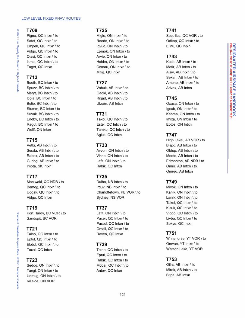
LOW LEVEL FIXED RNAV ROUTES
DE
SIG
NA
TE
D A
IRS
PA
CE
HA
ND
BO
OK
Effe
ctiv
e 090
1Z
17
JU
NE
20
21 to
09
01Z
12 A
UG
US
T 20
21
© 2
021
He
r Ma
jesty the Q
ue
en in R
ight o
f Can
ad
aS
ou
rce o
f Ca
nad
ian A
irspa
ce D
ata
© 2
021
Tra
nsp
ort C
an
ada
T709 Pigna, QC Intxn \ to
Satot, QC Intxn \ to
Empek, QC Intxn \ to
Vidgo, QC Intxn \ to
Olasi, QC Intxn \ to
Ikmol, QC Intxn \ to
Taget, QC Intxn
T713 Booth, BC Intxn \ to
Spuzz, BC Intxn \ to
Meryt, BC Intxn \ to
Icola, BC Intxn \ to
Bulie, BC Intxn \ to
Stumm, BC Intxn \ to
Suvak, BC Intxn \ to
Endby, BC Intxn \ to
Ragut, BC Intxn \ to
Wellf, ON Intxn
T715 Vetbi, AB Intxn \ to
Sesda, AB Intxn \ to
Rabox, AB Intxn \ to
Gudog, AB Intxn \ to
Imota, SK Intxn
T717 Maniwaki, QC NDB \ to
Bemog, QC Intxn \ to
Udgak, QC Intxn \ to
Vidgo, QC Intxn
T719 Port Hardy, BC VOR \ to
Sandspit, BC VOR
T721 Talno, QC Intxn \ to
Eptul, QC Intxn \ to
Ebdot, QC Intxn \ to
Toxal, QC Intxn
T723 Sedog, ON Intxn \ to
Tangi, ON Intxn \ to
Udmug, ON Intxn \ to
Killaloe, ON VOR
T725 Miglo, ON Intxn \ to
Reedo, ON Intxn \ to
Igvud, ON Intxn \ to
Epmok, ON Intxn \ to
Arvie, ON Intxn \ to
Habbs, ON Intxn \ to
Comau, ON Intxn \ to
Mitig, QC Intxn
T727 Vobuk, AB Intxn \ to
Gadki, AB Intxn \ to
Rigad, AB Intxn \ to
Ukram, AB Intxn
T731 Takol, QC Intxn \ to
Estel, QC Intxn \ to
Tamko, QC Intxn \ to
Agluk, QC Intxn
T733 Avvon, ON Intxn \ to
Vikno, ON Intxn \ to
Lafit, ON Intxn \ to
Rabik, QC Intxn
T735 Dulba, NB Intxn \ to
Irduv, NB Intxn \ to
Charlottetown, PE VOR \ to
Sydney, NS VOR
T737 Lafit, ON Intxn \ to
Puxer, QC Intxn \ to
Pusod, QC Intxn \ to
Omali, QC Intxn \ to
Reven, QC Intxn
T739 Talno, QC Intxn \ to
Eptul, QC Intxn \ to
Rabik, QC Intxn \ to
Mobal, QC Intxn \ to
Antov, QC Intxn
T741 Sept-Iles, QC VOR \ to
Odkap, QC Intxn \ to
Elinu, QC Intxn
T743 Kodit, AB Intxn \ to
Matir, AB Intxn \ to
Alsiv, AB Intxn \ to
Sekan, AB Intxn \ to
Amuno, AB Intxn \ to
Advox, AB Intxn
T745 Oxasa, ON Intxn \ to
Igsub, ON Intxn \ to
Kebma, ON Intxn \ to
Imixa, ON Intxn \ to
Eptos, ON Intxn
T747 High Level, AB VOR \ to
Bispo, AB Intxn \ to
Obtup, AB Intxn \ to
Mooto, AB Intxn \ to
Edmonton, AB NDB \ to
Omrir, AB Intxn \ to
Omreg, AB Intxn
T749 Mivok, ON Intxn \ to
Kanik, ON Intxn \ to
Lanrk, ON Intxn \ to
Takol, QC Intxn \ to
Kisuk, QC Intxn \ to
Vidgo, QC Intxn \ to
Livba, QC Intxn \ to
Sokye, QC Intxn
T751 Whitehorse, YT VOR \ to
Omvan, YT Intxn \ to
Watson Lake, YT VOR
T753 Oilrs, AB Intxn \ to
Mirek, AB Intxn \ to
Bitga, AB Intxn
121 DAH May 3, 2021 9:53 am

LOW LEVEL FIXED RNAV ROUTES
DE
SIG
NA
TE
D A
IRS
PA
CE
HA
ND
BO
OK
Effe
ctiv
e 090
1Z
17
JU
NE
20
21 to
09
01Z
12 A
UG
US
T 20
21
© 2
021
He
r Ma
jesty the Q
ue
en in R
ight o
f Can
ad
aS
ou
rce o
f Ca
nad
ian A
irspa
ce D
ata
© 2
021
Tra
nsp
ort C
an
ada
T755 Edmonton, AB VOR \ to
Jedii, AB Intxn \ to
Camra, AB Intxn \ to
Wainn, AB Intxn \ to
Saskatoon, SK VORTAC
T757
Aplig, BC Intxn \ to
Kalts, BC Intxn \ to
Fried, BC Intxn \ to
Mocha, BC Intxn \ to
Bokma, BC Intxn \ to
Omseb, BC Intxn \ to
Estit, BC Intxn
T759 Oilrs, AB Intxn \ to
Bisno, AB Intxn \ to
Kersa, AB Intxn \ to
Pevlu, AB Intxn
T761 Alkik, AB Intxn \ to
Rodku, AB Intxn \ to
Pepgo, AB Intxn \ to
Saxol, AB Intxn
T765 Whitecourt, AB VOR \ to
Obtup, AB Intxn
T767 Nubam, ON Intxn \ to
Imixa, ON Intxn
T773 Nosiv, AB Intxn \ to
Odlan, AB Intxn
T775 Treel, BC Intxn \ to
Nutbe, BC Intxn \ to
Bajol, BC Intxn \ to
Varsy, BC Intxn \ to
Basra, BC Intxn \ to
Mills, BC Intxn \ to
Frase, BC Intxn \ to
Pitt Meadows, BC VOR
T781 Bluez, MI USA Intxn \ to
Axobu, ON Intxn \ to
Havok, ON Intxn \ to
Derlo, ON Intxn \ to
Olamo, ON Intxn \ to
Davsi, ON Intxn \ to
Tesuk, ON Intxn \ to
Taleb, ON Intxn \ to
Bomet, ON Intxn \ to
Nopot, ON Intxn \ to
Tiget, ON Intxn \ to
Iptos, ON Intxn \ to
Verti, ON Intxn \ to
Agluk, QC Intxn \ to
Novid, QC Intxn \ to
Sokye, QC Intxn \ to
Ketru, QC Intxn \ to
Pesac, QC Intxn \ to
Quebec, QC VORTAC \ to
Pinte, QC Intxn
T783 Halifax, NS VOR \ to
Notop, NS Intxn \ to
Silro, NL Intxn \ to
Tigor, NL Intxn
T785 Prince Rupert, BC NDB \ to
Daxex, BC Intxn
T789 Vidri, BC Intxn \ to
Romra, BC Intxn \ to
Eskie, AB Intxn
T791 Olaba, ON Intxn \ to
Aloni, ON Intxn
T797 Vetbi, AB Intxn \ to
Sesda, AB Intxn \ to
Rabox, AB Intxn \ to
Libos, SK Intxn
T799 Lyton, BC Intxn \ to
Guchy, BC Intxn \ to
Chapt, BC Intxn \ to
Felko, BC Intxn \ to
Endby, BC Intxn \ to
Howzr, BC Intxn \ to
Farns, AB Intxn
122 DAH May 3, 2021 9:53 am

DE
SIG
NA
TE
D A
IRS
PA
CE
HA
ND
BO
OK
Effe
ctiv
e 090
1Z
17
JU
NE
20
21 to
09
01Z
12 A
UG
US
T 20
21
© 2
021
He
r Ma
jesty the Q
ue
en in R
ight o
f Can
ad
aS
ou
rce o
f Ca
nad
ian A
irspa
ce D
ata
© 2
021
Tra
nsp
ort C
an
ada
5. DESIGNATION OF CLASS F AIRSPACE
Class F airspace, as designated in Part 5, is excluded from all airspace designated in Part 3.
Each Danger, Restricted and Advisory Area within Canada has been assigned an identification code group whichconsists of four parts as follows:
Part a) will consist of the nationality letters "CY"; andPart b) will consist of the letter "D" for Danger Area, "R" for Restricted Area or the letter "A" for Advisory Area;
andPart c) will consist of a three-digit number which will identify the area. This number will also indicate the region
of Canada within which the area lies according to the following table:
101 to 199 - British Columbia201 to 299 - Alberta301 to 399 - Saskatchewan401 to 499 - Manitoba501 to 599 - Ontario601 to 699 - Quebec701 to 799 - New Brunswick
- Nova Scotia- Prince Edward Island- Newfoundland & Labrador
801 to 899 - Yukon Territory901 to 999 - Northwest Territories and Nunavut (including the Arctic Islands)
Part d) will, in the case of Advisory Areas, consist of the letter A, F, H, M, P, S or T in brackets after the threedigit number to indicate the type of activity within the area as follows:
A - AcrobaticF - Aircraft Test AreaH - Hang GlidingM - Military OperationsP - ParachutingS - SoaringT - Training
e.g. The identification code group CYA113(A) is as follows:
CY - indicates CanadaA - indicates Advisory Area113 - indicates the number of the area in British Columbia(A) - indicates acrobatic activity takes place within the area
The whole code group would be deciphered to read: "Acrobatic activity in Advisory Area 113, in British Columbia,Canada."
5.1 DANGER AREAS
CYD101 PACIFIC OCEAN (Near Tofino, BC)The airspace within the area bounded by a line beginning at:
N50°00'00.00" W128°10'00.00" toN49°20'00.00" W126°30'00.00" toN49°00'00.00" W126°30'00.00" toN49°00'00.00" W127°00'00.00" toN49°20'00.00" W128°30'00.00" toN50°00'00.00" W128°30'00.00" to
123 DAH May 3, 2021 1:46 pm

DE
SIG
NA
TE
D A
IRS
PA
CE
HA
ND
BO
OK
Effe
ctiv
e 090
1Z
17
JU
NE
20
21 to
09
01Z
12 A
UG
US
T 20
21
DANGER AREAS CYD106 PACIFIC OCEAN (NEAR TOFINO, BC)
© 2
021
He
r Ma
jesty the Q
ue
en in R
ight o
f Can
ad
aS
ou
rce o
f Ca
nad
ian A
irspa
ce D
ata
© 2
021
Tra
nsp
ort C
an
ada
N50°00'00.00" W128°10'00.00" point of beginningDesignated Altitude – From FL230 to FL600
Time of Designation – Ocsl by NOTAM 36 hours PN
User Agency – JTF(P) J3 AIR Esquimalt (250) 363-1050 (CSN) 333-1050 M-F 0800-1600 lcl. After hours (250) 889-0073
Controlling Agency – Vancouver ACC (604) 586-4500
Operating Procedures – No person should operate an aircraft within the area described unless the flight has been authorized by the User/Controlling Agency.
CYD106 PACIFIC OCEAN (Near Tofino, BC)The airspace within the area bounded by a line beginning at:
N49°20'00.00" W126°30'00.00" toN48°25'00.00" W126°30'00.00" toN48°20'00.00" W128°00'00.00" toN51°00'00.00" W133°45'00.00" toN53°30'00.00" W135°37'00.00" toN53°15'00.00" W133°30'00.00" toN52°42'00.00" W132°55'00.00" toN51°14'00.00" W130°35'00.00" toN50°00'00.00" W128°10'00.00" toN49°20'00.00" W126°30'00.00" point of beginning
Designated Altitude – Surface to FL230
Time of Designation – Cont
User/Controlling Agency – JTF(P) J3 AIR Esquimalt (250) 363-1050 (CSN) 333-1050 M-F 0800-1600 lcl. After hours (250) 889-0073
Operating Procedures – No person should operate an aircraft within the area described unless the flight has been authorized by the User/Controlling Agency.
CYD111 PACIFIC OCEAN (Near Tofino, BC)The airspace within the area bounded by a line beginning at:
N50°54'33.05" W129°55'33.66" toN50°00'00.00" W128°10'00.00" toN50°00'00.00" W128°30'00.00" toN49°20'00.00" W128°30'00.00" toN49°00'00.00" W127°00'00.00" toN49°00'00.00" W126°30'00.00" toN48°25'00.00" W126°30'00.00" toN48°20'00.00" W128°00'00.00" toN49°51'20.94" W131°07'42.88" toN50°54'33.05" W129°55'33.66" point of beginning
Designated Altitude – From FL230 to FL310
Time of Designation – Ocsl by NOTAM, 45 days PN
User Agency – JTF(P) J3 AIR Esquimalt (250) 363-1050 (CSN) 333-1050 M-F 0800-1600 lcl. After hours (250) 889-0073
Controlling Agency – Vancouver ACC (604) 586-4500
Operating Procedures – No person should operate an aircraft within the area described unless the flight has been authorized by the User/Controlling Agency.
CYD703 HALIFAX, NSThe airspace within the area bounded by a line beginning at:
N44°19'00.00" W064°00'00.00" toN43°30'30.00" W065°09'30.00" toN43°11'00.00" W066°00'00.00" toN42°47'00.00" W066°00'00.00" to
124 DAH May 3, 2021 1:46 pm

DE
SIG
NA
TE
D A
IRS
PA
CE
HA
ND
BO
OK
Effe
ctiv
e 090
1Z
17
JU
NE
20
21 to
09
01Z
12 A
UG
US
T 20
21
DANGER AREAS CYD734 HALIFAX, NS
© 2
021
He
r Ma
jesty the Q
ue
en in R
ight o
f Can
ad
aS
ou
rce o
f Ca
nad
ian A
irspa
ce D
ata
© 2
021
Tra
nsp
ort C
an
ada
N43°00'00.00" W064°00'00.00" toN44°19'00.00" W064°00'00.00" point of beginning
Designated Altitude – Surface to FL300
Time of Designation – Ocsl by NOTAM, 48 hours PN
User Agency – ACCE(A) (902) 427-2510, (CSN) 427-2510
Controlling Agency – Moncton ACC (506) 867-7178/7173
Operating Procedures – No person should operate an aircraft within the area described unless the flight has been authorized by the User/Controlling Agency.
CYD734 HALIFAX, NSThe airspace within the area bounded by a line beginning at:
N44°19'00.00" W064°00'00.00" toN44°19'00.00" W063°45'00.00" toN44°10'00.00" W063°45'00.00" toN44°10'00.00" W064°00'00.00" toN44°19'00.00" W064°00'00.00" point of beginning
Designated Altitude – Surface to FL200, Ocsl higher by NOTAM
Time of Designation – Cont
User Agency – ACCE(A) (902) 427-2510, (CSN) 427-2510
Controlling Agency – Moncton ACC (506) 867-7178/7173
Operating Procedures – No person should operate an aircraft within the area described unless the flight has been authorized by the User/Controlling Agency.
CYD735 HALIFAX, NSThe airspace within the area bounded by a line beginning at:
N44°19'00.00" W063°45'00.00" toN44°19'00.00" W063°30'00.00" toN44°10'00.00" W063°30'00.00" toN44°10'00.00" W063°45'00.00" toN44°19'00.00" W063°45'00.00" point of beginning
Designated Altitude – Surface to FL200, Ocsl higher by NOTAM
Time of Designation – Cont
User Agency – ACCE(A) (902) 427-2510, (CSN) 427-2510
Controlling Agency – Moncton ACC (506) 867-7178/7173
Operating Procedures – No person should operate an aircraft within the area described unless the flight has been authorized by the User/Controlling Agency.
CYD736 HALIFAX, NSThe airspace within the area bounded by a line beginning at:
N44°10'00.00" W064°00'00.00" toN44°10'00.00" W063°45'00.00" toN44°00'00.00" W063°45'00.00" toN44°00'00.00" W064°00'00.00" toN44°10'00.00" W064°00'00.00" point of beginning
Designated Altitude – Surface to FL200, Ocsl higher by NOTAM
Time of Designation – Cont
User Agency – ACCE(A) (902) 427-2510, (CSN) 427-2510
Controlling Agency – Moncton ACC (506) 867-7178/7173
Operating Procedures – No person should operate an aircraft within the area described unless the flight has been authorized by the User/Controlling Agency.
125 DAH May 3, 2021 1:46 pm

DE
SIG
NA
TE
D A
IRS
PA
CE
HA
ND
BO
OK
Effe
ctiv
e 090
1Z
17
JU
NE
20
21 to
09
01Z
12 A
UG
US
T 20
21
DANGER AREAS CYD737 HALIFAX, NS
© 2
021
He
r Ma
jesty the Q
ue
en in R
ight o
f Can
ad
aS
ou
rce o
f Ca
nad
ian A
irspa
ce D
ata
© 2
021
Tra
nsp
ort C
an
ada
CYD737 HALIFAX, NSThe airspace within the area bounded by a line beginning at:
N44°10'00.00" W063°45'00.00" toN44°10'00.00" W063°30'00.00" toN44°00'00.00" W063°30'00.00" toN44°00'00.00" W063°45'00.00" toN44°10'00.00" W063°45'00.00" point of beginning
Designated Altitude – Surface to FL200, Ocsl higher by NOTAM
Time of Designation – Cont
User Agency – ACCE(A) (902) 427-2510, (CSN) 427-2510
Controlling Agency – Moncton ACC (506) 867-7178/7173
Operating Procedures – No person should operate an aircraft within the area described unless the flight has been authorized by the User/Controlling Agency.
CYD738 HALIFAX, NSThe airspace within the area bounded by a line beginning at:
N44°19'00.00" W063°30'00.00" toN44°19'00.00" W063°00'00.00" toN44°00'00.00" W063°00'00.00" toN44°00'00.00" W063°30'00.00" toN44°19'00.00" W063°30'00.00" point of beginning
Designated Altitude – Surface to FL200, Ocsl higher by NOTAM
Time of Designation – Cont
User Agency – ACCE(A) (902) 427-2510, (CSN) 427-2510
Controlling Agency – Moncton ACC (506) 867-7178/7173
Operating Procedures – No person should operate an aircraft within the area described unless the flight has been authorized by the User/Controlling Agency.
CYD739 HALIFAX, NSThe airspace within the area bounded by a line beginning at:
N44°00'00.00" W064°00'00.00" toN44°00'00.00" W063°30'00.00" toN43°30'00.00" W063°30'00.00" toN43°30'00.00" W064°00'00.00" toN44°00'00.00" W064°00'00.00" point of beginning
Designated Altitude – Surface to FL300, Ocsl higher by NOTAM
Time of Designation – Ocsl by NOTAM
User Agency – ACCE(A) (902) 427-2510, (CSN) 427-2510
Controlling Agency – Moncton ACC (506) 867-7178/7173
Operating Procedures – No person should operate an aircraft within the area described unless the flight has been authorized by the User/Controlling Agency.
CYD740 HALIFAX, NSThe airspace within the area bounded by a line beginning at:
N44°00'00.00" W063°30'00.00" toN44°00'00.00" W063°00'00.00" toN43°30'00.00" W063°00'00.00" toN43°30'00.00" W063°30'00.00" toN44°00'00.00" W063°30'00.00" point of beginning
Designated Altitude – Surface to FL300, Ocsl higher by NOTAM
Time of Designation – Ocsl by NOTAM
User Agency – ACCE(A) (902) 427-2510, (CSN) 427-2510
Controlling Agency – Moncton ACC (506) 867-7178/7173
126 DAH May 3, 2021 1:46 pm

DE
SIG
NA
TE
D A
IRS
PA
CE
HA
ND
BO
OK
Effe
ctiv
e 090
1Z
17
JU
NE
20
21 to
09
01Z
12 A
UG
US
T 20
21
DANGER AREAS CYD741 HALIFAX, NS
© 2
021
He
r Ma
jesty the Q
ue
en in R
ight o
f Can
ad
aS
ou
rce o
f Ca
nad
ian A
irspa
ce D
ata
© 2
021
Tra
nsp
ort C
an
ada
Operating Procedures – No person should operate an aircraft within the area described unless the flight has been authorized by the User/Controlling Agency.
CYD741 HALIFAX, NSThe airspace within the area bounded by a line beginning at:
N44°00'00.00" W063°00'00.00" toN44°00'00.00" W062°30'00.00" toN43°30'00.00" W062°30'00.00" toN43°30'00.00" W063°00'00.00" toN44°00'00.00" W063°00'00.00" point of beginning
Designated Altitude – Surface to FL300, Ocsl higher by NOTAM
Time of Designation – Ocsl by NOTAM
User Agency – ACCE(A) (902) 427-2510, (CSN) 427-2510
Controlling Agency – Moncton ACC (506) 867-7178/7173
Operating Procedures – No person should operate an aircraft within the area described unless the flight has been authorized by the User/Controlling Agency.
CYD742 HALIFAX, NSThe airspace within the area bounded by a line beginning at:
N44°00'00.00" W062°30'00.00" toN44°00'00.00" W062°00'00.00" toN43°30'00.00" W062°00'00.00" toN43°30'00.00" W062°30'00.00" toN44°00'00.00" W062°30'00.00" point of beginning
Designated Altitude – Surface to FL300, Ocsl higher by NOTAM
Time of Designation – Ocsl by NOTAM
User Agency – ACCE(A) (902) 427-2510, (CSN) 427-2510
Controlling Agency – Moncton ACC (506) 867-7178/7173
Operating Procedures – No person should operate an aircraft within the area described unless the flight has been authorized by the User/Controlling Agency.
CYD743 HALIFAX, NSThe airspace within the area bounded by a line beginning at:
N43°30'00.00" W064°00'00.00" toN43°30'00.00" W063°30'00.00" toN43°00'00.00" W063°30'00.00" toN43°00'00.00" W064°00'00.00" toN43°30'00.00" W064°00'00.00" point of beginning
Designated Altitude – Surface to FL300, Ocsl higher by NOTAM
Time of Designation – Ocsl by NOTAM
User Agency – ACCE(A) (902) 427-2510, (CSN) 427-2510
Controlling Agency – Moncton ACC (506) 867-7178/7173
Operating Procedures – No person should operate an aircraft within the area described unless the flight has been authorized by the User/Controlling Agency.
CYD744 HALIFAX, NSThe airspace within the area bounded by a line beginning at:
N43°30'00.00" W063°30'00.00" toN43°30'00.00" W063°00'00.00" toN43°00'00.00" W063°00'00.00" toN43°00'00.00" W063°30'00.00" toN43°30'00.00" W063°30'00.00" point of beginning
Designated Altitude – Surface to FL300, Ocsl higher by NOTAM
127 DAH May 3, 2021 1:46 pm

DE
SIG
NA
TE
D A
IRS
PA
CE
HA
ND
BO
OK
Effe
ctiv
e 090
1Z
17
JU
NE
20
21 to
09
01Z
12 A
UG
US
T 20
21
DANGER AREAS CYD745 HALIFAX , NS
© 2
021
He
r Ma
jesty the Q
ue
en in R
ight o
f Can
ad
aS
ou
rce o
f Ca
nad
ian A
irspa
ce D
ata
© 2
021
Tra
nsp
ort C
an
ada
Time of Designation – Ocsl by NOTAM
User Agency – ACCE(A) (902) 427-2510, (CSN) 427-2510
Controlling Agency – Moncton ACC (506) 867-7178/7173
Operating Procedures – No person should operate an aircraft within the area described unless the flight has been authorized by the User/Controlling Agency.
CYD745 HALIFAX , NSThe airspace within the area bounded by a line beginning at:
N43°30'00.00" W063°00'00.00" toN43°30'00.00" W062°30'00.00" toN43°00'00.00" W062°30'00.00" toN43°00'00.00" W063°00'00.00" toN43°30'00.00" W063°00'00.00" point of beginning
Designated Altitude – Surface to FL300, Ocsl higher by NOTAM
Time of Designation – Ocsl by NOTAM
User Agency – ACCE(A) (902) 427-2510, (CSN) 427-2510
Controlling Agency – Moncton ACC (506) 867-7178/7173
Operating Procedures – No person should operate an aircraft within the area described unless the flight has been authorized by the User/Controlling Agency.
CYD746 HALIFAX, NSThe airspace within the area bounded by a line beginning at:
N43°30'00.00" W062°30'00.00" toN43°30'00.00" W062°00'00.00" toN43°00'00.00" W062°00'00.00" toN43°00'00.00" W062°30'00.00" toN43°30'00.00" W062°30'00.00" point of beginning
Designated Altitude – Surface to FL300, Ocsl higher by NOTAM
Time of Designation – Ocsl by NOTAM
User Agency – ACCE(A) (902) 427-2510, (CSN) 427-2510
Controlling Agency – Moncton ACC (506) 867-7178/7173
Operating Procedures – No person should operate an aircraft within the area described unless the flight has been authorized by the User/Controlling Agency.
CYD751 HALIFAX, NSThe airspace within the area bounded by a line beginning at:
N44°19'00.00" W062°30'00.00" toN44°00'00.00" W062°30'00.00" toN44°00'00.00" W063°00'00.00" toN44°19'00.00" W063°00'00.00" toN44°19'00.00" W062°30'00.00" point of beginning
Designated Altitude – Surface to 5000´
Time of Designation – Cont
User Agency – ACCE(A) (902) 427-2510, (CSN) 427-2510
Controlling Agency – Moncton ACC (506) 867-7178/7173
Operating Procedures – No person should operate an aircraft within the area described unless the flight has been authorized by the User/Controlling Agency.
CYD752 HALIFAX, NSThe airspace within the area bounded by a line beginning at:
N43°00'00.00" W063°30'00.00" toN42°50'00.00" W063°30'00.00" to
128 DAH May 3, 2021 1:46 pm

DE
SIG
NA
TE
D A
IRS
PA
CE
HA
ND
BO
OK
Effe
ctiv
e 090
1Z
17
JU
NE
20
21 to
09
01Z
12 A
UG
US
T 20
21
RESTRICTED AREAS CYR103 BENTINCK ISLAND, BC
© 2
021
He
r Ma
jesty the Q
ue
en in R
ight o
f Can
ad
aS
ou
rce o
f Ca
nad
ian A
irspa
ce D
ata
© 2
021
Tra
nsp
ort C
an
ada
N42°50'00.00" W064°00'00.00" toN43°00'00.00" W064°00'00.00" toN43°00'00.00" W063°30'00.00" point of beginning
Designated Altitude – Surface to 5000´
Time of Designation – Cont
User Agency – ACCE(A) (902) 427-2510, (CSN) 427-2510
Controlling Agency – Moncton ACC (506) 867-7178/7173
Operating Procedures – No person should operate an aircraft within the area described unless the flight has been authorized by the User/Controlling Agency.
5.2 RESTRICTED AREAS
CYR103 BENTINCK ISLAND, BCThe airspace within the area bounded by a circle of:
1 mile radius centred onN48°19'00.00" W123°32'24.00"
Designated Altitude – Surface to 1500´
Time of Designation – Cont
Designated Altitude – Above 1500´ to 3000´
Time of Designation – Ocsl by NOTAM
User Agency – Range Control, Base Operations Centre, CFB Esquimalt (250) 391-4164/4162, (CSN) 255-2000 (ask operator for 391-4164/4162)
Controlling Agency – Vancouver ACC (604) 586-4500
Operating Procedures – No person shall operate an aircraft within the area described unless the flight has been authorized by the User/Controlling Agency.
CYR104 ESQUIMALT, BCThe airspace within the area bounded by a line beginning at:
N48°26'34.00" W123°26'43.00" toN48°26'21.00" W123°25'49.00" toN48°26'12.00" W123°25'54.00" toN48°26'25.00" W123°26'48.00" toN48°26'34.00" W123°26'43.00" point of beginning
Designated Altitude – Surface to 2000´
Time of Designation – Ocsl by NOTAM
User Agency – Maritime Operations Centre, CFB Esquimalt (250) 363-2425/5848, (CSN) 255-2425
Controlling Agency – Vancouver ACC (604) 586-4500
Operating Procedures – No person shall operate an aircraft within the area described unless the flight has been authorized by the User/Controlling Agency.
CYR107 STRAIT OF GEORGIA, BCThe airspace within the area bounded by a line beginning at:
N49°19'30.00" W123°51'00.00" toN49°15'54.00" W123°56'00.00" toN49°17'18.00" W124°05'00.00" toN49°20'30.00" W124°12'00.00" toN49°25'30.00" W124°12'00.00" toN49°19'30.00" W123°51'00.00" point of beginning
Designated Altitude – Surface to 1000´
Time of Designation – Cont
129 DAH May 3, 2021 1:46 pm

DE
SIG
NA
TE
D A
IRS
PA
CE
HA
ND
BO
OK
Effe
ctiv
e 090
1Z
17
JU
NE
20
21 to
09
01Z
12 A
UG
US
T 20
21
RESTRICTED AREAS CYR108 MARY HILL, BC (NEAR VICTORIA, BC)
© 2
021
He
r Ma
jesty the Q
ue
en in R
ight o
f Can
ad
aS
ou
rce o
f Ca
nad
ian A
irspa
ce D
ata
© 2
021
Tra
nsp
ort C
an
ada
Designated Altitude – Above 1000´ to 13,500´
Time of Designation – Ocsl by NOTAM
User Agency – JTF(P) J3 AIR Esquimalt (250) 363-1050 (CSN) 333-1050 M-F 0800-1600 lcl. After hours (250) 889-0073
Controlling Agency – Vancouver ACC (604) 586-4500
Operating Procedures – No person shall operate an aircraft within the area described unless the flight has been authorizedby the User/Controlling Agency.
CYR108 MARY HILL, BC (Near Victoria, BC)The airspace within the area bounded by a circle of:
1 mile radius centred onN48°20'42.00" W123°33'00.00"
Designated Altitude – Surface to 3000´
Time of Designation – Ocsl by NOTAM
User Agency – Range Control, Base Operations Centre, CFB Esquimalt (250) 391-4164/4162, (CSN) 255-2000 (ask operator for 391-4164/4162
Controlling Agency – Vancouver ACC (604) 586-4500
Operating Procedures – No person shall operate an aircraft within the area described unless the flight has been authorized by the User/Controlling Agency.
CYR109 JUAN DE FUCA STRAIT, BCThe airspace within the area bounded by a line beginning at:
N48°22'00.00" W123°55'00.00" toN48°16'51.00" W123°55'00.00" toN48°17'54.00" W124°01'00.00" toN48°22'30.00" W124°17'30.00" toN48°28'18.00" W124°17'30.00" toN48°22'00.00" W123°55'00.00" point of beginning
Designated Altitude – Surface to unlimited
Time of Designation – Ocsl by NOTAM, 48 hours PN
User Agency – JTF(P) J3 AIR Esquimalt (250) 363-1050 (CSN) 333-1050 M-F 0800-1600 lcl. After hours (250) 889-0073
Controlling Agency – Vancouver ACC (604) 586-4500
Operating Procedures – No person shall operate an aircraft within the area described unless the flight has been authorized by the User/Controlling Agency.
CYR114 VICTORIA, BCThe airspace within the area bounded by a circle of:
0.5 mile radius centred onN48°28'57.00" W123°24'39.00"
Designated Altitude – Surface to 500´
Time of Designation – Cont
User/Controlling Agency – District Director, Vancouver Island Regional Correctional Center (250) 727-5059
Operating Procedures – No person shall operate an aircraft within the area described unless the flight has been authorized by the User/Controlling Agency.
CYR115 WHITE LAKE, BC (Near Penticton)The airspace within the area bounded by a circle of:
1 mile radius centred onN49°18'56.00" W119°37'51.00"
Designated Altitude – Surface to 2700´
130 DAH May 3, 2021 1:46 pm

DE
SIG
NA
TE
D A
IRS
PA
CE
HA
ND
BO
OK
Effe
ctiv
e 090
1Z
17
JU
NE
20
21 to
09
01Z
12 A
UG
US
T 20
21
RESTRICTED AREAS CYR130 VALEMOUNT, BC
© 2
021
He
r Ma
jesty the Q
ue
en in R
ight o
f Can
ad
aS
ou
rce o
f Ca
nad
ian A
irspa
ce D
ata
© 2
021
Tra
nsp
ort C
an
ada
Time of Designation – Cont
Designated Altitude – Above 2700´ to 3200´
Time of Designation – Ocsl by NOTAM
User/Controlling Agency – Operations Manager, Dominion Radio Astrophysical Observatory (250) 497-2313
Operating Procedures – No person shall operate an aircraft within the area described unless the flight has been authorized by the User/Controlling Agency.
CYR130 VALEMOUNT, BCThe airspace within the area bounded by a line beginning at:
N53°25'00.00" W118°20'00.00" toN53°34'00.00" W120°16'00.00" toN52°43'00.00" W121°12'00.00" toN51°47'00.00" W120°26'00.00" toN51°22'00.00" W119°36'00.00" toN51°38'00.00" W118°33'00.00" toN52°43'00.00" W117°35'00.00" toN53°25'00.00" W118°20'00.00" point of beginning
Designated Altitude – 18,000´ to FL230
Time of Designation – Ocsl by NOTAM
User Agency – JTF(P) J3 AIR Esquimalt (250) 363-1050 (CSN) 333-1050 M-F 0800-1600 lcl. After hours (250) 889-0073
Controlling Agency – Vancouver ACC (604) 586-4500
Operating Procedures – No person shall operate an aircraft within the area described unless the flight has been authorized by the User/Controlling Agency.
CYR138 KENT MOUNTAIN, BC (Near Agassiz)
The airspace within the area bounded by a line beginning at:N49°16'23.00" W121°50'46.00" toN49°16'28.00" W121°50'32.00" thence clockwise along the arc of a circle of1 mile radius centred onN49°15'35.00" W121°49'50.00" toN49°14'42.00" W121°49'08.00" toN49°14'37.00" W121°49'23.00" thence clockwise along the arc of a circle of1 mile radius centred onN49°15'30.00" W121°50'05.00" toN49°16'23.00" W121°50'46.00" point of beginning
Designated Altitude – Surface to 1100´
Time of Designation – Cont
User/Controlling Agency – Warden, Kent Mountain Institution (604) 796-2231
Operating Procedures – No person shall operate an aircraft within the area described unless the flight has been authorized by the User/Controlling Agency.
CYR139 WILLIAM HEAD, BC (Near Victoria, BC)The airspace within the area bounded by a circle of:
1 mile radius centred onN48°20'35.00" W123°31'50.00"
Designated Altitude – Surface to 1000´
Time of Designation – Cont
User/Controlling Agency – Warden, William Head Institution (250) 380-4642
Operating Procedures – No person shall operate an aircraft within the area described unless the flight has been authorized by the User/Controlling Agency.
131 DAH May 3, 2021 1:46 pm

DE
SIG
NA
TE
D A
IRS
PA
CE
HA
ND
BO
OK
Effe
ctiv
e 090
1Z
17
JU
NE
20
21 to
09
01Z
12 A
UG
US
T 20
21
RESTRICTED AREAS CYR140 MISSION, BC
© 2
021
He
r Ma
jesty the Q
ue
en in R
ight o
f Can
ad
aS
ou
rce o
f Ca
nad
ian A
irspa
ce D
ata
© 2
021
Tra
nsp
ort C
an
ada
CYR140 MISSION, BCThe airspace within the area bounded by a circle of:
1 mile radius centred onN49°09'50.00" W122°17'10.00"
Designated Altitude – Surface to 1500´
Time of Designation – Cont
User/Controlling Agency – Warden, Mission Institution (604) 826-1231
Operating Procedures – No person shall operate an aircraft within the area described unless the flight has been authorized by the User/Controlling Agency.
CYR141 MATSQUI, BC (Abbotsford, BC)The airspace within the area bounded by lines tangent to circles of:
0.8 mile radius centred onN49°01'35.00" W122°18'10.00" andN49°01'10.00" W122°18'05.00"
Designated Altitude – Surface to 300´
Time of Designation – Cont
User/Controlling Agency – Warden, Pacific Institution (604) 870-7755
Operating Procedures – No person shall operate an aircraft within the area described unless the flight has been authorized by the User/Controlling Agency.
CYR156 ALBERT HEAD, BC (Near Victoria, BC)The airspace within the area bounded by a circle of:
1 mile radius centred onN48°23'15.00" W123°28'36.00"
Designated Altitude – Surface to 3000´
Time of Designation – Ocsl by NOTAM
User Agency – Range Control, Base Operations Centre, CFB Esquimalt (250) 391-4164/4162, (CSN) 255-2000 (ask operator for 391-4164/4162)
Controlling Agency – Vancouver ACC (604) 586-4500
Operating Procedures – No person shall operate an aircraft within the area described unless the flight has been authorized by the User/Controlling Agency.
CYR157 COMOX, BCThe airspace within the area bounded by a line beginning at:
N51°59'00.00" W127°05'00.00" toN51°03'42.00" W125°15'00.00" toN51°00'00.00" W125°15'00.00" toN50°36'00.00" W125°47'00.00" toN51°22'00.00" W127°26'00.00" toN51°35'00.00" W127°36'00.00" toN51°59'00.00" W127°05'00.00" point of beginning
Designated Altitude – 7000´ to 17,000´
Time of Designation – Ocsl by NOTAM
User Agency – 19 Wing Operations Centre, Comox (250) 339-8231 (CSN) 252-8231
Controlling Agency – Vancouver ACC (604) 586-4500
Operating Procedures – No person shall operate an aircraft within the area described unless the flight has been authorized by the User/Controlling Agency.
CYR160 WILLIAMS LAKE, BC (Chilcotin Military Reserve)The airspace within the area bounded by a line beginning at:
N51°59'32.00" W122°23'57.00" to
132 DAH May 3, 2021 1:46 pm
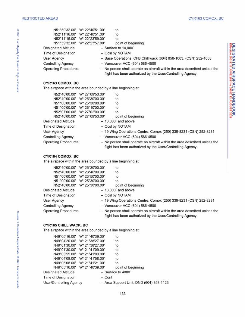
DE
SIG
NA
TE
D A
IRS
PA
CE
HA
ND
BO
OK
Effe
ctiv
e 090
1Z
17
JU
NE
20
21 to
09
01Z
12 A
UG
US
T 20
21
RESTRICTED AREAS CYR163 COMOX, BC
© 2
021
He
r Ma
jesty the Q
ue
en in R
ight o
f Can
ad
aS
ou
rce o
f Ca
nad
ian A
irspa
ce D
ata
© 2
021
Tra
nsp
ort C
an
ada
N51°59'32.00" W122°40'51.00" toN52°11'16.00" W122°40'51.00" toN52°11'15.00" W122°23'59.00" toN51°59'32.00" W122°23'57.00" point of beginning
Designated Altitude – Surface to 10,000´
Time of Designation – Ocsl by NOTAM
User Agency – Base Operations, CFB Chilliwack (604) 858-1003, (CSN) 252-1003
Controlling Agency – Vancouver ACC (604) 586-4500
Operating Procedures – No person shall operate an aircraft within the area described unless the flight has been authorized by the User/Controlling Agency.
CYR163 COMOX, BCThe airspace within the area bounded by a line beginning at:
N52°40'00.00" W127°09'53.00" toN52°40'00.00" W125°30'00.00" toN51°00'00.00" W125°30'00.00" toN51°00'00.00" W126°10'00.00" toN52°07'00.00" W127°02'00.00" toN52°40'00.00" W127°09'53.00" point of beginning
Designated Altitude – 18,000´ and above
Time of Designation – Ocsl by NOTAM
User Agency – 19 Wing Operations Centre, Comox (250) 339-8231 (CSN) 252-8231
Controlling Agency – Vancouver ACC (604) 586-4500
Operating Procedures – No person shall operate an aircraft within the area described unless the flight has been authorized by the User/Controlling Agency.
CYR164 COMOX, BCThe airspace within the area bounded by a line beginning at:
N52°40'00.00" W125°30'00.00" toN52°40'00.00" W123°46'00.00" toN51°00'00.00" W123°50'00.00" toN51°00'00.00" W125°30'00.00" toN52°40'00.00" W125°30'00.00" point of beginning
Designated Altitude – 18,000´ and above
Time of Designation – Ocsl by NOTAM
User Agency – 19 Wing Operations Centre, Comox (250) 339-8231 (CSN) 252-8231
Controlling Agency – Vancouver ACC (604) 586-4500
Operating Procedures – No person shall operate an aircraft within the area described unless the flight has been authorized by the User/Controlling Agency.
CYR165 CHILLIWACK, BCThe airspace within the area bounded by a line beginning at:
N49°05'16.00" W121°40'39.00" toN49°04'20.00" W121°38'27.00" toN49°01'30.00" W121°38'27.00" toN49°01'30.00" W121°41'09.00" toN49°03'55.00" W121°41'09.00" toN49°04'08.00" W121°41'58.00" toN49°05'08.00" W121°41'21.00" toN49°05'16.00" W121°40'39.00" point of beginning
Designated Altitude – Surface to 4000´
Time of Designation – Cont
User/Controlling Agency – Area Support Unit, DND (604) 858-1123
133 DAH May 3, 2021 1:46 pm

DE
SIG
NA
TE
D A
IRS
PA
CE
HA
ND
BO
OK
Effe
ctiv
e 090
1Z
17
JU
NE
20
21 to
09
01Z
12 A
UG
US
T 20
21
RESTRICTED AREAS CYR166 COMOX, BC
© 2
021
He
r Ma
jesty the Q
ue
en in R
ight o
f Can
ad
aS
ou
rce o
f Ca
nad
ian A
irspa
ce D
ata
© 2
021
Tra
nsp
ort C
an
ada
Operating Procedures – No person shall operate an aircraft within the area described unless the flight has been authorized by the User/Controlling Agency.
CYR166 COMOX, BCThe airspace within the area bounded by a line beginning at:
N53°49'00.00" W127°27'00.00" toN53°30'00.00" W125°30'00.00" toN52°40'00.00" W123°46'00.00" toN52°40'00.00" W127°09'53.00" toN53°49'00.00" W127°27'00.00" point of beginning
Designated Altitude – 18,000´ and above
Time of Designation – Ocsl by NOTAM
User Agency – 19 Wing Operations Centre Comox (250) 339-8231 (CSN) 252-8231
Controlling Agency – Vancouver ACC (604) 586-4500
Operating Procedures – No person shall operate an aircraft within the area described unless the flight has been authorized by the User/Controlling Agency.
CYR172 WHISTLER, BCThe airspace within the area bounded by a line beginning at:
N50°04'08.49" W122°57'49.77" toN50°06'30.38" W122°54'05.51" toN50°05'48.93" W122°53'07.17" toN50°03'30.57" W122°56'41.82" toN50°04'08.49" W122°57'49.77" point of beginning
Designated Altitude – Surface to 6000´
Time of Designation – Cont
User/Controlling Agency – Whistler Blackcomb Holdings Inc. (604) 938-7208
Operating Procedures – No person shall operate an aircraft within the area described unless the flight has been authorized by the User/Controlling Agency, except for medical, police and military aircraft on official duty flights.
CYR203 CAMP WAINWRIGHT, ABThe airspace within the area bounded by a line beginning at:
N52°51'15.00" W111°11'20.00" toN52°41'51.97" W111°11'20.00" toN52°41'52.19" W111°04'04.32" toN52°40'04.72" W111°04'04.27" toN52°40'05.11" W111°00'45.19" toN52°38'17.79" W111°00'45.11" toN52°38'16.78" W110°56'25.76" toN52°37'24.09" W110°56'25.71" toN52°37'23.34" W110°52'06.96" toN52°37'23.63" W110°49'15.72" toN52°37'23.89" W110°46'06.08" toN52°37'24.51" W110°43'29.86" toN52°36'58.59" W110°43'29.93" toN52°36'58.79" W110°42'45.98" toN52°37'24.44" W110°42'45.70" toN52°37'23.88" W110°35'34.24" toN52°37'49.93" W110°35'34.28" toN52°37'49.99" W110°34'51.16" toN52°40'03.50" W110°34'51.81" toN52°40'03.52" W110°35'04.11" toN52°42'43.70" W110°35'04.29" toN52°42'44.54" W110°48'06.77" to
134 DAH May 3, 2021 1:46 pm

DE
SIG
NA
TE
D A
IRS
PA
CE
HA
ND
BO
OK
Effe
ctiv
e 090
1Z
17
JU
NE
20
21 to
09
01Z
12 A
UG
US
T 20
21
RESTRICTED AREAS CYR204 COLD LAKE, AB
© 2
021
He
r Ma
jesty the Q
ue
en in R
ight o
f Can
ad
aS
ou
rce o
f Ca
nad
ian A
irspa
ce D
ata
© 2
021
Tra
nsp
ort C
an
ada
N52°41'51.72" W110°48'06.66" toN52°41'51.73" W110°49'34.77" toN52°41'51.46" W110°52'16.55" toN52°41'50.12" W110°52'30.00" toN52°50'13.38" W110°52'30.00" toN52°51'15.00" W110°55'01.25" toN52°51'15.00" W111°11'20.00" point of beginning
Designated Altitude – Surface to 17,000´, Ocsl higher by NOTAM
Time of Designation – Cont
User Agency – Base Operations, Camp Wainwright (780) 842-1363 Ext 1202, (CSN) 530-1202
Controlling Agency – Edmonton ACC (780) 890-8397
Operating Procedures – No person shall operate an aircraft within the area described unless the flight has been authorized by the User/Controlling Agency.
CYR204 COLD LAKE, ABAIR WEAPONS RANGE:
The airspace within the area bounded by a line beginning at:
N54°46'00.00" W108°40'00.00" thence westerly along latitude N54°46'00.00" \ toN54°46'00.00" W109°58'00.00" toN54°44'00.00" W109°58'00.00" thence westerly along latitude N54°44'00.00" \ toN54°44'00.00" W110°13'00.00" toN54°46'00.00" W110°13'00.00" thence westerly along latitude N54°46'00.00" \ toN54°46'00.00" W111°18'00.00" toN55°20'00.00" W111°18'00.00" thence easterly along latitude N55°20'00.00" \ toN55°20'00.00" W108°25'00.00" toN54°56'00.00" W108°25'00.00" toN54°46'00.00" W108°40'00.00" point of beginning
Designated Altitude – Surface to unlimited
Time of Designation – Cont
User Agency – 4 Wing Operations, CFB Cold Lake (780) 840-8000 Ext 8595, (CSN) 690-8595
Controlling Agency – Cold Lake Terminal (780) 840-8594, (CSN) 690-8594
Operating Procedures – No person shall operate an aircraft within the area described unless the flight has been authorized by the User/Controlling Agency.
CYR208 BOWDEN, ABThe airspace within the area bounded by a circle of:
1 mile radius centred onN51°58'35.00" W114°00'25.00"
Designated Altitude – Surface to 4100´
Time of Designation – Cont
User/Controlling Agency – Warden, Bowden Correctional Institute (403) 227-3391
Operating Procedures – No person shall operate an aircraft within the area described unless the flight has been authorized by the User/Controlling Agency.
CYR211 DRUMHELLER, ABThe airspace within the area bounded by a circle of:
1 mile radius centred onN51°25'30.00" W112°41'35.00"
Designated Altitude – Surface to 3800´
Time of Designation – Cont
User/Controlling Agency – Warden, Drumheller Institution (403) 823-5101
135 DAH May 3, 2021 1:46 pm

DE
SIG
NA
TE
D A
IRS
PA
CE
HA
ND
BO
OK
Effe
ctiv
e 090
1Z
17
JU
NE
20
21 to
09
01Z
12 A
UG
US
T 20
21
RESTRICTED AREAS CYR212 EDMONTON, AB
© 2
021
He
r Ma
jesty the Q
ue
en in R
ight o
f Can
ad
aS
ou
rce o
f Ca
nad
ian A
irspa
ce D
ata
© 2
021
Tra
nsp
ort C
an
ada
Operating Procedures – No person shall operate an aircraft within the area described unless the flight has been authorized by the User/Controlling Agency.
CYR212 EDMONTON, ABThe airspace within the area bounded by a circle of:
1 mile radius centred onN53°40'35.00" W113°20'20.00"
Designated Altitude – Surface to 3200´
Time of Designation – Cont
User/Controlling Agency – Warden, Edmonton Institution (780) 472-6052
Operating Procedures – No person shall operate an aircraft within the area described unless the flight has been authorized by the User/Controlling Agency.
CYR220 GRANDE CACHE, ABThe airspace within the area bounded by a circle of:
1 mile radius centred onN53°52'00.00" W119°09'00.00"
Designated Altitude – Surface to 4900´
Time of Designation – Cont
User/Controlling Agency – Warden, Grande Cache Institution (780) 827-4200
Operating Procedures – No person shall operate an aircraft within the area described unless the flight has been authorized by the User/Controlling Agency.
CYR221 COLD LAKE, ABThe airspace within the area bounded by a line beginning at:
N54°45'00.00" W111°56'00.00" toN55°19'00.00" W111°41'00.00" toN55°56'00.00" W111°18'30.00" toN56°04'00.00" W111°04'00.00" toN56°04'00.00" W108°25'00.00" toN55°20'00.00" W108°25'00.00" thence westerly along latitude N55°20'00.00" \ toN55°20'00.00" W111°18'00.00" toN54°46'00.00" W111°18'00.00" toN54°45'00.00" W111°56'00.00" point of beginning
Designated Altitude – 7000´ to unlimited
Time of Designation – Cont 14Z Mon - 01Z Sat, O/T by NOTAM
User Agency – 4 Wing Operations, CFB Cold Lake (780) 840-8000 Ext 8595, (CSN) 690-8595
Controlling Agency – Cold Lake ATC (780) 840-8594, (CSN) 690-8594
Operating Procedures – No person shall operate an aircraft within the area described unless the flight has been authorized by the User/Controlling Agency.
CYR222 COLD LAKE, ABThe airspace within the area bounded by a line beginning at:
N56°04'00.00" W111°04'00.00" toN56°30'00.00" W110°18'00.00" toN56°30'00.00" W107°55'00.00" toN56°05'42.00" W106°50'00.00" toN54°17'00.00" W106°50'00.00" toN54°12'00.00" W107°00'00.00" toN54°12'00.00" W108°37'36.00" thence counter-clockwise along the arc of a circle of60 miles radius centred onN54°24'31.00" W110°17'45.00" (Cold Lake, AB - TACAN) \ to
136 DAH May 3, 2021 1:46 pm

DE
SIG
NA
TE
D A
IRS
PA
CE
HA
ND
BO
OK
Effe
ctiv
e 090
1Z
17
JU
NE
20
21 to
09
01Z
12 A
UG
US
T 20
21
RESTRICTED AREAS CYR223 COLD LAKE, AB
© 2
021
He
r Ma
jesty the Q
ue
en in R
ight o
f Can
ad
aS
ou
rce o
f Ca
nad
ian A
irspa
ce D
ata
© 2
021
Tra
nsp
ort C
an
ada
N54°46'00.00" W108°41'30.00" thence easterly along latitude N54°46'00.00" \ toN54°46'00.00" W108°40'00.00" toN54°56'00.00" W108°25'00.00" toN55°20'00.00" W108°25'00.00" toN56°04'00.00" W108°25'00.00" toN56°04'00.00" W111°04'00.00" point of beginning
Designated Altitude – 18,000´ to unlimited
Time of Designation – Cont 14Z Mon - 01Z Sat O/T by NOTAM
User Agency – 4 Wing Operations, CFB Cold Lake (780) 840-8000 Ext 8595, (CSN) 690-8595
Controlling Agency – Cold Lake ATC (780) 840-8594, (CSN) 690-8594
Operating Procedures – No person shall operate an aircraft within the area described unless the flight has been authorized by the User/Controlling Agency.
CYR223 COLD LAKE, ABThe airspace within the area bounded by a line beginning at:
N56°04'00.00" W111°04'00.00" toN56°30'00.00" W110°18'00.00" toN56°30'00.00" W107°55'00.00" toN56°05'42.00" W106°50'00.00" toN54°17'00.00" W106°50'00.00" toN54°12'00.00" W107°00'00.00" toN54°12'00.00" W108°37'36.00" thence counter-clockwise along the arc of a circle of60 miles radius centred onN54°24'31.00" W110°17'45.00" (Cold Lake, AB - TACAN) \ toN54°46'00.00" W108°41'30.00" thence easterly along latitude N54°46'00.00" \ toN54°46'00.00" W108°40'00.00" toN54°56'00.00" W108°25'00.00" toN55°20'00.00" W108°25'00.00" toN56°04'00.00" W108°25'00.00" toN56°04'00.00" W111°04'00.00" point of beginning
Designated Altitude – 7000´ to below 18,000´
Time of Designation – Ocsl by NOTAM
User Agency – 4 Wing Operations, CFB Cold Lake (780) 840-8000 Ext 8595, (CSN) 690-8595
Controlling Agency – Cold Lake ATC (780) 840-8594, (CSN) 690-8594
Operating Procedures – No person shall operate an aircraft within the area described unless the flight has been authorized by the User/Controlling Agency.
CYR224 COLD LAKE, ABThe airspace within the area bounded by a line beginning at:
N54°12'00.00" W108°37'36.00" toN54°12'00.00" W107°00'00.00" toN54°17'00.00" W106°50'00.00" toN56°05'42.00" W106°50'00.00" toN55°47'00.00" W106°00'00.00" toN54°40'00.00" W106°00'00.00" toN53°42'00.00" W106°30'00.00" toN53°42'00.00" W109°06'02.00" thence counter-clockwise along the arc of a circle of60 miles radius centred onN54°24'31.00" W110°17'45.00" (Cold Lake, AB - TACAN) \ toN54°12'00.00" W108°37'36.00" point of beginning
Designated Altitude – Above 12,500´ to FL290
Time of Designation – Ocsl by NOTAM
137 DAH May 3, 2021 1:46 pm

DE
SIG
NA
TE
D A
IRS
PA
CE
HA
ND
BO
OK
Effe
ctiv
e 090
1Z
17
JU
NE
20
21 to
09
01Z
12 A
UG
US
T 20
21
RESTRICTED AREAS CYR225 COLD LAKE, AB
© 2
021
He
r Ma
jesty the Q
ue
en in R
ight o
f Can
ad
aS
ou
rce o
f Ca
nad
ian A
irspa
ce D
ata
© 2
021
Tra
nsp
ort C
an
ada
User Agency – 4 Wing Operations, CFB Cold Lake (780) 840-8000 Ext 8595, (CSN) 690-8595
Controlling Agency – Cold Lake ATC (780) 840-8594, (CSN) 690-8594
Operating Procedures – No person shall operate an aircraft within the area described unless the flight has been authorized by the User/Controlling Agency.
CYR225 COLD LAKE, ABThe airspace within the area bounded by a line beginning at:
N56°30'00.00" W107°55'00.00" toN57°30'00.00" W105°40'00.00" toN56°53'00.00" W104°29'00.00" toN55°47'00.00" W106°00'00.00" toN56°05'42.00" W106°50'00.00" toN56°30'00.00" W107°55'00.00" point of beginning
Designated Altitude – 18,000´ to FL290
Time of Designation – Ocsl by NOTAM
User Agency – 4 Wing Operations, CFB Cold Lake (780) 840-8000 Ext 8595, (CSN) 690-8595
Controlling Agency – Cold Lake ATC (780) 840-8594, (CSN) 690-8594
Operating Procedures – No person shall operate an aircraft within the area described unless the flight has been authorized by the User/Controlling Agency.
CYR229 SUFFIELD, ABThe airspace within the area bounded by a line beginning at:
N50°20'15.00" W111°10'00.00" toN50°35'00.00" W111°10'00.00" toN50°43'00.00" W111°05'00.00" toN50°43'00.00" W110°17'00.00" toN50°37'00.00" W110°17'00.00" toN50°25'00.00" W110°25'00.00" toN50°23'00.00" W110°28'00.00" toN50°23'00.00" W110°35'20.00" toN50°20'15.00" W110°35'47.57" toN50°20'15.00" W111°10'00.00" point of beginning
Designated Altitude – Surface to unlimited
Time of Designation – Cont 0000Z(DT2300Z) 1 Apr - 0700Z(DT0600Z) 1 Dec
Designated Altitude – Surface to 15,000´ or as specified by NOTAM
Time of Designation – Cont 0701Z(DT0601Z) 1 Dec - 2359Z(DT2259Z) 31 Mar
User/Controlling Agency – Operations Officer, CFB Suffield (403) 544-4310/4313, (CSN) 520-4310/4313
Operating Procedures – No person shall operate an aircraft within the area described unless the flight has been authorized by the User/Controlling Agency.
CYR230 SUFFIELD, ABThe airspace within the area bounded by a line beginning at:
N50°15'00.00" W111°10'00.00" toN50°20'15.00" W111°10'00.00" toN50°20'15.00" W110°35'47.57" toN50°13'00.00" W110°37'00.00" toN50°13'00.00" W111°07'20.00" toN50°15'00.00" W111°10'00.00" point of beginning
Designated Altitude – Surface to unlimited or as specified by NOTAM
Time of Designation – Cont
138 DAH May 3, 2021 1:46 pm

DE
SIG
NA
TE
D A
IRS
PA
CE
HA
ND
BO
OK
Effe
ctiv
e 090
1Z
17
JU
NE
20
21 to
09
01Z
12 A
UG
US
T 20
21
RESTRICTED AREAS CYR231 SUFFIELD, AB
© 2
021
He
r Ma
jesty the Q
ue
en in R
ight o
f Can
ad
aS
ou
rce o
f Ca
nad
ian A
irspa
ce D
ata
© 2
021
Tra
nsp
ort C
an
ada
User/Controlling Agency – Operations Officer, CFB Suffield (403) 544-4310/4313, (CSN) 520-4310/4313
Operating Procedures – No person shall operate an aircraft within the area described unless the flight has been authorized by the User/Controlling Agency.
CYR231 SUFFIELD, ABThe airspace within the area bounded by a circle of:
3 miles radius centred onN50°16'00.00" W111°11'00.00"
Designated Altitude – Surface to 6000´
Time of Designation – Cont
User/Controlling Agency – Operations Officer, CFB Suffield (403) 544-4310/4313, (CSN) 520-4310/4313
Operating Procedures – No person shall operate an aircraft within the area described unless the flight has been authorized by the User/Controlling Agency.
CYR232 NAMAO, ABThe airspace within the area bounded by a line beginning at:
N53°39'03.00" W113°29'32.00" toN53°43'05.00" W113°29'32.00" thence clockwise along the arc of a circle of3 miles radius centred onN53°40'09.00" W113°28'32.00" (Namao, AB - AD (Heliport)) \ toN53°39'03.00" W113°23'51.00" toN53°39'03.00" W113°29'32.00" point of beginning
Designated Altitude – Surface to below 3000´, Ocsl Surface to below 3400´ by NOTAM
Time of Designation – Cont
User Agency – 408 THS Ops, CFB Edmonton (780) 973-4011 Ext 4163, (CSN) 528-4163
Controlling Agency – SATCO, 408 Sqn Edmonton (780) 973-4011 Ext 4108
Operating Procedures – No person shall operate an aircraft within the area described unless the flight has been authorized by the User/Controlling Agency.
CYR233 NAMAO, ABThe airspace within the area bounded by a line beginning at:
N53°40'15.84" W113°26'30.18" toN53°40'16.18" W113°26'02.46" toN53°42'05.13" W113°25'49.27" toN53°42'05.23" W113°27'03.84" toN53°40'15.84" W113°26'30.18" point of beginning
Designated Altitude – Surface to below 3400´
Time of Designation – Cont
User Agency – Garrison Ops, CFB Edmonton (780) 973-1624, (CSN) 528-4108
Controlling Agency – SATCO, 408 Sqn Edmonton (780) 973-4011 Ext 4108
Operating Procedures – No person shall operate an aircraft within the area described unless the flight has been authorized by the User/Controlling Agency.
CYR234 FOREMOST, ABThe airspace within the area bounded by a line beginning at:
N49°31'24.97" W111°51'59.79" toN49°31'24.97" W111°48'00.00" toN49°29'40.00" W111°48'00.00" toN49°29'40.00" W111°40'30.00" toN49°28'44.70" W111°35'15.00" toN49°28'44.70" W111°26'26.72" to
139 DAH May 3, 2021 1:46 pm

DE
SIG
NA
TE
D A
IRS
PA
CE
HA
ND
BO
OK
Effe
ctiv
e 090
1Z
17
JU
NE
20
21 to
09
01Z
12 A
UG
US
T 20
21
RESTRICTED AREAS CYR235 FOREMOST, AB
© 2
021
He
r Ma
jesty the Q
ue
en in R
ight o
f Can
ad
aS
ou
rce o
f Ca
nad
ian A
irspa
ce D
ata
© 2
021
Tra
nsp
ort C
an
ada
N49°27'53.90" W111°26'26.26" toN49°19'08.00" W111°26'20.00" toN49°19'08.00" W111°45'15.19" toN49°21'01.86" W111°45'15.19" toN49°20'53.71" W111°51'59.99" toN49°31'24.97" W111°51'59.79" point of beginning
Designated Altitude – Surface to below 10,000'
Time of Designation – Ocsl by NOTAM, August 1 to May 31, 24 hr PN
User Agency – The Village of Foremost (403) 488-7208 or (406) 890-4514
Controlling Agency – Edmonton ACC (780) 890-8397
Operating Procedures – No person shall operate an aircraft within the area described unless the flight has been authorized by the User/Controlling Agency.
CYR235 FOREMOST, ABThe airspace within the area bounded by a line beginning at:
N49°27'53.90" W111°26'26.26" toN49°27'53.90" W111°13'00.00" toN49°28'44.70" W111°13'00.00" toN49°28'44.70" W110°59'28.00" toN49°27'53.27" W110°56'18.20" toN49°27'54.86" W110°32'40.52" toN49°15'38.86" W110°32'40.52" toN49°15'42.95" W110°44'44.25" toN49°12'10.33" W110°44'44.25" toN49°12'14.42" W111°26'26.65" toN49°19'08.00" W111°26'20.00" toN49°27'53.90" W111°26'26.26" point of beginning
Designated Altitude – Above 4,000' to below 10,000'
Time of Designation – Ocsl by NOTAM, August 1 to May 31, 24 hr PN
User Agency – The Village of Foremost (403) 488-7208 or (406) 890-4514
Controlling Agency – Edmonton ACC (780) 890-8397
Operating Procedures – No person shall operate an aircraft within the area described unless the flight has been authorized by the User/Controlling Agency.
CYR236 FOREMOST, ABThe airspace within the area bounded by a line beginning at:
N49°31'24.97" W111°51'59.79" toN49°31'24.97" W111°48'00.00" toN49°29'40.00" W111°48'00.00" toN49°29'40.00" W111°40'30.00" toN49°28'44.70" W111°35'15.00" toN49°28'44.70" W111°26'26.72" toN49°27'53.90" W111°26'26.26" toN49°27'53.90" W111°13'00.00" toN49°28'44.70" W111°13'00.00" toN49°28'44.70" W110°59'28.00" toN49°27'53.27" W110°56'18.20" toN49°27'54.86" W110°32'40.52" toN49°15'38.86" W110°32'40.52" toN49°15'42.95" W110°44'44.25" toN49°12'10.33" W110°44'44.25" toN49°12'14.42" W111°26'26.65" toN49°19'08.00" W111°26'20.00" toN49°19'08.00" W111°45'15.19" toN49°21'01.86" W111°45'15.19" to
140 DAH May 3, 2021 1:46 pm

DE
SIG
NA
TE
D A
IRS
PA
CE
HA
ND
BO
OK
Effe
ctiv
e 090
1Z
17
JU
NE
20
21 to
09
01Z
12 A
UG
US
T 20
21
RESTRICTED AREAS CYR251 LETHBRIDGE, AB
© 2
021
He
r Ma
jesty the Q
ue
en in R
ight o
f Can
ad
aS
ou
rce o
f Ca
nad
ian A
irspa
ce D
ata
© 2
021
Tra
nsp
ort C
an
ada
N49°20'53.71" W111°51'59.99" toN49°31'24.97" W111°51'59.79" point of beginning
Designated Altitude – 10,000' to below 18,000'
Time of Designation – Ocsl by NOTAM, August 1 to May 31, 24 hr PN
User Agency – The Village of Foremost (403) 488-7208 or (406) 890-4514
Controlling Agency – Edmonton ACC (780) 890-8397
Operating Procedures – No person shall operate an aircraft within the area described unless the flight has been authorized by the User/Controlling Agency.
CYR251 LETHBRIDGE, ABThe airspace within the area bounded by a circle of:
2 miles radius centred onN49°24'23.00" W112°06'28.00"
Designated Altitude – Surface to 12,000´
Time of Designation – Ocsl by NOTAM
User/Controlling Agency – Lethbridge Rocketry Association (403) 382-0746
Operating Procedures – No person shall operate an aircraft within the area described unless the flight has been authorized by the User/Controlling Agency.
CYR252 LETHBRIDGE, ABThe airspace within the area bounded by a circle of:
5 miles radius centred onN49°27'20.80" W112°00'26.60"
Designated Altitude – Surface to FL230
Time of Designation – Ocsl daylight by NOTAM
User/Controlling Agency – Lethbridge Rocketry Association (403) 382-0746 or (403) 380-0240
Operating Procedures – No person shall operate an aircraft within the area described unless the flight has been authorized by the User/Controlling Agency.
CYR268 COLD LAKE, ABAir Combat Manoeuvering Range:
The airspace within the area bounded by a line beginning at:
N53°32'35.00" W110°45'35.00" toN53°31'09.00" W109°57'04.00" toN53°43'37.00" W109°16'17.00" toN54°01'00.00" W109°43'00.00" toN53°53'00.00" W110°06'00.00" toN53°54'00.00" W110°33'00.00" toN53°32'35.00" W110°45'35.00" point of beginning
Designated Altitude – 7000´ to FL260
Time of Designation – 15-01Z (DT 14-2359Z) Mon - Fri. O/T Ocsl by NOTAM
User Agency – 4 Wing Operations, CFB Cold Lake (780) 840-8000 Ext 8595, (CSN) 690-8595
Controlling Agency – Cold Lake Terminal Control (780) 840-8594, (CSN) 690-8594
Operating Procedures – No person shall operate an aircraft within the area described unless the flight has been authorized by the User/Controlling Agency.
CYR269 COLD LAKE, ABAir Combat Manoeuvering Range:
The airspace within the area bounded by a line beginning at:
N54°11'50.00" W108°46'28.00" to
141 DAH May 3, 2021 1:46 pm

DE
SIG
NA
TE
D A
IRS
PA
CE
HA
ND
BO
OK
Effe
ctiv
e 090
1Z
17
JU
NE
20
21 to
09
01Z
12 A
UG
US
T 20
21
RESTRICTED AREAS CYR270 COLD LAKE, AB
© 2
021
He
r Ma
jesty the Q
ue
en in R
ight o
f Can
ad
aS
ou
rce o
f Ca
nad
ian A
irspa
ce D
ata
© 2
021
Tra
nsp
ort C
an
ada
N54°40'17.00" W108°46'58.00" toN54°33'00.00" W109°24'00.00" toN54°18'00.00" W109°24'00.00" toN54°11'50.00" W108°46'28.00" point of beginning
Designated Altitude – 7000´ to FL260
Time of Designation – 15-01Z (DT 14-2359Z) Mon - Fri. O/T Ocsl by NOTAM
User Agency – 4 Wing Operations, CFB Cold Lake (780) 840-8000 Ext 8595, (CSN) 690-8595
Controlling Agency – Cold Lake Terminal Control (780) 840-8594, (CSN) 690-8594
Operating Procedures – No person shall operate an aircraft within the area described unless the flight has been authorized by the User/Controlling Agency.
CYR270 COLD LAKE, ABThe airspace within the area bounded by a line beginning at:
N54°31'33.38" W111°51'13.91" toN54°28'30.36" W111°08'40.43" toN54°13'08.53" W111°05'08.05" toN54°03'25.68" W111°44'17.20" toN54°31'33.38" W111°51'13.91" point of beginning
Designated Altitude – 7000´ to FL260
Time of Designation – 15-01Z (DT 14-2359Z) Mon - Fri. O/T Ocsl by NOTAM
User Agency – 4 Wing Operations, CFB Cold Lake (780) 840-8000 Ext 8595, (CSN) 690-8595
Controlling Agency – Cold Lake Terminal Control (780) 840-8594, (CSN) 690-8594
Operating Procedures – No person shall operate an aircraft within the area described unless the flight has been authorized by the User/Controlling Agency.
CYR301 CAMP DUNDURN, SKThe airspace within the area bounded by a line beginning at:
N51°58'30.00" W106°43'30.00" toN51°58'30.00" W106°34'00.00" toN51°54'30.00" W106°31'20.00" toN51°45'30.00" W106°31'20.00" toN51°45'30.00" W106°43'30.00" toN51°58'30.00"¸ W106°43'30.00" point of beginning
Designated Altitude – Surface to 3000´
Time of Designation – Cont
Designated Altitude – South of latitude N51°54', above 3000´ to FL280
Time of Designation – Ocsl by NOTAM
User Agency – 17 Wing Operations, Winnipeg (204) 833-2700, (CSN) 257-2700
Controlling Agency – Winnipeg ACC (204) 983-8338
Operating Procedures – No person shall operate an aircraft within the area described unless the flight has been authorized by the User/Controlling Agency.
CYR302 REGIONAL PSYCHIATRIC CENTRE, SK (Saskatoon, SK)The airspace within the area bounded by a circle of:
0.5 mile radius centred onN52°09'40.00" W106°36'05.00"
Designated Altitude – Surface to 1900´
Time of Designation – Cont
User/Controlling Agency – Warden, Regional Psychiatric Centre (306) 975-5400
142 DAH May 3, 2021 1:46 pm

DE
SIG
NA
TE
D A
IRS
PA
CE
HA
ND
BO
OK
Effe
ctiv
e 090
1Z
17
JU
NE
20
21 to
09
01Z
12 A
UG
US
T 20
21
RESTRICTED AREAS CYR303 MOOSE JAW, SK
© 2
021
He
r Ma
jesty the Q
ue
en in R
ight o
f Can
ad
aS
ou
rce o
f Ca
nad
ian A
irspa
ce D
ata
© 2
021
Tra
nsp
ort C
an
ada
Operating Procedures – No person shall operate an aircraft within the area described unless the flight has been authorized by the User/Controlling Agency.
CYR303 MOOSE JAW, SKA military operations airspace within the area bounded by a line beginning at:
N49°59'00.00" W105°58'00.00" toN49°59'00.00" W105°33'34.00" toN49°52'00.00" W105°32'00.00" toN49°45'00.00" W105°31'42.00" toN49°45'00.00" W105°49'14.00" thence counter-clockwise along the arc of a circle of5 miles radius centred onN49°44'05.00" W105°56'49.00" (Assiniboia, SK - AD) \ toN49°49'00.00" W105°58'00.00" toN49°59'00.00" W105°58'00.00" point of beginning
Designated Altitude – Surface to 10,000´
Time of Designation – 1400-0030Z Mon-Fri (fr Nov 1 to Feb 15 1430-0100Z Mon-Fri) when Moose Jaw Twr is open. O/T Ocsl by NOTAM
User/Controlling Agency – Moose Jaw Tower, 15 Wing Moose Jaw (306) 694-2222 Ext 5574, (CSN) 826-5574
Operating Procedures – No person shall operate an aircraft within the area described unless the flight has been authorized by the User/Controlling Agency.
CYR309 PRINCE ALBERT, SKThe airspace within the area bounded by a circle of:
0.5 mile radius centred onN53°11'50.00" W105°48'55.00"
Designated Altitude – Surface to 1900´
Time of Designation – Cont
User/Controlling Agency – Warden, Saskatchewan Penitentiary (306) 765-8000
Operating Procedures – No person shall operate an aircraft within the area described unless the flight has been authorized by the User/Controlling Agency.
CYR316 MAPLE CREEK, SKThe airspace within the area bounded by a circle of:
1 mile radius centred onN49°45'28.00" W109°15'58.00"
Designated Altitude – Surface to 5000´
Time of Designation – Cont
User/Controlling Agency – Warden, OKIMAW OHCI Healing Lodge
Operating Procedures – No person shall operate an aircraft within the area described unless the flight has been authorized by the User/Controlling Agency.
CYR401 PINAWA, MBThe airspace within the area bounded by a circle of:
2.5 miles radius centred onN50°11'18.00" W096°00'35.00" Whiteshell Nuclear Research Establishment
Designated Altitude – Surface to 2000´
Time of Designation – Cont
User/Controlling Agency – Manager, Protective Services Branch (204) 753-2311 Ext 2224
Operating Procedures – No person shall operate an aircraft within the area described unless the flight has been authorized by the User/Controlling Agency.
143 DAH May 3, 2021 1:46 pm

DE
SIG
NA
TE
D A
IRS
PA
CE
HA
ND
BO
OK
Effe
ctiv
e 090
1Z
17
JU
NE
20
21 to
09
01Z
12 A
UG
US
T 20
21
RESTRICTED AREAS CYR402 CAMP SHILO, MB
© 2
021
He
r Ma
jesty the Q
ue
en in R
ight o
f Can
ad
aS
ou
rce o
f Ca
nad
ian A
irspa
ce D
ata
© 2
021
Tra
nsp
ort C
an
ada
CYR402 CAMP SHILO, MBThe airspace within the area bounded by a line beginning at:
N49°47'52.50" W099°40'40.00" toN49°47'52.30" W099°39'59.80" toN49°47'00.20" W099°39'59.70" toN49°47'00.30" W099°40'39.70" toN49°47'52.50" W099°40'40.00" point of beginning
Designated Altitude – Surface to 3000´ASL
Time of Designation – Cont
User/Controlling Agency – Range Control Commissionaire (204) 765-3000 Ext 3333, (CSN) 258-3333
Operating Procedures – No person shall operate an aircraft within the area described unless the flight has been authorized by the User/Controlling Agency.
CYR405 STONY MOUNTAIN, MBThe airspace within the area bounded by a line beginning at:
N50°05'10.00" W097°13'44.00" toN50°05'09.00" W097°12'23.00" toN50°03'50.00" W097°12'22.00" toN50°03'51.00" W097°13'33.00" toN50°04'20.00" W097°13'44.00" toN50°05'10.00" W097°13'44.00" point of beginning
Designated Altitude – Surface to 1800´
Time of Designation – Cont
User/Controlling Agency – Warden, Stony Mountain Institution (204) 453-5541
Operating Procedures – No person shall operate an aircraft within the area described unless the flight has been authorized by the User/Controlling Agency.
CYR406 CAMP SHILO, MBThe airspace within the area bounded by a line beginning at:
N49°50'50.00" W099°37'18.00" toN49°51'10.00" W099°33'58.00" toN49°48'34.05" W099°30'12.61" toN49°48'35.61" W099°37'16.93" toN49°50'50.00" W099°37'18.00" point of beginning
Designated Altitude – Surface to 4000´
Time of Designation – Cont
User/Controlling Agency – Range Control Commissionaire (204) 765-3000 Ext 3333, (CSN) 258-3333
Operating Procedures – No person shall operate an aircraft within the area described unless the flight has been authorized by the User/Controlling Agency.
CYR409 STONY MOUNTAIN, MBThe airspace within the area bounded by a circle of:
1.5 miles radius centred onN50°06'40.00" W097°10'15.00"
Designated Altitude – Surface to 1300´
Time of Designation – Cont
User/Controlling Agency – Bristol Aerospace Ltd., Rockwood Plant, Safety Officer or Administrative Services Manager (204) 344-5545
Operating Procedures – No person shall operate an aircraft within the area described unless the flight has been authorized by the User/Controlling Agency.
144 DAH May 3, 2021 1:46 pm
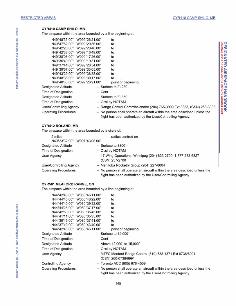
DE
SIG
NA
TE
D A
IRS
PA
CE
HA
ND
BO
OK
Effe
ctiv
e 090
1Z
17
JU
NE
20
21 to
09
01Z
12 A
UG
US
T 20
21
RESTRICTED AREAS CYR410 CAMP SHILO, MB
© 2
021
He
r Ma
jesty the Q
ue
en in R
ight o
f Can
ad
aS
ou
rce o
f Ca
nad
ian A
irspa
ce D
ata
© 2
021
Tra
nsp
ort C
an
ada
CYR410 CAMP SHILO, MBThe airspace within the area bounded by a line beginning at:
N49°48'33.00" W099°26'21.00" toN49°47'52.00" W099°20'56.00" toN49°42'28.00" W099°20'48.00" toN49°42'33.00" W099°16'49.00" toN49°38'06.00" W099°17'26.00" toN49°36'49.00" W099°19'31.00" toN49°37'41.00" W099°28'54.00" toN49°39'57.00" W099°33'05.00" toN49°43'29.00" W099°38'38.00" toN49°48'36.00" W099°39'17.00" toN49°48'33.00" W099°26'21.00" point of beginning
Designated Altitude – Surface to FL280
Time of Designation – Cont
Designated Altitude – Surface to FL350
Time of Designation – Ocsl by NOTAM
User/Controlling Agency – Range Control Commissionaire (204) 765-3000 Ext 3333, (CSN) 258-3333
Operating Procedures – No person shall operate an aircraft within the area described unless the flight has been authorized by the User/Controlling Agency.
CYR412 ROLAND, MBThe airspace within the area bounded by a circle of:
2 miles radius centred onN49°23'32.00" W097°43'08.00"
Designated Altitude – Surface to 8800´
Time of Designation – Ocsl by NOTAM
User Agency – 17 Wing Operations, Winnipeg (204) 833-2700, 1-877-283-6827 (CSN) 257-2700
User/Controlling Agency – Manitoba Rocketry Group (204) 227-8004
Operating Procedures – No person shall operate an aircraft within the area described unless the flight has been authorized by the User/Controlling Agency.
CYR501 MEAFORD RANGE, ONThe airspace within the area bounded by a line beginning at:
N44°42'48.00" W080°46'11.00" toN44°44'40.00" W080°46'22.00" toN44°44'40.00" W080°39'32.00" toN44°44'25.00" W080°37'17.00" toN44°42'50.00" W080°35'45.00" toN44°41'11.00" W080°35'35.00" toN44°39'45.00" W080°37'41.00" toN44°37'40.00" W080°43'40.00" toN44°42'48.00" W080°46'11.00" point of beginning
Designated Altitude – Surface to 12,000´
Time of Designation – Cont
Designated Altitude – Above 12,000´ to 15,000´
Time of Designation – Ocsl by NOTAM
User Agency – MTFC Meaford Range Control (519) 538-1371 Ext 6738/6991 (CSN) 260-6738/6991
Controlling Agency – Toronto ACC (905) 676-4509
Operating Procedures – No person shall operate an aircraft within the area described unless the flight has been authorized by the User/Controlling Agency.
145 DAH May 3, 2021 1:46 pm

DE
SIG
NA
TE
D A
IRS
PA
CE
HA
ND
BO
OK
Effe
ctiv
e 090
1Z
17
JU
NE
20
21 to
09
01Z
12 A
UG
US
T 20
21
RESTRICTED AREAS CYR502 CFB BORDEN, ON
© 2
021
He
r Ma
jesty the Q
ue
en in R
ight o
f Can
ad
aS
ou
rce o
f Ca
nad
ian A
irspa
ce D
ata
© 2
021
Tra
nsp
ort C
an
ada
CYR502 CFB BORDEN, ONThe airspace within the area bounded by a line beginning at:
N44°20'00.00" W079°59'00.00" toN44°20'00.00" W079°54'00.00" toN44°17'00.00" W079°54'00.00" toN44°16'00.00" W079°56'00.00" toN44°15'30.00" W079°59'00.00" toN44°20'00.00" W079°59'00.00" point of beginning
Designated Altitude – Surface to 7000´
Time of Designation – Cont
User/Controlling Agency – Base Ops/Duty Watch Officer (705) 424-1200 Ext 1381/2445 (CSN) 270-1381/2445, Range Control 24/7 (CSN) 270-2164
Operating Procedures – No person shall operate an aircraft within the area described unless the flight has been authorized by the User/Controlling Agency.
CYR504 JOYCEVILLE, ONThe airspace within the area bounded by a circle of:
1 mile radius centred onN44°21'30.00" W076°21'10.00"
Designated Altitude – Surface to 1400´
Time of Designation – Cont
User/Controlling Agency – Warden, Joyceville Institution (613) 542-4554
Operating Procedures – No person shall operate an aircraft within the area described unless the flight has been authorized by the User/Controlling Agency.
CYR505 MILLHAVEN, ON (Bath, ON)The airspace within the area bounded by a circle of:
1 mile radius centred onN44°11'48.00" W076°45'10.00"
Designated Altitude – Surface to 1300´
Time of Designation – Cont
User/Controlling Agency – Warden, Millhaven Institution (613) 352-3371
Operating Procedures – No person shall operate an aircraft within the area described unless the flight has been authorized by the User/Controlling Agency.
CYR506 WARKWORTH, ONThe airspace within the area bounded by a circle of:
1 mile radius centred onN44°12'40.00" W077°48'30.00"
Designated Altitude – Surface to 1400´
Time of Designation – Cont
User/Controlling Agency – Warden, Warkworth Institution (705) 924-2210
Operating Procedures – No person shall operate an aircraft within the area described unless the flight has been authorized by the User/Controlling Agency.
CYR507 COLLINS BAY, ON (Kingston, ON)The airspace within the area bounded by a circle of:
1 mile radius centred onN44°14'05.00" W076°33'13.00"
Designated Altitude – Surface to 520´
Time of Designation – Cont
User/Controlling Agency – Warden, Collins Bay Institution (613) 545-8598
146 DAH May 3, 2021 1:46 pm

DE
SIG
NA
TE
D A
IRS
PA
CE
HA
ND
BO
OK
Effe
ctiv
e 090
1Z
17
JU
NE
20
21 to
09
01Z
12 A
UG
US
T 20
21
RESTRICTED AREAS CYR508 HAZELDEAN, ON
© 2
021
He
r Ma
jesty the Q
ue
en in R
ight o
f Can
ad
aS
ou
rce o
f Ca
nad
ian A
irspa
ce D
ata
© 2
021
Tra
nsp
ort C
an
ada
Operating Procedures – No person shall operate an aircraft within the area described unless the flight has been authorized by the User/Controlling Agency.
CYR508 HAZELDEAN, ONThe airspace within the area bounded by a circle of:
0.4 mile radius centred onN45°19'18.00" W075°52'32.00"
Designated Altitude – Surface to 1400´
Time of Designation – Cont daylight
User/Controlling Agency – Natural Resources Canada, CANMET Facility (613) 995-1275
Operating Procedures – No person shall operate an aircraft within the area described unless the flight has been authorized by the User/Controlling Agency.
CYR510 CHALK RIVER, ONThe airspace within the area bounded by a line beginning at:
N46°01'06.00" W077°25'21.00" thence clockwise along the arc of a circle of2.5 miles radius centred onN46°02'00.00" W077°22'00.00" toN46°01'27.00" W077°18'30.00" thence along the Ottawa River shoreline \ toN46°02'17.00" W077°20'42.00" toN46°01'06.00" W077°25'21.00" point of beginning
Designated Altitude – Surface to 3000´
Time of Designation – Cont
User/Controlling Agency – General Manager, Facilities & Support, AECL (613) 584-3311 Ext 44476 (days)/44400 (24hrs)
Operating Procedures – No person shall operate an aircraft within the area described unless the flight has been authorized by the User/Controlling Agency.
CYR511 CFB PETAWAWA, ONThe airspace within the area bounded by a line beginning at:
N45°55'24.00" W077°17'34.00" toN45°53'40.00" W077°19'30.00" toN45°50'25.00" W077°32'16.00" toN45°58'45.00" W077°37'00.00" toN46°00'40.00" W077°30'10.00" toN46°00'23.00" W077°28'11.00" toN46°02'17.00" W077°20'42.00" toN46°00'42.00" W077°16'31.00" toN45°58'28.00" W077°19'00.00" toN45°55'24.00" W077°17'34.00" point of beginning
Designated Altitude – Surface to FL200
Time of Designation – Cont
User/Controlling Agency – Duty Centre (CSN) 677-5088, Range Control 24/7 (CSN) 677-5203
Operating Procedures – No person shall operate an aircraft within the area described unless the flight has been authorized by the User/Controlling Agency.
CYR512 CFB PETAWAWA, ONThe airspace within the area bounded by a line beginning at:
N45°53'03.59" W077°21'53.55" toN45°53'02.79" W077°21'49.92" toN45°53'03.48" W077°21'43.36" toN45°52'57.44" W077°21'32.48" toN45°52'55.93" W077°21'24.24" to
147 DAH May 3, 2021 1:46 pm

DE
SIG
NA
TE
D A
IRS
PA
CE
HA
ND
BO
OK
Effe
ctiv
e 090
1Z
17
JU
NE
20
21 to
09
01Z
12 A
UG
US
T 20
21
RESTRICTED AREAS CYR514 IPPERWASH, ON
© 2
021
He
r Ma
jesty the Q
ue
en in R
ight o
f Can
ad
aS
ou
rce o
f Ca
nad
ian A
irspa
ce D
ata
© 2
021
Tra
nsp
ort C
an
ada
N45°52'55.26" W077°21'07.94" toN45°52'51.80" W077°20'56.42" toN45°52'50.98" W077°20'34.92" toN45°52'48.09" W077°20'27.57" toN45°52'54.34" W077°19'53.55" toN45°53'17.01" W077°18'55.93" toN45°53'38.33" W077°18'39.99" toN45°54'11.13" W077°18'07.22" toN45°54'31.21" W077°17'29.93" toN45°55'24.00" W077°17'34.00" toN45°53'40.00" W077°19'30.00" toN45°53'03.59" W077°21'53.55" point of beginning
Designated Altitude – Surface to 2800´
Time of Designation – Cont
User/Controlling Agency – Duty Centre (CSN) 677-5088, Range Control 24/7 (CSN) 677-5203
Operating Procedures – No person shall operate an aircraft within the area described unless the flight has been authorized by the User/Controlling Agency.
CYR514 IPPERWASH, ONThe airspace within the area bounded by a circle of:
3 miles radius centred onN43°12'38.00" W081°55'56.00"
Designated Altitude – Surface to 6000´
Time of Designation – Ocsl by NOTAM
User Agency – Project Manager, Directorate of Contaminated and Legacy Sites Project Delivery, Department of National Defence (613) 943-7809 (CSN) 943-7809
Controlling Agency – Toronto ACC (905) 676-4509
Operating Procedures – No person shall operate an aircraft within the area described unless the flight has been authorized by the User/Controlling Agency.
CYR518 NIAGARA FALLS, ONThe airspace within the area bounded by a circle of:
2 miles radius centred onN43°05'00.00" W079°04'25.00"
Excluding that portion outside of Canadian airspace.Designated Altitude – Surface to below 3500´
Time of Designation – Cont
User/Controlling Agency – Transport Canada, Hamilton TC Centre (905) 679-3477
Operating Procedures – No person shall operate an aircraft, including model aircraft, within the area described unless the flight has been authorized by the User/Controlling Agency, except for medical, police and military aircraft on official duty flights.
CYR531 CONNAUGHT RANGE, ONThe airspace within the area bounded by a line beginning at:
N45°24'00.00" W075°55'00.00" toN45°22'00.00" W075°53'00.00" toN45°21'00.00" W075°55'00.00" toN45°23'00.00" W075°57'00.00" toN45°24'00.00" W075°55'00.00" point of beginning
Designated Altitude – Surface to 1000´
Time of Designation – Cont
User/Controlling Agency – Connaught Range Control (613) 991-5740 (CSN) 991-5740
148 DAH May 3, 2021 1:46 pm

DE
SIG
NA
TE
D A
IRS
PA
CE
HA
ND
BO
OK
Effe
ctiv
e 090
1Z
17
JU
NE
20
21 to
09
01Z
12 A
UG
US
T 20
21
RESTRICTED AREAS CYR533 KITCHENER, ON
© 2
021
He
r Ma
jesty the Q
ue
en in R
ight o
f Can
ad
aS
ou
rce o
f Ca
nad
ian A
irspa
ce D
ata
© 2
021
Tra
nsp
ort C
an
ada
Operating Procedures – No person shall operate an aircraft within the area described unless the flight has been authorized by the User/Controlling Agency.
CYR533 KITCHENER, ONThe airspace within the area bounded by a circle of:
1 mile radius centred onN43°24'07.00" W080°26'28.00"
Designated Altitude – Surface to 1500´
Time of Designation – Cont
User/Controlling Agency – Warden, Grand Valley Institution
Operating Procedures – No person shall operate an aircraft within the area described unless the flight has been authorized by the User/Controlling Agency.
CYR536 DWYER HILL, ONThe airspace within the area bounded by a line beginning at:
N45°09'46.00" W075°56'24.00" toN45°07'25.00" W075°53'37.00" toN45°05'16.00" W075°57'09.00" toN45°07'35.00" W075°59'10.00" toN45°09'46.00" W075°56'24.00" point of beginning
Designated Altitude – Surface to 2500´
Time of Designation – Cont
User/Controlling Agency – Dwyer Hill Training Centre D Ops O Air Aviation (613) 838-4756 Ext 2580
Operating Procedures – No person shall operate an aircraft within the area described unless the flight has been authorized by the User/Controlling Agency.
CYR537 PARLIAMENT HILL, ONThe airspace within the area bounded by a circle of:
0.4 mile radius centred onN45°25'29.05" W075°41'56.74"
Designated Altitude – Surface to 3000´
Time of Designation – Cont
User/Controlling Agency – RCMP [email protected] or (613) 952-4200
Operating Procedures – No person shall operate an aircraft, including model aircraft, within the area described unless the flight has been authorized by the User/Controlling Agency, except for medical, police and military aircraft on official duty flights and IFR flights.
CYR538 RIDEAU HALL, ONThe airspace within the area bounded by a circle of:
0.4 mile radius centred onN45°26'38.90" W075°41'17.80"
Designated Altitude – Surface to 3000´
Time of Designation – Cont
User/Controlling Agency – RCMP [email protected] or (613) 952-4200
Operating Procedures – No person shall operate an aircraft, including model aircraft, within the area described unless the flight has been authorized by the User/Controlling Agency, except for medical, police and military aircraft on official duty flights and IFR flights.
149 DAH May 3, 2021 1:46 pm

DE
SIG
NA
TE
D A
IRS
PA
CE
HA
ND
BO
OK
Effe
ctiv
e 090
1Z
17
JU
NE
20
21 to
09
01Z
12 A
UG
US
T 20
21
RESTRICTED AREAS CYR540 CFB PETAWAWA, ON
© 2
021
He
r Ma
jesty the Q
ue
en in R
ight o
f Can
ad
aS
ou
rce o
f Ca
nad
ian A
irspa
ce D
ata
© 2
021
Tra
nsp
ort C
an
ada
CYR540 CFB PETAWAWA, ONThe airspace within the area bounded by a line beginning at:
N46°11'00.00" W077°57'00.00" toN46°11'00.00" W077°44'00.33" toN45°46'00.00" W077°29'46.11" toN45°48'00.00" W077°44'00.00" toN46°11'00.00" W077°57'00.00" point of beginning
Designated Altitude – 3000´ to FL180
Time of Designation – Ocsl by NOTAM
User Agency – Petawawa Tower (613) 687-5511 Ext 7789/7702 or CFB Petawawa Range Control (613) 687-5511 Ext 5203
Controlling Agency – Montréal ACC 1 (800) 633-1353
Operating Procedures – No person shall operate an aircraft within the area described unless the flight has been authorized by the User/Controlling Agency.
CYR541 CFB PETAWAWA, ONThe airspace within the area bounded by a line beginning at:
N46°11'00.00" W077°44'00.33" toN46°11'00.00" W077°32'00.00" toN46°00'34.17" W077°29'29.13" toN46°00'40.00" W077°30'10.00" toN45°58'45.00" W077°37'00.00" toN46°11'00.00" W077°44'00.33" point of beginning
Designated Altitude – 3000´ to FL180
Time of Designation – Ocsl by NOTAM
User Agency – Petawawa Tower (613) 687-5511 Ext 7789/7702 or CFB Petawawa Range Control (613) 687-5511 Ext 5203
Controlling Agency – Montréal ACC 1 (800) 633-1353
Operating Procedures – No person shall operate an aircraft within the area described unless the flight has been authorized by the User/Controlling Agency.
CYR542 CFB PETAWAWA, ONThe airspace within the area bounded by a line beginning at:
N45°51'40.27" W077°27'21.18" toN45°46'00.00" W077°26'00.00" toN45°46'00.00" W077°29'46.11" toN45°50'25.00" W077°32'16.00" toN45°51'40.27" W077°27'21.18" point of beginning
Designated Altitude – 1000´ to FL180
Time of Designation – Ocsl by NOTAM
User Agency – Petawawa Tower (613) 687-5511 Ext 7789/7702 or CFB Petawawa Range Control (613) 687-5511 Ext 5203
Controlling Agency – Montréal ACC 1 (800) 633-1353
Operating Procedures – No person shall operate an aircraft within the area described unless the flight has been authorized by the User/Controlling Agency.
CYR543 CFB PETAWAWA, ONThe airspace within the area bounded by a line beginning at:
N46°07'00.00" W077°06'00.00" toN45°55'00.00" W077°02'00.00" toN45°55'24.00" W077°17'34.00" toN45°58'28.00" W077°19'00.00" toN46°00'42.00" W077°16'31.00" to
150 DAH May 3, 2021 1:46 pm

DE
SIG
NA
TE
D A
IRS
PA
CE
HA
ND
BO
OK
Effe
ctiv
e 090
1Z
17
JU
NE
20
21 to
09
01Z
12 A
UG
US
T 20
21
RESTRICTED AREAS CYR544 CFB PETAWAWA, ON
© 2
021
He
r Ma
jesty the Q
ue
en in R
ight o
f Can
ad
aS
ou
rce o
f Ca
nad
ian A
irspa
ce D
ata
© 2
021
Tra
nsp
ort C
an
ada
N46°01'45.48" W077°19'18.64" toN46°07'00.00" W077°18'00.00" toN46°07'00.00" W077°06'00.00" point of beginning
Designated Altitude – 4500´ to FL180
Time of Designation – Ocsl by NOTAM
User Agency – Petawawa Tower (613) 687-5511 Ext 7789/7702 or CFB Petawawa Range Control (613) 687-5511 Ext 5203
Controlling Agency – Montréal ACC 1 (800) 633-1353
Operating Procedures – No person shall operate an aircraft within the area described unless the flight has been authorized by the User/Controlling Agency.
CYR544 CFB PETAWAWA, ONThe airspace within the area bounded by a line beginning at:
N45°54'31.21" W077°17'29.93" toN45°54'48.06" W077°16'43.09" toN45°54'56.14" W077°16'35.19" toN45°55'06.06" W077°16'42.25" toN45°55'24.00" W077°17'34.00" toN45°54'31.21" W077°17'29.93" point of beginning
Designated Altitude – Surface to 1000´
Time of Designation – Cont
User/Controlling Agency – Duty Centre (CSN) 677-5088, Range Control 24/7 (CSN) 677-5203
Operating Procedures – No person shall operate an aircraft within the area described unless the flight has been authorized by the User/Controlling Agency.
CYR601 MIRABEL, QCThe airspace within the area bounded by a line beginning at:
N45°33'06.83" W074°03'21.58" toN45°40'24.00" W073°57'15.00" toN45°40'02.00" W073°55'23.00" toN45°41'17.53" W073°53'13.74" toN45°41'26.47" W073°50'21.16" thence clockwise along the arc of a circle of7 miles radius centred onN45°40'55.20" W074°00'18.60" (centre of CYMX Rwy 06/24) \ toN45°33'57.23" W073°59'21.23" thence counter-clockwise along the arc of a circle of12 miles radius centred onN45°28'05.00" W073°44'29.00" (Montréal/Pierre Elliott Trudeau Intl, QC - AD) \ toN45°33'51.81" W073°59'25.81" thence clockwise along the arc of a circle of7 miles radius centred onN45°40'05.84" W074°03'56.28" (centre of CYMX Rwy 11/29) \ toN45°33'06.83" W074°03'21.58" point of beginning
Designated Altitude – Surface to below 1300´
Time of Designation – Cont daylight, O/T by NOTAM
User Agency – Bell Helicopter/Textron (450) 437-8039
Controlling Agency – Montréal ACC 1 (800) 633-1353
Operating Procedures – No person shall operate an aircraft within the area described unless the flight has been authorized by the User/Controlling Agency.
CYR602 VALCARTIER, QCThe airspace within the area bounded by a line beginning at:
N47°13'00.00" W071°55'00.00" toN47°13'00.00" W071°25'30.00" toN47°00'00.00" W071°25'00.00" toN46°56'53.00" W071°27'13.00" to
151 DAH May 3, 2021 1:46 pm
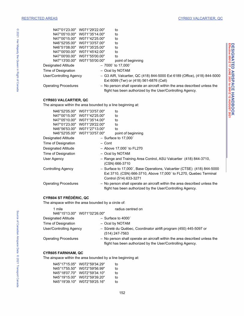
DE
SIG
NA
TE
D A
IRS
PA
CE
HA
ND
BO
OK
Effe
ctiv
e 090
1Z
17
JU
NE
20
21 to
09
01Z
12 A
UG
US
T 20
21
RESTRICTED AREAS CYR603 VALCARTIER, QC
© 2
021
He
r Ma
jesty the Q
ue
en in R
ight o
f Can
ad
aS
ou
rce o
f Ca
nad
ian A
irspa
ce D
ata
© 2
021
Tra
nsp
ort C
an
ada
N47°01'23.00" W071°29'22.00" toN47°05'10.00" W071°35'14.00" toN47°00'15.00" W071°42'25.00" toN46°52'05.00" W071°33'57.00" toN46°51'08.00" W071°35'25.00" toN47°00'00.00" W071°45'42.00" toN47°00'00.00" W071°55'00.00" toN47°13'00.00" W071°55'00.00" point of beginning
Designated Altitude – 7000´ to 17,000´
Time of Designation – Ocsl by NOTAM
User/Controlling Agency – G3 AIR, Valcartier, QC (418) 844-5000 Ext 6189 (Office), (418) 844-5000 Ext 6099 (Twr) or (418) 561-6876 (Cell)
Operating Procedures – No person shall operate an aircraft within the area described unless the flight has been authorized by the User/Controlling Agency.
CYR603 VALCARTIER, QCThe airspace within the area bounded by a line beginning at:
N46°52'05.00" W071°33'57.00" toN47°00'15.00" W071°42'25.00" toN47°05'10.00" W071°35'14.00" toN47°01'23.00" W071°29'22.00" toN46°56'53.00" W071°27'13.00" toN46°52'05.00" W071°33'57.00" point of beginning
Designated Altitude – Surface to 17,000´
Time of Designation – Cont
Designated Altitude – Above 17,000´ to FL270
Time of Designation – Ocsl by NOTAM
User Agency – Range and Training Area Control, ASU Valcartier (418) 844-3710, (CSN) 666-3710
Controlling Agency – Surface to 17,000´, Base Operations, Valcartier (CTSE) (418) 844-5000 Ext 3710, (CSN) 666-3710, Above 17,000´ to FL270, Quebec Terminal Control (514) 633-3271
Operating Procedures – No person shall operate an aircraft within the area described unless the flight has been authorized by the User/Controlling Agency.
CYR604 ST FRÉDÉRIC, QCThe airspace within the area bounded by a circle of:
1 mile radius centred onN46°15'13.00" W071°02'26.00"
Designated Altitude – Surface to 4000´
Time of Designation – Ocsl by NOTAM
User/Controlling Agency – Sûreté du Québec, Coordinator airlift program (450) 445-5097 or (514) 247-7563
Operating Procedures – No person shall operate an aircraft within the area described unless the flight has been authorized by the User/Controlling Agency.
CYR605 FARNHAM, QCThe airspace within the area bounded by a line beginning at:
N45°17'15.05" W072°59'34.29" toN45°17'55.50" W072°59'56.99" toN45°18'07.70" W072°59'34.10" toN45°19'15.00" W072°59'39.20" toN45°19'39.10" W072°59'25.16" to
152 DAH May 3, 2021 1:46 pm

DE
SIG
NA
TE
D A
IRS
PA
CE
HA
ND
BO
OK
Effe
ctiv
e 090
1Z
17
JU
NE
20
21 to
09
01Z
12 A
UG
US
T 20
21
RESTRICTED AREAS CYR606 LAC SAINT PIERRE, QC
© 2
021
He
r Ma
jesty the Q
ue
en in R
ight o
f Can
ad
aS
ou
rce o
f Ca
nad
ian A
irspa
ce D
ata
© 2
021
Tra
nsp
ort C
an
ada
N45°20'30.05" W072°59'20.51" toN45°20'33.28" W073°00'05.75" toN45°20'15.19" W073°00'36.85" toN45°19'50.12" W073°00'39.43" toN45°19'34.67" W073°02'57.23" toN45°18'41.58" W073°02'54.46" toN45°17'23.03" W073°01'00.09" toN45°17'14.74" W073°00'02.99" toN45°17'15.05" W072°59'34.29" point of beginning
Designated Altitude - Surface to 1200´, Ocsl Surface to 3500´ by NOTAM
Time of Designation - Cont
User / Controlling Agency - Farnham Range, Control Officer (450) 293-8163 Ext 5225 (CSN) 273-5225.
Operating Procedures - No person shall operate an aircraft within the area described unless the flight has been authorized by the User/Controlling Agency
CYR606 LAC SAINT PIERRE, QCThe airspace within the area bounded by a line beginning at:
N46°15'00.00" W072°39'14.00" toN46°15'00.00" W072°43'20.00" toN46°12'18.00" W072°48'41.00" toN46°10'54.00" W072°54'18.00" toN46°09'20.00" W072°56'20.00" toN46°07'21.00" W072°55'00.00" toN46°09'38.00" W072°45'15.00" toN46°08'38.00" W072°43'54.00" toN46°11'32.00" W072°39'40.00" toN46°13'57.00" W072°38'27.00" toN46°15'00.00" W072°39'14.00" point of beginning
Designated Altitude – Surface to 10,000´, Ocsl higher by NOTAM
Time of Designation – Cont 13-01Z (DT12-00Z) Mon - Fri O/T by NOTAM
User Agency – The Superintendent, Proof and Experimental Test Establishment (819) 293-2004
Controlling Agency – Montréal ACC 1 (800) 633-1353
Operating Procedures – No person shall operate an aircraft within the area described unless the flight has been authorized by the User/Controlling Agency.
CYR608 DONNACONA, QCThe airspace within the area bounded by a circle of:
1 mile radius centred onN46°41'20.00" W071°41'25.00"
Designated Altitude – Surface to 1200´
Time of Designation – Cont
User/Controlling Agency – Warden, Donnacona Institution (418) 285-2455
Operating Procedures – No person shall operate an aircraft within the area described unless the flight has been authorized by the User/Controlling Agency.
CYR610 COWANSVILLE, QCThe airspace within the area bounded by a circle of:
1 mile radius centred onN45°13'08.00" W072°47'15.00"
Designated Altitude – Surface to 600´
Time of Designation – Cont
153 DAH May 3, 2021 1:46 pm

DE
SIG
NA
TE
D A
IRS
PA
CE
HA
ND
BO
OK
Effe
ctiv
e 090
1Z
17
JU
NE
20
21 to
09
01Z
12 A
UG
US
T 20
21
RESTRICTED AREAS CYR612 VALCARTIER, QC
© 2
021
He
r Ma
jesty the Q
ue
en in R
ight o
f Can
ad
aS
ou
rce o
f Ca
nad
ian A
irspa
ce D
ata
© 2
021
Tra
nsp
ort C
an
ada
User/Controlling Agency – Operations Centre, Cowansville Institution (450) 263-3073 Ext. 2930
Operating Procedures – No person shall operate an aircraft within the area described unless the flight has been authorized by the User/Controlling Agency.
CYR612 VALCARTIER, QCThe airspace within the area bounded by a line beginning at:
N46°50'44.00" W071°32'39.00" toN46°52'05.00" W071°33'57.00" toN46°56'53.00" W071°27'13.00" toN46°54'10.00" W071°26'05.00" toN46°52'54.00" W071°25'32.00" toN46°50'44.00" W071°32'39.00" point of beginning
Designated Altitude – Surface to 2700´
Time of Designation – Cont
User Agency – Range and Training Area Control, ASU Valcartier (418) 844-3710, (CSN) 666-3710
Controlling Agency – Base Operations, Valcartier (CTSE) (418) 844-5000 Ext 3710, (CSN) 666-3710
Operating Procedures – No person shall operate an aircraft within the area described unless the flight has been authorized by the User/Controlling Agency.
CYR613 ARCHAMBAULT (Ste-Anne-des-Plaines, QC)The airspace within the area bounded by a circle of:
1 mile radius centred onN45°45'03.00" W073°51'26.00"
Designated Altitude – Surface to 800´
Time of Designation – Cont
User/Controlling Agency – Warden, Archambault Institution (514) 478-5960 – Warden, Regional Reception Centre (514) 478-5977
Operating Procedures – No person shall operate an aircraft within the area described unless the flight has been authorized by both User/Controlling agencies.
CYR614 LECLERC (St-Vincent-de-Paul, QC)The airspace within the area bounded by a line beginning at:
N45°36'12.00" W073°38'45.00" thence clockwise along the arc of a circle of1 mile radius centred onN45°37'11.00" W073°39'02.00" toN45°37'54.00" W073°38'02.00" thence southward along the west bank of Rivière-des-Prairies \ toN45°36'12.00" W073°38'45.00" point of beginning
Designated Altitude – Surface to 1300´
Time of Designation – Cont
User/Controlling Agency – Warden, Federal Training Centre (450) 661-7786 Ext 4100
Operating Procedures – No person shall operate an aircraft within the area described unless the flight has been authorized by both User/Controlling agencies.
CYR615 LA MACAZA, QCThe airspace within the area bounded by a line beginning at:
N46°23'43.50" W074°46'44.93" toN46°24'04.00" W074°46'48.00" toN46°25'00.00" W074°46'34.00" toN46°25'38.88" W074°46'07.75" thence clockwise along the arc of a circle of1 mile radius centred onN46°24'39.00" W074°46'12.00" to
154 DAH May 3, 2021 1:46 pm

DE
SIG
NA
TE
D A
IRS
PA
CE
HA
ND
BO
OK
Effe
ctiv
e 090
1Z
17
JU
NE
20
21 to
09
01Z
12 A
UG
US
T 20
21
RESTRICTED AREAS CYR617 PORT CARTIER, QC
© 2
021
He
r Ma
jesty the Q
ue
en in R
ight o
f Can
ad
aS
ou
rce o
f Ca
nad
ian A
irspa
ce D
ata
© 2
021
Tra
nsp
ort C
an
ada
N46°23'43.50" W074°46'44.93" point of beginningDesignated Altitude – Surface to 1800´
Time of Designation – Cont
User/Controlling Agency – Warden, La Macaza Institution (819) 275-2315
Operating Procedures – Except for IFR traffic above 1200´, no person shall operate an aircraft within the area described unless the flight has been authorized by the User/Controlling Agency.
CYR617 PORT CARTIER, QCThe airspace within the area bounded by a line beginning at:
N50°02'38.00" W066°51'56.00" toN50°02'51.00" W066°52'49.00" toN50°03'20.00" W066°53'54.00" toN50°03'47.00" W066°54'28.00" thence clockwise along the arc of a circle of1 mile radius centred onN50°03'15.00" W066°53'10.00" toN50°02'38.00" W066°51'56.00" point of beginning
Designated Altitude – Surface to 400´
Time of Designation – Cont
User/Controlling Agency – Warden, Port Cartier Institution (418) 766-7070
Operating Procedures – No person shall operate an aircraft within the area described unless the flight has been authorized by the User/Controlling Agency.
CYR618 DRUMMOND, QCThe airspace within the area bounded by a circle of:
1 mile radius centred onN45°51'06.00" W072°28'40.00"
Designated Altitude – Surface to 900´
Time of Designation – Cont
User/Controlling Agency – Warden, Drummond Institution (819) 477-5112
Operating Procedures – No person shall operate an aircraft within the area described unless the flight has been authorized by the User/Controlling Agency.
CYR620 HARRINGTON LAKE, QC (Lac Mousseau)The airspace within the area bounded by a circle of:
1 mile radius centred onN45°33'06.00" W075°55'45.00"
Designated Altitude – Surface to 2000´
Time of Designation – Cont
User/Controlling Agency – RCMP (613) 952-4200
Operating Procedures – No person shall operate an aircraft, including model aircraft, within the area described unless the flight has been authorized by the User/Controlling Agency.
CYR624 STE-THÉRÈSE, QCThe airspace within the area bounded by a line beginning at:
N45°40'24.00" W073°57'15.00" toN45°41'25.81" W073°56'02.25" toN45°42'14.37" W073°54'29.62" toN45°43'55.16" W073°51'17.11" thence clockwise along the arc of a circle of7 miles radius centred onN45°40'55.20" W074°00'18.60" toN45°41'26.47" W073°50'21.16" to
155 DAH May 3, 2021 1:46 pm

DE
SIG
NA
TE
D A
IRS
PA
CE
HA
ND
BO
OK
Effe
ctiv
e 090
1Z
17
JU
NE
20
21 to
09
01Z
12 A
UG
US
T 20
21
RESTRICTED AREAS CYR625 JOLIETTE, QC
© 2
021
He
r Ma
jesty the Q
ue
en in R
ight o
f Can
ad
aS
ou
rce o
f Ca
nad
ian A
irspa
ce D
ata
© 2
021
Tra
nsp
ort C
an
ada
N45°41'17.53" W073°53'13.74" toN45°40'02.00" W073°55'23.00" toN45°40'24.00" W073°57'15.00" point of beginning
Designated Altitude – Surface to below 1300´
Time of Designation – Cont daylight, O/T by NOTAM
User/Controlling Agency – Bell Helicopter/Textron (450) 437-8039
Operating Procedures – No person shall operate an aircraft within the area described unless the flight has been authorized by the User/Controlling Agency.
CYR625 JOLIETTE, QCThe airspace within the area bounded by a circle of:
0.5 mile radius centred onN46°01'56.00" W073°24'54.00"
Designated Altitude – Surface to 725´
Time of Designation – Cont
User/Controlling Agency – Warden, Joliette Institution
Operating Procedures – No person shall operate an aircraft within the area described unless the flight has been authorized by the User/Controlling Agency.
CYR626 CHUTE MONTMORENCY, QCThe airspace within the area bounded by a circle of:
0.25 mile radius centred onN46°53'14.00" W071°08'48.00"
Designated Altitude – Surface to 600´
Time of Designation – Cont
User/Controlling Agency – Director, Parc de la Chute-Montmorency (418) 663-3330
Operating Procedures – No person shall operate an aircraft within the area described unless the flight has been authorized by the User/Controlling Agency.
CYR628 BAGOTVILLE, QCThe airspace within the area bounded by a line beginning at:
N50°44'02.11" W072°00'00.00" toN48°55'12.00" W072°00'00.00" toN48°49'35.71" W071°50'33.84" thence counter-clockwise along the arc of a circle of45 miles radius centred onN48°19'50.00" W070°59'47.00" (Bagotville, QC - AD) \ toN48°40'00.00" W072°00'14.44" toN48°39'59.71" W072°18'37.55" toN49°38'11.00" W074°00'00.00" toN49°49'41.34" W074°00'00.00" toN50°44'02.11" W072°00'00.00" point of beginning
Designated Altitude – 8000´ to FL310
Time of Designation – Ocsl by NOTAM
User Agency – 3 Wing Operations, CFB Bagotville (418) 677-4000 Ext 7283, (CSN) 661-7283
Controlling Agency – Bagotville Military Terminal Control (418) 677-4000 Ext 7944, (CSN) 661-7944, Montréal ACC 1 (800) 633-1353
Operating Procedures – No person shall operate an aircraft within the area described unless the flight has been authorized by the User/Controlling Agency.
156 DAH May 3, 2021 1:46 pm

DE
SIG
NA
TE
D A
IRS
PA
CE
HA
ND
BO
OK
Effe
ctiv
e 090
1Z
17
JU
NE
20
21 to
09
01Z
12 A
UG
US
T 20
21
RESTRICTED AREAS CYR629 BAGOTVILLE, QC
© 2
021
He
r Ma
jesty the Q
ue
en in R
ight o
f Can
ad
aS
ou
rce o
f Ca
nad
ian A
irspa
ce D
ata
© 2
021
Tra
nsp
ort C
an
ada
CYR629 BAGOTVILLE, QCThe airspace within the area bounded by a line beginning at:
N51°00'05.99" W071°22'41.94" toN51°00'00.36" W069°36'39.48" toN49°52'16.14" W071°08'32.70" toN49°04'22.15" W071°09'03.05" thence counter-clockwise along the arc of a circle of45 miles radius centred onN48°19'50.00" W070°59'47.00" (Bagotville, QC - AD) \ toN48°49'35.71" W071°50'33.84" toN48°55'12.00" W072°00'00.00" toN50°44'02.11" W072°00'00.00" toN51°00'05.99" W071°22'41.94" point of beginning
Designated Altitude – 18,000´ to FL310
Time of Designation – 14-06Z (DT13-05Z) Mon - Fri excluding hols; O/T by NOTAM
User Agency – 3 Wing Operations, CFB Bagotville (418) 677-4000 Ext 7283, (CSN) 661-7283
Controlling Agency – Bagotville Military Terminal Control (418) 677-4000 Ext 7944, (CSN) 661-7944, Montréal ACC 1 (800) 633-1353
Operating Procedures – No person shall operate an aircraft within the area described unless the flight has been authorized by the User/Controlling Agency.
CYR630 BAGOTVILLE, QCThe airspace within the area bounded by a line beginning at:
N51°12'25.00" W068°00'00.00" toN50°36'17.35" W068°00'00.00" toN50°27'20.53" W068°01'23.28" toN49°11'15.00" W068°40'00.00" toN48°37'07.71" W070°14'05.52" thence counter-clockwise along the arc of a circle of35 miles radius centred onN48°19'50.00" W070°59'47.00" (Bagotville, QC - AD) \ toN48°54'14.28" W071°09'09.35" toN49°52'16.14" W071°08'32.70" toN51°12'24.75" W069°19'09.33" toN51°12'25.00" W068°00'00.00" point of beginning
Designated Altitude – 6000´ to FL310
Time of Designation – 14-06Z (DT13-05Z) Mon - Fri; 14-23Z (DT13-22Z) Sat, Sun and hols; O/T by NOTAM
User Agency – 3 Wing Operations, CFB Bagotville (418) 677-4000 Ext 7283, (CSN) 661-7283
Controlling Agency – Bagotville Military Terminal Control (418) 677-4000 Ext 7944, (CSN) 661-7944, Montréal ACC 1 (800) 633-1353
Operating Procedures – No person shall operate an aircraft within the area described unless the flight has been authorized by the User/Controlling Agency.
CYR631 STE-THÉRÈSE, QCThe airspace within the area bounded by a line beginning at:
N45°43'55.16" W073°51'17.11" toN45°44'00.00" W073°50'35.00" toN45°44'00.00" W073°49'28.00" toN45°44'35.00" W073°45'31.00" toN45°43'50.00" W073°45'11.00" toN45°43'44.00" W073°43'05.00" toN45°42'48.00" W073°42'42.00" toN45°42'35.00" W073°43'06.00" to
157 DAH May 3, 2021 1:46 pm
DE
SIG
NA
TE
D A
IRS
PA
CE
HA
ND
BO
OK
Effe
ctiv
e 090
1Z
17
JU
NE
20
21 to
09
01Z
12 A
UG
US
T 20
21
RESTRICTED AREAS CYR651 ALMA, QC
© 2
021
He
r Ma
jesty the Q
ue
en in R
ight o
f Can
ad
aS
ou
rce o
f Ca
nad
ian A
irspa
ce D
ata
© 2
021
Tra
nsp
ort C
an
ada
N45°42'30.79" W073°50'35.13" thence counter-clockwise along the arc of a circle of7 miles radius centred onN45°40'55.20" W074°00'18.60" toN45°43'55.16" W073°51'17.11" point of beginning
Designated Altitude – Surface to below 1500´
Time of Designation – Cont daylight, O/T by NOTAM
User/Controlling Agency – Bell Helicopter/Textron (450) 437-8039
Operating Procedures – No person shall operate an aircraft within the area described unless the flight has been authorized by the User/Controlling Agency.
CYR651 ALMA, QCThe airspace within the area bounded by a line beginning at:
N48°33'00.44" W071°45'02.38" toN48°28'55.18" W071°31'18.88" thence clockwise along the arc of a circle of5 miles radius centred onN48°30'58.02" W071°38'10.35" (1/2 mile north of centre-line & mid-point RWY 13/31 Alma Airport) \ toN48°33'00.44" W071°45'02.38" point of beginning
Designated Altitude – Surface to 6000´
Time of Designation – Ocsl by NOTAM, 48 hrs prior notice
User Agency – Alma UAS Centre of Excellence - (418) 669-5129 / [email protected]
Controlling Agency – Bagotville Military Terminal Control (418) 677-4000 Ext 7944, (CSN) 661-7944
Operating Procedures – No person shall operate an aircraft within the area described unless the flight has been authorized by the User/Controlling Agency.
CYR652 ALMA, QCThe airspace within the area bounded by a line beginning at:
N48°27'57.11" W071°40'42.21" toN48°27'16.99" W071°36'58.53" toN48°24'07.98" W071°38'16.85" toN48°24'48.06" W071°42'00.33" toN48°27'57.11" W071°40'42.21" point of beginning
Designated Altitude – 3500´ to 12,500´
Time of Designation – Ocsl by NOTAM, 48 hrs prior notice
User Agency – Alma UAS Centre of Excellence - (418) 669-5129 / [email protected]
Controlling Agency – Bagotville Military Terminal Control (418) 677-4000 Ext 7944, (CSN) 661-7944
Operating Procedures – No person shall operate an aircraft within the area described unless the flight has been authorized by the User/Controlling Agency.
CYR653 ALMA, QCThe airspace within the area bounded by a line beginning at:
N48°36'50.82" W071°58'03.01" toN48°30'14.62" W071°35'44.76" toN48°24'07.98" W071°38'16.85" toN48°27'42.29" W071°58'18.94" toN48°30'24.81" W072°00'20.47" thence clockwise along the arc of a circle of15 miles radius centred onN48°30'12.00" W071°37'48.00" (Alma, QC 'ITF' DME) \ toN48°36'50.82" W071°58'03.01" point of beginning
Designated Altitude – Above 2000´ to 8000´
Time of Designation – Ocsl by NOTAM, 48 hrs prior notice
User Agency – Alma UAS Centre of Excellence - (418) 669-5129 / [email protected]
158 DAH May 3, 2021 1:46 pm

DE
SIG
NA
TE
D A
IRS
PA
CE
HA
ND
BO
OK
Effe
ctiv
e 090
1Z
17
JU
NE
20
21 to
09
01Z
12 A
UG
US
T 20
21
RESTRICTED AREAS CYR654 ALMA, QC
© 2
021
He
r Ma
jesty the Q
ue
en in R
ight o
f Can
ad
aS
ou
rce o
f Ca
nad
ian A
irspa
ce D
ata
© 2
021
Tra
nsp
ort C
an
ada
Controlling Agency – Bagotville Military Terminal Control (418) 677-4000 Ext 7944, (CSN) 661-7944
Operating Procedures – No person shall operate an aircraft within the area described unless the flight has been authorized by the User/Controlling Agency.
CYR654 ALMA, QCThe airspace within the area bounded by a line beginning at:
N48°36'50.82" W071°58'03.01" toN48°33'44.16" W071°47'30.00" toN48°32'30.00" W071°48'30.00" toN48°30'00.00" W071°48'00.00" toN48°26'34.94" W071°52'00.00" toN48°27'42.29" W071°58'18.94" toN48°30'24.81" W072°00'20.47" thence clockwise along the arc of a circle of15 miles radius centred onN48°30'12.00" W071°37'48.00" (Alma, QC 'ITF' DME) \ toN48°36'50.82" W071°58'03.01" point of beginning
Designated Altitude – Surface to 2000´
Time of Designation – Ocsl by NOTAM, September 1 to May 31, 48 hrs prior notice
User Agency – Alma UAS Centre of Excellence - (418) 669-5129 / [email protected]
Controlling Agency – Bagotville Military Terminal Control (418) 677-4000 Ext 7944, (CSN) 661-7944
Operating Procedures – No person shall operate an aircraft within the area described unless the flight has been authorized by the User/Controlling Agency.
CYR655 ALMA, QCThe airspace within the area bounded by a line beginning at:
N48°33'44.16" W071°47'30.00" toN48°33'00.44" W071°45'02.38" thence counter-clockwise along the arc of a circle of5 miles radius centred onN48°30'58.02" W071°38'10.35" (1/2 mile north of centre-line & mid-point RWY 13/31 Alma Airport) \ toN48°29'16.86" W071°45'15.00" toN48°26'06.52" W071°49'20.00" toN48°26'34.94" W071°52'00.00" toN48°30'00.00" W071°48'00.00" toN48°32'30.00" W071°48'30.00" toN48°33'44.16" W071°47'30.00" point of beginning
Designated Altitude – Surface to 2000´
Time of Designation – Ocsl by NOTAM, September 1 to May 31, 48 hrs prior notice
User Agency – Alma UAS Centre of Excellence - (418) 669-5129 / [email protected]
Controlling Agency – Bagotville Military Terminal Control (418) 677-4000 Ext 7944, (CSN) 661-7944
Operating Procedures – No person shall operate an aircraft within the area described unless the flight has been authorized by the User/Controlling Agency.
CYR656 ALMA, QCThe airspace within the area bounded by a line beginning at:
N48°29'16.86" W071°45'15.00" thence counter-clockwise along the arc of a circle of5 miles radius centred onN48°30'58.02" W071°38'10.35" (1/2 mile north of centre-line & mid-point RWY 13/31 Alma Airport) \ toN48°26'26.00" W071°41'19.88" toN48°24'48.06" W071°42'00.33" toN48°26'06.52" W071°49'20.00" toN48°29'16.86" W071°45'15.00" point of beginning
159 DAH May 3, 2021 1:46 pm

DE
SIG
NA
TE
D A
IRS
PA
CE
HA
ND
BO
OK
Effe
ctiv
e 090
1Z
17
JU
NE
20
21 to
09
01Z
12 A
UG
US
T 20
21
RESTRICTED AREAS CYR657 ALMA, QC
© 2
021
He
r Ma
jesty the Q
ue
en in R
ight o
f Can
ad
aS
ou
rce o
f Ca
nad
ian A
irspa
ce D
ata
© 2
021
Tra
nsp
ort C
an
ada
Designated Altitude – Surface to 2000´
Time of Designation – Ocsl by NOTAM June 1 to August 31 - Tuesday, Wednesday, Thursday, O/T Ocsl by NOTAM, 48 hrs prior notice
User Agency – Alma UAS Centre of Excellence - (418) 669-5129 / [email protected]
Controlling Agency – Bagotville Military Terminal Control (418) 677-4000 Ext 7944, (CSN) 661-7944
Operating Procedures – No person shall operate an aircraft within the area described unless the flight has been authorized by the User/Controlling Agency.
CYR657 ALMA, QCThe airspace within the area bounded by a line beginning at:
N48°19'00.00" W072°49'04.51" thence counter-clockwise along the arc of a circle of25 miles radius centred onN48°32'41.00" W072°17'40.00" (Roberval, QC - NDB) \ toN48°10'36.62" W072°35'13.49" toN47°30'30.77" W072°52'30.00" toN47°45'00.00" W073°42'30.00" toN48°08'00.00" W073°28'00.00" toN48°19'00.00" W072°49'04.51" point of beginning
Designated Altitude – Above 4,000´ to below 18,000´
Time of Designation – Ocsl by NOTAM, 48 hrs prior notice
User Agency – Alma UAS Centre of Excellence - (418) 669-5129 / [email protected]
Controlling Agency – Montréal ACC 1 (800) 633-1353
Operating Procedures – No person shall operate an aircraft within the area described unless the flight has been authorized by the User/Controlling Agency.
CYR658 ALMA, QCThe airspace within the area bounded by a line beginning at:
N48°19'00.00" W072°49'04.51" thence counter-clockwise along the arc of a circle of25 miles radius centred onN48°32'41.00" W072°17'40.00" (Roberval, QC - NDB) \ toN48°10'36.62" W072°35'13.49" toN47°30'30.77" W072°52'30.00" toN47°45'00.00" W073°42'30.00" toN48°08'00.00" W073°28'00.00" toN48°19'00.00" W072°49'04.51" point of beginning
Designated Altitude – FL180 to below FL280
Time of Designation – Ocsl by NOTAM, 48 hrs prior notice
User Agency – Alma UAS Centre of Excellence - (418) 669-5129 / [email protected]
Controlling Agency – Montréal ACC 1 (800) 633-1353
Operating Procedures – No person shall operate an aircraft within the area described unless the flight has been authorized by the User/Controlling Agency.
CYR664 BAGOTVILLE, QCThe airspace within the area bounded by a line beginning at:
N50°44'02.11" W072°00'00.00" toN48°55'12.00" W072°00'00.00" toN48°49'35.71" W071°50'33.84" thence counter-clockwise along the arc of a circle of45 miles radius centred onN48°19'50.00" W070°59'47.00" (Bagotville, QC - AD) \ toN48°40'00.00" W072°00'14.44" toN48°39'59.71" W072°18'37.55" toN49°38'11.00" W074°00'00.00" toN49°49'41.34" W074°00'00.00" to
160 DAH May 3, 2021 1:46 pm

DE
SIG
NA
TE
D A
IRS
PA
CE
HA
ND
BO
OK
Effe
ctiv
e 090
1Z
17
JU
NE
20
21 to
09
01Z
12 A
UG
US
T 20
21
RESTRICTED AREAS CYR665 BAGOTVILLE, QC
© 2
021
He
r Ma
jesty the Q
ue
en in R
ight o
f Can
ad
aS
ou
rce o
f Ca
nad
ian A
irspa
ce D
ata
© 2
021
Tra
nsp
ort C
an
ada
N50°44'02.11" W072°00'00.00" point of beginningDesignated Altitude – above FL310 to unlimited
Time of Designation – Ocsl by NOTAM
User Agency – 3 Wing Operations, CFB Bagotville (418) 677-4000 Ext 7283, (CSN) 661-7283
Controlling Agency – Bagotville Military Terminal Control (418) 677-4000 Ext 7944, (CSN) 661-7944, Montréal ACC 1 (800) 633-1353
Operating Procedures – No person shall operate an aircraft within the area described unless the flight has been authorized by the User/Controlling Agency.
CYR665 BAGOTVILLE, QCThe airspace within the area bounded by a line beginning at:
N51°00'05.99" W071°22'41.94" toN51°00'00.36" W069°36'39.48" toN49°52'16.14" W071°08'32.70" toN49°04'22.15" W071°09'03.05" thence counter-clockwise along the arc of a circle of45 miles radius centred onN48°19'50.00" W070°59'47.00" (Bagotville, QC - AD) \ toN48°49'35.71" W071°50'33.84" toN48°55'12.00" W072°00'00.00" toN50°44'02.11" W072°00'00.00" toN51°00'05.99" W071°22'41.94" point of beginning
Designated Altitude – above FL310 to unlimited
Time of Designation – Ocsl by NOTAM
User Agency – 3 Wing Operations, CFB Bagotville (418) 677-4000 Ext 7283, (CSN) 661-7283
Controlling Agency – Bagotville Military Terminal Control (418) 677-4000 Ext 7944, (CSN) 661-7944, Montréal ACC 1 (800) 633-1353
Operating Procedures – No person shall operate an aircraft within the area described unless the flight has been authorized by the User/Controlling Agency.
CYR666 BAGOTVILLE, QCThe airspace within the area bounded by a line beginning at:
N51°12'25.00" W068°00'00.00" toN50°36'17.35" W068°00'00.00" toN50°27'20.53" W068°01'23.28" toN49°11'15.00" W068°40'00.00" toN48°37'07.71" W070°14'05.52" thence counter-clockwise along the arc of a circle of35 miles radius centred onN48°19'50.00" W070°59'47.00" (Bagotville, QC - AD) \ toN48°54'14.28" W071°09'09.35" toN49°52'16.14" W071°08'32.70" toN51°12'24.75" W069°19'09.33" toN51°12'25.00" W068°00'00.00" point of beginning
Designated Altitude – above FL310 to unlimited
Time of Designation – Ocsl by NOTAM
User Agency – 3 Wing Operations, CFB Bagotville (418) 677-4000 Ext 7283, (CSN) 661-7283
Controlling Agency – Bagotville Military Terminal Control (418) 677-4000 Ext 7944, (CSN) 661-7944, Montréal ACC 1 (800) 633-1353
Operating Procedures – No person shall operate an aircraft within the area described unless the flight has been authorized by the User/Controlling Agency.
161 DAH May 3, 2021 1:46 pm

DE
SIG
NA
TE
D A
IRS
PA
CE
HA
ND
BO
OK
Effe
ctiv
e 090
1Z
17
JU
NE
20
21 to
09
01Z
12 A
UG
US
T 20
21
RESTRICTED AREAS CYR701 GOOSE BAY, NL
© 2
021
He
r Ma
jesty the Q
ue
en in R
ight o
f Can
ad
aS
ou
rce o
f Ca
nad
ian A
irspa
ce D
ata
© 2
021
Tra
nsp
ort C
an
ada
CYR701 GOOSE BAY, NLThe airspace within the area bounded by a circle of:
10 miles radius centred onN53°50'48.00" W061°58'48.00"
Designated Altitude – Surface to FL280
Time of Designation – Ocsl by NOTAM
User/Controlling Agency – Wing Operations Centre 5 Wing, CFB Goose Bay (709) 896-6900 Ext 7331, (CSN) 555-7331, 1-800-563-2390
Operating Procedures – No person shall operate an aircraft within the area described unless the flight has been authorized by the User/Controlling Agency.
CYR704 HALIFAX, NSThe airspace within the area bounded by a line beginning at:
N43°56'26.00" W065°01'18.00" toN43°43'33.00" W064°51'05.00" toN43°41'29.00" W064°54'01.00" toN43°54'52.00" W065°04'53.00" toN43°56'26.00" W065°01'18.00" point of beginning
Designated Altitude – 3000´ to 5000´
Time of Designation – Ocsl by NOTAM, 48 hrs prior notice
User Agency – ACCE(A) (902) 427-2510, (CSN) 427-2510
Controlling Agency – Moncton ACC (506) 867-7178/7173
Operating Procedures – No person shall operate an aircraft within the area described unless the flight has been authorized by the User/Controlling Agency.
CYR705 HALIFAX, NSThe airspace within the area bounded by a line beginning at:
N44°06'32.00" W065°09'21.00" toN43°56'26.00" W065°01'18.00" toN43°49'51.00" W065°16'16.00" toN44°00'09.00" W065°24'39.00" toN44°06'32.00" W065°09'21.00" point of beginning
Designated Altitude – Surface to 5000´
Time of Designation – Ocsl by NOTAM, 48 hrs prior notice
User Agency – ACCE(A) (902) 427-2510, (CSN) 427-2510
Controlling Agency – Moncton ACC (506) 867-7178/7173
Operating Procedures – No person shall operate an aircraft within the area described unless the flight has been authorized by the User/Controlling Agency.
CYR706 CAMP ALDERSHOT, NSThe airspace within the area bounded by a circle of:
1 mile radius centred onN45°06'00.00" W064°33'00.00"
Designated Altitude – Surface to 1000´
Time of Designation – Cont
User Agency – Army Reserve Training Centre, Camp Alsershot (902) 678-7930 Ext 130, (CSN) 568-5355
Controlling Agency – 14 Wg Greenwood (902) 765-1494 Ext 5457, (CSN) 568-5457
Operating Procedures – No person shall operate an aircraft within the area described unless the flight has been authorized by the User/Controlling Agency.
162 DAH May 3, 2021 1:46 pm

DE
SIG
NA
TE
D A
IRS
PA
CE
HA
ND
BO
OK
Effe
ctiv
e 090
1Z
17
JU
NE
20
21 to
09
01Z
12 A
UG
US
T 20
21
RESTRICTED AREAS CYR711 SPRINGHILL, NS
© 2
021
He
r Ma
jesty the Q
ue
en in R
ight o
f Can
ad
aS
ou
rce o
f Ca
nad
ian A
irspa
ce D
ata
© 2
021
Tra
nsp
ort C
an
ada
CYR711 SPRINGHILL, NSThe airspace within the area bounded by a circle of:
1 mile radius centred onN45°37'30.00" W064°04'18.00"
Designated Altitude – Surface to 1600´
Time of Designation – Cont
User/Controlling Agency – Warden, Springhill Institution (902) 597-3755
Operating Procedures – No person shall operate an aircraft within the area described unless the flight has been authorized by the User/Controlling Agency.
CYR717 HALIFAX, NSThe airspace within the area bounded by a circle of:
0.75 miles radius centred onN44°42'43.00" W063°38'04.00"
Designated Altitude – Surface to 1700´
Time of Designation – Cont
User Agency – RJOC(A) (902) 427-2502, (CSN) 427-2502
Controlling Agency – Moncton ACC (506) 867-7178/7173
Operating Procedures – No person shall operate an aircraft within the area described unless the flight has been authorized by the User/Controlling Agency.
CYR720 FREDERICTON/GAGETOWN, NBThe airspace within the area bounded by a line beginning at:
N45°27'50.00" W066°21'10.00" toN45°29'00.00" W066°39'00.00" toN45°36'00.00" W066°53'00.00" toN45°46'30.00" W066°29'15.00" toN45°40'00.00" W066°35'00.00" toN45°33'30.00" W066°32'00.00" toN45°27'50.00" W066°21'10.00" point of beginning
Designated Altitude – Surface to FL250
Time of Designation – Ocsl by NOTAM, 24 hrs prior notice
User/Controlling Agency – CTC Gagetown Range Control Officer (506) 422-2000 Ext 3774/2387, (CSN) 432-3774/2387
Operating Procedures – No person shall operate an aircraft within the area described unless the flight has been authorized by the User/Controlling Agency.
CYR721 FREDERICTON/GAGETOWN, NBThe airspace within the area bounded by a line beginning at:
N45°50'00.00" W066°14'40.00" toN45°52'00.00" W066°02'30.00" toN45°39'00.00" W065°56'00.00" toN45°37'00.00" W066°06'46.00" toN45°46'00.00" W066°11'40.00" toN45°50'00.00" W066°14'40.00" point of beginning
Designated Altitude – 6000´ to 14,000´
Time of Designation – Ocsl by NOTAM, 24 hrs prior notice
User/Controlling Agency – CTC Gagetown Range Control Officer (506) 422-2000 Ext 3774/2387, (CSN) 432-3774/2387
Operating Procedures – No person shall operate an aircraft within the area described unless the flight has been authorized by the User/Controlling Agency.
163 DAH May 3, 2021 1:46 pm

DE
SIG
NA
TE
D A
IRS
PA
CE
HA
ND
BO
OK
Effe
ctiv
e 090
1Z
17
JU
NE
20
21 to
09
01Z
12 A
UG
US
T 20
21
RESTRICTED AREAS CYR722 FREDERICTON/GAGETOWN, NB
© 2
021
He
r Ma
jesty the Q
ue
en in R
ight o
f Can
ad
aS
ou
rce o
f Ca
nad
ian A
irspa
ce D
ata
© 2
021
Tra
nsp
ort C
an
ada
CYR722 FREDERICTON/GAGETOWN, NBThe airspace within the area bounded by a line beginning at:
N45°50'51.00" W066°23'15.00" toN45°50'35.00" W066°23'09.00" toN45°50'31.00" W066°23'43.00" toN45°50'47.00" W066°23'36.00" toN45°50'51.00" W066°23'15.00" point of beginning
Designated Altitude – Surface to 1200´
Time of Designation – Cont
User/Controlling Agency – CTC Gagetown Range Control Officer (506) 422-2000 Ext 3774/2387, (CSN) 432-3774/2387
Operating Procedures – No person shall operate an aircraft within the area described unless the flight has been authorized by the User/Controlling Agency.
CYR724 FREDERICTON/GAGETOWN, NBThe airspace within the area bounded by a line beginning at:
N45°51'20.00" W066°15'40.00" toN45°46'00.00" W066°11'40.00" toN45°34'40.00" W066°05'30.00" toN45°28'10.00" W066°14'40.00" toN45°27'50.00" W066°21'10.00" toN45°33'30.00" W066°32'00.00" toN45°40'00.00" W066°35'00.00" toN45°46'30.00" W066°29'15.00" toN45°48'00.00" W066°29'10.00" toN45°50'20.00" W066°25'40.00" toN45°51'20.00" W066°15'40.00" point of beginning
Designated Altitude – Surface to FL250
Time of Designation – Cont
User/Controlling Agency – CTC Gagetown Range Control Officer (506) 422-2000 Ext 3774/2387, (CSN) 432-3774/2387
Operating Procedures – No person shall operate an aircraft within the area described unless the flight has been authorized by the User/Controlling Agency.
CYR725 FREDERICTON/GAGETOWN, NBThe airspace within the area bounded by a line beginning at:
N45°28'10.00" W066°14'40.00" toN45°26'07.00" W066°17'40.00" toN45°27'50.00" W066°21'10.00" toN45°28'10.00" W066°14'40.00" point of beginning
Designated Altitude – Surface to 2000´
Time of Designation – Cont
User/Controlling Agency – CTC Gagetown Range Control Officer (506) 422-2000 Ext 3774/2387, (CSN) 432-3774/2387
Operating Procedures – No person shall operate an aircraft within the area described unless the flight has been authorized by the User/Controlling Agency.
CYR726 GOOSE BAY, NLThe airspace within the area bounded by a circle of:
30 miles radius centred onN52°17'23.00" W060°57'14.00"
Excluding CYR727.Designated Altitude – Surface to 3000´
164 DAH May 3, 2021 1:46 pm

DE
SIG
NA
TE
D A
IRS
PA
CE
HA
ND
BO
OK
Effe
ctiv
e 090
1Z
17
JU
NE
20
21 to
09
01Z
12 A
UG
US
T 20
21
RESTRICTED AREAS CYR727 GOOSE BAY, NL
© 2
021
He
r Ma
jesty the Q
ue
en in R
ight o
f Can
ad
aS
ou
rce o
f Ca
nad
ian A
irspa
ce D
ata
© 2
021
Tra
nsp
ort C
an
ada
Time of Designation – Ocsl by NOTAM
User/Controlling Agency – Wing Operations Centre, 5 Wing, CFB Goose Bay (709) 896-6900 Ext 7331, (CSN) 555-7331, 1-800-563-2390
Operating Procedures – No person shall operate an aircraft within the area described unless the flight has been authorized by the User/Controlling Agency.
CYR727 GOOSE BAY, NLAREA 1:
The airspace within the area bounded by a circle of:
10 miles radius centred onN52°17'23.00" W060°57'14.00"
Designated Altitude – Surface to 12,500´
Time of Designation – Cont
User/Controlling Agency – Wing Operations Centre, 5 Wing, CFB Goose Bay (709) 896-6900 Ext 7331, (CSN) 555-7331, 1-800-563-2390
Operating Procedures – No person shall operate an aircraft within the area described unless the flight has been authorized by the User/Controlling Agency.
AREA 2:
The airspace within the area bounded by a circle of:
16 miles radius centred onN52°17'23.00" W060°57'14.00"
Excluding the area within CYR750.Designated Altitude – Surface to FL280
Time of Designation – Ocsl by NOTAM
User/Controlling Agency – Wing Operations Centre, 5 Wing, CFB Goose Bay (709) 896-6900 Ext 7331, (CSN) 555-7331, 1-800-563-2390
Operating Procedures – No person shall operate an aircraft within the area described unless the flight has been authorized by the User/Controlling Agency.
CYR728 DORCHESTER, NBThe airspace within the area bounded by a circle of:
1 mile radius centred onN45°54'40.00" W064°30'40.00"
Designated Altitude – Surface to 1200´
Time of Designation – Cont
User/Controlling Agency – Warden, Dorchester Penitentiary (506) 379-2471
Operating Procedures – No person shall operate an aircraft within the area described unless the flight has been authorized by the User/Controlling Agency.
CYR729 ATLANTIC (Near Chatham, NB)The airspace within the area bounded by a circle of:
0.25 mile radius centred onN46°47'55.00" W065°48'12.00"
Designated Altitude – Surface to 600´
Time of Designation – Cont
User/Controlling Agency – Warden, Atlantic Institution (506) 622-2894
Operating Procedures – No person shall operate an aircraft within the area described unless the flight has been authorized by the User/Controlling Agency.
165 DAH May 3, 2021 1:46 pm

DE
SIG
NA
TE
D A
IRS
PA
CE
HA
ND
BO
OK
Effe
ctiv
e 090
1Z
17
JU
NE
20
21 to
09
01Z
12 A
UG
US
T 20
21
RESTRICTED AREAS CYR747 TRURO, NS
© 2
021
He
r Ma
jesty the Q
ue
en in R
ight o
f Can
ad
aS
ou
rce o
f Ca
nad
ian A
irspa
ce D
ata
© 2
021
Tra
nsp
ort C
an
ada
CYR747 TRURO, NSThe airspace within the area bounded by a circle of:
1 mile radius centred onN45°20'50.00" W063°18'10.00"
Designated Altitude – Surface to 1300´
Time of Designation – Cont
User/Controlling Agency – Warden, Nova Institution (902) 897-1750
Operating Procedures – No person shall operate an aircraft within the area described unless the flight has been authorized by the User/Controlling Agency.
CYR748 HALIFAX, NSThe airspace within the area bounded by a line beginning at:
N44°36'06.00" W063°26'06.00" toN44°32'41.00" W063°25'15.00" toN44°26'54.00" W063°10'48.00" toN44°36'54.00" W063°05'00.00" toN44°38'00.00" W063°24'30.00" toN44°36'06.00" W063°26'06.00" point of beginning
Designated Altitude – Surface to 1500´
Time of Designation – Ocsl by NOTAM
User/Controlling Agency – 12 Wing Air Traffic Control (902) 720-1292, (CSN) 720-1292
Operating Procedures – No person shall operate an aircraft within the area described unless the flight has been authorized by the User/Controlling Agency.
CYR750 GOOSE BAY, NLThe airspace within the area bounded by a circle of:
5 miles radius centred onN52°17'23.00" W060°57'14.00"
Designated Altitude – Above 12,500´ to FL600
Time of Designation – Ocsl by NOTAM
User/Controlling Agency – Wing Operations Centre, 5 Wing, CFB Goose Bay (709) 896-6900 Ext 7331, (CSN) 555-7331, 1-800-563-2390
Operating Procedures – No person shall operate an aircraft within the area described unless the flight has been authorized by the User/Controlling Agency.
CYR754 CONFEDERATION BRIDGE, PEThe airspace within the area bounded by a line beginning at:
N46°09'27.00" W063°48'24.00" toN46°12'06.00" W063°44'45.00" toN46°14'45.00" W063°41'45.00" toN46°15'24.00" W063°42'51.00" toN46°12'45.00" W063°45'51.00" toN46°10'09.00" W063°49'27.00" toN46°09'27.00" W063°48'24.00" point of beginning
Designated Altitude – Surface to 500´
Time of Designation – Cont
User/Controlling Agency – Strait Crossing Bridge Limited (902) 437-7349
Operating Procedures – No person shall operate an aircraft within the area described unless the flight has been authorized by the User/Controlling Agency.
166 DAH May 3, 2021 1:46 pm

DE
SIG
NA
TE
D A
IRS
PA
CE
HA
ND
BO
OK
Effe
ctiv
e 090
1Z
17
JU
NE
20
21 to
09
01Z
12 A
UG
US
T 20
21
ADVISORY AREAS CYA102(M) BLACK ROCK, BC
© 2
021
He
r Ma
jesty the Q
ue
en in R
ight o
f Can
ad
aS
ou
rce o
f Ca
nad
ian A
irspa
ce D
ata
© 2
021
Tra
nsp
ort C
an
ada
5.3 ADVISORY AREAS
CYA102(M) BLACK ROCK, BCThe airspace within the area bounded by a line beginning at:
N48°23'48.00" W123°18'30.00" toN48°18'34.00" W123°13'40.00" toN48°13'36.00" W123°31'48.00" toN48°20'00.00" W123°34'30.00" toN48°20'36.00" W123°31'34.00" toN48°23'21.00" W123°28'36.00" toN48°25'50.00" W123°26'45.00" toN48°24'25.00" W123°23'15.00" toN48°23'48.00" W123°18'30.00" point of beginning
Designated Altitude – Surface to 10,000´
Time of Designation – Ocsl by NOTAM
User Agency – JTF(P) J3 AIR Esquimalt (250) 363-1050 (CSN) 333-1050 M-F 0800-1600 lcl. After hours (250) 889-0073
Controlling Agency – Vancouver ACC (604) 586-4500
Operating Procedures – The rules for Class E airspace apply when the area is active. When not active, the rules for the applicable surrounding airspace apply.
CYA105(H) CHILLIWACK, BCThe airspace within the area bounded by a line beginning at:
N49°04'44.00" W121°23'23.00" toN49°15'00.00" W121°29'00.00" toN49°14'00.00" W121°41'30.00" toN49°03'35.00" W121°55'30.00" toN49°04'44.00" W121°23'23.00" point of beginning
Excluding CYR165.Designated Altitude – Surface to 8000´
Time of Designation – Cont daylight
User/Controlling Agency – Hang Gliding and Paragliding Association Canada, 3595 Old Clayburn Road, Abbotsford, BC (604) 854-5950
Operating Procedures – The rules for Class G airspace apply when the area is active. When not active, the rules for the applicable surrounding airspace apply.
CYA110(H) VICTORIA, BCThe airspace within the area bounded by a line beginning at:
N48°33'37.09" W123°32'34.28" toN48°33'50.00" W123°30'50.00" toN48°37'00.00" W123°30'50.00" toN48°37'00.00" W123°35'43.47" thence counter-clockwise along the arc of a circle of7 miles radius centred onN48°38'49.79" W123°25'32.67" (Victoria Intl, BC - AD) \ toN48°33'37.09" W123°32'34.28" point of beginning
Designated Altitude – Surface to 2500´
Time of Designation – Ocsl by NOTAM
Controlling Agency – Victoria Tower (250) 655-2866
Operating Procedures – All operations in accordance with User/Controlling Agency Letter of Agreement. The rules for Class G airspace apply when the area is active. When not active, the rules for the applicable surrounding airspace apply.
167 DAH May 3, 2021 1:46 pm

DE
SIG
NA
TE
D A
IRS
PA
CE
HA
ND
BO
OK
Effe
ctiv
e 090
1Z
17
JU
NE
20
21 to
09
01Z
12 A
UG
US
T 20
21
ADVISORY AREAS CYA113(A)(T)(H) NANAIMO, BC
© 2
021
He
r Ma
jesty the Q
ue
en in R
ight o
f Can
ad
aS
ou
rce o
f Ca
nad
ian A
irspa
ce D
ata
© 2
021
Tra
nsp
ort C
an
ada
CYA113(A)(T)(H) NANAIMO, BCThe airspace within the area bounded by a line beginning at:
N48°48'46.00" W124°05'43.00" toN48°59'59.00" W124°09'05.00" toN48°59'59.00" W124°00'29.00" toN48°54'52.14" W123°53'03.92" toN48°47'31.07" W123°57'32.72" toN48°46'26.69" W123°57'11.90" toN48°48'46.00" W124°05'43.00" point of beginning
Designated Altitude – Surface to 5000´
Time of Designation – Cont daylight
Operating Procedures – The rules for Class G airspace apply when the area is active. When not active, the rules for the applicable surrounding airspace apply.
CYA116(H) PEMBERTON, BCThe airspace within the area bounded by a line beginning at:
N50°33'33.00" W122°56'51.00" toN50°31'32.00" W123°00'52.00" toN50°19'58.00" W122°48'18.00" toN50°21'29.00" W122°44'50.00" toN50°33'33.00" W122°56'51.00" point of beginning
Designated Altitude – Surface to 10000´
Time of Designation – Cont daylight
Operating Procedures – The rules for Class G airspace apply when the area is active. When not active, the rules for the applicable surrounding airspace apply.
CYA117(H) OLIVER, BCThe airspace within the area bounded by a line beginning at:
N49°14'15.00" W119°46'30.00" toN49°14'15.00" W119°36'45.00" toN49°12'10.59" W119°36'45.00" thence counter-clockwise along the arc of a circle of3 miles radius centred onN49°10'24.00" W119°33'04.00" toN49°08'37.52" W119°36'45.00" toN49°01'55.00" W119°40'45.00" toN49°14'15.00" W119°46'30.00" point of beginning
Designated Altitude – Surface to 5000´
Time of Designation – Cont daylight
Operating Procedures – The rules for Class G airspace apply when the area is active. When not active, the rules for the applicable surrounding airspace apply.
CYA118(A)(T)(H) DUNCAN, BCThe airspace within the area bounded by a line beginning at:
N48°41'14.00" W123°55'31.00" toN48°47'31.07" W123°57'32.72" toN48°54'52.14" W123°53'03.92" toN48°51'43.46" W123°48'31.34" toN48°55'29.00" W123°40'25.00" toN48°53'01.00" W123°38'05.00" toN48°50'13.48" W123°41'21.79" toN48°50'10.19" W123°43'04.75" toN48°48'44.90" W123°43'05.66" toN48°40'21.00" W123°52'54.00" toN48°41'14.00" W123°55'31.00" point of beginning
168 DAH May 3, 2021 1:46 pm

DE
SIG
NA
TE
D A
IRS
PA
CE
HA
ND
BO
OK
Effe
ctiv
e 090
1Z
17
JU
NE
20
21 to
09
01Z
12 A
UG
US
T 20
21
ADVISORY AREAS CYA119(A)(T) VANDERHOOF, BC
© 2
021
He
r Ma
jesty the Q
ue
en in R
ight o
f Can
ad
aS
ou
rce o
f Ca
nad
ian A
irspa
ce D
ata
© 2
021
Tra
nsp
ort C
an
ada
Designated Altitude – Surface to 3000´
Time of Designation – Cont daylight
Operating Procedures – The rules for Class G airspace apply when the area is active. When not active, the rules for the applicable surrounding airspace apply.
CYA119(A)(T) VANDERHOOF, BCThe airspace within the area bounded by a line beginning at:
N53°56'30.00" W124°25'00.00" toN53°56'30.00" W124°00'00.00" toN53°54'30.00" W124°00'00.00" toN53°54'30.00" W123°41'00.00" toN53°50'00.00" W123°41'00.00" toN53°50'00.00" W124°25'00.00" toN53°56'30.00" W124°25'00.00" point of beginning
Designated Altitude – Surface to 6500´
Time of Designation – Cont daylight
Operating Procedures – The rules for Class G airspace apply when the area is active. When not active, the rules for the applicable surrounding airspace apply.
CYA120(A) PENTICTON, BCThe airspace within the area bounded by a line beginning at:
N49°18'00.00" W119°32'30.00" toN49°18'00.00" W119°23'00.00" toN49°05'15.00" W119°23'00.00" toN49°05'15.00" W119°32'30.00" toN49°07'26.00" W119°32'30.00" thence counter-clockwise along the arc of a circle of3 miles radius centred onN49°10'24.00" W119°33'04.00" (Oliver, BC - AD) \ toN49°13'22.00" W119°32'30.00" toN49°18'00.00" W119°32'30.00" point of beginning
Designated Altitude – Surface to 4000´
Time of Designation – Cont daylight
Operating Procedures – The rules for Class G airspace apply when the area is active. When not active, the rules for the applicable surrounding airspace apply.
CYA121(A)(S) HOPE, BCThe airspace within the area bounded by a line beginning at:
N49°24'30.00" W121°19'30.00" toN49°19'30.00" W121°19'30.00" toN49°19'30.00" W121°33'00.00" toN49°24'30.00" W121°33'00.00" toN49°24'30.00" W121°19'30.00" point of beginning
Designated Altitude – Surface to 7000´
Time of Designation – Cont daylight
Operating Procedures – The rules for Class G airspace apply when the area is active. When not active, the rules for the applicable surrounding airspace apply.
CYA122(A)(H) VERNON, BCThe airspace within the area bounded by a line beginning at:
N50°20'00.00" W118°36'00.00" toN50°10'00.00" W118°36'00.00" toN50°10'00.00" W119°10'00.00" toN50°20'00.00" W119°02'00.00" toN50°20'00.00" W118°36'00.00" point of beginning
169 DAH May 3, 2021 1:46 pm

DE
SIG
NA
TE
D A
IRS
PA
CE
HA
ND
BO
OK
Effe
ctiv
e 090
1Z
17
JU
NE
20
21 to
09
01Z
12 A
UG
US
T 20
21
ADVISORY AREAS CYA124(M) TEXADA ISLAND, BC
© 2
021
He
r Ma
jesty the Q
ue
en in R
ight o
f Can
ad
aS
ou
rce o
f Ca
nad
ian A
irspa
ce D
ata
© 2
021
Tra
nsp
ort C
an
ada
Designated Altitude – Surface to 6200´
Time of Designation – Cont daylight
Operating Procedures – The rules for Class G airspace apply when the area is active. When not active, the rules for the applicable surrounding airspace apply.
CYA124(M) TEXADA ISLAND, BCThe airspace within the area bounded by a line beginning at:
N49°46'30.00" W124°50'00.00" toN49°46'30.00" W124°40'00.00" toN49°43'30.00" W124°40'00.00" toN49°31'30.00" W124°16'00.00" toN49°33'00.00" W124°28'00.00" toN49°46'30.00" W124°50'00.00" point of beginning
Designated Altitude – Surface to 1000´ Ocsl to 5000´ by NOTAM
Time of Designation – Cont
User Agency – 19 Wing Operations, CFB Comox (250) 339-8231, (CSN) 252-8231
Controlling Agency – Comox IFRCC (250) 339-8115, (CSN) 252-8115
Operating Procedures – The rules for Class G airspace apply.
CYA131(M) VALEMOUNT, BCThe airspace within the area bounded by a line beginning at:
N53°25'00.00" W118°20'00.00" toN53°34'00.00" W120°16'00.00" toN52°43'00.00" W121°12'00.00" toN51°47'00.00" W120°26'00.00" toN51°22'00.00" W119°36'00.00" toN51°38'00.00" W118°33'00.00" toN52°43'00.00" W117°35'00.00" toN53°25'00.00" W118°20'00.00" point of beginning
Designated Altitude – 10,000´ to below 18,000´
Time of Designation – Ocsl by NOTAM
User Agency – JTF(P) J3 AIR Esquimalt (250) 363-1050 (CSN) 333-1050 M-F 0800-1600 lcl. After hours (250) 889-0073
Operating Procedures – The rules for Class G airspace apply when the area is active. When not active, the rules for the applicable surrounding airspace apply.
CYA133(H) VANCOUVER, BCThe airspace within the area bounded by a line beginning at:
N49°21'40.00" W123°01'05.00" toN49°21'40.00" W123°05'40.00" toN49°24'20.00" W123°07'46.00" thence clockwise along the arc of a circle of3 miles radius centred onN49°21'40.00" W123°05'40.00" toN49°21'40.00" W123°01'05.00" point of beginning
Designated Altitude – Surface to 5000´, Ocsl higher by NOTAM
Time of Designation – Cont daylight
Operating Procedures – The rules for Class G airspace apply when the area is active. When not active, the rules for the applicable surrounding airspace apply.
CYA135(H) LAKE COWICHAN, BCThe airspace within the area bounded by a line beginning at:
N48°58'45.00" W124°08'39.00" toN48°48'46.00" W124°05'43.00" to
170 DAH May 3, 2021 1:46 pm

DE
SIG
NA
TE
D A
IRS
PA
CE
HA
ND
BO
OK
Effe
ctiv
e 090
1Z
17
JU
NE
20
21 to
09
01Z
12 A
UG
US
T 20
21
ADVISORY AREAS CYA145(H) VICTORIA/SALTSPRING ISLAND, BC
© 2
021
He
r Ma
jesty the Q
ue
en in R
ight o
f Can
ad
aS
ou
rce o
f Ca
nad
ian A
irspa
ce D
ata
© 2
021
Tra
nsp
ort C
an
ada
N48°55'46.00" W124°31'05.00" toN48°58'45.00" W124°31'05.00" toN48°58'45.00" W124°08'39.00" point of beginning
Designated Altitude – Surface to 6000´
Time of Designation – Cont daylight
Operating Procedures – The rules for Class G airspace apply when the area is active. When not active, the rules for the applicable surrounding airspace apply.
CYA145(H) VICTORIA/SALTSPRING ISLAND, BCThe airspace within the area bounded by a line beginning at:
N48°45'03.35" W123°30'20.99" toN48°49'20.09" W123°34'16.41" thence clockwise along the arc of a circle of12 miles radius centred onN48°38'49.79" W123°25'32.67" (Victoria Intl, BC - AD) \ toN48°50'09.88" W123°31'26.65" toN48°47'06.00" W123°25'41.00" toN48°45'46.04" W123°26'53.59" thence counter-clockwise along the arc of a circle of7 miles radius centred onN48°38'49.79" W123°25'32.67" (Victoria Intl, BC - AD) \ toN48°45'03.35" W123°30'20.99" point of beginning
Designated Altitude – Surface to 2500´, Ocsl 4000´ by NOTAM
Time of Designation – Ocsl by NOTAM
Operating Procedures – The rules for Class G airspace apply when the area is active. When not active, the rules for the applicable surrounding airspace apply.
CYA158(P) WILLIAMS LAKE, BCThe airspace within the area bounded by a circle of:
2 miles radius centred on N51°55'00.00" W122°05'00.00"
Designated Altitude – Surface to 7000´
Time of Designation – Ocsl by NOTAM
Operating Procedures – The rules for Class G airspace apply when the area is active. When not active, the rules for the applicable surrounding airspace apply.
CYA159(S) SMITHERS, BCThe airspace within the area bounded by a line beginning at:
N55°24'30.00" W127°16'30.00" toN54°55'00.00" W126°40'00.00" toN54°27'08.00" W126°39'03.00" (Houston, BC - VOR) \ toN54°16'00.00" W127°28'30.00" toN55°04'30.00" W128°23'30.00" toN55°24'30.00" W127°16'30.00" point of beginning
Designated Altitude – 12,500´ to as specified by NOTAM
Time of Designation – Ocsl daylight by NOTAM
Operating Procedures – The rules for Class G airspace apply when the area is active. When not active, the rules for the applicable surrounding airspace apply.
CYA167(S) GOLDEN, BCThe airspace within the area bounded by a line beginning at:
N51°29'00.00" W117°03'00.00" toN51°12'00.00" W116°45'00.00" toN51°06'00.00" W117°24'00.00" toN51°16'00.00" W117°26'00.00" toN51°29'00.00" W117°03'00.00" point of beginning
171 DAH May 3, 2021 1:46 pm

DE
SIG
NA
TE
D A
IRS
PA
CE
HA
ND
BO
OK
Effe
ctiv
e 090
1Z
17
JU
NE
20
21 to
09
01Z
12 A
UG
US
T 20
21
ADVISORY AREAS CYA168(H) TERRACE, BC
© 2
021
He
r Ma
jesty the Q
ue
en in R
ight o
f Can
ad
aS
ou
rce o
f Ca
nad
ian A
irspa
ce D
ata
© 2
021
Tra
nsp
ort C
an
ada
Designated Altitude – 18,000´ to FL250
Time of Designation – Oscl by NOTAM
User Agency – Invermere Soaring Centre Ltd. (250) 342-7228
Controlling Agency – Vancouver ACC (604) 586-4500
Operating Procedures – The rules for Class G airspace apply when the area is active. When not active, the rules for the applicable surrounding airspace apply.
CYA168(H) TERRACE, BCThe airspace within the area bounded by a line beginning at:
N54°30'54.00" W128°32'00.00" toN54°27'40.00" W128°28'43.00" toN54°23'33.00" W128°30'45.00" toN54°23'33.00" W128°21'00.00" toN54°35'11.00" W128°21'00.00" toN54°30'54.00" W128°32'00.00" point of beginning
Designated Altitude – Surface to 10,000´
Time of Designation – Ocsl by NOTAM
Controlling Agency – Terrace FSS (250) 635-2110
Operating Procedures – The rules for Class G airspace apply when the area is active. When not active, the rules for the applicable surrounding airspace apply.
CYA184(A)(T)(H) CHILLIWACK, BCThe airspace within the area bounded by a line beginning at:
N49°02'42.64" W121°56'40.00" toN49°06'10.00" W121°56'40.00" thence counter-clockwise along the arc of a circle of3 miles radius centred onN49°09'10.00" W121°56'20.00" (Chilliwack, BC - AD) \ toN49°07'15.89" W121°52'48.13" toN49°06'33.93" W121°51'30.35" toN49°02'42.64" W121°56'40.00" point of beginning
Designated Altitude – Surface to 5500´
Time of Designation – Cont daylight
Operating Procedures – The rules for Class G airspace apply when the area is active. When not active, the rules for the applicable surrounding airspace apply.
CYA185(A)(T)(H) ALOUETTE LAKE, BCThe airspace within the area bounded by a line beginning at:
N49°26'08.47" W122°33'16.77" toN49°25'36.39" W122°30'52.98" toN49°21'40.00" W122°32'05.00" toN49°15'24.37" W122°17'49.41" toN49°11'25.00" W122°17'33.62" toN49°13'47.94" W122°36'05.04" toN49°15'54.95" W122°37'40.00" toN49°17'21.63" W122°37'40.00" toN49°18'04.06" W122°45'00.00" toN49°21'40.00" W122°45'00.00" toN49°21'40.00" W122°41'46.25" toN49°26'08.47" W122°33'16.77" point of beginning
Designated Altitude – Surface to 4000´
Time of Designation – Cont daylight
Operating Procedures – The rules for Class G airspace apply when the area is active. When not active, the rules for the applicable surrounding airspace apply.
172 DAH May 3, 2021 1:46 pm

DE
SIG
NA
TE
D A
IRS
PA
CE
HA
ND
BO
OK
Effe
ctiv
e 090
1Z
17
JU
NE
20
21 to
09
01Z
12 A
UG
US
T 20
21
ADVISORY AREAS CYA186(A)(T)(H) DICKSON LAKE, BC
© 2
021
He
r Ma
jesty the Q
ue
en in R
ight o
f Can
ad
aS
ou
rce o
f Ca
nad
ian A
irspa
ce D
ata
© 2
021
Tra
nsp
ort C
an
ada
CYA186(A)(T)(H) DICKSON LAKE, BCThe airspace within the area bounded by a line beginning at:
N49°23'16.20" W122°20'27.78" toN49°20'03.52" W122°12'29.97" toN49°18'36.13" W121°57'51.92" toN49°22'34.24" W121°50'21.25" toN49°17'30.00" W121°47'00.00" toN49°14'30.00" W121°47'00.00" toN49°13'00.00" W122°00'00.00" toN49°10'25.00" W122°05'42.00" toN49°09'30.00" W122°14'00.00" toN49°11'25.00" W122°17'33.62" toN49°15'24.37" W122°17'49.41" toN49°23'16.20" W122°20'27.78" point of beginning
Designated Altitude – Surface to 6000´
Time of Designation – Cont daylight
Operating Procedures – The rules for Class G airspace apply when the area is active. When not active, the rules for the applicable surrounding airspace apply.
CYA187(A)(T)(H) SUMAS, BCThe airspace within the area bounded by a line beginning at:
N49°08'15.00" W122°08'00.00" toN49°08'15.00" W122°00'41.01" thence counter-clockwise along the arc of a circle of3 miles radius centred onN49°09'10.00" W121°56'20.00" (Chilliwack, BC - AD) \ toN49°06'10.00" W121°56'40.00" toN49°00'00.30" W121°56'40.00" thence along the Can/USA bdry \ toN49°00'08.70" W122°07'24.00" toN49°04'30.00" W122°07'24.00" toN49°04'30.00" W122°08'40.00" toN49°08'15.00" W122°08'00.00" point of beginning
Designated Altitude – Surface to 5000´
Time of Designation – Cont daylight
Operating Procedures – The rules for Class G airspace apply when the area is active. When not active, the rules for the applicable surrounding airspace apply.
CYA188(A)(T) GLEN VALLEY, BCThe airspace within the area bounded by a line beginning at:
N49°10'10.05" W122°28'18.86" toN49°09'09.48" W122°24'06.96" toN49°07'52.92" W122°22'47.00" toN49°06'27.31" W122°22'47.00" thence counter-clockwise along the arc of a circle of5 miles radius centred onN49°01'31.00" W122°21'38.00" toN49°05'53.00" W122°25'20.3" toN49°05'53.00" W122°32'50.0" toN49°09'51.72" W122°31'48.87" toN49°10'10.05" W122°28'18.86" point of beginning
Designated Altitude – Surface to 5500´
Time of Designation – Cont daylight
Operating Procedures – The rules for Class G airspace apply when the area is active. When not active, the rules for the applicable surrounding airspace apply.
173 DAH May 3, 2021 1:46 pm

DE
SIG
NA
TE
D A
IRS
PA
CE
HA
ND
BO
OK
Effe
ctiv
e 090
1Z
17
JU
NE
20
21 to
09
01Z
12 A
UG
US
T 20
21
ADVISORY AREAS CYA201(S) COWLEY, AB
© 2
021
He
r Ma
jesty the Q
ue
en in R
ight o
f Can
ad
aS
ou
rce o
f Ca
nad
ian A
irspa
ce D
ata
© 2
021
Tra
nsp
ort C
an
ada
CYA201(S) COWLEY, ABThe airspace within the area bounded by a line beginning at:
N49°28'00.00" W114°00'00.00" toN49°28'00.00" W114°30'00.00" toN50°02'00.00" W114°30'00.00" toN50°05'00.00" W114°20'00.00" toN50°05'00.00" W113°45'00.00" toN49°43'00.00" W113°45'00.00" toN49°43'00.00" W114°00'00.00" toN49°28'00.00" W114°00'00.00" point of beginning
Designated Altitude – 18,000´ to as specified by NOTAM
Time of Designation – Ocsl daylight by NOTAM
User Agency – Alberta Soaring Council (403) 813-6658
Controlling Agency – Edmonton ACC (780) 890-8397
Operating Procedures – The rules for Class G airspace apply when the area is active. When not active, the rules for the applicable surrounding airspace apply.
CYA202(S) CHIPMAN, ABThe airspace within the area bounded by a circle of:
5 miles radius centred onN53°43'00.00" W112°38'00.00"
Designated Altitude – Surface to 9500´
Time of Designation – Ocsl daylight by NOTAM
User Agency – Edmonton Soaring Club (780) 363-3860
Operating Procedures – The rules for Class G airspace apply when the area is active. When not active, the rules for the applicable surrounding airspace apply.
CYA209(T) EDMONTON, ABThe airspace within the area bounded by a line beginning at:
N53°43'00.00" W114°22'00.00" toN53°43'00.00" W114°11'00.00" toN53°34'00.00" W114°11'00.00" toN53°34'00.00" W114°22'00.00" toN53°43'00.00" W114°22'00.00" point of beginning
Excluding CYA218(P).Designated Altitude – Surface to 9000´
Time of Designation – Cont daylight
Operating Procedures – The rules for Class G airspace apply when the area is active. When not active, the rules for the applicable surrounding airspace apply.
CYA210(T) LETHBRIDGE, ABThe airspace within the area bounded by a line beginning at:
N49°21'00.00" W113°10'00.00" toN49°21'00.00" W112°51'00.00" toN49°11'00.00" W112°51'00.00" toN49°11'00.00" W113°10'00.00" toN49°21'00.00" W113°10'00.00" point of beginning
Designated Altitude – Surface to 9500´
Time of Designation – Cont
Operating Procedures – The rules for Class G airspace apply.
174 DAH May 3, 2021 1:46 pm

DE
SIG
NA
TE
D A
IRS
PA
CE
HA
ND
BO
OK
Effe
ctiv
e 090
1Z
17
JU
NE
20
21 to
09
01Z
12 A
UG
US
T 20
21
ADVISORY AREAS CYA214(M) REDWATER, AB
© 2
021
He
r Ma
jesty the Q
ue
en in R
ight o
f Can
ad
aS
ou
rce o
f Ca
nad
ian A
irspa
ce D
ata
© 2
021
Tra
nsp
ort C
an
ada
CYA214(M) REDWATER, ABThe airspace within the area bounded by a circle of:
5 miles radius centred onN53°54'00.00" W112°58'00.00"
Designated Altitude – Surface to 3200´
Time of Designation – Cont
User/Controlling Agency – 408 Tac Hel Squadron (780) 973-4108, (CSN) 528-4108
Operating Procedures – The rules for Class G airspace apply.
CYA215(S) GRANDE PRAIRIE, ABThe airspace within the area bounded by a line beginning at:
N54°30'00.00" W120°18'00.00" toN54°30'00.00" W118°55'00.00" toN54°05'00.00" W118°55'00.00" toN54°05'00.00" W119°39'00.00" toN54°30'00.00" W120°18'00.00" point of beginning
Designated Altitude – 18,000´ to as specified by NOTAM
Time of Designation – Ocsl daylight by NOTAM
User Agency – Alberta Soaring Council (403) 813-6658
Controlling Agency – Edmonton ACC (780) 890-8397
Operating Procedures – The rules for Class G airspace apply when the area is active. When not active, the rules for the applicable surrounding airspace apply.
CYA218(P) EDMONTON/EDEN, ABThe airspace within the area bounded by a circle of:
2 miles radius centred onN53°37'20.00" W114°10'00.00"
Designated Altitude – Surface to 9000´, Ocsl higher by NOTAM
Time of Designation – Cont daylight
Controlling Agency – Edmonton Terminal (780) 890-8397
Operating Procedures – The rules for Class G airspace apply when the area is active. When not active, the rules for the applicable surrounding airspace apply.
CYA226(T) CALGARY, ABThe airspace within the area bounded by a line beginning at:
N51°25'00.00" W115°00'00.00" toN51°25'00.00" W114°39'00.00" toN51°14'00.00" W114°39'00.00" toN51°14'00.00" W114°50'00.00" toN51°11'00.00" W114°50'00.00" toN51°11'00.00" W115°00'00.00" toN51°25'00.00" W115°00'00.00" point of beginning
Designated Altitude – Surface to 11,000´
Time of Designation – Cont 13-07Z (DT12-06Z)
Operating Procedures – The rules for Class G airspace apply when the area is active. When not active, the rules for the applicable surrounding airspace apply.
CYA227(T) CALGARY, ABThe airspace within the area bounded by a line beginning at:
N51°11'00.00" W114°50'00.00" toN51°14'00.00" W114°50'00.00" toN51°14'00.00" W114°39'00.00" to
175 DAH May 3, 2021 1:46 pm

DE
SIG
NA
TE
D A
IRS
PA
CE
HA
ND
BO
OK
Effe
ctiv
e 090
1Z
17
JU
NE
20
21 to
09
01Z
12 A
UG
US
T 20
21
ADVISORY AREAS CYA228(H) CALGARY, AB
© 2
021
He
r Ma
jesty the Q
ue
en in R
ight o
f Can
ad
aS
ou
rce o
f Ca
nad
ian A
irspa
ce D
ata
© 2
021
Tra
nsp
ort C
an
ada
N51°11'00.00" W114°39'00.00" toN51°11'00.00" W114°50'00.00" point of beginning
Designated Altitude – 7000´ to 11,000´
Time of Designation – Cont 13-07Z (DT12-06Z)
Operating Procedures – The rules for Class G airspace apply when the area is active. When not active, the rules for the applicable surrounding airspace apply.
CYA228(H) CALGARY, ABThe airspace within the area bounded by a line beginning at:
N51°11'00.00" W114°28'00.00" toN51°13'16.62" W114°28'00.00" toN51°13'16.62" W114°25'30.00" toN51°11'00.00" W114°25'30.00" toN51°11'00.00" W114°28'00.00" point of beginning
Designated Altitude – Surface to 6500´
Time of Designation – Ocsl by NOTAM
Controlling Agency – Springbank Tower (403) 216-7130
Operating Procedures – The rules for Class G airspace apply when the area is active. When not active, the rules for the applicable surrounding airspace apply.
CYA263(S) BLACK DIAMOND, ABThe airspace within the area bounded by a line beginning at:
N50°47'34.00" W114°14'18.00" toN50°40'04.00" W114°22'30.00" thence counter-clockwise along the arc of a circle of30 miles radius centred onN51°06'50.00" W114°01'13.00" (Calgary, AB - AD) \ toN50°37'21.00" W114°09'41.00" toN50°45'59.00" W114°04'49.00" thence clockwise along the arc of a circle of21 miles radius centred on N51°06'50.00" W114°01'13.00" (Calgary, AB - AD) \ toN50°47'34.00" W114°14'18.00" point of beginning
Designated Altitude – Surface to 8000´
Time of Designation – Ocsl daylight by NOTAM
User Agency – Cu Nim Gliding Club (403) 938-2796
Controlling Agency – Edmonton ACC (780) 890-8397
Operating Procedures – The rules for Class G airspace apply when the area is active. When not active, the rules for the applicable surrounding airspace apply.
CYA264(P) BEISEKER, ABThe airspace within the area bounded by a circle of:
2 miles radius centred onN51°23'36.00" W113°28'19.00"
Designated Altitude – Surface to 7000´
Time of Designation – Ocsl by NOTAM
User Agency – Calgary Skydive Ranch (403) 285-5867
Controlling Agency – Edmonton ACC (780) 890-8397
Operating Procedures – The rules for Class G airspace apply when the area is active. When not active, the rules for the applicable surrounding airspace apply.
CYA304(M) MOOSE JAW, SKThe airspace within the area bounded by a line beginning at:
N50°21'44.65" W105°57'02.37" thence counter-clockwise along the arc of a circle of15 miles radius centred on
176 DAH May 3, 2021 1:46 pm

DE
SIG
NA
TE
D A
IRS
PA
CE
HA
ND
BO
OK
Effe
ctiv
e 090
1Z
17
JU
NE
20
21 to
09
01Z
12 A
UG
US
T 20
21
ADVISORY AREAS CYA305(M) MOOSE JAW, SK
© 2
021
He
r Ma
jesty the Q
ue
en in R
ight o
f Can
ad
aS
ou
rce o
f Ca
nad
ian A
irspa
ce D
ata
© 2
021
Tra
nsp
ort C
an
ada
N50°19'52.00" W105°33'48.00" (Moose Jaw, SK - VORTAC) \ toN50°08'42.30" W105°49'23.61" toN49°49'58.89" W106°15'02.40" thence clockwise along the arc of a circle of40 miles radius centred onN50°19'52.00" W105°33'48.00" (Moose Jaw, SK - VORTAC) \ toN50°20'05.00" W106°36'14.13" toN50°21'00.00" W106°15'15.00" toN50°21'44.65" W105°57'02.37" point of beginning
Designated Altitude – 6000´ to FL190
Time of Designation – 1400-0030Z Mon-Fri (fr Nov 1 to Feb 15 1430-0100Z Mon-Fri) when Moose Jaw Terminal is open. O/T Ocsl by NOTAM.
User/Controlling Agency – Moose Jaw Terminal, 15 Wing Moose Jaw, (306) 694-2222, Ext 5572 (CSN) 826-5572
Operating Procedures – The rules for Class E airspace apply when the area is active. When not active, the rules for the applicable surrounding airspace apply.
CYA305(M) MOOSE JAW, SKThe airspace within the area bounded by a line beginning at:
N50°08'42.30" W105°49'23.61" thence counter-clockwise along the arc of a circle of15 miles radius centred on N50°19'52.00" W105°33'48.00" (Moose Jaw, SK - VORTAC) \ to N50°05'38.33" W105°26'27.64" to N49°41'52.86" W105°14'30.90" thence clockwise along the arc of a circle of 40 miles radius centred on N50°19'52.00" W105°33'48.00" (Moose Jaw, SK - VORTAC) \ to N49°49'58.89" W106°15'02.40" to N50°08'42.30" W105°49'23.61" point of beginning
Excluding CYR303Designated Altitude – 6000´ to FL190
Time of Designation – 1400-0030Z Mon-Fri (fr Nov 1 to Feb 15 1430-0100Z Mon-Fri) when Moose Jaw Terminal is open. O/T Ocsl by NOTAM.
User/Controlling Agency – Moose Jaw Terminal, 15 Wing Moose Jaw, (306) 694-2222, Ext 5572 (CSN) 826-5572
Operating Procedures – The rules for Class E airspace apply when the area is active. When not active, the rules for the applicable surrounding airspace apply.
CYA306(T) DELISLE, SKThe airspace within the area bounded by a line beginning at:
N51°59'53.00" W106°58'20.00" toN51°47'40.00" W106°58'20.00" toN51°47'40.00" W107°26'40.00" toN51°59'53.00" W107°26'40.00" toN51°59'53.00" W106°58'20.00" point of beginning
Designated Altitude – Surface to 5000´
Time of Designation – Cont daylight
Operating Procedures – The rules for Class G airspace apply when the area is active. When not active, the rules for the applicable surrounding airspace apply.
CYA307(M) MOOSE JAW, SKThe airspace within the area bounded by a line beginning at:
N50°05'38.33" W105°26'27.64" thence counter-clockwise along the arc of a circle of15 miles radius centred onN50°19'52.00" W105°33'48.00" (Moose Jaw, SK - VORTAC) \ toN50°21'41.94" W105°10'33.34" to
177 DAH May 3, 2021 1:46 pm

DE
SIG
NA
TE
D A
IRS
PA
CE
HA
ND
BO
OK
Effe
ctiv
e 090
1Z
17
JU
NE
20
21 to
09
01Z
12 A
UG
US
T 20
21
ADVISORY AREAS CYA308(S) STRAWBERRY LAKES, SK
© 2
021
He
r Ma
jesty the Q
ue
en in R
ight o
f Can
ad
aS
ou
rce o
f Ca
nad
ian A
irspa
ce D
ata
© 2
021
Tra
nsp
ort C
an
ada
N50°16'30.00" W105°00'00.00" toN50°09'31.41" W104°33'36.08" thence clockwise along the arc of a circle of40 miles radius centred onN50°19'52.00" W105°33'48.00" (Moose Jaw, SK - VORTAC) \ toN49°41'52.86" W105°14'30.90" toN50°05'38.33" W105°26'27.64" point of beginning
Designated Altitude – 6000´ to FL190
Time of Designation – 1400-0030Z Mon-Fri (fr Nov 1 to Feb 15 1430-0100Z Mon-Fri) when Moose Jaw Terminal is open. O/T Ocsl by NOTAM.
User/Controlling Agency – Moose Jaw Terminal, 15 Wing Moose Jaw, (306) 694-2222, Ext 5572 (CSN) 826-5572
Operating Procedures – The rules for Class E airspace apply when the area is active. When not active, the rules for the applicable surrounding airspace apply.
CYA308(S) STRAWBERRY LAKES, SKThe airspace within the area bounded by a circle of:
3 miles radius centred onN50°22'00.00" W103°45'00.00"
Designated Altitude – Surface to 4000´
Time of Designation – Cont daylight 1 Apr - 31 Oct
User/Controlling Agency – Regina Soaring Club
Operating Procedures – The rules for Class G airspace apply when the area is active. When not active, the rules for the applicable surrounding airspace apply.
CYA310(M) MOOSE JAW, SKThe airspace within the area bounded by a line beginning at:
N50°20'05.00" W106°36'14.13" thence counter-clockwise along the arc of a circle of40 miles radius centred onN50°19'52.00" W105°33'48.00" (Moose Jaw, SK - VORTAC) \ toN49°49'58.89" W106°15'02.40" toN49°27'28.71" W106°45'32.34" thence clockwise along the arc of a circle of70 miles radius centred onN50°19'52.00" W105°33'48.00" (Moose Jaw, SK - VORTAC) \ toN49°57'12.71" W107°16'45.90" toN50°17'45.00" W106°59'30.00" toN50°19'30.00" W106°48'40.00" toN50°20'05.00" W106°36'14.13" point of beginning
Designated Altitude – 6000´ to FL300
Time of Designation – 1400-0030Z Mon-Fri (fr Nov 1 to Feb 15 1430-0100Z Mon-Fri) when Moose Jaw Terminal is open. O/T Ocsl by NOTAM.
User/Controlling Agency – Moose Jaw Terminal, 15 Wing Moose Jaw, (306) 694-2222, Ext 5572 (CSN) 826-5572
Operating Procedures – The rules for Class E airspace apply when the area is active. When not active, the rules for the applicable surrounding airspace apply.
CYA311(M) MOOSE JAW, SKThe airspace within the area bounded by a line beginning at:
N49°49'58.89" W106°15'02.40" thence counter-clockwise along the arc of a circle of40 miles radius centred onN50°19'52.00" W105°33'48.00" (Moose Jaw, SK - VORTAC) \ toN49°40'43.94" W105°46'23.41" toN49°11'23.48" W105°55'48.30" thence clockwise along the arc of a circle of70 miles radius centred onN50°19'52.00" W105°33'48.00" (Moose Jaw, SK - VORTAC) \ to
178 DAH May 3, 2021 1:46 pm

DE
SIG
NA
TE
D A
IRS
PA
CE
HA
ND
BO
OK
Effe
ctiv
e 090
1Z
17
JU
NE
20
21 to
09
01Z
12 A
UG
US
T 20
21
ADVISORY AREAS CYA315(M) MOOSE JAW, SK
© 2
021
He
r Ma
jesty the Q
ue
en in R
ight o
f Can
ad
aS
ou
rce o
f Ca
nad
ian A
irspa
ce D
ata
© 2
021
Tra
nsp
ort C
an
ada
N49°27'28.71" W106°45'32.34" toN49°49'58.89" W106°15'02.40" point of beginning
Designated Altitude – 6000´ to FL300
Time of Designation – 1400-0030Z Mon-Fri (fr Nov 1 to Feb 15 1430-0100Z Mon-Fri) when Moose Jaw Terminal is open. O/T Ocsl by NOTAM.
User/Controlling Agency – Moose Jaw Terminal, 15 Wing Moose Jaw, (306) 694-2222, Ext 5572 (CSN) 826-5572
Operating Procedures – The rules for Class E airspace apply when the area is active. When not active, the rules for the applicable surrounding airspace apply.
CYA315(M) MOOSE JAW, SKThe airspace within the area bounded by a line beginning at:
N49°40'43.94" W105°46'23.41" thence counter-clockwise along the arc of a circle of40 miles radius centred onN50°19'52.00" W105°33'48.00" (Moose Jaw, SK - VORTAC) \ toN49°41'52.86" W105°14'30.90" toN49°13'19.49" W105°00'31.54" thence clockwise along the arc of a circle of70 miles radius centred onN50°19'52.00" W105°33'48.00" (Moose Jaw, SK - VORTAC) \ toN49°11'23.48" W105°55'48.30" toN49°40'43.94" W105°46'23.41" point of beginning
Designated Altitude – 6000´ to FL300
Time of Designation – 1400-0030Z Mon-Fri (fr Nov 1 to Feb 15 1430-0100Z Mon-Fri) when Moose Jaw Terminal is open. O/T Ocsl by NOTAM.
User/Controlling Agency – Moose Jaw Terminal, 15 Wing Moose Jaw, (306) 694-2222, Ext 5572 (CSN) 826-5572
Operating Procedures – The rules for Class E airspace apply when the area is active. When not active, the rules for the applicable surrounding airspace apply.
CYA316(M) MOOSE JAW, SKThe airspace within the area bounded by a line beginning at:
N49°41'52.86" W105°14'30.90" thence counter-clockwise along the arc of a circle of40 miles radius centred onN50°19'52.00" W105°33'48.00" (Moose Jaw, SK - VORTAC) \ toN50°09'31.41" W104°33'36.08" toN50°08'30.00" W104°30'00.00" toN49°23'22.59" W104°30'00.00" thence clockwise along the arc of a circle of70 miles radius centred onN50°19'52.00" W105°33'48.00" (Moose Jaw, SK - VORTAC) \ toN49°13'19.49" W105°00'31.54" toN49°41'52.86" W105°14'30.90" point of beginning
Designated Altitude – 6000´ to FL300
Time of Designation – 1400-0030Z Mon-Fri (fr Nov 1 to Feb 15 1430-0100Z Mon-Fri) when Moose Jaw Terminal is open. O/T Ocsl by NOTAM.
User/Controlling Agency – Moose Jaw Terminal, 15 Wing Moose Jaw, (306) 694-2222, Ext 5572 (CSN) 826-5572
Operating Procedures – The rules for Class E airspace apply when the area is active. When not active, the rules for the applicable surrounding airspace apply.
CYA317(P) ESTEVAN, SKThe airspace within the area bounded by a circle of:
2 miles radius centred onN49°12'37.00" W102°57'57.00" (Estevan, SK - AD)
Designated Altitude – Surface to 11,500´
179 DAH May 3, 2021 1:46 pm

DE
SIG
NA
TE
D A
IRS
PA
CE
HA
ND
BO
OK
Effe
ctiv
e 090
1Z
17
JU
NE
20
21 to
09
01Z
12 A
UG
US
T 20
21
ADVISORY AREAS CYA403(T) BRANDON, MB
© 2
021
He
r Ma
jesty the Q
ue
en in R
ight o
f Can
ad
aS
ou
rce o
f Ca
nad
ian A
irspa
ce D
ata
© 2
021
Tra
nsp
ort C
an
ada
Time of Designation – Ocsl by NOTAM
User/Controlling Agency – Estevan Regional Airport Authority (306) 634-8668
Operating Procedures – The rules for Class G airspace apply when the area is active. When not active, the rules for the applicable surrounding airspace apply.
CYA403(T) BRANDON, MBThe airspace within the area bounded by a line beginning at:
N49°44'20.00" W100°11'50.00" toN49°37'20.00" W100°11'50.00" toN49°37'20.00" W099°57'20.00" toN49°44'20.00" W099°57'20.00" toN49°44'20.00" W100°11'50.00" point of beginning
Designated Altitude – Surface to 6000´
Time of Designation – Cont daylight
Operating Procedures – The rules for Class G airspace apply when the area is active. When not active, the rules for the applicable surrounding airspace apply.
CYA404(T) WINNIPEG, MBThe airspace within the area bounded by a line beginning at:
N50°24'01.00" W096°32'44.67" toN50°24'01.50" W096°29'29.00" toN50°22'16.00" W096°29'26.00" toN50°22'16.00" W096°21'16.00" toN50°03'43.00" W096°21'42.00" toN50°03'45.00" W096°29'53.50" toN50°04'38.00" W096°29'53.50" toN50°04'41.50" W096°52'15.10" toN50°05'20.00" W096°51'50.00" toN50°05'58.00" W096°51'47.00" toN50°08'45.97" W096°47'43.50" toN50°11'08.00" W096°47'41.00" toN50°21'21.00" W096°38'03.67" toN50°24'01.00" W096°32'44.67" point of beginning
Designated Altitude – Surface to 5000´
Time of Designation – Cont daylight
Operating Procedures – The rules for Class G airspace apply when the area is active. When not active, the rules for the applicable surrounding airspace apply.
CYA407(M) SOUTHPORT, MBThe airspace within the area bounded by a line beginning at:
N49°54'30.80" W099°02'35.98" toN49°55'02.91" W099°01'24.16" toN49°56'44.29" W098°59'25.47" toN49°56'53.46" W098°57'59.00" toN49°57'35.19" W098°55'18.42" toN49°57'35.82" W098°49'21.67" toN49°58'30.24" W098°45'59.52" toN49°58'28.72" W098°38'10.30" thence counter-clockwise along the arc of a circle of15 miles radius centred onN49°53'58.80" W098°16'02.10" (Portage, MB - VOR) \ toN49°47'21.27" W098°36'48.48" toN49°39'58.39" W098°59'36.91" thence clockwise along the arc of a circle of70 miles radius centred onN49°55'39.76" W097°14'21.50" (Winnipeg, MB - VOR) \ toN49°54'30.80" W099°02'35.98" point of beginning
180 DAH May 3, 2021 1:46 pm

DE
SIG
NA
TE
D A
IRS
PA
CE
HA
ND
BO
OK
Effe
ctiv
e 090
1Z
17
JU
NE
20
21 to
09
01Z
12 A
UG
US
T 20
21
ADVISORY AREAS CYA408(S) STARBUCK, MB
© 2
021
He
r Ma
jesty the Q
ue
en in R
ight o
f Can
ad
aS
ou
rce o
f Ca
nad
ian A
irspa
ce D
ata
© 2
021
Tra
nsp
ort C
an
ada
Designated Altitude – Surface to 8000´
Time of Designation – 14-23Z (DT13-22Z) Mon - Fri excluding hols O/T by NOTAM
User/Controlling Agency – Southport Tower Manager (204) 428-2467
Operating Procedures – The rules for Class G airspace apply when the area is active. When not active, the rules for the applicable surrounding airspace apply.
CYA408(S) STARBUCK, MBThe airspace within the area bounded by a line beginning at:
N49°46'07.35" W097°37'06.10" toN49°35'29.29" W097°37'03.96" toN49°35'29.88" W097°46'37.92" toN49°44'33.67" W097°46'40.09" toN49°45'22.48" W097°43'51.02" toN49°45'21.34" W097°40'27.76" toN49°45'37.11" W097°38'28.58" toN49°46'07.35" W097°37'06.10" point of beginning
Designated Altitude – Surface to below 3000´
Time of Designation – Cont daylight 1 Apr - 31 Dec
User/Controlling Agency – Winnipeg Gliding Club
Operating Procedures – The rules for Class G airspace apply when the area is active. When not active, the rules for the applicable surrounding airspace apply.
CYA411(F) STONY MOUNTAIN, MBThe airspace within the area bounded by a circle of:
0.5 mile radius centred onN50°04'18.00" W097°16'25.00"
Designated Altitude – Surface to 1500´
Time of Designation – Cont daylight
User/Controlling Agency – Loewen Aviation Ltd (Micropilot) (204) 344-5558
Operating Procedures – The rules for Class G airspace apply when the area is active. When not active, the rules for the applicable surrounding airspace apply.
CYA413(M) SOUTHPORT, MBThe airspace within the area bounded by a line beginning at:
N49°47'21.07" W098°36'49.10" toN49°38'24.98" W099°04'22.89" thence counter-clockwise along the arc of a circle of35 miles radius centred onN49°53'58.80" W098°16'02.10" toN49°19'46.03" W098°04'54.65" toN49°39'19.20" W098°11'14.14" thence clockwise along the arc of a circle of15 miles radius centred onN49°53'58.80" W098°16'02.10" toN49°47'21.07" W098°36'49.10" point of beginning
Designated Altitude – 5000´ to 8000´
Time of Designation – 14-23Z (DT13-22Z) Mon - Fri excluding hols, O/T by NOTAM
User/Controlling Agency – Southport Tower Manager (204) 428-2467
Operating Procedures – The rules for Class G airspace apply when the area is active. When not active, the rules for the applicable surrounding airspace apply.
CYA420(T) GIMLI, MBThe airspace within the area bounded by a line beginning at:
N50°48'24.00" W097°36'07.00" toN50°48'12.00" W097°13'31.00" to
181 DAH May 3, 2021 1:46 pm

DE
SIG
NA
TE
D A
IRS
PA
CE
HA
ND
BO
OK
Effe
ctiv
e 090
1Z
17
JU
NE
20
21 to
09
01Z
12 A
UG
US
T 20
21
ADVISORY AREAS CYA509(P) COOKSTOWN, ON
© 2
021
He
r Ma
jesty the Q
ue
en in R
ight o
f Can
ad
aS
ou
rce o
f Ca
nad
ian A
irspa
ce D
ata
© 2
021
Tra
nsp
ort C
an
ada
N50°34'30.00" W097°13'31.00" toN50°34'45.00" W097°36'01.00" toN50°48'24.00" W097°36'07.00" point of beginning
Designated Altitude – Surface to 6000´
Time of Designation – Cont daylight
User/Controlling Agency – Interlake Aviation
Operating Procedures – The rules for Class G airspace apply when the area is active. When not active, the rules for the applicable surrounding airspace apply.
CYA509(P) COOKSTOWN, ONThe airspace within the area bounded by a circle of:
1 mile radius centred onN44°14'20.00" W079°38'20.00"
Designated Altitude – Surface to 4500´
Time of Designation – Ocsl daylight by NOTAM
User/Controlling Agency – Skydive Toronto Inc.
Operating Procedures – The rules for Class G airspace apply when the area is active. When not active, the rules for the applicable surrounding airspace apply.
CYA513(P) PORT COLBORNE, ONThe airspace within the area bounded by a circle of:
2 miles radius centred onN42°53'00.00" W079°21'00.00"
Designated Altitude – Surface to 11,500´
Time of Designation – Ocsl daylight by NOTAM
User/Controlling Agency – St. Catharines Parachute Club
Operating Procedures – The rules for Class G airspace apply when the area is active. When not active, the rules for the applicable surrounding airspace apply.
CYA515(M) THUNDER BAY, ONThe airspace within the area bounded by a line beginning at:
N48°01'24.00" W089°26'48.00" toN48°15'24.00" W088°59'55.00" toN48°08'00.00" W088°59'51.00" toN47°59'22.00" W089°20'34.00" toN48°01'24.00" W089°26'48.00" point of beginning
Designated Altitude – Surface to 3000´
Time of Designation – Ocsl by NOTAM
User Agency – 435 Squadron Operations, 17 Wing Winnipeg (204) 833-2500 Ext 5036, (204) 612-2423
Controlling Agency – Winnipeg ACC (204) 983-8338
Operating Procedures – The rules for Class G airspace apply when the area is active. When not active, the rules for the applicable surrounding airspace apply.
CYA516(M) THUNDER BAY, ONThe airspace within the area bounded by a line beginning at:
N48°01'24.00" W089°26'48.00" toN48°15'24.00" W088°59'55.00" toN48°08'00.00" W088°59'51.00" toN47°59'22.00" W089°20'34.00" toN48°01'24.00" W089°26'48.00" point of beginning
182 DAH May 3, 2021 1:46 pm

DE
SIG
NA
TE
D A
IRS
PA
CE
HA
ND
BO
OK
Effe
ctiv
e 090
1Z
17
JU
NE
20
21 to
09
01Z
12 A
UG
US
T 20
21
ADVISORY AREAS CYA521(M) NORTH BAY, ON
© 2
021
He
r Ma
jesty the Q
ue
en in R
ight o
f Can
ad
aS
ou
rce o
f Ca
nad
ian A
irspa
ce D
ata
© 2
021
Tra
nsp
ort C
an
ada
Designated Altitude – Above 3000´ to 5000´
Time of Designation – Ocsl by NOTAM
User Agency – 435 Squadron Operations, 17 Wing Winnipeg (204) 833-2500 Ext 5036, (204) 612-2423
Controlling Agency – Winnipeg ACC (204) 983-8338
Operating Procedures – The rules for Class G airspace apply when the area is active. When not active, the rules for the applicable surrounding airspace apply.
CYA521(M) NORTH BAY, ONThe airspace within the area bounded by a line beginning at:
N46°32'17.00" W079°51'34.00" toN46°56'00.00" W080°46'00.00" toN47°22'08.00" W080°51'54.00" toN47°47'17.00" W080°07'47.00" toN47°23'00.00" W079°57'40.00" toN46°53'50.00" W079°42'00.00" toN46°40'27.00" W079°38'27.00" toN46°32'17.00" W079°51'34.00" point of beginning
Designated Altitude – 7000´ to FL250
Time of Designation – Ocsl by NOTAM
User Agency – Canadian Air Defence Sector, Senior Director (705) 494-2011 Ext 6480 (CSN) 628-6480
Controlling Agency – Toronto ACC (905) 676-4509
Operating Procedures – The rules for Class G airspace apply when the area is active. When not active, the rules for the applicable surrounding airspace apply.
CYA524(S) HAWKESBURY, ONThe airspace within the area bounded by a line beginning at:
N45°40'00.00" W074°40'47.00" toN45°40'00.00" W074°32'44.00" toN45°38'50.00" W074°30'00.00" toN45°33'50.00" W074°30'00.00" toN45°30'30.00" W074°34'00.00" toN45°28'30.00" W074°39'11.00" thence clockwise along the arc of a circle of30 miles radius centred onN45°36'57.00" W073°58'15.00" (Montreal, QC - VOR) \ toN45°40'00.00" W074°40'47.00" point of beginning
Designated Altitude – Surface to 7000´
Time of Designation – Ocsl daylight by NOTAM
User Agency – Montréal Soaring Council (613) 632-0886/5438/1985
Controlling Agency – Montréal ACC 1 (800) 633-1353
Operating Procedures – The rules for Class E airspace apply when the area is active. When not active the rules for the applicable surrounding airspace apply.
CYA528(S)(T) KEMPTVILLE, ONThe airspace within the area bounded by a line beginning at:
N45°05'59.00" W075°46'23.00" toN45°03'50.00" W075°45'48.00" toN45°03'02.00" W075°44'51.00" toN45°01'42.00" W075°39'32.00" toN44°57'19.00" W075°34'18.00" thence clockwise along the arc of 6 miles radius centred on
183 DAH May 3, 2021 1:46 pm

DE
SIG
NA
TE
D A
IRS
PA
CE
HA
ND
BO
OK
Effe
ctiv
e 090
1Z
17
JU
NE
20
21 to
09
01Z
12 A
UG
US
T 20
21
ADVISORY AREAS CYA529(P) GRAND BEND, ON
© 2
021
He
r Ma
jesty the Q
ue
en in R
ight o
f Can
ad
aS
ou
rce o
f Ca
nad
ian A
irspa
ce D
ata
© 2
021
Tra
nsp
ort C
an
ada
N44°51'44.00" W075°37'24.00" toN44°56'07.29" W075°31'38.95" thence counter-clockwise along the arc of a24 miles radius centred onN45°19'21.00" W075°40'09.00" (Ottawa/Macdonald-Cartier Intl. ON - AD) \ toN45°03'13.10" W075°15'01.84" toN45°06'53.00" W075°41'26.00" toN45°05'59.00" W075°46'23.00" point of beginning
Designated Altitude – Surface to below 4000´
Time of Designation – Ocsl daylight by NOTAM
User Agency – Rideau Valley Soaring
Controlling Agency – Montréal ACC 1 (800) 633-1353
Operating Procedures – Activated on request to and when approved by Ottawa Terminal. The rules for Class G airspace apply when the area is active. When not active, the rules for the applicable surrounding airspace apply.
CYA529(P) GRAND BEND, ONThe airspace within the area bounded by a circle of:
1.5 miles radius centred onN43°17'00.00" W081°43'00.00"
Designated Altitude – Surface to 12,500´
Time of Designation – Ocsl daylight by NOTAM
User/Controlling Agency – Grand Bend Sport Parachute Club
Operating Procedures – The rules for Class G airspace apply when the area is active. When not active, the rules for the applicable surrounding airspace apply.
CYA530(M) LAKE ONTARIO, ONThe airspace within the area bounded by a line beginning at:
N43°37'52.06" W078°41'26.00" toN43°49'00.00" W078°00'00.00" toN43°50'00.00" W076°47'47.98" toN43°37'52.06" W076°47'47.98" thence along the Can/USA bdry \ toN43°37'52.06" W078°41'26.00" point of beginning
Designated Altitude – 3000´ to FL500
Time of Designation – Ocsl daylight by NOTAM
User Agency – Canadian Air Defence Sector, Senior Director (705) 494-2011 Ext 6480 (CSN) 628-6480
Controlling Agency – Toronto ACC (905) 676-4509
Operating Procedures – The rules for Class G airspace apply when the area is active. When not active, the rules for the applicable surrounding airspace apply.
CYA534(S) KARS, ONThe airspace within the area bounded by a line beginning at:
N45°06'46.00" W075°42'06.00" toN45°06'53.00" W075°41'26.00" toN45°05'50.00" W075°33'46.00" thence counter-clockwise along the arc of a circle of3 miles radius centred onN45°06'00.00" W075°38'00.00" (Kars/Rideau Valley Air Park, ON - AD) \ toN45°06'46.00" W075°42'06.00" point of beginning
Designated Altitude – Surface to below 2500´
Time of Designation – Ocsl daylight by NOTAM
User Agency – Rideau Valley Soaring
Controlling Agency – Montréal ACC 1 (800) 633-1353
184 DAH May 3, 2021 1:46 pm

DE
SIG
NA
TE
D A
IRS
PA
CE
HA
ND
BO
OK
Effe
ctiv
e 090
1Z
17
JU
NE
20
21 to
09
01Z
12 A
UG
US
T 20
21
ADVISORY AREAS CYA616(T) QUÉBEC, QC
© 2
021
He
r Ma
jesty the Q
ue
en in R
ight o
f Can
ad
aS
ou
rce o
f Ca
nad
ian A
irspa
ce D
ata
© 2
021
Tra
nsp
ort C
an
ada
Operating Procedures – Activated on request to and when approved by Ottawa Terminal. The rules for Class G airspace apply when the area is active. When not active, the rules for the applicable surrounding airspace apply.
CYA616(T) QUÉBEC, QCThe airspace within the area bounded by a line beginning at:
N46°38'00.00" W070°58'00.00" toN46°32'00.00" W070°47'00.00" toN46°30'52.38" W070°57'08.08" thence counter-clockwise along the arc of a circle of11 miles radius centred onN46°19'53.31" W070°57'39.16" (St-Frédéric, QC - AD) \ toN46°22'53.60" W071°12'55.52" toN46°17'00.00" W071°20'00.00" toN46°15'16.00" W071°30'24.00" toN46°27'44.00" W071°31'58.00" toN46°38'00.00" W070°58'00.00" point of beginning
Designated Altitude – Surface to 4000´
Time of Designation – Cont daylight
Controlling Agency – Montreal ACC 1 (800) 633-1353
Operating Procedures – The rules for Class G airspace apply when the area is active. When not active, the rules for the applicable surrounding airspace apply.
CYA619 (H) MONT GRAND MORNE, QCThe airspace within the area bounded by a circle of:
3 miles radius centred on N46°08'00.00" W071°05'00.00"
Designated Altitude – Surface to 5000´
Time of Designation – Cont daylight 1 Apr - 30 Nov
User/Controlling Agency – Club de vol libre de Thetford Mines (418) 335-7945
Operating Procedures – The rules for Class G airspace apply when the area is active. When not active, the rules for the applicable surrounding airspace apply.
CYA621 (H) MONT YAMASKA, QCThe airspace within the area bounded by a circle of:
3 miles radius centred on N45°27'20.00" W072°52'00.00"
Designated Altitude – Surface to 7000´
Time of Designation – Cont daylight
User/Controlling Agency – Association Québécoise de vol libre (514) 279-2750
Operating Procedures – The rules for Class G airspace apply when the area is active. When not active, the rules for the applicable surrounding airspace apply.
CYA623(H) ROUGEMONT, QCThe airspace within the area bounded by a line beginning at:
N45°24'22.00" W072°52'39.00" toN45°25'24.00" W073°02'08.00" thence clockwise along the arc of a circle of3 miles radius centred onN45°28'22.00" W073°01'30.00" toN45°31'19.00" W073°00'51.00" toN45°30'17.00" W072°51'20.00" thence counter-clockwise along the arc of a circle of3 miles radius centred onN45°27'20.00" W072°52'00.00" toN45°24'22.00" W072°52'39.00" point of beginning
185 DAH May 3, 2021 1:46 pm

DE
SIG
NA
TE
D A
IRS
PA
CE
HA
ND
BO
OK
Effe
ctiv
e 090
1Z
17
JU
NE
20
21 to
09
01Z
12 A
UG
US
T 20
21
ADVISORY AREAS CYA627(S) ST-DOMINIQUE, QC
© 2
021
He
r Ma
jesty the Q
ue
en in R
ight o
f Can
ad
aS
ou
rce o
f Ca
nad
ian A
irspa
ce D
ata
© 2
021
Tra
nsp
ort C
an
ada
Designated Altitude – Surface to 3000´
Time of Designation – Cont daylight
User/Controlling Agency – Association Québécoise de vol libre (514) 279-2750
Operating Procedures – The rules for Class G airspace apply when the area is active. When not active, the rules for the applicable surrounding airspace apply.
CYA627(S) ST-DOMINIQUE, QCThe airspace within the area bounded by a line beginning at:
N45°31'00.00" W072°54'52.00" toN45°34'20.00" W072°56'10.00" toN45°39'00.00" W072°56'30.00" toN45°39'48.00" W072°52'24.00" toN45°38'32.00" W072°51'22.00" toN45°38'48.00" W072°43'06.00" toN45°36'18.00" W072°46'46.00" toN45°33'00.00" W072°49'28.00" toN45°31'00.00" W072°52'10.00" toN45°31'00.00" W072°54'52.00" point of beginning
Designated Altitude – Surface to 3000´
Time of Designation – Cont daylight
User/Controlling Agency – Association de vol à voile Champlain (450) 771-0500
Operating Procedures – The rules for Class G airspace apply when the area is active. When not active, the rules for the applicable surrounding airspace apply.
CYA632(P) JOLIETTE, QCThe airspace within the area bounded by a circle of:
2.5 miles radius centred onN46°06'34.00" W073°27'10.00" (Lourdes-de-Joliette, QC - AD) \ to
Designated Altitude - Surface to 12,500´
Time of Designation - Ocsl daylight by NOTAM April 10 - Oct 31
User Agency - École de Parachute Voltige
Controlling Agency - Montréal ACC 1 (800) 633-1353
Operating Procedures - Activated on request to, and when approved by Montreal Area Control Centre. The rules for Class G airspace apply when the area is active. When not active, the rules for the applicable surrounding airspace apply.
CYA633(P) JOLIETTE, QCThe airspace within the area bounded by a line beginning at:
N46°11'43.00" W073°21'44.00" toN46°09'41.00" W073°21'44.00" toN46°05'51.00" W073°23'43.00" thence clockwise along the arc of a circle of2.5 miles radius centred onN46°06'34.00" W073°27'10.00" (Lourdes-de-Joliette, QC - AD) \ toN46°04'05.00" W073°26'58.00" toN46°03'55.00" W073°29'21.00" toN46°05'16.00" W073°35'30.00" toN46°07'18.00" W073°36'15.00" toN46°11'43.00" W073°21'44.00" point of beginning
Designated Altitude - Above 12,500' to 13,500' Ocsl to below FL180
Time of Designation - Ocsl daylight by NOTAM April 10 - Oct 31
User Agency - École de Parachute Voltige
Controlling Agency - Montréal ACC 1 (800) 633-1353
186 DAH May 3, 2021 1:46 pm

DE
SIG
NA
TE
D A
IRS
PA
CE
HA
ND
BO
OK
Effe
ctiv
e 090
1Z
17
JU
NE
20
21 to
09
01Z
12 A
UG
US
T 20
21
ADVISORY AREAS CYA640(M) BAGOTVILLE, QC
© 2
021
He
r Ma
jesty the Q
ue
en in R
ight o
f Can
ad
aS
ou
rce o
f Ca
nad
ian A
irspa
ce D
ata
© 2
021
Tra
nsp
ort C
an
ada
Operating Procedures - Activated on request to and when approved by Montréal ACC. The rules for Class G airspace apply when the area is active. When not active, the rules for the applicable surrounding airspace apply.
CYA640(M) BAGOTVILLE, QCThe airspace within the area bounded by a line beginning at:
N52°00'00.00" W074°00'00.00" toN52°00'00.00" W068°00'00.00" toN51°12'25.00" W068°00'00.00" toN51°12'24.75" W069°19'09.33" toN51°00'00.36" W069°36'39.48" toN51°00'05.99" W071°22'41.94" toN49°49'41.34" W074°00'00.00" toN52°00'00.00" W074°00'00.00" point of beginning
Designated Altitude – Surface to below 6000´
Time of Designation – Ocsl by NOTAM
User Agency – 3 Wing Operations, CFB Bagotville (418) 677-4000 Ext 7283, (CSN) 661-7283
Controlling Agency – Montréal ACC 1 (800) 633-1353
Operating Procedures – The rules for Class G airspace apply when the area is active. When not active, the rules for the applicable surrounding airspace apply.
CYA641(M) BAGOTVILLE, QCThe airspace within the area bounded by a line beginning at:
N50°44'02.11" W072°00'00.00" toN48°55'12.00" W072°00'00.00" toN48°49'35.71" W071°50'33.84" thence counter-clockwise along the arc of a circle of45 miles radius centred onN48°19'50.00" W070°59'47.00" (Bagotville, QC - AD) \ toN48°40'00.00" W072°00'14.44" toN48°39'59.71" W072°18'37.55" toN49°38'11.00" W074°00'00.00" toN49°49'41.34" W074°00'00.00" toN50°44'02.11" W072°00'00.00" point of beginning
Designated Altitude – Surface to below 8000´
Time of Designation – Ocsl by NOTAM
User Agency – 3 Wing Operations, CFB Bagotville (418) 677-4000 Ext 7283, (CSN) 661-7283
Controlling Agency – Montréal ACC 1 (800) 633-1353
Operating Procedures – The rules for Class G airspace apply when the area is active. When not active, the rules for the applicable surrounding airspace apply.
CYA642(M) BAGOTVILLE, QCThe airspace within the area bounded by a line beginning at:
N51°00'05.99" W071°22'41.94" toN51°00'00.36" W069°36'39.48" toN49°52'16.14" W071°08'32.70" toN49°04'22.15" W071°09'03.05" thence counter-clockwise along the arc of a circle of45 miles radius centred onN48°19'50.00" W070°59'47.00" (Bagotville, QC - AD) \ toN48°49'35.71" W071°50'33.84" toN48°55'12.00" W072°00'00.00" toN50°44'02.11" W072°00'00.00" toN51°00'05.99" W071°22'41.94" point of beginning
187 DAH May 3, 2021 1:46 pm

DE
SIG
NA
TE
D A
IRS
PA
CE
HA
ND
BO
OK
Effe
ctiv
e 090
1Z
17
JU
NE
20
21 to
09
01Z
12 A
UG
US
T 20
21
ADVISORY AREAS CYA643(M) BAGOTVILLE, QC
© 2
021
He
r Ma
jesty the Q
ue
en in R
ight o
f Can
ad
aS
ou
rce o
f Ca
nad
ian A
irspa
ce D
ata
© 2
021
Tra
nsp
ort C
an
ada
Designated Altitude – Surface to below 6000´
Time of Designation – 14-06Z (DT13-05Z) Mon - Fri excluding hols; O/T by NOTAM
User Agency – 3 Wing Operations, CFB Bagotville (418) 677-4000 Ext 7283, (CSN) 661-7283
Controlling Agency – Montréal ACC 1 (800) 633-1353
Operating Procedures – The rules for Class G airspace apply when the area is active. When not active, the rules for the applicable surrounding airspace apply.
CYA643(M) BAGOTVILLE, QCThe airspace within the area bounded by a line beginning at:
N51°12'25.00" W068°00'00.00" toN50°36'17.35" W068°00'00.00" toN50°27'20.53" W068°01'23.28" toN49°11'15.00" W068°40'00.00" toN48°42'01.18" W070°00'56.81" thence counter-clockwise along the arc of a circle of45 miles radius centred onN48°19'50.00" W070°59'47.00" (Bagotville, QC - AD) \ toN49°04'22.15" W071°09'03.05" toN49°52'16.14" W071°08'32.70" toN51°12'24.75" W069°19'09.33" toN51°12'25.00" W068°00'00.00" point of beginning
Designated Altitude – Surface to below 6000´
Time of Designation – 14-06Z (DT13-05Z) Mon - Fri; 14-23Z (DT13-22Z) Sat, Sun and hols; O/T by NOTAM
User Agency – 3 Wing Operations, CFB Bagotville (418) 677-4000 Ext 7283, (CSN) 661-7283
Controlling Agency – Montréal ACC 1 (800) 633-1353
Operating Procedures – The rules for Class G airspace apply when the area is active. When not active, the rules for the applicable surrounding airspace apply.
CYA644(P) ST-ESPRIT, QCThe airspace within the area bounded by a circle of:
2.5 miles radius centred onN45°54'41.00" W073°40'21.00" (St-Esprit, QC - AD) \ to
Designated Altitude - Surface to 12,500´
Time of Designation - Ocsl daylight by NOTAM April 10 - Oct 31
User Agency - Parachute Montréal
Controlling Agency - Montréal ACC 1 (800) 633-1353
Operating Procedures - Activated on request to, and when approved by Montreal Area Control Centre. The rules for Class G airspace apply when the area is active. When not active, the rules for the applicable surrounding airspace apply.
CYA645(P) ST-ESPRIT, QCThe airspace within the area bounded by a line beginning at:
N46°02'57.00" W073°37'27.00" toN46°01'18.00" W073°31'10.00" toN45°53'29.95" W073°37'11.84" thence clockwise along the arc of a circle of2.5 miles radius centred onN45°54'41.00" W073°40'21.00" (St-Esprit, QC - AD) \ toN45°52'24.12" W073°38'53.29" toN45°50'45.00" W073°44'10.00" toN45°54'40.00" W073°45'48.00" toN46°00'22.00" W073°45'50.00" to
188 DAH May 3, 2021 1:46 pm

DE
SIG
NA
TE
D A
IRS
PA
CE
HA
ND
BO
OK
Effe
ctiv
e 090
1Z
17
JU
NE
20
21 to
09
01Z
12 A
UG
US
T 20
21
ADVISORY AREAS CYA702(P) GREENWOOD, NS
© 2
021
He
r Ma
jesty the Q
ue
en in R
ight o
f Can
ad
aS
ou
rce o
f Ca
nad
ian A
irspa
ce D
ata
© 2
021
Tra
nsp
ort C
an
ada
N46°02'57.00" W073°37'27.00" point of beginningDesignated Altitude - Above 12,500' to 16,000' Ocsl to below FL180
Time of Designation - Ocsl daylight by NOTAM April 10 - Oct 31
User Agency - Parachute Montréal
Controlling Agency - Montréal ACC 1 (800) 633-1353
Operating Procedures - Activated on request to and when approved by Montréal ACC. The rules for Class G airspace apply when the area is active. When not active, the rules for the applicable surrounding airspace apply.
CYA702(P) GREENWOOD, NSThe airspace within the area bounded by a circle of:
0.5 mile radius centred onN45°03'47.00" W064°43'19.00"
Designated Altitude – Surface to 500´
Time of Designation – Cont daylight
User/Controlling Agency – Sky Venture Atlantic (902) 848-6605
Operating Procedures – The rules for Class G airspace apply when the area is active. When not active, the rules for the applicable surrounding airspace apply.
CYA731(M) GOOSE BAY, NLThe airspace within the area bounded by a line beginning at:
N53°03'35.00" W059°51'02.00" toN52°52'00.00" W059°45'00.00" toN52°40'00.00" W059°30'00.00" toN51°20'00.00" W059°30'00.00" toN50°50'00.00" W060°00'00.00" toN50°50'00.00" W062°05'00.00" toN51°25'00.00" W064°00'00.00" toN52°47'00.00" W064°00'00.00" toN53°42'00.00" W064°55'00.00" toN54°25'00.00" W065°20'00.00" toN55°05'00.00" W065°05'00.00" toN55°25'00.00" W063°45'00.00" toN55°00'00.00" W062°30'00.00" toN54°49'43.00" W061°00'00.00" toN53°40'00.00" W061°00'00.00" toN53°38'00.00" W060°51'30.00" thence counter-clockwise along the arc of a circle of25 miles radius centred onN53°20'16.00" W060°21'57.00" (Goose, NL - NDB) \ toN53°03'35.00" W059°51'02.00" point of beginning
Excluding:i) The airspace within the area bounded by a circle of
22 miles radius centred onN53°33'43.00" W064°06'23.00" (Churchill Falls, NL - AD) \ and
ii) CYR726 and CYR727.
Designated Altitude – Surface to 5000´
Time of Designation – Ocsl by NOTAM
User/Controlling Agency – Wing Operations Centre, 5 Wing, CFB Goose Bay (709) 896-6900 Ext 7331, (CSN) 555-7331, 1-800-563-2390
Operating Procedures – High speed, low level jet traffic operating in all weather conditions. When the area is active the rules for Class G airspace apply, except that, unless authorized and coordinated with the User/Controlling Agency, civil aircraft VFR weather limits are 1500´ and 3NM. When not active, the rules for the applicable surrounding airspace apply.
189 DAH May 3, 2021 1:46 pm

DE
SIG
NA
TE
D A
IRS
PA
CE
HA
ND
BO
OK
Effe
ctiv
e 090
1Z
17
JU
NE
20
21 to
09
01Z
12 A
UG
US
T 20
21
ADVISORY AREAS CYA732(M) GOOSE BAY, NL
© 2
021
He
r Ma
jesty the Q
ue
en in R
ight o
f Can
ad
aS
ou
rce o
f Ca
nad
ian A
irspa
ce D
ata
© 2
021
Tra
nsp
ort C
an
ada
CYA732(M) GOOSE BAY, NLThe airspace within the area bounded by a line beginning at:
N53°31'20.00" W061°26'12.00" toN53°45'00.00" W062°43'00.00" toN53°50'00.00" W064°20'00.00" toN53°42'00.00" W064°55'00.00" toN54°25'00.00" W065°20'00.00" toN55°05'00.00" W065°05'00.00" toN55°25'00.00" W063°45'00.00" toN55°00'00.00" W062°30'00.00" toN54°48'30.00" W060°50'00.00" toN53°59'19.00" W060°35'57.00" thence counter-clockwise along the arc of a circle of40 miles radius centred onN53°20'16.00" W060°21'57.00" (Goose, NL - NDB) \ toN53°31'20.00" W061°26'12.00" point of beginning
Excluding CYR701.Designated Altitude – Above 5000´ to FL280 Ocsl FL600 by NOTAM
Time of Designation – Ocsl by NOTAM
User/Controlling Agency – Wing Operations Centre, 5 Wing, CFB Goose Bay (709) 896-6900 Ext 7331, (CSN) 555-7331, 1-800-563-2390
Operating Procedures – The rules for Class G airspace apply when the area is active. When not active, the rules for the applicable surrounding airspace apply.
CYA733(M) GOOSE BAY, NLThe airspace within the area bounded by a line beginning at:
N52°42'10.00" W060°02'07.00" toN51°54'00.00" W059°30'00.00" toN51°20'00.00" W059°30'00.00" toN50°50'00.00" W060°00'00.00" toN50°50'00.00" W062°05'00.00" toN51°22'26.00" W063°51'11.00" toN52°48'12.00" W061°01'29.00" thence counter-clockwise along the arc of a circle of40 miles radius centred onN53°20'16.00" W060°21'57.00" (Goose, NL - NDB) \ toN52°42'10.00" W060°02'07.00" point of beginning
Excluding CYR727 and CYR750.Designated Altitude – Above 5000´ to FL280 Ocsl FL600 by NOTAM
Time of Designation – Ocsl by NOTAM
User/Controlling Agency – Wing Operations Centre, 5 Wing, CFB Goose Bay (709) 896-6900 Ext 7331, (CSN) 555-7331, 1-800-563-2390
Operating Procedures – The rules for Class G airspace apply when the area is active. When not active, the rules for the applicable surrounding airspace apply.
CYA755(M) GOOSE BAY, NLThe airspace within the area bounded by a line beginning at:
N52°18'24.00" W062°02'38.00" toN51°22'26.00" W063°51'11.00" toN51°25'00.00" W064°00'00.00" toN52°47'00.00" W064°00'00.00" toN52°54'00.00" W064°06'51.00" toN52°58'01.00" W062°41'38.00" thence counter-clockwise along the arc of a circle of87 miles radius centred onN53°20'16.00" W060°21'57.00" (Goose, NL - NDB) \ toN52°18'24.00" W062°02'38.00" point of beginning
Designated Altitude – Above 5000´ to 17,000´, Ocsl FL600 by NOTAM
190 DAH May 3, 2021 1:46 pm

DE
SIG
NA
TE
D A
IRS
PA
CE
HA
ND
BO
OK
Effe
ctiv
e 090
1Z
17
JU
NE
20
21 to
09
01Z
12 A
UG
US
T 20
21
ADVISORY AREAS CYA755(M) GOOSE BAY, NL
© 2
021
He
r Ma
jesty the Q
ue
en in R
ight o
f Can
ad
aS
ou
rce o
f Ca
nad
ian A
irspa
ce D
ata
© 2
021
Tra
nsp
ort C
an
ada
Time of Designation – Ocsl by NOTAM
User/Controlling Agency – Wing Operations Centre, 5 Wing, CFB Goose Bay (709) 896-6900 Ext 7331, (CSN) 555-7331, 1-800-563-2390
Operating Procedures – The rules for Class G airspace apply when the area is active. When not active, the rules for the applicable surrounding airspace apply.
191 DAH May 3, 2021 1:46 pm
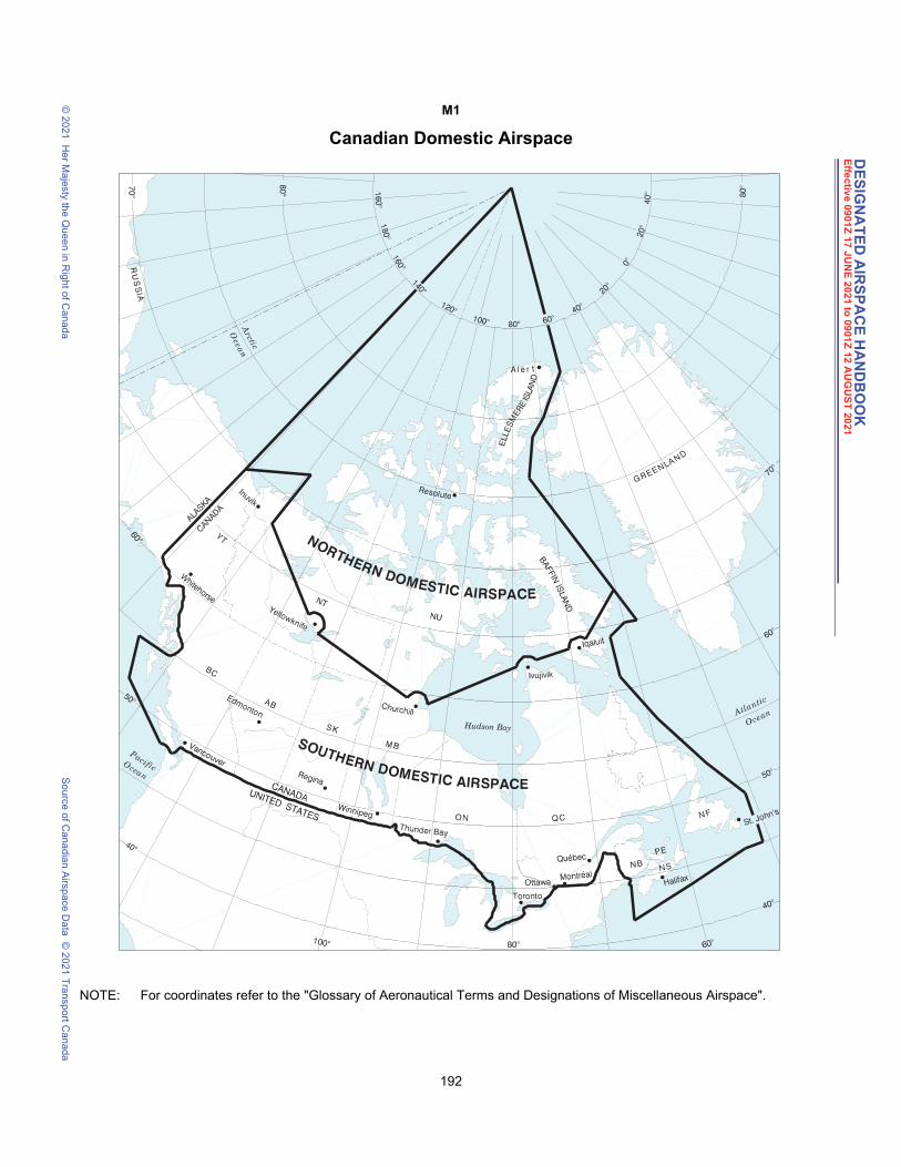
DE
SIG
NA
TE
D A
IRS
PA
CE
HA
ND
BO
OK
Effe
ctiv
e 090
1Z
17
JU
NE
20
21 to
09
01Z
12 A
UG
US
T 20
21
© 2
021
He
r Ma
jesty the Q
ue
en in R
ight o
f Can
ad
aS
ou
rce o
f Ca
nad
ian A
irspa
ce D
ata
© 2
021
Tra
nsp
ort C
an
ada
M1
Canadian Domestic Airspace
NOTE: For coordinates refer to the "Glossary of Aeronautical Terms and Designations of Miscellaneous Airspace".
192 DAH May 3, 2021 1:46 pm
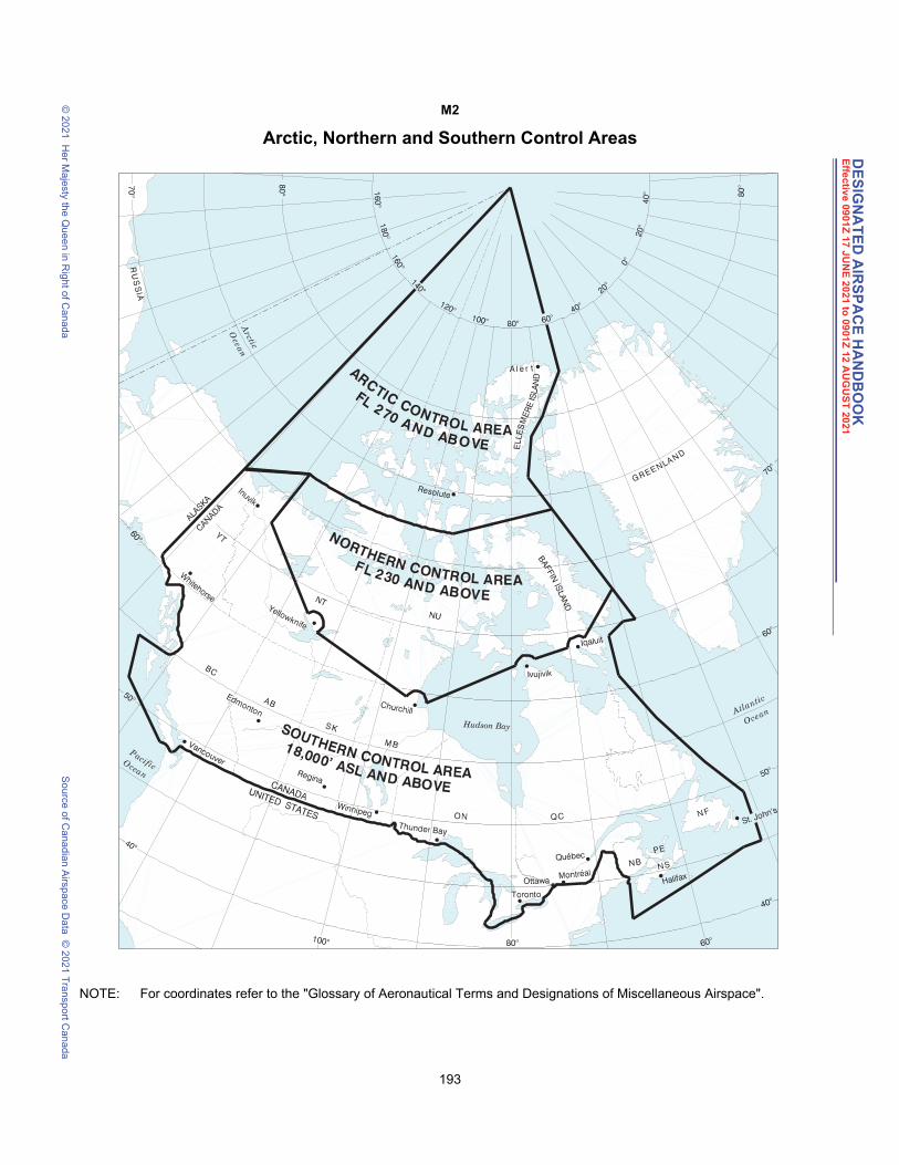
DE
SIG
NA
TE
D A
IRS
PA
CE
HA
ND
BO
OK
Effe
ctiv
e 090
1Z
17
JU
NE
20
21 to
09
01Z
12 A
UG
US
T 20
21
© 2
021
He
r Ma
jesty the Q
ue
en in R
ight o
f Can
ad
aS
ou
rce o
f Ca
nad
ian A
irspa
ce D
ata
© 2
021
Tra
nsp
ort C
an
ada
M2
Arctic, Northern and Southern Control Areas
NOTE: For coordinates refer to the "Glossary of Aeronautical Terms and Designations of Miscellaneous Airspace".
193 DAH May 3, 2021 1:46 pm

DE
SIG
NA
TE
D A
IRS
PA
CE
HA
ND
BO
OK
Effe
ctiv
e 090
1Z
17
JU
NE
20
21 to
09
01Z
12 A
UG
US
T 20
21
© 2
021
He
r Ma
jesty the Q
ue
en in R
ight o
f Can
ad
aS
ou
rce o
f Ca
nad
ian A
irspa
ce D
ata
© 2
021
Tra
nsp
ort C
an
ada
M3
Altimeter Setting and Standard Pressure Regions
NOTE: For coordinates refer to the "Glossary of Aeronautical Terms and Designations of Miscellaneous Airspace".
194 DAH May 3, 2021 1:46 pm
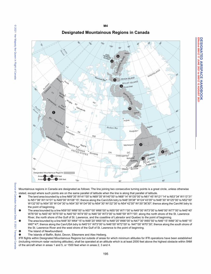
DE
SIG
NA
TE
D A
IRS
PA
CE
HA
ND
BO
OK
Effe
ctiv
e 090
1Z
17
JU
NE
20
21 to
09
01Z
12 A
UG
US
T 20
21
© 2
021
He
r Ma
jesty the Q
ue
en in R
ight o
f Can
ad
aS
ou
rce o
f Ca
nad
ian A
irspa
ce D
ata
© 2
021
Tra
nsp
ort C
an
ada
M4
Designated Mountainous Regions in Canada
Mountainous regions in Canada are designated as follows: The line joining two consecutive turning points is a great circle, unless otherwise
stated, except where such points are on the same parallel of latitude when the line is along that parallel of latitude. The land area bounded by a line N69°35' W141°00' to N69°35' W140°00' to N68°14' W135°00' to N61°45' W121°14' to N53°34' W113°31'
to N51°06' W114°01' to N49°00' W108°15'; thence along the Can/USA bdry to N48°29'38" W124°43'35" to N48°30' W125°00' to N52°00' W132°00' to N54°35' W134°30' to N54°30' W134°00' to N54°30' W132°30' to N54°42'30" W130°36'30"; thence along the Can/AK bdry to the point of beginning.
The area bounded by a line N59°00' W66°00' to N57°00' W66°00' to N55°00' W71°00' to N49°00' W73°00' to N46°00' W77°00' to N45°40' W76°00' to N45°40' W75°00' to N45°50' W74°00' to N46°30' W73°00' to N46°59' W71°00'; along the north shore of the St. Lawrence River, the north shore of the Gulf of St. Lawrence, and the coastline of Labrador and Quebec to the point of beginning.
The area bounded by a line N48°30' W64°15' to N48°20' W65°00' to N48°20' W66°00' to N47°30' W65°50' to N46°15' W66°30' to N46°15' W67°47'; thence along the Can/USA bdry to N45°01' W73°00' to N46°00' W72°00' to N47°00' W70°30'; thence along the south shore of the St. Lawrence River and the west shore of the Gulf of St. Lawrence to the point of beginning.
The Island of Newfoundland. The Islands of Baffin, Bylot, Devon, Ellesmere and Alex Heiberg.IFR flights within Designated Mountainous Regions but outside of areas for which minimum altitudes for IFR operations have been established (including minimum radar vectoring altitudes), shall be operated at an altitude which is at least 2000 feet above the highest obstacle within 5NM of the aircraft when in areas 1 and 5, or 1500 feet when in areas 2, 3 and 4.
195 DAH May 3, 2021 1:46 pm
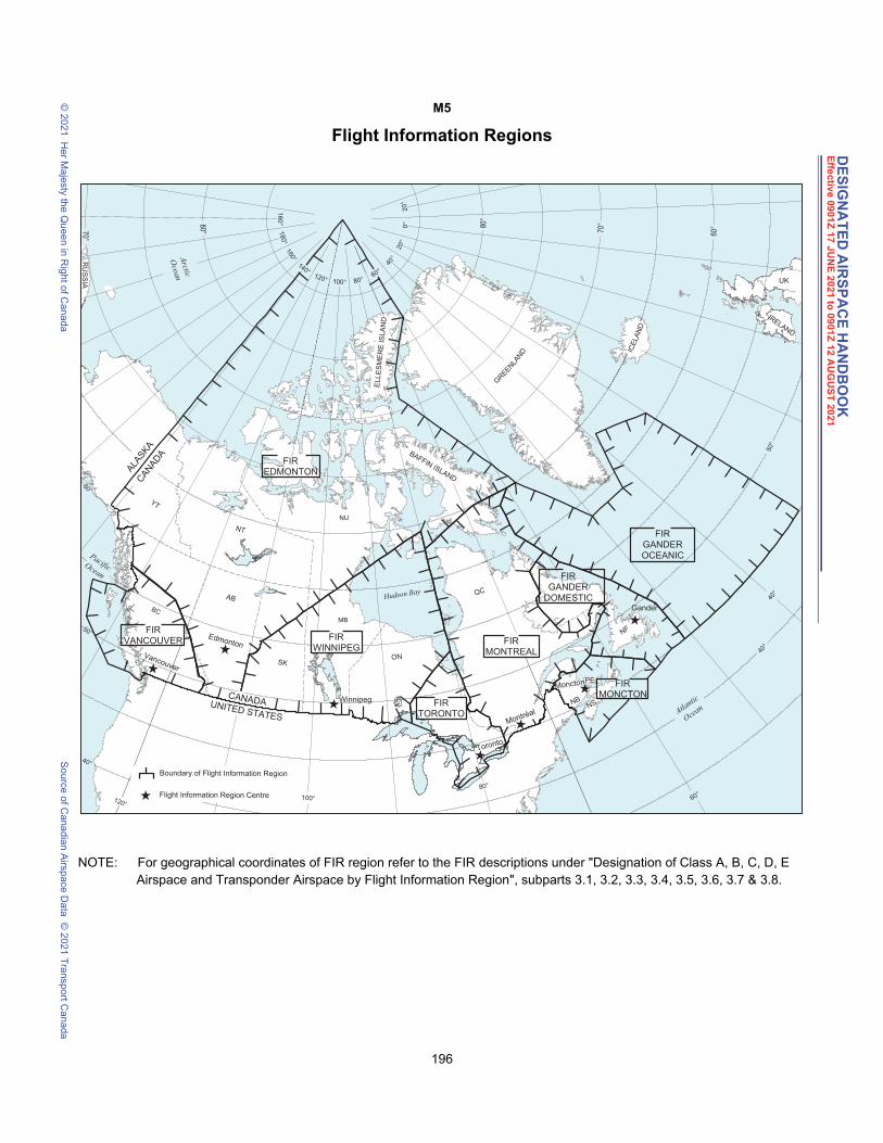
DE
SIG
NA
TE
D A
IRS
PA
CE
HA
ND
BO
OK
Effe
ctiv
e 090
1Z
17
JU
NE
20
21 to
09
01Z
12 A
UG
US
T 20
21
© 2
021
He
r Ma
jesty the Q
ue
en in R
ight o
f Can
ad
aS
ou
rce o
f Ca
nad
ian A
irspa
ce D
ata
© 2
021
Tra
nsp
ort C
an
ada
M5
Flight Information Regions
NOTE: For geographical coordinates of FIR region refer to the FIR descriptions under "Designation of Class A, B, C, D, E Airspace and Transponder Airspace by Flight Information Region", subparts 3.1, 3.2, 3.3, 3.4, 3.5, 3.6, 3.7 & 3.8.
196 DAH May 3, 2021 1:46 pm

DE
SIG
NA
TE
D A
IRS
PA
CE
HA
ND
BO
OK
Effe
ctiv
e 090
1Z
17
JU
NE
20
21 to
09
01Z
12 A
UG
US
T 20
21
© 2
021
He
r Ma
jesty the Q
ue
en in R
ight o
f Can
ad
aS
ou
rce o
f Ca
nad
ian A
irspa
ce D
ata
© 2
021
Tra
nsp
ort C
an
ada
M6
Air Defence Identification Zone (ADIZ)
AIR DEFENCE IDENTIFICATION ZONEThe airspace within the area bounded by a line beginning at:
a) North and EastN72°00'00.00" W066°40'00.00" toN75°00'00.00" W073°16'18.00" toN76°41'24.00" W075°00'00.00" toN77°30'00.00" W074°46'00.00" toN78°25'00.00" W073°46'00.00" toN78°48'30.00" W073°00'00.00" toN79°39'00.00" W069°20'00.00" toN80°00'00.00" W069°00'00.00" toN80°25'00.00" W068°20'00.00" toN80°45'00.00" W067°07'00.00" toN80°49'12.00" W066°29'00.00" to
197 DAH May 3, 2021 1:46 pm

DE
SIG
NA
TE
D A
IRS
PA
CE
HA
ND
BO
OK
Effe
ctiv
e 090
1Z
17
JU
NE
20
21 to
09
01Z
12 A
UG
US
T 20
21
© 2
021
He
r Ma
jesty the Q
ue
en in R
ight o
f Can
ad
aS
ou
rce o
f Ca
nad
ian A
irspa
ce D
ata
© 2
021
Tra
nsp
ort C
an
ada
N80°49'48.00" W066°26'18.00" toN80°50'30.00" W066°16'00.00" toN81°18'12.00" W064°11'00.00" toN81°52'00.00" W062°10'00.00" toN82°13'00.00" W060°00'00.00" toN86°00'00.00" W060°00'00.00" thence westerly along latitude N86°00'00.00" \ toN86°00'00.00" W080°00'00.00" toN75°00'00.00" W130°00'00.00" thence westerly along latitude N75°00'00.00" \ toN75°00'00.00" W141°00'00.00" toN69°50'00.00" W141°00'00.00" thence easterly along latitude N69°50'00.00" \ toN69°50'00.00" W066°48'21.00" toN64°00'00.00" W067°00'00.00" toN59°34'00.00" W063°23'00.00" toN55°45'00.00" W059°41'00.00" toN54°37'00.00" W056°44'00.00" toN53°31'00.00" W055°22'00.00" toN50°40'00.00" W055°22'00.00" toN49°20'00.00" W053°07'00.00" toN47°40'00.00" W052°23'00.00" toN46°30'00.00" W052°53'00.00" toN46°00'00.00" W058°00'00.00" toN43°15'00.00" W065°55'00.00" toN39°30'00.00" W063°45'00.00" toN45°00'00.00" W048°00'00.00" toN48°00'00.00" W047°00'00.00" toN58°00'00.00" W055°00'00.00" toN61°00'00.00" W057°00'00.00" toN65°00'00.00" W057°45'00.00" toN72°00'00.00" W066°40'00.00" point of beginning
b) WestN54°35'00.00" W133°00'00.00" toN54°00'00.00" W136°00'00.00" toN52°00'00.00" W135°00'00.00" toN48°20'00.00" W132°00'00.00" thence easterly along latitude N48°20'00.00" \ toN48°20'00.00" W128°00'00.00" toN48°30'00.00" W125°00'00.00" toN51°00'00.00" W129°45'00.00" toN52°42'00.00" W132°30'00.00" toN53°49'00.00" W133°00'00.00" toN54°35'00.00" W133°00'00.00" point of beginning
198 DAH May 3, 2021 1:46 pm

DE
SIG
NA
TE
D A
IRS
PA
CE
HA
ND
BO
OK
Effe
ctiv
e 090
1Z
17
JU
NE
20
21 to
09
01Z
12 A
UG
US
T 20
21
© 2
021
He
r Ma
jesty the Q
ue
en in R
ight o
f Can
ad
aS
ou
rce o
f Ca
nad
ian A
irspa
ce D
ata
© 2
021
Tra
nsp
ort C
an
ada
M7
Canadian Minimum Navigation Performance Specifications (CMNPS) Airspace andCanadian Minimum Navigation Performance Specifications (CMNPS) Transition Area
Required Navigation Performance Capability (RNPC) Airspace
NOTE: For coordinates refer to the "Glossary of Aeronautical Terms and Designations of Miscellaneous Airspace".
199 DAH May 3, 2021 1:46 pm
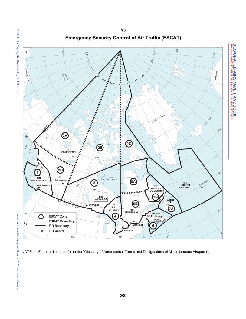
DE
SIG
NA
TE
D A
IRS
PA
CE
HA
ND
BO
OK
Effe
ctiv
e 090
1Z
17
JU
NE
20
21 to
09
01Z
12 A
UG
US
T 20
21
© 2
021
He
r Ma
jesty the Q
ue
en in R
ight o
f Can
ad
aS
ou
rce o
f Ca
nad
ian A
irspa
ce D
ata
© 2
021
Tra
nsp
ort C
an
ada
M8
Emergency Security Control of Air Traffic (ESCAT)
NOTE: For coordinates refer to the "Glossary of Aeronautical Terms and Designations of Miscellaneous Airspace".
200 DAH May 3, 2021 1:46 pm