design and implementation of distributed webgis architecture i... · geoserver, apache wms tomcat,...
TRANSCRIPT
GIS Cell, MNNIT-A
GIS CellMotilal Nehru National Institute of Technology
Allahabad- 211004
Saurabh Tiwari
Design and Implementation of Distributed WebGIS Architecture
ISPRS, TC/IV Symposium November 25-27, 2009, Hyderabad
Presented By
Prof. R.D. Gupta & Saurabh Tiwari
GIS Cell, MNNIT-A
WebGIS
• GIS is a powerful set of tools for collecting, storing, retrieving,
managing, analyzing and displaying spatial data.
• Users can combine data and information accessed over the
Intranet or Internet with the local data for display, query and
analysis.
• Internet allows all levels of society to access geo-spatial
information and provides a media for processing geo-related
information with no location restrictions.
• Web GIS is a mechanism to deliver maps and GIS services on the
internet.

GIS Cell, MNNIT-A
WebGIS
• WebGIS is a viable tool for building various geospatial Web
application.
• Traditionally, in WebGIS all the geographic data was stored on a
single server i.e. it uses a centralized paradigm approach.
• WebGIS is a cost effective, easy and efficient way to access and
disseminate the geographic information, spatial analysis tools and
geospatial web services.
• Web-based GIS is evolved from different web maps and can be
modeled as client-server architecture.
• This can be thin client architecture
• This can be thick client architecture
GIS Cell, MNNIT-A
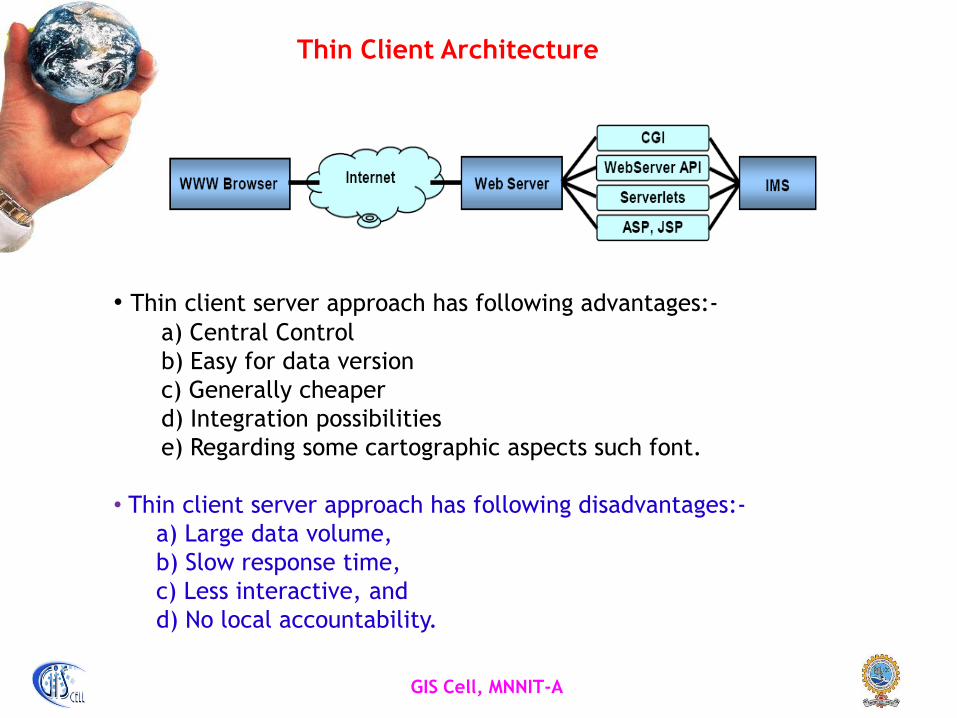
Thin Client Architecture
• Thin client server approach has following advantages:-
a) Central Control
b) Easy for data version
c) Generally cheaper
d) Integration possibilities
e) Regarding some cartographic aspects such font.
• Thin client server approach has following disadvantages:-
a) Large data volume,
b) Slow response time,
c) Less interactive, and
d) No local accountability.

GIS Cell, MNNIT-A
Thick Client Architecture
• Thick client server approach has following advantages:-
a) Document/graphics standards are not required.
b) Vector data can be used.
c) Image quality not restricted to GIF and JPEG.
d) Modern interface is possible;
it is not restricted to single – click operations.
• Thick client server approach has following disadvantages:-
a) Additional software requirement, and
b) Platform/ browser incompatibility.

GIS Cell, MNNIT-A
Distributed WebGIS
• Distributed WebGIS provides a efficient way to share data
worldwide on Internet.
• Distributed Web GIS architecture is modular and allows the
publishing of web service descriptions.
• Distributed GIS service model is that a client program, in either an
browser or an independent application, able to access the
distributed resources in the entire network.
• Client connect to the several servers if needed and a specific
machine may be the client at one time and the server at another
time.
• Ideal distributed GIS service model is “Geodata anywhere,
Geoprocessing anywhere”.

GIS Cell, MNNIT-A
Service Oriented Architecture for WebGIS
• SOA can be used to implement the Distributed WebGIS
Architecture.
• SOA in improving the efficacy of traditional client server model by
building distributed, dynamic service system to meet service
requirement of different user.
• Provide three type of different services. These are
a) Data Service,
b) Processing Service and
c) Registry Service.
GIS Cell, MNNIT-A
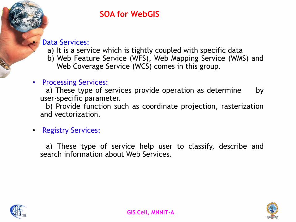
SOA for WebGIS
• Data Services:a) It is a service which is tightly coupled with specific datab) Web Feature Service (WFS), Web Mapping Service (WMS) and
Web Coverage Service (WCS) comes in this group.
• Processing Services:a) These type of services provide operation as determine by
user-specific parameter.b) Provide function such as coordinate projection, rasterization
and vectorization.
• Registry Services:
a) These type of service help user to classify, describe andsearch information about Web Services.
GIS Cell, MNNIT-A
Objective of Present Work
• To design and develop distributed WebGIS Architecture using OGC
standards.
• The Allahabad city of U.P., India has been taken as a study area.
• A prototype distributed WebGIS is developed using two
applications domains, namely, transportation network and water
supply system of Allahabad city.

GIS Cell, MNNIT-A
Open Source Technology
• Open source program allow users to modify source code according to
their requirement.
• Provides better interoperability.
• Open Geospatial Consortium, (OGC) is a international, voluntary
consensus standards organization that is leading the development of
standards for geospatial and location based services.
The OGC Standards for GIS
GIS Cell, MNNIT-A
Open Source Resources Used
• GeoServer is used as an open source software in the present study.
• ILWIS, an open GIS software is used to create integrated geospatial
database.
• GeoServer and Apache Tomcat are integrated for imparting
geospatial web capabilities with respect to WMS and WFS.
• MySQL is used for storing of security aspects and non-spatial data
for decision making.
• PHP: Hypertext Pre-processor language has been used for dynamic
server side scripting.
GIS Cell, MNNIT-A
Integrating Web Services in GIS
• OGC web services provide a framework for Web based discovery,access, integration and analysis of online geospatial data sources.
• Web Feature Service (WFS) and Web Map Service (WMS) are thetwo important OGC standard used in this study.
a) Web Feature Service• It allows a client to retrieve geospatial data from multiple
servers.• It support operation like Insert, Update, Delete, Query on
geographic feature using HTTP.
b) Web Map Service• It display map in standard image format such as Scalable Vector
Graphics (SVG), Portable Network Graphics etc.

GIS Cell, MNNIT-A
Methodology Adopted
Client 1.........
Client 2 Client N
Geospatial Database(Using ILWIS)
Storing of Geospatial data Non-spatial data
Geospatial Database(Using ILWIS)
Storing of Geospatial data Non-spatial data
WMS
WFS
GeoServer, Apache Tomcat, MySQL & PHP
Utility Service
WMS
WFS
GeoServer, Apache Tomcat, MySQL & PHP
Utility Service
WFS
GeoServer, Apache Tomcat, MySQL & PHPWMS Utility
Service
Master Server
Slave Server Slave Server

GIS Cell, MNNIT-A
Methodology Adopted…
• Different servers have been taken which will act as slave server
and consists of the geospatial data and non-spatial data.
• A Master server is used for sharing of the geospatial data and non
spatial data and publishing of map on the web.
For example:
• IP address of the slave server is 172.31.10.62 and 172.31.10.76
• IP address of the master server is 172.31.10.67.
• Distributed WebGIS services will be accessed by the client using:
http://172.31.10.67/DS_WebGIS
GIS Cell, MNNIT-A
Methodology Adopted…
• In the first slave server, the geospatial data and non-spatial data
of the Road Network of the Allahabad City is put.
• In another slave server, the geospatial data and non-spatial data
of the Water Supply System of the Allahabad City is put.
• From the master server, the geospatial data and non-spatial data
of the Road Network and Water Supply System of the Allahabad
City is accessed simultaneously.
• There would be no effect on the system if any of the slave servers
is shut down.
GIS Cell, MNNIT-A
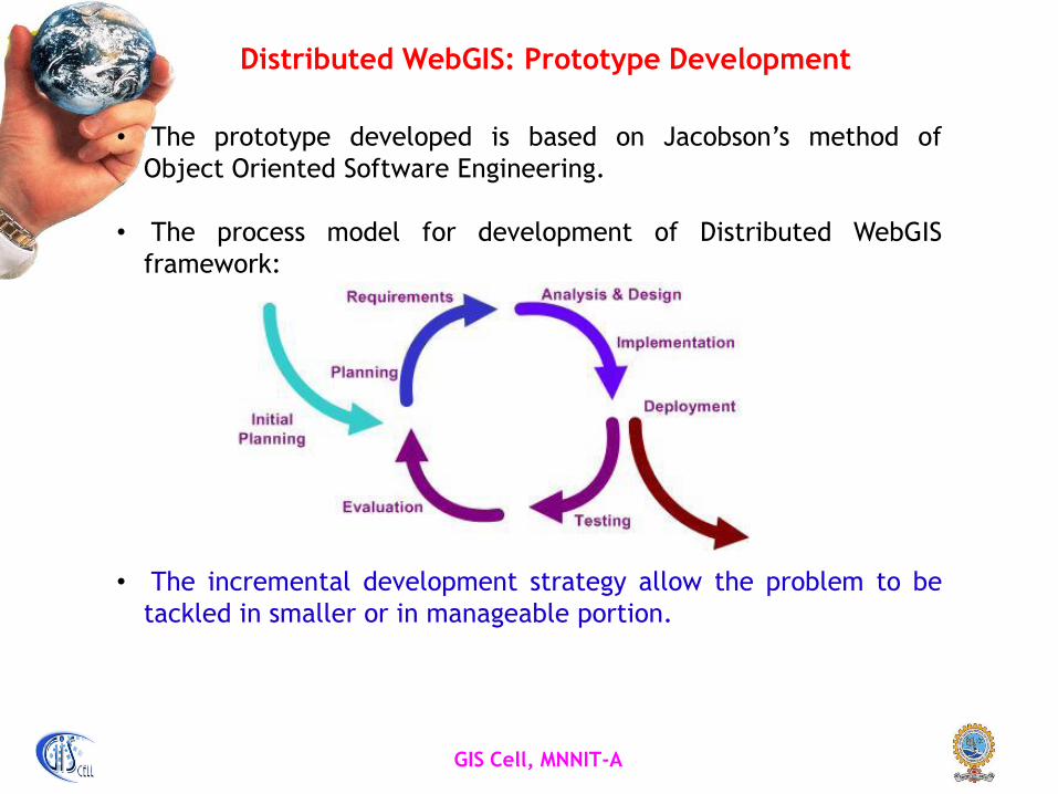
Distributed WebGIS: Prototype Development
• The prototype developed is based on Jacobson’s method of
Object Oriented Software Engineering.
• The process model for development of Distributed WebGIS
framework:
• The incremental development strategy allow the problem to be
tackled in smaller or in manageable portion.
GIS Cell, MNNIT-A
Distributed WebGIS: Prototype Development…
• The developed prototype has been associated with three users.
These are:-
a) Administrator user,
b) General user and
c) Developer.
• The design phase involve the creation of geospatial water supply
and road network database.
• The spatial and non spatial data of the water supply are put in
one server and road network server on another.
GIS Cell, MNNIT-A
Distributed WebGIS: Complete Framework
• Module I: describes the detailed process to register the user for
authentication. After registration process, user can use the
WebGIS with full phase operation.
• Module II: detailed viewing of Allahabad City associated with Road
Network and related data files.
• Module III: detailed viewing associated with Road Network of
Allahabad city and related data files.
• Module IV: describes utility services i.e., user level for security
aspects, and uploading/ downloading features
• This prototype Distributed WebGIS has been implemented
at MNNIT Intranet level.

GIS Cell, MNNIT-A
Visualization of Distributed WebGIS
Map Page

GIS Cell, MNNIT-A
Map Page
Visualization of Distributed WebGIS…
GIS Cell, MNNIT-A
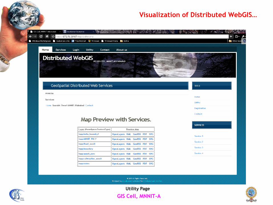
Utility Page
Visualization of Distributed WebGIS…
GIS Cell, MNNIT-A
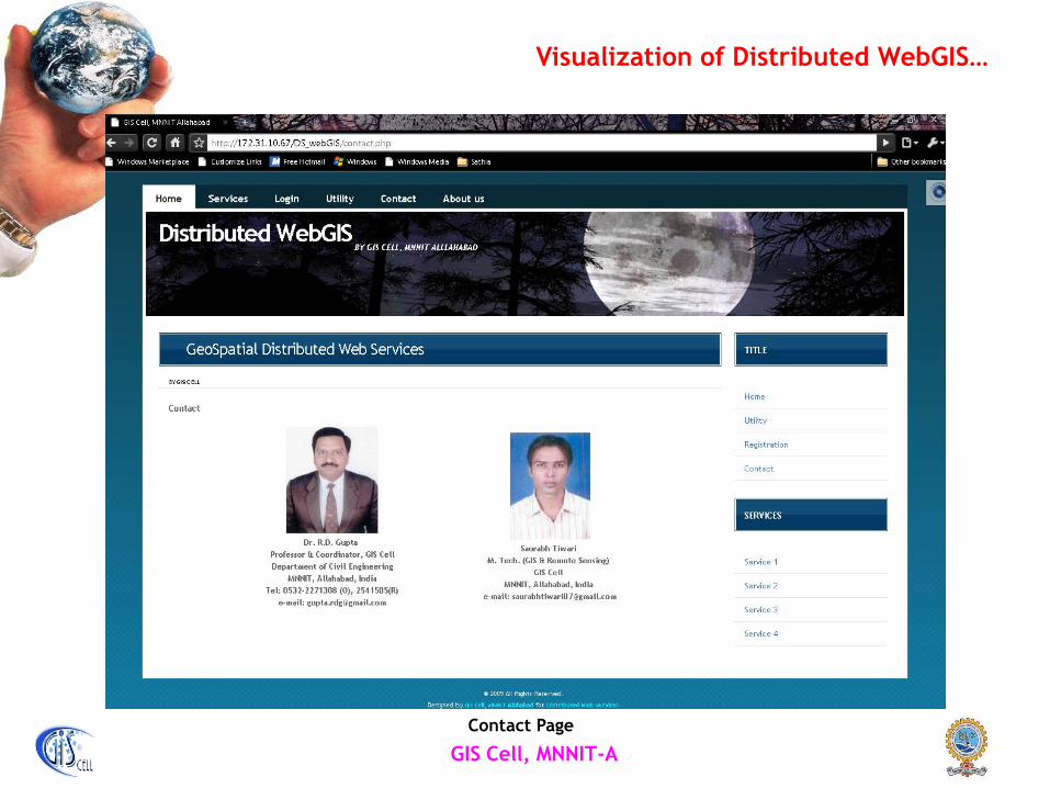
Contact Page
Visualization of Distributed WebGIS…
GIS Cell, MNNIT-A
Concluding Remarks
• The present research work uses OGC standards for creating,
accessing, integrating and sharing the geospatial information on
the web by adopting a new approach to develop a robust
distributed WebGIS architecture.
• A distributed architecture is developed so as to improve the
efficacy of traditional thin/thick client server architecture.
• This architecture provide an efficient mechanism for generating
and delivery of value added geospatial information.
• The developed architecture adopts a modular and flexible
structure.
GIS Cell, MNNIT-A
Concluding Remarks …
• It provides a mechanism for the generation and delivery of
geospatial information by extending the concept of web services
in the field of GIS.
• The developed prototype distributed WebGIS is operational at
MNNIT intranet level which will be put on Internet soon.
• The further refinement of the model provided by making the
existing database more comprehensive and adding more features
such as video-conferencing, chat room and 3D view.

GIS Cell, MNNIT-A
Thank You