department of national development bureau of mineral resources. geology ... · bmr record 1972119...
TRANSCRIPT

BMR Record 1972119
c.4
COMMONWEALTH OF AUSTRALIA
DEPARTMENT OF NATIONAL DEVELOPMENT
BUREAU OF MINERAL RESOURCES. GEOLOGY AND GEOPHYSICS
008980' Record i972/ 19
'! l' , . I. .
:~4. '\ .... . ,
SHALLOW STRATIGRAPHIC DRILLING OF RADIOACTIV ANOMALIES AT EYRE CREEK, SPRINGVALE SHEET
AREA, WESTERN QUEENSLAND, 1972
by
B'R' Senior and R.J. Hughes
The information contained in this report has been obtained by the Department of National Development as part of the policy of the Commonwealth Government to assist in the exploration and development of mineral resources. It may not be published in any form or used in a company prospectus or statement without the. permission in writirig of the Director, Bureau of Mineral Resources, Geology & Geophysics.

I I I I I I I I I I I I I I I I I I I I
Record 1972/19
SHALLOW STRATIGRAPHIC DRILLING OF RADIOACTIVE ANOMALIES AT EYRE CREEK, SPRINGVALE SHEET
AREA, WESTERN QUEENSLAND, 1972
by
B.R. Senior and R.J. Hughes

I I I I I I I I I I I I I I I I I I I I
CONTENTS
SUMMARY
INTRODUCTION
ABBREVIATIONS USED IN GRAPHIC LOGS
DESCRIPTION AND INTERPRETATION
BMR Springvale 2, 3, 4, and 5 " " 6 " " 7 " " 8
REFERENCES
TABLES
Table 1. Summary of drilling Results
Table 2. X-ray diffraction and major oxide analysis results
FIGURES
Fig. 1. Locality Map.
Fig. 2. Correlation and lithological logs of BMR Springvale 2, 3, 4, and 5.
Fig. 3. BMR Springvale 6.
Fig. 4. BMR Springvale 7.
Fig. 5. BMR Springvale 8.
APPENDIX
Page - .
1
4
5
5 5 7 7
8
2
9
Appendix 1. Chemical analysis of samples from the Springvale area by J. W. Sheraton.
I I I I I I I I I I I I I I I I I I I I
SUMMARY
Shallow stratigraphic drilling at Eyre Creek in the Springvale Sheet area, western Queensland in 1971:
a. Showed that relatively high gamma-ray anomalies in Cainozoic and Mesozoic sediments are due to the presence of potassium and phosphorus-bearing minerals concentrated in chemically differentiated sediments and deposits derived from them.
b. Revealed shallow pressure aquifers yielding stock water at" the east side of Eyre Creek.
c. Yielded additional data on the Cainozoic and Mesozoic stratigraphy of the area.

I I I I I I I I I I I I I I I I I I I I
INTRODUCTION
From 1-22 June 1971 some shallow stratigraphic holes were drilled · with a BMR Mayhew 1000 rig in the Eyre Creek area on western Springvale 1 :250 000 Sheet to investigate:
1. the occurrence of svanbergite, a mineral composed of alumina, phosphate, strontium, barium, minor silica, iron and lead.
2. a relatively high anomaly on the gamma-ray log of bore No. 1668 (Breadalbane No.9).
3. the nature and thickness of Cainozoic sediments in the riverine alluvium of the Eyre and King Creek drainage system, and obtain cores of fresh Mesozoic sediments for palynological and stratigraphic study.
The project involved 312 m of" drilling and 83 m of coring. A summary of the drilling results is given in Table 1.
Cuttings were collected at intervals of 150 cm while drilling with air, and 300 cm while drilling with water or mud as a circulating fluid. All core and cuttings are stored at the BMR Core and Cuttings Laboratory, Collie Street, Fyshwick, A.C. T. .
The core and cuttings were logged at the well-site using a binocular microscope, and re-examined at Fyshwick for selection of sediment for X-ray diffraction, major oxide, and palynological determinations. Results of palynological determinations by D. Burger will be reported separately. '
Naming of the holes is serial by 1 :250 000 Sheet areas, e.g. BMR Springvale 8 refers to the eighth hole drilled by the Bureau of Mineral Resources in the Springvale Sheet area.
·The composition of the minerals mentioned in the text is recorded in Table 2. Stratigraphic nomenclature is that of Vine et al. (1967). Crook's (1960) classification of arenites is followed in lithological descriptions.

-... -TABLE 1. SUMU.\RY OF DRILLING RESULTS
Hole number Total Cored Cc::-e Section pene:trated Results -depth Recovery (metres)
Springvale 2 24 m Nil Nil 0-1 Cainozoic Drilled at minor svanbergitc occurrence 1-24 Allaru Mudstone to determine its thickness. This mineral
occurs at the surface and in the interval 1.3 - am.
Springvale 3 .30 m Nil Nil 0-1 Cainozoic 1-30 Allaru Mudstone
Springvale 4 29 m Nil N:'l 0-2 Cainozoic Springvale Nos 3-5 were drilled as step-outs from No.2 to determine the extent 1-29 Allaru M.ldstone of the svanbergite which was found to be
Springvale 5 . 23 m Nil Nil 0-1 Cainozoic sm:.ll. Gamma-ray logs run in all holes 1-23 Allaru Mudstone but no anomalies occur.
Springvale 6 90 m 1 core 2.8 m ·0-19 Cainozoic Drilled near old mound springs near the 3m 19-46 A:laru Mudstone eastern edge of the Eyre Creek alluvial
46-59 Toolebuc LimeGtone belt. Pressure aquifers occurred in the 59-90 Wallumbilla Cainozoic and in the Toolebuc Limestone.
Formation Core of the TO::llebuc Limestone taken. A late Pleistocene diprotodon fauna collected at drill site .
Springvale 7 33 m 1 core 1.9 m . 0-17 Cainozoic Dril!ed to determine thickness of alluvium. 2.1 m 17-24 Allaru Mudstone Gamma-ray log shows high radioactive
(chem:'cally c!iffer- peak towards base of Cainozoic (12-17 m). entiated) A sample from this interval indicated the
24-33 Allaru Mudstone presence of jarosite. Core of Allaru Mu1stone taken. Hole gamma-ray logged~

Table 1 (Cant.)
Hole Number
Springvale 8
Total depth
76 m
Cored
:3 cores Total 7m
Core Recovery
3.6 m
-3-
Section penetrated (metres)
0-17 Cainozoic 17-59 Allaru Mudstone 59-72 Toolebuc Limestone 72-76 Wallumbilla
Formation
~ _ ... '.
Results
Drilled adjacent to gamma-ray logged Breadalbane 9 water bore. Obtained coreE from radioactive anomaly near base of Cainozoic. Tests for heavy elements proved negative. Flow of saline water encountered from top of Wallumbilla Formation. No logs run.
--------------------

I -4- I
ABBREVIA TIONS USED IN GRAPmC LOGS I
Alluvium All Layer Lyr I Black (ish) blk, (blk) Lens Len I Blue (ish) bl, (bl) Limestone Lst
Brown (ish) brn, (brn) Medium m I Bryzoa Bry Minor mnr
Calcite (areous) Calc, calc Mudstone Mdst I Carbonaceous carb Orange (ish) orng, (orng)
Cemented cmtd Pebble PbI I Clay CI Pink (ish) pk, (Pk)
I Coarse ers Poorly p
Compact cpct Probably prob I Concentration Conc Purple (ish) purp, (purp)
Conglomerate CgI Pyrite Pyr I Crystalline xl Quartz Qz
Dark elk Quartzite qzs I Fracture Frac Rounded rhdd
Fragment Frag Sand sd I Fine f Sandstone Sst
Fossil Foss Scale 'Sc I Grain Grn Silt (ly) Sit, ,sIt
Gravel Gvl Siltstone Sltst I Grey (ish) gy, (gy) Small s
Gypsum (iferous) Gyp, gyp Soft sft I Hard hd Sorted srtd
I Indurated indd Staining Stng
Interbedded inbdd Surface Surf I Iron Fe Very v
Irregular irreg White (ish) wh, (wh) I Labile lab Yellow (ish) yel, (yel)
I

I I I I I I I I I I I I I I I I I I I I
Fig I.
EYRE CREEK ALLUVIUM AND RADIOACTIVE MINERAL DRILLING PROJECT
SPRINGVALE SHEET AREA
BMR Drill site locations
~6Ja
I \ , { L2~~J-______ ~ __ ~ ____________ -L~~L-~ac~ ____________________________ ~2~OOO'
0 10 20 30 40 50 60 70 80 hm I I , I I , I , I r---~--.-~--~.-~--~~--~I~--~I----~~
40 50" 0 10 20 30
~ 7 BMR SIrallgrophiC hoi. wi'" nu",b"
Ga Goyalil. X roy dilfrocfloll d.,.,,,,lnallon fro",
s. . svanb"gl"}
Ja Jaro.ll. drill sa",pliu or oulcrop
A Alunil. .
To occompany Rl1cord 197:l /19
F !54/AI4/1
.,
Rood
> - Rlvtlr chon".I.
-9- arud",bln. No.9 w,,'.r bor. ("'0.1668)
~ Chemlc:ally differentloted Melazlt "dimen'.

I I I I I I I I I I I I I I I I I I I I
-5-
DESCRIPTION AND INTERPRETATION
BMR SPRINGVALE Nos 2, 3, 4, and 5.
Position: These four holes were drilled close together south of Pigeongah Waterhole, 25 kIn north of Coorabulka HomeBtead. Co-ordinates for the drill siteB are:
BMR Springvale 2 Lat. 23°33' 18" Long. 140° 10' 03"
" "
"
" " "
3 Lat. 23 °33' 30" Long. 140° 09' 33"
4 Lat. 23°33' 45" Long. 140° 08'51"
5 Lat. 23°32' 54" Long. 140° 10' 48"
ObjectiveB: To establiBh the subBurface extent of a Bvanbergite occurence. The mineral waB diBcovered in 1958 by J.N. Casey and an analysiB and locality is recorded by Reynolds (1965).
Drilling: The holes were drilled to an average depth of 25 m. Gamma-ray 10gB were run in each hole.
Results: BMR Springvale 2 established that the Bvanbergite at thiB locality (Springvale 1 :250 000 Geological Map ref. B28) consiBtB of floaters of concretionary svanbergite in colluvium. The deposit is less than 3 m thick. HoieB 3, 4, and 5 Bited close by penetrated · colluvium without svanbergite overlying Allaru Mudstone.
A Burface sample (No. 71050012) that looked like a ovoid concretion, which when broken revealed a fine- grained creamcoloured rock, was collected from the Springvale 2 drill site. It was identified by X-ray diffraction as Bvanbergite, and the Bame mineral was identified in Springvale 2 in the interval 1.3 to 3 m (No. 71050015). No gamma-ray anomaly iB associated with the occurrence, so the mineral iB probably present in discrete clastB. However, the top 5 m of Allaru Mudstone in Springvale No.2 iB chemically differentiated (kaolinized, Bilicified, and ferruginized) and the svanbergite could have originated as weathering concretions.
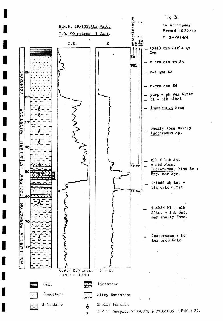
BMR SPRINGVALE 6
Position: Springvale SF/54-14. Lat. 23°43' 48", Long. 139°58' 51", 33 km W of Coorabulka HomeBtead (Fig. 1). The hole was sited near an old mound spring, 20 m northweBt of an abandoned water bore.
-6-
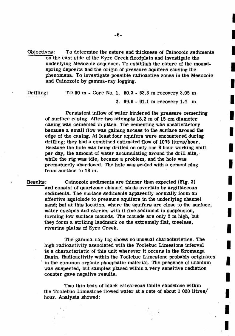
Objectives: To determine the nature and thickness of Cainozoic sediments on the east side of the Eyre Creek floodplain and investigate the underlying Mesozoic sequence. To establish the nature of the moundspring deposits and the origin of pressure aquifers causing the phenomena. To investigate possible radioactive zones in the MesozoiC and Cainozoic by gamma-ray logging.
Drilling: TD 90 m - Core No.1. 50.3 - 53.3 m recovery 3.05 m
2. 89.9 - 91.1 m recovery 1.4 m
Persistent inflow of water hindered the pressure cementing of sudace casing. After two attempts 18.2 m of 15 cm diameter casing was cemented in place. The cementing was unsatisfactory because a small flow was gaining access to the surface around the edge of the casing. At least four aquifers were encountered during drilling; they had a combined estimated flow of 1075 lttres/hour. Because the hole was being drilled on only one 8 hour working shift per day, the amount of water accumulating around the drill site, . while the rig was idle, became a problem, and the hole was prematurely abandoned. The hole was sealed With a cement plug from surface to 18 m.
Results: Cainozoic sediments are thinner than expected (Fig. 3) and consist of quartzose channel sands overlain by argillaceous sediments. The surface sediments apparently normally form an effective aquiclude to pressure aquifers in the underlying channel sand; but at this location, where the aquifers are close to the surface~ water escapes and carries with it fine sediment in suspension, forming low surface mounds. The mounds are only 2 m high, but they form a striking landmark on the extremely flat, treeless, riverine plains of Eyre Creek.
The gamma-ray log shows no unusual characteristics. The high radioactivity associated with the Toolebuc Limestone interval is a characteristic of this unit wherever it occurs in the Eromanga Basin. Radioactivity within the Toolebuc Limestone probably originates
" in the common organic phosphatic material. The presence of uranium was suspected, but samples placed within a very sensitive radiation counter gave negative results.
Two thin beds of black calcareous labile sandstone within the Toolebuc Limestone flowed water at a rate of about 1 000 IUres/ hour. Analysis showed:
I I I I I I I I I I I I I I I I I I I
'I !

I I I I I I I I I I I I I I I I I I I I
-7-
Depth interval 58-61 m
pH 6.5
Resistivity at 68°F (ohm-metres) 3.10
Salinity ppm NaCI 1568
Total dissolved solids (ppm) 1 780
The water should be suitable for stock prcviding the fluorine content (not tested) is not excessive.
Fragments of silicified bone from surface gravel in the vicinity of the mound springs were identified as Diprotodon optatum and Sthenurus sp. and indicate a late Pleistocene age (M.D. Plane, pers. comm.).
BMR SPRINGVALE 7
Position: . Springvale SF /54-14. Lat. 23 °33' 48", Long. 139°55' 55". 39 km W of Coorabulka Homestead on the west side of Pigeongah Creek (Fig. 1).
Objectives: To establish the nature and thickness of Cainozoic deposits in the centre of the Eyre Creek floodplain, and to investigate possible anomalous zones of radioactivity.
Drilling: Drilled with air to 12 m, where the groundwater table was reached. Water circulating fluid was used until total depth at 35 m.
Results: Cainozoic silt and sand was penetrated to 17m. Chemically differentiated Allaru Mudstone occurs from 17 m to a zone gradational to relatively fresh rock at 24 m. Fossiliferous bluegrey mudstone was penetrated to total depth at 33 m.
The gamma-ray log has an anomalous zone of radioactivity in the interval 13 to 18 m. A sample from this interval contains jarosite; the radioactivity is probably due to its potassium content (Table 2).
BMR SPRINGVALE 8
Position: Springvale SF /54-14, Lat. 23°55' 00", Long, 139°34' 43". 12 km south of Breadalbane Station (Fig. 1). The hole was sited 5 m west of water bore No. 1668 (Breadalbane No.9).

-8-
Objectives: The hole was sited alongside the gamma-ray logged water bore to core anomalous high radioactive zones (Fig. 5). Between 12 m and 18 m (Cainozoic riverine sediments), and between 58 m and 72 m (Toolebuc Ltmestone).
Drilling: Cemented 9.1 m of 15 cm casing. Swelling clays occur in the . basal Cainozoic and the poor core recovery was due to these clays . blocking and swelling inside the core barrel.
Core 1 - 12 - 15 m recovered 1.2 m.
Core 2 - 15 - 17 m recovered 1.2 m.
Core 3 - 1 7 - 20 m recovered 1.4 m.
The Toolebuc Limestone was not cored because a bridge formed in the Cainozoic swelling-clay interval preventing insertion of the core barrel. Several attempts at reaming were unsuccessful.
Results: Cainozoic sand, silt, mud, and swelling clay was penetrated from the surface to 17 m (Fig. 5). Altered Allaru Mudstone was penetrated to apprOXimately 21 m where the appearance of the sediment became relatively fresh. After penetrating the Toolebuc Limestone the hole was completed within the Wallumbilla Formation.
X-ray diffraction analysiS of samples from the Cainozoic highly radioactive zone did not reveal unusual mineral assemblages (Table 2). However, the presence of alunite or a similar mineral is suspected because of the very similar stratigraphic pOSition of the gamma-ray peak to that found in Springvale 7.
There is a marked similarity in lithological and wire-line log correlation between Springvale 7 and 8 although the holes are 38 km apart. Toolebuc Limestone aquifers occur in both localities although the quality of water apparently deteriorates westwards.
, 1
I I I I I I I I I I I I I I I I I I I I

- - - -B.K.R • .jHUi'jGVi~.LE NO.1 ••
T.D. 28.95 metres
O-.--~~ G.~.
- - - - -8.H.H.SPRINGVALE
l .. o. 3. T.D. 30.48 metres
G.R. 0...--_-.. ......
- - - - -8.M.H. Sl-RINGVALE No.2. T.~. 24.38 metres
o
- - - -B.M.rt. SPRliiGVALE No.5. T.D. 22.8~ m~tres
-C.R o -,----, ~-.---:::....:....:~---,
-c
........ """ --.
-"
1---"----'---------- :/~~;:.,:.
L_-----------r';I,);, .. ,~ .... I; ;,i;';u;i;/~i;, ;,,;,i,i;,ii,"; -71050015
": ' .;.,' . ~ :; : ......... ,.
1 _ - - 10
""1""",.,
20
71050016
10
I - -,- - -1- -1- -, - -i- _ -
G • R. =5 sees. 20 r ~ ~ ~I G.R.= 5 MR/HR =
MR/HR : 0.010 r;-;l Pbl,Conc ~ + Ie Gvl
+ Red brn ~oil
1:::--1 All
sees. 0.010
~ ¥aie f-Y, yel+ (purp) red I::::d Sl tst c==J red brn f 1ub ~st
P3 (red)brn b.=dGyp
sIt !"'st
10
20 - - -
- - - G.H.= 5 secs --- - - MR/HR = 0.00;
= Cc.lc
)( X R D Sumples ('1'a ble
C Cainozoic
Horizont~l ~cale 5 C~ : 0.6 km
To A "tcompany Retord 1972/19
F 54/A14/'
I 1 1 1 1 1 1 1 1 I I I · 1 I I I I I I I
u o N o Z e[ u
LU Z o ICIl o ::> ~
ICIl .J
2
·' .. ' " 0 ' 0 "0 t. Of'
· ... .. . · . ... . . . · . .. .. .
· ... ... , ..........
....... · ..... . .
- - -- ~ -- -~- -- ~ -- - - -- -
- -.1- - . - (:) - -- -A- --t)--
~r1.~ w .J o o I-
z o le[
~ Q:
o U.
- - - -
.,:-""].: -- -. . -~ . ..,.. · .. ...... . - - - -- - - -· ... .... ... . - --- - - -
'.--::'.~' .~'." - - - -
- - - --- --.. ~:.:.~.~ ~.;:.::.
- -- --
Silt
B.M.k. SPRINGVALE No.6.
T.D. 90 metres 1 Core.
G.R. R
0.5 ...,ecs. = 0.010
r-r---------,
H =
Lir-estone
at ~ O· :. J:
" II)
Ilol II: .... I .:
~ 00 "0 !D., N., "" ....
45'0",
Sandstone Silty Sandstone
!.>helly l··oGsils
Fig j.
To Accompany
Record 1912119
F 54/AI4I.
(yel) brn Slt' + Qz Gm
v ere qzs wh Sd
m-'f qZB Sd
m-crs qzs Sd
purp + pk ye1 Sltst bl - bIk .:iltst
Inoceramus Frag
~helly F'oss Kainly Inoceramus sp.
blk f lab Sst v abd Foes; Inoceretr.luB,. .Fish Sc + Bry. mnr Pyr.
intbdd wh Let + blk calc Sltst.
intbdd bl - blk SltGt + lab Sst, mnr shelly Foss.
Inoceramus .. hd Len prob Calc
1:_:1 Siltstone A R D SaMples 71050005 & 71050006 (Table 2).

I I I I I I I I I I I I I I I I I I I I
<[ u
B.II.R. :.;PRIlmALE 110. 1 TeD. 33 metree 1 ·~
CR
: ."x.,-: -. -.- ... .::....~.:...,,:... . --.. - - - -
1 GR e 5 ~ecs MR/HR.010
1-:.- : Pebbles d, Posails
Fig 4.
Surf Gvl So11
yel-brn SIt
- fih qzs Sd, p artd
11.050001
11050008
whqza Sd, p ertd
_. - g- MGot
- bl-g)' ",at
Inocenmus
- Inoceramus
(;B !lluviun x XRD Samples . (See 'fable 2).
liE Silt
~ .- Silty yandstonc
0 ... Samktone
D lludstone , 641 A '41 e

I I I I I I I I I I I I I I I I I I I I
r.u. ?b.20 Metres 3 Co~es Fig 5. o G. R. !...,0f, .of. Wa tcrhore no.1 Gee
! U I-. 0 10
N o Z <t U
20
UJ Z 0 1- . 0 (/)
0 :::> :E
Ii ' <t
...J
....J <t
0
......... "'" ~ '" V' . "'" ."... ..,.. ~ ..,. ~ , ~ . ..r. . ...... ' , .... ' ,' . ....... . . . . . . . .. .. .... ',', ' , '
..... ....... ' ,'
• ',"', ' 0" ','
I',"!':!."'N:". WT!~
'l1li!'f.!!!"~!~'
-c----!!,.---
=-=~---_-6-_-
-----~- ~ ; - - --; ---j
---=-~--~ - -d.- -_0 _
--~ -.. -u-
--...,- -- ~ -
-------~
(,0 ----6-=-1 l(/)
..J
u :::> CD w ..J o o 70 t-~ "-<t ...J ..J _. III :! :::> ...J ...J <t ~
___ -l
00 00010 ODOo()
....-'-
-o ~
tT
~ ----.." n ~
1011 =s
-. ... .., 10 III , =s o c: .,
flO ' Om
- ---- .......... ------
G.? = 1 Gee. l/.~/Il~ = C.005
To Accompony Record 1.72 / 19
---------
All v --yel CI Sd,cpct,sft, gyp
~-- pk,red,wh sIt Sd,eyp,epet sft
Cr,I, rndd, inac Mdst Pbl
- gy Hdst, irreg Frac,S"!clling Cl
Fe films
_ eel, rndd Hdst PbI brn-blk Fe Stng
_ bl 6Y Mdct,some yel Hast non CDlc
- Inoceror:lUs ---_._--
EY Hdst + (':ih) [,y - yel .¥clst , cal e + Ir.l~ cercmus
Lhelly Frag
Inoceramus, intbdd gy + (yel) Hdst '
hd Lyr,lnocerar.us Prag + S chips Lst
Calc with c~td lnoceraw.us
- r'rclg blk carb Sltst + xl (;ole, some yel-orng specs on dk I..iltst :Frag
cr.,. rndd Pbl
bl frY .:)ltGt
)( )( R D S.::unpl cs 71 05XJ01, 71050004 & 71050010 (Ta~le 2)
6 Shelly For,sils
Sample No.
71050001 " 0004
" 0005
" 0006
" 0007
" 0008
" 0010
" 0011+
" 0012+
" 0015+
" 0016+
-9-
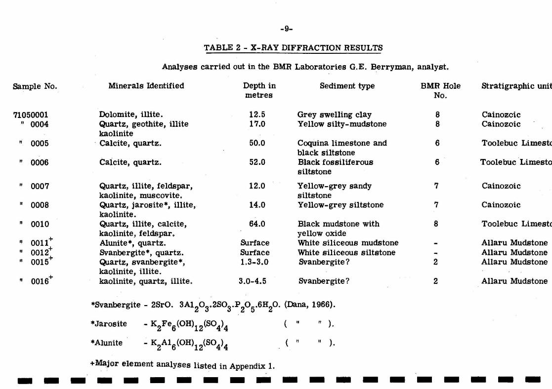
TABLE 2 - X-RAY DIFFRACTION RESULTS
Analyses carried out in the BMR Laboratories G.E. Berryman, analyst.
Minerals Identified Depth in Sediment type metres
Dolomite, illite. 12.5 Grey swelling clay Quartz, geothite, illite 17.0 Yellow silty-mudstone kaolinite
. Calcite, quartz. 50.0 Coquina limestone and black siltstone
Caicite, quartz. 52.0 Black fossiliferous siltstone
Quartz, illite, feldspar, 12.0 Yellow-grey sandy kaolinite, muscovite. siltstone Quartz, jarosite*, illite, 14.0 Yellow-grey siltstone kaolinite. Quartz, illite, calCite, 64.0 Black mudstone with kaolinite, feldspar. ye llow oxide Alunite*, quartz. Surface White siliceous mudstone Svanbergite*, quartz. Surface White siliceous siltstone Q,lartz, svanbergite *, 1.3-3.0 Svanbergite? kaolinite, illite. kaolinite, quartz, illite. 3.0-4.5 Svanbergite?
*Svanbergite - 2SrO. 3A120 3.2S03.P 205.6H20. (Dana, 1966).
*Jarosite - K2Fe6(OH)12(S04)4 ("" ).
*Alunite ( " " ).
BMR Hole No.
8 8
6
6
7
7
8
2
2
Stratigraphic unit
Cainozoic Cainozoic
Toolebuc Limestc
Toolebuc Limesto
Cainozoic
Cainozoic
Toolebuc Limestc
Allaru Mudstone Allaru Mudstone Allaru Mudstone
Allaru Mudstone
+Major element analyses listed in Appendix 1. --------------------
-10-
REFERENCES
CROOK, K.A.W., 1960 - Classification of arenites. Amer. J.Sci., 258, 419-28.
DANA, E.S., 1966 - DANA'S TEXTBOOK OF MINERALOGY. Fourth edition by W.E. Ford. - John Wiley & Sons, London.
REYNOLDS, M.A., 1965 - Springvale, Qld - 1:250 000 Geological Series. Bur. Miner. Resour. Aust. explan. Notes SF/54-14.
VINE, R.R., DAY, R.W., CASEY, D.J., MILLIGAN, E.N., GALLOWAY, M.C., and EXON, N.F., 1967 - Revised nomenclature of the Rolling Downs Group, Eromanga and Surat Basins. Qld Govt Min. J. 68, 144-51. .
I I I I I I I I I I I I I I I I I I I I

I I I I I I I I I I I I I I I I I I I I
-11-
APPENDIX 1
Chemical Analysis of Samples from the Springvale Area
by
J. W. Sheraton
Four samples from the Springvale area, were submitted for major element analysis by X-ray fluorescence, using material ignited at 900°C.
Two samples (Nos 71050012 and 71050015) contain svanbergite, identified by X-ray diffraction (see Table 2). This mineral is a phosphate and sulphate of aluminium and strontium and its presence accounts.. for the low totals for these two samples. Similarly, sample 71050011 contains alunite and would therefore include a significant percentage of sulphur.
Sample No. 71050011+ 71050012+ 71050015+ 71050016+
SiO 2 17.8 6.3 51. 7 51.5
Ti02 0.04 0.17 0.89 0.89
Al20 3 28.6 30.8 20.2 18.73
*Fe20
3 1.70 0.13 1.64 1.38
MnO 0.01 0.02 0.01 0.01
MgO 0.1 0.1 1.0 0.7
CaO 0.14 1.77 1.99 3.89
Na20 0.3 0.2 0.5 0.4
K20 7.61 0.25 0.88 0.76
P20
5 1.57 17.8 0.82 0.05
Loss on ignition 37.86 20.86 17.55 16.93
95.7 78.5 97.2 95.2
* Total iron as Fe20 3
+ X-ray diffraction analYSis listed in Table 2.