department of geomatics engineering · 2008-10-29 · chinese ministry of education and li ka-shing...
TRANSCRIPT

Schulich School of Engineering University of Calgary
Department of Geomatics Engineering
PROGRESS REPORT 2007-2008
Position Yourself Ahead of the Crowd
UCGE Number 50039
PROGRESS REPORT 2007/2008
DEPARTMENT OF GEOMATICS ENGINEERING
May 2008
UNIVERSITY OF CALGARY 2500 University Drive NW
Calgary, Alberta T2N 1N4
Telephone: (403) 220-5834 Fax: (403) 284-1980
Website: www.geomatics.ucalgary.ca


Admitted to the Degree of BACHELOR OF SCIENCE
Mahmoud Reda Abdelrahman (Internship) Philomena Akehurst
Britton William Armstrong (Distinction)(Internship) Karim Mohamed Assem (Internship)
Kurtis Shawn Bahan (Internship) Kirsti Helen Barber
Catherine Be Coral Amelia Mariella Bliss Taylor
Tamara Lorraine Bonham Douglas Lucas Cairns Rares George Caraba
Benjamin Frederick Clipperton (Internship)
Brandon Jefferson Culling (Internship) Corey Michael Doherty
Craig Doram (Internship) Brandon Dean Ellis
Eryn Emil Joseph Gibbs Meghan Elizabeth Gilmore Leighton John Greenstein
Marc James Hallworth Arne Ove Hals
Shannon Leigh Moynes Hill Roberto Infante
Ian Carl Isackson Erin Jennifer Kahr Pavlo Karbovnyk
Johnathan Andrew King (Internship) Dallas Jack Kuzek
Kristopher Marv Kwiatkowski (Internship) Josiah Yin Lau (Distinction) (Internship)
Tao Lin (Distinction) (Internship) Denis Hao Luu
Dale Christopher Madsen (Internship)
Ryan Joseph Man (Internship) Max David Miller (Internship) Carlo Steven Monette Cody Bruce Moser Tina Mosstajiri Richard Bryan Ong (Distinction) (Internship) Saman Orou Ryan Martin Pals Thomas Carson Penner Trevor Paul Phillips (Distinction) (Internship) Tyson Lee Quocksister Mina Saleh (Internship) Llana Leela Samaroo Aaron Gregory Shufletoski Amanda Melissa Paige Side (Internship) Nichola Kristiane Sinclair-Foreman (Internship) Amy Christine Spiers (Distinction) Kyle Morgan Titus Yee Hoang Tran (Internship) Daniel van der Straeten Carmen Wong (Internship)
Admitted to the Degree of DOCTOR OF PHILOSOPHY
Jianchen Gao Andrew James Simpson Hunter
Cécile Marie Mongrédien Elena Veselinova Rangelova
Niandry Leet Moreno Salas Surendran Konavattam Shanmugam Chen Xu Yong Yang
Mohannad Mansour Fadel Al-Durgham Carina May Butterworth Magesh Chandramouli Jean Gabriel Hasbani
Qais Kamal Marji Ahmad Reza Abdolhosseini Moghaddam Kerri L. Robinson Raymond Tsoi Donghua Yao
Admitted to the Degree of MASTER OF SCIENCE
Admitted to the Degree of MASTER OF ENGINEERING
Teresa M. Anderson Peter Jonathon Srajer
Xia ( Sally) Wu

TABLE OF CONTENTS
HIGHLIGHTS 2007/08···························································································1 MESSAGE FROM THE DEAN ··············································································3 AWARDS & RECOGNITION ·················································································4 PERSONNEL ········································································································6 Faculty ·······································································································6 Professors Emeritus·················································································10 New Faculty Members ·············································································11 Adjunct Professors···················································································13 Support Staff ····························································································14 Research Engineers/Associates/Assistants·············································15 Post Docs·································································································15 Guest Lecturers ·······················································································16 Visiting Scientists ·····················································································17 ADVISORY COMMITTEE AND STUDENT AWARDS ········································18 Geomatics Engineering Advisory Committee (GEAC)·····························18 Geomatics Engineering Liaison Committee·············································19 Student Awards Night ··············································································20 UNDERGRADUATE STUDIES ···········································································21 Enrollment································································································23 Common Core Curriculum ·······································································25 Undergraduate Curriculum in Geomatics Engineering ····························26 Geomatics Engineering Student Society (GESS) ····································27 Survey Camp ···························································································28 Engineering Internship Program ······························································29 ENGO 500 Projects and Guest Presentations·········································30 Geomatics Engineering Career Day ························································32 GRADUATE STUDIES ························································································33 Enrollment································································································33 Convocants ······························································································36 Grad Seminars·························································································37 RESEARCH·········································································································38 Research Statistics ··················································································38 Major Research Areas ·············································································40 Research Projects by Research Area······················································41 PUBLICATIONS ··································································································47 Books and Chapters ················································································47 Refereed Journals····················································································47 Conference Proceedings ·········································································50 Scholarly Presentations and Seminars ····················································56 Technical Reports and Notes···································································59 Licenses and Patents···············································································60 Articles ·····································································································60 Interviews/Broadcasts··············································································60 Posters·····································································································61 ACADEMIC AND PROFESSIONAL SERVICE ···················································63

Schulich School of Engineering, Geomatics Engineering Progress Report 2007/2008
Page 1
2007/2008 has been a very prosperous year. I would like to start by thanking our faculty, support and technical staff, and our students for their services, contributions and continued commitment to the Department. This year has brought both changes and challenges to the Department, as we continue to maintain a high quality undergraduate and graduate learning environment, and invest in cutting-edge research in one of the top Geomatics schools in the world. We are pleased to welcome six new faculty members to our team. These six academics will strengthen our research teams in four vital areas: • Earth Observation: Dr. Jeong Woo Kim’s research mainly focuses on integrating state-of-the-art geophysical and geodetic techniques for geohazard analysis and geodynamics. • Digital Imaging: Dr. Derek Lichti’s primary research focus is on the use of optical and range imagery for automated 3D object reconstruction for biomedical applications. • GIS and Land Tenure: Three new faculty members have joined us in this area:
Dr. Xin Wang is a computer scientist specializing in spatial data mining and knowledge engineering. Dr. Andrew Hunter’s current research is focused on the acquisition, use, and analysis of dynamic spatial data under the interrelated themes of Geographic Information Science, Spatial Statistics and GeoComputation. Dr. Steve Liang’s general research areas are Geospatial Information and Communication Technologies (GeoICT).
• Positioning, Navigation, and Wireless Location: Dr. Mark Petovello’s research interests include global navigation satellite systems (GNSS) and their integration with inertial navigation systems (INS) and other dead-reckoning sensors.
The past year has been a year of some loss, as well. Dr. Cathy Valeo moved to Civil Engineering within the Schulich School of Engineering, but continues to collaborate with our faculty members. Dr. Matthew Tait left the Department to pursue a career in Industry, with one of the world’s largest engineering companies. We wish them both the very best in their new endeavours. In addition, our Computer Analyst, Mr. Brad Groat passed away suddenly, in April, after a brief illness. We are very grateful to Steven and Janet MacPhee for a tremendous monetary donation to the Department that has given us the opportunity to
renovate the Geomatics 3rd and 4th year home rooms, and has provided additional funding for scholarships for undergraduate students. Continued on next page
♦ Six new faculty members joined the department
♦ One new faculty member to join the department in fall 2008.
♦ Research funding reaches $195 K per faculty member
♦ Numerous senior faculty and student awards
♦ Involvement in high level national and international boards, professional & learned societies
♦ Record number of convocants: 54 students
HIGHLIGHTS 2007/2008
Schulich School of Engineering, Geomatics Engineering Progress Report 2007/2008
Page 2
During 2007-2008, the Geomatics Engineering program continued to flourish. A total of 54 students received their BSc degree, 9 students a MSc degree, 3 student a MEng, and 8 students received a PhD degree. Undergraduate enrolment reached 58, 48 and 53 in each successive year of the undergraduate program, in addition to 13 students who entered the Internship Program. Demand for our BSc, MSc and PhD graduands remains exceptionally strong, particularly given the growth in the geomatics sector in Alberta. The 2007-2008 fiscal period was another very successful year from a research excellence point of view. Faculty members have continued to secure major research funding. Total direct research funding exceeded $3.9 million, which is approximately $195,000 in average research funding per faculty member. Numerous awards were received by students and faculty members that are detailed on the following pages. Several faculty members continued to serve in leadership positions on various boards and in learned societies. The Department launched a new web page to keep our supporters, alumni, friends and other colleagues up to date on our activities and direction. The Department is pursuing an opportunity to expand geomatics research in Alberta and Canada by applying, along with University of Alberta and University of Lethbridge, for provincial and federal funding to develop a centre in Integrated Resource Management. Results of this competition will be announced in the fall of 2008. Both government and Industry have shown keen interest in supporting the continued growth of geomatics-based products and personnel in the Province, and we see this as an exciting opportunity for the future for our Department and geomatics industry in general. Physical space for the Department, and funding for equipment for the Microlab and Survey Stores, continue to be on-going challenges we face. We are now entering a period where significant and transformational partnerships with Industry will play an important role to help ensure that our labs are equipped with state-of-the art technology, to meet the needs of graduates whose learning matches rapidly-evolving Industry standards. As always, Geomatics Engineering at the University of Calgary is committed to excellence. Dr. Naser El-Sheimy Professor and Head
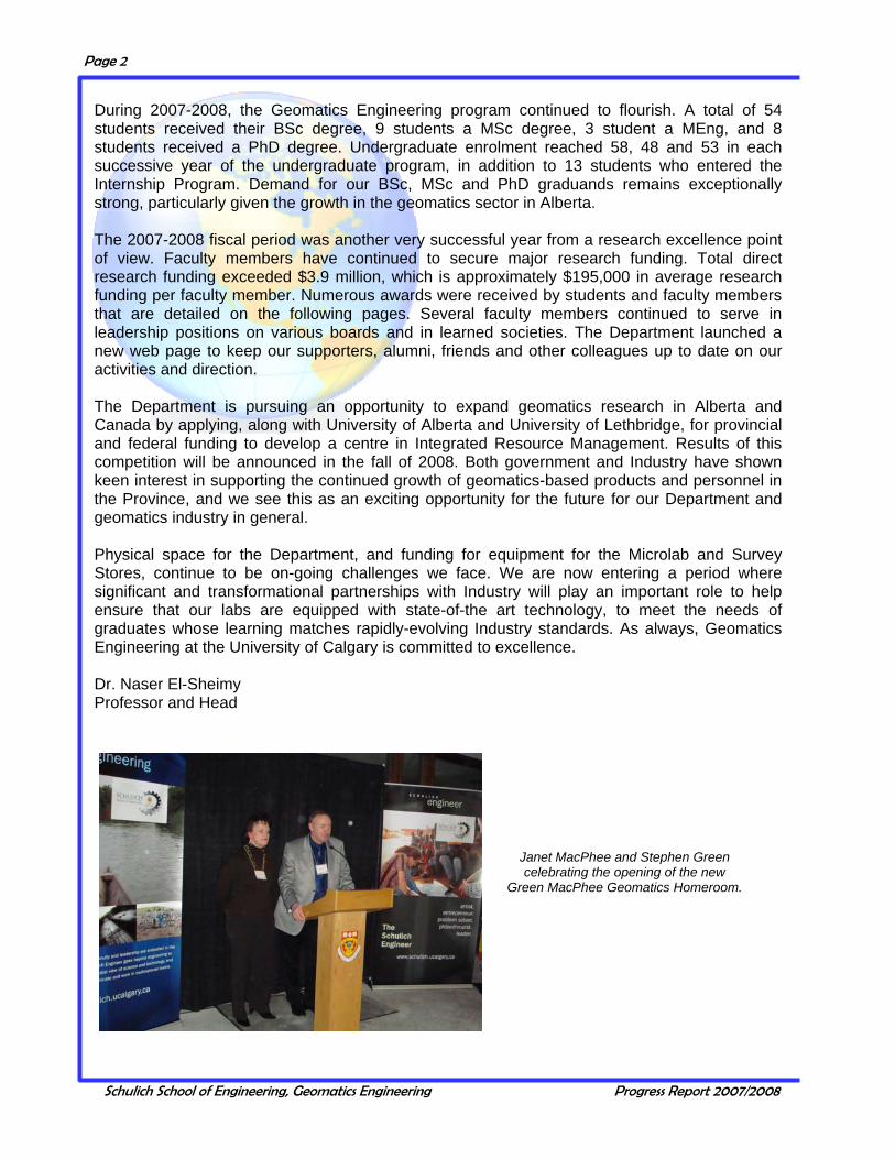
Janet MacPhee and Stephen Green celebrating the opening of the new
Green MacPhee Geomatics Homeroom.

Schulich School of Engineering, Geomatics Engineering Progress Report 2007/2008
Page 3
The Department of Geomatics Engineering has had another successful year in its programs and research. Congratulations to all the faculty, staff and students who have contributed to the continual building of the Department’s reputation and impact, both nationally and internationally. Through numerous faculty appointments over the past year, the Department is well positioned to accelerate its growth and increase its linkages with other strategic priorities in energy, the environment, ICT and biomedical engineering. In particular, the leadership the Department is showing in the development of a provincial Integrated Resource Management research strategy has strengthened its connections to the resource sector and to complementary research programs in Alberta. I am fully confident that these efforts will bear strong fruit in the coming year and I look forward to working with you and the geomatics community to further enhance Alberta’s reputation as an international centre of excellence for geomatics activities.
M. Elizabeth Cannon, PEng, FCAE, FRSC Dean, Schulich School of Engineering
Geomatics Engineering Faculty Members at the Annual Retreat
June, 2007
Back Row: M. Barry, Y. Gao, D. Marceau, N. El-Sheimy, G. Lachapelle, S. Skone, B. Teskey. Front Row: M. Sideris, A. Braun, K. O’Keefe, I. Couloigner, A. Habib. Missing: M. Collins, C. Valeo
MESSAGE FROM THE DEAN
Schulich School of Engineering, Geomatics Engineering Progress Report 2007/2008
Page 4
Several faculty members received awards in 2007 at the Engineering Faculty Council: Dr. Ayman Habib, Geomatics Engineering Graduate Educator Award; Dr. Gerard Lachapelle, Geomatics Engineering Research Excellence Award; Dr. Kyle O'Keefe, Geomatics Engineering Outstanding Teacher Award.
Ms. Julia Lai won the 2007 Donna Geekie Service Award.
Mr. Suren Shanmugam received a student sponsorship award from the Swiss Institute of Navigation to present a research paper at the European Navigation Conference held in Geneva in May 2007.
Dr. Michael Sideris was elected President of the International Association of Geodesy (IAG) for the period 2007 to 2011.
Mr. Wouter van der Wal won the 2007 Canadian Geophysical Union (CGU) Best Student Paper Award.
Dr. Yang Gao was awarded the Changjiang Chair Professorship at Wuhan University by the Chinese Ministry of Education and Li Ka-Shing Foundation.
Ms. Kerri Robinson won the Hoskin Scientific Best Student Poster Award at the 60th Annual Canadian Water Resources Conference in Saskatoon.
Mr. Mohammed Dabboor won the Canadian Geophysical Union (CGU) Geodesy Section Best Student Paper Award.
Mr. Cyrille Gernot and Ms. Florence Macchi have received Best Poster Awards at the iCORE Summit 2007, Banff, August 2007.
Dr. Susan Skone won a Best Presentation Award at the ION GNSS 2007.
Mr. Cyrille Gernot won a Best Student Award at the ION GNSS 2007.
Industry Canada announced the renewal of Professor Lachapelle’s Canada Research Chair in Wireless Location for a second seven year term starting April 1, 2008.
Engineering Student Society (ESS) Teaching Excellence Award for Geomatics was awarded to Dr. Matthew Tait. This award is based on excellence, enthusiasm and personality in teaching Engineering students throughout their academic years.
Engineering Student Society (ESS) winner of the Golden Geer Award was Mr. Brandon Ellis, the student who most embodies the spirit of Engineering .
Engineering Student Society (ESS) winner of the Student of the Year Award was Ms. Amanda Side, the student in their final year, who exemplifies Engineering at the Schulich School of Engineering.
Dr. Michael Sideris, Dr. Nico Sneeuw, Mr. Matthias Weigelt and Mr. Chen Xu were recipients of the 2008 F.W. (Casey) Baldwin Award of the Canadian Aeronautics and Space Institute (CASI). The award was given for their paper entitled "Spaceborne Gravimetry and Gravity Field Recovery”, which has been selected as the best paper published in the 2007 volume of Canadian Aeronautics and Space Journal (CASJ).
Mr. Cyrille Gernot received the Best Student Presentation Award at the European Navigation Conference 2008.
AWARDS AND RECOGNITION

Schulich School of Engineering, Geomatics Engineering Progress Report 2007/2008
Page 5
Dr. Chaminda Basnayake, who received his doctorate from our Department in 2004, won GM's 2006 Charles P. McCuen Award and the 2007 OnStar President’s Award. The Charles P. McCuen Award is the highest award offered by GM R&D.
Mr. Aiden Morrison was awarded a best presentation award at the University of Calgary 2007 Graduate Student Conference.
Mr. Richard Ong, BSc graduand, has been awarded the Chancellor David B. Smith Gold Medal in Engineering and the APEGGA Education Foundation Gold Medal in Engineering for his outstanding performance during his BSc studies.
Third Place for the 2008 John I. Davidson President’s Award for Practical Papers in the Journal of Photogrammetric Engineering and Remote Sensing were Dr. Ayman Habib, Dr. Eui-Myoung Kim and Mr. Changjae Kim. The title of their paper was ‘New Methodologies for True Orthophoto Generation’.
First runner-up for the 2008 Talbert Abrams Award for the following paper in the Journal of Photogrammetric Engineering and Remote Sensing: Dr. Ayman Habib, Mr. Eui-Myoung Kim and Mr. Changjae Kim. ‘New Methodologies for True Orthophoto Generation’.
Grand prize winner for the 2008 Talbert Abrams Award for the following paper in the Journal of Photogrammetric Engineering and Remote Sensing: Dr. Michel Morgan, Dr. Kyungok Kim, Dr. Soo Jeong and Dr. Ayman Habib. Epipolar Resampling of Space-Borne Linear Array Scanner Scenes using Parallel Projection.
Korean Society of Surveying, Geodesy, Photogrammetry and Cartography (KSGPC) and the Department of
Geomatics at the University of Calgary in January 2008. The KSGPC Society holds an annual international workshop in order
to exchange ideas on recent research activities and initiate collaboration
between the society and international partners. The University of Calgary was
the chosen location for 2008.
Schulich School of Engineering has entered into a three-year partnership agreement with
Alpine Canada Alpin. Professor Gérard Lachapelle (left) and ACA chief athletic officer Max Gartner (right) exchange hats to celebrate
the new partnership.
AWARDS AND RECOGNITION, continued

Schulich School of Engineering, Geomatics Engineering Progress Report 2007/2008
Page 6
Dr. M.B. Barry Associate Professor and Associate Head (Undergrad)
B.Sc., MBA, PhD (Natal) Cadastral Systems, land tenure and
geographic information systems Telephone: (403) 220-5826 Email: [email protected]
Dr. A.F. Habib Professor and
Associate Head (Graduate Studies) B.Sc., M.Sc., Ph.D. (Ohio State University), P.Eng. Digital photogrammetry, image processing, image understanding, mobile mapping systems, sensor,
data, and information integration Telephone: (403) 220-7105 Email: [email protected]
Dr. N. El-Sheimy Professor and Head
CRC in Multi-sensor Systems B.Sc., M.Sc., Ph.D. (University of Calgary), P.Eng.
Multi-sensor systems, real-time mapping and their applications in GIS Telephone: (403) 220-7587
Email: [email protected]
Dr. A. Braun Associate Professor
Diplom-Geophysiker, Dr. phil. nat. (geophysics, magna cum laude, Johann Wolfgang Goethe-Universität Frankfurt)
Byrd Fellow (The Ohio State University) Geophysics, satellite geodesy, geodynamics, sea level change, Earth systems observation
Telephone: (403) 220-4702 Email: [email protected]
PERSONNEL Faculty
Schulich School of Engineering, Geomatics Engineering Progress Report 2007/2008
Page 7
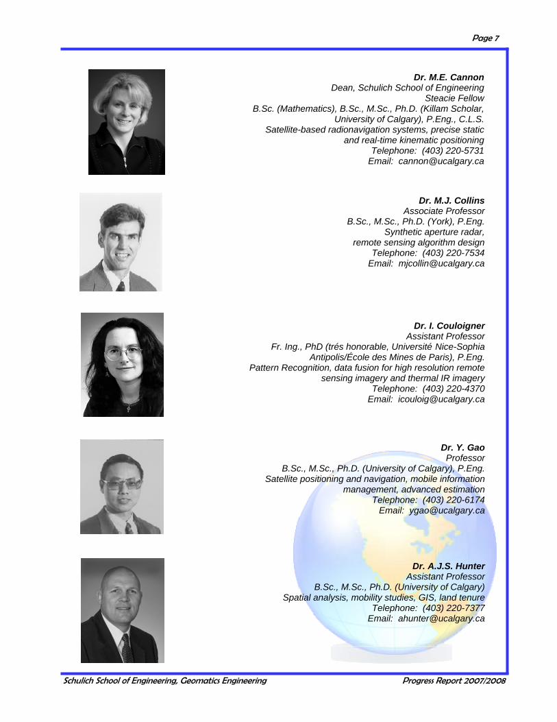
Dr. I. Couloigner Assistant Professor
Fr. Ing., PhD (trés honorable, Université Nice-Sophia Antipolis/École des Mines de Paris), P.Eng.
Pattern Recognition, data fusion for high resolution remote sensing imagery and thermal IR imagery
Telephone: (403) 220-4370 Email: [email protected]
Dr. M.J. Collins Associate Professor
B.Sc., M.Sc., Ph.D. (York), P.Eng. Synthetic aperture radar,
remote sensing algorithm design Telephone: (403) 220-7534
Email: [email protected]
Dr. Y. Gao Professor
B.Sc., M.Sc., Ph.D. (University of Calgary), P.Eng. Satellite positioning and navigation, mobile information
management, advanced estimation Telephone: (403) 220-6174
Email: [email protected]
Dr. M.E. Cannon Dean, Schulich School of Engineering
Steacie Fellow B.Sc. (Mathematics), B.Sc., M.Sc., Ph.D. (Killam Scholar,
University of Calgary), P.Eng., C.L.S. Satellite-based radionavigation systems, precise static
and real-time kinematic positioning Telephone: (403) 220-5731
Email: [email protected]
Dr. A.J.S. Hunter Assistant Professor
B.Sc., M.Sc., Ph.D. (University of Calgary) Spatial analysis, mobility studies, GIS, land tenure
Telephone: (403) 220-7377 Email: [email protected]

Schulich School of Engineering, Geomatics Engineering Progress Report 2007/2008
Page 8
Dr. G. Lachapelle Professor
CRC/iCORE Chair in Wireless Location B.Sc., M.Sc., L.Ph.,
Dr. Techn. (Technical University of Graz), P.Eng. Satellite-based positioning and
navigation, wireless location Telephone: (403) 220-7104
Email: [email protected]
Dr. D. Marceau Professor
B.Sc., M.Sc., Ph.D. (University of Waterloo) Geospatial Information Systems (GIS),
cellular automata and multi-agent system modeling for environmental resource management
Telephone: (403) 220-5314 Email: [email protected]
Dr. J.W. Kim Associate Professor
B.Sc., M.Sc., Ph.D. (Ohio State University) Geodetic earth observation,
satellite geophysics, geodynamics Telephone: (403) 220-4858 Email: [email protected]
Dr. S. Liang Assistant Professor
B.Sc., Ph.D. (York University) Geospatial Information Systems (GIS),
geo web, sensor web, cyberinfrastructures Telephone: (403) 210-4703
Email: [email protected]
Dr. D. Lichti Assistant Professor
B.Tech, M.Sc., Ph.D. (University of Calgary) Optical and range imaging systems
for precise 3D measurement Telephone: (403) 210-9495 Email: [email protected]

Schulich School of Engineering, Geomatics Engineering Progress Report 2007/2008
Page 9
Dr. M.P. Tait Assistant Professor
BEng (Hons), Ph.D. (Leeds), P.Eng. Industrial measurement systems and methodologies, closer integration of
metrology, 3D modelling Telephone: (403) 210-9494
Email: [email protected]
Dr. K. O’Keefe Assistant Professor
B.Sc. (Honours Physics), B.Sc., Ph.D (Honorary Killam Scholar,
University of Calgary), P.Eng. Wireless location, satellite-based
positioning and navigation Telephone: (403) 220-7378
Email: [email protected]
Dr. M.G. Sideris Professor and Associate Dean (Faculty of
Graduate Studies) Dipl.Ing. (Honours); M.Sc.,
Ph.D. (University of Calgary), Dr. h.c., P.Eng. Geodesy, optimization in geomatics, spectral analysis,
gravity field approximation Telephone: (403) 220-4985 Email: [email protected]
Dr. S.H. Skone Associate Professor and
Acting Head (July —December 2006) B.Sc., M.Sc., Ph.D. (University of Calgary), Wide-area differential GPS, marine DGPS,
atmospheric effects and modelling on satellite navigation Telephone: (403) 220-7589
Email: [email protected]
Dr. M. Petovello Assistant Professor B.Sc. (Geomatics),
Ph.D. (University of Calgary), P.Eng., GNSS navigation, inertial navigation and software receiver development
Telephone: (403) 210-9795 Email: [email protected]

Schulich School of Engineering, Geomatics Engineering Progress Report 2007/2008
Page 10
Dr. C. Valeo Associate Professor
B.Sc., B.A.Sc., M.Eng., PhD (McMaster), P.Eng., Water resources and environmental engineering,
remote sensing and GIS Telephone: (403) 220-4112 Email: [email protected]
Dr. W.F. Teskey Professor
B.Sc. (Distinction; APEGGA Gold Medal), M.Sc., Dr.-Ing. (Stuttgart University), P.Eng., A.L.S., C.L.S. Precise engineering and deformation surveys, integrated analysis of deformations
Telephone: (403) 220-7397 Email: [email protected]
Dr. X. Wang Assistant Professor
B.Sc., M.Eng., PhD (University of Regina) Spatial data mining, knowledge engineering;
web GIS and privacy protection in GIS Telephone: (403) 220-3355
Email: [email protected]
Dr. J.A.R. Blais, Ph.D. (University of New Brunswick), P.Eng. Estimation, spectral analysis, information theory and systems numerical methods, reference systems and gravitation. Dr. E.J. Krakiwsky, Ph.D. (Heiskanen Award; The Ohio State University), P.Eng. Least squares estimation and statistical testing, network design, satellite positioning, automatic vehicle location and navigation systems. Dr. A.C. McEwen, Ph.D. (University of London), C.L.S., N.L.S., Cadastral studies, survey law, land registration systems, international land and maritime boundaries surveys for aboriginal land claims. Dr. K.P. Schwarz, Dr.-Ing. (Summa cum laude; Technical University of Berlin), P.Eng., Geodesy, inertial techniques, airborne gravimetry, kinematic positioning and attitude determination by GPS/INS, multi-sensor systems, real-time applications.
Professors Emeritus

Schulich School of Engineering, Geomatics Engineering Progress Report 2007/2008
Page 11
Dr. Xin Wang was appointed in a faculty position in the area of GIS and Land Tenure. Dr. Wang holds a Bachelor degree in Computer Science, a M.Eng. degree in Software Engineering from Northwest University, China and a PhD degree in Computer Science from University of Regina. Prior to joining University of Calgary she worked with SaskTel. She was a lecturer at East China University of Science and Technology for three years. At the same time, she was also a software engineer with ASTI Shanghai and a researcher at Fudan University and Shanghai Software Centre. Her research has been primarily in the areas of spatial data mining, ontology and knowledge engineering in GIS.
Dr. Steve Liang was appointed in a faculty position in the area of GIS and Land Tenure. Dr. Liang holds a Bachelor degree in Survey Engineering from National Cheng-Kung University in Taiwan and a Ph.D. degree in Earth and Space Science from York University in Canada. His general research areas are Geospatial Information and Communication Technologies (GeoICT). Currently, his specific research interests lie at the intersection of Geo-Sensor Networks, Peer-to-Peer (p2p) computing, Wired and Wireless Internet GIS and Social Networks, specifically in the area of the Spatial Sensor Web (SSW), which is a spatial information infrastructure for heterogeneous sensor networks.
Dr. Jeong Woo Kim was appointed in a faculty position in the area of Earth Observation. Dr. Kim holds B.Sc. and MSc. degrees in Geophysics from Yonsei University in Korea and a PhD. degree in Satellite Geophysics from the Ohio State University. His professional experiences include Associate Professor with Sejong University in Korea, NRC Research Associate at NASA Goddard Space Flight Center, and Research Scientist at The Ohio State University, State University of New York, and Korea Polar Research Institute. His research activities have been in the areas of global geodynamics and geohazard analysis from integrated geodetic and geophysical measurements including superconducting gravimetry, regional and global geopotential modeling from satellite gravimetry and magnetometry, geoid, gravity, bathymetry, and ocean circulation from satellite radar altimetry, surface and subsurface EM properties and dynamics from optical and radar remote sensing, and microwave remote sensing of sea ice.
Dr. Andrew Hunter was appointed in a faculty position in the area of GIS and Land Tenure. Dr. Hunter holds a Bachelor of Surveying from the University of Otago and MSc and PhD degrees in Geomatics Engineering from the University of Calgary. He is a Professional Registered Surveyor with the New Zealand Institute of Surveyors, and he has extensive research experience in land tenure, land information systems and geospatial information systems. Dr. Hunter’s current research is focused on the acquisition, use, and analysis of dynamic spatial data under the interrelated themes of Geographic Information Science, Spatial Statistics and GeoComputation. The primary application fields within which his research falls include environmental applications related to animal tracking, land use planning and Cadastres. Dr. Hunter has won a number of awards for both teaching and research excellence, and he has a strong record of professional experience within the land surveying community.
New Faculty Members
Schulich School of Engineering, Geomatics Engineering Progress Report 2007/2008
Page 12
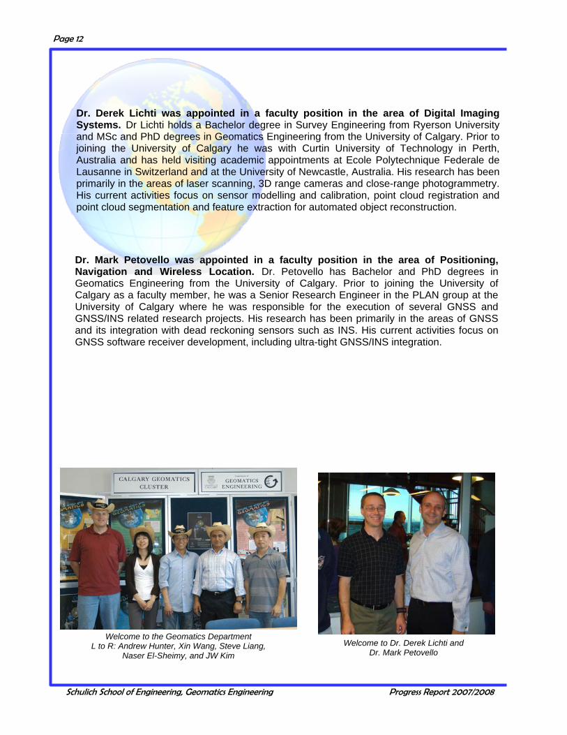
Dr. Derek Lichti was appointed in a faculty position in the area of Digital Imaging Systems. Dr Lichti holds a Bachelor degree in Survey Engineering from Ryerson University and MSc and PhD degrees in Geomatics Engineering from the University of Calgary. Prior to joining the University of Calgary he was with Curtin University of Technology in Perth, Australia and has held visiting academic appointments at Ecole Polytechnique Federale de Lausanne in Switzerland and at the University of Newcastle, Australia. His research has been primarily in the areas of laser scanning, 3D range cameras and close-range photogrammetry. His current activities focus on sensor modelling and calibration, point cloud registration and point cloud segmentation and feature extraction for automated object reconstruction.
Dr. Mark Petovello was appointed in a faculty position in the area of Positioning, Navigation and Wireless Location. Dr. Petovello has Bachelor and PhD degrees in Geomatics Engineering from the University of Calgary. Prior to joining the University of Calgary as a faculty member, he was a Senior Research Engineer in the PLAN group at the University of Calgary where he was responsible for the execution of several GNSS and GNSS/INS related research projects. His research has been primarily in the areas of GNSS and its integration with dead reckoning sensors such as INS. His current activities focus on GNSS software receiver development, including ultra-tight GNSS/INS integration.
Welcome to the Geomatics Department L to R: Andrew Hunter, Xin Wang, Steve Liang,
Naser El-Sheimy, and JW Kim Welcome to Dr. Derek Lichti and
Dr. Mark Petovello
Schulich School of Engineering, Geomatics Engineering Progress Report 2007/2008
Page 13
Dr. Bo Huang Chinese University of Hong Kong Dr. Richard Klukas UBC Okanagan Dr. Bryan Mercer Intermap Technologies Corp. Dr. Aboelmagd Noureldin Royal Military College of Canada Dr. Bruno Scherzinger Applanix Corporation Dr. Nico Sneeuw Universität Stuttgart
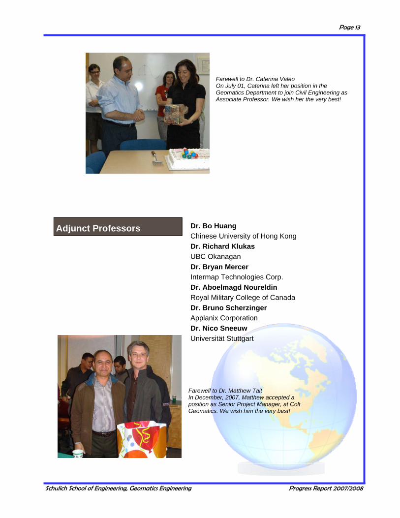
Farewell to Dr. Caterina Valeo On July 01, Caterina left her position in the Geomatics Department to join Civil Engineering as Associate Professor. We wish her the very best!
Farewell to Dr. Matthew Tait In December, 2007, Matthew accepted a position as Senior Project Manager, at Colt Geomatics. We wish him the very best!
Adjunct Professors

Schulich School of Engineering, Geomatics Engineering Progress Report 2007/2008
Page 14
Marcia Inch, Administrative Manager Monica Barbaro, Administrative Assistant Julia Lai, Administrative Assistant Lu-Anne Markland, Graduate Program Administrator Julia Millen, BSc, BMus, MA, Program Administrator, SCIberMENTOR Program
Garth Wanamaker, BSc, Technical Manager Kirk Collins, BSc, Dipl.Surveying & Mapping Technology, Survey Technician Brad Groat, BA, Dipl. in Electronics Engineering Technology, Computer Systems Administrator Kathy Hamilton, Network Technician Certificate, Computer Technician Gail Leask, Dipl. in Telecomputer Engineering Technology, Microcomputer Lab Administrator
Support Staff Technical
Julia Lai won the 2007 Donna Geekie Service Award.
Stampede Breakfast 2007
Support Staff Administrative
Schulich School of Engineering, Geomatics Engineering Progress Report 2007/2008
Page 15
Walid Abdel-Hamid Positioning, Navigation and Wireless Location Daniele Borio Positioning, Navigation and Wireless Location Saurabh Godha Positioning, Navigation and Wireless Location Jean Gabriel Hasbani GIS and Land Tenure Chen-Yu Hsieh Positioning, Navigation and Wireless Location Martin Lavigne Positioning, Navigation and Wireless Location Hasan Murtaza Positioning, Navigation and Wireless Location Phillip Mutulu Earth Observation Cillian O’Driscoll Positioning, Navigation and Wireless Location
Mark Petovello Positioning, Navigation and Wireless Location Rebeca Quinonez-Pinon GIS and Land Tenure Elena Rangelova Earth Observation Surendran Shanmugam Positioning, Navigation and Wireless Location Robert Watson Positioning, Navigation and Wireless Location Bruce Wright Positioning, Navigation and Wireless Location Karen Yee Positioning, Navigation and Wireless Location Cheng Zhang GIS and Land Tenure Zhan Zhang Earth Observation
Hamid Assilzadeh Positioning, Navigation and Wireless Location Mohamed El Habiby Earth Observation Mauricio Gende Positioning, Navigation and Wireless Location Dongqing Gu Positioning, Navigation and Wireless Location
Sameh Nassar Positioning, Navigation and Wireless Location Aluir Dal Poz Digital Imaging Systems Ruifang Zhai Digital Imaging Systems Yufeng Zhang Positioning, Navigation and Wireless Location
Research Engineers/Associates/Assistants
Post Doctoral Fellows

Schulich School of Engineering, Geomatics Engineering Progress Report 2007/2008
Page 16
Special Lecture Series
International Lecture Series
Dr. Neculai Archip Harvard Medical School Medical Image Computing for Image Guided Therapy Mr. Fabio Ayres The University of Calgary Medical Imaging and Computer-Aided Diagnosis in Medicine: Detection off Early Signs of Breast Cancer in Mammograms, and Analysis of Retinal Images Mr. Nezam Kachouie University of Waterloo Toward an Optimal Solution for Multi-Target Segmentation and Tracking with the Applications to Multi-Cellular Video Analysis
Dr. Derek Lichti Curtin University of Technology Modelling and Reconstruction Challenges and Solutions in Biomedical Photogrammetry Dr. Naga Mudigonda General Dynamics Canada Ltd. Image Analysis and Multi-source Information Fusion Concepts for Medical and Military Applications Dr. Mark Petovello The University of Calgary Using Weak GNSS Signals for High Accuracy Navigation
Mr. Ed Shaw CASI President Canada and Radar Satellites Dr. Jan Skaloud Swiss Federal Institute of Technology Lausanne From Town to Slopes by the Air: Similarities and Differences in Precise Trajectory Estimation in Urban, Mountain and Airborne Environment Dr. John Gyakum McGill University Regional Climate Issues in the Context of Global Change.
Dr. Mark Psiaki Cornell University Collection, Analysis, and Modeling of GPS Scintillation Data from Equatorial Regions Dr. Grace Gao Stanford University Decoding Galileo and Compass PRN Codes Dr. Junyong Chen State Bureau of Surveying and Mapping Modernization of the Chinese National Geodetic Datum
GUEST LECTURERS
Schulich School of Engineering, Geomatics Engineering Progress Report 2007/2008
Page 17
Visiting Scientists
Dr. Mohinder S. Grewal Cal State University, Fullerton, California Advanced Kalman Filtering Applied to Navigation Dr. Jayanta Ray Accord Software & Systems Pvt. Ltd. GNSS Receiver Design
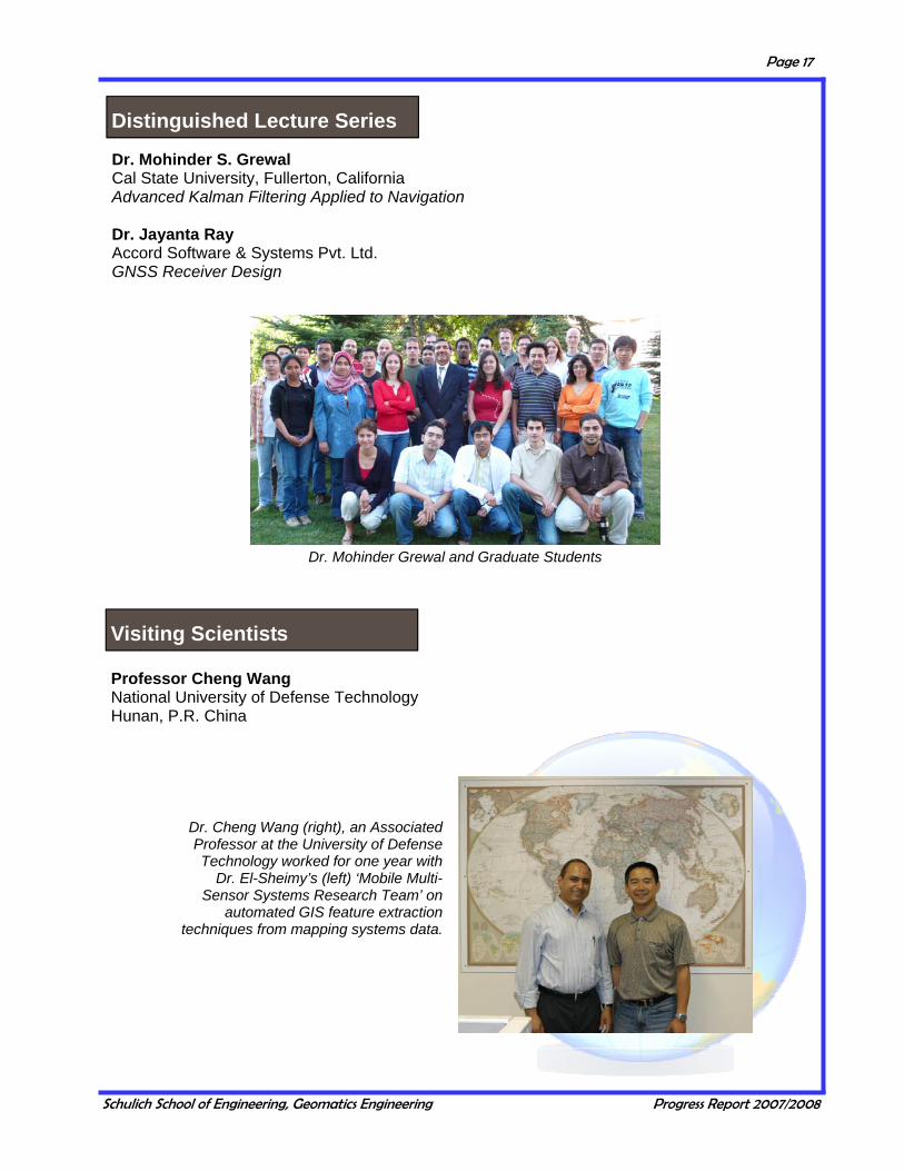
Professor Cheng Wang National University of Defense Technology Hunan, P.R. China
Dr. Cheng Wang (right), an Associated Professor at the University of Defense Technology worked for one year with
Dr. El-Sheimy’s (left) ‘Mobile Multi-Sensor Systems Research Team’ on
automated GIS feature extraction techniques from mapping systems data.
Dr. Mohinder Grewal and Graduate Students
Distinguished Lecture Series

Schulich School of Engineering, Geomatics Engineering Progress Report 2007/2008
Page 18
Advisory Committee 2007
Name Affiliation Eric Desroche, Chair Intermap Technologies Corporation Mohamed Abousalem Hemisphere GPS Arlin Amundrud Global Surveys Group Inc. Danielle Coulter The City of Calgary Steve Fediow Fugro SESL Geomatics Ltd. Hazen Gehue SiRF Technology Inc. Ron Hall Focus Corporation Teresa Myrfield Pacific Land Surveying Ltd. Stuart Salter Natural Resources Canada Kim Sturgess Alberta WaterSMART Gary Zhang MRF Geosystems Corporation Representatives of the U of C - N. El-Sheimy, M.B. Barry, A.F. Habib
It is the responsibility of the Geomatics Engineering Advisory Committee to ensure that the un-dergraduate, graduate and research programs meet the needs of the country and are kept up to date with society and the rapidly changing technologies. The 31st annual advisory committee meeting was held on Friday, November 30, 2007. The agenda included discussions on the department strategic plan for the next 5 years, the need to actively recruit undergraduate students, and the opportunities afforded by the Biomedical and the Energy and Environment specializations.
Geomatics Engineering Advisory Committee First row L to R, Arlin Amundrud, Naser El-Sheimy, Eric Desroche, Stephen Green; Centre row, Gary Zhang, Danielle Coulter, Teresa Myrfield, Victoria Hoyle; Back row, Mike Barry, Ayman Habib, Hazen Gehue, Steve Fediow, Mohamed Abousalem.
ADVISORY COMMITTEES AND STUDENT
Geomatics Engineering Advisory Committee (GEAC)
Schulich School of Engineering, Geomatics Engineering Progress Report 2007/2008
Page 19
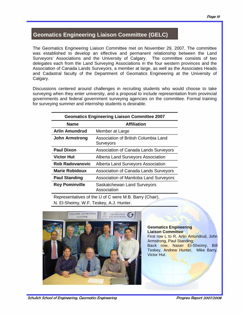
The Geomatics Engineering Liaison Committee met on November 29, 2007. The committee was established to develop an effective and permanent relationship between the Land Surveyors’ Associations and the University of Calgary. The committee consists of two delegates each from the Land Surveying Associations in the four western provinces and the Association of Canada Lands Surveyors, a member at large, as well as the Associates Heads and Cadastral faculty of the Department of Geomatics Engineering at the University of Calgary. Discussions centered around challenges in recruiting students who would choose to take surveying when they enter university, and a proposal to include representation from provincial governments and federal government surveying agencies on the committee. Formal training for surveying summer and internship students is desirable.
Geomatics Engineering Liaison Committee 2007 Name Affiliation
Arlin Amundrud Member at Large John Armstrong Association of British Columbia Land
Surveyors Paul Dixon Association of Canada Lands Surveyors Victor Hut Alberta Land Surveyors Association Rob Radovanovic Alberta Land Surveyors Association Marie Robidoux Association of Canada Lands Surveyors Paul Standing Association of Manitoba Land Surveyors Roy Pominville Saskatchewan Land Surveyors
Association Representatives of the U of C were M.B. Barry (Chair), N. El-Sheimy, W.F. Teskey, A.J. Hunter.
Geomatics Engineering Liaison Committee First row L to R, Arlin Amundrud, John Armstrong, Paul Standing; Back row, Naser El-Sheimy, Bill Teskey, Andrew Hunter, Mike Barry, Victor Hut.
Geomatics Engineering Liaison Committee (GELC)

Schulich School of Engineering, Geomatics Engineering Progress Report 2007/2008
Page 20
Student Awards Night
Student Awards Night was held on Tuesday, March 25, 2008. Awards night is an opportunity to publicly recognize the many accomplishments of our graduate and undergraduate students. It also provides an occasion for an informal meeting between members of the profession, students, faculty and other university representatives. The number of awards available for our students continues to rise, thanks to the commitment of the Geomatics community to our program and to our students.
Geomatics Engineering Student Award Winners and Donors
Schulich School of Engineering, Geomatics Engineering Progress Report 2007/2008
Page 21
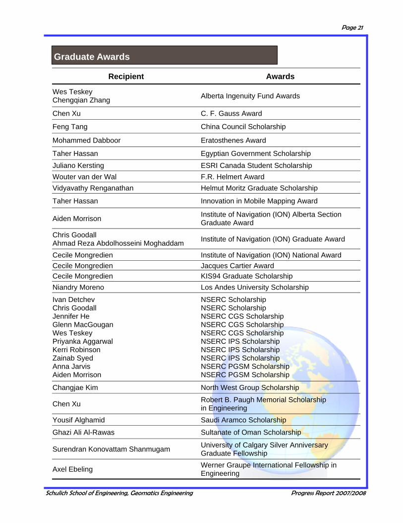
Graduate Awards
Recipient Awards
Wes Teskey Chengqian Zhang Alberta Ingenuity Fund Awards
Chen Xu C. F. Gauss Award
Feng Tang China Council Scholarship
Mohammed Dabboor Eratosthenes Award
Taher Hassan Egyptian Government Scholarship Juliano Kersting ESRI Canada Student Scholarship Wouter van der Wal F.R. Helmert Award Vidyavathy Renganathan Helmut Moritz Graduate Scholarship
Taher Hassan Innovation in Mobile Mapping Award
Aiden Morrison Institute of Navigation (ION) Alberta Section Graduate Award
Chris Goodall Ahmad Reza Abdolhosseini Moghaddam Institute of Navigation (ION) Graduate Award
Cecile Mongredien Institute of Navigation (ION) National Award Cecile Mongredien Jacques Cartier Award Cecile Mongredien KIS94 Graduate Scholarship Niandry Moreno Los Andes University Scholarship
Ivan Detchev Chris Goodall Jennifer He Glenn MacGougan Wes Teskey Priyanka Aggarwal Kerri Robinson Zainab Syed Anna Jarvis Aiden Morrison
NSERC Scholarship NSERC Scholarship NSERC CGS Scholarship NSERC CGS Scholarship NSERC CGS Scholarship NSERC IPS Scholarship NSERC IPS Scholarship NSERC IPS Scholarship NSERC PGSM Scholarship NSERC PGSM Scholarship
Changjae Kim North West Group Scholarship
Chen Xu Robert B. Paugh Memorial Scholarship in Engineering
Yousif Alghamid Saudi Aramco Scholarship
Ghazi Ali Al-Rawas Sultanate of Oman Scholarship
Surendran Konovattam Shanmugam University of Calgary Silver Anniversary Graduate Fellowship
Axel Ebeling Werner Graupe International Fellowship in Engineering

Schulich School of Engineering, Geomatics Engineering Progress Report 2007/2008
Page 22
Undergraduate Awards
Recipient Awards
Dustin James Engen A.D. (Denis) Hosford Scholarship
Amy Christine Spiers Alberta Land Surveyors' Association Scholarship
Arne Ove Hals British Columbia Land Surveyors Foundation Award
Corey Michael Doherty British Columbia Land Surveyors Foundation H.R. Goldfinch Memorial Award
Meghan Elizabeth A. Walsh Cannon-Lachapelle Family Scholarship
Carmen Wong Colt Geomatic Solutions Ltd. Bursary
Eduardo Infante David Scovill Memorial Bursary
Lindsay Michael McEachern E.J. Krakiwsky Bursary
Amanda Melissa P. Side Focus Intec Geomatics Bursary
Tao Lin Eduardo Infante Lindsay Michael McEachern
Geomatics Engineering '25th Anniversary' Bursary
Josiah Yin Lau Geomatics Engineering Future Leaders Award
Amanda Melissa P. Side Carmen Wong Geomatics Engineering Student Society Bursaries
Lindsay Michael McEachern Institute of Navigation Alberta Chapter Bursary
Jacky Chun Kit Chow Institute of Navigation (ION) Undergraduate Bursary
Trevor Paul Phillips Amy Christine Spiers J.H. Holloway Scholarship in Geomatics Engineering
Ryan Scott Enns Jerry J. Simpson Memorial Scholarship
Ian Carl Isackson Jim Van Dam Scholarship
Shawn Knor Tse John Deyholos Memorial Award
Kathryn Brenda Hannah KIS-97 Undergraduate Scholarship
Leighton John Greenstein L.R. (Dick) Newby Memorial Award
Jacky Chun Kit Chow Leica Geosystems Limited Scholarship
Coral Amelia M. Bliss Taylor McElhanney Scholarship
Lindsay Michael McEachern Ray Lowry Memorial Bursary
Carlo Steven Monette Saskatchewan Land Surveyors' Association Award
Coral Amelia M. Bliss Taylor Stephen P. Williams Memorial Award

Schulich School of Engineering, Geomatics Engineering Progress Report 2007/2008
Page 23
Enrollment
During the 2007/08 academic year, 159 undergraduate students (172 including internship) pursued studies in Geomatics Engineering at the University of Calgary. Undergraduate enrollment has remained consistently high, and close to the record number of students the Department achieved in recent years with an average enrollment per year of 53 students in each of second, third and fourth year.
44 52 53 57 52 50 48 58
52 4648 55 47 50 47 54
48
15 2320 16 21 25
1813
3444
52 48 52 4352 41 53
24
0
25
50
75
100
125
150
175
200
99/00
00/01
01/02
02/03
03/04
04/05
05/06
06/07
07/08
Year
Num
ber
of S
tude
nts
4thInternship3rd2nd
UNDERGRADUATE STUDIES

Schulich School of Engineering, Geomatics Engineering Progress Report 2007/2008
Page 24
Student Enrollment by Geographic Region
The figure to the left shows a breakdown of student enroll-ment by geographic region. Students from Alberta remain the largest group, and num-bers from the other groups remain fairly constant from year to year. 0
20
40
60
80
100
120
140
Alberta BC SK MB ON NB PEI
Intern
ation
al
Graduating Class of 2008, Proudly displaying ‘Iron Ring’
GESS Wins ENGG WEEK 2008
Amanda Side receiving the Student of the Year Award

Schulich School of Engineering, Geomatics Engineering Progress Report 2007/2008
Page 25
The common curriculum for engineering students is shown in the adjacent table. Students choose their department at the end of the first year and begin studies specific to that department in the second term of second year.
Common Program for All Engineering Students
Year 1 Course Number Course Name
AMAT 217 Calculus for Engineers and Scientists
AMAT 219 Multivariable Calculus for Engineers
CHEM 209 General Chemistry for Engineers
ENGG 201 Behaviors of Liquids, Gases and Solids
ENGG 205 Engineering Mechanics I
ENGG 233 Computing for Engineers I
ENGG 251 Design and Communications I
ENGG 253 Design and Communications II
MATH 221 Linear Algebra for Scientists and Engineers
PHYS 259 Electricity and Magnetism
COST -1 Complementary Studies Course
Year 2 (Fall)
AMAT 307 Differential Equations for Engineers
ENGG 319 Probability and Statistics for Engineers
ENGG 325 Electric Circuits and Systems
ENCM 339 Programming Fundamentals
ENGG 349 Engineering Mechanics II
PHYS 369 Acoustics, Optics and Radiation for Engineers
Abbreviations
AMAT Dept. of Mathematics & Statistics
CHEM Dept. of Chemistry
ENCM Computer Engineering
ENGG Faculty of Engineering
ENGO Dept. of Geomatics Engineering
PHYS Dept. of Physics
COST Complementary Studies Course
COMMON CORE CURRICULUM
Schulich School of Engineering, Geomatics Engineering Progress Report 2007/2008
Page 26
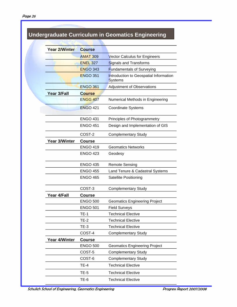
Year 2/Winter Course AMAT 309 Vector Calculus for Engineers ENEL 327 Signals and Transforms ENGO 343 Fundamentals of Surveying ENGO 351 Introduction to Geospatial Information
Systems ENGO 361 Adjustment of Observations
Year 3/Fall Course ENGG 407 Numerical Methods in Engineering
ENGO 421 Coordinate Systems
ENGO 431 Principles of Photogrammetry
ENGO 451 Design and Implementation of GIS
COST-2 Complementary Study
Year 3/Winter Course ENGO 419 Geomatics Networks
ENGO 423 Geodesy
ENGO 435 Remote Sensing
ENGO 455 Land Tenure & Cadastral Systems
ENGO 465 Satellite Positioning
COST-3 Complementary Study
Year 4/Fall Course ENGO 500 Geomatics Engineering Project
ENGO 501 Field Surveys
TE-1 Technical Elective
TE-2 Technical Elective
TE-3 Technical Elective
COST-4 Complementary Study
Year 4/Winter Course ENGO 500 Geomatics Engineering Project
COST-5 Complementary Study
COST-6 Complementary Study
TE-4 Technical Elective
TE-5 Technical Elective
TE-6 Technical Elective
Undergraduate Curriculum in Geomatics Engineering
Schulich School of Engineering, Geomatics Engineering Progress Report 2007/2008
Page 27
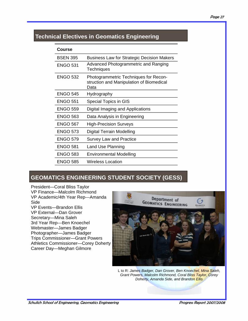
Course
BSEN 395 Business Law for Strategic Decision Makers
ENGO 531 Advanced Photogrammetric and Ranging Techniques
ENGO 532 Photogrammetric Techniques for Recon-struction and Manipulation of Biomedical Data
ENGO 545 Hydrography
ENGO 551 Special Topics in GIS
ENGO 559 Digital Imaging and Applications
ENGO 563 Data Analysis in Engineering
ENGO 567 High-Precision Surveys
ENGO 573 Digital Terrain Modelling
ENGO 579 Survey Law and Practice
ENGO 581 Land Use Planning
ENGO 583 Environmental Modelling
ENGO 585 Wireless Location
President—Coral Bliss Taylor VP Finance—Malcolm Richmond VP Academic/4th Year Rep—Amanda Side VP Events—Brandon Ellis VP External—Dan Grover Secretary—Mina Saleh 3rd Year Rep—Ben Knoechel Webmaster—James Badger Photographer—James Badger Trips Commissioner—Grant Powers Athletics Commissioner—Corey Doherty Career Day—Meghan Gilmore
L to R: James Badger, Dan Grover, Ben Knoechel, Mina Saleh, Grant Powers, Malcolm Richmond, Coral Bliss Taylor, Corey
Doherty, Amanda Side, and Brandon Ellis
Technical Electives in Geomatics Engineering
GEOMATICS ENGINEERING STUDENT SOCIETY (GESS)

Schulich School of Engineering, Geomatics Engineering Progress Report 2007/2008
Page 28
An important part of the undergraduate degree program in Geomatics Engineering is the field camp (ENGO 501). This two week camp is held at the Kananaskis Centre for Environmental Research, prior to the start of the Fall Session. It gives incoming fourth year students the opportunity to apply the knowledge and experience gained in the different areas of geomatics to an integrated practical project. In summer 2007, a record number of students attended Survey Camp. The Department of Geomatics Engineering would like to thank the following companies for their participation in the annual Survey Camp Equipment Day, or for the generous loan of equipment over the duration of Survey Camp: Butler Survey Supplies Ltd. Cansel Survey Equipment Spatial Technologies SAIT Polytechnic
Survey Camp 2007
GEOMATICS ENGINEERING SURVEY CAMP AT KANANASKIS
Schulich School of Engineering, Geomatics Engineering Progress Report 2007/2008
Page 29
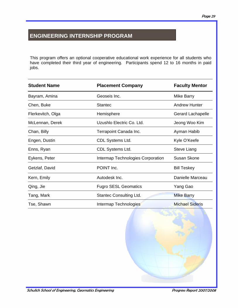
This program offers an optional cooperative educational work experience for all students who have completed their third year of engineering. Participants spend 12 to 16 months in paid jobs.
Student Name Placement Company Faculty Mentor
Bayram, Amina Geoseis Inc. Mike Barry
Chen, Buke Stantec Andrew Hunter
Flerkevitch, Olga Hemisphere Gerard Lachapelle
McLennan, Derek Uzushlo Electric Co. Ltd. Jeong Woo Kim
Chan, Billy Terrapoint Canada Inc. Ayman Habib
Engen, Dustin CDL Systems Ltd. Kyle O’Keefe
Enns, Ryan CDL Systems Ltd. Steve Liang
Eykens, Peter Intermap Technologies Corporation Susan Skone
Getzlaf, David POINT Inc. Bill Teskey
Kern, Emily Autodesk Inc. Danielle Marceau
Qing, Jie Fugro SESL Geomatics Yang Gao
Tang, Mark Stantec Consulting Ltd. Mike Barry
Tse, Shawn Intermap Technologies Michael Sideris
ENGINEERING INTERNSHIP PROGRAM
Schulich School of Engineering, Geomatics Engineering Progress Report 2007/2008
Page 30
ENGO 500 Special Presentations
The objective of the ENGO 500 group project course is the development of skills in cooperative research, report preparation and seminar presentation. Students plan and execute a project that must conform with professional requirements. The project must have design, measurement, analysis and presentation components. Submission and defense of progress reports and a final report are required.
Practical Offshore Project Management Bruce Calderbank Hydrographic Survey Consultants Intl. Ltd Projects at NovAtel Jonathan Auld NovAtel Inc. LiDAR Analysis on Power Lines Leannah Green Colt Geomatics The Human Factor in Management Mohamed Abousalem Hemisphere GPS GIS Project Management Gary Zhang MRF Geosystems Projects for Clearly Defined Problems and Wicked Problems Michael Barry University of Calgary
ENGO 500
Schulich School of Engineering, Geomatics Engineering Progress Report 2007/2008
Page 31
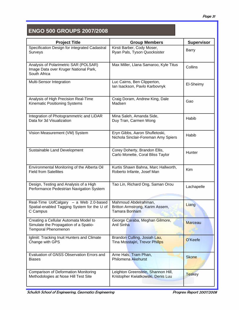
Project Title Group Members Supervisor Specification Design for integrated Cadastral Surveys
Kirsti Barber, Cody Moser, Ryan Pals, Tyson Quocksister Barry
Analysis of Polarimetric SAR (POLSAR) Image Data over Kruger National Park, South Africa
Max Miller, Llana Samaroo, Kyle Titus Collins
Multi-Sensor Integration Luc Cairns, Ben Clipperton, Ian Isackson, Pavlo Karbovnyk El-Sheimy
Analysis of High Precision Real-Time Kinematic Positioning Systems
Craig Doram, Andrew King, Dale Madsen Gao
Integration of Photogrammetric and LiDAR Data for 3d Visualization
Mina Saleh, Amanda Side, Duy Tran, Carmen Wong Habib
Vision Measurement (VM) System Eryn Gibbs, Aaron Shufletoski, Nichola Sinclair-Foreman Amy Spiers Habib
Sustainable Land Development Corey Doherty, Brandon Ellis, Carlo Monette, Coral Bliss Taylor Hunter
Environmental Monitoring of the Alberta Oil Field from Satellites
Kurtis Shawn Bahna, Marc Hallworth, Roberto Infante, Josef Man Kim
Design, Testing and Analysis of a High Performance Pedestrian Navigation System
Tao Lin, Richard Ong, Saman Orou Lachapelle
Real-Time UofCalgary – a Web 2.0-based Spatial-enabled Tagging System for the U of C Campus
Mahmoud Abdelrahman, Britton Armstrong, Karim Assem, Tamara Bonham
Liang
Creating a Cellular Automata Model to Simulate the Propagation of a Spatio-Temporal Phenomenon
George Caraba, Meghan Gilmore, Anil Sinha Marceau
Igliniit: Tracking Inuit Hunters and Climate Change with GPS
Brandon Culling, Josiah Lau, Tina Mosstajiri, Trevor Phillps O’Keefe
Evaluation of GNSS Observation Errors and Biases
Arne Hals, Tram Phan, Philomena Akehurst Skone
Comparison of Deformation Monitoring Methodologies at Nose Hill Test Site
Leighton Greenstein, Shannon Hill, Kristopher Kwiatkowski, Denis Luu Teskey
ENGO 500 GROUPS 2007/2008

Schulich School of Engineering, Geomatics Engineering Progress Report 2007/2008
Page 32
Career Day Participants 2008
AeroTec Alberta Geomatics Group
Alberta Land Surveyors' Association AltaLIS
Altus Ltd. Applanix Corporation
Association of BC Land Surveyors Autodesk
Caltech Surveys Ltd. Canadian Hydrographic Service
Canadian Institute of Geomatics Can-Am Geomatics Corp. CDL Systems Ltd. Challenger Geomatics Colt Engineering Corporation Focus Corporation Ltd.
Fugro SESL Geomatics Ltd. Global Surveys Group
Hemisphere GPS IBI Group Intermap Technologies Jones Geomatics Ltd.
Marshall Macklin, Monaghan Ltd. McElhanney Land Surveys Ltd.
Midwest Surveys Inc. Natural Resources Canada (Alberta)
Natural Resources Canada (Ontario) NavCom Technology, Inc.
NovAtel Inc. Point Inc.
Saskatchewan Land Surveyors Association SiRF Technology Inc.
Stantec Geomatics Ltd. Stewart, Weir & Co. Ltd.
The Orthoshop Trimble Navigation
Underhill Geomatics
On Thursday, February 7, 2008, the Geomatics Engineering Student’s Society and the Department of Geomatics Engineering hosted their twelfth annual Career Day. Career Day provides a forum for both companies and students to interact and discuss topics and career opportunities in the Geomatics industry. Several guest speakers made presentations on various topics throughout the day. In addition to these presentations, students and company representatives participated in the Industry Showcase, which was introduced to provide all participants with an opportunity to discuss careers in Geomatics. The Geomatics Engineering Student’s Society would like to thank all participants and sponsors for making this year’s Career Day a success.
GEOMATICS ENGINEERING CAREER DAY

Schulich School of Engineering, Geomatics Engineering Progress Report 2007/2008
Page 33
The number of graduate students remained fairly steady with a total of 115 students (96 full-time, 19 part-time). During the academic year 2007/2008, students were either enrolled in the graduate program or finishing their theses. Fifty-six were working towards their PhD degree, 49 towards their MSc degree and 10 towards their MEng degree. Students originated from 14 different countries. There were 20 students that graduated during the reporting period, 8 with a PhD degree, 9 with a MSc and three with a MEng. Details are given in the following tables.
Full-time PhD Students 2007/2008
Name Supervisor Name Supervisor Aggarwal, Priyanka El-Sheimy Megahed, Dina Reda Lachapelle/O’Driscoll
Al-Fanek, Ossama Skone Mongredien, Cecile Lachapelle/Cannon
Al-Rawas, Ghazi Valeo Moreno, Niandry Marceau
Anwar, Morshed Sk. Marceau Morrisen, Aiden Lachapelle/Cannon
Bang, Ki In Habib Muthuraman, Kannan Lachapelle/Klukas
Bhuiyan, Mohammad Lachapelle/Klukas Orlob, Martin Braun
Bian, Yong Mercer Raaflaub, Lynn Valeo
Broumandan, Ali Lachapelle/Nielsen Rangelova, Elena Sideris
Dabboor, Mohammed Braun Renganathan, Vid-yavathy Braun
Ebeling, Axel Teskey Sun, Debo Cannon/Petovello
El-Ghazouly, Ahmed El-Sheimy Syed, Zainab El-Sheimy
Ellum, Cameron El-Sheimy Tang, Feng Sideris/Gao
Gao, Jianchen Cannon Teskey, Wesley El-Sheimy
Gernot, Cyrille Lachapelle/O'Keefe Tiwari, Rajesh Skone
Goodall, Christopher El-Sheimy van der Wal, Wouter Sideris
Hassan, Taher El-Sheimy Wang, Fang Marceau
He, Jianxun Valeo Wang, Min Gao
Hunter, Andrew El-Sheimy Whittal, Jennifer Barry
Kersting, Ana Paula Habib Wijesekara, Gayan Marceau
Kim, Changjae Habib Xu, Chen Sideris
Konavattam, Surendran Lachapelle/Nielsen Xu, Feng Gao
Kwak, Eunju Habib Yang, Yong El-Sheimy
Lotafali Kazemi, Pejman
Lachapelle/O'Driscoll Youssef, Mohamed El-Sheimy/Noureldin
Macchi, Florence Lachapelle/Petovello Yuksel, Yigiter El-Sheimy Zhang, Chengqian Collins
GRADUATE STUDIES
Enrollment

Schulich School of Engineering, Geomatics Engineering Progress Report 2007/2008
Page 34
Name Supervisor Name Supervisor
MSc Students
Abbasiannik, Saloomeh Lachapelle/Petovello Kim, Kyoung-Min Habib
Abdolhosseini Moghad-dam, Ahmed Reza Lachapelle/Nielsen Knezevic, Aleksander Lachapelle
Al-Durgham, Mohannad Habib Kwakkel, Sidney P. Lachapelle/Cannon
Bancroft, Jared Brian Lachapelle/Cannon Li, Tao Lachapelle/Petovello
Butterworth, Carina M. Tait Liakopoulos, Alexandros Sideris
Cai, Changsheng Gao Liu, Hang ( Terry) El-Sheimy
Cao, Wei Cannon/O'Keefe Mahfuz, Mohammad Upal Lachapelle/Nielsen
Chandramouli, Magesh Huang/Gao Marji Qais Kamal Cannon
Chang, YuChuan Habib Muhsen, Abdel Rahman Barry
Chiu, David Sung – Tat O'Keefe Ni, Jingwen Couloigner
de Groot, Lance Skone/O'Keefe Omran, Nabila El-Sheimy/Habib
Detchev, Ivan Habib Osman, Mostafa El-Sheimy/Noureldin
Feng, Man Skone Robinson, Kerri L Valeo
Fraser, Scott Marceau Sadeque, Mohammed Skone
Ghafoori, Fatemeh Skone Salimi, Nazila Lachapelle/Nielsen
Hasbani, Jean-Gabriel Marceau Taghvakish, Sina Braun
Izadpanah, Ashkan Lachapelle/O'Driscoll Tao, Wenyou Gao
Jarvis, Anna Marie Habib Timmins, Tracy L. Hunter/Barry
Jha, Maya Nand Gao Yao, Donghua Lachapelle/Skone
Kassab, Ala’a Shawqi Gao/Liang Zhang, Zhan Blais
MEng Students
Alghamdi, Yousif Habib Khan, Muhammad A El-Sheimy
Anderson, Teresa El-Sheimy
Kersting, Juliano Habib Zhao, Xing (Bob) El-Sheimy
Kieser, Michael E. J. Marceau Zheng, Botao ( Shirley) Marceau
Full-Time MSc and MEng Students 2007/2008

Schulich School of Engineering, Geomatics Engineering Progress Report 2007/2008
Page 35
Part-time Graduate Students 2007/2008
Name MEng MSc PhD Supervisor Ali, Ibraheem 1 Braun/Sideris
Bobey, Michael James 1 El-Sheimy
Charkhand, Betash 1 El-Sheimy
Ching, Kwan Kit ( Stephen) 1 Cannon
MacGougan, Glenn Donald 1 O'Keefe/Klukas
El-Gizawy, Mahmoud L 1 El-Sheimy
Garin, Lionel Jacques Joseph 1 Lachapelle
Guo, Libing 1 Huang/Blais
Joseph, Angelo 1 Lachapelle
Kent, Steve 1 Blais
Nicholson, Natalya 1 Skone/Cannon
Radons, Charlene Marcia 1 Skone/O'Keefe
Srajer, Peter 1 Lachapelle
Tsoi, Raymond 1 Cannon
Wu, Sally Xia 1 Habib
Zhang, Huasiu (Larry) 1 Blais/Collins
Zhang, Hongmin (Holly) 1 Collins
Zheng, Bo 1 Lachapelle
Total 7 5 7
Name Degree Date Graduate Thesis Title Co-
Supervisor Dept/Institution
Alexander Ebner MSc Apr 08
On the attainable accuracy of multi-system GNSS positioning in high-
multipath urban environments Lachapelle Technical
University Graz.
Daniele Borio PhD Apr 08 A Statistical Theory for GNSS
Signal Acquisition Lachapelle
Dipartimento di Elettronica,
Politecnico di Torino.
P. Gaggero MSc Feb 08 Effect of oscillator instability on
GNSS signal integration time Lachapelle University of Neuchâtel
Dingchen Lu PhD Jul 07 Multipath Mitigation in TOA
Estimation Based on AOA Lachapelle Dept of Electrical
& Computer Engg, U of C
Erol Bihter PhD Jul 07 Investigations on local geoids for geodetic applications Sideris
Istanbul Technical University
Part-Time Graduate Students 2007/2008
External Convocants Supervised by ENGO Faculty

Schulich School of Engineering, Geomatics Engineering Progress Report 2007/2008
Page 36
Name Degree Date Graduate Thesis Title Supervisor
Carina Butterworth MSc Jun-08 Measuring Permafrost Deformation Caused by
Climate Change Using Differential Interferometric Synthetic Aperture Radar
Tait
Cécile Mongrédien PhD Jun-08 GPS L5 Software Receiver Development for High-Accuracy Applications
Lachapelle/Cannon
Niandry Moreno PhD Jun-08 A Vector-based Geographical Cellular Automata Model to Mitigate Scale Sensitivity and to Allow
Objects’ Geometric Transformations Marceau
Yong Yang PhD Jun-08 Tightly Coupled MEMS INS/GPS Integration with INS Aided Receiver Tracking Loops El-Sheimy
Jean Gabriel Hasbani MSc Jun-08
Semi-Automatic Calibration of a Cellular Automata Model to Simulate Land-use Changes
in the Calgary Region Marceau
Qais K. Marji MSc Jun-08 Precise Relative Navigation for Satellite Formation Flying Using GPS Cannon
Peter Srajer MEng Jun-08 n/a Lachapelle
Ahmad Reza Abdolhosseini Moghaddam
MSc Jun-08 Enhanced Cellular Network Positioning Using Space-Time Diversity
Lachapelle/Nielsen
Xia ( Sally) Wu MEng Jun-08 n/a Habib
Magesh Chandramouli MSc Nov-07
Integration of GA-Based Multiobjective Optimization with VR-Based Visualization to
Solve Landuse Problems Huang/Gao
Mohannad Al-Durgham MSc Nov-07 Alternative Methodologies for the Quality Control
of LiDAR Systems Habib
Andrew Hunter PhD Nov-07 Sensor Based Animal Tracking El-Sheimy
Kerri L. Robinson MSc Nov-07 Modeling Aquatic Vegetation and Dissolved Oxygen in the Bow River, Alberta Valeo
Surendran Konavattam Shanmugam
PhD Nov-07 New High Sensitivity Detection Techniques for GPS L1 C/A and Modernized Signal Acquisition
Lachapelle/Nielsen
Chen Xu PhD Nov-07 The Torus-Based Semi-Analytical Approach in Spaceborne Gravimetry Sideris
Elena Rangelova PhD Nov-07 A Dynamic Geoid Model for Canada Sideris
Donghua Yao MSc Nov-07 Interference Effects on GPS L2C Signal Acquisition and Tracking
Lachapelle/Skone
Raymond Tsoi MSc Nov-07 Precise GPS Relative Navigation for Future Geodetic Satellite Formation Flying Missions Cannon
Teresa Anderson MEng Nov-07 n/a El-Sheimy
Jianchen Gao PhD Nov-07 Development of a Precise GPS/INS/On-board
Vehicle Sensors Integrated Vehicular Positioning System
Cannon
Graduate Studies Convocants 2007/2008

Schulich School of Engineering, Geomatics Engineering Progress Report 2007/2008
Page 37
Graduate Seminars 2007/2008 SPEAKER TOPIC
Michael Kieser Multi-agent modeling to understand stakeholders’ land-use decisions in a residential land development project in Southern Alberta
David Chiu UWB Assisted GPS RTK in Hostile Environments Cyrille Gernot Comparison Of L1 C/A L2c Combined Acquisition Techniques Aiden Morrison Embedded GNSS Receiver-Acquision Failure Due to Thermal Variation Florence Macchi Development New Algorithms Of Acquisition For Galileo L1, Testing Using Real
Data And Statistical Analysis Changjae Kim Integration of photogrammetric and LiDAR data for more complete surface
description Ki In Bang Lidar System Calibration Using Planar Patches Taher Hassan Common Adjustment of Land-based and Airborne Mobile Mapping System Data Cecile Mongredien GPS L5 Software Development for High-Accuracy Applications Debo Sun GPS/Reduced IMU with a Local Terrain Predictor in Land Vehicle Navigation Carina Butterworth Measuring Permafrost Deformation caused by Climate Change using DInSAR Ali Broumandan Angle of Arrival Estimation and Beamforming in Wireless Geolocation Systems Chris Goodall Intelligent Integration of a MEMS IMU with GPS using a Reliable Weighting
Scheme Vidya Renganathan Arctic Sea Ice Freeboard Heights from Satellite Altimetry Cheng Zhang Integrating Image Texture Into Individual Tree Crown Classification On Airborne
MEIS Imagery Cecile Mongredien Real-Time Attitude Determinations Using Dual-Frequency Receivers Jingwen Ni Assessing SO2-Stressed Lodgepole Pine Needles Using Hyperspectral
Reflectance near gas plants in Elbow Valley, Calgary Sk. Morshed Anwar Multi-agent model to simulate the impact of human activities on wolf behavior in
the Banff National Park (BNP) in Alberta, Canada Wenyao Tao Real-time Water Vapor Sensing/Measurements with Precise Point Position
Algorithm And Canadian Geodetic (GPS) Network Yong Yang Tight MEMS IMU/GPS Integration With IMU Aided Receiver Tracking Loop Niandry Moreno Implementation Of A Dynamic Neighborhood In A Land-Use Vector-Based
Geographic Cellular Automata Model Magesh Chandramouli IntegraIntegration of GA-based multiobjective optimization with VR-based
visualization to solve landuse problems Mohannad Al-Durgham Error Analysis and Alternative Methodologies for the Quality Control of LiDAR
Systems Lance de Groot Investigation of radio occultation techniques for Canadian applications Jennifer He Stormwater reuse for irrigation Nazila Salimi Ahmad Abdolhosseini Moghaddam
Enhanced Cellular Network Positioning using Space-Time Diversity
Andrew Hunter A New Technology Solution for the Study of Bear Movement and Habitat Use
Elena Rangelova Models of Time-Variable Geoid and Orthometric Heights for a Dynamic Vertical Datum in Canada
Qais Marji Satellite Formation Flying
Zainab Syed Economical and Robust Inertial Sensor Configuration for a Portable Navigation System
Graduate Seminars 2007/2008

Schulich School of Engineering, Geomatics Engineering Progress Report 2007/2008
Page 38
Research is an integral part of Department activities. It allows individual faculty members to stay at the leading edge of their area of specialization and to apply their knowledge to current problems in industry and government. It also provides funding for research associates and graduate students. It thus supports the education of highly trained future engineers and the teaching activities of the Department. Direct research funding for this report year was at $3,945,137.
0
500,0001,000,000
1,500,0002,000,000
2,500,000
3,000,0003,500,000
4,000,0004,500,000
5,000,000
02/03 03/04 04/05 05/06 06/07 07/08
University of CalgaryForeignGrants-FedIndustryProvincial & MunicipalFederal ContractsNSERC
RESEARCH
Research Statistics
Direct Research Funding by Source 2002/03—2007/08

Schulich School of Engineering, Geomatics Engineering Progress Report 2007/2008
Page 39
Research Grants and Contracts for the Period April 1, 2007 – March 31, 2008
Source Amount
NSERC $1,034,640
Federal Government Contracts 324,004
Federal – Grants 1,159,650
Provincial and Municipal Government 747,929
Industry 369,106
Foreign Agencies 243,612
University of Calgary 66,197
Direct Research Support $3,945,137
Research Scholarships $363,317
Total Research Support $4,308,454
The figure on the previous page shows direct research funding for the last six years and the one below shows the research funding by source for 2007/2008
Direct Research Funding by Source 2007/08
Grants-Federal, 30%
U of C, 2%
Provincial 21%
Federal 22%
NSERC 21%Foreign 9%
Industry 8%
Schulich School of Engineering, Geomatics Engineering Progress Report 2007/2008
Page 40
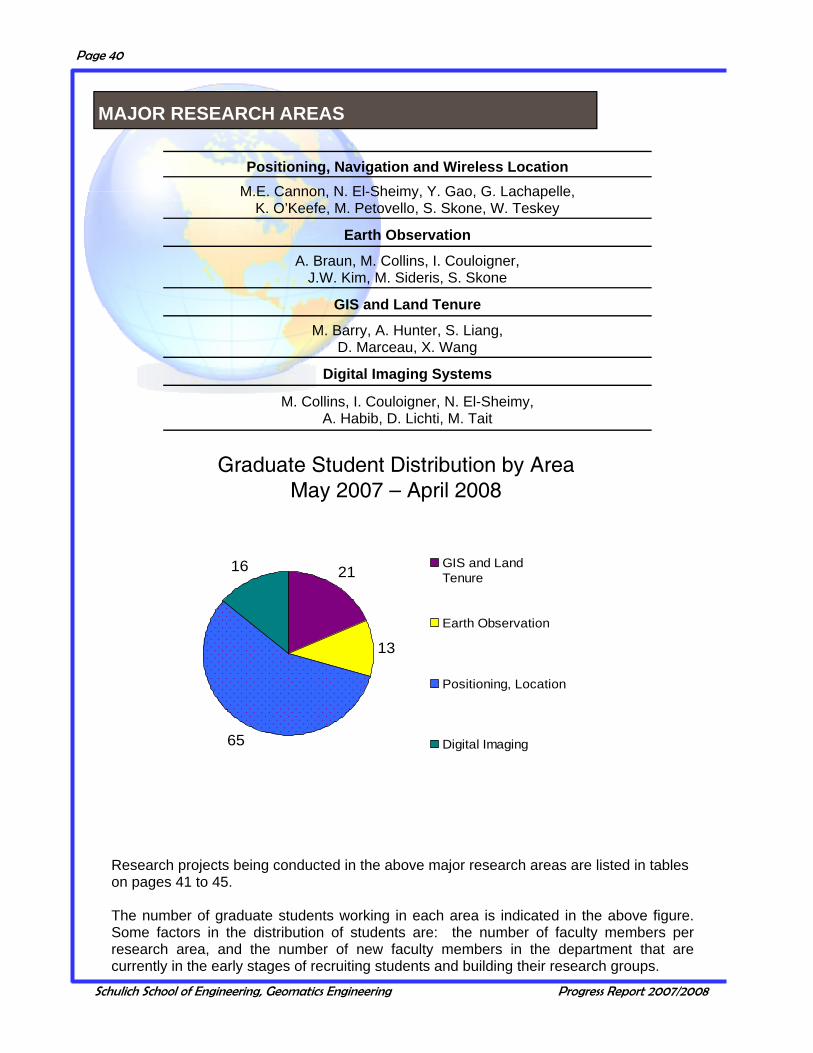
Positioning, Navigation and Wireless Location
M.E. Cannon, N. El-Sheimy, Y. Gao, G. Lachapelle, K. O’Keefe, M. Petovello, S. Skone, W. Teskey
Earth Observation
A. Braun, M. Collins, I. Couloigner, J.W. Kim, M. Sideris, S. Skone
GIS and Land Tenure
M. Barry, A. Hunter, S. Liang, D. Marceau, X. Wang
Digital Imaging Systems
M. Collins, I. Couloigner, N. El-Sheimy, A. Habib, D. Lichti, M. Tait
Graduate Student Distribution by AreaMay 2007 – April 2008
21
13
65
16 GIS and LandTenure
Earth Observation
Positioning, Location
Digital Imaging
Research projects being conducted in the above major research areas are listed in tables on pages 41 to 45. The number of graduate students working in each area is indicated in the above figure. Some factors in the distribution of students are: the number of faculty members per research area, and the number of new faculty members in the department that are currently in the early stages of recruiting students and building their research groups.
MAJOR RESEARCH AREAS

Schulich School of Engineering, Geomatics Engineering Progress Report 2007/2008
Page 41
Project Name Contract
Type Faculty
Investigators A National System for Water Vapour Estimation Using GPS and its Applications Federal Y. Gao
S. Skone
ASW-GPS and Ionospheric R&D Support Foreign S. Skone
G. Lachapelle M.E. Cannon
CRC—Faculty Support U of C N. El-Sheimy CRC Federal N. El-Sheimy Dept./Schulich School of Engineering Starter Grant U of C M. Petovello
Development of a Meteorological Probe for Aircraft Federal N. El-Sheimy S. Skone
Development of a Two Component Personal Navigation System Federal N. El-Sheimy
A. Hunter Development of a Humidity and Temperature Probe with MEMS-based Inertial Ref. for Aircraft Use Industry N. El-Sheimy
Development of Reconfigurable GNSS Software Receivers Federal
M.E. Cannon G. Lachapelle M. Petovello
Fast Convergence of Precise Point Positioning Federal Industry Y. Gao
Geo-Intelligent Collaborative Decision Support System for Real-Time Disaster & Emergency Management Industry Y. Gao
Geomatics Enhancements with Dual Use of GPS II/III and Galileo: High Accuracy Position with GPS & Galileo
Federal
G. Lachapelle M.E. Cannon
Y. Gao N. El-Sheimy
R. Klukas
Adaptive and Flexible GNSS Technology Development for Automotive Systems
NSERC Provincial
Industy
G. Lachapelle K. O’Keefe
M. Petovello
Alpine Canada Alpine Sponsorship Agreement Industry G. Lachapelle
Alberta Ingenuity Fund - Research Allowance-Studentship Provincial K. O’Keefe
General Research Area of Wireless Location Foreign G. Lachapelle
COC Project Industry G. Lachapelle
iCORE Chair in Wireless Location Provincial G. Lachapelle
Integrated Vehicle Navigation of Communication Systems Development Federal M.E. Cannon
G. Lachapelle
Integration of Kinematic GPS with Emerging Inertial Measurement NSERC M.E. Cannon
Intelligent Information Infrastructure for Wireless Multi-Sensor Motes Applications
NSERC Industry N. El-Sheimy
Projects in Positioning, Navigation and Wireless Location

Schulich School of Engineering, Geomatics Engineering Progress Report 2007/2008
Page 42
Project Name Contract Type
Faculty Investigators
Intelligent Structural Monitoring Project NSERC W. Teskey N. El-Sheimy
Intelligent Structural Monitoring Industry W. Teskey
Market Study and Business Model Project for M2G Mobile Mapping Federal N. El-Sheimy
Mitigation of Atmospheric Effects on GNSS NSERC S. Skone
Multi-Sensor Motes Amplification Industry N. El-Sheimy Multi-Sensor Navigation Systems Federal N. El-Sheimy Multi-Sensor System for Improved Quality of Life Federal N. El-Sheimy
Next Generation Direct Geo-Referencing Technology for Airborne Mapping NSERC N. El-Sheimy
Y. Gao
Observation and Modelling of Radio Frequency Propagation for Improved Wireless Location in Urban and Indoor Environments
NSERC K. O'Keefe
Performance Analysis of Multiple Global Navigation Satellite Systems NSERC G. Lachapelle
Proposal for Galileo Ground Station in Calgary Industry G. Lachapelle
Receiver Testing Industry Y. Gao Signal Tracking and Measurement Infrastructure to Support Wireless Location and Communications Research
Federal G. Lachapelle M. E. Cannon
Space Weather Hazards: Monitoring & Mitigation NSERC S. Skone G. Lachapelle
Triple Carrier Attitude Determination with GPS and Galileo Foreign
G. Lachapelle K. O’Keefe
M. Petovello
Turtle Mountain Deformation Monitoring Provincial W. Teskey
Ultra-Tight Software HSGPS/INS Receiver Phase II Federal G. Lachapelle M. Petovello
Wireless Location in Geomatics with the Emerging GPS II/III and Galileo Systems Federal G. Lachapelle
M.E. Cannon
Wireless Location with GPS II/III and Galileo Federal G. Lachapelle M.E. Cannon
Projects in Positioning, Navigation and Wireless Location, continued

Schulich School of Engineering, Geomatics Engineering Progress Report 2007/2008
Page 43
Project Name Contract Type
Faculty Investigators
Analysis of Forest Stand Structure Using Spatial Characteristics of High-resolution Image Data Provincial M. Collins
Canadian Altimetry Database and Processing System (CADS) Federal A. Braun
Climate Variability and its Impact on Hydrology of small Mid-Continent Lakes and Wetlands Foreign A. Braun
Electromagnetic Land Surface Classification for Optimal Mobile Communication Modeling Provincial J.W. Kim
Mapping the Ocean Surface with Geodetic and Oceanographic Tools Federal
J.A.R. Blais A. Braun
M. Sideris Monitoring Air Pollutants Using Thermal IR Camera NSERC I. Couloigner Multi-Satellite Determination of Global and Regional GEOIDE and Sea Level Changes NSERC M. Sideris
Quantification of Sea Ice Thickness and Surface Water Levels in the Arctic Ocean and Canada Using Satellite Altimetry
NSERC A. Braun
Risk Reduction Through Continuous Geodetic Monitoring NSERC M. Sideris
Space Gravimetry Contributions to Earth Monitoring Federal M. Sideris A. Braun
Uncertainty Management in Environmental Modelling NSERC M. Collins
Elena Rangelova successfully defended her PhD thesis
Mohannad Al-Durgham successfully defended his MSc thesis
Projects in Earth Observation
Schulich School of Engineering, Geomatics Engineering Progress Report 2007/2008
Page 44
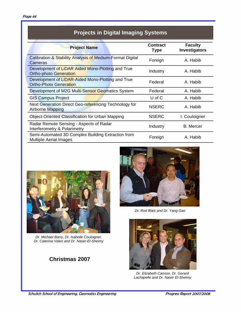
Calibration & Stability Analysis of Medium-Format Digital Cameras Foreign A. Habib
Development of LiDAR Aided Mono-Plotting and True Ortho-photo Generation Industry A. Habib
Development of LiDAR-Aided Mono-Plotting and True Ortho-Photo Generation Federal A. Habib
Development of M2G Multi-Sensor Geomatics System Federal A. Habib GIS Campus Project U of C A. Habib Next Generation Direct Geo-referencing Technology for Airborne Mapping NSERC A. Habib
Object-Oriented Classification for Urban Mapping NSERC I. Couloigner
Radar Remote Sensing - Aspects of Radar Interferometry & Polarimetry Industry B. Mercer
Semi-Automated 3D Complex Building Extraction from Multiple Aerial Images Foreign A. Habib
Project Name Contract Type
Faculty Investigators
Dr. Rod Blais and Dr. Yang Gao
Dr. Elizabeth Cannon, Dr. Gerard Lachapelle and Dr. Naser El-Sheimy
Dr. Michael Barry, Dr. Isabelle Couloigner, Dr. Caterina Valeo and Dr. Naser-El-Sheimy
Christmas 2007
Projects in Digital Imaging Systems
Schulich School of Engineering, Geomatics Engineering Progress Report 2007/2008
Page 45
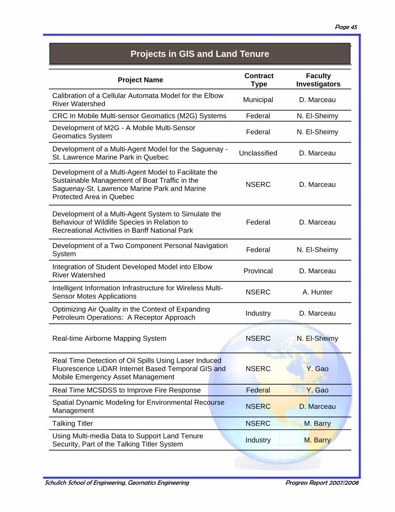
Calibration of a Cellular Automata Model for the Elbow River Watershed Municipal D. Marceau
CRC In Mobile Multi-sensor Geomatics (M2G) Systems Federal N. El-Sheimy
Development of M2G - A Mobile Multi-Sensor Geomatics System Federal N. El-Sheimy
Development of a Multi-Agent Model for the Saguenay - St. Lawrence Marine Park in Quebec Unclassified D. Marceau
Development of a Multi-Agent Model to Facilitate the Sustainable Management of Boat Traffic in the Saguenay-St. Lawrence Marine Park and Marine Protected Area in Quebec
NSERC D. Marceau
Development of a Multi-Agent System to Simulate the Behaviour of Wildlife Species in Relation to Recreational Activities in Banff National Park
Federal D. Marceau
Development of a Two Component Personal Navigation System Federal N. El-Sheimy
Integration of Student Developed Model into Elbow River Watershed Provincal D. Marceau
Intelligent Information Infrastructure for Wireless Multi-Sensor Motes Applications NSERC A. Hunter
Optimizing Air Quality in the Context of Expanding Petroleum Operations: A Receptor Approach Industry D. Marceau
Real-time Airborne Mapping System NSERC N. El-Sheimy
Real Time Detection of Oil Spills Using Laser Induced Fluorescence LiDAR Internet Based Temporal GIS and Mobile Emergency Asset Management
NSERC Y. Gao
Real Time MCSDSS to Improve Fire Response Federal Y. Gao
Spatial Dynamic Modeling for Environmental Recourse Management NSERC D. Marceau
Talking Titler NSERC M. Barry
Using Multi-media Data to Support Land Tenure Security, Part of the Talking Titler System Industry M. Barry
Project Name Contract Type
Faculty Investigators
Projects in GIS and Land Tenure

Schulich School of Engineering, Geomatics Engineering Progress Report 2007/2008
Page 46
Barry, M., Talking Titler Object Manager; Surveyor General of Canada. 4 licences Barry M., Talking Titler Object Manager; Lagos State Government, Director of Land
Regularization, Nigeria. 4 licences Barry, M., 2008 June Talking Titler Object Manager, Diane Dumashie Ellum, C., and N. El-Sheimy, BUNDLE Software— software package that performs
self-calibrating Photogrammetric BundleTM adjustments and terrestrial network adjustments. Licensed by University Technologies International.
Gao, Y., iVCAMS3, 2005, Software applied to support the following public events: 1) 2005 North America Solar Challenge 2) 2005 Sea to Sea Bike Tour.
Gao, Y., P3(R), 2005, Software licensed to major airborne mapping and land/marine surveys companies in North America and Asia.
Gao, Y., Precise point positioning, P3TM, 2004, Licensed to several companies. Gao, J., M.E. Cannon, M. Petovello, K. Nagamiya, I. Maeda and K. Kagawa, (2007),
Vehicular Navigation and Positioning System, Publication December 17, 2007, US Patent # WO 2007/143806 A2.
Habib, A., Stereo-Measure, 2004, software developed for ENGG 253 (Engineering Design II).
Habib, A., Calibration and Stability Analysis of Medium-Format Digital Cameras, 2006. Licensed by University Technologies International (Reference Number 725.1).
Hunter, AJS., N. El-Sheimy, G. Stenhouse, B. Wright (2007) Multi-sensor Systems for Animal Tracking Applications.
Hunter, AJS., N. El-Sheimy, Z. Syed, B. Wright (2007) Portable Navigation Systems. Lachapelle, G, M. Petovello and C. O'Driscoll (2007) GSNRx™ - GNSS Software
Receiver. Developed by the PLAN Group Petovello, M. and G. Lachapelle (2006) Efficient New Method of Performing Doppler
Removal and Correlation Computations. Patent filed in 2006. Petovello, M., M.E. Cannon and G. Lachapelle, C3NAVG2™- Combination of Code
and Carrier Phase for Navigation using GPS and GLONASS. Licensed by University Technologies International.
Petovello, M., M.E. Cannon and G. Lachapelle, SAINT™- software for the integration of GPS and low cost inertial navigation systems. Licensed by University Technologies International, a wholly-owned subsidiary of the University of Calgary.
Petovello, M.G. and G. Lachapelle, GNSS Software Navigation Receiver (GSNRx™) - Post-mission software-based GNSS receiver.
Schwarz, KP and N. El-Sheimy, KINGSPAD (KINematic Geodetic System for Positions and Attitude Determination) Software. A GPS/INS Integration Software for Navigation and Mapping Applications (www.kingspad.com). Licensed by University Technologies International.
Shin, E. and N. El-Sheimy, AINSTM—Aided Inertial Navigation Software, Matlab Tool Box for GNSS/INS Integration using EKF, UKF, and Backward Smoothing. Licensed by University Technologies International.
Sideris, M., FFTGEOID™ - Geoid Determination Software licensed by the Hydrographic and Oceanographic Department, Japan Coast Guard, through University Technologies International.
Skone, S., TECMODEL Software, Licensed by University Technologies International. Yang, Yong and N. El-Sheimy, Inertial Simulator—An Inertial Navigation Simulation
Tool, 2007. Licensed by University Technologies International.
LICENSES AND PATENTS
Schulich School of Engineering, Geomatics Engineering Progress Report 2007/2008
Page 47
PUBLICATIONS
Books and Chapters
Refereed Journals
Kim, J.W., C.K. Shum, B. Chao (Guest Edited) (2008) Earth, Planets and Space - Special Issue ‘Geohazards and the Role of Space-Born Observations’, 60(5): 447-528, ISSN 1343-8832.
Marceau, D.J., A. Ménard et N. Moreno, (2008) Les automates cellulaires appliqués à la simulation des changements d’utilisation du sol: Sensibilité à l’échelle spatiale et temporelle. Dans: Information géographique et dynamiques urbaines, vol 1 Thériault, M. et F. Desrosiers, eds, Lavoisier–Hermes Science Publication, pp 227-251.
Anwar, M., C. Jeanneret, L. Parrott, D.J. Marceau (2007) Conceptualization and implementation of a multi-agent model to simulate whale-watching activities in the St. Lawrence estuary in Quebec, Canada. Environmental Modeling and Software, 22: 1775-1787 Article ID 246703, 14 pages (doi:10.1155/2008/246703).
Asgharzadeh, M.F., R.R.B. von Frese, H.R. Kim, T.E. Leftwich, J.W. Kim, (2007) Spherical prism gravity effects by Gauss-Legendre quadrature integration, Geophysical Journal International, 169(1): 1–11.
Bae, K.-H., D. Belton, D.D. Lichti (2007) Pre-processing procedures for raw point clouds from terrestrial laser scanners. Journal of Spatial Science, 52(2): 41-50.
Bae, K.-H., D.D. Lichti (2008) A method for automated registration of unorganized point clouds. ISPRS Journal of Photogrammetry and Remote Sensing, 63(1): 36-54.
Barry M, D. Dewar, J. Whittal, I. Muzondo (2007) Land Conflicts in Informal Settlements: Wallacedene in Cape Town, South Africa. Urban Forum, 18(3): 171-189.
Barry M., (2007) Boundary Systems in Post Apartheid Urban Settlements in Cape Town. Surveying and Land Information Science, 67(2): 75-86.
Barry M., (2007) Post Conflict Boundary Systems: Browns Farm, Cape Town. Zeitschrift für Vermessungswesen. Heft 1 132.Jahrgang, 26–31.
Braun, A., C.-Y. Kuo, C.K. Shum, P. Wu, W. van der Wal, G. Fotopoulos (2008) Glacial Isostatic Adjustment in the Transition Zone: Models vs. Observations in the Great Lakes Region, Journal of Geodynamics, doi:10.1016/j.jog.2008.03.005.
Braun, A., G. Fotopoulos (2007) Accuracy Assessment of SRTM, ICESat, and Survey Control Monument elevations of multi-faceted terrain in Alberta, Photogrammetric Engineering & Remote Sensing, 73(12): 1333-1342.
Braun, A., H. R. Kim, B. Csatho, R. von Frese (2007) Gravity-inferred crustal thickness of Greenland, Earth Planet. Science Letters., 262: 138-158, doi:10.1016/j.epsl.2007.07.050.
Cai, C., Y. Gao (2008) Precise Point Positioning Using Combined GPS and GLONASS Observations. Journal of Global Positioning Systems, 6(1):.13-22.
Cheng, R., A. Habib (2007) Stereo-Photogrammetry for Generating and Matching Facial Models. Optical Engineering Journal, 46(7) 067203/1 - 067203/11.
Chiang K-W, A. Noureldin, N. El-Sheimy (2008) Developing a Low Cost MEMS IMU/GPS Integration Scheme Using Constructive Neural Networks. IEEE Transactions on Aerospace and Electronic Systems, 44(2): 582–594.
Schulich School of Engineering, Geomatics Engineering Progress Report 2007/2008
Page 48
El-Sheimy, N., H. Hou, X, Niu (2008) Analysis and Modeling of Inertial Sensors Using Allan Variance. IEEE Transaction on Instrumentation and Measurement, 57(1): 140–149.
Gao, J., M.G. Petovello, M.E. Cannon (2007) GPS/Low Cost IMU/On-Board Vehicle Sensors Integrated Land Vehicle Positioning System, EURASIP Journal on Embedded Systems, Special Issue on Embedded Systems for In te l l i gen t Veh ic l es , www.h indaw i . com/Ge tA r t i c l e . aspx?doi=10.1155/2007/62616, 14 pp.
Godha, S., G. Lachapelle (2008) Foot Mounted Inertial System for Pedestrian Navigation. Measurement Science and Technology, 19 075202 (9pp) (doi:10.1088/0957-0233/19/7/075202)
Gordon, S.J., D.D. Lichti (2007) Modeling terrestrial laser scanner data for precise structural deformation measurement. ASCE Journal of Surveying Engineering, 133(2): 72-80.
Habib, A., S. Shin, K. Kim, C. Kim, K. Bang, E. Kim, D. Lee (2007) Comprehensive Analysis of Sensor Modeling Alternatives for High Resolution Imaging Satellites. Photogrammetric Engineering & Remote Sensing 73(11): 1241-1251.
Huang, D., H. Leung, N. El-Sheimy (2007) Expectation Maximization Based GPS/INS Integration for Land-Vehicle Navigation. IEEE Transactions on Aerospace and Electronic Systems 43(3).
Jha, N., J. Levy Y. Gao (2008) Advances in Remote Sensing for Oil Spill Disaster Management: State-of-the-Art Sensors Technology for Oil Spill Surveillance, Sensors, 8, pp. 236-255.
Kim, J.W., B.Y. Lee (2007) Estimating Polar Marine Free-air Gravity Anomalies from Dense Radar Altimeter Data, Geosciences Journal, 11(4): 369-376.
Kim, J.W., D.R. Roman, B.Y. Lee, Y. Kim (2008) Altimetry Enhanced Free-air Gravity Anomalies in the High Latitude Region, Terrestrial, Atmospheric and Ocean Science, 19(1-2): 111-116.
Kim, J.W., J.S. Hwang, R.R.B. von Frese, H.R. Kim, S. Lee (2007) Geomagnetic field modeling from satellite attitude control magnetometer measurements, J o u r n a l o f G e o p h ys i c a l R e s e a r c h , 1 1 2 , B 0 5 1 0 5 , doi:10.1029/2005JB004042.
Kim, S.W., S. Wdowinski, T.H. Dixon, F. Amelung, J.S. Won, J.W. Kim (2008) InSAR-based Mapping of Surface Subsidence using JERS-1 and ENVISAT data in Mokpo City, Korea, Earth, Planets, & Space, 60: 453-461.
Kim, T.H., J. Neumeyer, I. Woo, H.J. Park, J.W. Kim (2007) Installation and Data Analysis of Superconducting Gravimeterin MunGyung, Korea: Preliminary Results, Journal of Korean Economic Environmental Geology, 40(4): 445-459.
Kopp, E.B., M.J. Collins (2007) On the Design and Evaluation of Multi-Objective Single Channel SAR Image Segmentation Algorithms. IEEE Transactions on Geoscience and Remote Sensing, 46(6): 1836-1846
Kuo, C.-Y., C.K. Shum, A. Braun, K.-C.Cheng, Y. Yi, (2008) Vertical motion determined by using satellite altimetry and tide gauges, Terrestrial Atmospheric and Ocean Sciences, 19(1-2).
Kuo, C.-Y., C.K. Shum, J. Guo, Y. Yi, A. Braun, I. Fukumori, K. Matsumoto, T. Sato, K. Shibuya (2008) Southern Ocean mass variation studies using GRACE and satellite altimetry, Earth Planets and Space, 60: 477-485.
Kuusniemi, H., A. Wieser, G. Lachapelle, J. Takala (2007) User-level Reliability Monitoring in Urban Personal Satellite-Navigation. IEEE Transactions on Aerospace and Electronic Systems, 43(4): 1305-1318.
Lee, H., C.K. Shum, C.-Y Kuo, Y. Yi, A Braun (2008) Application of TOPEX Altimetry for Solid Earth Deformation Studies. Terrestrial Atmospheric and Ocean Science, 19 (1-2).
Schulich School of Engineering, Geomatics Engineering Progress Report 2007/2008
Page 49
Lee, J., K. Yu, Y. Kim, A. Habib (2007) Adjustment of Discrepancies between LI-DAR Data Strips Using Linear Features. IEEE Geoscience and Remote Sensing Letters, 4(3): 475-479.
Liang, S.H.L., (2007) Introduction to the Spatial Sensor Web and Its Applications, Journal of Science Development, National Science Council, Taiwan, Au-gust ISSN: 0250-1651.
Lichti, D.D. (2008) A method to test differences between additional parameter sets with a case study in terrestrial laser scanner self-calibration stability analysis. ISPRS Journal of Photogrammetry and Remote Sensing, 63(2): 169-180.
Lichti, D.D., N. Pfeifer, H.-G. Maas, (2008) Editorial: theme issue “Terrestrial Laser Scanning”. ISPRS Journal of Photogrammetry and Remote Sensing, 63(1): 1-3.
Mitishita, E., A. Habib, J. Centeno, A. Machado, J. Lay, C. Wong (2008) Photo-grammetric and LiDAR Data Integration Using the Centroid of a Rectangular Roof as a Control Point. The Photogrammetric Record 23(121): 1-18.
Moreno, N., A. Ménard, D.J. Marceau (2008) VecGCA: A vector-based geographic cellular automata model allowing geometric transformations of polygons. Envi-ronment and Planning B, 35: 647-665.
Nassar, S., X. Niu, N. El-Sheimy (2007) Land-Vehicle INS/GPS Accurate Position-ing During GPS Signal Blockage Periods. Journal of Surveying Engineering (JSE), the American Society of Civil Engineers (ASCE). 133(3): 134-143.
Park, M., Y. Gao (2008) Error and Peformance Analysis of MEMS-based Inertial Sensors with a Low-cost GPS Receiver. Sensors 8, pp. 2240-2261.
Petovello M.G., G. Lachapelle (2008) Centimeter-Level Positioning Using an Effi-cient New Baseband Mixing and De-Spreading Method for Software GNSS Receivers, European Association for Signal Processing (EURASIP) Interna-tional Journal on Advances in Signal Processing (JASP), Article ID 194276, 12 pages, doi: 10.1155/2008/194276.
Petovello, M.G., K. O’Keefe, G. Lachapelle, M.E. Cannon (2008) Consideration of time-correlated errors in a Kalman filter applicable to GNSS, Journal of Ge-odesy, Springer-Verlag, 6 pages, DOI: 10.1007/s00190-008-0231-z http://dx.doi.org/10.1007/s00190-008-0231-z.
Potts, L.V., A. Akyilmaz, A. Braun, C.K. Shum (2008) Multi-resolution Dune Mor-phology using Shuttle Radar Topography Mission (SRTM) and Dune Mobility from Fuzzy Inference Systems using SRTM and Altimetric data. Int. J. Re-mote Sensing, 29(10), 2879-2901.
Rangelova, E., M.G. Sideris (2008) Contributions of terrestrial and GRACE data to the study of the secular geoid changes in North America. Journal of Geody-namics 46: pp 131-143.
Rangelova, E., W. van der Wal, A. Braun, M.G. Sideris, P. Wu (2007) Analysis of GRACE time-variable mass distribution signals over North America by means of principle component analysis, J. Geophys. Res., 112(F3) F03002 0.1029/2006JF000615.
Shanmugam, S., C. Mongrédien, J. Nielsen, G. Lachapelle (2008) Design of Short Synchronization Codes for Use in Future GNSS Systems. International Jour-nal of Navigation and Observation
Shin, S., A. Habib, M. Ghanma, C. Kim, E. Kim (2007) Algorithms for Multi-Sensor and Multi-Primitive Photogrammetric Triangulation. ETRI Journal, 29(4): 411-420.
Skone, S., A. Coster (2008) Potential for issuing ionospheric warnings to Canadian users of marine DGPS. Space Weather; 6(4) S04D03 DOI: 10.1029/2007SW000336
Tocho, C., G.S. Vergos, M.G. Sideris (2007) Estudios preliminares sobre la deter-minación de geoides marinos en el Océano Atlántico Argentino. Boletim de Ciências Geodésicas 13: pp 3-21.
Schulich School of Engineering, Geomatics Engineering Progress Report 2007/2008
Page 50
van der Wal, W., P. Wu, M.G. Sideris, C.K. Schum (2008). Usage of GRACE determined secular gravity rates of change for Glacial Isostatic Adjustment studies in North America. Journal of Geodynamics 46: pp 144-154.
von Frese, R.R.B., J.W. Kim, O. Hernandez, H.R. Kim, M.F. Asgharzadeh (2008) Assessing Intraplate Earthquake Hazards from Satellite Geopotential Field Observations, Earth, Planets & Space, 60: 487-495.
Wang, J., Y Gao (2007) High Sensitivity GPS Data Classification based on Signal Degradation Conditions, IEEE Transactions on Vehicular Technology, 56(2): 566-574.
Wang, J-H., Y. Gao (2007) The Aiding of MEMS INS/GPS Integration Using Artificial Intelligence for Land Vehicle Navigation, IAENG International Journal of Computer Science, 33(1): 61-67.
Xu, C., M. Weigelt, M.G. Sideris, N. Sneeuw (2007) Spaceborne gravimetry and gravity field recovery. Canadian Aeronautics and Space Journal, 53(3/4): 65-75.
Zhang, Y., Y. Gao (2007) A Method to Improve the Alignment Performance for GPS-IMU System. GPS Solutions, 11(2): 129-137.
Zhang, Y., Y. Gao (2008) Integration of Un-differenced GPS and INS Data for Precise Position and Attitude Determination, The European Journal of Navigation, 61(1): 87-97.
Aggarwal, P., D. Gu, N. El-Sheimy (2007) Extended Particle Filter for Vehicle Navigation. IGNSS Symposium 2007, Sydney, Australia, December 4-6.
Aggarwal, P., D. Gu, Z. Syed, S. Nassar, N. El-Sheimy (2007) Adaptive Particle Filter (APF) for INS/GPS Land Vehicle Navigation Applications. Proceedings of the ION GNSS 2007, Fort Worth, Texas, September 25-28.
Al-Fanek, O., S. Skone, G. Lachapelle, P. Fenton (2007) Evaluation of L2C Observations and Limitations. Proceedings of the ION GNSS 2007, Fort Worth, Texas, September 25-28, 9 pages.
Allan, J., M.J. Collins (2007) SARSim: A Digital SAR Signal Simulation System. Proceedings of RSPSoc Conference 2007, Newcastle upon Tyne, UK September 11-14.
Anwar, M., L. Parrot, D.J. Marceau (2007) Multi-agent based modeling of whale-watching excursions in the Saguenay-St. Lawrence Marine Park in Quebec, Canada. Proceedings of the International Conference on Geocomputation, National University of Ireland, Maynooth, September 3-5.
Bae, K-H., D.D. Lichti (2007) An on-site self-calibration method using planar targets for terrestrial laser scanners. The International Archives of the Photogrammetry, Remote Sensing and Spatial Information Sciences 36 (Part 3/W52), 14-19.
Baek, S., C.K. Shum, H. Lee, Z. Lu, R. Dietrich, M. Baessler, A. Braun (2007) Antarctic ice shelf tide modelling using PALSAR interferometry, Proceedings of The First Joint PI symposium of ALOS Data Nodes for ALOS Science Program in Kyoto, Kyoto, Japan, November 19-23.
Bang, K., A Habib, C Kim, S Shin, (2007) Comparative Analysis of Alternative Methodologies for True Orthophoto Generation from High Resolution Satellite and Aerial Imagery, The Fifth International Symposium on Mobile Mapping Technology (MMT’07), ISPRS, Padua, Italy, May 28-31.
Bang, K., A Habib, S Shin, K Kim, (2007) Comparative Analysis of Alternative Methodologies for True Ortho-Photo Generation from High Resolution Satellite Imagery, American Society of Photogrammetry and Remote Sensing (ASPRS) Annual Conference: Identifying Geo-Spatial Solution, Tampa, Florida, May 7-11.
Conference Proceedings

Schulich School of Engineering, Geomatics Engineering Progress Report 2007/2008
Page 51
Barry, M., (2008) Multimedia Data In Land Records Systems: Field Trials in Nigeria, Canadian Hydrographic Conference and National Surveyors Conference, Victoria, Canada.
Barry, M., F. Bruyas (2007) Land Administration Strategy Formulation in Post Conflict Situations: Case Hargeisa, Somaliland. International Conference on Sustainable Human Settlements For Economic And Social Development, Livingston, CASLE, Kitwe, May 2-5.
Barry, M., F. Bruyas (2008) Land Administration Strategy Formulation in Post Conflict Situations: Case Hargeisa, Somaliland. FIG Commission 3 Workshop on Spatial Information Management toward Environmental Management of Mega Cities, Valencia, Spain. Feb
Barry, M., O. MacLaren (2007) Law of Evidence and Multimedia Land Tenure Records, International Conference On Sustainable Human Settlements For Economic And Social Development, Livingston, CASLE, Kitwe, May 2-5.
Bisnath, S., Y. Gao (2007) Current State of Precise Point Positioning and Future Prospects and Limitations. Proceedings of XXIV IUGG Assembly, Perugia, Italy, July 2-13.
Borio, D. C. Gernot, F. Macchi, G. Lachapelle (2008) The Output SNR and its Role in Quantifying GNSS Signal Acquisition Performance. Proceedings of European Navigation Conference GNSS, Toulouse, April 23-25, 12 pages.
Broumandan, A., T. Lin, A.R.A. Moghaddam, D. Lu, J. Nielsen, G. Lachapelle (2007) Direction of Arrival Estimation of GNSS Signals Based on Synthetic Antenna Array. Proceedings of the ION GNSS 2007, Fort Worth, Texas, September 25-28 Session C2, 11 pages.
Cai, C., Y. Gao (2007) Performance Analysis of Precise Point Positioning Based on Combined GPS and GLONASS, Proceedings of ION GNSS 2007, Fort Worth, Texas, September 25-28.
Cao, H., X. Wang, J. Chen (2008) Design of an Extended Qualitative Cardinal Direction Model Based on Ontology, Proceedings of the Sixteenth International Conference on Geoinformatics, Guangzhou, China, June.
Cao, W., K. O’Keefe, M.E. Cannon (2007), Partial Ambiguity Fixing within Multiple Frequencies and Systems, Proceedings of the ION GNSS 2007, Fort Worth, Texas, September 25-28, CD 321-323
Cao, W., K. O’Keefe, M.G. Petovello and M.E. Cannon (2008) Simulated Performance of Multiple-signal and Multiple-system Positioning for Land Vehicle Navigation, Proceedings of ION NTM 2008, San Diego, California, January 28-30, CD, 10 pp.
Cheng W., T. Hassan, N. El-Sheimy (2007) Automatic Road Geometry Extraction System for Mobile Mapping, The Fifth International Symposium on Mobile Mapping Technology (MMT’07), ISPRS, Padua, Italy, May 28-31.
Chiu, D., G. MacGougan, K. O’Keefe (2008) UWB Assisted GPS RTK in Hostile Environments. Proceedings of ION NTM 2008, San Diego, California, January 28-30 pp 532-542.
Chiu, D., K. O’Keefe (2008) Bierman-Thornton UD Filtering for Double-Differenced Carrier Phase Estimation Accounting for Full Mathematical Correlation, Proceedings of ION NTM 2008, San Diego, California, January 28-30, pp 756 - 762.
Collins, M.J., J. Allan (2007) SARSim: A Digital SAR Signal Simulation System: Clutter Analysis. Proceedings of RSPSoc Conference 2007, Newcastle upon Tyne, UK September 11-14.
Couloigner I., Zhang Q. (2007) Iterative and Localized Radon Transform for Road Centerline Detection from Classified Imagery. Proceedings of the International Conference on Image Analysis and Recognition, Montreal, Canada, August 22-24, M. Kamel and A. Campilho (Eds.): ICIAR2007, LNCS 4633, © Springer-Verlag Berlin Heidelberg, pp. 1093-1104.

Schulich School of Engineering, Geomatics Engineering Progress Report 2007/2008
Page 52
de Groot, L., S. Skone, K. O’Keefe (2007) Validation of Radio Occultation Retrieval Methods for Canadian Conditions, Proceedings of the 2007 Annual Meeting of the Institute of Navigation Cambridge, Massachusetts April 23–25, pp 173-180.
Ebeling A., W.F. Teskey, J.W. Lovse (2007) Application of a Multi-Parameter Transformation on High Precision Observations for Structural Monitoring, Proceedings of the 8th Conference on Optical 3D Measurement Techniques , Zurich, Switzerland, June 9-12, 8pp.
El-Delgawy, M., A. Habib (2008) Alternative Procedures for the Incorporation of LiDAR-Derived Linear and Areal Features for Photogrammetric Geo-referencing. ASPRS Annual Conference Bridging the Horizons: New Frontiers in Geo-Spatial Collaboration, Portland, Oregon, April 28– May 2.
El-Habiby, M., D. Sampietro, F. Sansò, M.G. Sideris (2008) BVP, global models and residual terrain correction. Proceedings of XXIV IUGG Assembly, Perugia, Italy, July 2-13 pp 161-166.
El-Habiby, M., M.G. Sideris (2007) The inversion of Poisson’s integral in the wavelet domain. Proceedings of XXIV IUGG Assembly, Perugia, Italy, July 2-13 pp 212-217.
Franke, J., D.D. Lichti (2008) MillMapper - A Tool for Mill Liner Condition Monitoring and Mill Performance Optimization. Proceedings of the 40th Annual Meeting of the Canadian Mineral Processors, Ottawa, Canada, January 22-24, pp 391-400.
Gao, Y., M. Wang, (2007) Real-Time Kinematic OTF Positioning Using a Single GPS Receiver: Test Results and Challenges. Proceedings of XXIV IUGG Assembly, Perugia, Italy, July 2-13.
Gao, Y., W. Tao, Y. Zhang (2007) Station-based water vapor estimation using sparse national GPS network, Proceedings of 15th International Conference on Geoinformatics'2007, Nanjing, China, May 25-27.
Geng, L., L. Korba, Y. Wang, X. Wang, Y. You (2008) Finding Topics in Email Using Formal Concept Analysis and Fuzzy Membership Functions, Proceedings of the 21st Canadian Conference on Artificial Intelligence (CAI) Windsor, Ontario, Canada. May 28-30.
Gernot, C. (2007) GPS Signal Disturbance by Water in Various States. Proceedings of the ION GNSS 2007, Fort Worth, Texas, September 25-28, Session D5, 9 pages.
Gernot, C., K. O’Keefe, G. Lachapelle (2008) Comparison of L1 C/A-L2C Combined Acquisition Techniques. Proceedings of European Navigation Conference GNSS, Toulouse, April 23-25, 9 pages.
Gernot, C., S.K. Shanmugam, K. O’Keefe, G. Lachapelle (2007) A Novel L1 and L2C Combined Detection Scheme for Enhanced GPS Acquisition. Proceedings of the ION GNSS 2007, Fort Worth, Texas, September 25-28 pp 219-230.
Goodall, C., N. El-Sheimy (2007) Intelligent tuning of a Kalman filter using low-cost MEMS inertial sensors, The Fifth International Symposium on Mobile Mapping Technology (MMT’07), ISPRS, Padua, Italy, May 28-31.
Goodall, C., X. Niu, N. El-Sheimy (2007) Intelligent off-line tuning of a Kalman filter for INS/GPS navigation applications. Proceedings of ION GNSS 2007, Fort Worth, Texas, September 25-28.
Gu, D., Y. Qin, N. El-Sheimy (2007) A New Federated Kalman Filter for Integrated Navigation Systems Based on SINS. Proceedings of ION GNSS 2007, Fort Worth, Texas, September 25-28.
Habib, A., A Jarvis, P Quackenbush, G Stensaas, (2007) Medium-Format Digital Cameras: A Study into the Calibration, Stability Analysis and Achievable Accuracy, American Society of Photogrammetry and Remote Sensing (ASPRS) Annual Conference: Identifying Geo-Spatial Solution, Tampa, Florida, May 7-11.

Schulich School of Engineering, Geomatics Engineering Progress Report 2007/2008
Page 53
Habib, A., A Jarvis, P Quackenbush, G Stensaas, D Moe, J Lay, E Mitishita, (2007) Medium-Format Digital Cameras: A Study into the Calibration, Stability Analysis, and Application for Aerial Mapping, Joint CIG/ISPRS Conference on Geomatics for Disaster and Risk Management, Toronto, Ontario, May 23-25.
Habib, A., A. Jarvis, M. Al-Durgham, P. Quackenbush, G. Stensaas, D. Moe, (2007) Canadian and U.S. Cooperation for the development of Standards and Specifications for Emerging Mapping Technologies. CRSS/ASPRS 2007 Specialty Conference, Ottawa, Canada, October 28–November 1, (un-paginated CD Rom).
Habib, A., J. Lay, A. Jarvis, S. Griffith, D. Gugolj (2007) Medium-Format Digital Cameras: A Study into Their Calibration, Stability Analysis, and Integration with High Resolution Satellite Imagery. CRSS/ASPRS 2007 Specialty Conference, Ottawa, Canada, October 28–November 1, (un-paginated CD Rom).
Habib, A., K Bang, M Aldelgawy, W Shin, K Kim, (2007) Integration of Photogrammetric and LIDAR Data in a Multi-Primitive Triangulation Procedure, American Society of Photogrammetry and Remote Sensing (ASPRS) Annual Conference: Identifying Geo-Spatial Solution, Tampa, Florida, May 7-11.
Habib, A., K Bang, S Shin, E Mitishita, (2007) LIDAR System Self-Calibration using Planar Patches from Photogrammetric Data, The Fifth International Symposium on Mobile Mapping Technology (MMT’07), ISPRS, Padua, Italy, May 28-31.
Habib, A., K Bang, S Shin, E Mitishita, (2007) Tight Integration of Photogrammetric and LIDAR Data for the Estimation of LIDAR Bore-Sighting Parameters, Joint CIG/ISPRS Conference on Geomatics for Disaster and Risk Management, Toronto, Ontario, May 23-25.
Habib, A., K. Bang, S Shin, E. Mitishita, (2007) New Approach for LiDAR System Calibration Using Control Planar Patches from Photogrammetric Data. 5th Brazilian Colloquium in Geodetic Science 2nd Brazilian Symposium in Geomatics, San Paulo State University, Brazil, July 25, (un-paginated CD Rom).
Habib, A., M Al-Durgham, P Quackenbush, (2007) Alternative Methodologies for the Quality Control of LIDAR Systems, American Society of Photogrammetry and Remote Sensing (ASPRS) Annual Conference: Identifying Geo-Spatial Solution, Tampa, Florida, May 7-11.
Habib, A., M Al-Durgham, P Quackenbush, (2007) Error Analysis and Alternative Methodologies for the Quality Control of LIDAR Systems, Joint CIG/ISPRS Conference on Geomatics for Disaster and Risk Management, Toronto, Ontario, May 23-25.
Habib, A., M Jha, (2007) Hypothesis Generation of Instances of Road Signs in Color Imagery Captured by Mobile Mapping Systems, The Fifth International Symposium on Mobile Mapping Technology (MMT’07), ISPRS Padua, Italy, May 28-31.
Hasbani, J.-G., D.J. Marceau (2007) Calibration of a cellular automata model to simulate land-use changes in the Calgary region. Proceedings of the Geo-Tech Event, Calgary, Alberta May 14-17.
Hassan T., N. El-Sheimy (2008) System Calibration of Land-Based Mobile Mapping Systems. Proceedings of EuroCOW 2008, Castelldefels, Spain, January 30-February 01.
Hunter, A.J.S., N. El-Sheimy, B. Wright, G. Stenhouse (2007) a-tracker: A Technology Solution for Animal Tracking Using GPS and an Internal Pedometer, FIG Working Week 2007, Hong Kong SAR, May 13-17.

Schulich School of Engineering, Geomatics Engineering Progress Report 2007/2008
Page 54
Hunter, A.J.S., N. El-Sheimy, B. Wright, G. Stenhouse (2007) a-tracker: A Technology Solution for Animal Tracking Using GPS and an Internal Pedometer. The Fifth International Symposium on Mobile Mapping Technology (MMT’07), ISPRS, Padua, Italy, May 28-31.
Kersting, A., R. Zhai, A. Habib (2008) LiDAR Strip Adjustment using Conjugate Planar and Linear Features in Overlapping Strips. ASPRS Annual Conference Bridging the Horizons: New Frontiers in Geo-Spatial Collaboration, Portland, Oregon, April 28– May 2.
Kim, C., A Habib, P Mrstik, (2007) New Approach for Planar Patch Segmentation using Airborne Laser Data. Alternative Methodologies for the Quality Control of LIDAR Systems, American Society of Photogrammetry and Remote Sensing (ASPRS) Annual Conference: Identifying Geo-Spatial Solution, Tampa, Florida, May 7-11.
Kim, C., A Habib, P Mrstik, K Kusevic, (2007) New Approach for Classification and Segmentation of Airborne and Terrestrial LIDAR Data, Joint CIG/ISPRS Conference on Geomatics for Disaster and Risk Management, Toronto, Ontario, May 23-25.
Kopp, E.B., M.J. Collins (2007) On the Design of Optimal Single Channel SAR Image Segmentation Algorithms. Proceedings of RSPSoc Conference 2007, Newcastle upon Tyne, UK September 11-14.
Lichti, D., J. Skaloud, P. Schaer (2008) On the calibration strategy of medium format cameras for direct georeferencing. Proceedings of EuroCOW 2008, Castelldefels, Spain, January 30-February 01, CD-ROM.
Macchi, F., D. Borio, M.G. Petovello, G. Lachapelle (2008) New Galileo Acquisition Algorithms: Real Data Analysis and Statistical Characterization. Proceedings of European Navigation Conference GNSS Toulouse, April 23-25, 10 pages.
Macchi, F., M. Petovello (2007) Development of a One Channel Galileo L1 Software Receiver and Testing Using Real Data. Proceedings of the ION GNSS 2007, Fort Worth, Texas, September 25-28, Session C5, 14 pages.
Mitishita, E., A. Machado, G. Centino, A. Habib, (2007) Using Virtual Centroids of Rectangular Building Roofs as Photogrammetric Control. 5th Brazilian Colloquium in Geodetic Science 2nd Brazilian Symposium in Geomatics, San Paulo State University, Brazil, July 25 (un-paginated CD Rom).
Moghaddam, A.R.A., A. Broumandan, G. Lachapelle, J. Nielsen (2007) Enhanced Cellular Network Positioning Using Space-Time Diversity. Proceedings of the ION GNSS 2007, Fort Worth, Texas, September 25-28, Session B4, 8 pages.
Mongrédien, C., G. Lachapelle, M.E. Cannon (2008) Testing GPS L5 Tracking Algorithms and their Impact on Positioning Accuracy, Proceedings of European Navigation Conference GNSS, Toulouse, April 23-25, CD, 10 pp.
Mongrédien, C., M.E. Cannon and G. Lachapelle (2007) Performance Evaluation of Kalman Filter Based Tracking for the New GPS L5 Signal, Proceedings of the ION GNSS 2007, Fort Worth, Texas, September 25-28, CD, 10 pp.
Mongrédien, C., M.E. Cannon, G. Lachapelle (2007) Performance Evaluation of a GPS L5 Software Receiver Using a Hardware Simulator, Proceedings of European Navigation Conference, Geneva, May 29-31, CD, 12 pp.
Moreno, N. D.J. Marceau (2007) Performance assessment of a new vector-based geographic cellular automata model. Proceedings of the International Conference on Geocomputation, National University of Ireland, Maynooth, September 3-5.
Moreno, N., D.J. Marceau (2007) Modeling land-use changes using a novel vector-based cellular automata model. The 18th IASTED International Conference on Modelling and Simulation, Montreal, Quebec, May 30–June 1.
Morrison, A., G. Lachapelle (2008) Embedded GNSS Receiver Re-Acquisition Failure Due To Thermal Variation, Proceedings of ION NTM 2008, San Diego, California, January 28-30, 9 pages.
Schulich School of Engineering, Geomatics Engineering Progress Report 2007/2008
Page 55
Muhsen A-R., M.B. Barry (2008) Technical Challenges in Developing Flexible Land Records Software. FIG Commission 3 Workshop on Spatial Information Management toward Environmental Management of Mega Cities, Valencia, Spain. Feb
Muthuraman, K., S.K. Shanmugam, G. Lachapelle (2007) Evaluation of Data/Pilot Tracking Algorithms for GPS L2C Signals Using Software Receiver. Proceedings of the ION GNSS 2007, Fort Worth, Texas, September 25-28, 11 pages.
O’Driscoll, C., A. Izadpanah, G. Lachapelle (2007) Investigation of the Effect of Antenna Orientation on Indoor GPS Signal Reception. Proceedings of NAV07 Conference, Royal Institute of Navigation, London, Oct 30-Nov 01, 12 pages.
O'Driscoll, C., M.G. Petovello, G. Lachapelle (2008) Software Receiver Strategies for the Acquisition and Re-Acquisition of Weak GPS Signals, Proceedings of ION NTM 2008, San Diego, California, January 28-30 Session B4 pp.843-854.
Petovello, M, C. O’Driscoll, G. Lachapelle (2008) Weak Signal Carrier Tracking of Weak Using Coherent Integration with an Ultra-Tight GNSS/IMU Receiver. Proceedings of European Navigation Conference GNSS, Toulouse, April 23-25, 11 pages.
Petovello, M.G., C. O’Driscoll, G. Lachapelle (2007) Ultra-Tight GPS/INS for Carrier Phase Positioning In Weak-Signal Environments, NATO RTO-SET-104 Symposium on Military Capabilities Enabled by Advances in Navigation Sensors, Antalya, Turkey, October 1-2, 18 pages.
Petovello, M.G., C. O’Driscoll, G. Lachapelle (2008) Carrier Phase Tracking of Weak Signals Using Different Receiver Architectures, Proceedings of ION NTM 2008, San Diego, California, January 28-30, Session A4, pp 781-791.
Petovello, M.G., D. Sun, G. Lachapelle, M.E. Cannon (2007) Performance Analysis of an Ultra-Tightly Integrated GPS and Reduced IMU System, Proceedings of the ION GNSS 2007, Fort Worth, Texas, September 25-28, CD, 8 pp.
Shanmugam, S. (2007) Pre-filtering/Multi-Correlation Differential Detection for Enhanced GPS Acquisition under Interference Environment. Proceedings of European Navigation Conference Geneva, May 29-31.
Shanmugam, S.K., J. Nielsen, G. Lachapelle (2007) Enhanced Differential Detection Scheme for Weak GPS Signal Acquisition. Proceedings of the ION GNSS 2007, Fort Worth, Texas, September 25-28, 14 pages.
Skone, S. G. Lachapelle (2007) Investigation of L2C Data Quality &Tracking Considerations. Proceedings of the Royal Insititute of Navigation NAV 07 October 30-November 1, London.
Skone, S., (2008) Impact of ionospheric phenomena on GPS applications. Proceedings of the Canadian Aeronautics and Space Institute ASTRO April 29, Montreal, QC.
Skone, S., A. Coster (2007) Investigation of storm enhanced density effects in southern hemisphere. Proceedings of the ION GNSS 2007, Fort Worth, Texas, September 25-28 pp 2823-2831.
Skone, S., A. Coster (2007) Performance evaluation of DGPS versus SBAS/WADGPS for marine users. Proceedings of the ION GNSS 2007, Fort Worth, Texas, September 25-28 pp 1904-1913.
Syed, Z., P. Aggarwal, X. Niu, N. El-Sheimy (2007) Economical and Robust Inertial Sensor Configuration for a Portable Navigation System. Proceedings of ION GNSS 2007, Fort Worth, Texas, September 25-28.
Syed, Z., Y. Yang, N. El-Sheimy, C. Goodall (2007) Vehicle Navigation Using Constraints in Tightly Coupled INS/GPS Integration. IGNSS Symposium 2007, Sydney, Australia, December 4-6.
Schulich School of Engineering, Geomatics Engineering Progress Report 2007/2008
Page 56
Ali, I., A. Braun, M.G. Sideris (2007) Combining TOPEX and ICESat altimetry for the determination of the Great Lakes surface. 2007 Joint CMOS, CGU and AMS Congress, St. John's, Newfoundland and Labrador, May 28 – June 1.
Cannon, M.E., (2007) Keynote Address to Calgary Area Girl Guides Youth Awards, Calgary, October 28.
Cannon, M.E., (2007) Mentoring Panel Discussion, Nexen, Calgary, December 5. Cannon, M.E., (2008) Women’s Leadership Panel Discussion on Mentoring,
Women’s Executive Network Top 100, Calgary, February 7. El-Habiby, M., M.G. Sideris (2007) The use of Wavelet Transform in Gravity Field
Applications. 9th GEOIDE Annual Scientific Conference, Halifax, Nova Scotia, June 6-8.
El-Habiby, M., M.G. Sideris (2007) Wavelet Representation of the Deflection-Geoid and Inverse Vening Meinesz Integrals, 2007 Joint CMOS, CGU and AMS Congress, St. John's, Newfoundland and Labrador, May 28-June 1.
El-Habiby, M., M.G. Sideris (2007) Wavelets as a regularization tool-A combined wavelet and conjugate gradient method for the inversion of geodetic integrals, 2007 Joint CMOS, CGU and AMS Congress, St. John's, Newfoundland and Labrador, May 28-June 1.
El-Sheimy, N., (2007) GPS/INS Integration, Germany, July. El-Sheimy, N., (2007) Inertial Navigation Systems and their Applications in
Positioning and Mapping, NovAtel Inc, Calgary, May.
Scholarly Presentations and Seminars
Tait, M., I. Couloigner, S. Lissel, M. Guzman (2007) Vision based deformation monitoring of a masonry wall under simulated earthquake conditions. Proceedings of the 15th European Signal Processing Conference EUSIPCO Poznan, Poland, September 3-7, CD-Rom.
Tao, W., Y. Gao, Y. Zhang, (2007) Development of a real-time GPS data acquisition and water vapor database system: preliminary results, Proceedings of 2007 CIG/ISPRS Joint Conference on Geomatics for Disaster and Risk Management, Toronto, Ontario, May 22-25.
Tao, W., Y. Gao, Y. Zhang, (2007) Real-Time Water Vapor Sensing/Measurements Using a Network of GPS Reference Stations, Proceedings of ION GNSS 2007, Fort Worth, Texas, September 25-28.
Teskey, W., N. El-Sheimy, Y. Yang (2007) Alignment Monitoring Using MEMS-Based Sensors. Proceedings of the 8th Conference on Optical 3D Measurement Techniques , Zurich, Switzerland, June 9-12
Wang, M., Y. Gao (2008) A Controlled Experiment of Real-Time Precise Point Positioning for Deformation Monitoring. Proceedings of ION NTM 2008, San Diego, California, January 28-30.
Wang, X., H.J. Hamilton (2008) Using Clustering Methods in Geospatial Information Systems, Proceedings of the Sixteenth International Conference on Geoinformatics, Guangzhou, China, June.
Watson, R.W., M.G. Petovello, G. Lachapelle, R. Klukas (2007) Impact of Oscillator Errors on IMU-Aided GPS Tracking Loop Performance, Proceedings of European Navigation Conference GNSS 2007, Geneva, May 29-31,15 pages.
Yang, Y., N. El-Sheimy, (2007) Tracking Loop Level Integration for GPS/MEMS IMU. Proceedings of ION GNSS 2007, Fort Worth, Texas, September 25-28.
Zhai, R. A. Habib (2008) Use of LiDAR Data to Constrain the Matching of Conjugate Features in Large-Scale Imagery over Urban Areas. ASPRS Annual Conference Bridging the Horizons: New Frontiers in Geo-Spatial Collaboration, Portland, Oregon, April 28– May 2.
Schulich School of Engineering, Geomatics Engineering Progress Report 2007/2008
Page 57
El-Sheimy, N., (2007) Mobile Mapping Systems, Padova University during the 5th International Symposium on Mobile Mapping Technologies, May.
Erol, B., R. Klees, M.G. Sideris, R.N. Celik (2007) Combining GPS, Levelling and Geoid Data using Estimated Stochastic Parameters for Vertical Control in North-West of Turkey. 2007 IAG General Assembly, Perugia, Italy, July 2-13.
Gao, Y., (2007) A Station-based Deformation Monitoring Approach and Integer Ambiguity Resolution, Wuhan University, May
Gao, Y., (2007) Advances in Precise Point Positioning and Applications, Xian Institute of Surveying and Mapping, China, May
Gao, Y., (2007) MEMS IMU/GPS Integrated Vehicular Navigation System, Wuhan University, May
Gao, Y., (2007) Precise Point Positioning and Mobile Asset Management, Geoide Breakfast Research Talk, Montreal, May
Gao, Y., (2007) Precise Positioning of LEO Satellite Sensors, State Key Laboratory of Information Engineering in Surveying, Mapping and Remote Sensing, Wuhan, June
Gernot, C. (2007) GPS tracking performance under water, ice and snow. GEOIDE NCE Inter-Group Workshop, Halifax, June 6.
Habib, A., (2007) New Approach for Building-Roof Segmentation using Airborne Laser data, GeoTec, Twenty-first conference for geo-spatial technology professionals, AB, Canada, May.
Habib, A., (2007) Trends in Digital Imaging Systems: Canadian Perspective, American Society of Photogrammetry and Remote Sensing (ASPRS) Annual Conference: Identifying Geo-Spatial Solution, USA, May.
Hasbani J-G., D.J. Marceau (2007) Calibration of a cellular automata model to simulate land-use changes in the Calgary region, Geo-Tech Event, May.
Hunter, A. J. S., G. Stenhouse, N. El-Sheimy (2007) A new technology solution for the study of bear movement and habitat use: The Animal PathfinderTM, 18th International Conference on Bear Research and Management, Monterrey, Mexico, November
Hunter, A. J. S., G. Stenhouse, N. El-Sheimy (2007) Paths and images: A new technology solution for animal tracking, The Wildlife Society 14th Annual Conference, Tucson, Arizona, USA, September
Hunter, A.J.S., N. El-Sheimy, B. Wright, G. Stenhouse (2007) A-tracker: An animal tracking solution, The Fifth International Symposium on Mobile Mapping Technology (MMT’07), ISPRS, Padua, Italy, May 28-31.
Kim, J.W., (2007) Monitoring and Predicting Natural Hazard from Satellite Observations. Organized by Korea Ministry of Science & Technology, broadcasted on TV. Nov. 23.
Kim, J.W., (2008) Analysis of Korean Superconducting Gravimeter Measurement Geological Survey of Canada, Sidney, BC Mar. 27.
Kim, J.W., (2008) Geomatics Engineering - Position Yourself Ahead of the Crowd 2008 Seminar for High School Students Regarding Post Secondary Education organized by The Korean Student Association and The University of Calgary. Mar. 15.
Kim, J.W., (2008) Geomatics Engineering: Position Yourself Ahead of the Crowd and Geohazard Analysis from Integrated Geodetic and Geophysical Measurements Department of Earth & Environmental Sciences, Korea University, May 8
Lachapelle, G. (2007) (PLAN) Research, Development and Testing Capabilities. Invited Presentation, Politecnico di Torino, May 25.
Lachapelle, G. (2007) Adaptive and Flexible GNSS Technology Development for Automotive Systems. General Motors R&D Lab, Warren, MI, October 15.
Lachapelle, G. (2007) GPS/INS Pedestrian Navigation. Invited Seminar, Stanford University, USA, May 9.
Lachapelle, G. (2007) Wireless Location. iCORE Summit, Banff, August 23-25.

Schulich School of Engineering, Geomatics Engineering Progress Report 2007/2008
Page 58
Lachapelle, G. (2007) Wireless Location: Evolution or Revolution? Wireless Connection, Banff, November 15-16.
Lachapelle, G., M. Petovello (2007) GNSS Kinematics Methods. Navtech Seminars One-Day Course, Fort Worth, Texas, September 25.
Lachapelle, G., M. Petovello (2008) GPS Theory and Applications. Three-Day Course to NovAtel Inc, January.
Liu, Z. S. Skone, H. Sun Y. Gao (2007) Seasonal Variations of the Accuracies of GPS-Derived Water Vapor. CMOS-CGU-AMS Congress 2007, St. John’s, NL, May.
Marceau D.J., J-G. Hasbani (2007) Simulating land-use changes and management scenarios in the Elbow river watershed using a cellular automata model, Bow River Watershed Science Forum, University of Calgary, May
Marceau, D.J., (2007) Dynamic modeling of natural and human systems, Complexity Science Group, University of Calgary, May.
Moreno N., D.J. Marceau (2007) Modeling land-use changes using a novel vector-based geographic cellular automaton, The 18th IASTED International Conference on Modelling and Simulation, Montreal, June.
Morrison, A. (2007) Phase Lock Loop Tracking Performance Under Ionospheric Scintillation. GEOIDE NCE Inter-Group Workshop, Halifax, June 6.
Petovello, M., G. Lachapelle (2007) GNSS Receiver Signal Processing. Electronics and Telecommunications Research Institute, Korea, November 6.
Rangelova E., M.G. Sideris (2007) Combined vertical motion model-A case study for the Great Lakes. 2007 IAG General Assembly, Perugia, Italy, July 2-13.
Rangelova, E., M.G. Sideris (2007) Analysis of GRACE time-variable mass redistribution signals over North America. Jubilee Scientific Conference for the 65 Years of the University of Architecture, Civil Engineering and Geodesy. Sofia, Bulgaria, May 17–18.
Rangelova, E., G. Fotopoulos, M.G. Sideris (2007) On the combined use of GRACE and geodetic observations for vertical motion in the Great Lakes region. 2007 Meeting of the AGU, San Francisco, CA, Dec. 10-14.
Skone, S. (2007) Detection of Geomagnetic Pc 3 Pulsations using GPS, Proceedings of the URSI 2007 North American Radio Science Meeting, July 22-26, Ottawa.
Skone, S. (2007) Mitigation of ionospheric effects on DGPS and WADGPS operations. Invited presentation at the AGU Fall Meeting, Session G51D, December 10-14, San Francisco, CA.
Skone, S. (2007) Opportunities in Atmosphere Monitoring Offered by Modernized/New Global Navigation Satellite Systems. Invited presentation at the AGU Fall Meeting, Session G51D, December 10-14, San Francisco, CA.
Stenhouse, G., A.J.S Hunter, N. El-Sheimy (2007) Animal pathfinder: Tracing the life of a grizzly bear with images and sensors, Animal-bourne Imaging Symposium, Washington, DC, USA, October
Tait M., (2007) Quality Assurance with Laser Scanning in Construction Management and Revamp Projects, Zeus Development Corporation, Houston, TX. June.
Tocho, C. M.G. Sideris (2007) Estimation of a new high-accuracy marine geoid model offshore Argentina using CHAMP and GRACE-derived geopotential models. 2007 IAG General Assembly, Perugia, Italy, July 2-13.
van der Wal, W., M.G. Sideris, P. Wu (2007) Detecting Large Scale Mass Changes in North-America from Space. 9th GEOIDE Annual Scientific Conference, Halifax, Nova Scotia, June 6-8.
van der Wal, W., P. Wu, H. Wang, M.G. Sideris, H.H.A. Schotman (2007) Using GRACE derived gravity rates to constrain postglacial rebound in North America, 2007 IAG General Assembly, Perugia, Italy, July 2-13.
Xu, C., M.G. Sideris (2007) Evaluation of the Regularization Methods Used in the Torus-Based Semi-Analytical Approach for Gravity Field Recovery, 2007 IAG General Assembly, Perugia, Italy, July 2-13.
Schulich School of Engineering, Geomatics Engineering Progress Report 2007/2008
Page 59
Technical Reports, Technical Notes, Research Reports
Cannon, M.E., M.G. Petovello, J. Gao and S. Sun (2007) Design and Development of a Precise GPS/INS/On-Board Sensor Positioning System - Phase III, Contract Report prepared for Human-Machine Interface Group, Production Engineering Development Division, Toyota Motor Corporation, Japan, November.
Forsberg, R., H. Skourup, O. Andersen, P. Knnudsen, S. Laxon, A. Ridout, J. Johannesen, F. Siegesmund, H. Drange, C. Tscherning, D. Arabelos, A. Braun, V. Renganathan (2007) Combination of Spaceborne, Airborne, and In-situ Gravity Measurements in Support of Arctic Sea Ice Thickness Mapping, Technical Rep. 7, European Space Agency, Danish National Space Center, 136, May
Habib, A., K. Bang, M. Aldelgawy, D. Chang, C. Kim, A. Kresting, J. Lay (2007) Algorithmic Development for Rapid Updating of GIS Database Using Multi-Source Geo-Spatial Data. Technical Report Submitted to Sejong University for the Seoul City Project.
Habib, A., C. Kim, K. Bang, A. Kersting, J. Kersting, A. Jarvis, R. Zhai, I. Detchev (2008) Semi-Automated 3D Complex Building Extraction from Multiple Aerial Images and LiDAR Data. Submitted to the Korean Electronics and Telecommunications Research Institute (ETRI), April.
Lachapelle, G., M.G. Petovello (2007) Dynamic Flight Test Processing Results, Contract Report prepared for Department of National Defence Aerospace Engineering Test Establishment, Canada, December.
Lachapelle, G., M.G. Petovello, R. Ong (2007) Development and Evaluation of a Receiver Communication Manager, Contract Report prepared for General Motors of Canada, June.
Lin, T., A. Broumandan, U. Mahfuz, N. Salimi, A. Moghaddam, J. Nielsen and G. Lachapelle (2008), Tactical Outdoor Positioning System (TOPS) Technology Demonstration-Stage 3. Progress Report II-C, Defense Research and Development Canada, Department of National Defense.
O’Keefe, K., M. Petovello, G. Lachapelle (2008) PROGENY–Multi-Carrier Ambiguity Resolution for LEO Attitude Determination–Final Report, ESYS PLC and Telespazio, April.
Petovello, M, G. Lachapelle, C. O’Driscoll, D. Borio (2008) Development of an Ultra-Tight Software HSGPS/INS Receiver. Phase II-B Report, Defense Research and Development Canada, Department of National Defense.
Petovello, M., G. Lachapelle (2007) Dynamic Flight Test Processing Results, Contract Report prepared for Department of National Defence Aerospace Engineering Test Establishment, Canada, December.
Xu, C., M.G. Sideris, N. Sneeuw (2007) Feasibility of gravity field recovery from GRACE line-of-sight (LOS) gradiometry observations using the torus approach. 2007 Meeting of the AGU, San Francisco, CA, Dec. 10-14.
Xu, C., M.G. Sideris, N. Sneeuw (2007) Spherical Harmonic Analysis and Synthesis in Satellite Gravity Gradiometry Using the Torus Approach. 2007 Joint CMOS, CGU and AMS Congress, St. John's, Newfoundland and Labrador, May 28 – June 1.

Schulich School of Engineering, Geomatics Engineering Progress Report 2007/2008
Page 60
Articles in Magazines
Licenses and Patents
Barry, M., (2007) CBC Radio, Land Administration Strategy in Somaliland and ap-plying Talking Titler System in Nigeria. January.
Marceau, D.J., (2008) Interview for Radio-Canada French TV Channel in Alberta, May 1.
Marceau, D.J., (2008) Interview for the Calgary Journal, March 20. Marceau, D.J., (2008) Interview for the student’radio, campus University of Cal-
gary, January 23. Marceau, D.J., (2008) Interview for the Gauntlet, University of Calgary, January
17. Marceau, D.J., (2008) Interview for Golden West Radio, January 9. Marceau, D.J., (2007) Interview for the Supplement of the Calgary Sun, December
12. Marceau, D.J., (2007) Interview for Research in Action, U of C. publications, June
15. Marceau, D.J., (2007) Interview for the ISEEE Supplement, University of Calgary,
June 15.
El-Sheimy N., (2006) The Potential of Partial IMUs for Land Vehicle Navigation, Inside GNSS, Spring 2008, pp. 16-24.
El-Sheimy N., T. Hassan,M. Lavigne, (2007) VISAT: Mapping what you see, Coordinates, 3(V), May07, pp: 6-11.
Liang, S.H.L., (2007) Introduction to the World-Wide Sensor Web, Ontario Professional Surveyor, 50(4): 6-11
O’Driscoll, C., and G. Lachapelle (2007) Can multiple antennas provide improvement in indoor positioning? GPS World Discussion Forums, http://forums.gpsworld.com/
Schleppe, J. (2007) How well can GPS signals penetrate avalanche snow? Inside GNSS, September-October Issue, pp. 24-26.
Barry, M., 2008 April Talking Titler Object Manager; Surveyor General of Canada.
Barry, M., 2008 Feb Talking Titler Object Manager; Director of Land Regularisation, Lagos State, Nigeria.
Barry, M., 2008 June Talking Titler Object Manager, Diane Dumashie. Hunter, AJS., N. El-Sheimy, G. Stenhouse, B. Wright (2007) Multi-sensor Systems
for Animal Tracking Applications. Hunter, AJS., N. El-Sheimy, Z. Syed, B. Wright (2007) Portable Navigation
Systems. Lachapelle, G, M. Petovello and C. O'Driscoll (2007) GSNRx™ - GNSS Software
Receiver. Developed by the PLAN Group
Interviews/Broadcasts

Schulich School of Engineering, Geomatics Engineering Progress Report 2007/2008
Page 61
Posters
Abbisian Nik, S. (2007) Assessment of GPS, GLONASS and GPS/GLONASS. Presented at Schulich School of Engineering 4th Annual Graduate Student Research Conference, Apr 30–May 1.
Alfonsi L., P.J. Cilliers, G. De Franceschi, M. Materassi, C.N. Mitchell, V. Romano, S. Skone, P. Spalla, A.W. Wernik (2007) UAMPY contribution to eGY, Pro-ceedings of XXIV IUGG Assembly, Perugia, Italy, July 2-13.
Ali, I., A. Braun, M.G. Sideris (2007) Combining TOPEX and ICESat altimetry for the determination of the Great Lakes surface, 2007 Joint CMOS, CGU and AMS Congress, St. John's, Newfoundland and Labrador, May 28-June 1.
Broumandan, A., (2007) AOA Estimation and Multipath Mitigation for CDMA Sig-nals. Presented at Schulich School of Engineering 4th Annual Graduate Stu-dent Research Conference, Apr 30–May 1.
Cai, C., Y. Gao, (2007) Precise Point Positioning Using Integrated GPS and GLONASS Observations, 9th GEOIDE Annual Scientific Conference, Halifax, NS, June 6-8.
de Groot, L., K. O'Keefe, S. Skone (2007) Intercomparison of Radio Occultation, Radiosonde, and Numerical Weather Prediction for Canadian Occultation Events, 9th GEOIDE Annual Scientific Conference, Halifax, NS, June 6-8.
Ebner, A., (2007) A geometric GNSS multipath model for urban environments. Pre-sented at Schulich School of Engineering 4th Annual Graduate Student Re-search Conference, Apr 30–May 1.
El-Habiby, M., M.G. Sideris (2007) The use of Wavelet Transform in Gravity Field Applications, 9th GEOIDE Annual Scientific Conference, Halifax, NS, June 6-8.
Gernot, C. (2007) GPS Signal Disturbances by Water in Various States. Presented at Schulich School of Engineering 4th Annual Graduate Student Research Conference, Apr 30–May 1.
Gernot, C., (2007) A Novel L1 And L2C Combined Detection Scheme for En-hanced GPS Acquisition Poster Paper, iCORE Summit 2007, Banff, August 23-25.
Gernot, C., (2007) A Novel L1 And L2C Combined Detection Scheme for En-hanced GPS Acquisition Poster Paper, GEOIDE NCE Annual Conference, Halifax, June 6-8.
Hasan Bhuiyan, Z., (2007) Efficient Implementation of a Code Tracking Loop for the GPS L5 Signal. Presented at Schulich School of Engineering 4th Annual Graduate Student Research Conference, April 30–May 1.
Izadpanah, A., (2007) GPS multipath effects on Closely-spaced Antennas. Pre-sented at Schulich School of Engineering 4th Annual Graduate Student Re-search Conference, Apr 30–May 1.
Jakobsen, J., (2007) Double Difference Effect of Simulated GNSS Errors. Pre-sented at Schulich School of Engineering 4th Annual Graduate Student Re-search Conference, Apr 30–May 1.
Kazemi, P., (2007) A Weak GPS Signal Tracking Method for a Stand-Alone Soft-ware Receiver. Presented at Schulich School of Engineering 4th Annual Graduate Student Research Conference, Apr 30–May 1.
Macchi, F., (2007) Algorithms of Acquisition of the Galileo L1 Signal and Testing Using Real Data. Poster Paper, iCORE Summit 2007, Banff, August 23-25.
Macchi, F., (2007) Algorithms of Acquisition of the Galileo L1 Signal and Testing Using Real Data. Presented at Schulich School of Engineering 4th Annual Graduate Student Research Conference, Apr 30–May 1.
Macchi, F., (2007) Development of a one channel Galileo L1 software receiver and testing using real data. Poster Paper, GEOIDE NCE Annual Conference, Hali-fax, June 6-8.

Schulich School of Engineering, Geomatics Engineering Progress Report 2007/2008
Page 62
Mahfuz, U., (2007) Performance Evaluation of Multiple GNSS Receivers. Pre-sented at Schulich School of Engineering 4th Annual Graduate Student Re-search Conference, Apr 30–May 1.
Mongrédien, C., (2007) Development of a GPS L5 Software Receiver. Presented at Schulich School of Engineering 4th Annual Graduate Student Research Conference, Apr 30–May 1.
Morrison, A., (2007) Factors Limiting Modern Satellite Navigation. Presented at Schulich School of Engineering 4th Annual Graduate Student Research Con-ference, Apr 30–May 1.
Morrison, A., (2007) Thermal Unreliability in Embedded Navigation Systems. Poster Paper, GEOIDE NCE Annual Conference, Halifax, June 6-8.
Mutharaman, K., (2007) Evaluation of Data/Pilot Tracking Algoritms for GPS L2C Signals Using a Software Receiver. Presented at Schulich School of Engineer-ing 4th Annual Graduate Student Research Conference, Apr 30–May 1.
Quinonez-Pinon, M. R., W. van der Wal, C. Valeo, S. Marshall (2007) Validating gravimetry measurements in Canada with a continental scale hydrological da-tabase, CMOS-CGU-AMS 2007 Conference, St. John’s, Newfoundland, May 28–June 01.
Quinonez-Pinon, M.R., C. Valeo (2007) The use of different sapwood area mensu-ration methods: Implications in modelling canopy transpiration and catchment’s water balance, CMOS-CGU-AMS 2007 Conference, St. John’s, May 28-June 01.
Raaflaub, L.D., C. Valeo (2007) Hydrological properties of the organic layer of the forest floor for use in drying models, CMOS-CGU-AMS 2007 Conference, St. John’s, Newfoundland, May 28-June 01
Robinson, K., C. Valeo, M.C. Ryan, A. Chu (2007) Modelling aquatic vegetation and dissolved oxygen in the Bow River, Alberta, Canada, Canadian Water Re-sources Association 60th Annual National Conference, Water Science & Tech-nology: Implications for Water Management, Saskatoon, June.
Robu, I., J.L Ronsky, R Frayne, A Habib, (2007) Assessment of a Novel Technique for In Vivo Investigation of Joint Cartilage Deformation Characteristics, 2007 ASME Summer Bioengineering Conference, Colorado, June.
Skone S., H. van der Marel (2007) Activities 2003-2007 for IAG Sub-Commission 4.3: GNSS Measurement of the Atmosphere, Proceedings of XXIV IUGG As-sembly, Perugia, Italy, July 2-13.
Sun, D. (2007) Performance Analysis of GPS Receiver with INS Aiding. Presented at Schulich School of Engineering 4th Annual Graduate Student Research Conference, April 30–May 1.
Valeo, C., S. Skone, M.R. Quinonez-Pinon (2007) GPS derived precipitable water vapour as a source of data for evapotranspiration modelling, CMOS-CGU-AMS 2007 Conference, St. John’s, Newfoundland, May 28-June 01.
van der Wal, W., M.G. Sideris, P. Wu, (2007) Detecting Large Scale Mass Changes in North-America from Space., 9th GEOIDE Annual Scientific Confer-ence, Halifax, Nova Scotia, June 6-9
Xu, C., M.G. Sideris, N. Sneeuw (2007) Spherical Harmonic Analysis and Synthe-sis in Satellite Gravity Gradiometry Using the Torus Approach, 2007 Joint CMOS, CGU and AMS Congress, St. John's, Newfoundland and Labrador, May 28-June 1
Schulich School of Engineering, Geomatics Engineering Progress Report 2007/2008
Page 63
M. Barry • Director, Federation Internationale des Geometres (FIG) Foundation • Canada Representative, Federation Internationale des Geometres (FIG)
Commission 7 • Canadian Council of Land Surveyors Board of Examiners Coordinating
Committee • Canadian Institute of Geomatics (CIG) Certification Committee • Undergraduate Studies Committee • Chair Geomatics Engineering Liaison Committee
A. Braun • Research Associate, Arctic Institute of North America • Steering Committee, International Altimetry Service (IAS) of the
International Association of Geodesy (IAG) • Convener, GGEO Symposium, Crete, Greece • Scientific committee and invited panel member, ESA Space for
Hydrology Workshop, Geneva • Member, The International Institute for Infrastructure Renewal and
Reconstruction (IIIRR), Sound Science Initiative, American Geophysical Union, European Geophysical Union, Canadian Geophysical Union, member at large, Geodesy Section.
• Reviewer, J. Geophysical Research, J. of Geodynamics, Phys. Chem. Earth. Int., Sensors, J. of Global Positioning Systems, Geomatica, Remote Sensing of Environment, Int. J. of Remote Sensing, J. of Geodesy, Pure and Applied Geophysics, Earth Sciences Research Journal, Hydrological & Earth System Science
• Schulich School of Engineering Internship committee and Student activities Fund Committee
M.E. Cannon • Canada Foundation for Innovation (CFI) Board of Directors • Enbridge Income Fund Board of Trustees • NSERC Expert Panel on IP • TELUS World of Science Board of Directors, (Currently Vice-Chair) • Alberta Ingenuity Fund Board of Trustees • Alberta Information and Communications Technology Institute Board • Alberta Science and Research Authority Board of Management • NSERC GSC Restructuring Committee • Top 40 Under 40 Selection Board
M. Collins • APEGGA, Board of Examiners • APEGGA Committee on Aboriginal Affairs • Associate Editor, International Journal of Remote Sensing • Reviewer for several technical journals • Reviewer for NSERC grant proposals
ACADEMIC AND PROFESSIONAL SERVICES
Schulich School of Engineering, Geomatics Engineering Progress Report 2007/2008
Page 64
N. El-Sheimy • Canada Research Chair in Mobile Multi-sensor Geomatics Systems • President, Technical Commission I, International Society for
Photogrammetry and Remote Sensing (ISPRS) • Member, GEOIDE NCE Research Management Committee • Technical Program Chair, Co-Chair and Member, Organizing Committee
for a number of national and international conferences • Member of the Editorial Board of Journal of Survey Review, Coordinates,
and Journal of Applied Geodesy • Vice Chair, the IAG WG SC4.1 "Mobile Multi-Sensor Systems”
Y. Gao • Board of Directors, International Association of Chinese Professionals in Global Positioning Systems
• Chairman, IAG Sub-Commission 4.5 “High Precision GNSS” • Special Examiner, Board of Examiners for Canada Land Surveyors • Associate Editor, IEEE Transactions on Vehicular Technology • Editorial Board, Journal of Global Positioning Systems • Reviewer for refereed journals and grant applications • Session chair and program committee members for international
conferences
A. Habib • Member, American Society for Photogrammetry and Remote Sensing (ASPRS).
• Member, International Editorial Board of the Korean Journal of Geomatics.
• Member, Editorial Board of the Brazilian Journal of Cartography (RBC) in the field of Photogrammetry and Remote Sensing.
• Session Chair/Moderator for several ISPRS conferences and symposia. • Reviewer for the journals of PE&RS, Photogrammetric Record, ISPRS,
Geomatica, Australian Journal of Spatial Science, Computer Vision and Image Understanding, and IEEE transactions on Aerospace and Electronic Systems.
• Member, British Columbia Community of Practice for Medium-Format Digital imaging Systems
• Member, British Columbia Community of Practice for LIDAR Systems • Special Examiner for the Canadian Board of Examiners for Professional
Surveyors (CBEPS) in the are of Remote Sensing and Applied Photogrammetry
• Member, British Columbia Community of Practice for Digital Orthophoto Generation Associate editor for the Geomatica Journal for the area of Photogrammetry
I. Couloigner • Member, European Association of Remote-Sensing Laboratories • Member, Canadian Image Processing and Pattern Recognition Society • Member, Alberta Geomatics Group • Member, APEGGA • Reviewer, for Several International Journals
Schulich School of Engineering, Geomatics Engineering Progress Report 2007/2008
Page 65
G. Lachapelle • Chair, Institute of Navigation Alberta Chapter • Editorial Board, GPS World • Editorial Board, GPS Solutions • Columnist, Inside GNSS • Editorial Board, International Journal on Navigation and Measurement • Member, External Research Advisory Board • Editor for Navigation, IEEE Transactions on Aerospace and Electronic
Systems • Associate Editor-in-Chief, IEEE Transactions on Aerospace and
Electronic Systems • Guest Editor, International Journal on Navigation and Measurement
Special Issue on Future GNSS Signals.
JW. Kim • Member, Canadian Geophysical Union • Member, American Geophysical Union • Member, IEEE GSRS (Geoscience and Remote Sensing Society) • Member, Korea Remote Sensing Society • Member, Korea Soc. of Env. Geology
S. Liang • Secretary, the ISPRS TC I WG I.3 on “Multi-Platform Sensing and Sensor Networks”
• Session Chair for several international conferences • Reviewer for Photogrammetric Engineering & Remote Sensing (PE&RS) • Member, Canada Institute of Geomatics
D. Lichti • Guest Editor, ISPRS Journal of Photogrammetry and Remote Sensing, Terrestrial Laser Scanning Theme
• Chair, International Society for Photogrammetry and Remote Sensing Working Group V/3 Terrestrial Laserscanning
• Editorial Board Member, Journal of Spatial Science • Project Associate, Heritage 3D, United Kingdom. • Journal reviewer: Applied Optics, Automation in Construction, IEEE
Journal of Selected Topics in Signal Processing • Member: Canadian Institute of Geomatics, Spatial Sciences Institute
(Australia)
A. Hunter • Chair, the FIG C.53 WG “Integrated Positioning, Navigation and Mapping Systems"
• Member ALSA - Future of the Association Comm. • Academic Member Canadian Board of Examiners for Professional
Surveyors Education • Education Rep for Alberta Geomatics Group • Department Rep Internship Advisory • Member Learning and Instructional Development Subcommittee • Member Department Website Development
Schulich School of Engineering, Geomatics Engineering Progress Report 2007/2008
Page 66
K. O’Keefe • Member, Institute of Navigation, Canadian Institute of Geomatics, Canadian Aeronautics and Space Institute, American Geophysical Union
• Member, Faculty Gender and Diversity Committee • Member, Department Awards Committee, Department Merit Advisory
Committee • Editorial Board, GPS Solutions • Member, IAG WG 4.5.1 Network RTK, WG 4.5.4 Data Processing of
Multiple GNSS Signals • Reviewer, IEEE Aerospace and Electronic Systems, IEEE Vehicular
Technology, GPS Solutions, Journal of Geodesy
M. Petovello • Contributing editor, Inside GNSS magazine’s GNSS Solutions column • Co-Editor, U.S. Institute of Navigation Red Book on Integrated Navigation • Vice-Chair, Institute of Navigation Alberta Section • Chair, U.S. Institute of Navigation’s Student/Education Outreach sub-
committee • Session Chair, 2008 IEEE Vehicular Technology Conference (VTC) • Session Chair, U.S. Institute of Navigation GNSS 2008 Conference • Member, U.S. Institute of Navigation, APEGGA • Reviewer, IEEE TAES, IEEE TWireless, IEEE TVT, Proceedings of the
IEEE, Journal of Geodesy, International Journal of Navigation and Observation
D. Marceau • Member of the International Program Committee for the IASTED International Conference on Modeling and Simulation, Quebec
• Member of the scientific committee of the Digital Earth Summit on Geoinformatics, Postsdam/Berlin, Germany
• Member of the program committee of the Spatial Knowledge and Information Conference, Fernie BC
• Member of the organisation and the scientific committees of the International Conference on Geographic Object-Based Image Analysis, Calgary
• Member of the international editorial board of La Revue internationale de géomatique
• Member of the international editorial board of the Indonesian Journal of Remote Sensing
• Editor for the GIScience section in The Canadian Geographer • Member of ISEEE (Institute for Sustainable Energy, Environment, and
Economy), U. of Calgary • Member of the hiring committee of a Faculty member in Chemical and
Petroleum Engineering, University of Calgary • Member of the selection committee for a Faculty position, Faculty of
Environmental Design, University of Calgary

Schulich School of Engineering, Geomatics Engineering Progress Report 2007/2008
Page 67
S. Skone • Institute of Navigation Western Council Member-at-Large • NSF CEDAR Science Steering Committeee • Chair, Canadian Navigation Society • CASI Executive Council • Associate Editor, Canadian Aeronautics and Space Journal
M. Sideris • Associate Dean (Engineering), Faculty of Graduate Studies • Member, Board of Directors of the GEOIDE NCE • President, International Association of Geodesy (IAG) • Member, Bureau and Executive Committee of the IAG • Member, Executive Committee of IUGG • Fellow of the IAG and of the International Geoid Service • Member of several IAG special study groups, commissions, and working
groups • Member, Board of Directors of the Bureau Gravimetrique International • Reviewer for the Journal of Geodesy, Geomatica and Journal of
Geophysical Research • Member, Editorial Board, Journal of Geodesy and Cartography • External reviewer, NSERC Grants
M. Tait • Vice-Chairman, Calgary CIG Branch • Member of the American Society of Photogrammetry and Remote
Sensing • Member, Academic Appeals Committee • Chair of IAG WG4.2.2 ‘Dynamic Monitoring of Buildings’. • Member, FIG WG V/3
W. Teskey • Co-Chair, Faculty of Engineering Academic Appeals Committee • Canadian representative to Commission 6 (Engineering Surveys) of the
International Federation of Surveys (FIG) • Member, Publications Committee, Journal of Surveying Engineering
X. Wang • Program Committee Member, The 5th International Conference on Fuzzy Systems and Knowledge Discovery (FSKD'08) and The 4th International Conference on Natural Computation (ICNC'08)
• Reviewer, Pattern Recognition, IEEE International Conference on Data Mining (ICDM 2007)
• Committee member, Faculty Gender and Diversity in Engineering Committee (GDEC)
• Member, The Association of Chinese Professionals in Geographic Information Systems