denver international airport site habs no. co-123 between
TRANSCRIPT
Denver International Airport Site Between 56th & 128th Avenues; Buckley Road and Box Elder Creek Denver
HABS No. co-123
Denver County Colorado
PHOTOGRAPH
WRITTEN HISTORICAL AND DESCRIPTIVE DATA
REDUCED COPY OF MEASURED DRAWING
Historic American Buildings Survey National Park Service
Department of the Interior Denver, Colorado 80225-0287
HISTORIC AMERICAN BUILDINGS SURVEY
DENVER INTERNATIONAL AIRPORT SITE HABS No.
Location:
UTMs:
Present Owner:
Present Occupant:
Present Use:
statement of Significance:
Project Statement:
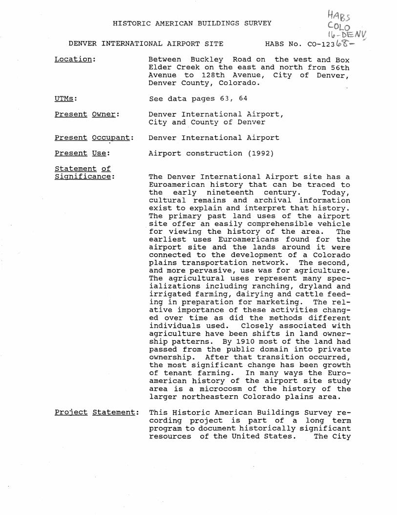
Between Buckley Road on the west and Box Elder Creek on the east and north from 56th Avenue to 128th Avenue, City of Denver, Denver County, Colorado.
See data pages 63, 64
Denver International Airport, City and County of Denver
Denver International Airport
Airport construction (1992)
The Denver International Airport site has a Euroamerican history that can be traced to the early nineteenth century. Today, cultural remains and archival information exist to explain and interpret that history. The primary past land uses of the airport site offer an easily comprehensible vehicle for viewing the history of the area. The earliest uses Euroamericans found for the airport site and the lands around it were connected to the development of a Colorado plains transportation network. The second, and more pervasive, use was for agriculture. The agricultural uses represent many specializations including ranching, dryland and irrigated farming, dairying and cattle feeding in preparation for marketing. The relative importance of these activities changed over time as did the methods different individuals used. Closely associated with agriculture have been shifts in land ownership patterns. By 1910 most of the land had passed from the public domain into private ownership. After that transition occurred, the most significant change has been growth of tenant farming. In many ways the Euroamerican history of the airport site study area is a microcosm of the history of the larger northeastern Colorado plains area.
This Historic American Buildings Survey recording project is part of a long term program to document historically significant resources of the United states. The City

,,
Historian:
Denver International Airport Site
HABS No. C0-123 (page 2)
and county of Denver through the Denver International Airport provided funding for the project. The field measured drawings, historical reports and photographs were prepared under the direction of Deborah Andrews of Andrews & Anderson under contract to the City and county of Denver. Deborah Andrews, Nanon Anderson, Karen Hardaway and Jim Fischer of Andrews & Anderson did the field measurements and architectural delineations. Arnold Thallheimer of Custom Photography undertook the photography. Steven Mehls of Western Historical Studies, under sub-contract to Andrews & Anderson, served as project historian.
Steven F. Mehls, Western Historical Studies, Inc., March 10, 1992

HISTORICAL INFORMATION
Historical Narrative:
Introduction
Denver International Airport Site
HABS No. C0-123 (page 3)
The area that soon will service tens of th0usands of air travellers on their way to and from Denver already has experienced an eventful, if not colorful, past. Studies of the history of the area, including those stemming from cultural resource management concerns, have discovered common threads that run through much of the Euroamerican history of the airport site. Those threads are closely associated to the uses people have found for the lands over the past one hundred and eighty or so years. Some of the patterns are relatively unimportant to our understanding of the area's past because they were rooted in comparatively minor events or trends. Others, particularly transportation and agriculture, have been much more important to the area's past and have left evidence of their presence on the land. The passage of time allows us to look back, identify and interpret these trends. Moreover, we can identify the changes in technology, land availability and especially the responses of the people to the natural environment that caused significant shifts in the airport site's land use patterns.
Among the earliest uses Euroamericans found for the airport site and the lands around it were connected to the development of a Colorado plains transportation network. The second, and more pervasive, use was for agriculture. The agricultural uses represent many specializations including: ranching, dryland and irrigated farming, dairying and cattle feeding in preparation for marketing. Within both of these land use patterns we can observe, through the historic record, fluctuations such as the abnormally dry weather of the early 1890s, and how the residents responded. Moreover, we can identify relationships between localized events and trends and the larger regional and national historical patterns. 1
Natural and Political Setting
The approximately 55 square miles that comprise the airport site are flat, gently rolling prairie. The South Platte River flows in a north-northeasterly direction a few miles west of the Denver International Airport site. The South Platte is the area's major watercourse. Tributaries to the South Platte crossing parts of the airport site include, from east to west,
Denver International Airport Site
HABS No. C0-123 (page 4)
Box Elder, Third, Second and First Creeks. East of the site other watercourses of consequence to the region's history include Kiowa, Bijou and Badger Creeks. The elevation and climatic conditions of the site are characteristic of the Colorado Piedmont. The altitude reflects the levelness of the terrain, ranging from 5,250 to 5,400 feet above sea level. Especially important to the Euroamerican history of the area, the average annual precipitation is typical of a semi-arid environment with approximately 14 inches of moisture falling each year, concentrated between April and October. The summers are warm to hot while winters generally are moderate, with only occasional sub-zero temperatures. This gives rise to a variety of native plants, but bunch grasses dominate the vegetation communities (see sheet 1 of 1 and pp. 53, 54). 2
The prairie soil proved suitable for certain types of agricultural pursuits. Along the various waterways are belts of Laurel sandy loam soil. This type of soil is rich and retains what little precipitation falls in the semi-arid environment. Laurel sandy loam is an excellent soil for growing onions, cabbage and sugar beets. Farther from the waterways the soil types are suitable for beans, alfalfa, wheat, oats, corn and potatoes, providing that irrigation exists. These crops require a steady water supply available only from irrigation. On the non-irrigated lands crops such as milo maize and kafir maize, and drought-resistant varieties of wheat and corn have been raised successfully. In addition, the plains provide adequate forage for cattle, sheep and horses. 3
Adams County, Colorado, the historical parent of the Denver International Airport site is irregular in shape, but generally rectangular. With an area of 807, 680 acres, it is slightly larger than the state of Rhode Island. Colorado voters established Adams County in 1902, the same year they approved organization of the City and County of Denver. Both Denver and Adams County were created from sections of Arapahoe County. Originally Adams County stretched east to the Kansas border, but a few years later county voters opted to decrease the county's size. Washington and Yuma County voters then approved annexation of the eastern extremes of Adams County (see Colorado county maps, pp. 56-59). Because of its large land mass and good soil, Adams County has been primarily an agricultural county. Towns exist, but most of Adams County is not considered an urban area. While many of the towns have traditional ties to county agricultural fortunes, today most town dwellers in the County are suburbanites with their livelihoods linked to Denver. The airport project area was incorporated into the City and County

Denver International Airport Site
HABS No. C0-123 (page 5)
of Denver in 1988 as the result of an election in May of that year and subsequent annexation allowing airport construction by the City and County of Denver. Subsequently, the City and County of Denver has acquired the individual properties, generally through condemnation, since 1989.
Background to Settlement
Spain, the original European claimant of the Denver International Airport site, and indeed all of Colorado, held tenuous control of the region throughout the sixteenth, seventeenth and eighteenth centuries by virtue of Coronado's wanderings of 1540-41. From that point in time until 1720 Spanish explorations, military parties and traders ventured north out of Mexico, eventually settled New Mexico, and continued to venture north into Colorado. They travelled both east and west of the mountains. In 1719-20 Pedro de Villasur, leading a small military detachment north to the Platte River, fell victim to Pawnee Indians. 4 Spanish authorities had hoped Villasur's expedition would thwart French traders moving into the Platte-South Platte Valley. The plan failed and an intense rivalry of words between the Spanish and French followed. From that point until 1763, when France formally relinquished all claims to the area, the two European powers sought to control the local native American population, either through trade or diplomatic means. After removal of the French threat in 1763, Spain showed little interest in the lands north of the Arkansas River until 1793. From then until 1819 and ratification of the Adams-Onis Treaty, the Spanish army sent a number of patrols into the South Platte area (see map of Spanish control, p. 55). 5
The Adams-Onis Treaty led to official Spanish recognition of the United States. American claims dated to the Louisiana Purchase of 1803 that gave the new American government control of the central and northern Great Plains as far west as the Continental Divide. As a result of the agreement with Spain, the United States sent out a number of expeditions to the Colorado area. The most famous Federal exploration of northeastern Colorado came in 1820. That year Major Stephen Long led a party of soldiers and scientists along the South Platte River to the ·Front Range and then south to the Arkansas River before returning to the Mississippi Valley. While it is almost certain that Long did not cross the airport site, his reports did have a lasting impact on the settlement and usage of the area. Long, in his official descriptions, labelled the lands from central Nebraska to the front of the Rockies as the Great American Desert, proclaiming the land to be fit only for grazing and homelands for nomadic

Denver International Airport Site
HABS No. C0-123 (page 6)
Indians. The image of the desert stayed in the American mind and influenced the way later settlers looked at the lands. After Long's trip, dozens of mountain men used the South Platte and other area streams as routes to and from the mountains to trap and trade beaver pelts. 6
The era of exploration and the fur trade created a growing body of geographical, ecological and scientific knowledge about the American West and Colorado by the late 1850s. The contribution important toward development of the airport site's history came from the government explorers and mountain men, who discovered and mapped travel routes, including the South Platte Trail, Smoky Hill Trail and Santa Fe Trail. When William G. Russell's party of Georgians discovered gold in 1858 Americans already knew how to get to the Cherry Creek gold fields. 7 .
The Denver International Airport Site and the Evolution of Colorado Plains Transportation Networks
The history of Colorado during the nineteenth century is in large part the history of transportation and access to the territory and state. By the time of the 1859 gold rush a branch of the Oregon/Overland Trail known as the Trappers' or South Platte Trail had been in use for nearly forty years. The Santa Fe Trail through southeastern Colorado with its own branch, the Old Cherokee Trail, north from the Arkansas Valley to the South Platte River also had been operational for nearly forty years by 1859. During the late 1850s the Army established a supply road along the Smoky Hill River as far west as Ft. Lyon that prospectors extended to the Cherry Creek gold fields after the rush started. Of these, only the South Platte Trail and the northern most branch of the Smoky Hill Trail came close to the site. Settlers developed a number of cut-offs and branches that connected to those two routes as short-cuts. Two such routes crossed the airport site. All these trails served to connect Colorado's infant settlements with each other and to the rest of the United States. The territory's transportation picture remained constant for over a decade, but it proved to be less than satisfactory (see trails maps, pp. 60, 61). 8 ·
Historians believe that as many as 100, ooo people rushed to Colorado because of the well publicized gold discoveries of 1858. The routes used by the Fifty-niners served as the first commercial links between Colorado and the rest of the nation. 9
The Smoky Hill and South Platte Trails, mentioned above, quickly developed as heavily used routes for both freighters and stage coaches. This happened for two reasons. First, accustomed usage

Denver International Airport Site
HABS No. C0-123 (page 7)
of the routes meant that they were well established by 1859 with some stopover points already in business. Secondly, these paths tended to follow natural routes where water and forage could be found. 10 Margaret Long, one of Colorado's foremost authorities on pioneer trails during the 1930s, summarized the origins and engineering considerations of the early routes, writing:
Today automobiles and railroad trains speed over the routes of the forgotten trails of more than half a century ago. The trail was often 10 miles wide, depending on the widely varying local circumstances. It followed the contours of the country, avoiding hills whenever possible, but taking to the higher ground in wet weather, or perhaps swinging around some sandy spot. Grass for the stock, or even the highly essential "buffalo chip" for fuel, would often change the location of a trail for several miles. 11
The territory's dependence on wagon roads and the work by Coloradans to secure railroads marks the period 1858-1870 in Colorado history. This corresponds to a national period when railroads dominated American transportation planning. Generally, wagon road construction methods tended to be nothing more than widening horse paths and cutting tree stumps as close to the ground as possible, where necessary. By the 1850s road building had changed little and as attention focused more and more on railroads, governments expended only minimal effort on roads. The road tax system, a practice accepted across the United States, allowed citizens to pay their taxes through three days of road work, which generally became festive community parties rather than serious work projects. Not until 1879 did the pattern begin to chan~e as the public nation-wide started demanding better roads. 1 This coincided with the beginnings of a regularized county road system in the airport area(see HAER co-65) •
Early travellers made most of their trips by wagon or stagecoach. The first recorded stage trip into the region occurred in the fall of 1858 when a Ft. Laramie, Wyoming, driver took newcomers from the Overland Trail southward to the Colorado gold fields. The excitement caused by mineral discoveries led others to consider the possibilities of operating a coach service to Colorado from the Missouri River. Foremost among such companies was the firm of Russell, Majors and Waddell, a long-time Western
Denver International Airport Site
HABS No. C0-123 (page 8)
transportation company. During the winter of 1858-185~ preparations were made to commence service with the coming of spring. They chartered the Leavenworth and Pike's Peak Express Company (L&PPEC). This line followed a route near the Smoky Hill Trail until it reached northeast Colorado. Once in the region it proceeded west along the Republican River and then overland to the South Platte Trail and on into Denver. 13
The stage line rapidly encountered financial problems and operating difficulties. Reorganization resulted and a new corporation, the Central Overland California and Pike's Peak Express (COC&PP), emerged. The COC&PP used a new route along the overland Trail across Nebraska from Nebraska City, the home of Russell, Majors and Waddell's freight operations. Once in northeastern Colorado, this new line followed the South Platte Trail to Latham, a stage stop near present day Greeley. Here coaches either continued south along the South Platte River into Denver or moved west to Camp Collins (now Fort Collins) and Virginia Dale before rejoining.the Overland Trail in Wyoming. The revised route worked better. Stage stations developed at Brighton and Henderson's Ranch west of the airport site about this time. However, high costs of outfitting the stages, stations and other facilities, along with smaller than expected revenues forced the company into receivership. Further financial troubles beset Russell, Majors and Waddell and eventually forced them out of business.
Ben Holladay bought the bankrupt operation and continued staging and freighting throughout much of the West. One of the most important improvements made by the flamboyant Holladay involved using the cut-off from Fort Morgan south and southwest to Living Springs and from there to Box Elder Station southwest of modern Watkins, Colorado, near the Denver International Airport site. From Box Elder Station the stages followed the Smoky Hill North Trail into Denver. Box Elder Station became a home station complete with meal service for the passengers. Admittedly, the few accounts of meals, indicate its operators did not do better than many others in providing appetizing entrees. 14 Despite Holladay's efforts to improve service he found his company beset by competition. In 1865 John A. Butterfield opened a stage line, the Overland Dispatch, on the Smoky Hill South Trail. 15 Within a year Holladay purchased the Dispatch and rerouted.it to the Smoky Hill North Trail. In 1866 the last few miles into Denver on the new route were described:
Denver International Airport Site
HABS No. C0-123 (page 9)
From Hedinger's Lake to Denver a new cut-off (Smoky Hill North] has recently been made, shortening the distance about twenty miles. Ours was the last coach which passed over the old road, [Smoky Hill South], the stations and stock being taken up behind us, and transferred across the country to their new positions. The road from Cheyenne Wells to Denver is thus abridged by fo~ty miles, making the entire distance from Ft. Riley to the latter place 460 miles . . . . At Reed's Springs we obtains [sic] our last 'square meal' [breakfast], with the inevitable bacon, for a dollar and a half. Thenceforth our road led over the high divides between Beaver [E. Bijou], Bijou [W. Bijou], and Kiowa Creeks, all of which flow northward to the Platte . . . Midday was intensely sultry . . . We took a hasty dinner at Running-Creek [now known as Box Elder Creek, this location was Box Elder Station], and then made our slow way, with poor horses across the ridges to Cherry Creek, which we struck about fifteen miles above Denver. Up to this point we had found no settlement, except two or three grazing ranches . . . . 16
Travel by stagecoach to Colorado in 1860 was primitive even by that era's standards. A journey from the Missouri River to Denver took ten to twelve days. Occasional overnight stops were made at home stations, but generally the passengers spent the time packed into the coaches. Passengers faced days of travel with little protection from the elements other than the roof over their heads. The dry soils of the plains turned to dust clouds under horses' hooves and the fine particles found their way into even the most tightly sealed luggage. The suspension, leather-straps that allowed the coach body some insulation from the bumps of the road, depended on the load of the coach and skill of the driver to be effective. Riders generally faced a vicious pounding along the way. Rest and meal stops served to punctuate the trip. The stories of horrendous meals served to travellers at stage stations are legion, with the table frequently filled with salt pork, beans and stale bread or crackers. Occasionally, fresh bread and pies could be had, but those stops tended to be few and very far between. Other stops offered travellers delicacies such as buffalo or antelope roast if the station operator had experienced a successful hunt. As if

Denver International Airport Site
HABS No. C0-123 {page 10)
to compound the abuse, stage fares from the Missouri River to Denver generally ran between $100 to $150 each way. 17
Despite such ticket prices, stage companies usually faced a financial struggle to survive. By the late 1860s Holladay lost control of his company after Wells, Fargo and Company bought most of its stock. Wells Fargo enjoyed a virtual monopoly over long distance Western transportation at that point. 18 However, most individuals could not afford a ticket and had to make their own way across the plains.
The Fifty-niners (and guidebook authors) mostly ignored the extensive information available on high plains travel. This situation came about from the excitement of the moment and from the optimism of many immigrants. However, once on the trail, potential miners found themselves ill-prepared. Often supplies necessary for survival were left behind so that mining equipment could be taken. All forms of overland transportation were used; wagons, carts, buggies, horses,-mules and by foot. More often than not a small band assembled at a supply town and embarked on the journey without hiring a guide or forming a wagon train. 19
on the trail, emigrants soon faced many problems. Securing a fuel supply proved difficult since few trees grew on the plains. As a substitute, buffalo droppings were used when they could be found. Equally crucial and scarce were food and water for man and beast. Streams and springs with water during wet times of the year dried up by mid-summer. A party could go for days without water. Other water holes dried up from heavy use. Securing forage along the trails was another problem migrants faced. Many travellers took supplies only for the first few days of the journey hoping to live off the land for the rest of the trip. 20
Travellers and settlers also depended on the trails, some of which became county roads, as the method of local transportation. Not surprisingly branches and feeders to the major trails such as the Smoky Hill North or South Platte developed to meet local needs. Two such trails once crossed the lands of the airport site.
One of the secondary trails, the Second Creek Road, appears to have originated in the early 1860s, possibly 1860 or 1861. The Second Creek Road's exact origins remain somewhat clouded, but its route from the South Platte River to the Smoky Hill North Trail (also known as the North Fork of the Smoky Hill Trail) indicates that the Second Creek Road served as a connector and feeder between two of the major routes to Denver at the time.

Denver International Airport Site
HABS No. C0-123 (page 11)
More specifically, the Second Creek Road linked two important points on the plains east and north of Denver by 1860 and for many years thereafter. Box Elder Station, mentioned above, served as the likely southeastern terminus of the Second Creek route while Henderson's Ranch, an early cattle ranch, commercial stockyard and stopover point on the South Platte Trail was located near the western end of the trail. This road served as a segment of a road system for the area until the 1880s when the county government began a road designation program that tended toward roads on section lines rather than drainages. 21
Settlers developed other trails to meet their specific needs. A number of routes came about because of open range cattle ranching. The open range, or "Beef Bonanza" ranches thrived between 1865 (the end of the Civil War) and the late 1880s, when harsh wintera combined with twenty years of over-grazing led to disaster for most stock growers. Even though ranchers used railroads to ship their animals to eastern markets, they depended on trails to move the herds from their ranches to the railroads. For cattle trails certain constraints, including topography, available water, and ease of travel influenced the routings of all the trails. As a result, many of the trails followed the courses of creeks or rivers. For example, one such trail in the Denver International Airport site paralleled Box Elder Creek. 22
Box Elder Creek offered certain advantages, especially for people moving large herds of livestock, that other routes could not. First, the creek traversed gently rolling terrain from the Monument Divide area (its headwaters) north to its mouth at the South Platte River. Secondly, the route offered water and forage for the herds. Finally, the route split the distance from Denver to Bijou Creek, providing an alternative to the heavily travelled Bijou Creek route. More directly, the Box Elder Creek route gave direct access from the south to John w. Iliff's Crow Creek Ranch and its predecessor, Elbridge Gerry's 1860 ranch at the mouth of Crow creek. Crow Creek lies almost directly opposite the mouth of Box Elder Creek (also referred to as Terrapin or Running Creek during the late nineteenth century) • 23 Box Elder Road then began its useful life as a feeder to the four major cattle trails that reached northeastern Colorado durin~ the 1860s and then served as a county road for almost 60 years. 2 (For more detail please see HAER C0-65).
Primary and secondary trails, while an important. part of Colorado's early history, proved to be less than dependable. Soon dissatisfaction developed in Denver, Boulder and other early
Denver International Airport Site
HABS No. C0-123 (page 12)
communities. Railroads held the promise of reliability and comfort sought by early Coloradans. In 1862, without Southern opposition, President Abraham Lincoln convinced Congress to pass the first Pacific Railroad Act. That law chartered the Union Pacific Railroad and recognized California's Central Pacific as the companies to build the transcontinental route. Also, the law authorized substantial grants of public land to each of these companies to offset the construction costs associated with building a rail line from the Missouri River to the Pacific coast through generally unsettled land. Two years later Congress passed a second Pacific Railroad Act. The new law increased Federal monetary and land subsidies to the Union Pacific and Central Pacific.
Coloradans saw these laws as the answer to their prayers. If the Union Pacific could be lured to build through Denver the city would be on the first transcontinental railroad and its future would be assured. This did not happen, leading disappointed Denverites to form their own railroad, the Denver Pacific (DP), in 1867. Its route, through modern day Brighton, connected with the Union Pacific in Cheyenne. Denver boosters also convinced the Kansas Pacific (KP) to build as far west as Denver before fulfilling its Federal land grand charter obligation to connect with the Union Pacific. Congress extended the KP's land grants west with the rail line and as a result the grant included tracts within the airport site. Between 1867 and 1870 the KP and DP, by 1868 a subsidiary of the KP, struggled to finish their lines.
Little over a decade after the first locomotives reached Denver in 1870, a new round of rail building began extending service to more of Adams County. The Burlington and Missouri River Railway, a subsidiary of the Chicago, Burlington and Quincy, identified Denver as a potentially rich market and began to extend their line west from McCook, Nebraska. The Burlington opened its Denver service during the early 1880s. Presence of the Burlington led to the founding of the towns of Irondale and Derby by the end of the decade. The Union Pacific, by then the owner of the Denver Pacific, improved service on both the DP and KP lines as a result of the presence of the rival Burlington. These routes, complemented by the wagon road system, acted to tie the area, including much of the Denver International Airport site, together as a geographical and economic unit well before many other places in Colorado. More than that, the railroads offered transportation to most of what became Adams County from the East; and, through their emigration and/or land departments, the companies encouraged many farmers to relocate to the area before and after the turn of the century. 25
Denver International Airport Site
HABS No. C0-123 (page 13)
Another railroad, the Colorado Eastern, crossed the southern edge of the airport site. Built in 1886, its owners hoped to haul coal from the Scranton coal mine to the Omaha and Grant Smelter on the then northwest edge of Denver. Built as a narrow (3') gauge line, it only hauled coal for about two years before the mines at Scranton closed. From 1889 to 1915 the narrow gauge stayed in operation but lost money each year. Finally, in 1915 its backers realized the futility of maintaining the operation. In August of that year the managers shipped the locomotive and one remaining passenger car to Leadville (see map, p. 62) . 26 The Colorado Eastern' s demise came during a time when the entire region experienced a number of changes, including significant changes in local transportation and agricultural practices when compared to those of the late nineteenth century.
One transportation innovation led to important lifestyle changes for the area's residents and closed the pioneer period more than any other - the automobile. From 1890 to 1910 Adams County and the rest of Colorado reacted· to the Good Roads Movement. Originally begun by bicyclists to pressure state legislatures for better and improved roads, the Good Roads Movement soon picked up the support of automobile users. In Adams County residents lobbied the Colorado General Assembly and the county government for improved roads. In 1916 the Federal government authorized construction of a coast to coast highway. Work began three years later. This road, U.S. Highway 40, crossed the eastern plains and passed immediately south of the airport site and then through Denver. Within a few years other highways would cross Adams County. The automobile afforded area residents the opportunity to change trade, recreation and employment patterns. As the speed of automobiles increased it was possible to travel longer distances in less time to purchase goods, have fun or work. These changes all began in the years before 1920 and only evolved fully in the years after World War II. 27 The auto proved to be only one symbol of the change overtaking the area by 1900, however. Agriculture, the basic pattern of economic life for the study area also changed after 1890. From 1859 to 1890 the area experienced a pioneer type of agriculture. But pioneer agriculture on Colorado plains proved to be quite different from that of Illinois or Iowa a generation or two earlier.
Early Agricultural and Ranching Development, 1859-1890
The Colorado gold rush of 1859 spurred interest in the Rocky Mountains. The plains region, originally viewed as another barrier to be crossed to reach the mines in the mountains, soon became a source of wealth in its own right. The rapid influx of
Denver International Airport Site
HABS No. C0-123 (page 14)
people to Colorado spurred efforts to establish a territorial government. But Congress hesitated until 1861 before organizing the Colorado Territory. In addition to the political needs of the region, other pioneers recognized the necessity for produce, goods and services. That recognition led entrepreneurs to start a series of businesses to support the miners. Farming and trading were actively promoted and efforts to encourage immigration to the Colorado Territory began. For example, William Byers, editor of the Rocky Mountain News, and a major booster of the region, penned many articles and pamphlets encouraging farmers and ranchers to immigrate to Colorado.
Federal legislation aided these booster movements by making land available at low prices. The 1842 Preemption Act allowed for the purchase of 160 acres of land at $1.25 per acre. Not satisfied, Westerners continued to campaign for free government land. Finally, in 1862 Congress responded with the Homestead Act. The 1862 legislation made available 160 acres of public land, under certain conditions, to each adult, head of a family, for $10.00 in fees. The settler had to prove five years of continuous residence and cultivation to gain patent to the land. This legislation proved popular although fraud was common. 28
Fraud continued to flourish under the new land legislation of the 1870s and 1880s. The Timber Culture Act of 1873 granted 160 acres to a settler who planted 40 acres in trees. In 1878 only 10 acres of trees were required. The Desert Land Act of 1877 provided 640 acres at $1. 25 acre if the land was irrigated. Recognition of the difficulties of settlement in arid regions received legislative aid but the provisions were seldom met and illegal entries constituted a public scandal. In 1891 Congress repealed the Timber Culture and Preemption Acts and modified the Desert Land Act. Passed three years later, the Carey Act provided for the proceeds from sales of selected lands to go to states to be used for irrigation project construction. All of these laws benef itted speculators and provided minimal revenues to the states. The results were negligible, both in terms of the impacts on irrigation and on settlement of the site area. Part of that can be traced to the railroad land grants and activities of their associates such as the Platte Land Company that Paul Friedman, principal investigator for the intensive level cultural resource studies at the airport site, feels delayed intense settlement of the airport site until the early twentieth century. 29 Unfortunately, Union Pacific land records are all but unavailable and what evidence is extant is not clear about whether railroad leasing or credit sale activities in the area aided or hindered efforts of local ranchers or farmers. 30
Denver International Airport Site
HABS No. C0-123 (page 15~
Even though railroads, as Friedman argues, may have delayed settlement, 31 railroad development definitely led to a number of changes in the study area's built environment. The railroads opened up sources of building materials for the residents. From the 1870s forward local contractors could use milled lumber, premanufactured parts and millwork and non-native stone. Because of that, the pioneer lean-tos, sod. house~ and occasional log or stone cabins along timbered drainages soon disappeared from the landscape as those who prospered replaced their first houses with frame buildings. The railroads also made possible use of coal for fuel and its attendant changes on the interior layout and furnishings of the houses.
Despite transportation means and the vast quantities of land available, settlers faced several problems. First, the Civil War of 1861-65, resulted in the flow of settlers to the Western regions slowing to a trickle. The limited number of settlers resulted in numerous problems and risks associated with isolation. The continued threat of Indian attack plagued pioneers in the airport site area and throughout Colorado. Wars with the native population after the Civil War significantly reduced this threat by the end of the 1860s. 32 ·
In spite of the obstacles, by 1860 the roots of permanent settlement north and east of the fledgling town of Denver began to appear as farmers and stock raisers turned prospectors returned to farming, establishing farms and running cattle herds along the South Platte. In 1860 Thomas Donelson, formerly of Illinois and Wisconsin, located on an 80 acre farm near modern Brighton and by 1861 Colonel John D. Henderson, the owner of Henderson's Ranch mentioned in conjunction with Second Creek Road, established a ranch with 2,000 head of cattle near modern Henderson, Colorado, on the South Platte. 33 Farther east on Box Elder Creek, then soon to be famous cattleman John W. Iliff ran a herd of cattle to fatten for sale in his grocery store. 34
Iliff, known by the 1870s as Colorado's leading cattleman, was one of the first in the territory to bring in a. Texas herd for fattening and sale. He came to Colorado to make his fortune from mining. Finding little opportunity in mining, he soon turned to shopkeeping as a way· to make a living. Iliff felt, quite correctly, that supplying miners could be as profitable as being one of them. From his Denver store he sold goods and bought a freight wagon outfit to supply the store. He also began running cattle to butcher for sale in his shop. It was from this part of his business then that he got his start in ranching.
Denver International Airport Site
HABS No. C0-123 (page 16)
Iliff bought herds from Texas or Missouri, when available, and fattened them for resale in his and other Colorado butcher shops-. This venture proved to be so profitable that he gave up his other pursuits.
His ranch used Box Elder Road {HAER C0-65) as an access route and as a result had an intimate connection to the early history of the road. 35 By the mid-1870s Iliff's range land extended north to the Wyoming-Colorado border and from Box Elder Creek east to the edge of Colorado. Other ranchers followed Iliff's example.
In competition with the large ranchers for the land were the incoming farmers and smaller ranchers who wanted to take advantage of cheap land prices and ready markets. B:s¥ 1880 cattlemen, mostly smaller ranchers, dominated the area. For example, the Wellenkotter family established a farmstead in the late 1870s along Box Elder Road. Friedman speculates that this ranch, situated about half way between Box Elder Station and Hudson, may have been a road house on the Box Elder Trail as well as a working cattle ranch. Immigrants from Germany, .the Wellenkotters moved to the U.S. in 1875 and to the study area shortly thereafter. The 1880 U.S. manuscript population census portrays the family at approximately the time they settled the farm. The census listed Herman Wellenkotter as a single, 52-year-old, Prussian-born cattle rancher. Herman resided on the ranch with his 46-year-old brother, Fritz, a farm laborer. Mary, Fritz's 48-year-old wife was listed as "keeping house." Fritz and Mary had four children living with them: a 17-year-old daughter, Minnie; a 15-year-old son, William; an 11-year-old son, John; and a 6-year-old son, Henry. All of the Wellenkotters were born in Prussia. William worked on the ranch, while the other children were listed as "at home. "37 This pattern of an extended family household was one of the typical household patterns of the Colorado plains during the late nineteenth century. 38 John, the 11-year-old, eventually would become the last Wellenkotter to own and operate the ranch.
The Wellenkotters are typical of the families that settled the region and stayed there through the turn of the century. The 1880s and 1900 censuses indicate that over 80% of the inhabitants were members of family units. The censuses indicate that more than one generation often worked on the same ranch or farm, giving the impression, at least, that the extended family, such as the Wellenkotters became as the family matured, was something of a standard economic unit in the area. The pattern continued into the first half of the twentieth century. The Wellenkotters contributed to another, somewhat more subtle trend in the area as

Denver International Airport Site
HABS No. C0-123 (page 17)
well. In 1880 and 1900 the preponderance of the population was native born, but in the foreign-born minority, Germany provided most of the area's population. Finally, boarders, such as Nels Word, who worked for the Wellenkotters in 1900, formed an integral part of the family economic unit for almost one-third of the families in the area by then. These boarders provided an additional source of funds and also, provided a labor supply for the farms. 39
From these early roots the area began to evolve into one of Denver's agricultural hinterlands, supplying the town and its merchants with food. Despite the ranchers' successes, area farmers soon discovered that Long's description of the area as a desert was at least partially accurate. Samuel Branter and other farmers found natural precipitation was not enough to grow crops and in 1860, under Branter's lead, nine individuals built the Branter Ditch. During June of that year work began on the Burlington Ditch, followed in 1865 by the Fulton Ditch farther south. These efforts proved _to be only the beginning of irrigation along the South Platte as future generations built ever larger and more elaborate systems to bring water to the fields, including Barr Lake, the Lone Tree Ditch and the Highline Extension Canal (see HAER C0-67).
This search for a continuous and reliable water supply in the arid West, Colorado and the Denver International Airport site was complicated because water availability constantly changed due to the unpredictability of natural supplies. Diversion and distribution of the resource were not the only issues, as access to and usage of water profoundly affected land utilization and subsequent social relations. 40
The issue of water and water rights became increasingly important as more settlers came to arid Colorado and sought water for mining, farming, ranching and domestic use. The dry years of 1873-74 only added to the growing confusion over water rights and usage. The Panic of 1873 resulted in a depres·sion for agricultural markets. Settlement and further irrigation promotion activity declined markedly. The Panic was short lived and within three years settlers .once again were moving into the future Adams County. These immigrants, primarily farmers and ranchers, wanted land and water. For some, alfalfa became a popular corp, especially for those involved in dairying.
The issue of water rights had been officially raised at the Colorado Constitutional Convention in 1876. After much debate and discussion the delgates developed a new water rights system.
Denver International Airport Site
HABS No. C0-123 (page 18)
The Convention adopted a policy of prior appropriation or "first in time, first in right" for the new State of Colorado. This did not resolve all water-related issues but did go a long way toward providing general guidelines. Furthermore, it became the keystone of a policy adopted by many arid Western states in dealing with water issues. 41
Problems were not long in appearing in Colorado as the number of irrigators rose through the latter years of the 1870s. By 1879 the vagaries of the constitution regarding riparian and diversionist rights led to a conflict between water users on St. Vrain Creek. Three years later, litigants placed the dispute before the State Supreme Court. The jurists finally settled in favor of appropriation over riparian rights. The court's opinion succinctly stated not only the salient points of the case but the larger problem of English common law as it applied to the environmental conditions of the arid West. It said:
The common law doctrine_giving the riparian owner a right to the flow of water in its natural channel upon and over his lands, even though he makes no beneficial use thereof is inapplicable to Colorado. Imperative necessity, ... , compels the recognition of another doctrine in conflict therewith. We hold that . . . the first appropriator of water from a natural stream for a beneficial purpose has • . . a prior right thereto to the extent of such appropriation. 42
The 1882 Coffin v. Left Hand Ditch Company case, quoted above, firmly established the doctrine of prior appropriation and beneficial use while rejecting all parts of the riparian doctrine for surface waters in the state. These policies became known popularly as the Colorado Doctrine and were copied by many other Western territories and states during the late nineteenth and early twentieth centuries.
In Colorado the irrigators moved ahead to address new issues throughout the 1880s and 1890s. The first problem they approached through legislation was that of royalties imposed on users by water companies. Corporate ventures into irrigation began in Colorado during the late 1870s and continue to the present. These organizations were founded to meet an apparent need and to profit by providing larger amounts of capital than most of the irrigators could raise independently.
Denver International Airport Site
HABS No. C0-123 (page 19)
Easterners as well as Europeans, particularly the British, invested heavily in water projects, following a long tradition of investment in Colorado. The Travelers Insurance Company undertook many of the more successful of these efforts. The company lent money and technical expertise to many construction projects throughout the plains and the Grand (Colorado) River Valley. Often employees of the water company or land developers promoted these undertakings as the salvation of an area through assuring adequate water for future needs. Water company investments attracted ca pi ta lists with a system of perpetual royalties charged to users that became standard during the 1880s. 43
The question of perpetual payments to the water companies to secure water rights became a source of irritation between the users and their benefactors. Irrigators felt that water rights were theirs without the royal ties and the only payments they should be forced to make were the annual user fees and rentals for the water. One of the proj.ects that led to many irrigator outcries was the original Highline Canal. Later it, and its associated Extension, would play a key role in the development of the Denver International Airport site (see HAER C0-67 for more detail) . During the early 1880s when South Platte Valley farmers began to protest the royalties through nonpayment, they found that the companies replied by turning off the water supplies. As the cultivators watched their crops wither in the fields they looked to the state legislature for help. This political activity continued until 1887 when the State Grange convinced Colorado's lawmakers to consider creation of a State Board of Water Commissioners and enact an anti-royalty law. Such provisions were later adopted by other Western states. 44
The anti-royalty conflicts pointed to the need for a more comprehensive state program of legislation to deal with problems before the state's courts drowned in water cases. During the 1890s the state developed water boards, charging the State Engineer with overall administration of allocations, diversions and enforcement of the laws. While the state's irrigators suffered throughout the Panic of 1893 and depression they realized that the state could do very little to help them. Instead, the irrigators turned their attentions to Congress and undertook a campaign to interest Federal officials in supporting new and more extensive water diversion. and reservoir projects. By the nineties the early corporate efforts had proven inadequate to build large reservoirs and diversion tunnels. The financial problems were further accentuated by the depression of the 1890s as canal companies either declared bankruptcy or left projects
Denver International Airport Site
HABS No. C0-123 (page 20)
only partially completed. Those who had settled on lands with the promise of water provided by private sources suffered the most, but all users found themselves faced with inadequate water supplies and exorbitant expenses to finish the ditches or keep them in good repair. These experiences led to ever-increasing calls for Federal intervention. The Centennial State irrigators were joined in their calls by others throughout the Western states. 45 The planned development of new irrigation projects proved to be only one of the changes taking place during the closing years of the nineteenth century.
Airport Site Agriculture After 1890
The most dramatic changes in agriculture at and around the airport site were in the types of farming and livestock raising carried out by local residents. Farming and livestock raising became more diversified and included raising dairy and feeder cattle. As early as the 1870s lands west of Box Elder Creek, which runs through the Ziegler farm, were used by dairy farmers although these early dairies were farther north than the present study area. 46 From 1900 on family farming has been the predominate pattern of the area. This was consistent with the pattern exhibited in 1880, as was the preponderance of the population being native born. 47 George Rittmayer, for example, set up a dairy farm before the turn of the century. Located near his father's homestead on present day 64th Avenue, Rittmayer, his wife Ada and his two children worked the farm. Rittmayer died in 1905 and Ada quickly remarried George Hohlencamp and continued operation of the farm. They continued operation of the dairy farm for many years and the farm remained in the family until 1989. 48 The Rittmayer's are typical of the families that settled the region after 1890. 49 The Zieglers were another local family who recognized the potential of dairying in the area and adapted accordingly. Their dairy, started during the 1930s, became one of the largest at the airport site by World War II.
The shifting land use patterns proved to be one of the many changes witnessed in Colorado agriculture during the 1890s. Among others, the period saw the advent of widespread sheep raising along the Colorado front range and plains. Cattle remained important, but no longer were they the sole heirs of the range. Sheep, historically the enemy of cattlemen because cattle growers believed that sheep chewed the plants down below the root level making the grasses unable to regrow were raised in increasing number. In addition, some ranchers believed that cattle would not graze on lands occupied by sheep. The introduction of sheep was not without acrimonious exchange, but
Denver International Airport Site
HABS No. C0-123 (page 21)
by World War I over 3, 500 sheep were being fed in the Adams County area. At that time Colorado ranked tenth nationally in lamb production. so This rapid increase is explained because while cattle prices dropped, sheep prices rose or remained steady. The sheep market did not undergo the fluctuations of the cattle market. In addition sheep provided more than one marketable crop - they provided both wool and meat.s1 Similarly, dairying became more popular in parts of Adam~ County between 1890 and World War I because that activity supplied a more consistent cash flow. sz
Interest in irrigation continued out of necessity. Farmers and ranchers utilized other sources to provide a water supply. Deep wells were dug and pumps used to raise the water to ground level. These irrigation systems and water supplies became especially important when in 1890 a drought cycle began. The next three years continued dry. To compound the problem, by 18 9 3 the United States once again found itself involved in a financial panic.s3
The combination of drought and economic downturn ended the first boom period of agricultural expansion in Adams County. The previous thirty years had brought what appeared to be a stable population to the area and thousands of acres of land were put into production. However, the depression years of the nineties were characterized by demands for social and economic change. The springboard for these ref arms was the Populist movement. The rapid expansion of tilled lands during the 1880s resulted in an over production of crops. This oversupply of crops and livestock led to declining prices. The drought years of 1891-93 hurt farmers and ranchers who could not find enough grazing land for their herds. In 1893 President Grover Cleveland responded to falling world silver prices by suspending Federal silver purchases. The resulting confusion ended in bank failures and severe economic dislocation as bankers called in loans. Farmers and ranchers had to pay up, sell out or just leave. In many instances farmers and ranchers did not own their lands as they had not occupied the acreages for the five years required for a patent, or if they had been buying land on credit from the Union Pacific they may have been forced from that land as well. Before the decade closed the Union Pacific itself would be sold at auction to satisfy debts. Some farmers and ranchers left the region.s4 Despite those that moved out the local population remained fairly stable in the face of all these problems. Some pioneers would later recall that they were too poor to leave.SS The 1900 census for the study area indicates that approximately
Denver International Airport Site
HABS No. C0-123 (page 22)
310 individuals composed 78 households. Eighty-two percent were family units with 36% of the population under the age of 16. 56 -
The early years of the twentieth century witnessed continuing evolutionary changes for the study area. New ideas, crops and visions accompanied the new century. cattle raising witnessed the most dramatic change during the period. Aside from the growing number of sheep, the uses of rangeland also underwent a metamorphosis. During the depression of the previous ten years large acreages had been abandoned. Slowly the lands returned to their original state, and as a result, improved their animal carrying capacities. This greatly aided the cattle and sheep industries by increasing the quality of available pastures. 57
In addition to the impact of the above changes, Adams County farming experienced another major transformation related to sugar beet cultivation and processing. Sugar beets had gained popularity in central Europe during the Napoleonic Wars as a source of domestic sugar. The crop slowly spread to the United States, and by the Civil War beet sugar was viewed as an alternative to cane sugar. The Rocky Mountain News ran an editorial on November 3, 1866 exhorting farmers to embrace sugar beets as a viable cash crop and investment opportunity. From then until the early twentieth century many people experimented with sugar beets. In 1899, the first beet sugar factory in Colorado opened in Grand Junction and beet mania spread. Farmers in parts of Adams County and throughout the South Platte Valley responded. Sugar factories sprang up from Brighton to Julesburg. 58 Hand in hand, Denver newspapers and other Colorado boosters promoted immigration to the state. For example, the Denver Re~ublican boosted both immigration and new irrigation projects. 5
For areas in northeastern Colorado, the beet mania, combined with talk of an irrigation project to be built by private funds, caused something of a land rush. The Union Pacific renewed its efforts to sell its land grant in the area. The dream of irrigating the area started in 1891 with the Lone Tree Ditch. 60
Built between 1891 and 1907 the Lone Tree was designed to divert water from Box Elder Creek to nearby lands. The low cost, approximately $10,000, resulted from construction by hand labor and horse drawn blading equipment. In addition to the Lone Tree Ditch, settlers and boosters of the 1900s prophesied that the proposed Highline Extension Canal System would provide water for at least 60,000 acres in the Denver International Airport area.

Denver International Airport Site
HABS No. C0-123 (page 23)
Many people felt that the key to expanding farming, both locally and across the state, lay in the availability of water for irrigation. This in turn led Denver and Colorado boosters to look for ways to finance and build new water projects. One source of funding, the Federal government, heard the calls from Colorado and other Western states. In 1894 Congress passed the Carey Act, which provided for the proceeds from land sales to go to states to be used for irrigation. The results proved negligible. 61 By 1900 new calls were coming from the West for government action. Through the Newlands Act of 1902 Congress established the Reclamation Service (modern Bureau of Reclamation). The United States government was now taking an active leadership role in providing financing and expertise for irrigation projects in the arid states. Irrigation projects were financed by the proceeds from the sale of public lands in the arid states. The connection between public land dispersal and the need to provide water supplies was now established. The New lands Act· provided for the Reclamation Service to aid the homesteader by limiting farms_ to 160 acres. This acreage limitation has been-much debated but was designed to force sale of speculative lands into 160 acre sections in order for the land owners to receive water allotments. The hew Reclamation Service was placed under the Department of Interior. 62
Later legislation provided additional dollars for reclamation projects. The Reclamation Service's mission of building dams and other irrigation projects enabled the West to enter a new economic era. Arid lands were reclaimed for a variety of purposes including domestic and industrial use, lands for crops and grazing, and eventually for the generation of hydroelectric power. These uses allowed the arid states to provide increased livelihoods for a growing population and to provide goods and services for the rest of the nation. The passage of the New lands Act and rapid development of water projects duri~g the early 1900s underscore the reclamation consciousness of the West during the early twentieth century.
For areas not included in the early rounds of Reclamation Service projects, boosters tried alternatives, including cajoling the Service to evaluate projects, enpouragement of state_ funding, or private schemes such as the Highline Canal Extension bonds (see HAER C0-67). The sugar beet boom brought thousands of acres of irrigated land in Adams County into production and led others to hope that thousands more acres also could be planted in beets.
Friedman indicates that irrigation was not critical to settlement because well drilling techniques could be utilized and provide an

Denver International Airport Site
HABS No. C0-123 {page 24)
alternative source of water. This conclusion appears somewhat strained because most of the farmsteads were within irr.igating distance of either the existing or proposed diversion projects. While a number of factors, including well drilling technology, realignment of county roads and the sale of the Union Pacific land grant all affected settlement patterns, the Highline Extension laterals attracted settlers to certain portions of the airport site because of irrigation possibilities. 63
The Ziegler family was following a county and regional trend when they had several wells drilled on the land they farmed for the District Landowners Trust. In an attempt to take advantage of the new water supply and the continuing strong sugar beet market, Ziegler cultivated sugar beets for two years. Beet cultivation in Adams County grew from 6,640 acres in 1920 to 10,448 acres in 1930,M the period of Zieglers' beet growing experiment {See HABS C0-127).
While the local farmers waited f~r water sources to be developed they grew new types of wheat and frequently combined cattle and sheep raising with farming. They were aided by the passage in 1909 of the Enlarged Homestead Act. This was a recognition of the difficulty of grazing a large herd of cattle on 160 acres. Therefore the new act provided for 320-acre homesteads in arid regions. The Borah Act passed three years later reduced the residency requirements to seven months of each "prove up" year. In 1916 Congress passed the Stock Raising Homestead Act allowing up to 640 acres in arid climates for stock raisers. Another aid to farmers and ranchers was the unusually wet weather during the 1910s.
The wet weather, Congressional generosity with the public domain, and hope that the Highline Extension would succeed helped spur dramatic increases in the number of farmers in the area as they sought to tame the lands that traditionally had been home to cattle and sheep. These twentieth century boomers, honyockers or sod busters, whatever label is applied, temporarily succeeded where earlier drylanders had failed.
The new generation felt more confident because in the aftermath of the late nineteenth century dryland failures a number of agronomists addressed the problem of farming the high plains. Leadership in this effort came from Professor Hardy W. Campbell of the University of Nebraska in Lincoln. Simplified, Campbell's theories held that cyclic field use followed by fallow periods as well as deep tilling could increase the water retaining ability of the soils given a year or two between crop plantings. Adequate
Denver International Airport Site
HABS No. C0-123 (page 25)
moisture would accumulate for successful crop planting during the fallow years. Beyond Campbell's work, others, including the state Agricultural College (now Colorado State University), experimented with new drought resistant crops. Agronomists published their work, making volumes of information available to farmers and would be farmers. Additionally, state schools and private companies introduced dozens of new machines to help farmers in their toil. All these aforementioned factors combined to lead to dramatic growth in Adams County agricultural output during the first two decades of the twentieth century. 65 The changes, especially in labor saving machinery meant that fewer people could cultivate more land effectively.
The boom caused in Adams County by those changes are evident in the population figures. In 1900 the population of the County was estimated at 4, 500. By 1910 the number of people in Adams County had grown to 8, 892. Approximately one-quarter of those were foreign born. That growth trend continued during the next decade. Clearly the agricultural boom of the early 1900s had a direct impact on the number of residents of some parts of Adams County. 66
The census for 1910 indicates that 73 households made up of 252 people, resided in the airport site area, down from 310 in 1900. The average age was 38, few were boarders but there were 16 children. This was an increase in the number of children from 1900. The number of adult women was also up, but the number of adult men declined. Over sixty percent of the population was native born with few ethnic minorities. 67
Much of the credit for struggling through the difficult times of early settlement belongs to the women who risked much to settle this area. Within the community the role of women cannot be underestimated. Recent histories have found two conflicting interpretations of women's settlement experience. Historian Julie Roy Jeffrey found many ties between the Victorian ideas common at the time and the experience of Western women on the pre-1900 frontier. Sandra Myres concluded somewhat the opposite, that most Western women were adventurous and nonconformist, rejecting the concept of "women's roles." Other studies indicate that women on the Colorado plains certainly benef itted from the cosmopolitan nature of Denver and the various mining rushes. Moreover, they were part and parcel of.the farming and ranching experience that allowed them to be partners and civilizers as well as entrepreneurs.~ Most of the women who settled or owned property appear to have been partners in the operation of the
Denver International Airport Site
HABS No. C0-123 (page 26)
farms and ranches. Some even became entrepreneurs; owning land, operating farms and acting as absentee landlords.
One example of the strong women who helped settle the airport site was Annie (Anna) Altman. Annie, also referred to in some sources as Anna, was of Polish descent. Her family moved to Colorado in 1881 to farm. Anna married Moses Altman after the family arrived in Colorado. Altman already was an established rancher on the plains with land holdings near Cheyenne. 69 Anna purchased the house and farmstead at the site bearing her name on June 21, 1907. That purchase included four work horses, one bull, 20 milk cows, four calves, six heifers, three hogs, 40 chickens, three turkeys, two farm wagons, two buggies, two harrows, three plows, a reding plow, a churn, a butter press, a butter works, a still, a range (stove), a mower, a rake, a disk, a hay stacker, a cultivator, a separator, a saddle, three sets of harnesses, a branding iron, and crops in the field. 70 Annie Altman owned and operated the farm for the next 30 years. Local informants, interviewed by Friedman, recalled that the farm operated as a feed lot. 71 (For more detail please see HABS co-125)
Unfortunately, the role of children in the West has yet to come under intense scholarly examination except from Elliot West and therefore little comparative opinion exists about the role of children. Children experienced many of the same hardships that adults did, but they did so through the eyes of a child. The children felt the overcrowding in the dwelling and looked forward to building a bigger house. They learned about nature, such as rattlesnakes, first hand. Most importantly, they were part of the economic unit -- the family. West has found that on farms and family ranches, children participated in all phases of the work from farm building (clearing fields, building fences, etc.) to the cyclical work of plowing, planting, harvesting and animal tending. As machinery changed, especially after 1900, the children did not do less work or become less valuable. They simply took on new tasks or learned to operate the new machinery. The result was that age and gender distinctions, well developed elsewhere in American society, tended to erode on the farms of Colorado and the West.n
While authors such as West offer comparative insights and the 1910 census provides data on individuals, the land ownership patterns that dominated the twentieth century, divided into three categories by Friedman, were already in place by 1910; only the names would change. Corporate owners accounted for one group and were composed of the Platte Land Company or later the.Fulenwiders
Denver International Airport Site
HABS No. C0-123 (page 27)
and Monaghans. Small, independent owners comprising the second group included families such as the Kochs and Egans. Tenant farmers were the third group. In 1910, 58% were farm owners, 39% were farm laborers and 3% were farm managers. These percentages should not be considered indicative of the land tracts. Clearly more than 3% of the land was owned and managed by farm managers.~ Their activities and the work of other farmers during the 1910s found an ally in the battlefields of aistant Europe.
World War I aided the early twentieth century dryland boom. The wartime needs encouraged continued increases in crop output. Existing farms could not meet the demands and new immigrants came into the region to take advantage of land opportunities. In addition, marginal lands were placed into production in order to take advantage of high crop prices. By World War I more than 80% of the County's lands had been patented, and dryland farming was the fastest growing segment of county agriculture. In 1918 the Colorado Board of Trade estimated that 86,594 acres were under irrigation. Farmers utilized - another 428, 084 acres without irrigation, and 152,036 acres were set aside for grazing and hay production. That body further estimated that the value of irrigated land averaged $112 in Adams County while non-irrigated land was worth $20 per acre. This boom in population and land values proved short 1 i ved. 74
The end of World War I represented a beginning of hard times for much of Adams County, but the study area somewhat bucked that trend. As wartime demand diminished so did the optimistic hopes of the region's farmers and ranchers. The Panic of 1921 hit farmers especially hard and, to compound the problem, European agriculture, disrupted by the war, recovered quickly. But many local farmers never recovered from the dropping commodity prices. In order to survive, many Adams County farmers continued to put marginal lands into production in order to increase their crop yields. Also, farmers from elsewhere migrated to the County, putting more pressure on the land base. Unfortunately these higher production volumes only tended to depress prices even farther. Some switched from farming to cattle as cattle prices remained high. Also, dairying, a long-time occupation for some in the area, became a more significant part of the local farm economy. Gradually during the middle 1920s crop prices began to stabilize and then rise. In Adams County this delayed what proved to be the inevitable.
Part of the reason for the land availability during the 1920s stemmed from the land speculation attendant to the construction of the Highline Extension Canal. In 1913, as the canal neared

Denver International Airport Site
HABS No. C0-123 (page 28)
completion, one of the backers, Horace G. Clark, decided to sel.;L the Antero Reservoir, the canal's water source, to the City of Denver. To further delay the project Clark and others brought suit against Henry L. Doherty, who had financed the Canal construction. Clark's actions led to a number of suits and a five year period of litigation ensued. The case of Doherty versus the Antero Company eventually went to the Colorado Supreme court, which ruled in favor of the reservoir company in November 1920. That decision cleared the way for the City of Denver to acquire the Highline Canal and Antero Reservoir. The City took possession of the property in 1924 (see HAER C0-67).~
During the litigation, no irrigation water ran through the Highline Extension Canal system. The Rocky Mountain News aptly summarized the state of affairs in 1922, saying the Extension Canal would need to be "dusted out" and that for its East Denver Municipal Irrigation District, "water has never been supplied to these 60,000 acres. 1176 After the City of Denver acquired the Highline Canal and Antero Reservoir, the Denver Utility Commission decided that urban domestic water needs had a higher priority than downstream farmers. The East Denver District farmers complained, even taking their case to court, but they found no relief. 77 In 1924 Doherty, the builder, conveyed ownership of the Highline Extension Canal system to the District Landowners Trust, then managed by Denver attorney, I. B. Mel ville. The Landowners Trust realized that the City was unlikely to supply water to the system on a regular basis and proceeded with construction of the Terminal Reservoir after they had ownership of the system. By the late 1930s other smaller reservoirs, such as one on Third Creek, also had been constructed. Unfortunately, by then it was too late for many farmers. The situation for the farmers deteriorated through the 1920s. Many property owners had mortgaged their properties to raise the $3 million construction bond issue. To aid the landowners, the District Landowners Trust loaned them money. After 1924, when Denver provided no water for irrigation, many of the farmers went bankrupt, leaving the Trust in possession of an ever-growing land area that by the 1930s proved too costly for the Trust.
In addition to the problems of the Highline Extension, local farmers found themselves part of a nationwide effort ·lobbying Congress for relief. Using techniques begun by the Populists, farmers requested a variety of aid. The most notable, or at least noisiest, the McNary-Haugen movement, sought Federal purchases of agricultural surpluses to stabilize prices at the 1910 level. In other words, a parity program for farmers. Debate over the McNary-Haugen proposals continued throughout the

Denver International Airport Site
HABS No. C0-123 (page 29)
decade. In 1929 the Smoot-Hawley Tariff was enacted which raised the import tax on certain products to record levels. Sugar was a heavily taxed commodity and Adams County growers were pleased to receive the market protection the tariff provided. Prices rose but hopes for a new prosperity were dashed on October 23, 1929 when the New York Stock Market crashed and the Great Depression began. Despite these years of adverse conditions the population in Adams County continued to grow, albeit at a much slower rate. Previous analysis of the study area by Friedman indicates that while the number of farmers in the County as a whole grew slowly, the 1920s proved to be a time of rapid farm development for the airport site area as farmers rapidly inf illed the unsettled lands that had been held by the railroad and other land companies awaiting completion of the Highline Extension. Adams County's population increased by 5,815 people during the decade. 78
. Adverse weather conditions further affected agricultural markets already weakened by the stock market crash. After several wet years, the early 1930s saw below average rainfall. The natural aridity of the region combined with increased tillage of marginal lands resulted in once rich fields blowing away in wind storms. The winds of 1932-33 caused so called dust blizzards or "Dusters." These storms were regularly described on daily radio reports and in newspapers with the weather forecast. The Federal government geographically defined the "Dust Bowl" and southern Colorado was officially included but northeastern Colorado was not. Nonetheless, conditions in Adams County left area farmers and ranchers suffering like their counterparts in the southern portion of the state. Many who could afford to left Adams County and the state looking for better opportunities elsewhere, frequently in California. For others tenant farmer status remained as an alternative.
The District Landowners Trust controlled thousands of acres of land in the vicinity of the airport site as a result of the Highline Extension canal failure. In order to profitably use the properties, the District Landowners Trust rented ground to tenant farmers under various arrangements or hired men to farm Trust lands. Even these arrangements were not profitable and financial problems continued the plague the Trust.
During the 1930s considerable land acquisition and ownership consolidation activity took place in the project area. For example, L. c. (Cal) Fulenwider, who moved to Colorado in 1904 for health reasons, purchased approximately 40,000 acres. With financial backing from the Van Schaack real estate company,
Denver International Airport Site
HABS No. C0-123 (page 30)
Fulenwider paid back taxes and created Box Elder Farms. A court battle ensued over the legality of these purchases but Fulenwider was awarded title by the courts in 1939. Fulenwider was not alone in being an absentee landlord. Land ownership maps indicate that by the late 1930s absentee ownership and tenant farming dominated the area. 79 During this period some tenant farmers began, what became, long-term relationships with their landlords. For example, Ray Beierle, Sr., and Carl Ziegler, Sr., worked for Box Elder Farms. In their cases usage of the land was generally left to the tenants' discretion. (See HABS C0-124 and HABS C0-127).
Ray Beierle, with the help of his sons, Ray, Jr., and Harold converted the farmstead from wheat and grain production to a dairy (see HABS C0-124). The Beierles began dairying during the late 1940s and gradually increased the size of their herd and their operation. The family's physical improvements to the property focused on the barn, to make it a class A dairy barn by 1956. They also improved feed-storage by adding the first of many grain bins at the farmstead. These metal bins provided a convenient and economical feed grain storage. The Beierles also drilled a well to supply water to hay and alfalfa fields that provided forage for the dairy herd. 80 Beierles and others in the area felt that the burgeoning population growth of the Denver metropolitan area during the years after 1945 provided an expanding market for dairy products. For example, in 1947 the Denver area, including Adams county, had 50 operating dairies. 81
The projections the family made regarding population growth proved accurate. Adams County became a county of city dwellers between 1950 and 1960. The 1960 census revealed that more than one-half of the Adams County population lived in suburbs and cities. Moreover, the population growth during the decade ( 1950-1960) approached 300% (40,234 in 1950, 120,296 in 1960). Nonetheless, increasing production costs and competition by out-ofstate producers had many Colorado dairymen either leaving the business or at least considering abandonment. 82
This pattern of a family concern working the land as a unit was typical of many others in Adams County. In 1963 the Beierles quit dairying and converted their herds to feeder cattle. During the remainder of the 1960s Beierle had about 200 head of beef cattle on the farm. The family stayed in the cattle business for approximately twenty years. Beef cattle production methods the Beierles used in Adams County of the 1960s were vastly different from those typical of the area during the 1860s. As early as the 1890s, after the disastrous blizzards of the late 1880s and the over-grazing that had all but destroyed the range,

Denver International Airport Site
HABS No. C0-123 (page 31)
cattle raisers began adopting practices such as winter feeding. Those changed practices led to the development of feeding and fattening as standard operation for cattle-raisers by the 1920s and 1930s in most of northeastern Colorado. That corner of the state so came to dominant cattle feeding that by the time the Beierles decided to convert their operations, the northeastern part of the state, including Adams County, accounted for nearly 85% of the total feeder cattle being raised and marketed in Colorado. 83 •
Another tenant farm that exemplifies airport site tenant family farming is the Ziegler Farm (HABS C0-127). Three generations of Zieglers operated two leased properties. During the late 1920s they attempted to raise sugar beets but converted their operations to dairying, as mentioned earlier. Unfortunately, due to low milk prices and government support prices during the Great Depression of the 1930s, the Zieglers found themselves unable to pay their property taxes. The difficulties experienced by dairy farmers are reflected in an approximately 15% decrease in the number of cows milked and value of dairy products produced in Adams County between 1934 and 1939.~
The failure of the Zieglers to pay their property taxes resulted in the sale of the land to L. c. (Cal) Fulenwider by Adams County in 1938. Fulenwider incorporated the property into his Box Elder Farms, and the Ziegler family continued to occupy both of the farmsteads as tenants. 85 Fulenwider' s property acquisitions during the 1930s helped keep the acreage of tenant operated farms stable in Adams County. Farm tenancy in the county during the 1930s remained fairly constant in the number of acres (209,500) but the percent of farms operated by tenants increased nearly 3% overall during the decade with a peak during the middle 1930s of nearl~ 39% of all farms in the county being operated by tenants.
The two changes of title that took place on the Ziegler farm during the 1930s were typical of much of Adams County and the general area. During the decade considerable land acquisition and ownership consolidation activity took place in the Denver International Airport site.
Full scale economic recovery for northeastern Colorado began with the advent of World War II. Wartime· demand resulted in new markets for agricultural products. When the war ended in 1945 many County residents feared a return to the depression. Developing a stable cash crop was of foremost importance. Sugar beets continued as an important cash crop, but corn sweeteners

Denver International Airport Site
HABS No. C0-123 (page 32)
threatened demand. As a reflection of this trend Great Western sugar cut back operations. Wheat, corn, potatoes, barley, dry beans and oats all became important cash crops in the 1950s, 1960s and 1970s. Farmers in the study area did not face such drastic adjustments. Winter wheat continued to dominate crop production in the study area as it had before the War. Countywide cattle production grew in the thirty years after the War also. Changes in cattle raising to produce fatter, highly marbled qualities in the meat resulted in changes in feedlot operation and less range feeding of cattle (see Altman Farm, HABS C0-125). This reflected the ability of the producers to manipulate the animals to meet market demands. The years after World War II have been subjected to market fluctuations and weather conditions but ~enerally agriculture in the area has been healthy since the war. 8
PART II. ARCHITECTURAL INFORMATION
A. General Information
The architecture of Adams County, including the Denver International Airport site, and especially that of the farms, reflects the various stages of economic development. The descriptions that follow have been gleaned from photograph collections, Civil Works Administration interviews, promotional pamphlets, a sample of patent applications and field survey results summarized by Friedman. They emphasize the plains area of the county more than the foothills portion near the county's western extremes. Other studies of architectural and economic development on the Colorado plains offer comparative information and models that Friedman found useable for his work at the site. 88 Beyond that, research has found that the extant architecture and historical archaeological remains exhibit a high correlation between the historic development patterns discussed in previous pages and the marked changes in the built environment. Friedman identified four developmental periods for the study area, including the Frontier, Pioneer, Irrigation District and Corporate Farming stages, each with different characteristics.
Frontier Stage, 1860-1890
The frontier stage of development proved short lived, but repetitive. Some building techniques, such as sod construction, were well adapted to the pioneering periods, whether it was during the late nineteenth century.or the later dryland boom of the 1910-1920 period. Other building techniques used equally

Denver International Airport Site
HABS No. C0-123 (page 33)
readily available building materials, such as stone or log. Only one of these early structures remains in the study area, the core and basement of the main house at the Wellenkotter Ranch (see HABS C0-126 for more detail). Five other recorded sites from this period have already become archaeological resources. Stylistically the Frontier stage buildings could be categorized as folk or vernacular in the truest sense. Outbuildings on these pioneer homesteads were few and tended to be multi-functional and built of sod, pole and mud or dugout construction.
Pioneer Stage, 1890-1910
From the 1870s, and especially after 1890, local contractors used milled lumber, premanufactured parts and millwork and non-native stone. Because of that, the pioneer lean-tos, sod houses and occasional log cabins along timbered drainages either disappeared from the landscape or took on a different function as those who prospered quickly replaced their first houses and buildings. The railroads also made possible the use of coal for fuel. Coal for heat resulted in changes to the interior layout and furnishings of the houses.
Builders depended largely on wood with only limited use of stone or other materials. Stone and brick were not locally available and were costly to transport because of their weight. Wood was more readily transportable and therefore was widely used by builders. The development of Colorado cement supplies made concrete one of the most popular materials for foundations and basements by the end of the nineteenth century. The use of brick tended to be for decorative purposes or in specific applications such as chimneys or foundations/basements. This no doubt reflected the high cost of transportation of bricks to the building sites located in areas generally some distance from railroads or brick yards.
The popular styles of the day were reflected around Adams County, most notably in the farm houses and in cases of the more prosperous, the carriage houses and workers' quarters. Of the stylistic influences of the late nineteenth century, two appear to have been in the majority in Adams County - Italianate and Gothic Revival-both vernacular, not the work of architects. Probably most were adapted by local builders from pattern books or the popular press. Other styles that may have been present include Queen Anne and it variants. None of these styles were recorded during the pedestrian survey of the airport site.

Denver International Airport Site
HABS No. C0-123 (page 34)
In addition to those houses that could be clearly identified as having some stylistic influences, the utilitarian vernacular houses transplanted from the Midwest also dotted Adams County during the late nineteenth century. The most popular of these and possibly of all houses in rural Adams County was the "Gabled Ell" as defined in National Register of Historic Places Bulletin 31. Though that publication refers to Midwestern architecture, the Gabled Ell and its dozens of mutations appear to have been the most popular in Adams County during the late nineteenth century. Also, hipped roof cottages, similar to widely used designs in Colorado coal mining towns appeared. Other vernacular styles such as the double pile and shotgun house also could be found in Adams County by 1910.
Irrigation District Stage, 1910-1940
After 1910 the architectural preferences of Adams County farmers diversified and broadened, reflective of the general prosperity in the county during the first two decades of the new century. Some stylistic movements of the period caught the eye of prospective house builders. However, others did not. Even some of the more urban-oriented, generally smaller house styles appeared on Adams County farms. Three styles that proved popular with rural Adams County residents were the vernacular bungalow and its variations (recorded at Zeigler Farm, HABS C0-127), the four square or prairie cube and its variations, including one story, hipped roof cottages for workers' quarters. The variations on the four square primarily are found in porch treatments, rear additions, window arrangements and dormer /no dormer roof lines, not in the basic volume, massing and feel of the houses. Finally, a limited amount of colonial revival influence could be seen at one time. Again, it appears as if pattern books and other popular media had great impacts on Adams County. Beyond that the availability of mail order and rural free delivery made parts, millwork, decorative items and even whole houses available to Adams County farmers. These tools of mass marketing acted to increase the diversity of Adams County's built environment, but at the same time made much of the area look like farms from Ohio to the Rockies.
Outbuildings that appear to have been fairly common were pump houses for domestic and/or agricultural water supply, animal sheds either attached to the barn or separate, chicken coops and granaries. Beyond those fairly common buildings the diversity grew. Dairy operators built special milking houses, with attached or separate storage rooms for the milk, more feed storage areas, loafing sheds or hay derricks (see HABS C0-127).
Corporate Farming, 1940-1989
Denver International Airport Site
HABS No. C0-123 (page 35)
By this stage farming had matured in the study area and much of Adams County. Specialization of buildings by function became prevalent, often reflecting the type of farming taking place. The one common denominator, the barn, originally served three basic functions: storage of hay, an area for intensive livestock husbandry such as milking or draft animal care, and storage for some machinery. By this later period each of these activities tended to have their own space requirements and separate building, if they were present on the farm at all. Large wheat and grain farms constructed large granaries and their own elevators or converted barns for that purpose. Others, specializing in animal feeding, converted barns to pseudo-grain mills to mix grains for feedlot use (see HABS C0-125). The increase in the size and complexity of machinery after the Great Depression led to most farmers building machine sheds separate from their other buildings. At approximately the same time the automobile caused .farmers to·· construct garages or convert carriage houses. Historically these garages all appear to be separate from the house, sometimes connected by a breezeway. Friedman found that the United States Army also contributed to the built environment of the study area during this period. Three cases were found where buildings formerly located on Rocky Mountain Arsenal were sold and moved to the study area. In three other cases he found quonset huts that farmers had acquired as Army surplus after World War II. 89 The farmsteads of the study area and Adams County by 1960 resembled small industrial plants more than they did subsistence farms of a few decades earlier.
Other Trends in the Built Environment
From the 1920s to the 1980s one agricultural structure experienced more change than any other - the grain bin. Late nineteenth century farmers depended on slat side corn cribs and enclosed buildings similar to cottages to store their grain. This system was practical for the smaller farms and lower yields of the period, but as agronomists found new and more productive techniques and land holding grew these structures proved inadequate. In their place rural designers began· working on plans for bins -- small, easily constructed buildings that could store any type of grain. The first ones appeared in the early twentieth century, and by World War I the octagonal wood frame wood sided bin appears to have been fairly common on the grain farms of Adams County as it was elsewhere on the . ·Colorado plains. 90

Denver International Airport Site
HABS No. C0-123 (page 36)
During the Great Depression when Secretary of Agriculture Henry Wallace announced his concept of the ever normal granary, bin construction got a boost in the form of Federal construction aid. The need for massive numbers of storage bins led to development of the prefabricated metal bin. Easy to assemble on any site, all a farmer with a set of wrenches needed was an extra helper. The utility of these bins quickly became obvious, and over time they have become one of the most common of all farm structures. 91
Buildings associated with agricultural development which were once found throughout much of rural Adams County, including the study area, are school houses, grange halls, churches, and local cross-roads stores. Structures present include livestock loading pens and corrals, windmills and hay derricks. Linear features include abandoned roads and trails, railroad grades and abando~ed irrigation systems. Objects include a wide variety of farm machinery and implements and sheepherders wagons.
The early school houses appear to have been the traditional wood frame wood sheath end gable style popular throughout much of rural America. Colorado's early adoption of the consolidated school concept and rural busing led to the disappearance of many of these small school houses. During the 1930s brick cube style schools appeared in Adams County, including Box Elder School in the study area, as a result of programs of the Roosevelt Administration. The grange halls and churches of rural Adams County appear to have been architecturally similar to the schools, in that they were the simple wood frame structures common to much of rural America. In the case of some churches that have remained open, the core building has become rather lost in the myriad of additions.
one linear feature, critical to the history of the area, is the irrigation ditch, canal or system. When first built, these ditches tended to be unlined with concrete, metal and wood used only for headgates and other flow control features. Due to the financial problems each irrigation company experienced, the canals remained unlined.
The farm buildings associated with the hoped for irrigation systems reflected the needs of the crops grown or animals raised. As a result of the expected availability of a steady water supply the complexity of the architecture and specialization of structural use was reflected by the built environment. on the other hand, the buildings of historic dryland farms tended to be less specialized, except on the large wheat farms. In the study area some conversion can be found as settlers built their build-

Denver International Airport Site
HABS No. C0-123 (page 37)
ings waiting for the Highline Extension Canal to be completed and altered the buildings to other uses after the canal failed.
The landscaping typically associated with Adams County farms and ranches, besides plowed fields and pastures, is defined by a concentration of outbuildings around the main structures. A windbreak/shade belt of trees surrounding this complex or the main house is quite common. A kitchen garden was frequently located near the main structure. Decorative landscaping was generally minimal, however, there were instances of flowerbeds and shrubbery around or on the front side of the main residential structure.
ENDNOTES
1.Steven F. Mehls, Plains Historic Context, (Denver: Colorado Historical Society,. 1984); and Paul D. Friedman, "Historic Properties Preservation Plan For the New Denver International Airport, Denver County, Colorado," September 14, 1990, New Denver Airport Office, Stapleton International Airport, Denver, co, p. 72.
2.Friedman, "Historic Properties," pp. 6, 8.
3.Ibid., pp. 189-191, and Colorado State Planning Commission, Colorado Yearbook, 1962-1964, (Denver: State of Colorado, 1964), pp. 874-888; and Frederick L. Paxson, "The County Boundaries of Colorado," in The University of Colorado Studies, vol. 3, 1906.
4.Margaret Long, The Smoky Hill Trail, (Denver: W.H. Kistler Stationery Co., 1943), pp. 117-118.
5.Steven F. Mehls, The New Empire of the Rockies, A History of Northeastern Colorado, (Denver: Bureau of Land Management, 1984), pp. 19-20.
6.William H. Goetzmann, Exploration and Empire, The Explorer and Scientist in the Winning of the American West, (New York: Alfred A. Knopf, 1966), pp. 40-64.
7.Carla Elizabeth Neuhaus, "Transportation to Colorado, 1858-1869," (M.A. Thesis, University of Colorado, 1928), pp. 6-21.

Denver International Airport Site
HABS No. C0-123 (page 38)
8.Ibid., and U.S.D.I., Bureau of Land Management, "Survey Plats for Townships 1 through 5 south, Ranges 64-67 west," 1867, microfiche on file at Bureau of Land Management, Colorado State Off ice, Lakewood, co.
9.Robert G. Athearn, The Coloradans, (Albuquerque: University of New Mexico Press, 1976), pp. 25-31; and William Alexander Lawson Interview, Civil Works Administration, vol. 355, typescript on file Colorado Historical Society, Denver, CO.; and George W. Lechner Interview, Civil Works Administration, vol. 358, typescript on file Colorado Historical Society, Denver, CO.
10.Long, Smoky, pp. 60-62.
11.Margaret Long, "The Smoky Hill Trail," The Colorado Magazine 9(November 1932):220.
12. Albert c. Rose, "The Highway From the Rai-lroad to the Automobile, 11 in Jean Labatut and Wheaton J. Lane, eds., Highways in our National Life, A Symposium, (New York: Arno Press, 1972), pp. 81-85.
13.Neuhaus, "Early Transportation," pp. 39-44
14.Margaret Long Collection, box 21, ff 4, Western History Collections, Norlin Library, University of Colorado, Boulder, CO.
15.Long, Smoky, pp. 41-44., and W. Turrentine Jackson, Wells Fargo in Colorado Territory, Monograph Series, #1, (Denver: Colorado Historical Society, 1982), pp. 12~13, 16-20.
16. Margaret Long, "The Smoky Hill Trails in Colora~o, 11 The Colorado Magazine ll(March 1934): 74-75.
17.For some of the stage coach stories please see: George W. Lechner, "Diary," and Hattie L. Hedges Trout Interview, civil Works Administration, vol. 345, typescript on file Colorado Historical Society, Denver, co. There are dozens of others as well.
18. Ibid., and Long, Smoky, pp. 41-44., - and Jackson, Wells Fargo, pp. 12-13, 16-20.
19.Long, Smoky, p.21 and Frank A. Root, "Early Days in Weld County," The Trail 6(December, 1913): 10.
20.Neuhaus, "Early Transportation," pp. 20-21.
Denver International Airport Site
HABS No. C0-123 (page 39}
21.Bureau of Land Management, "Survey Plats."
22.Mehls, New Empire, pp. 51-53.
23.Bureau of Land Management, "Survey Plats."
24.David Allen Henderson, "The Beef Cattle Industry in Colorado," (M.A. Thesis, University of Colorado,~1951), p. 10.
25.Thomas J. Noel, "All Hail the Denver Pacific: Denver's First Railroad," The Colorado Magazine 50(Spring 1973) :91-116; and Robert G. Athearn, Union Pacific County, (Chicago: Rand McNally, 1971), pp. 133-34, 224; and Richard c. Overton,·Burlington Route: A History of the Burlington Lines, (New York: Alfred A. Knopf, 1965), pp. 163-173.
26.See: John c. Newell and P.R. Griswold, Narrow Gauge East From Denver; The Colorado and Eastern Railroad, (Boulder: Pruett Publishing Co., 1983).
27. Lyle w. Dorsett, The Queen City A History of pcnvcr, (Boulder: Pruett Publishing Co., 1977) ; pp. 126-13 O, Athearn, Coloradans, pp. 259-65; and Nell Brown·Propst, Forgotten People: A History of the South Platte Trail, (Boulder: Pruett Publishing Co., 1979), pp. 190-195.
28.Much work has been done on the intentions, provisions and results of land legislation. Roy M. Robbins volume, Our Landed Heritage, (Lincoln: University of Nebraska Press, 1976) provides a general study of land legislation; Paul W. Gates, in a variety of works, most notably History of Public Land Law Development, (Washington: Government Printing Office, 1968) and ed., Public Land Policies: Management and Disposal, (New York: Arno Press, 1979) has studied the speculator and corporate role in the public·domain. His article, "The Homestead Law an Incongruous Land System," American Historical Review, 42 (July 1936): 652-81 destroyed the myths surrounding the Homestead Act and illustrated its continuity with past land legislation. Other important works include Paul S. Taylor, Essays on Land, Water and the Law in California, (New York: Arno Press, 1979) which explores the 160 acre limitation of the Newlands Act. Vernon Carstensen, ed. The Public Lands, Studies in the History of the Public Domain, (Madison: University of Wisconsin Press, 1963) contains a number of good essays on the development of the idea of public domain as does Everett N. Dick, The Lure of the Land: A Social History of the Public Lands from the Articles of Confederation to the New Deal, (Lincoln: University of Nebraska Press, 1970), and Harold H. Durhan, Government Handout: A Study in the Administration of the Public Lands, 1875-1891, (New York: DaCapo Publishers, 1970).
Denver International Airport Site
HABS No. C0-123 (page 40)
29. Robbins, Landed Heritage, pp. 104-153; and Friedman, "Historic Properties," p. 75.
30.Annual Reports, 1880-1891, Union Pacific Collection, Colorado Historical Society, Denver, CO.
31.Friedman, "Historic Properties," p. 75.
32.James F. Willard, "The Gold Rush," in A Colorado Reader, ed. by Carl Ubbelohde, (Boulder: Pruett Publishing co., 1962), pp. 83-85; and James H. Pierce, "The First Prospecting in Colorado," The Trail 7 (October 1914) :5-9; and Athearn, Coloradans, pp. 7-20; and Dorsett, Queen City, pp. 2-10; and Robbins, Landed Heritage, pp. 211-235.
33.Richard Marcy and William O'Connor, eds., Forgotten Past of Adams County, (Thornton: Thornton High School, 1976-1979), pp. II:56-58; and Albin Wagner, Adams County, Crossroads of the West, 2 vols. (Brighton: Adams County Commissioners, 1977), pp. I:22-23.
34.Wagner, Adams County, pp. I:22-23.
35. Eugene Williams interview, Civil Works Administration, vol. 341, typescript on file Colorado Historical Society, Denver, CO.; and Agnes Wright Spring, "John W. Iliff-Cattleman," in A Colorado Reader, edited by Carl Ubbelohde, {Boulder: Pruett Press, 1962), pp. 194-207.
3 6. Richard Goff and Robert H. McCaf free, Century in the Saddle, (Denver: Colorado Cattlemen's Centennial Commission, 1967), pp. 9-37, 69-120; and Ora B. Peake, The Colorado Range Cattle Industry, (Glendale, CA: The Arthur N. Clark Co., 1937), see entire volume; and W. H. Delbert, Civil Works Administration Int.erviews, volume 343, typescript on file Colorado Historical Society, Denver, co.; and Board of Trade, Farming in Colorado, (Greeley: sun Publishing, 1887), v.p.
37 .Manuscript census pages for precinct labeled "east of Denver, east of Range 66 [W]," 1880, microfilm available Denver Branch, National Archives.
38.See: Katherine L. H. Harris, "Women and Families on Northeastern Colorado Homesteads, 1873-1920." Ph.D. dissertation, University of Colorado, Boulder, 1983.
39 .Manuscript census pages for precinct labeled "east of Denver, east of Range 66[W], 1880 and First Creek and Box Elder Creek precincts, 1900, Box Elder Creek, Derby and Watkins precincts, 1910, microfilms available Denver Branch, National Archives.
Denver International Airport Site
HABS No. C0-123 (page 41)
40. Arthur Maass and Raymond L. Anderson, ... and the Desert Shall Rejoice: Conflict, Growth and Justice in Arid Environments, (Cambridge: MIT Press, 1978), pp. 364-366.
41.Robert A. Dunbar, "The Origins of the Colorado System of Water Right Control, 11 The Colorado Magazine, 27(0ctober 1944):241-262; and Robert A. Dunbar, "Water Conflicts and Controls in Colorado," Agricultural History, 22(July 1948):180-86; and May L. Geffs, Under Ten Flags, A History of Weld County, Colorado, (Greeley: McVey Printery, 1938), pp. 138-144; and no author, Facts About Farm Lands of the Homeseekers Land and Water Company in the Greeley District, Colorado, (Denver: Colonial Securities and Trust Co., n.d.[1910]), entire pamphlet.
42.Coffin v. Left Hand Ditch Co.l, 6 Colo. 443 (1882).
43.For an outline of early water development in the state see: C. W. Beach a~d P. J. Preston, Irrigation in Colorado (Washington, D.C.: Government Printing Office, 1910). Examples of the boomer literature can be found in The Earth, vols, 3, 4, 5, and 6, published by the Santa Fe Railway.
44.Leonard P. Fox, "State Regulation of the Canal Corporation in Colorado," Michigan Law Review 16 (1917-1918) :165-168.
45.Ibid.; and Robert G. Dunbar, Forging New Rights in Western Waters, (Lincoln: University of Nebraska Press, 1983), pp. 18-35, 37-39.
46.Goff and Mccaffree, Century Saddle, p. 60.
47 .Manuscript census pages for precinct labeled "east of Denver, east of Range 66[W], 1880 and First Creek and Box Elder Creek precincts, 1900, microfilms available Denver Branch, National Archives.
48.Friedman, "Historic Properties," p. 27.
49.Manuscript census pages for precinct labeled "east of Denver, east of Range 66[W], 1880 and First Creek and Box Elder Creek precincts, 1900, microfilms available Denver Branch, National Archives.
50.Colorado Board of Immigration, Colorado Yearbook, 1918, (Denver: State of Colorado, 1918), pp. 38-40.
51.The Greeley Tribune, 10 March 1888 and 12 October 1905.
52.Friedman, "Historic Properties," p. 84.

Denver International Airport Site
HABS No. C0-123 (page 42)
53.Ibid., pp. 138-144; and 1918 Yearbook, pp. 190.
54.Dorsett, Queen City, pp. 50-65, Propst, Forgotten, pp. 150-55, and Anna Homm Interview, Civil Works Administration, vol. 350, typescript on file Colorado Historical Society, Denver, co.
55.Hattie L. Hedges Trout Interview, CWA.
56.Manuscript Census, 1900.
57.Mehls, New Empire, pp. 138-142.
58.William J. May, "The Great Western Sugarlands: History of the Great Western Sugar Company, 11 University of Colorado, Ph.D. dissertation, 1982, entire volume; and no author, "The Growth of the Sugar Beet Industry in Colorado, The Trail, ?(December 1914): 11-16; and Alvin T. Steinel, History of Agriculture in Colorado, (Denver: State Board o~ Agriculture, 1926). pp. 281-310.
59.For example see: Denver Republican, 21 August 1907, p. 12.
60.Friedman, "Historic Properties," pp. 80-81.
61. Taylor, Essays on Land, Water, explores the 160 acre limitation of the Newlands Act; see also: Carstensen, ed., Public Lands, contains a number of good essays on the development of the idea of public domain as does Dick, The Lure of the Land , and Durhan, Government Handout.
62.The official Bureau of Reclamation policy is explained in William E. Warne, The Bureau of Reclamation, (New York: Praeger, 1973), Chapters 1 and 2. The author considers himself one of the "men" of reclamation but this is the best general work on the policies of the bureau, including the 160 acre limitation. Lawrence B. Lee's historiographical essay on reclamation in Reclaiming the American West: An Historiography and Guide, (Santa Barbara: American Bibliographical Center-Clio Press, 1980) is an excellent overview of these stages of reclamation and scholarly works available. Also useful is George W. James, Reclaiming the Arid West, (New York: Dodd, Mead and Co., 1917). For a different view see Raymond Moley, "What Price Federal Reclamation?" National Economic Problems, 455 (New York: American Enterprise Association, 1955).
63.Friedman, "Historic Properties," p. 77.

Denver International Airport Site
HABS No. C0-123 (page 43)
64. U.S. Department of Commerce, Bureau of the Census, Fourteenth Census of the United States Taken in the Year 1920, Agriculture, (Washington, D.C.: Government Printing Office, 1921), p. 190; U.S. Department of Commerce, Bureau of the Census, Fifteenth Census of the United States Taken in the Year 1930, Agriculture, (Washington, D.C.: Government Printing Office, 1932), p. 268.
65.Steinel, Agriculture, pp. 283-310. For a discussion of Campbell and well irrigation on the high plains after 1900 see: Donald E. Green, Land of Underground Rain, (Austin: University of Texas Press, 1973).
66.Manuscript Census, 1910, and 1918 Yearbook, p. 200.
67.Manuscript Census, 1910.
68.Julie Roy Jeffrey, Frontier Women, The Trans-Mississippi West, 1840-1880, (New York: Oxford University Press, 1979); and Sandra L. Myres, Westering Women and the Frontier Experience, 1880-1915, (Albuquerque: University of New Mexico Press, 1982); and Nell Brown Propst, Those Strenuous Dames of the Colorado Prairie, (Boulder: Pruett Publishing Co., 1982); and Katherine L. H. Harris, "Women and Families on Northeastern Colorado Homesteads, 1873-1920." Ph.D. dissertation, University of Colorado, Boulder, 1983.
69.Rocky Mountain News, 12 January and 14 May 1881; Denver Post, 9 May 1943.
70.Grantee Records, Adams County Clerk and Recorder's Office, Brighton, CO.; and Friedman, "Historic Properties," p. 118.
71.Friedman, "Historic Properties," p. 118.; and P. Friedman and L. Rhodes, "Site Records, Site 5DV3004," 14 April 1989, copy on file, Colorado Office of Archaeology and Historic Preservation, Denver, CO.
72.Elliot West, Growing Up With the Country; Childhood on the Far Western Frontier, (Albuquerque: University of New Mexico Press, 1989), pp. xviii, 55-56, 74-79.
73.Friedman, "Historic Properties," p. 78.
74.1918 Yearbook, pp. 66-67.
Denver International Airport Site
HABS No. C0-123 (page 44)
75.Case 9360, Colorado Supreme Court, Folio vol. I, pp. 10-11, 97-101, 219-221 and vol. II, pp. 850-853, and Plaintiff'~ Exhibit A-34, Map of East Denver Municipal Irrigation District Showing System as Constructed by Fred L. Lucas, Record Group A-84, Colorado State Archives, Denver, co., and Earl L. Mosley, "History of the Denver Water System," undated manuscript, Denver Water Department Engineering Records Office, pp. 60-61.
76.Rocky Mountain News, 24 January 1922, p. 4.
77.Ibid., 20 January 1922, p. 12.
78.Colorado State Planning Commission, Colorado Yearbook, 1937-1938, (Denver: State of Colorado, 1938), p. 22, and Friedman, "Historic Properties, 11 p. 81.
79.Colorado Yearbook, 1937-38, pp. 30-31; and Don c. Smith and Edmund Smith, A Smith Atlas, Adams County, Colorado, Flagler, CO: The Smith Map Co., Sept. 1,- 1937).
SO.Ibid; and Appraisal Card, 1725-00-0-00-057, Adams County Assessor's Office, Brighton, co.
81.Denver Post, 22 August 1947.
82.Colorado State Planning Commission, Colorado State Yearbook, 1962-1964, (Denver: State of Colorado, 1964), pp. 577, 874.
83.Ibid., p. 577; and see: David Allen Henderson, "The Beef cattle Industry in Colorado," (M.A. Thesis, University of Colorado, 1951} for an overview of the changes taking place in Colorado cattle raising, especially after 1900.
8 4 . U. s. Department of Commerce, Bureau of the Census, sixteenth Census of the United States Taken in the Year 1940, (Washington, o.c.: Government Printing Office, 1941), p. 252.
85.Lease Agreements, Book 257, p. 48, Adams County Clerk and Recorder's Office.
86. Bureau of the Census, Sixteenth Census 1940, Agriculture, p. 240.
87 .Dorsett, Queen City, pp. 220-225; and Athearn, Coloradans, pp. 296-300; and Mehls, New Empire, pp. 173-182; and Henderson, "Beef Cattle," pp. 160-175; and 1962-1964 Yearbook, pp. 874-887.
Denver International Airport Site
HABS No. C0-123 (page 45)
88.Friedman, "Historic Properties," p. 84; and Steven F. Mehls and Carol D. Mehls, Survey Report, Weld County, Colorado Farm and Ranch Inventory, (Denver: Colorado Historical Society, 1989) I PP• 30-44.
89.Friedman, "Historic Properties," p. 84. ·.
90.Mehls and Mehls, Weld County, pp. 36-37.
91.Ibid., pp. 37-38.
BIBLIOGRAPHY
A. UNPUBLISHED SOURCES
Denver International Airport Site
HABS No. C0-123 (page 46)
Beierle, Ray, Jr. Personal Commnication with Steven F. Mehls. 26 March and 7 April 1992.
Coffin v. Left Hand Ditch Co.1, 6 Colo. 443 (1882).
Denver, CO. Colorado State Archives. Colorado Supreme Court. Record Group A-84. Case 9360.
Denver, co. Colorado Historical Society. W. H. Delbert Interview, Civil Works Administration, vol. 343, typescript on file.
Friedman, Paul D. "Historic Properties Preservation Plan for the New Denver International Airport, Denver, County, Colorado. " New Denver Airport Office, _Stapleton International Airport, Denver, Co., September 14, 1990.
Harris, Katherine L. H. "Women and Families on Northeastern Colorado Homesteads, 1873-1920." Ph.D. dissertation, University of Colorado, Boulder, 1983.
Henderson, David A. "The Beef Cattle Industry of Colorado." M.A. Thesis, University of Colorado, Boulder, 1951.
Denver, co. Colorado Historical Society. Anna Hemm Interview, Civil Works Administration, vol. 345, typescript on file.
Denver, co. Colorado Historical Society. William Alexander Lawson Interview, Civil Works Administration, vol. 355, typescript on file.
Denver, co. Colorado Historical Society. George W. Lechner Interview, Civil Works Administration, vol. 358, typescript on file.
Boulder, CO. Norlin Library. Western History Collections. Margaret Long Collection.
May, William J. "The Great Western Sugarlands: History of the Great Western sugar Company." Ph.D. dissertation, University of Colorado, Boulder, 1982.

Denver International Airport Site
HABS No. C0-123 (page 47)
Denver, co. Denver Water Department. Engineering Records Office. Earl L. Mosley. "History of the Denver Water System. 1• undated manuscript.
Neuhaus, Carla E. "Transportation to Colorado, 1858-1869." M.A. Thesis, University of Colorado, Boulder, 1928.
Denver, co. Colorado Historical Society. Hattie L. Hedges Trout Interview, Civil Works Administration, vol. 345, typescript on file.
Denver, co. Colorado Historical Society. Union Pacific Collection.
u. s. Bureau of Land Management, Colorado state Office. Master Title Plats, Historical Indices, Serial Pages and Patents, v.d. Microfiche on file at Bureau of Land Management, Colorado State Office, Lakewood, co.
U.S. Bureau of Land Management, Colorado State Office. Survey Plats for Townships 1 through 5 south, Ranges 64-67 west, 1867. Microfiche on file at Bureau of Land Management, Colorado state Office, Lakewood, co.
Manuscript Census pages for precinct labeled, "East of Denver east of Range 66 (W], 1880 and First creek and Box Elder Creek precincts, 1900, 1910. Denver Branch, National Archives.
Denver, co. Colorado Historical Society. Eugene Williams Interview, Civil Works Administration, vol. 341, typescript on file.
B. PUBLISHED SOURCES
No author. A Detailed Mao of Railroads in the State of Colorado. Golden: Colorado Railroad Museum, n.d. (1973].
No author. Facts About Farm Lands of the Homeseekers Land and Water Company in the Greeley District, Colorado. Denver: Colonial Securities and Trust Co., n.d. ((1910]).
No Author. "The Growth of the Sugar Beet Industry in Colorado." The Trail, 7 (December 1914):11-16.
Denver International Airport Site
HABS No. C0-123 (page 48)
Athearn, Robert G. The Coloradans. Albuquerque: University of New Mexico Press, 1976.
Union Pacific Country. Chicago: Rand McNally, 1971.
Beach, c.w. and P. J. Preston. Irrigation in Colorado. Washington, D.C.: Government Printing Office, 1910.
Board of Trade. Farming in Colorado. Greeley: Sun Publishing 1887.
Carstensen, Vernon, ed. The Public Lands, Studies in the History of the Public Domain. Madison: University of Wisconsin Press, 1963.
Colorado Board of Immigration. Yearbook of the State of Colorado, 1918. Denver: Brock Haffner Press, 1918.
Colorado State Planning Commission. Yearbook of the State of Colorado, 1937-1938. Denver: Bradford Robinson, 1938.
Colorado State Planning Commission. Colorado Yearbook, 1962-1964. Denver: State of Colorado, 1964.
Denver Republican. various dates.
Dick, Everett N. The Lure of the Land: A Social History of the Public Lands From the Articles of Confederation to the New Deal. Lincoln: University of Nebraska Press, 1970.
Dorsett, Lyle W. The Queen City, A History of Denver. Boulder: Pruett Publishing Co., 1977.
Dunbar, Robert. "The Origins of the Colorado System of Water Right Control." The Colorado Magazine, 27 (October 1944) :241-262.
"Water Conflicts and Controls in Colorado." Agricultural History, 22 (July 1948): 180-86.
Forging New Riahts in Western Waters. Lincoln: University of Nebraska Press, 1983.
Durhan, Harold N. Government Handout: A Administration of Public Lands, 1875-1891. Publishers, 1970.
Studv in the New York: DeCapo

Denver International Airport Site
HABS No. C0-123 (page 49}
The Earth. various dates. Santa Fe Railway.
Fox, Leonard P. "State Regulation of the Canal Corporation in Colorado." Michigan Law Review 16 (1917-1918):165-168.
Gates, Paul W. History of Public Land Law Development. Washington: Government Printing Office, 1968.
~~~~~-· ·public Land Policies: Management and Disposal. New York: Arno Press, 1979.
"The Homestead Law, an Incongruous Land System." American Historical Review 42(July 1936} :652-81.
Geffs, May L. Colorado.
Under Ten Flags, A History of Weld County, Greeley: Mcvey Printery, 1938.
Goetzmann, William H. Exploration and Empire: The Explorer and Scientist in Winning of the American West. New York: Knopf, 1966.
Goff, Richard and Robert Mccaffree. Century in the Saddle. Denver: Colorado Cattlemen's Centennial Commission, 1967.
Greeley Tribune. various dates.
Green, Donald E. Land of the Underground Rain. Austin: University of Texas Press, 1973.
Jackson, W. Turrentine. Wells Faroo in Colorado Territory. Denver: Colorado Historical Society, 1982.
James, George W. Reclaiming the Arid West. New York: Dodd, Mead and Co., 1917.
Jeffrey, Julie Roy. Frontier Women, The Trans-Mississippi West, 1840-1880. New York: Oxford University Press, 1979.
Lee, Lawrence B. Reclaiming the American West: An Historiography and Guide. Santa Barbara: American Bibliographical Center Clio Press, 1980.
Long, Margaret. The Smoky Hill Trail. Denver: w. H. Kistler Stationery Co, 1943.
Denver International Airport Site
HABS No. C0-123 (page 50)
"The Smoky Hill Trail." The Colorado Magazine 9(November 1932):220-231.
"The Smoky Hill Trails in Colorado." The Colorado Magazine ll(March 1934):74-75.
Marcy, Richard and William O'Conner, eds. Forgotten Past of Adams County. Thornton: Thornton High School, 1976-1979.
Maass, Arthur and Raymond L. Anderson. . . . and the Desert Shall Rejoice: Conflict, Growth and Justice in Arid Environments. Cambridge: MIT Press, 1978.
Mehls, Steven F. The New Empire of the Rockies: A History of Northeast Colorado. Denver: Bureau of Land Management, 1984.
Colorado Plains Historic Context. Denver: Colorado Historical Society, 1984. -
and Carol D. Mehls. survev Report. Weld County, Colorado, Farm and Ranch Inventory. Denver: Colorado Historical Society, 1989.
Meley, Raymond. "What Price Federal Reclamation?" National Economic Problems. New York: American Enterprise Association, 1955.
Myres, Sandra L. 1880-1915. 1982.
Westering Women and the Frontier Experience, Albuquerque: University of New Mexico Press,
Newell, John c. and P. R. Griswold. Narrow Gauge East From Denver; The Colorado Eastern Railroad. Boulder: Pruett Publishing Co., 1983.
Noel, Thomas J. "All Hail the Denver Pacific: Denver's First Railroad." The Colorado Magazine, 50 (Spring 1973):91-116.
Overton, Richard c. Burlington Route: A History of the Burlington Lines. New York: Alfred A. Knopf, 1~65.
Paxson, Frederick L. "The County Boundaries of Colorado." University of Colorado Studies, 3 (1906).

Denver International Airport Site
HABS No. C0-123 (page 51)
Peake, Ora B. The Colorado Range Cattle Industry. Glendale, CA: Arthur H. Clark Co., 1937.
Pierce, James H. "The First Prospecting in Colorado." The Trail ?(October 1914):5-9.
Propst, Nell Brown. Platte Trail.
Forgotten People: A History of the South Boulder: Pruett Publishing Co., 1979.
Those Strenuous Dames of the Colorado Prairie. Boulder: Pruett Publishing Co., 1982.
Robbins, Roy. Our Landed Heritage. Lincoln: University of Nebraska Press, 1976.
Rose, Albert c. "The Highway From the Railroad to the Automobile. " in Jean Laba tut and Wheaton J. Lane, eds . .... H~i.._g ..... h_w~a .... y._s...__ .... i ..... n ......... o .... u=r....._.N~a~t~i~o~n~a_l_L~i_f_e~, _A_~s .... vm .......... o_o_s_1~· u~m_. New York: Arno Press, 1972.
Rocky Mountain News, various dates.
Root, Frank A. "Early Days in Weld County." The Trail 6(December 1913):10.
Smith, Don c. and Edmund Smith. A Smith Atlas, Adams Countv, Colorado. Flagler, CO: The Smith Map Co., September, 1937.
Spring, Agnes Wright. "John W. Iliff-Cattleman." in Carl Ubbelohde, ed al eds., Colorado Reader. Boulder: Pruett Press, 1962.
Steinel, Alvin T. History of Agriculture in Colorado. Denver: State Board of Agriculture, 1926.
Taylor, Paul s. Essavs on Land, Water and Law in California. New York: Arno Press, 1979.
Ubbelohde, Carl, Maxine Benson and Duane A. Smith. A Colorado History. Boulder: Pruett Publishing Company, 1982.
U.S. Department of Commerce. Bureau of the Census. Thirteenth Census of the United States Taken in the Year 1910. Washington, D.C.: Government Printing Office, 1913.

Denver International Airport Site
HABS No. C0-123 (page 52)
U.S. Department of Commerce, Bureau of the Census. Fourteenth Census of the United States Taken in the Year 1920. Washington, D.C.: Government Printing Office, 1921.
U.S. Department of Commerce, Bureau of the Census. Fifteenth Census of the United States Taken in the Year 1930. Washington, D.C.: Government Printing Office, 1932.
U.S. Department of Commerce, Bureau of the Census. Sixteenth Census of the United States Taken in the Year 1940. Washington, D.C.: Government Printing Office, 1941.
Wagner, Albin. Adams Countv: Crossroads of the West. Brighton: Adams County Commissioners, 1977.
Warne, William E. The Bureau of Reclamation. New York: Praeger, 1973.
West, Elliot. Growing Up With the County; Childhood on the Far Western Frontier. Albuquerque: University of New Mexico Press, 1989).
Willard, James F. "The Gold Rush." in A Colorado Reader, ed. by Carl Ubbelohde. Boulder: Pruett Publishing Co., 1962.

Denver International Airport Site
HABS No. C0-123 (page 53)
U.S.G.S. Quadrangle Maps
All are 7.5' maps
Horse Creek, Colorado Mile High Lakes, Colorado Brighton, Colorado Eastlake, Colorado Manila, Colorado, Box Elder School, Colorado Sable, Colorado Commerce City, Colorado
Denver International Airport Site
HABS No. C0-123 (page 54)
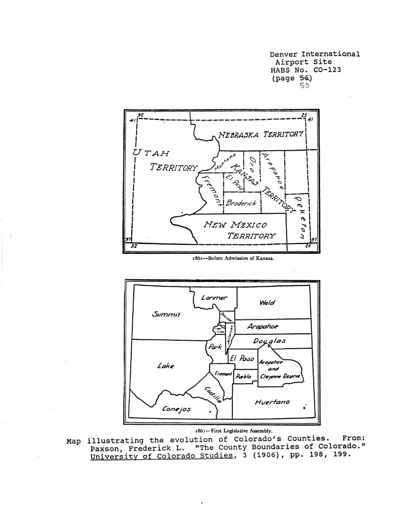
:n ""'''-------:----' I I I UTAH I
Denver International Airport site
HABS No. C0-123 (page ~)
Z5
------------------,~ HEJJRA:'JKA TERRITORY I
I
I TERRITORY
I I I I I
.1 I I I
Summit
Lake
1861-Bcforc Admission of Kansas.
w~1d
Arapahoe
Art:1poho~ ,,___........ and
Chf'~ Re.wrw
Huerfano
·1861-First Legislative Assembly.
Map illustrating the evolution of Colorado's Counties. From: Paxson, Frederick L. "The County Boundaries of Colorado. 11
University of Colorado Studies, 3 (1906), pp. 198, 199.

Summit
.5ornml/
Lake
lo Plata
Denver International Airport Site
HABS No. C0-123 (page S:Z..)
s~
Weld
Arapaho~
1866-Second to Sixth Assemblies.
Weld
!Jent
AnirnP.S
1874-Ninth.and Tenth Assemblies.
Map illustrating the evolution of Colorado's Counties. From: Paxson, Frederick L. "The County Boundaries of Colorado." University of Colorado Studies, 3 (1906), pp. 200, 203.
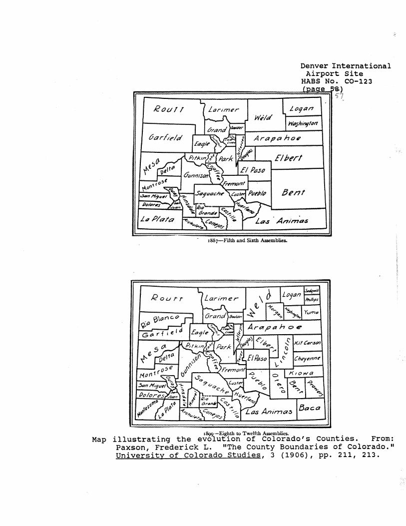
Map
Denver International Airport Site
HABS No. C0-123
1F,:==:::::::::=~~~==~~=:=~~~~~ Rou11
·w;1d
6orl"ield Arapaho/?
Dent
1887-Fifth and Sixth Assemblies.
Rourr Larimer Loaan
,/ Ph1/6ps
1892·-Eighth to Twelfth Assemblies. illustrating the evolution of Colorado's Counties. From: Paxson, Frederick L. "The County Boundaries of Colorado." University of Colorado Studies, 3 (1906), pp. 211, 213.
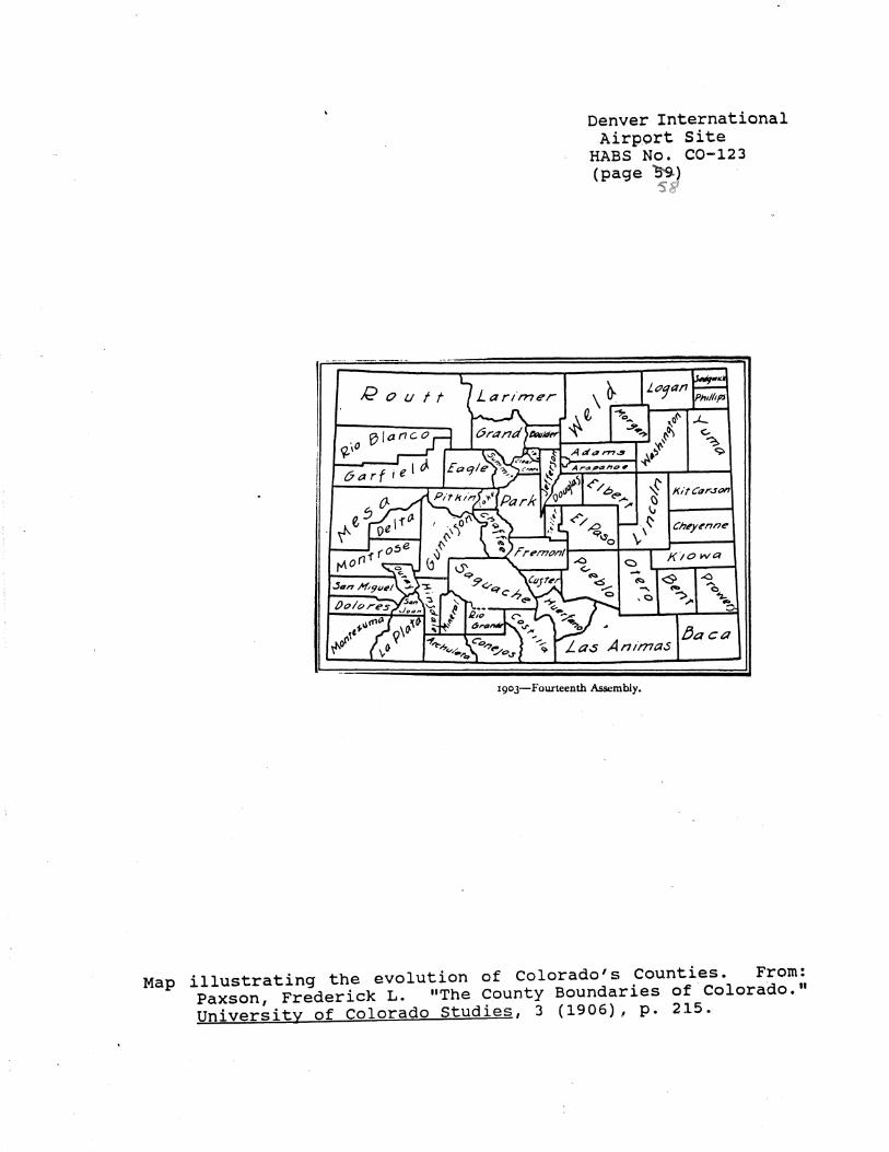
/2outt
Denver International Airport Site
HABS No. C0-123 (page~}
~15''
Cheyenne
Kiowa
1903-Fourleenth Assembly.
Map illustrating the evolution of Colorado's Counties. From: Paxson, Frederick L. "The county Boundaries of Colorado." University of Colorado Studies, 3 (1906), p. 215.

Denver International Airport Site
HABS No. C0-123 (page ~)
UTM COORDINATES: '$~
A: 13: 517680, 4401760 B: 13: 517680, 4403720 C: 13: 518000, 4405200 D: 13: 518000, 4410000 E: 13: 521200, 4410000 F: 13: 521200, 4410680 G: 13: 522800, 4410680 . H: 13: 522800, 4418080 I: 13: 525120, 4418080 J: 13: 525120, 4419080 K: 13: 525920, 4419080 L: 13: 252920, 4420000 M: 13: 527320, 4420000 N: 13: 527320, 4417280 O: 13: 531560, 4417280 P: 13: 531560, 4416480 Q: 13: 535600, 4416480 R: 13: 535600, 4416600 S: 13: 536000, 4416600 T: 13: 536000, 4414440 U: 13: 535600, 4414440 V: 13: 535600, 4414240 W: 13: 532760, 4414240 X: 13: 532760, 4406000 Y: 13: 529600, 4406000 Z: 13: 529600, 4405200 AA: 13: 528400, 4405200 BB: 13: 528400, 4407680 CC: 13: 521200, 4407680 DD: 13: 519360, 4408440 EE: 13: 519360, 4408440 FF: 13: 518560, 4407400 GG: 13: 518560, 4406400 HH: 13: 518760, 4406400 II: 13: 518760, 4405200 JJ: 13: 518560, 4405200 KK: 13: 518240, 4403720 LL: 13: 518240, 4401480
See data page SS. for sketch map showing points
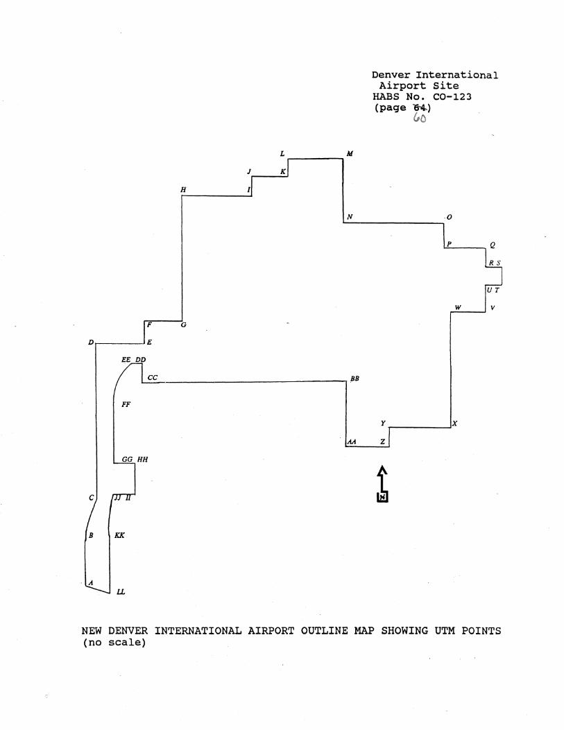
;;·
L M -------J K
H I
N
F G
D E
cc BB
FF
M
GG HH
c
B KK
, A
LL
Denver International Airport Site
HABS No. C0-123 (page lt4.)
&o
0
p
UT
w v
y x
z
l
NEW DENVER INTERNATIONAL AIRPORT OUTLINE MAP SHOWING UTM POINTS (no scale)