demo: tracking transit with easytrackerjakob/papers/gerlich-sensys11.pdf · demo: tracking transit...
TRANSCRIPT

Demo: Tracking Transit with EasyTracker
Tomas Gerlich James Biagioni Timothy Merrifield Jakob Eriksson∗
[email protected] [email protected] [email protected] [email protected]
Department of Computer ScienceUniversity of Illinois at Chicago
Chicago, IL 60607, USA
AbstractEasyTracker is an automated system that assists small
public or private transit agencies in deploying bus trackingand arrival time prediction. This demo will showcase howdata from GPS sensors embedded in smartphones can be au-tomatically processed in order to accurately estimate routes,bus stop locations, schedules, and make annotated maps withreal-time bus tracking and arrival time predictions. We willalso demonstrate a website portal which transit agencies canuse to further interact with their bus transit systems.
Categories and Subject DescriptorsH.4.2 [INFORMATION SYSTEMS APPLICA-
TIONS]: Types of Systems—LogisticsGeneral Terms
Algorithms, Design, ExperimentationKeywords
Public transit, public transportation, bus, real-time track-ing, smartphone, GPS
1 OverviewCreating a new bus tracking, route classification and ar-
rival time prediction system can be a costly, elaborate, andlengthy process. We offer a system design suitable for smallpublic or private transit agencies in need of bus trackingsystems that are ideal for college or corporate campuses,commuter shuttles traveling to transit hubs, or school buses.
∗This material is based upon work supported by the Na-tional Science Foundation under Grants CNS-1017877 and DGE-0549489, as well as the Transportation Research Board of the Na-tional Academies contract Transit IDEA #T-65.
Copyright is held by the author/owner(s).SenSys’11, November 1–4, 2011, Seattle, WA, USA.ACM 978-1-4503-0718-5/11/11
Figure 1. Envisioned smartphone/driver interface.
EasyTracker [1] provides a solution for automating many ofthe steps in creating a transit tracking and mapping systemand it provides an opportunity to interact with the system ona continuous basis.
2 System DescriptionThe transit agency places a smartphone running our ap-
plication into each bus. Every second, the application trans-fers the GPS location of the bus to the back-end server whichis then able to track in real-time each bus in the system anddisplay its location on a map in a web interface. Figure 1shows the envisioned driver interface of the smartphone ap-plication.
In order to estimate routes, bus stops and schedules, thedevices are left in the buses (without any further driver inputor interaction with the device) while the driver follows herusual route, stops at bus stops in order to pick-up or drop-offpassengers, and maintains a schedule or a headway interval.Once a sufficient amount of data is collected on the back-end server, the system automatically processes the unlabeledGPS traces in order to create accurate routes, bus stops, andschedules for each route in the transit system. The algo-rithms can produce accurate routes despite the fact that eachbus is free to follow different routes on different days whilethe driver does not provide information about which routeshe follows. The system also automatically determines the
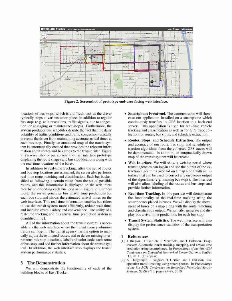
Figure 2. Screenshot of prototype end-user facing web interface.
locations of bus stops, which is a difficult task as the drivertypically stops at various other places in addition to regularbus stops (e.g. at intersections, traffic signals, due to conges-tion, or at staging or maintenance stops). Furthermore, thesystem produces bus schedules despite the fact that the dailyvolatility of traffic conditions and traffic congestion typicallyprevents the driver from maintaining accurate arrival times ateach bus stop. Finally, an annotated map of the transit sys-tem is automatically created that provides the relevant infor-mation about routes and bus stops to the transit rider. Figure2 is a screenshot of our current end-user interface prototypedisplaying the route shapes and bus stop locations along withthe real-time locations of the buses.
In addition to real-time tracking, after the set of routesand bus stop locations are estimated, the server also performsreal-time route matching and classification. Each bus is clas-sified as following a certain route from the set of possibleroutes, and this information is displayed on the web inter-face by color-coding each bus icon as in Figure 2. Further-more, the server generates bus arrival time predictions foreach bus stop and shows the estimated arrival times on theweb interface. This real-time information enables bus ridersto use the transit system more efficiently, reduce wait time,and increase overall safety and convenience. The utility of areal-time tracking and bus arrival time prediction system isquantified in [2].
All of the information about the transit system is acces-sible via the web interface where the transit agency adminis-trators can log-in. The transit agency has the option to man-ually adjust the estimated routes, add or delete missing or er-roneous bus stop locations, label and color-code each routeor bus stop, and add further information about the transit sys-tem. In addition, the web interface also displays the transitsystem performance statistics.
3 The DemonstrationWe will demonstrate the functionality of each of the
building blocks of EasyTracker.
• Smartphone Front-end. The demonstration will show-case our application installed on a smartphone whichcontinuously transfers its GPS location to a back-endserver. This application is used for real-time vehicletracking and classification as well as for GPS trace col-lection for routes, bus stops, and schedule extraction.
• Routes, Stops, and Schedule Extraction. The outputand accuracy of our route, bus stop, and schedule ex-traction algorithms from the collected GPS traces willbe demonstrated. In addition, an automatically drawnmap of the transit system will be created.
• Web Interface. We will show a website portal wheretransit agencies can log-in and see the output of the ex-traction algorithms overlaid on a map along with an in-terface that can be used to correct any erroneous outputof the algorithms (e.g. missing bus stops). The interfacewill also allow labeling of the routes and bus stops andprovide further information.
• Real-time Tracking. In this part we will demonstratethe functionality of the real-time tracking using thesmartphones placed in buses. We will display the move-ment of buses on a map along with the route matchingand classification output. We will also generate and dis-play bus arrival time predictions for each bus stop.
• Transit System Statistics. The web interface will alsodisplay the performance statistics of the transportationsystem.
4 References[1] J. Biagioni, T. Gerlich, T. Merrifield, and J. Eriksson. Easy-
tracker: Automatic transit tracking, mapping, and arrival timeprediction using smartphones. In Proceedings of the 9th ACMConference on Embedded Networked Sensor Systems, SenSys’11, 2011. (To appear).
[2] A. Thiagarajan, J. Biagioni, T. Gerlich, and J. Eriksson. Co-operative transit tracking using smart-phones. In Proceedingsof the 8th ACM Conference on Embedded Networked SensorSystems, SenSys ’10, pages 85–98, 2010.