delineation, transformation assessment and intervention ... · pdf filedelineation,...
TRANSCRIPT
Mitra, Tapas ‘Grey zones’ of Kolkata 49th ISOCARP Congress 2013
1
Delineation, transformation assessment and intervention initiatives for ‘Grey zones’ of Kolkata, India
Tapas MITRA, School of Planning and Architecture, Bhopal, India
Sheuli MITRA, School of Planning and Architecture, Bhopal, India
Synopsis: This paper focuses on the aspects of dynamics of change in older residential areas of Kolkata, India, which do not necessarily qualify as ‘heritage districts’. It assesses the areas from spatial, perceptual and socio-cultural perspectives and eventually presents a rapid appraisal template to initiate processes of developing design intervention strategies.
1. Introduction: study background
The city of Kolkata has been documented and interpreted by authors of various backgrounds who have portrayed the city in its multiple and complex layers. The city, as is known, rose to prominence from the mid 18th century, as the chosen Capital of British India. As a natural outcome of being the seat of power, the settlement developed as a major urban centre of the British times providing the ambience and amenities befitting a capital city. Thus, public edifices representing British colonial architecture are strewn all across the city. As a result of this process of concentration of wealth, undeterred urbanisation occurred, and Kolkata grew to become a primate city with large concentrations of population. It also became a culturally vibrant city, being an arena for significant cultural movements. The city continues to represent the splendours of the Raj coexisting with abject poverty and squalor of the large in-migrant population.
The pressures of population on the city’s economy and infrastructure over time coupled with the reduced political role of the city from a colonial capital to a provincial capital, has led to transformation of the city socially, spatially and perceptually. The many dimensions of this process of transformation have been documented through various seminal works on Kolkata, both in English and Bengali. The subjects of much of the critical writings on Kolkata are seen to focus majorly on three key aspects of the city- a) the Colonial Splendours, b) City and its poverty and C) City and its culture.
The focus of the old city areas in academic works has thus either been on the social and cultural setting, which existed in the colonial times or on the recent infrastructure inputs to the areas as urban renewal projects in recent times. Some attention has also been given to individual historic buildings and their conservation. There however, remains one area of interest in urban studies, namely, academic discussions on the older residential neighborhoods of the city, which has found comparatively lesser thrust in the context of Kolkata. The image of the city through the perception of its neighborhoods, as they exist in the collective memory of its residents, has not been a major area of focus in academic studies. One of the ways of understanding a city is about understanding its residential neighborhoods which form the major bulk of its building stock and are woven all over the body of the city. This, as classified by Rossi1, is one of the two ‘permanences’ of a city. Significant work in this regard is found in the west, but has remained by and large unexplored in the Indian context. Kolkata, with its many layers of history and development, has many old residential areas, interwoven and strewn across large parts of the city. The visual and social character of these areas, possess an identity, distinct even today, from the newer planned areas of the city. The transformation which has occurred in them as a result of the city’s growth is also of interest, as these areas form a large chunk of the city core.
This research work focuses primarily on the older residential parts of Kolkata, analysing them in spatial, perceptual and socio-cultural perspectives, and tries to capture the dynamics of transformation which has occurred therein.
Mitra, Tapas ‘Grey zones’ of Kolkata 49th ISOCARP Congress 2013
2
2. Academic structure of the research The Perception School spearheaded by Lynch2, and the works of Jane Jacobs3 and Habraken4, have raised strong point against Modernist City planning advocated by Corbusier during the heydays of modernism in the 30s and 40s, which saw great architecture but not great liveable cities, where the automobile becomes the major protagonist and situates the participator (to borrow a terminology from Edmund Design of Cities5) in the automobile dominated realm. Jacobs and her compatriots strongly advocate local interventions and reorganisation of the urban fabric at the local levels as against the monumental urban renewal proposals that dominated the 60s American city planning practices. The whole movement of New Urbanism is an offshoot of this world view. In the city of Kolkata, many of the neighborhoods are heavy with important architectural artefacts, but are more importantly, consistently made up of ‘structures of the ordinary’. A large part of the ‘native’ or ‘black’ towns which developed over a period of time demonstrate the characters of this ‘structure of the ordinary’. Interestingly, the temporal variations in the development of the different neighborhoods, give rise to variations in their perception and character. Notably, the older black town in North Kolkata forms a contrast to the newer neighborhood developments in South Kolkata, and the metamorphosis which they undergo over time. The Perception School continues to be a major influence in the work of two other major thinkers, Tridib Banerjee and William C. Baer, who in their seminal book Beyond the Neighborhood unit6, use perception techniques to delineate the extent of what they call ‘residential neighborhood areas’ which disqualifies and outdates the neighborhood unit concept of Clarence Perry7 in his work of 1929. 3. The purpose and process of research
This work attempts to understand the city of Kolkata as a continuum of residential neighborhoods which form a predominant structure in its urban fabric. Perception of the inhabitants, presence of the past and the future, permeability within the neighborhood patches and the presence of the particular, the solus locus, as Rossi8 puts it; all form part of a combined approach in this study.
The present research work tries to identify the ‘quintessential’ Kolkata neighborhoods and examines them in the context of the city’s development patterns.
The first part of the study establishes the morphology of the city and identifies parameters and attributes of defining the neighborhood typologies which fulfil the requirements of ‘quintessential’ Kolkata residential neighborhoods. The term “Grey Zone” as a definition of such areas is coined. In this part, a detailed inventory of works on city morphology and neighborhood structures, available in research works across the world, is critically examined and then the appropriateness of these available models, when applied to Kolkata, is also adjudged. The spatial structure of the city, its chronological growth and impact on older city areas are analysed. Selected case study areas are then identified as representative samples of residential neighborhoods in transformation, from the possible qualifying zones.
In the second part of the work, detailed surveys (physical, socio-economic and cultural) of the two chosen case study neighborhood areas of Kolkata, are undertaken. An examination of the data collected, reveals patterns of development and neighborhood transformation. The transformation of neighborhoods and also individual residential properties, are documented through chronological spatial data analyses and socio-economic surveys to understand household level transformations and the impact of these on neighborhood characteristics.
The study concludes with an analysis of the key attributes, which help retain the essence of
Mitra, Tapas ‘Grey zones’ of Kolkata 49th ISOCARP Congress 2013
3
‘quintessential Kolkata neighborhoods’. An attempt is also made to assess the vulnerability of neighborhoods to total transformations and identify the different attributes which are responsible for the transformation correlating their own inter relationship, which affect the dynamics of change. Based on the cumulative impact of the effect of these attributes, suggestive intervention strategies are put forward, with a commentary on the possibilities of taking this research forward.
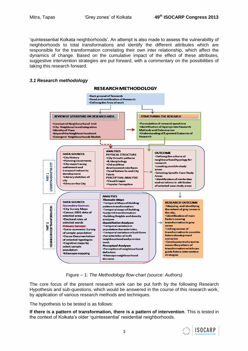
3.1 Research methodology
Figure – 1: The Methodology flow-chart (source: Authors)
The core focus of the present research work can be put forth by the following Research Hypothesis and sub-questions, which would be answered in the course of this research work, by application of various research methods and techniques.
The hypothesis to be tested is as follows:
If there is a pattern of transformation, there is a pattern of intervention. This is tested in the context of Kolkata’s older ‘quintessential’ residential neighborhoods.
Mitra, Tapas ‘Grey zones’ of Kolkata 49th ISOCARP Congress 2013
4
The sub-questions which have been answered to be able to test the hypothesis are as follows:
A. Which areas of the city have neighborhood patches with ‘quintessential characteristics’
which can be identified for testing the hypothesis?
B. Do all residential neighborhoods in old town areas have similar characteristics, or are
there location-wise variations?
C. Within a neighborhood, which are the attributes that contribute to ‘transformation’ of the
built environment?
Sub questions A and B pertain more to the entire city with its structure and fabric as it is
today. Through an overview of the chronological development of the city, the areas with
‘quintessential characteristics’ and criteria qualifying them as ‘grey zones’ are defined. This is
followed by identifying the ‘grey zones’ at the city level and attempting to compare such grey
zones for similarity or variations in characteristics. The next question, C would have to be
addressed with reference to specific neighborhoods and analysing factors affecting change
would have to be demonstrated with specific case studies of prototypical neighborhoods in
transition. Case specific observations of more than one case study from different ‘grey zones’
would then be compared to find out how similar, causes of transition for different ‘grey zones’
are, and whether a common framework of intervention guidelines could be developed for all
grey zone areas of Kolkata.
3.2 Research Techniques
Various techniques of data collection and analyses have been used in this research work as found appropriate. The techniques are discussed in the following section based on the classification of data targeting the three sub-questions.
A. Which areas of the city have neighborhood patches with ‘quintessential characteristics’
which can be identified for testing the hypothesis?
In order to define which neighborhoods would qualify as neighborhoods with quintessential characteristics, largely references from secondary sources which discuss the history of the city and its development (social and spatial) were used.
References to documents on popular culture, cultural sketches from different periods of time, academic work on city growth and documents from planning organisations involved in city restructuring and new development works over a period of time, form the base for identifying the quintessential neighborhoods. Visual depiction of these neighborhoods in films and literature are also taken as bases for identifying key parameters of subject area definition. A rationalisation of perceptions and data is then done to list out the parameters which define neighborhoods with quintessential characteristics.
Other data sources referred to for answering this question, are city maps showing the chronological growth of the city, which help identify these ‘grey zones’.
B. Do all the residential neighborhoods with ‘quintessential characteristics’ have similar
attributes, or are there variations based on different factors?
The areas are compared on the following parameters:
Mitra, Tapas ‘Grey zones’ of Kolkata 49th ISOCARP Congress 2013
5
Street Network: Satellite images and city maps are used to understand basic road
and street network patterns in different parts of town and the impact on size and scale
of the neighborhood blocks. These are analysed to find out if the patterns are similar
or differ with locational differences.
Visual Impact: A visual documentation of the streetscapes of some of these
neighborhoods is undertaken, also to help identify visual attributes of neighborhoods
in different parts of town.
Perceptual Image: References to films and literary sketches set in different parts of
the town, but all in these ‘grey zones’ are used to analyse perceptual similarities and
variations in neighborhoods in discrete grey zones and the causes for these
variations, if any.
C. Within a neighborhood, which are the attributes that contribute to ‘transformation’ of the
built environment?
Attributes, which contribute to a neighborhood’s identity, when modified, lead to transformation of the neighborhood, beyond the threshold of retaining the quintessential nature. As this section forms the main body of the research, many different surveys were designed to obtain the required data in the most appropriate manner. Two major case study patches were selected from two parts of the city, North and South Kolkata, based on the findings of the previous section.
Each case study area is then analysed in terms of Physical transformation, wherein primary physical survey of the entire study patches is done to generate thematic maps for the following attributes:
o Present Land Use (roads, residential-non residential distribution)
o Time series maps of Holding size pattern (1910, 1950, 2011)
o Time series maps of Building Footprint (1910, 1950, 2011)
o Map of Building Heights, 2011.
Analyses based on the map generated:
o Percentage Distribution of road and plots areas within the patches and
comparison between the two study patches.
o Quantitative Analyses of the maps on Holding Size showing transformation
over time in holding sizes and comparisons between the two study areas.
o Quantitative analyses of built and un-built space in each study patch and
comparison between the two study areas.
o Quantitative analyses of the heights of buildings and comparison between
the two study areas.
Social attributes of the neighborhoods were obtained and analysed with Census Data
(2001) and Electoral rolls (2010-11) and a primary socio-economic survey was conducted
through survey questionnaires of a random sample of the households in the neighborhood.
For Premise level variations and attributes, Stratified sampling of the households and premises was done to get a fair representation of most types of houses in the neighborhood
Mitra, Tapas ‘Grey zones’ of Kolkata 49th ISOCARP Congress 2013
6
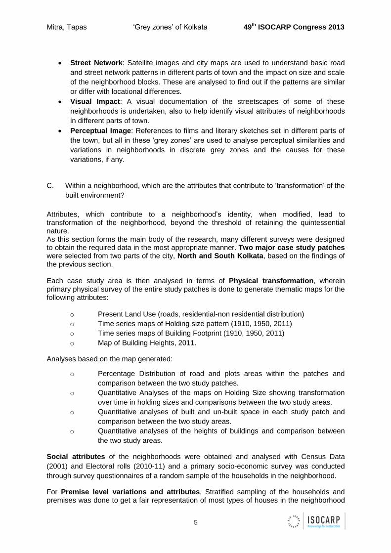
to comprehend premise level transformations which affect the overall neighborhood area and generate clues for intervention scenarios. Image and perception of the neighborhoods were generated through Cognitive maps and Kitescapes of the patches.The following snapshots from the city core portray the urban fabric and building typologies of a typical ‘Grey Zone’:
The urban fabric:
The raised platform on the outer wall
The corner grocery or the cigarette shop
Little open space or the neighborhood park
A certain patterned balustrade
The occasional colonial lampposts
Figure – 2: Urban fabric of a typical ‘Grey Zone’ (source: Authors)
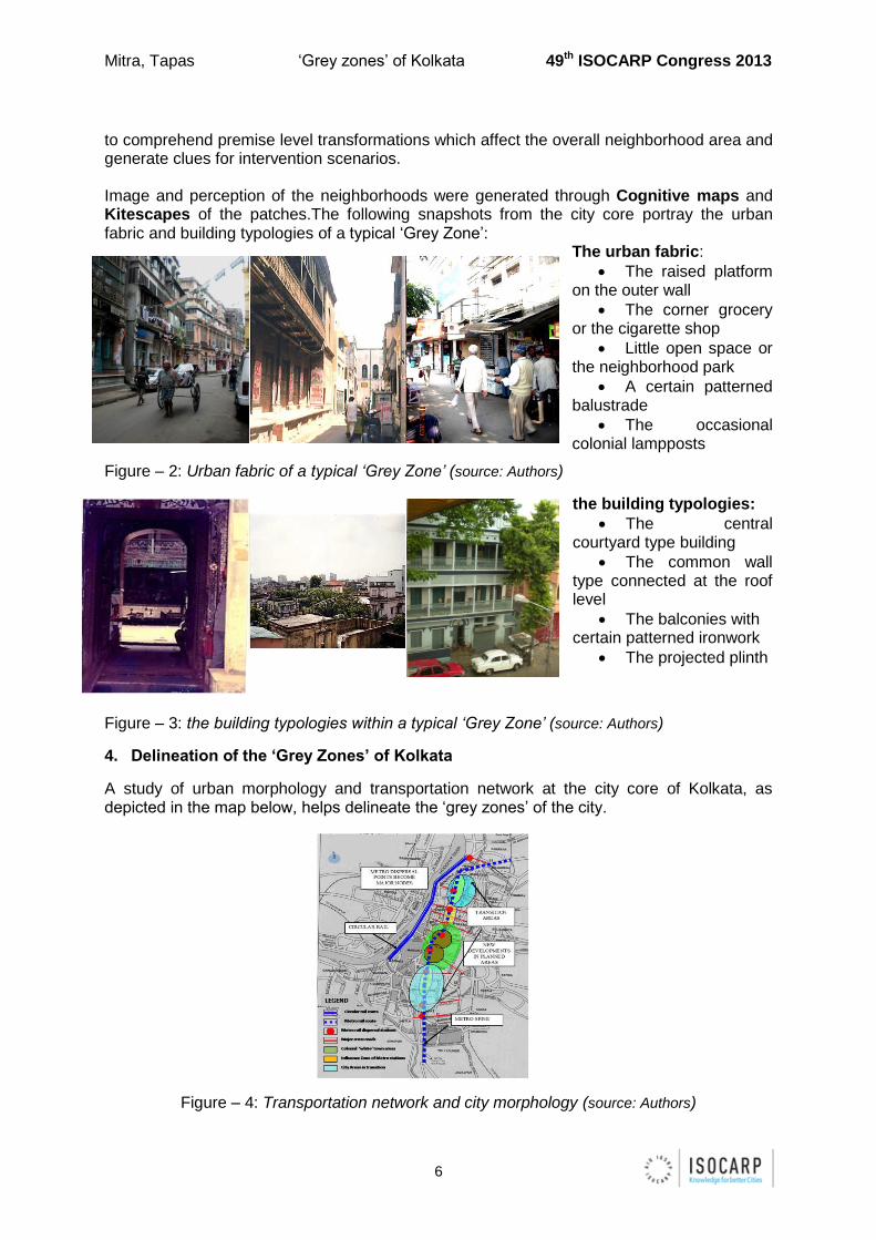
the building typologies:
The central courtyard type building
The common wall type connected at the roof level
The balconies with certain patterned ironwork
The projected plinth
Figure – 3: the building typologies within a typical ‘Grey Zone’ (source: Authors)
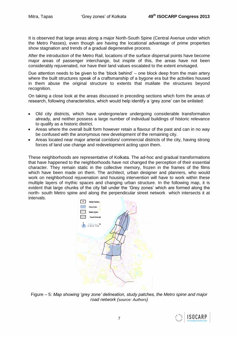
4. Delineation of the ‘Grey Zones’ of Kolkata
A study of urban morphology and transportation network at the city core of Kolkata, as depicted in the map below, helps delineate the ‘grey zones’ of the city.
Figure – 4: Transportation network and city morphology (source: Authors)
Mitra, Tapas ‘Grey zones’ of Kolkata 49th ISOCARP Congress 2013
7
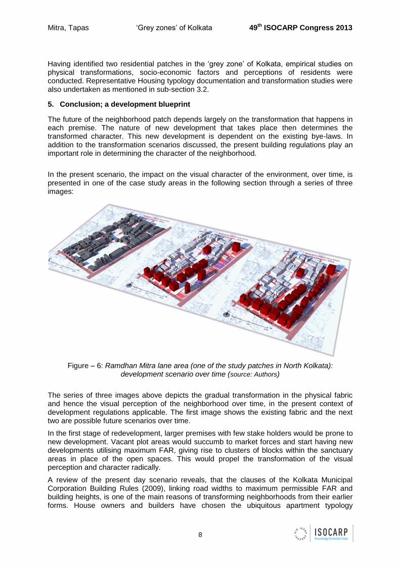
It is observed that large areas along a major North-South Spine (Central Avenue under which the Metro Passes), even though are having the locational advantage of prime properties show stagnation and trends of a gradual degenerative process.
After the introduction of the Metro Rail, locations of the surface dispersal points have become major areas of passenger interchange, but inspite of this, the areas have not been considerably rejuvenated, nor have their land values escalated to the extent envisaged.
Due attention needs to be given to the ‘block behind’ – one block deep from the main artery where the built structures speak of a craftsmanship of a bygone era but the activities housed in them abuse the original structure to extents that mutilate the structures beyond recognition.
On taking a close look at the areas discussed in preceding sections which form the areas of research, following characteristics, which would help identify a ‘grey zone’ can be enlisted:
Old city districts, which have undergone/are undergoing considerable transformation already, and neither possess a large number of individual buildings of historic relevance to qualify as a historic district.
Areas where the overall built form however retain a flavour of the past and can in no way be confused with the anonymous new development of the remaining city.
Areas located near major arterial corridors/ commercial districts of the city, having strong forces of land use change and redevelopment acting upon them.
These neighborhoods are representative of Kolkata. The ad-hoc and gradual transformations that have happened to the neighborhoods have not changed the perception of their essential character. They remain static in the collective memory, frozen in the frames of the films which have been made on them. The architect, urban designer and planners, who would work on neighborhood rejuvenation and housing intervention will have to work within these multiple layers of mythic spaces and changing urban structure. In the following map, it is evident that large chunks of the city fall under the ‘Grey zones’ which are formed along the north- south Metro spine and along the perpendicular street network which intersects it at intervals.
Figure – 5: Map showing ‘grey zone’ delineation, study patches, the Metro spine and major road network (source: Authors)
Mitra, Tapas ‘Grey zones’ of Kolkata 49th ISOCARP Congress 2013
8
Having identified two residential patches in the ‘grey zone’ of Kolkata, empirical studies on physical transformations, socio-economic factors and perceptions of residents were conducted. Representative Housing typology documentation and transformation studies were also undertaken as mentioned in sub-section 3.2.
5. Conclusion; a development blueprint
The future of the neighborhood patch depends largely on the transformation that happens in each premise. The nature of new development that takes place then determines the transformed character. This new development is dependent on the existing bye-laws. In addition to the transformation scenarios discussed, the present building regulations play an important role in determining the character of the neighborhood.
In the present scenario, the impact on the visual character of the environment, over time, is presented in one of the case study areas in the following section through a series of three images:
Figure – 6: Ramdhan Mitra lane area (one of the study patches in North Kolkata): development scenario over time (source: Authors)
The series of three images above depicts the gradual transformation in the physical fabric and hence the visual perception of the neighborhood over time, in the present context of development regulations applicable. The first image shows the existing fabric and the next two are possible future scenarios over time.
In the first stage of redevelopment, larger premises with few stake holders would be prone to new development. Vacant plot areas would succumb to market forces and start having new developments utilising maximum FAR, giving rise to clusters of blocks within the sanctuary areas in place of the open spaces. This would propel the transformation of the visual perception and character radically.
A review of the present day scenario reveals, that the clauses of the Kolkata Municipal Corporation Building Rules (2009), linking road widths to maximum permissible FAR and building heights, is one of the main reasons of transforming neighborhoods from their earlier forms. House owners and builders have chosen the ubiquitous apartment typology
Mitra, Tapas ‘Grey zones’ of Kolkata 49th ISOCARP Congress 2013
9
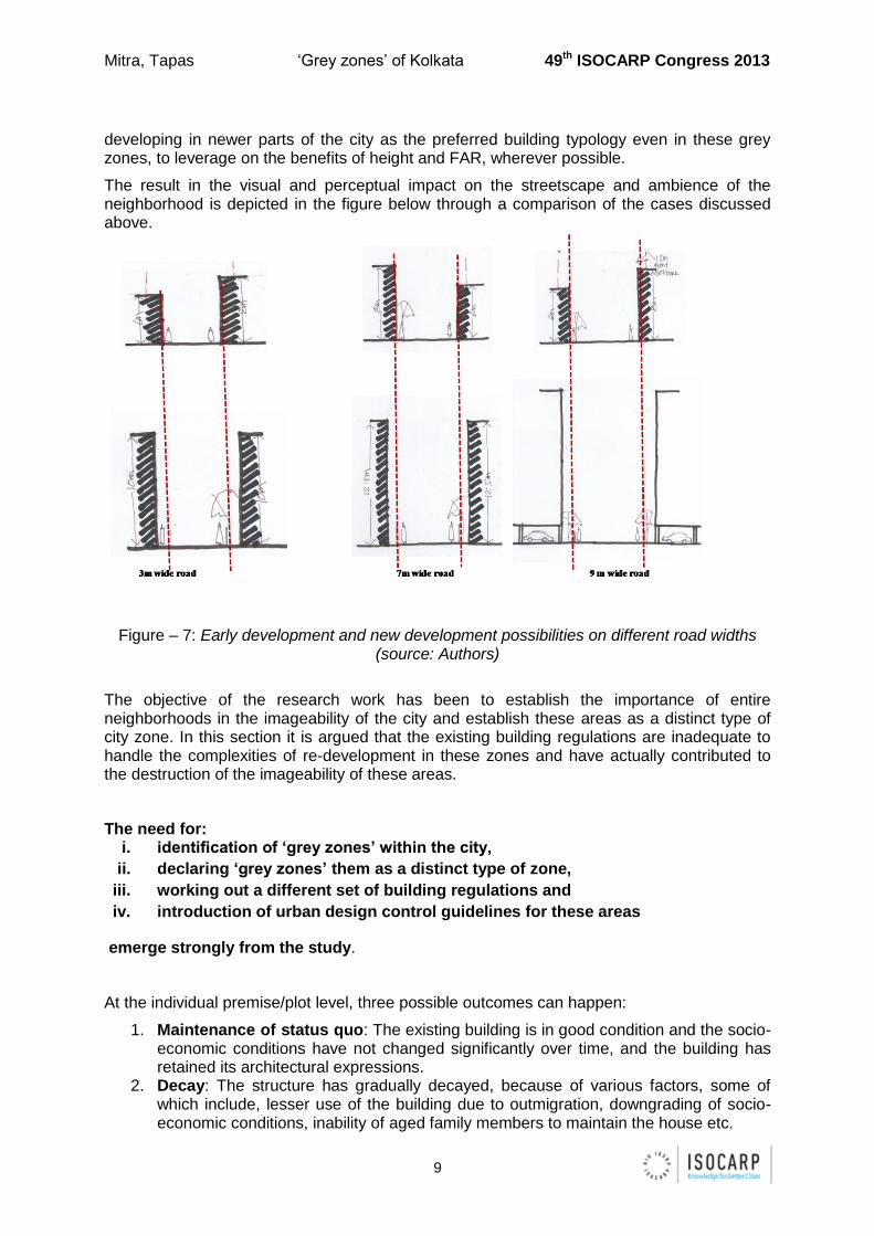
developing in newer parts of the city as the preferred building typology even in these grey zones, to leverage on the benefits of height and FAR, wherever possible.
The result in the visual and perceptual impact on the streetscape and ambience of the neighborhood is depicted in the figure below through a comparison of the cases discussed above.
Figure – 7: Early development and new development possibilities on different road widths (source: Authors)
The objective of the research work has been to establish the importance of entire neighborhoods in the imageability of the city and establish these areas as a distinct type of city zone. In this section it is argued that the existing building regulations are inadequate to handle the complexities of re-development in these zones and have actually contributed to the destruction of the imageability of these areas.
The need for: i. identification of ‘grey zones’ within the city,
ii. declaring ‘grey zones’ them as a distinct type of zone,
iii. working out a different set of building regulations and
iv. introduction of urban design control guidelines for these areas
emerge strongly from the study.
At the individual premise/plot level, three possible outcomes can happen:
1. Maintenance of status quo: The existing building is in good condition and the socio-economic conditions have not changed significantly over time, and the building has retained its architectural expressions.
2. Decay: The structure has gradually decayed, because of various factors, some of which include, lesser use of the building due to outmigration, downgrading of socio-economic conditions, inability of aged family members to maintain the house etc.
Mitra, Tapas ‘Grey zones’ of Kolkata 49th ISOCARP Congress 2013
10
3. Transformation: a. This may include modifications in the built structure to accommodate changes
in family structure. This can either change the original character totally or can continue to retain the old characteristics.
b. Other transformations may include demolition of old structures and construction of new buildings. The apartment typology has found much appreciation and has come up on many plots. However, there are no urban design guidelines for the visual expression of these new buildings.
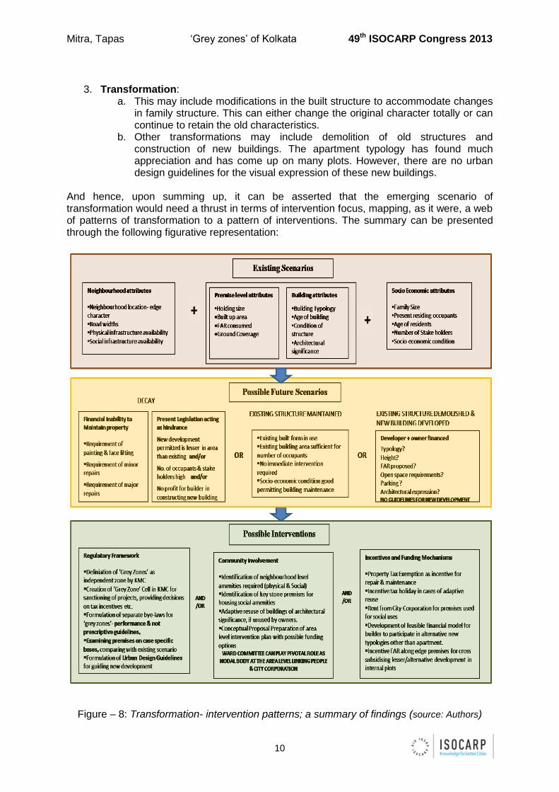
And hence, upon summing up, it can be asserted that the emerging scenario of transformation would need a thrust in terms of intervention focus, mapping, as it were, a web of patterns of transformation to a pattern of interventions. The summary can be presented through the following figurative representation:
Figure – 8: Transformation- intervention patterns; a summary of findings (source: Authors)
Mitra, Tapas ‘Grey zones’ of Kolkata 49th ISOCARP Congress 2013
11
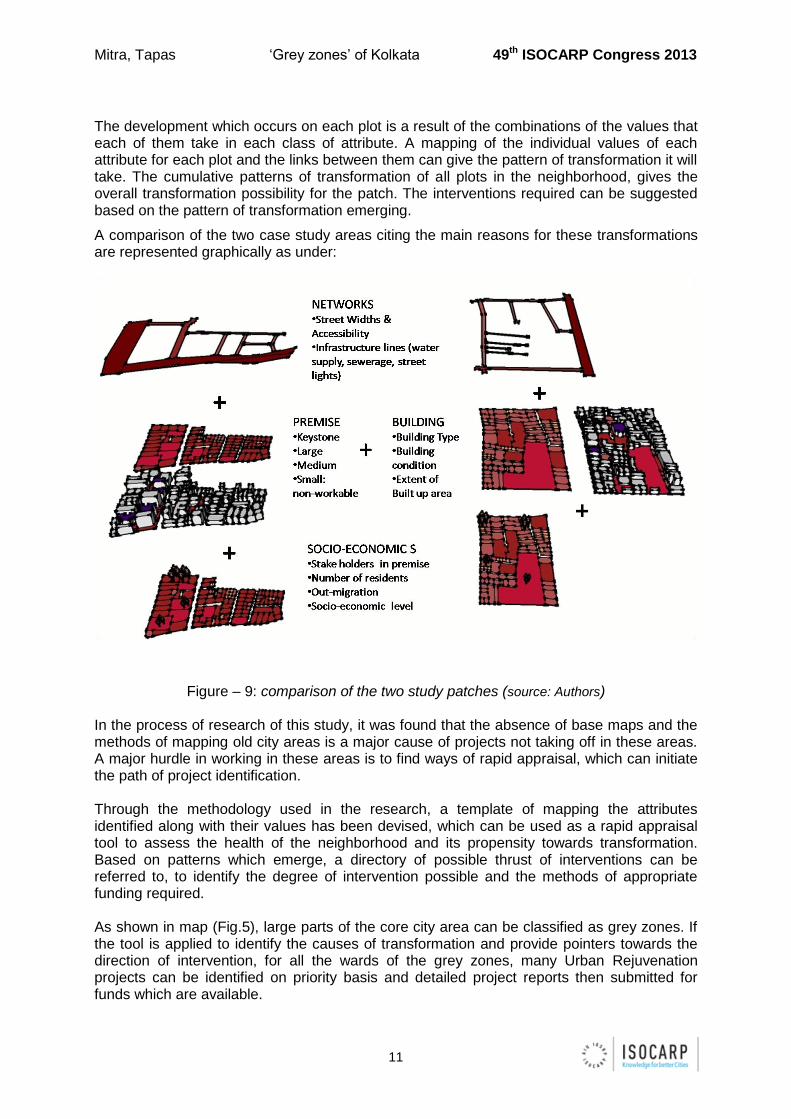
The development which occurs on each plot is a result of the combinations of the values that each of them take in each class of attribute. A mapping of the individual values of each attribute for each plot and the links between them can give the pattern of transformation it will take. The cumulative patterns of transformation of all plots in the neighborhood, gives the overall transformation possibility for the patch. The interventions required can be suggested based on the pattern of transformation emerging.
A comparison of the two case study areas citing the main reasons for these transformations are represented graphically as under:
Figure – 9: comparison of the two study patches (source: Authors) In the process of research of this study, it was found that the absence of base maps and the methods of mapping old city areas is a major cause of projects not taking off in these areas. A major hurdle in working in these areas is to find ways of rapid appraisal, which can initiate the path of project identification. Through the methodology used in the research, a template of mapping the attributes identified along with their values has been devised, which can be used as a rapid appraisal tool to assess the health of the neighborhood and its propensity towards transformation. Based on patterns which emerge, a directory of possible thrust of interventions can be referred to, to identify the degree of intervention possible and the methods of appropriate funding required. As shown in map (Fig.5), large parts of the core city area can be classified as grey zones. If the tool is applied to identify the causes of transformation and provide pointers towards the direction of intervention, for all the wards of the grey zones, many Urban Rejuvenation projects can be identified on priority basis and detailed project reports then submitted for funds which are available.
Mitra, Tapas ‘Grey zones’ of Kolkata 49th ISOCARP Congress 2013
12
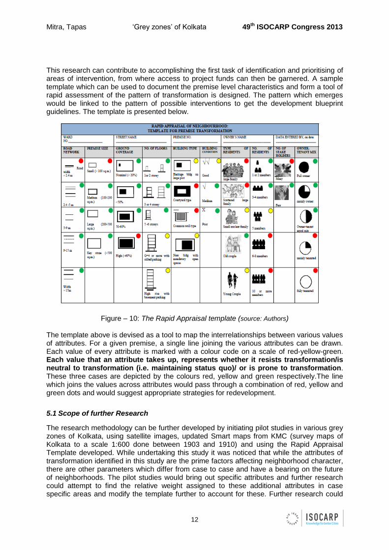
This research can contribute to accomplishing the first task of identification and prioritising of areas of intervention, from where access to project funds can then be garnered. A sample template which can be used to document the premise level characteristics and form a tool of rapid assessment of the pattern of transformation is designed. The pattern which emerges would be linked to the pattern of possible interventions to get the development blueprint guidelines. The template is presented below.
Figure – 10: The Rapid Appraisal template (source: Authors) The template above is devised as a tool to map the interrelationships between various values of attributes. For a given premise, a single line joining the various attributes can be drawn. Each value of every attribute is marked with a colour code on a scale of red-yellow-green. Each value that an attribute takes up, represents whether it resists transformation/is neutral to transformation (i.e. maintaining status quo)/ or is prone to transformation. These three cases are depicted by the colours red, yellow and green respectively.The line which joins the values across attributes would pass through a combination of red, yellow and green dots and would suggest appropriate strategies for redevelopment.
5.1 Scope of further Research
The research methodology can be further developed by initiating pilot studies in various grey zones of Kolkata, using satellite images, updated Smart maps from KMC (survey maps of Kolkata to a scale 1:600 done between 1903 and 1910) and using the Rapid Appraisal Template developed. While undertaking this study it was noticed that while the attributes of transformation identified in this study are the prime factors affecting neighborhood character, there are other parameters which differ from case to case and have a bearing on the future of neighborhoods. The pilot studies would bring out specific attributes and further research could attempt to find the relative weight assigned to these additional attributes in case specific areas and modify the template further to account for these. Further research could
Mitra, Tapas ‘Grey zones’ of Kolkata 49th ISOCARP Congress 2013
13
also extend to other cities having similar development patterns of juxtaposition of new and old areas. This would test the validity of the template and the methodology applied as a research method of a better informed decision making tool to develop city specific intervention strategies in older city core areas, to address their inherent conflicts between financial feasibility and place imageability.
References:
1. Rossi, Aldo (1966) The Architecture of the City, tr., Diane Ghirardo and Joan Oakman
eds., Kenneth Frampton and Peter Eisenmann, Cambridge, Massachusetts, and
London, England: The MIT Press.
2. Lynch, Kevin (1960) The Image of the City, Cambridge, Massachusetts, and London,
England: The MIT Press.
3. Jacobs, Jane (1961) The Death and Life of Great American Cities, New York: Random House.
4. Habraken, N.J. (1998) The Structure of the Ordinary, Cambridge, Massachusetts, and London, England: The MIT Press.
5. Bacon, Edmund (1967) Design of Cities, New York: Penguin Books. 6. Baer, William C. and Banerjee, Tridib (1984) Beyond the Neighborhood Unit, New York
and London: Plenum Press. 7. Perry, Clarence (1929) “The Neighborhood Unit, a Scheme for Arrangement for the
Family-Life Community”, Neighborhood and Community planning, Regional Plan and Survey, Vol.7, New York: Regional plan Association of New York.
8. Rossi, Aldo (1966) The Architecture of the City, tr., Diane Ghirardo and Joan Oakman
eds., Kenneth Frampton and Peter Eisenmann, Cambridge, Massachusetts, and
London, England: The MIT Press.