dekalb county planning & development department boc... · tenant build out improvements that do...
TRANSCRIPT

05/22/2018 Page 1 TA-18-21949 / D-1
AGENDA NO: D-1 ZONING CASE NO: TA-18-21949 MEETING DATE: May 22, 2018
APPLICANT: Dekalb County Board Of Commissioners
***********************************************************************************************************************************************
SECTIONS OF ZONING ORDINANCE AFFECTED BY AMENDMENTS:
27-3.36 Scottdale Overlay District
***********************************************************************************************************************************************
REASON OF REQUEST:
To consider the conversion of some areas from Tier 1, a commercial tier to Tier II and IV, singlefamily residential tiers in the Scottdale Overlay.
*********************************************************************************************************************************************
RECOMMENDATION(S):
PLANNING DEPARTMENT:DEFERRAL Full Cycle to allow better notification to the property owners and more citizenparticipation in addressing the needs and wants of the community.
Deferral: CC 4 vote a recommendation of deferral(9-3-0)
DeKalb County Planning & DevelopmentDepartment
330 Ponce De Leon Avenue, Suite 500Decatur, GA 30030
404/371-2155 or 404/371-2813(Fax)
TEXT AMENDMENT ANALYSIS
Michael L. ThurmondChief Executive Officer
COMMUNITY COUNCIL:
PLANNING COMMISSION:DEFERRAL L. Osler moved, J. Johnson seconded for a full cycle deferral.

Proposed Scottdale Overlay District Text Amendment TA- 18 - 21949
May 15, 2018
Page | 1 language to be deleted language to be added
27-3.1 DIVISION 36. SCOTTDALE AREA COMPATIBLE USE OVERLAY DISTRICT [25]
3.36.1 Scope of regulations.
This division establishes standards and procedures that apply to any development, use, alteration, height,
density, parking, open space, and building on any lot or portion thereof which is in whole or in part contained
within the boundaries of the Scottdale Area Compatible Use Overlay District (hereinafter referred to as the
"Scottdale Overlay District").
(Ord. No. 08-20, Pt. I, 10-14-08)
3.36.2 Applicability of regulations.
This division applies to each application for a permit for the development, use, alteration, or modification of
any structure where the subject property is in whole or in part contained within the boundaries of the Scottdale
Overlay District. The procedures, standards, and criteria herein apply only to that portion of the subject
property within the boundaries of the Scottdale Overlay District. Permits for repairs, interior alterations or
tenant build out improvements that do not alter the exterior appearance of the structure shall be exempt from
the requirements of this division. The planning director or designee shall determine the applicability of such
regulations on a case by case basis.
(Ord. No. 08-20, Pt. I, 10-14-08)
3.36.3 Statement of purpose and intent.
The purpose and intent of the board of commissioners in establishing the Scottdale Overlay District is as
follows:
A. To preserve, protect and enhance the existing character of the Scottdale Community;
B. To encourage new development that is appropriate to the existing character of the Scottdale Community;
C. To enhance the long term economic viability of this portion of DeKalb County by encouraging new
commercial and residential developments that increase the tax base and provide jobs to the citizens of
DeKalb County;
D. To implement the policies and objectives of the DeKalb County Comprehensive Plan 2005—2025 and
the policies and objectives of the Design Guidelines for the Scottdale Area Compatible Use Overlay
District;
E. To encourage mixed-use developments along appropriate corridors which have sufficient access and
infrastructure to support such developments; and
F. To protect established residential areas from encroachment of uses which are either incompatible or
unduly cause adverse impacts on such communities, and to protect the health, safety and welfare of the
citizens of DeKalb County.
(Ord. No. 08-20, Pt. I, 10-14-08)
3.36.4 District boundaries and maps.
A. Boundaries: The boundaries of the Scottdale Overlay District shall be established by a zoning map
amendment, dated May 28, 2013, which is attached hereto as Exhibit A and is adopted
contemporaneously with the adoption of this section and which is incorporated by reference as if fully set
forth herein and made a part of this chapter 27. The zoning map amendment shall be maintained by the
director of the department of planning and sustainability and shall be available for public inspection in the
office of said director.
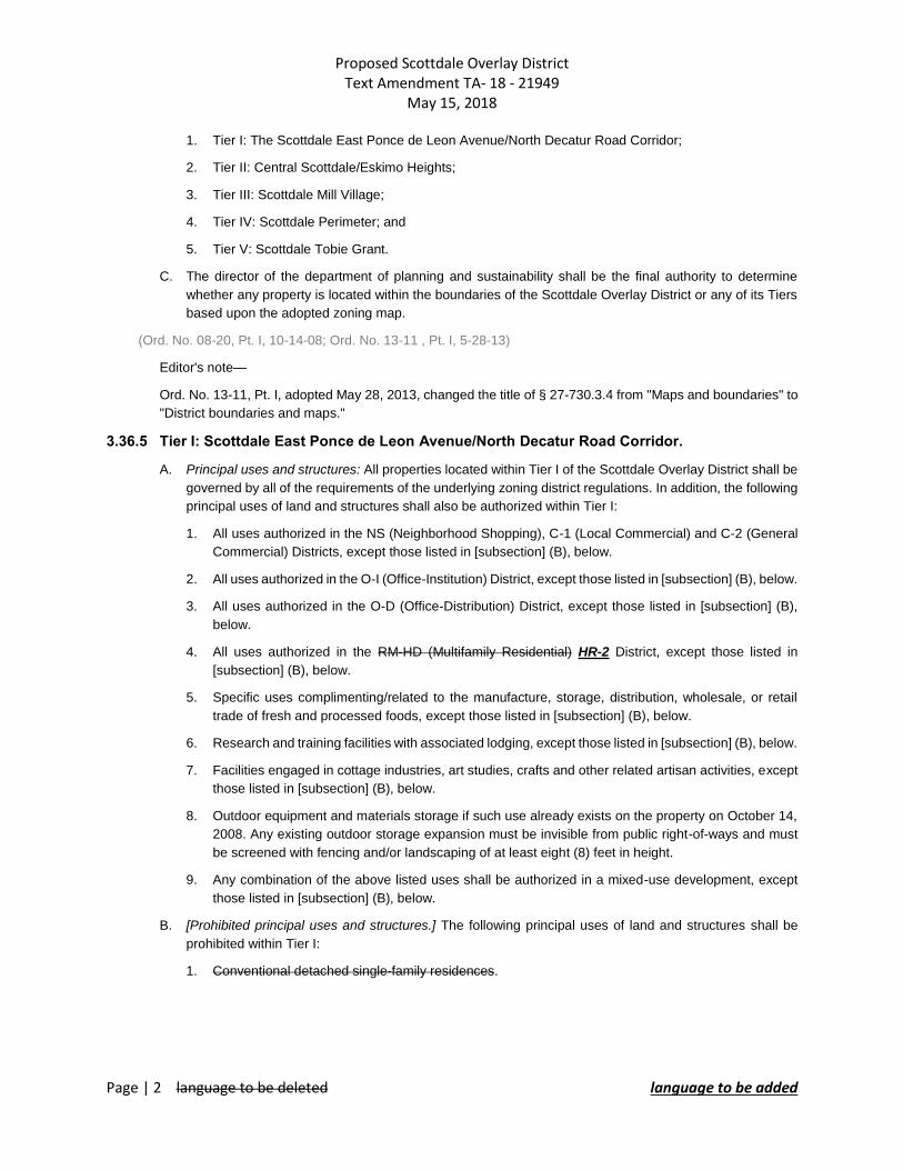
B. Tiers: The Scottdale Overlay District shall be divided into five (5) tiers:
Proposed Scottdale Overlay District Text Amendment TA- 18 - 21949
May 15, 2018
Page | 2 language to be deleted language to be added
1. Tier I: The Scottdale East Ponce de Leon Avenue/North Decatur Road Corridor;
2. Tier II: Central Scottdale/Eskimo Heights;
3. Tier III: Scottdale Mill Village;
4. Tier IV: Scottdale Perimeter; and
5. Tier V: Scottdale Tobie Grant.
C. The director of the department of planning and sustainability shall be the final authority to determine
whether any property is located within the boundaries of the Scottdale Overlay District or any of its Tiers
based upon the adopted zoning map.
(Ord. No. 08-20, Pt. I, 10-14-08; Ord. No. 13-11 , Pt. I, 5-28-13)
Editor's note—
Ord. No. 13-11, Pt. I, adopted May 28, 2013, changed the title of § 27-730.3.4 from "Maps and boundaries" to
"District boundaries and maps."
3.36.5 Tier I: Scottdale East Ponce de Leon Avenue/North Decatur Road Corridor.
A. Principal uses and structures: All properties located within Tier I of the Scottdale Overlay District shall be
governed by all of the requirements of the underlying zoning district regulations. In addition, the following
principal uses of land and structures shall also be authorized within Tier I:
1. All uses authorized in the NS (Neighborhood Shopping), C-1 (Local Commercial) and C-2 (General
Commercial) Districts, except those listed in [subsection] (B), below.
2. All uses authorized in the O-I (Office-Institution) District, except those listed in [subsection] (B), below.
3. All uses authorized in the O-D (Office-Distribution) District, except those listed in [subsection] (B),
below.
4. All uses authorized in the RM-HD (Multifamily Residential) HR-2 District, except those listed in
[subsection] (B), below.
5. Specific uses complimenting/related to the manufacture, storage, distribution, wholesale, or retail
trade of fresh and processed foods, except those listed in [subsection] (B), below.
6. Research and training facilities with associated lodging, except those listed in [subsection] (B), below.
7. Facilities engaged in cottage industries, art studies, crafts and other related artisan activities, except
those listed in [subsection] (B), below.
8. Outdoor equipment and materials storage if such use already exists on the property on October 14,
2008. Any existing outdoor storage expansion must be invisible from public right-of-ways and must
be screened with fencing and/or landscaping of at least eight (8) feet in height.
9. Any combination of the above listed uses shall be authorized in a mixed-use development, except
those listed in [subsection] (B), below.
B. [Prohibited principal uses and structures.] The following principal uses of land and structures shall be
prohibited within Tier I:
1. Conventional detached single-family residences.

Proposed Scottdale Overlay District Text Amendment TA- 18 - 21949
May 15, 2018
Page | 3 language to be deleted language to be added
2. Apartments Multi-family1, except within a mixed-use development.
3. Adult entertainment establishment.
4. Adult service facility.
5. Automobile and truck sales.
6. Parking lots as a primary use.
7. Automobile repair and paint shop.
8. Automobile upholstery shop.
9. Automobile wash service.
10. Automobile, truck and trailer lease and rentals.
11. Boat sales.
12. Breeding kennels.
13. Cemetery, columbarium, or mausoleum.
14. Check cashing establishment.
15. Drive-in theater.
16. Extended stay hotel.
17. Fraternity house, sorority house and residence hall.
18. Fuel dealers, manufacturers and wholesalers.
19. Gift, novelty or souvenir store selling adult novelties.
20. Go-cart and motorcycle or other motorized concession.
21. Golf driving range or batting cage facility.
22. Heavy construction contractor with outside storage areas.
23. Heavy repair service and trade shop.
24. Hospital.
25. Motel.
26. Pawn shop.
27. Radio and television broadcasting station with outdoor tower.
28. Shelter for homeless persons.
29. Storage yard for damaged or confiscated automobiles.
30. Tire retreading and recapping.
1 Zoning Code definition - Dwelling unit, multi-family: One (1) or more rooms with a private bath and kitchen facilities comprising an independent, self-contained residential unit in a building containing four (4) or more dwelling units.

Proposed Scottdale Overlay District Text Amendment TA- 18 - 21949
May 15, 2018
Page | 4 language to be deleted language to be added
31. Trailer salesroom and sales lot.
C. Accessory uses and structures: The following accessory uses of land and structures shall be authorized
in Tier I:
1. Accessory uses and structures incidental to any authorized use.
2. Parking lots and parking decks which are accessory to any authorized use.
3. Clubhouse, including meeting room or recreation room.
4. Swimming pools, tennis courts, and other recreation areas and similar amenities.
5. Signs, in accordance with the provisions of chapter 21 and this chapter.
D. The Scottdale Neighborhood Center: The Scottdale Neighborhood Center shall be established within Tier
I. The boundaries of said Scottdale Neighborhood Center shall be established by a zoning map
amendment adopted pursuant to this chapter which amendment shall be incorporated herein and made
a part of this chapter 27
E. Building setbacks: The following requirements shall apply to all structures within Tier I:
1. Outside neighborhood center:
a. Front yard setback: Shall be a minimum of zero (0) feet and no more than twenty-five (25) feet.
b. Minimum interior side yard setback: Shall be a minimum of zero (0) feet. However, there shall
be a minimum of fifteen (15) feet between buildings and structures less than two (2) stories in
height and a minimum of twenty (20) feet between any two (2) buildings and structures when
one (1) of them is greater than two (2) stories in height.
c. Minimum rear yard setback: Fifteen (15) feet.
2. Within neighborhood center:
a. Front yard setback: Shall be a minimum of zero (0) feet and a maximum of fifteen (15) feet.
b. Minimum side yard setback: Shall be zero (0) feet; There shall be a minimum of twenty (20) feet
between buildings.
c. Minimum rear yard setback: Fifteen (15) feet.
F. Height of buildings and structures: No building or structure within Tier I shall exceed fifty (50) feet in height,
except for architectural projections which may include parapets, skylights and roof access enclosures.
Buildings and structures within the Neighborhood Center shall not exceed seventy (70) feet in height
except for architectural projections which may include parapets, skylights and roof access enclosures.
G. Architectural guidelines: Architectural design of all buildings and structures within Tier I shall comply with
the following guidelines.
1. Each building elevation shall be constructed of brick, stone, stucco, steel, glass, wood or any
combination thereof.
2. Roofing materials for hipped or pitched roofs shall consist of standing metal seam, tile, slate, stone,
or architectural-style shingles.
3. Walls visible from roadways or parking areas shall incorporate changes in building material/color or
varying design details such as trellises, false windows, landscaping, or storefronts every one hundred
fifty (150) linear feet.
H. Redevelopment:

Proposed Scottdale Overlay District Text Amendment TA- 18 - 21949
May 15, 2018
Page | 5 language to be deleted language to be added
1. Redeveloped buildings or structures shall be permitted to maintain existing building materials and
character, subject to review and approval of the planning director or designee. The director shall
inform the president of the Scottdale Community Alliance of such proposed redevelopment in writing
at least ten (10) business days before any such approval may be given.
I. Parking: Surface parking shall be located to the rear or the side of buildings, whether in a surface lot or
parking deck. Shared parking is encouraged and may result in permitted reductions of off-street parking
requirements. Parking facilities within a parcel may be shared if multiple uses cooperatively establish and
operate parking facilities and if these uses generate parking demands primarily when the remaining uses
are not in operation. Applicants shall make an application to the director of planning and development for
authorization for shared parking. Applicants shall include proof of a written formal shared-parking
agreement between the applicant and all affected property owners. Shared parking arrangements may
be approved by the director of planning and development upon determination that the above stated off-
street parking requirements for each use are met during said use's operational hours. Required parking
for residential units shall be prohibited from being shared.
(Ord. No. 08-20, Pt. I, 10-14-08)
3.36.6 Tier II: Central Scottdale/Eskimo Heights.
A. Principal uses and structures: The following principal uses of land and structures shall be authorized
within Tier II:
1. Detached single-family residences.
B. Accessory uses and structures: Accessory uses, buildings and structures shall be located within the rear
yard. Accessory buildings and structures shall not exceed twenty (20) feet in height or the height of the
principal structure, whichever is less, and shall comply with the requirements of Section 4.2.2. The
following accessory uses of land and structures shall be authorized in Tier II:
1. Accessory uses and structures incidental to any authorized principal use, including the following and
similar uses:
a. Garages for parking of automobiles.
b. Storage buildings.
c. Swimming pools.
d. Tennis courts and other play and recreation areas.
2. Signs, in accordance with the provisions of chapter 21 and this chapter.
C. Special permits: The following uses and structures shall be authorized only by permits of the type
indicated:
1. Special administrative permit as required in Code Section 4.2.31.
a. Home occupation involving no customer contact and no employee other than a person residing
on the premises.
2. Special exception permit from the zoning board of appeals:
a. Utility structure necessary for the transmission or distribution of service.
3. Special land use permit from the board of commissioners:
a. Adult day care facility.
b. Child day care facility.

Proposed Scottdale Overlay District Text Amendment TA- 18 - 21949
May 15, 2018
Page | 6 language to be deleted language to be added
c. Convent or monastery.
d. Home occupation involving any customer contact.
e. Home stay bed and breakfast residence.
f. Neighborhood recreation club.
g. Personal care home, family.
h. Personal care home, registered.
i. Place of worship.
D. Minimum lot area: Lots within Tier II shall be no less than five thousand (5,000) square feet in area.
E. Minimum lot width: Lots within Tier II shall be no less than fifty (50) feet in width.
F. Building setbacks: The following requirements shall apply to all structures within Tier II:
1. Minimum front yard setback: When a lot (or lots) is (are) located within a block where sixty (60)
percent or more of the lots within said block have been developed, and where there are existing
buildings fronting on the same street and within the same zoning district within seventy-five (75) feet
of the side lot lines of such vacant lot (or lots), then setback averaging shall be required. The minimum
required building setback line for said vacant lot (or lots) shall be determined by averaging the existing
building setbacks of buildings within seventy-five (75) feet of the side lot lines of such vacant lot (or
lots). The minimum setback for additions to existing structures may be the average of the existing
setbacks. Otherwise, the minimum front yard setback requirement shall be thirty (30) feet.
2. Minimum side yard setback: Seven and one-half (7.5) feet.
3. Minimum rear yard setback: Thirty (30) feet.
G. Height of buildings and structures: No building or structure within Tier II shall exceed twenty-eight (28)
feet in height, except when located on an individual nonconforming lot of record. Buildings and structures
on an individual nonconforming lot of record shall not exceed thirty-two (32) feet in height.
H. Floor area of dwelling: The floor area of each dwelling shall be no less than one thousand (1,000) square
feet of heated floor area.
I. Architectural guidelines: Architectural design of all buildings and structures within Tier II shall comply with
the following guidelines:
1. Detached residential guidelines:
a. Each building elevation shall be constructed of brick, stone, stucco, wood, wood shake, cement
fiberboard siding, or any combination thereof.
b. Roofing materials for pitched or hip roofs shall consist of metal standing seam, tile, slate, stone,
wood shake or architectural-style shingles.
J. Parking: Off-street parking requirements for uses and structures authorized and permitted in Tier II are
as follows:
1. Detached single-family dwelling: Two (2) spaces.
K. No lot shall be developed to exceed the maximum allowable coverage by buildings,
structures, driveways or parking areas, or any other impervious surface specified for the zoning
district in which the lot is located. In addition to the maximum impervious surface amount, pervious
materials may be added up to a maximum amount of fifteen percent (15%) of the total lot area for
driveways, walkways, patios and pool decks.

Proposed Scottdale Overlay District Text Amendment TA- 18 - 21949
May 15, 2018
Page | 7 language to be deleted language to be added
(Ord. No. 08-20, Pt. I, 10-14-08)
3.36.7 Tier III: Scottdale Mill Village.
A. Principal uses and structures: The following principal uses of land and structures shall be authorized
within Tier III:
1. Detached single-family residences.
B. Accessory uses and structures: Accessory uses, buildings and structures shall be located within the rear
yard. Accessory buildings and structures shall not exceed twenty (20) feet in height or the height of the
principal structure, whichever is less, and shall comply with the requirements of Section 4.2.2. The
following accessory uses of land and structures shall be authorized in Tier III:
1. Accessory uses and structures incidental to any authorized principal use, including the following and
similar uses:
a. Garages for parking of automobiles.
b. Storage buildings.
c. Swimming pools.
d. Tennis courts and other play and recreation areas.
2. Signs, in accordance with the provisions of chapter 21 and this chapter.
C. Special permits: The following uses and structures shall be authorized only by permits of the type
indicated:
1. Special administrative permit from director of public works:
a. Home occupation involving no customer contact and no employee other than a person residing
on the premises.
2. Special exception permit from the zoning board of appeals:
a. Utility structure necessary for the transmission or distribution of service.
3. Special land use permit from the board of commissioners:
a. Adult day care facility.
b. Child day care facility.
c. Convent or monastery.
d. Home occupation involving any customer contact.
e. Home stay bed and breakfast residence.
f. Neighborhood recreation club.
g. Personal care home, family.
h. Personal care home, registered.
i. Place of worship.
D. Minimum lot area: Lots within Tier III shall be no less than seven thousand five hundred (7,500) square
feet in area.
E. Minimum lot width: Lots within Tier III shall be no less than seventy (70) feet in width.

Proposed Scottdale Overlay District Text Amendment TA- 18 - 21949
May 15, 2018
Page | 8 language to be deleted language to be added
F. Buildings setbacks: The following requirements shall apply to all structures within Tier III:
1. Minimum front yard setback: When a lot (or lots) is (are) located within a block where sixty (60)
percent or more of the lots within said block have been developed, and where there are existing
buildings fronting on the same street and within the same zoning district within seventy-five (75) feet
of the side lot lines of such vacant lot (or lots), then setback averaging shall be required. The minimum
required building setback line for said vacant lot (or lots) shall be determined by averaging the existing
building setbacks of buildings within seventy-five (75) feet of the side lot lines of such vacant lot (or
lots). Otherwise, the minimum front yard setback shall be thirty-five (35) feet.
2. Minimum side yard setback: Seven and one-half (7.5) feet.
3. Minimum rear yard setback: Thirty (30) feet. Rear setback averaging is allowed if approved by the
planning director or designee.
G. Height of buildings and structures: No building or structure within Tier III shall exceed twenty-eight (28)
feet in height.
H. Floor area of dwelling: The floor area of each dwelling shall be no less than six-hundred-fifty (650) square
feet of heated floor area.
I. Architectural guidelines: Architectural design of all buildings and structures within Tier III shall comply with
the following guidelines:
1. Detached residential guidelines:
a. The scale, size and character of new construction shall be consistent with existing structures.
b. Each building elevation shall be constructed of wood or cement fiberboard lap siding. Chimneys
shall be constructed of brick. Other materials, such as vinyl or aluminum siding, may be repaired
or replaced in kind on structures that are currently constructed of such materials.
c. Foundations of principal structures shall be constructed of brick, stone or concrete covered with
stucco.
d. Roofing materials for pitched or hip roofs shall consist of metal seam, tile, slate, stone, wood
shake or architectural style shingles.
e. Covered front porches shall be required. Front porches may be screened, but shall not be
enclosed.
f. Additions to existing houses shall not be permitted on the front of the houses. Additions may be
constructed in the side or rear yard in compliance with the setback requirements of this section.
J. Parking: Off-street parking requirements for uses and structures authorized and permitted in Tier III are
as follows:
1. Detached single-family dwelling: Two (2) spaces.
K. Transitional zone: A transitional zone shall be established extending one hundred (100) feet outward from
any boundary of Tier III. The transitional zone shall consist of public rights-of-way, easements, alleys, and
parcels that are immediately adjacent to Tier III. Within the transitional zone, mixed use developments
complementary to the character of the Mill Village, the Mill, the DeKalb Farmers Market, and artisan
activities shall be permitted. The properties that lie within the transition zone shall be governed by the
principal uses and structures of Tier I. In addition, the transitional zone shall include single-family
detached residential uses.

Proposed Scottdale Overlay District Text Amendment TA- 18 - 21949
May 15, 2018
Page | 9 language to be deleted language to be added
1. Buildings and structures within the transitional zone shall not exceed thirty (30) feet in height except
for the normal architectural projections which may include roof parapets, skylights, or access
enclosures.
2. New buildings and structures to be constructed on parcels that are immediately adjacent to or across
a street from any Tier III property shall have a front and side yard setback that is equivalent to the
setback of those properties within Tier III.
3. Buildings and structures within the transitional zone shall have architectural character and design
details that are complimentary to the Scottdale Mill Village.
4. Buildings and structures must be constructed of brick, stone, stucco, steel, glass, wood, cement
fiberboard lap siding, or any combination thereof.
5. All parking areas are to be located in the rear of or on the side of all new buildings. Where parking
areas are visible from roadways and sidewalks, a fifteen (15) foot landscape screen shall be
established.
6. Shared parking is encouraged and may be authorized by the director of planning or designee.
L. No lot shall be developed to exceed the maximum allowable coverage by buildings, structures,
driveways or parking areas, or any other impervious surface specified for the zoning district in
which the lot is located. In addition to the maximum impervious surface amount, pervious
materials may be added up to a maximum amount of fifteen percent (15%) of the total lot area for
driveways, walkways, patios and pool decks.
(Ord. No. 08-20, Pt. I, 10-14-08)
3.36.8 Tier IV: Scottdale Perimeter.
A. Principal uses and structures: The following principal uses of land and structures shall be authorized
within Tier IV:
1. Rockbridge and Old Rockbridge Road: Detached single-family residences.
2. Lantern Ridge Subdivision: Attached single-family residences shall be permitted on properties
having a minimum of one hundred (100) feet of frontage.
3. Lantern Ridge Subdivision: Fee-simple multifamily residences shall be permitted on properties
having a minimum of one hundred (100) feet of frontage.
B. Accessory uses and structures: Accessory uses, buildings and structures shall be located within the rear
yard. Accessory buildings and structures shall not exceed twenty (20) feet in height or the height of the
principal structure, whichever is less, and shall comply with the requirements of Section 4.2.2. The
following accessory uses of land and structures shall be authorized in Tier IV:
1. Accessory uses and structures incidental to any authorized principal use, including the following and
similar uses:
a. Garages for parking of automobiles.
b. Storage buildings.
c. Swimming pools.
d. Tennis courts and other play and recreation areas.
2. Signs, in accordance with the provisions of chapter 21 and this chapter.
C. Special permits: The following uses and structures shall be authorized only by permits of the type
indicated:

Proposed Scottdale Overlay District Text Amendment TA- 18 - 21949
May 15, 2018
Page | 10 language to be deleted language to be added
1. Special administrative permit from the director of public works:
a. Home occupation involving no customer contact and no employee other than a person residing
on the premises.
2. Special exception permit from the zoning board of appeals:
a. Utility structure necessary for the transmission or distribution of service.
3. Special land use permit from the board of commissioners:
a. Adult day care facility.
b. Child day care facility.
c. Convent or monastery.
d. Home occupation involving any customer contact.
e. Home stay bed and breakfast residence.
f. Neighborhood recreation club.
g. Place of worship.
h. Personal care home, family.
i. Personal care home, registered.
j. Private elementary, middle and high school.
D. Minimum lot area/density: Lots within Tier IV developed for detached single-family residences shall be no
less than six thousand (6,000) square feet in area, and the density shall not exceed six (6) units per acre.
E. Minimum lot width:
1. Single-family detached residences: Lots shall be no less than sixty (60) feet in width as measured
along the road frontage.
2. Single-family attached residences: Lots shall be no less than one hundred (100) feet in width as
measured along the road frontage.
F. Building setbacks: The following requirements shall apply to all structures within Tier IV:
1. Single-family detached residences:
a. Minimum front yard setback: When a lot (or lots) is (are) located within a block where sixty (60)
percent or more of the lots within said block have been developed, and where there are existing
buildings fronting on the same street and within the same zoning district within seventy-five (75)
feet of the side lot lines of such vacant lot (or lots), then setback averaging shall be required.
The minimum required building setback line for said vacant lot (or lots) shall be determined by
averaging the existing building setbacks of buildings within seventy-five (75) feet of the side lot
lines of such vacant lot (or lots). The minimum setback for additions to existing structures may
be the average of the existing setbacks. Otherwise, the minimum front yard setback shall be as
follows:
i. From major thoroughfares: Forty-five (45) feet.
ii. From minor thoroughfares: Thirty-five (35) feet.
iii. From collector streets: Thirty (30) feet.
iv. From other streets: Thirty (30) feet.

Proposed Scottdale Overlay District Text Amendment TA- 18 - 21949
May 15, 2018
Page | 11 language to be deleted language to be added
b. Minimum side yard setback: Seven and one-half (7.5) feet.
c. Minimum rear yard setback: Thirty (30) feet.
2. Single-family attached residences:
a. Minimum front yard setback: Five (5) feet, except that where a garage door faces the street, the
facade of said garage shall be set back no less than twenty (20) feet from the sidewalk.
b. Minimum interior side yard setback: Fifteen (15) feet.
3. Minimum rear yard setback: Thirty (30) feet.
G. Height of buildings and structures: No building or structure within Tier IV shall exceed thirty-five (35) feet
in height.
H. Floor area of dwelling: The floor area of each dwelling shall be no less than one thousand two hundred
(1,200) square feet of heated floor area.
I. Architectural guidelines: Architectural design of all buildings and structures within Tier IV shall comply
with the following guidelines:
1. Detached residential guidelines:
a. Each building elevation shall be constructed of brick, stone, stucco, wood, wood shake, cement
fiberboard siding, or any combination thereof.
b. Roofing materials for pitched or hip roofs shall consist of metal standing seam, tile, slate, stone,
wood shake, asphalt or architectural-style shingles.
c. Any new dwelling constructed on a lot with frontage on Rockbridge Road shall have its primary
entrance facing Rockbridge Road.
d. Any new dwelling constructed on a lot with frontage on Old Rockbridge Road shall have its
primary entrance facing Old Rockbridge Road.
J. Parking: Off-street parking requirements for uses and structures authorized and permitted in Tier IV are
as follows:
1. Detached single-family dwelling: Two (2) spaces.
2. Attached single-family dwelling: Two (2) spaces.
3. Condominiums: One and seventy-five one-hundredths (1.75) spaces per dwelling unit.
K. Sidewalks: Sidewalks shall be provided along both sides of the right-of-way of all public streets in
accordance with Section 3.39.12
L. Streets: No cul-de-sacs are allowed.
M. No lot shall be developed to exceed the maximum allowable coverage by buildings, structures,
driveways or parking areas, or any other impervious surface specified for the zoning district in
which the lot is located. In addition to the maximum impervious surface amount, pervious
materials may be added up to a maximum amount of fifteen percent (15%) of the total lot area for
driveways, walkways, patios and pool decks.
(Ord. No. 08-20, Pt. I, 10-14-08)
3.36.9 Re-establishment of street grid.
Within the Scottdale Overlay District, the existing street grid shall be continued or re-established where site
conditions allow. Where there is no existing street grid system to connect into, or where site conditions do not

Proposed Scottdale Overlay District Text Amendment TA- 18 - 21949
May 15, 2018
Page | 12 language to be deleted language to be added
allow for the continuation or re-establishment of the street grid system, the planning director or designee may
approve an alternative street system, including without limitation, stub streets and alleyways. In no case shall
new roads alter the established street grid. Cul-de-sacs are prohibited in all new developments.
(Ord. No. 08-20, Pt. I, 10-14-08)
3.36.10 Measurement of building height.
Within the Scottdale Overlay District building height shall be measured by the following methods pursuant to
Section 27-5.25 of the Zoning Ordinance, as amended.
A. For undeveloped lots: From the average existing grade as measured along the building setback line to
the midpoint of the highest roof structure; or
B. For developed lots: From the threshold of the main entrance of an existing dwelling to the midpoint of the
highest roof structure. In the case of an infill building that would require alteration or demolition of the
original threshold; the original elevation thereof shall be measured and certified by a licensed surveyor or
professional engineer. The certified elevation shall be submitted as a part of the application for any
demolition or building permit.
(Ord. No. 08-20, Pt. I, 10-14-08)
3.36.11 Landscaping requirements.
The following landscaping regulations shall apply to all uses within the Scottdale Overlay District where
landscape strips or screening is deemed necessary and appropriate by the planning director or designee:
A. Landscape strips: Any landscape strip shown as part of the final design package shall be not less than
five (5) feet in width and shall be provided along all side and rear property lines and on both sides of all
public streets. The landscape strip in the front yard shall be a minimum of ten (10) feet in width and shall
be planted with a row of street trees of at least three and one-half (3.5) inches in caliper, selected from
the list of street trees species identified in Section 3.36.11(D) and the Design [Guidelines] for the Scottdale
Overlay District dated May 2008, a copy of which shall be maintained by the planning director and
available for public inspection, and planted not less than thirty (30) feet on center. Continuous landscaped
strips shall be constructed along public rights-of-way except at points of ingress or egress into the facility.
B. Ground cover: Ground cover shall also be provided in accordance with the Design Guidelines for the
Scottdale Area Overlay District in order to protect tree roots and to prevent erosion. Ground cover shall
consist of evergreen shrubs or groundcover plant material mulched with pine bark mulch, or other similar
landscaping material.
C. Street trees: Newly planted trees shall conform to the Design Guidelines for the Scottdale Overlay District.
No tree shall be planted closer than two (2) feet from the street or sidewalk, and no closer than five (5)
feet from a fire hydrant, sign post, streetlight standard, utility pole, or similar structure.
D. Street tree planting: Street trees of a caliper of not less than three (3) inches shall be planted no less than
thirty (30) feet on center along all properties within the district having frontage on a public street. Trees of
the following types shall be used:
1. Crape myrtle, standard trunk.
2. Dogwood (Cornus Florida).
3. October glory red maple.
4. Sunset maple.
5. Nuttal oak (Quercus Nattalli).
6. Shumard oak (Quercus Shumardii)

Proposed Scottdale Overlay District Text Amendment TA- 18 - 21949
May 15, 2018
Page | 13 language to be deleted language to be added
7. Willow oak (Quercus Phellos).
8. Zelkova Serrata.
9. Ginkgo (Ginkgo Biloba).
10. Trident maple (Acer Buergeranum).
11. Allee lacebark elm (Ulmus Parvifolia Emer II).
12. Other varieties are subject to the review and approval of the county arborist and the planning director
or designee.
E. Maintenance of trees and ground cover: All street trees and other trees and all ground cover required by
this chapter or by chapter 14 shall be maintained in a healthy condition, and any trees or ground cover
which die shall be replaced within the earliest possible planting season.
F. Parking lot landscaping requirements: All parking lots within the Scottdale Overlay District shall be
landscaped pursuant to the requirements of Section 5.4.4.
(Ord. No. 08-20, Pt. I, 10-14-08)
3.36.12 Sidewalks and curb cuts.
A. Sidewalk requirement: There shall be a public sidewalk constructed along all public street frontages
contiguous to all properties within Tiers I, II, and IV of the Scottdale Overlay District. The sidewalk shall
be located five (5) feet from the curb and shall be fifteen (15) feet in width within Tier I. Within Tiers II and
IV new sidewalks shall match existing sidewalk patterns. In places where sidewalks are not present, new
sidewalks shall be established. The new sidewalks shall be located four (4) feet from the curb and shall
be five (5) feet in width. The zone adjacent to the curb shall be the street tree planting zone. In blocks
where there are overhead utility lines, the planning director or designee may authorize exceptions to allow
for a landscape plan that will not interfere with such utilities. All such conditions will be subject to review
and approval by the planning director or designee in addition to the DeKalb County Arborist.
B. Curb cuts: Driveway curb cuts shall be a minimum of twenty-five (25) feet from any driveway curb cut on
an adjoining property, and shall not be permitted within fifty (50) feet of the intersection of any two public
streets. Driveway curb cuts shall not exceed a width of eighteen (18) feet.
(Ord. No. 08-20, Pt. I, 10-14-08)
3.36.13 Signs.
All lots in the Scottdale Overlay District shall comply with all requirements of chapter 21, subject to the following
additional regulations:
A. Signs shall be designed so as to be compatible with the Scottdale Overlay District Design Guidelines.
B. All ground signs shall be monument style signs with a base and framework made of brick; the design of
ground signs must comply with the Scottdale Overlay District Design Guidelines.
C. Each lot shall have no more than one (1) ground sign.
D. The sign area of ground signs shall not exceed thirty-two (32) square feet, unless the lot contains a
shopping center, in which case ground signs are limited to sixty-four (64) square feet.
E. Ground signs shall not exceed a height of six (6) feet, unless the lot contains a shopping center, in which
case ground signs shall not exceed a height of fifteen (15) feet.
F. For mixed-use developments, each separate store front may have a maximum of two (2) wall signs, each
of which shall not exceed an area of ten (10) percent of the area of the facade of the ground floor of the
building or seventy-five (75) square feet, whichever is less.

Proposed Scottdale Overlay District Text Amendment TA- 18 - 21949
May 15, 2018
Page | 14 language to be deleted language to be added
G. Wall signs shall be located on the primary building facade and within fifteen feet (15) of the public right of
way.
H. Window signs are prohibited.
I. Banners are prohibited.
J. Wall-mounted signs shall be channel cut letters applied directly to the building facade. Raceways are not
allowed. Flashing, animated, marquee, sound emitting, fluorescent, rotating or otherwise moving signs
are prohibited.
K. Sign shape and lettering shall be limited as follows:
1. Signs with more than two (2) faces are prohibited.
2. Sign facing shall be flat in profile and shall not exceed a thickness of eight (8) inches.
3. Sign faces shall be parallel.
4. Sign lettering shall consist of block lettering in which individual letters are proportional in size to the
overall size of the sign, but in no event shall individual letters exceed twenty-four (24) inches in height.
L. Sign lettering shall be of an opaque material.
M. Multitenant developments: A Master Sign Plan shall be submitted to the planning director or designee for
review and approval prior to issuance of any sign permit for any new development having multiple tenants.
All owners, tenants, subtenants and purchasers of individual units within a multitenant development shall
comply with the approved Master Sign Plan and the provisions of chapter 21. The Master Sign Plan shall
include:
1. General location of signs: The proposed location of any ground signs, entrance signs or directional
signs on a lot shall be identified on the Master Sign Plan. The proposed locations for any projecting
sign, wall sign, canopy sign, or window sign shall be clearly identified on renderings of the building
elevation(s).
2. Types of signs: The proposed types of signs (e.g., ground sign, projecting sign, individual channel
letters, box mount, painted, electronic variable message signs, etc.) shall be identified in the Master
Sign Plan.
3. Materials: The proposed materials for all sign structures and sign surfaces shall be identified in the
Master Sign Plan.
4. Size and number of signs: The maximum number and maximum size of proposed signs, including
maximum height, maximum width, and maximum square footage, should be identified in the Master
Sign Plan.
5. Style and color: The proposed style and color palette for all signs shall be identified in the Master
Sign Plan. The style and color shall be consistent with the design details of the primary structure on
the lot.
6. Illumination: The type of illumination, if any, proposed for all signs shall be identified in the Master
Sign Plan.
7. Individual sign approval: Prior to the issuance of a sign permit for an individual sign, all proposed
signs shall be reviewed for conformity with the Master Sign Plan and the provisions of chapter 21.
No sign shall be erected, located, or placed on a property that has been developed for occupancy by
multiple tenants which does not conform to the guidelines of the Master Sign Plan for said
development.

Proposed Scottdale Overlay District Text Amendment TA- 18 - 21949
May 15, 2018
Page | 15 language to be deleted language to be added
8. Amendment: A Master Sign Plan may be amended upon submission of a revised Master Sign Plan
to the planning director or designee; and approval of planning director or designee.
(Ord. No. 08-20, Pt. I, 10-14-08)
3.36.14 Variances and special exceptions.
Any request for a variance or special exception for property located in whole or in part within the boundaries
of the Scottdale Overlay District shall be submitted by the applicant to the then current president of the
Scottdale Community Alliance at least ten (10) business days prior to the first public hearing before the zoning
board of appeals.
(Ord. No. 08-20, Pt. I, 10-14-08)
3.36.15 Permits for uses.
Any use authorized by this division shall require that a development permit be issued before property
improvements can be made in accordance with section 7.7.2 and a building permit required in accordance
with the provisions of section 7.7.3. No permit shall be issued prior to the issuance of a certificate of compliance
described in section 3.39.17.
(Ord. No. 08-20, Pt. I, 10-14-08)
3.36.16 Design Guidelines for the Scottdale Area Compatible Use Overlay District.
The Scottdale Overlay District Design Guidelines dated May 2008 provides acceptable minimum standards to
guide design and development within the overlay district. The planning director or designee is authorized to
create, administer, and amend Design Guidelines for the Scottdale Overlay District. These guidelines provide
acceptable architectural design controls, landscaping, detail drawings, signage, fencing, lighting, street and
site furniture, and grating criteria. These guidelines shall be used to promote proper design criteria and shall
guide the planning director or designee in deciding whether a proposed design complies with the requirements
of the Scottdale Overlay District.
(Ord. No. 08-20, Pt. I, 10-14-08)
3.36.17 Plans required; certificates of compliance.
A. Plans required: Prior to the issuance of any land-disturbance permit, building permit, or sign permit, the
applicant shall submit to the district commissioners and the director of planning or designee an application
which shall include a conceptual plan package as defined by this chapter which shall demonstrate that
the proposed design is in compliance with all of the requirements of this Scottdale Overlay District and
the underlying zoning classification. The director of planning shall notify the president of the Scottdale
Community Alliance of any application. Copies of all applications shall be mailed to the president of the
Scottdale Community Alliance by the planning director or designee at least ten (10) business days before
any certificate of compliance is issued.
B. Fees: Plans shall be accompanied by an application and payment of a fee in an amount to be determined
by the board of commissioners.
C. Review: The director of planning or designee shall review each application for compliance with all
requirements of the Scottdale Overlay District and the underlying zoning classification. Where the director
or designee determines that said plans comply with the requirements of the Scottdale Overlay District a
certificate of compliance shall be issued in the form of the director or designee's signature on the plans
and drawings after which the applicant shall then apply for land disturbance, building or signs permits.
Where the director or designee determines that said plans do not comply with the requirements of this
section, then the director or designee shall notify the applicant in writing stating the manner in which said
applicant fails to comply with such requirements. All applications shall be considered and decided by the

Proposed Scottdale Overlay District Text Amendment TA- 18 - 21949
May 15, 2018
Page | 16 language to be deleted language to be added
director of planning or designee within thirty (30) days of receipt of a complete application. Any appeal of
the decision in this regard shall be to the zoning board of appeals pursuant to section 7.5.2.
(Ord. No. 08-20, Pt. I, 10-14-08)
3.36.18 Conceptual plan package review.
A. The conceptual plan package shall be composed of the following:
1. A narrative addressing the proposed development explaining how it meets the purpose, intent, and
standards of this chapter. The narrative shall include a tabulation of the approximate number of acres
in each land use, the approximate number of dwelling units by type, the approximate gross residential
density, the approximate commercial density, the approximate public space acreage, the anticipated
number, type and size of recreational facilities and other public amenities; and a site location map
showing the proposed development, abutting property, the relationship of the proposed development
to surrounding natural features and existing development, and transitional buffer zones, if required.
B. The plan to be submitted in the conceptual plan package shall contain the following information:
1. Six (6) copies of a plan drawn to a designated scale of not less than one (1) inch equals one hundred
(100) feet, certified by a professional engineer or land surveyor licensed by the State of Georgia,
presented on a sheet having a maximum size of twenty-four (24) inches by thirty-six (36) inches, and
one (1) eight and one-half (8½) by eleven-inch reduction of the plan. If presented on more than one
(1) sheet, match lines shall clearly indicate where the several sheets join. Such plan shall contain the
following information:
a. Boundaries of the entire property proposed to be included in the development, with bearings and
distances of the perimeter property lines.
b. Scale and north arrow, with north, to the extent feasible, oriented to the top of the plat and on all
supporting graphics.
c. Location and approximate dimensions in length and width, for landscape strips and required
transitional buffers, if any.
d. Existing topography with a maximum contour interval of five (5) feet and a statement indicating
whether it is an air survey or field run.
e. Approximate delineation of any floodplain designated by the Federal Emergency Management
Agency. United States Geological Survey, or DeKalb County.
f. The delineation of any jurisdictional wetlands as defined by section 404 of the Federal Clean
Water Act.
g. Approximate delineation of any significant historic or archaeological feature, grave, object or
structure marking a place of burial if known, and a statement indicating how the proposed
development will impact it.
h. A delineation of all existing structures and whether they will be retained or demolished.
i. General location, in conceptual form, of proposed uses, lots, buildings, building types and
building entrances.
j. Height and setback of all buildings and structures.
k. Approximate areas and development density for each type of proposed use.
l. Location, size, and number of all on-street and off-street parking spaces, including a shared
parking analysis, if shared parking is proposed.

Proposed Scottdale Overlay District Text Amendment TA- 18 - 21949
May 15, 2018
Page | 17 language to be deleted language to be added
m. Identification of site access points and layout, width of right-of-way and paved sections of all
internal streets.
n. Conceptual plans for drainage with approximate location and estimated size of all proposed
stormwater management facilities and a statement as to the type of facility proposed.
o. Development density and lot sizes for each type of use.
p. Areas to be held in joint ownership, common ownership or control.
q. Identification of site access points and layout, width of right-of-way and paved sections of all
internal streets.
r. Location of proposed sidewalks and bicycle facilities trails, recreation areas, parks, and other
public or community uses, facilities, or structures on the site.
s. Conceptual layout of utilities and location of all existing or proposed utility easements having a
width of twenty-five (25) feet or more.
t. Standard details of signs, sidewalks, streetlights, driveways, medians, curbs and gutters,
landscaped areas, fencing, grating, street furniture, bicycle lanes, streets, alleys, and other
public improvements demonstrating compliance with the design guidelines for the Scottdale
Overlay District.
u. Seal and signature of professional preparing the plan.
(Ord. No. 08-20, Pt. I, 10-14-08)
3.36.19 Final design package review and approval process.
A. [Final design package.] Upon receiving comments on the conceptual design package, the applicant will
submit the final design package for review and approval. The final design package must include full
architectural and landscape architectural plans and specifications. The submitted plans must include the
following, demonstrating that the final design package is in compliance with all requirements of the
Scottdale Overlay District and the underlying zoning classification: a site plan; architectural elevations
and sections; rendering depicting the building design, including elevations and architectural details of
proposed buildings, exterior materials and colors; and plans and elevations of all hardscape, landscape
and signage. The final design package must be signed and sealed by a professional engineer/architect.
The final design package must contain all plans, elevations, sections and specifications necessary for
obtaining development and building permits. The applicant may submit the final design package
simultaneously with the permit application.
B. Review: The director of planning or designee shall review each application for compliance with all
requirements of the Scottdale Overlay District and the underlying zoning classification. Where the director
or designee determines that said plans comply with the requirements of the Scottdale Overlay District a
certificate of compliance shall be issued in the form of the director or designee's signature on the plans
and drawings after which the applicant shall then apply for land disturbance, building or signs permits.
Where the director or designee determines that said plans do not comply with the requirements of this
chapter, then the director or designee shall notify the applicant in writing stating the manner in which said
applicant fails to comply with such requirements. All applications shall be considered and decided by the
director of planning or designee within thirty (30) days of receipt of a complete application. Any appeal of
the decision in this regard shall be to the zoning board of appeals pursuant to section 7.5.2.
(Ord. No. 08-20, Pt. I, 10-14-08)

Proposed Scottdale Overlay District Text Amendment TA- 18 - 21949
May 15, 2018
Page | 18 language to be deleted language to be added
3.36.20 Final approval of plans.
Prior to issuance of any development or building permit, the application shall be submitted to and approved
by the director of planning or designee. A final site plan shall be submitted and shall be consistent with the
Scottdale Overlay District. By enacting the Scottdale Overlay District, the board of commissioners authorizes
the planning and development director or designee to accept, review and determine the compliance of all
proposed development that provides for unique site features and innovative design in concert with the design
guidelines and all related requirements of this ordinance.
(Ord. No. 08-20, Pt. I, 10-14-08)
3.36.21 Tier V: Scottdale Tobie Grant.
A. Principal uses and structures: The following principal uses of land and structures shall be authorized
within Tier V, regardless of the underlying zoning of the property:
1. Detached single-family residences.
2. Attached single-family residences.
3. Multi-family residences.
4. Adult day care centers.
5. Child day care centers.
6. Places of worship, provided that the requirements of section 4.2.41 are also satisfied.
7. Retail uses as part of a mixed-use development, subject to the requirements set forth in this section.
B. Accessory uses and structures: Accessory uses, buildings and structures shall only be located within the
rear yard of a single-family residence. Accessory buildings and structures shall not exceed the lesser of
thirty-five (35) feet in height or the height of the principal structure to which it relates. Accessory uses shall
include, but are not limited to:
1. Clubhouses, including meeting rooms or recreation rooms.
2. Garages for parking of automobiles.
3. Laundry facilities for residents.
4. Leasing offices.
5. Mail rooms.
6. Storage buildings.
7. Swimming pools.
8. Tennis courts and other play and recreation areas.
C. Density: The entire Tier V property shall not exceed twelve (12) units per acre.
D. Special permits: The following uses and structures shall be authorized only by permits of the type
indicated:
1. Special administrative permit from the director of public works:
a. Home occupation involving no customer contact and no employee(s) other than person(s)
residing on the premises.
2. Special exception permit from the zoning board of appeals:
a. Utility structures necessary for the transmission or distribution of service.

Proposed Scottdale Overlay District Text Amendment TA- 18 - 21949
May 15, 2018
Page | 19 language to be deleted language to be added
b. Shared parking arrangements.
3. Special land use permit from the board of commissioners:
a. Home occupations involving any customer contact.
b. Home stay bed and breakfast residences.
c. Personal care homes, community.
d. Personal care homes, group.
e. Private elementary, middle and high schools.
f. Child day care facilities.
g. Adult day care facilities.
E. Minimum lot area: Lots within Tier V developed for detached single-family residences shall be no less
than six thousand (6,000) square feet in area. Fee simple townhomes shall not have a minimum lot area,
but the townhome development as a whole shall not be less than two (2) acres. Multifamily developments
shall also require a minimum lot area of two (2) acres. Retail uses on the ground floor of a multi-family
structure do not have a minimum lot size. Free-standing retail uses require a minimum lot area of ten
thousand (10,000) square feet.
F. Lot width:
1. Single-family detached residences: Lots shall be no less than sixty (60) feet in width as measured
along road frontage.
2. Single-family attached and multi-family residences: Lots on which a condominium, townhome units
as a complex, and on which a multi-family project is located shall be no less than one hundred (100)
feet in width as measured along the road frontage.
3. Free-standing retail uses: Lots on which a free-standing retail use is located shall have a lot width of
at least one hundred (100) feet.
G. Building setbacks: The following requirements shall apply to all structures within Tier V:
1. Single-family detached residences:
a. The minimum front yard setback shall be as follows:
i. From major thoroughfares: Forty-five (45) feet.
ii. From minor thoroughfares: Thirty-five (35) feet.
iii. From collector streets: Twenty (20) feet.
iv. From other streets: Twenty (20) feet.
b. Minimum side yard setback: Seven and one-half (7.5) feet.
c. Minimum rear yard setback: Thirty (30) feet.
2. Single-family attached residences, whether condominium or townhomes:
a. Minimum front yard setback: Five (5) feet, except that where a garage door faces the street, the
facade of said garage shall be set back no less than twenty (20) feet from the sidewalk.
b. Minimum interior side yard setback: Fifteen (15) feet.
c. Minimum rear yard setback: Thirty (30) feet.

Proposed Scottdale Overlay District Text Amendment TA- 18 - 21949
May 15, 2018
Page | 20 language to be deleted language to be added
3. Multi-family development:
a. Minimum front-yard setback: Five (5) feet.
b. Minimum interior side yard setback: Fifteen (15) feet.
c. Minimum rear yard setback: Twenty (20) feet.
H. Height of buildings and structures: No multi-family building or structure within Tier V shall exceed sixty
(60) feet in height. No single-family building or accessory structure shall exceed thirty-five (35) feet in
height. No free-standing retail use shall exceed twenty-five (25) feet in height. No transitional height
planes are required within Tier V itself.
I. Floor area of dwellings: The floor area of each single-family attached or detached dwelling shall be no
less than one thousand two hundred (1,200) square feet of heated floor area. The minimum floor area of
each multi-family unit shall be as follows:
1. One (1) bedroom: Six hundred fifty (650) square feet. However, twenty (20) percent of the total units
in a multifamily development may have a floor area of not less than five hundred twenty (520) square
feet.
2. Two (2) bedrooms: Eight hundred (800) square feet.
3. Three (3) or more bedrooms: One thousand (1,000) square feet.
4. Multifamily dwellings, supportive living: Three hundred (300) square feet.
J. Architectural guidelines: Architectural design of all buildings and structures within Tier V shall comply with
the following guidelines:
1. Each building elevation shall be constructed of brick, stone, cement stucco, EFIS (not exceeding
twenty (20) percent), wood, wood shake, cement fiberboard siding, or any combination thereof.
2. Roofing materials for pitched or hip roofs shall consist of metal standing seam, tile, slate, stone, wood
shake, asphalt or architectural-style shingles.
K. Parking: Off-street parking requirements for uses and structures authorized and permitted in Tier V are
as follows:
1. Detached single-family dwelling: Two (2) spaces.
2. Attached single-family dwelling: Two (2) spaces.
3. Multifamily dwelling, general: One and one-half (1.5) spaces per dwelling unit (and parallel parking
on street may be counted towards the final parking count).
4. Multifamily dwelling for senior citizens: One space per dwelling unit.
5. Freestanding community center: Three (3) spaces per thousand (1,000) square feet of heated space.
6. All other uses shall satisfy the requirements of section 27-387. Notwithstanding the foregoing, shared
parking is encouraged subject to the approval of the director of the department of planning and
sustainability.
L. Sidewalks: Sidewalks shall be provided along both sides of the right-of-way of all public streets in
accordance with section 3.36.12
M. Streets: No culs-de-sac are allowed, but eyebrows are allowed. Driveway curb cuts shall not exceed a
width of twenty-four (24) feet. Alleys may be used for rear access to single-family detached and attached
homes.
N. Regulations relative to the retail component of a mixed-use development:

Proposed Scottdale Overlay District Text Amendment TA- 18 - 21949
May 15, 2018
Page | 21 language to be deleted language to be added
1. No individual free-standing building shall exceed an area of twenty-five thousand (25,000) square
feet.
2. Uses shall be restricted to those allowed by the NS and C-1 zoning district regulations found at
section 27-556 et seq. and section 27-576 et seq. Notwithstanding the foregoing, the following uses
are prohibited: motels, hotels, pawn shops, adult entertainment establishments, and billiard parlors.
O. Subdivision: The subdivision of property within any mixed-use development is allowed. Newly-created
property lines created by the subdivision of property are not required to satisfy setback, buffer or other
requirements, provided that the layout for the project as a whole complies with those regulations. Ord.
No. 13-11 , Pt. I, 5-28-13)
FOOTNOTE(S):
--- (25) ---
Editor's note— Ord. No. 08-20, Pt. I, adopted Oct. 14, 2008, added material pertaining to the Scottsdale Area Compatible Use Overlay District but did not assign a numerical designation to the new division. The provisions have been designated to as Div. 39 to maintain the numerical sequence and continuity of the Code.

18-04718-046
18-010
18-045
18-011
18-048
CHURCH ST
N DECATUR RD
3RD A
VE
E PONCE DE LEON AVE GLENDALE RD
OHM A
VE
WARR
EN AV
E
CEDAR ST
KELLY ST
N CLA
REND
ON AV
E
TOBIE CIR
ALCOVE DR
PARK
DALE
DR
BAY ST
ROCKBRIDGE RD
CHAPEL ST
REED
ST
ZION ST
HATT
ON DR
1ST A
VE
GIFFO
RD DR
CREIG
HTON
AVE
TOBIE
CT
DECATUR AVE
WOOD
LAND A
VE
7TH AV
E
KENT
UCKY
ST
ANNIE
ST
PROCTOR AVE
HEMP
STEA
D ST
ELIZA ST
WALNUT ST
GIBBO
NS DR
PARK NORTH BLVD
WELLS ST
GIFFORD ST
LANTERN WOOD DREXCHANGE AVE
FRAN
CES S
T
HILL BLVD
CHESTNUT ST
PATTE
RSON
AVE
WILFAWN WAY
ALDRIDGE AVE MARIG
NA AV
E
TOBIE GRANT LN
STRATTON LN
ALTACREST DR
SOMERLANE PL
LONGMEADOW DR
BROWNELL AVE
ROBINSON AVE
LAWRENCE ST
BLANTON DR
CHERRY ST
GIBBONS LN
NEWFIELD WAY
BOOKER AVE
GLEN COVE DR
LANTERN VIEW LN
VALLEY BROOK RD
RUFUS HENDERSON DR
CREEKVIEW PLPRESSLEY DR
GRANBY AVE
HERNDON DR
JOINT
ER AV
E
MCHENRY AVE
ALDR
ICH AV
E
BELL
BLVD
PALOMA DR
COBB
LEST
ONE T
RLS TOBIE CIR
CORMEN AVE
CALH
OUN S
T
DIXON ST
BROAD ST
WALNUT ST
ROBINSON AVE
OHM A
VE
HERNDON DR
PATTE
RSON
AVE
REED ST
CHESTNUT ST
REED
ST
BOOK
ER AV
E
E PON
CE DE
LEON
A
VE
E PONCE DE LEON AVE
Scottdale Overlay DistrictDraft Proposal December 1, 2017
LegendScottdale_Tier1_New2Scottdale_Tier__2_NewScottdale_Tier_NC_NewScottdale_Tier_3_NewScottdale_Tier_4_NewScottdale_Tier5_Tobie_Grant_Newout_of_1ToTier2_from_1ToTier4_from_1Clarkston Annex (HR 1128)
Last Amended on May 28, 2013