Before we launch into a discussion about dam height, dam categories, and struggles with Code 378, I want to tell you about my division. We’re called the Sediment and Stormwater Plan Review Division. As our name suggests, we review plans for sediment control and stormwater management, specifically for State and federal agencies. We also review ponds for compliance with MD Code 378. We’re a one stop shop, with one reviewer reviewing sediment, stormwater, and small ponds. Essentially, we’re like the County DPW and the SCD rolled into one. What this means is that, even though we’re part of MDE, we’re just like you. We have the same questions for Stewart about the Stormwater Manual and the same questions for Hal and John about Code 378. It also means that if we’re experiencing challenges with small ponds and 378, you’re likely experiencing challenges with small ponds and 378. And we ARE experiencing problems. Many of you may have known Jim Tracy, the former chief of the Plan Review Division. Seven years ago he fell ill and passed away. He was great guy, a truly outstanding human being, and a top notch engineer. His death hit me on many levels. Not only did I lose a fatherly mentor, I was left holding the bag as division chief. Jim had the most amazing memory and was too busy to write policies. When the engineers in the division had questions, we deferred to him. He was our walking encyclopedia. When he died, he took everything in his head with him, including his knowledge of small ponds and Code 378. The first time a small pond came across my desk for approval, I remember thinking “now what”? Sure I had been reviewing sediment and stormwater management for many years, and I was familiar with Code 378, but I never thought too much about it because Jim was in charge and he always did a final review. So the first thing I did was open Code 378, and that’s when I got really confused. I don’t want to offend the SCS, but Code 378 isn’t an easy document to understand. There are no diagrams; there are four different references to height; an embankment pond can be considered an excavated pond if it meets certain criteria, but no, not really, because wait, there might be a failure potential, and in which case that embankment pond which is considered an excavated pond is really an embankment pond. Are you confused? I certainly was. I had questions about what structures were exempt from 378 and which had to be designed and constructed in accordance with 378. What was I to do with sand filters and micro-bioretention facilities where if the filter media and underdrain were considered, the height of the embankment would be well over 6 feet. How could these bath tubs need to be designed to 378? I know many of you have your own work-around for this issue and others. We have our own for our division. We could probably have a session just on the issues of media ponds, and maybe we will! So please share with us your agency’s struggles with 378 and solutions. Your insight will help MDE address deficiencies with current documents and establish better policies.
Title 26 DEPARTMENT OF THE ENVIRONMENT Subtitle 17 WATER MANAGEMENT ADMINISTRATION Chapter 04 Construction on Nontidal Waters and Floodplains.02 Definitions.
"Dam" means any obstruction, wall, or embankment, together with its abutments and appurtenant works, if any, in, along, or across any stream, heretofore or hereafter constructed for the purpose of storing or diverting water or for creating a pool upstream of the dam, as determined by the Administration.
Presenter
Presentation Notes
What is a dam? The point that I want to make is that based on the definition in COMAR, the baby pool in your back yard could be considered a dam! More relevantly, it also means that an ESD facility or a culvert crossing under a roadway or railroad could be a dam. The objective of my presentation is to try to answer the question of when SWM structures should be considered dams or, more relevantly, small ponds. There is an issue on nomenclature and how the term “small pond” is confusing. We’re stuck with this term for now because it’s in Regulation, but it would make more sense if “small ponds” were called “small dams”.
We see a lot of pond configurations in our world of stormwater management. Probably the craziest ones are ponds jammed into crowded urban areas. Ponds managing runoff from highways and railroads are the most challenging ones that my division sees because they’re located in narrow right-of-way and butt up against highways or railroad embankments. Our discussion today focuses on SWM ponds and earthen embankments and the applicability of Code 378. Earthen ponds fall into two categories – excavated ponds and embankment ponds. We’re also going to talk about culverts that penetrate roadway and railroad embankments, which, if they meet certain criteria, we do not consider to be dams.
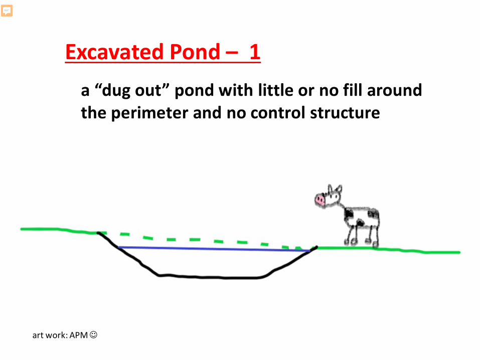
a “dug out” pond with little or no fill around the perimeter and no control structure
Excavated Pond – 1
art work: APM
Presenter
Presentation Notes
The classic excavated pond is a “dug out” pond with little or no fill around the perimeter and no control structure. These ponds are typically used for agricultural purposes. A truly excavated pond has no potential for failure. These ponds are not suitable for SWM.
Excavated Pond – 2 (new definition needed)
an excavated pond discharging to a closed storm drain system (subject to certain conditions)
art work: APM
Presenter
Presentation Notes
As I alluded to earlier, the criteria in Code 378 for categorizing an excavated pond is problematic. It desperately needs to be reworked so that it is indicative of the functionality of an excavated pond, that being a pond that is below ground with only very minimal fill and no potential for failure. The new criteria needs to consider spillways that are excavated into existing ground, because by excavating and backfilling a trench for the pipe, the potential for a piping failure is introduced. MDE would like feedback on replacing the projection criteria for excavated pond of L = 10H + 20 ft with criteria based on the amount of cover over the storm drain, the length of the pipe, and the storage volume. This refined category of excavated pond would be constructed by excavation and would have a spillway conduit that is excavated into the ground that discharges to a closed storm-drain system. The pond would need to be part of the surrounding terrain with no visual embankment, or, only a limited fill embankment to maintain adequate freeboard for the design storm.
Embankment Ponda pond with an embankment that is formed by all fill or by both excavation and fill
ALL FILL
EXCAVATION AND FILL
art work: APM
Presenter
Presentation Notes
Now let’s jump from excavated ponds to embankment ponds. The overwhelming majority of ponds that we see for SWM are embankment ponds. An embankment pond has a dam that is formed by all fill or by both excavation and fill. If the embankment is formed by both excavation and fill that means that part of the storage volume along the embankment is below existing ground.
pipe spillway outlets to a surface drainage way
Principal Spillway Configuration – 1
art work: APM
Presenter
Presentation Notes
Let’s talk about spillway configurations. All embankment ponds have a principal spillway and some also have an auxiliary spillway or what we call emergency spillway. This diagram shows a pipe spillway that outlets to a surface drainage way.
pipe spillway outlets to storm drain system
Principal Spillway Configuration – 2
projection L > 10H + 20 ft but not an excavated pond
art work: APM
Presenter
Presentation Notes
This diagram shows a pipe spillway that outlets to a storm drain system. These cause us a lot of heartburn because the designers will argue that they meet the criteria for an excavated pond. It’s true, they often do meet the projection criteria of L=10H+20’. But, because there is a constructed embankment which creates a failure potential, we do not consider them to be excavated ponds. There is also a concern that the trench that was excavated and filled for the spillway and storm drain has the potential for failure. Page 10 of Code 378 reads that excavated ponds that create a failure potential through a constructed or created embankment will be designed as embankment ponds. We have huge debates in our division about how to interpret this. Would this be anytime the spillway is connected to a storm drain system? Is this unless the depth of impounded water is less than 3 feet? Or would it only be when the embankment projection is less than L=10H+20? The projection criteria seems to be a better indicator of a superwide embankment, rather than an excavated pond.
weir spillway
Principal Spillway Configuration – 3
art work: APM
Presenter
Presentation Notes
The final spillway configuration is a weir outlet. This is a single spillway often comprised of multiple weir lengths for controlling different storm events. The current 2000 version of 378 says almost nothing about weir spillways. Formal guidance and design criteria are definitely needed, and the Dam Safety Division intends to do this. If you have thoughts on criteria, requests, or input that you would like to contribute, including feedback on the weir wall criteria contained in the NRCS’s March 2018 draft version of Code 378, please send it to the Dam Safety Division.
We call often call SWM facilities, “best management practices” or “BMPs” Different types of BMPs include ESD micro-scale facilities, ESD being the abbreviation for Environmental Site Design. These include, for example micro-biorentention, landscape infiltration, and submerged gravel wetlands. Other BMPs include infiltration basins, surface sand filters, bioretention, and wetland ponds. Just to name a few. The BMP does not have to have the word “pond” in its name for Pond Code 378 to apply. Some designers erroneously think that because the pond feasibility criteria in the SW Manual was placed in the pond section of Chapter 3, instead of in the section on Performance Criteria for BMP Design, that Code 378 is not a consideration for all BMPs. Not true. Most BMPs have earthen embankments that function as dams, albeit small dams, and Code 378, despite having pond in its name, is really a code for small dams. And therefore, the design and construction of all BMPs with earthen embankments are required to follow Pond Code 378 standards and specifications, unless exempt. BMPs that are exempt from 378 still have minimum design and construction criteria, but they are not required to meet all conditions of Code 378 or be approved by the SCD. I want to say something about the term “exempt”. I am referring to ponds that are exempt from 378, but the word “exempt” is also used to refer to small ponds that are exempt from a Dam Safety Permit.
Possible Design Categories:
Exempt from Code 378Code 378 Pond
• Embankment pond• Excavated pond• Special roadway embankment or “superwide”
pond
DamCulvert
Presenter
Presentation Notes
Possible Design Categories. Why is important to understand different embankment and spillway configurations? The purpose is to determine the applicable regulations for the category of SWM facility. Once you know the design category you can ascertain the associated criteria for designing and constructing the BMP. Essentially there are four possible design categories, with Code 378 ponds being broken down into three categories: The BMP can be exempt from Code 378 It can be a Code 378 Pond which includes Embankment ponds Excavated ponds Special roadway embankment or “superwide” ponds The other design categories are Dams and Culverts
Design category is a function of three things: configuration; size; and hazard class. We have just discussed configuration, and I am not going to discuss hazard class, other than to say that my discussion is geared toward low hazard or class “a” structures. Let’s talk about size.
SIZE SIZE SIZE SIZEEmbankment Ponds:
• ESD micro-scale pond
• “Chapter 3 pond”
• Code 378 pond
• Roadway Embankment “Superwide”
Presenter
Presentation Notes
Here are four embankment ponds, all with the same configuration, but because of their size, the design and construction criteria differ. Remember, we’re assuming for this discussion that they are all low hazard. ESD micro-scale facilities should be exempt from Code 378, but there are times when because of the filter media and the underdrain, the height of the embankment exceeds 6 feet, and therefore the structure TECHNICALLY does not qualify for an exemption from 378. We want to address this because we would like to exempt these tiny structures. We are considering introducing a volume cutoff of 10,000 cf. Some of you have your own work around for this issue We want to hear from you. Please share your thoughts with us if you haven’t already. Chapter 3 ponds. The first thing that I want to say about these ponds is we need a better name for them. Chapter 3 of the SW Manual presents structural BMPs. Some of these BMPs are going to be Code 378 ponds, but others are smaller than 378 size. We need a name for the ponds that are larger than ESD micro-scale practices and smaller than 378 small ponds. Jokingly, in the Program we refer to these as puddles or dinky dams. If you have a good name that you would like to share with us, please type it in the chat. Code 378 ponds. Ponds of this size need to be designed and constructed in accordance with Code 378. Please note that even if the hazard class is low, a permit is required from the Dam Safety Division if the 378 pond is located in a Use III watershed or one of the Baltimore watersheds of Jones Falls, Gwynn's Falls, or Herring Run. Roadway Embankment Ponds. This criteria is presented in Appendix B of Code 378 to address ponds whose embankments are formed by roadways. The size of the roadway is not defined, but it’s undoubtedly directed at highways, where the mass of the roadway is large in comparison to the amount of water being stored. This needs to be clarified and reworked. MDE wants to refine this criteria. Again, we want to hear from you. So please share your thoughts with us.
SIZE SIZE SIZE SIZEEmbankment Ponds:
• ESD micro-scale pond
• “Chapter 3 pond”
• Code 378 pond
• Roadway Embankment “Superwide”
Drainage area <1/2 acreStorage volume typically < 10,000 cfIntent to EXEMPT from Code 378
Height < 4 ft or Height ≤ 6 ft and V ≤ 40,000 cfEXEMPT from Code 378
Height ≥ 4 ft and < 20 ftPond embankment is formed by roadway8:1 projection line does not intercept downstream slopeControl StructureHW/D and HW-TW indicate damCode 378, with allowance for special embankment design
Height ≥ 4 ft and < 20 ftHeight > 6 ft and V > 40,000 cfV < 50 ac-ftDA < 640 acresCode 378
Culverts…
Presenter
Presentation Notes
Most of you probably recognize this. It is the very last page of Code 378. Appendix B. I want to talk abut the first decision box. It says that if none of these three criteria is true, then there is no special design. In other words, the spillway can be designed like a regular old culvert. Conversely, and very importantly, this means that if these criteria are not met, the culvert is creating a dam, and dam regulations and design criteria apply.
Potential Dams:
ROADWAY EMBANKMENT
RAILROAD EMBANKMENT
art work: APM
Presenter
Presentation Notes
Roadway and railroad embankments can function as dams, intentionally or unintentionally, and these embankments are not constructed to impound water. Culverts fail and dams fail, but the more water impounded behind the roadway/railroad embankment, the greater the hazard and the greater the likelihood of failure. This is an important issue, so important, that I have a 45 minute presentation on this topic alone, which we’re going to save for another day. I do, however, want to mention some basic points.
Culvert Criteria
A conduit penetrating a roadway or railroad embankment is considered a culvert when all four of these conditions are met:
a. HW-TW ≤ 10 feet or HWdepth/D ≤ 2;b. Permanent pool ≤ 3 feet;c. There is no structure to control water
surface elevations; andd. The embankment height is ≤ 35 feet
Presenter
Presentation Notes
A conduit penetrating a roadway or railroad embankment is considered a culvert when all four of these conditions are met. If any of these conditions is not met, then the pipe is creating a dam, and the spillway and embankment must be designed and constructed in accordance with the applicable dam category. MDE has written a policy memo on this topic, largely in part to address the confusion that we engineers as a group have with the meaning of the words “and” and “or” when used in series
Policy Memo #2 - Roadway/Railroad Embankments with Culvert Crossings
Presenter
Presentation Notes
Dam Safety’s Policy Memo #2 titled “Roadway/Railroad Embankments with Culvert Crossings” is posted on the Dam Safety webpage, and I encourage everyone to read it.
The engineer's wife
A wife asks her husband, an engineer, "Darling, can you please go to the shop, buy one pint of milk, and if they have eggs, get a dozen!"
Off he goes. Half an hour later the husband returns with 12 pints of milk.
His wife stares at him and asks, "Why on earth did you get 12 pints of milk?"
I want to take a break to tell a joke. It’s called “the Engineer’s Wife”. I happen to be an engineer and a wife, and even though I am not an engineer’s wife, it’s still funny because it sums up the frustrations that we engineers face with semantics and syntax in the regulatory world. Some of us are too literal, and others of us are not literal enough. Some of us have no idea what the words “and” and “or” mean when used together, but all of us think we do.
Old Flow Chart Determine Design Category of Pond Embankment
Presenter
Presentation Notes
What this means is that the flow chart that MDE developed in April 2015 as Figure 1 for the Guidance on Embankment Retrofit Design has morphed into this.
New Flow Chart - DRAFTMDE Sediment, Stormwater, and Dam Safety ProgramFlow Chart for Determining Embankment Design Category and Approval Authority
Presenter
Presentation Notes
Obviously you can’t read this. I am only sharing it to demonstrate how many decision trees there are. Some folks at MDE have been ribbing me about this flow chart, but I really do think it’s going to help owners, designers, and reviewers get on the same page early in the design process. Also, it includes approval authority, which is another source of confusion. I am going to wrap up today’s presentation with a quick overview of approval authority.
Embankment Approval Authority Stormwater Management Approval Authority• Structures exempt from Code 378• Culverts through embankments ≤ 35 feet
Small Pond Approval Authority (SCDs and MDE Plan Review Division)• Code 378 and hazard class “a” **
**Unless in Use III watershed or Jones Falls/Gwynns Falls/Herring Run watersheds or Baltimore City
MDE Dam Safety Permits Division• Code 378 ponds not approved by the SCDs including those in Use
III watersheds or Jones Falls/Gwynns Falls/Herring Run watersheds or Baltimore City
• Larger than Code 378 or significant/high hazard classification• Non-earthen dams• Culverts through embankments > 35 feet
Presenter
Presentation Notes
Embankment Approval Authority. We get a lot of questions from SHA folks about this. All stormwater management facilities require approval from the stormwater management approval authority, that would be the local county agency or municipality, if delegated. In the case of State and federal agencies, that would be my division, except for SHA projects because SHA now has delegated authority for sediment and stormwater approval. IN ADDITION to the stormwater management approval, there’s the embankment, and depending on the design category, that embankment or “dam” may also require a separate approval. Listed in the slide are the three potential approval authorities for the embankment. (Culverts through embankments higher than 35 feet need to be submitted to the Dam Safety division for screening and possible permitting in accordance with Policy Memo #2.)