dealing with disasters: environmental history of early
TRANSCRIPT

Dealing with Disasters: Environmental History of
Early Modern Cities (Edo, Istanbul, London, Pest, and Prague)
EDITED BY
Koichi Watanabe and Akiko Kimura
National Institutes for Humanities

Dealing with Disasters: Environmental History of
Early Modern Cities (Edo, Istanbul, London, Pest and Prague)
EDITED BY
Koichi Watanabe and Akiko Kimura
National Institutes for Humanities

Dealing with Disasters: Environmental History of Early Modern Cities (Edo, Istanbul, London, Pest, and Prague)
Published by National Institute of Japanese Literature (NIJL), National Institutes for the Humanities (NIHU)
10-3 Midori-chō, Tachikawa City, Tokyo 190-0014, Japan
Copyright©2021 by all contributors, except for the right of the reproduction and the right to transmit to the public of the work, which are reserved by NIHU
The cover disigns incorporate a Cloud image of Typhoon Hagibis at 3pm on October 10, 2019 (from Digital Typhoon, National Institute of Informatics) (left), Drawing of the flooded square in the city of
Edo (from “Ansei Fubun-shu” [A Reportage of the Ansei Great East Japan Typhoon], the National Archives of Japan Digital Archive) (right)
ISBN: 978-4-87592-199-8

TABLE OF CONTENTS
List of Contributors Foreword Introduction 1 The Ordinary and the Extraordinary in Early Modern Cities
Koichi Watanabe trans. by Hisashi Kuboyama Part I: Aspects of Urban Disasters Chapter 1 10 Typhoon Damage in 1856 Edo: Integrating Archaeology, Climatology and History
Koichi Watanabe, Junpei Hirano, Hiroyuki Ishigami, and Masumi Zaiki trans. by Hisashi Kuboyama
Chapter 2 23 The Great Flood in Pest, 1838
Csaba Katona Chapter 3 33 Fire Disasters in European Cities, 1600-1800
David Garrioch Comment Disaster of Beijing in the Qing Dynasty 1644-1911 48
Akira Horichi trans. by Yoko Onodera Part II: Disasters and Responses Chapter 4 53 Prevent the Big Water. Flood Control Measures in Prague (Bohemia) Issued by Public Administrative Bodies in Late 18th Century
Ondřej Hudeček

Chapter 5 60 Citizens’ Awareness of Firefighting in Edo: Analysing Eighteenth-Century Textbooks on Firefighting
Reiji Iwabuchi trans. by Hisashi Kuboyama Part III: Infrastructure as Artificial Nature Chapter 6 79 The Ordinary Made Extraordinary: The Archaeology of Water Management in a Global City
Sophie Jackson Chapter 7 89 Management and Civil Engineering of Urban Water Supply and Sewage System in Edo as Seen from Archaeological Excavation
Hiroyuki Ishigami trans. by Mina Ishizu Chapter 8 99 Dredging the Edo Castle's Moat: a Case of the Okayama-Domain Dredging in 1765
Reiji Iwabuchi trans. by Naoko Nomoto Chapter 9 116 Canal, Dredging and Sedimentation in the Lowland Area of East Edo: Considering Physical and Spatial Characteristics of Canals in a Historical Context
Genki Takahashi trans. by Hisashi Kuboyama
Part IV: Hinterland and Nature Chapter 10 132 Flooding in Edo and the Tone-gawa River and Tama-gawa River Systems
Koichi Watanabe trans. by Hisashi Kuboyama Chapter 11 146 The Great Edo Flood of 1742 and the Okutama Valley
Koichi Watanabe trans. by Hisashi Kuboyama

Chapter 12 161 The Deluge of Istanbul in 1563: a Case of Flood Where There Was No River
Kazuaki Sawai trans. by Yoko Onodera Chapter 13 172 Storms, Flooding and the Development of London 1300-1500
Matthew Davies Chapter 14 182 Bridging London’s River’s General Situation of London, the Thames, the Bridge
Vanessa Harding

List of Contributors Matthew Davies: Executive Dean and Professor of Urban History, School of Social Sciences, History & Philosophy, Birkbeck, University of London David Garrioch: Emeritus Professor, School of Philosophical, Historical and International Studies, Monash University Vanessa Harding: Professor of London History, Department of History, Classics & Archaeology, Birkbeck, University of London Junpei Hirano: Associate Professor of Department of Literature, Teikyo University Akira Horichi: Professor of Department of Chinese, The University of Kitakyushu Ondřej Hudeček: PhD at Department of Humanities, Charles University (the Czech Republic) Hiroyuki Ishigami: Associate Professor of Department of Historical Heritage, Kyoto University of the Arts Mina Ishizu: Research Officer, the London School of Economics and Political Science Reiji Iwabuchi: Professor of Department of Japanese Studies, Gakushuin Women’s College Sophie Jackson: Director, Developer Services, Museum of London Archaeology Csaba Katona: Professor of Institute of History, Research Centre for the Humanities, Hungarian Academy of Sciences Akiko Kimura: Celtic Studies MLitt at University College Dublin, Visiting researcher of Institute of Cultural Science, Chuo University

Hisashi Kuboyama: PhD at School of History, Classics and Archaeology, College of Arts, Humanities & Social Sciences, Edinburgh University Naoko Nomoto: Cultural Heritage Studies MA at University College London Yoko Onodera: University College London, Department of History PhD student Kazuaki Sawai: Professor of Department of Literature, Kansai University Genki Takahashi: Project Assistant Professor or Project Researcher, The University of Tokyo Koichi Watanabe: Professor of National Institute of Japanese Literature, National Institutes for the Humanities Masumi Zaiki: Professor of Faculty of Economics Department of Contemporary Economic Studies, Seikei University

Foreword
Covid-19 is ravaging the world at the moment. Millions of people have sadly lost their lives and it is our duty to turn this tragic experience into an opportunity to rethink what kind of society we want to live in. For this rethinking exercise, we can learn from history as it provides an insight into the relationship between nature and humans in the past. History of natural disasters forms a key part of this.
Since 2016, our research group has hosted international symposiums on comparative history of natural disasters in cities and held sessions at academic conferences in Europe. These activities are based on two research projects below:
National Institutes for Humanities project: ‘Archives and the human life: interactive study among past, present and future’, 2016-2021. The Grants-in-aid for Scientific Research, “History of urban disasters in the early modern period: the interaction between nature and humans” from the Japan Society for the Promotion of Science, 2018-2022.
These projects resulted in the publication of this book. Particularly, it is based on research papers read at three recent international symposiums as below. ・Session 7 ‛Responses to disasters in early modern capitals’, International Conference ‛Cities and disasters: urban adaptability and resilience in history’, Institute of Historical Research, University of London, 4 November 2016. Chapter 12 ・International Symposium ‘The Ordinary and the Extraordinary in the Early Modern Metropolis: Canal, River and the Flood’, National Institute of Japanese Literature, 24 February 2018. Chapter 6, 8, 9, 10, 13,14. ・Main Session 7 ‛Natural disasters and the urban: earthquakes, floods and great fires in early modern cities:1400-1800’, European Association for Urban History 14th Conference ‘Urban renewal and resilience: cities in comparative perspective’, Roma Tre University, 30 August 2019.
Chapter 1, 4. ・ International Conference ‘Disasters and Natural Environment in Early Modern Cities’, National Institute of Japanese Literature, 12 January 2020.

Chapter 2, 3, 5, 7, 11, Column.
The session in Rome was organised by Matthew Davies (University of London), Domenico Cesare (University of Naples), Mina Ishizu (University of London) and myself. Dr Cesare and I drafted a text each of call for papers and sent to Professor Davies, who finalised it.
Throughout these projects, many people helped us and we would like to thank them all, particularly those who read papers at these events and also their translators. In addition, we received invaluable support from Sho Makino, who studies early-modern Irish history, for the symposium at the National Institute of Japanese Literature in 2018. For the 2020 event at the Institute, Akiko Kimura played a key part as well.
The structure of this book was initially proposed by Kimura and was firmed up through email exchanges between contributors who were based in countries all over the world. Its title was suggested by Professor Garrioch, whilst the idea to add the names of cities in the subtitle of articles came from Professor Harding. Various other suggestions from contributors helped me rethink the book’s structure. I am grateful to all of them indeed.
A vast amount of editing and administrative work including legal process to hand over contributors’ public transmission rights and proofreading English texts was undertaken by Kimura as well. Also I would like to note my special thanks to her outstanding work. Ryuya Hashiguchi, who is the postgraduate student of Chuo University in Tokyo, helped check the papers. I appreciate his assistance.
Unfortunately, it was impossible to include all the images, maps and charts due to a lack of funding. For this I would like to sincerely apologise to contributors.
Our group’s activities were greatly affected by Covid-19. We were meant to host the headline session ‘Perceptions of Disasters in Early Modern Cities’ at the European Association for Urban History 15th Conference ‘Cities in Motion’ in Antwerp but the conference has been postponed for a year, and now it is likely to be held virtually. An international symposium in Budapest which was agreed in April 2019, but now we don't even have a date for this symposium due to the ongoing pandemic.
Despite all the challenges, however, we can continue our scholarly work. The group’s meetings were held virtually three times in the evening in the Japanese time to allow scholars based in Europe such as London and Paris to join. This book in itself is an attempt to develop our studies when it is impossible to meet

other scholars in person. History of the relationship between nature and humans teaches that infectious diseases are something we live with, rather than defeat. We seek to explore further how we can continue our international collaboration during a pandemic.

1
Introduction: The Ordinary and the Extraordinary in Early Modern Cities1
Koichi Watanabe
Translated by
Hisashi Kuboyama
Since the 2011 Great East Japan earthquake, the number of historical studies on natural disasters has increased dramatically. It is a welcoming situation as historians’ interests are closely linked to what is currently happening in our world. However, what concerns me is that a pattern appears to have emerged in which historians examine individual cases simply by describing the extent of damage and then explaining how recovery was achieved. Case studies of disasters certainly form the basis of historians’ understanding of natural disasters and therefore it is natural to have many of them. Nevertheless, it is equally important that we explore a new perspective on the history of natural disasters.
In my view, this new perspective consciously regards the history of natural disasters as part of the history of natural environment. By doing so, historians will be able to avoid seeing the relationship between nature and humans as binomial opposition where human beings conquer and exploit nature or the latter is seen as a threat to the former. Since natural phenomena such as flooding and earthquake cause disasters, there are seven areas of interests for scholars of natural disasters:
1. Understanding natural phenomena themselves that directly cause disasters such as typhoons and earthquakes
2. Understanding natural conditions created by human beings that turn natural phenomena into natural disasters
1 This is largely based on the English translation of “Introduction”, The ordinary and the extraordinary in early modern cities [Japanese] (Bensei Publication, 2019) which is included at the end of the book.

2
3. Understanding the situation of societies that are affected by natural disasters
4. Uncovering the extent of damage. This needs to be explained in line with natural factors (1. and 2.) and social factors (3.)
5. Examining the recovery process and measures against natural disasters
6. Understanding natural conditions created by human beings that emerge as a result of recovery and measures against natural disasters
7. Understanding changes in social conditions that emerge as a result of recovery and measures against natural disasters
By exploring these seven areas as a whole, we will be able to grasp the image of “a society with nature embedded within it”.2 “A society with nature embedded within it” is a dynamic image of successive, interrelated historical changes in which the human society as artificial nature is affected by natural disasters and then, to deal with natural disasters, humans intervene artificial nature and therefore cause changes in their society which is again hit by another natural disaster that forces humans to take measures against it.3 Many studies around 4 and 5 have recently been produced in the history of natural disasters. In terms of 1, there are a number of studies
2 “Natural disasters during the Edo period and Matsushiro Domain: society within nature, nature within society”, a lecture in “The History and Archives of the Sanada Family in Matsushiro Domain II” on 19 February 2017. Its presentation slides are available in the information repository of National Institute of Japanese Literature. Included in “Core Research for the Multidisciplinary Collaborative Project, Changes of Local Society in the Japanese Archipelago and Reconstruction of Local Culture from Natural Disasters, a unit for National Institute of Japanese Literature: Bidirectrional Research on Archives and Human Life: Interactive Study among Past, Present and Future. Annual report for 2016”. This lecture was made before the publication of the Japanese translation of The Shock of the Anthropocene: The Earth, History and Us in 2018. 3 Researchers outside traditional history have been discussing this for some time. Tadashi Miyamura, Flooding: Wisdom of Flood Prevention and Management (Kanto Gakuin University Publication, 1985, rev. in 2010), a study by a researcher in civil engineering, discusses “nature as a given condition” which in this book is described as “artificial nature” and argues that flooding is a response from nature as a given condition.

3
in natural science, although progress has been considerably slow partly due to the limited number of researchers of climate and weather compared to those of earthquakes. In terms of 1, there are a number of studies on earth quakes in natural science, although progress of climate and weather studies has been slow due to the limited number of researchers. For instance, historians have only started to publish studies on typhoons which caused large-scale flooding. In terms of 2, it is well known that many studies have been done in geology, physical geography and the history of civil engineering and they have increasingly been utilised by researchers of 4, although more could be done. It seems that not enough conscious effort has been made to work on 6 or 7. It is the aim of this book to explore these seven areas and gain a better understanding of them. Looking into 2 and 3 will allow us to take numerous factors that are not strictly relating to natural disasters into account. In other words, without understanding how a city as artificial nature functions properly, historians cannot fully grasp natural disasters which cause a city to grind to a halt. In addition, it is even possible to put natural disasters in the wider context of artificial nature not functioning properly. As it is now clear to readers, “the ordinary” in this book’s title means a state when artificial nature functions properly, whilst “the extraordinary” is used to describe a situation when artificial nature fails to function, including such situations caused by natural disasters.4 To establish this new perspective, it is necessary to integrate different academic disciplines into one methodology. Historians who rely on written evidence cannot fully examine “pure” natural phenomena5 ,
4 As an existing study on natural disasters, see Takeshi Ito, Federico Scaroni and Noriko Matsuda (eds), Along the water: Urban natural crises between Italy and Japan (Sayusha, 2017). This book put forward issues around architectural history and its focus is on natural disasters. Based on the fact that cities inherently would suffer from natural disasters, it explores grand themes such as “territorial history”, “historical time” and “cultural structuralism”. At the same time, our book is by traditional historians and it includes cases that cannot be regarded as crises as part of “the extraordinary”. By doing so, it allows us to explore continuity between natural disasters and ordinary daily lives and also to compare cities affected by natural disasters with ones that don’t experience them very often. 5 Here, I refer to phenomena in geoscience such as typhoons and earthquakes, but the brackets were used because now we have a study that argues that changes in the

4
whilst at the same time needing to analyse the ground itself. In addition, they have to understand the urban space itself. Therefore this book is contributed by researchers in historical climate, archaeology and architectural history. It is also essential to draw on studies of historians outside Japan in order for us to polish and rationalise our methodology. Historical studies in Japan have probably reached the highest academic standard in terms of their use of primary sources, although not enough effort has been made to make these findings relevant and available to a wider audience. A comparative approach is necessary in an attempt to make Japan’s history of natural disasters a meaningful part of the history of the world. This book has thus been edited around four key themes: natural disaster, environment, integration of academic disciplines and comparative approach.
Below is a brief introduction of articles in this book. Part I: Aspects of Urban Disasters Chapter 1 "Typhoon Damage in 1856 Edo: Integrating Archaeology, Climatology and History"(Koichi Watanabe, Junpei Hirano, Hiroyuki Ishigami, and Masami Zaiki)is an attempt to integrate findings in archaeology, historical climatology and history. This article finds out about geographical characteristics of Edo and then reveals which parts of Japan the Ansei East-Japan typhoon in 1856 went past, whilst having estimates of its maximum wind velocity and the height of tidal waves. Based on these two key findings, it considers how the extent of damage in the Kanto Region and Edo caused by varies in relation to these estimates. Chapter 2 "The Great Flood in Pest, 1838" (Csaba Katona) looks into a flood caused by frozen surface of a river that blocked the passage of water – a natural disaster which is unique to a cold climate. It describes floods before 1838 and the construction of embankment as well as damage caused by these floods and rescue operations. It then points out that the river’s management plans were developed in response to these floods, followed by the construction of new
composition of atmosphere caused by human activities occurred before the industrialisation (The Shock of the Anthropocene).

5
embankments, and that the new building regulations on construction materials greatly changed the look of the city. It also refers to literary works which were created to commemorate the floods. It is a comprehensive analysis of a large-scale flood and its impact. Chapter 3 "Fire Disasters in European Cities, 1600-1800" (David Garrioch) is an overview of fires in Western European cities. It points out that, comparatively speaking, fires involve more social factors as their causes than other types of disasters, while taking into account impact of climate change. It concludes that large-scale urban fires are caused by weather and climate, building materials, characteristics of urban economy, measures taken by the urban authorities and function of firefighting organisations. This analysis can be universally adopted for any urban fire. Column "Disaster of Beijing in the Qing Dynasty 1644-1911" (Akira Horichi) is an overview of floods, draughts, severe snows and hailstones, earthquakes, locust plague and epidemics in Beijing between 1644 and 1911, providing a comparative viewpoint for findings and analysis in the other articles in this book. Part II: Disasters and Responses Chapter 4 "Prevent the Big Water. Flood Control Measures in Prague (Bohemia) Issued by Public Administrative Bodies in Late 18th Century"(Ondřej Hudeček)describes how an inland city in the subarctic zone dealt with flooding caused by excessive amounts of meltwater in a big river. Prague’s climate and topography were of course very different from those of Edo, but I believe a comparison between the two cities can be made as the way they dealt with disasters was driven by optimisation of administrative processes such as the standardisation of measures against disasters. Chapter 5 "Citizens' Awareness of Firefighting in Edo: Analyzing Eighteenth-Cnetury Textbooks on Firefighting" (Reiji Iwabuchi) analyses textbooks of firefighting and diaries of a writer who lived in Edo and experiences fires. The analysis reveals that traditional knowledge and collective experiences about how to deal with fires led people to prioritise their own fortune and lives in case of a fire.

6
Edo’s fire management was based on such knowledge and experiences among the people, rather than the authorities’ instructions and infrastructure development, resulting in relatively low numbers of deaths despite frequent fires in the city. Part III: Infrastructure as Artificial Nature Chapter 6 "The Ordinary Made Extraordinary: The Archaeology of Water Management in a Global City" (Sophie Jackson) offers an overview of the development of London’s water management system throughout history. Based on archaeological findings, it describes how the natural river system of the Thames developed into the modern water and sewage system in London. It also discusses what the London’s water management system would look like in future. This article has a strong environmental focus and invites comparison with Chapter 11. Chapter 7 "Management and Civil Engineering of Urban Water Supply and Sewage System in Edo as Seen from Archaeological Excavation" (Hiroyuki Ishigami) demonstrates, from an archaeological point of view, how Edo’s water supply was managed. The main part of waterworks were made of stones, but timbers and bamboos were used for their branch lines with a view to making it easy to recover from disasters. Ishigami also describes the sewage system and shows how the canals which could be regarded as a public good were managed by a complex mixture of organisations and associations. Chapter 8 "Dredging the Edo Castle's Moat: A Case of the Okayama-Domain Dredging in 1765"(Reiji Iwabuchi) Chapter 9 "Canal, Dredging and Sedimentation in the Lowland Area of East Edo: Considering physical and spatial characteristics of canals in a historical context (Genki Takahashi) both concern the maintenance of canals and rivers in Edo. Iwabuchi looks at the outer moat of the castle, whilst Takahashi examines the canals in the city, with each case’s dredging methods drawing a stark contrast. Dredging was done in response to the natural process of sedimentation in the canals and rivers, but the fact that such maintenance and management allowed for moderate degrees of

7
sedimentation and narrowing of the waterways (changes in artificial nature – 6) did indeed worsen flooding’s damage, as both Iwabuchi and Takahashi show. Takahashi points out that that the height of the Tate-kawa River’s embankment in Honjo went up from 0.9 meter by 1.2 meter, whilst Ishigami in Chapter Two concludes that the added soil in the Honjo and Fukagawa area was around one meter high, showing that two different academic disciplines, in this case architectural history and archaeology, have reached practically the same conclusion. Part IV: Hinterland and Nature Chapter 10 "Flooding in Edo and the Tone-gawa River and Tama-gawa River Systems" (Koichi Watanabe) examines how the rivers and the waterworks normally flew in the ordinary state and how they changed when flooded, which is an extraordinary situation. Chapter 11 "The Great Edo Flood of 1742 and the Okutama Valley" (Koichi Watanabe) analyses the extent of damage in the OkutamaValley caused by the 1742 flood and how the Shogunate and urban society dealt with it and then examines the Shogunate’s measures to clear muddy water in a water system that supplied the city with water. At the same time, it looks into the Shogunate’s relief measures for villages along the upper and middle areas along the Tama-gawa River. This is an attempt to describe, in a holistic manner, the complex, multi-faceted relationship between the flood’s damage to the city and its rural hinterland and how the Shogunate, Edo’s citizens and peasants in the Okutama villages, all of which were connected through the problem of the water system’s muddy water. Chapter 12 " The Deluge of Istanbul in 1563: a Case of Flood Where There Was No River" (Sawai Kazuaki) is aimed at drawing some comparison with Chapter 11 and discusses how the Ottoman Empire’s government undertook its capital’s recovery from a large-scale flood. Chapter 13 "Storms, Flooding and the Development of London 1300-1500" (Matthew Davies) is based on his research as part of an

8
environmental history project 6 on the areas around the Thames Estuary and discusses its findings in relation to London’s urban history. He argues that land reclamation during the twelfth and thirteenth centuries was negated by the sixteenth century because of changes in climate, society and economy. Chapter 14 "Bridging London’s River" (Vanessa Harding) interprets the London Bridge as a human intervention in nature and discusses in a holistic manner the diversification of harbours along the Thames River, the social relationship around maintenance and repair of the bridge and the bridge’s symbolic meaning to the city.
6 London and the tidal Thames 1250-1550: marine flooding, embankment and economic change, https://www.history.ac.uk/projects/research/tidal-thames

PART I:
ASPECTS OF URBAN DISASTERS

10
Chapter 1
Typhoon Damage in 1856 Edo: Integrating Archaeology, Climatology
and History
Koichi Watanabe Junpei Hirano
Hiroyuki Ishigami Masumi Zaiki
Translated by
Hisashi Kuboyama Introduction (Watanabe) The Japanese archipelago is located in the eastern periphery of the monsoon climate zone as well as on the edge of the Pacific Plate where it is being subducted beneath the North American Plate. This means that these islands experience numerous typhoons every year and also a catastrophic major earthquake in around every one hundred years. The early modern period in Japan began around 1600 with the emergence of cities (i.e. modification of nature) which led to a large-scale concentration of wooden houses that were located near water. This resulted in large population living in areas which were prone to natural disasters. This paper adopts an approach which integrates findings in climatology, archaeology and history, and with this approach, it aims to sheds new light on storm and flood damages in large cities. It examines the impact and social effect of gales and storm-surge caused by a typhoon in 1856 which hit Edo and its surrounding areas in the Kanto and Tokai regions. First, from an archaeological perspective, it looks at Edo’s topographical and geological characteristics that created the conditions for how the city was affected by the typhoon. Secondly, it analyses the typhoon from a climatologic point of view and traces its course and wind speed. Thirdly and finally, based on these findings, it examines primary written sources as historical evidence to identify

11
the scale of the damage caused by the typhoon and also to consider its social impact. 1. Urban space as a result of modification of nature (Ishigami) This section looks at Edo’s urban development by utilising recent findings in archaeology. Edo’s urban development started in 15901 and could be divided into four phases: the first phase was the opening of Onagi River (canal) which changed the course of Hirakawa River, which flew into Edo Bay and was also used to transport materials and goods including salt; the second was the land reclamation of Hibiya Irie (inlet) and the construction of Funeiri Hori (wharf), which was used to load and unload cargo; the third phase was the opening of Kanda River, which was the outwork of Edo Castle, and also the construction of its outer moat2; and the fourth phase was the development of Edo’s low-lying marshland. During the development, Edo witnessed a large fire in 1657. As part of its recovery plans, it was decided that the samurai’s residential area was to be moved away from the castle to low-lying marshland of Honjo and Fukagawa which was to be reclaimed on the eastern bank of Sumida River. As a result of large-scale civil engineering over half a century, Edo’s foundation as a one-million city was established by the eighteenth century. Topographically speaking, Edo was divided into the low-lying area and the plateau area. Studies on Edo have established its topographical characteristics through boring geological surveys for urban development, whilst new findings have been made by scholars of geology and pedology.3 The plateau in the west of Edo is 20-35 meters high around its eastern edge and is a solid, firm ground which consists of three layers of loam in Tachikawa, Musashino and Simo Sueyoshi, formed in the Quaternary period. At the same time, Edo’s low-lying area which spreads in the east of the city mainly consists of numerous thick layers of unstable, weak silt soil and sand called Yurakucho Layer and Nanago Layer that were formed during the Holocene period. The alluvium is up to 50 meters thick. The fact that Edo was built on two completely different types of ground is extremely important in considering its ability to deal with natural disasters. In particular, the low-lying areas were certainly affected by flooding, but there were also a number of challenges such as soil liquefaction caused by earthquakes and ground subsidence resulting from excessive groundwater
1 A. Okano, Why Ieyasu Chose Edo, Kyoiku Shuppan, 1999. Books, articles and sources cited in this article are all in Japanese unless otherwise stated. 2 R. Suzuki, Edo 100 in Illusion, Chikuma Shobo, 1991. 3 S. Kaizuka, Natural History of Tokyo, 2nd edition, Kinokuniya Shoten, 1979.

12
extraction. To examine the impact of the 1856 flooding, it is therefore essential to take into account the land reclamation of Hibiya Irie and the development of low-lying marshland as contributing factors that created the conditions for the flooding. The following paragraphs focus on Edo’s low-lying areas and consider how the city’s modification of nature and natural disasters were related by utilising topographical and geological information such as heights above the sea level, type of soil and manner of land creation which archaeological studies have uncovered. Results from a few excavations, as well as one on Hibiya Irie, provide information about the height of the top of sedimentary layers from the sea level and also about people’s lives in the early seventeenth century and around the 1870s. The Atago-Shita site (in Minato Ward) lies in A-area in Figure 1, and it was mostly daimyo and samurai residential area.4 The east side of the excavation site, the Shibaguchi district, was close to the sea, and Hibiya Irie was probably in this district. Sedimentary layers at this site showed that a natural layer of black clay was next to a soil layer which was accumulated as a result of human activities. The borderline between these layers was just around an elevation of zero meter, which is considered to be the soil surface in the early Edo period. As part of the initial land reclamation work, the construction of earth embankment around 0.5 to 1.5 meters high was allowed. Underneath the black clay sedimentary layer was a layer of sand which contained some evidence of vegetation. It showed that, in the Middle Ages, there were water plants such as reed and cogon grass which grow near water, whilst this district was around the sea level, 0 to 0.5 meters high, and almost dried around 1590 when the land reclamation started. Land development during the Edo period created many layers of soil, around one to two meters thick in total. This shows that many ground levelling works were carried out to recover from large fires and other disasters.
4 Tokyo Metropolitan Archaeological Centre, Atago Shimo Archaeological Site, 3, Minato Ward no. 149, Tokyo Sports Benefits Corporation and Cultural Asset Centre, Tokyo Metropolitan Government, 2014.

13
Figure 1 (original Image ©National Agriculture and Food Research Organization) Excavations also revealed how land reclamation works were carried out in the Fukagawa (B-area in Figure 1) and Honjo (C-area in Figure 1) area. Natural sedimentary layers were found at two to five meters above the sea level. However, to estimate the current elevation of the Fukagawa and Honjo area, ground subsidence after the modern period needs to be taken into account.5 Excavations indicate that, before the land reclamation, the elevation of this area was mostly below A.P., 6 which means this area was a mud flat and below the sea level. The layer of banking was around one meter thick, and its elevation was lower than zero meter. Also, unlike in Hibiya Irie (A-area), there were not many layers of soil, implying that few ground levelling works were undertaken, due to the low importance of this area and also a lack of funding. The degree of ground subsidence after the modern period has been estimated
5 T. Endo, S. Kawashima and M. Kawai, Historical Review of Development of Land Subsidence and its Cease in Shitamachi Lowland, Tokyo, “Applied Geology”, 2001, 42, 2, pp. 74-87. 6 A.P. is an abbreviation of Arakawa Peil, based on the watergauge set in 1868 in Reiganjima Island. The zero point of this shows the high tide in Arakawa River (Sumida River) during the spring tide. At the moment, it is lower than the T.P. (the zero elevation, or the average sea level in Tokyo Bay) by 1.1344 meters.
Honjo
Fukagawa
Nihon bashi
Hibiya irie (inlet)

14
to be around one to two meters, but further analysis is required to gain more accurate figures. Written evidence could also indicate the elevation of Edo’s low-lying areas. Map of Tokyo Central, 1:5000 was the first map drawn around 1870 by the Department of Land Surveying of the Imperial Japanese Army General Staff Office. It was based on the French land surveying method and recorded the elevation of buildings, canals and each point.7 The map shows that Suzaki, which was the seaside part of B-area, was one to 1.7 meter high, whilst the tidal flat area was around one meter above the sea level. On the other hand, the elevation of the inland part of B-area was around 1.5 to two meters, which was around one to two meters higher than the estimated elevation in the late early-modern period, indicating that it is necessary to revisit the previously accepted extent of ground subsidence which was based on figures measured from the early modern period and onwards. The elevation of the Nihonbashi and Ginza area in D-area showed around four meters as they were on a relatively solid sunken plateau called Edomaechou. A-area’s elevation was around three meters, slightly higher than the Shitamachi low-lying area, which corresponds to the result from excavations. As Chapter 3 shows, this could partly explain why this area was unaffected by the 1856 storm surge. To estimate the scale of the 1856 storm surge, the height of a stone breakwater wall and an embankment needs to be established. Historical records show that the embankment was 1.74 meters high. The height of the stone breakwater wall was measured during an excavation. To take into account the extent of ground subsidence, this area’s elevation was roughly T.P.-0.77m (A.P. +0.3m).8 Adding the height of the embankment, 1.74 meters, the stone breakwater wall and the embankment was estimated to be T.P.0.97m (A.P.+2.04m) tall. With this estimate, however, the stone breakwater wall would be lower than the normal tide, meaning it would be hit by waves. The aforementioned land survey map made around 1870, as well as evidence in Section 3 of this paper, show that the top of the stone wall was sometimes the same level as the sea,9 so it is appropriate to estimate an even greater extent of land subsidence. To calculate the elevation of the bottom of the stone wall, based on its height A.P.
7 Department of Land Surveying of the Imperial Japanese Army General Staff Office, Map of Tokyo Central, 1:5000, Japan Map Centre, 1984. This is the basis for Figure 1. 8 Based on the estimate shown in footnote 5, I presumed that land subsidence of 1.5 meters occurred after the modern period and amended the figures accordingly. The height of the stone wall was 2.28 meters on average. Koto Ward Education Committee, Reports on Excavations of Susaki Breakwater Stone Wall and Old Yahata Moat, Koto Ward Education Committee, 1987. 9 Suzaki Ikken, 3, National Diet Library.
15
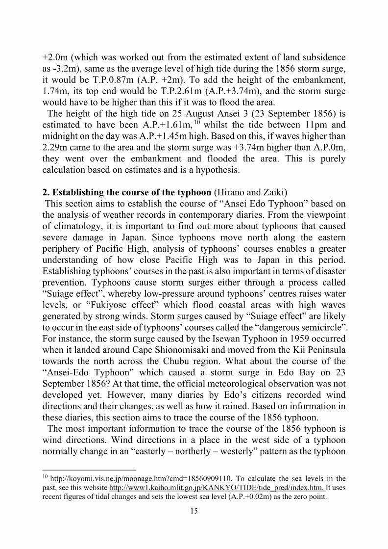
+2.0m (which was worked out from the estimated extent of land subsidence as -3.2m), same as the average level of high tide during the 1856 storm surge, it would be T.P.0.87m (A.P. +2m). To add the height of the embankment, 1.74m, its top end would be T.P.2.61m (A.P.+3.74m), and the storm surge would have to be higher than this if it was to flood the area. The height of the high tide on 25 August Ansei 3 (23 September 1856) is estimated to have been A.P.+1.61m, 10 whilst the tide between 11pm and midnight on the day was A.P.+1.45m high. Based on this, if waves higher than 2.29m came to the area and the storm surge was +3.74m higher than A.P.0m, they went over the embankment and flooded the area. This is purely calculation based on estimates and is a hypothesis. 2. Establishing the course of the typhoon (Hirano and Zaiki) This section aims to establish the course of “Ansei Edo Typhoon” based on the analysis of weather records in contemporary diaries. From the viewpoint of climatology, it is important to find out more about typhoons that caused severe damage in Japan. Since typhoons move north along the eastern periphery of Pacific High, analysis of typhoons’ courses enables a greater understanding of how close Pacific High was to Japan in this period. Establishing typhoons’ courses in the past is also important in terms of disaster prevention. Typhoons cause storm surges either through a process called “Suiage effect”, whereby low-pressure around typhoons’ centres raises water levels, or “Fukiyose effect” which flood coastal areas with high waves generated by strong winds. Storm surges caused by “Suiage effect” are likely to occur in the east side of typhoons’ courses called the “dangerous semicircle”. For instance, the storm surge caused by the Isewan Typhoon in 1959 occurred when it landed around Cape Shionomisaki and moved from the Kii Peninsula towards the north across the Chubu region. What about the course of the “Ansei-Edo Typhoon” which caused a storm surge in Edo Bay on 23 September 1856? At that time, the official meteorological observation was not developed yet. However, many diaries by Edo’s citizens recorded wind directions and their changes, as well as how it rained. Based on information in these diaries, this section aims to trace the course of the 1856 typhoon. The most important information to trace the course of the 1856 typhoon is wind directions. Wind directions in a place in the west side of a typhoon normally change in an “easterly – northerly – westerly” pattern as the typhoon
10 http://koyomi.vis.ne.jp/moonage.htm?cmd=18560909110. To calculate the sea levels in the past, see this website http://www1.kaiho.mlit.go.jp/KANKYO/TIDE/tide_pred/index.htm. It uses recent figures of tidal changes and sets the lowest sea level (A.P.+0.02m) as the zero point.

16
moves. On the other hand, in a place in the east side of a typhoon, winds blow in an “easterly – southerly – westerly” pattern. In a place in the “dangerous semicircle” in a typhoon’s east side, where winds going into the typhoon’s centre and winds around it blow in the same direction, winds are likely to be stronger. Information on wind directions and changes, as well as strength of wind, helps trace a typhoon’s course.11 Based on information in historical documents and diaries, scholars have previously looked at typhoons’ courses such as the 1828 Siebold Typhoon which landed in the Kyushu region12 and also a typhoon in 1742 (Kanpo 2) which ravaged the Kanto region.13 In terms of “Ansei Edo Typhoon”, Sakazaki has traced its course, using information on high tides.14 However, it has been pointed out that primary evidence from the Izu Peninsula as well as wider Shizuoka Prefecture could provide a more accurate picture of how the typhoon moved. This section aims to trace the course of “Ansei Edo Typhoon” by paying attention to timings of changes in wind directions in Shizuoka Prefecture and the Kanto region. Figure 2 shows wind directions between 23 and 24 September when the typhoon went past the area. In Izu Shimoda (Location A), wind directions changed from east-southeast, south-southeast, south-southwest to west-northwest. This shows that the typhoon moved north in the west of Shimoda. In Yoshiwara in Fuji-city in Shizuoka Prefecture, a record shows that “on 23 September, a high tide blocked the river mouth, around 360 meters wide, causing a backflow of seawater, which ruined the crops”.15 With the seawater flowing back into the river, it is probable that a storm surge was caused by a strong southerly wind of “Fukiyose effect” around Yoshiwara (Location B). Therefore, it appears that the typhoon landed in Suruga Bay to the west of Yoshiwara as Figure 2 shows. Based on high- tide records, Sakazaki argues that the typhoon landed in Suruga Bay and went past the west side of Edo,16 but, as this section has shown, according to wind directions recorded in diaries taken around Izu Peninsula, it appears that the typhoon landed in Suruga Bay in the west of Izu Peninsula. In Yokohama (Location C) and Tachikawa (Location D) in the Kanto region, records show that strong
11 J. Hirano, How to Teach the Relationships between Historical Events and Climate – Historical Climatologist’s Perspective, “Geological Studies”, 2017, 197. 12 T. Konishi, 1828 Siebold Typhoon and Storm Surge, “Weather”, 2010, 57. 13 N. Machida, Reconstruction of The Course of the Typhoon and the Climate which Caused Kanpo 2 Disaster, “Geological Studies”, 2014, 123. 14 T. Sakazaki, Y. Kano, J. Omura, K. Hattori, Damage caused by Ansei Edo Typhoon (1856) and Estimating the Climate at that time, “Journal of Research Institute for Sustainable Humanosphere”, 2015, 11. 15 History of Shizuoka Prefecture Appendix 2: History of Natural Disaster, 1996. 16 See footnote 14.

17
winds blew from south and south east, indicating that this area came in the “dangerous semicircle”.
Figure 2. Estimated course of “Ansei East- Japan Typhoon It is hard to estimate the strength of winds, but according to the current standards set by the Meteorological Agency,17 winds of 40 m/s or more on average could destroy houses. If these standards are to be applicable to the case of the 1856 typhoon, the winds could have been stronger In the north of Saitama Prefecture and Gunma Prefecture, there are few records of wind changes, but in Tamamura Cho in Gunma Prefecture, Diaries of Sanemon show that the wind direction changed from north-east to north in the night of 23 September. This implies that Tamamura Cho (Location E) came in the “navigable semicircle” in the typhoon’s west side, meaning that, as Figure 2 shows, the typhoon went through the middle of Saitama Prefecture. It also caused strong southerly winds around Edo Bay which was in the east side of the typhoon and a potential storm surge.18 “Ansei Edo Typhoon” did not hit Edo Bay and Edo directly, but it went past areas in the west far off the city. Therefore, it appear that Edo Bay’s storm surge was not caused by “Suiage effect”, or a decrease in pressure around the typhoon’s centre, but by “Fukiyose effect” of strong southerly winds. There are few records of wind changes and damage caused by gusts in Gunma
17 Meteorological Office, How the Wind Blows and How Storing It is, 2000, http://www.jma.go.jp/jma/kishou/know/yougo_hp/kazehyo.html (accessed on 16 July 2018) than 40 m/s or more on average as houses collapsed and trees fell in and around Edo. 18 See Hirano in footnote 11.

18
Prefecture and Nagano Prefecture which lay in west of the typhoon, but this is due to the fact that these areas came in the “negative semicircle” where winds are relatively weaker, instead of “dangerous semicircle”. After passing the south of the Kanto region, it appears that the typhoon moved north through the north of the Kanto region. Otaka-shi Papers in Mito City in Ibaraki Prefecture (Location F) show that there were strong southerly winds and lightning on 23 September, indicating that Mito came in the “dangerous semicircle” in the east of the typhoon’s passage. Diaries of Yoshidaya Genbei in Fukushima City in Fukushima Prefecture (Location G) also suggest that there were strong winds from the south-east. Therefore the typhoon is likely to have gone past the west of Souma City (Location G). There are few records of wind changes in the north of the Tohoku region and Hokkaido, making it difficult to estimate the precise course of the typhoon at the moment. 3. Typhoon’s damage and the society (Watanabe) This section looks at the damage caused by the 1856 typhoon. It affected a large part of Japan, from the Tokai to the Kanto regions. In the Tokai region and around Tokyo Bay, storm surge caused significant damage, while the Kanto region saw its major river flood and strong winds knock down numerous houses and trees.19 I am going to look into statistical records.20 These do not contain information of damage in Shizuoka Prefecture (Izu, Suruga and Totoumi) and Yamanashi Prefecture (Kai), which were hit by the typhoon, and the northern half of Ibaraki Prefecture (Hitachi) and the western half of Kanagawa (Sagami) were excluded too. In the Kanto region, more than 99,702 houses and buildings were either damaged or destroyed, which counted for around 15 per cent of all the buildings in the region. The typhoon also killed at least 455 people. The percentage of buildings damaged or destroyed by the typhoon in each area is shown below. In the eastern Kanagawa prefecture, more than 30 per cent of buildings were affected, presumably by storm surge which also hit the coastal area of Tokyo and southern part of Chiba prefecture. At the same time, the southern part of Ibaraki prefecture saw around 25 per cent of buildings affected, and it seems that gusts and strong winds did that damage. This could support the estimated course of the typhoon discussed in
19 Ansei Fubun Shu (H. Arakawa (ed.), Historical Sources 4, Early Modern Records on Climate, Cress Shuppan, 2002; Shinsai Doyoshu, National Diet Library 189/3/295; T. Yada, Damage Figures of 1855 Ansei Edo Earthquake and 1856 Ansei Edo Typhoon, “Studies on Historical Sources”, 2018, 15. 20 Records of Damages in Eight Counties, Mikikigusa 9, Cabinet Library Publications, Special Vol. 2, Kyuko Shoin, 1985, p.63.

19
the previous section. At the same time, as the previous sections show, Edo came into the “dangerous semicircle” and experienced strong winds of 40 m/s or more and also 2.3 meter high storm surge. Figure 3 shows destroyed buildings identified by town magistrates in each town headman’s area. 21 According to this, Fukagawa (B-area), number 17, had 2,257 destroyed buildings, which is the highest number in this area, followed by Shiba, number 9, which saw 1,826 buildings affected. Both Fukagawa and Shiba were along the coastline, so it appears that the damage was caused by storm surge. As explained in the earlier section, Fukagawa was created after land reclamation since the mid- seventeenth century and the land there was only one or two meter above the sea level. Temporary shops and stalls along the coast and river were swept away by storm surge or knocked down by strong winds. In more inland-areas such as number 3 and 18 (C-area), gusts destroyed buildings and stripped their roofs.22
Figure 3 Number 17 also was affected badly, but the damage was half man-made. This
21 Damage in Edo, Mikikigusa 9, p.65. 22 Shinsai Doyoshu.

20
area had an embankment built in 1689, 2,700 meter long and 5.1 meters high of which 3.3 meters was the foundation and 1.8 meters was the earthen wall. By the mid-eighteenth century, however, this embankment was partly broken and, in the aftermath of storm surge in 1791, local residents expressed their concern to the town magistrate that another storm surge could occur if no repair work was to be done. 23 A new embankment was built behind a breakwater wall, but it was only 374 meter long. The new embankment was as high as the old one, but the damage done to the old one was not fixed. As a result, the foundation of the old embankment was submerged in the spring tide in 1856.24 It appears that the embankment was lower than when it was built in 1698. This is probably because, after the 1791 storm surge, the most severely damaged area was left vacated so there would be no more damage or victim. Figure 425 shows how the embankment was damaged by the 1856 storm surge. Three sections of the 374 meters long embankment were broken and they were 16.2m, 28.8m and 5.4m wide respectively. The upper half of the 5.4m section collapsed, enabling storm surge to flood the area and to destroy many buildings.
Figure 4
23 K. Watanabe, The Formality of Agreement on 'the Clearance': the Measures to Recover from the Typhoon Surge in the 1790s Metropolis Edo, “Historical Journal”, 2016, 797. 24 See footnote 10. 25 https://www.dl.ndl.go.jp/info:ndljp/pid/2548357 (Accessed on January 15, 2021)

21
At the same time, numbers 1, 2, 4, 5 and 6, all merchants’ districts, suffered relatively less damage. There were few written records of the damage in these districts either. These were in-land districts with 4 meters above the sea level, avoiding the storm surge, and buildings there remained intact. An earthquake in the previous year showed a similar pattern of damage. This area was on a thin layer of alluvium which reduced the extent of vibration and therefore was relatively less affected by the earthquake than the other areas.26 Number 4 and 5 areas in Figure 4 which were in the west of the moat had a large concentration of Daimyo’s mansions and were severely affected by the earthquake in the previous year. This was because these areas had been an inlet in the middle ages and had a thick layer of alluvium which made the ground weak and unstable. However, after a number of land reclamation works, the ground was raised to around three meters above the sea leave, which helped these areas avoid the storm surge and see relatively little damage. To compare the damage by the typhoon in the merchant districts with that by the earthquake, 3,262 houses and buildings were destroyed, which was around a fifth destroyed by the earthquake, while the typhoon claimed the lives of 60 people, which was around one seventieth of those killed by the earthquake. The typhoon therefore caused less damage than the earthquake. In particular, the number of deaths was lower because it was possible to predict the arrival of the typhoon, whilst the earthquake was unpredictable. At the same time, experience of dealing with devastating earthquakes was rarely passed on across generations because their intervals were longer than people’s lives, but severe flooding occurred rather frequently, enabling people to accumulate their know-hows about measures against it and to therefore become better at dealing with it. What did the shogunate do to help the citizens recover from the typhoon? What was notable about the shogunate’s measures was that it introduced a measure to control the prices of building materials such as timber and roof tiles and also the builders’ wages. The shogunate repeated the measures it took in the previous year in the aftermath of the earthquake. The shogunate made sure that its enforcement of the control was strict by arresting offenders. Despite these efforts, the pace of recovery was slow. In the two main thoroughfares in front of Edo Castle, damaged buildings had yet to be repaired even two years after these disasters. There were also records of a family of a shogunate retainer who sank into poverty, rented a house, got affected by the earthquake and then again became victims of the typhoon, which made them
26 I. Matsuda, Edo’s Ground and Ansei Earthquake, “Historical Disaster Studies in Kyoto”, 2006, 5.

22
homeless, and they were still unable to find a place to live ten months after it. Edo was hit by the typhoon before it fully recovered from the damage by the 1855 earthquake. Edo being ravaged by two major disasters in a short period changed not only how it suffered, but also how it recovered. This shows that these disasters did significant damage to Edo’s society. My paper in London in 2016 looked into disaster relief activities by the elite and ordinary citizens and pointed out how Edo’s social convention to look after victims of disasters not only enabled citizens to support each other directly, but also created a more indirect reciprocal relationship through two-way provision of labour and food. 27 It is possible that this sophisticated mechanism of relief and support lost its function as a resilience provider after Edo suffered repeatedly from devastating disasters. Conclusions (Watanabe) Before it managed to recover from these two disasters, Edo was hit by another disaster in the summer of 1858 – the outbreak of a cholera epidemic. Therefore the typhoon should be considered as part of the complex series of three successive natural disasters. At the moment, the current estimated courses of typhoons which could cause storm surge in Tokyo are closer to the capital than the course of the 1856 typhoon this paper has established. Since typhoons which go past far west of Tokyo could cause storm surge, as we have demonstrated, the current estimate needs an urgent review. From 7th to 8th July this year during severe rains in the west of Japan. The floods claimed the lives of 223 people in 14 prefectures (as of 20 July). More studies of water disasters have to be carried out by historians, urgently.
27 K. Watanabe, State and Private Responses to the Complex Succession of Disasters in Edo during the 1780s, Session 7: Responses to disasters in early modern capitals, International conference ‘Cities and disasters; Urban adaptability and resilience in history’, Institute of Historical Research, University of London, 3-4 November 2016.

23
Chapter 2
The Great Flood in Pest, 1838
Csaba Katona Hungary is one of the fortunate states that rarely have a natural disaster. So they are very memorable. These include the 1763 earthquake in Komárom or the 1879 flood in Szeged. But no natural disaster has survived as much in the memory of the Hungarian people as the great flood of Pest in 1838. Many people died as a result of the flood, and many buildings collapsed. There- fore, the city of Pest was transformed afterwards. Pest, which was united with Buda and Óbuda in 1873, is today Budapest, the capital of Hungary. Many of the dominant buildings in today's cityscape are built after the flood. March 15 is a day of remembering the heroes of the 1848/1849 Hungarian revolution and independence war. But only ten years earlier, in 1838, a devastating natural disaster occurred when the Danube flooded the entire Pest side of the later city of Budapest as the flat areas of Pest were not adequately protected against such elevated water levels. A little history: previous floods in Pest However, there have been floods in Pest before 1838. According to records, between 1012 and 1838 there were 54 major floods in the later Hungarian capital. But more detailed data are available only for floods in the 18th and 19th centuries. The eccentric female writer Sarolta Vay, who wrote as Sándor Vay, has found some interesting data on several of these. For example the ice flood in 1775 destroyed about 600 houses in Pest. At that time, Gábor Nyitray, the rector of the University of Pest, commanded for the law students to help people. Many aristo- crats helped with donations. Count Gedeon Ráday, for example, provided accommodation for the fleeing people in Pécel, near Pest, where he had his possession. According to Sarolta Vay, he and his wife slept in a servant's room, because he wanted to accommodate more people. The memory of this flood was preserved on a plaque in Pest, just like the flood of 1744. It only destroyed

24
50 houses. After the flood in 1775, serious work began in Pest to prevent further flooding. The embankment that protected the city from the north, from the city of Vác, was built near Pest. It was raised between today's Nyugati Square and Lehel Square. In the south, the soroksar dam was completed and a wooden dam was built between today's Haller Street and Boráros Square. However, in 1794, the collapsed ice sheets broke the pontoonbridge between Buda and Pest. This is what the Saxon Count Hofmannsegg from Dresden, who in this year lives in Buda, saw. He also described how this had happened before. Pest city was flooded by the Danube in 1789 and 1795 too. In 1795, for example, József Lányi court counselor visited Baron László Orczy on a little boat. But since the boat was stolen by someone while talking to Orczy, he traveled back in a trough. There was a flood in 1799, when the suburb called Ferencváros was destroyed. Therefore, after 1800, new dams were built in Pest. This is when the Tüköry Dam between Miksa Falk and Szent István Boulevard was built, and another be- tween today's Dózsa György Street and the City Park. Ferencváros is also being rebuilt, protected by a new dam between Haller Street and Gát Street. These dams more or less really protected the city until 1838. Conditions in Pest before the great flood In 1838, the unregulated Danube was again threatened by a massive flood for decades. But the fast-growing Pest and Buda had done nothing to prevent it for a long time. On several occasions the idea of building dams has arisen, but this has not happened. The harnessing of the Danube was also lagging behind. This was mainly wanted by Pál Vásárhelyi, an engineer, a member of Hungarian Academy of Sciences, who wrote in an article in the Athenaeum in early March 1838 that a water level higher than 1775 would arrive in Pest. He wrote that the main reason for this would be an ice barrier on an unregulated river. Later Pál Vásárhelyi prepared the regulation of the second largest Hungarian river, the Tisza, as an engineer. Lack of work has had fatal consequences. At the end of 1837 a lot of rain fell in Hungary. At the end of the year, there was a sudden, unexpected cold. On the Danube, ice blocks were formed. The river at the beginning of the new year, on January 6, 1838, flooded some streets of Buda. There were no dams at all in Buda. Fortunately, after a few days, the water retreated into the river bed. The City Council of Pest has taken action in response to these threatening

25
signs. Quickly built dams reaching the flood level of 1775 using sand and manure. The council trusted that these dams would protect the city. True, in a short period of time, no better dam could have been built. At the beginning of March, melting down the river from the city of Vienna began. However, the enormous mass of water and ice from the north was restrained for several days by the ice block on Szentendre Island above Pest. The Danube bed is shallow, with many reefs and islands, so the flood and ice could only slowly retreat. In shallower areas, ice plugs were formed, the ice overflowed in a short time, and the river was swollen. However, the water level in Buda was again high. People traveled on boats between houses near the coast. The people from Pest looked at it with interest, but thought nothing wrong. Although many smaller settlements were flooded along the coast, not only Buda. The popular newspaper of the era, Jelenkor, wrote on January 16, 1838: “The post office is not due to terrible snow storms. The Vienna Post of 13 and 14 January has not yet arrived, and the foreign journals have not yet arrived.” In fact, the Danube is covered with ice up to Vienna, and the ice has been flooded in many places. The great flood At noon on March 13, 1838, the ice began to break. The crushed ice caught on the great Csepel Island in southern Pest. Here an ice barrier formed on the coast of Csepel Island, which held back the ice and then the water. The water could no longer flow south. It was swollen inside the city. At 10 o'clock in the middle of downtown, at the Vigadó building, the water passed through the embankment. First, the lower parts of downtown were flooded by the river. It is the area around Váci Street and Ferenc Deák Street today. A little later, the Danube broke through the northern Vác dam to midnight, then in the morning hours to the southern barrier of Soroksár. The mass of water coming from three directions rained on Pest at a terrible speed, the windows broke and the houses of the suburbs collapsed. Panic broke out, and most people didn't have time to escape. The rescue only started the next day, March 14, 1838. The main reason for this was that the people and the city council trusted the fortified dams and did not expect such a massive flood, which was higher than in 1775. The extreme danger of the situation was precisely assessed by a Hungarian aristocrat. Baron Wesselényi Miklós was one of the best known leaders of the Hungarian political opposition. He was a man of great stature, educated

26
and possessed of great wealth. At this time he was the first idol of the patriot Hungarian women. Under the leadership of the brave Baron, rescue of the victims began. They saved people by boat. They tried to take people to the floors and attics of the stronger houses, or to the suburban houses. About fifty thousand people were temporarily homeless. For others who did not have to be rescued, they carried food and warm clothes on the boat. Fortunately, there were some public buildings that could not be damaged by the flood. So the Újépület, which was a military barracks, and Ludovika, the military college. Today the Hungarian Museum of Natural History operates in Ludvokika. Most of the rescued people were placed in these two huge buildings. Stronger downtown churches also provided shelter for people fleeing. Thus refugees lived on Deák Square, in the Lutheran Church or on the Franciscan Square in the Franciscan Church. Meanwhile, János Lónyay (1796-1859), former parliamentary ambassador and deputy sheriff of Bereg County, was appointed royal commissioner by the pal- atine of Hungary, Joseph of Habsburg-Lotharingen. At time of the flood he was already a clerk of the court chancellery. The appointment of Lónyay was an important step because rescue and care for the injured were, for a long time, disorganized despite heroic courage. This action of the palatine made a difference. As a royal commissioner, Lónyay played an important role in maintaining order and providing food for the people during the flood. Many others also earned merit in the rescue, so Lajos Landerer, one of the most famous printers in Pest. The best witness of the flood and the dramatic events unfolding surrounding this natural disaster was Miklós Wesselényi, who was not only an active participant during the rescue operations, but also kept a diary of the entire calamity. On the first day of the flood, Baron Miklós Wes- selényi wrote in his diary: “On March 13 at five o'clock water began to freeze. An ice barrier formed, which began to break as the water of the Danube flooded it. The water had left the riverbed, the wild river had already broken the dams. But as the ice swam, most people thought the danger was gone. That's what I hoped for. I went to the theater. But the play was not over when the news came that water had flooded the city. ” Miklós Wesselényi wrote about the second day of the flood: “The houses began to fall. The sound of the houses collapsing, the frightening screaming and crying, and the roaring were terrible. All of this showed destruction. […] I found Kígyó street nearly completely under water, so first I inched forward in the swirling water up to my knees, then up to my waist without

27
wanting to retreat, until I reached the city market area immersed in water up to my neck where I could not locate a single barge. When I reached dry land, my clothes began to freeze onto my skin and by the time I reached Helmeczy’s residence in the Trattner-Károlyi-house (which was only a few hundred steps away) my clothing was covered with a layer of ice. At that point, I had to shed my clothing and jump around a little, until my limbs thawed somewhat. Later, János arrived with a barge to get home. I immediately got dressed into dry clothes and went to look for barges at the Sebestyén market, where I found heavy traffic with barges coming and going.” Wesselényi not only described the circumstances of the rescue operations, but also lambasted some of the bystanders sharply when he felt it necessary. He criticized Baron Csekonics, who tried to save his horses during the rescue instead of saving people, or some aristocrats such as baron Albert Prónay, who smoked their pipes sitting on top of secure masonry buildings instead of taking part in the rescue. The ice block near Csepel Island held back the water for two whole days, so it floated on the streets of Pest. Finally, on the night of March 15, the ice barrier set off, but shortly afterwards, an ice barrier was formed at Budafok. This again pushed the water back to Pest. The flood was then 929 centimeters high. It was 1.5 meters higher than before. The floods were 203 centimeters high in the city center, 260 centimeters in Ferencváros and 216 centimeters in Józsefváros. When most of the water flooded the city on March 15, 1838, the highest water level along today's Grand Boulevard was. This is where an earlier branch of the Danube stretched, which made it smaller than the rest of the city. People were in the most difficult position during the flood. The enormous body of water finally spilled out on the left bank of the Danube. The water, within a 20-kilometer radius, cleared everything that was in its way. Individual experiences from the time of the great flood The tragedy was remembered by many Pest citizens. We know many small details of the time of the flood. We know, for example, that on the 30th of March, 1838, the most outstanding Hungarian redactor József Bajza married to Julia Csajághy her fiancée in Tápiószentmárton, because her parents had a house in Csepel, south of Pest. And from there they had to flee because of the flood. The instinct for survival is evident in the grotesque scene described by one of the most famous Hungarian painters,

28
Miklós Barabás: "Two waiters rowing a thick, wide board from a restaurant called the King of Hungary. Curtain rods were used for rowing. They took rolls and croissants to the hotel guests who could not get out of the building. The rolls and croissants were wrapped in a small cloth. But they were unlucky because the planks overturned and they both fell in dirty water. "Barabas himself escaped from the floods on the boats after taking his money. He ordered his servant to rent a boat. Barabás confronted the owner of the Szarvas restaurant a few days after the flood. The restaurant stood in Buda, in the part where the floods could not be reached due to the mountains. Barabás protested indignantly: "Flooding in Pest forced restaurants to take small portions of coffee to give. Not in Buda. Every person from Pest makes a mistake if he accepts half a cup of coffee in Buda ”. István Széchenyi, one of the most well-known Hungarian politicians of the period, called the greatest Hungarian by his political opponent, the famous freedom fighter, Lajoss Kossuth, also wrote about the flood in his diary. Sometimes he recorded quite small details. On March 15, 1838, he wrote that when he went to his wife to take her with them, because their house was in danger, she combed her hair. Széchenyi and his family survived the flood. But before that zealous-spirited count, the picture of the destruction of the Hungarian nation also appeared, "How will this end, I do not know. And what will be the consequences for me? This is impossible to calculate. This is a final blow for Hungary!" Consequences When the flood finally receded, there was a terrible devastation in Pest. Before the flood, there were 4,254 houses in the city. 2281 houses collapsed completely. 827 was seriously damaged. Only 1146 buildings remained intact. So more than half of the houses were destroyed. Fewer buildings in Buda were damaged. 204 houses collapsed completely. 262 was severely damaged. And 2023 remained intact. The reason for this difference is that it lies on the Pest Plain, while in Buda the flood only destroyed the foothills. Parts of Buda in the mountains were not reached by water. The damage to property was tremendously high, estimated at 70 million forints. More than 50,000 people became temporarily homeless, most of them living in Pest, and about 22,000 people lost everything. The merchants also suffered great losses, because on March 19, 1838 the famous Joseph's Day Fair would have been. Their goods were already delivered to Pest for the fair. They

29
were also destroyed by the flood. In the Hungarian section of the Danube, including Pest and Buda, a total of about 10,000 houses were destroyed and 4,000 damaged. Of the 153 Hungarian deaths, 151 were residents of Pest. The devastating human and economic effects of the Great Flood of 1838 have been compared to that of the Great Fire of London of 1666. The devastating destruction of Pest, of course, had consequences. Plans to control the river (through flood control and flood protection systems) and the construction of a new river embankment were immediately launched as authorities did not want to see this tragedy reoccur ever again. First, the City of Pest Council drafted a regulation on flood protection. Such had never happened before. In 1840, the Hungarian Parliament passed a law on the continuation of dam construction and the harnessing of the Danube. But before that, in 1838, dams and embankments were restored and strengthened. However, regulation of the Danube riverbed had to wait for decades. The application for the regulation of the Danube section of Pest has not received adequate plans. Since 1808, the Beautification Committee, regulating the architecture of the city, has been operating in Pest. It was established in 1808 by the palatine Joseph (he was the palatine of Hungary between 1795 and 1847). After the flood surge, the commission said that no one could begin construction in Pest until the damage caused by the flood was assessed and a professional proposal for the rebuilding of the city was made. The aim was not only to reduce the damage of subsequent floods, but also to create a modern, less densely built city in place of the ruins. Subsequently, the rebuilding of Pest was indeed commenced under the strict guidelines of the Beautification Committee. Among other things, the use of loam was forbidden because it could not withstand the flood. From then on, it could only be used to fill a wall between pillars, and only above the highest flood level. The Beautification Committee also mandated the thickness of the walls, the height of the buildings and the depth of the foundations. Courtyards that were deeper than the flood had to be filled with sand or stone. To comply with the regulations, signs were placed in the city to indicate the level of the flood. Construction could only commence on the basis of an officially authorized blueprint. After the flood, the buildings completely transformed the cityscape of Pest. This is the time when the most important buildings of one of the greatest Hungarian architects, József Hild, were built. North of Pest, an aristocrat, Count István Károlyi, encouraged settlers to build in the northern part of the Danube. This area

30
was his property. Whoever started building here gave him discounts of building cost and discount of tax. The village of Újpest was established in 1840 and it is now a part of Budapest. Finally, in 1870, new plans were made to regulate the Danube. The Hungarian Parliament decided in 1872 to start the works. The Soroksar Danube arm was closed, eliminating the place where the ice barrier was most easily created. The next winter in 1876, another major icy flood arrived in Pest. It peaked on March 9, 1876 in Budapest. The ice was collected south of Pest at the villages of Ercsi and Budafok. The swollen Danube caused damage mainly to Buda and Óbuda due to the low quay. The Pest side could not be flooded. Shortly afterwards, on April 30, 1876, the new Margaret Bridge in Budapest was opened to traffic. Subsequently, the Dan- ube was narrowed on the section between the bridge and Vámház tér, and the shore wall was built. Aftermath and legends After the flood, Wesselényi was given a new nickname: the boatman of the flood. It is a lesser known fact that the nickname of Baron is attributed to Mihály Vörösmarty, one of the greatest Hungarian poets. The “Boatman of the Flood'' is the title of a dramatic poem, which attempts to grasp rescue operations during the collapse of city infrastructure. Vörösmarty and his friends at the time of the flood moved on to Pécel, to the residence of count Gedeon Ráday. He was the descendant of Gedeon Ráday, who provided shelter to refugees in Pest during the flood of 1775. That is when the poem “Boatman of the Flood'' was written, which, according to baron Lajos Hatvany the famous 20th century literary historian and patron of art was offered to the beautiful actress Róza Laborfalvy by Vörösmarty the following way: „My dear Rozi, I have brought you something to recite.” Róza Laborfalvi, the wife of Mór Jókai, the most famous Hungarian writer of the era, performed the poem at the Hungarian Theater in Pest on April 27, 1838. One of the most important literary memories of the deep impact of the 1838 flood is the Budapest Flood Book (Budapesti Árvízkönyv), published in five volumes between 1839 and 1841. The book was published by Gusztáv Heckenast, one of the most famous printers in Pest at that time. He was a companion to Lajos Landerer, a famous printer who earned merit in the rescue at the time of the great flood. Ten years later, at the time of the 1848 Revolution, the printing of the famous poem of the Revolution, The

31
National Song (Nemzeti dal) written by the young poet Sándor Petőfi, and famous 12 points containing political demands were printed in their printing press. The Budapest Floodbook is very interesting in many ways. It was edited by Baron József Eötvös, who, as a writer and a politician, was one of the greatest people in nineteenth-century Hungary. He was Minister of Culture in the Revolutionary Government in 1848, then in the Austro–Hungarian Monarchy in the New Hungarian Government in 1867. Most of the authors were among the most outstanding in contemporary Hungarian literature, such as the already mentioned József Bajza. Mihály Vörösmarty and Baron Miklós Wesselényi. What is more interesting about the book is that although Budapest was only created in 1873, the title of the book already contains this city name in that form. The publication of the five volumes clearly shows the severity of the trauma of the 1838 flood, not only in Pest, but also in Hungary. Finally, the story of the flood also includes an urban legend, which of course has a real foundation. It is common knowledge that the brilliant Hungarian composer and pianist of the 19th century, the world-famous Ferenc Liszt, was in Venice in Italy when the bad news of the flood in Pest came to him. He then decided to travel to Vienna immediately, where he would give a concert for the victims of the flood. In Vienna, Liszt finally gave a total of eight concerts. It transfers 24,000 forints to the victims of the flood, according to other sources only 1,700 forints. This is the right amount. This beautiful story is not quite true. In fact, at the time of the flood, Franz Liszt was indeed in Venice, with his partner, the mother of his children, Countess Marie d'Agoult. He found out in a newspaper what happened in Pest. He traveled to Vienna in mid- April, where he really gave more concerts. But it was not because of the news of the flood that he traveled to Vienna from Venice. Tobias Haslinger, Liszt’s supporter in Vienna announced weeks later, at the end of 1837, that Liszt would give concerts in Vienna. Liszt finally arrived in Vienna on April 10, 1838, and gave a concert on April 18, 1838. The 1,700 forint of this revenue was really offered to the victims of the flood. But shortly afterwards Liszt gave eleven more concerts. But Liszt did not use the proceeds to benefit the victims of the flood. In addition, fourteen concerts were held in Vienna between March 29 and April 18, 1838, for the benefit of the victims of the flood, with the participation of several prominent artists. Liszt's April 18 concert was the last of these. So the legend is more beautiful than reality.

32
Summary While wandering side streets in the centre of Budapest, you’ll occasionally spot a marker line set in stone – sometimes chest-high, sometimes higher – that refers to mid-March of 1838. To get a sense of how widespread this almost-unimaginable inundation actually was, walk up from the riverbank and far into District V to find one of the most graphic memorials to the 1838 flood at Egyetem Square’s corner with Király Pál Street. This monument features a detailed map of Budapest carefully carved into pink and blue marble, with the flooded sections clearly delineated as stretching far beyond both the Buda and Pest banks, including the entirety of downtown well past the Grand Boulevard. There is no doubt that Budapest still vividly remembers the flood that once destroyed the city. Unfortunately, many people lost their lives in the flood. Only after the flood was destroyed were the appropriate dams and embankments constructed. This was only completed when Budapest, a true world city, was created through the unification of Pest, Buda and Óbuda. However, the great flood was a special contributor to the creation of the modern capital, because after its destruction the downtown street structure, the 19th century cityscape that still dominates in Budapest, was formed.

33
Chapter 3
Fire Disasters in European Cities, 1600-1800
David Garrioch
My recent work is on fire in European cities across the early modern
period and into the nineteenth century, roughly between 1550 and 1850. It arises partly from a long-standing interest in how early modern cities functioned, and particularly in the connections between human behaviour and the built environment. But it is also inspired by work in environmental history. It used to be thought that wildfires, those occurring in what we think of as ‘natural environments’, were related primarily to weather and short-term climatic conditions such as drought and unusually hot weather. Recent work, however, shows that fires in such environments are very often produced by human activity, not only in setting alight forests or grassland, but in creating the conditions – notably through changing forms of forest management – for new kinds of fires to take place. In Australia, for example, for thousands of years indigenous people used frequent burning for hunting, and in the process radically changed the environment. When Europeans arrived and dispossessed the indigenous people, then adopted different forms of land use and fire management, they made possible the giant, super-hot fires that we now see almost every year. Scientists and forest historians are also beginning to understand the influence of longer-term climatic change, which in recent years has contributed to making forest fires both larger and more common.
The same understandings can be applied to cities. Fire is a natural phenomenon, but in urban environments its behaviour is shaped largely by human activity. It is the inhabitants who, in the past, made daily use of fire, and whose actions could produce major conflagrations: a candle knocked over or brought too close to flammable substances could lead to the destruction of an entire neighbourhood. The largest fire in early modern Europe, the Great Fire of London of 1666, was almost certainly caused by a baker’s oven left alight overnight. But it was also human agency that created the conditions that allowed such fires to spread. Even if a blaze had natural

34
causes, such as a lightning strike, it usually only spread beyond the building first hit by the lightning – usually a church tower – because there were wooden houses built against the church. In other words, the flames were able to spread because of the way humans constructed the urban environment. Equally significant was the inhabitants’ response to the fire, particularly when it first broke out. If not contained at an early stage, it might threaten the entire city. Like forest fires, too, urban ones are affected by climatic conditions. A prolonged period of hot, dry weather, but also longer-term climatic change, influenced their incidence and gravity.
My larger project aims to understand why particular kinds of urban fires occurred at particular times. Here, I will be discussing disastrous fires, by which I mean very large ones that destroyed significant parts of a major city or town, causing serious social and economic dislocation. If that definition seems rather subjective, it is partly because the sources do not always offer reliable figures on the numbers of buildings destroyed or lives lost, much less on the economic costs of such fires. For earlier periods, we need to rely largely on chronicles and municipal records, which often give few details. For Venice, for example, there are records of two bad fires in 1505/6, but the sources tell us only that one burned the entire district of Casselaria and that the other destroyed ‘the whole island of Rialto’ (Gallicciolli 2:237). Even with such scant details, however, I think we can safely assume that these were large and very destructive fires. Despite their terseness, where such archives are complete they do enable us to gauge the frequency of such events, since it is unlikely that they would not record a major fire disaster.
But a ‘fire disaster’ is also, to some degree, a relative concept. Early modern cities were much smaller than modern ones, and European ‘cities’ remained, in global terms, fairly small until the industrial period. Between 1400 and 1700, Paris was the largest city in Europe (if we exclude Constantinople). The French capital grew from around 250,000 to roughly half a million in the late seventeenth century and then to 6-700,000 by the late eighteenth. London reached 100,000 inhabitants in the later sixteenth century, then expanded rapidly, attaining a population of half a million by 1700 and one million by 1800. It was then by far the largest city in Europe, ahead of Paris and, in third place, Naples, which reached 400,000 by the eighteenth century. For most of the early modern period, even the most dynamic urban centres – Venice, Milan, and Amsterdam – had between 100,000 and 200,000 people. In this context, a disastrous fire, using the definition I have proposed, was most often one that destroyed several hundred houses.

35
Of course, what represented a ‘house’ also varied over time and from place to place. Most sixteenth-century cities had a very low skyline, with few residential buildings more than two storeys tall. By 1800, the average height of an apartment building was much greater, and so too was its surface area. But there were equally large differences from one place to another. In eighteenth-century Edinburgh, the Scottish capital, which was constructed on a confined site, some residential buildings were ten or even fifteen storeys tall. In Paris, at the same period, those in the centre of the city often reached six to eight storeys. Yet that was unusual in Europe, and even in London or Vienna most of the buildings were no more than four storeys tall. Furthermore, in almost all European towns and cities there was a significant difference between the centre and the periphery, and the size of houses might even vary greatly within the city centre itself. Some constructions were much smaller, particularly in the suburbs, while those of noble families might be very large. Hence, a fire that burned a few hundred ‘houses’ could be very different in size and scale, according to the building patterns in the particular locality. For comparative purposes, however, it is difficult to know what other measure to use.
Of course, a focus on fire disasters still requires us to consider smaller fires, since large ones always start out small. The key question I will be asking, therefore, is how and why small fires sometimes became large and then disastrous ones?
Patterns of urban fire disasters
The first point to make is that disastrous fires were not very common. One often gets the impression, reading general urban histories and even those that deal specifically with fire, that vast areas of European cities burned frequently. Urban historians have tended to see fires as a fact of life in early modern cities, something that just happened, in environments largely built of wood and in the absence of effective prevention and advanced technologies of fire fighting. And it is certainly true that small fires, and in some places even quite large ones, were very numerous. Cornel Zwierlein, examining fires in Central European towns between the year 1000 and 1939, counted 8.200 big fires that occurred in 1964 towns (Zwierlein 2011: 82). Yet if they had happened evenly in all those places, that would represent an average of 4.2 major fires in each town across a period of 900 years: one every 214 years. Many of the towns that Zwierlein included, furthermore, had only a couple of thousand inhabitants, and the majority of the fires burned at most a few dozen houses. They were terrible for the victims, yet cannot be termed ‘fire disasters’ in a wider sense. The number

36
of significant fire disasters was very much smaller. In Zwierlein’s sample for Central Europe, over 900 years, there were seventy-one large fires that destroyed between 200 and 299 houses, forty-six that burned between 300 and 399 houses, while ten were larger than that. Of those ten, two destroyed between 600 and 700 houses and the two largest burned between 700 and 750 (Zwierlein 2011: 85). By comparison with fires in Constantinople, for instance, these are quite modest figures.
There were some conflagrations in other parts of Europe that were very much larger. The worst of all was the Great Fire of London of 1666, which destroyed over 13,000 buildings. The next largest was a fire in the relatively small town of Aachen, in 1656, which destroyed seven-eighths of the buildings: some 4,600 houses and twenty churches. Another large blaze took place in Stockholm, in Sweden, in 1686, burning around 1800 buildings, although most of them were single-storey. Just two years earlier, in 1684, a very large fire burned a large area of Hamburg, destroying just over 1700 houses in a city of 60,000 people. Another fire of a similar size burned nearly a third of the city of Copenhagen in 1728. Other blazes, smaller but still disastrous in terms of the destruction they caused, took place in London and Stockholm, in the much smaller centres of Rennes and Chateaudun in France, and in a number of English towns.
The relatively small number of truly disastrous fires is surprising, since fire was everywhere in European cities and towns. It provided lighting, in the form of candles and lamps. It served to keep people warm in winter, in the form of fires in chimney-places in Western and Southern Europe, while in Central, Northern, and Eastern Europe, enclosed stoves were more common for heating. Fire was also used in a very wide range of trades: bakers and cooks had ovens, and so did potters. The metal trades, from blacksmiths to knife-makers and goldsmiths, all required a forge. Brewers needed to dry their grain as well as to heat the raw materials for their beer, while dyers, glass-workers, soap-makers, laundrywomen, and many, many others all used fire.
There were also many religious, ritual, and festive uses of fire. Candles were an important part of Christian rites, especially Catholic ones, and they were the source of many fires in churches. After an earthquake and tsunami hit the city of Lisbon, capital of Portugal, on a holy day in 1755, most of the buildings that remained standing were destroyed by fires that were almost certainly started when candles knocked over by the earthquake set alight furnishings in churches and houses. Another ritual use of fire was in the form of fireworks. These began to be used in Italian cities in civic celebrations in the 16th century, and they became a routine way of marking military victories

37
and dynastic events such as royal births and weddings. Similar use was made, in many cities, of fires in the streets: in London and Paris, for instance, the inhabitants were required to light bonfires to show their joy at the coronation of a new monarch.
This meant that accidents were inevitable and innumerable. The Paris fire service was called to over 100 fires a year in the early eighteenth century and to around 5-600 annually by 1800, and since not all fires were reported, these figures under-estimate the real number. Many were caused by faulty construction of chimneys and flue-pipes, while others were accidental, caused by someone knocking over a candle, by a stray spark from a fireplace, or by an ember that escaped from a warming-pan or portable heating device. A new source, spreading in the seventeenth century, was tobacco-smoking, which was blamed for many fires. Industrial accidents caused other blazes. One of the theatres in Vienna, capital of the Austrian Empire, burned down in 1699 after workers making varnish let it boil over. A major fire in Venice, in 1789, began in an olive-oil warehouse. When the first fire insurance companies were founded in London in the late seventeenth century, they quickly identified the most dangerous industries: breweries, dye-works, tobacco factories, candle-makers, sugar-works, and bread bakers. Fireworks, particularly rockets, also caused many fires.
In certain respects, the risks grew across the early modern period. I will mention the growing risk from trade and industry in a moment, but in a more general sense, the growing use of the night hours meant more widespread use of lighting and heating. From the late 17th century, the social elites began to keep far later hours, first at court and later in attending theatre, opera, and other social activities. This meant that the service industries associated with such activities also continued at night: servants, coachmen, and other suppliers. The curfews that were pretty much universal in European cities until the 17th century, and in some towns well into the 18th, gradually disappeared. Fires were no longer damped down at night, and the danger of fire increased accordingly.
The risk, therefore, was always high and in some ways increasing, and yet truly disastrous fires remained rare. Why? And why did they occur in some cities but not in others? Paris, for instance, had very few large fires and no truly disastrous ones, whereas Stockholm and London had many.
Why did disastrous fires take place?
Four key factors had a considerable influence on their incidence: the sources of fuel available; climatic factors; the preventive measures put in

38
place by urban authorities; and the response of the inhabitants and the authorities when a fire broke out.
In historical work on urban history, the most common explanation for disastrous fires in early modern Europe is the forms of construction: houses made of flammable materials, densely packed along narrow streets, which allowed flames to jump easily from one building to the next. This was certainly a key factor. In most big fires, before the late 18th century, the buildings themselves, constructed of wood and even straw, provided the main fuel. Brick and stone were used in places where suitable stone and clay were readily available but even there, roofs were often made of flammable materials. Big fires, once they were under way, spread primarily at roof level, then burned downwards. The thatched roofs were a major factor in the great fire in Aachen in 1656, where a strong wind blew embers from a fire that began in the suburbs right across the centre of the town, setting fire to almost every neighbourhood. Wooden buildings were also important in Rennes in 1720, where the fire began in the densely-built city centre. The very narrow streets, and houses with shared walls and abutting roofs, helped such fires to spread. But even when brick and stone houses became more common, they often had internal wooden frames, as well as floors, stairways, and often the linings of rooms, made of wood. Even these new houses continued to burn, as in London in 1748, when the whole neighbourhood around Cornhill, an area rebuilt in brick after the 1666 Great Fire, was destroyed.
Yet the building materials were far from representing the only source of fuel in the urban environment. We must also consider the contents of houses and storage areas. The consumer revolution of the seventeenth and eighteenth centuries filled domestic interiors with goods, and materials such as cotton, wood, silks, and consumables like sugar helped small fires to grow into large ones. In the French town of Rennes, where the disastrous fire of 1720 took place at the start of winter, many of the inhabitants had brought in stocks of wood for heating, often in the form of sticks that would ignite quickly, most often stored in the attics of the houses. This appears to have contributed to the extent and the heat of the fire. Even more significant, particularly in the port cities, were warehouses full of flammable materials. London, once again, offers the best example. The Great Fire of 1666 became unstoppable when it reached the warehouses along the river, where goods were unloaded from the ever-increasing numbers of ships in the port. These included coal, vegetable oil, sugar, brandy, and naval stores such as pitch, tar and turpentine for waterproofing, hemp for sails, and timber for shipbuilding. Such products were present in large quantities in the major Atlantic ports like London, Hamburg, and Amsterdam, and in all those cities
39
fed many dangerous fires. In this way, the growth of maritime trade, and the importation of new products like sugar, tobacco, and later cotton, greatly increased the fire risk (Garrioch 2016).
After the late 18th century, new industries added to the danger. Most significant was the growing use of chemicals, particularly oils and acids, in a wide range of industrial processes. The spread of glass-making, of sugar refining, and of different laqueurs for furnishings and waterproofing for textiles, and then, in the first half of the 19th century, the use of coal gas for lighting, all created a situation where a small fire could quickly become a large one. Furthermore, these new products were typically manufactured in larger factories and stored in far greater quantities. A series of large fires in Liverpool in the 1830s and 1840s consumed vast quantities of goods stored in huge warehouses, including cotton and turpentine (Ewen 2020: 55-7). Any fire that broke out in these new structures was likely to be huge and to reach higher temperatures than an ordinary house fire, melting even the cast iron that was by then being used in construction. Gasometers represented a huge danger to entire neighbourhoods: in 1865, the Nine Elms gas factory in London exploded, killing twelve people and destroying 100 houses.
Yet the building materials and even their contents are not sufficient to explain the incidence of fire disasters. There were many wooden towns and cities that did not burn. Paris, as already noted, experienced no disastrous fires in the early modern period, even though it contained many wooden buildings. There were clearly other explanatory factors.
One of the most significant was climate. The climatic zone in which cities and towns were situated had a powerful influence on the risk and gravity of fires. The foremost historian of fire, Stephen Pyne, identifies three main fire ‘provinces’ in Europe. The south has wet winters and long, hot, mostly dry summers when strong winds are common, and that is when most woodland fires occur. The northern regions have long winters, but the short summers can be warm and dry and are when forest fires typically broke out. The zone in between has a more restricted temperature range and rainfall fairly evenly distributed across the year. Across all three regions, in Central Europe and the eastern interior, the climate was warmer in summer and colder in winter. Where towns were largely constructed of flammable materials, they were subject to the same calendar as woodland environments (Pyne 1997). Hence in Stockholm, which was mainly built of wood, most serious fires happened in summer. This was despite the fact that heating and lighting were needed far more during the colder part of the year. In Vienna too, where the winters were cold, both large and small fires occurred mainly in spring and summer, with far fewer in winter. The seasons made less

40
difference in cities like London or Paris, where both rainfall and fires were fairly evenly distributed across the year.
Yet climate is not constant, and the Little Ice Age that affected Europe across the early modern period had a significant impact on the incidence of bad fires. Lower temperatures and wetter summers made fires less likely, but the effects of so-called ‘anomalies’, exceptional events that appear to accompany climatic change, are clear. The years 1540 and 1666 had exceptionally long, dry, hot summers, and Cornel Zwierlein has shown that these were the years when the largest numbers of bad fires occurred in Central Europe (Zwierlein 2011: 104, 108-9). It is conspicuous, in fact, that the great European fire disasters of the early modern period cluster in the later seventeenth century, the period when the Little Ice Age had greatest impact. Moscow burned in 1648, after several months with no rain. Much of the Scottish town of Glasgow was destroyed in 1652, after an exceptionally hot summer, and the same happened in Aachen in 1656. Ten years later, the Great Fire of London followed six weeks of unusually hot weather that dried out wooden roofs and helped to limit water for fire-fighting. Hamburg burned in 1684, Stockholm in 1686. Another long, dry period preceded a bad fire in the London suburbs, in 1699. The early 18th century, when the overall temperatures began to rise again, also witnessed a cluster of fire disasters: in the French towns of Rennes and Châteaudun in 1720 and 1723, and in Copenhagen in 1728. I have not included Constantinople in my analysis, as it was on the fringe of Europe, but a number of very big fires took place there in these same years (Zwierlein 2012). Heat and drought were crucial contributing factors, then, but so was wind. Most of the really bad fires, like today’s forest fires, were spread by strong winds, and these too were linked both to the seasons and to climatic variation, if it brought an increased incidence of tempests. In almost all the fire disasters in early modern Europe, outside wars, the flames were driven by strong winds, often

41
with abrupt changes of direction that made fighting the fires well-nigh impossible.
The third key factor I mentioned was the preventive measures put in place by urban authorities. The late Middle Ages were a fairly disastrous time for fires, almost everywhere in Europe, and perhaps climatic factors were again a factor, since this was a fairly warm period. Following bad fires, many municipalities took action. In London, a major ordinance of 1212 insisted on the construction of firewalls between houses, and required bakers and brewers to plaster the walls of their premises. Roofs were to be tiled or at least covered with plaster, and every householder was to have a supply of water on hand, in case a fire broke out. The watch, undertaken by the
burghers of the city, was extended throughout the night. These measures seem to have been quite effective, since were no more big fires in London before the seventeenth century. Other towns introduced similar rules, often after a similar fire disaster. In particular, they attempted to regulate building materials. In Paris, plaster was increasingly used for both outer and inside walls, and while it did not entirely prevent houses from burning, it retarded the flames and was almost certainly one of the key factors that prevented that city from experiencing disastrous fires.
Another important preventive measure was the exclusion of the most dangerous activities from the central areas of cities. In Vienna, bakers had been relocated to the suburbs by the late seventeenth century. In Paris, too, the new police organization of the late seventeenth century saw more rigorous enforcement of preventive measures, including exiling from the city centre dangerous industries such as fireworks manufacture, lime-

42
burning, and glass-making. This does not seem to have happened in London, where sugar-factories and breweries went on operating in the central districts and continued to cause large fires. A further important change, in the late 17th and 18th centuries, was the widening of streets. Great avenues were built in many cities, initially as a demonstration of the power of the ruler or for urban beautification, yet in the 18th century even small streets began to be widened, as a measure against fire.
The early modern period, right across Europe, was also characterized by what we would call public information campaigns, intended to change the fire behaviour of the inhabitants. Many fire regulations, particularly after 1600, warned people never to carry a naked flame into attics or to smoke in stables full of hay. They required bakers and others to stack wood well away from their ovens. Bans on burning straw mattresses in the street and on the private use of fireworks were widespread by the 1700s.
Of course, many of these rules were disregarded, and they were not always sufficient to prevent fire disasters. In order for construction to be regulated successfully, much depended on the availability of fireproof materials. In Italy, good stone for building was abundant, whereas in northern Europe, vast forests and poor stone ensured that towns continued to be constructed of wood. As urban populations increased in the later 16th century, and in the larger cities particularly in the 17th and 18th centuries, pressure on housing encouraged cheap and poor-quality construction in wood. By the late 18th century, however, almost everywhere the cost of wood was rising, and brick often became a cheaper alternative, although shoddy buildings in brick still burned in large numbers, in the suburbs of London, for example.
If a general pattern can be observed, it is in the impact of forms of government. In places where city governments were motivated to enforce fire regulations, and had the power to do so, prevention was quite effective. We can see this in both Paris and Vienna. In the French capital, the monarchy steadily increased its authority, and by the late 17th century the royal police was active in enforcing fire prevention. In Vienna, once the Habsburg court settled there in early 17th century, the monarchy began transforming the city buildings, partly to provide better accommodation for the royal administration and the courtiers. There too, fire prevention measures seem to have been actively policed by powerful city magistrates. By contrast, this did not happen in 17th-century London, where there was no central authority to co-ordinate measures.
The fourth key factor in determining whether small fires grew into disastrous ones was fire fighting. Most urban fires, everywhere in Europe,

43
were put out very quickly, usually by the inhabitants themselves. Even in the 19th century, fire brigades often arrived to find that the neighbours had already extinguished the flames. Until then, fires were the business of the entire population, and in most cases people rushed to help. This meant that very few small fires became large ones.
When they did, it was usually because the fire broke out and spread before people noticed it. Many of the disastrous fires began at night : in Copenhagen in 1728, Aachen in 1656, London in 1666, and in Rennes in 1720. Another fire in the London borough of Southwark, in 1676, began at four in the morning and burned over 600 houses. Still other great fires took hold because they happened on holidays, when the usual vigilance and forms of organization tended to lapse. The Great Fire of London began on a Saturday night in summer, when many of the wealthier inhabitants – those who were responsible for directing fire-fighting – had left the city. In Rennes in 1720, the fire started on a Sunday night just before Christmas, when according to the local authorities, much of the population had gone to bed drunk. When the alarm was raised, few people arrived to fight the flames. Fire-fighting of course depended not only on people mobilizing but on their having the necessary equipment. In the early modern period, this was quite simple: buckets, fire-axes, hooks, and ladders. By the late 17th century, fire pumps began to appear in many towns. The provision of this equipment was sometimes the responsibility of the wealthier inhabitants, sometimes of the municipality or the guilds, but everywhere it depended on foresight and organization by local authorities. The same applied to the supply of water. In London in 1666, there was insufficient water to fight the fire, and that was one reason it became so huge. In most cities, people got their water from fountains and wells. In the case of wells, the quantities available depended on the water table, which in London was certainly low after a period of drought, but it had also dropped because of the growth of the population and hence of demand. Public fountains and conduits were usually more reliable, but only if the city government built and maintained them. There is some evidence that in London the public water supply actually deteriorated in the 17th and 18th centuries, when the provision of water was handed to private companies. There are many examples, across this period, where the fire pumps arrived while the fire was quite small, but could not get access to water (Garrioch 2016).
When a small fire did get out of control, just how disastrous it became was then partly determined by expert fire-fighters. The first paid firemen, in modern times, were possibly the four fire-callers employed in Vienna 1522, but more numerous was the squad created in Venice in 1536. Composed of

44
thirty men, it was specifically employed to fight fires throughout the city (Davis 1991: 169-70). Across the 17th century, a few other places, such as Amsterdam, introduced professional fire-fighters. But more common was an obligation for certain groups to help in case of fire. In most places, the building workers were required to attend when the fire alarm bell rang, since they were accustomed to climbing onto the roofs and they knew how to demolish houses to create a fire break, if necessary.
Whatever the form of recruitment, for fighting big fires co-ordination was essential. This meant getting enough fire-fighters – most often volunteers – to the right place, with the right equipment. It also meant stopping onlookers from getting in the way – and indeed, from stealing things evacuated from burning buildings. The most effective fire-fighting therefore, once again, was found in towns where there were clear lines of authority and co-operation between the different groups responsible. In Paris and Venice, things worked pretty well. But in Stockholm, aristocratic army officers often resented being ordered around by the city magistrates, who were usually merchants, their social inferiors. In Rennes, in 1720, recent conflict and distrust between soldiers and civilians led to a marked failure of co-operation even in the face of a huge fire. In Copenhagen in 1728, soldiers actively hindered fire-fighting efforts, refusing access to water supplies in the military zone adjoining the fortifications. Jurisdictional rivalries might also hinder fire-fighting: again, the Great Fire of London provides perhaps the best example, since absence of co-operation between different authorities certainly prevented effective action in the first couple of days of the fire. Short-term political factors also had, in some cases, a distressingly great role. In London, Vanessa Harding has suggested that local government was disrupted by political upheaval at the national level in the preceding decades. In Rennes, too, there had been considerable disorder in the period before the fire of 1720. In both places, this meant that when a serious fire erupted, the men in authority were less experienced and poorly equipped to deal with the situation.
In most European cities, it was not until the 19th century that permanent, professional fire services (paid or volunteer) came into existence, although for a long time they still relied on the assistance of the population. Their creation has often been seen as a delayed reaction to an age-old risk of fire, but in fact it makes more sense to understand it as a response to a new problem. Older methods of fire-fighting were less effective as city buildings grew taller, and they were not much use against the new kinds of fires that were taking place in nineteenth-century factories, large warehouses and theatres. Growing use of chemicals accelerated the pace and heat of fires and

45
made explosions likely. Greater expertise and training, and more specialized equipment, were required to handle fires in large spaces filled with flammable materials.
Conclusion
This quick survey points to several main conclusions. Disastrous fires were infrequent, and when they occurred resulted from a range of factors, including climatic and weather conditions, the nature of city buildings and their contents, the failure of local authorities to introduce and police effective preventive measures, but also the timing of fires. This meant that the incidence of fire disasters was not predictable, nor linear, but we can identify certain patterns.
Risk levels rose and fell over time, and varied from one place to another. Climatic zones influenced the timing and severity of fires, as did longer-term climate change. So did the nature of building materials available, though that could be modified by decisive government action. The nature of the urban economy was a crucial factor: port cities, in the early modern period, were at greater risk of serious fires because of their exports, imports, and naval supplies. As Europe became more connected to an emerging world economy, so the fire risk grew astronomically.
The nature of disastrous fires, however, changed over time. The definition I have proposed is no longer useful in the 19th century, when most of the worst fires took place in large warehouses, factories, theatres and department stores. A new threat then arose from fumes released by the fires. Yet there is not a clear break in the industrial period, since as early as the 17th century, in the Great Fire of London, warehouses and manufactories contributed greatly to the destructive power of the flames. The ‘chemical revolution’ of the late 18th century accelerated this trend. The traditional division between industrial and preindustrial cities does not apply here.
Nor do fire prevention and fire-fighting follow a linear progression. Post-medieval prevention was quite effective, but with changes in the urban economy, new uses of fire such as tobacco-smoking and fireworks, and with larger populations, the risk grew again. In this context, the way city authorities responded to the fire risk was crucial: in London, after 1650, they did not manage well, whereas in Amsterdam in the same period, facing many of the same dangers, they were far more effective. This reflected, in part, the nature of urban authority, its power, and its willingness to take action. But there is no direct correlation between absolutism and fire prevention, since Stockholm continued to burn and Paris did not, even though both had strong absolute monarchies. The Venetian government, republican but oligarchical

46
and very authoritarian, was also quite effective in preventing fire disasters. At the same time, the capacity of the ordinary inhabitants to influence government policy was quite important, particularly in demanding action when the fire risk was clearly apparent.
There is, nevertheless, a long-term trend that corresponds to the changing nature of the state across the early modern and into the modern period. Everywhere, local and central governments were becoming more powerful and more interventionist, whatever their particular form. And everywhere, too, fire fighting was gradually becoming more professional, even though urban populations continued to play a key role until the middle of the 19th century.
It is also worth pointing out that in fire-fighting, new technologies and forms of organization were in large measure a response to changes in the perceived risk of serious fires. The widespread introduction of more efficient fire pumps in the late 17th century was partly a response to the Great Fire of London, and 19th-century fire-fighting technologies and growing professionalization were once again a response to the need to deal with new kinds of urban fires. But even then, the pattern was not the same everywhere.
In some cases, tracing the history of individual fires leaves us with the impression that there was also an element of chance. The combination of bad weather, political upheaval, the unfortunate timing that allowed a small fire to spread before it was noticed, sometimes a local water pump being out of action and the fountain dry, all these local contributing factors appear quite random. One town burned, whereas another town with very similar characteristics did not. Nothing, it seems, could have saved the city of Lisbon from the flames that destroyed what was left of it, after the terrible earthquake in 1755. The fire history of European cities is as complex as the urban environments themselves. References Aubert, G. and Provost, G., eds (2020). Le grand incendie de Rennes, 1720. Rennes: Presses universitaires de Rennes Czeike, F. (1962). Das Feuerlöschwesen in Wien. 13.-18. Jahrhundert. Vienna: Verlag für Jugend und Volk Davis, R. (1991). Shipbuilders of the Venetian Arsenal. Workers and Workplace in the Preindustrial City. Baltimore & London, Johns Hopkins University Press Ewen, S. (2010). Fighting Fires. Creating the British Fire Service, 1800-1978. Houndmills, Basingstoke: Palgrave Macmillan

47
Gallicciolli, G. (1795). Delle memorie venete antiche profane ed ecclesiastiche raccolte da Giambattista Gallicciolli. 8 vol. Venezia: Appresso Domenico Fracasso Frenzel, B., Pfister, C., Gläser, B. (1994) (eds). Climatic Trends and Anomalies in Europe (1675-1715). Stuttgart: Gustav Fischer Verlag Garrioch, D. (2016). ‘1666 and London’s fire history: a re-evaluation,’ Historical Journal, 59:2 Garrioch, D. (2019). ‘Why Didn’t Paris Burn in the Seventeenth and Eighteenth Centuries?’ French Historical Studies, 42: 1 Pyne, S. (1997). Vestal Fire. An Environmental History, Told through Fire, of Europe and Europe’s Encounter with the World. Seattle & London: University of Washington Press Zwierlein, C. (2011). Der gezähmte Prometheus. Feuer und Sicherheit zwischen Früher Neuzeit und Moderne. Göttingen: Vandenhoeck & Ruprecht Zwierlein, C. (2012). ‘The Burning of a Modern City? Istanbul as Perceived by the Agents of the Sun Fire Office, 1865-1870,’ in Flammable Cities: Urban Conflagration and the Making of the Modern World, eds G. Bankoff, U. Lübken and J. Sand. Madison, Wisconsin: University of Wisconsin Press

48
Comment
Disaster of Beijing in the Qing Dynasty 1644-1911
Akira Horichi
Translated by Yoko Onodera
1. Natural disasters in Beijing in the Qing dynasty Beijing lies in the North China Plain, where it is hot in summer and dry and cold in winter, with the average rainfall 530 millimetres per year and the average humidity 54 per cent. By comparison, London’s annual average rainfall is 600 millimetres, while that of Tokyo is 1,530 millimetres. The table below, based on Yin Junke, Yu Deyuan, Wu Wentao [1997], shows known cases of natural disasters in Beijing in the 268 years of the Qing dynasty.
There were many cases of floods and droughts in Beijing in the Qing dynasty. They occurred throughout the year, with a cycle of winter floods and summer droughts. The period between 1662 and 1772 saw most droughts. Hail snows, earthquakes and locusts happened eight or nine times

49
a year on average, but their frequency was lower than floods and droughts. The period from the late seventeenth to the eighteenth centuries experienced around 85 per cent of earthquakes. Hail snow was the third most frequent disaster due to the region’s cold weather. Floods occurred most between 1875 and 1908, with 29 cases in 34 years. There were relatively smaller cases of earthquakes, with 39 in 268 years. In the whole period, there were usually more than one type of disaster a year, and it was very rare that only one type of disaster happened in a year. Epidemics and famine tended to occur after natural disasters. Floods and droughts are divided into three categories of A, B and C according to the seriousness of the damage they caused, with A the most serious and C the least. A-ranked floods happened five times – in 1653, 1668, 1801, 1890 and 1893, whilst B-ranked floods occurred thirty times. There were four A-ranked droughts in 1689, 1832, 1867 and 1875. B-ranked droughts happened seventy times (Yin Junke,Yu Deyuan,Wu Wentao[1997]). There have not been many historical studies of natural disasters in Beijing, with only several articles on the great earthquake in 1679 and the large-scale flood in 1801. Even though historians have examined fire and fire management in the Forbidden City, it was the imperial residence that was completely cut out from the Beijing urban society where ordinary citizens lived. There is no study on Beijing’s fire, particularly ones that look into how a large-scale fire started. There is no study on its fire management organization either. Therefore it is necessary to examine what kind of primary sources are available on Beijing’s fire and fire management organization in the Qing dynasty. 2. Fires in Beijing during the Qing Dynasty Chart 2 shows the number of fires in Beijing during the Qing Dynasty. The Qing period is divided into two subperiods in the chart: from 1644 to 1873 and from 1875 to 1911. This is because the number of fires during each subperiod is based on different types of primary sources. The main sources for the period 1644 to 1874 are imperial annals and reports from bureaucrats which were directly sent to emperors. On the other hand, the information was obtained mainly from newspapers for the period 1875 to 1911. It is worth noting that there are more records of fires in later periods. This makes it harder for us to produce reliable trends in fire. The number of fires in the palace and in the inner city was greater than the number of

50
fires in the outer city from 1644 to 1874. On average, there were about nine fires a year from 1875 to 1911. The number of fires in the outer city was the greatest, followed by the number of fires in the inner city. Fires in the outer city seem to have often been omitted from imperials annals and bureaucrats’ reports. Therefore, the data for the period 1875-1911 is more likely to reflect the actual circumstances. Chart 3 shows what types of buildings were damaged by fires. Buildings are grouped into four categories: Palace, Office, Temple and Shop and House. Shops and houses were the most commonly damaged buildings, but fires in offices were not uncommon. Of a total of 367 fires, we know in which month 303 of the fires occurred. As Figure 1 shows, there were as many as 206 fires from January to May and in December, which amounted to 70 per cent of all of the fires. There were 155 fires from January to April, namely during the period when it was cold and windy. By contrast, there were only 48 fires from June to September.

51
Reference Yin Junke, Yu Deyuan, Wu Wentao [1997], Historical Study on Natural Disaster of Beijing 206 B.C-1911 (尹鈞科・于徳源・呉文涛[1997]『北京歴史自然災害研究』中国環境科学出版
社) HORICHI,Akira [2016], The Beijing Floods of 1801 and the Jiaqing Emperor’s Relief Policies, MURAKAMI Ei ed, Reorganization of Social and Economic Institutions in Modern China,pp.271-298, Institute for Research in Humanities, Kyoto University, September 2016 (堀地明「嘉慶 6(1801)年北京の水害と嘉慶帝の救荒政策」(村上衛編『近現代
中国における社会経済制度の再編』京都大学人文科学研究所、2016年 9月、271~
298頁) HORICHI, Akira [2019], Government Fire Brigades and Chronological Table of Fire Extinguishing Activities in the Qing Dynasty Beijing, Bulletin, Faculty of Foreign Studies, The University of Kitakyushu,No.149, pp.127-184,March 2019 (堀地明「清代北京の官治消防と火災消火活動年表」(『北九州市立大学紀要』
149 号、1頁~58頁、2019年 3月)
3341 39 42
28
136
13 16
2721 23
0
10
20
30
40
50
Figure No.1 Number of Fires per Month of Beijing 1644-1911

PART II:
DISASTERS AND RESPONSES
53
Chapter 4
Prevent the Big Water. Flood Control Measures in Prague
(Bohemia) Issued by Public Administrative Bodies in Late 18th
Century
Ondřej Hudeček During the winter of 1783–1784, practically all European states were struck by severe floods.1 These natural disasters challenged the state bodies and their capacities to cope with exceptional situations. At the time, administrative bodies in the Czech lands were undergoing numerous and substantial reforms designed in the spirit of enlightened absolutism to improve efficiency and thus contribute to the “greater good”. The aim of all these reforms was to bring security to the lives of people and promote their quality, because this brought advantages for the whole state. In consequence, people’s lives became subordinated to the logic of economics. These findings lead me to propose the main hypothesis of the following paper. State flood prevention of the late 1780s owes its operation to experience of flooding in 1784 and implementation of principles of biopolitics in reformed state bodies. The research of historical floods is quite popular among scientists abroad interested in climate history. Especially in the course of the last decades a new tendency in research has emerged focusing on the interpretation of “natural disasters” across different historical periods.2 To my regret, the Czech scientific
1 R. Brázdil et al., European floods during the winter 1783/1784. Scenarios of an extreme event during the ʻLittle Ice Ageʼ, “Theoretical and Applied Climatology”, 2010, 100, 1-2, pp. 163–189. 2 D. Groh (ed.), Naturkatastrophen. Beiträge zu ihrer Deutung, Wahrnehmung und Darstellung in

54
milieu does not seem to be affected by this paradigmatic shift yet. The research still prefers either a “factual” description of historical floods or an analysis of countermeasures. These types of inquiry were facilitated by older studies and only a few took advantage of new archival research. Archival sources are still only used in minor research projects.3 My research does not present a simple adaptation of some recent projects conducted by other researchers, but it was inspired by various projects employing different historical methods that aided my better understanding of Czech Enlightenment society, its specifics and therefore the emergence of state flood prevention. Some methods of approach, however, were central as a matter of fact, these including historical anthropology, microhistory and environmental history. These branches of historical research have much in common, and it would probably lead to no satisfactory results to try to define strict barriers between them. The general definition of environmental history states that it studies human interaction with the natural world in history.4 This rather simple characteristic also stands as the main benefit of environmental history, i.e., its emphasis of the natural world and basic elements such as water, wind or soil in social sciences and humanities. For someone not acquainted with the current trends in historical research, it might sound rather odd that there were — and still are — many projects that do not consider the natural world. Such, however, is the situation, even though environmental history has helped change this. Historical anthropology, my second source of inspiration, helped me break other long-term stereotypes in historical research.5 Marxism and structuralism, both great science narratives of the 1950s and 60s, had no space for an autonomous humanity ungoverned by unspecified external forces or structures. Historical anthropology and (Italian) microhistory helped change this view. Although they do not deny the existence of some given contexts which shaped
Text und Bild von der Antike bis ins 20. Jahrhundert, Narr, 2003; G. N. Poliwoda, Learning from disasters. Saxony fights the floods of the river Elbe 1784–1845, “Historical Social Research”, 2007, 32, 3, pp. 169-199. 3 L. Elleder, Reconstruction of the 1784 flood hydrograph for the Vltava River in Prague, Czech Republic, “Global and Planetary Change”, 2010, 70, 1–4, pp. 117-124; J. Munzar, L. Elleder, M. Deutsch, The catastrophic flood in February/March 1784 – a natural disaster of European scope, “Moravian Geographical Reports”, 2005, 13, 1, pp. 8-24. 4 J. R. McNeill, Observations on the Nature and Culture of the Environmental History, “History and Theory”, 2003, 42, pp. 5-43. 5 J. Tanner, Historische Anthropologie zur Einführung, Junius, 2004.

55
people’s destinies, they also point out that the possibility for negotiation always existed, although in some cases, was strictly limited. People do not behave like chess figures, driven by something that transcends them. Nature has a key role in our lives and shapes our way of life more than we are willing to acknowledge, and it must be included in all historical research. The end of the eighteenth century climatologically saw the era of the so-called “little ice age”, which is known for its variable climate and irregularly but frequently occurring extreme climate phenomena.6 For example, the cool and rainy year of 1769 led to crop failure and famine in the following years. In Bohemia alone, one tenth of the population died during this time. Adverse natural (climatic) conditions did not necessarily lead to the same results in all affected areas. These depended on the specific mechanisms invented by societies for coping with these extraordinary situations. As mentioned above, the experience with exceptional floods in 1784 was one of the crucial moments that led to establishing preventive mechanisms in Bohemia. This extraordinary meteorological phenomenon was probably caused by the Laki (Iceland) and the Asama (Japan) eruptions in 1783, which released huge amounts of volcanic ash and gases into the atmosphere.7 This volcanic aerosol caused or helped cause severe winter cooling in 1784 across much of the European continent. An extraordinary summer full of heavy storms and rains was followed by a severe winter characterised by low temperatures, frozen soils and high accumulation of snow. When sudden warming came combined with heavy rainfall, vast amounts of snow rapidly melted and created flooding across the country. In Prague, for example, the Stone Bridge (later known as the Charles Bridge) was heavily damaged, its guardhouse falling into the river and four of five guards drowning. Not only Prague, but other villages and towns along rivers were affected, especially in northern Bohemia. The Enlightenment reforms of state administration represented the second crucial reason that allowed, or perhaps better, initiated flood prevention governed by the Habsburg state. This was based on the postulates of so-called cameralism, a German version of mercantilism and its assumptions that a successful state is characterized by an abundant, healthy and satisfied
6 R. Glaser, Klimageschichte Mitteleuropas. 1000 Jahre Wetter, Klima, Katastrophen, Primus, 2001. 7 Ch. A. Wood, Climatic effects of the 1783 Laki eruption, in Ch. R. Harrington (ed.), The Year without a summer: World climate in 1816, Canadian Museum of Nature, 1992, pp. 58-77; J. F. Richards, The unending frontier. An environmental history of the early modern world, University of California Press, 2003: 177.

56
population. But accidents like floods, great fires or epidemics were a setback in the balance of this hard-earned happiness and had to be prevented. The goal towards happiness became the main topic of cameralist thinking and was the first task for state bodies and bureaucrats in state service, especially police institutions.8 The police force was overhauled from the ground up, becoming a centralized institution independent of municipal governments, which previously had the agenda of public affairs in their authority. One of the main tasks of the newly organised police force was to control every possible irregularity, contingency and risk which could endanger the state and other property, people’s health or social order.9 My view of the Enlightenment police force owes much to French philosopher Michel Foucault and his concept of biopolitics.10 He shows that the police served not only as a disciplinary force, but its purpose was rather complex, because at the same time it triggered the activities expected and approved by state authorities. For example, the state authorities attempted to foster mutual solidarity between town dwellers by rewarding a person who saved somebody from drowning. While Enlightenment thinkers continued to stress the role of “love for human beings” (Menschenliebe), i.e., universal interpersonal solidarity, elites held the view that the biggest motivation for anyone to save a person from drowning was a monetary reward. One aim of the Enlightenment, however, was to encourage people to embrace the ideal of “Menschenliebe” and fully identify with it. How can these theoretical concepts and climatic events be traced into the everyday practice of late eighteenth century Bohemia? In 1788, or perhaps earlier, Prague’s commissioner of police initiated intensive communication with regional offices and an exchange of information concerning the thickness of the snow blanket and the ice on rivers. After the lesson learned from 1784, administrative bodies focused on careful preparations and departed from Vienna’s instructions and previous experience, issuing in 1785 a list of measures to be taken during flooding, flood alleviation and subsequent flood relief. At that time, Prague was divided into flood districts, each being allocated their own metropolitan and police officers. For example, the administration
8 J. Sonnenfels, Grundsätze der Polizey, Handlung und Finanz. Erster Theil, Joseph Kurzböck, 1786. 9 F. Roubík, Počátky policejního ředitelství v Praze. Sborník archivu Ministerstva vnitra Republiky československé. Svazek I., Ministerstvo vnitra republiky Československé, 1926. 10 M. Foucault, Security, Territory, Population. Lectures at the Collège de France, Basingstoke, 2007.

57
prepared “evacuation centers” or areas to concentrate people rescued from drowning. The administration’s main efforts focused on being prepared and showing people that it was prepared. The activity of the authorities was monitored and promoted by the press of that time, which was, of course, subject to censorship. With very little exaggeration, it can be said that articles in those newspapers were sort of “advertisements” for the Enlightenment and enlightenment authorities. However, they primarily document that the Enlightenment state also began to claim supervision in areas that had not been controlled before, and that it made active efforts to achieve a more efficient administration. Based on how newspapers of the time report on the event we can observe that the discourse adopted and internalized certain Enlightenment values. Published advertisements offered temporary accommodation for individuals endangered by the possibility of being flooded by the rising level of the Vltava River. The values of prevention, “love for human beings”, selflessness and willingness to help were obviously shared by many people, and newspapers which were part of state propaganda helped spread awareness among their readers. For a historian, the occurrence of floods in the late 18th century may serve as an interesting gateway to the world of the Enlightenment society undergoing the period of reforms. The related official correspondence documents the new interest in the population, the necessity to create multilayer communication and then entrance of state interventions in areas, where only local authorities had been operating. On the basis of experience from floods in Bohemia in 1784, gradual formation of a flood control system can be found. It is assumed by the state, which, in its interest in the population, gradually begins to usurp control in areas, which have not been controlled by the state before (which is proven by the formation of the state police, which was in charge of the protection against natural disasters). This leads to the origination of an elaborated administrative system on various levels (municipal, regional, state). We can see the gradual development of a control system, systemisation of substantial information and implementation of individual instructions. The goal of this paper is to argue that the birth of flood prevention in Bohemia was basically caused by two factors — the enlightenment reforms in state administration driven by principles and mechanisms of biopolitics and the extraordinary climatic situation in the late eighteenth century. I would like to highlight the fact that this was nothing but the work of chance and even if the severe floods of 1784, which helped the newly reformed police

58
force demonstrate to citizens the benefits of “public well-being”, i.e., controlling each possible irregularity, contingency and risk, had not occurred, the state flood prevention policy would certainly have been adopted later. Counter-arguments from proponents of constructivist theories can be certainly expected who will argue that “so-called (climatic) reality” is irrelevant in social science. In their view it is what people perceive as reality which represents the most important thing. I would like to oppose this approach with reference to environmental history, which takes the natural world into account. I believe that the responsibility for correct and persistent application of methodology falls on the individual researcher, at least in social and human sciences. There is no such thing as the “correct approach” to researching historical topics. Some approaches only lead to anticipated conclusions, while others offer new views of the given subject. I prefer the latter. References
R. Brázdil et al., European floods during the winter 1783/1784. Scenarios of an extreme event during the ʻLittle Ice Ageʼ, “Theoretical and Applied Climatology”, 2010, 100, 1-2, pp. 163–189. L. Elleder, Reconstruction of the 1784 flood hydrograph for the Vltava River in Prague, Czech Republic, “Global and Planetary Change”, 2010, 70, 1–4, pp. 117-124. Foucault, Security, Territory, Population. Lectures at the Collège de France, Basingstoke, 2007. R. Glaser, Klimageschichte Mitteleuropas. 1000 Jahre Wetter, Klima, Katastrophen, Primus, 2001. D. Groh (ed.), Naturkatastrophen. Beiträge zu ihrer Deutung, Wahrnehmung und Darstellung in Text und Bild von der Antike bis ins 20. Jahrhundert, Narr, 2003. Kaiserlich königlich Prager Oberpostamtszeitung, Prag 1784-1799. J. R. McNeill, Observations on the Nature and Culture of the Environmental History, “History and Theory”, 2003, 42, pp. 5-43. J. Munzar, L. Elleder, M. Deutsch, The catastrophic flood in February/March 1784 – a natural disaster of European scope, “Moravian Geographical Reports”, 2005, 13, 1, pp. 8-24. G. N. Poliwoda, Learning from disasters. Saxony fights the floods of the river

59
Elbe 1784–1845, “Historical Social Research”, 2007, 32, 3, pp. 169-199. J. F. Richards, The unending frontier. An environmental history of the early modern world, University of California Press, 2003. F. Roubík, Počátky policejního ředitelství v Praze. Sborník archivu Ministerstva vnitra Republiky československé. Svazek I., Ministerstvo vnitra republiky Československé, 1926. J. Sonnenfels, Grundsätze der Polizey, Handlung und Finanz. Erster Theil, Joseph Kurzböck, 1786. J. Tanner, Historische Anthropologie zur Einführung, Junius, 2004. Ch. A. Wood, Climatic effects of the 1783 Laki eruption, in Ch. R. Harrington (ed.), The Year without a summer: World climate in 1816, Canadian Museum of Nature, 1992, pp. 58-77. Archival sources National Archives Prague, PG, inv. č. 280, sign. 15c, kart. 235, 236. National Archives Prague, ČG – Publ., inv. č. 2057, sign. B XXXIV, kart. 946. National Archives Prague, ČG – Publ., inv. č. 2028, sign. B III, kart. 903. National Archives Prague, PŘ, kart. 4, 5.

60
Chapter 5
Citizens’ Awareness of Firefighting in Edo: Analysing Eighteenth-Century
Textbooks on Firefighting
Reiji Iwabuchi
Translated by Hisashi Kuboyama
Introduction Throughout history, fires have occurred regularly and caused significant damage particularly to cities where population density is high. In early modern Japan, where most houses and buildings were made of wood, urban fires occurred quite regularly. The period between the seventeenth and mid-nineteenth centuries is very important in the history of Japan because it witnessed the establishment of the Tokugawa shogunate (1603-1868). Tokugawa Ieyasu, put an end to the Sengoku period, or Warring States period, in 1603, unified the country and became the first shogun of the Tokugawa shogunate. Since this period saw the emergence and development of castle towns which served as regional political centres and also cities as hubs of trade and commerce, some historians call it “the age of cities”. At the same time, Japanese cities in this period also experienced numerous fires. However, while we know relatively well about the shogunate’s firefighting measures and also urban firefighting organisations which developed rapidly, particularly in the early eighteenth century, historians have paid little attention to how ordinary urban citizens dealt with fires. (The first section). The knowledge of ordinary people has rarely been written down as it depends on experience. Therefore this paper looks into contemporary publications. The Edo period saw the development of printing and publishing, and numerous books were published, including not only

61
religious, philosophical and literature books but also practical textbooks and guides. Peter Burke has argued that wisdom gained by individuals became collective, accumulated knowledge through the commercialisation of books and that this process led to the standardisation of knowledge. Burke includes early-modern Japan as an example of places where the commercialisation of books took place (Burke 2000). Indeed, specialist, technical books on firefighting were published in the Edo period. This paper looks at these firefighting books as some sort of widespread knowledge shared by ordinary citizens and considers their firefighting awareness. In its analysis, this paper also takes into consideration the mentality and personality traits of citizens of Edo (commonly called Edokko) 1 because how to deal with fires was the main part of their identity. Edokko mentality was known to consist of “modesty” which helped them accept fires as part of their daily life, bravery of firefighters who were not afraid of fires, independence against the authorities, generosity (Edokko were known to spend all the money as soon as they earn it). However, such characterisation of Edokko was based on fictional characters in novels and plays and tends to be used to idealize the Edo period. Therefore it requires serious reconsideration.2 This paper analyses a firefighting textbook called Chinka Yojinshu, which contains 53 chapters of firefighting instructions. It was first published in 1731 in Edo and Sendai, approximately 300 kilometres north of Tokyo, and then re-published three times between the late eighteenth and nineteenth centuries. It was also mentioned in late nineteenth-century magazines which reviewed the firefighting literature published during the Edo period as one of the two essential books which contained firefighting knowledge (Takeda1897~98)3. Based on this analysis, this paper further looks at other firefighting textbooks published in the same period (the third section),
1 The pride of Edokko which was described in the literature works after the 1770s was that they were born in Edo, not stingy (spending all the money they earned on the day), wealthy background that allowed them to grow up under their nanny’s umbrella (this was them being ostentatious), three generations of their family living in Edo where people came and went, and their tendency for rebelliousness from samurai and the shogunate (Mitamura 1933, Nishiyama 1980 and Yamamoto 1983). 2 I have warned the recent trend to establish cultural nationalism in Japan. By learning from “Invention of tradition” theory by Hobsbawm and drawing on evidence, I have criticized studies which idealize the Edo culture as the representative of pre-modern popular culture. (Iwabuchi 2018). 3 The other one was Chinka Yojinguruma, which the section three of this paper looks at.

62
examines Edo's favourite author Kyokutei (Takizawa) Bakin’s experience of being affected by fires (the fourth section) and then aims to understand the ordinary citizens’ knowledge about firefighting. 1. Fires in cities in the Edo period and studies on them First of all, this section looks at cases of fire in the Edo period and its historiography. In Edo, which was the largest city in early-modern Japan, large-scale fires happened seven times until 1856 and a fire that consumed five to 20 towns occurred four to five times a year, whilst it was perceived that one citizen was affected by a fire every three to five years. (see Bokasakuzakui, 1856, Chapter III) and there were at least 2,019 recorded cases of fire (Nishida et al, 2003). Of these cases, 654 have details of the areas that were consumed, whilst in 480 cases when the fire started is known. Many fires occurred between December and March, and around 45 per cent of fires that claimed people’s lives happened in March. This seems to be related to the fact that there were many windy days in March. Of the 480 cases which have information about the time when the fire started, most fires occurred between 3am and 5am, followed by 1am and 3am. Of the 654 cases with information about the consumed areas, 31 killed people. Although records of fires from other cities might vary, known cases of fires in Edo and Sendai concentrate around winter and spring. Historians of urban disasters have thus far studied fires and earthquakes which caused significant damage. Some historians call Edo “the fire city” as it witnesses so many of it (Nishiyama 1980). A lot of attention has been paid to the use of empty land and embankment which functioned as buffers to prevent fires from spreading, encouragement to build fire-resistant walls and roofs and how it worked and development of firefighting organizations called Hikeshi. The shogunate ran their own firefighting organization called Jobikeshi and also had samurai deal with fires at government buildings and facilities, and at the same time the early-eighteenth century saw the emergence of community firefighting units called Machibikeshi by the shogunate’s order. Local communities employed Tobi, professional firefighters, who dealt with fires in the townsmen district. In 1720, 48 firefighting units were formed in Edo and each had its own area to look after. In 1738, there were 11,429 professional firefighters in Edo, whose population was around 500,000 (Yamamoto 1983). They prevented fires from spreading by knocking down buildings on fire as they were made of wood. In novels and plays, they were portrayed as the ordinary citizens’ brave heroes (the flower of Edo).

63
Despite the numerous cases of fire, it is notable that in Edo relatively small numbers of lives were claimed by them. In Edo, even after firefighting organisations were established in the early eighteenth century, the number of fires remained high (Nishida et al, 2004). The shogunate made no effort to provide guidance or information about firefighting to the ordinary citizens either. This could mean that there were relatively few casualties because the citizens knew what to do with fires. Therefore it is important to understand not only the firefighting measures and organizations but also the citizens’ knowledge about firefighting. 2. Citizens’ firefighting knowledge in Chinka Yojinshu This section looks into the ordinary citizen’s firefighting knowledge in Chinka Yojinshu. This book was published in 1731 by Edo’s major publisher Suharaya Jiemon and a paper merchant in Sendai called Tomiya Chuzaemon. It appears to be based on an earlier book for the merchant household, Kanai Yojinshu, by Tomiya in 1730, and therefore he is believed to be the author (Yoshida 1994). Incidentally, Sendai witnessed six major fires between 1707 and 1727, including the 1708 fire which consumed most of the city (Saito 2004). Therefore these fires in Sendai might have prompted the publication of this book. After published in 1731, this book was reprinted three times between the late eighteenth and nineteenth centuries in 1797, 1803 and 1823 by another publisher who used a new printing block and also added a new introduction and drawings to the 1823 edition. A copy of the first edition was owned by someone in Numata in Gunma Prefecture, 120 kilometres north-west of Tokyo, as well as another copy of the 1823 edition by someone in Nagano Prefecture. This shows this book had quite a wide readership. In addition, Hinomotoyojinki, which will be discussed in the next chapter, is likely to be a pirated edition, showing its high demand. In the last chapter of this book, the author explained why he wrote this book. He said fire was the most devastating disaster of all kind, and large fires made everyone sad and destroyed unmeasurable amounts of personal property. Therefore it was vital that fires need to be prevented for himself, other people and the society, and that was why he wrote down his own experience and what he heard from other people, with a view to passing it down to the future generations. He advised the book to be read out to families and servants a few times every month so they understood and suggested that the knowledge of this book should be shared with other

64
people. He wrote that it was important to deal with a fire seriously, otherwise it would be unlikely to receive god’s help. For the author, the continuation of his family business was of paramount importance, whilst he believed that firefighting was a social responsibility and therefore he published the book so knowledge about it should be shared widely. At the same time, although writing about practical firefighting measures, he cited god as a source of authority. The first edition of this book had another title, Kairoku Youjinshu, and Kairoku meant fire but it was also the name of a fire god. This implies that the author relied on some kind of divine authority. Let’s have a look at practical measures which the author wanted to share with the reader. This book contains 53 chapters, and while two of them are about villages, most are concerning cities. Its readership was intended to include poor singles, the lower class who lived in tenement houses and the middle and upper class who owned warehouses. These chapters consisted of (1) preparation for firefighting (14 chapters); (2) preventative measures (12 chapters); (3) evacuation (18 chapters); (4) early-stage fire extinguishing (seven chapters); and (5) what to do in the aftermath of fires (one chapter). In the last chapter, 13 useful tools for firefighting and evacuation were mentioned. (1) Preparation for firefighting (14 chapters) – these chapters explained how to secure water for extinguishing fires. It was suggested that buckets with water should be put on roofs and in warehouses and that, when there was strong wind, water should be kept in all the buckets, kegs, pots and bath tubs, regardless of wind directions. It was also recommended that, in case of fires at night, readers made sure they knew where torches and temporary lights were, whilst keeping ignition tools at hand in each room. If there were high winds, readers should finish their meals quickly and also prepare more food than normally in seasons when fires occurred frequently. Preparing firefighting tools was important too. The author listed numerous tools such as ladders, rooftop footholds, well buckets, dippers (or bowls), brooms (to bash fires with them soaked in water), buckets, pumps, tools to keep fire sparks away (big fans), fire blankets, sandbags to create channels for water and fireproof screens (Doromomen). Fire blankets were cotton sheets that were used instead of leather firefighting suits. They were massaged well with bean flour, were soaked in water mixed with potassium alum and then were dried. Fireproof screens were thick cotton sheets soaked in water mixed with salt and mud. The book suggested that cords should be

65
attached to screens so they could be hung on the wall in case of a fire, and both sides of the screens should be splashed with water in possible. Normally they should be folded down and stored with dry soil and salt. (2) Preventative measures (12 chapters) – the author listed causes of fires and also explained how to deal with them: keep your ovens in good condition so sparks would not leak out of cracks, and keep combustible items away from them. If you put charcoals which you used in a shed for storing timbers and logs, make sure charcoals were no longer burning. Don’t keep new ashes in sheds that kept fertilizers. Kotatsu, or Japanese foot warmers, caused fires because not only blankets and clothes caught fire, but also burning charcoals in them gave out sparks. To prevent this, put ashes on charcoals as soon as you finished using it. Don’t smoke in mosquito nets if you were drunk or too tired as you might fall asleep and then your cigarette pipes might cause a fire. Don’t put logs or anything combustible around warehouses. Fires at tenement houses for the lower class people normally started around walls, and this was because they put ignition tools on shelves which were old and faulty. To avoid this, make sure older ignition tools were replaced. When burning rubbish, don’t leave the fire with combustibles around it. When you dry jackets that were oiled to make them waterproof, wait until they got cool and then put them away. When you scutch cotton at night with a light, cords of scutching tools might snap and catch fire which might spread to cotton, so make sure you had firefighting brooms and mats at hand. Fires caused by lightning would get worse if you splash water on them, but they could be put out by adding another fire to them (although this sounds very much like a superstition). Ensure you understood this. (3) Evacuation (18 chapters) – the elderly people, women and children should escape first, so it was suggested that they prepare by putting a set of clothes, shoes and dried food in a basket each so they could take it out with them. Put on some sort of protection on head such as a wet towel so their hair wouldn’t catch fire. Other sections of this book mentioned how useful towels were – they could be used as some sort of smoke mask to avoid choking on smoke, whilst you could soak them in water and then squeeze them to drink when they were thirsty. Cords, a radish (per person) to use in case they choked on smoke and dried food (which they should prepare for more than that would be needed and keep in small bags so they could take them with you when they escape).

66
Identify evacuation sites and make sure everyone, particularly the elderly people, women and children, knew where to go. When escaping, husbands and wives should carry weapons, important documents, small coins, clothes and food. Act in groups where possible. Also carry a portable brush-and-ink case. Small coins would be useful to hire people. Make a lot of baskets, using bamboo and paper, to put tools in. If you didn’t have a warehouse, put these baskets on top of each other in an empty plot, put wet straw mats on them and keep them wet so they would function as a warehouse. A warehouse was a fireproof storehouse made of slaked lime. At the same time, the author explained how and where to protect and store valuable household belongings in detail. Warehouses were important. If a family had a warehouse, they should regularly check what was in it and make sure it was tidy inside. If they were bringing valuable household belongings in it, instruct people in a calm manner, bring valuable items inside first to the back of it and put in front what was needed immediately after the fire was put out such as clothes to change, food (rice), condiments (miso), pots and kettles. If you didn’t have a warehouse and lived in the Western Japan such as Kyoto and Osaka, erect mud walls with a roof (1.8 meter high, 3.6 to 5.4m wide, roof stretching 1.2m), put valuable household belongings and then cover them with wet straw mats. If you couldn’t afford to build mud walls, erect a pole about 1.5 to 1.8 meter high, put household tools around it and then cover them with straw mats or bordered mats which should be kept wet. If you couldn’t do either, dig a hole around your house or in your yard and pack valuable household belongings in chests or baskets tightly and neatly (anagura). Or attach name tags and marks to your belongings and ask others who had a warehouse to keep them in it. If you didn’t have access to any of such facilities, carry a minimal amount of belongings with you, put on good clothes so you gain trust from other people and have small change so you can buy things and pay for them. However, there was no guarantee that you won’t lose anything, so be prepared. In that case, always keep valuables in small packs so they could be taken out swiftly by women and children in case of a fire. If you were greedy and tried to escape with a lot of things, that would be too much to take with you and you would end up leaving your belongings and losing them.

67
(4) Early-stage fire extinguishing (seven chapters) It was important to extinguish a fire at an early stage. Tighten your belt to lift your spirit, roll up your sleeves, put on your tabi socks and go out with a cord. The cord was for using a bucket and also to tie it to tile pins and facia boards in case your ladder fell. You should also carry a water bucket, a sickle, a fork and a fire hook. A sickle and a fork were to take things out of a fire, whilst a fire hook would be used to stop you from sliding and falling from a roof. If a fire was nearby, take a small bucket and a bowl with water, splash the water on the origin of the fire and put it out. What was important was to extinguish a fire where it started, and as long as it was done, your belongings would be safe, so that must be done first, rather than protecting your belongings. And if you behave in that way, other people would follow you and help each other. A god would surely give a helping hand too. When a fire was spreading from a temple and a samurai mansion in a less populated area, it was caused by flying sparks, so make sure that each house put up a ladder and get onto the roof with a broom, and protect houses in the windward. When a fire occurred, everyone assumed that houses would be burned and focused on saving their belongings, but it was unwise to do so. Fires spread and got worse because you didn’t put out the flying sparks when they were small, and eventually you would lose your “treasures” in your warehouse. Make sure you understand this and it is important to put out flying sparks as soon as possible. If a stranger came to you to help, this person could be a thief, so ask him to go up the roof or to carry water. (5) What to do in the aftermath of fires (one chapter). If a house caught fire and the person who was taking care of valuable household belongings had to escape, stay around the house, prepare a bucket, a ladder and a pail with water and hold a hoe and clogs in hand. Once the fire was put out, run to the house and uncover the cellar (anagura). Check a wall of the warehouse which was close to the fire, and if it was on fire, splash water on it from the roof, and if the water stopped changing, open the fireproof door slowly. If you opened the door in a hurry, things would start to catch fire because of the heat that had penetrated through the wall and stayed inside the warehouse. This was based on my own experiences. Bear it in mind.

68
This is the summary of Chinka Yojinshu. Its main part was (3) evacuation. This implies that readers were keen to find out how to protect their valuable household belongings and lives. Relatively fewer pages were used for (4) early-stage firefighting, and this also proves that, once a fire started or spread, protecting lives became the priority. Also the author’s emphasis that early-stage firefighting and stopping a fire spreading would help protect valuable household belongings suggests that people did not help others’ firefighting. In (1) preparation for firefighting, he condemned people’s reluctance to invest in firefighting as stupid as they eventually lost their valuable household belongings. Chinka Yojinshu thus showed that urban citizens were keen to protect their lives and valuable household belongings. The author talked about the lower class who didn’t have much fortune, so he must have included them in the book’s readership. 3. A summary of firefighting textbooks during the Edo period This section looks at other firefighting textbooks and draw a comparison between them and Chinka Yojinshu. I have been able to find seven such firefighting books. Except for (4), a summary for each book is available,4 although there has been no attempt to compare their contents. Therefore the section below looks at each book. (1) Atago Miyage (a souvenir from a firefighting god) This book was published in Kyoto in 1699 by an unknown author. The author said he did research about firefighting, put the knowledge in practice and summarized it in this book. The title meant a souvenir from Atago Shrine in Kyoto, which was dedicated to a firefighting god. The book started with the shrine’s oracle, and out of its 109 chapters, around a third (36 chapters) were on religious charms, Chinese classics and myths from ancient and medieval Japan. The other two thirds contained practical information such as what to prepare on a daily basis, prevention of fires, early-stage firefighting, firefighting tools, evacuation, treatment. The author wrote these
4 For summaries of each book, see “Tenka Taihen – natural disasters in Edo in primary sources (National Diet Library Exhibition, 2003) for (1) and (7); Women’s book archives for the Edo period, 48 vol (Taikusha, 1996) and Shigeo Negishi, “Biography: Firefighting manual in the Edo period “Chinka Yojinshu”, Musashino, 71 (2) (323), 1993 for (2), (3) and (6); Aga Murakami, ” A Study on the risk management of cities in the Edo Period (1)” Bulletin of Atomi Junior College 42 for (5).

69
poems so readers could remember key messages of the book. Part of this book’s practical information was referred by Kaibara Ekken (1630-1714), Confucianist philosopher and herbalist, in his encyclopedia of daily life Banpohijiroku, which compiled simple, basic knowledge of life which everyone can put in practice, and then repeated in other firefighting textbooks. For instance, Chinka Yojinshu’s advice not to open the door of a warehouse immediately after the fire was put out was based on this book. (2) Chinka Yojinshu Published in 1731. Its contents were summarized in the previous section. In this edition, there was little mention of the role of gods in firefighting. It is also important to note that emphasis was put on evacuation, instead of early-stage firefighting. (3) Chinkayojinguruma Published in 1766 in Edo, Osaka and Kyoto with a new edition published in 1788. The new edition was probably prompted by a large fire in Kyoto in the same year. The introduction said that the original draft was written by someone in Edo and it was edited by another person in Kyoto, although the details of the authors are not clear. However, description of wells, warehouses and cellars was based on how they were done in the Kyoto area. The first third of the contents was on prevention and early-stage firefighting, whilst the rest of the book discussed what to do after a fire started such as evacuation and protection of valuable household belongings and spent many pages on warehouses and cellars. There was no reference to gods or religion. A copy of this book was owned by a merchant in Tsuruoka, a regional town in the Eastern Japan, around 340 kilometers away from Tokyo. (4) Hinomotoyojinki Published in 1767 in Edo and Osaka by an unknown author. The contents were almost the same as (3), whilst a new introduction and six chapters were added. The wording was slightly changed, and chapters were in a different order. This appears to be a pirated version of (3). (5) Bokayojintsuchi Published in 1829 following a large fire in Edo by an unknown author, although the author seems to be someone who was involved in a religion. The tone of this book was rather religious, arguing that belief in firefighting
70
would help avoid fires and discussed the importance of preventing a fire at a time and a day whose element was fire according to the Yin and Yang philosophy as well as religious principles in choosing where to relocate and how to rebuild or repair a house. This book also contained records about major fires in Edo between 1657 and 1829 and also how the capital’s important buildings were affected by them. (6) Hinoyojinshikata Published in Edo in 1837 by Kamono Norikiyo, who was from a family of Shinto priests at Kamigamo Shrine in Kyoto and, as a leading religious figure, advised the shogunate and worked on social improvement. Because of this background, the author spent half of the book to discuss the rituals and ceremonies to calm fire-gods, prayers and how to arrange timbers to build houses by following divine teaching. At the same time, in an attempt to calm people’s intense emotions (“put out fires in people’s mind”), the latter half of the book discussed how to deal with the moral degeneration in the increasingly stratified society. He explained how to run free schools which would help children from poor families develop their personality. (7) Bokasakuzukai Published in 1856 by Oda Togaku, who was a doctor from Gunma Prefecture, 100 kilometers north-west of Tokyo. After serving a daimyo (feudal lord) in Gunma Prefecture (the Yada clan) as a doctor, he moved to Asakusa in Edo and started practice. The author showed, with drawings and illustrations, measures to avoid fires and also to deal with natural disasters such as earthquakes and typhoons. It seems that the author was prompted to publish this book by a major earthquake in Edo in the previous year and also a severe rainstorm in 18565. The author noticed that old buckets used by Tofu makers to keep bittern (nigari) in didn’t burn very much, so he soaked a thick straw mat (nekoda) which was normally used as a rug in “firefighting water” made of bittern water and used it as a fireproof screen to wrap a building so the building wouldn’t burn. He also showed how to build more robust houses and warehouses with braces so they could withstand a
5 For this rainstorm, see Junpei Hirano and Masumi Zaiki, “Tracing of the Course of East Japan Typhoon in 1856”, Koichi Watanabe, “Damage Situation and Reaction of Edo towards the East Japan Typhoon in 1856”, in Koichi Watanabe and Matthew Divies (eds.) The Ordinary and the Extraordinary in the Early Modern Metropolis: Artificial Natural Environment and Water 2020, Bensei Publication.

71
rainstorm. These are the summaries of seven firefighting textbooks. Firstly, in most cases, it is unclear who wrote these books, but it appears that they were mostly written by those who lived in cities such as Edo and Kyoto, implying that fires were regarded as an urban disaster. Secondly, little is known about the readership of these books, and there are only a few cases of known ownership of them too. However, these books were written mostly with hiragana characters, and kanji or Chinese characters had hiragana alongside them. They were written in plain Japanese, while some had simple slogans written like poems. This implies that these books were not only aimed at the rich but also for ordinary citizens. Thirdly, the fact that the publication of these books was prompted by large fires and that they were re-published as pirated versions after fires shows that firefighting knowledge was needed in the aftermath of natural disasters, whilst it appears that such knowledge was not widely shared. This could be due to the transient nature of urban population. Fourthly, (1) spent around a third of the book on religious matters, and (5) and (6) had religious elements, but after the publication of (2) Chinka Yojinshu, most books focused on practical measures. In addition, the later textbooks spent more pages on evacuation and what to do in the aftermath of a fire, rather than fire prevention. 4. Kyokutei (Takizawa) Bakin’s experience of fires How was the advice from these firefighting textbooks put in practice then? Practical measures to deal with fires were rarely recorded in the Edo period, even though these were taken in extraordinary times. Most of the city’s residents were lower sorts and they didn’t leave any document or written record either. This paper instead examines diaries of Edo’s popular author Kyokutei (Takizawa) Bakin, who is known for his popular books such as Nanso Satomi Hakkenden, and his letters to his friend in Ise Matsusaka and considers how people dealt with fires.6 Kyokutei (Takizawa) Bakin (1767-1848) was born in Fukagawa in Edo and moved around the city. And then he lived in Iidamachi (A - north west of central Edo) from 1793 to 1824, in
6 For Bakin’s diaries, see Kyokutei Bakin Diaries, vols I-IV and Supplement (Chuo Koron Shinsha, 2009-2013); Collection of Bakin Letters, vols I-VI and Supplement (Chuo Koron Shinsha, 2002-2004. I would like to thank Koichi Watanabe for his advice on Bakin’s comments about fires. For quotation, only the date is cited for diaries and the date and the recipient for letters.

72
Kanda Dobocho (B - central Edo, currently the Chiyoda ward) after leaving his adopted son to run his shop in Iidamachi in 1824 and in Yotsuya Shinanomachi (C - western outskirts of Edo, currently the Shinjuku ward) from 1838 when he moved as his grandson started a new job. His diaries and letters were mostly from after the 1820s, in which he was in his old age. This means that the period under consideration in this section was when he had a number of health issues such as weakening eyesight, declining strength and also when he was fearful and afraid how a fire would affect him. In winter, in particular, if sunny and windy days continued, he was anxious about fires, and when fires did happen in Edo, he and his families were unable to sleep. The rest of this section will look into his diaries’ entries from the afternoon of 2 April in 1832 (I), when a fire occurred in Kanda Dobocho (B), from 7 to 10 February in 1834 (II), when Kanda Dobocho (B) saw fires three days in a row and ones from 1 December 1839 (III), when a fire happened in his neighbourhood in Yotsuya Shinanomachi. (1) Bakin’s perception and experiences of fires When fires occurred three days in a row in February 1834 (II), Bakin wrote to his friend Josai (Tonomura Sagobee): “I thought big fires in Edo happen every thirty to forty years, so recent fires that have happened three days in a row are extremely unusual because it’s been only six years since the last big fire in 1829. I guess you must have heard about this in Matsusaka”. It is clear that large-scale fires were thought to occur in Edo every thirty to forty years. In another letter to Keisou (Ozu Hisatari), another friend of Bakin’s in Matsusaka, he was worried that his friend’s shop in Nihombashi which had been re-built after burned down in the 1829 fire might be affected again, lamenting that it would be too soon as it was only six years since it caught fire. This indicates that Bakin and general public thought that fires did occur in Edo but that large-scale ones were rare, whilst they didn’t think they would become a fire victim themselves. Were different parts of Edo affected differently by fires? In terms of Iidamachi (A), Bakin wrote to Josai in Matsusaka as below: he left his books in the upstairs of his adopted son’s shop in Iidamachi (A) even after he moved to Kanda (B) because he thought “fires are unlikely to happen in Iidamachi”. However, there were two fires in the neighbourhood after he moved to Kanda and one of which reached the backyard of the building and burned many of his books. "Having learned the hard way”, he had about forty of his

73
books kept in Iidamachi sent back to him as he came to feel that “if my books are meant to be burned, it’s better to have them at hand”. In terms of Yotsuya Shinanomachi (C), in his letter III to a friend in Matsusaka, Bakin wrote that he had thought that, although it was an inconvenient rural place to live in, it had its merit in that fires were unlikely to happen. However, “if there is a fire in the nearby town of Naito Shinjuku, I can’t relax because my house will be in the leeward side”. These letters show that he felt that, although fires might have been relatively frequent in Kanda Dobocho (B), neither Iidamachi (A) or Yotsuya Shinanomachi (C) were safe after all. How often was Bakin actually affected by fires? In his diaries, around thirty entries a year touch on fire incidents.7 But in fact his own house was never affected. Indeed in his letter II to Josai, he wrote that: “I have seen three big fires in 1772, 1806 and 1829 in my life, but I managed to escape from danger”. There were two fires right next to his house in Iidamachi, it still didn’t catch fire. After his experience of III, he wrote in his letter to Keisou that he felt lucky not to have been affected by any fire even though he was born in Edo, showing his understanding and acceptance. In Edo, it was generally thought that only small number of people would actually become victims of a fire and that people’s houses would rarely catch fire as Bakin himself indeed was never a fire victim himself. However, it was also understood that one was lucky if he or she was unaffected by any fire. In winter, particularly, people were constantly anxious about fires. (2) Measures against a fire What did Bakin do to deal with a fire? His diaries suggest that he took precautionary measures as below: 1. he did not raise flags outdoors or light a lamp during a festival (II, on 11 February); 2. he packed necessary items for each person so they can take them out in case of fire (II, a letter to Josai on 18 February 1834) and tidied his house, put things away and packed them in boxes (on 16 February); 3. he followed the advice of his landlord and asked him to keep his books and hanging scrolls in his warehouse (II); and 4. he lent firefighting tools to his landlord (diary on 7 February). These are basically precautionary measures to protect household goods.
7 The number was taken from “excerpts on fires” (in Kyokutei Bakin Diaries, Supplement (Chuo Koron Shinsha, 2010)) based on seven volumes Bakin’s diaries between 1828 and 1834 except for the excerpt.

74
In terms of what was actually done when a fire happened, Bakin mostly wrote about how to protect household goods. He only mentioned firefighting measures when his grandchildren prevented flying sparks from starting another fire by climbing onto the roof and using a pump (a letter to Keisou on 8 January 1841 and another to Josai on 9 February 1841). When there was a fire, Bakin’s adopted son went along to the scene of fire (a fire on 21 March 1829, Seiemon’s action, diary). He did so not because he was just an onlooker – rather, he wanted to understand the situation and also help his friends take refuge from the fire (Kinkamimai). Indeed, when Bakin’s house nearly caught fire, his friends as well as merchants and tradespeople he dealt with rushed to help his family take out household goods. In the letter about the case of the fire I, around 50 to 60 people helped him, whilst in the letter about the case of the fire II, approximately ten came to his house to assist. There were cases where a crowd of onlookers prevented families and friends from helping the fire victim. The Shogunate issued decrees to ban people from gathering around the sight of a fire as a crowd often included thieves, but such decrees didn’t have the desired effect (I, letter to Josai on 28 April 1832). When it came to actually protecting household goods, neighbouring landlords immediately got rid of floorboards and tatami mats, whilst removing cookers and dissembling water vases (I, letter to Josai on 28 April 1832). At Bakin’s household, they took necessary items away and left them at his friend’s house in Shitaya in the north of Tokyo (I, diary on 2 April). In the case of a fire in II, his friend in Hatchobori came to Bakin’s house to ask him to keep his papers, indicating that such arrangements to look after friend’s important documents and household belongings in case they were affected by a fire were customary practices and that Bakin and his friends had agreed to ones of their own. In addition, in the case of III, rats and mice drilled holes in his warehouse so he was prepared for “everything to be burned down”, thinking that “if the building caught fire, I would take out a few valuable household belongings with me and take refuge in my back garden, hiding under a straw mat” (letter to Keisou on 8 January 1841). At the same time, in the case of I, as Bakin’s wife didn’t properly put the lid on a box which was sent to his friend, some clothes fell off the box and were lost on its way to his friend’s. On this, Bakin wrote that “I was calm and relaxed about it, but my family were upset and confused. So even though we had discussed what we should do in case of a fire, it didn’t go as planned”

75
(letter to Josai on 28 April 1832). In terms of items that were not taken out immediately, it appears that they put them in the warehouse with the help of their friends and then sealed it up. In the case of III, his grandson and his friend closed the windows and the door of the warehouse and sealed the gaps around them with plaster (letter to Keisou on 8 January 1841). There were people who only focused on protecting their own household belongings so much that they ended up causing trouble to others. Social sanctions were imposed on such people. In the case of the fire in I, the merchant from whose house the fire started was absent, so his wife instructed her servants to deal with it. The door of the warehouse was sealed with miso. The wife also shut the gate of the alleyway so sparks wouldn’t start another fire. This prevented those who lived in the same premises from getting out, whilst those who were out and about weren’t able to come back to their house, eventually losing their household belongings. After the fire was put out, the merchant’s household belongings were safely kept in the sealed warehouse and escaped any damage, but those who lost theirs felt angry with the merchant’s family. They threw stones at the merchant’s family when they went to the warehouse to collect their household goods, stopping them from doing so. Bakin’s letters and diaries on fires show four key points about how people dealt with fires: 1. in winter in particular, precautionary measures were taken such as packing valuable household belongings, keeping goods in the warehouse and having arrangements in place with your friends so they could keep items that were immediately necessary; 2. in case of a fire, friends and acquaintances helped people take out household belongings and warehouses and evacuation sites were utilised; 3. however, facing an actual fire, people were often too scared and confused to carry out plans and agreements to deal with a fire; 4.there is evidence that a merchant family behaved selfishly to protect their own household belongings, ending up causing trouble to others. Such behaviour could well have been seen elsewhere. What is notable is that Bakin wrote mostly about protecting household belongings. Although he was part of a wealthy class that could afford to collect and keep valuable goods such as books and hanging scrolls, but 4. shows that rescuing household belongings was a practice that was widely carried out. As has been discussed in the “firefighting textbooks”, Bakin’s behaviours and perception show that, while people gave up stopping a fire, they were prepared to do everything they could to protect their household belongings.

76
Old sayings such as “Edokko” and “spending all of the day’s earnings before midnight” need to be taken just as an image, rather than a reality. Conclusions Historians have previously studied the frequency of fires, firefighting facilities and systems. However, the firefighting textbooks which this paper has analysed show that, instead of instructions from the shogunate or firefighting infrastructure, it was urban citizen’s knowledge accumulated in these textbooks that helped them deal with fires. In addition, in terms of how Edokko tackled fires, it has been suggested that the character of Edokko, such as a strong sense of duty and obligation and also warm-heartedness, was strongly influenced by the brevity of Tobi (firefighters) (Yamamoto 1993). Historians have also argued that Edo citizens had the habit of not keeping many valuable household belongings because they were very used to being affected by fires (Yamamoto 1993, Mitamura 1933,Nishiyama 1980). However, the firefighting textbooks demonstrated that what was most important for Edo citizens was to protect their lives and valuable household belongings. By the time (2) Chinka Jojinshu was published, many cities established their own firefighting groups and organizations, and firefighting was undertaken by professional firefighters. Fires were dealt with by destroying buildings, so fires were rarely extinguished. This was why the protection of valuable household belongings and safety was prioritized even when their own residential area was affected. This paper concludes that such accumulation of firefighting knowledge among urban citizens was both their achievement and limitation in the Edo period. On a related note, the recent flood in July in 2018 in the western Japan killed over 200 people despite alarms raised by local authorities. At the same time, last year’s Typhoons Faxai and Hagibis exposed serious issues around a lack of evacuation centres, where evacuation centres were set up and the timing of evacuation warnings. People’s sense and awareness about the danger posed by natural disasters remains an important subject for historians. Bibliography Peter Burke, A Social History Of Knowledge: from Guterberg to Diderot,

77
Blackwell Publishers, 2000 (translated into Japanese in 2004) . MTTHEW DAVIES (EDS), The Ordinary and the Extraordinary in the Early Modern Metropolis: Artificial Natural Environment and Water, 2020, Bensei Publication. Reiji Iwabuchi, What We Can Glimpse beyond the Distant Edo Period?: On“Blissful Images of the Edo Period” and Cultural Nationalism, “Rekishigaku Kenkyu (Journal of Historical Studies) ” 966, 2018, pp 29-38. Engyo Mitamura, Edokko, Waseda University Publication, 1933. Matsunosuke Nishiyama, Edokko, Yoshikawakobunkan, 1980. Yukio Nishida and et. al, Study of fires on edo era during edo period, “ Journal of Asian Architecture and Building Engineering”, 17, 2003, pp 197-202- Yukio Nishida and et. al, Study of fires on Edo and Tokyo area in the past 400 years, “Journal of Architecture and Planning (Transactions of AIJ)”, 575, 2004, pp 1 -6 Etsuo Saito, Natural disasters in castle towns, “History of Sendai”, 5, Sendai city, 2004, pp 122-130 Nobukata Takeda, Firefighting awareness, “Fuzoku Gahou”, 153, 158, 160, 165, 1897-98 Sumiyoshi Yamamoto, Firefighting and fire extinguishing in Edo, Kawadeshoboshinsha, 1993. Yutaka Yoshida, Paper merchant Tomiya Chuzaemon and Kanai Yojinshu, “Edojidaijin Hitodukuri Fudoki” 4, Rural Culture Association Japan, 1994, pp 230-236 [Additional note] This paper’s sections 1, 2 and 3 are based on my paper “Firefighting awareness of citizens in Edo: Analysing eighteenth-century textbooks on firefighting” read at EAUH (European Association for Urban History) Rome Conference in September 2018.

PART III:
INFRASTRUCTURE AS ARTIFICIAL
NATURE

79
Chapter 6
The Ordinary Made Extraordinary: The Archaeology of Water
Management in a Global City
Sophie Jackson Introduction The most ordinary archaeological features that we excavate in London are associated with drainage and waste water. Sometimes the ditches, drains and pits are the only surviving evidence of houses and communities, like this shallow ghost of a ditch that once collected rainwater falling from the thatched roof of a round house built on the outskirts of Roman London, nearly 2000 years ago. Drainage features are so common in London’s archaeology because there has always been a need to control and remove waste water since the city was founded and also because drainage features tend to be channels or pits dug into the ground which have a better chance of surviving later development above. Almost every human settlement has to come up with solutions for water and we can learn a lot about the evolution and organisation of communities from archaeological evidence of drainage. This paper examines how recent archaeological excavations in London are helping us to understand some of the complexity of the interaction between topography, people, drainage and flooding and in particular how the latest extraordinary response to London’s waste water, the Tideway Tunnel, literally builds on the solutions of the past and in doing so is exposing evidence of historic exploitation of London’s river systems. My paper has five parts:
1. A very brief introduction to how London’s river system has been transformed by waste water, and how by the 19th century this unfiltered system led to the pollution of the River Thames and the spread of disease.
2. A brief summary of the ambitious drainage system designed in the 1850s by engineer Joseph Bazalgette, which intercepted the waste

80
water from the Thames tributaries, but which can no longer contain both flood and pollution.
3. A description of how the massive Tideway Tunnel engineering project will build on the 19th century improvements.
4. An introduction to how the excavations for this project are exposing past evidence of the exploitation and management of London’s rivers.
5. I will also briefly describe how the company undertaking the work is planning to use archaeology, history and public art to change perceptions of the Thames as well as celebrate this extraordinary project.
1. The transformation of London’s rivers As Chapter 13 and 14 have noted, the topography and underlying geology of the Thames Valley are key factors in explaining the location of London and its development. The Thames river valley has a long and complex history dating back millions of years. Initially a fast flowing arctic river (and a tributary of the river that was to become the Rhine), it finally settled down into its current location approximately 15,000 years ago. Changing sea levels, variations in climate and human intervention since the last Ice Age have created a mosaic of islands, abandoned channels and ‘lost’ tributary rivers which underlie the modern City. The tributaries were a useful source of food and resources for nomadic groups in the Mesolithic period, and evidence can still be seen at very low tides on the Thames foreshore today, of prehistoric timber structures, possibly fishing platforms that once extended out into the river in the area of a lost tributary, the Effra. In front of the UK government’s Secret Intelligence Service building, archaeologists are recording some of these prehistoric timbers, under close observation. The foundation of London by the Romans in the 1st century AD brought two of London’s major tributaries, the Fleet and the Walbrook, into an urban environment, and the process of transformation from natural rivers to industrial and drainage channels began. Although the population of Londinium was only about 30,000 at its peak, archaeological evidence reveals just how much effort and engineering went into transforming the landscape and exploiting the tributaries. Recent archaeological excavations on the Walbrook, have revealed considerable land raising activity in the first 40 years of Roman occupation, lifting the ground level in the Walbrook valley by nearly 4m in response to the risk of flooding. An extensive network of timber drains managed the flow of storm

81
and waste water across the Roman city, into the natural water channels and ultimately into the Thames. The Roman masonry culvert, which may have taken waste water from a major public building, ran for a distance of more than 80m and still worked when we uncovered it in the 1990s, carrying water down the slope into the river Thames. The Roman administration abandoned Britain in AD 410 and the area of the old Roman City was not reoccupied until the 9th century. The response to drainage in the medieval period was to continue to use the tributary rivers as sewers, with individual properties relying on cess pits for the temporary storage of human waste. These pits were emptied by ‘nightsoil’ men who would carry the waste for a fee to the market gardens and farms beyond the city limits. Cess pits, now thankfully sterile after many hundreds of years, are some of the most informative and rewarding archaeological features, containing artefacts dropped by accident and environmental evidence for diet and disease. From the 13th century the City of London Corporation made efforts to secure fresh water supplies from the Tyburn river via an organised system of conduits, cisterns and lead and wooden pipes. This system was primarily for the wealthier citizens, and most people continued to draw drinking water from communal wells and pumps in the street or from the Thames. Although the causal link to disease was not recognised at this time, the continuing pollution of tributaries with sewage and refuse had become a matter of public concern from the 15th century and there are many historical records that relate to the punishment of individual property owners for failures to maintain drains or culverts on their properties. Greater regulation of waste disposal from the 17th century was undermined by rapid population growth, and pollution of the tributaries worsened. Once the tributaries were culverted, covered and no longer visible, as this 16th century map illustrates in the case of the Walbrook, the problem was largely transferred into the Thames which itself became an open sewer that failed to clear with each low tide. Water companies continued to distribute untreated drinking water from the Thames. In the early 19th century many writers commented about the state of the river. Charles Dickens wrote in his novel Little Dorrit, “Through the heart of the town a deadly sewer ebbed and flowed, in the place of a fine fresh river,” (1855-57). Cartoons and newspaper articles maintained a steady critique of the authorities and their failure to fix the problem. In response to concerns about public health in 1848 the newly founded Metropolitan

82
Commission of Sewers required the blocking up of 200,000 of London’s old cess pits and the diversion of sewage into the inadequate and leaking drains. This unfortunately made the situation worse and resulted in the poisoning of water supplies and pushing more raw sewage into the Thames. By the mid-19th century, London was suffering from recurring epidemics of cholera, with more than 10,000 killed between 1853 and 1854. It was thought at the time that cholera was caused by foul air or ‘miasma’. The 1854 outbreak was investigated by a physician, Dr John Snow and he worked out that the spread of cholera was due to contaminated water and not the ‘miasma’. His argument included the fact that none of the 70 local brewery workers had become infected as they only drank beer and they didn’t touch the local street water pump, which it was later revealed had been contaminated by a leaking sewer. The miasma was particularly bad during the hot summer of 1858 creating the 'Great Stink of London', which overwhelmed all those who went near the Thames including the government which was situated in the newly built Houses of Parliament, on the river. The fear of disease and the stench led to the Parliament evacuating to Oxford, but they did pass legislation enabling another new organisation, the Metropolitan Board of Works, to begin work on sewers and street improvements. Only eight years later most of London was connected to the new sewer network. 2. The mid-19th century solution Joseph Bazalgette, had been appointed as Chief Engineer to the Metropolitan Board of Works in 1856, and was responsible for the design and implementation of the solution. His scheme was and still is one of the marvels of modern engineering. It transformed public health in London and changed the look and smell of the city. Bazalgette’s design involved replacing hundreds of miles of old sewers with new, larger capacity sewers, many of which followed the line of the former tributary rivers. The flow from these sewers was intercepted by east-west running lower-level sewers, which led to outfall sites to the east of London at Beckton and Crossness.

83
SLIDE: Joseph Bazalgette’s intercepting low level sewers Bazalgette created a largely invisible masterpiece; majestic brick sewers which are still in excellent condition today. There were also pumping stations at Deptford, Abbey Mills and Crossness and described by architectural historian, Nikolaus Pevsner, as ‘A masterpiece of engineering – a Victorian cathedral of ironwork’. The more dramatically visible elements of Bazalgette’s scheme were the Albert, Victoria and Chelsea Embankments. These replaced the tidal mud of the Thames foreshore with 52 acres of reclaimed ground for riverside roads and gardens. These new embankments protected Bazalgette's sewer, as well as providing space for a subway and the underground railway. The embankment was a grand unified design, including the river wall, trees, benches and lamps. His scheme was brilliant, ambitious and very expensive, but it didn’t entirely solve the problem. The Thames estuary was still massively polluted downriver of the sewer outfalls and sewage played a part in England’s worst ever passenger ship disaster. The Princess Alice was an excursion steamer run by the London Steamboat Company. On an evening in September 1878 she was returning from a trip to Gravesend and collided with a coal ship. Within 4 minutes the ship has sunk. 650 people died; most were trapped on board but many of the survivors of the immediate accident subsequently died from pollution. The sewer outfalls at Barking and Crossness had just completed the evening release of 170 million cubic metres of raw sewage one hour before the collision: the heavily polluted water was believed to contribute to the deaths of those who went into the river. Sewage treatment works were only added at Beckton and Crossness in the 20th century. 3. The extraordinary solution today – The Tideway Tunnel The problem for London today is capacity. Bazalgette’s system was designed to capture both rainwater run-off and sewage for 4 million people.

84
As a failsafe, to prevent the system becoming overloaded with rainwater in heavy storms, and flooding people’s homes and streets, Bazalgette designed the system to overflow into the River Thames via a system of combined sewer overflows (CSOs). Today the population of London is over 8 million and estimated to reach 10 million by 2026 and the current system is running out of capacity. The CSOs, which were originally meant to operate during very heavy rain a few times a year, now regularly release combined raw sewage and rainwater at an average of 50 times a year. As little as 2mm of rain can trigger a discharge and leads to about 30 million tonnes of untreated sewage being dumped into the river each year. This increase in overflows into the river is not surprising; the system is dealing with a population at twice the level it was designed for, there is considerably more paving than in the 1870s meaning more rainwater runs-off the streets into drains and less is absorbed and our weather appears to be getting more extreme. Various solutions to tackling discharges into the tidal River Thames have been examined and the Thames Tideway Tunnel has been determined to be the most cost-effective solution. It’s a simple principle; in times of heavy rain the overflow that was heading for the river is intercepted and diverted into a shaft which leads down to a tunnel deep beneath the Thames. The tunnel will work with gravity. The combined sewage and rainwater will flow downhill to the east and will be pumped up nearly 70m to new pumping stations at Abbey Mills (near the 2012 Olympic Park) from where it will be transferred into another tunnel and on to Beckton sewage works for treatment. The Tunnel will capture sewage flows from the 34 worst polluting CSOs.

85
SLIDE – SCHEMATIC ILLUSTRATIONS OF THE PRINCIPLES OF THE SCHEME The project is necessarily large in scale. In order to capture waste water from the 34 CSOs, 24 sites are required along the 25km route of the tunnel, to enable boring of the tunnel, and to put in place the necessary interception infrastructure. There are three main tunnel drive sites, where large shafts, 30m in diameter will be excavated from the surface. Other sites involve the excavation of access shafts, maintenance sites and improvement works. The majority of the construction sites are either land-based adjacent to the riverfront, or on the foreshore, usually to provide shortest connections to the existing sewage infrastructure. Once built there will be a number of permanent structures in place at the sites. These will include ventilation structures, access points to the tunnel and a kiosk to house control equipment. Where replacement CSOs have been built over the foreshore there will be extensions to the existing embankment. 4. The archaeological project As most of the new shafts connect to sewers that were originally tributary rivers, the Tideway Project provides a unique opportunity to investigate archaeological deposits in these river systems and we hope that this project will uncover physical evidence of earlier infrastructure including remains associated with water management and exploitation extending back through all of London’s history. The archaeological work has so far involved desk-based research and surveys for the Environmental Impact Assessment process and, over the past two years, a programme of test excavations at selected sites. This has allowed archaeologists to identify which sites have the most potential for surviving archaeological remains and to plan for larger programmes of archaeological excavation, integrated with construction. The archaeological work is being undertaken by MOLA (Museum of London Archaeology) in

86
collaboration with another archaeological organisation, Headland Archaeology. The company that is building and managing the overall project is called ‘Tideway’. At the time of writing, this work is at an early stage and this paper includes a very brief overview of initial results to provide an indication of the type of deposits that we are encountering and what they may say about exploitation of London’s Rivers. One of the sites is in the area of London known as Nine Elms, close to the location of the new American embassy and Battersea Power Station. Archaeological work here in recent years has shown that a large part of this area was once an earlier channel of the Thames, with localised islands and deep alluvial deposits, laid down during periods of changing climate conditions. The site is named after the nearby road, Kirtling Street. The excavation took place within a 30m diameter concrete ring, which eventually extended down 60m below ground level. The layers of archaeological interest extended 11m down from the ground and the deposits encountered provide fascinating detail of the development and exploitation of the river Thames in different periods. At the base of the archaeological sequence was a complex series of flood and river deposits which illustrate the differing river conditions within the former course of the Thames. Gravel deposits at the base would have been originally laid down in fast flowing glacial meltwaters. Then multiple layers of silt and sands and gravels indicate different river regimes, all overlain by a thick organic, peaty layer, laid down during a period of dryer conditions, with later evidence of floods carving new channels. Radiocarbon dates from these layers indicate that the earliest deposits are probably 18,000 years old and the latest 18th century. The first evidence of human exploitation dates from post-Roman period, and is part of a fish trap, designed to catch fish as the tide went out. Over this was an early 19th century dock and finds included a Baltic tar barrel re-used as a sump or drainage feature and helpfully stamped with the date ‘1830’. This panorama of London’s waterfront from 1829 illustrates the landscape at the time and the expanse of green marshy fields is the area of naturally wetter ground over the former course of the Thames. Towards the eastern end of the scheme, Chambers Wharf is one of the largest construction sites. Following trial excavations in 2015 (and foreshore surveys and recording in 2016–2017), the excavation is due to start in the next few months and is expected to reveal the timber river walls from at least three, perhaps up to seven, waterfront revetments (river walls)

87
dating from the medieval period through to the 18th century, representing successive phases of land reclamation. These are predicted to include a dock or slipway, and remains of the maritime-related industries along the river frontage – remnants of buildings on the reclaimed land, and debris from ship repair, breaking, and perhaps construction. A stream or drainage channel emptying through the river wall is expected in later work, and appears to be of medieval date. Ships and boat timbers are also expected, both debris from boat-breaking, and re-used in the revetments, as well as dumps of refuse from a nearby 17th-century pottery, perhaps the Rotherhithe pothouse, in operation from 1638 to 1663. Some 19th-century features will also be present, including the remains of granaries on the riverfront. The archaeological deposits on this site are thought to represent all aspects of London’s maritime history from land reclamation, to ship building and dismantling, industry, docks and of course drainage, utilising earlier natural channels. Further to the southeast, the Deptford Church Street site is away from the river Thames but archaeological deposits here tell the story of London’s evolving waste water systems. The site contained remains dating to the beginning of the 19th-century and was occupied by terraced houses, a public house, and large buildings dating from the early 19th to early 20th-century. Relatively little survived of these buildings apart from the drainage structures below ground level. As noted at the beginning of this paper, sometimes drains are all we have. There were remains of 18th and early 19th century cess pits which were replaced by new later Victorian drains and pipework, reflecting the development in sanitation described earlier in this paper. 5. Celebrating the project – The Heritage Interpretation and Public
Arts Strategy Tideway, the company responsible for the tunnel have a wide vision ‘to promote a change in the relationship between Londoners and their river: Reconnecting London with the Thames.’ This vision includes a project-wide Heritage Interpretation Strategy (HIS), which is to help inform the design of the new structures and open spaces that will be created by the project as well as inspire public art. It also forms part of the overall communication about the project, including the archaeological messaging. It’s an interesting approach, designed to help focus and frame interpretation. The overarching theme set out in the strategy

88
is the ‘River of Liberty’, specifically the relationship between the Thames and Londoners of the past and today. The stated aim of the Heritage Interpretation Strategy is to ‘open new perceptions and perspectives of the river so that people are inspired to encounter the Thames and experience its history and influence on London’s contemporary culture and ways of living.’ The objectives of the strategy are to
● Communicate the River Thames’s unique cultural heritage and awaken Londoners, and others, to its value to the city and to the lives they live, stimulating interest, experience and exploration;
● Respond to heritage knowledge and resources embedded in the river and woven into its architectural fabric, that engage and foster a sense of connection and cultural authenticity;
● Celebrate the achievements of the 19th century engineers responsible for the sewage infrastructure and explore its contribution to London as a World City;
● Encourage the creation of inspirational designs and memorable local places of sustainable and lasting cultural value;
● Sustain heritage authenticity by promoting the retention of extant features of interest wherever possible.
6. Conclusion As I hope this paper has demonstrated, the whole Thames Tideway project is an extraordinary response to an ordinary human problem of how to dispose of waste water. Joseph Bazalgette’s solution and now Tideway’s massive improvements on this are all linked back to London’s topography and earlier exploitation of tributary rivers. The excavations for the new CSOs will expose evidence of London’s development along these rivers and it is appropriate that this archaeological and historical link will be given such prominence through the Heritage Interpretation Strategy and new public art commissions.

89
Chapter 7
Management and Civil Engineering of Urban Water Supply and Sewage
System in Edo as Seen from Archaeological Excavations
Hiroyuki ISHIGAMI
Translated by Mina Ishizu
I. Conduits of Water in Edo Edo was built on the waterfront. When Tokugawa Ieyasu (1542-1616) selected the site of Edo as the capital of his domain territory in the Kanto region in 1590, the Edo Castle was on the foreshore of the Edo Bay. The city of Edo was built on the man-made lands by draining and filling the foreshore. The city was developed on the waterfront specifically in order to take advantage of waterborne transport arteries. For example, Oda Nobunaga (1534-82), the prominent warlord during the Warring States era (the end of the fifteenth century - the end of sixteenth century) built his Azuchi Castle (built in 1579) on the hilltop by the Lake Biwa, Japan's largest lake. Oda was able to move large amount of commodities across the lake by boats to promote commerce in fairs and markets in his territory in the peace time. He was also able to move food stuff and weapons easily in warfare. Many castles and castle towns were built on the waterfront following the example of the Azuchi Castle. The city of Edo was equipped with the extensive network of canals and conduits. Edo was the de facto political capital of Japan where the Tokugawa shoguns resided and the city’s population reached one million by the early eighteenth century. To supply commodities to the city’s population, there was an urgent need to import vast amount of commodities into the city. Designated piers were built for unloading the cargos that shipped goods from all over the country to Edo. The unloaded goods were

90
then moved through the extensive network of canals that covered the area particularly in the eastern side of the Edo Castle, into the city. However, most canals are now filled and cannot be seen. Only archaeological excavations can reveal their structures. The most vital urban infrastructure to support Edo’s increasing population was its urban waterworks. The city was equipped with two waterworks, the Kanda Water Supply and the Tamagawa Water Supply. The Kanda Waterworks drew its water from the Inokashira spring while the Tamagawa Waterworks took water from the River Tama. Both waterworks were formed of exposed aqueducts and culverts. The Kanda Water Supply carried water in exposed aqueducts (this part of the waterworks was the Kanda River) from the Inokashira spring to Sekiguchi (today's Bunkyo-ku Sekiguchi) from which water was delivered through a culvert. The Tamagawa Water Supply conveyed water in exposed aqueducts from the Hamura Water Weir to Naito Shinjuku, then delivered the water in the culvert within the city. Archival sources can sometimes reveal how the structures of water supply and sewage were formed, new evidence is becoming available from archaeological excavations. Many studies that draw on archaeological evidences tend to focus on the engineering aspect of water supply system and sewage by paying more attention to how they were formed and how they changed over time. However, it is equally important to consider the waterworks in wider living and social contexts. This presentation therefore examines the civil engineering of waterworks and sewage system in relation to the issue of urban public goods, namely, who was responsible for the management of Edo’s infrastructure. II. Excavated Conduits 1.Water Supply System There are many types of waterworks that archaeologists discover from excavations because the infrastructure of water supply and river management concerned various aspects. People in the past used water for drinking, fire prevention, decorative fountains, and irrigation, but the different usages of water did not necessarily require separate waterworks. For example, the water from the Tamagawa Waterworkd was not only used for drinking but also for irrigation in the newly reclaimed Musashino Plain (fig.1). Thus water resources often served dual or multiple purposes. Let us turn our attention first to the examples of Edo’s waterworks as it being the

91
most advanced infrastructure in the city and examine their structural characteristics. Two major waterworks in Edo were the Kanda Water Supply that was built around 1590 (the 18th year of Tensho) and the Tamagawa Water Supply that was completed in 1653 (the 2nd year of Shouou).The Kanda Waterworks drew its water from the springs of Inokashira (in today’s Musashino and Mitaka Cities, Tokyo), Zenpukuji (in today’s Suginami Ward, Tokyo) and Myoshoji (in today’s Suginami Ward). A large scale weir was built in Sekiguchi (in today’s Bunkyo Ward, Tokyo) to divert the flow of the Kanda River to supply water to the area in the north of the Edo Castle. Because the Kanda Water Supply took water from the north side of the Kanda River, in order to supply water to the area in the south of Edo, a bridge conduit was built in Ochanomizu to deliver water beyond the Kanda River into the city. Most parts of the Kanda River were in fact built as canals, and the lower end of the River formed the outer moat of the Edo Castle, which was for the military purpose. The Tamagawa Water Supply was built in order to cope with the increasing population in Edo. It drew its water from the Hamura Water Weir in the upper Tama River and delivered the water to the area in the south of the Edo Castle and the commoner’s quarter in Ginza and Nihonbashi. The distance between the Hamura Water Weir and the outlet to the outer moat of the Castle was 43 kilometres with the altitude of 15 meters. Its construction was likely to require very advanced engineering. The waterworks carried water from the weir to Naito Shinjuku (a post town on the Kosyu Highway Road, today’s Shinjuku Ward) in the exposed aqueducts, and within the city of Edo, in the culvert. Additional smaller waterworks that took water from the Tamagawa Waterworks were also built. All waterworks had similar structural characteristics. The water was carried in the exposed aqueducts through the surrounding villages and delivered in the culverts within the city. The water mains were formed of canals and pipes both made of stone. For instance, some remain of stone masonry of the Kanda Waterworks has been excavated that shows the waterworks delivered water through the upper residence of the Mito Tokugawa Clan to the Suidobashi. (We can see its replica in the Tokyo Waterworks Historical Museum in Bunkyo Ward, Tokyo). The water taken from the mains was delivered in wooden or bamboo pipes that were connected to the mains. As no pump was involved, Edo’s waterworks was built to use natural water flows of down slopes. The water flowed into the

92
wells from which people or the users pulled up water. Many wells were dotted across the city and they were used to store the supplied water (water supply wells), to monitor the water quality or to adjust the water flow (called tame-masu). There were also artesian wells that were used to extract groundwater. Advanced level of engineering was required to maintain sufficient water pressures in the water pipes. The residence of daimyo lords often sheds light upon how the city’s waterworks operated. Daimyos, originally war lords, governed the provincial territory that was legitimated by the Tokugawa shogunate. In return, every daimyo was required to move between Edo and his domain spending alternate years in each place. His wife and heir were required to remain in Edo. He needed the space to administrate his fief’s governments and to house a group of his retainers. For these reasons, typically every daimyo had several residences in Edo. As these residences contained many buildings and houses, numerous water pipes were built to supply water to them. In this presentation, we look at the Shiodome Site (in Minato Ward, Tokyo) the former residences of Wakisaka Clan, Date Clan and Aizu Matsudaira Clan (fig1) Fig.4 shows the map of waterworks found in the Site. The excavation of this large area, thanks to a recent large scale urban regeneration project, has revealed the numerous and intricate water pipes that supplied water to the daimyo residences. Let us look at Date’s residence. Fig. 5 shows two stages of the residence’s waterworks, one is of the period between the mid seventeenth century and the late eighteenth century and the other is of the period between the first quarter of the nineteenth century and 1867 (the end of the Tokugawa period). It shows a long water pipe that ran from the intake of the first water supply to the other end of the residence. Interestingly, the pipe ran up to the edge of the garden pond, which suggests that the water was used to replenish the ornamental pond. A similar example has been found in the Iidamachi Site in Chiyoda Ward (the former residence of Sanuki Matsudaira Clan). These examples have led some scholars to believe that a larger proportion of water was used for the ornamental ponds than used for drinking. The water pipes were connected to the water supply wells from which water was pulled up for use, and it likely that the height of the wells and the position of the water pipes were adjusted so that the water was delivered to all areas of the residence. There is little difference in the pipe size or the methods used to connect the pipes to the wells amongst the three daimyo residences in the Shiodome Site (Note1). On the other hand, the size of the
93
area that was equipped with the water pipes and the number of wells were different, which suggests the differences in the residents’ activities and economic levels in each residence (Note 2). Interestingly, Fig. 5 shows that the water pipes were frequently repaired. One of the possible reasons was the damage caused by earthquakes and fires. Edo was prone to disasters and in particular frequently suffered from fires. The three Shiodome residences suffered from fires at least ten times in the early modern era, and the buildings were rebuilt many times. When the residence underwent rebuilding, the spatial structure of the buildings could have greatly changed and this may also have changed its conduits system. In addition, as the water pipes were made from wood or bamboo, they needed repairing when they were worn out. They also needed fixing when the water quality declined because too much sands accumulated at the bottom. It would have saved the trouble of repairing many times if stone pipes had been introduced, but the wooden and bamboo pipes were not replaced by stone pipes. Due to the lack of archival sources, we can only speculate that wooden and bamboo pipes were favoured partly because they were economical and simple to maintain. More importantly, wooden and bamboo pipes were probably more suited to Edo’s residents because they were easy and quick to repair when damaged by disasters (Note 3). Edo’s infrastructure management took into account the need of building materials that were suitable for swift repairs because the city was so prone to disasters. Let us summarise the notable features of Edo’s water supply system. The main water pipes were made of stone and well built and it is likely that they were provided by the government. However, the water pipes in the daimyo residences and the commoner quarter were made from wood and bamboo. It is likely that wooden and bamboo pipes were chosen partly because of the economic convenience but it is also possible that the disaster management was taken into consideration. For the actual details of the preservation and management of Edo’s water supply, please see the presentation by Professor Watanabe who is able to draw on the rich archival sources. 2. Sewage system According to the archival sources, there were three sewer routes in Edo and the city’s waste water was collected through them before eventually pouring into the Edo Bay. They were the main sewer or o-gesui, the connecting sewer or yokogiri-gesui, and the minor sewer or sho-gesui. Rain water and waste water from individual commoner’s houses and daimyo

94
residences would gather in the minor sewers. Several minor sewers would then flow into the connecting sewers which would convey the sewage into the main sewers. The main sewers eventually flowed into canals or rivers. Although there have been some excavated examples of Edo’s sewage system, unlike the waterworks, the complicated sewer routes in Edo means that our understanding of the entire waste water system has been limited. Let us look at the archaeological evidence again. Figures 6 and 7 show the photographs of the boundary moat between the residences of Wakisaka Clan and Date Clan, found in the Shiodome Site. The boundary moat, built on the border of the residence and the sewer, collected waste water from the residence which eventually poured into the Edo Bay. The masonry revetment structures of the boundary moat of the Wakisaka residence were smaller than that of the Date residence. Also the stones used in the Date residence were more neatly cut and the moat appeared to be better built. The differences between two residences suggest that the boundary moat was independently managed by the owner of the land. Similar examples can be seen in other excavation sites, too. A figure shows some of the masonry revetment structures including the boundary moat of a daimyo residence in the eastern side of the Edo Castle, the Yanagihara Bank, and the sewer of the commoners’ quarter. Public masonry structures such as the Yanagihara Bank of the Kanda River used large stones and the masonry was of high quality. The boundary moat of a daimyo residence found in the Marunouchi 1-chome Site was also built using large masonry because it also formed a part of the Castle’s inner moat. On the other hand, the stones used to build the boundary moat in other daimyo residences were of uneven sizes which shows a market difference from the pubic masonry structures (Note 4). The sewer found in the Nihombashi 1-chome Site (Chuo Ward, Tokyo), the former commoner quarter, was made using smaller stones and it also appears that the sewer was repaired several times. We know that the area suffered from fires a number of times as many damaged household items and burnt soils were also found. After clearing the debris, fresh soil was added on the top of the burnt soil. Every time the surface level was raised, some new stones were added on top of the existing sewer masonry. The evidence from this site shows not only how often Edo suffered from fires but also that the city’s commoners maintained the damaged sewer in their quarter by themselves. The boundary moat, found in the former site of the Suigen-ji/Syoken-ji temples (Shinjuku Ward), was built using recycled small graveyard stones

95
that were used to keep flowers and water. This example also suggests that the owner of the lands was in charge of the management of the sewers. Studies of archival sources have revealed who was responsible for the maintenance costs of the sewers and the moats (Note 5). The main sewers, o-gesui, were provided by the government but the maintenance costs were shared between the government and the commoners. For example, when one of the worst floods destroyed the main sewer in the Ichigayatamachi 3-chome in 1742 (the 2nd year of Kyoto), its repairs costs were shared between the commoners who paid to fix their side of the masonry revetment and the government who paid to repair the other side. The commoners pooled money into the communal fund called machi-iriyou to pay for the repairs of the stone revetments and sewers or for emptying the debris from the sewer pipes in their quarter, whilst landlords also contributed. In daimyo residences area, each daimyo was responsible for the maintenance costs of the sewers in their premises. In short, the government was in charge of the main sewers while the commoners and the users were in charge of the connecting sewers yokogiri-gesui. The minor sewers shogesui were maintained by the owners of the land. However, considering that the sewers and moats were in essence public goods as they were also used for the prevention of fires, it is curious that they were managed by different parties in Edo. The evidence available from the excavations show the complex system of Edo’s urban infrastructure management. For further details about how the sewers and the boundary moats were preserved and maintained, please see the presentations by Professors Iwabuchi and Watanabe who would show us the evidence from archival sources. This presentation has drawn on the archeological evidence of Edo’s waterworks, sewers and canals. Although we did touch upon in the presentation, it is notable that the prevention of urban floods remained insufficient throughout the period. This is apparent when we think of the disastrous floods of the Sumida River that affected many properties even in the Meiji period. The lack of sufficient flood prevention measures perhaps shows that the urban planning in the early modern period placed more emphasis on how to make the best use of living by the water, rather than on conquering the forces of water. People in the early modern Edo saw the positives of living on the water, of using the water borne transport arteries, or of enjoying the pleasures related to the waterfront such as boating. This

96
might have meant, on the other hand, that the city’s disaster management measures remained limited. Tokyo’s urban planners today are rediscovering the benefits of its waterscape and urgently required to find how to harmoniously build the urban life by the water. As modern urban planning placed emphasis on how to control the water, its priority was so often placed on the development of convenient urban life that it built over the waterfront space that the people in the early modern period had developed to enjoy the water. What has remained is only people’s memories. I believe that the legacy of the pre-modern Edo’s water conduits can be best appreciated by the historical insights into the management and preservation of the conduits. I hope that we can encourage more interests and better understanding of the city’s conduits. (Note 1) There are two types of wooden water pipes that are found in the Shiodome Site. In the first type, the pipes were carved out of wood into the shape of a ditch and covered the top with a lid. In the second type, four wooden planks were out together to form a rectangular pipe. A joint connected the pipes, while the each end of a pipe was connected to various water tanks that were used to supply water or to divert the water flow. There was also a special basin that was used to monitor the water quality. The pipes of the Wakisaka residence are 16-24 cm wide outside and 9cm wide inside. Those of the Date residence are 23-25cm wide outside and 9-12cm wide inside. The average length of the pipe is 4.3m in both residences (Saito 2011). (Note 2) We can see some differences in water supply in the three residences in the Shiodome Site. For example, while the number of wooden pipes found in the Wakisaka residence was 176, there are 480 pipes in the Date residence. On the other, the Wakisaka residence had 429 bamboo pipes while there were only 33 bamboo pipes in the Date residence. It is interesting that the number and materials of water pipes were different between the two residences. The number of water tanks that were used to supply water or to divert the water flow was 338 in the Wakisaka’s while 436 in the Date’s. It is likely that these differences reflected the daimyo’s wealth and the activity level (Saito 2011). (Note 3) According to Shinshi, in Musashino-shokudan’s volume 23, there is an account that the government’s Councillor Akimoto Tajima-no-kami Takatomo of the Genroku era stated that wooden water pipes were

97
earthquake-proof (Shinshi 1964). It is possible that people were aware of the benefits of wooden water pipes. (Note 4) Public masonry revetments were constructed by the government’s order. For example, many engraved stamps in the masonry were discovered from the excavation of the Edo Castle’s outer moat. Each stamp represented the daimyo who was appointed to carry out the riveting. The stamps allowed the researchers to identify the parts of the moat with the daimyo who carried out the job. The riveting works and its wooden foundation structures have revealed how the appointed daimyos coordinated to complete the government’s order (Kitahara 1997). (Note 5) See Kitahara 1990, pp.23-33. REFERENCES Anbo, K., Fujita, T. and Chino, Y. 2001. ‘Hakkutsu kiji nimiru chisui risui gijutsu no hensen nikansun kenkyu’, Doboku-shi Kenkyu, Vol.21. pp.345-356. Ito, T. 2005. ‘Mizube no kukan; Toshi to kenchiku’ in T. Ito and Yoshida, Nobuyuki (eds). Bessatsu Toshishi-Kenkyu, Mizube to Toshi (Yamakawa Shuppansha), pp.1-9. Ito, K. 1994. ‘Machi—iriyo’ in Nishiyama, M. (ed) Edogaku-jiten (kobun-do), pp,201-203. Uji-ji rekishi shiyokan (ed) 2009. Ujigawa Taiko-tsutsumi-ato Hhakkutsu Chosa Houkoku-sho. Uchino, T. 2011. ‘Daimyo yashiki no kyokai shisetsu’ in Kumano, M., Kawakami, G. Tanighichi, S. and Koizumi, H.(eds). Rekishi Kokogaku wo shiru jiten (Tokyo-do shuppan), pp.232-233. Uchino, T. (2009) ‘Kinsei Edo niokeru ishigumi shisetsu no hensen to kakki; Edo iseki kensyutsu jirei kara’ in Edo Iseki Kenkyukai (ed). Edo wo Tsukutta Doboku-jutsu, pp.157-74. Edo Iseki Kenkyukai (ed) 2011. Edo no Josuido to Gesuido (Yoshikawa Kogbunkan). Ozawa, E. 1998. Saigai-toshi Edo to Anagura (Yoshikawa Kobunkan). Kawana, N. (2007). Kawagishi (Hosei Daigaku Shuppankai). Kanki, K. 2009. Wagakuni no Toshi Suirishisetsu ni kansuru Dobokushi Kenkyu. Kitahara, I. 1990. ‘Edo no suido’ in Shinjuku-ku Kyoiku Iinkai. Momijibori Iseki (Teito Kosokudo Kotsueidan), pp.23-33. Kitahara, I. 1997. Edojo Sotobori Monogatari (Thikuma Sinsho).

98
Koizumi, H. 1990. Edo no Ana (Kashiwa Shobo). Goto, H. 2011. ‘Edo no josuido to hori; Edjo gaikaku wo chusin ni’, in Edo Iseki Kenkyukai (ed) Edo no Josuido to Gesuido. (Yoshikawa Kobunkan), pp.10-4-0. Saito, S. 2011. ‘Edo iseki niokeru josui no kozo to mokuteki nitsuite’. In Edo Iseki Kenkyukai (edo). Edo no Josuido to Gesuido. (Yoshikawa Kobunkan), pp.62-94. Sakazume, T. 1995, Edo no hori to sono kanri’, Sensyu Hoken Ronsyu, Vol.18, pp.1-40. Sakazume, T. 1996. ‘Edo no kawa kanri; Edo gawa, Kanda gawa no seiritsu to kanri wo daizai ni’, Sensyu Hoken Ronsyu, Vol.17, pp.55-89. Shinshi, Y. 1964. ‘Edo jidai niokeru mizu no syusyusou’, Suiri Kagaku, Vol8-2, pp.133-141. Shinjuku-ku Kyoiku Iinkai. Momijibori Iseki (Teito Kosokudo Kotsueidan). Shinjuku-ku No.102 iseki chosadan, 1998. Matsudaira Settsunokami Kamiyashiki-ato Gesui Ankyo. (Tokyo-to Gesuidokyoku. Suzuki, R. 1991. Maboroshi no Edo 100nen. (Chikuma Shobo). Chuo-ku Kyoiku Iinkai, 2003. Nihombashi 1-chome Iseki I. Chuo-ku Kyoiku Iinkai, 2013. Yanagihara Dote Ato Iseki. Tokyo-to Maizou Bunkazai Centre. 1997. Shiodome Iseki I. Tokyo-to Maizou Bunkazai Centre. 2000. Shiodome Iseki II. Tokyo-to Maizou Bunkazai Centre. 2003. Shiodome Iseki III. Tokyo-to Maizou Bunkazai Centre. 2006. Shiodome Iseki IV. Torigoe, T. 2011. ‘Mokusei masugata anagura no bunpu to Edo no suigai taisaku’, Kokogaku Zasshi, Vo. 93-3. Pp/40-64. Nakagawa Funabansho Iseki Hakkutsu Chosadan. 1995. Nakagawa Funabansho Iseki Chosa Hokokusho. (Koto-ku Kyoiku Iinkai). Nakamitsu, M. 2011. ‘Edo no machiya no jogesui’, in Edo Iseki Kenkyukai (ed) 2011. Edo no josuido to gesuido. Nakamitsu M. 2013. ‘Chosakekka karamita Yanagiharadote-ato Iseki’, in Chuo-ku Kyoiku Iinkai, 2013. Yanagihara Dote Ato Iseki. Hatano, K. 1995. ‘Josui karamita Edo no toshikeikaku’, in Ogi, S. and Jinnai, H. (eds). Edo Tokyogaku eno Shotai 2. (Nihon Hoso Shuppankyokai), pp.136-158. Fukuyama, A. 2003. Kinsei Nihon no suiri to chiiki: Yodogawa ryuiki wo chushin ni (Yuzankaku). Yoshihara, K. 1994. ‘Omizu’, in Nishiyama, M. (ed) Edogaku-jiten (Kobundo), pp.588-590.

99
Chapter 8
Dredging the Edo Castle’s Moat: a Case of the Okayama-Domain
Dredging in 1765
Reiji Iwabuchi
Translated by Naoko Nomoto
Introduction Edo—the capital city of Edo and the bakufu’s seat—has always attracted attention for its waterways playing an important role in transportation and sewerage. However, the dredge of the Edo Castle—apart from the outer moat that was constituted partly by Kanda River—has rarely been discussed within this discourse of Edo’s waterway (Kitahara 1997). However, Edo Castle’s moat was connected to the Edo harbor through by a river (fig.1). This report focuses on the east side of the outer moat, which is connected to the area where the townspeople lived. Here, a few days after dredging the moat, there was a high tide that filled the moat completely with water nearly 1m higher than a usual high tide. The outer moat had a harbor that samurai and merchant classes used, and after dredging, restoration of the riverbank and passing of merchant ships were approved. There has been much scholarly discussion on such harbors (Yoshida 2009). This report uses the dredging of Edo Castle’s moat—heavily burdened on the daimyos—as a case study to examine the environment of the Edo Castle’s moat, the technology and methodology of dredging, and issues of dredging in cities.

100
1. Dredging the Edo Castle’s moat There are three ways in which waterway construction was done during Early Modern Japan: 1. A large scale construction done by the bakufu, for development or restoring after natural disasters 2. Construction by the landowner (bakufu, daimyo, or hatamoto) 3. When the controlled classes constructed for themselves (jibushin) (Ohtani, 1986). The projects were funded by themselves for 3, and even for 1 and 2 it was very rare that the owners of the land would pay for all of it, and would usually just be some funds. Within 1, there was those that were done by: a. Bakufu’s direct choice b. Bakufu’s orders to daimyo as a necessary military investment (gun-yaku) (Yoshizumi 1967), and c. collecting expenses from daimyos with less than 200 thousand stones. For the bakufu, it was important to limit its own expenses between 4-13% of the whole budget for construction when ordering daimyos to help. Initially, local citizens and farmers did the physical work, and the daimyo supervised the work based on the bakufu’s orders. However, such projects often came with complexities of unclear estimates and fairness. In light of this, in 1767 experts were given positions within the bakufu, and from 1775 in Gai district’s dredging “Okanetetsudaifushin 「御金手伝普請」was established within the government that allowed the bakufu to do the actual building, then collect expenses from specific daimyos (Matsuo 1973). Although water construction in rural villages was much discussed in relation to farming and production, research in the context of urban areas were only taken up after 1990s (Sakazume 1999). Especially as for Edo Castle, the actual building of the moat was much discussed in relation to the development of the Edo city as a whole, but Itoko Kitahara’s work (1997) is the only research on the maintenance after the construction. Her work uncovered the general trend of maintenance after the 18th century based on resources from the public office of the bakufu. Some of the trend was as follows: 1. There was a set depth to the moat of the Edo Castle, and the proper level was maintained by the public officials who regularly came for inspection. 2. The actual dredging was carried out by contract workers, who either worked in exchange for living in the city yashiki (mansion) for

101
10 years, or hiring irregular contractors to dredge the moat. 3. Moreover, when the moat started to get generally filled, a larger dredging project was carried out by contract workers from the orders of the bakufu and expenses from the daimyos. There had been 11 times when daimyos had been ordered to do this (Sakazume 1999). 4. Eventually, they developed a group of people who regularly dredge the container that catches all sewage in the moat, and thereby reducing both bakufu and daimyo’s expenses. Among this system, I want to focus on 3, the irregular large-scale dredging, since I suspect it reflects issues that could not be dealt with within the usual system that they developed. In 1770, a merchant of selling dirt became approved with the development of the system outlined in 4. This helped the constant dredging of I and IIb in this report (Yoshida 2009) but even after this there has been large scale dredging by the government, and the root problem was left unsolved. Kitahara examined especially the dredging of the south side of 1762 Yamatokoriyama han’s moat (fig. 1,△9 Toranomon ~ △ 11 Ymashitamon, 760 m) . The government gave the go-ahead of the dredging based on the possibility of ships passing through the Mio Way. They drained the moat first, estimated the amount of expenses, made a designated team within the bakufu in charge of the dredge and ordered Yamato-gun to go ahead with the dredging. The work took 4 months to complete, and cost 45000 ryo. The length of the actual dredging process was 33 days, with a workforce of 158,348 people of which only 30% of were actually dredging. The other 70% were put to carry the mud away. According to Kitahara, the han actually had no active participation in the dredging process since it was merely a transmitter to tell the orders form the bakufu to the workers, but still having to burden all of the expenses. With Kitahara’s analysis as a premise, this report will deal with the daimyo dredging in 1765 (fig 1-I, II, III). This area has undergone large-scale dredging twice consecutively, we can assume that this was especially an important economic area for the bakufu (Kitahara 1997). Also, the river that connects to the moat is one of the most important rivers that flows out to the Edo bay, and therefore a significant aspect of the Edo Castle’s drainage (fig1). This may have been the reason why workers were allowed to work around this area with no charge (Iwabuchi 2004).

102
Historical records in the Okayama-han include A. reports from Edo, B. record written by the local workers, and C. document written by the chief executive. Based on these findings I would like to introduce technical history to the field of archaeology as well, and reconsider the role of the han which has been long understood to not have any active role. 2. 1765 Dredging by Okayama-han 2.1 Summary The dredging in 1765 started with research in September in the previous year, and Tosa-han was allocated Fig.1-I, Okayama-han Fig 1-IIa and IIb, and Matsuyama-han Fig. 1-III. Okayama-han and Tosa-han were ordered by Edo Castle on 18 February in the same year, allocated their working sites on 27 March, began working 25 April, and dredging was completed on 23 September. For Matsuyama-han, they were ordered by the Edo Castle on 16 May, and worked between 13 July and 13 October. Firstly, I will describe the situation of the area based on the report of orders given to the Okayama-han on 18 March (C). On the table is the goals and situation of each working section. Fig.2 is a diagram of the moat situation with notes inscribed by the Okayama-han’s executive (C). Okayama-han’s working section included No.1-4 (Fig1 IIa) and No.5 -15 (Fig.1 IIb), which were 788.6m and 1896.2m big respectively, and a total of 2684m. The depth of the dredge was ideally 2.7m (deepest area, mio, should be 2.4 at the highest tide), but this was based on the bakufu’s measurements. The difference between the deepest area and the edge would vary about 1.5m between lowest and highest tide, so work was heavily affected by the tides. At this point, the moat was still shallow, more than 81 – 133cm than planned. In the research in December the previous year, small boats could not even pass (‘Shojochou’ vol.29 ). The mouth of the Kyobashi river in No.14 was the most important place to dredge. It was because the harbor of the three major families of the bakufu (Yoshida 2009, Iwabuchi 2000). The actual procedure was as follows: stop the river water flow, drain the water by making a hakodoi (gutter, Figure 5) and have people go inside to dig. There were 15 working sites (No.1-15) and the process was: 1. Preparing (March-April), 2. Actual dredging (15 May – 23 September),

103
and 3. Cleaning up (-5th October). The bakufu wanted the dredging completed within 130 days, and Okayama-han finished the work generally within this time frame. The initial estimate of the bakufu was 7700 tons of removed mud, expense of 25254 ryo (‘Shojochou’ Vol.29). The details are as follows.
The working section No.
The total of length (m)
The average of width (m)
The condition in high tide (m)
The depth of the dredge (low tide/high tide)(m)
The deepest
area The edge
1~2
434.54
30.15
○a The depth of mouth of Tatsunokuchi:0.9~1.2
No.1 The depth of the moat buried at the deepest area:0.8 The depth of the
moat buried at the edge:0.6
0.9/2.4
0.3/1.8
3~4
354.09
32.42
No.3 Width:1.9~2.7 No.4 The depth of the moat buried at the deepest area:0.9 The depth of the
moat buried at the edge:0.7
0.9/2.4
0.3/1.8
5 101.06 59.24 - 1.2/2.7 0.3/1.8
6~7
279.24
81.36 No.6 The depth of the moat buried at the deepest area:0.5 The depth of the
moat buried at the edge:about 1.2 No.7 Depth:0.9~1.2
1.2/2.7
0.3/1.8
8~11
880.4475
49.242
No.8 Width:about 7.6 Depth:0.3 No.10 The depth of the moat buried at the deepest area:0.8 The depth of the
moat buried at the edge:1.1 No.11 Width:3.8~5.7 Depth:0.3
1.2/2.7
0.3/1.8
12~15 635.45 59.0905 No.13 The depth of the moat buried at the deepest area:1.3 The depth of the moat buried at the edge:1.3
1.2/2.7 0.3/1.8
Table 1 2.2 Preparation (March) Fig. 2 shows the situation of the workplace, with facilities made to carry out the dredging.
1. There were the following two facilities: kaisho (the bakufu’s public office of about 430 square meters), dekoya (the han’s public office) and igoya (Figure 5) (another of the han’s public office of about 1320 square m3, Fig. 3, 5)). The kaisho was the bakufu’s central office for giving orders to the workplace, and they swapped after a 10-day cycle, with both day and night time workers and guards. Next to the kaisho was motokoya (wakikoya) for each han, and there was always one person during the day and two during the night, to keep watch over tools and reports (B, 23 April). Initially, Okayama-han was recommended to borrow 1300 tsubo of land within the working section for igoya and shitakoya. However,

104
they decided to commute from their nearest han residence, and instead have an increase of 100 tsubo for their igoya. In this way their areas were determined, and the blueprint was given to them by the bakufu yakusho on 21 March (B, C). Everything was basically completed by 14 April, and the executives from Okayama-han and Tosa-han came to examine them (C). 2. The worker’s resting area (yunomijo) and the mobile guard place were established. For these areas, the han was given permission to choose 8 areas to place them. (B, 26 April) 3. A post was put up to measure the diameters and the depth of the moat (specifically called mizumorikui). The latter was 3.9m long, and 12cm in diameter. The bakufu distributed 141 of them, and were put up on that day. 4. The mizushiboriba (a temporary place to put the mud and dry) and tsuchiokiba (a place to put the dry mud) were established. The plan was to place the tsuchiokiba at the east side of the moat, and the mizushiboriba on the west side as the moats were being expanded. There was also a temporary tsuchiokiba near Ryukancho and Konyacho, and a tsuchisuteba near Tsukiji and other areas of reclamation work. Also, 100 posts (1.8m long, 9cm on each side) were given out for a temporary tsuchiokiba (B, 25 April) Setting the specifications of a dam (oohshimekiri) and a drainage (toi) in the Tatsunokuchi (Fig 2, ○a), the east mouth of the area, there were steps made so that the water flows out of the moat. In the Sukiyabashi (○13) mouth at the south end was initially closed, but was reopened to dredge the bottoms further. Apart from these, in the border between Tosa-han and the working area was a dam (shimekiri) but this was probably under Tosa’s responsibility. The two mouths were outside the northern Ikkoubashi (Fig 2, ○i ) connecting to Nihonbashi River( Fig 2, ○j) and Bikunibashi (Fig 2, ○k ). The former’s dimensions were 11.8m in bottom width, 7.9m in top width and 40m in length, and the latter was 3.9m in bottom width and 1.9m in top width, and the height was ordered to be 45cm higher than the water level at high tide. Also, the bakufu’s initial plan was

105
to use two partitions to make the moat, but the workers made an alternative suggestion to make a frame within the partitions so they can avoid problems in case of heavy rain and high tide. They also suggested to take off the stone walls for a short while to avoid water leaks, but only the first suggestion was approved.
There were two hakodoi (drainpipe): letting water flow from to , and to outside of . Initially, the dimensions for the former was 1.5m in width and 91cm in depth, and for the latter 91cm in width and 61cm for depth, and the Suikyumasu was 2.1m in diameter and 1.2m in depth. However since water would increase at times of rain, the masu’s width was increased to 1.8m. (B, 12 April). Workers made these beforehand and the preparations were done by 19 April. These drainpipes and masu boxes were secured by piles made from pine trees (length of 5-5.9m, and radius of 9-12cm). They suggested to place these by the street by the city side, but the government advised them to place them 1.8-3.6m away from it (C, 12 April). As for draining wastewater, they requested that they want to drain it out the Seikonyacho ooshimekiri (Figure 4) and Ikkokubashi ooshimekiri (Figure 3) and was approved (C, 12 April).
2.3 Construction (25 April – 13 August)
1. Situating the drainpipe and shimekiri On 25 April, the construction began under the supervision of the bakufu executive, and executives from Okayama-han and Tosa-han. The drainpipe was installed, followed by the shimekiri and draining the water.
The drainpipe to drain water from Sukiyabashi mouth to Seikonyacho shimekiri began on 25 April, and the one from Ryunoguchi on 1 May, and the two ooshimekiri started on 28 April. As the work progressed, it became clear that some soil was too hard to place a pile, and in such cases it was allowed for them to be placed in different places (B, 26 April). The Bikunibashi’s ohshimekiri finished by 10 May, and began draining. However there was water leakage and the water did not go through the drainpipe, and it was the 13 May when it was finally finished. On the other hand, the

106
ishiishibashi could not hold all of the water, and because it could not be extended, they had to make another row of temporary shimekiri (length 33m, width 16kan, and depth 3.6m). They held the water between the temporary shimekiri and the oohshimekiri (4 June). 2. Building the drainage between Sukiyabashi and Hibiyamon Okayama-han was also in charge of building the drainage from their working area to saikonyamachi ooshimekiri, which was within Matsuyama-han’s working area. It was done by breaking a part of the stone walls and making a drainage in the bottom (length 14m, width 1.9m, depth 1.3m). They were given the land on 27 April, began work on the 1 May, and finished on 12 May. 3. Dredging In this way preparation was done, and actual dredging began on 15 May. Work was carried out in each han, with a person in charge and their workers. However, working areas 1-4 had to wait for the Ikkokubashi Oohshimekiri to be ready, and 1-2 working areas began on 26 May, and 3-4 working areas from the 28 May. A day’s work was as follows: start at 8am, break at 12pm, break at 2pm, and finish at 4pm (C, 24 April). The han decided whether or not to proceed with work on days of bad weather. It was the han’s responsibility to report the content of the work and the number of workers that day, but there are only some reports remaining in the diary between the actual periods of work. Therefore, it is not clear exactly how many people were part of the dredging, but there are 54,162 people (54,124 workers and 38 carpenters) just between June 1-5, amounting to at least 10,000 people a day. Also, an executive from Okayama-han estimates that there would be some days with 30,000 workers at the site. This is a number far greater than the number Kitahara had analyzed. The work besides dredging included such things as changing water, getting rid of mud, and also repairing facilities on site. By 30 June, working sites 1-4 were done, and Zenigamebashi ( ○d) was repaired and reinforced, followed by a drainage on top and the releasing of water from Ryunoguchi on 12 July. Working sites 5-7 and 8-11 were finished by 8 July and 13 July respectively.

107
However, the other remaining working sites faced some difficulties, Firstly, in site 13 the mud raised from the moat crumbled down and broke the drainage, causing water to flow into site 14. Therefore, site 12’s work was postponed to after 13 July, and they were forced to do some repairing. Furthermore, a heavy rain on 22 July caused the mouth of the drain in site 14 to break, along with water flowing over in the drainage, followed by water completely full in sites 14 and 15, and sites 12 and 13 increasing in water levels. Therefore, it was ordered it to be repaired and water to be changed. However, the han requests to the bakufu that because even a small amount of rain could break the drain mouth in site 14, they want to do it after water changing in sites 12 and 13 are generally complete, and the same for sites 14 and 15. This order would allow water to flow to site 13 in case site 14 overflowed, and thus shorten working days required for changing water. According to the han, sites 12-15 were difficult working sites that are easily affected by weather, so they wanted to know as soon as possible when water was basically changed and dredged. After such issues, it was finally completed on 29 July. In addition, on 15 July, water increased in Ryunoguchi shimekiri, and the dredging area would not go back to its original state. Therefore, they had to stop releasing the water in order to dig deeper by a tool called joren, and they were able to make estimates by 11 August (A, C) and 12 August for Zenigamebashi shimekiri. Lastly, they got rid of the Ikkokubashi shimekiri on 12 August, and let water flow through Tsuchibashi to Ryunoguchi mouth. In this way, the whole process completed on 13 August. 4. Dealing with dredged mud The mud that was duf up amounted to 120.000 m3 with all the 3 hans combined. The mud was kept in the kariokiba (temporary place to put mud) and was dealt with after end of June.
Initially, the bakufu’s plan was to dry the mud at Kandahori (Fig 1, 3▲C) and Sotokanda (around Fig 1, △2) , widen sites 8-15, and decide later on where to take the dried mud. Apart from this, each of the sites 5-15 had a place on the north side of their site to drain the water out of the

108
mud, and a tsuchiokiba on the south side of the site (Fig 2). Also for sites 1-4, water was drained from the mud around ・, and took those mud to tsuchiokiba in sites 12-15 (26 May). However, on 1 June it was realized that the lack of water draining areas in sites 3-4 are causing problems, they were allowed an extension of the area. It was probably difficult to place a huge amount of wet mud temporarily, and extending was not enough. On the other hand, the bakufu decided against reclaiming the Fukagawa, due to transportation expenses. Instead, it recruited alternatives from the city to repair open land that is not smooth, and reclaiming rivers that are not used for transport recently (Takahashi 2017). The reclaimed land was going to be a site for a new city. After a series of discussions, they settled on 3 areas for disposing mud:
A: Sunamura shinden (Fig 1, ○a) – After all, the bakufu decided to reclaim Fukagawa river. On 18 June it ordered for 16.000 m3 of mud, but was raised to 24,200 m3 when another reclamatioin was decided to (Fig 1, ●b). The reclamation was under the responsibility of the bakufu’s acting administrator Ina Hanzaemon, and was a city worker in Suzakibentenmae city (C, 5 Oct). On 24 that same month, he received the harbor on Nihonbashi River (Fig1, ▲1) and on the 28th releasing dredged mud around Gofukubashi area (around sites 7,8). Also, he received the harbor in Tsukiji (Fig 1, ▲2), brining the mud from IIb to here, and send the mud to Sunamura shinden by a ship. There was a problem of the two harbors being too narrow and small, and on top of that Ikkokubashi was dredging so it was very crowded. Ships were not able to depart and thus he requested to directly take the mud from Ikkokubashi to Horiuchi, but was rejected. On 1 September all clean-up in the sites were finished and was decided for ships to directly come in and take the mud. On 10 September, it was also approved to collect all mud in the residence of the han’s merchants in Sunamuratemae to raise efficiency. All transportation of the mud was completed on 5 October. B: Reclamation of Reigishibashi (Fig 1, ●b) – On 29 June, citizens of the city requested 8,200 m3 of reclaimed land in Reikishibashi, and the bakufu approved. The Okayama han received the area on 14 July. The transport was by land, and though they requested for water

109
transport, it is unknown whether it was approved or not (B, 9 Aug). C: Reclamation of Kandabori through Hamachoiribori (Fig 1, ●c) – It was initially a part of an area designated for drying. On 21 July, it was ordered to make new land here for extending the city, and 14,300 m3 of mad was carried in. Apart from this, 65,000 m3 of dredged mud was put in the banks of sites 12 -15, and Fig 1, ▲3. For the latter, 31,000 m3 reclaimed and made banks for the Uchishinden city, which is next to the bakufu. The remaining mud was used for roads in the townspeople area or samurai areas. The procedure is unknown since it was not within Okayama han’s responsibility. On the other hand, when Okayama-han did the riverbanks of sites 7-15 (length 1420m, width 11.8-13.8m), they first cleaned, dug about 30cm, put the mud in and leveling them all even (B, 17 August). 5. Removal of sites and repair – After dredging was completed, it was necessary to remove all facilities at the same time as removing the mud to a state like before. Putting the Sukiyabashi (○13) moat back (completed on 16 August), removing the goyodanjo, getting rid of all small shimekiri (finished on 25 August), cleaning the tsuchiokiba at Ryunoguchi (finished on 2 September), preventative methods to avoid rubbish from flowing at incoming tides (1-18 September), repairing the banks of Dosanbashi (○c) and Hyoteijomae (○b), dredging Ikkokubashi (○i) shimekiri and banks in on both sides (finished on 16 September), dredging Seikonyacho ooshimekiri (○l) and the area around it, leveling all roads and mizushiboriba between Sukiyabashi (○13) and Ikkokubashi (○h) and took out all piles within the moat on Mio way. On 21 September was strict feedback on estimates which were amended, and on 28 Sept estimates were finished by the roju (an official of the highest rank in the Shogunate government). On 3 October, the Hanshu (leader of han) paid a visit to the Edo castle, and was given a reward by the shogun (A, C).
Conclusion To conclude this paper, there are some points to be remarked upon.

110
1. A characteristic of the dredge of Edo Castle Under conditions that the ditch mouth was narrow and that it was easily affected by the ebb and flow, Okayama-han government had to meet the need, which shogunate had required, to adjust the depth as defined. In order to realise the dredge, a technology to construct a shimekiri and todoi that would stop the water flow was necessary. In the area assigned to the Okayama government took a long time in dredging, since water would accumulate especially in the blocks from the twelfth to the fifteenth that there had been a high rate of mad before the river scoop. 2. A common problem in the Urban dredge Certainly, the most serious cause of the reason why Okayama-han took a long time to dredge in the southern area assigned was the collapse of the mizushiboriba of the thirteenth part (11 July). However, shown in the mud storage that fell in at the twelfth (1 July) as well, the actual reason was, rather, that they could not spare enough space for disposing of mud. As for this, we can see that the Tosa-han too experienced the mud collapse three times (17, 28 June and 25 August). When to attempt to dredge in a large scale, they could not deal with the considerable amount of sludge, using to mend roads and enlarge banks; Therefore, they sought to make use of it for reclamation. In other words, in the urban area, it was inevitable to face to a vicious circle that the dredge which was a restoration of facilities would increase the reclamation which caused to build new facilities. 3. A general problem that regards to civil engineering. The massive scale of dredge as such could only be realised when there were both governmental engineers who would make a plan and civil contractor who possessed techniques. Even though Okayama-han frequently made some suggestions and confirmations about alterations of measure, yet, indeed, the almost all of them were proposed by the civil contractors. In the Okayama-han’s district, though some were overlapped, in addition to fifty people who shared themselves to manage the dredging and progress in the fifteen construction areas, there were forty people for gutters (hakodoi and
111
todoi, and ukemasu: three for the big dam: forty for carrying the mud: besides 4 for being in charge of a shed and hut for external usage (hakobansho, kaisho and igoya), five to provide special retainers necessary for rituals towards shogunate bureaucrats and three for catering. Surely, the 1765 Dredge of Edo Castle is paid attention for the fact that the construction had an aspect of the poor relief and employed labourers broadly (Kitahara 1997), but the contractors with skills and managing abilities were necessary for the construction as well. The reason why they could socially increase was continuous urban developments. And Okayama-han ran the bid (B), while two contractors for regular dredge and the shogunate official towns people (c 「御金手伝普請」was established within the government that allowed the bakufu) five townspeople with governmental recommendation were offered (B), the fact that people had communicated with Okayama-han was chosen is observable. Furthermore, regarding workers, there were ‘day labourers’ that would go for the work day by day, but contractors in the gutter and in both dredging and carrying the mud had some people from suburban areas around Edo. flood control was necessary also for the rural area, it is conceivable that a certain level of civil engineering technologies existed generally. I have already raised some questions, towards 'Social History of Civil Engineering', that it needs clarifying human-networks including both urban and rural areas, and that it also needs scrutinising a relation to a bid-rigging in the modern period onwards by considering of the bids of civil engineering and construction (Iwabuchi 2009, 2010). Hence, the Edo Castle Dredge is also to be examined as an example of such civil engineering business. The dredge, for Okayama-han, was the first public duty after the Han-lord's succession. Although I did not touch upon this point here, in fact, they paid attention to many respects of the construction such as an establishment of meeting-places, the format for border stakes and manners to communicate with shogunate bureaucrats. Persistently pressed by the shogunate government for the schedule, even though they experienced the large-scale construction on the

112
land along the river in Kanto in 1742 (Otani 1986), Okayama-han seemed to cope with erection with much tension. Also, they were asked to do with other various duties other than the construction to control the district assigned, such as the fire prevention and support for the meeting-place for shogunate officers and measurement towards the dead or the something lost on the road. Moreover, surely the skills of dredge and management of the labour should be dependent on the contractors, it is notable that some of them had already contracted with the Han government. Okayama-han did not merely mediate, as Kitahara states, between the shogunate and the contractors, but Okayama-han could reflect their interest. From now on, in conclusion, it is important to contemplate relationships between Han duties and the shogunate government, thinking that the Edo Castle Dredge is one example of the Daimyo large-scale constructions before 'Okaneotetsudai' construction.

113
Fig. 1 Relationship diagram of the dredging the Edo Castle’s Moat in 1765

114
Figure 3. Ikkokubashi ooshimekiri and hakodoi, ○f kaisho and ○e○g igoya (Figure 2—○h Ikkokubashi, No. 7~5, ○16 Tokiwabashi) ©Okayama University Libraries
Figure 4. Nishikonyacho ooshimekiri and hakodoi (Figure 2—No. 13~11, ○14 Kajibashi) The places surrounded by boards are tsuchiokiba. ©Okayama University Libraries

115
Figure 5, ○n igoya and hakodoi (Figure 2: No. 15~13) ©Okayama University Libraries

116
Chapter 9
Canal, Dredging and Sedimentation in the Eastern Lowland Area of Edo:
Considering Physical and Spatial Characteristics of Canals in a
Historical Context
Genki Takahashi Translated by
Hisashi Kuboyama Introduction Canals in Edo were man-made rivers, created as a result of coastal and waterways engineering. And importantly, most of these canals were under the strong influence of the tides because of their proximity to the sea. It was therefore vital to maintain the canal’s function to service water transport vehicles such as boats by undertaking dredging works called kawa-zarae to keep their depth and width. This work involved clearing up rubbish and mud on the canal bed by using a tool called jorenguwa and also enclosing a section of a canal, draining the water inside the enclosure and then work on the canal bed. This dredging work, kawa-zarae, was done regularly (jō-zarae) to clear sediment and also on an irregular basis (rinji-zarae). There were two different types of such canal dredging – one was kōgi-zarae (government-funded dredging) and the other was jibun-zarae (self-funded dredging) [KOBAYASHI 2002]. The former was planned by bakufu (shogunate) and funded by the shogunate, daimyō (feudal lords), chōnin (townsmen) and shōnin (merchants). At the same time, the latter was undertaken by towns, samurai families, shrines and temples,
117
approved by the shogunate and normally funded by the landlord along the canal which needed dredging. Throughout the early modern period, the shogunate did not establish any distinction between these two types of dredging, and there was no clear official or legal definition either. The shogunate also had no centralized administrative system which enabled it to control over the maintenance and management of the entire canal system in Edo. If you look at old maps, it is clear that the canal system created during the Edo period was passed onto Tokyo after the Meiji Restoration. How, then was this possible? In other words, how was the canal system managed and maintained throughout the early modern period? Was there actually very little change in it as well? In my previous work, I have examined canal dredging projects in the central Edo area on the western bank of Sumida river, and demonstrated that: 1) sedimentation of soil on the canal bed universally occurred throughout the period; 2) canals were not adequately managed or maintained, and some canals were left with a thick layer of sediment which blocked the passage of boats; and 3) some canals, at the same time, did not need dredging despite their sedimentation [TAKAHASHI 2017]. Based on these findings, this paper looks into dredging works in the Honjo and Fukagawa area which was built in the marshland on the eastern bank of Sumida River from the eighteenth to mid-nineteenth centuries. By exploring relationship between this area and its frequent flooding, it aims to consider the spatial and historical characteristics of the canal in this period. 1. The canal system in Honjo and Fukagawa The eastern side of Sumida River used to be the shallow sea and became reclaimed land after the mid-sixteen century. Honjo and Fukagawa on the eastern bank of Sumida River consisted of an area built on the river banks around the mouth of Sumida River in the early seventeenth century and also another area reclaimed by the shogunate which carried out large-scale engineering works after the Great fire of Meireki in 1657 until the late seventeenth century (Fig. 1). Fig. 1 shows the canal system in Honjo and Fukagawa and allows us to understand its scale, whilst Table 1 contains information about canals in Honjo and Fukagawa in the early eighteenth century. Fig. 1 shows that canals in the Honjo area, planned by the shogunate from the late seventeenth century, ran straight horizontally from east to west and

118
vertically from north to south. At the same time, those in the Fukagawa area developed in a more organic manner by merchants in the early seventeenth century. The contrast of the canal system in these areas is striking, although it is possible to categorize these canals in three different groups in terms of its width. Firstly, there were canals which were used as main transport routes. They were normally 27 to 36 meters wide on the water surface and 18 to 27 meters wide on the canal bed, such as Tate-kawa River, Yoko-kawa River and Sendaibori River (group Alpha). Secondly, canals such as Jikken-gawa River and Abura-bori River, with 18-27 meters width on the surface and 9-18 meters width on the canal bed. They functioned as a sort of by-pass routes, linking main and wider canals (group Beta). Thirdly, there were canals which were 3-5 meters wide and functioned as drainage or river wharf which was passable by boats (group Gamma). Information about the depth of the canal water in the early eighteenth century is limited and available only for the Honjo area (the depth was measured during days around the new moon and the full moon, when the tidal difference was the largest and the water level was the shallowest), but group Alpha’s depth was 1.5-1.8 meters and group Beta 1.2-1.5 meters, corresponding to the size of the canals in these groups. Table 2 shows various sets of information about canals on the western bank of Sumida River in the mid-nineteenth century. Comparing information in Table 1 and 2, it is noticeable that most of the canals in Honjo and Fukagawa were as wide at the canal bed as Nihonbashi River in the eighteenth century, which was the most important waterway in Edo. It is also important to note that these canals were quite deep as well. However, we need to bear in mind that we are comparing two different periods. Records of dredging works in the Honjo area after the nineteenth century show that the depth of canals in groups Alpha and Beta was 0.9-1.2 meters, and there was very little difference in the depth of canals in the eastern and western banks of Sumida River. As will be pointed out later, the width of canals in the Honjo area in the early nineteenth century was almost as half as that in the early eighteenth century. In other words, although canals in Honjo and Fukagawa seem unchanged on maps, they were, below surface, undergoing a significant change from the late eighteenth to the nineteenth centuries.

119
©National Diet Library, Japan

120
2. Maintenance and management of Tate-kawa River This section looks at how, and by whom, canals in Honjo and Fukagawa were managed and maintained, by examining the case of Tate-kawa River, a main waterway which connected Sumida River in the west and Naka-gawa River in the east. Table 3 shows the dredging works planned and carried out on Tate-kawa River in the eighteenth to mid-nineteenth centuries that were identifiable

121
by documentary sources. Although the scale and timings were inconsistent, these dredging works were carried out on average around once in twelve years, which is considerably frequent, compared with canals of the similar size in the western bank of Sumida River [TAKAHASHI 2017]. Let’s look at these works on Tate-kawa River chronologically.
2-1. 1705 (Hōei 2) to 1808 (Bunka 5) Tate-kawa River’s dredging works could be divided into two groups in terms of their scale. (A) Large-scale dredging The first large scale dredging work that was known to historians was undertaken in 1705 (Hōei 2).1 Tonegawa River’s embankment had been destroyed by heavy rains in July in 1704, which caused severe flooding (shussui) in Honjo and Fukagawa. The dredging work in 1705 was part of a large-scale restoration project which ensured that roads were re-paved, embankment was built using sediment soil removed from the canal and drainage pipes and sluice gates were made. Another large-scale dredging on the entire Tate-kawa River was carried out in 1784 (Tenmei 4). 2 As discussed in the following section, maintenance works of smaller scale were done after 1705, but this was the first large-scale project by the shogunate in almost 80 years. It is worth pointing out that the shogunate planned a separate large-scale dredging
1 Honjo kawazarae michitsukuri gesui nado gofushin kakitome(『本所川浚道造下水等御
普請書留』), Archival document of National Diet Library. 2 Tenmei senyō ruishū, vol.16, Tatekawa sarae no bu(『天明撰要類集』16,「竪川浚
之部」), Anei senyō ruishū, vol.16, Tatekawa sarae no bu(『安永撰要類集』16、竪
川浚之部)and Kawazarae kakitome vol.2, 『川浚書留』2, Archival document of National Diet Library.

122
project in the aftermath of flooding in late July and August in 1742 (Kanpō 2).3 It appears that this project did not go ahead, but it is noteworthy in considering how flooding and sedimentation in canals in Honjo and Fukagawa were related. In the early nineteenth century, the shogunate carried out large-scale dredging works in 1801 (Kyōwa 1) on canals in the Honjo area including Tate-kawa River and also in 1808 (Bunka 5) on Nihonbashi River, Onagi-gawa River and Tate-kawa River.4 These works were done in order to make these canals suitable for the shogun to use (shogun onari). (B) Partial dredging Apart from these large-scale projects, partial dredging works were carried out as follows: ● 1730 (Kyōhō 15)5 ● A merchant (land owner) along Tate-kawa dori dredged part of the
canal at his own expense and repaired its riverbank, embankment and road on it.
● 1735 (Kyōhō 20)6 ● Fushin bugyo (commissioners of engineering works) undertook
dredging between ● Ichinohashi and Ninohashi. ● 1752 (Hōreki 2)7 ● Funamochi (ship owners) in the Honjo area requested machi
bugyosho (town commissioners’ office) to allow them to dredge a section between Ichinohashi-kiwa and Okawaguchi, roughly 69 meter long, at their own expense.
● 1757 (Hōreki 7)8 ● A merchant (land owner) along Tate-kawa dori dredged a part of the
3 Shussui ikken, vol.16(『出水一件』16), Archival document of National Diet Library. 4 Nihonbashikawasuji tatekawa onagigawa sarae ikken kakitome, Tatekawa sarae no bu, no.2 and 3(『日本橋川筋竪川小名木川浚一件書留』,「竪川浚之部」2・3), Archival document of National Diet Library. 5 Tatekawa dori sarae ikken kakitome, vol.2-1, item.35(『竪川通浚一件書留』1-2、35 件), Archival document of National Diet Library. 6 Tenmei senyō ruishū, vol.16, Tatekawa sarae no bu(『天明撰要類集』16,「竪
川浚之部」), Archival document of National Diet Library. 7 Kyōhō senyō ruishū, vol.19, Horikawa sarae no bu, item.19(『享保撰要類集』
19,「堀川浚之部」,19件), Archival document of National Diet Library. 8 Tenmei senyō ruishū, vol.16, Tatekawa sarae no bu(『天明撰要類集』16,「竪
川浚之部」), Archival document of National Diet Library.

123
canal at his own expense and repaired its riverbank, embankment and road on it.
● 1798 (Kansei 10)9 ● The shogunate carried out a dredging work on some part of Tate-kawa
River. It appears that it was done around the mouth of Tate-kawa River or the river wharf on embankment which was used by the shogun.
Not much is known about these works, apart from the fact that they were dredging works and actually carried out. It is therefore entirely possible that there were other small scale works that were not recorded in any document. However, it is hard to imagine that there were any large-scale dredging works other than the ones described in the section (A). 2-2. After 1812 (Bunka 9) In 1812 (Bunka 9), Edo’s zaimoku toiya (timber wholesalers) sent a petition to the shogunate to offer to dredge Tate-kawa River regularly in return for the privilege of exclusive rights to trade, which the shogunate approved.10 This means that the timber wholesalers would clear the sediment on mio-suji (channel line) on 200 days a year, using ten boats a day. It is worth pointing out that another similar request to clean up Tate-kawa River was sent to machi-bugyō sho (town commissioner’s office) in 1781.11 This request was not approved, but, as Table 3 shows, little effort had been made to dredge Tate-kawa River in this period, and this request indicates that sediment in the canal had accumulated so much that it could have caused some kind of problem. At the same time, it is important to note that, despite the regular dredging approved by the shogunate after 1812 (Bunka 9), irregular dredging works did take place. The shogunate ordered the timber wholesalers to dredge a section of Tate-kawa River between Ichinohashi and Matsui-bashi in 1824 and also sections between Ōkawaguchi and Ninohashi and Itsutusme-watashiba and Nakagawakuchi in 1829 (Bunsei
9 Nihonbashikawasuji tatekawa onagigawa sarae ikken kakitome, Nihonbashi no bu no.1(『日本橋川筋竪川小名木川浚一件書留』,「日本橋之部」1), Archival document of National Diet Library. 10 Kawa-zarae kakitome, vol.3(『川浚書留』3)and Edo-bashi yori ōkawa deguchi made jō-zarae ikken kakitome(『江戸橋ゟ大川出口迄定浚一件書留』), Archival document of National Diet Library. 11 Tokyo shi shi kō, Sangyō hen, vol.27(『東京市史稿』産業篇、第 27 巻), pp.285-288.

124
12). Each of these works became necessary to get rid of layers of sediment accumulated in Tate-kawa River after flooding in Sumida River in Honjo and Fukagawa. In December 1841, as the shogunate disbanded the timber wholesalers, the regular dredging works stopped. Afterwards the shogunate planned to undertake dredging of the entire canal system in Edo, and works on Tate-kawa River were carried out in 1846 (Kōka 3). Three points can be drawn from the discussion so far.
1) Throughout the early-modern period, the shogunate planned and carried out dredging works on Tate-kawa River. This is probably due to the fact that it was part of the official route used by the shogun. There were only two dredging works during the eighteenth century, but the nineteenth century saw three dredging projects in its first 50 years.
2) At the same time, it is important to note that dredging works were undertaken by merchants and townsmen, even though their scale was relatively small. In particular, a lot of works were done around the embankment and the eastern and western mouths of Tate-kawa River where it was connected with Sumida River and Naka-gawa River. This implies that the works by the shogunate were not adequate to maintain the canal’s function.
3) From the early nineteenth century, regular dredging was undertaken. However, this arrangement was not enough to maintain the canal, and irregular dredging needed to be carried out. This suggests that the early-modern canal management and maintenance was no longer effective and that sedimentation in the canals in Honjo and Fukagawa caused by flooding became increasingly intense.
3. Changing Tate-kawa River 3-1. Flooding and Sedimentation Due to its low ground, Honjo and Fukagawa suffered from flooding of rivers, high tides, high waves and tsunamis caused by typhoons and severe rain every year, with a flood occurring in every five year on average.12 The frequent occurrence of flooding resulted in continuous accumulation
12 Surprisingly, there has been virtually no historical study of flooding in Honjo and Fukagawa, not least Edo, with the exception of pioneering works including ICHIKAWA 2010 which examined large-scale flooding in Kanpo 2 and the restoration effort in its aftermath, as well as WATANABE 2013, 2016 and 2017.

125
of sediments on the canal bed, and this must be the reason why dredging works onTate-kawa River were carried out. The storm and flood in 1742 (Kanpō 4) did an unprecedented damage to most of Honjo and Fukagawa. In the aftermath, there emerged a couple of sandbanks in Tate-kawa River – one around its eastern mouth, with 2.7 to 4.5 meter width, and the other between Ichinohasi and the western mouth which was 1.8-5.4 meter wide. 13 According to a record of a dredging work in 1784, 80 years after a large-scale dredging project, “Tate-kawa River, being sandwiched by Sumida River and Naka-gawa River, is where sediment from both rivers gathers”, and its sediment was 0.9-1.2 meter deep.14 Moreover, just before a dredging work in 1808 (Bunka 5), the canal was as shallow as 0.3-0.45 meters at low tide in the spring tide, even though another dredging work had been done seven years earlier in 1801 (Kyōwa 1).15 As has been pointed out, irregular dredging works were undertaken along with regular ones, and this was because of the effect of frequent heavy rains and tsunamis. A land survey in 1829 for a dredging work recorded levels of sediment in Tate-kawa River: 0.45m between Ichinohashi and Ninohashi; 0.24m between Ninohashi and Sannohashi; 0.27m around Yonnohashi; and 0.3m between Itsutsume-toba and Sakai-toba (Fig 2).16 Results of this survey on the state of Tate-kawa River show that sedimentation in the canal bed was inevitable. At the same time, the fact that partial dredging works concentrated around the areas where Tate-kawa River met Sumida River and Naka-gawa River indicates that there tended to be thicker layers of sediment at both eastern and western mouths of Tate-kawa River. 3-2. The change in the canal’s shape and function Lastly, this section looks at how the sedimentation changed the canal’s shape and function. Fig 3 (left) is a section drawing of the canal, a point between Sannohashi and Shinohashi, drawn after a dredging work in 1705 (Hōei 2). Based on
13 Shussui ikken, vol.16(『出水一件』16), Archival document of National Diet Library. 14 Kawazarae kakitome vol.2(『川浚書留』2), Archival document of National Diet Library. 15 Ibid(同上). 16 Honjo Tatekawa dōri sarae basho ezu in Tatekawa dori sarae ikken kakitome, vol.1-1(「本
所竪川通浚場所絵図」『竪川通浚一件書留』1-1), Archival document of National Diet Library.

126
this, I drew Fig 3 (right). Although not clearly stated in the 1705 section drawing, it appears that [wr] and [wr’] indicates the top width and the base width of the canal respectively. Fig 3 shows that the river banks were raised by 0.9-1.2m from the original height [rb] to the current height [rb’] by using dredged materials. What happened underneath the water surface is noteworthy. The canal’s depth [dw] (mizusoko) is 1.9m, the depth of low tide at the spring tide. The canal bed [ds] (umari) shows the state of sediment after dredging and is 1.2 meter thick at the deepest point of the canal. Fig 3 also shows that Tate-kawa River’s original depth was approximately 3.6 meter. This means that the thick line in the right drawing indicates what Tate-kawa River was like in 1659 (Manji 2), which was when the canal was initially dug up. In other words, the dredging work, carried out in 1705 (Hōei 2), was not a serious engineering work as it failed to clear up all the sediment and just managed to regain some depth. This implies that dredging works in the early modern period aimed just to clear some sediment and regain a little bit of depth, rather than bringing the canal back to the original state by getting rid of all the sediment. Sediment depicted in Fig 3 was the soil, sand and mud accumulated after the canal was initially dug up.

127
© National Diet Library, Japan

128
Table 4 contains information about Tate-kawa River’s top width, base width and depth which was recorded in a document to prepare for a dredging work. This shows that the canal became shallower, with the depth changing from 1.5-1.8m at the beginning of the eighteenth century to 0.9-1.2m in the late eighteenth century. The base width also changed from 29m in the eighteenth century to 11m in the nineteenth century. This information shows that Tate-kawa River became shallower and narrower by almost half from the eighteenth to the nineteenth centuries. As has been discussed in the previous section, even though numerous dredging works were done after the eighteenth century, these failed to maintain the canal’s original function. The nineteenth century saw more frequent dredging works on Tate-kawa River, and it signifies the fact that the canal had changed its nature as space considerably.
Conclusion Floods caused by heavy rain, high tides and tsunamis put houses underwater and destroyed them, affecting the lives of people in Honjo and Fukagawa. At the same time, floods brought in huge amounts of sediment, paralyzing the canal system which was a very important

129
infrastructure for transport and distribution in the area. In this sense, flooding was indeed an extraordinary situation for the city and its residents. However, Edo was on the Kanto Plain, whose location naturally caused an increase in rainfall during the summer months, which raised the level of water and therefore accelerated the pace of the sedimentation in the canal, whether there was flooding or not. In a sense, the canal’s sedimentation in Honjo and Fukagawa was an inevitable natural phenomenon because this area was created by large-scale land reclamation. The fact that the canal got shallower and narrower over the course of the early modern period implies the inadequacy of the canal management and maintenance system at that time. This change in the canal, in other words constant sedimentation on the canal bed and its resultant elevation, lowered the amount of water it could contain and, as a result, led to more frequent flooding, which was an extraordinary situation in the lives of Edo’s people. However, looking into the early modern system to manage and maintain the canal, which was part of the ordinary state of Edo’s civic life provides some clue to rethink the relationships between human beings and nature in the urban context in the 21st century.
Reference ・ISHIYAMA, Hidekazu. (2010), “Current situation and challenges of the studies on floods in the city of Edo”, Tokyo to Edo-Tokyo Hakubutsukan Kenkyū Hōkoku (Journal of Edo-Tokyo Studies), no.16, Edo-Tokyo Museum, Tokyo.(石山秀和「都市江戸におけ
る水害史研究の現状と課題」『東京都江戸東京博物館研究報
告』16、東京都江戸東京博物館、2010 年)
・ICHIKAWA, Hiroaki. (2010), “Damages on the Hirosaki Domain Residence after Kampo flood and their restoration process”, Tokyo to Edo-Tokyo Hakubutsukan Kenkyū Hōkoku (Journal of Edo-Tokyo Studies), no.16, Edo-Tokyo Museum, Tokyo.(市川寛明「弘前藩江
戸屋敷における寛保水害の被災状況と復興過程」『東京都江戸
東京博物館研究報告』16、東京都江戸東京博物館、 2010 年)
・KOBAYASHI, Shinya. (2002), Edo no Minshū Sekai to Kindaika (The World Populace of Edo and Modernization), Yamakawa
130
Shuppansha, Tokyo.(小林信也『江戸の民衆世界と近代化』山川
出版社、2002 年。)
・TAKAHASHI, Genki. (2017), “The Spatial Dynamics of Canals in the Edo and their Continued Existence: A Study of Kochō no Kashi (Old Town Riverbanks)”, Toshishi Kenkyu (Journal of Urban and Territorial History), no.4, Yamakawa Shuppansha, Tokyo.(髙橋元
貴「江戸市中における堀川の空間動態とその存続—「古町之川
岸」の川浚を通して」『都市史研究』4、山川出版社、2017 年。)
・WATANABE, Koichi. (2013), “Measures against Disasters and Administration of the Edo City Magistrate Office in the 18th Century”, Rekishi Hyōron (Historical Journal), vol.760(渡辺浩一
「災害対応と文書行政—江戸における二つの大水害から—」
『歴史評論』760, 2013 年 8 月。)
・WATANABE, Koichi. (2016), “The formality of agreement on 'the clearance' : the measures to recover from the typhoon surge in 1790's Metropolis Edo”, Rekishi Hyōron (Historical Journal), vol.797.(渡
辺浩一「災害復興をめぐる近世都市政策と地域社会—寛政期に
おける江戸深川洲 崎の高潮被害—」『歴史評論』797、2016 年 9 月。)
・WATANABE, Koichi. (2017), “Edo suigai to toshi infra”, Nihon Rekishi, vol.830.(渡辺浩一「江戸水害と都市インフラ」『日本
歴史』830、2017 年 7 月。

PART IV:
HINTERLAND AND NATURE

132
Chapter 10
Flooding in Edo and the Tone-gawa River and Tama-gawa River systems
Koichi Watanabe
Translated by
Hisashi Kuboyama Introduction My current research interests focus on how the water flowed in and out of the early-modern metropolis Edo [Watanabe 2017]. In this paper, I am going to be discussing the former point – where and how the water came into the capital. There appear to be virtually no comprehensive studies on this particular topic, although many historians of water management have looked at individual cases and uncovered quite a lot of facts and details. There have also been studies by archeologists and historians of civil engineering and physical geography. In addition, water management departments of the national government and local authorities have complied a number of historical records on flooding and water engineering too. Utilizing findings by these previous studies, this paper will examine primary sources on flooding, particularly looking at how the water flowed into Edo and how people’s daily lives were affected by large-scale flooding caused by typhoons and torrential rains. In doing so, it is important to widen the scope of analysis and take the water system in Edo’s hinterland into account, rather than focusing on the city itself. 1. The river system that brought the water into Edo – the Tone-gawa River system The Tone-gawa River’s river source was in the north east of the Kanto region, north-northwest of Edo, approximately 200 kilometers away from the metropolis. It currently flows eastwards into the Pacific Ocean, although until the twentieth century the Tone-gawa River flowed into the Edo Bay (Tokyo Bay). The lower section of the present-day Tone-gawa River was

133
called the Hitachi-gawa River, which had a different river source. From the mid-sixteenth century, water engineering changed the course of the Tone-gawa River, and with Edo becoming the capital in the seventeenth century, more works were carried out, resulting in the Tone-gawa River connected to other rivers and some of its water flowing eastwards. And this river engineering had a number of positive impacts in Edo – improvement in water transport, making flooding less damaging and helping the development of new fields in the north-east of Edo (the Saitama Plains). [Okuma 1989; Hashimoto 2010] New embankments were built to make the Tone-gawa River flow eastwards. However, if they were broken, flooded water flowed southwards along the older river course of the Tone-gawa River and reached the eastern Edo area (Honjo and Fukagawa). In the eastern Edo area, large-scale projects were undertaken to develop and reclaim land after the Meireki Fire in 1657 with a view to addressing the capital’s land shortage caused by the rapidly increasing population. This area was renowned for the frequent flooding, and after the devastating floods in 1680 people who had moved into the newly developed land moved out, whilst the shogunate put a halt to its development projects. However, several years afterwards, land development started again, signifying the shogunate’s intention to make Honjo and Fukagawa a habitable area and also a hub for water transport, despite its proneness to flooding. The eighteenth century Edo, particularly its eastern area like Honjo and Fukagawa, witnessed a number of floods. It is notable that the rainfall in the early-eighteenth century Japan was greater than in the other periods [Nakatsuka 2018]. It has also been suggested that the increase of arable land as well as the deforestation of hills and mountains throughout the seventeenth century caused frequent flooding [Kasatani and Mizumoto]. These two factors – climate change and human activities – appear to have contributed to frequent flooding in Edo. It has been demonstrated that the direct cause of flooding in Edo in this period was the collapse of two embankments in the middle section of the Tone-gawa River, Gongendo Tsutsumi and Chujo-Tei. Historical records show that Chujo-Tei burst in 1631, 1723, 1736, 1743, 1786, 1791, 1859 and 1868. At the same time, Gongendo Tsutumi was destroyed at least six times in this period in 1704, 1742, 1757, 1786, 1802 and 1846, and all of these, except for 1757, caused flooding in the eastern area of Edo. [Hara 1995; Katsushika-ku 2007; Hashimoto 2010]

134
Out of these, the flooding in 1786 was the severest. The drawing shows areas which were flooded. The eastern Edo saw the water reaching above eaves, according to historical records. It would have looked as if roofs were floating on the water surface in the urban area. Since it took one or two days until the flood reached Edo from where the embankments were, some residents who had heard of the flood approaching had left the area, while others stayed and took refuge in the upstairs or on the roof. It took about seven days until the water disappeared, and in the meantime food and water was provided by rescue boats operated by the shogunate and local wealthy merchants. In total, 223 boats took those 5,113 people who requested evacuation help to places of refuge on the west bank of the Sumida-gawa River where they were given food. The town magistrate office provided 137,750 meals in total. [Watanabe 2013, 2016a] One of the two embankments in discussion here, Gogendo Tsutsumi, was along the Gongendo-gawa River, which flowed out of the Tone-gawa River. However, the western half of the embankment was away from the Gongendo-gawa River, stretching westwards. Between the Tone-gawa River and the Gongendo Tsutsumi embankment lay a vast area where there were a lot of agricultural villages, and many landowners, including the shogunate, collected the land tax there. Embankments such as Gogendo Tsutsumi were built with a view to utilizing the land between the river and the embankment as an open levee. Embankments and other water management facilities were manually built with materials such as earth, logs and bamboos, and therefore creating an open levee was only logical and reasonable at that time. Two groups of villages – one consisting of 59 villages on the northern side of the embankment, the other formed by 52 villages in the south of the river – came into conflict with each other over water management. The northern village group complained about the abundance of water, making effort to secure means of drainage. At the same time, the southern village group wanted no extra amount of water coming from the north of the embankment and hoped to build water management facilities to avoid it. During flooding, the northern side of the embankment became flooded as an open levee, and the villages wanted to drain the water as soon as possible. The southern village group, on the other hand, wanted to reinforce the embankment so it would not be affected by flooding. After 1783, when Mount Asama erupted, volcanic ashes and debris flowed

135
into rivers across the Kanto Plains, including the Tone-gawa River, resulting in sedimentation and a rise in river beds, which in turn caused frequent flooding. Gogendo-Tsutsumi burst in 1786 and 1802, but the shogunate repaired the embankment. Afterwards, the embankment came to be maintained jointly by the shogunate and also local landowners, and this collaborative maintenance system successfully prevented flooding for over thirty years. However, in 1830, the shogunate attempted to create a drainage channel in the embankment to improve the northern villages’ water management. The southern village group objected to the plan, maintaining that it would weaken the embankment. Interestingly, the southern village group described Gogendo-Tsusumi “like a fort which protects Edo”. A similar rhetoric had been used since 1772. The shogunate officials in charge of the capital’s water management also described Gogendo-Tsutsumi as “a fort which protects Edo”. Such description precisely reflected the embankment’s function which has been established by historical studies of water and civil engineering as well physical geography. [Katsushika-ku 2007; Hashimoto 2010] In 1833, after receiving numerous complaints by the southern village group, the shogunate’s water management department decided against the plan to create a drainage channel in the embankment. The plan resurfaced in 1836 but it was somehow not carried out. In the following year, 1837, the shogunate officials proposed a plan to establish a comprehensive water management system for the area. The plan argued against the idea of creating a drainage channel in the embankment and instead suggested that, by closing the Gogendo-gawa River and channeling the water through to the Tone-gawa River, water management of north villages should be improved and also further flooding of the Gogendo-gawa River be prevented. 1 It appears that there were different opinions within the shogunate’s water management department. The original plan was in fact not carried out until 1842, which implies that the shogunate took a careful approach and tried not to push through against the objection. In 1842, however, a drainage channel was created in the embankment (Satte p.633). This means the shogunate changed its plan, although there is no evidence which explains the background of this change. However, this
1 This is based on the results of inspections as part of the water management reform from Tempo 7 [Iijima 1994, etc].

136
was the year when the shogunate undertook a major political reform which involved new agricultural policy to pave the way for increasing the land tax. [Fujita]. 2 It seems that the shogunate chose to increase agricultural production and therefore tax revenue by improving water management in the north of the embankment, rather than to prepare for flooding which would occur every thirty years.3 This suggests that protecting Edo from flooding was not the absolute priority of the shogunate. After all, flooding did not cause any damage to the central part of the capital where the shogunate and the Edo castle were located. Flooding only affected the eastern lowland area. The shogunate’s change of attitude was important in that it prioritised the improvement of the ordinary state of affairs (in this case agricultural production) and disregarded measures to respond to extraordinary situations (flood prevention).4 The management of Gogendo-Tsutsumi involved the conflict between the northern and southern village groups, and the shogunate needed to make careful decisions by taking into account the local interests, water management of neighbouring areas, water transport and the impact of flooding in the central part of Edo, as well as managing the internal
2 Around 1840, the shogunate’s agricultural policy remained unchanged. In 1836, a land register was created, with a view to collecting information about land along rivers which was exempt from land tax [Sugimoto 1999]. The aforementioned water management reform started in the next year, and water engineering projects were selected and the information gathering for untaxed land along rivers was carried out. This reform also aimed to quieten conflict over water management (Otake 7). Following these measures, the shogunate’s land tax reform started in 1842 [Fujita 1987]. 3 It is possible that the shogunate’s decision was related to a major civil and water engineering project on Inba-numa Lake, which was south of the lower section of Tone-gawa River. The shogunate attempted to shorten the transport route by opening a canal between Inba-numa Lake and Edo Bay. As Otake suggests, by reducing Gongengo-gawa River’s water levels, the Tone-gawa River’s water levels would increase, making its lower parts prone to flooding. If there was to be flooding, the Inba-numa project might fail, like in the case of flooding in 1786. The failure of the 1786 project led to the collapse of the government at that time. If Otake is right, creating a drainage channel in the Gongendo-Tsutsumi embankment was imposed on, in order to resolve the water problem around Gongendo-Tsutsumi without increasing Tone-gawa River’s water levels because the shogunate needed to finish the Inba-numa project. There is another suggestion that the Inba-numa project was carried out to improve the inland waterway system to respond to the threat posed by Britain, which jus defeated China in the Opium War. This means the Gongendo-Tsutsumi water management issue might have had an international dimension, but this is yet to be researched.
4 So far I have discussed this as an issue of embankment, but it is important to take water transport by boats into account [Hara 1999].

137
disagreement. Not only that, there existed complex local dynamics between individual villages and also within each villages. 5 This myriad of intertwined interests at the local and government levels influenced the shogunate’s approach to deal with the ordinary and the extraordinary. 2. The river system that did not reach Edo – the Tama-gawa River system The Tama-gawa River’s source was approximately 80 kilometers away from Edo in the western hills, flowing south-eastwards into the Edo Bay with its river mouth 15 kilometers south of the capital. This means that the Tama-gawa River did not flow into the capital itself. In the seventeenth century, with the absence of major rivers, Edo’s townspeople dug wells and created canals which brought water from rivers in the central plateau.6 The largest of such canals was the Kanda-josui (the Kanda waterworks). I call this water system “Edo Water System”.7 Being the capital of the country, Edo expanded rapidly in the seventeenth century and its population increased, and by the 1640s the water supply through the Edo Water System became insufficient. In 1653, to address the water shortage, a 40 kilometer long canal was crated from Hamura, a village located at the apex of an alluvial fan in the middle section of the Tama-gawa River. This canal was called Tama-gawa Josui (the Tama-gawa waterworks). From the viewpoint of human-nature relationship, this was a remarkable achievement 8 because it created an
5 Of the fifty three villages in the south side of the embankment, eleven in the lower part of it were most vehemently against the proposal (Saitama 13p306). Some local residents enclosed part of the embankment in their property, built houses and warehouses on the embankment and did some work on the embankment to make it suitable for using boats. These private works weakened the embankment (Shimotakano, 1-23). 6 [Edo Archaeological Society 2011] showed some archaeological discoveries of remains of waterworks other than the Kanda and Tama-gawa waterworks, and the significance of the Kanda and Tama-gawa waterworks have recently been put into context. This section is based on these new findings. 7 Kanda-gawa River currently belongs to the Ara-kawa River system [Department of Transport and Engineering]. However, I call this “the Edo water system” because humans were able to use it without large-scale engineering projects or in the wider natural settings where the city was built. Therefore my usage of “water system” is slightly different from that in physical geography or civil and water engineering. 8 From this point of view, the 1960s is the watershed period (see Conclusion). There was a period when water coming from Sayama-ike Lake as “assisting water” flowed into the Tama-gawa waterworks. Sayama-ike Lake (later Murayama Reservoir and Sayama-ko Lake) belonged to the Ara-kawa River system, so the Tama-gawa waterworks’ water was not just

138
artificial channel which brought water into the capital. It improved the water supply in the Musashino area, which had suffered from a lack of sufficient water provision. Koichi Ito, who is a distinguished historian of Edo and its rural villages, pointed out two negative impacts of the Tama-gawa Josui [Ito 1996]. One of them was the reduction of water level in the lower section of the Tama-gawa River. It was said that it became possible to cross the river on foot. The other negative impact was that lower parts of the Yamanote area along the Edo Water System such as Koishikawa, Sekiguchi and Kohinata started to suffer from frequent flooding. Citing a lack of documentary evidence, Ito only discussed this as a hypothesis. I believe Ito’s hypothesis is wrong. To give some background, the Kanda waterworks’ source was a pond 12 kilometers west of Edo, and the water flowed eastwards, branching into the Kanda waterworks and the Edo-gawa River at a weir in the north west of the capital. The Kanda waterworks ran east-southeast through Korakuen (the current Tokyo Dome), crossing the outer moat of the Edo castle at Suidobashi, then flowing into the samurai residential area. The Edo-gawa River ran southeast and flowed into the castle’s outer moat around 1.4 kilometers west of Suidobashi. At the weir, the amount of water going into the Kanda waterworks was managed by the gatekeeper who normally maintained the water level of Kanda waterworks by controlling water flowing into the Edo-gawa River. In severe rains, the gate to the Edo-gawa River was opened fully, so no excessive water flowed into the Kanda waterworks. When the water level was back to normal, the gate was re-adjusted to maintain the Kanda waterworks’ water level. Following sections look at two incidents of flooding. On 15 July 1786, town officials around the Edo-gawa River reported to the town magistrate office that “many people drowned and died, whilst those who survived were about to suffer from thirst and hunger”. Surprised at the report, the town magistrate office ordered boat owners around Ushigome-niageba (just west of the mouth of Edo-gawa River) to use their boats and rescue the survivors. “If the rescue boats had been delayed by half a day, more people would have drowned. The residents thank the magistrate office for its swift and graceful response”, according to a contemporary account (Sangyo 30 p.253). At that time, the outer moat of the Edo castle was used as a canal and it was a major
provided by Tama-gawa River, strictly speaking. However, water from Sayama-ike Lake did not flow into the Tama-gawa waterworks constantly. The fact remains that water of the Tama-gawa waterworks mostly came from Tama-gawa River.

139
water transport route towards the north-west of Edo up to Ushigome [Yoshida 20**]. This is why there were boat owners around Ushigome and their boats were utilized for the rescue operation. The flooding on 25 August 1779 burst the waterway in Sekiguch and collapsed the embankment of Suidobashi 36 meter wide, with the debris piling on the drainage, cutting off the water supply for twenty days [Hensai 2p.417; Suido 1p.570]. Ito is right in that areas around the Edo water system did suffer from flooding. Then how were those areas which were relatively high up flooded? Ito only vaguely pointed out the routes through which water of the Tama-gawa waterworks came into the north side of the castle’s outer moat. However recent studies found out that there was a gate in front of Yotsuya-mon which released the Tama-gawa waterworks’ excess water into the castle’s outer moat. There were other seventeen gates along the Tama-gawa waterworks, and they were located in the south of the Edo castle [Kamiyoshi 2001]. This means that the excess water from the Tama-gawa waterworks did not flow through the outer moat on the north side of the castle into Kanda-gawa River. Yotsuya was the highest point along the castle moat, and this means that water coming into the moat near Yotsuya must have flowed either north or south along the outer moat. Therefore the amount of water flowing into the moat at Yotsuya-mon should only be a small part of water coming from the weir at Hamura. It is also worth pointing out that the Tama-gawa waterworks were connected to the Kanda waterworks. Through this route, water from the Tama-gawa waterworks flowed into the Kanda waterworks. However, the gate that connected both was very small, only 40 centimeter wide [Nonaka 2012]. The Tama-gawa waterworks had another gate at Yotsuya-Okido, where the water level was managed. From here, excess water flowed south into the samurai mansion and then through the south side of the castle into the Edo Bay. Therefore, water from the Tama-gawa waterworks did indeed flow into Kanda-gawa River, but it appears that it was only small amount. Following sections look at the intake of the Tama-gawa waterworks. When Tama-gawa River’s water level got higher, what kind of measures were taken at the intake at Hamura? As the figure shows, the river was closed at the weir, and the water was guided through the gate towards the waterworks. The shogunate’s supervisors stayed and oversaw the intake, and it was managed and controlled by gatekeepers.

140
To control the amount of water flowing into the waterworks, there were several detachable devices at the intake. When the river’s water level was up, the devices were taken out from the weir to release excess water, whilst they were attached to the weir to close the river. In addition, several timber planks were slotted into the gate at the intake to control the water flow. When the river was swollen, more planks were put in so the water flowing into the waterworks would be limited.9 However, floods broke the gate at the Hamura weir. One such example was in 1742, when areas along the Kanda waterworks were flooded, the weir’s gate was destroyed. Below is a detailed description of what happened: “The water level of the Tama-gawa River was 1.5 meter higher than normal. Therefore the second gate of the Hamura weir was completely destroyed and gone, whilst other gates were swept away with the embankment. The waterworks will dry up in a couple of days”, according to a report by the town magistrate for the shogun’s elderly council [Suido-hen 1p.450]. This evidence shows that the shogunate officials in charge of managing the Tama-gawa waterworks were seriously concerned about the situation where the water supply to Edo would be cut off.10 The movement of water shows that an excessive amount of water flowed into the Tama-gawa waterworks when the intake area was flooded such as when the weir’s gates were destroyed, but a small part of it went to the Kanda-gawa waterworks, and its water level was controlled at Yotsuya-Kido and excess water was drained into the castle’s outer moat. This was not the reason why lower parts of the Yamanote area was flooded. Takizawa Bakin, a contemporary poet, wrote in one of his essays: “someone who knows a lot about water movement told me that the end of the Ushigome and Koishikawa area (which means lower parts of the Yamanote area) is flooded when Kanda-gawa River flows in the opposite direction” [Hensai 2p.468]. Contemporary experts understood that backflow of Kanda-gawa River occurred when Sumida-gawa River was swollen. Sumida-gawa River was the lower section of Ara-kawa River and, strictly speaking, did not
9 This is a summary from Hamura-Cho Shi (1974), Hamura City Museum, Tamagawa Josui Hamura Seki (2015). I also received information from Yasuhiro Kawamura, director of Hamura City Museum. “Tamagawa Josui Dome” [no.118] 100 (National Diet Library) also contains detailed descriptions. 10 Hamura Choshi Shiryo 12, Sashidake Nikki (Hamura City Education Committee, 1984) also contains information about day-to-day management of the Hamura weir. Sedimentation occurred around or in the gate when the water levels rose, and clearance works were carried out.

141
belong to the Tone-gawa River system. However, studies by Takashi Okuma, a historian of civil and water engineering, and Naoko Hashimoto, a scholar of physical geography, imply that water from the Tone-gawa River system did flow into Sumida-gawa River through numerous small streams and rivers as well as intricate networks of canals and waterways. In addition, whenever flooding occurred and embankments of the Tone-gawa River burst, its water flowed through smaller rivers and waterways into Sumida-gawa River [Katsuhika-ku 2007; Matsuura 2016]. Therefore Kanda-gawa River’s backflow was caused by excess water both from the Ara-kawa River system and the Tone-gawa River system. To summarise, flooding and burst embankments brought water from Tone-gawa River through Sumida-gawa River to Edo, and this means that, when there was flooding, water coming from the Tone-gawa River system and the Tama-gawa River system flowed into the moat in the north side of the castle – this is my hypothesis. It is important that this was made possible by man-made waterways, one of which was Kanda-gawa, created in 1620 to become the northern half of the castle moat and the other the Tama-gawa waterworks created in 1653. Conclusion Below is the summary of this paper’s discussion. 1. There was recognition shared by the local people and the shogunate that Gogendo-Tsutusmi, which made Tone-gawa River flow eastwards, functioned as a sort of protective fort for Edo. Therefore its management and maintenance was influenced by a complex set of interests, although it was the shogunate which funded its maintenance. When it was broken, however, Edo suffered from flooding. 2. The Tama-gawa waterworks did not cause flooding in the lower parts of the Yamanote area, but it appears that some of the flooded water came from the Tama-gawa River system. 3. The Edo’s water management system brought water through the waterworks but at the same time let water out from the capital. Previous studies have considered the enlargement of arable land, improvement in agricultural production and resultant population increase in a positive light and also regarded this as a clever manner of utilizing what the nature provides. However, if nature is seen as an agent of history, rather than an object on which humans worked or a background where human activities took place, Edo’s water management could represent humans’ self-centred

142
engineering of the natural water system. Indeed, changing the course of Tone-gawa River out of Edo Bay and bringing water from Tama-gawa River across hills was clearly not the best or most carefully planned civil and water engineering. Once the capital was hit by a typhoon or a severe rain, powerful flooding affected Edo and its surrounding villages, with water supply to the city sometimes cut off. Finally, findings of this paper has some implications on water management in the modern period.11 Tone-gawa River’s flooding continued to occur in the same way as the early-modern period. In 1930, the Ara-kawa discharge channel was built, and this put an end to flooding in the eastern side of Tokyo caused by an overflow of Tone-gawa River. In terms of the lower parts of the Yamonote area, flooding kept occurring until the deluge of 1910. However, the Kathleen typhoon in 1947 did not cause flooding in this area. Some repair works on the former Edo-gawa River (current Kanda-gawa River) seem to have been carried out, although I have not looked into these yet. Little seems to have change regarding the Tama-gawa River system until the 1960s. Although the new water supply to the capital from Yodobashi Purification Plant from 1898 was a remarkable achievement [Horikoshi 1981], it was still the Tama-gawa River system that provided water to the plant, and this means the overall water supply system did not change since the early modern period. It was the five projects to increase Tokyo’s water supply from 1950 to 1963 that brought water to the city from sources other than the Tama-gawa River system for the first time. Since then, Tokyo’s water sources include river systems of Tama-gawa River, Sagami-gawa River, Tone-gawa River and Ara-kawa River. [Tokyo Water Management Department 1999] Although it was an extraordinary situation where water from the Tama-gawa River system and the Tone-gawa River system was mixed in the early modern period, it is the ordinary state in the present day. Whether it is water engineering with stone, rocks, earth and wood or with steel and concrete, this is a man-made water system, and that seems to be the big problem. [Reference] Toru Ike, Yoshiki Sakurai, Hidenobu Jinnai, Koichi Nishiki and Nobuyuki
11 See Koichi Watanabe, “Flooding in Edo/Tokyo and the Metropolitan Water System” (lecture at historical science lecture series on 4 February 2018, Jinmin no Rekishigaku , 216, July 2018-06, pp. 1-12.
143
Yoshida (eds), Look, Read and Walk – History of Tokyo, Chronological History 1-3 (Yoshikawa Kobunkan, 2017) Akira Ijima, “The Development of the Shogunate’s Water Management Policy in the Tempo Era”, Kokushi-gaku (The Journal of Japanese History ), 152, 1994 [Koichi Ito, History of Canals in Edo (Yoshikawa Kobunkan, 1996/2010), pp.69-75 Edo Archaeological Society, Canals and Sewage in Edo (Yoshikawa Kobunkan, 2011)] Takashi Okuma, Change in Water Management and Floods (University of Tokyo Publications, 1981) Takashi Okuma, History of Rivers on Floods and Water Management, From Controlling of Floods to Accepting, (Heibonsha, 1989/2007)] Katsuhika-Ward Museum of Local History and Astronomy (ed.), Floods and Swollen Rivers across Japan – Lessons from the Kathleen Typhoon (2007) Kazuo Kamiyoshi, Historical Studies on Civil and Water Engineering on Urban Water Management in Japan (PhD dissertation, Kobe University, 2001) Department for Transport and Civil Engineering, “Map of the Ara-kawa River System” http://www.ktr.mlit.go.jp/arajo/arajo00025.html Fumiko Sugita, Development of Territorial Control in the Early Modern Period (Yamakawa Shuppan, 1991) Tokyo Metropolitan Water Management Department, Modern History of Tokyo’s Water Management (1999) Takeshi Nakatsuka, “A Survey of Climate Change in Japanese History” (to be published in 2018) Kazuo Nonaka (ed.), Edo’s Waterways (Doseisha, 2012)] Naoko Hashimoto, Land Development, Landscape and Natural Environmental History: River Environment around the Tone-gawa River in the Early Modern Period, (Kokon Shoin, 2010)] Taihei Hara, “The ‘Sand’ Problem around the Gongendo-gawa River in the Early Modern Period: The situation of the Sotogouma Village in Horei 7”, Historical Studies on Yashio City, 17, 1995 Junji Hara, “Repairing Nakatone-gawa River: Expansion of Akahori-gawa River and its Water Transport”, Shimoso Sakai Historical Studies, 5, 1999 Kojiro Sakaemori, Kazuo Kamiyoshi and Hiroshi Hiruma (eds), Water Management Expertise and Accounting in Edo: The Tama-gawa Waterworks - Reproduction and Commentary (Kuori, 2000)

144
Satoru Fujita, Political History of Feudal Shogunate System: Order, Military and Diplomacy in the Tempo Era (Azekura Shobo, 1987) Education Committee of Bunkyo Ward (ed), Archaeological Site at Kohinata Ward 1 and 2 (2014)] Masao Horikoshi, Cultural History of Waterways – Waterways in Edo and Tokyo (Kashima Shuppankai, 1981)] Shigeki Matsuura, The Tone-gawa River throughout Early-Modern and Modern Periods (Kokon Shoin, 2016) Hiroyuki Yoshida, Moat Embankment’ and Wharf, Norie Takazawa, Alain Thillay, Nobuyuki Yoshida, Paris and Edo: to the comparative history of traditional cities, Yamakawa Shuppann-sha, 2009 Koichi Watanabe, “Records of Flooding and the Creation of How-To Manuals”, Bulletin for National Institute of Japanese Literature, Archival Studies, 9, 2013 Koichi Watanabe, “Taking Measures against Natural Disasters and Document-based Administration: Two Deluges in Edo”, Historical Journal, 760, 2013 Koichi Watanabe, Considering Edo’s Natural Disaster Culture – Analysis of Refugee Records on a Flood in Edo in 1846” [Reports on the Results of Climate Change History Project (Research Institute for Humanity and Nature), I, 2016a Koichi Watanabe, ”Early-Modern Urban Policy on Disaster Recovery and Local Society: High-Tide and its Impact in Fukagawa Suzaki in the Kansei Era”, Historical Journal, 797, 2016b Koichi Watanabe, “Flooding in Edo and Urban Infrastructure: Creation and Destruction of Mitsumata Nakasu Tominaga Cho”, Japanese History, 830, 2017 Hideo Watanabe, Study of the Tone-gawa River Water Management History (Yoshikawa Kobunkan, 2002) [Primary sources] Satte – History of Satte City, Early Modern Sources 2 (Satte City, 1998) Saitama – New History of Saitama Prefecture, Sources 13, Early Modern Period 2 (Saitama Prefecture, 1983) Kamitakano – Kamitakano Papers, Musashi Province, Katsushika County, held at Keio University Historical Archives] Otake – Otake Papers, held at Kyoto University Graduate School for Humanities

145
[Josui – History of Tokyo City, Canals 1 (Tokyo City, 1919) Hensai – History of Tokyo City, Natural Disasters 2 (Tokyo City, 1915) Sangyo – History of Tokyo City, Industry 30 (Tokyo Metropolitan Government, 1986) Josui-ki – Records on Waterworks (Tokyo Water Management Department, 2006) Tamagawa – Records on the Tama-gawa Waterworks, National Diet Library

146
Chapter 11
The Great Edo Flood of 1742 and the Okutama Valley
Koichi Watanabe
Translated by
Hisashi Kuboyama Introduction In 1742, severe flooding affected Edo and its hinterland. This article examines this flooding and considers the relationship between the city and the natural environment. At the last symposium, I provided an overview of Edo’s wider water system that flowed into the city including waterworks and how it was related to natural disasters.1 Based on the symposium paper, this article instead discusses the issue of the quality of drinking water 1. Artificial nature and flooding2 Edo was where the Tokugawa Shogunate was located and also a city with over one million people. It was a metropolis and, if we are to consider its natural disasters, it is important to understand the natural environment in which the city was built and also how it emerged. Edo was built around the estuary of the Tonegawa and Arakawa river systems. In a sense, it was a focal point of the Kanto Region’s geography. If there was large-scale flooding in the Kanto Region, therefore, overflow water from these river systems would flood the east side of the future metropolis. This is where Edo was built. While the city was being built, there were four phases of large-scale interference in nature.
1 Flooding in Edo and the River System, The Ordinary and the Extraordinary in the Early Modern Metropolis: Artificial Natural Environment and Water, Bensei-shuppan, 2020.. 2 ibid.

147
The first was to change the courses of big rivers. From the mid-sixteenth century to the mid-seventeenth century, the Tonegawa River’s course was artificially altered a number of times. The Tonegawa River used to flow into the Edo Bay, but these successive changes made about half of the river’s water flow east towards Choshi, creating the current course of the river. To enable such artificial changes, several embankments were erected along the right bank of the river’s middle basin. The Chujo Tsutsumi and the Gongendo Tsutsumi were of particular significance because, if these embankments were flooded or breached, the water would go southwards into old rivers and eventually reach Edo. The second phase was water engineering works on rivers inside the city to change their courses. While the early-modern Edo was being built, the Hirakawa River, which flowed into the Hibiya estuary, was artificially altered by creating the outer moat (the Kandagawa River) in the 1630s. As a result, the Hirakawa River met the Sumidagawa River in the east of current Akihabara. This large-scale engineering work saved the centre of Edo from flooding, although overflow water from the Sumidagawa River flowed backward into the outer moat. The third was the water provision from outside the city. In 1653, a dam was erected near the apex of an alluvial fan called Hamura in the middle Tamagawa River, and from there a 40-kilometer waterway was created on a plateau. This is called the Tamagawa Josui waterworks. The waterworks provided Edo with water from outside the city for the first time. From the viewpoint of the mutual relationship between nature and humans, it was a watershed moment because it brought water into the city that otherwise wouldn’t flow into it in the natural geographical state. The fourth was expansion of the city area. The Shogunate had plans to develop the Honjo and Fukagawa area where there had been small fishing villages and started to carry out its plans from around the Great Meireki Fire of 1657. The south-east of Honjo and Fukagawa were mainly tidal flats which the Shogunate reclaimed so people could build homes and move in, although the reclaimed land was prone to flooding. If the Sumidagawa River was swollen, the Honjo and Fukagawa area, which lay on the eastern bank of the river, was flooded because its elevation was low, only at about one meter.3
3 See Chapter 1.

148
Thus the metropolis Edo was built, but it was destined to be affected by water disasters. The city was also artificial nature created by humans. At the same time, in terms of its climate, Japan is on the eastern edge of the East Asian monsoon climate zone. This means that the country sees lots of severe rains in June and July in the solar calendar as it is coming out of a rainy season, whilst it is hit by many typhoons from July to September. Due to the geographical conditions described above, flooding frequently occurred in Edo. Then, how often did flooding happen in Edo? Throughout the Edo period, there were over 100 identified cases of flooding.4 This is more than one in three years, although severe flooding that claimed people’s lives was much less frequent, taking place roughly every thirty or forty years. I will explain how such severe flooding occurred by taking the case of the 1742 flooding as an example. Firstly, the embankment in the middle Tonegawa River was broken and that overflow water moved southwards, reaching Edo and flooding its eastern lowland. In 1743, flooded water was up to around one meter deep in some areas and it took roughly 20 days until the water disappeared. Secondly, in the northern edge of Edo Sumidagawa River burst its banks or overflowed, although the flooding was relatively limited due to a high ground in the west of the river. Thirdly, the Sumidagawa River got swollen and this made the outer moat flow back. As water from the Tamagawa Josui waterworks flowing into the outer moat also increased, the outer moat eventually burst and flooded areas between higher grounds around its upper courses. This means that flooding in these lower areas between higher grounds was almost artificially caused. Part of excess water from the Tamagawa Josui waterworks flowed into the outer moat, and the Kanda Josui waterworks were going through these lower areas between the higher grounds. The outer moat was an artificial waterway, and water from two other artificial waterways flowed into it. In addition, the outer moat joined the Sumidagawa River almost at a right angle – an angle at which few rivers would meet in the natural world. Moreover, in the south-west corner of where these two rivers joined, a wharf specially made for the Shogun stuck out in the river, making its current prone to flow back.5
4 Keiko Takayama, “The formation of Edo’s fishing village Fukagawa and the development of the Fukagawa area”, in The Urban History Annual, 21 (2014). 5 The reconstructed map of Edo (The Tokyo Metropolitan Government Education

149
Furthermore, there was the Ryogokubashi Bridge just south of where these two rivers joined. Bridges back then were wooden and had many bridge piers. If there was flooding, these bridge piers caught boats, timbers and debris from broken buildings and houses. As a result, they would stop or slow down the flow of water and therefore cause further flooding. These factors indicate that flooding in the lower areas between the higher grounds was almost entirely man-made. And this is how the main causes of Edo’s large scale flooding, particularly can be explained, Flooding’s meteorological cause was often typhoons. Severe floods in 1743 and 1856 were caused by typhoons and the courses of these have been identified. The 1856 case shows that, if a typhoon with particularly strong wind went through the west of Edo, it caused storm surges in the Edo Bay. Contemporary records of the 1786 typhoon have no mention of strong wind, which indicates that the flooding was not caused by a typhoon but by severe rains towards the end of a delayed rainy season. 2. The Shogunate’s response to the 1742 flooding6 The flooding occurred on 1 August in 1742.7 Severe rains in the Chichibu and Okutama mountains caused the Chikumagawa River, which ran both sides of the mountains, and its main stream the Shinanogawa River, the Tonegawa River, the Arakawa River and the Tamagawa River, to flood.8 The flooding affected vast areas including the central parts of the Japanese island, namely the current Kanto Region as well as Nagano and Niigata Prefectures. The number of victims could have been at least over 10,000. Some evidence suggests that 3,914 lives were lost in Edo by 7 August. After the flooding started, the town magistrates built a shed on the west side of Shin-ohashi bridge and the officials stayed there. This could well be called emergency headquarters. The officials gathered vital flooding information such as levels of the river, speed of the water flow, extent of bridges’ damage and how badly areas in the west of the Sumidagawa River
Department, 1988). 6 Measure against disasters and administration of the Edo City Magistrate Office in the 18th Century(Japanese), Historical Journal(REKISHI HYORON), 760, 2013. 7 The years in this article are based on Common Era. However, the dates are in the Japanese calendar unless otherwise stated. 8 This pattern has been repeated in the 1910 flooding, the 1947 Kathleen Typhoon and the Typhoon Number 19 in 2019.

150
were affected. The information gathered by them was constantly passed through the town magistrate onto the Shogunate’s senior ministers including members of shogun's council of elders. At some point as many as six reports were sent to the Shogunate in a day. These reports contained not only information around flooding and its damage but also intelligence around recovery measures such as closures of bridges and provision of food for those affected. The senior ministers of the Shogunate gave ex-post-facto approvals to these measures and initiatives taken by the site officials, showing that they respected the local officials’ decisions. These reports and communications were all written down on documents. In Edo’s history of natural disasters, basic measures of recovery such as provision of food for those affected and those in need were established throughout the early modern period including the case of the famine in 1641 and the great fire in 1657. The city experienced the flooding in 1704 and the sharp rise in rice prices caused by the great famine in the west of Japan in 1732, and through these experiences emerged a sense of benevolent rule that demanded that rulers must help those affected and those in need. These experiences provided a background to the recovery measures in the aftermath of the 1742 flooding. Severe flooding in Edo affected so many areas in the city that a number of rescue boats were required to transport those who were left on the roofs and trees and also to provide food and other necessary goods. Food for those in refugee camps was needed too. In total, 3,357 people were rescued by boats. The town magistrate provided 186,000 meals, that is around 360 koku [1789 bushel] of rice. The graph below shows the number of people rescued by boats. According to this, five days after the flooding occurred[6 August], the rescue operation by boats reached its peak, with 222 boats deployed to rescue 1,734 people.
The number of boats deployed remained high even they rescued fewer people after this peak. This is because they continued to be used to provide food and water for those who were left in the flooded areas. After 11 August, the number of people rescued slightly

151
increased because a typhoon went past the east of Edo. Contemporary documents and evidence suggest that the water disappeared on 12 August, putting an end to the rescue and recovery operation by the town magistrate.
This graph shows how food was provided for flood victims. The figures in the graph show the number of people who received food supply. According to this, the peak of operation came later than the peak of the boat rescue operation discussed above. After that, reports on the
situation of flooded areas were sent to the town magistrate. The food supply was gradually reduced according to these reports. The food supply continued twelve day after the boat rescue operation ended because the refugee camp at the west side of Shinohashi bridge remained open. The food supply ended after a report indicated that flood victims’ lives returned to normal. As discussed so far, information about the flood affected area s was gathered, documented and sent to the town magistrate, forming the basis of decision-making on flood recovery measures. And these decisions were communicated back to the site operation through documents. This shows the document-based administration was still functioning well even during periods of large-scale natural disasters. The Shogunate provided food for flood victims because many people, rich or poor, were forced to live in a difficult situation. It was recorded that flooding caused kitchen stoves to get wet, making it difficult for people to cook. Therefore, even after large-scale natural disasters, there were cases when food was not supplied for disaster victims. For instance, between around 1720 and 1792, the Shogunate did not supply food for big fir e victims because ‘there were no requests from them’. The famous 1772 large-scale fire claimed 13,700 lives according to the official record, although there doesn’t seem to have been any rescue activity.9 The severe storm
9 Koichi Watanabe, “The metropolitan response to a series of complex natural disasters in Edo in the Tenmei era”, in Takeshi Nakatsuka, Kaoru Kamatani and Koichi Watanabe (eds), Revisiting the early modern period from the perspective of climate change: statistics, system

152
caused by a typhoon in 1856 caused significant damage and destroyed more homes and buildings than an earthquake in the previous year did, but rise in water levels was not as high as other large-scale floods. It appears that the water disappeared rather quickly, which would probably enable people to use their kitchen stoves and cook, and therefore no food was supplied for flood victims. This is how the Shogunate responded to severe floods. After flooding, work began to repair and rebuild river management facilities. The Shogunate took the lead when it came to large-scale work such as repairing major rivers’ embankments. However, the Shogunate’s role was to give orders to feudal lords to undertake the work, rather than to do the work themselves or pay for it. So the work was done by feudal lords for the Shogun. Sometimes feudal lords in the west of Japan were also ordered to undertake water engineering work in the Kanto Region. Feudal lords’ undertaking of such work was as significant as them fighting in a war to help the Shogun, and after the civil war period ended in 1615, it became a very important way of feudal lords showing their loyal service to the Shogun. The building of Edo, in other words the large-scale reshaping of nature, was carried out in the same way. The creation of the outer moat discussed in the first section was done by a feudal lord. The repairs of major rivers in the Kanto Region after the 1742 great flooding was undertaken by as many as eight feudal lords too. Historians argue that this also helped create jobs in impoverished rural villages that were affected by the flooding.10 As has been discussed so far, the Shogunate’s response towards flooding was well organized, whilst the government officials clearly worked hard for flood victims and recovery. All of these officials were samurai, the ruling elite of early modern Japan. There was an ideological background as to why they were involved in these disaster recovery measures.11 The rulers of the early modern Japan such as the Shogunate and feudal lords collected land tax from peasants and imposed compulsory labour on merchants and craftsmen whilst in return they were expected to protect the subjects’ lives.
and technology (Historical Climate Adaptation Project, vol. V) Rinsen Shoten, 2019. 10 Itoko Kitahara, “The new perspective on natural disasters as a result of new studies: the great flooding of 1742”, Shinano 70-4 (2018). 11 Natural Disasters and Beliefs in Divine Punishment and Eschatology in Early Modern Japanese Metropolis, in the international conference ‘Natural Disasters and the Apocalypse’, University of Cambridge, 13 September 2018.

153
This idea of benevolent rule was also shared by peasants and merchants and craftsmen. At the same time, in East Asia, there was a widespread notion of divine admonition that a natural disaster was a warning from the deity against misgovernment by the rulers. Appropriate disaster recovery measures were therefore the rulers’ duty in early modern Japan. However, it was of course impossible to provide an infinite amount of disaster recovery measures and reliefs, so the rulers made a judgement to limit these measures and reliefs. 3. Civic response towards natural disasters12 The Shogunate’s disaster recovery measures were limited, so the civil society filled the gap. In the 1742 flooding, 80 donations of food and goods for flood victims were recorded. One of the agencies in the civil society which provided recovery measures and reliefs was wealthy merchants. Their reliefs such as supplying food for flood victims were large-scale. For instance, Denbei Takamatsu, who was a rice merchant, gave flood victims at least more than 3,000 meals of rice and rice porridge. They arranged their own rescue boats which went around the flooded areas to provide food and water for the flood victims who took refuge on rooftops. Takamatsu was one of the merchants who were attacked by rioting crowds in the popular disturbance over soaring price of rice caused by the great west Japan famine in 1733. It has been argued that he helped flood victims to avoid being attacked again. Ordinary citizens also helped flood victims too. Of the 80 donations described above, about half of them were small donations by ordinary people. One medium-sized merchant, for example, allowed as many as 70 flood victims to stay in the upstairs of his house and fed them for eight days. There was also a small donation worth 81 mons by a servant of a merchant. This amount was equivalent to 5 bowls of Soba noodles. Donations were made not just by individuals but collectively by groups of people such as neighborhood groups and trade associations. By donating collectively, these groups managed to donate large sums of money. Unlike rich merchants who
12 Metropolitan responses toward a series of disasters in 1780s Edo, in the international conference ‘Cities and disasters: urban adaptability and resilience in history’ at University of London, Nov. 2016; Koichi Watanabe, The relation between the fire sympathy and relief in Early Modern Metropolis Edo (Japanese), Journal of The Institute of Cultural Sciences, 94, Chuo University, 2019.

154
were able to arrange their own boats and use them to help flood victims, these individuals and groups took their donations to the town magistrate’s shed. Different ways of donations represent different characteristics of donations. The background to these acts was the Japanese called Kaji-mimai. This was a well-established and widespread practice in late early-modern Edo, conducted not only by merchants but also samurai as well as shrines and temples. In this tradition, friends and acquaintances of fire victims gave gifts and well wishes to disaster victims. Gifts were normally ready-to-eat food such as rice balls and rice porridge and also useful and necessary stuff such as timber sheets and rush mats. These are very similar to what was given to flood victims. It was also common to offer to help clearing up ashes, ruins and debris of burned houses. In case of a fire, neighbours and people who lived in the leeward escaped with their household items, so gifts and help were offered to those who had to escape. Drinks and food were customarily given to those who came to assist as a reward. In Edo, fires happened frequently and therefore the Kaji-mimai was conducted frequently too, creating reciprocal relationships between friends, neighbours and acquaintances. Moreover, people helped strangers in case of a fire, and they were treated with drinks and food in the aftermath of the fire. This means that this tradition could have contributed to high consumption and wide distribution of drinks, food and gifts as they were given to numerous fire victims and those who helped them. As a result, the donation in the civil society had a continuity with mimai, another form of reciprocal practice. This supplemented relief measures provided by the Shogunate. Even after severe flooding, Edo’s society managed to return to its normality if it was an isolated disaster. In the case of 1743 flooding, however, it was a different story. 4. The Tamagawa Josui waterworks’ muddy water and debate around how to deal with it After the 1743 flooding, the water of the Tamagawa River, which was the source of the Tamagawa Josui waterworks, remained muddy, so did the Tamagawa Josui waterworks’ water. This was because the Okutama Valleys were severely damaged by the typhoon in 1743. There were more than seven landslides in the valley, and large amounts of mud stayed in the Tamagawa River’s riverbed and made the water muddy. In the village of Hikawa, sediments in the valley brought by these landslides amounted to 2.4 meter

155
to 3 meter high, practically burying the valley. What was the impact of muddy water in the Tamagawa Josui waterworks? According to memoirs of village official’s who lived just outside the Okutama Valley, the muddy water annoyed Edo’s people. However, this village official didn’t live in Edo and his memoirs tend to contain misinformation such as a wildly inaccurate estimate of the number of victims of the 1743 flooding as 100,000. More evidence is needed. Indeed, Tadasuke Ooka, one of the senior ministers of the Shogunate, wrote in his business diary on 19 September that his ministerial colleague said “After the flooding, the water is still very muddy and people don’t like it.” Records of a temple in the south of Edo do not mention anything about the muddy water of the Tamagawa Josui waterworks in this period. This temple was in the areas which got water from the waterworks. Ooka himself wrote that: “The Tamagawa River is too muddy to be good for the use of the Edo castle” on 5 October. Another senior minister also mentioned on 22 October that “I hear that not only the Tamagawa River, but also others such as the Sumidagawa River, are still muddy. Moreover, ordinary people must be drinking muddy water but I don’t hear they got sick because of it.” Water from the waterworks was used in the centre of the Edo castle where the Shogun lived,13 so it appears that the senior ministers thought the muddy water was not good enough for its use. The Shogunate therefore sought to address the issue of muddy water so it did some field work survey and came up with a few plans. The first plan was to introduce water from the Irumagawa River system. The Irumagawa River was a branch of the Arakawa River, which changed its name for the Sumidagawa River once it’s in Edo. So this was a plan to bring water from a different water system from the Tamagawa River system. The assumptions were that new waterworks would bring fresh water into the Tamagawa Josui waterworks and made the water clear. However, it was estimated to be around 20 kilometer long and it turned out to be impossible as the Shogunate’s field work found hills in between. This idea to bring water from the Arakawa River system into Tokyo and use it as drinking water did not materialize until 1924. The second plan was to bring water from the Kanda Josui waterworks. Near the middle point of the Tamagawa Josui waterworks, both waterworks
13 Kojiro Eimori, Kazuo Kamiyoshi and Hiroshi Hiruma (eds), The technology and management of Edo’s waterworks (Quori, 2000).

156
ran parallel and close to each other. The plan must have been to dig a new waterway to connect both waterworks which would bring water from the Kanda Josui to the Tamagawa Josui which was expected to clear the latter’s water. Moreover, the Kanda Josui’s water was not enough, so it was suggested that water should be taken from the Kanda Josui from the Shakujiigawa River. However, there were two factors that made the plan impossible. Firstly, the elevations of these waterworks were not appropriate to make the plan work, or there was simply not enough water for this scale of work. The other factor was cost – it was just too expensive. Some also pointed out that many rice fields needed to be destroyed to deliver this plan. The third plan was to regulate reservoirs. If there were many regulating reservoirs along the Tamagawa Josui waterworks and leave muddy water in them for a while, the water would be clear as the mud would be settled out. And then clear water could be brought back to the Tamagawa Josui. This plan again was abandoned because many newly created rice fields needed to be destroyed. It is, however, a very interesting plan because the idea is very similar to modern waterworks.14 It was in 1898 when a similar idea turned into reality in Tokyo. The fourth plan was to dredge mud in the upper courses of the Tamagawa River. The Shogunate came up with this first and attempted to carry it out with other plans. Throughout the process of discussing plans and identifying action, reports were made to the Shogun and indeed his advice was sometimes sought too. Thus the Shogunate looked into a number of options to make the Tamagawa Josui waterworks clear in the autumn of 1742, but meanwhile the Tamagawa River’s water was becoming clearer, so the Shogunate decided to see how things would go. One thing that is obvious in this process is that the senior ministers of the Shogunate as well as the Shogun himself had no issue at all with changing the natural environment according to their needs, showing some kind of developmentalism. 5. The damage to villages in the Okutama Valley and relief measures Villages in the Okutama Valley were severely affected by the landslides. Villages and their main agricultural land should have been in relatively flat,
14 Toyoyuki Sabata, The watersupply as a thought: cultural history of cities and water (Chuko Shinsho, 1996).

157
narrow areas above the valley, and it appears that the landslides were large-scale and affected these areas. At the moment, however, little is known about these landslides because there is not enough research based on primary evidence. What is clear is that large parts of these agricultural areas were exempt from land tax. In this year, 32 per cent of the land tax in the K village was exempt. These villages produced lacquer, but in October 1742, they lost on average 28 per cent of the lacquer production in weight. In the three villages in the upper courses, the figures went up to 36 per cent. Sweetfish fishing was also another main income for the villages. But the landslides seem to have changed the geography in this part of the valley, creating a waterfall in the middle of it. The water still remained muddy too. Therefore sweetfish stopped coming up the river above the waterfall, and the number of the fish dropped significantly below it too. The damage caused by the landslides was such that the villages requested a reduction in land tax payment and also emergency loans of food, which was approved by the local governor. In the T village in the north of Hikawa, a sixth of land was exempt from land tax in 1743, one year after the disaster. The three villages in the upper course of the river got a reduction of land tax by around 59 per cent in terms of square measure in 1744. In the K village in the middle of the river, 90 people received loans of food worth 10 ryo 3 mon to pay back in five-yearly installments. People in the village of Hamura got an extension of their payment for previously borrowed food, while 24 households of peasants got food loans which they would pay off in installments for seven years. The villages also requested the Shogunate to pay for dredging work in each village. Peasants in the villages were expected to be employed and villages thought that would help them financially. There is evidence in Hamura that the money was actually paid to those who did the dredging work and also that the villagers helped each other. The 1743 flooding thus caused significant damage to villages in the Okutama Valley. The Shogunate responded to requests from the affected villages and provided relief measures such as land tax reduction and food loans. It is also clear, as will be discussed in the next section, that the dredging work to clear the river’s water created employment opportunities for the people in the Valley and was regarded as part of the Shogunate’s relief measures.

158
6. The dredging work in the Okutama Valley The river water in the Okutama Valley remained muddy in the following year, and two floods in the beginning of summer made it even muddier. Therefore it was decided that the fourth plan as discussed above would be put in place. In 1743, experimental dredging work was undertaken at a point near the village of Hamura which was where the Tamagawa Josui waterworks started. The point was around 1.6 and 2 kilometer long and in the upper courses of the river. The work was not to actually get rid of mud and debris from the riverbed but, but to wash them away in the river. The water became clear as a result. The success was reported to Edo with a wooden bottle of “clean” water. The water was even checked by a senior minister of the Shogunate. After this experimental work, the actual dredging work took place between 1 May and 29 July 1744. The washing away of mud and debris was undertaken from the H village to Hamura, nearly 64 kilometer long. Details of how the work was carried out are unknown. There is evidence that in Hikawa in the upper courses of the river some water control facility was used, so this means that the control facility stopped the water like a dam, and possibly a large amount of water would be released with a view to washing mud away. For this task, workers needed to be in deep water and sometimes get wet up to their chest, so skilled labour was used. For other related tasks, people from the local villages were employed and got paid for the work. The estimated cost was over 3,000 ryo, although the actual expenditure was just 1,000 ryo. The money was collected from those in Edo who used water from the Tamagawa Josui waterworks. This was how the waterworks’ usual maintenance cost was covered. Throughout the process, what is particularly interesting is the Shogunate’s pursuit of the “cleanliness” of the water. This is probably because the Tamagawa Josui waterworks provided water for the centre of Edo castle where the Shogun lived. The idea that the Tamagawa Josui waterwork’s water needed to be clean was shared by people in the villages near the village of Hamura, where the waterworks took water in. In 1836, for example, in the N village, five kilometer in the upper courses from the Hamura village, there was a public notice that fishing should not cause any problem for the waterworks. Reports sent from Hamura to the landlord explaining the situation of the village in detail also said that: “We pay very close attention to the quality of

159
water here because it goes into the Tamagawa Josui waterworks.” Interestingly, in 1832, when a drowned body was found in the upper courses from Hamura, a prayer was organized. This indicates that the sense of kegare (defilent) was behind the notion that the waterworks’ water should be clean. The waterwork’s water was used to look after the Shogun, who must be protected from any form of impurity, and therefore every effort was made to make and keep the water clean. Conclusions The urban space of Edo was often affected by flooding. It was because the city itself was artificial nature, built a result of re-shaping the natural environment such as water engineering to change rivers’ courses and creating and maintaining waterworks. The typhoon, a natural phenomenon, in 1742 brought severe flooding to Edo and caused landslides in the Okutama Valley. In the city, the Shogunate and the civil society provided relief measures so the city would return to its normal state. At the same time, the landslides destroyed agricultural land and disrupted fishing business. The Shogunate responded to the situation and provided relief measures, whilst at the same time villages helped themselves. The mud and debris of the landslides, however, kept the Tamagawa River muddy and therefore the Tamagawa Josui waterworks remained murky. This represents the imperfectness of artificial nature. The muddy water was regarded as inappropriate for the use of the Shogun’s living space. Whilst at the same time, it seems to have been recognised as the cause of health issues for Edo’s citizens. It is possible to argue that this was a problem for the human body as “inner nature”. Discussions around this issue contain many elements of reshaping of the natural environment and developmentalism, with some providing the basis for the modern civil engineering. As a result of the discussions, however, the dredging work was carried out to wash the mud way in the upper courses of the Tamagawa River. Therefore the action taken by the Shogunate was very typically early-modern indeed. This work created employment opportunities for people in the local area whose livelihood had been affected by the landslides, and they regarded this as beneficial. As a result of the work, the water of the Tamagawa Josui waterworks regained its “cleanliness”. Human intervention in the natural environment helped artificial nature return to its normal state. The whole situation and process initiated by the typhoon in 1743 was

160
repeated in 1859. In the Okutama Valley, thick layers of sediment were up to three meters high around the T village and water flowed upon the sediment, whilst mud was flowing downward. In the T village, the waterfall that had appeared in 1742 disappeared. The mud in the valley made the Tamagawa River muddy and therefore the Tamagawa Josui waterworks was murky too. Learning from the case of the 1744 dredging, similar work was undertaken. After 1898, more modern waterworks system was gradually established in Edo, and clean water became accessible to its citizens. From the viewpoint of the state and urban administration, it was one of the means to turn humans into bodies of a modern nation. Cleanliness was one of the key words of the hygienic system of the modern nation state. However, recent studies show that people’s perception and behavior around cleanliness was extremely varied and complex. For instance, in terms of opinions for or against cremation, both sides of the debate use the idea of ”cleanliness”.15 There are even cases where the concept of cleanliness which was based on disinfection and originated from Europe was understood to be connected to the traditional idea of defilement in Japan. The enlargement of modern cities created three problems that are relevant to this paper. The first is water shortage. This problem was addressed by undertaking an even larger-scale reshaping of the natural environment. The second is the deterioration of the quality of water. To deal with this, the most up-to-date technologies available at the time have been used and nowadays people use highly artificial water that is cleaned through an advanced water purification method using ozone and biological activated carbon.16 The third problem is housing development of flood-prone areas. This problem became acute during natural disasters, a point just proven by the typhoon 19 in 2019.
15 Hitonari Ishii, ”The formation of the idea of cleanliness and the modernisation of medicine”, in Historical Society on Meiji Restoration (ed), Lecture Series Meiji Restoration, vol. 10: Meiji Restoration and the ideas and the society (Yushisha, 2016); ibid., ”The discourse of ’cleanliness’ in the year Meiji I: the debate on banning cremation”, The Journal of the Historical Science Society of Japan, 808 (2007). 16 https://www.waterworks.metro.tokyo.jp/suigen/kodojosui.html (accessed on January 5, 2021)

161
Chapter 12
The Deluge of Istanbul in 1563: a Case of Flood Where There Was
No River
Kazuaki Sawai
Translated by Yoko Onodera
Introduction With the growing public concerns over the environment in the last several decades, historians have recently paid greater attention to natural disasters than before. In particular, since the Great East Japan Earthquake on 11th March 2011, Japanese historians have highlighted the importance of historical studies on natural disasters such as earthquakes. At the same time, historians of the Ottoman Empire have just started to follow this trend. Despite the length and breadth of Ottoman history, which covers over 620 years from its establishment in north-western Anatolia to its abolishment in 1922 in the aftermath of the World War I and also vast territory including parts of Asia, Africa and Europe, only limited amount of works, with a few notable exceptions, has been done on its history of natural disasters. Even when historians of the Ottoman Empire look at the subject, their interest has focused only on earthquakes, primarily because Turkey, which was the central part of the empire, experienced a number of earthquakes, like Japan. For instance, out of the nineteen articles in Elizabeth Zachariadou (ed.), Natural Disasters in the Ottoman Empire, Rethymnon, 1999, which is one of the few examples in Ottoman historical studies that treated natural disasters as the main subject, as many as fourteen examined earthquakes.

162
Needless to say, however, earthquakes were not the only kind of natural disasters that occurred in the Ottoman Empire. Large-scale floods also caused as significant damage to the society as great earthquakes. In particular, a flood in 1563 that hit Istanbul, which was the imperial capital at that time, had a devastating impact on the city and its surrounding areas. Featured in the opening part of Tarih-i Selâniki, a famous sixteenth- century chronicle by Mustafa Selaniki, the flood is well known as “the Deluge of Istanbul in 1563” among historians of the sixteenth-century Ottoman Empire, but no historian has looked into this important natural disaster.1 Since there was no big river in and around the capital, one would naturally ask why and how such a large flood occurred in Istanbul. Without any water source nearby, the city depended on a vast network of aqueducts which provided water from its rural hinterland. So how was it affected by the deluge? This paper, using contemporary and historical documents as primary sources, aims to answer these questions with a view to drawing historical lessons out of what happened and to presenting some comparative perspective for international historical studies of urban natural disasters. I. The Ottoman Empire and Istanbul in the late sixteenth century In the late sixteenth century, the Ottoman Empire was reaching its zenith under Süleyman I (1494-1566), who was hailed as “il magnifico” by contemporary Europeans. At the end of his reign, Süleyman I extended the empire’s territory which included Ukraine in the north and Yemen and Ethiopia in the south, whilst, in the east, obtaining western parts of Iran from the Safavid dynasty and, in the west, edging closer to Vienna, which was the Hapsburg stronghold. The Byzantine Empire, which had dominated the Mediterranean region throughout the Middle Ages, had collapsed after Mehmed II (1432-81), who was the great-grandfather of Süleyman I, conquered its capital Constantinople in 1453. At the same time, Mehmed II made Constantinople the new capital of the Ottoman Empire and quickly restored it from the damage caused during the decline of the Byzantine
1 Çeçen, Kazım has mentioned the deluge of Istanbul in 1563 and its impact on the capital’s sewage system in Çeçen, Kazım, İstanbul’un Osmanlı Dönemi Suyolları, İstanbul, 2001, 43-47.

163
Empire and also by the Ottoman attack. By the end of the fifteenth century, Constantinople established itself as a thriving imperial capital.2 However, Istanbul was hit by a devastating earthquake in 1509, only 56 years later after the Ottoman conquest. The extent of the damage was such that it was described as “Kıyamet-i suǧra”, the end of the world, in a chronicle, but it appears that the empire’s centralized administration helped the capital recover from the damage relatively quickly.3 By the mid-sixteenth century, having recovered from damages caused by wars and natural disasters, Istanbul developed into the capital of the mighty Ottoman Empire, becoming the centre of politics, economy and culture of the Middle East and the Mediterranean regions. However, the capital struggled to feed the rapidly increasing population, ending up with constant food scarcity,4 whilst a great number of its migrants causing urban problems such as difficulty of keeping the peace.5 II: The Deluge of Istanbul in 1563 The Deluge hit Istanbul in the midst of its rapid and complicated development into a thriving imperial capital. One might think that the flood was caused by overflow of water from a big river, but, as it has been pointed out, there was no big river in and around Istanbul. So what caused this flood? The direct cause of this flood was heavy rain between 19th and 20th September 1563 (the end of Muḥarram and the beginning of Ṣafar 971 in the Hijri year)6. At the same time, its wider background appears to have been cooling of climate and an overall increase of rainfall in the
2 For recovery measures taken by Mehmed II, Kayoko Hayashi, “The establishment of Istanbul as the new Ottoman capital”, in Toru Horikawa (ed.), Islam spreading across the world (Tokyo, 1995), 304-45 (in Japanese). This paper calls the city Istanbul, but its name changed throughout the Ottoman period. For instance, it was called Kostantiniyye (Ottoman spelling of Constantinople) or Der Saadet, which means where the peace lies. 3 For the earthquake that hit Istanbul in 1509 and the capital’s recovery from it, Kazuaki Sawai, “The earthquake of Istanbul in 1509 and Subsequent recovery”, Mediterranean World, no.22, Tokyo, 2015, 29-42. 4 Kazuaki Sawai, “Food provision in Istanbul in the late sixteenth century”, in Research Institute for Humanity and Nature, metropolis projects – reports from Whole Earth Urban Historical Research Seminar, 4, 2011, 13-31(in Japanese). 5 Kazuaki Sawai, “Migration to Istanbul in the late sixteenth century and measures towards it”, Annals of Japan Association for Middle East Studies, 23-1, 2007, 175-195 (in Japanese). 6 It begins its count from 622 AD, the year of the migration of Muhammad and his followers from Mecca to Medina. This paper uses H. for a Hijri year.

164
Mediterranean region from the mid-sixteenth century.7 The Ottoman Empire was at the end of the long Süleyman’s reign. According to Tarih-i Selâniki, Süleyman I was hunting in Halkalı, a valley in Istanbul’s outskirts in the morning of 19th September 1563. Sensing the severity of rain, Süleyman I and his entourage left the valley and headed for a villa in Ayastefanos8 on the southern coast. However, due to the heavy rain, they had to stay in the villa and were unable to go back to the Topkapı Palace in Istanbul. In the afternoon on the following day, the villa was swallowed by a torrent which was overflowing from the Halkalı valley towards the sea. Süleyman I, who was 69 years old, failing to escape from the villa, almost drowned in his room but was rescued by a servant who was tall and strong enough to get him on a chest of drawers. Around the same time, in Belgrad Ormani,9 a forest with many rivers and lakes, 55 km north of Istanbul, there occurred a large-scale flood caused by severe rain. Tarih-i Selâniki describes the heavy rain and floods in detail: In the Monday morning of the end of Muḥarram and the beginning of Ṣafar H.971, His Imperial Majesty, admired as the refuge of the world, went to the valley of Halkalı for hunting. Having seen signs of rain, he hurried himself to the İskender Çelebi garden in a village near the sea known as Aya Stefanoz. The moment he was about to sit down in the garden, the sky and stars suddenly changed their look, causing dreadful roaring thunders and blinding lightning strikes all over the horizon which had never been seen or heard in the past. The gigantic storm kept the severe rain coming down constantly throughout the day and night. There were 74 lightning strikes. After the time of afternoon worship, a flood came out of the valley of Halkalı like a tsunami, sweeping all the people and animals in its way.
7 Some scientists call the cooling of this period “Little Ice Age''. See Kazuaki Sawai, “Climate change and the Ottoman Empire: the cooling of the climate during ‘Little Ice Age’”, in Tsukasa Mizushima (ed.), Environment and historical studies (supplement for Asia Yuugaku 136), Tokyo, 2010, 143-53 (in Japanese). 8 25 km west of Istanbul, Ayastefanos is known as the place where the Treaty of San Stefano was signed, which ended the Russo-Turkish War that started in 1867. Today the town is called Yeşilköy, where Istanbul Atatürk International Airport is located. 9 The forest was named after Belgrade in Serbia. It is believed that many migrants from Belgrade lived there. See Yalıtırık, Faik, ʻʻBelgrad Ormanı,’’ Dünden Bügüne İstanbul Ansiklopedisi, vol.2, İstanbul, 1994, pp.147-150.

165
The flood surrounded the İskender Çelebi garden and came into the saray, almost destroying it from its foundation. His Imperial Majesty, admired as the refuge of the world, was carried on the shoulders of a well-built servant and put on a chest of drawers to escape the troubles. … At night, the flood, carrying all the debris and rubble in it, filled the arches of the newly-built aqueduct with them, turning all the valleys into the sea, whilst muddy water ran on the aqueduct and destroyed it. The aqueduct, known as Maǧlava, collapsed overnight with a dreadful, apocalyptic noise. And other aqueducts were swallowed by the sea-like flood. Those tall plane trees in Kağıthane turned into a summit of debris and rubble. The flood, passing Kağıthane, reached the town of sacred Ebu Eyyûb el-Ensarî, invading the holiest mosque, where the water came up to as high as one zira. The flood, not contained in the port of Golden Horn and the Galata straits, destroyed city walls and houses along the coast, turning them into ruins. Only very well built houses survived. Around the palace cape, where the current is normally very fast, the colour of the sea was different for over a week. The bridges in Silivri, in the Great and Litte Çekmece Lakes and in the Halkalı valley, however strong and well built, were unable to withstand the power and shock of the flood and turned into ruins.10 A closer look at Tarih-i Selâniki shows that the heavy rain that caused the flood started on 19th September 1563 – normally at the end of summer in Istanbul. The capital and its surrounding areas are in a so-called Mediterranean climate zone, and while they are free from typhoons or hurricanes, they are occasionally hit by low-pressure and severe weather. For instance, Istanbul was hit by low-pressure on 9th September 2009. The rain which continued from 19th September 1563 over a day and a night appears to have caused floods in two separate areas near Istanbul. The overflow of water in the Halkalı valley became a rapid torrent, heading towards south, and reached the Sea of Marmara. It was this torrent which affected Süleyman I, who was staying in a villa for shelter. The severe and constant rain triggered another large-scale flood in the Belgrade Forest in the north of Istanbul. As in the Halkalı valley, a huge amount of rainwater turned into strong currents that flowed downwards towards the sea and destroyed new bridges in their path which had been
10 Selaniki Mustafa Efendi, (Mehmet İpşirli, ed.,) Tarih-i Selaniki, vol.1, İstanbul, 1989, p.1f.

166
built to provide water for Istanbul. It appears that these currents carried debris and rubble in them as they destroyed well-built stone bridges and also as some historical documents sources show. These currents passed through the Kağıthane district and reached Eyüp, a holy place at the rearmost part of Golden Horn. The water flooded a sacred temple there, reaching as high as 75 cm. The currents flowed into Golden Horn, creating storm surges that swept and destroyed houses along the coast, and out towards Boshporus Strait. The flood changed the colour of the sea for over a week. This is the second flood caused by the severe weather. Tarih-i Selâniki also shows that the heavy rain and so-called “drift effect” produced storm surges not only in Golden Horn but also along the coast of the Sea of Marmara. This is probably why bridges in Silivri, 67 km west of Istanbul, and Çekmece Lakes, also in the west of Istanbul, which connected Europe and the capital, were severely damaged or destroyed. Tarih-i Selâniki described the deluge in 1563 which did significant damage to Istanbul as “Afet-i semavi” (divine disaster).11 At the same time, it was referred as “tufan-ı seyl”, a deluge like Noah’s Flood in the Book of Genesis of the Old Testament, in Süleyman I’s decree to reconstruct the capital after the deluge in Mühimme Defteri, a collection of copies of imperial decrees.12 These descriptions show that the deluge and its damage were seen as unprecedented at that time. Moreover, the deluge’s damage and impact were long-lasting. Istanbul failed to cope with a huge amount of rainwater, but ironically, it was affected by severe and long-term scarcity of water in the aftermath of the deluge. This water-supply problem resulted from the destruction of Belgrade Forrest aqueducts by one of the two floods caused by the heavy rain. As has been pointed out, Istanbul depended on a vast network of aqueducts which provided water from its rural hinterland since the Roman times when the capital was called Constantinople. Extensive water pipes were laid down, and aqueducts sent water from rural areas over hills and valleys to the city.13 This water-supply system was severely damaged by the deluge of Istanbul in 1563.
11 Selaniki, op cit., p.3. 12 MD6:548, 555. 13 For Istanbul’s water-supply system, see Çeçen, op. cit.

167
III. The restoration of Istanbul in the midst of water scarcity Little is known about what kind of activities were undertaken to recover from the flood’s damage in the Kağıthane district, where plane trees were submerged under the water, and in Eyüp, which was on the other side of the Kağıthane district in Gold Horn, where its sacred mosque and mausoleum was flooded with the water level rising up to 75cm high inside it. It is also unclear how houses along the coast of Golden Horn that were destroyed by storm surges were restored. As will be discussed below in detail, most of the contemporary accounts describe how aqueducts outside Istanbul were re- built. This appears to suggest that the impact of the destruction of aqueducts and the scarcity of water caused by it was felt most serious and long-lasting in Istanbul, which had been developing from a city into a metropolis in this very period. E.12005 document kept at the Topkapı Palace Museum Archives describe how three of the six aqueducts in the Belgrade Forest which provided water to Istanbul, including the Mağlava Aqueduct referred in Tarih-i Selâniki, were destroyed by the 1563 flood in detail: These are six aqueducts in total, and the flood didn’t damage three of them. The other three were destroyed. One of the three surviving aqueducts was the Güzelce Aqueduct, another the Kovak Aqueduct and the other the Orta Aqueduct. The flood exposed the foundations of the Güzelce and Kovak aqueducts, but there was no damage. One of the destroyed aqueducts was the Mağlava Aqueduct, another the Uzun Aqueduct and the other the Ayvad Aqueduct. Four of the arches on one end of the Mağlava Aqueduct survived, so did two on the other end, but the arches in the middle were all gone. All the water flowing through the aqueduct gathered there. Fifteen of the arches on one end of the Uzun Aqueduct survived, and two of them were damaged by lightning strikes. But they didn’t collapse. On the other end, five arches survived, so did sixteen arches in between. Twelve arches between the surviving fifteen and sixteen ones were destroyed, so were two in between the sixteen and five surviving arches. The Ayvad Aqueduct had one arch, where a big tree carried by the flood was stuck, and, as a result, the flood went over the aqueduct and destroyed all the middle part of it, with some of pillars on either end left surviving.14
14 Topkapı Sarayı Müzesi Arşivi (The Topkapı Palace Museum Archives), E.12005.

168
According to Tarih-i Selâniki, immediately after it stopped raining, Süleyman I visited the sites of these aqueducts with his entourage. Aiming to rebuild destroyed aqueducts quickly, he made Mimar Sinan15, who was Hassa Mimar Başı (principal court architect), in charge of engineering and also Piyale Paşa16, Kaptan-ı Derya (commander-in-chief of the navy), and Ali Aǧa17, Yeniçeri Aǧası (commander-in-chief of the Janissary corps), in charge of obtaining labourers. The Janissary infantry, which formed the core part of the standing army, employed a number of cadets called Acemi oǧlanı, who did miscellaneous duties. The navy also kept many prisoners and criminals in order to use them as rowers in galleys which formed the navy’s main squadron at that time. It appears that the Ottoman government mobilised these labourers effectively with a view to quickly rebuilding the severely damaged water-supply system. Tarih-i Selâniki describes how the rebuilding project was carried out in detail: In the meantime, in order to restore the peace, the emperor paid a visit to all the aqueducts that were destroyed with all of his great ministers among all the senior government officials and, granting a robe of honour to Sinan Aǧa, who was the chief of architects (ser-mimaran) and the best architect of the time, ordered, “I am prepared to permit you to spend whatever is needed to rebuild aqueducts in a most suitable method or otherwise”. He also ordered, “To make captains, irregular soldiers and rowers under the command of Admiral Piyale Paşa and the strongest among craftsmen and cadets of the Janissary infantry work in rotation and make sure they make the utmost effort to complete the repair work. Also to promote them according to the rules and grant them ranks and honours”. With this edict, the provision of materials and parts for reconstructing the aqueducts started immediately with the utmost effort.
15 Sinan Aǧa (1489?-1588), known as Mimar Sinan was one of the most celebrate architects of the Ottoman Empire. He served three emperors including Süleyman I as Hassa Mimar Başı and is believed to have built over 450 buildings including Süleymaniye Mosque throughout his long career. 16 Piyale Paşa (1515-78), originally from Croatia, served as Kaptan-ı Derya (commander-in-chief of the navy) for over 14 years and was later promoted from the third minister to the second. 17 According to Robert Anhegger, who examined Menakıb-ı Sultan Süleyman presented by Eyyubi, Ali Aǧa, who was Yeniçeri Aǧası (commander-in-chief of the Janissary corps) at that time, was later promoted to Kaptan-ı Derya, and he was Muezzinzade Ali Paşa (d.1571) who died in the Battle of Lepanto in 1571. See Anhegger, Robert, ʻʻEyyubi’nin Menakıb-ı Sultan Süleyman’ı,’’ Tarih Dergisi, no.1-1, 1949, pp.137.

169
Rabī‘ al-awwal in H.971 (from 10 October to 17 November 1563).18 This description shows that specially selected strong men were deployed to repair the aqueducts in rotation, day and night. As it cites “I am prepared to permit you to spend whatever is needed”, which is believed to be Süleyman I’s own word, a vast amount of money was spent on the repair work. According to Çeçen, the repair of the destroyed part of the aqueduct system cost 9,791,144 akçe in total. The cost of building the whole system was 40,263,063 akçe, so the cost of the repair work amounted to almost one fourth of the building cost.19 Despite the large amount of money spent and labour deployed, the repair of the three destroyed aqueducts and also of the water supply system was not something that could be completed immediately. Therefore in the summer of 1564, one year after the flood, the water supply to Istanbul was not fully restored yet. According to Tarih-i Selâniki, Istanbul saw severe water shortage during the heat wave and was unable to provide enough water for its population. As a result, the water price went up as high as 15 akçe per bag of water brought in from the city’s hinterland, but people rushed to buy that expensive water.20 At the same time, Mühimme Defteri contains an edict on 13 December 1564, more than a year and three months after the flood, to provide architects and joiners from the Rumelia area of the Ottoman Empire such as Adrianople (Edirne) and Thessaloniki (Selanik) for the repair of aqueducts in Istanbul.21 Another edict dated on the same day ordered to the governor-general in Egypt that he send 150 labourers (hammal) to Istanbul to help carry stones and woods for the repair of aqueducts.22 In fact, Anhegger quotes evidence from Menakıb-ı Sultan Süleyman which shows that the repair work was finally completed in the year of H.972 (August and July 1565).23 Considering the fact that an edict to repair aqueducts was issued in late December 1564, it appears that the water supply system started working again around spring or early summer in 1565. While the recovery from the flood progressed slowly, there was some
18 Selaniki, op. cit., p.2f. 19 Çeçen, op. cit. p.47f. 20 Selaniki, op. cit., p.3. 21 MD6: 477. 22 MD6: 555. 23 Anhegger, op. cit., p.137.

170
kind of limit to Istanbul’s flood prevention. Due to the lack of a big river in the city, prevention of flood caused by heavy rain required large-scale construction works such as creating regulating ponds and also building check dams to prevent debris flows. The coastal areas of the city also needed large-scale embankments to avoid damages from storm surges. However, in the Ottoman Empire in the late sixteenth century, it was not easy to carry out such flood prevention measures that required high levels of engineering skills. Therefore Istanbul, mainly its districts in lower parts of the city, still suffered from floods after the Deluge of 1563. Mühimme Defteri contains a record of a flood in Istanbul on 5 January1579, more than 15 years after 1563. It shows that the damage caused by this flood was not as devastating as the Deluge of 1563, but districts in Istanbul’s lower parts were flooded and an edict ordered that drain gutters in these parts be widened to prevent flooding in future.24 As this edict suggests, the Ottoman government could only undertake basic flood prevention measures such as widening and clearing drain gutters. IV. Conclusion This paper examined the Deluge of Istanbul in 1563 by utilising primary sources. It showed that the heavy rain that started on 19th September 1563 caused two separate floods in Halkalı and the Belgrad Forest, both of which were in the capital’s outskirts. It also showed that the damage along the coast of Golden Horn and the Sea of Marmara was probably worsened by storm surges, contrary to the accepted explanation that the damage was caused just by the flood. Although there are a limited amount of primary sources which help understand how Istanbul recovered from the flood’s damage, the capital’s repair works were carried out in the midst of water scarcity caused by the destruction of its water supply system. The Ottoman Empire concentrated its resources on the capital’s recovery and spent a vast sum of money to rebuild the water supply system by deploying labourers in rotation and continuing the work ceaselessly. However, repairing all the three aqueducts that were destroyed by the flood was no easy task, even with the genius of Mimar Sinan, known as the best architect of the time. Not until before the summer of 1565, two
24 MD36: 55.

171
years after the Deluge, was the capital’s water supply system fully rebuilt.

172
Chapter 13
Storms, Flooding and the Development of London 1300-1500
Matthew Davies
In this paper I want to focus in particular on the impact of storms and
flooding on London – especially on the important economic hinterland of the Thames estuary, which lay between the city itself and the sea. To begin with, though, I would like to set the scene with some discussion of London’s development and especially its relationship to the river Thames and the Thames estuary. 1. London’s geographical situation
Medieval London, a great commercial city, owed its very existence and prosperity to water, especially that of the river Thames. The city was established by the Romans in the first century AD by the banks of the River Thames: the Romans built the first set of City walls, and the line of the walls remained approximately the same throughout the middle ages and into the early modern period. The topography of the River Thames and its north and south banks were crucial in determining where London was founded. The city was founded at the lowest crossing point of the Thames – along the north/south routes built by the Romans – and on a well-drained site where a bridge could be built. Most of the land south of the river was vulnerable to flooding, as I’ll discuss later: this meant that there was only limited development on the south side by the bridge and along the river front on that

173
side for many centuries. The walled Roman city – Londinium – was therefore situated entirely to the north of the river.1
The City was abandoned for a while after the fall of the Roman empire, but it was reoccupied in the ninth century when the city walls were rebuilt in exactly the same place. The walls enclosed what became the medieval City of London, with gradually expanding suburbs lying beyond these walls. We can see the City walls again here in a 13th century image, which and captures some of the most important features of London: the City wall and its gates, St Pauls’ Cathedral, but it also shows the river Thames at the top –and it is clear that the river had great practical as well as symbolic importance.
The medieval bridge over the Thames occupied virtually the same site as its Roman predecessor – which has been made of wood - and was one of the most obvious and powerful symbols of London. This was especially so from the late twelfth century onwards, when it was rebuilt in stone in an operation closely associated with the growth of the citizens' collective identity and of their communal government under the mayor. The rebuilding of the bridge, and the creation of an endowment to maintain it, was perhaps the most impressive enterprise undertaken by the citizens of medieval London.2
The bridge was a vital strategic connecting point – economically and politically. It was part of important north-south inland trading routes which had originally been established in the Roman period. It was the only crossing point of the River Thames in London until 1750 when Westminster Bridge was built. It also had to function as part of London’s defences. So the bridge was an important symbol of London’s power and independence. The bridge was also a significant barrier in another sense, and this brings me on to the main theme of this paper. The Thames is a tidal river for much
1 For the topography of Roman London see M.D. Lobel (ed.) The British Atlas of Historic Towns III: London c. 1520 (Oxford: Oxford University Press, 1989). Much, however, has recently been discovered about the Roman City, and some of the latest archaeological findings are included in Lacey M. Wallace, The Origin of Roman London (Cambridge: Cambridge University Press, 2014). 2 A useful summary of the building and history of medieval London Bridge can be found at "Introduction." London Bridge: Selected Accounts and Rentals, 1381-1538. Eds. Vanessa Harding, and Laura Wright. London: London Record Society, 1995. vii-xxix. British History Online. Web. 28 June 2019. http://www.british-history.ac.uk/london-record-soc/vol31/vii-xxix. [date accessed: 20 June 2019].

174
of its length – and indeed it has a large tidal range, about 7 metres today. The tidal flow of the Thames was an important factor in determining its construction: as you can see from the images, it was built on a large number of stone ‘starlings’ which had to be extremely strong to withstand the forces of the tides. One of the consequences of this was that large ships could not travel beyond the Bridge, so as a result the area below the Bridge became associated with the Port of London and was where institutions such as the Customs House were set up. Eventually, in the seventeenth and eighteenth centuries the needs of much larger ships meant that the dockyards had to move further down river to new London industrial suburbs such as Wapping and Shadwell. In broad terms, then, the position and nature of London Bridge had a very significant effect on the character of those areas of London that were above and below it.3
With this context in mind, I now want to turn to the main part of the paper, where I want to talk about the relationship between London and its estuarine hinterland – and the relationship between climate, geography and economics. This was the subject of a research project which ran in London at the Centre for Metropolitan History which looked at the impact of flooding in the Thames estuary.4
2. The Estuarine Zone of the Thames
Within the estuarine zone, the various land-uses and environments complemented one another, and changes in one habitat impacted upon the others. This was a highly dynamic environment, subject to rapid and radical change in response to both natural and human stimuli.
The primary concern of those who ruled London was with trade, fishing, maintaining the flow of the Thames, and mitigating the impact of serious flooding on the economic hinterland as well as the city itself. It is significant that by the early twelfth century London’s rulers in fact controlled the
3 Work by Derek Morris in particular has helped to chart the development of the eastern suburbs of London and the docks in the 17th and 18th centuries: e.g. D. Morris and K. Cozens, ‘The Shadwell Waterfront in the Eighteenth Century’, The Mariner’s Mirror, 99 (2013), 86-91. 4 See https://www.history.ac.uk/projects/research/tidal-thames [date accessed: 20 June 2019]. The project was directed by Dr James A. Galloway and ran from 2008-10, funded by the Economic and Social Research Council, award ref. RES-000-22-2693.

175
Thames far beyond the small extent of its territorial jurisdiction, which as we have seen was limited to the walled city and its immediate suburbs on the north bank. Upstream, London's authority extended some forty miles (65 km.) to Staines, presumably because the royal reeves responsible for the city were also, as sheriffs, responsible for the county of Middlesex. Downstream the jurisdiction extended thirty-eight miles (61 km.) to Yantlet Creek and the Medway at the beginning of the Thames estuary. Here control was less exclusive, for both citizens and royal officers had an interest in ensuring that ships and merchants approaching London from overseas did not land their goods at quays other than those in the city.5
The Thames estuary lay at the heart of the commercialised economy of the London region in the middle ages. This was a gateway to the rest of England and the wider world beyond, but at the same time served as a highly productive and well-connected rural umland, a key part of the supply zone.6 In this sense The Thames was more than a commercial artery, however, no matter how vital. It was also a complex hydrological system, supporting a wide variety of ecosystems within and adjacent to the main channel of the river. The tidal nature of the river enhanced its value as a trade route, allowing larger vessels to penetrate up river, but human intervention had influenced the flow and the height of tides through embankment, reclamation, bridging and dredging. But it was a region that was (and still is) highly vulnerable to environmental conditions and changes. Londoners had strong and varied direct interests in the estuarine zone as merchants, fishermen, landlords and tenants of individual marshland holdings, while the strategic value of the Thames to the city and the kingdom is shown by significant and continuing military investment in water-side fortifications. Industries, notably shipbuilding, increasingly clustered in the lower Thames area during the later middle ages. The power of the tidal river and its
5 James A. Galloway, ‘‘Tempests of weather and great abundance of water’: the flooding of the Barking marshes in the later middle ages’, in M. Davies and J.A. Galloway (eds.) London and Beyond: essays in honour of Derek Keene (London: Institute of Historical Research, 2012), p. 67. 6 This was explored in earlier projects which focussed on the supply of food and fuel to the capital, see J. A. Galloway, D.J. Keene and M. Murphy, ‘Fuelling the City: Production and Distribution of Firewood and Fuel in London's Region, 1290-1400’, Economic History Review, 49 (2008), 447-72.

176
tributaries was harnessed to process grain by means of tide-mills, recent examples of which have been uncovered by archaeologists. Many other valuable resources for metropolitan consumption - including meat, cheese and wool from animals grazed on the Thames-side marshes, fish from the river and marshland creeks, fuel and building materials from the uplands – were readily or potentially available within reach of the many small ports or hythes of the tidal river and the estuary. 7
3. Flooding in the Thames
As London grew in importance from 1100 onwards, the estuary became more and more intensively managed. The twelfth and early thirteenth centuries saw widespread embankment and draining of the Thames marshlands, and their conversion from tidal saltmarsh, mudflat and back-fen, exploited for extensive grazing, fishing, fowling and the cutting of reeds and rushes, into intensive pasture land and high-yielding arable. Part of wider English and European transformation of coastal wetlands, this movement can also be seen as an important aspect of agricultural intensification within London’s hinterland. This reclaimed land was, however, highly vulnerable to flooding, and we can see a similar vulnerability in coastal wetlands around the North Sea region. In particular, the effects of intensification of land-use, and interventions such as the systematic use of embankment, meant that the storage capacity needed to accommodate excess flood-water was reduced considerably by the fourteenth century. 8
What is clear is that the later Middle Ages saw repeated flood disasters and massive land losses in coastal wetlands: in England, the Low Countries,
7 ‘Introduction’ in J.A. Galloway (ed.) Tides and Floods: New research on London and the tidal Thames from the middle ages to the Twentieth century (London: Institute of Historical Research, 2010), xi-; for tide mills see D. Goodburn and S. Davis, ‘Two new Thames tide mill finds of the 690s and 1190s and a brief up-date on archaeological evidence for changing medieval tidal levels’, in Tides and Floods, ed. Galloway, pp. 1-13. For the discovery of a medieval tide mill on the Thames estuary in 2009 see https://www.mola.org.uk/blog/museum-london-uncover-rare-medieval-waterwheel [date accessed: 20 June 2019]. 8 Seem especially S. Rippon, The Transformation of Coastal Wetlands: Exploitation and Management of Marshland Landscapes in North West Europe during the Roman and Medieval Periods (Oxford, 2000).

177
Northern Germany and Southern Scandinavia thousands of hectares of reclaimed land and hundreds of villages were lost to the sea. For instance, in the Scheldt Estuary in the present-day province of Zeeland (The Netherlands), more than 110 medieval villages were permanently lost between the later thirteenth and the early seventeenth century. A series of studies have shown that major flooding events became progressively more frequent between the twelfth and the sixteenth centuries, before declining again thereafter. The extent to which this was the result of increased storminess over the North Sea because of increased climatic instability is a subject of very active debate: what we have is largely the impact of flooding, which is taken as proxy evidence of the actual incidence of storms. The interaction between human action and the effects of climate change and natural forces is complex, of course: but recent studies have emphasised the role of human agency in fostering or hampering the resilience of coastal wetlands – cities, towns and communities had at their disposal a range of institutions and techniques that could limit the risk of uncontrolled flooding, and what we need to do therefore is to study how these were used, and the wider socio-economic circumstances which determined this. What is becoming clear, however, is that climate change on its own is an insufficient explanation for the effects of flooding that we see in the sources.9
In London, these events can be explored through the records of institutions which owned lands along the Thames estuary. Again, we have to use proxy evidence – in this case the records of expenditure on maintaining walls and drainage. Among the areas most affected were parts of the Barking, East Ham and Dagenham marshes, the Isle of Dogs, Erith and Lesnes marshes and the marshes around the mouth of the river Medway. Using different types of proxy evidence, we can create a pattern of major flooding events that closely matches what we can see from similar evidence from other North Sea coastal areas. The most serious and wide-ranging episodes of surge-related flooding affecting the Thames-side lands occurred in the 1280s, 1323-4, 1334, the mid 1370s, 1404, 1421, c.1450, 1477 and 1530, although many other less severe or more localised floods have been
9 For an important intervention, and summary of the debates and evidence see T. Soens, ‘Flood Security in the Medieval and Early Modern North Sea Area: A Question of Entitlement?’, Environment and History, 19 (2013), pp. 209-22.

178
identified and are not shown on this timeline. Storm surges driving in from the North Sea posed a recurrent threat to reclaimed marshlands, as did extreme high tides, while intense rainfall could provoke freshwater flooding through rapid run-off from adjacent higher ground. 10
What, then, were the implications for London and its region? And in particular, how can we characterise the responses to flooding, given the wide variability in human responses across the North Sea region, and these complex interactions with environmental events?
4. Multiple Factors Forming Responses to Flooding
The storm surges certainly had serious implications for London: some of its close suburbs, especially south of the river, lay on areas of reclaimed marshland – Bermondsey and Southwark in particular. Marshland along the Thames estuary and elsewhere was sought after and protected at considerable expense because it was potentially highly fertile and when drained could provide both rich grazing and high-yielding arable land. An effective network of drainage ditches and sluices, together with sufficiently high and robust walls along the river front, supplemented by cross-walls to compartmentalize the marshes, was therefore essential to minimize the threat of damage to the valuable reclaimed lands. Even in periods when storm surges were absent or rare, sea-walls needed to be kept in repair against spring tides and ‘normal’ winter storms, while sewers and drainage ditches had to be regularly scoured out to counteract silting and prevent fresh-water flooding of reclaimed lands. As already mentioned, the evidence for this work provides us with our best indications of the frequency and seriousness of flooding events in the fourteenth and fifteenth centuries.11 Individually, many Londoners owned lands in the Thames marshes, and thus faced similar problems to other landholders there in the later middle ages. Collectively the citizens of London reacted with concern to many of the changes that were occurring. Flooded marshes were seen as a threat to navigation through obstruction of the Thames channel, and reduction of tidal heights, while weirs in flooded marshes were blamed for the destruction of fish stocks. One result of all this was that the jurisdiction of
10 Galloway, ‘”Tempests of weather and great abundance of water”’, pp. 70-71. 11 Galloway, ‘”Tempests of weather and great abundance of water”’, pp. 70-71.
179
the Mayor over the river was extended to cover flooded ground along the tidal Thames – in other words not just the Thames where it ran through the City itself. 12 This was a period when rapid reclamation of land by the Thames gave way to a much more complicated picture which highlighted the connections between wider environmental and economic change, and the role of metropolitan demand and commercial organisation in these processes. As a result some areas were given back to the sea, while other areas were maintained at high cost by the City in the face of regular threats from flooding. So here the proxy evidence can be misleading – the lack of expenditure, especially later in the period – might just be a result of decisions to give up trying to hold back the sea. London’s interests in the riverside lands, and in the threat posed to them by marine flooding, seem by the close of the middle ages to have become largely confined to the issues of navigation and fisheries, whereas at an earlier period the marshlands had been important to the city as sources of agrarian produce – grain, meat, wool and dairy produce. This change reflects wider changes in economy and society after the Black Death, and in particular from the 1370s, when collapsing demand for bulk agricultural produce was translated into long-term price falls. At the same time, wages were inexorably rising with labour scarcer, with serious consequences for the profitability of the Thames-side marshes – and indeed the availability of labour to assist with flood protection. All of this points to what one historian has called a ‘general crisis, socio-economic as much as environmental’ along the Thames estuary.13 In other words the actions of London’s government and other institutions were determined in large part by wider socio-economic and demographic changes, and these in turn had a profound impact on responses to flooding - helping to shape its impact, perhaps in many cases overriding the needs and demands of local inhabitants. These impacts can be seen in specific examples such as Barking Abbey, for instance, which stopped pouring money into attempting to recover flooded lands for practical reasons and because agricultural prices remained depressed. Instead they did their best
12 J.A. Galloway, ‘‘‘Piteous and grievous sights’: the Thames marshes at the close of the middle ages’, in Tides and floods: new research on London and the tidal Thames from the middle ages to the twentieth century, ed. J.A. Galloway (London, 2010), pp. 25-26. 13 Galloway, ‘”Tempests of weather and great abundance of water”’, pp. 74-75.

180
to obtain compensation from the Crown for their losses, and to try to exploit flooded areas for lower alternative forms of revenue.
To look at one example, fisheries in the tidal river and estuary of the Thames were profoundly influenced by the management of the marshlands and the effects of flooding. ‘Natural’ marshlands provide feeding for fish at high tides, and have an important role as nurseries for young fish. Embankment reduced or removed these opportunities of feeding and shelter for river and estuarine fish (although drainage ditches offered more limited homes to freshwater and brackish-water species). It also reduced the scope for human exploitation of marshland fisheries through the use of weirs or ‘kiddles’ set up on the foreshore or in creeks along the marshes. Late medieval flooding partially reversed this process and had unexpected impacts upon fish stocks in the river, upon the balance of species caught, and upon the supplies that were available for consumption in London. New weirs could be placed in flooded marshes and - a recurrent complaint - stocks damaged by the trapping of small fish resorting to the marshes at high tide. Londoners took a keen interest in this issue, from the late twelfth century onwards, out of concern both for metropolitan fish supply and for the navigability of the river and the estuary, and attempted to regulate the fishing activities of smaller communities up and down-river. This periodically brought the city of London into conflict with these communities and with the Constable of the Tower, a royal official who claimed a rival jurisdiction over the Thames waterway.14
Conclusion
To conclude, the situation of the Thames marshes at the close of the middle ages was highly complex. Where two centuries years earlier the picture had been one of general reclamation of the marshes, now they presented a patch-work; many reclaimed marshes continued to be used as agricultural land, defended against the tides, while others had reverted to inter-tidal conditions and their fisheries and other natural resources came to assume greater importance. Changes in the structure of demand from the
14 J.A. Galloway, ‘Storm flooding, coastal defence and land use around the Thames estuary and tidal river c.1250–1450’, Journal of Medieval History, 35 (2009), pp. 171-88, at pp. 177-8.
181
London market – including a decline in the bulk grain trade and rising demand for fresh fish as living standards rose – had impacted upon the productive but vulnerable Thames marshes more intensely than elsewhere. The 1370s appear to represent a turning point in the history of the Thames marshes, after which the rapid repair of storm damaged sea- and river-defences was less likely to be the automatic response of marshland lords and communities. In many places, such as Barking for instance, two centuries of reclamation were reversed, and significant areas of land reverted to tidal saltmarsh and mudflat. These conditions substantially persisted through the fifteenth century, and this pattern fits with responses in other parts of the North Sea region where it is argued that ‘entitlement to flood protection’ and the allocation of resources was determined by the interaction of local political and economic forces. In the sixteenth century, the dissolution of the monastic orders and the changes of ownership that ensued added institutional disruption to the mix, and acted to prolong instances of flooding at some Thames-side locations. It was probably not until the second half of the sixteenth century, as London’s population regained and then rapidly exceeded its peak medieval level, that the momentum for recovery of ‘drowned marshes’ became irresistible.
182
Chapter 14
Bridging London’s River’s General Situation of London, the
Thames, the Bridge
Vanessa Harding
Like many cities around the world, the city of London is located at a key point on a major river; on England’s longest river, in fact, at the lowest point where it could be bridged, until modern times. The Thames extends some 215 miles (346 km) from its source to the sea, draining a large and fertile hinterland across southern England and linking London with coastal and continental ports. Much of it is navigable, and the lower reaches are strongly tidal. The relationship between the city, the river, and the bridge has thus been important for the whole of London’s history, influencing London’s physical development, its security, communications, and its engagement in patterns of national and international trade.
The Roman city of Augusta, later Londinium, was founded in the 1st century CE, on a couple of low hills on the north bank, with low-lying land all around and on the south bank. The site may have been chosen for its defensive potential, and because the flood tide brought ships up from the estuary with minimal effort, but it also proved to be a suitable bridgehead. A timber bridge was built in the 1st century, linking the north bank settlement to a network of roads on the south bank.
Whether and how the bridge survived after the 5th century, when Londinium itself fell into decay, remains uncertain: whether it was still operative, partially ruined but still visible, or wholly lost over time. Certainly ships were able to pass the site of the Roman bridge to reach the 8th-century settlement further upstream along the Strand. But a timber bridge was built or restored in the 9th or 10th century, when the site of the Roman settlement was (re)occupied and developed, and the bridge played an important part in struggles for control of London in the early 11th century.
There may have been several rebuildings or restorations of the timber bridge, following storm damage and other destruction, between the early
183
11th and the late 12th century. It was finally replaced by a substantial stone bridge, begun in 1176 and completed by 1209. This is the bridge that dominates representations of the city of London through to the 19th century, that shaped the river and the city’s relationship with it, and that through its needs and nature helped to form London’s civic identity and the practice of municipal government. For six centuries it was the only river crossing in or near the city, and it played a correspondingly important part in the history of London. The physical impact of bridge and river
Little is known of the structure and building techniques of the Roman and Saxon timber bridges, and even their exact line is uncertain, though it was probably very close to that of the medieval stone bridge.
Details of the construction process of the stone bridge are lost, and the fabric was much altered over time, but its essential character remained the same. Nineteen pointed arches, with variable gaps between them, spanned some 900 ft. (275 m.) of fast-flowing, tidal river, with a wider arch for a drawbridge towards the southern end. The multiple arches were required because of the strong flow of the river in both directions, but they also created a problem by partially damming the river, holding back both the natural flow outward and the tidal flow inward and causing dangerous turbulence at some states of the tide. The flow and turbulence tended to undermine the piers or pillars of the bridge, which had to be reinforced with breastworks of piling and rubble, but these breastworks – known as ‘starlings’1 - further narrowed the space for the passage of water.
Over time, with constant reinforcement, the starlings increased in size until they took up about 2/3 of the whole width of the river, so that the natural flow of the river was held back even more and the tidal flow altered. This had a number of effects: it may well have helped the use of the river above the bridge, making it easier and safer for small boats; it probably made it easier to develop and build out the upstream waterfront of the city, subject to a less vigorous tidal regime, as well. When the removal of the stone bridge was being discussed in the early 19th century, considerable anxiety was expressed about the effects of demolishing such a substantial and by now essential part of the river. On the other hand, the dam effect, and perhaps the low salinity of the river above the bridge, must have contributed to the freezing of the river as well, especially notable in the 17th century, and the ice could further damage the bridge.
1 From ‘staddling’ or ‘staddle’ = foundation, base, support: OED.

184
And the bridge was a major impediment to east-west communications by river. At its maximum, at the bottom of the ebb tide from below the bridge, the fall in water-level from above to below the bridge was as much as five feet (1.5m), so that passing up must have been impossible and passing down very dangerous. There are many references to accidents involving important persons, such to the duke of Norfolk's barge in 1428, when he and some companions were saved by leaping onto the starlings, but many more were lost, or the accident in which one of Queen Henrietta Maria's maids of honour was drowned in the 17th century. Many more fatal and non-fatal accidents must have gone unrecorded.
The bridge thus limited the access of shipping and boats from the lower Thames, the coastal trade, and overseas to the upper river, and therefore really determined the eastward shift of maritime and port-related activities. Larger barges and ships could only pass through when the drawbridge was raised. The development of the Vintry area, above the bridge, in the twelfth and thirteenth centuries, and also of the Saltwharf at Queenhithe, suggest that it was not a complete barrier to trade, even of wine- and salt-ships, which were among the largest using the port, but they may have used lighters.
In the late 14th century, some 500-600 seagoing ships were using the port every year; the records of tolls paid for raising the drawbridge suggest that only a minority of these were passing under the bridge. In 1464 it was noted that the upstream Queenhithe market was declining, because of the inconvenience caused by the Bridge. To remedy this the Mayor and Aldermen ordered that one in every two ships and boats coming up the Thames with victuals (grain, vegetables, fish, and eels) from the lower reaches and the estuary should be obliged to pass through the Bridge to Queenhithe market, rather than concentrate at Billingsgate below the bridge. It is not clear how effective this was: by this time at most 80 ships were passing through each year.
The tolls were last collected in 1476, and in 1477 it was stated that the drawbridge could not be raised because the stonework needed repair. This statement is repeated in every account thereafter. The drawbridge had been raised against Fauconberg's rebel army in 1471, but in 1481 the wardens petitioned that it should only be raised for the defence of the city and not for the passage of ships, and in fact it does not appear that it was ever raised again.
However, the bridge’s dam effect probably eased river traffic in the middle reaches of the Thames, keeping more water in the river and reducing the current. Much traffic between the city and Westminster went by river

185
rather than by land. The river remained an important transport route to the towns and royal palaces above London, at Richmond, Hampton Court, and Windsor.
As noted above, the bridge’s impact on the river also had an impact on the city’s waterfront, with seaborne trade and its appurtenances (quays, warehouses, customs facilities, and eventually enclosed wet docks) concentrating below the bridge, and river-trades concentrating above. When in the 16th century there was a major review of the port, virtually the whole waterfront below the bridge was licensed for international trade, but only three quays and the Steelyard of the Hanse merchants above. By the time we have representations of the waterfront in detail, the effect of the bridge on the use of the river is clear.
There were also measurable social effects, in an increasing difference between the occupations and wealth of the inhabitants of the upper and lower waterfront areas. Breweries and dye-houses lined the upper waterfront; manufacturing occupations above contrasted with mercantile ones below. Rent values were lower in the waterfront parishes above the bridge, and health outcomes were poorer, compared with waterfront parishes below the bridge.
Though the bridge was an obstacle to river traffic, it was also London's gateway to the southern road network, including the roads to the channel ports. Stane Street and Watling Street converged on Southwark and the bridge foot, bringing with them traffic from radiating roads through Kent and Surrey.
Nearer at hand, the bridge linked the city with Southwark, a much smaller settlement, in a relationship that was unequal but symbiotic: Southwark's economy was dependent on and complementary to that of the city, in that it housed activities and individuals not welcome in the latter. Strong government in the city exiled noisome trades to the suburbs; Southwark became known for brothels and theatres, and housed foreign craftsmen and prostitutes. It also offered space for institutions found in other London suburbs such as hospitals, prisons, and the London homes of nobles and ecclesiastics. It had very little of the mercantile, professional and high-class retail activities that characterised the city. For the whole of the medieval and early modern periods, the metropolitan population south of the river was only a fraction of that to the north. Only in the 18th century, and still more in the 19th, did south London's population expand, and this was of course tied in to the building of several more bridges and new road and rail systems.

186
Another aspect of the bridge's economic importance is its development as a place of trade and specialist retail. The stone bridge did not at first have houses on it, though there was probably a defensive gate as well as towers for the drawbridge, but within a few years it was lined with houses and shops. In 1358 there were 138 shops and two mansions, together rented for over £160 per annum. The bridge remained an active and profitable area even when rents in other parts of the city were falling in the later-medieval depression. The same number of shops was rented for over £180 in 1404; by 1537, when rebuilding and rearrangement had reduced the number of shops to 100, the value of the property had nearly doubled.
The shops were occupied in the middle ages by modest craftsmen and retailers. In the 14th and 15th centuries tenants included fletchers and bowyers (makers of arrows and bows), and in 1488 the guild of bowyers maintained a light before the rood and St George in the chapel on the bridge. By the 16th century, when rents were rising, the bridge became, for a time, a fashionable place for merchants to live and do business. The poet William Dunbar in c. 1500 referred to the 'lusty bridge of pillars white,' with 'merchants full royal to behold'; around 1600, the houses were said to be inhabited by wealthy citizens and furnished with all manner of trades, including goldsmiths. In 1633, the dominant trade was that of accessory-retailer (haberdashers, hat-sellers, hosiers, glovers, a milliner), with some textile retailers (silkmen, woollen-drapers, a linen-draper, a mercer). But by this time, fashionable London was moving west. The bridge seems to have developed a different retail speciality, that of bookselling: at least a dozen booksellers occupied premises there between the 1630s and 1700, in some cases in a long line of succession. Retail specialisation suggests that customers were attracted because they knew they would find a particular commodity there, rather than just the passing trade. The bridge as civic enterprise
Little contemporary documentation survives for the first construction of the bridge, but some aspects of its management can be traced back, and there is a voluminous and well-kept archive from the mid-fourteenth century, itself evidence of the importance of the bridge to the city.
A cleric called Peter of Colechurch (d. 1205) was principal fundraiser for the stone bridge, as well as overseer of the building work. One or more guilds or fraternities were formed to raise money, relying on local piety and the importance attached to the maintenance of roads and bridges as works of charity, and in particular on the currently developing cult of the London-born martyr and saint Thomas Becket. The popular pilgrimage route to

187
Thomas’s shrine at Canterbury began in Southwark, and the chapel on the bridge was dedicated to him.
Citizens' benefactions and pious bequests, probably mostly dating from the thirteenth century, contributed to the formation of a large property portfolio which produced the revenues that supported the repair of the bridge. Further small donations were recorded in many 14th-century wills and in 15th-century accounts. After a period when the crown claimed control of the bridge, but failed to maintain it satisfactorily, the City effectively took over its administration in the later 13th century. Thereafter, important decisions about the estate and regulations about the bridge's use were authorised by the mayor, aldermen, and citizens, who kept a close eye on its administration and finances, and defended its interests. The mayor and aldermen made or approved leases of property devoted to the bridge's upkeep, and other business concerning the bridge was issued under the City's common seal. The day-to day running of the bridge and its estate was in the hands of wardens or masters elected by and answerable to the citizens; auditors of their accounts were appointed annually. The organisation was known as the Bridge House, with its headquarters in Southwark, where there was an office and a storehouse for building materials.
Responsibility for this, the largest and in many ways the most successful of the city's enterprises, must have been a factor in the maturing of civic bureaucracy of the high middle ages, and the records document the importance of the bridge to the civic mind. There are in fact much earlier and more complete records of the administration of the bridge than of any other aspect of civic administration. Muniments of title date from the 12th century, rentals and detailed accounts for the management of the estate from the 14th, and very full week-by-week accounts of building works from the early 15th. From the 16th century we have further records about materials and supplies, and the series continues into the 19th. There are frequent references to the bridge in the other administrative memoranda of the city - especially the appointment of wardens and auditors of the accounts, and any special actions or policy decisions taken about the use or repair of the structure. When things went wrong, the city devoted time and effort to sorting them out; though at one time or another it borrowed from the bridge revenues to support other works, such as the building of Guildhall in the early 15th century, it also raised capital sums to pay for work on the bridge, and it never diverted the revenues to any significant degree.
The maintenance of the bridge was the largest and longest-running building enterprise in medieval or early modern London. The only possible comparator would be St Paul’s cathedral, the other physical symbol of
188
London’s identity, but no major construction project was undertaken there after the 13th century, until the Wren rebuilding after the Fire of 1666. The sums involved were considerable: the bridge wardens accounted for income and expenditure of some £750 a year in the late 14th century and around £1,500 in the mid-16th (equivalent to some £400-450,000 in 21st-century money).
The staff of the Bridge House varied according to the projects on hand, but apart from the wardens and their clerks there was a master mason, with a team of four to six masons, and one or more master carpenters with a larger team of carpenters, sometimes ten or twelve. The masons worked mainly on the bridge itself, while the carpenters’ work focused on the houses on the bridge and the rented properties elsewhere in the city and Southwark, though some also worked on the starlings. In addition there were a large number of labourers, who served the masons and carpenters but also worked in shifts on the starlings of the bridge, reinforcing the elm piles with rubble and cement. Other building workmen, including sawyers, plasterers, daubers, glaziers, and paviours, were employed from time to time. There were also one or more boatmen, and a carter and a team of horses.
Unlike many other building projects, the bridge was a permanent work in progress; maintenance work went on for much of the year, and continued from year to year. Individual masons and carpenters worked for long periods for the Bridge House, and apprentices and family members also took up employment. The structural problems were caused principally by the continuous assault of tide and river, and to a lesser extent by the vibration of traffic and the drawbridge; careless watermen also damaged the bridge by collision, and fishermen's nets and anchors may have dragged at the foundations. But there were also emergency repairs and new construction. Five arches of the bridge were swept away in 1282, following severe frost and snow; a major fundraising effort for repairs in 1289 may relate to this. In 1437 the gatehouse tower and the arch or arches on which it stood collapsed, necessitating immediate and expensive repairs, and work continued to at least 1440. The city remained concerned about the bridge, appointing committees to review and report on necessary repairs in 1453, 1456, and 1462. The drawbridge tower, built or rebuilt in 1426, also had serious problems. It was damaged during Cade's revolt in 1450, when the bridge was stormed and the drawbridge burned, and the houses round it were burned by Fauconberg's rebels in 1471. After 1476 it was impossible to raise the drawbridge, 'until the stonework of the drawbridge tower be amended'. The pier on which the chapel stood underwent repair in 1501–2, and one of the arches at the Southwark end was repaired in 1537–8. The chapel itself

189
was deconsecrated at the Reformation, and evidently decayed, but continued to be used as a storehouse. A fire on the bridge in 1633 destroyed a block of houses, though not the stonework, but the bridge was left with a gap-tooth look until the rest of the houses were cleared in the 18th century in an attempt to enable the bridge to carry more traffic.
The materials bought by the bridge wardens give some idea of the nature of the bridge’s construction. They included stone, notably ashlar or squared blocks, Reigate and Maidstone stone, rag stone, and chalk rubble for the starlings. The masons used iron clamps, lead, and a waterproof cement made with pitch and rosin, delivered hot, to fix the stonework. Oak timber was bought for house-building, and elm trees were bought and hewn into piles and boards for the waterworks. Smiths supplied iron shoes for the piles, and mended and sharpened tools (adzes, augers, axes) for masons at the waterworks. There were two or more mechanical pile-drivers or gins. The wardens' activity in seeking and securing building materials, the prices they paid, and the costs of delivery, are thoroughly documented in the medieval and early modern accounts. The bridge as civic symbol
The symbolic importance of the bridge was, if anything, even greater than its strategic. It was an important image of the city, and of civic pride and enterprise; it had been built by the citizens' donations, and was maintained by good management and effectively a department of the city government. It clearly attracted the attention of outsiders and visitors, and is one of the most obvious and recognisable visual images of the city between the 13th and the 18th centuries - far more so than either St Paul's cathedral or the Guildhall. Most of all, though, it played an important part in the representation of the city through ceremony and pageantry, and particularly those aspects that linked the city with the outside world - royal entries and triumphal processions, and, by complement, the ritual humiliation of traitors by exposing their heads or mutilated bodies to public gaze.
English kings, like many other European princes, used the urban landscape as backdrop for pageants and processions of national importance. Most medieval and early modern monarchs made at least one ceremonial entry into the city of London; one of the complaints against the Stuarts was that they neglected these rituals. There were obviously several coronation entries, but royal weddings (Katherine of France, Margaret of Anjou, Katherine of Aragon) and visits of foreign princes (the emperor Sigismund, the emperor Charles V, the queen-mother Marie de Medicis) also provided

190
splendid occasions. The entry was also used for more overt political purposes: the victorious return of Henry V after Agincourt was marked by a procession through London that both elevated the monarchy and complimented the city, whose supply of money and materials had been crucial, while London's quarrel with Richard II in 1392 was in some sense healed by the staging of a sumptuous 'reconciliation' pageant that figured Richard II as Christ and London as the new Jerusalem.
The bridge played a major part in these royal entries, almost all of which began by crossing the bridge into the city before parading through the streets to St Paul’s or Westminster. Occasionally an entry or procession started from the Tower, but for the most part it is clear that the crossing of the bridge into the city was an essential part of the proceedings. On the processional route, there were a number of stages or locations at which a pageant or tableau vivant would be presented. The structure of the bridge supplied three appropriate spaces - before the bridge foot in Southwark, where the wide street of the market narrowed into the bridge roadway; at the stone gate itself, where the tall gate-tower offered points of vantage for figures to stand and a big frontage for decoration; and at the drawbridge gate, another tower and open space. The bridge itself was evidently thronged with people as well: nine people were crushed to death on the bridge during the procession for the wedding of Richard II and Isabel of France in 1396.
The processions as a whole were carefully scripted, with each pageant or tableau conveying its own message, and culminating in a major pageant at the west end of Cheapside by St Pauls'. The bridge pageants therefore could set the tone for each; in some cases they gave the entrant a sketch of what was to come. Thus in 1432 the young king Henry VI was greeted on the bridge by three empresses, representing Nature, Fortune, and Grace, who gave him the gifts of grace and kingship, a recurrent theme in all the pageants of that entry. A second theme of the entry, the union of the crowns of England and France in Henry's person, was also initiated on the bridge with the arms of England and France displayed together. As the first to be seen, the bridge pageants may have been specially impressive; on the other hand, there was a need to keep the procession going, and Katherine of Aragon was apparently hurried on from the bridge before everything had been said, so that she could get to the next one at Gracechurch Street in time. Some of the bridge pageants seem to have had a more military or defensive character than those of some other locations. There are references to giants there from at least 1413; there were lions and giants for Henry V in 1415, and for his entry with Katherine of France in 1421; a giant armed as a champion against the king's enemies for Henry VI in 1432; even the

191
wedding entry of Katherine of Aragon in 1501 was greeted by Hercules and Samson. The entry of Henry V after Agincourt was understandably very military in character, with a figure of St George on the bridge and a display of St George’s cross, which also forms part of the city’s arms.
The symbolism of the open gates and welcoming crowds was always important, but it must have been specially pointed when the gates had recently been shut against rebels or invaders. Equally striking was the use of the bridge gate to display traitors' heads and quarters; Henry V's return from Agincourt must have passed under the heads of the men executed for conspiracy on the eve of his campaign. After the collapse of Cade's rebellion, contemporaries must have appreciated the grisly irony of displaying the executed leader's head on the bridge that his rebels had won.
The practice dates from at least the early fourteenth century, when the head of Scottish rebel - or patriot - William Wallace was displayed there; it continued through the later medieval and early modern period. Given a fairly generous interpretation of the statue of treason - invoked for offences such as coining - there can have been few times when the bridge was not so adorned. The reign of Henry VIII provided a good crop, from the Carthusians and the catholic martyrs like More and Fisher to staunch protestants like Cromwell. Although common, it was never quite commonplace: both Londoners and visitors remarked on it, and the heads on the bridge are a notable feature of 17th-century views of the city. Conclusion
River, bridge, and city are intertwined in the political, economic and cultural history of London. The river had determined where London was first founded; the bridge reshaped both river and city in physical terms. It was a vital part of London’s infrastructure, funnelling road traffic and redirecting river trade. The long-term task of maintaining the fabric of the bridge against natural and human actions focused the attention and resources of the civic government and the citizens, and made it a symbol of civic wealth, competence, and pride.