ddai - welcome to city of cape coral, florida web.pdf · ddai david douglas associates, inc....
TRANSCRIPT
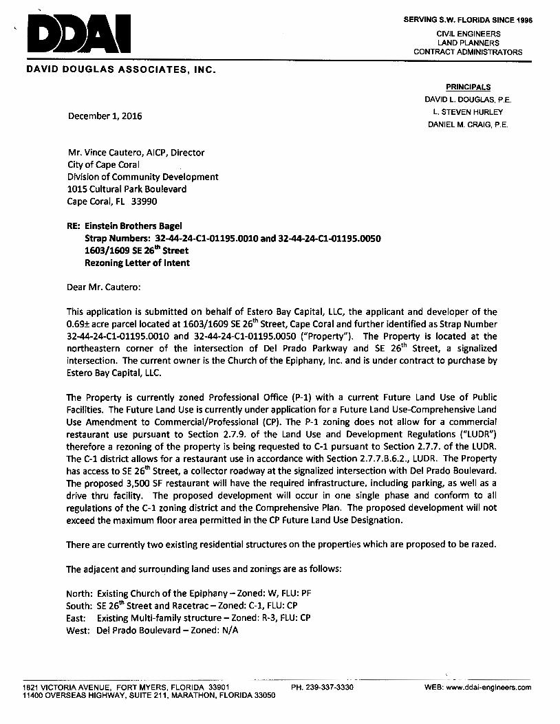
DDAI DAVID DOUGLAS ASSOCIATES, INC.
December 1, 2016
Mr. Vince Cautero, AICP, Director City of Cape Coral Division of Community Development 1015 Cultural Park Boulevard Cape Coral, FL 33990
RE: Einstein Brothers Bagel Strap Numbers: 32-44-24-Cl-01195.0010 and 32-44-24-Cl-01195.0050 1603/1609 SE 26th Street Rezoning Letter of Intent
Dear Mr. Cautero:
SERVING S.W. FLORIDA SINCE 1996
CIVIL ENGINEERS LAND PLANNERS
CONTRACT ADMINISTRATORS
PRINCIPALS
DAVID L. DOUGLAS, P.E.
L. STEVEN HURLEY
DANIEL M. CRAIG, P.E.
This application is submitted on behalf of Estero Bay Capital, LLC, the applicant and developer of the 0.69± acre parcel located at 1603/1609 SE 26th Street, Cape Coral and further identified as Strap Number 32-44-24-Cl-01195.0010 and 32-44-24-Cl-01195.0050 ("Property"). The Property is located at the northeastern corner of the intersection of Del Prado Parkway and SE 26th Street, a signalized intersection. The current owner is the Church of the Epiphany, Inc. and is under contract to purchase by Estero Bay Capital, LLC.
The Property is currently zoned Professional Office (P-1) with a current Future Land Use of Public Facilities. The Future Land Use is currently under application for a Future Land Use-Comprehensive Land Use Amendment to Commercial/Professional (CP). The P-1 zoning does not allow for a commercial restaurant use pursuant to Section 2.7.9. of the Land Use and Development Regulations ("LUDR") therefore a rezoning of the property is being requested to C-1 pursuant to Section 2.7.7. of the LUDR. The C-1 district allows for a restaurant use in accordance with Section 2.7.7.B.6.2., LUDR. The Property has access to SE 26th Street, a collector roadway at the signalized intersection with Del Prado Boulevard. The proposed 3,500 SF restaurant will have the required infrastructure. including parking, as well as a drive thru facility. The proposed development will occur in one single phase and conform to all regulations of the C-1 zoning district and the Comprehensive Plan. The proposed development will not exceed the maximum floor area permitted in the CP Future Land Use Designation.
There are currently two existing residential structures on the properties which are proposed to be razed.
The adjacent and surrounding land uses and zonings are as follows:
North: Existing Church of the Epiphany- Zoned: W, FLU: PF South: SE 26th Street and Racetrac- Zoned: C-1, FLU: CP East: Existing Multi-family structure - Zoned: R-3, FLU: CP West: Del Prado Boulevard-Zoned: N/A
1821 VICTORIA AVENUE, FORT MYERS, FLORIDA 33901 PH. 239-337-3330 11400 OVERSEAS HIGHWAY, SUITE 211, MARATHON, FLORIDA 33050
WEB: www.ddai-engineers.com

December 1, 2016 Rezoning Letter of Intent Page 2 of 2
The proposed zoning is compatible with the surrounding zonings and uses, has sufficient lot frontage and access, will meet the setback requirements for the zoning district and will provide code required buffering to surrounding properties where required. The proposed zoning will not be injurious to the health, safety and welfare to owners or occupants of adjacent properties, nearby residents or to the community.
Please accept this letter as a formal written request for rezoning for approval on the properties to the Commercial/Pedestrian (C-1) zoning district.
Sincerely,
DA~ID ~~S ASS"TES, INC ...
~?&-/If~~ Linda Stewart, AICP Principal Planner/Project Manager
Ends.
1821 VICTORIA AVENUE, FORT MYERS, FLORIDA 33901 PH. 239-337-3330 WEB: www.ddai-engineers.com 11400 OVERSEAS HIGHWAY, SUITE 211, MARATHON, FLORIDA 33050

LETTER OF AUTHORIZATION
The undersigned hereby acknowledges to be the owner or legal representative of the real property described below and further authorizes DAVID DOUGLAS ASSOCIATES, INC. to act as agent in order to apply for all necessary permits for development of the subject property.
ESTERO BAY CAPITAL, LLC
By: ~SAD Jeffllitr, Manager
Property Description: 1603/1609 SE 26th Street, Cape Coral, Florida
State of \-,:-),lo-u~ County of(~...eL-The foregoing instrument was acknowledged before me this /.:)fh day of ~ . ,
20 i 0 by C\ / S 3bt. I tz:_. who is personally known to me or who has produced
f) /rt as identification and who did (did not) take an oath.
NOTARY PUBLIC, STATE OF F Lo;:;!__t O/}-·
~;L~ NOtafYPUblic
My commission expires:

-· LETTER OF AUTHORIZATION
The undersigned hereby acknowledges to be the owner or legal representative of the real property described below and further authorizes ES TERO BAY CAPITAL, LLC to act as agent in order to apply for all necessary permits for development of the subject property.
CHURCH OF THE EPIPHANY, INC.
By•~ F;efR)Tanwrigt
Property Description: 1603/1609 SE 26th Street, Cape Coral, Florida
State of Vt;ie 1 l> .q.
County of l £ 0
d-The foregoing instrument was acknowledged before me this d t? day of Nt>vf::,rn-8, £::..~
20 I {p by btvtfle 4trn lv,e19/rr who is personally known to me or who has produc~
(/me 1 f) tl L t Ct ti s & as identification and who did ( d~t) take an oath.
NOTARY PUBLIC, STATE OF {lo,e 1 Di4 My commission expires: . /-/~-/~
,di_~ (), ku,~~ /NOtary Public
o"";.v.:~..-i- SHARON A. MEMOl.J "'~· MY COMMISSION t FF 065885
* * EXPIRES: January 16, 2018 "'~~ ~.,,~ Bonded Thru Budge! Notary Services
~OFF\."'
LETTER OF AUTHORIZATION
The undersigned hereby acknowledges to be the owner or legal representative of the real property described below and further authorizes DAVID DOUGLAS ASSOCIATES, INC. to act as agent in order to apply for all necessary permits for development of the subject property.
CHURCH OF THE EPIPHANY, INC.
By:~f F~yaJ; Wright
Property Description: 1603/1609 SE 26th Street, Cape Coral, Florida
State of t\ Q('.I d elf
Countyof ~
The foregoing instrument was acknowledged before me this 22cd day of b\.ove_ mW 20 '(p by ~(\ f\ \Jn Sf\' who is personally known to me or who has produced
~sa@lbf \({\owlf'\-o Y'0k as identification and who did (did not) take an oath.
NO ARY PUBLIC, STATE OF P\ondC< My commission expires: lv - \ - 2018
.-··~':iF.""•-... LINDA L. COMER t.rii~ con:imlssion # FF 089133 ~· '.~ Exp1res June 1, 2018 ·-.);)', " J~f Bonded Ttvu Troy Fain i111111111CO llCJ0.385.7019
,04>
>-<(
3: ~I l ~ ,o·
<(
~ I ~
3: '-......
0 0::: <( 0::: 0 Q_
0 ..--_J
~· '--' w I ,o· 0 ASPHALT
•".
CAPE OORAl BENOOIARK BOUNDARY & TOPOGRAPHIC SURVEY . rENa: POST ON CORNER 0-llSEL.ED X IN COHC FOOTER l::fl I STOOY CONC UNABLE 10 SET CORNER
~!w"':';~~TIJMELEV• o.12' ELEVATIONS NGVD 1929 DATUM ;' ~~~o'%~"'"''"c ~~··=•rn ~ 0tf 0-:.~ • / STRAP# 32-44-24-C1-0030A.0010 )( ,;; ~ ..fl 0.34' E. .&:. O.JCt S. 'b·
•'-f ~ f.,. 'b~Y OWNER: CHUROi OF THE EPIPHAN~INC. . 'b· • • o,!'- CONCRfTE WAU< ci.· o,~ \ o,· II FD 5/Pf' REBAR • , -- · -- -- -· ;.·CONC BLOCK WALL K'bt;J WATER REUS£ o,9 oi
. ® e x ~
~ ..
.~fll~i
a: C>P LS3877. FLAG POlE -v==~= 0/~ox &: rfl1...TER 1.2' 'b~ • i'' ,,,~ ~ [!] O, ·
. GAS WATER 'b<:;> I x'b'::- , "-l xo.6. 0.4' _":lz 'M>P/P 'b~ T --t - l>llCll'IH:
s·•c.L.r. MARK(R MANHOLE • 21' 4 C.Lf. 'b· I 6 C.L.f. /
0 RIM ELEV • 9.05' N.88"35'04"E. 245.00 . - l P/P
XtJ; TEL£ BOX WITH CONC SVJl
... ~ .. O'v£RHEA0 POWER
.~, SlRAPf 32-+4-24-Cl-01195.0010 . . ~
'!' o_ -N 1
BLOCK 1195 1-l~ o"' vi 2
°'" '\ ... I~ 221' .F _____ t s2 .• ·- - , - - - "i xOJ'S
OJ~· I~ 1 STORY CONC S7RUCTURE Fr=10.T8'
I ~ ~~ ~ -- -~ u~ j~ ~~~c ~
O,· ' 15.1'
4 SJ.o·- - - - •'tr?,,
"' g
..
.;.
'.j ._;
''°·"~
~ " ~
I <::
~ i
i !
~~~/ .~· l::i ~; .,,<tri, OJ~·
6' C.LF. uO'
o.<::;l" ;.,
'tr~ q,'?"J.
.~ ..
.. ... ~ STRAP# 32-44-24-Cl-01195.0050
.;.·
SlRAPf 32-44'-24-C1-00200.00CE 01\NERo CORALEE CONDO ASSN.
0 . -?-
:fo '75 I Q - - I -wooo'"'
r: --------- 14.4' SURVEYOR' NOTES
SCALE IN FEET 1"= 30' I
I 35.2'
I I I I 6 I I
SlRUCnJRE d Fr:a9.55' ,....
1
1 STORY CONC
I" ;..
I ~r· 71 l~~ I ~ ~ ~ N~~~ ~ ~ .,; . • l1 !n~io N 'b'? n
~"' '!'
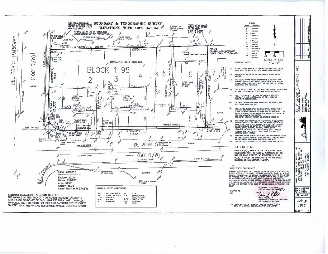
(1) 8£AR!NGS SHO'M-1 HEREON AAE ASSUMED AHO ARE BASED Q'f lHE NORTH RIGHT Of WAY ~ S.E. 2611i STRf[T BEING N.88'J5'04•t.
(2) IMPRO\oBIEJHS 8£1.0W 1HE GROUNO SURFACE, F AHY, ARE NOT LOCATED.
(J) a.IL Y AS<M: GROUND \1SIBl£ ENCROACHMENTS (JllTO DR FROM ~ING PROPERTY AR£ SHOWN. ENCR<lACHt.IOHS BENEATH 1HE GROUND SURF'ACE ANO lHOSE 'MilCH AAf. NOT VISIBI..£ BY NORMAL OOS£RVAT10N ARE NOT SHCMN.
J
" 8 ~ ~ ill~
I uO'
, ,,9-" I
0 .• --- (4) I.AHO IS IN FlOOO ZONE "'X', ELEV. NONE. BASED UPON F.E.M.A. FlOOO ttSURANCE RATE MAP NO. 12onco405F, DATED 08/28/2008.
6' C.L.t. !o· 10.s·
~~ <t.· 'a:Q:
~~ ~"
;... .,..,, :" 0 u;'b->°'
(5)
(6)
(7)
ASPHALT
THIS CERTIFICATION IS ONLY FDR TH£ LANDS AS ~IBEO HEREON, IT IS NOT A C[RTl1CATION fX Tin.£, ZCf.llMG OR FREEDOM Of ENCUMBRAHC£S.
THE l£CAL DESCRIPTION SHOYiN HEREOH WAS PROWJED BY M CUl.f SHORE SUR'wOINC. INC.
LANDS SHOM-1 HEREON \llERE NOT ABSlRACTED fCR EASEMENTS. SETBACKS, RESlRICllONS OR RIGiTS Of WAY Of REcmD. l"O SEAROf Of PUBLIC RECOROS HAS BEEH MADE BY 'MS OFTICE. THIS SUR\'EY rs Sl.18.ECT TO AHY FACTS THAT MAY BE OISQ..OSED BY A A.ti ANO ACOJRATE Tin.£ SEAROl. lHIS SUR\'EY ~S NOT RUtECT OR DETERMINE O'M£RSHIP. I .u,01
~o~'b ~"' ...... --·- ~
C~~~~~~:,.E';~~~~~~~~~~~~~~~~~~~~~~~~~~~::~~~~;r.::~::~~;;::::::o:"""::::•~::•:°"'~"~~~:;;;~~~~~~..,~-1~•~~~~~ -------'-i"lt-:;~ u SET 5/8" REBAR ,•"
~GNAL ARM MAST • N 88"35'04"E. . ~ CN' LB 6729
'bf 'b~ • 218.64' "'
I .......,_ ~ •"'L TRAfflCL ABER OPTIC ";.Q
.i> (•) i g :;j
.,4' ..f (9)
'O~
THIS SUR\'EY WAS P£RfORMED FOR THE PURPOSE Of DEUNEA TtlG BOUNOARY LINES Of 1H£ PARCEi.. AHO TiiE VISll!lE IMPRO'vDIENTS lHER£TO ONl Y AND IS NOT fflD«D TO IDENTIFY TiiE DISTENC£ Of, MOR DELINEATE THE EXTENT Of, n£ JURISDICTION Of ANY FEDERAL. STATE, RECK»IAL. OR LOCAi. ACENCY, BOARD, COMMISSION, OR OTHER ENTITY MiOSE RVLES. RECULATIONS OR CROINAHC[S MAY AF'FECT lHIS PARCEL EXCU'T AS MAY BE OTHER'MSE !WiOWN l<REClt.
El.£VAllONS !WiOWN HERf:ON ARE IN FEET ANO ARE RELATI\'E TO THE NATKHAL CEOOETIC "°TlCAL OA"Tl..M (Sl.D 1929}; AHO ARE BASED
BOX 'tr SIGNAL VAULT 'b •• " •• •· ..,
ASPHALT
ON CAPE CORAL BENo-t MARK 043-0S-01, El.EV. 8.12' •
i .. (10} CONTAINS 30,475 SOOARE FEET OR 0.6996 ACRES MORE OR U:SS.
VAULT PAISIENT STRIPE I .f __ 0 .,..-
{ ~ PA'.£M£NT STRIP£
't.f h -~ SE 26TH STREET
-;~ ..,"¥ DESCRIPTION:
LOTS 1,2,3,4,5. AND 6, BLOCK 1195, CAPE CORAL SUBDl\1SION, UNIT 20 PART 2, ACCORDING TO lHE MAP OR PL.AT lHEREOF, AS RECORDED IN PL.AT BOOK 19, PAGES 43 lHROUGH 48. Of lHE PUBLIC RECORDS Of L£E COUNTY, FlORIOA.
.. 'b~i, ,,.°'" •' "
ASPHALT (60' R/W) . 2· CONCRETE VAUEY ro'Y -& ... 2' OJRB 4: GUTTER
.~ ,.
._tlr? o1>
. :07 'Ofi -------=-==-__:;:=-=::- q').t\, q9'\. ( SURVEYOR'S CERTIFICATE
..-r=-11rvA n11mhAr 1 ~ ~ ~ I HEREBY C£RT1f'Y THAT THE ATIAOIED SKETCH a:'" SUR\'EY IS AN ACCURATE s· CONC CURB ~ CQNCR£TE 'O· REPRESENTATION or THE LANDS OES~BED HERE~ ACCORDING TO A RECENT
,o· Radius= 25.00' Delta= 93"02'06" Arc= 40.59' Chord= 36.28' Chord Brg.= N.44"53'53"W.
EASEMENT DEDICATION: {AS SHOWN ON PLAT) THE OWNERS OF THIS PROPERTY DO HEREBY DEDICATE EASEMENTS ALONG EACH BOUNDARY OF EACH HOMESITE FOR COUNTY DRAINAGE PURPOSES, AND FOR PUBLIC UTILITIES SAID EASEMENT NOT TO EXCEED SIX FEET EACH SIDE OF SAID BOUNDARIES, UNLESS OTHERl'v1SE SHOWN.
U:CEND OF SURVE:Y ABBRE:VIATlONS
A/C C.Lf. CONC. El£C EL
AIR CONDlllONER CHAIN LINK FENCE GONCR8E ELECTRICAL ELEVATION
FO P.K.
R/W TELE
""
•• "
FOUND
RACE lRACK BUILDING FF'210.97'
PARKER KAI.ON (MASONRY NAIL) RIGHT Of WAY TELEPHONE V<lOO
SUR\'£Y P£RfOfU.IEO ON THE GROONO IN ACCORD.A.NC£ 1MltH THE STANOAROS <i> It Of PRACTICE FOR LAND SUR\'EYINC. OIAPTER 5JGt 7-IS FAC. · AS .SET FORTli
<ti' ~R~~Nf}~0~~~~0'4'fi.~~~n~.:'-s~~~~~ANOASM~~o UNDER THE DIRCECT SUPERVISION Of TH[ UNDERSIGNED REQSTEREO LANO SURVE~. IS TRUE ANO CORRECT TO THE BEST Of OJR KNO'IW.EDCE, .INFORMAlloN ANO BEUEf.
~!~ :~bH~fu~?~l}1'/1v
-:?~(!.// ' ~~ £.~~:::O MAPPER NOT VALID WITHOOT THE SICIO.TURE:O~~::::~~l
6
s: !< .
CERTIFIED TO: OOAJ
SOL Of A FlORIOA LICENSED SUR~ _ AHO · M APPER.
c..i ~
'5 z :>= ~ 0:: ::i
(f) I:
w~ :I ~i a~ ::i:~ ~ i~ Cfl~ § ia ~!I ;!Is 0~ ~I~
~ ~N ..
I ! ~
i
- "' -~- -< )&:;~)( ~ 9 ~ .. 8 a:~ mom 0 _,
l&.~t-!:i~~ o:;::'i..,JI: Q):J~~~ ~ ~ ~ ~G.8 8 ~8~ ~ ~ -w~ ~ _, 111"-0 ,_ < ... goa::
DATE : 11/13/1011 SCMI: : 1•a30• Fu : 1115mll
32-.U-24
JOB I 1615
SHCF:T

~
l ~
I c
~ 0
CHARLOTTE
....
-#"" I c 0
PROJECT LOCATION
. SE. .::nc Sr ., ,,
vi
SE:nr S:
0: ~
;-;
SE i5th Lr··;
-';'[ :::· ~·. ' --
Marq~Ctn.e-mn
HQl'rlfo(;OM'I I• (;l)tfdwMd I 0 . Cv•.dwwJ
~~11'lgt;i,ttpr
2" 'tt>•S,
"
" " ~
" ~
COUNTY
PROJECT LOCATION
.Jt.tL'''!.:.
u 0 241~S;
','rru.:;'1~ P•,,-·)
LEHIGH ACRES
> ... z
" 0 u
>
"' Q
z w :c
NTS
NTS
:to-.................................................................................................... ..., ....................................................................................................................................................................................................................... ..... ~ DATE : 12--01-16 NO. REVISION
- SCALE : N.T.S.
f DESIGN: STS
~ CAD : STS ii:
DAVID DOUGLAS ASSOCIATES, INC. 1-----Lo_c_A_T_1o_N_M_A_P ___ .... CIVIL ENGINEERS- LAND PLANNERS - CONTRACT ADMINISTRATORS
1821 Victoria Ave, Fort Myers, Flortda 33901 Ph. 23~337-3330 Web: www.ddal-englneers.com Florida Certlflcate of Authorization # 7568 DDAI
EINSTEIN BROS BAGEL 1603 26TH STREET
CAPE CORAL, FL. 33000
DDAIJOB NUMBER 14-0178

Planning Division Case Report ZA16-0009
Review Date: January 23, 2017 Applicant and Church of the Epiphany, Inc. Property Owners: 2507 Del Prado Boulevard South Cape Coral, FL 33904 Site Address: 1603-1609 SE 26th Street Cape Coral, FL 33904 Location: Southeast Cape Coral; Unit 20 Part 2, Block 1195, Lots 1-6, Cape Coral Subdivision 32-44-24-C1-01195.0010 32-44-24-C1-01195.0050 Authorized Linda Stewart, AICP Representative: David Douglas Associates, Inc.
1821 Victoria Avenue Fort Myers, FL 33901 (239) 337-3990
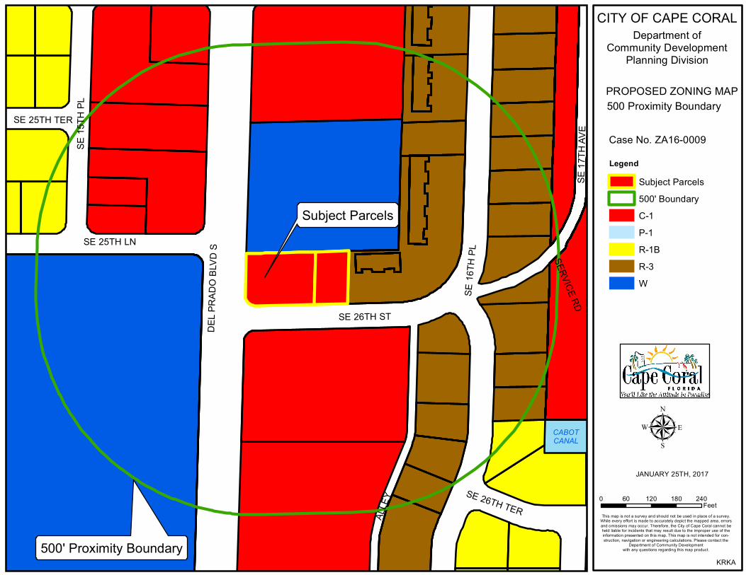
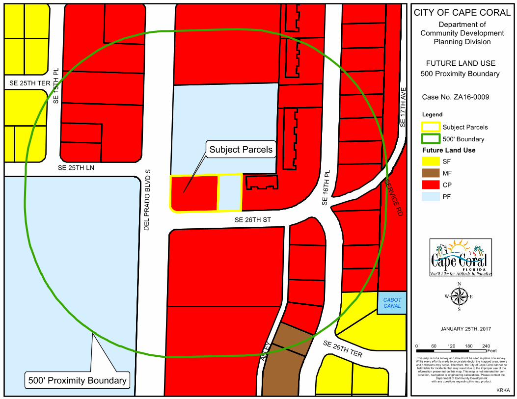
Case Staff: Wyatt Daltry, AICP, Planning Team Coordinator Review Approved By: Robert Pederson, AICP, Planning Manager Purpose/Request: The applicant requests a rezone from Professional Office (P-1) and Place of Worship (W)
to Pedestrian Commercial (C-1) for a 30,000 square feet (0.69 acre) site. Subject Property:
Future Land Use Zoning
Current: Public Facilities (PF) P-1 (Lots 1-4) and W (Lots 5-6) Proposed: N/A. Commercial/Professional (CP) proposed in
upcoming FLU case C-1
Surrounding Future Land Use Surrounding Zoning North: PF W South: CP C-1 East: CP and PF Multi-Family Residential (R-3) and W West: CP and PF C-1 and W Urban Service Area: Infill City Water and Sewer: The area is served by City water and sewer
January 23, 2017 ZA16-0009
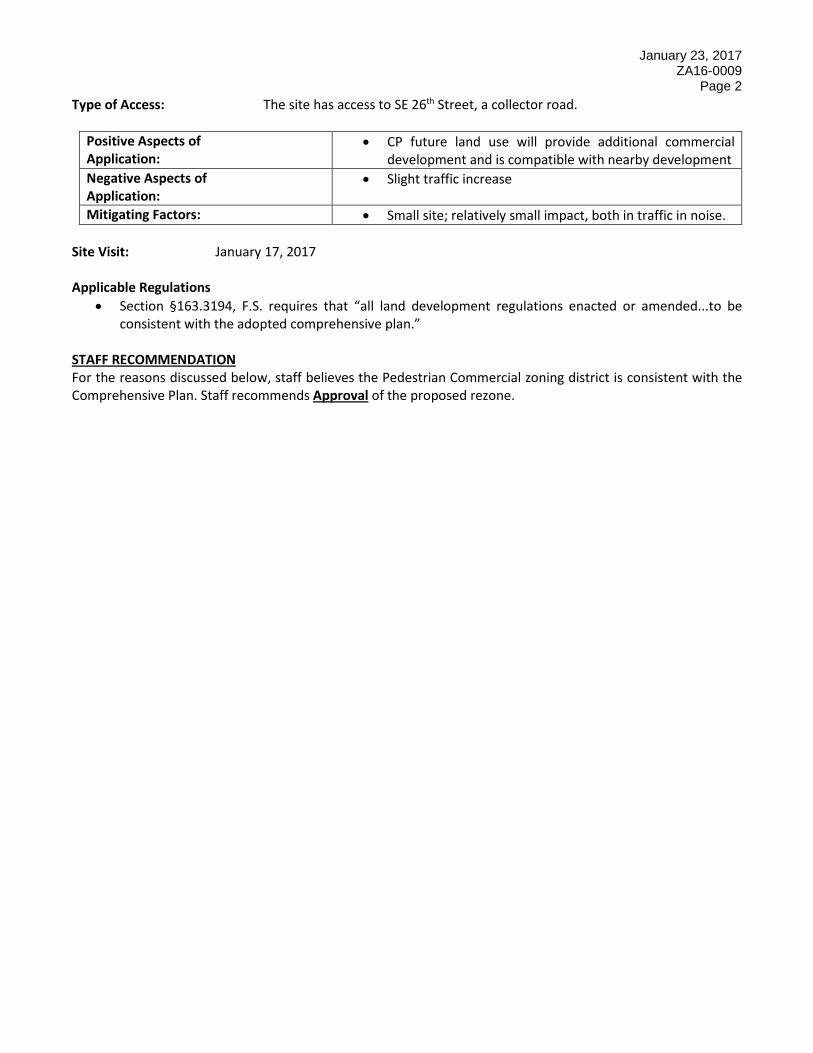
Page 2 Type of Access: The site has access to SE 26th Street, a collector road.
Positive Aspects of Application:
• CP future land use will provide additional commercial development and is compatible with nearby development
Negative Aspects of Application:
• Slight traffic increase
Mitigating Factors: • Small site; relatively small impact, both in traffic in noise. Site Visit: January 17, 2017 Applicable Regulations
• Section §163.3194, F.S. requires that “all land development regulations enacted or amended...to be consistent with the adopted comprehensive plan.”
STAFF RECOMMENDATION For the reasons discussed below, staff believes the Pedestrian Commercial zoning district is consistent with the Comprehensive Plan. Staff recommends Approval of the proposed rezone.
January 23, 2017 ZA16-0009
Page 3 Background/Analysis:
The site has three older single-family residences, two of which were built in 1978, and the third in 1981. The properties were zoned Multi-Family Residential (R-3) at the time of construction; subsequently, Lots 1-4 of Block 1195 were rezoned to P-1 in 1988 and Lots 5-6 were rezoned to the Worship zoning district in 2004. The site was amended to the Public Facilities Future Land Use Map Classification in 2007. The properties have direct access to SE 26th Street, a collector roadway which serves as the main route to the Everest Parkway neighborhoods and the City Everest Utility Plant. The site is adjacent to Del Prado Boulevard, a major arterial roadway. The applicant’s letter of intent indicates this site is under contract to purchase from the Church of the Epiphany; adjacent to the north. It appears the requested change may facilitate commercial development of some type. The City has also received an application (LU16-0014) to amend the future land use Lots 5-6 to CP, which will be presented simultaneously with this case. Comprehensive Plan The proposed rezone is consistent with the proposed CP future land use map classification. The rezone is consistent with Objective 2 and Policies 3.1 and 3.4 of the Future Land Use Element. Land Use and Development Regulations -- Section 8.7 Amendments: Staff reviewed this request in accordance with Section 8.7 Amendments, .3 Consistency with Comprehensive Plan and General Standards, B. 1.-10. of the Land Use and Development Regulations and provides the following analysis. This section is used for future land use map amendments, comprehensive plan amendments, and for rezone requests.
1. The extent to which the value of the property is diminished by the proposed land use restriction or zoning of the property.
Rezoning these properties from P-1 and W to the C-1 district would not likely diminish the land value because this proposed district increases the number of permitted and special exception uses.
2. The extent to which the removal of a proposed land use restriction or change depreciates the value of other properties in the area. The proposal is not anticipated to depreciate the value of other properties in the area.
3. The suitability of the property for the zoning purpose or land use restriction imposed on the property as zoned. The proposed zoning district would be consistent with the land use classification of CP, which is proposed to be amended for Lots 5-6 simultaneously with the rezoning. Lots 1-4 already have the CP Future Land Use Map Classification.

January 23, 2017 ZA16-0009
Page 4 4. The character of the neighborhood, existing uses, zoning of nearby and surrounding properties, and
compatibility of the proposed land use restriction or zoning.
The surrounding area has a commercial character. The site is at the intersection of Del Prado Boulevard and SE 26th Street. Existing commercial development is nearby, particularly to the south. The proposed rezone is compatible with the surrounding area.
5. The relative gain to the community as compared to the hardship, if any imposed, by the proposed land
use restrictions or from rezoning said property.
The effect of this rezoning is to increase the City’s inventory of commercial properties. The proposal would increase the City’s tax base in an area that has a commercial character. As a result, this proposed rezone does not create more hardship than gain to the community.
6. The community need for the use proposed by the zoning or land use restriction.
Additional commercial lands that result in an increase in the community’s tax base would provide a benefit to the community. There is a need for the uses permitted by the proposed rezone.
7. Length of time the property proposed to be rezoned has been vacant, as zoned, when considered in the
context of the City of Cape Coral Comprehensive Land Use Plan for the development of the proposed property and surrounding property. The subject property is developed with three residences, which will be removed in the process of redeveloping the site.
8. The extent to which the proposed land use restriction or zoning promotes the health, safety, morals, or
general welfare of this community.
Approval of this rezone should have a negligible effect upon the health, general welfare, safety, or morals of the community due to the small size of the site. Providing a zoning designation that is consistent with the future land use map classification should have a positive effect on the general welfare for the community. It should be noted, however, that a consistent zoning designation, Professional Office, already exists for the site.
9. The extent to which the proposed land use, land use restriction, or zoning will impact the level of service
standards for public facilities as specified in the Comprehensive Plan.
Impacts on infrastructure for development on this site will be negligible due to the size of the site. Facility capacity exists for the transportation infrastructure network. Utilities are available at this location.
10. Whether the proposed land use restriction, removal of a restriction, or zoning is consistent with the City
of Cape Coral Comprehensive Land Use Plan. Both the existing and proposed zoning designations are consistent with the CP future land use classification.
January 23, 2017 ZA16-0009
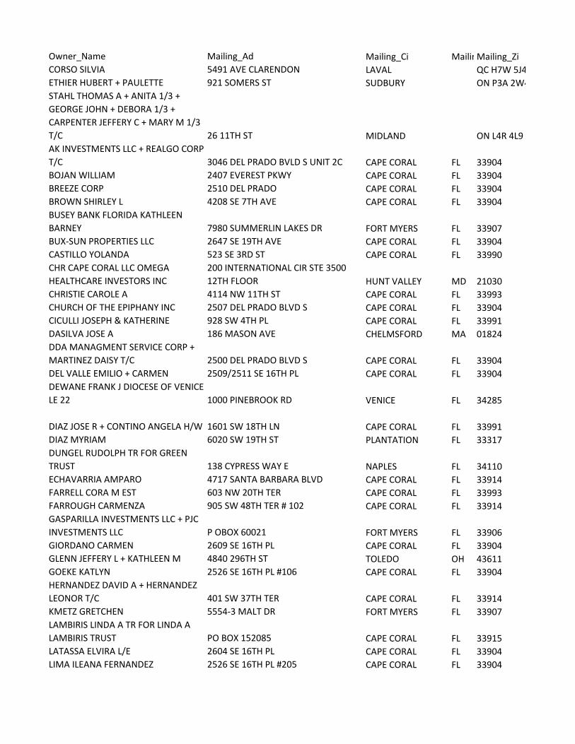
Page 5 Public Notification This case will be publicly noticed as required by LUDR, Section 8.3.2.A as further described below. Publication: A legal ad will be prepared and sent to the News-Press announcing the intent of the petitioners to rezone the property described within this report. The ad will appear in the News-Press a minimum of 10 days prior to the public hearing scheduled before the Hearing Examiner. Following the public hearing before the Hearing Examiner, the ad announcing the final public hearing before the City Council will appear once in the News-Press. The ad will appear in the newspaper not less than 10 days prior to the date of the final public hearing before the City Council. Written notice: Property owners located within 500 feet from the property line of the land which the petitioners request to rezone will receive written notification of the scheduled public hearings. These letters will be mailed to the aforementioned parties a minimum of 10 days prior to the public hearing scheduled before the Hearing Examiner. Posting of a Sign: A large sign identifying the case and providing salient information will be posted on the property, as another means of providing notice of the rezoning request. Recommendation: Planning staff has reviewed this request in accordance with Section 8.7 Amendments, .3 Consistency with the Comprehensive Plan and General Standards A., B. 1.-10 of the Land Use and Development Regulations and the City’s Comprehensive Plan. Planning Division recommends approval of the rezone request. Staff Contact Information: Wyatt Daltry, AICP
Planning Team Coordinator Department of Community Development Planning Division (239) 573-3160 email: [email protected]
Please contact us with changes or cancellations as soon as possible, otherwise no further action needed.
TOLL-FREE Local # Email
888-516-9220 239-335-0258 [email protected]
Customer:
CAPE CORAL FL 33990
USA
1015 CULTURAL PARK BLVDAddress:
CITY OF CAPE CORAL_DEPT OF COMAd No.: 0001952540
Net Amt: $
02/25/17Run Dates:
Run Times: 1 No. of Affidavits: 1
Text of Ad:

Please contact us with changes or cancellations as soon as possible, otherwise no further action needed.
TOLL-FREE Local # Email
888-516-9220 239-335-0258 [email protected]
Customer:
CAPE CORAL FL 33990
USA
1015 CULTURAL PARK BLVDAddress:
CITY OF CAPE CORAL_DEPT OF COMAd No.: 0002011249
Net Amt: $
03/24/17Run Dates:
Run Times: 1 No. of Affidavits: 1
Text of Ad:
Department of Community Development Post Office Box 150027 Cape Coral, Florida 33915-0027
1015 Cultural Park Blvd. Cape Coral, Florida 33990 Email: [email protected]
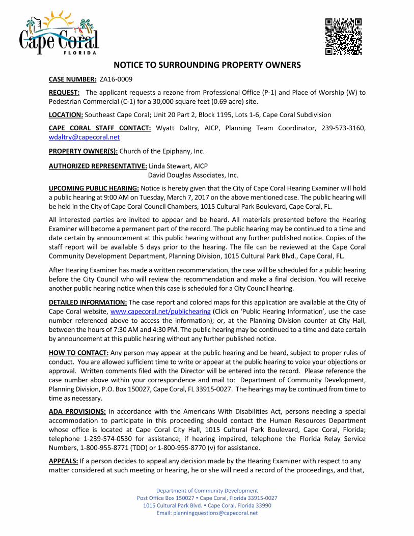
NOTICE TO SURROUNDING PROPERTY OWNERS
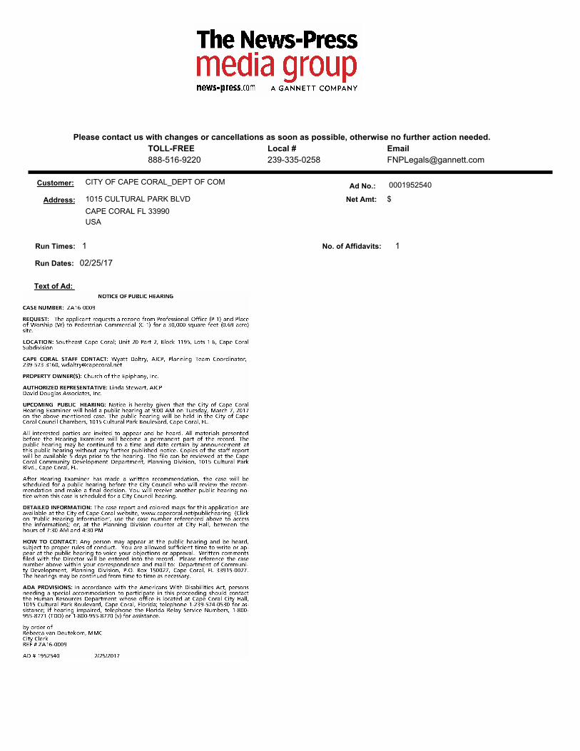
CASE NUMBER: ZA16-0009
REQUEST: The applicant requests a rezone from Professional Office (P-1) and Place of Worship (W) to Pedestrian Commercial (C-1) for a 30,000 square feet (0.69 acre) site.
LOCATION: Southeast Cape Coral; Unit 20 Part 2, Block 1195, Lots 1-6, Cape Coral Subdivision
CAPE CORAL STAFF CONTACT: Wyatt Daltry, AICP, Planning Team Coordinator, 239-573-3160, [email protected]
PROPERTY OWNER(S): Church of the Epiphany, Inc.
AUTHORIZED REPRESENTATIVE: Linda Stewart, AICP David Douglas Associates, Inc.
UPCOMING PUBLIC HEARING: Notice is hereby given that the City of Cape Coral Hearing Examiner will hold a public hearing at 9:00 AM on Tuesday, March 7, 2017 on the above mentioned case. The public hearing will be held in the City of Cape Coral Council Chambers, 1015 Cultural Park Boulevard, Cape Coral, FL.
All interested parties are invited to appear and be heard. All materials presented before the Hearing Examiner will become a permanent part of the record. The public hearing may be continued to a time and date certain by announcement at this public hearing without any further published notice. Copies of the staff report will be available 5 days prior to the hearing. The file can be reviewed at the Cape Coral Community Development Department, Planning Division, 1015 Cultural Park Blvd., Cape Coral, FL.
After Hearing Examiner has made a written recommendation, the case will be scheduled for a public hearing before the City Council who will review the recommendation and make a final decision. You will receive another public hearing notice when this case is scheduled for a City Council hearing.
DETAILED INFORMATION: The case report and colored maps for this application are available at the City of Cape Coral website, www.capecoral.net/publichearing (Click on ‘Public Hearing Information’, use the case number referenced above to access the information); or, at the Planning Division counter at City Hall, between the hours of 7:30 AM and 4:30 PM. The public hearing may be continued to a time and date certain by announcement at this public hearing without any further published notice.
HOW TO CONTACT: Any person may appear at the public hearing and be heard, subject to proper rules of conduct. You are allowed sufficient time to write or appear at the public hearing to voice your objections or approval. Written comments filed with the Director will be entered into the record. Please reference the case number above within your correspondence and mail to: Department of Community Development, Planning Division, P.O. Box 150027, Cape Coral, FL 33915-0027. The hearings may be continued from time to time as necessary.
ADA PROVISIONS: In accordance with the Americans With Disabilities Act, persons needing a special accommodation to participate in this proceeding should contact the Human Resources Department whose office is located at Cape Coral City Hall, 1015 Cultural Park Boulevard, Cape Coral, Florida; telephone 1-239-574-0530 for assistance; if hearing impaired, telephone the Florida Relay Service Numbers, 1-800-955-8771 (TDD) or 1-800-955-8770 (v) for assistance.
APPEALS: If a person decides to appeal any decision made by the Hearing Examiner with respect to any matter considered at such meeting or hearing, he or she will need a record of the proceedings, and that,

Department of Community Development Post Office Box 150027 Cape Coral, Florida 33915-0027
1015 Cultural Park Blvd. Cape Coral, Florida 33990 Email: [email protected]
for such purpose, he or she may need to ensure that a verbatim record of the proceedings is made, which record includes the testimony and evidence upon which the appeal is to be based.

CABOTCANAL
SE 26TH TER
SE 25TH TER
SE 25TH LN
SERVICE RD
SE 16
TH PL
SE 26TH ST
SE 17
TH AV
E
SE 15
TH PL
ALLE
Y
DEL P
RADO
BLVD
SSubject Parcels
500' Proximity Boundary
CITY OF CAPE CORALDepartment of
Community DevelopmentPlanning Division
CURRENT ZONING MAP500 Proximity Boundary
Case No. ZA16-0009Legend
Subject Parcels500' BoundaryC-1P-1R-1BR-3W
µJANUARY 25TH, 2017
0 60 120 180 240Feet
This map is not a survey and should not be used in place of a survey.While every effort is made to accurately depict the mapped area, errorsand omissions may occur. Therefore, the City of Cape Coral cannot beheld liable for incidents that may result due to the improper use of theinformation presented on this map. This map is not intended for con-struction, navigation or engineering calculations. Please contact the
Department of Community Developmentwith any questions regarding this map product.
KRKA

SE 26TH ST
SE 25TH LN
DEL P
RADO
BLVD
S
SE 16
TH PLSubject Parcels
0 50 100FeetThis map is not a survey and should not be used in place of a survey.While every effort is made to accurately depict the mapped area, errorsand omissions may occur. Therefore, the City of Cape Coral cannot beheld liable for incidents that may result due to the improper use of theinformation presented on this map. This map is not intended forconstruction, navigation or engineering calculations. Please contact the Department of Community Development with any questions regarding this map product.
µMap Date: February 21, 2017Aerial Date: 2016
CITY OF CAPE CORALDepartment of
Community DevelopmentCase # ZA16-0009
Subject Parcel
CABOTCANAL
SE 26TH TER
SE 25TH TER
SE 25TH LN
SERVICE RD
SE 16
TH PL
SE 26TH ST
SE 17
TH AV
E
SE 15
TH PL
ALLE
Y
DEL P
RADO
BLVD
SSubject Parcels
500' Proximity Boundary
CITY OF CAPE CORALDepartment of
Community DevelopmentPlanning Division
PROPOSED ZONING MAP500 Proximity Boundary
Case No. ZA16-0009Legend
Subject Parcels500' BoundaryC-1P-1R-1BR-3W
µJANUARY 25TH, 2017
0 60 120 180 240Feet
This map is not a survey and should not be used in place of a survey.While every effort is made to accurately depict the mapped area, errorsand omissions may occur. Therefore, the City of Cape Coral cannot beheld liable for incidents that may result due to the improper use of theinformation presented on this map. This map is not intended for con-struction, navigation or engineering calculations. Please contact the
Department of Community Developmentwith any questions regarding this map product.
KRKA
CABOTCANAL
SE 26TH TER
SE 25TH TER
SE 25TH LN
SERVICE RD
SE 16
TH PL
SE 26TH ST
SE 17
TH AV
E
SE 15
TH PL
ALLE
Y
DEL P
RADO
BLVD
SSubject Parcels
500' Proximity Boundary
CITY OF CAPE CORALDepartment of
Community DevelopmentPlanning Division
FUTURE LAND USE500 Proximity Boundary
Case No. ZA16-0009
LegendSubject Parcels500' Boundary
Future Land UseSFMFCPPF
µJANUARY 25TH, 2017
0 60 120 180 240Feet
This map is not a survey and should not be used in place of a survey.While every effort is made to accurately depict the mapped area, errorsand omissions may occur. Therefore, the City of Cape Coral cannot beheld liable for incidents that may result due to the improper use of theinformation presented on this map. This map is not intended for con-struction, navigation or engineering calculations. Please contact the
Department of Community Developmentwith any questions regarding this map product.
KRKA
Owner_Name Mailing_Ad Mailing_Ci MailinMailing_ZiCORSO SILVIA 5491 AVE CLARENDON LAVAL QC H7W 5J4 ETHIER HUBERT + PAULETTE 921 SOMERS ST SUDBURY ON P3A 2W4 STAHL THOMAS A + ANITA 1/3 + GEORGE JOHN + DEBORA 1/3 + CARPENTER JEFFERY C + MARY M 1/3 T/C 26 11TH ST MIDLAND ON L4R 4L9 AK INVESTMENTS LLC + REALGO CORP T/C 3046 DEL PRADO BVLD S UNIT 2C CAPE CORAL FL 33904BOJAN WILLIAM 2407 EVEREST PKWY CAPE CORAL FL 33904BREEZE CORP 2510 DEL PRADO CAPE CORAL FL 33904BROWN SHIRLEY L 4208 SE 7TH AVE CAPE CORAL FL 33904BUSEY BANK FLORIDA KATHLEEN BARNEY 7980 SUMMERLIN LAKES DR FORT MYERS FL 33907BUX-SUN PROPERTIES LLC 2647 SE 19TH AVE CAPE CORAL FL 33904CASTILLO YOLANDA 523 SE 3RD ST CAPE CORAL FL 33990CHR CAPE CORAL LLC OMEGA HEALTHCARE INVESTORS INC
200 INTERNATIONAL CIR STE 3500 12TH FLOOR HUNT VALLEY MD 21030
CHRISTIE CAROLE A 4114 NW 11TH ST CAPE CORAL FL 33993CHURCH OF THE EPIPHANY INC 2507 DEL PRADO BLVD S CAPE CORAL FL 33904CICULLI JOSEPH & KATHERINE 928 SW 4TH PL CAPE CORAL FL 33991DASILVA JOSE A 186 MASON AVE CHELMSFORD MA 01824DDA MANAGMENT SERVICE CORP + MARTINEZ DAISY T/C 2500 DEL PRADO BLVD S CAPE CORAL FL 33904DEL VALLE EMILIO + CARMEN 2509/2511 SE 16TH PL CAPE CORAL FL 33904DEWANE FRANK J DIOCESE OF VENICE LE 22 1000 PINEBROOK RD VENICE FL 34285
DIAZ JOSE R + CONTINO ANGELA H/W 1601 SW 18TH LN CAPE CORAL FL 33991DIAZ MYRIAM 6020 SW 19TH ST PLANTATION FL 33317DUNGEL RUDOLPH TR FOR GREEN TRUST 138 CYPRESS WAY E NAPLES FL 34110ECHAVARRIA AMPARO 4717 SANTA BARBARA BLVD CAPE CORAL FL 33914FARRELL CORA M EST 603 NW 20TH TER CAPE CORAL FL 33993FARROUGH CARMENZA 905 SW 48TH TER # 102 CAPE CORAL FL 33914GASPARILLA INVESTMENTS LLC + PJC INVESTMENTS LLC P OBOX 60021 FORT MYERS FL 33906GIORDANO CARMEN 2609 SE 16TH PL CAPE CORAL FL 33904GLENN JEFFERY L + KATHLEEN M 4840 296TH ST TOLEDO OH 43611GOEKE KATLYN 2526 SE 16TH PL #106 CAPE CORAL FL 33904HERNANDEZ DAVID A + HERNANDEZ LEONOR T/C 401 SW 37TH TER CAPE CORAL FL 33914KMETZ GRETCHEN 5554-3 MALT DR FORT MYERS FL 33907LAMBIRIS LINDA A TR FOR LINDA A LAMBIRIS TRUST PO BOX 152085 CAPE CORAL FL 33915LATASSA ELVIRA L/E 2604 SE 16TH PL CAPE CORAL FL 33904LIMA ILEANA FERNANDEZ 2526 SE 16TH PL #205 CAPE CORAL FL 33904

LINDNER DANIEL R + LINDNER ANITA 2526 SE 16TH PL #109 CAPE CORAL FL 33904
LOUGHREA EDWARD R TR FOR EDWARD R LOUGHREA FAMILY TRUST 4015 SW 1ST PL CAPE CORAL FL 33914LUNDBERG RICHARD + SUSAN 3340 SE 17TH PL CAPE CORAL FL 33904MEDINA CARLOS J 1210 SW 14TH ST CAPE CORAL FL 33991MOORE AMANDA M 1617 SE 26TH ST # 102 CAPE CORAL FL 33904NAD DURIS JAN 620 S ALTON WAY APT 7D DENVER CO 80247NIARAKI-ASLI ILIAD 848 N RAINBOW BLVD # 3611 LAS VEGAS NV 89107NIEDUNG HELEN B TR FOR HELEN B NIEDUNG TRUST 2632 SE 16TH PL CAPE CORAL FL 33904PANTALONE JOSEPH 1/2 + MAJOR GARY 1/2 T/C 1617 SE 26TH ST # 204 CAPE CORAL FL 33904PINERA ELENA A TR FOR ELENA A PINERA TRUST 415 SE 28TH TER CAPE CORAL FL 33904PIZZA MICHELLE M 3023 NW 2ND PL CAPE CORAL FL 33993RACE DOUGLAS A + MARILYN D 5922 NUTHATCH CT CHARLOTTE NC 28277RACETRAC PETROLEUM INC PO BOX 56607 ATLANTA GA 30343ROBERTS ANNETTE A 16 RYERSON AVE BLOOMINGDALE NJ 07403RODRIGUEZ JOANN N 2510 SE 16TH PL APT 204 CAPE CORAL FL 33904ROYAL PALM COAST HOLDINGS INC 2840 WINKLER AV FORT MYERS FL 33916RUBIO ELISA PENA 2526 SE 16TH PL #210 CAPE CORAL FL 33904RUIZ DARELYS ANDINO 2510 SE 16TH PL APT 103 CAPE CORAL FL 33904
SCHWARTZ DANIEL W + DOROTHY19333 W COUNTRY CLUB DR APT 1901 AVENTURA FL 33180
SCURLOCK CLAUDIA E B 2526 SE 16TH PL #208 CAPE CORAL FL 33904SERMENO VILMA + DANIEL E 1617 SE 26TH ST #104 CAPE CORAL FL 33904SILVA ALFONSO + MAITTE 2613 SE 16TH PL CAPE CORAL FL 33904SIMPSON PAUL G + ANNE M 716 SE 44TH ST CAPE CORAL FL 33904SZYMURSKI RENATA M 2526 SE 16TH PL #111 CAPE CORAL FL 33904TAMMACCO FRANCESCO & RITA 1833 SW 41ST ST CAPE CORAL FL 33914TAMMACCO FRANCESCO & RITA 1833 SW 41ST ST CAPE CORAL FL 33914TANDOC MERLE N 63 WETHERSTONE DR WEST SENECA NY 14224UNKNOWN HEIRS OF VITIELLO SILVERIO B 15 AZTEC LILY LN LEHIGH ACRES FL 33936WJ SMITH ENTERPRISES LLC 1939 SE 32ND TER CAPE CORAL FL 33904