day trip #1
TRANSCRIPT

United States Department of Agriculture Forest Service Northern Region June 2010
The Great 1910 Fires of Idaho and Montana Day Trip Guide to Historic Sites Day Trip #1 – Idaho Web Print Version (1 of 3)
Mariah Leuschen and Rose Davis Commemoration Team June 2010 1023-2M09-MTDC

2

3
Contents of Day Trip #1 (pages 1 – 19) The 1910 Fires - The Land ........................................................... 1
The 1910 Fires – The People ........................................................ 2
1910 Fires Commemoration Sites – Idaho .................................... 4
Day Trip #1 ......................................................................... 4
Contents of Day Trip #2 and #3 (print from separate document pages 20 - 35)
1910 Fires Commemoration Sites—Idaho .................................. 20
Day Trip #2 ........................................................................... 20
1910 Fires Commemoration Sites—Montana ............................. 25
Day Trip #3 ........................................................................... 25
Contents of Day Trip #4 (print from separate document pages 36 - 49)
1910 Fires Commemoration Sites—Montana ............................. 36
Day Trip #4 .......................................................................... 36
The Forest Service, United States Department of Agriculture (USDA), has developed this information for the guidance of its employees, its contractors, and its cooperating Federal and State agencies and is not responsible for the interpretation or use of this information by anyone except its own employees. The use of trade, firm, or corporation names in this document is for the information and convenience of the reader and does not constitute an endorsement by the Department of any product or service to the exclusion of others that may be suitable. The U.S. Department of Agriculture (USDA) prohibits discrimination in all its programs and activities on the basis of race, color, national origin, age, disability, and where applicable, sex, marital status, familial status, parental status, religion, sexual orientation, genetic information, political beliefs, reprisal, or because all or part of an individual’s income is derived from any public assistance program. (Not all prohibited bases apply to all programs.) Persons with disabilities who require alternative means for communication of program information (Braille, large print, audiotape, etc.) should contact USDA’s TARGET Center at (202) 720-2600 (voice and TDD). To file a complaint of discrimination, write to USDA, Director, Office of Civil Rights, 1400 Independence Avenue, S.W., Washington, D.C. 20250-9410, or call (800) 795-3272 (voice) or (202) 720-6382 (TDD). USDA is an equal opportunity provider and employer.

1
The 1910 Fires— The Land
The 1910 Fires were a pivotal event in western and U.S. history
affecting thousands of people and forging the Forest Service’s early fire suppression policy. The fires also spurred national interest in conservation and the need for scientific research into fires. This research now includes fire prevention, the role of fire in the nation’s varied ecosystems, forest insects and diseases, tree genetics, timber management, and silviculture.
Burned over white pine in the St. Joe River drainage. Photo by R.H. McKay
Approximately eight billion board feet of timber burned in the fires. The intense heat severely damaged entire watersheds across nearly three million acres. One third of the town of Wallace Idaho burned and the towns of Mullan and Avery Idaho were barely saved by residents who set backburns. A backburn ignites the trees, grass and brush in front of an oncoming wildfire which slows or stops a fire by robbing it of burnable fuels.

2
The 1910 Fires— The People
Many families in north Idaho and western Montana were affected by the fires of 1910. The most awe-inspiring event that occurred is often referred to as the “Big Blowup,” a 36-hour firestorm that burned nearly three million acres on August 20 and August 21, 1910.
The firefighter memorial at St. Maries.
Although numbers vary, it is believed that 85 people died in the fire and most were Forest Service firefighters. Both Wallace and St. Maries Idaho honor these fallen firefighters. Woodlawn Cemetery in St. Maries marks these firefighters’ graves in concentric circles with a large granite marker in their midst, chiseled to resemble a large flame. Some names are unknown to this day.

3
A partial list of Forest Service casualties from the 1910 Fires.
Ident if ied Dead on Set ser (sic) Creek:
1. George Smith 2. G.A. Blodgett 3. Oscar Weigert 4. Harry Jackson 5. L. Ustlo 6. Jimmy
Donahue 7. Frank Sanders 8. Patrick Grogan 9. Lary Levar
Unident if ied Dead on Set ser (sic) Creek:
1. M. Phwiser 2. J. Rusick 3. M. Dilo 4. Jack Hill 5. O. Bing 6. Ed Murphy 7. H. Siphers 8. Ralph Ekhoen 9. Frank Sketchell 10. Ed Dunn 11. W.F. Norton 12. L. Schwartz 13. H. W. Baker 14. Frank
Masterson 15. George McGurk 16. O. Ellefson 17. F.D. Swick 18. W. Polk 19. Wm. Casey
Unident if ied Dead on Big Creek:
1. Gus Johnson 2. W. Flynn 3. Sam Hull 4. L. Johnson 5. Edward Frye 6. John Hoss 7. Harry Smith 8. Joe Denden 9. J. Stevens 10. J. Harp 11. Chris
Christensen 12. Jim Denten 13. Glenn Taylor 14. K. Anderson

4
1910 Fires Commemoration Sites— Idaho
Day Tr ip #1—This section of the journey starts from the Idaho side of the country most affected by the Big Burn beginning in Coeur D’Alene Idaho on Interstate 90 (I-90). Day Trip #1 leads to historic St. Maries and Avery Idaho. Driving east there are a variety of historical stops to choose from.
Tip: It’s best to have a full tank of gas before you begin. Read ahead to determine how your individual interests might connect to another day trip through a different section of country burned by the fires of 1910.
St. Maries, ID—Woodlawn Cemetery: From Coeur D’Alene drive about 21 miles east toward Kellogg. Leave I-90 at Exit 34 and turn right onto Idaho State Highway 3 (ID-3) leading to Rose Lake/Harrison/St. Maries. Stay on ID 3 for 38 miles to reach St. Maries.
An alternate route is to exit in Coeur d’Alene headed to Sandpoint/ Moscow. Turn left, heading south on US-95, continue south about 32 miles to the town of Plummer. In the middle of Plummer follow signs taking ID-5 east to St. Maries. Stay on ID-5 east the length of the trip.
Woodlawn Cemetery is the final resting place for 58 men who perished fighting the 1910 fires including many whose identity is unknown. These men served throughout the region and were interred in this plot of land owned by the U.S. Forest Service. The site was dedicated as a peaceful location to honor all fallen firefighters who are heroes in the past, present and future.

5
The cemetery can be reached from St. Maries by traveling west out of town towards Plummer. Approximately 0.8 miles on ID 5 from the city center, turn south/left into the cemetery and follow the road to the top of the hill (about 0.2 miles).
The Memorial Stone at St. Maries Cemetery.
On August 20 2010, a 1910 Forest Firefighter Memorial will be rededicated at this site paying tribute to the 58 plots that encircle the original memorial. An interpretive sign is located directly across from the entrance to the cemetery. More information is provided at the cemetery about the fires of 1910 along with a Steam Donkey used for logging during the early days of timber harvest on the St. Joe National Forest (NF). The St. Joe NF is now part of the larger Idaho Panhandle NF.

6
St. Maries, ID: The Hughes House—Seated at the city center of St. Maries on the corner of Sixth Street and Main Avenue is the Hughes log house built in 1902. It started out as a men’s club and then in 1906, G.S. “Doc” Thompson bought the house and used part of it as his office and treatment center. The house survived the 1910 Fires. In the 1920’s Thompson lost his building to the Lumberman’s State Bank of Kootenai County and this charming log house began to suffer deterioration as a rental. In 1926 Raleigh Hughes purchased the home and began years of loving restoration and improvements. In 1989 the Centennial Committee purchased the home from the Hughes family. It opened as the Hughes House Historical Museum on June 18 1990 and serves as a historic museum and excellent example for the types of homes found in the area. Open Wednesday through Sunday noon-4 p.m.
Hughes House was built in 1902.

7
On the Road from St. Maries to Avery
Tip: Set your odometer to view specific points of interest.
Traveling to Avery, Idaho takes one to two hours, depending upon the number of stops. From St. Maries follow signs out of town on ID-3, and after about one-half mile north turn right towards Avery along St. Joe River Road/Forest Highway 50 (FH 50). Along this road note the hillsides to the north/left compared to the south side of the river. The south side of the river burned with a lower intensity in 1910 but since this slope is south facing and exposed to more of nature’s elements, re-growth tends to be at a slower rate.
In 1967, Orlando Scott of St. Maries wrote the following about his memory of watching the August 1910 fire move through Thomas
Creek, “It was then that we saw a wall of bright red flame leap from the west ridge to the east ridge of Thomas Creek, a mile wide jump,
in a moment of time. Then the flames sucked down into the depths of the canyon of Thomas Creek and swept upward toward Round Tom Mountain in a seething caldron of falling trees, with soot and smoke and flaming branches soaring high into the air. Acres of timber went
down in a flash and no power on earth could save it…”

8
About ten miles up the road is the Forest Service Shadowy St. Joe Campground. *Facilities are available.*
Traveling along the St. Joe River Road/FH 50, you’ll see another road to the south/right that follows the St. Joe River. This is the old Milwaukie railroad route used in 1910 to transport people fleeing the fires from Avery. The railroad had just opened one year prior to the fires in 1909.
After approximately 13 miles, turn off to St. Joe City. Entering the town, imagine August 20, 1910 when the fires are growing along the hills surrounding the city with 40 to 75 mile an hour winds pushing the fire upstream towards Avery. In 1910 St. Joe was a bustling city known as the gateway to the national forest.
The after effects of one of the 1910 Fires, the Hurricane Fire, on a heavy stand of white pine on the Little North Fork of the St. Joe River. Photo by R.
H. McKay.

9
Continuing on the St. Joe River Road, Avery Falls Creek appears within just a couple of miles and a little further is the old bridge crossing the river. This bridge was also once the part of the Milwaukie Railroad route.
The fires of 1910 spread beyond the Trout Creek drainage down into the Big Creek drainage where homesteaders lost their cabins and much of their timber. The resource loss is still evident today with fewer acres of white pine trees in the drainage.
The next portion of road winds through spectacular wildlife viewing areas. Watch for moose and bald eagles along Moose Creek!
At the turn off to Calder a side route starts here to Big Creek and a Civilian Conservation Corp (CCC) camp site. At the time of the fires Calder was called Elk Prairie. The town escaped the fire but the forest north of town burned. Milwaukee lumber company salvaged fire-killed timber for the next several years.
IN MEMORIAM: Delbert E. Rich was among the 78 firefighters who lost their lives in the Great 1910 Fires. At Big Creek, in the Coeur d’Alene forest, seven men died when they took refuge in a prospect hole. Three others there were killed by an immense falling pine. (Rich died at Big Creek.)

10
In 1910 at the mouth of Big Creek stood Herrick, Idaho where the Milwaukee railroad housed section men and built rail tracks to move the choice white pine timber. Unfortunately the fires of 1910 took out the tracks and the white pine. In the 1930’s the area along Big Creek was used for a large Civilian Conservation Corp (CCC) camp. Today the old CCC facility is a Forest Service campground.
11
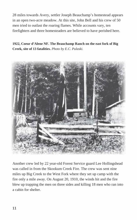
28 miles towards Avery, settler Joseph Beauchamp’s homestead appears in an open two-acre meadow. At this site, John Bell and his crew of 50 men tried to outlast the roaring flames. While accounts vary, ten firefighters and three homesteaders are believed to have perished here.
1922, Coeur d’Alene NF. The Beauchamp Ranch on the east fork of Big Creek, site of 13 fatalities. Photo by E.C. Pulaski.
Another crew led by 22 year-old Forest Service guard Lee Hollingshead was called in from the Skookum Creek Fire. The crew was sent nine miles up Big Creek to the West Fork where they set up camp with the fire only a mile away. On August 20, 1910, the winds hit and the fire blew up trapping the men on three sides and killing 18 men who ran into a cabin for shelter.

12
The rest of Hollingshead’s crew left the area through the already burned part of the landscape. Today’s firefighters call that move ‘escaping to the black’.
At about 28 miles towards Avery is the Huckleberry Campground managed by the Bureau of Land Management (BLM). *Facilities are available.* The Cedar snag at the campground is an excellent example of the size of some snags left by the 1910 fire. A snag is a dead standing tree. This particular snag burned during a more recent fire event.
History Note: 30.9 Miles: Moe’s Hole Mill site. The mill has been an important site providing lumber and jobs to the area since 1951 when it was built by Erling Moe, in the 1970’s the Mill burned, but a concrete pier can still be seen as you drive up river. At 31.3 miles: Spring Creek. This was originally a CCC camp site.
Marble Creek appears at about 33.5 miles into this route providing an excellent historical perspective on the way early logging helped shape this drainage. This area is the gateway to one of the largest stands of white pine trees remaining in the Inland Northwest and was largely untouched by most of the fires of 1910. The homesteads at the mouth of Marble creek where it flows into the St. Joe River were not so fortunate and were destroyed by the fires.
At the bridge crossing the St. Joe River, the road now follows on top of the old Milwaukie railroad bed. This railroad was the main escape route for those fleeing Avery from the burning hillsides. The bridges and trestles that connected much of the railroad route were mostly destroyed by the fires.

13
1910 Coeur d’Alene NF. The Milwaukee Railroad loop on the North Fork on the St. Joe River. Most of the basin was burned including the railroad trestle pictured here. Photo by R. H. McKay.
Slate Creek drainage appears around mile marker 39, followed in one mile by Hoyt Flat. This area was also once a CCC camp and is now a Forest Service field office.
The Forest Service Avery office, located six miles west of Avery, is open to visitors 8 a.m. to 4 p.m. Monday through Friday year round and open weekends in 2010 from Memorial Day through Labor Day. *Facilities are available.*

14
History Note: A couple miles up the road is Rock Creek. Named for a former USFS ranger William Rock this local boy led a crew of seventy men through the Big Burn. Rock and the men were cut off from the trail to Avery, Idaho. Keeping calm, they spent the night in a burned over meadow north of Avery. One man panicked, fleeing into the night and his body was discovered the following morning after he apparently shot himself twice in the chest. Rock and the rest of his crew survived the fire.
At mile marker 43, pull into the Storm Creek turnout to read the interpretative sign, The Mystery of the Lost Fire Crew about 28 firefighters who died here. Two miles more at mile marker 45 is Setzer Creek. It was at Setzer creek where a deputy sheriff, sent by Forest Service Avery District Ranger Ralph Debitt, told another 70-man crew to head for Avery. Most obeyed, but 28 stayed. These were the men of the Lost Fire Crew.
In MEMORIUM: O. Ellefsen was among the 78 firefighters who lost their lives in the Great 1910 Fire. He was trapped at Setzer Creek near Avery, Idaho, along with others. Some firefighters soaked themselves in the creeks, some sought refuge in mines, and others backtracked to previously burned areas praying the flame, heat, and smoke would not overtake them.

15
1910 St. Joe NF. September, Setzer Creek, disinterred bodies prepared for transportation and burial at St Maries. Photo by J.B. Halm.
History Note: Just one mile up the road is a local area known as Lower Landing. This area was used to house materials and equipment for the Milwaukie railroad. It burned in 1910. During the Great Depression the landing was also used as a CCC camp. The area across the road to the left/north leading to the town of Avery, Idaho was the main camp for Japanese railroad workers. For several years the town folks of Avery looked forward to celebrating the Emperor of Japan’s birthday on November 3.
16
Just up the road you are welcomed to the town of Avery. To your left-north you can see the Avery Community Center, once the site of the Milwaukee railroad depot. The location currently houses the post office and museum. Stop and look at the Fishpond (circa 1910) and feed the rainbow trout. Just remember no fishing please!
AVERY IS YOUR LAST STOP FOR GAS! In 1910 there were 250 people living in Avery. Today there are less than sixty permanent residents with an increase in population in the summer. While still a small town, Avery is a popular destination for visitors to fish, hunt, camp and hike. During the 1910 Fires, pack trains of mules were used to get the few available supplies to firefighters in the area. Optional Additional Drive: This is about 25 miles of forest road, some portions unpaved, so please choose wisely and drive slowly.
History Note: Black troops of the 25th Infantry out of Fort Wright in Spokane were detailed to Avery to fight fire and to maintain order through the hectic days of the 1910 fire. As fires raged around the town, the soldiers patrolled to protect the residents and property in Avery.

17
Ranger Ralph Debitt (arrow) and the Buffalo Soldiers from the 25th Infantry. Photo from the North Idaho Museum.
From Avery you can take Forest Service Road 456, also known as Moon Pass Road to Wallace Idaho.
About ten miles out of Avery on Moon Pass Road is the Cedar Graveyard, also locally known as “Ghost Cedars.” At Cedar Graveyard are numerous large cedar snags (standing dead cedars) killed in the 1910 Fires. They are located along the North Fork St. Joe River wetlands area.
Historically in an average summer, these river bottom wetlands are too moist to carry a forest fire even when the surrounding hillsides are dry enough to burn. In early 1910, this bottomland was filled with an old growth cedar forest. These cedars did burn due to the severity of the drought and heat conditions that contributed to the severity of the 1910 Fires. Many of these cedar trees were 300 – 500 years in 1910.

18
Snags in the St. Joe. Photo by C. H. Gregory
A fire of this magnitude that burns everything in its path with great intensity is called a stand-replacing wildfire.
The young forest now growing on the surrounding mountainsides regenerated since the 1910 Fire. But once the river bottom cedars were killed, the water table rose, and dense sedges, forbs, and shrubs filled in the newly open ground. Gophers and other rodents fed on the sedges and forbs, populating in such numbers that they also ate any tree seedling that started to grow. Without the cover of trees, this bottomland is also subject to severe spring and fall frosts that can kill young starter cedar trees.
The moist river bottoms which are normally the most fire-resistant locations and support the biggest and oldest trees, also take longer to naturally regenerate once burned in a stand-replacing wildfire.

19
“Then came that fateful 20th of August. For two days the wind blew
a gale from the southwest. All along the line, from north of the Canadian boundary south to the Salmon the gale blew. Little fires
picked up into big ones. Fire lines which had been held for days melted away under the fierce blast. The sky turned a ghastly yellow, and at four o’clock it was black dark ahead of the advancing flames. The heat of the fire and the great masses of flaming gas created great
whirlwinds which mowed down swaths of trees in advance of the flames.” 1942 - Elers Koch, Lolo Forest Supervisor in 1910
A Final Note: The 1910 Fires started as hundreds of small fires that were reportedly whipped into one giant conflagration by severe winds gusting to 70 mph to create the Big Burn. Today, Ranger Ed Pulaski’s tool is still used to build fireline and many areas are only slowly recovering from the intensity of fires. Today we know that the forests in north Idaho and western Montana need fire to work as part of the natural cycle of ecology in these forests. The Forest Service, the Idaho Department of Lands, the Montana Division of Natural Resources and conservation and the Bureau of Land Management work to help nature’s balance by using fire to reduce fuels and keep devastating fires from completely destroying landscapes. Fire prevention, Firewise for homeowners in the wildland-urban interface, and an increased understanding of fire behavior help land managers, property owners and firefighters stay safe and restore functioning landscapes. Thank you for commemorating the deep history, great loss, and lessons learned in the fires of 1910. Please: Honor Wilderness protocols. Prevent wildfires. Help others to learn to live with fire. Recycle this guide.