date: 13 april 2013 location: red mountain, snoqualmie...
TRANSCRIPT
Date: 13 April 2013
Location: Red Mountain, Snoqualmie Pass, WA
Accident: several persons partly or completely buried, 1 fatality
Submitted by: Garth Ferber and Dennis D’Amico (Northwest Avalanche Center)
Comments and photos from Andrew Toyota (Everett Mountain Rescue):
“On 4/13/13 at 2:15pm, Everett Mountain Rescue Unit (EMRU) was requested to assist Seattle Mountain
Rescue with an avalanche accident at Red Mountain, WA. Two subjects from a group of 13 snowshoers, were
reported missing after an avalanche
that occurred about an hour before.
The Reporting Party (RP) called 911
but GPS coordinates could not be
determined. EMRU deployed a team
which consisted of 3 mountain
rescuers and a search K9 from the
trailhead at 3:10pm. At 3:30pm,
EMRU located 4 subjects who had
been separated from the group after the
avalanche. These subjects were
escorted back to their vehicles by other
rescue teams. At 5:15pm, EMRU
made voice contact with the RP. By
5:45pm, EMRU reached the accident
site to find 6 subjects as 3 more
subjects had already departed the
accident site. Based on interviews,
EMRU learned that several subjects
had been partially or completely buried
between 10 minutes and > 45 minutes.
Upon EMRU's arrival, one subject was deceased and the others were ambulatory. Given the continued
inclement weather, an EMRU member escorted the ambulatory subjects down the ridge to meet incoming
rescue teams. At 6:30pm, other rescuers from Tacoma Mountain Rescue, Central Mountain Rescue and ESAR
joined EMRU to rig a series of hauls & lower for 800' to evacuate the deceased subject down to the trail. By
12:00am, all rescuers and subjects were out of the field.
Avalanche was estimated to be size 1.5-
2 and occurring on a SW aspect, ~32
degree slope at 4800'. No evidence if it
was natural or human triggered.
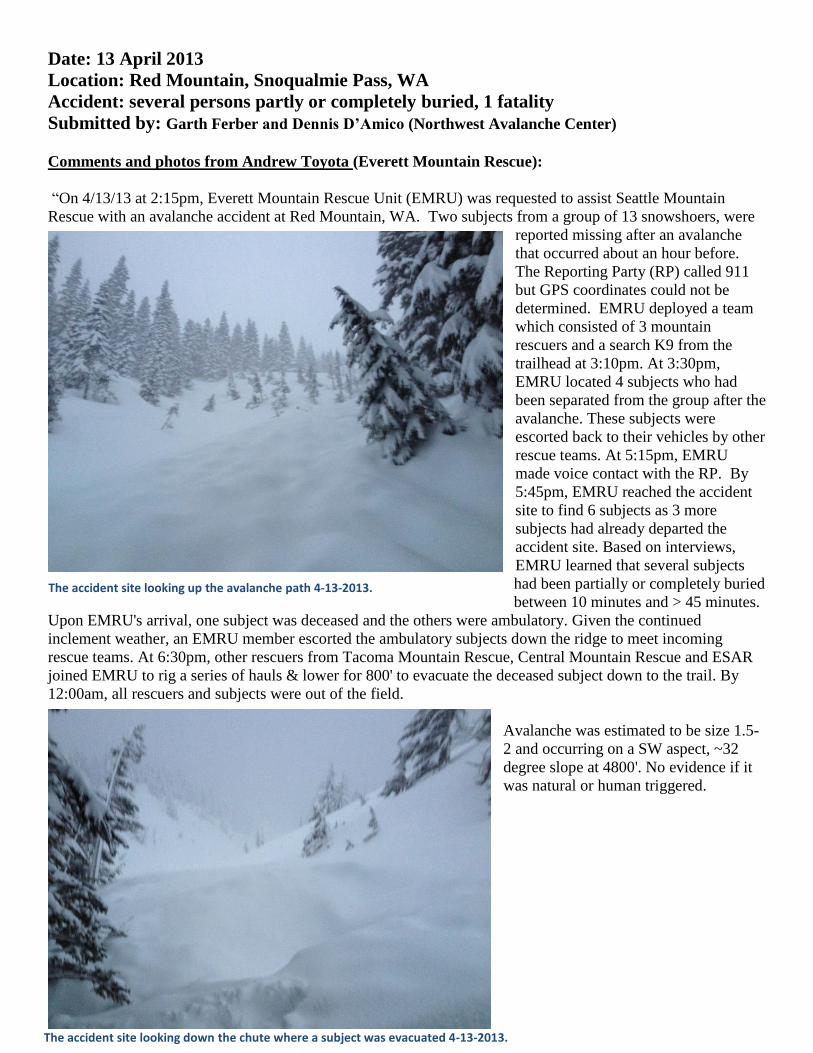
The accident site looking up the avalanche path 4-13-2013.
The accident site looking down the chute where a subject was evacuated 4-13-2013.

Paraphrased comments from Detective Edward Christian
(King County Search and Rescue Coordinator):
Neither the solo snowshoer (victim) nor anyone in the large
group was carrying avalanche rescue equipment (beacon,
probe, shovel) carried. The victim was buried at a depth of
about 5 feet and found by digging in the area she was
believed to be buried. There were 2 burials, one the deceased
solo snowshoer and the other from the larger group. There
was a language barrier between rescuers and the large
snowshoe group that may have hindered communications.
Comments from Garth Ferber and Dennis D’Amico, (Northwest Avalanche Center - NWAC): This storm
arrived somewhat stronger than expected. However, expected avalanche and weather conditions were fairly
well described in the avalanche forecast that was available via the NWAC web site the prior evening. Rapid
loading and warming seen in the weather station data undoubtedly contributed to unstable snow conditions that
day (see weather station data and avalanche and mountain weather forecasts below). Shooting cracks and
triggered avalanches from the Snoqualmie Pass area were reported via the local Turns All Year web site later
that day:
http://www.turns-all-year.com/skiing_snowboarding/trip_reports/index.php?topic=28266.0
http://www.turns-all-year.com/skiing_snowboarding/trip_reports/index.php?topic=28274.0
http://www.turns-all-year.com/skiing_snowboarding/trip_reports/index.php?topic=28271.0
http://www.turns-all-year.com/skiing_snowboarding/trip_reports/index.php?topic=28264.0
From Andrew’s description, the GPS track and the map it seems likely the accident occurred pretty close to
where the Red Mountain trail crosses the 4800’ contour on Red Mountain (see map below).
Personnel from the NWAC communicated with Search and Rescue personnel for this report and did not have
communication with the victims. Second hand and news media information indicates that the victim was
snowshoeing solo with her dog and following a larger party. The avalanche apparently divided the larger party
and then they noticed the dog was still present but the victim was missing. Our best guess based on the
available and somewhat limited information is that it was a soft storm slab that may have been human triggered
or naturally triggered above the group. We do not know if anyone in the large group had any avalanche
education or had seen a recent avalanche forecast.
The path rescuers established to reach the accident site 4-13-2013.
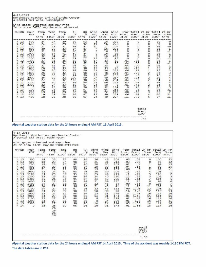
Alpental weather station data for the 24 hours ending 4 AM PST, 13 April 2013.
Alpental weather station data for the 24 hours ending 4 AM PST 14 April 2013. Time of the accident was roughly 1-130 PM PDT.
The data tables are in PST.
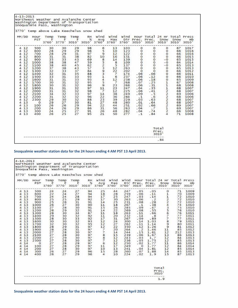
Snoqualmie weather station data for the 24 hours ending 4 AM PST 13 April 2013.
Snoqualmie weather station data for the 24 hours ending 4 AM PST 14 April 2013.
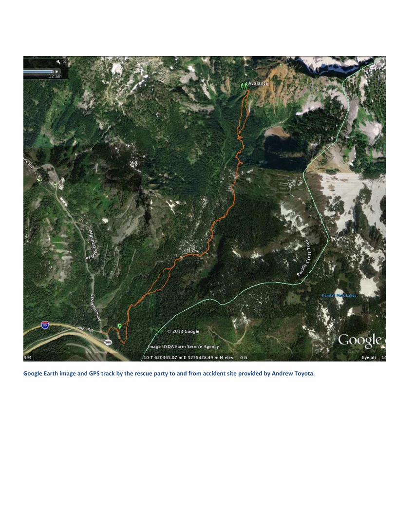
Google Earth image and GPS track by the rescue party to and from accident site provided by Andrew Toyota.

Approximate location victim was caught in the avalanche based on rescuers GPS track, narrative and pictures.

Detailed Avalanche Forecast
Northwest Weather and Avalanche Center Seattle Washington
1800 PM PDT Fri Apr 12 2013
This forecast applies to back country avalanche terrain below 7000 feet and does not apply to developed ski areas or highways.
Please note: The NWAC will end regularly scheduled mountain weather and avalanche forecasting on
Sunday 14 April and change to spring operations which is normal at this time of year. Staff at the NWAC
will continue to monitor weather and snow conditions in the Olympics and Cascades during the spring and issue special avalanche statements after this date when conditions warrant.
Zone Avalanche Forecasts
Forecast for: Olympics, Stevens Pass, Snoqualmie Pass, White Pass, WA Cascades near and west of crest - north of Stevens Pass, WA Cascades near and west of crest - between Stevens and Snoqualmie Pass, WA Cascades near and west of crest - between Snoqualmie and White Pass, WA Cascades near and west of crest - south of White Pass
Summary Danger Forecast For Saturday
Overall Danger
Trend
Saturday: Considerable avalanche danger above 4000 feet and moderate below increasing strongly in the
afternoon. Avalanche danger decreasing late Saturday night.
Concerns
Concern Aspect Size Trend
Storm slab avalanche
All
Initially shallow but
increasing in depth
Increasing strongly in
the afternoon
Wind Slab Avalanche
Lee N thru SE
aspects of higher
terrain
Isolated larger slabs
possible higher lee
slopes
Increasing Slightly
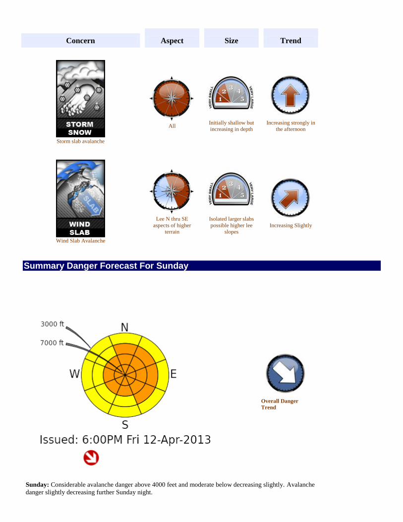
Summary Danger Forecast For Sunday
Overall Danger
Trend
Sunday: Considerable avalanche danger above 4000 feet and moderate below decreasing slightly. Avalanche
danger slightly decreasing further Sunday night.

Concerns
Concern Aspect Size Trend
Wind Slab Avalanche
Lee N thru SE
aspects of higher
terrain
Isolated larger slabs
possible higher lee
slopes
Decreasing Slightly
Loose-wet Snow Avalanche
Solar aspects,
especially steeper
slopes of lower
terrain
Generally shallow
Increasing Slightly
Snowpack Discussion
A storm cycle returned last Thursday to Sunday with a series of frontal systems and a low pressure
system crossing the Northwest. Snow levels started out at about 5000 feet in the north and 6000 feet in
the south on Friday and fell roughly a thousand feet a day to about 3000 feet in the north and 4000 feet
in the south by Sunday. Storm water equivalents ending Monday ranged from about 3-5.5 inches at NWAC
stations near and west of the crest with storm snowfall totals at higher elevations of 2-3 feet. Reports of
sensitive 6-12 inch storm slab were received from the ski areas and in one back country report via TAY
from Mt. Baker on Sunday.
A transitory ridge caused mostly dry conditions with a moderate warming trend Monday and Tuesday. A
front crossed the Northwest on Wednesday morning with rain below about 6000 feet in the north and
7000 feet in the south. Crystal mountain plus the WSDOT avalanche control near Washington Pass
reported size-able wet-loose slides with the warming and rain on Wednesday. Wet loose releases continued into Thursday for Alpental where a convergence zone cause light rain at lower elevations.
Ski area and DOT reports from Friday morning indicated that clear skies and good cooling Thursday night
formed a stout melt-freeze crust. This crust may briefly weaken Friday afternoon with rain initially at lower
elevations, but dropping temperatures Friday night should reform the crust and help keep the upper
snowpack locked down. The mid and lower snow pack are considered stable and fairly consolidated.
Detailed Forecasts

Saturday
Another winter-like weekend is in store for the PNW...
After a strong front passes through Friday night, light to moderate snow showers Saturday morning will
likely become moderate to occasionally heavy Saturday afternoon for the west slopes as an upper level
shortwave enhances precipitation over the PNW. Pronounced cooling early Saturday should help new snow
bond well to Friday night's snowfall. However, periods of high snowfall rates and strong crest level
westerlies and NW flow aloft should lead to quickly escalating avalanche danger Saturday afternoon and evening.
Showers and windy conditions should eventually ease Saturday night and lead to a slight decrease in the avalanche danger.
Concerns:
Storm slab avalanches should become more widespread and easier to trigger on all aspects in the
afternoon due instabilities within the new storm snow Saturday, but avalanches should be contained to the
new storm snow.
New wind slab should build on the usual N thru SE lee slopes of higher terrain. Due to winter-like temperatures, new snow should be easier to transport and thus build thicker wind slabs especially up high.
The bottom line is don't let your avalanche guard down just because the calendar says it's mid-April. Use
the same cautious route-finding and terrain selection techniques you would use mid-winter during a storm
cycle. Look for the warning signs like shooting cracks indicating instability propagation of a slab and for
obvious indicators like recent natural avalanche activity as a message that it's time to pull back.
Sunday
Sunday should be a post-storm day as a cool upper level trough resides over the PNW. A variable amount
of cloudiness including some sunbreaks along with slight warming and generally light convective afternoon showers should allow the avalanche danger to decrease Sunday.
Wind slabs that formed below ridges on mainly lee easterly aspects Friday night through Saturday should
become less sensitive on Sunday. However, due to the cold temperatures aloft, new wind slab instabilities
will be slow to settle and deserve another day of caution. Practice safe route-finding by traveling along the
windward side of ridges and watch for shooting cracks on the approach as a warning sign lingering instability.
Since it is mid-April, sunbreaks and above freezing temperatures at low or even mid elevations should
allow wet-loose avalanches to occur mainly on steeper solar aspects in the late morning or afternoon.
Watch for softening of the surface snow beyond the top few inches and natural pinwheeling as signs of
increasing instability. Wet-loose avalanches should begin shallow but may be able to entrain the most recent storm snow and quickly become difficult to manage.
Storm slab instabilities should have mainly settled out by Sunday, but be aware that localized areas of heavy snow that extend into Saturday evening may still be sensitive on Sunday.

Mountain Weather Forecast
Northwest Weather and Avalanche Center Seattle Washington
704 AM PDT Sat Apr 13 2013
The NWAC program is administered by the USDA-Forest Service and operates out of the National Weather
Service Forecast Office in Seattle. NWAC services are made possible by important collaboration and support
from a wide variety of federal, state and private cooperators.
Please note: The NWAC will end regularly scheduled mountain weather and avalanche forecasting
on Sunday 14 April and change to spring operations which is normal at this time of year. Staff at
the NWAC will continue to monitor weather and snow conditions in the Olympics and Cascades
during the spring and issue special avalanche statements after this date when conditions warrant.
Weather Synopsis for Saturday and Sunday
A cold deep upper low pressure system began to dig southeast over BC on Friday. A strong jet reminiscent of
winter became aimed at Washington. A front moved rapidly over the area late on Friday. An initial convergence
zone moved east over the central Cascades Saturday early morning. New snow amounts at NWAC sites near
and west of the crest from Mt Baker to Mt Hood range from 2 to 11 inches Saturday early morning with the
most at Stevens and the upper Alpental station.
The cold upper low will sink from BC to the north Rockies on Saturday. A cool unstable west northwest flow
will be seen over the Northwest. A secondary short wave should rotate over the area Saturday afternoon. After a
lull in showers Saturday morning, orographic showers should increase in the afternoon. More convergence
zone(s) are likely in the Stevens to Snoqualmie area by Saturday afternoon and evening.
Winds and orographic showers should decrease Saturday night.
A broad cold weak upper trough should generally sink south from southwest Canada to over the northwest US
on Sunday. Northwest flow will greatly weaken over the Northwest. With the cold slightly unstable air mass
and April daytime heating some light showers should bubble up again by afternoon. Showers should diminish in
the evening as the sun sets.
Weather Forecast for Saturday and Sunday
Olympics
Time Weather
Saturday morning Windy. Light to moderate snow showers.
Saturday afternoon Increasing light to moderate snow showers.
Saturday night Decreasing mostly light snow showers.
Sunday Increasing mostly light snow showers.
Sunday night Mostly cloudy with decreasing light snow showers.
Washington Cascades near and west of the crest

Stevens, Snoqualmie and White Passes
Time Weather
Saturday
morning Windy. Light to moderate snow showers.
Saturday
afternoon
Increasing light to moderate snow showers except moderate to heavy
in convergence shifting from near Stevens to near Snoqualmie by the
afternoon and evening.
Saturday
night Decreasing mostly light snow showers.
Sunday Increasing mostly light snow showers.
Sunday
night Mostly cloudy with decreasing light snow showers.
East slopes Washington Cascades
Time Weather
Saturday
morning Windy. Light snow showers mainly higher elevations.
Saturday
afternoon
Increasing light occasional moderate snow showers mainly higher
elevations central part.
Saturday night Decreasing light snow showers mainly higher elevations.
Sunday Increasing light snow showers.
Sunday night Partly cloudy with decreasing light snow showers.
Mt Hood area
Time Weather
Saturday morning Windy. Light to moderate snow showers.
Saturday afternoon Increasing light to moderate snow showers.
Saturday night Decreasing mostly light snow showers.
Sunday Increasing mostly light snow showers.
Sunday night Mostly cloudy with decreasing light snow showers.
Snow Level/Freezing Level Trends in feet
SNOW LEVELS
Olympics, Cascades--Mt Baker (N) to Snoq Pass (C) to Mt Hood (S)
Time Olympics North Central South
Sat morn 2000 2000 2000 2500
Sat aft 3000 3000 3000 3500
Sat night and Sun morn 2000 2000 2000 2500
Sun aft 3000 3000 3000 3500
Sun night 2000 2000 2000 2500
Cascade Snow / Freezing Levels noted above refer to the north (approximately Mt Baker and Washington Pass), central
(approximately Stevens and Snoqualmie Pass) and south (near Mt Hood). Note that surface snow levels are common near the passes
during easterly pass flow and may result in multiple snow / freezing levels.
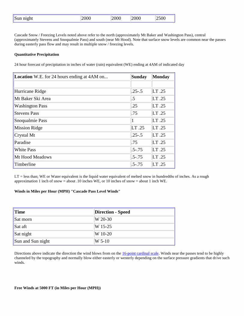
Quantitative Precipitation
24 hour forecast of precipitation in inches of water (rain) equivalent (WE) ending at 4AM of indicated day
Location W.E. for 24 hours ending at 4AM on... Sunday Monday
Hurricane Ridge .25-.5 LT .25
Mt Baker Ski Area .5 LT .25
Washington Pass .25 LT .25
Stevens Pass .75 LT .25
Snoqualmie Pass 1 LT .25
Mission Ridge LT .25 LT .25
Crystal Mt .25-.5 LT .25
Paradise .75 LT .25
White Pass .5-.75 LT .25
Mt Hood Meadows .5-.75 LT .25
Timberline .5-.75 LT .25
LT = less than; WE or Water equivalent is the liquid water equivalent of melted snow in hundredths of inches. As a rough
approximation 1 inch of snow = about .10 inches WE, or 10 inches of snow = about 1 inch WE.
Winds in Miles per Hour (MPH) "Cascade Pass Level Winds"
Time Direction - Speed
Sat morn W 20-30
Sat aft W 15-25
Sat night W 10-20
Sun and Sun night W 5-10
Directions above indicate the direction the wind blows from on the 16-point cardinal scale. Winds near the passes tend to be highly
channeled by the topography and normally blow either easterly or westerly depending on the surface pressure gradients that drive such
winds.
Free Winds at 5000 FT (in Miles per Hour (MPH))

Time Olympics Cascades
North
Cascades
Central
Cascades
South
Sat early morn W 25-35 W 20-30 W 25-35 W 30-40
Sat late morn and
aft W 25-35 W 10-20 W 25-35 W 25-35
Sat night W 10-20 W 5-15 W 10-20 W 15-25
Sun morn and aft W 5-15 W 5-15 W 5-15 W 10-20
Sun night N 5-15 N 5-15 N 5-15 N 5-15
Directions above indicate the direction the wind blows from on the 16-point cardinal scale. These winds and the 9000 ft winds below
also indicate "free" winds, or those winds in the atmosphere not influenced by terrain. Topographical effects may produce greater or
lower wind speeds in certain locations as well as significant variations in direction.
Free Winds at 9000 FT (in Miles per Hour (MPH))
Time Olympics Cascades
North
Cascades
Central
Cascades
South
Sat early
morn
WNW 35-
45 WNW 35-45 WNW 45-60 WNW 50-70
Sat late morn WNW 35-
45 WNW 30-40 WNW 40-50 WNW 40-50
Sat aft WNW 35-
45 WNW 25-35 WNW 40-50 WNW 40-50
Sat night WNW 10-
20 WNW 10-20 WNW 20-30 WNW 30-40
Sun morn NW 5-15 NW 5-15 NW 10-20 NW 15-25
Sun aft NW 5-15 NW 5-15 NW 5-15 NW 10-20
Sun night NE 5-15 NE 5-15 NE 5-15 NE 5-15
Directions above indicate the direction the wind blows from on the 16-point cardinal scale. These winds indicate "free" winds, or
those winds in the atmosphere not influenced by terrain. Topographical effects may produce greater or lower wind speeds in certain
locations as well as significant variations in direction.
Extended Weather Synopsis for Monday through Wednesday
A cool weak northwest flow should be seen over the area on Monday. A weak short wave is indicated by the
GFS to rotate around the departing low and mainly affect the Cascade east slopes.
An upper ridge will gradually build over the Northwest coastal waters on Tuesday and Wednesday. A little
moisture is indicated to move over the ridge and mainly affect the Olympics and north Cascades on Wednesday.
Extended Weather Forecast for Monday through Wednesday
Olympics, Washington Cascades & Mt Hood Area
Time Weather
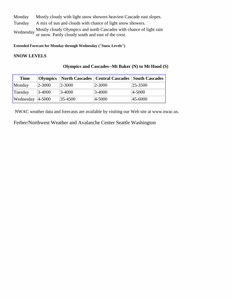
Monday Mostly cloudy with light snow showers heaviest Cascade east slopes.
Tuesday A mix of sun and clouds with chance of light snow showers.
Wednesday Mostly cloudy Olympics and north Cascades with chance of light rain
or snow. Partly cloudy south and east of the crest.
Extended Forecast for Monday through Wednesday ("Snow Levels")
SNOW LEVELS
Olympics and Cascades--Mt Baker (N) to Mt Hood (S)
Time Olympics North Cascades Central Cascades South Cascades
Monday 2-3000 2-3000 2-3000 25-3500
Tuesday 3-4000 3-4000 3-4000 4-5000
Wednesday 4-5000 35-4500 4-5000 45-6000
NWAC weather data and forecasts are available by visiting our Web site at www.nwac.us.
Ferber/Northwest Weather and Avalanche Center Seattle Washington