data management plan - md imapimap.maryland.gov/.../mdimap_datamanagementplan.pdf · my signature...
TRANSCRIPT

MD IMAP
DATA MANAGEMENT
PLAN JANUARY 2015
Version 1.0
My signature indicates approval of this Data Management Plan.
Approved by:
Geographic Information Officer

MD iMap Data Management Plan 2
Table of Contents
EXECUTIVE SUMMARY .................................................................................................................................. 4
1 PURPOSE ............................................................................................................................................... 5
2 EXCEPTIONS .......................................................................................................................................... 5
3 ROLES AND RESPONSIBILITIES .............................................................................................................. 5
3.1 Department of Information Technology ....................................................................................... 5
3.2 Data Custodians ............................................................................................................................ 6
3.3 Data Owners ................................................................................................................................. 6
3.4 MD iMap Technical Committee .................................................................................................... 6
3.5 MD iMap Executive Committee .................................................................................................... 6
4 GENERAL DATA SPECIFICATIONS .......................................................................................................... 6
4.1 Data and Services Format ............................................................................................................. 6
4.2 File Naming Convention ................................................................................................................ 7
4.3 Service Naming Convention .......................................................................................................... 7
4.4 Coordinate System ........................................................................................................................ 7
5 METADATA ............................................................................................................................................ 7
5.1 Metadata Requirements ............................................................................................................... 8
6 DATA MAINTENANCE .......................................................................................................................... 10
7 QUALITY ASSURANCE / QUALITY CONTROL (QA/QC) ......................................................................... 11
7.1 Data Owners/Custodians ............................................................................................................ 11
7.2 DoIT GIO Staff.............................................................................................................................. 11
8 DATA SECURITY ................................................................................................................................... 11
9 ORGANIZATION ................................................................................................................................... 12
9.1 Organization of Data ................................................................................................................... 12
10 PROCEDURES FOR PUBLICATION OF DATA ONTO MD IMAP .......................................................... 14
10.1 Submission Guidelines ................................................................................................................ 14
10.2 Metadata ................................................................................................................................. 16
10.3 Symbology ............................................................................................................................... 16
10.4 Data Caching ........................................................................................................................... 16
References .................................................................................................................................................. 18

MD iMap Data Management Plan 3
Revision History
Date Version Description Author
12/03/2012 1.00 Initial document creation L. Lowe
9/17/2013 1.00 Updated security section to include four
levels of iMap security
L. Lowe
1/29/2015 1.00 Revised to reflect changes in MD iMap 2.0 L. Lowe

MD iMap Data Management Plan 4
EXECUTIVE SUMMARY
Spatial data has become a vital component for many organizations. It is also a critical piece of
the decision making process. The State of Maryland publishes almost 200 web map services
sourced from multiple agencies through a common information technology platform. In March
2012, the Governor signed an Executive Order that states that MD iMap is Maryland’s
statewide enterprise GIS system. MD iMap is a central store of data and services, giving the
public and staff from all industries access to the most recent spatial data that is so critical to
their work.
In the past, the MD iMap system has had no formal plan for managing the large of amount of
data in its system. This has resulted in redundant and inconsistent data. The specifications and
guidelines in this Data Management Plan will improve data consistency and availability of
information. It will ensure that all levels of government and the public have access to the most
up-to-date GIS information; reduce or eliminate overlapping data requests and redundant data
maintenance; ensure metadata is consistently created; and ensure that data services can be
displayed by the consumer with the cartography of its choice.
This Data Management Plan contains the following sections:
Roles and Responsibilities - Entities involved in MD iMap and their responsibilities
General Data Specifications - Data specifications that pertain to all spatial data. The goal
is to adhere to the recognized national and international geospatial standards.
Metadata - Datasets included on MD iMap are the basis for many applications and
services. This section contains instructions for MD iMap metadata requirements.
Data Maintenance - The data owner/custodian will be responsible for ensuring the data
on MD iMap is kept up-to-date. Where applicable, the data shall be updated at least two
(2) times a year.
Quality Assurance/Quality Control - Data owners/custodians will be responsible for
QA/QC of these data. Recommended minimum steps are provided. In addition, the DoIT
GIO staff will perform some basic quality inspection such as ensuring data is displayed
correctly.
Data Security - Security will conform to MD Department of Information Technology's
Information Security Policy.
Organization - MD iMap services and data will be grouped in categories.
Procedures for Publication of Data onto MD iMap - Instructions on preparing and
submitting data for inclusion on MD iMap.

MD iMap Data Management Plan 5
1 PURPOSE
MD iMap is Maryland’s statewide enterprise GIS system. The standards and specifications
within this Data Management Plan will improve data consistency and availability of information.
MD iMap contains a central store of data and services, giving the public and staff from all
industries access to the most recent spatial data that is critical to many organizations. The MD
iMap central data store will reduce costs and improve the effectiveness of agency GIS efforts
by:
Ensuring that all levels of government and the public have access to the up-to-date GIS
information from other agencies;
Reducing or eliminating:
o Overlapping data requests; for example, multiple agencies contacting SHA for
the latest road centerlines;
o Redundant data maintenance; for example, MDP sends data updates to multiple
agencies each of whom upload the data on their own system and update their
geocoding services.
Ensuring metadata is consistently created, maintained, understood and used
Data services (unlike most services currently published on iMap) can be displayed by the
consumer agency with the cartography or related tables of its choice.
Data that is restricted for use within the government can be securely handled and
shared.
This central store and catalog of data and services is a complex system that requires planning if
it is to be successful.
2 EXCEPTIONS
Exceptions to the standards in this document can be made by requesting an exemption from
the State Geographic Information Officer. Requests for exemption from these standards must
include justification.
3 ROLES AND RESPONSIBILITIES
This section contains a list of entities involved in MD iMap and their responsibilities.
3.1 Department of Information Technology
DoIT is responsible for overall management of the MD iMap system.
DoIT will be the default custodian on any data layers that are ambiguous, data layers that do not
have a clear custodian.

MD iMap Data Management Plan 6
3.2 Data Custodians
The data custodian is not necessarily the data owner. For example, MDA may repackage USDA
data but they are not considered the data owner. USDA would be the data owner and MDA
would be the data custodian.
The data custodians are responsible for quality assurance and quality control and maintenance
of their datasets.
3.3 Data Owners
The authoritative data source ;
Can authorize or deny access to the data and is responsible for its accuracy, integrity, and
timeliness
3.4 MD iMap Technical Committee
The Technical Committee is responsible for the development of the MD iMap content, policies,
and procedures;
Provides status reports to the Open Data Council;
Resolves issues identified or brings them to the Open Data Council for resolution;
3.5 Open Data Council
Approves the policies and procedures developed by the Technical Committee;
Resolves issues identified by the Technical Committee;
Provides recommendations and technical support to the budget approving authority;
Provide guidance to the Technical Committee;
Advises the Governor on issues related to MD iMap.
4 GENERAL DATA SPECIFICATIONS
This section contains the data specifications that apply to all spatial data. Various national and
international bodies establish and maintain geospatial standards. The goal is to adhere to these
recognized geospatial standards.
4.1 Data and Services Format
All spatial data shall meet the format requirements defined in Table 4-1.
Table 4-1 Data Formats
Information Type Preferred Format Comments
GIS Data ESRI Shapefile
Geodatabase ESRI file geodatabase Enterprise geodatabase
Digital Elevation Models (DEM, point cloud, mass points)
TIFF and GeoTIFF
ArcGIS GRID
JPG and TIF images shall be supplied with an associated ‘world file’ containing image

MD iMap Data Management Plan 7
ERDAS IMAGINE
.LAS file format
header information (.JFW or .TFW file)
Satellite Imagery
Aerial Photography
Georeferenced Images
TIFF and GeoTIFF
JPEG
ERDAS IMAGINE
Lossless compression as the raster images may be used for analysis or deriving other data products
JPG and TIF images shall be supplied with an associated ‘world file’ containing image header information (.JFW or .TFW file)
Data Attribute Tables Dbase IV
Comma separated value
Spreadsheets (i.e, Microsoft Excel or similar)
4.2 File Naming Convention
4.2.1 File names shall succinctly summarize the data to allow users to understand the content
of the data quickly. The following naming convention should be followed:
CategoryAbbreviation_DataLayerName_DataLayerOwnerAgencyAbbreviation. For example,
BSEC_EnterpriseZones_DBED
4.3 Service Naming Convention
The service name will be in the form of <State>_<Dataset Name>
Example: MD_TargetedEcologicalAreas
4.4 Coordinate System
Web Mercator coordinate system will be used for all data. ArcGIS users would choose, Projected
Coordinate System World WGS 1984 Web Mercator (auxiliary sphere)
5 METADATA
Datasets included on MD iMap are the basis for many applications and services. It is essential
that the datasets be thoroughly documented to ensure the integrity of the information being
presented via MD iMap. Metadata allows data users to make informed decisions on the
suitability of data for a given purpose and to understand the method used to capture the data
and its currency.

MD iMap Data Management Plan 8
5.1 Metadata Requirements
5.1.1 FGDC compliant metadata must be included with all data submissions.
5.1.2 Metadata may be submitted in xml or txt format.
5.1.3 The data owner may use any tool at their disposal that will output FGDC compliant
metadata.
5.1.4 The metadata should be validated for FGDC compliance prior to submitting.
5.1.5 ISO Standard metadata is acceptable.
Table 5-1 shows the required metadata fields that must be submitted with all data and Table 5-
2 shows additional optional fields that may also be submitted with the data, as defined by
FGDCi.
Table 5-1 Required Metadata Fields *
Field Description
Identification Originator Party responsible for the data set Publication Date The date the data was published or otherwise made available
Title Dataset title Online Linkage URL to data download, data clearinghouse, or web-mapping services Abstract Brief description of the dataset that should include general content
and features, data set form (GIS, CAD, image, database) and geographic coverage (county/city name)
Purpose Time Period of Content The relevant date of the data content. This can be a single date,
multiple dates, or a range of dates. Currentness Reference The basis on which the time period of content information is
determined. For example, an orthophotograph may have been compiled and delivered in June (publication date) but flown in February (ground condition).
Update Frequency Frequency with which changes are made to the data set after the initial data set is completed. Domain: continually, daily, weekly, monthly, annually, unknown, as needed, irregular, none planned
Progress This field has a fixed domain of: Complete, In Work, and Planned. Theme Keyword Include ISO Topic Category and any additional descriptive terms Place Keyword specific regional reference such as city or county name Access Constraints Any restrictions or legal prerequisites to accessing the actual data set Use Constraints Any restrictions or legal prerequisites to using the data set.

MD iMap Data Management Plan 9
Point of Contact The individual or organization that is knowledgeable about the data set and should be contacted with questions.
Metadata Date The date the metadata is written or completed
Bounding Coordinates
Metadata Contact The individual or organization that is responsible for the metadata for the dataset
Spatial Reference
Horizontal Coordinate System
Description of the reference frame for horizontal position such as geographic, latitude/longitude, etc.
Abscissa resolution/ordinate resolution
The smallest distance that can exist between two points.
Planar Distance Units The units of measure
Metadata Reference
Metadata Date The date that the metadata is written or completed
Metadata Contact The individual or organization that is responsible for the metadata for the data set.
Metadata Name Content Standard for Digital Geospatial Metadata
Metadata Version As of Oct 2002: FGDC-STD-001-1998 Table 5-2 Optional Metadata Fields*
Field Description
Identification Supplemental Information
An comment field that can include information that will not fit anywhere else in the metadata
Dataset credit Identify others that should be recognized for their contributions to the data set
Native Dataset Environment
Software and version and operating system and version used to create the data.
Data Quality Attribute Accuracy Report
Assessments as to how “true” the attribute values may be. It may refer to field checks, crosschecks with other documents, statistical analysis of values, and parallel independent measures. It does NOT refer to the positional accuracy of the feature.
Logical Consistency Report
Tests used to check for data inconsistencies including topological checks (clean and build), and database QA/QC routines such as: Are the X values always between 0 and 100? Are all Y values text format? Does value Z always equal the sum of values R and S?
Completeness Report Is there anything I might expect to be in the data set that isn’t? Identification of data omitted from the data set that might normally expected, as well as the reason for the exclusion. This may include geographic exclusions, ‘data was not available for the South Shores neighborhood’; categorical exclusions ‘municipalities with population
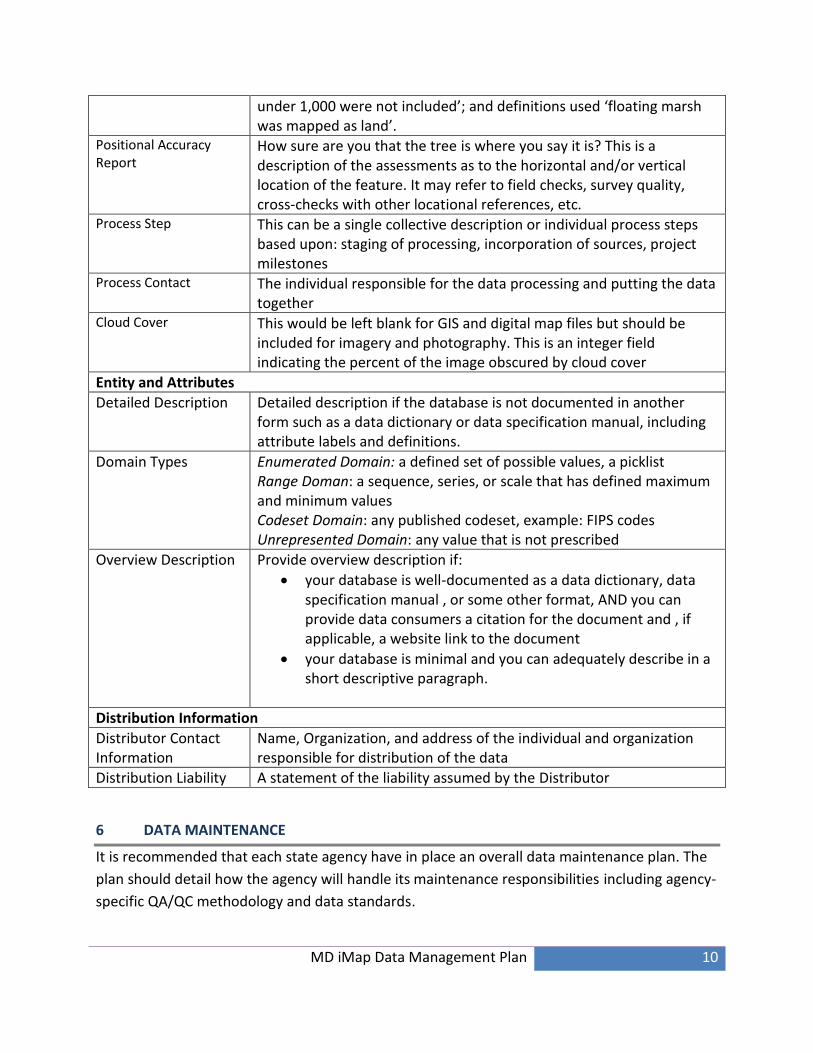
MD iMap Data Management Plan 10
under 1,000 were not included’; and definitions used ‘floating marsh was mapped as land’.
Positional Accuracy Report
How sure are you that the tree is where you say it is? This is a description of the assessments as to the horizontal and/or vertical location of the feature. It may refer to field checks, survey quality, cross-checks with other locational references, etc.
Process Step This can be a single collective description or individual process steps based upon: staging of processing, incorporation of sources, project milestones
Process Contact The individual responsible for the data processing and putting the data together
Cloud Cover This would be left blank for GIS and digital map files but should be included for imagery and photography. This is an integer field indicating the percent of the image obscured by cloud cover
Entity and Attributes
Detailed Description Detailed description if the database is not documented in another form such as a data dictionary or data specification manual, including attribute labels and definitions.
Domain Types Enumerated Domain: a defined set of possible values, a picklist Range Doman: a sequence, series, or scale that has defined maximum and minimum values Codeset Domain: any published codeset, example: FIPS codes Unrepresented Domain: any value that is not prescribed
Overview Description Provide overview description if:
your database is well-documented as a data dictionary, data specification manual , or some other format, AND you can provide data consumers a citation for the document and , if applicable, a website link to the document
your database is minimal and you can adequately describe in a short descriptive paragraph.
Distribution Information
Distributor Contact Information
Name, Organization, and address of the individual and organization responsible for distribution of the data
Distribution Liability A statement of the liability assumed by the Distributor
6 DATA MAINTENANCE
It is recommended that each state agency have in place an overall data maintenance plan. The
plan should detail how the agency will handle its maintenance responsibilities including agency-
specific QA/QC methodology and data standards.

MD iMap Data Management Plan 11
The data owner/custodian will be responsible for ensuring the data on MD iMap is kept up-to-
date. Where applicable, the data shall be updated at least two (2) times a year.
7 QUALITY ASSURANCE / QUALITY CONTROL (QA/QC)
7.1 Data Owners/Custodians
Data owners/custodians will be responsible for QA/QC of these data.
To the extent possible, it is recommended that automated analytical techniques be used for
vector datasets. At a minimum, the following steps are recommended:
Vectors – Are the vectors in the correct position when compared against a suitable
raster or vector?
Are there attributes and are they what was expected?
o Do they provide aliases for the field names?
o Are the addresses in a standard format? For example, using St or Street but not
mixed); street address, city, state, zip in separate fields.
Rasters – Are the rasters in the correct location when compared against a suitable raster
or vector?
7.2 DoIT GIO Staff
When the data is submitted for inclusion in MD iMap, GIO staff will perform some basic quality
inspection such as ensuring the data displays as expected. These steps will include:
Did we receive everything that was expected?
Is the projection in WGS1984 Web Mercator?
Does it contain metadata?
Any discrepancies in the data will be reported to the party submitting the data. In the case
where more than one agency is submitting similar datasets, discrepancies will be reported to
each party and DoIT GIO staff will coordinate resolution.
8 DATA SECURITY
The MD iMap system will contain four levels of security:
Public
Any level of government
Only Maryland State agencies
MD iMap Data Management Plan 12
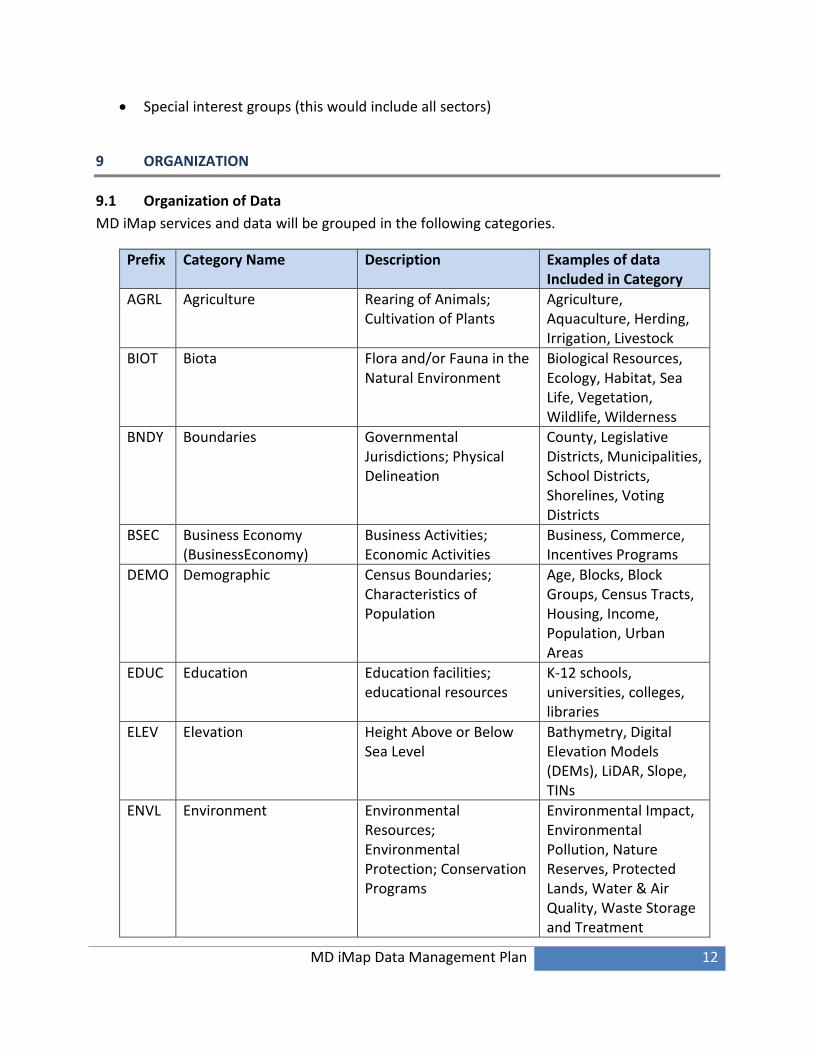
Special interest groups (this would include all sectors)
9 ORGANIZATION
9.1 Organization of Data
MD iMap services and data will be grouped in the following categories.
Prefix Category Name Description Examples of data Included in Category
AGRL Agriculture Rearing of Animals; Cultivation of Plants
Agriculture, Aquaculture, Herding, Irrigation, Livestock
BIOT Biota Flora and/or Fauna in the Natural Environment
Biological Resources, Ecology, Habitat, Sea Life, Vegetation, Wildlife, Wilderness
BNDY Boundaries Governmental Jurisdictions; Physical Delineation
County, Legislative Districts, Municipalities, School Districts, Shorelines, Voting Districts
BSEC Business Economy (BusinessEconomy)
Business Activities; Economic Activities
Business, Commerce, Incentives Programs
DEMO Demographic Census Boundaries; Characteristics of Population
Age, Blocks, Block Groups, Census Tracts, Housing, Income, Population, Urban Areas
EDUC Education Education facilities; educational resources
K-12 schools, universities, colleges, libraries
ELEV Elevation Height Above or Below Sea Level
Bathymetry, Digital Elevation Models (DEMs), LiDAR, Slope, TINs
ENVL Environment Environmental Resources; Environmental Protection; Conservation Programs
Environmental Impact, Environmental Pollution, Nature Reserves, Protected Lands, Water & Air Quality, Waste Storage and Treatment

MD iMap Data Management Plan 13
Geocode Services Automated Process to Match an Attribute Location to a Geospatial Location
Address Points, Centerlines, Highway Exits, Intersections, Parcel Points, ZIP Codes
Geoprocessing Services Access Capabilities of Geospatial Analysis
Clip and Ship, Print, Query, Search, Select
GSCI Geoscientific Information Pertaining to Earth Sciences
Earthquakes, Erosion, Geology, Geophysical Features, Hydrogeology, Minerals, Soils
HLTH Health Health Facilities; Health Services; Health Trends; Human Ecology
Diseases, Health Care Facilities, Mental and Physical Health, Public Health, Substance Abuse
HIST Historic Archeological Data; Historic Locations
Archeological Sites; Historic Properties; Preservation Sites; Sites of Historic Events
HYDR Hydrology Movement of Water On and Below Earth’s Surface and In the Atmosphere
Continental Shelf, Currents, Dams, Hydrography, Outer Continental Shelf, Rivers, Streams, Tides, Shoreline, Watersheds, Wetlands
IMAG Imagery Imagery Color Infrared Imagery; Composite Imagery; Grids; High Resolution Imagery; Incident-Specific Imagery
LOCA Location Positional Information and Services
Addresses, Centroids, Geodetic Control Points
MLTY Military Military Activities, Bases and Structures
Barracks, Events, Facilities, Military Transportation, Training Grounds
PLAN Planning Cadastre (PlanningCadastre)
Land Designations; Property Boundary Delineation; Tax Appropriations
Cadastral Surveys, Easements, Land Cover, Land Use, Parcel Boundaries, Tax Maps, Zoning
MD iMap Data Management Plan 14
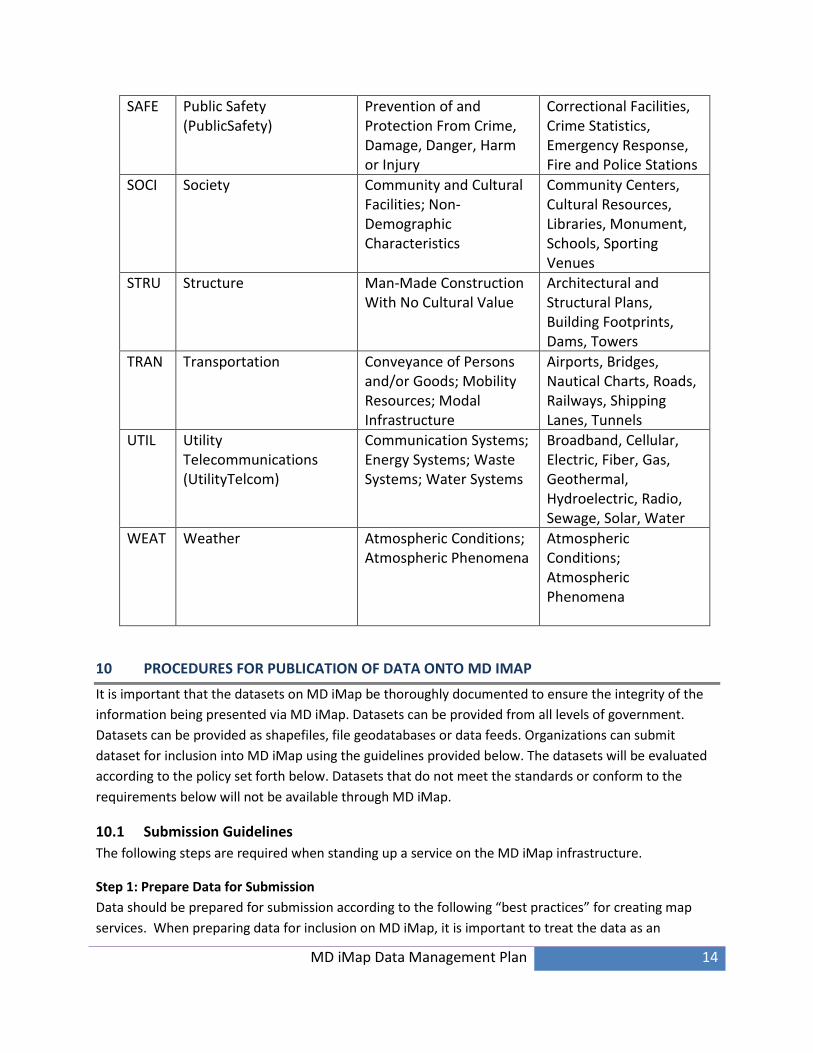
SAFE Public Safety (PublicSafety)
Prevention of and Protection From Crime, Damage, Danger, Harm or Injury
Correctional Facilities, Crime Statistics, Emergency Response, Fire and Police Stations
SOCI Society Community and Cultural Facilities; Non-Demographic Characteristics
Community Centers, Cultural Resources, Libraries, Monument, Schools, Sporting Venues
STRU Structure Man-Made Construction With No Cultural Value
Architectural and Structural Plans, Building Footprints, Dams, Towers
TRAN Transportation Conveyance of Persons and/or Goods; Mobility Resources; Modal Infrastructure
Airports, Bridges, Nautical Charts, Roads, Railways, Shipping Lanes, Tunnels
UTIL Utility Telecommunications (UtilityTelcom)
Communication Systems; Energy Systems; Waste Systems; Water Systems
Broadband, Cellular, Electric, Fiber, Gas, Geothermal, Hydroelectric, Radio, Sewage, Solar, Water
WEAT Weather Atmospheric Conditions; Atmospheric Phenomena
Atmospheric Conditions; Atmospheric Phenomena
10 PROCEDURES FOR PUBLICATION OF DATA ONTO MD IMAP
It is important that the datasets on MD iMap be thoroughly documented to ensure the integrity of the
information being presented via MD iMap. Datasets can be provided from all levels of government.
Datasets can be provided as shapefiles, file geodatabases or data feeds. Organizations can submit
dataset for inclusion into MD iMap using the guidelines provided below. The datasets will be evaluated
according to the policy set forth below. Datasets that do not meet the standards or conform to the
requirements below will not be available through MD iMap.
10.1 Submission Guidelines
The following steps are required when standing up a service on the MD iMap infrastructure.
Step 1: Prepare Data for Submission
Data should be prepared for submission according to the following “best practices” for creating map
services. When preparing data for inclusion on MD iMap, it is important to treat the data as an

MD iMap Data Management Plan 15
informational product that will be meaningful to others outside your agency. DoIT GIO office
recommends following these steps to produce an intelligent map service:
Project data to WGS 1984 Web Mercator (auxiliary sphere)
o ArcGIS users would choose, Projected Coordinate System World WGS 1984 Web
Mercator (auxiliary sphere)
Use simple symbology
Set the appropriate scale dependencies for labels and geometry. Check to determine if the right
amount of information is displayed at various scales.
Use simple labeling techniques. Consider using an annotation layer versus dynamic labeling.
Use clear descriptions when naming layers and groups. Jargon should not be used.
Provide appropriate map/layer documentation including title, summary (typically 1 sentence),
description (1-4 sentences), tags, author, and credits. This information should be entered into
the Map Document Properties so the information will be published with the service.
Provide aliases to all named attributes.
Any fields that you do not wish to display should be removed from the attribute table prior to
submission.
Step 2: Notify the DoIT GIO Office
Data should be submitted to the DoIT GIO Office for inclusion on MD iMap. Send an initial email request
to your DoIT GIO staff person liaison (see MD iMap Portal GIO Office tab for list of GIO staff
http://imap.maryland.gov/Pages/gio-organizational-chart.aspx). The following information should be
included in the email:
Data Layer(s) Name
Desired Map Service Name
Request the Map Service to be Cached? Yes or No
Frequency of Data Update
Last Updated
Map Service Description (225 characters max)
WFS enable? Yes or No, if No please provide an explanation (Ex – Secure Data, Licensed Data)
Do you want the data available for download? (This pertains to vector datasets only, no raster
datasets can be downloaded).
Would you like the data moved to Socrata? Yes or No
Step 3: Receive Approval to proceed via email from DoIT GIO
Upon approval notification email, submit the GIS Dataset(s), MXD(s), and all supporting documentation
to DoIT GIO via FTP (to be supplied with the approval notification).
Step 4: Deliver Data

MD iMap Data Management Plan 16
When initiating the publishing of a map service on the MD iMap infrastructure, the party requesting the
map service must provide the following data to DoIT GIO:
All vector and/or raster datasets that the map service will use. Vector data can be delivered as a
shapefile or in a file geodatabase.
An MXD that has all scale dependencies, symbolization, and field visibility defined for all data layers.
FGDC-Compliant metadata for each dataset must be provided, as defined in Section 5 of this
document. ISO standard metadata is acceptable but FGDC-compliant is preferred.
Step 5: Map Service Deployment and Verification
Once the data, MXD, and metadata have been received and verified by the DoIT GIO staff, the data will
be loaded into the geodatabase and map service(s) created staging and production servers. The
following verification steps will occur:
Requesting party will verify the map service on the staging server upon receiving an email from DoIT
GIO. Staging allows Internet viewing, specifically by the requesting party to provide confirmation
for deployment into production. Should any changes/updates be necessary prior to production
deployment, staging allows those changes/updates to be viewed via the Internet.
When confirmation is received to deploy to production, it will be the responsibility of the requesting
party to verify production and provide confirmation.
10.2 Metadata
It is essential that the datasets be documented thoroughly and accurately to ensure the integrity of the
information being presented via MD iMap. All datasets submitted for inclusion into MD iMap should
include FGDC complaint metadata. See metadata section above for list of required fields. We will also
accept ISO Standard metadata.
10.3 Symbology
A dataset must be accompanied by information on how the organization prefers the data to be
symbolized. The specification for symbology can be in the form of a written specification or an ESRI
ArcGIS map document file (mxd). The hosting organization will render the data according to the
information provided on the development environment for certification prior to moving the dataset to
the production site.
Tips for Optimizing Map Service Performance
Complex symbols can take longer to draw than simple symbols and ArcGIS Server cannot handle
some custom symbology. Use simple line and fill symbols where possible, avoid symbology that
contains multiple layers, complicated dash patterns, hash lines, or outlines.
If applicable, set scale dependency so that symbols are not drawn until zoomed in to a certain scale.
10.4 Data Caching
MD iMap would like to make datasets available as dynamic services as much as possible. This will allow
end users to resymbolize the service and help reduce redundant and application specific services.

MD iMap Data Management Plan 17
However, MD iMap may cache datasets to optimize performance. An organization can request that the
submitted data be included in an existing data cache or that a new cache be established. The DoIT GIO
will make the final decision whether or not to cache the data.
MD iMap Data Management Plan 18
REFERENCES
i Federal Geographic Data committee (FGDC). (2005). Geospatial Metadata Quick Guide. Retrieved from http://www.fgdc.gov/metadata/metadata-publications-list.