data integration and sharing for disaster...
TRANSCRIPT
UNITED NATIONS E/CONF.102/IP.11
ECONOMIC AND SOCIAL COUNCIL
Nineteenth United Nations Regional Cartographic Conference for Asia and the Pacific Bangkok, 29 October – 1 November 2012 Item 6(b) of the provisional agenda Conference papers: Invited papers on achievements and developments in Geographical information management in addressing national, regional and global issues.
Data Integration and Sharing for Disaster Management*
_________________ * Prepared by Mr. John SF. Fabic, Director, Information Management Department, NAMRIA

19th UNITED NATIONS REGIONAL CARTOGRAPHIC CONFERENCE
FOR ASIA AND THE PACIFIC October 29 – November 01, 2012
DATA INTEGRATION AND SHARING FOR DISASTER MANAGEMENT
THE PHILIPPINES National Mapping and Resource Information Authority Department of Environment and Natural Resources
www.namria.gov.ph [email protected]
Director John SF. Fabic Information Management Department
+632-884-2851
2
UNRCC Report: Philippines
Page 1 07 September 2012
Summary
The Philippines is considered as a climate “hotspot” and is widely regarded as one of the world’s most disaster‐prone countries reflecting both its high incidence of natural hazard events and significant vulnerability. The Germanwatch Global Climate Risk Index (CRI) 2012 Briefing Paper reported that the Philippines is in the top ten most affected countries in the last two decades (1991‐2010) both in terms of fatalities and economic losses as a result of the quantified impacts of extreme weather events such as tropical storms, floods and landslides.
Because of its geography and geology, the Philippines has a high level of exposure to natural hazards. A Philippine government body, the National National Disaster Risk Reduction and Management Council (NDRRMC), oversees the protection and welfare of the people during disasters or emergencies. The National Mapping and Resource Information Authority (NAMRIA), together with four other government agencies, has been a key partner of NDRRMC in its undertakings in the area of hazard mapping and the conduct of information, education and communication campaigns (IEC) at the community level. NAMRIA provides the topographic or base maps at scale 1:50,000 and 1:10,000 for the hazard mapping projects of NDRRMC led by the Office of Civil Defense. One of these projects is the “Hazard Mapping and Assessment for Effective Community‐Based Disaster Risk Management” or READY project. The hazard maps produced are flood, rain‐induced landslide, earthquake‐induced landslide, ground rupture, ground shaking, liquefaction, storm surge, tsunami, and volcanic eruption. Through the project’s IEC campaigns, these hazard maps are then shared with the sub‐national government units or communities for the ultimate purpose of having these maps integrated into their local comprehensive development or land use plans. The READY Project is supported by UNDP and AusAID. NAMRIA is presently implementing the Philippine Geoportal: One Nation One Map Project (Philippine Geoportal). The Philippine Geoportal is an e‐government funded project that aims to establish a web portal that provides a system for sharing of and access to geospatial information using one common multiscalebasemaps. The system will provide a mechanism for a clearinghouse network, data management and exchange standards and protocols, and institutional interface that will facilitate the flow of information across all levels of government, the private and non‐profit sectors, the academia, and other stakeholders, with safeguards to protect misuse and potential risks to individuals, community and country.
3
UNRCC Report: Philippines
Page 2 07 September 2012
The Philippine Geoportal will hold and serve to the general public the basemaps and fundamental datasets that NAMRIA produces and eventually all the thematic datasets of the other stakeholder agencies. It currently features, among other fundamental datasets, disaster management data showcasing the hazard maps of the READY Project. It will soon host products from related projects.The continual build‐up of data content, development of GIS‐based applications, and development of agency/sectoral node portals, will be included in the succeeding phases of the Project. In order to relentlessly pursue gathering of commitment of key stakeholder agencies and ensure operational sustainability of the Philippine Geoportal, NAMRIA has prepared three strategic instruments that give emphasis to data contribution and sharing. These are: (a) Memorandum of Understanding, which provides for a manifesto of support from the Project Steering Committee whose members are Assistant Secretary and Undersecretary levels and whose agencies were identified as potential sources of fundamental geospatial data; (b) Data Sharing Agreement, which is an instrument that formalizes the sharing of the geospatial datasets by the all stakeholder agencies who want their data published on the Philippine Geoportal; and (c) Executive Directive, a policy issuance which provides for the establishment of the Philippine Geospatial Data Infrastructure and addresses issues on data sharing, access and management in the long‐term. It also includes the further development and sustainability of the Philippine Geoportal, the development of the agency node portals, data custodianship and funding. The implementing rules and regulations that would set the detailed guidelines for this policy are still in progress. The policy covers the entire Philippine government bureaucracy. In the implementation of the project, it had been expected that some issues and concerns could arise especially on data sharing and coordination. This is because of perceived notions about data ownership, privacy and public access, unclear policies on sharing agreements, and liability, among others. These issues have been clarified and addressed in various consultations, roundtable discussions, and high‐level meetings with the stakeholder agencies.
The Philippine Geoportal has started laying the groundwork to improve further the management and dissemination of geospatial information in the country. NAMRIA recommends the following through the Philippine Geoportal: (a) Initiate the linking of geospatial information to statistics in the succeeding phases of the project; (b) Pursue the building of a business case (geospatial application/map service) on disaster management together with other business cases; (c) Ensure that the Philippine Geoporta laddress issues such as data sharing, policies and arrangements, data quality, promotion and awareness, leveraging on ICT, and private partnership; (d) Pursue the
4
UNRCC Report: Philippines
Page 3 07 September 2012
development of a knowledge base for geospatial information management; and (e) Ensure the long‐term operational and economic sustainability of the Philippine Geoportal.
5
UNRCC Report: Philippines
Page 4 07 September 2012
I. Background
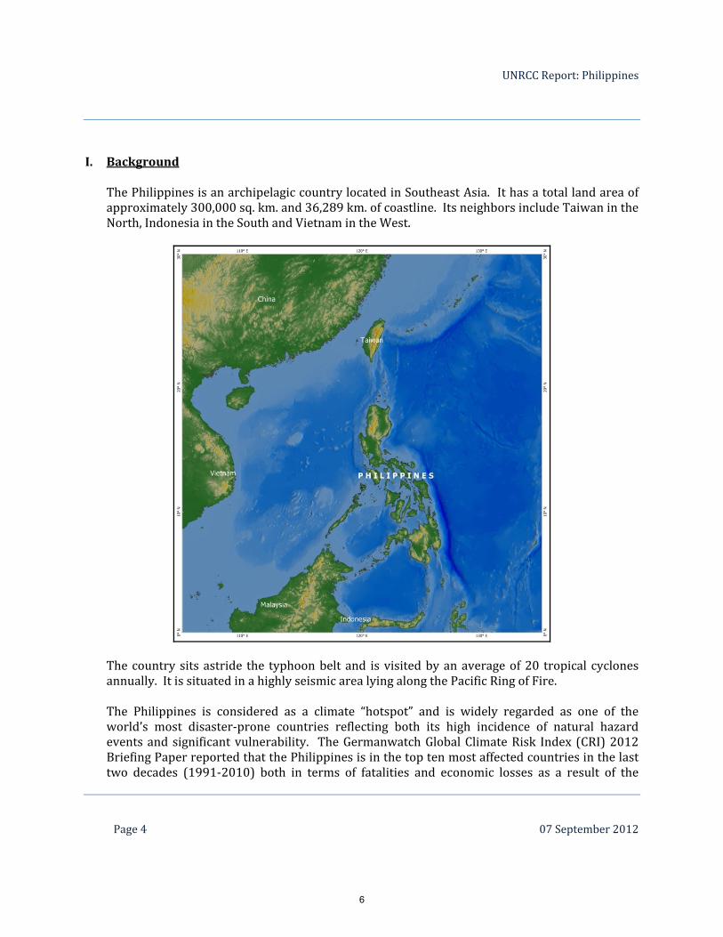
The Philippines is an archipelagic country located in Southeast Asia. It has a total land area of approximately 300,000 sq. km. and 36,289 km. of coastline. Its neighbors include Taiwan in the North, Indonesia in the South and Vietnam in the West.
The country sits astride the typhoon belt and is visited by an average of 20 tropical cyclones annually. It is situated in a highly seismic area lying along the Pacific Ring of Fire. The Philippines is considered as a climate “hotspot” and is widely regarded as one of the world’s most disaster‐prone countries reflecting both its high incidence of natural hazard events and significant vulnerability. The Germanwatch Global Climate Risk Index (CRI) 2012 Briefing Paper reported that the Philippines is in the top ten most affected countries in the last two decades (1991‐2010) both in terms of fatalities and economic losses as a result of the
6
UNRCC Report: Philippines
Page 5 07 September 2012
quantified impacts of extreme weather events such as tropical storms, floods and landslides. According to the same report, the Philippines had a total of 270 events in the period covered resulting in an annual average of 800 deaths and $660 million economic losses. Based on the 2010 census of population and housing, the Philippines has a household population of 92.1 million persons recorded as of May 01, 2010 with 11.8 million coming from the National Capital Region or Metro Manila.
II. National Disaster Management Initiatives
Because of its geography and geology, the Philippines has a high level of exposure to natural hazards. This being the case, a Philippine government body was created to ensure the protection and welfare of the people during disasters or emergencies. The National National Disaster Risk Reduction and Management Council (NDRRMC) developed and leads in the implementation of a framework that provides for a comprehensive, multihazard, multisectoral, interagency and community‐based approach to disaster risk reduction and management. The National Mapping and Resource Information Authority (NAMRIA), together with four other government agencies, has been a key partner of NDRRMC in its undertakings in the area of hazard mapping and the conduct of information, education and communication campaigns (IEC) at the community level. NAMRIA provides the topographic or base maps at scale 1:50,000 and 1:10,000 for the hazard mapping projects of NDRRMC led by the Office of Civil Defense. One of these projects is the “Hazard Mapping and Assessment for Effective Community‐Based Disaster Risk Management” or READY project. The hazard maps produced are flood, rain‐induced landslide, earthquake‐induced landslide, ground rupture, ground shaking, liquefaction, storm surge, tsunami, and volcanic eruption. Through the project’s IEC campaigns, these hazard maps are then shared with the sub‐national government units or communities for the ultimate purpose of having these maps integrated into their local comprehensive development or land use plans. The READY Project is supported by UNDP and AusAID.
III. The Role of NAMRIA in Data Sharing for Disaster Management NAMRIA, (namria.gov.ph), an office attached to the Department of Environment and Natural Resources (DENR, denr.gov.ph), is the central mapping agency of the government. It is mandated to provide the public with mapmaking services and to act as the repository of and distribution facility for base maps, nautical charts and other resource data. Its core functions are topographic base mapping, development of the national geodetic network, land classification, hydrographic surveys and nautical charting, delineation of maritime boundaries, and geographic information management.
7
UNRCC Report: Philippines
Page 6 07 September 2012
The READY Project is only one of the collaborative projects undertaken under NDRRMC’s Collective Strengthening for Community Awareness to Natural Disasters (CSCAND) Projects. The other undertakings which NAMRIA is a part of are: Building Community Resilience and Strengthening Local Government Capacities for Recovery and Disaster Risk Management (Resilience Project) funded by UNDP and CIDA; Enhancing Risk Analysis Capacities for Flood, Tropical Cyclone, Severe Wind and Earthquake for Greater Metro Manila (Risk Analysis Project) funded by AusAID; and Enhancing Greater Metro Manila's Institutional Capacities for Effective Disaster/Climate Risk Management towards Sustainable Development (READY for GMMA Project) funded by UNDP and AusAID. Consistent with the shared objectives of the Philippines’ NSDI and UN‐GGIM, NAMRIA is presently implementing the Philippine Geoportal: One Nation One Map Project which aims at establishing an effective coordination and infrastructure management that would realize the full potential of geospatial information and the underlying technology in order to make geospatial information accessible to and effectively used by a broad range of users. The Philippine Geoportal currently features, among other fundamental datasets, disaster management data showcasing the hazard maps of the READY Project. It will soon host products from the other CSCAND projects.
IV. The Philippine Geoportal: One Nation One Map Project
In a wider perspective, an effective and robust data sharing system is recognizably vital to any national and local disaster management planning and implementation. At the action scene, the use of Internet‐based technology even more facilitates data sharing especially in the proverbial golden hours. The Philippine Geoportal: One Nation One Map Project (Philippine Geoportal), a technology‐based project, captures the essence just described. It is now redefining the landscape of geospatial dissemination in the Philippines. In 2003, NAMRIA and another government agency, the National Statistical Coordination Board co‐led the development of the Philippines’ NSDI Framework. In late 2011, the Philippine Geoportal started to concretize the ideas set forth in the PNSDI Framework. It envisions “a spatially enabled nation with a comprehensive and consistent geospatial datasets widely available and shared for sustainable economic, environment and social environment and management”.
8

UNRCC Report: Philippines
Page 7 07 September 2012
The Philippine Geoportal is an e‐Government funded project that aims at establishing a web portal that provides a system for sharing of and access to geospatial information using one common multiscale basemaps. The system will provide a mechanism for a clearinghouse network, data management and exchange standards and protocols, and institutional interface that will facilitate the flow of information across all levels of government, the private and non‐profit sectors, the academia, and other stakeholders, with safeguards to protect misuse and potential risks to individuals, community and country. The Philippine Geoportal will hold and serve to the general public the basemaps and fundamental datasets that NAMRIA produces and eventually all the thematic datasets of the other stakeholder agencies. It will also promote the participation of local government units having mandate to produce subnational level geospatial data, e.g., land use plans, which is otherwise not being carried out by the national government agencies. The continual build‐up of data content, development of GIS‐based applications, and development of agency/sectoral node portals, will be included in the succeeding phases of the Project. The Philippine Geoportal also intends to provide an ICT platform for collaboration, data and resource sharing, integration, transparency and resource optimization. The Goals
Conceptual Framework
9
UNRCC Report: Philippines
Page 8 07 September 2012
In the long‐run, the Philippine Geoportal should have realized the following outcomes that clearly revolve around sharing of and access to geospatial information. One multiscale framework map served and used for government planning, decision making,
and monitoring of projects; Built‐up, updated and maintained databases guided by standards and established data
policies; Highly accessible and available map and geoprocessing services; Implemented policies and procedures on data access, sharing, standards, security and
pricing; Improved service delivery of maps and data by government map/data producers; Citizen‐centric portal enabling others to create value‐added goods and services; Improved capability of government map/data producers to provide data in GIS format; and Broader private sector participation in ICT development The Data Sharing Strategies In order to relentlessly pursue gathering of commitment of key stakeholder agencies and ensure operational sustainability of the Philippine Geoportal, NAMRIA has prepared three strategic instruments that give emphasis to data contribution and sharing. These are: Memorandum of Understanding, which provides for a manifesto of support from the Project
Steering Committee whose members are Assistant Secretary and Undersecretary levels and whose agencies were identified as potential sources of fundamental geospatial data. In terms of data, the instrument aims at allowing NAMRIA to fast track collection of geospatial datasets that can be readily showcased in the Philippine Geoportal. It also intends to gather full appreciation of and commitment from the heads of Departments or agencies through the members at the very onset of the project.
Data Sharing Agreement, which is an instrument that formalizes the sharing of the geospatial datasets by the all stakeholder agencies who want their data published on the Philippine Geoportal. This document, which is signed between the heads of NAMRIA and stakeholder agency, contains provisions that give assurance regarding security and protection of the datasets contributed by the latter. However, the stakeholder agency is also given the responsibility to take care of the quality of its shared datasets.
Executive Directive, a policy issuance which can take the form of either an executive order
or administrative order. This directive provides for the establishment of the Philippine Geospatial Data Infrastructure and addresses issues on data sharing, access and management in the long‐term. It also includes the further development and sustainability of the Philippine Geoportal, the development of the agency node portals, data custodianship and funding. The implementing rules and regulations that would set the detailed guidelines
10
UNRCC Report: Philippines
Page 9 07 September 2012
for this policy are still in progress. The policy covers the entire Philippine government bureaucracy.
The Operational Components
The development of the Philippine Geoportal is divided into three phases, the first of which took off towards the latter part of 2011. The plan for the succeeding phases of the project is being prepared in time for the completion of the first phase in the third quarter of the year and for presentation to the approving government authority for funding thereafter. Seven integral working components will run until the project’s completion. These are: applications development, ICT infrastructure establishment, data build‐up and integration, training and capability building, policy framework and institutionalization, forward and sustainability planning, and project management. The Status To date, the Philippine Geoportal is undergoing intensive testing prior to its full
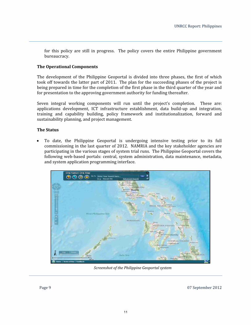
commissioning in the last quarter of 2012. NAMRIA and the key stakeholder agencies are participating in the various stages of system trial runs. The Philippine Geoportal covers the following web‐based portals: central, system administration, data maintenance, metadata, and system application programming interface.
Screenshot of the Philippine Geoportal system
11

UNRCC Report: Philippines
Page 10 07 September 2012
The GIS software, hardware and network needed to operationalize the Philippine Geoportal are already in place. Competitive bidding was undertaken for the acquisition of these resources. The enterprise GIS software license was provided by ESRI. The main Philippine Geoportal data center was established by a government service provider, Advanced Science and Technology Institute, to complete the required servers and network installations. A data center was set up in NAMRIA to serve as the hub of the agency and backup of the Philippine Geoportal databases.
For the data component, NAMRIA has uploaded the available topographic base maps namely, 1:250,000 (whole country), 1:50k and 1:10K (selected areas), LiDAR and orthophotos (Greater Metro Manila, 2011), geodesy (geodetic control points, gravity stations, declination; whole country), hydrography (bathymetry, lighthouses, tide stations), forest cover, and land classification. Key government stakeholder agencies also provided their fundamental datasets to the Philippine Geoportal and these include data on agriculture, environment, health, education, national roads and infrastructure, tourism, transportation and communication, climate and natural hazards.
To ensure that the Philippine Geoportal will be sustained in terms of the required human
resource capacity, key personnel from NAMRIA and stakeholder agencies underwent technical trainings in software, hardware and network. The personnel from stakeholder agencies will be the focals for the development of the agency node portals and databases that will be shared with and published on the Philippine Geoportal. These government agencies will develop and continuously maintain their respective geospatial databases as the primary source of geospatial information for the Philippine Geoportal. They will continue to provide and allocate funds for the acquisition, production and dissemination of their respective mandated geospatial data.
12
UNRCC Report: Philippines
Page 11 07 September 2012
NAMRIA is in the process of formulating the policy framework and its implementing rules
and regulations on the protocols and standards for the sharing and exchange of geospatial data in government, with and to the private sector, academe, general public and other stakeholders. This policy also includes data management standards to ensure quality of geospatial data and full compatibility with acceptable standards. A critical element of the policy framework is the inclusion of a provision for funding required for the establishment and initial operation of the Philippine Geoportal through the e‐Government funds. For financial sustainability, the policy proposes that the succeeding operational budget be incorporated into the NAMRIA's regular annual budget. Likewise, agencies will include in their annual regular budget the funding for the development and maintenance of their respective agency node portals and for the acquisition, production and dissemination of their geospatial information.
The overall success of the Philippine Geoportal rests heavily on the online availability and
usability of geospatial data; hence NAMRIA will continue to hold extensive information campaigns to ensure participation of data contributors in the broadest possible way. The plan for the succeeding phases of the Philippine Geoportal includes the full implementation of the data sharing and access policy, completion of the geodatabasing of the 1:50,000 scale topographic maps and nautical charts of NAMRIA, mobile application, crowd sourcing, other map and geospatial processing services, e‐payment and data pricing, upgrade in network capacity, mainstreaming of GIS into the government’s information strategic plans, expansion of stakeholder agency membership, and operational sustainability.
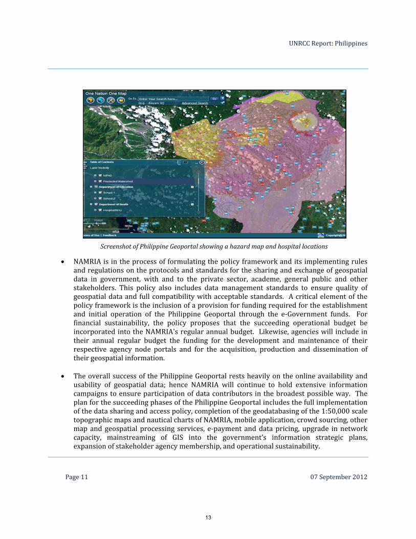
Screenshot of Philippine Geoportal showing a hazard map and hospital locations
13
UNRCC Report: Philippines
Page 12 07 September 2012
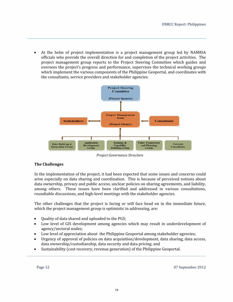
Project Governance Structure
At the helm of project implementation is a project management group led by NAMRIA
officials who provide the overall direction for and completion of the project activities. The project management group reports to the Project Steering Committee which guides and oversees the project’s progress and performance, supervises the technical working groups which implement the various components of the Philippine Geoportal, and coordinates with the consultants, service providers and stakeholder agencies.
The Challenges In the implementation of the project, it had been expected that some issues and concerns could arise especially on data sharing and coordination. This is because of perceived notions about data ownership, privacy and public access, unclear policies on sharing agreements, and liability, among others. These issues have been clarified and addressed in various consultations, roundtable discussions, and high‐level meetings with the stakeholder agencies. The other challenges that the project is facing or will face head on in the immediate future, which the project management group is optimistic in addressing, are: Quality of data shared and uploaded to the PGS; Low level of GIS development among agencies which may result in underdevelopment of
agency/sectoral nodes; Low level of appreciation about the Philippine Geoportal among stakeholder agencies; Urgency of approval of policies on data acquisition/development, data sharing, data access,
data ownership/custodianship, data security and data pricing; and Sustainability (cost recovery, revenue generation) of the Philippine Geoportal.
14
UNRCC Report: Philippines
Page 13 07 September 2012
Alongside the Philippine Geoportal, another technology‐based project that is also revolutionizing the way weather‐related information is disseminated in the country is Project Nationwide Operational Assessment of Hazards (Project NOAH).
V. Project NOAH
Project NOAH is the response of the Department of Science and Technology (DOST) to the call of President Benigno S. Aquino III for a more accurate, integrated, and responsive disaster prevention and mitigation system, especially in high‐risk area throughout the Philippines.
Since its launch in July 2012, the Noah website (noah.dost.gov.ph) has been giving the public the unique chance to access data taken from the Philippine weather bureau’s weather satellites and Doppler radars that give information on rain‐bearing clouds; all‐automatic weather stations, rain gauges and stream gauges that track the weather, amount of rainfall and depth of rivers; and manned ground weather stations that validate the data culled from these technologies. All of the automated weather stations, stream gauges and rain gauges are locally developed, and they transmit data to DOST every 10 to 15 minutes, allowing forecasters to see the weather situation in specific areas in near‐real time. Data from the instruments and observations are published on the Noah website, which is open to all Internet users.
The project’s grand objective is to improve rain and flood forecasting through speedier and more accurate reporting and dissemination of weather information.
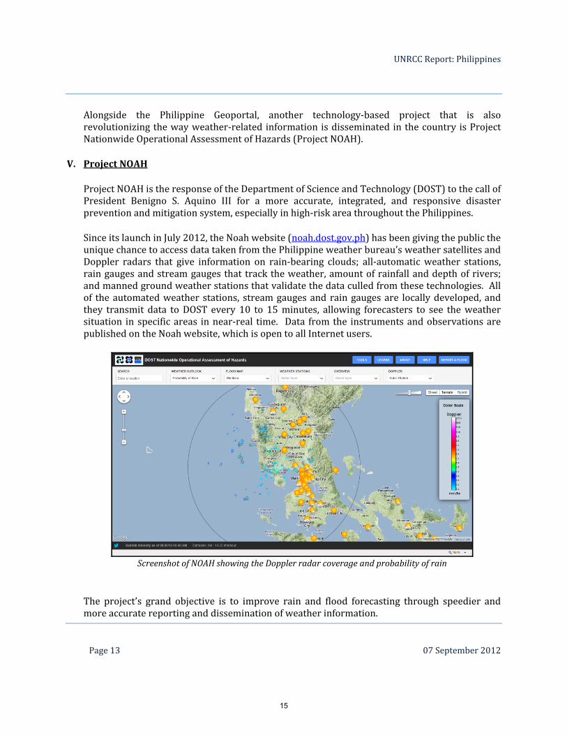
Screenshot of NOAH showing the Doppler radar coverage and probability of rain
15
UNRCC Report: Philippines
Page 14 07 September 2012
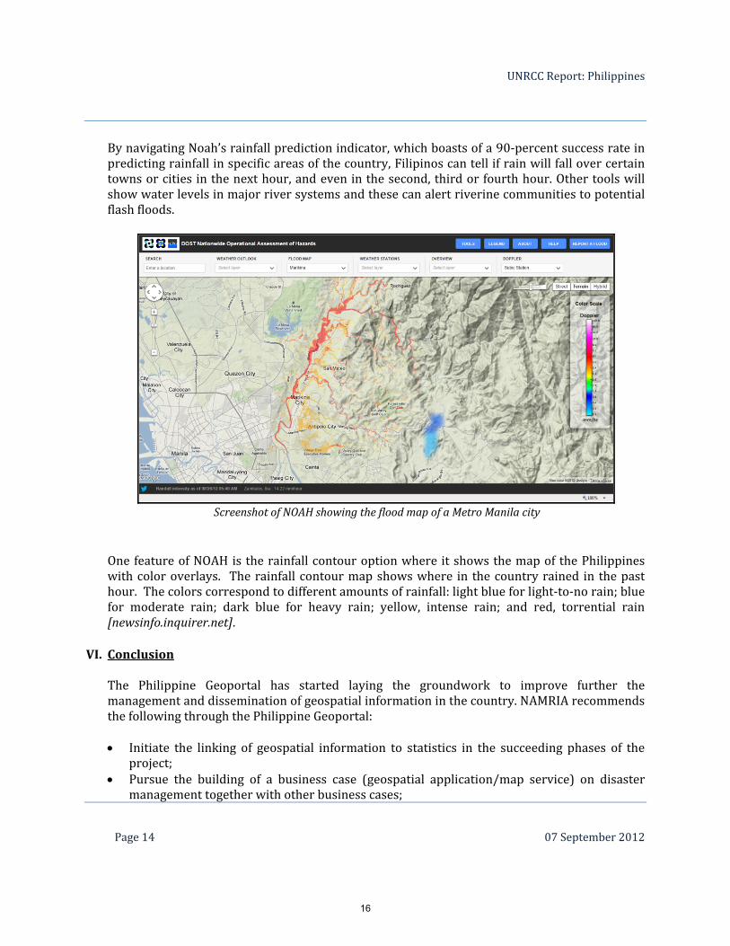
By navigating Noah’s rainfall prediction indicator, which boasts of a 90‐percent success rate in predicting rainfall in specific areas of the country, Filipinos can tell if rain will fall over certain towns or cities in the next hour, and even in the second, third or fourth hour. Other tools will show water levels in major river systems and these can alert riverine communities to potential flash floods.
One feature of NOAH is the rainfall contour option where it shows the map of the Philippines with color overlays. The rainfall contour map shows where in the country rained in the past hour. The colors correspond to different amounts of rainfall: light blue for light‐to‐no rain; blue for moderate rain; dark blue for heavy rain; yellow, intense rain; and red, torrential rain [newsinfo.inquirer.net].
VI. Conclusion The Philippine Geoportal has started laying the groundwork to improve further the management and dissemination of geospatial information in the country. NAMRIA recommends the following through the Philippine Geoportal: Initiate the linking of geospatial information to statistics in the succeeding phases of the
project; Pursue the building of a business case (geospatial application/map service) on disaster
management together with other business cases;
Screenshot of NOAH showing the flood map of a Metro Manila city
16

UNRCC Report: Philippines
Page 15 07 September 2012
Ensure that the Philippine Geoportal address issues such as data sharing, policies and arrangements, data quality, promotion and awareness, leveraging on ICT, and private partnership;
Pursue the development of a knowledge base for geospatial information management; and Ensure the long‐term operational and economic sustainability of the Philippine Geoportal.
17