data feed specification for developerscontent.tfl.gov.uk/tims-feed-technical-specification.pdfdata...
TRANSCRIPT

Transport for London
Surface Transport
Copyright Transport for London
Traffic Directorate Traffic System Software
Data Feed Specification for Developers

Issue 1
Page 2
CONTENTS
1 OVERVIEW ......................................................................................................... 2
2 TIMS FEED OVERVIEW ..................................................................................... 2
3 TIMS FEED STRUCTURE .................................................................................. 4
4 TIMS FEED DETAIL ........................................................................................... 6
5 TIMS FEED EXAMPLE ..................................................................................... 13
6 ERROR EXAMPLE ........................................................................................... 17
1 OVERVIEW
Traffic Directorate (TD) has developed a new Traffic Information Management System (TIMS) to replace the current London Traffic Information System (LTIS) to cater for new requirements to detect, manage and report disruptions. As part of this, there is now a requirement to replace the current LTIS data feed with an XML feed from TIMS. The TIMS system captures a richer range of information about road disruptions, including improved spatial information, details of closures and more in-depth categorisation of the cause of a disruption. This document details the content of the feed and the associated functionality.
2 TIMS FEED OVERVIEW
TfL Online will distribute the new TIMS XML data feed to the public via channels such as the Developer’s Area and the Traffic News map at tfl.gov.uk/trafficnews.
2.1 Content
TfL will provide one feed containing an XML representation of all disruptions with the following filtering and sorting requirements: Filtering: Disruptions will be filtered with a status of Active, Active Long Term, Scheduled and Recurring Works (starting within 180 days) and Recently Cleared (in the last 24 hours). Sorting: Disruptions will be sorted by decreasing severity i.e. Severe, Serious, Moderate and Minimal and then sorted by status i.e. Active, Long Term, Scheduled, Recurring Works and Recently Cleared.

Issue 1
Page 3
Disruption Content: Each disruption will contain TIMS fields describing the disruption and a geographic representation of the CAUSE AREA for each disruption. The CauseArea will contain the following:
1. DisplayPoint: a Point on the road network closest to the centroid of the CAUSE AREA (or the start point if the CAUSE AREA is a line).
2. Streets: an list of Streets, each with a name, closure and directions and a list of Links, each with an OS ITN toid (a unique number identifying an Ordnance Survey Integrated Transport Network road link) and a Line containing the start and end points of the road segments of the OS ITN road nodes. The order of the start and end points will not indicate the direction of the disruption. Points will be represented using British National Grid Eastings and Northings. If the disruption has no streets, Streets will be omitted and there will be a Boundary.
3. Boundary: an optional Boundary containing a preset area (see below) Polygon. Boundary will be omitted if there are Streets.
4. Coordinates: points, lines or polygons will be represented using both British National Grid eastings and northings (using Oracle Spatial coordinate system reference id SRID=81989) and Longitude / Latitude (WGS 84 aligned to Google Maps) coordinates.
Note that a CauseArea will always contain either Streets or a Boundary. A Boundary polygon will be included for large preset areas only, which have no streets e.g. Twickenham Rugby Stadium:
Generalization of polygons: The TIMS feed will generalize the cause area polygons to reduce the number of points using the following parameters:
parameter description
threshold the acceptable maximum distance between the generalized and original polygons e.g. 3 metres
tolerance the acceptable maximum distance two points can be apart and still considered the same e.g. 1 metre.

Issue 1
Page 4
2.2 Reliability
The TIMS feed will be robust to errors in both structure and content i.e. to any special characters that may be entered by operators. The TIMS feed shall be dependent on as few points of failure and as few intermediate stages as possible. In addition, TIMS feeds shall, where possible, be pulled to prevent concurrent reading while writing problems.
2.3 Frequency
The TIMS feed will be fetched every 5 minutes.
3 TIMS FEED STRUCTURE
The proposed TIMS feed XML structure is shown below:
3.1 Root Object
The top level XML object is the Root object consisting of a Header object and a Disruptions object. The Disruptions object contains a set of Disruption objects
Root
Header
Disruptions
Disruption
.
.Disruption
3.2 Disruption Object
Each Disruption object will contain TIMS fields and a CauseArea object (created using the TIMS user interface map). The CauseArea will contain a DisplayPoint object, and either a Streets or a Boundary object.

Issue 1
Page 5
Figure: Shows the TIMS fields and the CauseArea objects with either Streets or a
Boundary.
3.3 Link Object
A TOID (TOpographic IDentifier) is a unique reference identifier assigned by the Ordnance Survey to identify every geographic feature in their dataset of Great Britain. The Link object will contain the TOID of the road link affected and a Line object representing the geometry of the ends of the road link. The order of the start and end points will not indicate the direction of the disruption.
3.4 Point Object
The Point object will contain the coordinates of a point in both eastings/northings and WGS84 long/lat aligned to Google Maps.
3.5 Line Object
The Line object will contain the generalized coordinates of a line in both eastings/northings and WGS84 long/lat aligned to Google Maps.
3.6 Polygon Object
The Polygon object will contain the generalized coordinates of a polygon in both eastings/northings and WGS84 long/lat aligned to Google Maps.

Issue 1
Page 6
Figure: Shows the Link, Point, Line and Polygon (leaf) objects (they are not related)
4 TIMS FEED DETAIL
Below are the details of the feed objects and elements. [] means optional, so the field is omitted to denote where information is not known. Note that because TIMS is the source of the information, some values appearing in the TIMS feed may change depending on values from TIMS.
4.1 Header Object
The Header is a standard object included in syndicated TfL feeds. It is documented in the Syndication Developer Guidelines.
4.2 Disruption Object
4.2.1 Summary of What
Attribute Description
id This is the unique identifier for each disruption. XML datatype: integer.
Element Description
status This describes the status of the disruption. XML datatype: string with enumeration constraint.
Active = currently in progress Active Long Term = currently in progress and long term Scheduled = scheduled to start within the next 180 days Recurring Works = planned maintenance works that follow a

Issue 1
Page 7
regular routine or pattern and whose next occurrence is to start within the next 180 days. Recently Cleared = recently cleared in the last 24 hours Note that the status of Scheduled or Recurring Works disruptions will change to Active when they start, and will change status again when they end
severity This describes the current or expected impact of the disruption on traffic. This is a subjective description assigned to the disruption by the operator managing it. XML datatype: string with enumeration constraint.
Minimal = assigned when traffic is very light at a location, with no traffic queuing and no noticeable inconvenience to the road user.
Moderate = assigned when: a) traffic is moving, with some traffic queuing that is unusual for the time of day at the location; and b) there is minor noticeable inconvenience being caused through road closures. Serious = assigned when: a) there is traffic congestion that is unusual for the time of day at the location or in an area, and traffic has been stopped for less than 5 minutes but in excess of the red signal time displayed on the traffic signals operating on the road; and b) there is traffic queuing that is longer than normal for the time of day and incidents that do, or will within a short space of time, cause inconvenience to road users. Severe = assigned when; a) there is traffic congestion that is unusual for the time of day at the location or in an area, and traffic has been stopped for more than 5 minutes; and b) traffic queuing that is longer than normal for the time of day, more than for Serious Congestion and also incidents that do, or will within a short space of time, cause significant inconvenience* to road users. *NOTE significant inconvenience at least 20 minutes to the road user’s journey.
levelOfInterest This describes the level of potential impact on traffic operations of the disruption. XML datatype: string with enumeration constraint.
High = e.g. a one-off disruption on a major or high profile route which will require a high level of operational attention Medium = This is the default value Low = e.g. a frequently occurring disruption which is well known

Issue 1
Page 8
operationally, or a one-off in a low traffic area
category This describes the nature of disruption. The values will be text, taken from the Database Sub-Category in the table below as follows (may change depending on values from TIMS). XML datatype: string.
Database High Level Category
Database Sub-Category = Feed category
Hazard(s) Burst Water Main
Hazard(s) Collapsed Manhole
Hazard(s) Dangerous Structure
Hazard(s) Fire
Hazard(s) Flooding
Hazard(s) Ice on Road
Hazard(s) Obstruction
Hazard(s) Other
Hazard(s) Spillage
Hazard(s) Surface Damage
Hazard(s) Weather
Hazard(s) Wires Exposed
Infrastructure Issue Barriers
Infrastructure Issue Ferry Disruption/Cancellation
Infrastructure Issue Other
Infrastructure Issue Signal Timing
Infrastructure Issue Traffic Signal
Special and Planned Events Abnormal Load
Special and Planned Events Bridge Lift
Special and Planned Events Ceremonial Event
Special and Planned Events Concert
Special and Planned Events Construction Activity
Special and Planned Events Demonstration
Special and Planned Events Exhibition
Special and Planned Events March/Procession
Special and Planned Events Other
Special and Planned Events Parade/Celebration
Special and Planned Events Sporting Event
Traffic Incidents Accident
Traffic Incidents Breakdown
Traffic Incidents Emergency Services Incident
Traffic Incidents Other
Traffic Volume Industrial Action
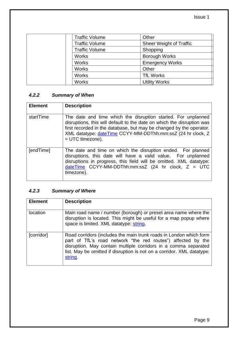
Issue 1
Page 9
Traffic Volume Other
Traffic Volume Sheer Weight of Traffic
Traffic Volume Shopping
Works Borough Works
Works Emergency Works
Works Other
Works TfL Works
Works Utility Works
4.2.2 Summary of When
Element Description
startTime The date and time which the disruption started. For unplanned disruptions, this will default to the date on which the disruption was first recorded in the database, but may be changed by the operator. XML datatype: dateTime CCYY-MM-DDThh:mm:ssZ (24 hr clock, Z = UTC timezone).
[endTime] The date and time on which the disruption ended. For planned disruptions, this date will have a valid value. For unplanned disruptions in progress, this field will be omitted. XML datatype: dateTime CCYY-MM-DDThh:mm:ssZ (24 hr clock, Z = UTC timezone).
4.2.3 Summary of Where
Element Description
location Main road name / number (borough) or preset area name where the disruption is located. This might be useful for a map popup where space is limited. XML datatype: string.
[corridor] Road corridors (includes the main trunk roads in London which form part of TfL’s road network “the red routes”) affected by the disruption. May contain multiple corridors in a comma separated list. May be omitted if disruption is not on a corridor. XML datatype: string.

Issue 1
Page 10
4.2.4 Detail of What
comments Full text of comments describing the disruption, including details of any road closures and diversions, where appropriate. XML datatype: string.
[currentUpdate] Text of the most recent update from the LSTCC on the state of the disruption, including the current traffic impact and any advice to road users. XML datatype: string. Note - Not all disruptions will have currentUpdate, because there is not always CCTV in the vicinity or staff on the ground to enable progress and impact to be reported. Therefore, currentUpdate may be omitted.
4.2.5 Detail of When
[remarkTime] The time when the last currentUpdate was recorded. See [currentUpdate] element above for more details. XML datatype: dateTime CCYY-MM-DDThh:mm:ssZ (24 hr clock, Z = UTC timezone).
lastModTime The time when the last change was made to the database entry for the disruption. XML datatype: dateTime CCYY-MM-DDThh:mm:ssZ (24 hr clock, Z = UTC timezone).
4.2.6 Detail of Where
CauseArea See below
4.3 CauseArea Object
The CauseArea object contains a DisplayPoint object, and either a Streets object or a Boundary object.
4.3.1 DisplayPoint Object
The DisplayPoint object contains a Point object which is a point on the road network closest to the centroid of the CAUSE AREA (or the start point if the CAUSE AREA is a line). There is one DisplayPoint per CauseArea object.
Element Description
Point Object to hold the coordinates of a point.
coordinatesEN List of British National Grid easting and northing grid references

Issue 1
Page 11
(using Oracle Spatial coordinate system reference id SRID=81989) as a comma separated list of floating point numbers. XML datatype: string.
coordinatesLL List of WGS 84 longitude and latitude coordinates aligned to Google Maps as a comma separated list of floating point numbers. XML datatype: string.
4.3.2 [Streets] Object
The Streets objects contains one or more Street objects. Where a cause area is defined by a Boundary object, the Streets object will be omitted.
4.3.2.1 Street Object Each Street object represents a street in the CAUSE AREA of the disruption.
Element Description
name Street name. XML datatype: string.
closure Type of road closure. XML datatype: string. Allowed values below (may change depending on values from TIMS): Open = road is open, not blocked, not closed, not restricted. It maybe that the disruption has been moved out of the carriageway. Partial Closure = road is partially blocked, closed or restricted. Full Closure = road is fully blocked or closed. This information is to be considered alongside the direction information, when known.
directions Set of directions on the road. XML datatype: string. Allowed values in the set (may change depending on values from TIMS): All Directions All Approaches Clockwise Anti-Clockwise Northbound Eastbound Southbound Westbound Both Directions

Issue 1
Page 12
4.3.2.2 Link Object Each Link object represents a road link identified by a TOID. There are one or more Link objects per Street object.
Element Description
toid A 16 digit unique integer identifying a OS ITN (Ordnance Survey Integrated Transport Network) road link. XML datatype: string with maxLength constraint.
Line Object to hold the generalized coordinates of a line. In this context, Line contains the geometry of a [Road] Link object. The order of the start and end points will not indicate the direction of the disruption.
coordinatesEN List of British National Grid easting and northing grid references (using Oracle Spatial coordinate system reference id SRID=81989) as a comma separated list of floating point numbers. XML datatype: string.
coordinatesLL List of WGS 84 longitude and latitude coordinates aligned to Google Maps as a comma separated list of floating point numbers. XML datatype: string.
4.3.3 [Boundary] Object
Each optional Boundary object contains a Polygon object which geographically represents the CAUSE AREA. Where a CAUSE AREA is defined by Streets object, Boundary object will be omitted.
Element Description
Polygon Object to hold the generalized coordinates of a polygon.
coordinatesEN List of British National Grid easting and northing grid references (using Oracle Spatial coordinate system reference id SRID=81989) as a comma separated list of floating point numbers. XML datatype: string.
coordinatesLL List of WGS 84 longitude and latitude coordinates aligned to Google Maps as a comma separated list of floating point numbers. XML datatype: string.

Issue 1
Page 13
5 TIMS FEED EXAMPLE
In the map below, as an example, a disruption is shown with one road link (in red).

Issue 1
Page 14

Issue 1
Page 15
Below is an example TIMS feed with one disruption that includes Streets and no Boundary. <?xml version="1.0" encoding="iso-8859-1"?> <Root xmlns="http://www.tfl.gov.uk/tims/1.0"> <Header> <Identifier>Transport for London | Live Traffic Disruptions</Identifier> <DisplayTitle>Transport for London | Traffic Information Management System(TIMS) Feed</DisplayTitle> <Version>1.0</Version> <PublishDateTime canonical="2012-05-02T16:17:55Z">Wednesday, 2 May 2012 16:17:55</PublishDateTime> <Author>[email protected]</Author> <Owner>Transport for London</Owner> <RefreshRate>5</RefreshRate> <Max_Latency>30</Max_Latency> <TimeToError>30</TimeToError> <Schedule>Every 5 minutes</Schedule> <Attribution> <Url>http://www.tfl.gov.uk/</Url> <Text>(c) Transport for London</Text> <Logo>http://www.tfl.gov.uk/tfl-global/images/roundel.gif</Logo> </Attribution> <Language>EN</Language> </Header> <Disruptions> <Disruption id='1449'> <status>Active</status> <severity>Severe</severity> <levelOfInterest>High</levelOfInterest> <category>Accident</category> <startTime>2013-02-05T16:33:00Z</startTime> <location>Blackfriars Road (Southwark)</location> <corridor>Farringdon Cross Route</corridor> <comments>Northbound direction. One lane of three is closed to due to an accident. Delays may occur during peak periods. Diversion through Meymott St.</comments> <currentUpdate> Lane one (of three) is currently restricted. Traffic is flowing well.</currentUpdate> <remarkTime>2013-05-02T15:44:39Z</remarkTime> <lastModTime>2013-05-02T15:44:39Z</lastModTime> <CauseArea> <DisplayPoint> <Point> <coordinatesEN>531650.528,180246.667</coordinatesEN> <coordinatesLL>-.104486,51.505755</coordinatesLL> </Point> </DisplayPoint> <Streets> <Street> <name>Blackfriars Road</name> <closure>Open</closure> <directions>North Bound</directions> <Link> <toid>4000000030239261</toid> <Line> <coordinatesEN>531651.06,180218.33,531650.00,180275.00</coordinatesEN> <coordinatesLL>-.104489,51.5055,-.104483,51.50601</coordinatesLL> </Line> </Link> </Street> </Streets> </CauseArea> </Disruption> </Disruptions> </Root>

Issue 1
Page 16
Below is an example Boundary object from the TIMS feed for a disruption that includes a Boundary and no Streets.
<Boundary> <Polygon> <coordinatesEN>531667.7255,180236.149800001,531667.7255,180260.160800001, 531650.5275,180268.230599999,531635.9754,180258.5733,531635.9754,180237.4727,531653.1733, 180229.5352,531667.7255,180236.149800001</coordinatesEN> <coordinatesLL>-.104242,51.505656,-.104233,51.505872,-.104478,51.505949,-.104691,51.505865,-.104699,51.505676,-.104454,51.5056,-.104242,51.505656</coordinatesLL> </Polygon> </Boundary>

Issue 1
Page 17
6 ERROR EXAMPLE
If an error occurs during the fetching of the feed, the system will output an empty XML feed that still validates, but contains an extra <ErrorMessage> element for diagnostics, e.g. <?xml version="1.0" encoding="ISO-8859-1" ?> - <Root xmlns="http://www.tfl.gov.uk/tims/1.0"> - <Header> <Identifier>Transport for London | Live Traffic Disruptions</Identifier> <DisplayTitle>Transport for London | Traffic Information Management System (TIMS) Feed</DisplayTitle> <Version>1.0</Version> <PublishDateTime canonical="2013-02-22T10:28:10Z">Friday, 22 Feb 2013 10:28:10</PublishDateTime> <Author>[email protected]</Author> <Owner>Transport for London</Owner> <RefreshRate>5</RefreshRate> <Max_Latency>30</Max_Latency> <TimeToError>30</TimeToError> <Schedule>Every 5 minutes</Schedule> <ErrorMessage>ORA-31011: XML parsing failed ORA-19202: Error occurred in XML processing LPX-00225: end-element tag "CCauseArea" does not match start-element tag "CauseArea" Error at line 69</ErrorMessage> - <Attribution> <Url>http://www.tfl.gov.uk/</Url> <Text>(c) Transport for London</Text> <Logo>http://www.tfl.gov.uk/tfl-global/images/roundel.gif</Logo> </Attribution> <Language>EN</Language> </Header> <Disruptions /> </Root>
- END OF DOCUMENT -