data dictionary - alaska department of natural...
TRANSCRIPT

Data Dictionary Alaska Department of Natural Resources
Division of Mining, Land & Water and Division of Oil & Gas
North Slope Planning Area Geospatial Infrastructure Data
Contact: Resource Assessment and Development Section (RADS), Division of Mining, Land, & Water
or Division of Oil & Gas (DOG)
Phone: 907-269-8534(RADS) 907-269-8800(DOG)
March 31, 2014
Prepared by Resource Data, Inc.
560 E. 34th Avenue, Suite 100 Anchorage, Alaska 99503

AK DNR DMLW and DOG North Slope Planning Area Geospatial Infrastructure Data March 31, 2014 i
Table of Contents
Introduction 1
Project Overview 1
Study Limitations 2
Design Overview 4
Atlas Geodatabase (DNR_NS_Planning_Infrastructure.gdb) 6
Airstrip_pt 6
Airstrip_py 8
DisposalSites_pt 9
DisposalSites_py 10
Easement_py 11
GravelPad_py 12
MaterialSite_pt 13
MaterialSite_py 15
Pipeline 17
Powerline 18
Road_ln 19
Road_py 20
Structure_pt 21
Structure_py 22
Transportation_pt 23
Well_pt 24
Derived Map Layers (Derived_Map_Layers.gdb) 25
Airstrip_Derived_Merged_pt 25
Airstrip_Derived_pt 26
Clustered_Well_Derived_pt 27
DisposalSites_Derived_pt 28
GravelPad_Derived_pt 29
MaterialSite_Derived_pt 30
Structure_Derived_pt 32
Domain Tables 33

AK DNR DMLW and DOG North Slope Planning Area Geospatial Infrastructure Data March 31, 2014 ii
Source_Org_Codes 33
Well_Class_Codes 34
Well_Status_Codes 35
Appendix 1: Creating the Derived Feature Classes 37
Process: Airstrip_Derived_pt, DisposalSites_Derived_pt, GravelPad_Derived_pt,
MaterialSite_Derived_pt, Structure_Derived_pt 38
Process: Airstrip_Derived_Merged_pt 39
Process: Clustered_Well_Derived_pt 40
Appendix 2: Data Acquisition 41
Sample Letter 43
Appendix 3: List of Acronyms 48
Appendix 4: Metadata 49
Section 1 – Feature Class Metadata 50
Airstrips; Points Metadata 50
Airstrips; Polygons Metadata 58
Disposal Sites; Points Metadata 66
Disposal Sites; Polygons Metadata 73
Easements; Polygons Metadata 80
Gravel Pads; Polygons Metadata 87
Material Sites; Points Metadata 95
Material Sites; Polygons Metadata 103
Pipelines; Lines Metadata 112
Powerline; Lines Metadata 120
Roads; Lines Metadata 127
Roads; Polygons Metadata 134
Structures; Points Metadata 141
Structures; Polygons Metadata 148
Transportation; Points Metadata 155
Wells; Points Metadata 162
Derived Merged Airstrips; Point Metadata 170
Derived Airstrips; Points Metadata 175
Derived Clustered Wells; Points Metadata 183
Derived Disposal Sites; Points Metadata 188

AK DNR DMLW and DOG North Slope Planning Area Geospatial Infrastructure Data March 31, 2014 iii
Derived Gravel Pads; Points Metadata 195
Derived Material Sites; Points Metadata 203
Derived Structures; Points Metadata 212
Section 2 - Georeferenced PDF’s 219
Nikaitchuq-Spy Island Drill Site (SID) Civil-Site Plan Offshore Drilling Facilities Metadata 219
Nikaitchuq-Oliktok Point Pad (OPP) Civil-Site Plan Onshore Process & Drilling Facilities Metadata
223
Nikaitchuq-Kuparuk (KPL) General Notes, Key Map, Plan, & Section Gravel and Kuparuk
Pipeline Tie-In (KPG02) Metadata 227
Nikaitchuq Operating Center (NOC) Civil-Site Plan Operating Center Pad Metadata 231
Figure 2.4-5 Alternative B - Applicant's Proposed Action Sheet 1 of 2 Metadata 235
Figure 2.4-5 Alternative B - Applicant's Proposed Action Sheet 2 of 2 Metadata 239
Figure 2.4-26 Alternative B - Coastal Pads with Seasonal Ice Roads Sheet 1 of 2 Metadata 243
Figure 2.4-27 Alternative B - Coastal Pads with Seasonal Ice Roads Sheet 2 of 2 Metadata 247
Figure 3.13-1 Land Ownership and Management Metadata 251
Figure 3.13-2 Leases and Development In and Near the Point Thomson Project Metadata 255
Figure 3.14-1 Arctic National Wildlife Refuge Metadata 259
Figure 3.17-4 Existing Transportation Systems Metadata 263
Nikaitchuq-North Slope Development (NSD) Electrical Underground Power Plan Oliktok Point
Area Underground Installation (PLE01) Metadata 267
Eni OPP Barge Landing Asbuilt Location Metadata 271
Nikaitchuq North Slope Development (NSD) Pipeline - Plan & Section Road Crossing at DS-3Q
(PLR02) Metadata 275
Nikaitchuq North Slope Development (NSD) Pipeline - Plan & Section Road Crossing at DS-3N
(PLR02) Metadata 279
Nikaitchuq North Slope Development (NSD) Pipeline - Plan & Section Road Crossing at CPF3
(PLR02) Metadata 283
Nikaitchuq North Slope Development (NSD) Pipeline - Plan & Section Road Crossing at DS-1Y
(PLR02) Metadata 287
Nikaitchuq North Slope Development (NSD) Pipeline - Plan & Section Road Crossing at Spine
Road (PLR02) Metadata 291
Nikaitchuq Development 2010 Flowline Route Monitoring Program Regional Overview & Index
Map Metadata 295

AK DNR DMLW and DOG North Slope Planning Area Geospatial Infrastructure Data March 31, 2014 iv
This page intentionally left blank.

AK DNR DMLW and DOG North Slope Planning Area Geospatial Infrastructure Data March 31, 2014 1
Introduction
This data dictionary describes all the data obtained by Resource Data, Inc. (RDI) on behalf of the
Alaska Department of Natural Resources (DNR) Divisions of Oil and Gas (DOG) and Mining, Land
and Water (DMLW) under TO 0086-10-13-010. It is intended that both DNR divisions would use this
data in its operational review and approval activities and that it would provide, in large part, the data
base necessary for the preparation of a North Slope Management Plan. Appendix 1 describes the
geoprocessing used to develop the derived feature classes used for atlas symbolization, Appendix 2
describes the data collection methodology, Appendix 3 provides a list of acronyms used in this
document, and Appendix 4 attaches the formal metadata.
Project Overview
DNR engaged RDI to compile existing infrastructure and facility location information and material
(sand and gravel) source information on all State-owned and State-selected lands (including uplands,
shore lands, tidelands, and submerged lands) on the North Slope of Alaska within defined geographic
areas. The study area for this project is shown below and in the sample data request letter in Appendix
2. In this report, this area is referred to as the “study area.”
Figure 1: North Slope Planning Area
AK DNR DMLW and DOG North Slope Planning Area Geospatial Infrastructure Data March 31, 2014 2
The purpose of this information is to support subsequent surface analyses by DNR in this area, either
for authorization review and approval or for the development of a management plan. It includes only
surface and near-surface features. Surface features are those features which are visible on the land
surface such as above-ground pipeline, buildings, material sites, wells, and airstrips. Near-surface
features include buried pipelines, culverts, and, potentially, material site boundaries that are still
under surface cover.
This data collection effort only included State-owned and State-selected lands within the area of
interest, as stated in the sample letter in Appendix 2. Most land in the study area, both uplands and
waters, are owned by the State of Alaska. We also received data from the North Slope Borough for
lands owned by the Borough. We did not filter provided information to remove information on
private lands; if an organization provided information from private lands, it is included in the
database and maps. While we did request information from the Arctic Slope Regional Corporation, it
was only for information on State-owned and State-selected lands. Their land holdings were
considered to be private lands.
RDI conducted the project in two distinct phases: data collection followed by data analysis,
processing, and cartography. During data collection, the emphasis was to collect the desired
information from as many sources as possible. The information that was requested is listed in the
“Sample Letter” in Appendix 2.1 DNR, in its development of the initial scope of work, determined
the attribute data that were most important for the purposes of the study. Appendix 2 describes the
data collection in more detail. During the second phase, the effort shifted to analyzing the submitted
digital data, developing an appropriate geodatabase model, loading the submissions into a
geodatabase, conducting further geoprocessing to support the printed map atlas, and producing the
atlas and data dictionary.
Study Limitations
• Source organizations contacted during the data collection phase either provided information
or responded to DNR or RDI that they did not have information that met the terms of the
request. DNR and RDI did informal evaluations of those organizations that responded “no
data” and determined one of the following:
o The organization did not have leases within the study area.
o Any information the organization might have was not critical to the study purpose.
o The information was available from another entity.
o The organization has privately-owned land that is outside the scope of this study.
• Source organizations determined which data met the requirements of the study and which
attribute information they would provide.
1 The sample letter represents the information that we requested and expected to receive. In some cases, entities
responded with partial data and were contacted again to request the missing data. The missing data was provided in
some instances; in others, no additional data was forthcoming and information pertinent to the field is intentionally
missing.

AK DNR DMLW and DOG North Slope Planning Area Geospatial Infrastructure Data March 31, 2014 3
o Different organizations may have submitted different attribute information, not all
which is relevant to the study purpose of surface analysis of North Slope
infrastructure. These are identified in the discussion of each feature class for the
DNR_NS_Planning_Infrastructure.gdb. DNR has received all of the source
information and consequently has all of the information that was not loaded to the
geodatabase. The following list describes attributes we determined not to be relevant:
� Location references to private reference systems such as a unique grid system
used by a single company. These cannot be used without full knowledge of
the private reference systems, which were not provided.
� Duplicate information. If the same information was provided in two
attributes, it was loaded as a single attribute.
� Source organization cartographic and categorization information.
Organizations often include attribute columns used for map production
within that organization that provide no value outside of the organization.
These were not loaded.
� Historical lineage and geoprocessing information. Some organizations
included attributes showing the historical migration from one system to
another or the organization’s geoprocessing steps. These provide no
meaningful information outside of the organization.
� References to information in other systems. Some organizations provided
attribute columns with links to other systems, but these have no meaning
without the other system.
� Geometric information. Some organizations provided geometric attributes
that could easily be derived from the feature itself.
� Detailed engineering, legal, or historical information. AOGCC provided
several additional tables of ancillary well data that is outside of the scope of
the project. These include detailed engineering information, such as bottom-
hole details, production details, geologic information, permit information,
leasing information, and well history information, such as descriptions of the
type of work done.
o Organizations may or may not have submitted attribute information that was of
interest, such as the status date or record currency date of each feature. In every case,
if the value in an attribute column is blank or null, the source organization did not
provide that data.
• Organizations were encouraged to submit data in digital formats that could be imported into
an Esri geodatabase but were allowed to submit portable document format (PDF) files, hard
copy maps, and other static documents in lieu of importable digital formats. This project did
not include any digitizing of data submitted via static documents, but did, at times,
georeference documents.
• Where possible, maps submitted as PDFs were georeferenced even though they could not be
imported into the geodatabase feature classes.

AK DNR DMLW and DOG North Slope Planning Area Geospatial Infrastructure Data March 31, 2014 4
• Although Pipeline Open Data Standards (PODS) formatted datasets were requested, if
available, no respondent provided PODS data.
• This project relied solely on the data submitted by source organizations and, by design, did
not include any independent verification of data accuracy. The accuracy of the information in
the data dictionary is believed to be good, reflecting the data that was submitted, but since
data could not be field verified, some uncertainty exists and appropriate caution should be
exercised.
Design Overview
RDI designed two Esri file geodatabases in which to store the data: the DNR North Slope (NS)
planning infrastructure geodatabase (DNR_NS_Planning_Infrastructure.gdb) and the derived
geodatabase (Derived_Map_Layers.gdb).
The feature classes in the DNR_NS_Planning_Infrastructure.gdb preserve detailed information from
the source organization. This geodatabase is intended primarily for detailed analysis. Each record in
the DNR_NS_Planning_Infrastructure.gdb represents one record in a source feature class.
The derived geodatabase's major purpose is to support map production through streamlining and
making it easier to visualize critical information. The Derived_Map_Layers.gdb consists of feature
classes that have been derived from the submitted data. Multiple data records from the sources may
have been consolidated into a single record. For example, the derived wells layer represents wells
within a restricted geographical area by a single point and a count of the number of wells represented
by that point. By necessity, the derived layers have much less attribute information than those in
DNR_NS_Planning_Infrastructure.gdb.
RDI evaluated all submitted data to develop consolidated feature classes within the DNR NS planning
infrastructure geodatabase. The feature classes within DNR_NS_Planning_Infrastructure.gdb
preserve the geometry of the source data: point (PT), line (LN), or polygon (PY). This means that all
of the spatial information from the source data is preserved in this geodatabase. In contrast, all spatial
information in the derived geodatabase has been abstracted to points. Most polygon feature classes
are represented by their centroid while the wells were collapsed so all wells in a restricted area are
represented by a single point with a number for all of the wells represented by that point. See
Appendix 1 for more information on how the derived geodatabase was created.
The DNR_NS_Planning_Infrastructure.gdb feature classes contain all of the attributes that would be
valuable for the project goals of surface mapping and analysis. In many cases, all submitted attributes
were retained in the final feature classes, but as noted in “Study Limitations,” some attribute
information was not valuable for the study purposes. Each feature class entry below identifies if
source organization attributes were omitted from the final DNR NS planning infrastructure
geodatabase and, if so, a description of the attributes that were omitted during the load process. In all
cases, DNR received a copy of the actual data received from the source organization and there are
record pointers back to the source data.

AK DNR DMLW and DOG North Slope Planning Area Geospatial Infrastructure Data March 31, 2014 5
The primary functions of the design of the DNR_NS_Planning_Infrastructure.gdb are to be able to
easily determine what a feature represents, symbolize it appropriately, and trace the lineage of the
feature back to its original source. To these ends, every feature class contains the following:
• Acquisition_Date identifies the date on which the source organization submitted the data.
• Conf identifies whether a feature was identified as requiring confidential treatment
according to the instructions of the data provider.
• DOG_Type contains categories provided by DOG. Every feature was successfully assigned
one of these categories with no ambiguous features.
• Source_FC identifies the name of the feature class (or shape file or other geographic
information system [GIS] format file) in which the data were contained from the source
organization.
• Source_OID contains the original Object ID number of the feature within its source feature
class.
• Source_Org identifies the organization from which the data were received.
• Type field is used for symbolization and identification.
The remaining fields are unique to each feature class. The features had highly variable amounts of
attribute data. Some features were provided with an extensive number of descriptive attributes, but
often we received no more than simple Name and Type values.
While we have included an acquisition date identifying when the source organization submitted the
data, organizations did not normally provide a status date indicating the data currency. If a source
organization provided the status date, the feature class contains a status date column. If there is not a
status date column, the converse is true and the source organizations did not provide that data.
In many cases, identical or almost identical features were received from multiple source
organizations. We made no attempt to evaluate which of these may have been more spatially accurate
or contain better attribute data. All features have been included, but they can be distinguished easily
based on their source information.
The primary purpose of Derived_Map_Layers.gdb is to support the generation of the atlas. Given the
map scale and tile sizes, full feature representation of all of the map polygons and points resulted in
an extremely cluttered map when printed. At DNR’s request, we created point layers for most
polygons and created a derived wells layer that consolidates all wells in a geographical area, such as a
pad or a few adjacent pads, into a single point with a count of the number of wells. The geoprocessing
is described in Appendix 1.
All spatial data is in the Alaska Albers North American Datum 1983 projection.
AK DNR DMLW and DOG North Slope Planning Area Geospatial Infrastructure Data March 31, 2014 6
Atlas Geodatabase (DNR_NS_Planning_Infrastructure.gdb)
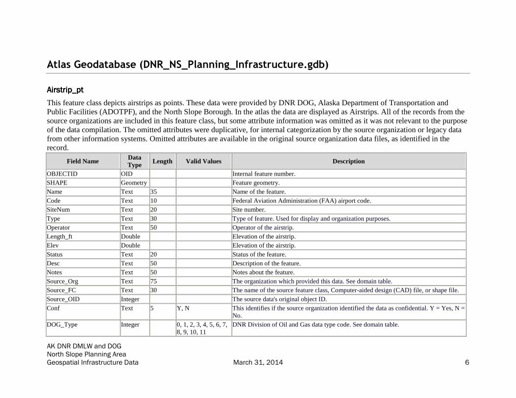
Airstrip_ptAirstrip_ptAirstrip_ptAirstrip_pt
This feature class depicts airstrips as points. These data were provided by DNR DOG, Alaska Department of Transportation and
Public Facilities (ADOTPF), and the North Slope Borough. In the atlas the data are displayed as Airstrips. All of the records from the
source organizations are included in this feature class, but some attribute information was omitted as it was not relevant to the purpose
of the data compilation. The omitted attributes were duplicative, for internal categorization by the source organization or legacy data
from other information systems. Omitted attributes are available in the original source organization data files, as identified in the
record.
Field Name Data
Type Length Valid Values Description
OBJECTID OID Internal feature number.
SHAPE Geometry Feature geometry.
Name Text 35 Name of the feature.
Code Text 10 Federal Aviation Administration (FAA) airport code.
SiteNum Text 20 Site number.
Type Text 30 Type of feature. Used for display and organization purposes.
Operator Text 50 Operator of the airstrip.
Length_ft Double Elevation of the airstrip.
Elev Double Elevation of the airstrip.
Status Text 20 Status of the feature.
Desc Text 50 Description of the feature.
Notes Text 50 Notes about the feature.
Source_Org Text 75 The organization which provided this data. See domain table.
Source_FC Text 30 The name of the source feature class, Computer-aided design (CAD) file, or shape file.
Source_OID Integer The source data's original object ID.
Conf Text 5 Y, N This identifies if the source organization identified the data as confidential. Y = Yes, N =
No.
DOG_Type Integer 0, 1, 2, 3, 4, 5, 6, 7,
8, 9, 10, 11
DNR Division of Oil and Gas data type code. See domain table.

AK DNR DMLW and DOG North Slope Planning Area Geospatial Infrastructure Data March 31, 2014 7
Field Name Data
Type Length Valid Values Description
Acquisition_Date Date Date of data acquisition.

AK DNR DMLW and DOG North Slope Planning Area Geospatial Infrastructure Data March 31, 2014 8
Airstrip_pyAirstrip_pyAirstrip_pyAirstrip_py
This feature class depicts airstrips as polygons. These data were provided by DNR DOG. In the atlas the data are displayed as
Airstrips. All of the records from the source organizations are included in this feature class, but some attribute information was
omitted as it was not relevant to the purpose of the data compilation. The omitted attributes were duplicative, for internal
categorization by the source organization, or legacy data required by other information systems. Omitted attributes are available in the
original source organization data files, as identified in the record.
Field Name Data
Type Length Valid Values Description
OBJECTID OID Internal feature number.
SHAPE Geometry Feature geometry.
Name Text 35 Name of the feature.
Code Text 10 FAA airport code.
SiteNum Text 20 Site number.
Type Text 30 Type of feature. Used for display and organization purposes.
Operator Text 50 Operator of the airstrip.
Length_ft Double Elevation of the airstrip.
Elev Double Elevation of the airstrip.
Status Text 20 Status of the feature.
Desc Text 50 Description of the feature.
Notes Text 50 Notes about the feature.
Source_Org Text 75 The organization which provided this data. See domain table.
Source_FC Text 30 The name of the source feature class, CAD file, or shape file.
Source_OID Integer The source data's original object ID.
Conf Text 5 Y, N This identifies if the source organization identified the data as confidential. Y = Yes, N =
No.
DOG_Type Integer 0, 1, 2, 3, 4, 5, 6, 7,
8, 9, 10, 11
DNR Division of Oil and Gas data type code. See domain table.
Acquisition_Date Date Date of data acquisition.
SHAPE_Length Double Length of feature in meters.
SHAPE_Area Double Area of feature in meters squared.

AK DNR DMLW and DOG North Slope Planning Area Geospatial Infrastructure Data March 31, 2014 9
DisposalSites_ptDisposalSites_ptDisposalSites_ptDisposalSites_pt
This feature class depicts disposal sites as points. These data were provided by Repsol. In the atlas the data are displayed as Landfills
(Disposal Sites). All of the records and attribute information from the source organizations are included in this feature class.
Field Name Data
Type Length Valid Values Description
OBJECTID OID Internal feature number.
SHAPE Geometry Feature geometry.
Name Text 35 Name of the feature.
Operator Text 50 Operator of the site.
Status Text 20 Status of the feature.
Type Text 35 Type of feature. Used for display and organization purposes.
Desc Text 50 Description of the feature.
Source_Org Text 50 The organization which provided this data. See domain table.
Source_FC Text 30 The name of the source feature class, CAD file, or shape file.
Source_OID Integer The source data's original object ID.
Conf Text 5 Y, N This identifies if the source organization identified the data as confidential. Y = Yes, N =
No.
DOG_Type Integer 0, 1, 2, 3, 4, 5, 6, 7,
8, 9, 10, 11
DNR Division of Oil and Gas data type code. See domain table.
Acquisition_Date Date Date of data acquisition.

AK DNR DMLW and DOG North Slope Planning Area Geospatial Infrastructure Data March 31, 2014 10
DisposalDisposalDisposalDisposalSites_pySites_pySites_pySites_py
This feature class depicts disposal sites as polygons. These data were provided by the North Slope Borough. In the atlas the data are
displayed as Landfills (Disposal Sites). All of the records from the source organizations are included in this feature class, but some
attribute information was omitted as it was not relevant to the purpose of the data compilation. The omitted attributes were strictly for
labelling or from other information systems. Omitted attributes are available in the original source organization data files, as identified
in the record.
Field Name Data
Type Length Valid Values Description
OBJECTID OID Internal feature number.
SHAPE Geometry Feature geometry.
Name Text 35 Name of the feature.
Operator Text 50 Operator of the site.
Status Text 20 Status of the feature.
Type Text 35 Type of feature. Used for display and organization purposes.
Desc Text 50 Description of the feature.
Source_Org Text 50 The organization which provided this data. See domain table.
Source_FC Text 30 The name of the source feature class, CAD file, or shape file.
Source_OID Integer The source data's original object ID.
Conf Text 5 Y, N This identifies if the source organization identified the data as confidential. Y = Yes, N =
No.
DOG_Type Integer 0, 1, 2, 3, 4, 5, 6, 7,
8, 9, 10, 11
DNR Division of Oil and Gas data type code. See domain table.
Acquisition_Date Date Date of data acquisition.
SHAPE_Length Double Length of feature in meters.
SHAPE_Area Double Area of feature in meters squared.

AK DNR DMLW and DOG North Slope Planning Area Geospatial Infrastructure Data March 31, 2014 11
Easement_pyEasement_pyEasement_pyEasement_py
This feature class depicts easements as polygons. These data were provided by the State Pipeline Coordinator's Office. The data are
not displayed in the atlas. All of the records from the source organizations are included in this feature class, but some attribute
information was omitted as it was not relevant to the purpose of the data compilation. The omitted attributes contain geoprocessing
information from the source organization. Omitted attributes are available in the original source organization data files, as identified in
the record.
Field Name Data
Type Length Valid Values Description
OBJECTID OID Internal feature number.
SHAPE Geometry Feature geometry.
Name Text 35 Name of the feature.
Operator Text 50 Operator of the airstrip.
Desc Text 50 Description of the feature.
Notes Text 50 Notes about the feature.
Type Text 35 Type of feature. Used for display and organization purposes.
Source_Org Text 50 The organization which provided this data. See domain table.
Source_FC Text 30 The name of the source feature class, CAD file, or shape file.
Source_OID Integer The source data's original object ID.
Conf Text 5 Y, N This identifies if the source organization identified the data as confidential. Y = Yes, N =
No.
DOG_Type Integer 0, 1, 2, 3, 4, 5, 6, 7,
8, 9, 10, 11
DNR Division of Oil and Gas data type code. See domain table.
Acquisition_Date Date Date of data acquisition.
SHAPE_Length Double Length of feature in meters.
SHAPE_Area Double Area of feature in meters squared.

AK DNR DMLW and DOG North Slope Planning Area Geospatial Infrastructure Data March 31, 2014 12
GravelPad_pyGravelPad_pyGravelPad_pyGravelPad_py
This feature class depicts gravel pads as polygons. These data were provided by BP, DNR DOG, Brooks Range Petroleum Corporation, the
North Slope Borough, ConocoPhillips Alaska and Repsol. In the atlas the data are displayed as Pads and Roads. All of the records from the
source organizations are included in this feature class, but some attribute information was omitted as it was not relevant to the purpose of the
data compilation. The omitted attributes contain legacy data from other information systems, organization specific location references without
published keys, labelling information, or original lineage information. Omitted attributes are available in the original source organization data
files, as identified in the record.
Field Name Data
Type Length Valid Values Description
OBJECTID OID Internal feature number.
SHAPE Geometry Feature geometry.
Name Text 35 Name of the feature; sometimes an abbreviation for labeling purposes.
Desc Text 50 Description of the feature.
FullName Text 50 Full name of the gravel pad. Also the facility name, not abbreviated.
Operator Text 35 Operator of the gravel pad.
Purpose Text 25 Purpose of the gravel pad.
Status Text 20 Status of the feature.
Notes Text 50 Notes about the feature.
Type Text 35 Type of feature. Used for display and organization purposes.
Source_Org Text 75 The organization which provided this data. See domain table.
Source_FC Text 30 The name of the source feature class, CAD file, or shape file.
Source_OID Integer The source data's original object ID.
Conf Text 5 Y, N This identifies if the source organization identified the data as confidential. Y = Yes, N =
No.
DOG_Type Integer 0, 1, 2, 3, 4, 5, 6, 7,
8, 9, 10, 11
DNR Division of Oil and Gas data type code. See domain table.
Acquisition_Date Date Date of data acquisition.
SHAPE_Length Double Length of feature in meters.
SHAPE_Area Double Area of feature in meters squared.

AK DNR DMLW and DOG North Slope Planning Area Geospatial Infrastructure Data March 31, 2014 13
MaterialSite_ptMaterialSite_ptMaterialSite_ptMaterialSite_pt
This feature class depicts material sites as points. These data were provided by the Alaska Department of Transportation and Public Facilities.
In the atlas the data are displayed as Mine Sites (>= 5 acres). All of the records from the source organizations are included in this feature
class, but some attribute information was omitted as it was not relevant to the purpose of the data compilation. The omitted attributes contain
information for other information systems. Omitted attributes are available in the original source organization data files, as identified in the
record.
Field Name Data
Type Length Valid Values Description
OBJECTID OID Internal feature number.
SHAPE Geometry Feature geometry.
Name Text 35 Name of the feature.
Desc Text 50 Description of the feature.
Site_ID Integer Site ID of the material site.
ADL Text 20 Alaska Division of Lands (ADL) number of the site.
Operator Text 50 Operator of the material site.
Acreage Double Acreage of the site calculated by RDI.
Status Text 50 Status of the feature.
Quantity Double Quantity of the site in billion cubic yards.
Quality Text 50 Quality of the material.
Potential Text 50 Potential of the material site.
Type Text 35 Type of feature. Used for display and organization purposes.
MTRS Text 255 Meridian, Township, Range, Section (MTRS) location of the feature. Calculated by RDI
based on the feature’s intersection with MTRS polygons.
RoadProximity_ft Double Approximate straight-line distance of the material site to the closest road based on
received data, in feet. 0 means there is a road to the material site. Calculated by RDI and
provided by the Alaska Oil and Gas Conservation Commission (AOGCC).
Report_URL Text 255 URL of PDF file with a full report of the material site. Most values for the AOGCC data
were populated from these reports.
Source_Org Text 50 The organization which provided this data. See domain table.
Source_FC Text 30 The name of the source feature class, CAD file, or shape file.
Source_OID Integer The source data's original object ID.
Conf Text 5 Y, N This identifies if the source organization identified the data as confidential. Y = Yes, N =
No.

AK DNR DMLW and DOG North Slope Planning Area Geospatial Infrastructure Data March 31, 2014 14
Field Name Data
Type Length Valid Values Description
DOG_Type Integer 0, 1, 2, 3, 4, 5, 6, 7,
8, 9, 10, 11
DNR Division of Oil and Gas data type code. See domain table.
Acquisition_Date Date Date of data acquisition.

AK DNR DMLW and DOG North Slope Planning Area Geospatial Infrastructure Data March 31, 2014 15
MaterialSite_pyMaterialSite_pyMaterialSite_pyMaterialSite_py
This feature class depicts material sites as polygons. These data were provided by the North Slope Borough and the United States Department
of Transportation (US DOT). In the atlas the data are displayed as Mine Sites (>= 5 acres). All of the records from the source organizations
are included in this feature class, but some attribute information was omitted as it was not relevant to the purpose of the data compilation. The
omitted attributes only contain labelling information. Omitted attributes are available in the original source organization data files, as
identified in the record.
Field Name Data
Type Length Valid Values Description
OBJECTID OID Internal feature number.
SHAPE Geometry Feature geometry.
Name Text 35 Name of the feature.
Desc Text 50 Description of the feature.
Site_ID Integer Site ID of the material site.
ADL Text 20 ADL number of the site.
Operator Text 50 Operator of the material site.
Acreage Double Acreage of the site calculated by RDI.
Status Text 50 Status of the feature.
Quantity Double Quantity of the site.
Quality Text 50 Quality of the material.
Potential Text 50 Potential of the material site.
Type Text 35 Type of feature. Used for display and organization purposes.
MTRS Text 255 MTRS location of the feature. Calculated by RDI based on the feature’s intersection
with MTRS polygons.
RoadProximity_ft Double Approximate straight-line distance of the material site to the closest road based on
received data, in feet. 0 means there is a road to the material site. Calculated by RDI.
Source_Org Text 75 The organization which provided this data. See domain table.
Source_FC Text 30 The name of the source feature class, CAD file, or shape file.
Source_OID Integer The source data's original object ID.
Conf Text 5 Y, N This identifies if the source organization identified the data as confidential. Y = Yes, N =
No.
DOG_Type Integer 0, 1, 2, 3, 4, 5, 6, 7,
8, 9, 10, 11
DNR Division of Oil and Gas data type code. See domain table.
Centroid_X Double X coordinate of the polygon centroid in NAD83 decimal degrees. Calculated by RDI.
AK DNR DMLW and DOG North Slope Planning Area Geospatial Infrastructure Data March 31, 2014 16
Field Name Data
Type Length Valid Values Description
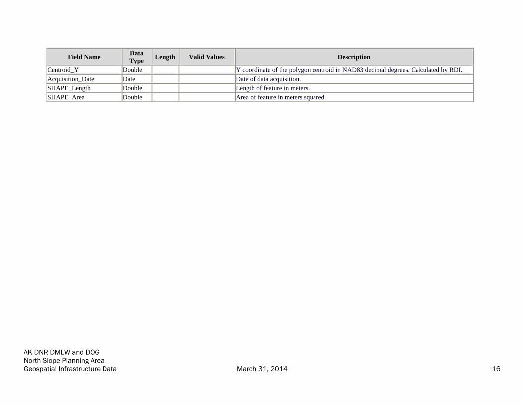
Centroid_Y Double Y coordinate of the polygon centroid in NAD83 decimal degrees. Calculated by RDI.
Acquisition_Date Date Date of data acquisition.
SHAPE_Length Double Length of feature in meters.
SHAPE_Area Double Area of feature in meters squared.

AK DNR DMLW and DOG North Slope Planning Area Geospatial Infrastructure Data March 31, 2014 17
PipelinePipelinePipelinePipeline
This feature class depicts pipeline data as lines. These data were provided by DNR DOG, BP, the North Slope Borough,
ConocoPhillips Alaska and the State Pipeline Coordinator's Office. In the atlas the data are displayed as Above Ground Pipelines,
Below Ground Pipelines, Proposed Alaska Stand Alone Pipeline (ASAP) (and Liquefied Natural Gas (LNG)), Trans-Alaska Pipeline
System (TAPS) Above Ground, TAPS Below Ground, and TAPS Fuel Gas Line (FGL). All of the records from the source
organizations are included in this feature class, but some attribute information was omitted as it was not relevant to the purpose of the
data compilation. The omitted attributes contained legacy data from other information systems or organization specific location
references without published keys. Omitted attributes are available in the original source organization data files, as identified in the
record.
Field Name Data
Type Length Valid Values Description
OBJECTID OID Internal feature number.
SHAPE Geometry Feature geometry.
Name Text 35 Name of the feature.
Desc Text 50 Description of the feature.
Operator Text 50 Operator of the pipeline.
Status Text 20 Status of the feature.
Type Text 50 Type of feature. Used for display and organization purposes.
Product Text 50 Product carried by the pipeline.
Owner Text 150 Owner of the pipeline.
Diam_in Double Diameter of the pipeline in inches.
Pipe_ID Integer Pipe ID number, as provided by source organizations.
Source_Org Text 50 The organization which provided this data. See domain table.
Source_FC Text 30 The name of the source feature class, CAD file, or shape file.
Source_OID Integer The source data's original object ID.
Conf Text 5 Y, N This identifies if the source organization identified the data as confidential. Y = Yes, N =
No.
DOG_Type Integer 0, 1, 2, 3, 4, 5, 6, 7,
8, 9, 10, 11
DNR Division of Oil and Gas data type code. See domain table.
Acquisition_Date Date Date of data acquisition.
SHAPE_Length Double Length of feature in meters.

AK DNR DMLW and DOG North Slope Planning Area Geospatial Infrastructure Data March 31, 2014 18
PowerlinePowerlinePowerlinePowerline
This feature class depicts powerline data as lines. These data were provided by BP and ConocoPhillips Alaska. In the atlas the data are
displayed as Buried Powerlines and Overhead Powerlines. All of the records and attribute information from the source organizations are
included in this feature class.
Field Name Data
Type Length Valid Values Description
OBJECTID OID Internal feature number.
SHAPE Geometry Feature geometry.
Name Text 35 Name of the feature.
Desc Text 50 Description of the feature.
Operator Text 50 Operator of the powerline.
Voltage Text 10 Voltage of the powerline.
Type Text 35 Type of feature. Used for display and organization purposes.
Source_Org Text 50 The organization which provided this data. See domain table.
Source_FC Text 30 The name of the source feature class, CAD file, or shape file.
Source_OID Integer The source data's original object ID.
Conf Text 5 Y, N This identifies if the source organization identified the data as confidential. Y = Yes, N =
No.
DOG_Type Integer 0, 1, 2, 3, 4, 5, 6, 7,
8, 9, 10, 11
DNR Division of Oil and Gas data type code. See domain table.
Acquisition_Date Date Date of data acquisition.
SHAPE_Length Double Length of feature in meters.

AK DNR DMLW and DOG North Slope Planning Area Geospatial Infrastructure Data March 31, 2014 19
Road_lnRoad_lnRoad_lnRoad_ln
This feature class depicts roads in line format. Data were obtained from DNR DOG, ADOTPF, Geographic Coordinate Database, the
North Slope Borough, and Repsol. In the atlas the data are displayed as Primary Road and Secondary Road. All of the records from
the source organizations are included in this feature class, but some attribute information was omitted as it was not relevant to the
purpose of the data compilation. The omitted attributes contain organization specific location references without published keys,
internal symbology information, original lineage information, geometric information that could be derived from this data, or data from
other information systems. Omitted attributes are available in the original source organization data files, as identified in the record.
Field Name Data
Type Length Valid Values Description
OBJECTID OID Internal feature number.
SHAPE Geometry Feature geometry.
Name Text 35 Name of the feature.
Desc Text 50 Description of the feature.
Operator Text 50 Operator of the road.
Width_ft Double Width of the road in feet.
Material Text 50 Material of the road.
Type Text 50 Type of feature. Used for display and organization purposes.
Source_Org Text 75 The organization which provided this data. See domain table.
Source_FC Text 30 The name of the source feature class, CAD file, or shape file.
Source_OID Integer The source data's original object ID.
Conf Text 5 Y, N This identifies if the source organization identified the data as confidential. Y = Yes, N =
No.
DOG_Type Integer 0, 1, 2, 3, 4, 5, 6, 7,
8, 9, 10, 11
DNR Division of Oil and Gas data type code. See domain table.
Acquisition_Date Date Date of data acquisition.
SHAPE_Length Double Length of feature in meters.
AK DNR DMLW and DOG North Slope Planning Area Geospatial Infrastructure Data March 31, 2014 20
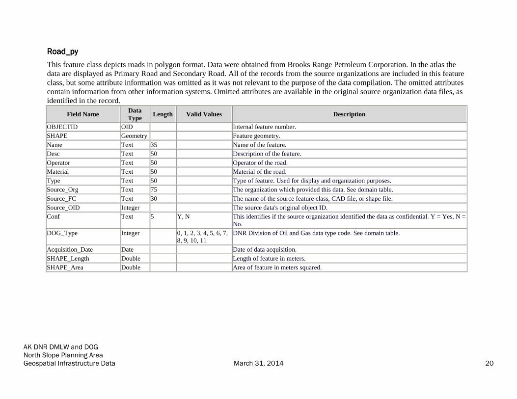
Road_pyRoad_pyRoad_pyRoad_py
This feature class depicts roads in polygon format. Data were obtained from Brooks Range Petroleum Corporation. In the atlas the
data are displayed as Primary Road and Secondary Road. All of the records from the source organizations are included in this feature
class, but some attribute information was omitted as it was not relevant to the purpose of the data compilation. The omitted attributes
contain information from other information systems. Omitted attributes are available in the original source organization data files, as
identified in the record.
Field Name Data
Type Length Valid Values Description
OBJECTID OID Internal feature number.
SHAPE Geometry Feature geometry.
Name Text 35 Name of the feature.
Desc Text 50 Description of the feature.
Operator Text 50 Operator of the road.
Material Text 50 Material of the road.
Type Text 50 Type of feature. Used for display and organization purposes.
Source_Org Text 75 The organization which provided this data. See domain table.
Source_FC Text 30 The name of the source feature class, CAD file, or shape file.
Source_OID Integer The source data's original object ID.
Conf Text 5 Y, N This identifies if the source organization identified the data as confidential. Y = Yes, N =
No.
DOG_Type Integer 0, 1, 2, 3, 4, 5, 6, 7,
8, 9, 10, 11
DNR Division of Oil and Gas data type code. See domain table.
Acquisition_Date Date Date of data acquisition.
SHAPE_Length Double Length of feature in meters.
SHAPE_Area Double Area of feature in meters squared.

AK DNR DMLW and DOG North Slope Planning Area Geospatial Infrastructure Data March 31, 2014 21
Structure_ptStructure_ptStructure_ptStructure_pt
This feature class depicts structures as points. These data were provided by DNR DOG, ADOTPF, DNR DMLW, BP, ConocoPhillips
Alaska and Repsol. In the atlas the data are displayed as Dish Antenna, Tower, Facilities, and Pump Stations. All of the records from
the source organizations are included in this feature class, but some attribute information was omitted as it was not relevant to the
purpose of the data compilation. The omitted attributes contain original source lineage information, duplicate information or milepost
information. Omitted attributes are available in the original source organization data files, as identified in the record.
Field Name Data
Type Length Valid Values Description
OBJECTID OID Internal feature number.
SHAPE Geometry Feature geometry.
Name Text 35 Name of the feature.
Desc Text 50 Description of the feature.
Operator Text 50 Operator of the structure.
Status Text 20 Status of the feature.
Type Text 35 Type of feature. Used for display and organization purposes.
Source_Org Text 75 The organization which provided this data. See domain table.
Source_FC Text 30 The name of the source feature class, CAD file, or shape file.
Source_OID Integer The source data's original object ID.
Conf Text 5 Y, N This identifies if the source organization identified the data as confidential. Y = Yes, N =
No.
DOG_Type Integer 0, 1, 2, 3, 4, 5, 6, 7,
8, 9, 10, 11
DNR Division of Oil and Gas data type code. See domain table.
Acquisition_Date Date Date of data acquisition.
AK DNR DMLW and DOG North Slope Planning Area Geospatial Infrastructure Data March 31, 2014 22
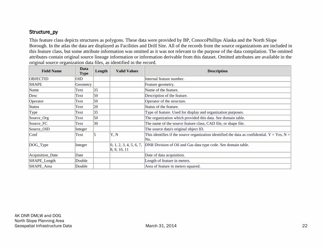
Structure_pyStructure_pyStructure_pyStructure_py
This feature class depicts structures as polygons. These data were provided by BP, ConocoPhillips Alaska and the North Slope
Borough. In the atlas the data are displayed as Facilities and Drill Site. All of the records from the source organizations are included in
this feature class, but some attribute information was omitted as it was not relevant to the purpose of the data compilation. The omitted
attributes contain original source lineage information or information derivable from this dataset. Omitted attributes are available in the
original source organization data files, as identified in the record.
Field Name Data
Type Length Valid Values Description
OBJECTID OID Internal feature number.
SHAPE Geometry Feature geometry.
Name Text 35 Name of the feature.
Desc Text 50 Description of the feature.
Operator Text 50 Operator of the structure.
Status Text 20 Status of the feature.
Type Text 35 Type of feature. Used for display and organization purposes.
Source_Org Text 50 The organization which provided this data. See domain table.
Source_FC Text 30 The name of the source feature class, CAD file, or shape file.
Source_OID Integer The source data's original object ID.
Conf Text 5 Y, N This identifies if the source organization identified the data as confidential. Y = Yes, N =
No.
DOG_Type Integer 0, 1, 2, 3, 4, 5, 6, 7,
8, 9, 10, 11
DNR Division of Oil and Gas data type code. See domain table.
Acquisition_Date Date Date of data acquisition.
SHAPE_Length Double Length of feature in meters.
SHAPE_Area Double Area of feature in meters squared.
AK DNR DMLW and DOG North Slope Planning Area Geospatial Infrastructure Data March 31, 2014 23
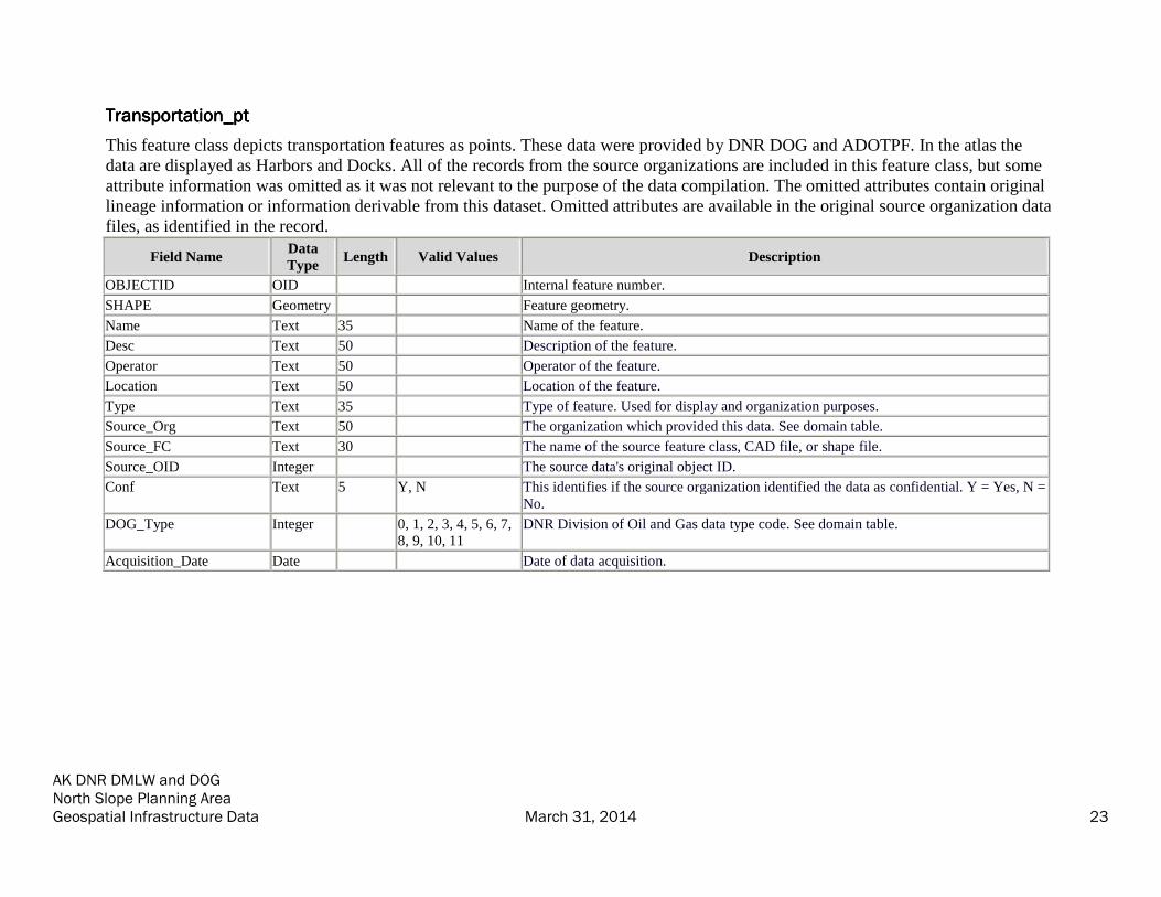
Transportation_ptTransportation_ptTransportation_ptTransportation_pt
This feature class depicts transportation features as points. These data were provided by DNR DOG and ADOTPF. In the atlas the
data are displayed as Harbors and Docks. All of the records from the source organizations are included in this feature class, but some
attribute information was omitted as it was not relevant to the purpose of the data compilation. The omitted attributes contain original
lineage information or information derivable from this dataset. Omitted attributes are available in the original source organization data
files, as identified in the record.
Field Name Data
Type Length Valid Values Description
OBJECTID OID Internal feature number.
SHAPE Geometry Feature geometry.
Name Text 35 Name of the feature.
Desc Text 50 Description of the feature.
Operator Text 50 Operator of the feature.
Location Text 50 Location of the feature.
Type Text 35 Type of feature. Used for display and organization purposes.
Source_Org Text 50 The organization which provided this data. See domain table.
Source_FC Text 30 The name of the source feature class, CAD file, or shape file.
Source_OID Integer The source data's original object ID.
Conf Text 5 Y, N This identifies if the source organization identified the data as confidential. Y = Yes, N =
No.
DOG_Type Integer 0, 1, 2, 3, 4, 5, 6, 7,
8, 9, 10, 11
DNR Division of Oil and Gas data type code. See domain table.
Acquisition_Date Date Date of data acquisition.

AK DNR DMLW and DOG North Slope Planning Area Geospatial Infrastructure Data March 31, 2014 24
Well_ptWell_ptWell_ptWell_pt
This feature class depicts wells in as points. These data were provided by the North Slope Borough, ConocoPhillips Alaska, AOGCC,
and Repsol. In the atlas the data are displayed as Wells (number), where the number represents the number of wells in a 250 meter
vicinity.
All of the well locations from the source organizations are included in this feature class, but some attribute and supplemental
information was omitted as it was not relevant to the purpose of the data compilation. The omitted attributes contain information
derivable from this dataset, location information that could otherwise be derived from GIS, organization specific location references
without published keys, duplicate information, and data used by other information systems.
AOGCC provided extensive information in multiple tables for each well, most of which was not necessary for the purposes of
cartography and surficial analysis. AOGCC data excluded from this feature class include detailed engineering information, such as
bottom hole details, production details, geologic information, permit information, leasing information, and well history information,
such as descriptions of the type of work done. All omitted information is available in the original source organization data files, as
identified in the record.
Field Name Data
Type Length Valid Values Description
OBJECTID OID Internal feature number.
SHAPE Geometry Feature geometry.
APINum Text 16 American Petroleum Institute (API) number for the well.
Operator Text 100 Operator of the well.
Location Text 29 Location of the well.
WellNum Text 20 Well number.
WellName Text 32 Well name.
Class Text 3 Class of the well.
Status Text 6 Status of the feature.
StatusDate Date Date of the well status.
LeaseNum Text 42 Lease number.
Type Text 35 Type of feature. Used for display and organization purposes.
Source_Org Text 50 The organization which provided this data. See domain table.
Source_FC Text 30 The name of the source feature class, CAD file, or shape file.
Source_OID Integer The source data's original object ID.

AK DNR DMLW and DOG North Slope Planning Area Geospatial Infrastructure Data March 31, 2014 25
Field Name Data
Type Length Valid Values Description
Conf Text 5 Y, N This identifies if the source organization identified the data as confidential. Y = Yes, N =
No.
DOG_Type Integer 0, 1, 2, 3, 4, 5, 6, 7,
8, 9, 10, 11
DNR Division of Oil and Gas data type code. See domain table.
Acquisition_Date Date Date of data acquisition.
DerivedDerivedDerivedDerived Map LayersMap LayersMap LayersMap Layers (Derived_Map_Layers.gdb)
Airstrip_Derived_Merged_ptAirstrip_Derived_Merged_ptAirstrip_Derived_Merged_ptAirstrip_Derived_Merged_pt
These data depict merged, generalized airstrips as points. Note: these data are intended for display purposes only, as in the data atlas. This
was derived from data "Airstrip_pt" and "Airstrip_py." See Appendix 1 for geoprocessing information.
Field Name Data
Type Length Valid Values Description
OBJECTID OID Internal feature number.
SHAPE Geometry Feature geometry.
Centroid_X Double X coordinate of the polygon centroid in NAD83 decimal degrees. Calculated by RDI.
Centroid_Y Double Y coordinate of the polygon centroid in NAD83 decimal degrees. Calculated by RDI.

AK DNR DMLW and DOG North Slope Planning Area Geospatial Infrastructure Data March 31, 2014 26
Airstrip_Airstrip_Airstrip_Airstrip_Derived_Derived_Derived_Derived_ptptptpt
These data depict generalized airstrips as points. Note: these data are intended for display purposes only, as in the data atlas. This was derived
from data "Airstrip_py." See Appendix 1 for geoprocessing information.
Field Name Data
Type Length Valid Values Description
OBJECTID OID Internal feature number.
SHAPE Geometry Feature geometry.
Name Text 35 Name of the feature.
Code Text 10 FAA airport code.
SiteNum Text 20 Site number.
Type Text 30 Type of feature. Used for display and organization purposes.
Operator Text 50 Operator of the airstrip.
Length_ft Double Elevation of the airstrip.
Elev Double Elevation of the airstrip.
Status Text 20 Status of the feature.
Desc Text 50 Description of the feature.
Notes Text 50 Notes about the feature.
Source_Org Text 75 The organization which provided this data. See domain table.
Source_FC Text 30 The name of the source feature class, CAD file, or shape file.
Source_OID Integer The source data's original object ID.
Conf Text 5 Y, N This identifies if the source organization identified the data as confidential. Y = Yes, N =
No.
DOG_Type Integer 0, 1, 2, 3, 4, 5, 6, 7,
8, 9, 10, 11
DNR Division of Oil and Gas data type code. See domain table.
Acquisition_Date Date Date of data acquisition.
Centroid_X Double X coordinate of the polygon centroid in NAD83 decimal degrees. Calculated by RDI.
Centroid_Y Double Y coordinate of the polygon centroid in NAD83 decimal degrees. Calculated by RDI.

AK DNR DMLW and DOG North Slope Planning Area Geospatial Infrastructure Data March 31, 2014 27
Clustered_Well_Derived_ptClustered_Well_Derived_ptClustered_Well_Derived_ptClustered_Well_Derived_pt
These data depict clustered wells in point format. Note: these clustered well data are intended for display purposes only, as in the data atlas.
This was derived from "Well_pt." See Appendix 1 for geoprocessing information.
Field Name Data
Type Length Valid Values Description
OBJECTID OID Internal feature number.
SHAPE Geometry Feature geometry.
Count Integer Count of the number of wells that are clustered at that point.
Centroid_X Double X coordinate of the polygon centroid in NAD83 decimal degrees. Calculated by RDI.
Centroid_Y Double Y coordinate of the polygon centroid in NAD83 decimal degrees. Calculated by RDI.

AK DNR DMLW and DOG North Slope Planning Area Geospatial Infrastructure Data March 31, 2014 28
DisposalSites_Derived_ptDisposalSites_Derived_ptDisposalSites_Derived_ptDisposalSites_Derived_pt
These data depict generalized disposal sites as points. Note: these data are intended for display purposes only, as in the data atlas. This was
derived from "DisposalSites_py." See Appendix 1 for geoprocessing information.
Field Name Data
Type Length Valid Values Description
OBJECTID OID Internal feature number.
SHAPE Geometry Feature geometry.
Name Text 35 Name of the feature.
Operator Text 50 Operator of the site.
Status Text 20 Status of the feature.
Type Text 35 Type of feature. Used for display and organization purposes.
Desc Text 50 Description of the feature.
Source_Org Text 50 The organization which provided this data. See domain table.
Source_FC Text 30 The name of the source feature class, CAD file, or shape file.
Source_OID Integer The source data's original object ID.
Conf Text 5 Y, N This identifies if the source organization identified the data as confidential. Y = Yes, N =
No.
DOG_Type Integer 0, 1, 2, 3, 4, 5, 6, 7,
8, 9, 10, 11
DNR Division of Oil and Gas data type code. See domain table.
Acquisition_Date Date Date of data acquisition.
Centroid_X Double X coordinate of the polygon centroid in NAD83 decimal degrees. Calculated by RDI.
Centroid_Y Double Y coordinate of the polygon centroid in NAD83 decimal degrees. Calculated by RDI.

AK DNR DMLW and DOG North Slope Planning Area Geospatial Infrastructure Data March 31, 2014 29
GravelPad_Derived_ptGravelPad_Derived_ptGravelPad_Derived_ptGravelPad_Derived_pt
These data depict generalized gravel pads as points. Note: these data are intended for display purposes only, as in the data atlas. This was
derived from "GravelPad_py." See Appendix 1 for geoprocessing information.
Field Name Data
Type Length Valid Values Description
OBJECTID OID Internal feature number.
SHAPE Geometry Feature geometry.
Name Text 35 Name of the feature; sometimes an abbreviation for labeling purposes.
Desc Text 50 Description of the feature.
FullName Text 50 Full name of the gravel pad. Also the facility name, not abbreviated.
Operator Text 35 Operator of the gravel pad.
Purpose Text 25 Purpose of the gravel pad.
Status Text 20 Status of the feature.
Notes Text 50 Notes about the feature.
Type Text 35 Type of feature. Used for display and organization purposes.
Source_Org Text 75 The organization which provided this data. See domain table.
Source_FC Text 30 The name of the source feature class, CAD file, or shape file.
Source_OID Integer The source data's original object ID.
Conf Text 5 Y, N This identifies if the source organization identified the data as confidential. Y = Yes, N =
No.
DOG_Type Integer 0, 1, 2, 3, 4, 5, 6, 7,
8, 9, 10, 11
DNR Division of Oil and Gas data type code. See domain table.
Acquisition_Date Date Date of data acquisition.
Centroid_X Double X coordinate of the polygon centroid in NAD83 decimal degrees. Calculated by RDI.
Centroid_Y Double Y coordinate of the polygon centroid in NAD83 decimal degrees. Calculated by RDI.
AK DNR DMLW and DOG North Slope Planning Area Geospatial Infrastructure Data March 31, 2014 30
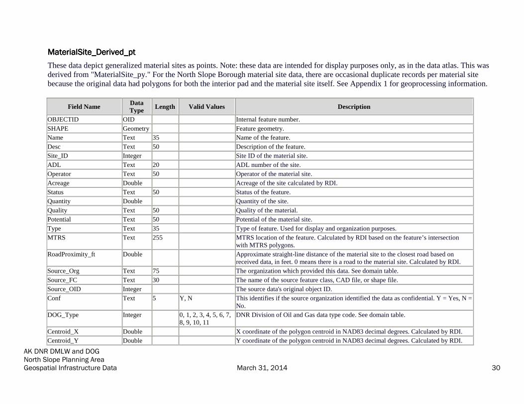
MaterialSite_MaterialSite_MaterialSite_MaterialSite_Derived_ptDerived_ptDerived_ptDerived_pt
These data depict generalized material sites as points. Note: these data are intended for display purposes only, as in the data atlas. This was
derived from "MaterialSite_py." For the North Slope Borough material site data, there are occasional duplicate records per material site
because the original data had polygons for both the interior pad and the material site itself. See Appendix 1 for geoprocessing information.
Field Name Data
Type Length Valid Values Description
OBJECTID OID Internal feature number.
SHAPE Geometry Feature geometry.
Name Text 35 Name of the feature.
Desc Text 50 Description of the feature.
Site_ID Integer Site ID of the material site.
ADL Text 20 ADL number of the site.
Operator Text 50 Operator of the material site.
Acreage Double Acreage of the site calculated by RDI.
Status Text 50 Status of the feature.
Quantity Double Quantity of the site.
Quality Text 50 Quality of the material.
Potential Text 50 Potential of the material site.
Type Text 35 Type of feature. Used for display and organization purposes.
MTRS Text 255 MTRS location of the feature. Calculated by RDI based on the feature’s intersection
with MTRS polygons.
RoadProximity_ft Double Approximate straight-line distance of the material site to the closest road based on
received data, in feet. 0 means there is a road to the material site. Calculated by RDI.
Source_Org Text 75 The organization which provided this data. See domain table.
Source_FC Text 30 The name of the source feature class, CAD file, or shape file.
Source_OID Integer The source data's original object ID.
Conf Text 5 Y, N This identifies if the source organization identified the data as confidential. Y = Yes, N =
No.
DOG_Type Integer 0, 1, 2, 3, 4, 5, 6, 7,
8, 9, 10, 11
DNR Division of Oil and Gas data type code. See domain table.
Centroid_X Double X coordinate of the polygon centroid in NAD83 decimal degrees. Calculated by RDI.
Centroid_Y Double Y coordinate of the polygon centroid in NAD83 decimal degrees. Calculated by RDI.

AK DNR DMLW and DOG North Slope Planning Area Geospatial Infrastructure Data March 31, 2014 31
Field Name Data
Type Length Valid Values Description
Acquisition_Date Date Date of data acquisition.

AK DNR DMLW and DOG North Slope Planning Area Geospatial Infrastructure Data March 31, 2014 32
Structure_Derived_ptStructure_Derived_ptStructure_Derived_ptStructure_Derived_pt
These data depict generalized structures as points. Note: these data are intended for display purposes only, as in the data atlas. This was
derived from "Structure_py." See Appendix 1 for geoprocessing information.
Field Name Data
Type Length Valid Values Description
OBJECTID OID Internal feature number.
SHAPE Geometry Feature geometry.
Name Text 35 Name of the feature.
Desc Text 50 Description of the feature.
Operator Text 50 Operator of the structure.
Status Text 20 Status of the feature.
Type Text 35 Type of feature. Used for display and organization purposes.
Source_Org Text 50 The organization which provided this data. See domain table.
Source_FC Text 30 The name of the source feature class, CAD file, or shape file.
Source_OID Integer The source data's original object ID.
Conf Text 5 Y, N This identifies if the source organization identified the data as confidential. Y = Yes, N =
No.
DOG_Type Integer 0, 1, 2, 3, 4, 5, 6, 7,
8, 9, 10, 11
DNR Division of Oil and Gas data type code. See domain table.
Acquisition_Date Date Date of data acquisition.
Centroid_X Double X coordinate of the polygon centroid in NAD83 decimal degrees. Calculated by RDI.
Centroid_Y Double Y coordinate of the polygon centroid in NAD83 decimal degrees. Calculated by RDI.

AK DNR DMLW and DOG North Slope Planning Area Geospatial Infrastructure Data March 31, 2014 33
DomainDomainDomainDomain TablesTablesTablesTables
Source_Org_CodesSource_Org_CodesSource_Org_CodesSource_Org_Codes
The organization which provided this data. See domain table.
Code Description
ADNR_DOG Alaska Department of Natural Resources Division of Oil and Gas
ADNR_DMLW Alaska Department of Natural Resources Division of Mining, Land & Water
ADOT_PF Alaska Department of Transportation and Public Facilities
BP BP Exploration Alaska
BRPC Brooks Range Petroleum Corporation
GCDB Geographic Coordinate Database
NSB North Slope Borough
REPUS Repsol E&P USA, Inc.
USDOT U.S. Department of Transportation
SPCO State Pipeline Coordinator's Office
CPA ConocoPhilllps Alaska
AOGCC Alaska Oil and Gas Conservation Commission

AK DNR DMLW and DOG North Slope Planning Area Geospatial Infrastructure Data March 31, 2014 34
Well_Class_Codes Well class codes from AOGCC.
Code Description
DEV Development
EXP Exploratory
SER Service
STR Stratigraphic Test

AK DNR DMLW and DOG North Slope Planning Area Geospatial Infrastructure Data March 31, 2014 35
Well_Status_CodesWell_Status_CodesWell_Status_CodesWell_Status_Codes
Well status codes from AOGCC.
Code Description
1-CBNG Coal Bed Natural Gas
1-GAS Gas well, single completion
1G-GS Gas well & Storage well
1GINJ Gas injection, single completion
1G-WD Gas well & Disposal well, dual comp
1MHNG Methane Hydrates Natural Gas
1O-2G Oil & gas well, triple comp, 1oil-2gas
1-OIL Oil well, single completion
1O-WI Oil Well, Alt Wtr Inj, Single Comp
1-SBNG Shale Bed Natural Gas
1WIN2S Water injection, single pool, two tbg strings
1WIN3S Water injection, single pool, three tbg strings
1WINJ Water injection, single completion
2-GAS Gas well, dual completion
2G-GS Gas well (dual) & Storage well
2O-1G Oil & gas well, 2oil-1gas, triple comp
2O-2G Oil & gas well, 2oil-2gas, quad comp
2-OIL Oil well, dual completion
2WINJ Water injection, dual completion
3-GAS Gas well, triple completion
3-OG Oil & gas well, triple completion
3-OIL Oil well, triple completion
ADMA Administratively abandoned
CANC Permit cancelled
CO-1O Commingled well (single), oil
CO-2O Commingled well (dual), oil

AK DNR DMLW and DOG North Slope Planning Area Geospatial Infrastructure Data March 31, 2014 36
Code Description
CO-3G Commingled well (triple), gas
CO-3O Commingled well (triple), oil
COND Condensate well, single comp
EXPIR Permit expired
GASSP Gas supply well
G-C Gas & condensate well
GEOTH Geothermal
GI-1O Gas Inj & Oil Prod, Singl Comp
GSTOR Gas storage well
INFO Information well
NGL Natural Gas Liquids Facility
OBSW Observation well
P&A Plugged & Abandoned
PROW Process well
RELIF Relief Well for Blowout
SI Shut In
SPLUG Surface Plug
SQZED Sqzd orig hole w/mult laterals
SUSP Suspended well
UN Unknown
WAGIN Water alt gas injection
WDSP1 Disposal injection well, Class 1
WDSP2 Disposal injection well, Class 2
WTRSP Water supply well

AK DNR DMLW and DOG North Slope Planning Area Geospatial Infrastructure Data March 31, 2014 37
Appendix 1:Appendix 1:Appendix 1:Appendix 1: Creating the Derived FeatureCreating the Derived FeatureCreating the Derived FeatureCreating the Derived Feature ClassesClassesClassesClasses
This appendix describes the geoprocessing techniques used to develop the derived geodatabase. The
following table summarizes the source and derived feature classes.
Source Feature Classes Derived Feature Classes Atlas Legend Identifier
Airstrip_pt
Airstrip_py
Airstrip_Derived_Merged_pt Airstrips
Airstrip_pt Airstrip_Derived_pt
Well_pt Clustered_Well_Derived_pt Wells (16)
DisposalSites_py DisposalSites_Derived_pt Landfills (Disposal Sites)
GravelPad_py GravelPad_Derived_pt Pads
MaterialSite_py MaterialSite_Derived_pt Mine Sites (>= 5 acres)
Structure_py Structure_Derived_pt Facilities
Drill Pads
Drill Site

AK DNR DMLW and DOG North Slope Planning Area Geospatial Infrastructure Data March 31, 2014 38
Process: Airstrip_Derived_pt, DisposalSites_Derived_pt, Process: Airstrip_Derived_pt, DisposalSites_Derived_pt, Process: Airstrip_Derived_pt, DisposalSites_Derived_pt, Process: Airstrip_Derived_pt, DisposalSites_Derived_pt,
GravelPad_Derived_pt, MaterialSite_Derived_pt, GravelPad_Derived_pt, MaterialSite_Derived_pt, GravelPad_Derived_pt, MaterialSite_Derived_pt, GravelPad_Derived_pt, MaterialSite_Derived_pt, Structure_Derived_ptStructure_Derived_ptStructure_Derived_ptStructure_Derived_pt
The specified North Slope infrastructure feature classes are the sources of the derived feature
class as identified in the table below. The X and Y coordinates for the polygon centroids were
calculated in ArcMap using the Calculate Geometry functionality. The data were then exported to
temporary, intermediate tables. We added these intermediate tables to ArcMap, used the Display
XY Data functionality, and exported the resulting events layers to new feature classes in the
database Derived_Map_Layers.gdb. We then added these derived feature classes to the ArcMap
Atlas mxd and symbolized the data as points.
Source Feature Classes Derived Feature Classes Atlas Legend Identifier
Airstrip_pt Airstrip_Derived_pt Airstrips
DisposalSites_py DisposalSites_Derived_pt Landfills (Disposal Sites)
GravelPad_py GravelPad_Derived_pt Pads
MaterialSite_py MaterialSite_Derived_pt Mine Sites (>= 5 acres)
Structure_py Structure_Derived_pt Facilities
Drill Pads
Drill Site
AK DNR DMLW and DOG North Slope Planning Area Geospatial Infrastructure Data March 31, 2014 39
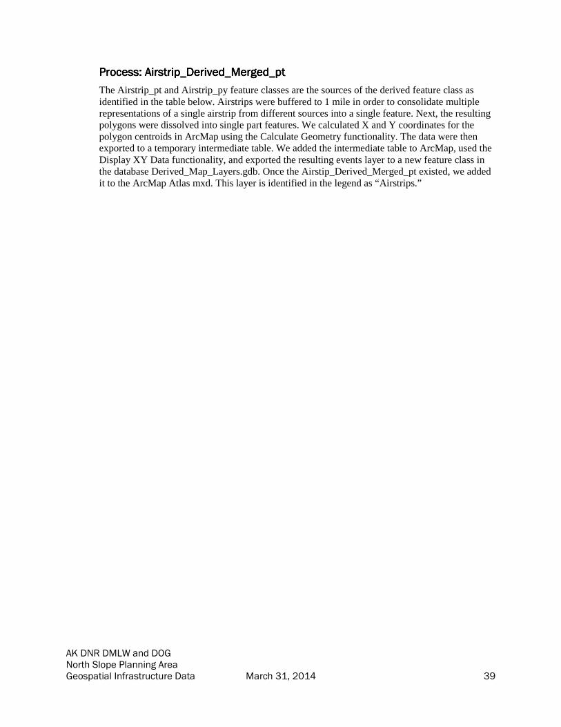
Process: Airstrip_Derived_Merged_ptProcess: Airstrip_Derived_Merged_ptProcess: Airstrip_Derived_Merged_ptProcess: Airstrip_Derived_Merged_pt
The Airstrip_pt and Airstrip_py feature classes are the sources of the derived feature class as
identified in the table below. Airstrips were buffered to 1 mile in order to consolidate multiple
representations of a single airstrip from different sources into a single feature. Next, the resulting
polygons were dissolved into single part features. We calculated X and Y coordinates for the
polygon centroids in ArcMap using the Calculate Geometry functionality. The data were then
exported to a temporary intermediate table. We added the intermediate table to ArcMap, used the
Display XY Data functionality, and exported the resulting events layer to a new feature class in
the database Derived_Map_Layers.gdb. Once the Airstip_Derived_Merged_pt existed, we added
it to the ArcMap Atlas mxd. This layer is identified in the legend as “Airstrips.”

AK DNR DMLW and DOG North Slope Planning Area Geospatial Infrastructure Data March 31, 2014 40
Process: Clustered_Well_Derived_ptProcess: Clustered_Well_Derived_ptProcess: Clustered_Well_Derived_ptProcess: Clustered_Well_Derived_pt
The Well_pt feature class is the source of the Clustered_Well_Derived_pt feature class that
aggregates wells within a geographical area to a single point. Well points were buffered to 250
meters. The resulting polygons were dissolved into derived single part polygon features. We then
joined these derived polygons to the original Well_pt feature class and calculated the summary
and sum value of the join. This represents the count of the wells represented by this derived
polygon. We calculated X and Y coordinates of the polygon centroids in ArcMap using the
Calculate Geometry functionality. The data were then exported to a temporary intermediate table.
We added the temporary table to ArcMap, used the Display XY Data functionality, and exported
the resulting events layer to a new feature class in the database Derived_Map_Layers.gdb. We
then added the Clustered_Well_Derived_pt to the ArcMap Atlas mxd and symbolized the data as
well points labeled by the count of wells calculated previously. The legend entry is Wells (16)
where the number is intended to represent that the label indicates the number of wells represented
by the point.

AK DNR DMLW and DOG North Slope Planning Area Geospatial Infrastructure Data March 31, 2014 41
Appendix 2Appendix 2Appendix 2Appendix 2:::: Data AcquisitionData AcquisitionData AcquisitionData Acquisition
RDI contacted candidate organizations that were thought to have potentially pertinent information to this
project. The initial list of candidate organizations was designed to include as many organizations as
possible, recognizing that many of these organizations might not have relevant data. Beginning in Fall
2013, we sent letters to the organizations listed below. During the next several months, RDI and DNR
responded to requests from the organizations for clarification, documented responses indicating that none
of the requested information is available, and cataloged the submitted data as it was received.
Source Organization Summary of Response
Alaska Department of Environmental Conservation Responded no relevant
information
Alaska Department of Fish and Game Responded no relevant
information
Alaska Department of Transportation and Public Facilities Provided relevant
information
Alaska Department of Natural Resources – Division of Mining, Land and
Water
Provided relevant
information
Alaska Department of Natural Resources – Division of Oil and Gas Provided relevant
information
Alaska Department of Natural Resources – Joint Pipeline Office for TAPS Provided relevant
information
Alaska Oil and Gas Conservation Commission Provided relevant
information
Alyeska Pipeline Company DNR determined this
information was available
from the Joint Pipeline
Office
Anadarko Petroleum Corporation Responded no relevant
information
Arctic Slope Regional Corporation Responded no relevant
information
ASRC Exploration, LLC Responded no relevant
information
BP Exploration Alaska Provided relevant
information
Brooks Range Petroleum Corporation Provided relevant
information
ConocoPhillips Alaska Provided relevant
information
ENI Petroleum Company Provided relevant
information
ExxonMobil Corporation Provided Environmental
Impact Statement

AK DNR DMLW and DOG North Slope Planning Area Geospatial Infrastructure Data March 31, 2014 42
Source Organization Summary of Response
Geographic Coordinate Database Provided relevant
information
Great Bear Petroleum, LLC Responded no relevant
information
Natural Resources Conservation Service Responded no relevant
information
Nordaq Energy, Inc. Responded no relevant
information
North Slope Borough Provided relevant
information
Pioneer Natural Resources Alaska, Inc. (Caelus Energy Alaska) DNR determined no
relevant information
Public Land Survey System Responded no relevant
information that was not
provided by another public
source
Repsol E&P USA, Inc. Provided relevant
information
Savant Alaska, LLC Responded no relevant
information
Shell Offshore, Inc. Responded no relevant
information
U.S. Army Corps of Engineers Responded no relevant
information
U.S. Department of Transportation Provided relevant
information
U.S. Geological Survey Responded no relevant
information
Ultrastar Exploration, LLC No longer a potential data
source
University of Alaska Fairbanks DNR determined no
relevant information
UIC Holdings, LLC Responded no relevant
information that was not
provided by another public
source

AK DNR DMLW and DOG North Slope Planning Area Geospatial Infrastructure Data March 31, 2014 43
Sample Letter
The following sample letter illustrates the content sent to all source organizations. The specific contact
information has been removed as it is no longer valid.
Re: Infrastructure and Material Source Data Collection Contract, TO# 0086-10-13-01, with
Resource Data, Inc., 560 E. 34th St, Suite 100, Anchorage, AK 99518
To Whom It May Concern:
The Department of Natural Resources (DNR) has begun a land management planning project for
state lands on the North Slope of Alaska. Our firm has been contracted to collect existing digital
information on state land that will be used to develop a North Slope management plan. The data
collected will be public information unless confidentiality is specifically requested under AS
38.05.035(a)(8). We’ve attached the authorization from DNR explaining this.
The State is requesting digital location information for material staging and oil and gas operations
infrastructure on all state owned and state-selected lands on the North Slope of Alaska, including
uplands, shorelands, tidelands, and submerged lands. Please see the attached map for the
areas of interest. Typical infrastructure information includes the following.
• Material (sand and gravel) sources
• Roads, by type of road -winter, summer, year-round
• Trails, by type of trail - winter, summer, year-round
• Bridges
• Docks, harbors and other man-made wharfs or structures, public and private
• Offshore structures and causeways, e.g, man-made islands
• Airstrips, public and private, seasonal or year-round
• Pipelines, by type of pipeline - gas, oil, water, multi-phase, etc.
• Transmission lines and utility corridors, by type of transmission line
• Cell towers, or other transmission towers
• Base camps, by type and use of camp
• Drill pads and storage areas
• Processing facilities
• Miscellaneous facilities by type and use of facility (machine shops, support services, etc.)
• Gas compression and storage facilities
• Power facilities
• Tank Farms
• Abandoned well sites
• Waste disposal sites and reserve pits
We are looking for any format of spatial information including spreadsheets or similar files with
latitude/longitudes or any of the standard GIS formats. If you have data in the pipeline open data
standard (PODS), the State of Alaska has requested that it be submitted in the PODS model.
Please submit any data that your organization has that can help us in compiling information for
DNR, for use with this project by October 1. You may upload your data to our file storage
location.. If you would like to use this, please contact <name was provided> at <phone number>
AK DNR DMLW and DOG North Slope Planning Area Geospatial Infrastructure Data March 31, 2014 44
and she will provide a logon and instructions. If your data is available for download, please let us
know and we will download it. Alternatively, you may send us hard drives, usb thumb drives, or
other physical media. You can mail these to our main office in Anchorage, at the following
address:
Resource Data, Inc.
560 E. 34th St.
Suite 100
Anchorage, AK 99503
Please let us know if you want your physical media returned. In the event that the data is only
contained on physical maps, we can also receive those by mail. We will not return physical maps
as we must submit them to the state.
Your assistance in helping us gather this data is greatly appreciated. Thank you for your
cooperation. We look forward to working with you.
If you have any questions please contact <contact info>.
Sincerely,
<name was provided>
Programmer/Analyst
Resource Data, Inc. (907) 770-4100 <email was provided>

AK DNR DMLW and DOG North Slope Planning Area Geospatial Infrastructure Data March 31, 2014 45

AK DNR DMLW and DOG North Slope Planning Area Geospatial Infrastructure Data March 31, 2014 46

AK DNR DMLW and DOG North Slope Planning Area Geospatial Infrastructure Data March 31, 2014 47

AK DNR DMLW and DOG North Slope Planning Area Geospatial Infrastructure Data March 31, 2014 48
Appendix 3: List of Acronyms
The following table defines acronyms used in this document.
Acronym Definition
ADL Alaska Division of Lands (previous name for the DMLW land
management group)
ADOTPF Alaska Department of Transportation and Public Facilities
AOGCC Alaska Oil and Gas Conservation Commission
API American Petroleum Institute
ASAP Alaska Stand Alone Pipeline
CAD Computer-aided Design
DOG Division of Oil and Gas
DNR Alaska Department of Natural Resources
DMLW Division of Mining, Land and Water
FAA Federal Aviation Administration
FC Feature Class
FGL Fuel Gas Line
GIS Geographic Information System
LN Line (Esri geometry type)
LNG Liquefied Natural Gas
MTRS Meridian, Township, Range, Section
NS North Slope
PDF Portable Document Format
PODS Pipeline Open Data Standards
PT Point (Esri geometry type)
PY Polygon (Esri geometry type)
RDI Resource Data, Inc
TAPS Trans-Alaska Pipeline System
USDOT United States Department of Transportation

AK DNR DMLW and DOG North Slope Planning Area Geospatial Infrastructure Data March 31, 2014 49
Appendix 4Appendix 4Appendix 4Appendix 4:::: MetadataMetadataMetadataMetadata
This appendix contains the metadata for all of the feature classes and all of the georeferenced
pdf’s in the two geodatabases: DNR_NS_Planning_Infrastructure.gdb and
Derived_Map_Layers.gdb.

AK DNR DMLW and DOG North Slope Planning Area Geospatial Infrastructure Data March 31, 2014 50
Section 1 – Feature Class Metadata
Airstrips; Points Metadata
• Identification_Information
• Data_Quality_Information
• Spatial_Data_Organization_Information
• Spatial_Reference_Information
• Entity_and_Attribute_Information
• Metadata_Reference_Information
Identification_Information:
Citation:
Citation_Information:
Publication_Date: 20140113
Publication_Time: 020000
Title: Airstrips; Points
Geospatial_Data_Presentation_Form: vector digital data
Description:
Abstract: These data depict airstrips in point format.
Purpose:
This dataset was developed for the Alaska Department of Natural Resources under TOPS
Contract 0086-10-13-010 to compile existing data of infrastructure and material sources
on the North Slope of Alaska. Data were compiled by Resource Data, Inc. in 2013-2014
from existing data supplied by various organizations.
Status:
Progress: Complete
Maintenance_and_Update_Frequency: None planned
Spatial_Domain:
Bounding_Coordinates:
West_Bounding_Coordinate: -180.000000
East_Bounding_Coordinate: 180.000000
North_Bounding_Coordinate: 71.310271
South_Bounding_Coordinate: 51.730300
Keywords:
Theme:
Theme_Keyword_Thesaurus: Unknown
Theme_Keyword: Airstrip
Theme_Keyword: Alaska
Theme_Keyword: North Slope
Theme:
Theme_Keyword_Thesaurus: ISO 19115 Topic Categories
Theme_Keyword: structure
Theme_Keyword: utilitiesCommunication
Theme_Keyword: transportation
Theme_Keyword: location

AK DNR DMLW and DOG North Slope Planning Area Geospatial Infrastructure Data March 31, 2014 51
Theme_Keyword: planningCadastre
Theme:
Theme_Keyword_Thesaurus: ISO 19115 Topic Categories
Theme_Keyword: transportation
Theme_Keyword: location
Theme_Keyword: planningCadastre
Theme_Keyword: structure
Theme_Keyword: utilitiesCommunication
Temporal:
Temporal_Keyword_Thesaurus: Unknown
Temporal_Keyword: Unknown
Access_Constraints: None
Use_Constraints:
Use limited by Alaska DNR. Features identified with field CONF = "Y" were identified
as confidential by the source organization.
Point_of_Contact:
Contact_Information:
Contact_Organization_Primary:
Contact_Organization:
AK Department of Natural Resources - Information Resource Management Section
Contact_Person: GIS Public Access Coordinator
Contact_Position: GIS Public Access Coordinator
Contact_Address:
Address_Type: mailing and physical
Address: 550 W. 7th Suite 706
City: Anchorage
State_or_Province: AK
Postal_Code: 99501
Country: US
Contact_Voice_Telephone: 907 269 8839
Contact_Facsimile_Telephone: 907 269 8920
Contact_Electronic_Mail_Address: [email protected]
Hours_of_Service: 800-1600 AST
Point_of_Contact:
Contact_Information:
Contact_Organization_Primary:
Contact_Organization:
AK Department of Natural Resources - Information Resource Management Section
Contact_Person: GIS Public Access Coordinator
Contact_Position: GIS Public Access Coordinator
Contact_Address:
Address_Type: mailing and physical
Address: 550 W. 7th Suite 706
City: Anchorage
State_or_Province: AK
Postal_Code: 99501
Country: US
AK DNR DMLW and DOG North Slope Planning Area Geospatial Infrastructure Data March 31, 2014 52
Contact_Voice_Telephone: 907 269 8839
Contact_Facsimile_Telephone: 907 269 8920
Contact_Electronic_Mail_Address: [email protected]
Hours_of_Service: 800-1600 AST
Native_Data_Set_Environment:
Microsoft Windows 7 Version 6.1 (Build 7601) Service Pack 1; Esri ArcGIS 10.1.0.3035
Data_Quality_Information:
Logical_Consistency_Report: Unknown
Lineage:
Process_Step:
Process_Description:
Data were obtained from ADNR DOG, ADOT PF, and North Slope Borough. The data
were then loaded into the feature class. Each record includes the attribution to link back
to the original source, including source organization, source feature name, source object
ID, confidentiality information, and DNR data types. See each record's attributes for this
information.
Process_Date: 20140110
Spatial_Data_Organization_Information:
Direct_Spatial_Reference_Method: Vector
Point_and_Vector_Object_Information:
SDTS_Terms_Description:
SDTS_Point_and_Vector_Object_Type: Entity point
Point_and_Vector_Object_Count: 469
Spatial_Reference_Information:
Horizontal_Coordinate_System_Definition:
Planar:
Map_Projection:
Map_Projection_Name: Albers Conical Equal Area
Albers_Conical_Equal_Area:
Standard_Parallel: 55.0
Standard_Parallel: 65.0
Longitude_of_Central_Meridian: -154.0
Latitude_of_Projection_Origin: 50.0
False_Easting: 0.0
False_Northing: 0.0
Planar_Coordinate_Information:
Planar_Coordinate_Encoding_Method: coordinate pair
Coordinate_Representation:
Abscissa_Resolution: 0.0001
Ordinate_Resolution: 0.0001
Planar_Distance_Units:
Geodetic_Model:
Horizontal_Datum_Name: D North American 1983
Ellipsoid_Name: GRS 1980

AK DNR DMLW and DOG North Slope Planning Area Geospatial Infrastructure Data March 31, 2014 53
Semi-major_Axis: 6378137.0
Denominator_of_Flattening_Ratio: 298.257222101
Entity_and_Attribute_Information:
Detailed_Description:
Entity_Type:
Entity_Type_Label: Airstrip_pt
Entity_Type_Definition:
Airstrip data in point format provided by the source organizations.
Entity_Type_Definition_Source: RDI
Attribute:
Attribute_Label: Source_OID
Attribute_Definition: The source data's original object ID.
Attribute_Definition_Source: RDI
Attribute_Domain_Values:
Unrepresentable_Domain: Source object ID.
Attribute:
Attribute_Label: OBJECTID
Attribute_Definition: Internal feature number.
Attribute_Definition_Source: Esri
Attribute_Domain_Values:
Unrepresentable_Domain:
Sequential unique whole numbers that are automatically generated by the GIS
application.
Attribute:
Attribute_Label: SHAPE
Attribute_Definition: Feature geometry.
Attribute_Definition_Source: Esri
Attribute_Domain_Values:
Unrepresentable_Domain: Coordinates defining the features.
Attribute:
Attribute_Label: Code
Attribute_Definition: FAA airport code.
Attribute_Definition_Source: RDI
Attribute_Domain_Values:
Unrepresentable_Domain: FAA airport code.
Attribute:
Attribute_Label: SiteNum
Attribute_Definition: Site number.
Attribute_Definition_Source: RDI
Attribute_Domain_Values:
Unrepresentable_Domain: Site number.
Attribute:
Attribute_Label: Type
Attribute_Definition: Type of feature. Used for display and organization purposes.
Attribute_Definition_Source: RDI
Attribute_Domain_Values:

AK DNR DMLW and DOG North Slope Planning Area Geospatial Infrastructure Data March 31, 2014 54
Unrepresentable_Domain: Type of feature. Used for display and organization purposes.
Attribute:
Attribute_Label: Name
Attribute_Definition: Name of the feature.
Attribute_Definition_Source: RDI
Attribute_Domain_Values:
Unrepresentable_Domain: Name of the feature.
Attribute:
Attribute_Label: Length_ft
Attribute_Definition: Length of the airstrip in feet.
Attribute_Definition_Source: RDI
Attribute_Domain_Values:
Unrepresentable_Domain: Length of the airstrip in feet.
Attribute:
Attribute_Label: Elev
Attribute_Definition: Elevation of the airstrip.
Attribute_Definition_Source: RDI
Attribute_Domain_Values:
Unrepresentable_Domain: Elevation of the airstrip.
Attribute:
Attribute_Label: Desc
Attribute_Definition: Description of the feature.
Attribute_Definition_Source: RDI
Attribute_Domain_Values:
Unrepresentable_Domain: Description of the feature.
Attribute:
Attribute_Label: Operator
Attribute_Definition: Operator of the airstrip.
Attribute_Definition_Source: RDI
Attribute_Domain_Values:
Unrepresentable_Domain: Operator of the airstrip.
Attribute:
Attribute_Label: Notes
Attribute_Definition: Notes about the feature.
Attribute_Definition_Source: RDI
Attribute_Domain_Values:
Unrepresentable_Domain: Notes about the feature.
Attribute:
Attribute_Label: Status
Attribute_Definition: Status of the feature.
Attribute_Definition_Source: RDI
Attribute_Domain_Values:
Unrepresentable_Domain: Status of the feature.
Attribute:
Attribute_Label: Source_Org
Attribute_Definition: The organization which provided this data.
Attribute_Definition_Source: RDI

AK DNR DMLW and DOG North Slope Planning Area Geospatial Infrastructure Data March 31, 2014 55
Attribute_Domain_Values:
Unrepresentable_Domain: Name of source organization.
Attribute:
Attribute_Label: Source_FC
Attribute_Definition: The name of the source featureclass, CAD file, or shapefile.
Attribute_Definition_Source: RDI
Attribute_Domain_Values:
Unrepresentable_Domain: Name of source featureclass.
Attribute:
Attribute_Label: Conf
Attribute_Definition:
This identifies if the source organization identified the data as confidential.
Attribute_Definition_Source: RDI
Attribute_Domain_Values:
Enumerated_Domain:
Enumerated_Domain_Value: Y
Enumerated_Domain_Value_Definition: Data is confidential.
Enumerated_Domain_Value_Definition_Source: RDI
Enumerated_Domain:
Enumerated_Domain_Value: N
Enumerated_Domain_Value_Definition: Data is not confidential.
Enumerated_Domain_Value_Definition_Source: RDI
Attribute:
Attribute_Label: DOG_Type
Attribute_Definition: ADNR Division of Oil and Gas data type code.
Attribute_Definition_Source: ADNR DOG
Attribute_Domain_Values:
Enumerated_Domain:
Enumerated_Domain_Value: 0
Enumerated_Domain_Value_Definition: Unknown infrastructure
Enumerated_Domain_Value_Definition_Source: ADNR DOG
Enumerated_Domain:
Enumerated_Domain_Value: 1
Enumerated_Domain_Value_Definition: Highway
Enumerated_Domain_Value_Definition_Source: ADNR DOG
Enumerated_Domain:
Enumerated_Domain_Value: 2
Enumerated_Domain_Value_Definition: Secondary Road
Enumerated_Domain_Value_Definition_Source: ADNR DOG
Enumerated_Domain:
Enumerated_Domain_Value: 3
Enumerated_Domain_Value_Definition: Trail
Enumerated_Domain_Value_Definition_Source: ADNR DOG
Enumerated_Domain:
Enumerated_Domain_Value: 4
Enumerated_Domain_Value_Definition: Railroad
Enumerated_Domain_Value_Definition_Source: ADNR DOG

AK DNR DMLW and DOG North Slope Planning Area Geospatial Infrastructure Data March 31, 2014 56
Enumerated_Domain:
Enumerated_Domain_Value: 5
Enumerated_Domain_Value_Definition: Electrical
Enumerated_Domain_Value_Definition_Source: ADNR DOG
Enumerated_Domain:
Enumerated_Domain_Value: 6
Enumerated_Domain_Value_Definition: Telephone
Enumerated_Domain_Value_Definition_Source: ADNR DOG
Enumerated_Domain:
Enumerated_Domain_Value: 7
Enumerated_Domain_Value_Definition: Landing strip
Enumerated_Domain_Value_Definition_Source: ADNR DOG
Enumerated_Domain:
Enumerated_Domain_Value: 8
Enumerated_Domain_Value_Definition: Pipeline
Enumerated_Domain_Value_Definition_Source: ADNR DOG
Enumerated_Domain:
Enumerated_Domain_Value: 9
Enumerated_Domain_Value_Definition: Forest Development Road
Enumerated_Domain_Value_Definition_Source: ADNR DOG
Enumerated_Domain:
Enumerated_Domain_Value: 10
Enumerated_Domain_Value_Definition: Alaska Marine Highway
Enumerated_Domain_Value_Definition_Source: ADNR DOG
Enumerated_Domain:
Enumerated_Domain_Value: 11
Enumerated_Domain_Value_Definition: Fiberoptic
Enumerated_Domain_Value_Definition_Source: ADNR DOG
Attribute:
Attribute_Label: Acquisition_Date
Attribute_Definition: Date of data acquisition.
Attribute_Definition_Source: RDI
Overview_Description:
Entity_and_Attribute_Overview:
The data in this feature class were obtained and consolidated from several source
organizations as noted in the lineage. During this consolidation, data attributes were
abstracted to load all similar information into a single field (for example Name, short
description, feature_name would have all been loaded to NAME). Because the data did
not always include a data dictionary, not all domains are defined. Please see the original
data for full information from the data's originator. Data are provided as unchanged from
source organizations.
The fields populated by RDI for Alaska DNR are described in this metadata.
Metadata_Reference_Information:
Metadata_Date: 20140226
Metadata_Contact:
Contact_Information:

AK DNR DMLW and DOG North Slope Planning Area Geospatial Infrastructure Data March 31, 2014 57
Contact_Organization_Primary:
Contact_Organization: Resource Data, Inc.
Contact_Person: Bixler McClure
Contact_Position: GIS Programmer/Analyst
Contact_Address:
Address_Type: mailing and physical
Address: 560 E. 34th Ave., Suite 100
City: Anchorage
State_or_Province: AK
Postal_Code: 99503
Country: US
Contact_Voice_Telephone: 907-563-8100
Contact_Facsimile_Telephone: 907-561-0159
Contact_Electronic_Mail_Address: [email protected]
Metadata_Standard_Name: FGDC Content Standard for Digital Geospatial Metadata
Metadata_Standard_Version: FGDC-STD-001-1998
Metadata_Time_Convention: local time
Generated by mp version 2.9.12 on Tue Mar 18 09:48:39 2014
AK DNR DMLW and DOG North Slope Planning Area Geospatial Infrastructure Data March 31, 2014 58
Airstrips; Polygons Metadata
• Identification_Information
• Data_Quality_Information
• Spatial_Data_Organization_Information
• Spatial_Reference_Information
• Entity_and_Attribute_Information
• Metadata_Reference_Information
Identification_Information:
Citation:
Citation_Information:
Publication_Date: 20140113
Publication_Time: 020000
Title: Airstrips; Polygons
Geospatial_Data_Presentation_Form: vector digital data
Description:
Abstract: These data depict airstrips in polygon format.
Purpose:
This dataset was developed for the Alaska Department of Natural Resources under TOPS
Contract 0086-10-13-010 to compile existing data of infrastructure and material sources
on the North Slope of Alaska. Data were compiled by Resource Data, Inc. in 2013-2014
from existing data supplied by various organizations.
Status:
Progress: Complete
Maintenance_and_Update_Frequency: None planned
Spatial_Domain:
Bounding_Coordinates:
West_Bounding_Coordinate: -162.238476
East_Bounding_Coordinate: -141.736883
North_Bounding_Coordinate: 71.360754
South_Bounding_Coordinate: 67.794141
Keywords:
Theme:
Theme_Keyword_Thesaurus: ISO 19115 Topic Categories
Theme_Keyword: location
Theme_Keyword: structure
Theme_Keyword: utilitiesCommunication
Theme_Keyword: transportation
Theme_Keyword: planningCadastre
Theme:
Theme_Keyword_Thesaurus: Unknown
Theme_Keyword: Airstrip
Theme_Keyword: Alaska
Theme_Keyword: North Slope
Temporal:

AK DNR DMLW and DOG North Slope Planning Area Geospatial Infrastructure Data March 31, 2014 59
Temporal_Keyword_Thesaurus: Unknown
Temporal_Keyword: Unknown
Access_Constraints: None
Use_Constraints:
Use limited by Alaska DNR. Features identified with field CONF = "Y" were identified
as confidential by the source organization.
Point_of_Contact:
Contact_Information:
Contact_Organization_Primary:
Contact_Organization:
AK Department of Natural Resources - Information Resource Management Section
Contact_Person: GIS Public Access Coordinator
Contact_Position: GIS Public Access Coordinator
Contact_Address:
Address_Type: mailing and physical
Address: 550 W. 7th Suite 706
City: Anchorage
State_or_Province: AK
Postal_Code: 99501
Country: US
Contact_Voice_Telephone: 907 269 8839
Contact_Facsimile_Telephone: 907 269 8920
Contact_Electronic_Mail_Address: [email protected]
Hours_of_Service: 800-1600 AST
Point_of_Contact:
Contact_Information:
Contact_Organization_Primary:
Contact_Organization:
AK Department of Natural Resources - Information Resource Management Section
Contact_Person: GIS Public Access Coordinator
Contact_Position: GIS Public Access Coordinator
Contact_Address:
Address_Type: mailing and physical
Address: 550 W. 7th Suite 706
City: Anchorage
State_or_Province: AK
Postal_Code: 99501
Country: US
Contact_Voice_Telephone: 907 269 8839
Contact_Facsimile_Telephone: 907 269 8920
Contact_Electronic_Mail_Address: [email protected]
Hours_of_Service: 800-1600 AST
Native_Data_Set_Environment:
Microsoft Windows 7 Version 6.1 (Build 7601) Service Pack 1; Esri ArcGIS 10.1.0.3035
Data_Quality_Information:
Logical_Consistency_Report: Unknown

AK DNR DMLW and DOG North Slope Planning Area Geospatial Infrastructure Data March 31, 2014 60
Lineage:
Process_Step:
Process_Description:
Data were obtained from ADNR DOG. The data were then loaded into the feature class.
Each record includes the attribution to link back to the original source, including source
organization, source feature name, source object ID, confidentiality information, and
DNR data types. See each record's attributes for this information.
Process_Date: 20140110
Spatial_Data_Organization_Information:
Direct_Spatial_Reference_Method: Vector
Point_and_Vector_Object_Information:
SDTS_Terms_Description:
SDTS_Point_and_Vector_Object_Type: GT-polygon composed of chains
Point_and_Vector_Object_Count: 50
Spatial_Reference_Information:
Horizontal_Coordinate_System_Definition:
Planar:
Map_Projection:
Map_Projection_Name: Albers Conical Equal Area
Albers_Conical_Equal_Area:
Standard_Parallel: 55.0
Standard_Parallel: 65.0
Longitude_of_Central_Meridian: -154.0
Latitude_of_Projection_Origin: 50.0
False_Easting: 0.0
False_Northing: 0.0
Planar_Coordinate_Information:
Planar_Coordinate_Encoding_Method: coordinate pair
Coordinate_Representation:
Abscissa_Resolution: 0.0001
Ordinate_Resolution: 0.0001
Planar_Distance_Units:
Geodetic_Model:
Horizontal_Datum_Name: D North American 1983
Ellipsoid_Name: GRS 1980
Semi-major_Axis: 6378137.0
Denominator_of_Flattening_Ratio: 298.257222101
Entity_and_Attribute_Information:
Detailed_Description:
Entity_Type:
Entity_Type_Label: Airstrip_py
Entity_Type_Definition:
Airstrip data in polygon format provided by the source organizations.
Entity_Type_Definition_Source: RDI
AK DNR DMLW and DOG North Slope Planning Area Geospatial Infrastructure Data March 31, 2014 61
Attribute:
Attribute_Label: Source_OID
Attribute_Definition: The source data's original object ID.
Attribute_Definition_Source: RDI
Attribute_Domain_Values:
Unrepresentable_Domain: Source object ID.
Attribute:
Attribute_Label: Desc
Attribute_Definition: Description of the feature.
Attribute_Definition_Source: RDI
Attribute_Domain_Values:
Unrepresentable_Domain: Description of the feature.
Attribute:
Attribute_Label: DOG_Type
Attribute_Definition: ADNR Division of Oil and Gas data type code.
Attribute_Definition_Source: ADNR DOG
Attribute_Domain_Values:
Enumerated_Domain:
Enumerated_Domain_Value: 0
Enumerated_Domain_Value_Definition: Unknown infrastructure
Enumerated_Domain_Value_Definition_Source: ADNR DOG
Enumerated_Domain:
Enumerated_Domain_Value: 4
Enumerated_Domain_Value_Definition: Railroad
Enumerated_Domain_Value_Definition_Source: ADNR DOG
Enumerated_Domain:
Enumerated_Domain_Value: 1
Enumerated_Domain_Value_Definition: Highway
Enumerated_Domain_Value_Definition_Source: ADNR DOG
Enumerated_Domain:
Enumerated_Domain_Value: 2
Enumerated_Domain_Value_Definition: Secondary Road
Enumerated_Domain_Value_Definition_Source: ADNR DOG
Enumerated_Domain:
Enumerated_Domain_Value: 9
Enumerated_Domain_Value_Definition: Forest Development Road
Enumerated_Domain_Value_Definition_Source: ADNR DOG
Enumerated_Domain:
Enumerated_Domain_Value: 7
Enumerated_Domain_Value_Definition: Landing strip
Enumerated_Domain_Value_Definition_Source: ADNR DOG
Enumerated_Domain:
Enumerated_Domain_Value: 3
Enumerated_Domain_Value_Definition: Trail
Enumerated_Domain_Value_Definition_Source: ADNR DOG
Enumerated_Domain:
Enumerated_Domain_Value: 10

AK DNR DMLW and DOG North Slope Planning Area Geospatial Infrastructure Data March 31, 2014 62
Enumerated_Domain_Value_Definition: Alaska Marine Highway
Enumerated_Domain_Value_Definition_Source: ADNR DOG
Enumerated_Domain:
Enumerated_Domain_Value: 8
Enumerated_Domain_Value_Definition: Pipeline
Enumerated_Domain_Value_Definition_Source: ADNR DOG
Enumerated_Domain:
Enumerated_Domain_Value: 6
Enumerated_Domain_Value_Definition: Telephone
Enumerated_Domain_Value_Definition_Source: ADNR DOG
Enumerated_Domain:
Enumerated_Domain_Value: 11
Enumerated_Domain_Value_Definition: Fiberoptic
Enumerated_Domain_Value_Definition_Source: ADNR DOG
Enumerated_Domain:
Enumerated_Domain_Value: 5
Enumerated_Domain_Value_Definition: Electrical
Enumerated_Domain_Value_Definition_Source: ADNR DOG
Attribute:
Attribute_Label: Operator
Attribute_Definition: Operator of the airstrip.
Attribute_Definition_Source: RDI
Attribute_Domain_Values:
Unrepresentable_Domain: Operator of the airstrip.
Attribute:
Attribute_Label: Conf
Attribute_Definition:
This identifies if the source organization identified the data as confidential.
Attribute_Definition_Source: RDI
Attribute_Domain_Values:
Enumerated_Domain:
Enumerated_Domain_Value: N
Enumerated_Domain_Value_Definition: Data is not confidential.
Enumerated_Domain_Value_Definition_Source: RDI
Enumerated_Domain:
Enumerated_Domain_Value: Y
Enumerated_Domain_Value_Definition: Data is confidential.
Enumerated_Domain_Value_Definition_Source: RDI
Attribute:
Attribute_Label: SiteNum
Attribute_Definition: Site number.
Attribute_Definition_Source: RDI
Attribute_Domain_Values:
Unrepresentable_Domain: Site number.
Attribute:
Attribute_Label: SHAPE
Attribute_Definition: Feature geometry.

AK DNR DMLW and DOG North Slope Planning Area Geospatial Infrastructure Data March 31, 2014 63
Attribute_Definition_Source: Esri
Attribute_Domain_Values:
Unrepresentable_Domain: Coordinates defining the features.
Attribute:
Attribute_Label: Source_Org
Attribute_Definition: The organization which provided this data.
Attribute_Definition_Source: RDI
Attribute_Domain_Values:
Unrepresentable_Domain: Name of source organization.
Attribute:
Attribute_Label: Status
Attribute_Definition: Status of the feature.
Attribute_Definition_Source: RDI
Attribute_Domain_Values:
Unrepresentable_Domain: Status of the feature.
Attribute:
Attribute_Label: Notes
Attribute_Definition: Notes about the feature.
Attribute_Definition_Source: RDI
Attribute_Domain_Values:
Unrepresentable_Domain: Notes about the feature.
Attribute:
Attribute_Label: OBJECTID
Attribute_Definition: Internal feature number.
Attribute_Definition_Source: Esri
Attribute_Domain_Values:
Unrepresentable_Domain:
Sequential unique whole numbers that are automatically generated by the GIS
application.
Attribute:
Attribute_Label: Elev
Attribute_Definition: Elevation of the airstrip.
Attribute_Definition_Source: RDI
Attribute_Domain_Values:
Unrepresentable_Domain: Elevation of the airstrip.
Attribute:
Attribute_Label: Length_ft
Attribute_Definition: Length of the airstrip in feet.
Attribute_Definition_Source: RDI
Attribute_Domain_Values:
Unrepresentable_Domain: Length of the airstrip in feet.
Attribute:
Attribute_Label: Name
Attribute_Definition: Name of the feature.
Attribute_Definition_Source: RDI
Attribute_Domain_Values:
Unrepresentable_Domain: Name of the feature.

AK DNR DMLW and DOG North Slope Planning Area Geospatial Infrastructure Data March 31, 2014 64
Attribute:
Attribute_Label: Code
Attribute_Definition: FAA airport code.
Attribute_Definition_Source: RDI
Attribute_Domain_Values:
Unrepresentable_Domain: FAA airport code.
Attribute:
Attribute_Label: Type
Attribute_Definition: Type of feature. Used for display and organization purposes.
Attribute_Definition_Source: RDI
Attribute_Domain_Values:
Unrepresentable_Domain: Type of feature. Used for display and organization purposes.
Attribute:
Attribute_Label: Source_FC
Attribute_Definition: The name of the source featureclass, CAD file, or shapefile.
Attribute_Definition_Source: RDI
Attribute_Domain_Values:
Unrepresentable_Domain: Name of source featureclass.
Attribute:
Attribute_Label: SHAPE_Length
Attribute_Definition: Length of feature in internal units.
Attribute_Definition_Source: Esri
Attribute_Domain_Values:
Unrepresentable_Domain: Positive real numbers that are automatically generated.
Attribute:
Attribute_Label: SHAPE_Area
Attribute_Definition: Area of feature in internal units squared.
Attribute_Definition_Source: Esri
Attribute_Domain_Values:
Unrepresentable_Domain: Positive real numbers that are automatically generated.
Attribute:
Attribute_Label: Acquisition_Date
Attribute_Definition: Date of data acquisition.
Attribute_Definition_Source: RDI
Attribute:
Attribute_Label: Centroid_X
Attribute:
Attribute_Label: Centroid_Y
Overview_Description:
Entity_and_Attribute_Overview:
The data in this feature class were obtained and consolidated from several source
organizations as noted in the lineage. During this consolidation, data attributes were
abstracted to load all similar information into a single field (for example Name, short
description, feature_name would have all been loaded to NAME). Because the data did
not always include a data dictionary, not all domains are defined. Please see the original
data for full information from the data's originator. Data are provided as unchanged from

AK DNR DMLW and DOG North Slope Planning Area Geospatial Infrastructure Data March 31, 2014 65
source organizations. The fields populated by RDI for Alaska DNR are described in this
metadata.
Metadata_Reference_Information:
Metadata_Date: 20140226
Metadata_Contact:
Contact_Information:
Contact_Organization_Primary:
Contact_Organization: Resource Data, Inc.
Contact_Person: Bixler McClure
Contact_Position: GIS Programmer/Analyst
Contact_Address:
Address_Type: mailing and physical
Address: 560 E. 34th Ave., Suite 100
City: Anchorage
State_or_Province: AK
Postal_Code: 99503
Country: US
Contact_Voice_Telephone: 907-563-8100
Contact_Facsimile_Telephone: 907-561-0159
Contact_Electronic_Mail_Address: [email protected]
Metadata_Standard_Name: FGDC Content Standard for Digital Geospatial Metadata
Metadata_Standard_Version: FGDC-STD-001-1998
Metadata_Time_Convention: local time
Generated by mp version 2.9.12 on Tue Mar 18 09:48:39 2014
AK DNR DMLW and DOG North Slope Planning Area Geospatial Infrastructure Data March 31, 2014 66
Disposal Sites; Points Metadata
• Identification_Information
• Data_Quality_Information
• Spatial_Data_Organization_Information
• Spatial_Reference_Information
• Entity_and_Attribute_Information
• Metadata_Reference_Information
Identification_Information:
Citation:
Citation_Information:
Publication_Date: 20140113
Publication_Time: 020000
Title: Disposal Sites; Points
Geospatial_Data_Presentation_Form: vector digital data
Description:
Abstract: These data depict disposal sites in point format.
Purpose:
This dataset was developed for the Alaska Department of Natural Resources under TOPS
Contract 0086-10-13-010 to compile existing data of infrastructure and material sources
on the North Slope of Alaska. Data were compiled by Resource Data, Inc. in 2013-2014
from existing data supplied by various organizations.
Status:
Progress: Complete
Maintenance_and_Update_Frequency: None planned
Spatial_Domain:
Bounding_Coordinates:
West_Bounding_Coordinate: -148.523052
East_Bounding_Coordinate: -148.523052
North_Bounding_Coordinate: 70.293535
South_Bounding_Coordinate: 70.293535
Keywords:
Theme:
Theme_Keyword_Thesaurus: ISO 19115 Topic Categories
Theme_Keyword: location
Theme_Keyword: structure
Theme_Keyword: utilitiesCommunication
Theme_Keyword: transportation
Theme_Keyword: planningCadastre
Theme:
Theme_Keyword_Thesaurus: Unknown
Theme_Keyword: Disposal
Theme_Keyword: Alaska
Theme_Keyword: North Slope
Temporal:

AK DNR DMLW and DOG North Slope Planning Area Geospatial Infrastructure Data March 31, 2014 67
Temporal_Keyword_Thesaurus: Unknown
Temporal_Keyword: Unknown
Access_Constraints: None
Use_Constraints:
Use limited by Alaska DNR. Features identified with field CONF = "Y" were identified
as confidential by the source organization.
Point_of_Contact:
Contact_Information:
Contact_Organization_Primary:
Contact_Organization:
AK Department of Natural Resources - Information Resource Management Section
Contact_Person: GIS Public Access Coordinator
Contact_Position: GIS Public Access Coordinator
Contact_Address:
Address_Type: mailing and physical
Address: 550 W. 7th Suite 706
City: Anchorage
State_or_Province: AK
Postal_Code: 99501
Country: US
Contact_Voice_Telephone: 907 269 8839
Contact_Facsimile_Telephone: 907 269 8920
Contact_Electronic_Mail_Address: [email protected]
Hours_of_Service: 800-1600 AST
Point_of_Contact:
Contact_Information:
Contact_Organization_Primary:
Contact_Organization:
AK Department of Natural Resources - Information Resource Management Section
Contact_Person: GIS Public Access Coordinator
Contact_Position: GIS Public Access Coordinator
Contact_Address:
Address_Type: mailing and physical
Address: 550 W. 7th Suite 706
City: Anchorage
State_or_Province: AK
Postal_Code: 99501
Country: US
Contact_Voice_Telephone: 907 269 8839
Contact_Facsimile_Telephone: 907 269 8920
Contact_Electronic_Mail_Address: [email protected]
Hours_of_Service: 800-1600 AST
Native_Data_Set_Environment:
Microsoft Windows 7 Version 6.1 (Build 7601) Service Pack 1; Esri ArcGIS 10.1.0.3035
Data_Quality_Information:
Logical_Consistency_Report: Unknown

AK DNR DMLW and DOG North Slope Planning Area Geospatial Infrastructure Data March 31, 2014 68
Lineage:
Process_Step:
Process_Description:
Data were obtained from Repsol. The data were then loaded into the feature class. Each
record includes the attribution to link back to the original source, including source
organization, source feature name, source object ID, confidentiality information, and
DNR data types. See each record's attributes for this information.
Process_Date: 20140110
Spatial_Data_Organization_Information:
Direct_Spatial_Reference_Method: Vector
Point_and_Vector_Object_Information:
SDTS_Terms_Description:
SDTS_Point_and_Vector_Object_Type: Entity point
Point_and_Vector_Object_Count: 1
Spatial_Reference_Information:
Horizontal_Coordinate_System_Definition:
Planar:
Map_Projection:
Map_Projection_Name: Albers Conical Equal Area
Albers_Conical_Equal_Area:
Standard_Parallel: 55.0
Standard_Parallel: 65.0
Longitude_of_Central_Meridian: -154.0
Latitude_of_Projection_Origin: 50.0
False_Easting: 0.0
False_Northing: 0.0
Planar_Coordinate_Information:
Planar_Coordinate_Encoding_Method: coordinate pair
Coordinate_Representation:
Abscissa_Resolution: 0.0001
Ordinate_Resolution: 0.0001
Planar_Distance_Units:
Geodetic_Model:
Horizontal_Datum_Name: D North American 1983
Ellipsoid_Name: GRS 1980
Semi-major_Axis: 6378137.0
Denominator_of_Flattening_Ratio: 298.257222101
Entity_and_Attribute_Information:
Detailed_Description:
Entity_Type:
Entity_Type_Label: DisposalSites_pt
Entity_Type_Definition:
Disposal sites data in point format provided by the source organizations.
Entity_Type_Definition_Source: RDI

AK DNR DMLW and DOG North Slope Planning Area Geospatial Infrastructure Data March 31, 2014 69
Attribute:
Attribute_Label: Source_FC
Attribute_Definition: The name of the source featureclass, CAD file, or shapefile.
Attribute_Definition_Source: RDI
Attribute_Domain_Values:
Unrepresentable_Domain: Name of source featureclass.
Attribute:
Attribute_Label: Type
Attribute_Definition: Type of feature. Used for display and organization purposes.
Attribute_Definition_Source: RDI
Attribute_Domain_Values:
Unrepresentable_Domain: Type of feature. Used for display and organization purposes.
Attribute:
Attribute_Label: Operator
Attribute_Definition: Operator of the site.
Attribute_Definition_Source: RDI
Attribute_Domain_Values:
Unrepresentable_Domain: Operator of the site.
Attribute:
Attribute_Label: DOG_Type
Attribute_Definition: ADNR Division of Oil and Gas data type code.
Attribute_Definition_Source: ADNR DOG
Attribute_Domain_Values:
Enumerated_Domain:
Enumerated_Domain_Value: 6
Enumerated_Domain_Value_Definition: Telephone
Enumerated_Domain_Value_Definition_Source: ADNR DOG
Enumerated_Domain:
Enumerated_Domain_Value: 2
Enumerated_Domain_Value_Definition: Secondary Road
Enumerated_Domain_Value_Definition_Source: ADNR DOG
Enumerated_Domain:
Enumerated_Domain_Value: 7
Enumerated_Domain_Value_Definition: Landing strip
Enumerated_Domain_Value_Definition_Source: ADNR DOG
Enumerated_Domain:
Enumerated_Domain_Value: 1
Enumerated_Domain_Value_Definition: Highway
Enumerated_Domain_Value_Definition_Source: ADNR DOG
Enumerated_Domain:
Enumerated_Domain_Value: 10
Enumerated_Domain_Value_Definition: Alaska Marine Highway
Enumerated_Domain_Value_Definition_Source: ADNR DOG
Enumerated_Domain:
Enumerated_Domain_Value: 4
Enumerated_Domain_Value_Definition: Railroad
Enumerated_Domain_Value_Definition_Source: ADNR DOG

AK DNR DMLW and DOG North Slope Planning Area Geospatial Infrastructure Data March 31, 2014 70
Enumerated_Domain:
Enumerated_Domain_Value: 11
Enumerated_Domain_Value_Definition: Fiberoptic
Enumerated_Domain_Value_Definition_Source: ADNR DOG
Enumerated_Domain:
Enumerated_Domain_Value: 9
Enumerated_Domain_Value_Definition: Forest Development Road
Enumerated_Domain_Value_Definition_Source: ADNR DOG
Enumerated_Domain:
Enumerated_Domain_Value: 8
Enumerated_Domain_Value_Definition: Pipeline
Enumerated_Domain_Value_Definition_Source: ADNR DOG
Enumerated_Domain:
Enumerated_Domain_Value: 3
Enumerated_Domain_Value_Definition: Trail
Enumerated_Domain_Value_Definition_Source: ADNR DOG
Enumerated_Domain:
Enumerated_Domain_Value: 0
Enumerated_Domain_Value_Definition: Unknown infrastructure
Enumerated_Domain_Value_Definition_Source: ADNR DOG
Enumerated_Domain:
Enumerated_Domain_Value: 5
Enumerated_Domain_Value_Definition: Electrical
Enumerated_Domain_Value_Definition_Source: ADNR DOG
Attribute:
Attribute_Label: Conf
Attribute_Definition:
This identifies if the source organization identified the data as confidential.
Attribute_Definition_Source: RDI
Attribute_Domain_Values:
Enumerated_Domain:
Enumerated_Domain_Value: Y
Enumerated_Domain_Value_Definition: Data is confidential.
Enumerated_Domain_Value_Definition_Source: RDI
Enumerated_Domain:
Enumerated_Domain_Value: N
Enumerated_Domain_Value_Definition: Data is not confidential.
Enumerated_Domain_Value_Definition_Source: RDI
Attribute:
Attribute_Label: Status
Attribute_Definition: Status of the feature.
Attribute_Definition_Source: RDI
Attribute_Domain_Values:
Unrepresentable_Domain: Status of the feature.
Attribute:
Attribute_Label: OBJECTID
Attribute_Definition: Internal feature number.

AK DNR DMLW and DOG North Slope Planning Area Geospatial Infrastructure Data March 31, 2014 71
Attribute_Definition_Source: Esri
Attribute_Domain_Values:
Unrepresentable_Domain:
Sequential unique whole numbers that are automatically generated by the GIS
application.
Attribute:
Attribute_Label: Source_Org
Attribute_Definition: The organization which provided this data.
Attribute_Definition_Source: RDI
Attribute_Domain_Values:
Unrepresentable_Domain: Name of source organization.
Attribute:
Attribute_Label: Name
Attribute_Definition: Name of the feature.
Attribute_Definition_Source: RDI
Attribute_Domain_Values:
Unrepresentable_Domain: Name of the feature.
Attribute:
Attribute_Label: SHAPE
Attribute_Definition: Feature geometry.
Attribute_Definition_Source: Esri
Attribute_Domain_Values:
Unrepresentable_Domain: Coordinates defining the features.
Attribute:
Attribute_Label: Source_OID
Attribute_Definition: The source data's original object ID.
Attribute_Definition_Source: RDI
Attribute_Domain_Values:
Unrepresentable_Domain: Source object ID.
Attribute:
Attribute_Label: Desc
Attribute_Definition: Description of the feature.
Attribute_Definition_Source: RDI
Attribute_Domain_Values:
Unrepresentable_Domain: Description of the feature.
Attribute:
Attribute_Label: Acquisition_Date
Attribute_Definition: Date of data acquisition.
Attribute_Definition_Source: RDI
Overview_Description:
Entity_and_Attribute_Overview:
The data in this feature class were obtained and consolidated from several source
organizations as noted in the lineage. During this consolidation, data attributes were
abstracted to load all similar information into a single field (for example Name, short
description, feature_name would have all been loaded to NAME). Because the data did
not always include a data dictionary, not all domains are defined. Please see the original
data for full information from the data's originator. Data are provided as unchanged from
AK DNR DMLW and DOG North Slope Planning Area Geospatial Infrastructure Data March 31, 2014 72
source organizations. The fields populated by RDI for Alaska DNR are described in this
metadata.
Metadata_Reference_Information:
Metadata_Date: 20140226
Metadata_Contact:
Contact_Information:
Contact_Organization_Primary:
Contact_Organization: Resource Data, Inc.
Contact_Person: Bixler McClure
Contact_Position: GIS Programmer/Analyst
Contact_Address:
Address_Type: mailing and physical
Address: 560 E. 34th Ave., Suite 100
City: Anchorage
State_or_Province: AK
Postal_Code: 99503
Country: US
Contact_Voice_Telephone: 907-563-8100
Contact_Facsimile_Telephone: 907-561-0159
Contact_Electronic_Mail_Address: [email protected]
Metadata_Standard_Name: FGDC Content Standard for Digital Geospatial Metadata
Metadata_Standard_Version: FGDC-STD-001-1998
Metadata_Time_Convention: local time
Generated by mp version 2.9.12 on Tue Mar 18 09:48:40 2014

AK DNR DMLW and DOG North Slope Planning Area Geospatial Infrastructure Data March 31, 2014 73
Disposal Sites; Polygons Metadata
• Identification_Information
• Data_Quality_Information
• Spatial_Data_Organization_Information
• Spatial_Reference_Information
• Entity_and_Attribute_Information
• Metadata_Reference_Information
Identification_Information:
Citation:
Citation_Information:
Publication_Date: 20140113
Publication_Time: 020000
Title: Disposal Sites; Polygons
Geospatial_Data_Presentation_Form: vector digital data
Description:
Abstract: These data depict disposal sites in polygon format.
Purpose:
This dataset was developed for the Alaska Department of Natural Resources under TOPS
Contract 0086-10-13-010 to compile existing data of infrastructure and material sources
on the North Slope of Alaska. Data were compiled by Resource Data, Inc. in 2013-2014
from existing data supplied by various organizations.
Status:
Progress: Complete
Maintenance_and_Update_Frequency: None planned
Spatial_Domain:
Bounding_Coordinates:
West_Bounding_Coordinate: -148.530534
East_Bounding_Coordinate: -148.509386
North_Bounding_Coordinate: 70.290697
South_Bounding_Coordinate: 70.284790
Keywords:
Theme:
Theme_Keyword_Thesaurus: ISO 19115 Topic Categories
Theme_Keyword: location
Theme_Keyword: structure
Theme_Keyword: utilitiesCommunication
Theme_Keyword: transportation
Theme_Keyword: planningCadastre
Theme:
Theme_Keyword_Thesaurus: Unknown
Theme_Keyword: Disposal
Theme_Keyword: Alaska
Theme_Keyword: North Slope
Temporal:

AK DNR DMLW and DOG North Slope Planning Area Geospatial Infrastructure Data March 31, 2014 74
Temporal_Keyword_Thesaurus: Unknown
Temporal_Keyword: Unknown
Access_Constraints: None
Use_Constraints:
Use limited by Alaska DNR. Features identified with field CONF = "Y" were identified
as confidential by the source organization.
Point_of_Contact:
Contact_Information:
Contact_Organization_Primary:
Contact_Organization:
AK Department of Natural Resources - Information Resource Management Section
Contact_Person: GIS Public Access Coordinator
Contact_Position: GIS Public Access Coordinator
Contact_Address:
Address_Type: mailing and physical
Address: 550 W. 7th Suite 706
City: Anchorage
State_or_Province: AK
Postal_Code: 99501
Country: US
Contact_Voice_Telephone: 907 269 8839
Contact_Facsimile_Telephone: 907 269 8920
Contact_Electronic_Mail_Address: [email protected]
Hours_of_Service: 800-1600 AST
Point_of_Contact:
Contact_Information:
Contact_Organization_Primary:
Contact_Organization:
AK Department of Natural Resources - Information Resource Management Section
Contact_Person: GIS Public Access Coordinator
Contact_Position: GIS Public Access Coordinator
Contact_Address:
Address_Type: mailing and physical
Address: 550 W. 7th Suite 706
City: Anchorage
State_or_Province: AK
Postal_Code: 99501
Country: US
Contact_Voice_Telephone: 907 269 8839
Contact_Facsimile_Telephone: 907 269 8920
Contact_Electronic_Mail_Address: [email protected]
Hours_of_Service: 800-1600 AST
Native_Data_Set_Environment:
Microsoft Windows 7 Version 6.1 (Build 7601) Service Pack 1; Esri ArcGIS 10.1.0.3035
Data_Quality_Information:
Logical_Consistency_Report: Unknown
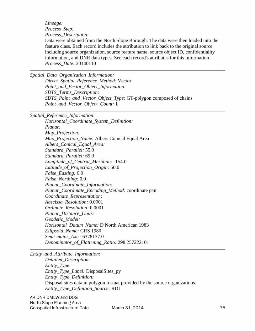
AK DNR DMLW and DOG North Slope Planning Area Geospatial Infrastructure Data March 31, 2014 75
Lineage:
Process_Step:
Process_Description:
Data were obtained from the North Slope Borough. The data were then loaded into the
feature class. Each record includes the attribution to link back to the original source,
including source organization, source feature name, source object ID, confidentiality
information, and DNR data types. See each record's attributes for this information.
Process_Date: 20140110
Spatial_Data_Organization_Information:
Direct_Spatial_Reference_Method: Vector
Point_and_Vector_Object_Information:
SDTS_Terms_Description:
SDTS_Point_and_Vector_Object_Type: GT-polygon composed of chains
Point_and_Vector_Object_Count: 1
Spatial_Reference_Information:
Horizontal_Coordinate_System_Definition:
Planar:
Map_Projection:
Map_Projection_Name: Albers Conical Equal Area
Albers_Conical_Equal_Area:
Standard_Parallel: 55.0
Standard_Parallel: 65.0
Longitude_of_Central_Meridian: -154.0
Latitude_of_Projection_Origin: 50.0
False_Easting: 0.0
False_Northing: 0.0
Planar_Coordinate_Information:
Planar_Coordinate_Encoding_Method: coordinate pair
Coordinate_Representation:
Abscissa_Resolution: 0.0001
Ordinate_Resolution: 0.0001
Planar_Distance_Units:
Geodetic_Model:
Horizontal_Datum_Name: D North American 1983
Ellipsoid_Name: GRS 1980
Semi-major_Axis: 6378137.0
Denominator_of_Flattening_Ratio: 298.257222101
Entity_and_Attribute_Information:
Detailed_Description:
Entity_Type:
Entity_Type_Label: DisposalSites_py
Entity_Type_Definition:
Disposal sites data in polygon format provided by the source organizations.
Entity_Type_Definition_Source: RDI

AK DNR DMLW and DOG North Slope Planning Area Geospatial Infrastructure Data March 31, 2014 76
Attribute:
Attribute_Label: Source_FC
Attribute_Definition: The name of the source featureclass, CAD file, or shapefile.
Attribute_Definition_Source: RDI
Attribute_Domain_Values:
Unrepresentable_Domain: Name of source featureclass.
Attribute:
Attribute_Label: Type
Attribute_Definition: Type of feature. Used for display and organization purposes.
Attribute_Definition_Source: RDI
Attribute_Domain_Values:
Unrepresentable_Domain: Type of feature. Used for display and organization purposes.
Attribute:
Attribute_Label: Operator
Attribute_Definition: Operator of the site.
Attribute_Definition_Source: RDI
Attribute_Domain_Values:
Unrepresentable_Domain: Operator of the site.
Attribute:
Attribute_Label: DOG_Type
Attribute_Definition: ADNR Division of Oil and Gas data type code.
Attribute_Definition_Source: ADNR DOG
Attribute_Domain_Values:
Enumerated_Domain:
Enumerated_Domain_Value: 6
Enumerated_Domain_Value_Definition: Telephone
Enumerated_Domain_Value_Definition_Source: ADNR DOG
Enumerated_Domain:
Enumerated_Domain_Value: 2
Enumerated_Domain_Value_Definition: Secondary Road
Enumerated_Domain_Value_Definition_Source: ADNR DOG
Enumerated_Domain:
Enumerated_Domain_Value: 7
Enumerated_Domain_Value_Definition: Landing strip
Enumerated_Domain_Value_Definition_Source: ADNR DOG
Enumerated_Domain:
Enumerated_Domain_Value: 1
Enumerated_Domain_Value_Definition: Highway
Enumerated_Domain_Value_Definition_Source: ADNR DOG
Enumerated_Domain:
Enumerated_Domain_Value: 10
Enumerated_Domain_Value_Definition: Alaska Marine Highway
Enumerated_Domain_Value_Definition_Source: ADNR DOG
Enumerated_Domain:
Enumerated_Domain_Value: 4
Enumerated_Domain_Value_Definition: Railroad
Enumerated_Domain_Value_Definition_Source: ADNR DOG
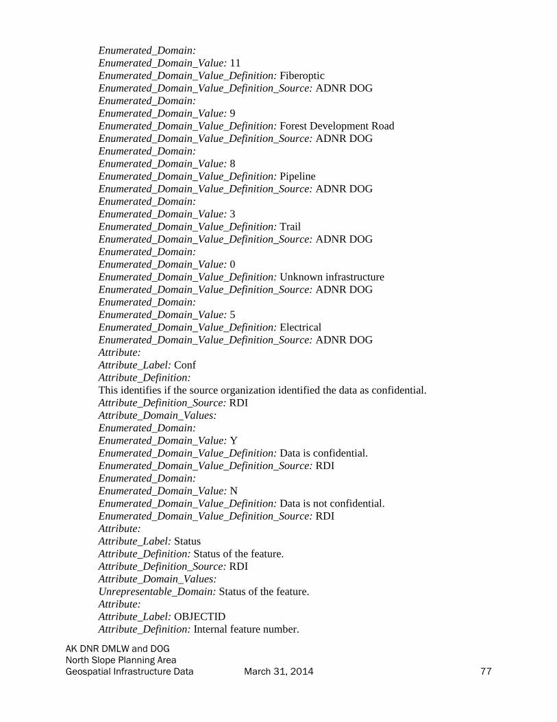
AK DNR DMLW and DOG North Slope Planning Area Geospatial Infrastructure Data March 31, 2014 77
Enumerated_Domain:
Enumerated_Domain_Value: 11
Enumerated_Domain_Value_Definition: Fiberoptic
Enumerated_Domain_Value_Definition_Source: ADNR DOG
Enumerated_Domain:
Enumerated_Domain_Value: 9
Enumerated_Domain_Value_Definition: Forest Development Road
Enumerated_Domain_Value_Definition_Source: ADNR DOG
Enumerated_Domain:
Enumerated_Domain_Value: 8
Enumerated_Domain_Value_Definition: Pipeline
Enumerated_Domain_Value_Definition_Source: ADNR DOG
Enumerated_Domain:
Enumerated_Domain_Value: 3
Enumerated_Domain_Value_Definition: Trail
Enumerated_Domain_Value_Definition_Source: ADNR DOG
Enumerated_Domain:
Enumerated_Domain_Value: 0
Enumerated_Domain_Value_Definition: Unknown infrastructure
Enumerated_Domain_Value_Definition_Source: ADNR DOG
Enumerated_Domain:
Enumerated_Domain_Value: 5
Enumerated_Domain_Value_Definition: Electrical
Enumerated_Domain_Value_Definition_Source: ADNR DOG
Attribute:
Attribute_Label: Conf
Attribute_Definition:
This identifies if the source organization identified the data as confidential.
Attribute_Definition_Source: RDI
Attribute_Domain_Values:
Enumerated_Domain:
Enumerated_Domain_Value: Y
Enumerated_Domain_Value_Definition: Data is confidential.
Enumerated_Domain_Value_Definition_Source: RDI
Enumerated_Domain:
Enumerated_Domain_Value: N
Enumerated_Domain_Value_Definition: Data is not confidential.
Enumerated_Domain_Value_Definition_Source: RDI
Attribute:
Attribute_Label: Status
Attribute_Definition: Status of the feature.
Attribute_Definition_Source: RDI
Attribute_Domain_Values:
Unrepresentable_Domain: Status of the feature.
Attribute:
Attribute_Label: OBJECTID
Attribute_Definition: Internal feature number.
AK DNR DMLW and DOG North Slope Planning Area Geospatial Infrastructure Data March 31, 2014 78
Attribute_Definition_Source: Esri
Attribute_Domain_Values:
Unrepresentable_Domain:
Sequential unique whole numbers that are automatically generated by the GIS
application.
Attribute:
Attribute_Label: Source_Org
Attribute_Definition: The organization which provided this data.
Attribute_Definition_Source: RDI
Attribute_Domain_Values:
Unrepresentable_Domain: Name of source organization.
Attribute:
Attribute_Label: Name
Attribute_Definition: Name of the feature.
Attribute_Definition_Source: RDI
Attribute_Domain_Values:
Unrepresentable_Domain: Name of the feature.
Attribute:
Attribute_Label: SHAPE
Attribute_Definition: Feature geometry.
Attribute_Definition_Source: Esri
Attribute_Domain_Values:
Unrepresentable_Domain: Coordinates defining the features.
Attribute:
Attribute_Label: SHAPE_Length
Attribute_Definition: Length of feature in internal units.
Attribute_Definition_Source: Esri
Attribute_Domain_Values:
Unrepresentable_Domain: Positive real numbers that are automatically generated.
Attribute:
Attribute_Label: SHAPE_Area
Attribute_Definition: Area of feature in internal units squared.
Attribute_Definition_Source: Esri
Attribute_Domain_Values:
Unrepresentable_Domain: Positive real numbers that are automatically generated.
Attribute:
Attribute_Label: Source_OID
Attribute_Definition: The source data's original object ID.
Attribute_Definition_Source: RDI
Attribute_Domain_Values:
Unrepresentable_Domain: Source object ID.
Attribute:
Attribute_Label: Desc
Attribute_Definition: Description of the feature.
Attribute_Definition_Source: RDI
Attribute_Domain_Values:
Unrepresentable_Domain: Description of the feature.

AK DNR DMLW and DOG North Slope Planning Area Geospatial Infrastructure Data March 31, 2014 79
Attribute:
Attribute_Label: Acquisition_Date
Attribute_Definition: Date of data acquisition.
Attribute_Definition_Source: RDI
Attribute:
Attribute_Label: Centroid_X
Attribute:
Attribute_Label: Centroid_Y
Overview_Description:
Entity_and_Attribute_Overview:
The data in this feature class were obtained and consolidated from several source
organizations as noted in the lineage. During this consolidation, data attributes were
abstracted to load all similar information into a single field (for example Name, short
description, feature_name would have all been loaded to NAME). Because the data did
not always include a data dictionary, not all domains are defined. Please see the original
data for full information from the data's originator. Data are provided as unchanged from
source organizations. The fields populated by RDI for Alaska DNR are described in this
metadata.
Metadata_Reference_Information:
Metadata_Date: 20140226
Metadata_Contact:
Contact_Information:
Contact_Organization_Primary:
Contact_Organization: Resource Data, Inc.
Contact_Person: Bixler McClure
Contact_Position: GIS Programmer/Analyst
Contact_Address:
Address_Type: mailing and physical
Address: 560 E. 34th Ave., Suite 100
City: Anchorage
State_or_Province: AK
Postal_Code: 99503
Country: US
Contact_Voice_Telephone: 907-563-8100
Contact_Facsimile_Telephone: 907-561-0159
Contact_Electronic_Mail_Address: [email protected]
Metadata_Standard_Name: FGDC Content Standard for Digital Geospatial Metadata
Metadata_Standard_Version: FGDC-STD-001-1998
Metadata_Time_Convention: local time
Generated by mp version 2.9.12 on Tue Mar 18 09:48:40 2014

AK DNR DMLW and DOG North Slope Planning Area Geospatial Infrastructure Data March 31, 2014 80
Easements; Polygons Metadata
• Identification_Information
• Data_Quality_Information
• Spatial_Data_Organization_Information
• Spatial_Reference_Information
• Entity_and_Attribute_Information
• Metadata_Reference_Information
Identification_Information:
Citation:
Citation_Information:
Publication_Date: 20140113
Publication_Time: 020000
Title: Easements; Polygons
Geospatial_Data_Presentation_Form: vector digital data
Description:
Abstract: These data depict easements in polygon format.
Purpose:
This dataset was developed for the Alaska Department of Natural Resources under TOPS
Contract 0086-10-13-010 to compile existing data of infrastructure and material sources
on the North Slope of Alaska. Data were compiled by Resource Data, Inc. in 2013-2014
from existing data supplied by various organizations.
Status:
Progress: Complete
Maintenance_and_Update_Frequency: None planned
Spatial_Domain:
Bounding_Coordinates:
West_Bounding_Coordinate: -147.110398
East_Bounding_Coordinate: -146.258764
North_Bounding_Coordinate: 70.203844
South_Bounding_Coordinate: 70.098551
Keywords:
Theme:
Theme_Keyword_Thesaurus: ISO 19115 Topic Categories
Theme_Keyword: planningCadastre
Theme_Keyword: structure
Theme_Keyword: utilitiesCommunication
Theme_Keyword: location
Theme_Keyword: transportation
Theme:
Theme_Keyword_Thesaurus: Unknown
Theme_Keyword: Easements
Theme_Keyword: Alaska
Theme_Keyword: North Slope
Temporal:

AK DNR DMLW and DOG North Slope Planning Area Geospatial Infrastructure Data March 31, 2014 81
Temporal_Keyword_Thesaurus: Unknown
Temporal_Keyword: Unknown
Access_Constraints: None
Use_Constraints:
Use limited by Alaska DNR. Features identified with field CONF = "Y" were identified
as confidential by the source organization.
Point_of_Contact:
Contact_Information:
Contact_Organization_Primary:
Contact_Organization:
AK Department of Natural Resources - Information Resource Management Section
Contact_Person: GIS Public Access Coordinator
Contact_Position: GIS Public Access Coordinator
Contact_Address:
Address_Type: mailing and physical
Address: 550 W. 7th Suite 706
City: Anchorage
State_or_Province: AK
Postal_Code: 99501
Country: US
Contact_Voice_Telephone: 907 269 8839
Contact_Facsimile_Telephone: 907 269 8920
Contact_Electronic_Mail_Address: [email protected]
Hours_of_Service: 800-1600 AST
Point_of_Contact:
Contact_Information:
Contact_Organization_Primary:
Contact_Organization:
AK Department of Natural Resources - Information Resource Management Section
Contact_Person: GIS Public Access Coordinator
Contact_Position: GIS Public Access Coordinator
Contact_Address:
Address_Type: mailing and physical
Address: 550 W. 7th Suite 706
City: Anchorage
State_or_Province: AK
Postal_Code: 99501
Country: US
Contact_Voice_Telephone: 907 269 8839
Contact_Facsimile_Telephone: 907 269 8920
Contact_Electronic_Mail_Address: [email protected]
Hours_of_Service: 800-1600 AST
Native_Data_Set_Environment:
Microsoft Windows 7 Version 6.1 (Build 7601) Service Pack 1; Esri ArcGIS 10.1.0.3035
Data_Quality_Information:
Logical_Consistency_Report: Unknown

AK DNR DMLW and DOG North Slope Planning Area Geospatial Infrastructure Data March 31, 2014 82
Lineage:
Process_Step:
Process_Description:
Data were obtained from the State Pipeline Coordinator's Office. The data were then
loaded into the feature class. Each record includes the attribution to link back to the
original source, including source organization, source feature name, source object ID,
confidentiality information, and DNR data types. See each record's attributes for this
information.
Process_Date: 20140110
Spatial_Data_Organization_Information:
Direct_Spatial_Reference_Method: Vector
Point_and_Vector_Object_Information:
SDTS_Terms_Description:
SDTS_Point_and_Vector_Object_Type: GT-polygon composed of chains
Point_and_Vector_Object_Count: 2
Spatial_Reference_Information:
Horizontal_Coordinate_System_Definition:
Planar:
Map_Projection:
Map_Projection_Name: Albers Conical Equal Area
Albers_Conical_Equal_Area:
Standard_Parallel: 55.0
Standard_Parallel: 65.0
Longitude_of_Central_Meridian: -154.0
Latitude_of_Projection_Origin: 50.0
False_Easting: 0.0
False_Northing: 0.0
Planar_Coordinate_Information:
Planar_Coordinate_Encoding_Method: coordinate pair
Coordinate_Representation:
Abscissa_Resolution: 0.0001
Ordinate_Resolution: 0.0001
Planar_Distance_Units:
Geodetic_Model:
Horizontal_Datum_Name: D North American 1983
Ellipsoid_Name: GRS 1980
Semi-major_Axis: 6378137.0
Denominator_of_Flattening_Ratio: 298.257222101
Entity_and_Attribute_Information:
Detailed_Description:
Entity_Type:
Entity_Type_Label: Easement_py
Entity_Type_Definition:
Easement data in polygon format provided by the source organizations.

AK DNR DMLW and DOG North Slope Planning Area Geospatial Infrastructure Data March 31, 2014 83
Entity_Type_Definition_Source: RDI
Attribute:
Attribute_Label: Source_OID
Attribute_Definition: The source data's original object ID.
Attribute_Definition_Source: RDI
Attribute_Domain_Values:
Unrepresentable_Domain: Source object ID.
Attribute:
Attribute_Label: Desc
Attribute_Definition: Description of the feature.
Attribute_Definition_Source: RDI
Attribute_Domain_Values:
Unrepresentable_Domain: Description of the feature.
Attribute:
Attribute_Label: DOG_Type
Attribute_Definition: ADNR Division of Oil and Gas data type code.
Attribute_Definition_Source: ADNR DOG
Attribute_Domain_Values:
Enumerated_Domain:
Enumerated_Domain_Value: 0
Enumerated_Domain_Value_Definition: Unknown infrastructure
Enumerated_Domain_Value_Definition_Source: ADNR DOG
Enumerated_Domain:
Enumerated_Domain_Value: 4
Enumerated_Domain_Value_Definition: Railroad
Enumerated_Domain_Value_Definition_Source: ADNR DOG
Enumerated_Domain:
Enumerated_Domain_Value: 1
Enumerated_Domain_Value_Definition: Highway
Enumerated_Domain_Value_Definition_Source: ADNR DOG
Enumerated_Domain:
Enumerated_Domain_Value: 2
Enumerated_Domain_Value_Definition: Secondary Road
Enumerated_Domain_Value_Definition_Source: ADNR DOG
Enumerated_Domain:
Enumerated_Domain_Value: 9
Enumerated_Domain_Value_Definition: Forest Development Road
Enumerated_Domain_Value_Definition_Source: ADNR DOG
Enumerated_Domain:
Enumerated_Domain_Value: 7
Enumerated_Domain_Value_Definition: Landing strip
Enumerated_Domain_Value_Definition_Source: ADNR DOG
Enumerated_Domain:
Enumerated_Domain_Value: 3
Enumerated_Domain_Value_Definition: Trail
Enumerated_Domain_Value_Definition_Source: ADNR DOG
Enumerated_Domain:

AK DNR DMLW and DOG North Slope Planning Area Geospatial Infrastructure Data March 31, 2014 84
Enumerated_Domain_Value: 10
Enumerated_Domain_Value_Definition: Alaska Marine Highway
Enumerated_Domain_Value_Definition_Source: ADNR DOG
Enumerated_Domain:
Enumerated_Domain_Value: 8
Enumerated_Domain_Value_Definition: Pipeline
Enumerated_Domain_Value_Definition_Source: ADNR DOG
Enumerated_Domain:
Enumerated_Domain_Value: 6
Enumerated_Domain_Value_Definition: Telephone
Enumerated_Domain_Value_Definition_Source: ADNR DOG
Enumerated_Domain:
Enumerated_Domain_Value: 11
Enumerated_Domain_Value_Definition: Fiberoptic
Enumerated_Domain_Value_Definition_Source: ADNR DOG
Enumerated_Domain:
Enumerated_Domain_Value: 5
Enumerated_Domain_Value_Definition: Electrical
Enumerated_Domain_Value_Definition_Source: ADNR DOG
Attribute:
Attribute_Label: Operator
Attribute_Definition: Operator of the airstrip.
Attribute_Definition_Source: RDI
Attribute_Domain_Values:
Unrepresentable_Domain: Operator of the easement.
Attribute:
Attribute_Label: Conf
Attribute_Definition:
This identifies if the source organization identified the data as confidential.
Attribute_Definition_Source: RDI
Attribute_Domain_Values:
Enumerated_Domain:
Enumerated_Domain_Value: N
Enumerated_Domain_Value_Definition: Data is not confidential.
Enumerated_Domain_Value_Definition_Source: RDI
Enumerated_Domain:
Enumerated_Domain_Value: Y
Enumerated_Domain_Value_Definition: Data is confidential.
Enumerated_Domain_Value_Definition_Source: RDI
Attribute:
Attribute_Label: SHAPE
Attribute_Definition: Feature geometry.
Attribute_Definition_Source: Esri
Attribute_Domain_Values:
Unrepresentable_Domain: Coordinates defining the features.
Attribute:
Attribute_Label: Source_Org

AK DNR DMLW and DOG North Slope Planning Area Geospatial Infrastructure Data March 31, 2014 85
Attribute_Definition: The organization which provided this data.
Attribute_Definition_Source: RDI
Attribute_Domain_Values:
Unrepresentable_Domain: Name of source organization.
Attribute:
Attribute_Label: OBJECTID
Attribute_Definition: Internal feature number.
Attribute_Definition_Source: Esri
Attribute_Domain_Values:
Unrepresentable_Domain:
Sequential unique whole numbers that are automatically generated by the GIS
application.
Attribute:
Attribute_Label: Name
Attribute_Definition: Name of the feature.
Attribute_Definition_Source: RDI
Attribute_Domain_Values:
Unrepresentable_Domain: Name of the feature.
Attribute:
Attribute_Label: Type
Attribute_Definition: Type of feature. Used for display and organization purposes.
Attribute_Definition_Source: RDI
Attribute_Domain_Values:
Unrepresentable_Domain: Type of feature. Used for display and organization purposes.
Attribute:
Attribute_Label: SHAPE_Length
Attribute_Definition: Length of feature in internal units.
Attribute_Definition_Source: Esri
Attribute_Domain_Values:
Unrepresentable_Domain: Positive real numbers that are automatically generated.
Attribute:
Attribute_Label: SHAPE_Area
Attribute_Definition: Area of feature in internal units squared.
Attribute_Definition_Source: Esri
Attribute_Domain_Values:
Unrepresentable_Domain: Positive real numbers that are automatically generated.
Attribute:
Attribute_Label: Source_FC
Attribute_Definition: The name of the source featureclass, CAD file, or shapefile.
Attribute_Definition_Source: RDI
Attribute_Domain_Values:
Unrepresentable_Domain: Name of source featureclass.
Attribute:
Attribute_Label: Acquisition_Date
Attribute_Definition: Date of data acquisition.
Attribute_Definition_Source: RDI
Attribute:

AK DNR DMLW and DOG North Slope Planning Area Geospatial Infrastructure Data March 31, 2014 86
Attribute_Label: Centroid_X
Attribute:
Attribute_Label: Centroid_Y
Overview_Description:
Entity_and_Attribute_Overview:
The data in this feature class were obtained and consolidated from several source
organizations as noted in the lineage. During this consolidation, data attributes were
abstracted to load all similar information into a single field (for example Name, short
description, feature_name would have all been loaded to NAME). Because the data did
not always include a data dictionary, not all domains are defined. Please see the original
data for full information from the data's originator. Data are provided as unchanged from
source organizations. The fields populated by RDI for Alaska DNR are described in this
metadata.
Metadata_Reference_Information:
Metadata_Date: 20140226
Metadata_Contact:
Contact_Information:
Contact_Organization_Primary:
Contact_Organization: Resource Data, Inc.
Contact_Person: Bixler McClure
Contact_Position: GIS Programmer/Analyst
Contact_Address:
Address_Type: mailing and physical
Address: 560 E. 34th Ave., Suite 100
City: Anchorage
State_or_Province: AK
Postal_Code: 99503
Country: US
Contact_Voice_Telephone: 907-563-8100
Contact_Facsimile_Telephone: 907-561-0159
Contact_Electronic_Mail_Address: [email protected]
Metadata_Standard_Name: FGDC Content Standard for Digital Geospatial Metadata
Metadata_Standard_Version: FGDC-STD-001-1998
Metadata_Time_Convention: local time
Generated by mp version 2.9.12 on Tue Mar 18 09:48:40 2014

AK DNR DMLW and DOG North Slope Planning Area Geospatial Infrastructure Data March 31, 2014 87
Gravel Pads; Polygons Metadata
• Identification_Information
• Data_Quality_Information
• Spatial_Data_Organization_Information
• Spatial_Reference_Information
• Entity_and_Attribute_Information
• Metadata_Reference_Information
Identification_Information:
Citation:
Citation_Information:
Publication_Date: 20140113
Publication_Time: 020000
Title: Gravel Pads; Polygons
Geospatial_Data_Presentation_Form: vector digital data
Description:
Abstract: These data depict gravel pads in polygon format.
Purpose:
This dataset was developed for the Alaska Department of Natural Resources under TOPS
Contract 0086-10-13-010 to compile existing data of infrastructure and material sources
on the North Slope of Alaska. Data were compiled by Resource Data, Inc. in 2013-2014
from existing data supplied by various organizations.
Status:
Progress: Complete
Maintenance_and_Update_Frequency: None planned
Spatial_Domain:
Bounding_Coordinates:
West_Bounding_Coordinate: -152.257960
East_Bounding_Coordinate: -140.802571
North_Bounding_Coordinate: 70.842849
South_Bounding_Coordinate: 68.071614
Keywords:
Theme:
Theme_Keyword_Thesaurus: ISO 19115 Topic Categories
Theme_Keyword: location
Theme_Keyword: structure
Theme_Keyword: utilitiesCommunication
Theme_Keyword: transportation
Theme_Keyword: planningCadastre
Theme:
Theme_Keyword_Thesaurus: Unknown
Theme_Keyword: Alaska
Theme_Keyword: North Slope
Theme_Keyword: Gravel Pad
Temporal:

AK DNR DMLW and DOG North Slope Planning Area Geospatial Infrastructure Data March 31, 2014 88
Temporal_Keyword_Thesaurus: Unknown
Temporal_Keyword: Unknown
Access_Constraints: None
Use_Constraints:
Use limited by Alaska DNR. Features identified with field CONF = "Y" were identified
as confidential by the source organization.
Point_of_Contact:
Contact_Information:
Contact_Organization_Primary:
Contact_Organization:
AK Department of Natural Resources - Information Resource Management Section
Contact_Person: GIS Public Access Coordinator
Contact_Position: GIS Public Access Coordinator
Contact_Address:
Address_Type: mailing and physical
Address: 550 W. 7th Suite 706
City: Anchorage
State_or_Province: AK
Postal_Code: 99501
Country: US
Contact_Voice_Telephone: 907 269 8839
Contact_Facsimile_Telephone: 907 269 8920
Contact_Electronic_Mail_Address: [email protected]
Hours_of_Service: 800-1600 AST
Point_of_Contact:
Contact_Information:
Contact_Organization_Primary:
Contact_Organization:
AK Department of Natural Resources - Information Resource Management Section
Contact_Person: GIS Public Access Coordinator
Contact_Position: GIS Public Access Coordinator
Contact_Address:
Address_Type: mailing and physical
Address: 550 W. 7th Suite 706
City: Anchorage
State_or_Province: AK
Postal_Code: 99501
Country: US
Contact_Voice_Telephone: 907 269 8839
Contact_Facsimile_Telephone: 907 269 8920
Contact_Electronic_Mail_Address: [email protected]
Hours_of_Service: 800-1600 AST
Native_Data_Set_Environment:
Microsoft Windows 7 Version 6.1 (Build 7601) Service Pack 1; Esri ArcGIS 10.1.0.3035
Data_Quality_Information:
Logical_Consistency_Report: Unknown

AK DNR DMLW and DOG North Slope Planning Area Geospatial Infrastructure Data March 31, 2014 89
Lineage:
Process_Step:
Process_Description:
Data were obtained from BP, ADNR DOG, Brooks Range Petroleum Corporation, North
Slope Borough, ConocoPhillips Alaska, and Repsol. The data were then loaded into the
feature class. Each record includes the attribution to link back to the original source,
including source organization, source feature name, source object ID, confidentiality
information, and DNR data types. See each record's attributes for this information.
Process_Date: 20140110
Spatial_Data_Organization_Information:
Direct_Spatial_Reference_Method: Vector
Point_and_Vector_Object_Information:
SDTS_Terms_Description:
SDTS_Point_and_Vector_Object_Type: GT-polygon composed of chains
Point_and_Vector_Object_Count: 1457
Spatial_Reference_Information:
Horizontal_Coordinate_System_Definition:
Planar:
Map_Projection:
Map_Projection_Name: Albers Conical Equal Area
Albers_Conical_Equal_Area:
Standard_Parallel: 55.0
Standard_Parallel: 65.0
Longitude_of_Central_Meridian: -154.0
Latitude_of_Projection_Origin: 50.0
False_Easting: 0.0
False_Northing: 0.0
Planar_Coordinate_Information:
Planar_Coordinate_Encoding_Method: coordinate pair
Coordinate_Representation:
Abscissa_Resolution: 0.0001
Ordinate_Resolution: 0.0001
Planar_Distance_Units:
Geodetic_Model:
Horizontal_Datum_Name: D North American 1983
Ellipsoid_Name: GRS 1980
Semi-major_Axis: 6378137.0
Denominator_of_Flattening_Ratio: 298.257222101
Entity_and_Attribute_Information:
Detailed_Description:
Entity_Type:
Entity_Type_Label: GravelPad_py
Entity_Type_Definition:
Gravel pad data in polygon format provided by the source organizations.

AK DNR DMLW and DOG North Slope Planning Area Geospatial Infrastructure Data March 31, 2014 90
Entity_Type_Definition_Source: RDI
Attribute:
Attribute_Label: SHAPE
Attribute_Definition: Feature geometry.
Attribute_Definition_Source: Esri
Attribute_Domain_Values:
Unrepresentable_Domain: Coordinates defining the features.
Attribute:
Attribute_Label: Source_FC
Attribute_Definition: The name of the source featureclass, CAD file, or shapefile.
Attribute_Definition_Source: RDI
Attribute_Domain_Values:
Unrepresentable_Domain: Name of source featureclass.
Attribute:
Attribute_Label: Source_Org
Attribute_Definition: The organization which provided this data.
Attribute_Definition_Source: RDI
Attribute_Domain_Values:
Unrepresentable_Domain: Name of source organization.
Attribute:
Attribute_Label: SHAPE_Length
Attribute_Definition: Length of feature in internal units.
Attribute_Definition_Source: Esri
Attribute_Domain_Values:
Unrepresentable_Domain: Positive real numbers that are automatically generated.
Attribute:
Attribute_Label: DOG_Type
Attribute_Definition: ADNR Division of Oil and Gas data type code.
Attribute_Definition_Source: ADNR DOG
Attribute_Domain_Values:
Enumerated_Domain:
Enumerated_Domain_Value: 2
Enumerated_Domain_Value_Definition: Secondary Road
Enumerated_Domain_Value_Definition_Source: ADNR DOG
Enumerated_Domain:
Enumerated_Domain_Value: 4
Enumerated_Domain_Value_Definition: Railroad
Enumerated_Domain_Value_Definition_Source: ADNR DOG
Enumerated_Domain:
Enumerated_Domain_Value: 0
Enumerated_Domain_Value_Definition: Unknown infrastructure
Enumerated_Domain_Value_Definition_Source: ADNR DOG
Enumerated_Domain:
Enumerated_Domain_Value: 6
Enumerated_Domain_Value_Definition: Telephone
Enumerated_Domain_Value_Definition_Source: ADNR DOG
Enumerated_Domain:

AK DNR DMLW and DOG North Slope Planning Area Geospatial Infrastructure Data March 31, 2014 91
Enumerated_Domain_Value: 11
Enumerated_Domain_Value_Definition: Fiberoptic
Enumerated_Domain_Value_Definition_Source: ADNR DOG
Enumerated_Domain:
Enumerated_Domain_Value: 8
Enumerated_Domain_Value_Definition: Pipeline
Enumerated_Domain_Value_Definition_Source: ADNR DOG
Enumerated_Domain:
Enumerated_Domain_Value: 7
Enumerated_Domain_Value_Definition: Landing strip
Enumerated_Domain_Value_Definition_Source: ADNR DOG
Enumerated_Domain:
Enumerated_Domain_Value: 10
Enumerated_Domain_Value_Definition: Alaska Marine Highway
Enumerated_Domain_Value_Definition_Source: ADNR DOG
Enumerated_Domain:
Enumerated_Domain_Value: 3
Enumerated_Domain_Value_Definition: Trail
Enumerated_Domain_Value_Definition_Source: ADNR DOG
Enumerated_Domain:
Enumerated_Domain_Value: 5
Enumerated_Domain_Value_Definition: Electrical
Enumerated_Domain_Value_Definition_Source: ADNR DOG
Enumerated_Domain:
Enumerated_Domain_Value: 9
Enumerated_Domain_Value_Definition: Forest Development Road
Enumerated_Domain_Value_Definition_Source: ADNR DOG
Enumerated_Domain:
Enumerated_Domain_Value: 1
Enumerated_Domain_Value_Definition: Highway
Enumerated_Domain_Value_Definition_Source: ADNR DOG
Attribute:
Attribute_Label: Source_OID
Attribute_Definition: The source data's original object ID.
Attribute_Definition_Source: RDI
Attribute_Domain_Values:
Unrepresentable_Domain: Source object ID.
Attribute:
Attribute_Label: Name
Attribute_Definition:
Name of the feature; sometimes an abbreviation for labeling purposes.
Attribute_Definition_Source: RDI
Attribute_Domain_Values:
Unrepresentable_Domain:
Name of the feature; sometimes an abbreviation for labelling purposes.
Attribute:
Attribute_Label: OBJECTID

AK DNR DMLW and DOG North Slope Planning Area Geospatial Infrastructure Data March 31, 2014 92
Attribute_Definition: Internal feature number.
Attribute_Definition_Source: Esri
Attribute_Domain_Values:
Unrepresentable_Domain:
Sequential unique whole numbers that are automatically generated by the GIS
application.
Attribute:
Attribute_Label: Status
Attribute_Definition: Status of the feature.
Attribute_Definition_Source: RDI
Attribute_Domain_Values:
Unrepresentable_Domain: Status of the feature.
Attribute:
Attribute_Label: Purpose
Attribute_Definition: Purpose of the gravel pad.
Attribute_Definition_Source: RDI
Attribute_Domain_Values:
Unrepresentable_Domain: Purpose of the gravel pad.
Attribute:
Attribute_Label: Conf
Attribute_Definition:
This identifies if the source organization identified the data as confidential.
Attribute_Definition_Source: RDI
Attribute_Domain_Values:
Enumerated_Domain:
Enumerated_Domain_Value: Y
Enumerated_Domain_Value_Definition: Data is confidential.
Enumerated_Domain_Value_Definition_Source: RDI
Enumerated_Domain:
Enumerated_Domain_Value: N
Enumerated_Domain_Value_Definition: Data is not confidential.
Enumerated_Domain_Value_Definition_Source: RDI
Attribute:
Attribute_Label: FullName
Attribute_Definition:
Full name of the gravel pad. Also the facility name, not abbreviated.
Attribute_Definition_Source: RDI
Attribute_Domain_Values:
Unrepresentable_Domain:
Full name of the gravel pad. Also the facility name, not abbreviated.
Attribute:
Attribute_Label: Desc
Attribute_Definition: Description of the feature.
Attribute_Definition_Source: RDI
Attribute_Domain_Values:
Unrepresentable_Domain: Description of the feature.
Attribute:

AK DNR DMLW and DOG North Slope Planning Area Geospatial Infrastructure Data March 31, 2014 93
Attribute_Label: Operator
Attribute_Definition: Operator of the gravel pad.
Attribute_Definition_Source: RDI
Attribute_Domain_Values:
Unrepresentable_Domain: Operator of the gravel pad.
Attribute:
Attribute_Label: SHAPE_Area
Attribute_Definition: Area of feature in internal units squared.
Attribute_Definition_Source: Esri
Attribute_Domain_Values:
Unrepresentable_Domain: Positive real numbers that are automatically generated.
Attribute:
Attribute_Label: Type
Attribute_Definition: Type of feature. Used for display and organization purposes.
Attribute_Definition_Source: RDI
Attribute_Domain_Values:
Unrepresentable_Domain: Type of feature. Used for display and organization purposes.
Attribute:
Attribute_Label: Acquisition_Date
Attribute_Definition: Date of data acquisition.
Attribute_Definition_Source: RDI
Attribute:
Attribute_Label: Centroid_X
Attribute:
Attribute_Label: Centroid_Y
Overview_Description:
Entity_and_Attribute_Overview:
The data in this feature class were obtained and consolidated from several source
organizations as noted in the lineage. During this consolidation, data attributes were
abstracted to load all similar information into a single field (for example Name, short
description, feature_name would have all been loaded to NAME). Because the data did
not always include a data dictionary, not all domains are defined. Please see the original
data for full information from the data's originator. Data are provided as unchanged from
source organizations. The fields populated by RDI for Alaska DNR are described in this
metadata.
Metadata_Reference_Information:
Metadata_Date: 20140226
Metadata_Contact:
Contact_Information:
Contact_Organization_Primary:
Contact_Organization: Resource Data, Inc.
Contact_Person: Bixler McClure
Contact_Position: GIS Programmer/Analyst
Contact_Address:
Address_Type: mailing and physical
Address: 560 E. 34th Ave., Suite 100

AK DNR DMLW and DOG North Slope Planning Area Geospatial Infrastructure Data March 31, 2014 94
City: Anchorage
State_or_Province: AK
Postal_Code: 99503
Country: US
Contact_Voice_Telephone: 907-563-8100
Contact_Facsimile_Telephone: 907-561-0159
Contact_Electronic_Mail_Address: [email protected]
Metadata_Standard_Name: FGDC Content Standard for Digital Geospatial Metadata
Metadata_Standard_Version: FGDC-STD-001-1998
Metadata_Time_Convention: local time
Generated by mp version 2.9.12 on Tue Mar 18 09:48:42 2014

AK DNR DMLW and DOG North Slope Planning Area Geospatial Infrastructure Data March 31, 2014 95
Material Sites; Points Metadata
• Identification_Information
• Data_Quality_Information
• Spatial_Data_Organization_Information
• Spatial_Reference_Information
• Entity_and_Attribute_Information
• Metadata_Reference_Information
Identification_Information:
Citation:
Citation_Information:
Publication_Date: 20140113
Publication_Time: 020000
Title: Material Sites; Points
Geospatial_Data_Presentation_Form: vector digital data
Description:
Abstract: These data depict material sites in point format.
Purpose:
This dataset was developed for the Alaska Department of Natural Resources under TOPS
Contract 0086-10-13-010 to compile existing data of infrastructure and material sources
on the North Slope of Alaska. Data were compiled by Resource Data, Inc. in 2013-2014
from existing data supplied by various organizations.
Status:
Progress: Complete
Maintenance_and_Update_Frequency: None planned
Spatial_Domain:
Bounding_Coordinates:
West_Bounding_Coordinate: -149.579110
East_Bounding_Coordinate: -148.418579
North_Bounding_Coordinate: 70.312279
South_Bounding_Coordinate: 68.390722
Keywords:
Theme:
Theme_Keyword_Thesaurus: ISO 19115 Topic Categories
Theme_Keyword: location
Theme_Keyword: structure
Theme_Keyword: utilitiesCommunication
Theme_Keyword: transportation
Theme_Keyword: planningCadastre
Theme:
Theme_Keyword_Thesaurus: Unknown
Theme_Keyword: Alaska
Theme_Keyword: North Slope
Theme_Keyword: Material sites
Temporal:

AK DNR DMLW and DOG North Slope Planning Area Geospatial Infrastructure Data March 31, 2014 96
Temporal_Keyword_Thesaurus: Unknown
Temporal_Keyword: Unknown
Access_Constraints: None
Use_Constraints:
Use limited by Alaska DNR. Features identified with field CONF = "Y" were identified
as confidential by the source organization.
Point_of_Contact:
Contact_Information:
Contact_Organization_Primary:
Contact_Organization:
AK Department of Natural Resources - Information Resource Management Section
Contact_Person: GIS Public Access Coordinator
Contact_Position: GIS Public Access Coordinator
Contact_Address:
Address_Type: mailing and physical
Address: 550 W. 7th Suite 706
City: Anchorage
State_or_Province: AK
Postal_Code: 99501
Country: US
Contact_Voice_Telephone: 907 269 8839
Contact_Facsimile_Telephone: 907 269 8920
Contact_Electronic_Mail_Address: [email protected]
Hours_of_Service: 800-1600 AST
Point_of_Contact:
Contact_Information:
Contact_Organization_Primary:
Contact_Organization:
AK Department of Natural Resources - Information Resource Management Section
Contact_Person: GIS Public Access Coordinator
Contact_Position: GIS Public Access Coordinator
Contact_Address:
Address_Type: mailing and physical
Address: 550 W. 7th Suite 706
City: Anchorage
State_or_Province: AK
Postal_Code: 99501
Country: US
Contact_Voice_Telephone: 907 269 8839
Contact_Facsimile_Telephone: 907 269 8920
Contact_Electronic_Mail_Address: [email protected]
Hours_of_Service: 800-1600 AST
Native_Data_Set_Environment:
Microsoft Windows 7 Version 6.1 (Build 7601) Service Pack 1; Esri ArcGIS 10.1.0.3035
Data_Quality_Information:
Logical_Consistency_Report: Unknown

AK DNR DMLW and DOG North Slope Planning Area Geospatial Infrastructure Data March 31, 2014 97
Lineage:
Process_Step:
Process_Description:
Data were obtained from the Alaska Department of Transportation and Public Facilities.
The data were then loaded into the feature class. Each record includes the attribution to
link back to the original source, including source organization, source feature name,
source object ID, confidentiality information, and DNR data types. See each record's
attributes for this information. MTRS information was added from BLM polygon data.
Process_Date: 20140110
Spatial_Data_Organization_Information:
Direct_Spatial_Reference_Method: Vector
Point_and_Vector_Object_Information:
SDTS_Terms_Description:
SDTS_Point_and_Vector_Object_Type: Entity point
Point_and_Vector_Object_Count: 38
Spatial_Reference_Information:
Horizontal_Coordinate_System_Definition:
Planar:
Map_Projection:
Map_Projection_Name: Albers Conical Equal Area
Albers_Conical_Equal_Area:
Standard_Parallel: 55.0
Standard_Parallel: 65.0
Longitude_of_Central_Meridian: -154.0
Latitude_of_Projection_Origin: 50.0
False_Easting: 0.0
False_Northing: 0.0
Planar_Coordinate_Information:
Planar_Coordinate_Encoding_Method: coordinate pair
Coordinate_Representation:
Abscissa_Resolution: 0.0001
Ordinate_Resolution: 0.0001
Planar_Distance_Units:
Geodetic_Model:
Horizontal_Datum_Name: D North American 1983
Ellipsoid_Name: GRS 1980
Semi-major_Axis: 6378137.0
Denominator_of_Flattening_Ratio: 298.257222101
Entity_and_Attribute_Information:
Detailed_Description:
Entity_Type:
Entity_Type_Label: MaterialSite_pt
Entity_Type_Definition:
Material site data in point format provided by the source organizations.

AK DNR DMLW and DOG North Slope Planning Area Geospatial Infrastructure Data March 31, 2014 98
Entity_Type_Definition_Source: RDI
Attribute:
Attribute_Label: SHAPE
Attribute_Definition: Feature geometry.
Attribute_Definition_Source: Esri
Attribute_Domain_Values:
Unrepresentable_Domain: Coordinates defining the features.
Attribute:
Attribute_Label: Source_FC
Attribute_Definition: The name of the source featureclass, CAD file, or shapefile.
Attribute_Definition_Source: RDI
Attribute_Domain_Values:
Unrepresentable_Domain: Name of source featureclass.
Attribute:
Attribute_Label: Source_Org
Attribute_Definition: The organization which provided this data.
Attribute_Definition_Source: RDI
Attribute_Domain_Values:
Unrepresentable_Domain: Name of source organization.
Attribute:
Attribute_Label: DOG_Type
Attribute_Definition: ADNR Division of Oil and Gas data type code.
Attribute_Definition_Source: ADNR DOG
Attribute_Domain_Values:
Enumerated_Domain:
Enumerated_Domain_Value: 2
Enumerated_Domain_Value_Definition: Secondary Road
Enumerated_Domain_Value_Definition_Source: ADNR DOG
Enumerated_Domain:
Enumerated_Domain_Value: 4
Enumerated_Domain_Value_Definition: Railroad
Enumerated_Domain_Value_Definition_Source: ADNR DOG
Enumerated_Domain:
Enumerated_Domain_Value: 0
Enumerated_Domain_Value_Definition: Unknown infrastructure
Enumerated_Domain_Value_Definition_Source: ADNR DOG
Enumerated_Domain:
Enumerated_Domain_Value: 6
Enumerated_Domain_Value_Definition: Telephone
Enumerated_Domain_Value_Definition_Source: ADNR DOG
Enumerated_Domain:
Enumerated_Domain_Value: 11
Enumerated_Domain_Value_Definition: Fiberoptic
Enumerated_Domain_Value_Definition_Source: ADNR DOG
Enumerated_Domain:
Enumerated_Domain_Value: 8
Enumerated_Domain_Value_Definition: Pipeline

AK DNR DMLW and DOG North Slope Planning Area Geospatial Infrastructure Data March 31, 2014 99
Enumerated_Domain_Value_Definition_Source: ADNR DOG
Enumerated_Domain:
Enumerated_Domain_Value: 7
Enumerated_Domain_Value_Definition: Landing strip
Enumerated_Domain_Value_Definition_Source: ADNR DOG
Enumerated_Domain:
Enumerated_Domain_Value: 10
Enumerated_Domain_Value_Definition: Alaska Marine Highway
Enumerated_Domain_Value_Definition_Source: ADNR DOG
Enumerated_Domain:
Enumerated_Domain_Value: 3
Enumerated_Domain_Value_Definition: Trail
Enumerated_Domain_Value_Definition_Source: ADNR DOG
Enumerated_Domain:
Enumerated_Domain_Value: 5
Enumerated_Domain_Value_Definition: Electrical
Enumerated_Domain_Value_Definition_Source: ADNR DOG
Enumerated_Domain:
Enumerated_Domain_Value: 9
Enumerated_Domain_Value_Definition: Forest Development Road
Enumerated_Domain_Value_Definition_Source: ADNR DOG
Enumerated_Domain:
Enumerated_Domain_Value: 1
Enumerated_Domain_Value_Definition: Highway
Enumerated_Domain_Value_Definition_Source: ADNR DOG
Attribute:
Attribute_Label: Site_ID
Attribute_Definition: Site ID of the material site.
Attribute_Definition_Source: RDI
Attribute_Domain_Values:
Unrepresentable_Domain: Site ID of the material site.
Attribute:
Attribute_Label: ADL
Attribute_Definition: ADL number of the site.
Attribute_Definition_Source: RDI
Attribute_Domain_Values:
Unrepresentable_Domain: ADL number of the site.
Attribute:
Attribute_Label: Source_OID
Attribute_Definition: The source data's original object ID.
Attribute_Definition_Source: RDI
Attribute_Domain_Values:
Unrepresentable_Domain: Source object ID.
Attribute:
Attribute_Label: Acreage
Attribute_Definition: Acreage of the site.
Attribute_Definition_Source: RDI
AK DNR DMLW and DOG North Slope Planning Area Geospatial Infrastructure Data March 31, 2014 100
Attribute_Domain_Values:
Unrepresentable_Domain: Acreage of the site.
Attribute:
Attribute_Label: Name
Attribute_Definition: Name of the feature.
Attribute_Definition_Source: RDI
Attribute_Domain_Values:
Unrepresentable_Domain: Name of the feature.
Attribute:
Attribute_Label: Quantity
Attribute_Definition: Quantity of the site in billion cubic yards.
Attribute_Definition_Source: RDI
Attribute_Domain_Values:
Unrepresentable_Domain: Quantity of the site in billion cubic yards.
Attribute:
Attribute_Label: Quality
Attribute_Definition: Quality of the material.
Attribute_Definition_Source: RDI
Attribute_Domain_Values:
Unrepresentable_Domain: Quality of the material.
Attribute:
Attribute_Label: Potential
Attribute_Definition: Potential of the material site.
Attribute_Definition_Source: RDI
Attribute_Domain_Values:
Unrepresentable_Domain: Potential of the material site.
Attribute:
Attribute_Label: OBJECTID
Attribute_Definition: Internal feature number.
Attribute_Definition_Source: Esri
Attribute_Domain_Values:
Unrepresentable_Domain:
Sequential unique whole numbers that are automatically generated by the GIS
application.
Attribute:
Attribute_Label: Status
Attribute_Definition: Status of the feature.
Attribute_Definition_Source: RDI
Attribute_Domain_Values:
Unrepresentable_Domain: Status of the feature.
Attribute:
Attribute_Label: Conf
Attribute_Definition:
This identifies if the source organization identified the data as confidential.
Attribute_Definition_Source: RDI
Attribute_Domain_Values:
Enumerated_Domain:

AK DNR DMLW and DOG North Slope Planning Area Geospatial Infrastructure Data March 31, 2014 101
Enumerated_Domain_Value: Y
Enumerated_Domain_Value_Definition: Data is confidential.
Enumerated_Domain_Value_Definition_Source: RDI
Enumerated_Domain:
Enumerated_Domain_Value: N
Enumerated_Domain_Value_Definition: Data is not confidential.
Enumerated_Domain_Value_Definition_Source: RDI
Attribute:
Attribute_Label: Desc
Attribute_Definition: Description of the feature.
Attribute_Definition_Source: RDI
Attribute_Domain_Values:
Unrepresentable_Domain: Description of the feature.
Attribute:
Attribute_Label: Operator
Attribute_Definition: Operator of the material site.
Attribute_Definition_Source: RDI
Attribute_Domain_Values:
Unrepresentable_Domain: Operator of the material site.
Attribute:
Attribute_Label: Type
Attribute_Definition: Type of feature. Used for display and organization purposes.
Attribute_Definition_Source: RDI
Attribute_Domain_Values:
Unrepresentable_Domain: Type of feature. Used for display and organization purposes.
Attribute:
Attribute_Label: MTRS
Attribute_Definition:
MTRS location of the feature. Calculated by RDI based on MTRS polygons.
Attribute_Definition_Source: RDI
Attribute_Domain_Values:
Unrepresentable_Domain: MTRS location of the feature.
Attribute:
Attribute_Label: Report_URL
Attribute_Definition:
Approximate straight-line distance of the material site to the closest road based on
received data, in feet. 0 means there is a road to the material site. Calculated by RDI and
provided by AOGCC.
Attribute_Definition_Source: RDI
Attribute:
Attribute_Label: RoadProximity_ft
Attribute_Definition:
Approximate straight-line distance of the material site to the closest road based on
received data, in feet. 0 means there is a road to the material site. Calculated by RDI and
provided by AOGCC.
Attribute_Definition_Source: RDI
Attribute_Domain_Values:

AK DNR DMLW and DOG North Slope Planning Area Geospatial Infrastructure Data March 31, 2014 102
Unrepresentable_Domain:
Approximate straight-line distance of the material site to the closest road based on
received data, in feet. 0 means there is a road to the material site. Calculated by RDI.
Attribute:
Attribute_Label: Acquisition_Date
Attribute_Definition: Date of data acquisition.
Attribute_Definition_Source: RDI
Overview_Description:
Entity_and_Attribute_Overview:
The data in this feature class were obtained and consolidated from several source
organizations as noted in the lineage. During this consolidation, data attributes were
abstracted to load all similar information into a single field (for example Name, short
description, feature_name would have all been loaded to NAME). Because the data did
not always include a data dictionary, not all domains are defined. Please see the original
data for full information from the data's originator. Data are provided as unchanged from
source organizations. The fields populated by RDI for Alaska DNR are described in this
metadata.
Metadata_Reference_Information:
Metadata_Date: 20140226
Metadata_Contact:
Contact_Information:
Contact_Organization_Primary:
Contact_Organization: Resource Data, Inc.
Contact_Person: Bixler McClure
Contact_Position: GIS Programmer/Analyst
Contact_Address:
Address_Type: mailing and physical
Address: 560 E. 34th Ave., Suite 100
City: Anchorage
State_or_Province: AK
Postal_Code: 99503
Country: US
Contact_Voice_Telephone: 907-563-8100
Contact_Facsimile_Telephone: 907-561-0159
Contact_Electronic_Mail_Address: [email protected]
Metadata_Standard_Name: FGDC Content Standard for Digital Geospatial Metadata
Metadata_Standard_Version: FGDC-STD-001-1998
Metadata_Time_Convention: local time
Generated by mp version 2.9.12 on Tue Mar 18 09:48:42 2014

AK DNR DMLW and DOG North Slope Planning Area Geospatial Infrastructure Data March 31, 2014 103
Material Sites; Polygons Metadata
• Identification_Information
• Data_Quality_Information
• Spatial_Data_Organization_Information
• Spatial_Reference_Information
• Entity_and_Attribute_Information
• Metadata_Reference_Information
Identification_Information:
Citation:
Citation_Information:
Publication_Date: 20140113
Publication_Time: 020000
Title: Material Sites; Polygons
Geospatial_Data_Presentation_Form: vector digital data
Description:
Abstract:
These data depict material sites in polygon format. For the North Slope Borough material
site data, there are occasional duplicate records per material site because the original data
had polygons for both the interior pad and the material site itself.
Purpose:
This dataset was developed for the Alaska Department of Natural Resources under TOPS
Contract 0086-10-13-010 to compile existing data of infrastructure and material sources
on the North Slope of Alaska. Data were compiled by Resource Data, Inc. in 2013-2014
from existing data supplied by various organizations.
Status:
Progress: Complete
Maintenance_and_Update_Frequency: None planned
Spatial_Domain:
Bounding_Coordinates:
West_Bounding_Coordinate: -156.810409
East_Bounding_Coordinate: -145.903104
North_Bounding_Coordinate: 71.304673
South_Bounding_Coordinate: 69.919139
Keywords:
Theme:
Theme_Keyword_Thesaurus: ISO 19115 Topic Categories
Theme_Keyword: location
Theme_Keyword: structure
Theme_Keyword: utilitiesCommunication
Theme_Keyword: transportation
Theme_Keyword: planningCadastre
Theme:
Theme_Keyword_Thesaurus: Unknown
Theme_Keyword: Material sites

AK DNR DMLW and DOG North Slope Planning Area Geospatial Infrastructure Data March 31, 2014 104
Theme_Keyword: Alaska
Theme_Keyword: North Slope
Temporal:
Temporal_Keyword_Thesaurus: Unknown
Temporal_Keyword: Unknown
Access_Constraints: None
Use_Constraints:
Use limited by Alaska DNR. Features identified with field CONF = "Y" were identified
as confidential by the source organization.
Point_of_Contact:
Contact_Information:
Contact_Organization_Primary:
Contact_Organization:
AK Department of Natural Resources - Information Resource Management Section
Contact_Person: GIS Public Access Coordinator
Contact_Position: GIS Public Access Coordinator
Contact_Address:
Address_Type: mailing and physical
Address: 550 W. 7th Suite 706
City: Anchorage
State_or_Province: AK
Postal_Code: 99501
Country: US
Contact_Voice_Telephone: 907 269 8839
Contact_Facsimile_Telephone: 907 269 8920
Contact_Electronic_Mail_Address: [email protected]
Hours_of_Service: 800-1600 AST
Point_of_Contact:
Contact_Information:
Contact_Organization_Primary:
Contact_Organization:
AK Department of Natural Resources - Information Resource Management Section
Contact_Person: GIS Public Access Coordinator
Contact_Position: GIS Public Access Coordinator
Contact_Address:
Address_Type: mailing and physical
Address: 550 W. 7th Suite 706
City: Anchorage
State_or_Province: AK
Postal_Code: 99501
Country: US
Contact_Voice_Telephone: 907 269 8839
Contact_Facsimile_Telephone: 907 269 8920
Contact_Electronic_Mail_Address: [email protected]
Hours_of_Service: 800-1600 AST
Native_Data_Set_Environment:
Microsoft Windows 7 Version 6.1 (Build 7601) Service Pack 1; Esri ArcGIS 10.1.0.3035
AK DNR DMLW and DOG North Slope Planning Area Geospatial Infrastructure Data March 31, 2014 105
Data_Quality_Information:
Logical_Consistency_Report: Unknown
Lineage:
Process_Step:
Process_Description:
Data were obtained from the North Slope Borough and US DOT. The data were then
loaded into the feature class. Each record includes the attribution to link back to the
original source, including source organization, source feature name, source object ID,
confidentiality information, and DNR data types. See each record's attributes for this
information. Polygon centroids were calculated by RDI using the Calculate Geometry
function in ArcMap. MTRS information was added from BLM polygon data.
Process_Date: 20140110
Spatial_Data_Organization_Information:
Direct_Spatial_Reference_Method: Vector
Point_and_Vector_Object_Information:
SDTS_Terms_Description:
SDTS_Point_and_Vector_Object_Type: GT-polygon composed of chains
Point_and_Vector_Object_Count: 25
Spatial_Reference_Information:
Horizontal_Coordinate_System_Definition:
Planar:
Map_Projection:
Map_Projection_Name: Albers Conical Equal Area
Albers_Conical_Equal_Area:
Standard_Parallel: 55.0
Standard_Parallel: 65.0
Longitude_of_Central_Meridian: -154.0
Latitude_of_Projection_Origin: 50.0
False_Easting: 0.0
False_Northing: 0.0
Planar_Coordinate_Information:
Planar_Coordinate_Encoding_Method: coordinate pair
Coordinate_Representation:
Abscissa_Resolution: 0.0001
Ordinate_Resolution: 0.0001
Planar_Distance_Units:
Geodetic_Model:
Horizontal_Datum_Name: D North American 1983
Ellipsoid_Name: GRS 1980
Semi-major_Axis: 6378137.0
Denominator_of_Flattening_Ratio: 298.257222101
Entity_and_Attribute_Information:
Detailed_Description:
AK DNR DMLW and DOG North Slope Planning Area Geospatial Infrastructure Data March 31, 2014 106
Entity_Type:
Entity_Type_Label: MaterialSite_py
Entity_Type_Definition:
Material site data in polygon format provided by the source organizations.
Entity_Type_Definition_Source: RDI
Attribute:
Attribute_Label: Source_FC
Attribute_Definition: The name of the source featureclass, CAD file, or shapefile.
Attribute_Definition_Source: RDI
Attribute_Domain_Values:
Unrepresentable_Domain: Name of source featureclass.
Attribute:
Attribute_Label: Quality
Attribute_Definition: Quality of the material.
Attribute_Definition_Source: RDI
Attribute_Domain_Values:
Unrepresentable_Domain: Quality of the material.
Attribute:
Attribute_Label: Type
Attribute_Definition: Type of feature. Used for display and organization purposes.
Attribute_Definition_Source: RDI
Attribute_Domain_Values:
Unrepresentable_Domain: Type of feature. Used for display and organization purposes.
Attribute:
Attribute_Label: Potential
Attribute_Definition: Potential of the material site.
Attribute_Definition_Source: RDI
Attribute_Domain_Values:
Unrepresentable_Domain: Potential of the material site.
Attribute:
Attribute_Label: Operator
Attribute_Definition: Operator of the material site.
Attribute_Definition_Source: RDI
Attribute_Domain_Values:
Unrepresentable_Domain: Operator of the material site.
Attribute:
Attribute_Label: ADL
Attribute_Definition: ADL number of the site.
Attribute_Definition_Source: RDI
Attribute_Domain_Values:
Unrepresentable_Domain: ADL number of the site.
Attribute:
Attribute_Label: DOG_Type
Attribute_Definition: ADNR Division of Oil and Gas data type code.
Attribute_Definition_Source: ADNR DOG
Attribute_Domain_Values:
Enumerated_Domain:

AK DNR DMLW and DOG North Slope Planning Area Geospatial Infrastructure Data March 31, 2014 107
Enumerated_Domain_Value: 6
Enumerated_Domain_Value_Definition: Telephone
Enumerated_Domain_Value_Definition_Source: ADNR DOG
Enumerated_Domain:
Enumerated_Domain_Value: 2
Enumerated_Domain_Value_Definition: Secondary Road
Enumerated_Domain_Value_Definition_Source: ADNR DOG
Enumerated_Domain:
Enumerated_Domain_Value: 7
Enumerated_Domain_Value_Definition: Landing strip
Enumerated_Domain_Value_Definition_Source: ADNR DOG
Enumerated_Domain:
Enumerated_Domain_Value: 1
Enumerated_Domain_Value_Definition: Highway
Enumerated_Domain_Value_Definition_Source: ADNR DOG
Enumerated_Domain:
Enumerated_Domain_Value: 10
Enumerated_Domain_Value_Definition: Alaska Marine Highway
Enumerated_Domain_Value_Definition_Source: ADNR DOG
Enumerated_Domain:
Enumerated_Domain_Value: 4
Enumerated_Domain_Value_Definition: Railroad
Enumerated_Domain_Value_Definition_Source: ADNR DOG
Enumerated_Domain:
Enumerated_Domain_Value: 11
Enumerated_Domain_Value_Definition: Fiberoptic
Enumerated_Domain_Value_Definition_Source: ADNR DOG
Enumerated_Domain:
Enumerated_Domain_Value: 9
Enumerated_Domain_Value_Definition: Forest Development Road
Enumerated_Domain_Value_Definition_Source: ADNR DOG
Enumerated_Domain:
Enumerated_Domain_Value: 8
Enumerated_Domain_Value_Definition: Pipeline
Enumerated_Domain_Value_Definition_Source: ADNR DOG
Enumerated_Domain:
Enumerated_Domain_Value: 3
Enumerated_Domain_Value_Definition: Trail
Enumerated_Domain_Value_Definition_Source: ADNR DOG
Enumerated_Domain:
Enumerated_Domain_Value: 0
Enumerated_Domain_Value_Definition: Unknown infrastructure
Enumerated_Domain_Value_Definition_Source: ADNR DOG
Enumerated_Domain:
Enumerated_Domain_Value: 5
Enumerated_Domain_Value_Definition: Electrical
Enumerated_Domain_Value_Definition_Source: ADNR DOG

AK DNR DMLW and DOG North Slope Planning Area Geospatial Infrastructure Data March 31, 2014 108
Attribute:
Attribute_Label: Conf
Attribute_Definition:
This identifies if the source organization identified the data as confidential.
Attribute_Definition_Source: RDI
Attribute_Domain_Values:
Enumerated_Domain:
Enumerated_Domain_Value: Y
Enumerated_Domain_Value_Definition: Data is confidential.
Enumerated_Domain_Value_Definition_Source: RDI
Enumerated_Domain:
Enumerated_Domain_Value: N
Enumerated_Domain_Value_Definition: Data is not confidential.
Enumerated_Domain_Value_Definition_Source: RDI
Attribute:
Attribute_Label: Status
Attribute_Definition: Status of the feature.
Attribute_Definition_Source: RDI
Attribute_Domain_Values:
Unrepresentable_Domain: Status of the feature.
Attribute:
Attribute_Label: OBJECTID
Attribute_Definition: Internal feature number.
Attribute_Definition_Source: Esri
Attribute_Domain_Values:
Unrepresentable_Domain:
Sequential unique whole numbers that are automatically generated by the GIS
application.
Attribute:
Attribute_Label: Source_Org
Attribute_Definition: The organization which provided this data.
Attribute_Definition_Source: RDI
Attribute_Domain_Values:
Unrepresentable_Domain: Name of source organization.
Attribute:
Attribute_Label: Quantity
Attribute_Definition: Quantity of the site.
Attribute_Definition_Source: RDI
Attribute_Domain_Values:
Unrepresentable_Domain: Quantity of the site.
Attribute:
Attribute_Label: Name
Attribute_Definition: Name of the feature.
Attribute_Definition_Source: RDI
Attribute_Domain_Values:
Unrepresentable_Domain: Name of the feature.
Attribute:

AK DNR DMLW and DOG North Slope Planning Area Geospatial Infrastructure Data March 31, 2014 109
Attribute_Label: Acreage
Attribute_Definition: Acreage of the site. Calculated by RDI in ArcMap.
Attribute_Definition_Source: RDI
Attribute_Domain_Values:
Unrepresentable_Domain: Acerage of the site.
Attribute:
Attribute_Label: Site_ID
Attribute_Definition: Site ID of the material site.
Attribute_Definition_Source: RDI
Attribute_Domain_Values:
Unrepresentable_Domain: Site ID of the material site.
Attribute:
Attribute_Label: SHAPE
Attribute_Definition: Feature geometry.
Attribute_Definition_Source: Esri
Attribute_Domain_Values:
Unrepresentable_Domain: Coordinates defining the features.
Attribute:
Attribute_Label: SHAPE_Length
Attribute_Definition: Length of feature in internal units.
Attribute_Definition_Source: Esri
Attribute_Domain_Values:
Unrepresentable_Domain: Positive real numbers that are automatically generated.
Attribute:
Attribute_Label: SHAPE_Area
Attribute_Definition: Area of feature in internal units squared.
Attribute_Definition_Source: Esri
Attribute_Domain_Values:
Unrepresentable_Domain: Positive real numbers that are automatically generated.
Attribute:
Attribute_Label: Source_OID
Attribute_Definition: The source data's original object ID.
Attribute_Definition_Source: RDI
Attribute_Domain_Values:
Unrepresentable_Domain: Source object ID.
Attribute:
Attribute_Label: Desc
Attribute_Definition: Description of the feature.
Attribute_Definition_Source: RDI
Attribute_Domain_Values:
Unrepresentable_Domain: Description of the feature.
Attribute:
Attribute_Label: MTRS
Attribute_Definition:
MTRS location of the feature. Calculated by RDI based on MTRS polygons.
Attribute_Definition_Source: RDI
Attribute_Domain_Values:

AK DNR DMLW and DOG North Slope Planning Area Geospatial Infrastructure Data March 31, 2014 110
Unrepresentable_Domain: MTRS location of the feature.
Attribute:
Attribute_Label: RoadProximity_ft
Attribute_Definition:
Approximate straight-line distance of the material site to the closest road based on
received data, in feet. 0 means there is a road to the material site. Calculated by RDI.
Attribute_Definition_Source: RDI
Attribute_Domain_Values:
Unrepresentable_Domain:
Approximate straight-line distance of the material site to the closest road based on
received data, in feet. 0 means there is a road to the material site. Calculated by RDI.
Attribute:
Attribute_Label: Centroid_X
Attribute_Definition:
X coordinate of the polygon centroid in NAD83 decimal degrees. Calculated by RDI.
Attribute_Definition_Source: RDI
Attribute_Domain_Values:
Unrepresentable_Domain:
X coordinate of the polygon centroid in meters. Calculated by RDI.
Attribute:
Attribute_Label: Centroid_Y
Attribute_Definition:
Y coordinate of the polygon centroid in NAD83 decimal degrees. Calculated by RDI.
Attribute_Definition_Source: RDI
Attribute_Domain_Values:
Unrepresentable_Domain:
Y coordinate of the polygon centroid in meters. Calculated by RDI.
Attribute:
Attribute_Label: Acquisition_Date
Attribute_Definition: Date of data acquisition.
Attribute_Definition_Source: RDI
Overview_Description:
Entity_and_Attribute_Overview:
The data in this feature class were obtained and consolidated from several source
organizations as noted in the lineage. During this consolidation, data attributes were
abstracted to load all similar information into a single field (for example Name, short
description, feature_name would have all been loaded to NAME). Because the data did
not always include a data dictionary, not all domains are defined. Please see the original
data for full information from the data's originator. Data are provided as unchanged from
source organizations. The fields populated by RDI for Alaska DNR are described in this
metadata.
Metadata_Reference_Information:
Metadata_Date: 20140226
Metadata_Contact:
Contact_Information:
Contact_Organization_Primary:
AK DNR DMLW and DOG North Slope Planning Area Geospatial Infrastructure Data March 31, 2014 111
Contact_Organization: Resource Data, Inc.
Contact_Person: Bixler McClure
Contact_Position: GIS Programmer/Analyst
Contact_Address:
Address_Type: mailing and physical
Address: 560 E. 34th Ave., Suite 100
City: Anchorage
State_or_Province: AK
Postal_Code: 99503
Country: US
Contact_Voice_Telephone: 907-563-8100
Contact_Facsimile_Telephone: 907-561-0159
Contact_Electronic_Mail_Address: [email protected]
Metadata_Standard_Name: FGDC Content Standard for Digital Geospatial Metadata
Metadata_Standard_Version: FGDC-STD-001-1998
Metadata_Time_Convention: local time
Generated by mp version 2.9.12 on Tue Mar 18 09:48:42 2014

AK DNR DMLW and DOG North Slope Planning Area Geospatial Infrastructure Data March 31, 2014 112
Pipelines; Lines Metadata
• Identification_Information
• Data_Quality_Information
• Spatial_Data_Organization_Information
• Spatial_Reference_Information
• Entity_and_Attribute_Information
• Metadata_Reference_Information
Identification_Information:
Citation:
Citation_Information:
Publication_Date: 20140113
Publication_Time: 020000
Title: Pipelines; Lines
Geospatial_Data_Presentation_Form: vector digital data
Description:
Abstract: These data depict pipeline data in line format.
Purpose:
This dataset was developed for the Alaska Department of Natural Resources under TOPS
Contract 0086-10-13-010 to compile existing data of infrastructure and material sources
on the North Slope of Alaska. Data were compiled by Resource Data, Inc. in 2013-2014
from existing data supplied by various organizations.
Status:
Progress: Complete
Maintenance_and_Update_Frequency: None planned
Spatial_Domain:
Bounding_Coordinates:
West_Bounding_Coordinate: -152.369280
East_Bounding_Coordinate: -137.630061
North_Bounding_Coordinate: 70.585123
South_Bounding_Coordinate: 59.530268
Keywords:
Theme:
Theme_Keyword_Thesaurus: ISO 19115 Topic Categories
Theme_Keyword: location
Theme_Keyword: structure
Theme_Keyword: utilitiesCommunication
Theme_Keyword: transportation
Theme_Keyword: planningCadastre
Theme:
Theme_Keyword_Thesaurus: Unknown
Theme_Keyword: Pipeline
Theme_Keyword: Oil
Theme_Keyword: Gas
Theme_Keyword: Alaska
AK DNR DMLW and DOG North Slope Planning Area Geospatial Infrastructure Data March 31, 2014 113
Theme_Keyword: North Slope
Temporal:
Temporal_Keyword_Thesaurus: Unknown
Temporal_Keyword: Unknown
Access_Constraints: None
Use_Constraints:
Use limited by Alaska DNR. Features identified with field CONF = "Y" were identified
as confidential by the source organization.
Point_of_Contact:
Contact_Information:
Contact_Organization_Primary:
Contact_Organization:
AK Department of Natural Resources - Information Resource Management Section
Contact_Person: GIS Public Access Coordinator
Contact_Position: GIS Public Access Coordinator
Contact_Address:
Address_Type: mailing and physical
Address: 550 W. 7th Suite 706
City: Anchorage
State_or_Province: AK
Postal_Code: 99501
Country: US
Contact_Voice_Telephone: 907 269 8839
Contact_Facsimile_Telephone: 907 269 8920
Contact_Electronic_Mail_Address: [email protected]
Hours_of_Service: 800-1600 AST
Point_of_Contact:
Contact_Information:
Contact_Organization_Primary:
Contact_Organization:
AK Department of Natural Resources - Information Resource Management Section
Contact_Person: GIS Public Access Coordinator
Contact_Position: GIS Public Access Coordinator
Contact_Address:
Address_Type: mailing and physical
Address: 550 W. 7th Suite 706
City: Anchorage
State_or_Province: AK
Postal_Code: 99501
Country: US
Contact_Voice_Telephone: 907 269 8839
Contact_Facsimile_Telephone: 907 269 8920
Contact_Electronic_Mail_Address: [email protected]
Hours_of_Service: 800-1600 AST
Point_of_Contact:
Contact_Information:
Contact_Organization_Primary:

AK DNR DMLW and DOG North Slope Planning Area Geospatial Infrastructure Data March 31, 2014 114
Contact_Organization:
AK Department of Natural Resources - Information Resource Management Section
Contact_Person: GIS Public Access Coordinator
Contact_Position: GIS Public Access Coordinator
Contact_Address:
Address_Type: mailing and physical
Address: 550 W. 7th Suite 706
City: Anchorage
State_or_Province: AK
Postal_Code: 99501
Country: US
Contact_Voice_Telephone: 907 269 8839
Contact_Facsimile_Telephone: 907 269 8920
Contact_Electronic_Mail_Address: [email protected]
Hours_of_Service: 800-1600 AST
Native_Data_Set_Environment:
Microsoft Windows 7 Version 6.1 (Build 7601) Service Pack 1; Esri ArcGIS 10.1.0.3035
Data_Quality_Information:
Logical_Consistency_Report: Unknown
Lineage:
Process_Step:
Process_Description:
Data were obtained from ADNR DOG, BP, ConocoPhillips Alaska, the North Slope
Borough, and the State Pipeline Coordinator's Office. The data were then loaded into the
feature class. Each record includes the attribution to link back to the original source,
including source organization, source feature name, source object ID, confidentiality
information, and DNR data types. See each record's attributes for this information.
Process_Date: 20140110
Spatial_Data_Organization_Information:
Direct_Spatial_Reference_Method: Vector
Point_and_Vector_Object_Information:
SDTS_Terms_Description:
SDTS_Point_and_Vector_Object_Type: String
Point_and_Vector_Object_Count: 13695
Spatial_Reference_Information:
Horizontal_Coordinate_System_Definition:
Planar:
Map_Projection:
Map_Projection_Name: Albers Conical Equal Area
Albers_Conical_Equal_Area:
Standard_Parallel: 55.0
Standard_Parallel: 65.0
Longitude_of_Central_Meridian: -154.0
Latitude_of_Projection_Origin: 50.0

AK DNR DMLW and DOG North Slope Planning Area Geospatial Infrastructure Data March 31, 2014 115
False_Easting: 0.0
False_Northing: 0.0
Planar_Coordinate_Information:
Planar_Coordinate_Encoding_Method: coordinate pair
Coordinate_Representation:
Abscissa_Resolution: 0.0001
Ordinate_Resolution: 0.0001
Planar_Distance_Units:
Geodetic_Model:
Horizontal_Datum_Name: D North American 1983
Ellipsoid_Name: GRS 1980
Semi-major_Axis: 6378137.0
Denominator_of_Flattening_Ratio: 298.257222101
Entity_and_Attribute_Information:
Detailed_Description:
Entity_Type:
Entity_Type_Label: Pipeline
Entity_Type_Definition:
Pipeline data in line format provided by the source organizations.
Entity_Type_Definition_Source: RDI
Attribute:
Attribute_Label: Source_FC
Attribute_Definition: The name of the source featureclass, CAD file, or shapefile.
Attribute_Definition_Source: RDI
Attribute_Domain_Values:
Unrepresentable_Domain: Name of source featureclass.
Attribute:
Attribute_Label: Type
Attribute_Definition: Type of feature. Used for display and organization purposes.
Attribute_Definition_Source: RDI
Attribute_Domain_Values:
Unrepresentable_Domain: Type of feature. Used for display and organization purposes.
Attribute:
Attribute_Label: Operator
Attribute_Definition: Operator of the pipeline.
Attribute_Definition_Source: RDI
Attribute_Domain_Values:
Unrepresentable_Domain: Operator of the pipeline.
Attribute:
Attribute_Label: DOG_Type
Attribute_Definition: ADNR Division of Oil and Gas data type code.
Attribute_Definition_Source: ADNR DOG
Attribute_Domain_Values:
Enumerated_Domain:
Enumerated_Domain_Value: 6
Enumerated_Domain_Value_Definition: Telephone

AK DNR DMLW and DOG North Slope Planning Area Geospatial Infrastructure Data March 31, 2014 116
Enumerated_Domain_Value_Definition_Source: ADNR DOG
Enumerated_Domain:
Enumerated_Domain_Value: 2
Enumerated_Domain_Value_Definition: Secondary Road
Enumerated_Domain_Value_Definition_Source: ADNR DOG
Enumerated_Domain:
Enumerated_Domain_Value: 7
Enumerated_Domain_Value_Definition: Landing strip
Enumerated_Domain_Value_Definition_Source: ADNR DOG
Enumerated_Domain:
Enumerated_Domain_Value: 1
Enumerated_Domain_Value_Definition: Highway
Enumerated_Domain_Value_Definition_Source: ADNR DOG
Enumerated_Domain:
Enumerated_Domain_Value: 10
Enumerated_Domain_Value_Definition: Alaska Marine Highway
Enumerated_Domain_Value_Definition_Source: ADNR DOG
Enumerated_Domain:
Enumerated_Domain_Value: 4
Enumerated_Domain_Value_Definition: Railroad
Enumerated_Domain_Value_Definition_Source: ADNR DOG
Enumerated_Domain:
Enumerated_Domain_Value: 11
Enumerated_Domain_Value_Definition: Fiberoptic
Enumerated_Domain_Value_Definition_Source: ADNR DOG
Enumerated_Domain:
Enumerated_Domain_Value: 9
Enumerated_Domain_Value_Definition: Forest Development Road
Enumerated_Domain_Value_Definition_Source: ADNR DOG
Enumerated_Domain:
Enumerated_Domain_Value: 8
Enumerated_Domain_Value_Definition: Pipeline
Enumerated_Domain_Value_Definition_Source: ADNR DOG
Enumerated_Domain:
Enumerated_Domain_Value: 3
Enumerated_Domain_Value_Definition: Trail
Enumerated_Domain_Value_Definition_Source: ADNR DOG
Enumerated_Domain:
Enumerated_Domain_Value: 0
Enumerated_Domain_Value_Definition: Unknown infrastructure
Enumerated_Domain_Value_Definition_Source: ADNR DOG
Enumerated_Domain:
Enumerated_Domain_Value: 5
Enumerated_Domain_Value_Definition: Electrical
Enumerated_Domain_Value_Definition_Source: ADNR DOG
Attribute:
Attribute_Label: Conf

AK DNR DMLW and DOG North Slope Planning Area Geospatial Infrastructure Data March 31, 2014 117
Attribute_Definition:
This identifies if the source organization identified the data as confidential.
Attribute_Definition_Source: RDI
Attribute_Domain_Values:
Enumerated_Domain:
Enumerated_Domain_Value: Y
Enumerated_Domain_Value_Definition: Data is confidential.
Enumerated_Domain_Value_Definition_Source: RDI
Enumerated_Domain:
Enumerated_Domain_Value: N
Enumerated_Domain_Value_Definition: Data is not confidential.
Enumerated_Domain_Value_Definition_Source: RDI
Attribute:
Attribute_Label: Product
Attribute_Definition: Product carried by the pipeline.
Attribute_Definition_Source: RDI
Attribute_Domain_Values:
Unrepresentable_Domain: Product carried by the pipeline.
Attribute:
Attribute_Label: Status
Attribute_Definition: Status of the feature.
Attribute_Definition_Source: RDI
Attribute_Domain_Values:
Unrepresentable_Domain: Status of the feature.
Attribute:
Attribute_Label: Owner
Attribute_Definition: Owner of the pipeline
Attribute_Definition_Source: RDI
Attribute_Domain_Values:
Unrepresentable_Domain: Owner of the pipeline.
Attribute:
Attribute_Label: Diam_in
Attribute_Definition: Diameter of the pipeline in inches.
Attribute_Definition_Source: RDI
Attribute_Domain_Values:
Unrepresentable_Domain: Diameter of the pipeline in inches.
Attribute:
Attribute_Label: OBJECTID
Attribute_Definition: Internal feature number.
Attribute_Definition_Source: Esri
Attribute_Domain_Values:
Unrepresentable_Domain:
Sequential unique whole numbers that are automatically generated by the GIS
application.
Attribute:
Attribute_Label: Source_Org
Attribute_Definition: The organization which provided this data.
AK DNR DMLW and DOG North Slope Planning Area Geospatial Infrastructure Data March 31, 2014 118
Attribute_Definition_Source: RDI
Attribute_Domain_Values:
Unrepresentable_Domain: Name of source organization.
Attribute:
Attribute_Label: Name
Attribute_Definition: Name of the feature.
Attribute_Definition_Source: RDI
Attribute_Domain_Values:
Unrepresentable_Domain: Name of the feature.
Attribute:
Attribute_Label: SHAPE
Attribute_Definition: Feature geometry.
Attribute_Definition_Source: Esri
Attribute_Domain_Values:
Unrepresentable_Domain: Coordinates defining the features.
Attribute:
Attribute_Label: Source_OID
Attribute_Definition: The source data's original object ID.
Attribute_Definition_Source: RDI
Attribute_Domain_Values:
Unrepresentable_Domain: Source object ID.
Attribute:
Attribute_Label: Desc
Attribute_Definition: Description of the feature.
Attribute_Definition_Source: RDI
Attribute_Domain_Values:
Unrepresentable_Domain: Description of the feature.
Attribute:
Attribute_Label: SHAPE_Length
Attribute_Definition: Length of feature in internal units.
Attribute_Definition_Source: Esri
Attribute_Domain_Values:
Unrepresentable_Domain: Positive real numbers that are automatically generated.
Attribute:
Attribute_Label: Pipe_ID
Attribute_Definition: Pipe ID number, as provided by source organizations.
Attribute_Definition_Source: RDI
Attribute_Domain_Values:
Unrepresentable_Domain: Pipe ID number, as provided by source organizations.
Attribute:
Attribute_Label: Acquisition_Date
Attribute_Definition: Date of data acquisition.
Attribute_Definition_Source: RDI
Overview_Description:
Entity_and_Attribute_Overview:
The data in this feature class were obtained and consolidated from several source
organizations as noted in the lineage. During this consolidation, data attributes were

AK DNR DMLW and DOG North Slope Planning Area Geospatial Infrastructure Data March 31, 2014 119
abstracted to load all similar information into a single field (for example Name, short
description, feature_name would have all been loaded to NAME). Because the data did
not always include a data dictionary, not all domains are defined. Please see the original
data for full information from the data's originator. Data are provided as unchanged from
source organizations. The fields populated by RDI for Alaska DNR are described in this
metadata.
Metadata_Reference_Information:
Metadata_Date: 20140226
Metadata_Contact:
Contact_Information:
Contact_Organization_Primary:
Contact_Organization: Resource Data, Inc.
Contact_Person: Bixler McClure
Contact_Position: GIS Programmer/Analyst
Contact_Address:
Address_Type: mailing and physical
Address: 560 E. 34th Ave., Suite 100
City: Anchorage
State_or_Province: AK
Postal_Code: 99503
Country: US
Contact_Voice_Telephone: 907-563-8100
Contact_Facsimile_Telephone: 907-561-0159
Contact_Electronic_Mail_Address: [email protected]
Metadata_Standard_Name: FGDC Content Standard for Digital Geospatial Metadata
Metadata_Standard_Version: FGDC-STD-001-1998
Metadata_Time_Convention: local time
Generated by mp version 2.9.12 on Tue Mar 18 09:48:43 2014
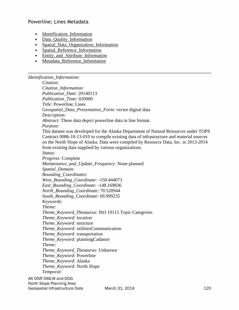
AK DNR DMLW and DOG North Slope Planning Area Geospatial Infrastructure Data March 31, 2014 120
Powerline; Lines Metadata
• Identification_Information
• Data_Quality_Information
• Spatial_Data_Organization_Information
• Spatial_Reference_Information
• Entity_and_Attribute_Information
• Metadata_Reference_Information
Identification_Information:
Citation:
Citation_Information:
Publication_Date: 20140113
Publication_Time: 020000
Title: Powerline; Lines
Geospatial_Data_Presentation_Form: vector digital data
Description:
Abstract: These data depict powerline data in line format.
Purpose:
This dataset was developed for the Alaska Department of Natural Resources under TOPS
Contract 0086-10-13-010 to compile existing data of infrastructure and material sources
on the North Slope of Alaska. Data were compiled by Resource Data, Inc. in 2013-2014
from existing data supplied by various organizations.
Status:
Progress: Complete
Maintenance_and_Update_Frequency: None planned
Spatial_Domain:
Bounding_Coordinates:
West_Bounding_Coordinate: -150.444073
East_Bounding_Coordinate: -148.169836
North_Bounding_Coordinate: 70.520944
South_Bounding_Coordinate: 69.999235
Keywords:
Theme:
Theme_Keyword_Thesaurus: ISO 19115 Topic Categories
Theme_Keyword: location
Theme_Keyword: structure
Theme_Keyword: utilitiesCommunication
Theme_Keyword: transportation
Theme_Keyword: planningCadastre
Theme:
Theme_Keyword_Thesaurus: Unknown
Theme_Keyword: Powerline
Theme_Keyword: Alaska
Theme_Keyword: North Slope
Temporal:

AK DNR DMLW and DOG North Slope Planning Area Geospatial Infrastructure Data March 31, 2014 121
Temporal_Keyword_Thesaurus: Unknown
Temporal_Keyword: Unknown
Access_Constraints: None
Use_Constraints:
Use limited by Alaska DNR. Features identified with field CONF = "Y" were identified
as confidential by the source organization.
Point_of_Contact:
Contact_Information:
Contact_Organization_Primary:
Contact_Organization:
AK Department of Natural Resources - Information Resource Management Section
Contact_Person: GIS Public Access Coordinator
Contact_Position: GIS Public Access Coordinator
Contact_Address:
Address_Type: mailing and physical
Address: 550 W. 7th Suite 706
City: Anchorage
State_or_Province: AK
Postal_Code: 99501
Country: US
Contact_Voice_Telephone: 907 269 8839
Contact_Facsimile_Telephone: 907 269 8920
Contact_Electronic_Mail_Address: [email protected]
Hours_of_Service: 800-1600 AST
Point_of_Contact:
Contact_Information:
Contact_Organization_Primary:
Contact_Organization:
AK Department of Natural Resources - Information Resource Management Section
Contact_Person: GIS Public Access Coordinator
Contact_Position: GIS Public Access Coordinator
Contact_Address:
Address_Type: mailing and physical
Address: 550 W. 7th Suite 706
City: Anchorage
State_or_Province: AK
Postal_Code: 99501
Country: US
Contact_Voice_Telephone: 907 269 8839
Contact_Facsimile_Telephone: 907 269 8920
Contact_Electronic_Mail_Address: [email protected]
Hours_of_Service: 800-1600 AST
Native_Data_Set_Environment:
Microsoft Windows 7 Version 6.1 (Build 7601) Service Pack 1; Esri ArcGIS 10.1.0.3035
Data_Quality_Information:
Logical_Consistency_Report: Unknown

AK DNR DMLW and DOG North Slope Planning Area Geospatial Infrastructure Data March 31, 2014 122
Lineage:
Process_Step:
Process_Description:
Data were obtained from BP and ConocoPhillips Alaska. The data were then loaded into
the feature class. Each record includes the attribution to link back to the original source,
including source organization, source feature name, source object ID, confidentiality
information, and DNR data types. See each record's attributes for this information.
Process_Date: 20140110
Spatial_Data_Organization_Information:
Direct_Spatial_Reference_Method: Vector
Point_and_Vector_Object_Information:
SDTS_Terms_Description:
SDTS_Point_and_Vector_Object_Type: String
Point_and_Vector_Object_Count: 3181
Spatial_Reference_Information:
Horizontal_Coordinate_System_Definition:
Planar:
Map_Projection:
Map_Projection_Name: Albers Conical Equal Area
Albers_Conical_Equal_Area:
Standard_Parallel: 55.0
Standard_Parallel: 65.0
Longitude_of_Central_Meridian: -154.0
Latitude_of_Projection_Origin: 50.0
False_Easting: 0.0
False_Northing: 0.0
Planar_Coordinate_Information:
Planar_Coordinate_Encoding_Method: coordinate pair
Coordinate_Representation:
Abscissa_Resolution: 0.0001
Ordinate_Resolution: 0.0001
Planar_Distance_Units:
Geodetic_Model:
Horizontal_Datum_Name: D North American 1983
Ellipsoid_Name: GRS 1980
Semi-major_Axis: 6378137.0
Denominator_of_Flattening_Ratio: 298.257222101
Entity_and_Attribute_Information:
Detailed_Description:
Entity_Type:
Entity_Type_Label: Powerline
Entity_Type_Definition:
Powerline data in line format provided by the source organizations.
Entity_Type_Definition_Source: RDI

AK DNR DMLW and DOG North Slope Planning Area Geospatial Infrastructure Data March 31, 2014 123
Attribute:
Attribute_Label: Source_FC
Attribute_Definition: The name of the source featureclass, CAD file, or shapefile.
Attribute_Definition_Source: RDI
Attribute_Domain_Values:
Unrepresentable_Domain: Name of source featureclass.
Attribute:
Attribute_Label: Type
Attribute_Definition: Type of feature. Used for display and organization purposes.
Attribute_Definition_Source: RDI
Attribute_Domain_Values:
Unrepresentable_Domain: Type of feature. Used for display and organization purposes.
Attribute:
Attribute_Label: SHAPE_Length
Attribute_Definition: Length of feature in internal units.
Attribute_Definition_Source: Esri
Attribute_Domain_Values:
Unrepresentable_Domain: Positive real numbers that are automatically generated.
Attribute:
Attribute_Label: Operator
Attribute_Definition: Operator of the powerline.
Attribute_Definition_Source: RDI
Attribute_Domain_Values:
Unrepresentable_Domain: Operator of the powerline.
Attribute:
Attribute_Label: DOG_Type
Attribute_Definition: ADNR Division of Oil and Gas data type code.
Attribute_Definition_Source: ADNR DOG
Attribute_Domain_Values:
Enumerated_Domain:
Enumerated_Domain_Value: 6
Enumerated_Domain_Value_Definition: Telephone
Enumerated_Domain_Value_Definition_Source: ADNR DOG
Enumerated_Domain:
Enumerated_Domain_Value: 2
Enumerated_Domain_Value_Definition: Secondary Road
Enumerated_Domain_Value_Definition_Source: ADNR DOG
Enumerated_Domain:
Enumerated_Domain_Value: 7
Enumerated_Domain_Value_Definition: Landing strip
Enumerated_Domain_Value_Definition_Source: ADNR DOG
Enumerated_Domain:
Enumerated_Domain_Value: 1
Enumerated_Domain_Value_Definition: Highway
Enumerated_Domain_Value_Definition_Source: ADNR DOG
Enumerated_Domain:
Enumerated_Domain_Value: 10
AK DNR DMLW and DOG North Slope Planning Area Geospatial Infrastructure Data March 31, 2014 124
Enumerated_Domain_Value_Definition: Alaska Marine Highway
Enumerated_Domain_Value_Definition_Source: ADNR DOG
Enumerated_Domain:
Enumerated_Domain_Value: 4
Enumerated_Domain_Value_Definition: Railroad
Enumerated_Domain_Value_Definition_Source: ADNR DOG
Enumerated_Domain:
Enumerated_Domain_Value: 11
Enumerated_Domain_Value_Definition: Fiberoptic
Enumerated_Domain_Value_Definition_Source: ADNR DOG
Enumerated_Domain:
Enumerated_Domain_Value: 9
Enumerated_Domain_Value_Definition: Forest Development Road
Enumerated_Domain_Value_Definition_Source: ADNR DOG
Enumerated_Domain:
Enumerated_Domain_Value: 8
Enumerated_Domain_Value_Definition: Pipeline
Enumerated_Domain_Value_Definition_Source: ADNR DOG
Enumerated_Domain:
Enumerated_Domain_Value: 3
Enumerated_Domain_Value_Definition: Trail
Enumerated_Domain_Value_Definition_Source: ADNR DOG
Enumerated_Domain:
Enumerated_Domain_Value: 0
Enumerated_Domain_Value_Definition: Unknown infrastructure
Enumerated_Domain_Value_Definition_Source: ADNR DOG
Enumerated_Domain:
Enumerated_Domain_Value: 5
Enumerated_Domain_Value_Definition: Electrical
Enumerated_Domain_Value_Definition_Source: ADNR DOG
Attribute:
Attribute_Label: Conf
Attribute_Definition:
This identifies if the source organization identified the data as confidential.
Attribute_Definition_Source: RDI
Attribute_Domain_Values:
Enumerated_Domain:
Enumerated_Domain_Value: Y
Enumerated_Domain_Value_Definition: Data is confidential.
Enumerated_Domain_Value_Definition_Source: RDI
Enumerated_Domain:
Enumerated_Domain_Value: N
Enumerated_Domain_Value_Definition: Data is not confidential.
Enumerated_Domain_Value_Definition_Source: RDI
Attribute:
Attribute_Label: Voltage
Attribute_Definition: Voltage of the powerline.
AK DNR DMLW and DOG North Slope Planning Area Geospatial Infrastructure Data March 31, 2014 125
Attribute_Definition_Source: RDI
Attribute_Domain_Values:
Unrepresentable_Domain: Voltage of the powerline.
Attribute:
Attribute_Label: OBJECTID
Attribute_Definition: Internal feature number.
Attribute_Definition_Source: Esri
Attribute_Domain_Values:
Unrepresentable_Domain:
Sequential unique whole numbers that are automatically generated by the GIS
application.
Attribute:
Attribute_Label: Source_Org
Attribute_Definition: The organization which provided this data.
Attribute_Definition_Source: RDI
Attribute_Domain_Values:
Unrepresentable_Domain: Name of source organization.
Attribute:
Attribute_Label: Name
Attribute_Definition: Name of the feature.
Attribute_Definition_Source: RDI
Attribute_Domain_Values:
Unrepresentable_Domain: Name of the feature.
Attribute:
Attribute_Label: SHAPE
Attribute_Definition: Feature geometry.
Attribute_Definition_Source: Esri
Attribute_Domain_Values:
Unrepresentable_Domain: Coordinates defining the features.
Attribute:
Attribute_Label: Source_OID
Attribute_Definition: The source data's original object ID.
Attribute_Definition_Source: RDI
Attribute_Domain_Values:
Unrepresentable_Domain: Source object ID.
Attribute:
Attribute_Label: Desc
Attribute_Definition: Description of the feature.
Attribute_Definition_Source: RDI
Attribute_Domain_Values:
Unrepresentable_Domain: Description of the feature.
Attribute:
Attribute_Label: Acquisition_Date
Attribute_Definition: Date of data acquisition.
Attribute_Definition_Source: RDI
Overview_Description:
Entity_and_Attribute_Overview:

AK DNR DMLW and DOG North Slope Planning Area Geospatial Infrastructure Data March 31, 2014 126
The data in this feature class were obtained and consolidated from several source
organizations as noted in the lineage. During this consolidation, data attributes were
abstracted to load all similar information into a single field (for example Name, short
description, feature_name would have all been loaded to NAME). Because the data did
not always include a data dictionary, not all domains are defined. Please see the original
data for full information from the data's originator. Data are provided as unchanged from
source organizations. The fields populated by RDI for Alaska DNR are described in this
metadata.
Metadata_Reference_Information:
Metadata_Date: 20140226
Metadata_Contact:
Contact_Information:
Contact_Organization_Primary:
Contact_Organization: Resource Data, Inc.
Contact_Person: Bixler McClure
Contact_Position: GIS Programmer/Analyst
Contact_Address:
Address_Type: mailing and physical
Address: 560 E. 34th Ave., Suite 100
City: Anchorage
State_or_Province: AK
Postal_Code: 99503
Country: US
Contact_Voice_Telephone: 907-563-8100
Contact_Facsimile_Telephone: 907-561-0159
Contact_Electronic_Mail_Address: [email protected]
Metadata_Standard_Name: FGDC Content Standard for Digital Geospatial Metadata
Metadata_Standard_Version: FGDC-STD-001-1998
Metadata_Time_Convention: local time
Generated by mp version 2.9.12 on Tue Mar 18 09:48:44 2014

AK DNR DMLW and DOG North Slope Planning Area Geospatial Infrastructure Data March 31, 2014 127
Roads; Lines Metadata
• Identification_Information
• Data_Quality_Information
• Spatial_Data_Organization_Information
• Spatial_Reference_Information
• Entity_and_Attribute_Information
• Metadata_Reference_Information
Identification_Information:
Citation:
Citation_Information:
Publication_Date: 20140113
Publication_Time: 020000
Title: Roads; Lines
Geospatial_Data_Presentation_Form: vector digital data
Description:
Abstract: These data depict roads in line format.
Purpose:
This dataset was developed for the Alaska Department of Natural Resources under TOPS
Contract 0086-10-13-010 to compile existing data of infrastructure and material sources
on the North Slope of Alaska. Data were compiled by Resource Data, Inc. in 2013-2014
from existing data supplied by various organizations.
Status:
Progress: Complete
Maintenance_and_Update_Frequency: None planned
Spatial_Domain:
Bounding_Coordinates:
West_Bounding_Coordinate: -180.000000
East_Bounding_Coordinate: 180.000000
North_Bounding_Coordinate: 71.400964
South_Bounding_Coordinate: 51.570519
Keywords:
Theme:
Theme_Keyword_Thesaurus: ISO 19115 Topic Categories
Theme_Keyword: location
Theme_Keyword: structure
Theme_Keyword: utilitiesCommunication
Theme_Keyword: transportation
Theme_Keyword: planningCadastre
Theme:
Theme_Keyword_Thesaurus: Unknown
Theme_Keyword: Roads
Theme_Keyword: Alaska
Theme_Keyword: North Slope
Temporal:

AK DNR DMLW and DOG North Slope Planning Area Geospatial Infrastructure Data March 31, 2014 128
Temporal_Keyword_Thesaurus: Unknown
Temporal_Keyword: Unknown
Access_Constraints: None
Use_Constraints:
Use limited by Alaska DNR. Features identified with field CONF = "Y" were identified
as confidential by the source organization.
Point_of_Contact:
Contact_Information:
Contact_Organization_Primary:
Contact_Organization:
AK Department of Natural Resources - Information Resource Management Section
Contact_Person: GIS Public Access Coordinator
Contact_Position: GIS Public Access Coordinator
Contact_Address:
Address_Type: mailing and physical
Address: 550 W. 7th Suite 706
City: Anchorage
State_or_Province: AK
Postal_Code: 99501
Country: US
Contact_Voice_Telephone: 907 269 8839
Contact_Facsimile_Telephone: 907 269 8920
Contact_Electronic_Mail_Address: [email protected]
Hours_of_Service: 800-1600 AST
Point_of_Contact:
Contact_Information:
Contact_Organization_Primary:
Contact_Organization:
AK Department of Natural Resources - Information Resource Management Section
Contact_Person: GIS Public Access Coordinator
Contact_Position: GIS Public Access Coordinator
Contact_Address:
Address_Type: mailing and physical
Address: 550 W. 7th Suite 706
City: Anchorage
State_or_Province: AK
Postal_Code: 99501
Country: US
Contact_Voice_Telephone: 907 269 8839
Contact_Facsimile_Telephone: 907 269 8920
Contact_Electronic_Mail_Address: [email protected]
Hours_of_Service: 800-1600 AST
Native_Data_Set_Environment:
Microsoft Windows 7 Version 6.1 (Build 7601) Service Pack 1; Esri ArcGIS 10.1.0.3035
Data_Quality_Information:
Logical_Consistency_Report: Unknown
AK DNR DMLW and DOG North Slope Planning Area Geospatial Infrastructure Data March 31, 2014 129
Lineage:
Process_Step:
Process_Description:
Data were obtained from ADNR DOG, ADOT PF, the Geographic Coordinate Database,
the North Slope Borough, and Repsol. The data were then loaded into the feature class.
Each record includes the attribution to link back to the original source, including source
organization, source feature name, source object ID, confidentiality information, and
DNR data types. See each record's attributes for this information.
Process_Date: 20140110
Spatial_Data_Organization_Information:
Direct_Spatial_Reference_Method: Vector
Point_and_Vector_Object_Information:
SDTS_Terms_Description:
SDTS_Point_and_Vector_Object_Type: String
Point_and_Vector_Object_Count: 15716
Spatial_Reference_Information:
Horizontal_Coordinate_System_Definition:
Planar:
Map_Projection:
Map_Projection_Name: Albers Conical Equal Area
Albers_Conical_Equal_Area:
Standard_Parallel: 55.0
Standard_Parallel: 65.0
Longitude_of_Central_Meridian: -154.0
Latitude_of_Projection_Origin: 50.0
False_Easting: 0.0
False_Northing: 0.0
Planar_Coordinate_Information:
Planar_Coordinate_Encoding_Method: coordinate pair
Coordinate_Representation:
Abscissa_Resolution: 0.0001
Ordinate_Resolution: 0.0001
Planar_Distance_Units:
Geodetic_Model:
Horizontal_Datum_Name: D North American 1983
Ellipsoid_Name: GRS 1980
Semi-major_Axis: 6378137.0
Denominator_of_Flattening_Ratio: 298.257222101
Entity_and_Attribute_Information:
Detailed_Description:
Entity_Type:
Entity_Type_Label: Road_ln
Entity_Type_Definition: Road data in line format provided by the source organizations.
Entity_Type_Definition_Source: RDI

AK DNR DMLW and DOG North Slope Planning Area Geospatial Infrastructure Data March 31, 2014 130
Attribute:
Attribute_Label: OBJECTID
Attribute_Definition: Internal feature number.
Attribute_Definition_Source: Esri
Attribute_Domain_Values:
Unrepresentable_Domain:
Sequential unique whole numbers that are automatically generated by the GIS
application.
Attribute:
Attribute_Label: SHAPE_Length
Attribute_Definition: Length of feature in internal units.
Attribute_Definition_Source: Esri
Attribute_Domain_Values:
Unrepresentable_Domain: Positive real numbers that are automatically generated.
Attribute:
Attribute_Label: Source_Org
Attribute_Definition: The organization which provided this data.
Attribute_Definition_Source: RDI
Attribute_Domain_Values:
Unrepresentable_Domain: Name of source organization.
Attribute:
Attribute_Label: Type
Attribute_Definition: Type of feature. Used for display and organization purposes.
Attribute_Definition_Source: RDI
Attribute_Domain_Values:
Unrepresentable_Domain: Type of feature. Used for display and organization purposes.
Attribute:
Attribute_Label: Source_OID
Attribute_Definition: The source data's original object ID.
Attribute_Definition_Source: RDI
Attribute_Domain_Values:
Unrepresentable_Domain: Source object ID.
Attribute:
Attribute_Label: SHAPE
Attribute_Definition: Feature geometry.
Attribute_Definition_Source: Esri
Attribute_Domain_Values:
Unrepresentable_Domain: Coordinates defining the features.
Attribute:
Attribute_Label: Name
Attribute_Definition: Name of the feature.
Attribute_Definition_Source: RDI
Attribute_Domain_Values:
Unrepresentable_Domain: Name of the feature.
Attribute:
Attribute_Label: Material
Attribute_Definition: Material of the road.

AK DNR DMLW and DOG North Slope Planning Area Geospatial Infrastructure Data March 31, 2014 131
Attribute_Definition_Source: RDI
Attribute_Domain_Values:
Unrepresentable_Domain: Material of the road.
Attribute:
Attribute_Label: Width_ft
Attribute_Definition: Width of the road in feet.
Attribute_Definition_Source: RDI
Attribute_Domain_Values:
Unrepresentable_Domain: Width of the road in feet.
Attribute:
Attribute_Label: Conf
Attribute_Definition:
This identifies if the source organization identified the data as confidential.
Attribute_Definition_Source: RDI
Attribute_Domain_Values:
Enumerated_Domain:
Enumerated_Domain_Value: N
Enumerated_Domain_Value_Definition: Data is not confidential.
Enumerated_Domain_Value_Definition_Source: RDI
Enumerated_Domain:
Enumerated_Domain_Value: Y
Enumerated_Domain_Value_Definition: Data is confidential.
Enumerated_Domain_Value_Definition_Source: RDI
Attribute:
Attribute_Label: Source_FC
Attribute_Definition: The name of the source featureclass, CAD file, or shapefile.
Attribute_Definition_Source: RDI
Attribute_Domain_Values:
Unrepresentable_Domain: Name of source featureclass.
Attribute:
Attribute_Label: Operator
Attribute_Definition: Operator of the road.
Attribute_Definition_Source: RDI
Attribute_Domain_Values:
Unrepresentable_Domain: Operator of the road.
Attribute:
Attribute_Label: Desc
Attribute_Definition: Description of the feature.
Attribute_Definition_Source: RDI
Attribute_Domain_Values:
Unrepresentable_Domain: Description of the feature.
Attribute:
Attribute_Label: DOG_Type
Attribute_Definition: ADNR Division of Oil and Gas data type code.
Attribute_Definition_Source: ADNR DOG
Attribute_Domain_Values:
Enumerated_Domain:

AK DNR DMLW and DOG North Slope Planning Area Geospatial Infrastructure Data March 31, 2014 132
Enumerated_Domain_Value: 0
Enumerated_Domain_Value_Definition: Unknown Infrastructure
Enumerated_Domain_Value_Definition_Source: ADNR DOG
Enumerated_Domain:
Enumerated_Domain_Value: 1
Enumerated_Domain_Value_Definition: Highway
Enumerated_Domain_Value_Definition_Source: ADNR DOG
Enumerated_Domain:
Enumerated_Domain_Value: 2
Enumerated_Domain_Value_Definition: Secondary Road
Enumerated_Domain_Value_Definition_Source: ADNR DOG
Enumerated_Domain:
Enumerated_Domain_Value: 3
Enumerated_Domain_Value_Definition: Trail
Enumerated_Domain_Value_Definition_Source: ADNR DOG
Enumerated_Domain:
Enumerated_Domain_Value: 4
Enumerated_Domain_Value_Definition: Railroad
Enumerated_Domain_Value_Definition_Source: ADNR DOG
Enumerated_Domain:
Enumerated_Domain_Value: 5
Enumerated_Domain_Value_Definition: Electrical
Enumerated_Domain_Value_Definition_Source: ADNR DOG
Enumerated_Domain:
Enumerated_Domain_Value: 6
Enumerated_Domain_Value_Definition: Telephone
Enumerated_Domain_Value_Definition_Source: ADNR DOG
Enumerated_Domain:
Enumerated_Domain_Value: 7
Enumerated_Domain_Value_Definition: Landing Strip
Enumerated_Domain_Value_Definition_Source: ADNR DOG
Enumerated_Domain:
Enumerated_Domain_Value: 8
Enumerated_Domain_Value_Definition: Pipeline
Enumerated_Domain_Value_Definition_Source: ADNR DOG
Enumerated_Domain:
Enumerated_Domain_Value: 9
Enumerated_Domain_Value_Definition: Forest Development Road
Enumerated_Domain_Value_Definition_Source: ADNR DOG
Enumerated_Domain:
Enumerated_Domain_Value: 10
Enumerated_Domain_Value_Definition: Alaska Marine Highway
Enumerated_Domain_Value_Definition_Source: ADNR DOG
Enumerated_Domain:
Enumerated_Domain_Value: 11
Enumerated_Domain_Value_Definition: Fiberoptic
Enumerated_Domain_Value_Definition_Source: ADNR DOG
AK DNR DMLW and DOG North Slope Planning Area Geospatial Infrastructure Data March 31, 2014 133
Attribute:
Attribute_Label: Acquisition_Date
Attribute_Definition: Date of data acquisition.
Attribute_Definition_Source: RDI
Overview_Description:
Entity_and_Attribute_Overview:
The data in this feature class were obtained and consolidated from several source
organizations as noted in the lineage. During this consolidation, data attributes were
abstracted to load all similar information into a single field (for example Name, short
description, feature_name would have all been loaded to NAME). Because the data did
not always include a data dictionary, not all domains are defined. Please see the original
data for full information from the data's originator. Data are provided as unchanged from
source organizations. The fields populated by RDI for Alaska DNR are described in this
metadata.
Metadata_Reference_Information:
Metadata_Date: 20140226
Metadata_Contact:
Contact_Information:
Contact_Organization_Primary:
Contact_Organization: Resource Data, Inc.
Contact_Person: Bixler McClure
Contact_Position: GIS Programmer/Analyst
Contact_Address:
Address_Type: mailing and physical
Address: 560 E. 34th Ave., Suite 100
City: Anchorage
State_or_Province: AK
Postal_Code: 99503
Country: US
Contact_Voice_Telephone: 907-563-8100
Contact_Facsimile_Telephone: 907-561-0159
Contact_Electronic_Mail_Address: [email protected]
Metadata_Standard_Name: FGDC Content Standard for Digital Geospatial Metadata
Metadata_Standard_Version: FGDC-STD-001-1998
Metadata_Time_Convention: local time
Generated by mp version 2.9.12 on Tue Mar 18 09:48:44 2014

AK DNR DMLW and DOG North Slope Planning Area Geospatial Infrastructure Data March 31, 2014 134
Roads; Polygons Metadata
• Identification_Information
• Data_Quality_Information
• Spatial_Data_Organization_Information
• Spatial_Reference_Information
• Entity_and_Attribute_Information
• Metadata_Reference_Information
Identification_Information:
Citation:
Citation_Information:
Publication_Date: 20140113
Publication_Time: 020000
Title: Roads; Polygons
Geospatial_Data_Presentation_Form: vector digital data
Description:
Abstract: These data depict roads in polygon format.
Purpose:
This dataset was developed for the Alaska Department of Natural Resources under TOPS
Contract 0086-10-13-010 to compile existing data of infrastructure and material sources
on the North Slope of Alaska. Data were compiled by Resource Data, Inc. in 2013-2014
from existing data supplied by various organizations.
Status:
Progress: Complete
Maintenance_and_Update_Frequency: None planned
Spatial_Domain:
Bounding_Coordinates:
West_Bounding_Coordinate: -150.293198
East_Bounding_Coordinate: -150.117383
North_Bounding_Coordinate: 70.273288
South_Bounding_Coordinate: 70.245002
Keywords:
Theme:
Theme_Keyword_Thesaurus: ISO 19115 Topic Categories
Theme_Keyword: location
Theme_Keyword: structure
Theme_Keyword: utilitiesCommunication
Theme_Keyword: transportation
Theme_Keyword: planningCadastre
Theme:
Theme_Keyword_Thesaurus: Unknown
Theme_Keyword: Roads
Theme_Keyword: Alaska
Theme_Keyword: North Slope
Temporal:
AK DNR DMLW and DOG North Slope Planning Area Geospatial Infrastructure Data March 31, 2014 135
Temporal_Keyword_Thesaurus: Unknown
Temporal_Keyword: Unknown
Access_Constraints: None
Use_Constraints:
Use limited by Alaska DNR. Features identified with field CONF = "Y" were identified
as confidential by the source organization.
Point_of_Contact:
Contact_Information:
Contact_Organization_Primary:
Contact_Organization:
AK Department of Natural Resources - Information Resource Management Section
Contact_Person: GIS Public Access Coordinator
Contact_Position: GIS Public Access Coordinator
Contact_Address:
Address_Type: mailing and physical
Address: 550 W. 7th Suite 706
City: Anchorage
State_or_Province: AK
Postal_Code: 99501
Country: US
Contact_Voice_Telephone: 907 269 8839
Contact_Facsimile_Telephone: 907 269 8920
Contact_Electronic_Mail_Address: [email protected]
Hours_of_Service: 800-1600 AST
Point_of_Contact:
Contact_Information:
Contact_Organization_Primary:
Contact_Organization:
AK Department of Natural Resources - Information Resource Management Section
Contact_Person: GIS Public Access Coordinator
Contact_Position: GIS Public Access Coordinator
Contact_Address:
Address_Type: mailing and physical
Address: 550 W. 7th Suite 706
City: Anchorage
State_or_Province: AK
Postal_Code: 99501
Country: US
Contact_Voice_Telephone: 907 269 8839
Contact_Facsimile_Telephone: 907 269 8920
Contact_Electronic_Mail_Address: [email protected]
Hours_of_Service: 800-1600 AST
Native_Data_Set_Environment:
Microsoft Windows 7 Version 6.1 (Build 7601) Service Pack 1; Esri ArcGIS 10.1.0.3035
Data_Quality_Information:
Logical_Consistency_Report: Unknown

AK DNR DMLW and DOG North Slope Planning Area Geospatial Infrastructure Data March 31, 2014 136
Lineage:
Process_Step:
Process_Description:
Data were obtained from Brooks Range Petroleum Corporation. The data were then
loaded into the feature class. Each record includes the attribution to link back to the
original source, including source organization, source feature name, source object ID,
confidentiality information, and DNR data types. See each record's attributes for this
information.
Process_Date: 20140110
Spatial_Data_Organization_Information:
Direct_Spatial_Reference_Method: Vector
Point_and_Vector_Object_Information:
SDTS_Terms_Description:
SDTS_Point_and_Vector_Object_Type: GT-polygon composed of chains
Point_and_Vector_Object_Count: 1
Spatial_Reference_Information:
Horizontal_Coordinate_System_Definition:
Planar:
Map_Projection:
Map_Projection_Name: Albers Conical Equal Area
Albers_Conical_Equal_Area:
Standard_Parallel: 55.0
Standard_Parallel: 65.0
Longitude_of_Central_Meridian: -154.0
Latitude_of_Projection_Origin: 50.0
False_Easting: 0.0
False_Northing: 0.0
Planar_Coordinate_Information:
Planar_Coordinate_Encoding_Method: coordinate pair
Coordinate_Representation:
Abscissa_Resolution: 0.0001
Ordinate_Resolution: 0.0001
Planar_Distance_Units:
Geodetic_Model:
Horizontal_Datum_Name: D North American 1983
Ellipsoid_Name: GRS 1980
Semi-major_Axis: 6378137.0
Denominator_of_Flattening_Ratio: 298.257222101
Entity_and_Attribute_Information:
Detailed_Description:
Entity_Type:
Entity_Type_Label: Road_py
Entity_Type_Definition:
Road data in polygon format provided by the source organizations.

AK DNR DMLW and DOG North Slope Planning Area Geospatial Infrastructure Data March 31, 2014 137
Entity_Type_Definition_Source: RDI
Attribute:
Attribute_Label: Name
Attribute_Definition: Name of the feature.
Attribute_Definition_Source: RDI
Attribute_Domain_Values:
Unrepresentable_Domain: Name of the feature.
Attribute:
Attribute_Label: DOG_Type
Attribute_Definition: ADNR Division of Oil and Gas data type code.
Attribute_Definition_Source: ADNR DOG
Attribute_Domain_Values:
Enumerated_Domain:
Enumerated_Domain_Value: 0
Enumerated_Domain_Value_Definition: Unknown Infrastructure
Enumerated_Domain_Value_Definition_Source: ADNR DOG
Enumerated_Domain:
Enumerated_Domain_Value: 4
Enumerated_Domain_Value_Definition: Railroad
Enumerated_Domain_Value_Definition_Source: ADNR DOG
Enumerated_Domain:
Enumerated_Domain_Value: 1
Enumerated_Domain_Value_Definition: Highway
Enumerated_Domain_Value_Definition_Source: ADNR DOG
Enumerated_Domain:
Enumerated_Domain_Value: 2
Enumerated_Domain_Value_Definition: Secondary Road
Enumerated_Domain_Value_Definition_Source: ADNR DOG
Enumerated_Domain:
Enumerated_Domain_Value: 9
Enumerated_Domain_Value_Definition: Forest Development Road
Enumerated_Domain_Value_Definition_Source: ADNR DOG
Enumerated_Domain:
Enumerated_Domain_Value: 7
Enumerated_Domain_Value_Definition: Landing Strip
Enumerated_Domain_Value_Definition_Source: ADNR DOG
Enumerated_Domain:
Enumerated_Domain_Value: 3
Enumerated_Domain_Value_Definition: Trail
Enumerated_Domain_Value_Definition_Source: ADNR DOG
Enumerated_Domain:
Enumerated_Domain_Value: 10
Enumerated_Domain_Value_Definition: Alaska Marine Highway
Enumerated_Domain_Value_Definition_Source: ADNR DOG
Enumerated_Domain:
Enumerated_Domain_Value: 8
Enumerated_Domain_Value_Definition: Pipeline

AK DNR DMLW and DOG North Slope Planning Area Geospatial Infrastructure Data March 31, 2014 138
Enumerated_Domain_Value_Definition_Source: ADNR DOG
Enumerated_Domain:
Enumerated_Domain_Value: 6
Enumerated_Domain_Value_Definition: Telephone
Enumerated_Domain_Value_Definition_Source: ADNR DOG
Enumerated_Domain:
Enumerated_Domain_Value: 11
Enumerated_Domain_Value_Definition: Fiberoptic
Enumerated_Domain_Value_Definition_Source: ADNR DOG
Enumerated_Domain:
Enumerated_Domain_Value: 5
Enumerated_Domain_Value_Definition: Electrical
Enumerated_Domain_Value_Definition_Source: ADNR DOG
Attribute:
Attribute_Label: Material
Attribute_Definition: Material of the road.
Attribute_Definition_Source: RDI
Attribute_Domain_Values:
Unrepresentable_Domain: Material of the road.
Attribute:
Attribute_Label: Desc
Attribute_Definition: Description of the feature.
Attribute_Definition_Source: RDI
Attribute_Domain_Values:
Unrepresentable_Domain: Description of the feature.
Attribute:
Attribute_Label: SHAPE_Length
Attribute_Definition: Length of feature in internal units.
Attribute_Definition_Source: Esri
Attribute_Domain_Values:
Unrepresentable_Domain: Positive real numbers that are automatically generated.
Attribute:
Attribute_Label: Source_FC
Attribute_Definition: The name of the source featureclass, CAD file, or shapefile.
Attribute_Definition_Source: RDI
Attribute_Domain_Values:
Unrepresentable_Domain: Name of source featureclass.
Attribute:
Attribute_Label: Conf
Attribute_Definition:
This identifies if the source organization identified the data as confidential.
Attribute_Definition_Source: RDI
Attribute_Domain_Values:
Enumerated_Domain:
Enumerated_Domain_Value: N
Enumerated_Domain_Value_Definition: Data is not confidential.
Enumerated_Domain_Value_Definition_Source: RDI

AK DNR DMLW and DOG North Slope Planning Area Geospatial Infrastructure Data March 31, 2014 139
Enumerated_Domain:
Enumerated_Domain_Value: Y
Enumerated_Domain_Value_Definition: Data is confidential.
Enumerated_Domain_Value_Definition_Source: RDI
Attribute:
Attribute_Label: SHAPE
Attribute_Definition: Feature geometry.
Attribute_Definition_Source: Esri
Attribute_Domain_Values:
Unrepresentable_Domain: Coordinates defining the features.
Attribute:
Attribute_Label: Source_OID
Attribute_Definition: The source data's original object ID.
Attribute_Definition_Source: RDI
Attribute_Domain_Values:
Unrepresentable_Domain: Source object ID.
Attribute:
Attribute_Label: Type
Attribute_Definition: Type of feature. Used for display and organization purposes.
Attribute_Definition_Source: RDI
Attribute_Domain_Values:
Unrepresentable_Domain: Type of feature. Used for display and organization purposes.
Attribute:
Attribute_Label: OBJECTID
Attribute_Definition: Internal feature number.
Attribute_Definition_Source: Esri
Attribute_Domain_Values:
Unrepresentable_Domain:
Sequential unique whole numbers that are automatically generated by the GIS
application.
Attribute:
Attribute_Label: Source_Org
Attribute_Definition: The organization which provided this data.
Attribute_Definition_Source: RDI
Attribute_Domain_Values:
Unrepresentable_Domain: Name of source organization.
Attribute:
Attribute_Label: SHAPE_Area
Attribute_Definition: Area of feature in internal units squared.
Attribute_Definition_Source: Esri
Attribute_Domain_Values:
Unrepresentable_Domain: Positive real numbers that are automatically generated.
Attribute:
Attribute_Label: Operator
Attribute_Definition: Operator of the road.
Attribute_Definition_Source: RDI
Attribute_Domain_Values:

AK DNR DMLW and DOG North Slope Planning Area Geospatial Infrastructure Data March 31, 2014 140
Unrepresentable_Domain: Operator of the road.
Attribute:
Attribute_Label: Acquisition_Date
Attribute_Definition: Date of data acquisition.
Attribute_Definition_Source: RDI
Overview_Description:
Entity_and_Attribute_Overview:
The data in this feature class were obtained and consolidated from several source
organizations as noted in the lineage. During this consolidation, data attributes were
abstracted to load all similar information into a single field (for example Name, short
description, feature_name would have all been loaded to NAME). Because the data did
not always include a data dictionary, not all domains are defined. Please see the original
data for full information from the data's originator. Data are provided as unchanged from
source organizations. The fields populated by RDI for Alaska DNR are described in this
metadata.
Metadata_Reference_Information:
Metadata_Date: 20140226
Metadata_Contact:
Contact_Information:
Contact_Organization_Primary:
Contact_Organization: Resource Data, Inc.
Contact_Person: Bixler McClure
Contact_Position: GIS Programmer/Analyst
Contact_Address:
Address_Type: mailing and physical
Address: 560 E. 34th Ave., Suite 100
City: Anchorage
State_or_Province: AK
Postal_Code: 99503
Country: US
Contact_Voice_Telephone: 907-563-8100
Contact_Facsimile_Telephone: 907-561-0159
Contact_Electronic_Mail_Address: [email protected]
Metadata_Standard_Name: FGDC Content Standard for Digital Geospatial Metadata
Metadata_Standard_Version: FGDC-STD-001-1998
Metadata_Time_Convention: local time
Generated by mp version 2.9.12 on Tue Mar 18 09:48:44 2014
AK DNR DMLW and DOG North Slope Planning Area Geospatial Infrastructure Data March 31, 2014 141
Structures; Points Metadata
• Identification_Information
• Data_Quality_Information
• Spatial_Data_Organization_Information
• Spatial_Reference_Information
• Entity_and_Attribute_Information
• Metadata_Reference_Information
Identification_Information:
Citation:
Citation_Information:
Publication_Date: 20140113
Publication_Time: 020000
Title: Structures; Points
Geospatial_Data_Presentation_Form: vector digital data
Description:
Abstract: Structures in point format.
Purpose:
This dataset was developed for the Alaska Department of Natural Resources under TOPS
Contract 0086-10-13-010 to compile existing data of infrastructure and material sources
on the North Slope of Alaska. Data were compiled by Resource Data, Inc. in 2013-2014
from existing data supplied by various organizations.
Status:
Progress: Complete
Maintenance_and_Update_Frequency: None planned
Spatial_Domain:
Bounding_Coordinates:
West_Bounding_Coordinate: -180.000000
East_Bounding_Coordinate: 180.000000
North_Bounding_Coordinate: 90.000000
South_Bounding_Coordinate: 0.000000
Keywords:
Theme:
Theme_Keyword_Thesaurus: ISO 19115 Topic Categories
Theme_Keyword: location
Theme_Keyword: structure
Theme_Keyword: utilitiesCommunication
Theme_Keyword: transportation
Theme_Keyword: planningCadastre
Theme:
Theme_Keyword_Thesaurus: Unknown
Theme_Keyword: Powerlines
Theme_Keyword: Guywires
Theme_Keyword: Culverts
Theme_Keyword: Bridges

AK DNR DMLW and DOG North Slope Planning Area Geospatial Infrastructure Data March 31, 2014 142
Theme_Keyword: Alaska
Theme_Keyword: North Slope
Temporal:
Temporal_Keyword_Thesaurus: Unknown
Temporal_Keyword: Unknown
Access_Constraints: None
Use_Constraints:
Use limited by Alaska DNR. Features identified with field CONF = "Y" were identified
as confidential by the source organization.
Point_of_Contact:
Contact_Information:
Contact_Organization_Primary:
Contact_Organization:
AK Department of Natural Resources - Information Resource Management Section
Contact_Person: GIS Public Access Coordinator
Contact_Position: GIS Public Access Coordinator
Contact_Address:
Address_Type: mailing and physical
Address: 550 W. 7th Suite 706
City: Anchorage
State_or_Province: AK
Postal_Code: 99501
Country: US
Contact_Voice_Telephone: 907 269 8839
Contact_Facsimile_Telephone: 907 269 8920
Contact_Electronic_Mail_Address: [email protected]
Hours_of_Service: 800-1600 AST
Point_of_Contact:
Contact_Information:
Contact_Organization_Primary:
Contact_Organization:
AK Department of Natural Resources - Information Resource Management Section
Contact_Person: GIS Public Access Coordinator
Contact_Position: GIS Public Access Coordinator
Contact_Address:
Address_Type: mailing and physical
Address: 550 W. 7th Suite 706
City: Anchorage
State_or_Province: AK
Postal_Code: 99501
Country: US
Contact_Voice_Telephone: 907 269 8839
Contact_Facsimile_Telephone: 907 269 8920
Contact_Electronic_Mail_Address: [email protected]
Hours_of_Service: 800-1600 AST
Native_Data_Set_Environment:
Microsoft Windows 7 Version 6.1 (Build 7601) Service Pack 1; Esri ArcGIS 10.1.0.3035

AK DNR DMLW and DOG North Slope Planning Area Geospatial Infrastructure Data March 31, 2014 143
Data_Quality_Information:
Logical_Consistency_Report: Unknown
Lineage:
Process_Step:
Process_Description:
Data were obtained from ADNR DOG, ADOT PF, ADNR DMLW, BP, ConocoPhillips
Alaska, and Repsol. The data were then loaded into the feature class. Each record
includes the attribution to link back to the original source, including source organization,
source feature name, source object ID, confidentiality information, and DNR data types.
See each record's attributes for this information.
Process_Date: 20140110
Spatial_Data_Organization_Information:
Direct_Spatial_Reference_Method: Vector
Point_and_Vector_Object_Information:
SDTS_Terms_Description:
SDTS_Point_and_Vector_Object_Type: Entity point
Point_and_Vector_Object_Count: 3976
Spatial_Reference_Information:
Horizontal_Coordinate_System_Definition:
Planar:
Map_Projection:
Map_Projection_Name: Albers Conical Equal Area
Albers_Conical_Equal_Area:
Standard_Parallel: 55.0
Standard_Parallel: 65.0
Longitude_of_Central_Meridian: -154.0
Latitude_of_Projection_Origin: 50.0
False_Easting: 0.0
False_Northing: 0.0
Planar_Coordinate_Information:
Planar_Coordinate_Encoding_Method: coordinate pair
Coordinate_Representation:
Abscissa_Resolution: 0.0001
Ordinate_Resolution: 0.0001
Planar_Distance_Units:
Geodetic_Model:
Horizontal_Datum_Name: D North American 1983
Ellipsoid_Name: GRS 1980
Semi-major_Axis: 6378137.0
Denominator_of_Flattening_Ratio: 298.257222101
Entity_and_Attribute_Information:
Detailed_Description:
Entity_Type:

AK DNR DMLW and DOG North Slope Planning Area Geospatial Infrastructure Data March 31, 2014 144
Entity_Type_Label: Structure_pt
Entity_Type_Definition:
Structures data in point format provided by the source organizations.
Entity_Type_Definition_Source: RDI
Attribute:
Attribute_Label: Source_FC
Attribute_Definition: The name of the source featureclass, CAD file, or shapefile.
Attribute_Definition_Source: RDI
Attribute_Domain_Values:
Unrepresentable_Domain: Name of source featureclass.
Attribute:
Attribute_Label: Type
Attribute_Definition: Type of feature. Used for display and organization purposes.
Attribute_Definition_Source: RDI
Attribute_Domain_Values:
Unrepresentable_Domain: Type of feature. Used for display and organization purposes.
Attribute:
Attribute_Label: Operator
Attribute_Definition: Operator of the structure.
Attribute_Definition_Source: RDI
Attribute_Domain_Values:
Unrepresentable_Domain: Operator of the structure.
Attribute:
Attribute_Label: DOG_Type
Attribute_Definition: ADNR Division of Oil and Gas data type code.
Attribute_Definition_Source: ADNR DOG
Attribute_Domain_Values:
Enumerated_Domain:
Enumerated_Domain_Value: 6
Enumerated_Domain_Value_Definition: Telephone
Enumerated_Domain_Value_Definition_Source: ADNR DOG
Enumerated_Domain:
Enumerated_Domain_Value: 2
Enumerated_Domain_Value_Definition: Secondary Road
Enumerated_Domain_Value_Definition_Source: ADNR DOG
Enumerated_Domain:
Enumerated_Domain_Value: 7
Enumerated_Domain_Value_Definition: Landing strip
Enumerated_Domain_Value_Definition_Source: ADNR DOG
Enumerated_Domain:
Enumerated_Domain_Value: 1
Enumerated_Domain_Value_Definition: Highway
Enumerated_Domain_Value_Definition_Source: ADNR DOG
Enumerated_Domain:
Enumerated_Domain_Value: 10
Enumerated_Domain_Value_Definition: Alaska Marine Highway
Enumerated_Domain_Value_Definition_Source: ADNR DOG
AK DNR DMLW and DOG North Slope Planning Area Geospatial Infrastructure Data March 31, 2014 145
Enumerated_Domain:
Enumerated_Domain_Value: 4
Enumerated_Domain_Value_Definition: Railroad
Enumerated_Domain_Value_Definition_Source: ADNR DOG
Enumerated_Domain:
Enumerated_Domain_Value: 11
Enumerated_Domain_Value_Definition: Fiberoptic
Enumerated_Domain_Value_Definition_Source: ADNR DOG
Enumerated_Domain:
Enumerated_Domain_Value: 9
Enumerated_Domain_Value_Definition: Forest Development Road
Enumerated_Domain_Value_Definition_Source: ADNR DOG
Enumerated_Domain:
Enumerated_Domain_Value: 8
Enumerated_Domain_Value_Definition: Pipeline
Enumerated_Domain_Value_Definition_Source: ADNR DOG
Enumerated_Domain:
Enumerated_Domain_Value: 3
Enumerated_Domain_Value_Definition: Trail
Enumerated_Domain_Value_Definition_Source: ADNR DOG
Enumerated_Domain:
Enumerated_Domain_Value: 0
Enumerated_Domain_Value_Definition: Unknown infrastructure
Enumerated_Domain_Value_Definition_Source: ADNR DOG
Enumerated_Domain:
Enumerated_Domain_Value: 5
Enumerated_Domain_Value_Definition: Electrical
Enumerated_Domain_Value_Definition_Source: ADNR DOG
Attribute:
Attribute_Label: Conf
Attribute_Definition:
This identifies if the source organization identified the data as confidential.
Attribute_Definition_Source: RDI
Attribute_Domain_Values:
Enumerated_Domain:
Enumerated_Domain_Value: Y
Enumerated_Domain_Value_Definition: Data is confidential.
Enumerated_Domain_Value_Definition_Source: RDI
Enumerated_Domain:
Enumerated_Domain_Value: N
Enumerated_Domain_Value_Definition: Data is not confidential.
Enumerated_Domain_Value_Definition_Source: RDI
Attribute:
Attribute_Label: Status
Attribute_Definition: Status of the feature.
Attribute_Definition_Source: RDI
Attribute_Domain_Values:
AK DNR DMLW and DOG North Slope Planning Area Geospatial Infrastructure Data March 31, 2014 146
Unrepresentable_Domain: Status of the feature.
Attribute:
Attribute_Label: OBJECTID
Attribute_Definition: Internal feature number.
Attribute_Definition_Source: Esri
Attribute_Domain_Values:
Unrepresentable_Domain:
Sequential unique whole numbers that are automatically generated by the GIS
application.
Attribute:
Attribute_Label: Source_Org
Attribute_Definition: The organization which provided this data.
Attribute_Definition_Source: RDI
Attribute_Domain_Values:
Unrepresentable_Domain: Name of source organization.
Attribute:
Attribute_Label: Name
Attribute_Definition: Name of the feature.
Attribute_Definition_Source: RDI
Attribute_Domain_Values:
Unrepresentable_Domain: Name of the feature.
Attribute:
Attribute_Label: SHAPE
Attribute_Definition: Feature geometry.
Attribute_Definition_Source: Esri
Attribute_Domain_Values:
Unrepresentable_Domain: Coordinates defining the features.
Attribute:
Attribute_Label: Source_OID
Attribute_Definition: The source data's original object ID.
Attribute_Definition_Source: RDI
Attribute_Domain_Values:
Unrepresentable_Domain: Source object ID.
Attribute:
Attribute_Label: Desc
Attribute_Definition: Description of the feature.
Attribute_Definition_Source: RDI
Attribute_Domain_Values:
Unrepresentable_Domain: Description of the feature.
Attribute:
Attribute_Label: Acquisition_Date
Attribute_Definition: Date of data acquisition.
Attribute_Definition_Source: RDI
Overview_Description:
Entity_and_Attribute_Overview:
The data in this feature class were obtained and consolidated from several source
organizations as noted in the lineage. During this consolidation, data attributes were
AK DNR DMLW and DOG North Slope Planning Area Geospatial Infrastructure Data March 31, 2014 147
abstracted to load all similar information into a single field (for example Name, short
description, feature_name would have all been loaded to NAME). Because the data did
not always include a data dictionary, not all domains are defined. Please see the original
data for full information from the data's originator. Data are provided as unchanged from
source organizations. The fields populated by RDI for Alaska DNR are described in this
metadata.
Metadata_Reference_Information:
Metadata_Date: 20140304
Metadata_Contact:
Contact_Information:
Contact_Organization_Primary:
Contact_Organization: Resource Data, Inc.
Contact_Person: Bixler McClure
Contact_Position: GIS Programmer/Analyst
Contact_Address:
Address_Type: mailing and physical
Address: 560 E. 34th Ave., Suite 100
City: Anchorage
State_or_Province: AK
Postal_Code: 99503
Country: US
Contact_Voice_Telephone: 907-563-8100
Contact_Facsimile_Telephone: 907-561-0159
Contact_Electronic_Mail_Address: [email protected]
Metadata_Standard_Name: FGDC Content Standard for Digital Geospatial Metadata
Metadata_Standard_Version: FGDC-STD-001-1998
Metadata_Time_Convention: local time
Generated by mp version 2.9.12 on Tue Mar 18 09:48:44 2014

AK DNR DMLW and DOG North Slope Planning Area Geospatial Infrastructure Data March 31, 2014 148
Structures; Polygons Metadata
• Identification_Information
• Data_Quality_Information
• Spatial_Data_Organization_Information
• Spatial_Reference_Information
• Entity_and_Attribute_Information
• Metadata_Reference_Information
Identification_Information:
Citation:
Citation_Information:
Publication_Date: 20140113
Publication_Time: 020000
Title: Structures; Polygons
Geospatial_Data_Presentation_Form: vector digital data
Description:
Abstract: Structures in polygon format.
Purpose:
This dataset was developed for the Alaska Department of Natural Resources under TOPS
Contract 0086-10-13-010 to compile existing data of infrastructure and material sources
on the North Slope of Alaska. Data were compiled by Resource Data, Inc. in 2013-2014
from existing data supplied by various organizations.
Status:
Progress: Complete
Maintenance_and_Update_Frequency: None planned
Spatial_Domain:
Bounding_Coordinates:
West_Bounding_Coordinate: -165.847756
East_Bounding_Coordinate: -140.658905
North_Bounding_Coordinate: 72.200371
South_Bounding_Coordinate: 67.936834
Keywords:
Theme:
Theme_Keyword_Thesaurus: ISO 19115 Topic Categories
Theme_Keyword: location
Theme_Keyword: structure
Theme_Keyword: utilitiesCommunication
Theme_Keyword: transportation
Theme_Keyword: planningCadastre
Theme:
Theme_Keyword_Thesaurus: Unknown
Theme_Keyword: Guywires
Theme_Keyword: Powerlines
Theme_Keyword: Alaska
Theme_Keyword: North Slope

AK DNR DMLW and DOG North Slope Planning Area Geospatial Infrastructure Data March 31, 2014 149
Theme_Keyword: Culverts
Theme_Keyword: Bridges
Temporal:
Temporal_Keyword_Thesaurus: Unknown
Temporal_Keyword: Unknown
Access_Constraints: None
Use_Constraints:
Use limited by Alaska DNR. Features identified with field CONF = "Y" were identified
as confidential by the source organization.
Point_of_Contact:
Contact_Information:
Contact_Organization_Primary:
Contact_Organization:
AK Department of Natural Resources - Information Resource Management Section
Contact_Person: GIS Public Access Coordinator
Contact_Position: GIS Public Access Coordinator
Contact_Address:
Address_Type: mailing and physical
Address: 550 W. 7th Suite 706
City: Anchorage
State_or_Province: AK
Postal_Code: 99501
Country: US
Contact_Voice_Telephone: 907 269 8839
Contact_Facsimile_Telephone: 907 269 8920
Contact_Electronic_Mail_Address: [email protected]
Hours_of_Service: 800-1600 AST
Point_of_Contact:
Contact_Information:
Contact_Organization_Primary:
Contact_Organization:
AK Department of Natural Resources - Information Resource Management Section
Contact_Person: GIS Public Access Coordinator
Contact_Position: GIS Public Access Coordinator
Contact_Address:
Address_Type: mailing and physical
Address: 550 W. 7th Suite 706
City: Anchorage
State_or_Province: AK
Postal_Code: 99501
Country: US
Contact_Voice_Telephone: 907 269 8839
Contact_Facsimile_Telephone: 907 269 8920
Contact_Electronic_Mail_Address: [email protected]
Hours_of_Service: 800-1600 AST
Native_Data_Set_Environment:
Microsoft Windows 7 Version 6.1 (Build 7601) Service Pack 1; Esri ArcGIS 10.1.0.3035
AK DNR DMLW and DOG North Slope Planning Area Geospatial Infrastructure Data March 31, 2014 150
Data_Quality_Information:
Logical_Consistency_Report: Unknown
Lineage:
Process_Step:
Process_Description:
Data were obtained from BP, ConocoPhillips Alaska, and the North Slope Borough. The
data were then loaded into the feature class. Each record includes the attribution to link
back to the original source, including source organization, source feature name, source
object ID, confidentiality information, and DNR data types. See each record's attributes
for this information.
Process_Date: 20140110
Spatial_Data_Organization_Information:
Direct_Spatial_Reference_Method: Vector
Point_and_Vector_Object_Information:
SDTS_Terms_Description:
SDTS_Point_and_Vector_Object_Type: GT-polygon composed of chains
Point_and_Vector_Object_Count: 8398
Spatial_Reference_Information:
Horizontal_Coordinate_System_Definition:
Planar:
Map_Projection:
Map_Projection_Name: Albers Conical Equal Area
Albers_Conical_Equal_Area:
Standard_Parallel: 55.0
Standard_Parallel: 65.0
Longitude_of_Central_Meridian: -154.0
Latitude_of_Projection_Origin: 50.0
False_Easting: 0.0
False_Northing: 0.0
Planar_Coordinate_Information:
Planar_Coordinate_Encoding_Method: coordinate pair
Coordinate_Representation:
Abscissa_Resolution: 0.0001
Ordinate_Resolution: 0.0001
Planar_Distance_Units:
Geodetic_Model:
Horizontal_Datum_Name: D North American 1983
Ellipsoid_Name: GRS 1980
Semi-major_Axis: 6378137.0
Denominator_of_Flattening_Ratio: 298.257222101
Entity_and_Attribute_Information:
Detailed_Description:
Entity_Type:
AK DNR DMLW and DOG North Slope Planning Area Geospatial Infrastructure Data March 31, 2014 151
Entity_Type_Label: Structure_py
Entity_Type_Definition:
Structures data in polygon format provided by the source organizations.
Entity_Type_Definition_Source: RDI
Attribute:
Attribute_Label: Conf
Attribute_Definition:
This identifies if the source organization identified the data as confidential.
Attribute_Definition_Source: RDI
Attribute_Domain_Values:
Enumerated_Domain:
Enumerated_Domain_Value: N
Enumerated_Domain_Value_Definition: Data is not confidential.
Enumerated_Domain_Value_Definition_Source: RDI
Enumerated_Domain:
Enumerated_Domain_Value: Y
Enumerated_Domain_Value_Definition: Data is confidential.
Enumerated_Domain_Value_Definition_Source: RDI
Attribute:
Attribute_Label: Desc
Attribute_Definition: Description of the feature.
Attribute_Definition_Source: RDI
Attribute_Domain_Values:
Unrepresentable_Domain: Description of the feature.
Attribute:
Attribute_Label: Status
Attribute_Definition: Status of the feature.
Attribute_Definition_Source: RDI
Attribute_Domain_Values:
Unrepresentable_Domain: Status of the feature.
Attribute:
Attribute_Label: Source_OID
Attribute_Definition: The source data's original object ID.
Attribute_Definition_Source: RDI
Attribute_Domain_Values:
Unrepresentable_Domain: Source object ID.
Attribute:
Attribute_Label: Name
Attribute_Definition: Name of the feature.
Attribute_Definition_Source: RDI
Attribute_Domain_Values:
Unrepresentable_Domain: Name of the feature.
Attribute:
Attribute_Label: Source_Org
Attribute_Definition: The organization which provided this data.
Attribute_Definition_Source: RDI
Attribute_Domain_Values:

AK DNR DMLW and DOG North Slope Planning Area Geospatial Infrastructure Data March 31, 2014 152
Unrepresentable_Domain: Name of source organization.
Attribute:
Attribute_Label: OBJECTID
Attribute_Definition: Internal feature number.
Attribute_Definition_Source: Esri
Attribute_Domain_Values:
Unrepresentable_Domain:
Sequential unique whole numbers that are automatically generated by the GIS
application.
Attribute:
Attribute_Label: DOG_Type
Attribute_Definition: ADNR Division of Oil and Gas data type code.
Attribute_Definition_Source: ADNR DOG
Attribute_Domain_Values:
Enumerated_Domain:
Enumerated_Domain_Value: 9
Enumerated_Domain_Value_Definition: Forest Development Road
Enumerated_Domain_Value_Definition_Source: ADNR DOG
Enumerated_Domain:
Enumerated_Domain_Value: 4
Enumerated_Domain_Value_Definition: Railroad
Enumerated_Domain_Value_Definition_Source: ADNR DOG
Enumerated_Domain:
Enumerated_Domain_Value: 2
Enumerated_Domain_Value_Definition: Secondary Road
Enumerated_Domain_Value_Definition_Source: ADNR DOG
Enumerated_Domain:
Enumerated_Domain_Value: 7
Enumerated_Domain_Value_Definition: Landing strip
Enumerated_Domain_Value_Definition_Source: ADNR DOG
Enumerated_Domain:
Enumerated_Domain_Value: 0
Enumerated_Domain_Value_Definition: Unknown infrastructure
Enumerated_Domain_Value_Definition_Source: ADNR DOG
Enumerated_Domain:
Enumerated_Domain_Value: 6
Enumerated_Domain_Value_Definition: Telephone
Enumerated_Domain_Value_Definition_Source: ADNR DOG
Enumerated_Domain:
Enumerated_Domain_Value: 8
Enumerated_Domain_Value_Definition: Pipeline
Enumerated_Domain_Value_Definition_Source: ADNR DOG
Enumerated_Domain:
Enumerated_Domain_Value: 11
Enumerated_Domain_Value_Definition: Fiberoptic
Enumerated_Domain_Value_Definition_Source: ADNR DOG
Enumerated_Domain:

AK DNR DMLW and DOG North Slope Planning Area Geospatial Infrastructure Data March 31, 2014 153
Enumerated_Domain_Value: 10
Enumerated_Domain_Value_Definition: Alaska Marine Highway
Enumerated_Domain_Value_Definition_Source: ADNR DOG
Enumerated_Domain:
Enumerated_Domain_Value: 5
Enumerated_Domain_Value_Definition: Electrical
Enumerated_Domain_Value_Definition_Source: ADNR DOG
Enumerated_Domain:
Enumerated_Domain_Value: 3
Enumerated_Domain_Value_Definition: Trail
Enumerated_Domain_Value_Definition_Source: ADNR DOG
Enumerated_Domain:
Enumerated_Domain_Value: 1
Enumerated_Domain_Value_Definition: Highway
Enumerated_Domain_Value_Definition_Source: ADNR DOG
Attribute:
Attribute_Label: Operator
Attribute_Definition: Operator of the structure.
Attribute_Definition_Source: RDI
Attribute_Domain_Values:
Unrepresentable_Domain: Operator of the structure.
Attribute:
Attribute_Label: Type
Attribute_Definition: Type of feature. Used for display and organization purposes.
Attribute_Definition_Source: RDI
Attribute_Domain_Values:
Unrepresentable_Domain: Type of feature. Used for display and organization purposes.
Attribute:
Attribute_Label: Source_FC
Attribute_Definition: The name of the source featureclass, CAD file, or shapefile.
Attribute_Definition_Source: RDI
Attribute_Domain_Values:
Unrepresentable_Domain: Name of source featureclass.
Attribute:
Attribute_Label: SHAPE_Length
Attribute_Definition: Length of feature in internal units.
Attribute_Definition_Source: Esri
Attribute_Domain_Values:
Unrepresentable_Domain: Positive real numbers that are automatically generated.
Attribute:
Attribute_Label: SHAPE_Area
Attribute_Definition: Area of feature in internal units squared.
Attribute_Definition_Source: Esri
Attribute_Domain_Values:
Unrepresentable_Domain: Positive real numbers that are automatically generated.
Attribute:
Attribute_Label: SHAPE

AK DNR DMLW and DOG North Slope Planning Area Geospatial Infrastructure Data March 31, 2014 154
Attribute_Definition: Feature geometry.
Attribute_Definition_Source: Esri
Attribute_Domain_Values:
Unrepresentable_Domain: Coordinates defining the features.
Attribute:
Attribute_Label: Acquisition_Date
Attribute_Definition: Date of data acquisition.
Attribute_Definition_Source: RDI
Attribute:
Attribute_Label: Centroid_X
Attribute:
Attribute_Label: Centroid_Y
Overview_Description:
Entity_and_Attribute_Overview:
The data in this feature class were obtained and consolidated from several source
organizations as noted in the lineage. During this consolidation, data attributes were
abstracted to load all similar information into a single field (for example Name, short
description, feature_name would have all been loaded to NAME). Because the data did
not always include a data dictionary, not all domains are defined. Please see the original
data for full information from the data's originator. Data are provided as unchanged from
source organizations. The fields populated by RDI for Alaska DNR are described in this
metadata.
Metadata_Reference_Information:
Metadata_Date: 20140226
Metadata_Contact:
Contact_Information:
Contact_Organization_Primary:
Contact_Organization: Resource Data, Inc.
Contact_Person: Bixler McClure
Contact_Position: GIS Programmer/Analyst
Contact_Address:
Address_Type: mailing and physical
Address: 560 E. 34th Ave., Suite 100
City: Anchorage
State_or_Province: AK
Postal_Code: 99503
Country: US
Contact_Voice_Telephone: 907-563-8100
Contact_Facsimile_Telephone: 907-561-0159
Contact_Electronic_Mail_Address: [email protected]
Metadata_Standard_Name: FGDC Content Standard for Digital Geospatial Metadata
Metadata_Standard_Version: FGDC-STD-001-1998
Metadata_Time_Convention: local time
Generated by mp version 2.9.12 on Tue Mar 18 09:48:44 2014

AK DNR DMLW and DOG North Slope Planning Area Geospatial Infrastructure Data March 31, 2014 155
Transportation; Points Metadata
• Identification_Information
• Data_Quality_Information
• Spatial_Data_Organization_Information
• Spatial_Reference_Information
• Entity_and_Attribute_Information
• Metadata_Reference_Information
Identification_Information:
Citation:
Citation_Information:
Publication_Date: 20140113
Publication_Time: 020000
Title: Transportation; Points
Geospatial_Data_Presentation_Form: vector digital data
Description:
Abstract: These data depict transportation features in point format.
Purpose:
This dataset was developed for the Alaska Department of Natural Resources under TOPS
Contract 0086-10-13-010 to compile existing data of infrastructure and material sources
on the North Slope of Alaska. Data were compiled by Resource Data, Inc. in 2013-2014
from existing data supplied by various organizations.
Status:
Progress: Complete
Maintenance_and_Update_Frequency: None planned
Spatial_Domain:
Bounding_Coordinates:
West_Bounding_Coordinate: -180.000000
East_Bounding_Coordinate: 180.000000
North_Bounding_Coordinate: 70.474506
South_Bounding_Coordinate: 51.734407
Keywords:
Theme:
Theme_Keyword_Thesaurus: ISO 19115 Topic Categories
Theme_Keyword: location
Theme_Keyword: structure
Theme_Keyword: utilitiesCommunication
Theme_Keyword: transportation
Theme_Keyword: planningCadastre
Theme:
Theme_Keyword_Thesaurus: Unknown
Theme_Keyword: Bridges
Theme_Keyword: Mileposts
Theme_Keyword: Docks
Theme_Keyword: Alaska

AK DNR DMLW and DOG North Slope Planning Area Geospatial Infrastructure Data March 31, 2014 156
Theme_Keyword: North Slope
Temporal:
Temporal_Keyword_Thesaurus: Unknown
Temporal_Keyword: Unknown
Access_Constraints: None
Use_Constraints:
Use limited by Alaska DNR. Features identified with field CONF = "Y" were identified
as confidential by the source organization.
Point_of_Contact:
Contact_Information:
Contact_Organization_Primary:
Contact_Organization:
AK Department of Natural Resources - Information Resource Management Section
Contact_Person: GIS Public Access Coordinator
Contact_Position: GIS Public Access Coordinator
Contact_Address:
Address_Type: mailing and physical
Address: 550 W. 7th Suite 706
City: Anchorage
State_or_Province: AK
Postal_Code: 99501
Country: US
Contact_Voice_Telephone: 907 269 8839
Contact_Facsimile_Telephone: 907 269 8920
Contact_Electronic_Mail_Address: [email protected]
Hours_of_Service: 800-1600 AST
Point_of_Contact:
Contact_Information:
Contact_Organization_Primary:
Contact_Organization:
AK Department of Natural Resources - Information Resource Management Section
Contact_Person: GIS Public Access Coordinator
Contact_Position: GIS Public Access Coordinator
Contact_Address:
Address_Type: mailing and physical
Address: 550 W. 7th Suite 706
City: Anchorage
State_or_Province: AK
Postal_Code: 99501
Country: US
Contact_Voice_Telephone: 907 269 8839
Contact_Facsimile_Telephone: 907 269 8920
Contact_Electronic_Mail_Address: [email protected]
Hours_of_Service: 800-1600 AST
Native_Data_Set_Environment:
Microsoft Windows 7 Version 6.1 (Build 7601) Service Pack 1; Esri ArcGIS 10.1.0.3035

AK DNR DMLW and DOG North Slope Planning Area Geospatial Infrastructure Data March 31, 2014 157
Data_Quality_Information:
Logical_Consistency_Report: Unknown
Lineage:
Process_Step:
Process_Description:
Data were obtained from ADNR DOG and ADOT PF. The data were then loaded into the
feature class. Each record includes the attribution to link back to the original source,
including source organization, source feature name, source object ID, confidentiality
information, and DNR data types. See each record's attributes for this information.
Process_Date: 20140110
Spatial_Data_Organization_Information:
Direct_Spatial_Reference_Method: Vector
Point_and_Vector_Object_Information:
SDTS_Terms_Description:
SDTS_Point_and_Vector_Object_Type: Entity point
Point_and_Vector_Object_Count: 4787
Spatial_Reference_Information:
Horizontal_Coordinate_System_Definition:
Planar:
Map_Projection:
Map_Projection_Name: Albers Conical Equal Area
Albers_Conical_Equal_Area:
Standard_Parallel: 55.0
Standard_Parallel: 65.0
Longitude_of_Central_Meridian: -154.0
Latitude_of_Projection_Origin: 50.0
False_Easting: 0.0
False_Northing: 0.0
Planar_Coordinate_Information:
Planar_Coordinate_Encoding_Method: coordinate pair
Coordinate_Representation:
Abscissa_Resolution: 0.0001
Ordinate_Resolution: 0.0001
Planar_Distance_Units:
Geodetic_Model:
Horizontal_Datum_Name: D North American 1983
Ellipsoid_Name: GRS 1980
Semi-major_Axis: 6378137.0
Denominator_of_Flattening_Ratio: 298.257222101
Entity_and_Attribute_Information:
Detailed_Description:
Entity_Type:
Entity_Type_Label: Transportation_pt
Entity_Type_Definition:

AK DNR DMLW and DOG North Slope Planning Area Geospatial Infrastructure Data March 31, 2014 158
Transportation features in point format provided by the source organizations.
Entity_Type_Definition_Source: RDI
Attribute:
Attribute_Label: Source_FC
Attribute_Definition: The name of the source featureclass, CAD file, or shapefile.
Attribute_Definition_Source: RDI
Attribute_Domain_Values:
Unrepresentable_Domain: Name of source featureclass.
Attribute:
Attribute_Label: Type
Attribute_Definition: Type of feature. Used for display and organization purposes.
Attribute_Definition_Source: RDI
Attribute_Domain_Values:
Unrepresentable_Domain: Type of feature. Used for display and organization purposes.
Attribute:
Attribute_Label: Operator
Attribute_Definition: Operator of the feature.
Attribute_Definition_Source: RDI
Attribute_Domain_Values:
Unrepresentable_Domain: Operator of the feature.
Attribute:
Attribute_Label: DOG_Type
Attribute_Definition: ADNR Division of Oil and Gas data type code.
Attribute_Definition_Source: ADNR DOG
Attribute_Domain_Values:
Enumerated_Domain:
Enumerated_Domain_Value: 6
Enumerated_Domain_Value_Definition: Telephone
Enumerated_Domain_Value_Definition_Source: ADNR DOG
Enumerated_Domain:
Enumerated_Domain_Value: 2
Enumerated_Domain_Value_Definition: Secondary Road
Enumerated_Domain_Value_Definition_Source: ADNR DOG
Enumerated_Domain:
Enumerated_Domain_Value: 7
Enumerated_Domain_Value_Definition: Landing strip
Enumerated_Domain_Value_Definition_Source: ADNR DOG
Enumerated_Domain:
Enumerated_Domain_Value: 1
Enumerated_Domain_Value_Definition: Highway
Enumerated_Domain_Value_Definition_Source: ADNR DOG
Enumerated_Domain:
Enumerated_Domain_Value: 10
Enumerated_Domain_Value_Definition: Alaska Marine Highway
Enumerated_Domain_Value_Definition_Source: ADNR DOG
Enumerated_Domain:
Enumerated_Domain_Value: 4

AK DNR DMLW and DOG North Slope Planning Area Geospatial Infrastructure Data March 31, 2014 159
Enumerated_Domain_Value_Definition: Railroad
Enumerated_Domain_Value_Definition_Source: ADNR DOG
Enumerated_Domain:
Enumerated_Domain_Value: 11
Enumerated_Domain_Value_Definition: Fiberoptic
Enumerated_Domain_Value_Definition_Source: ADNR DOG
Enumerated_Domain:
Enumerated_Domain_Value: 9
Enumerated_Domain_Value_Definition: Forest Development Road
Enumerated_Domain_Value_Definition_Source: ADNR DOG
Enumerated_Domain:
Enumerated_Domain_Value: 8
Enumerated_Domain_Value_Definition: Pipeline
Enumerated_Domain_Value_Definition_Source: ADNR DOG
Enumerated_Domain:
Enumerated_Domain_Value: 3
Enumerated_Domain_Value_Definition: Trail
Enumerated_Domain_Value_Definition_Source: ADNR DOG
Enumerated_Domain:
Enumerated_Domain_Value: 0
Enumerated_Domain_Value_Definition: Unknown infrastructure
Enumerated_Domain_Value_Definition_Source: ADNR DOG
Enumerated_Domain:
Enumerated_Domain_Value: 5
Enumerated_Domain_Value_Definition: Electrical
Enumerated_Domain_Value_Definition_Source: ADNR DOG
Attribute:
Attribute_Label: Conf
Attribute_Definition:
This identifies if the source organization identified the data as confidential.
Attribute_Definition_Source: RDI
Attribute_Domain_Values:
Enumerated_Domain:
Enumerated_Domain_Value: Y
Enumerated_Domain_Value_Definition: Data is confidential.
Enumerated_Domain_Value_Definition_Source: RDI
Enumerated_Domain:
Enumerated_Domain_Value: N
Enumerated_Domain_Value_Definition: Data is not confidential.
Enumerated_Domain_Value_Definition_Source: RDI
Attribute:
Attribute_Label: Location
Attribute_Definition: Location of the feature.
Attribute_Definition_Source: RDI
Attribute_Domain_Values:
Unrepresentable_Domain: Location of the feature.
Attribute:

AK DNR DMLW and DOG North Slope Planning Area Geospatial Infrastructure Data March 31, 2014 160
Attribute_Label: OBJECTID
Attribute_Definition: Internal feature number.
Attribute_Definition_Source: Esri
Attribute_Domain_Values:
Unrepresentable_Domain:
Sequential unique whole numbers that are automatically generated by the GIS
application.
Attribute:
Attribute_Label: Source_Org
Attribute_Definition: The organization which provided this data.
Attribute_Definition_Source: RDI
Attribute_Domain_Values:
Unrepresentable_Domain: Name of source organization.
Attribute:
Attribute_Label: Name
Attribute_Definition: Name of the feature.
Attribute_Definition_Source: RDI
Attribute_Domain_Values:
Unrepresentable_Domain: Name of the feature.
Attribute:
Attribute_Label: SHAPE
Attribute_Definition: Feature geometry.
Attribute_Definition_Source: Esri
Attribute_Domain_Values:
Unrepresentable_Domain: Coordinates defining the features.
Attribute:
Attribute_Label: Source_OID
Attribute_Definition: The source data's original object ID.
Attribute_Definition_Source: RDI
Attribute_Domain_Values:
Unrepresentable_Domain: Source object ID.
Attribute:
Attribute_Label: Desc
Attribute_Definition: Description of the feature.
Attribute_Definition_Source: RDI
Attribute_Domain_Values:
Unrepresentable_Domain: Description of the feature.
Attribute:
Attribute_Label: Acquisition_Date
Attribute_Definition: Date of data acquisition.
Attribute_Definition_Source: RDI
Overview_Description:
Entity_and_Attribute_Overview:
The data in this feature class were obtained and consolidated from several source
organizations as noted in the lineage. During this consolidation, data attributes were
abstracted to load all similar information into a single field (for example Name, short
description, feature_name would have all been loaded to NAME). Because the data did

AK DNR DMLW and DOG North Slope Planning Area Geospatial Infrastructure Data March 31, 2014 161
not always include a data dictionary, not all domains are defined. Please see the original
data for full information from the data's originator. Data are provided as unchanged from
source organizations. The fields populated by RDI for Alaska DNR are described in this
metadata.
Metadata_Reference_Information:
Metadata_Date: 20140226
Metadata_Contact:
Contact_Information:
Contact_Organization_Primary:
Contact_Organization: Resource Data, Inc.
Contact_Person: Bixler McClure
Contact_Position: GIS Programmer/Analyst
Contact_Address:
Address_Type: mailing and physical
Address: 560 E. 34th Ave., Suite 100
City: Anchorage
State_or_Province: AK
Postal_Code: 99503
Country: US
Contact_Voice_Telephone: 907-563-8100
Contact_Facsimile_Telephone: 907-561-0159
Contact_Electronic_Mail_Address: [email protected]
Metadata_Standard_Name: FGDC Content Standard for Digital Geospatial Metadata
Metadata_Standard_Version: FGDC-STD-001-1998
Metadata_Time_Convention: local time
Generated by mp version 2.9.12 on Tue Mar 18 09:48:45 2014

AK DNR DMLW and DOG North Slope Planning Area Geospatial Infrastructure Data March 31, 2014 162
Wells; Points Metadata
• Identification_Information
• Data_Quality_Information
• Spatial_Data_Organization_Information
• Spatial_Reference_Information
• Entity_and_Attribute_Information
• Metadata_Reference_Information
Identification_Information:
Citation:
Citation_Information:
Publication_Date: 20140113
Publication_Time: 020000
Title: Wells; Points
Geospatial_Data_Presentation_Form: vector digital data
Description:
Abstract: These data depict wells in point format.
Purpose:
This dataset was developed for the Alaska Department of Natural Resources under TOPS
Contract 0086-10-13-010 to compile existing data of infrastructure and material sources
on the North Slope of Alaska. Data were compiled by Resource Data, Inc. in 2013-2014
from existing data supplied by various organizations.
Status:
Progress: Complete
Maintenance_and_Update_Frequency: None planned
Spatial_Domain:
Bounding_Coordinates:
West_Bounding_Coordinate: -168.293515
East_Bounding_Coordinate: -130.184050
North_Bounding_Coordinate: 72.200186
South_Bounding_Coordinate: 54.926914
Keywords:
Theme:
Theme_Keyword_Thesaurus: ISO 19115 Topic Categories
Theme_Keyword: location
Theme_Keyword: structure
Theme_Keyword: utilitiesCommunication
Theme_Keyword: transportation
Theme_Keyword: planningCadastre
Theme:
Theme_Keyword_Thesaurus: Unknown
Theme_Keyword: Wells
Theme_Keyword: Alaska
Theme_Keyword: North Slope
Temporal:
AK DNR DMLW and DOG North Slope Planning Area Geospatial Infrastructure Data March 31, 2014 163
Temporal_Keyword_Thesaurus: Unknown
Temporal_Keyword: Unknown
Access_Constraints: None
Use_Constraints:
Use limited by Alaska DNR. Features identified with field CONF = "Y" were identified
as confidential by the source organization.
Point_of_Contact:
Contact_Information:
Contact_Organization_Primary:
Contact_Organization:
AK Department of Natural Resources - Information Resource Management Section
Contact_Person: GIS Public Access Coordinator
Contact_Position: GIS Public Access Coordinator
Contact_Address:
Address_Type: mailing and physical
Address: 550 W. 7th Suite 706
City: Anchorage
State_or_Province: AK
Postal_Code: 99501
Country: US
Contact_Voice_Telephone: 907 269 8839
Contact_Facsimile_Telephone: 907 269 8920
Contact_Electronic_Mail_Address: [email protected]
Hours_of_Service: 800-1600 AST
Point_of_Contact:
Contact_Information:
Contact_Organization_Primary:
Contact_Organization:
AK Department of Natural Resources - Information Resource Management Section
Contact_Person: GIS Public Access Coordinator
Contact_Position: GIS Public Access Coordinator
Contact_Address:
Address_Type: mailing and physical
Address: 550 W. 7th Suite 706
City: Anchorage
State_or_Province: AK
Postal_Code: 99501
Country: US
Contact_Voice_Telephone: 907 269 8839
Contact_Facsimile_Telephone: 907 269 8920
Contact_Electronic_Mail_Address: [email protected]
Hours_of_Service: 800-1600 AST
Native_Data_Set_Environment:
Microsoft Windows 7 Version 6.1 (Build 7601) Service Pack 1; Esri ArcGIS 10.1.0.3035
Data_Quality_Information:
Logical_Consistency_Report: Unknown

AK DNR DMLW and DOG North Slope Planning Area Geospatial Infrastructure Data March 31, 2014 164
Lineage:
Process_Step:
Process_Description:
Data were obtained from the North Slope Borough, Repsol, AOGCC, and ConocoPhillips
Alaska. The data were then loaded into the feature class. Each record includes the
attribution to link back to the original source, including source organization, source
feature name, source object ID, confidentiality information, and DNR data types. See
each record's attributes for this information. The AOGCC data was assumed to be in
NAD83 format.
Process_Date: 20140110
Spatial_Data_Organization_Information:
Direct_Spatial_Reference_Method: Vector
Point_and_Vector_Object_Information:
SDTS_Terms_Description:
SDTS_Point_and_Vector_Object_Type: Entity point
Point_and_Vector_Object_Count: 15429
Spatial_Reference_Information:
Horizontal_Coordinate_System_Definition:
Planar:
Map_Projection:
Map_Projection_Name: Albers Conical Equal Area
Albers_Conical_Equal_Area:
Standard_Parallel: 55.0
Standard_Parallel: 65.0
Longitude_of_Central_Meridian: -154.0
Latitude_of_Projection_Origin: 50.0
False_Easting: 0.0
False_Northing: 0.0
Planar_Coordinate_Information:
Planar_Coordinate_Encoding_Method: coordinate pair
Coordinate_Representation:
Abscissa_Resolution: 0.0001
Ordinate_Resolution: 0.0001
Planar_Distance_Units:
Geodetic_Model:
Horizontal_Datum_Name: D North American 1983
Ellipsoid_Name: GRS 1980
Semi-major_Axis: 6378137.0
Denominator_of_Flattening_Ratio: 298.257222101
Entity_and_Attribute_Information:
Detailed_Description:
Entity_Type:
Entity_Type_Label: Well_pt
Entity_Type_Definition: Well data in point format provided by the source organizations.

AK DNR DMLW and DOG North Slope Planning Area Geospatial Infrastructure Data March 31, 2014 165
Entity_Type_Definition_Source: RDI
Attribute:
Attribute_Label: Source_FC
Attribute_Definition: The name of the source featureclass, CAD file, or shapefile.
Attribute_Definition_Source: RDI
Attribute_Domain_Values:
Unrepresentable_Domain: Name of source featureclass.
Attribute:
Attribute_Label: Type
Attribute_Definition: Type of feature. Used for display and organization purposes.
Attribute_Definition_Source: RDI
Attribute_Domain_Values:
Unrepresentable_Domain: Type of feature. Used for display and organization purposes.
Attribute:
Attribute_Label: APINum
Attribute_Definition: API number for the well.
Attribute_Definition_Source: RDI
Attribute_Domain_Values:
Unrepresentable_Domain: API number for the well.
Attribute:
Attribute_Label: Operator
Attribute_Definition: Operator of the well.
Attribute_Definition_Source: RDI
Attribute_Domain_Values:
Unrepresentable_Domain: Operator of the well.
Attribute:
Attribute_Label: Location
Attribute_Definition: Location of the well.
Attribute_Definition_Source: RDI
Attribute_Domain_Values:
Unrepresentable_Domain: Location of the well.
Attribute:
Attribute_Label: WellNum
Attribute_Definition: Well number.
Attribute_Definition_Source: RDI
Attribute_Domain_Values:
Unrepresentable_Domain: Well number.
Attribute:
Attribute_Label: WellName
Attribute_Definition: Well name.
Attribute_Definition_Source: RDI
Attribute_Domain_Values:
Unrepresentable_Domain: Well name.
Attribute:
Attribute_Label: Class
Attribute_Definition: Class of the well.
Attribute_Definition_Source: RDI

AK DNR DMLW and DOG North Slope Planning Area Geospatial Infrastructure Data March 31, 2014 166
Attribute_Domain_Values:
Unrepresentable_Domain: Class of the well.
Attribute:
Attribute_Label: DOG_Type
Attribute_Definition: ADNR Division of Oil and Gas data type code.
Attribute_Definition_Source: ADNR DOG
Attribute_Domain_Values:
Enumerated_Domain:
Enumerated_Domain_Value: 6
Enumerated_Domain_Value_Definition: Telephone
Enumerated_Domain_Value_Definition_Source: ADNR DOG
Enumerated_Domain:
Enumerated_Domain_Value: 2
Enumerated_Domain_Value_Definition: Secondary Road
Enumerated_Domain_Value_Definition_Source: ADNR DOG
Enumerated_Domain:
Enumerated_Domain_Value: 7
Enumerated_Domain_Value_Definition: Landing strip
Enumerated_Domain_Value_Definition_Source: ADNR DOG
Enumerated_Domain:
Enumerated_Domain_Value: 1
Enumerated_Domain_Value_Definition: Highway
Enumerated_Domain_Value_Definition_Source: ADNR DOG
Enumerated_Domain:
Enumerated_Domain_Value: 10
Enumerated_Domain_Value_Definition: Alaska Marine Highway
Enumerated_Domain_Value_Definition_Source: ADNR DOG
Enumerated_Domain:
Enumerated_Domain_Value: 4
Enumerated_Domain_Value_Definition: Railroad
Enumerated_Domain_Value_Definition_Source: ADNR DOG
Enumerated_Domain:
Enumerated_Domain_Value: 11
Enumerated_Domain_Value_Definition: Fiberoptic
Enumerated_Domain_Value_Definition_Source: ADNR DOG
Enumerated_Domain:
Enumerated_Domain_Value: 9
Enumerated_Domain_Value_Definition: Forest Development Road
Enumerated_Domain_Value_Definition_Source: ADNR DOG
Enumerated_Domain:
Enumerated_Domain_Value: 8
Enumerated_Domain_Value_Definition: Pipeline
Enumerated_Domain_Value_Definition_Source: ADNR DOG
Enumerated_Domain:
Enumerated_Domain_Value: 3
Enumerated_Domain_Value_Definition: Trail
Enumerated_Domain_Value_Definition_Source: ADNR DOG

AK DNR DMLW and DOG North Slope Planning Area Geospatial Infrastructure Data March 31, 2014 167
Enumerated_Domain:
Enumerated_Domain_Value: 0
Enumerated_Domain_Value_Definition: Unknown infrastructure
Enumerated_Domain_Value_Definition_Source: ADNR DOG
Enumerated_Domain:
Enumerated_Domain_Value: 5
Enumerated_Domain_Value_Definition: Electrical
Enumerated_Domain_Value_Definition_Source: ADNR DOG
Attribute:
Attribute_Label: StatusDate
Attribute_Definition: Date of the well status.
Attribute_Definition_Source: RDI
Attribute_Domain_Values:
Unrepresentable_Domain: Date of the well status.
Attribute:
Attribute_Label: LeaseNum
Attribute_Definition: Lease number.
Attribute_Definition_Source: RDI
Attribute_Domain_Values:
Unrepresentable_Domain: Lease number.
Attribute:
Attribute_Label: Conf
Attribute_Definition:
This identifies if the source organization identified the data as confidential.
Attribute_Definition_Source: RDI
Attribute_Domain_Values:
Enumerated_Domain:
Enumerated_Domain_Value: Y
Enumerated_Domain_Value_Definition: Data is confidential.
Enumerated_Domain_Value_Definition_Source: RDI
Enumerated_Domain:
Enumerated_Domain_Value: N
Enumerated_Domain_Value_Definition: Data is not confidential.
Enumerated_Domain_Value_Definition_Source: RDI
Attribute:
Attribute_Label: Status
Attribute_Definition: Status of the feature.
Attribute_Definition_Source: RDI
Attribute_Domain_Values:
Unrepresentable_Domain: Status of the feature.
Attribute:
Attribute_Label: OBJECTID
Attribute_Definition: Internal feature number.
Attribute_Definition_Source: Esri
Attribute_Domain_Values:
Unrepresentable_Domain:

AK DNR DMLW and DOG North Slope Planning Area Geospatial Infrastructure Data March 31, 2014 168
Sequential unique whole numbers that are automatically generated by the GIS
application.
Attribute:
Attribute_Label: Source_Org
Attribute_Definition: The organization which provided this data.
Attribute_Definition_Source: RDI
Attribute_Domain_Values:
Unrepresentable_Domain: Name of source organization.
Attribute:
Attribute_Label: SHAPE
Attribute_Definition: Feature geometry.
Attribute_Definition_Source: Esri
Attribute_Domain_Values:
Unrepresentable_Domain: Coordinates defining the features.
Attribute:
Attribute_Label: Source_OID
Attribute_Definition: The source data's original object ID.
Attribute_Definition_Source: RDI
Attribute_Domain_Values:
Unrepresentable_Domain: Source object ID.
Attribute:
Attribute_Label: Acquisition_Date
Attribute_Definition: Date of data acquisition.
Attribute_Definition_Source: RDI
Overview_Description:
Entity_and_Attribute_Overview:
The data in this feature class were obtained and consolidated from several source
organizations as noted in the lineage. During this consolidation, data attributes were
abstracted to load all similar information into a single field (for example Name, short
description, feature_name would have all been loaded to NAME). Because the data did
not always include a data dictionary, not all domains are defined. Please see the original
data for full information from the data's originator. Data are provided as unchanged from
source organizations. The fields populated by RDI for Alaska DNR are described in this
metadata.
Metadata_Reference_Information:
Metadata_Date: 20140226
Metadata_Contact:
Contact_Information:
Contact_Organization_Primary:
Contact_Organization: Resource Data, Inc.
Contact_Person: Bixler McClure
Contact_Position: GIS Programmer/Analyst
Contact_Address:
Address_Type: mailing and physical
Address: 560 E. 34th Ave., Suite 100
City: Anchorage

AK DNR DMLW and DOG North Slope Planning Area Geospatial Infrastructure Data March 31, 2014 169
State_or_Province: AK
Postal_Code: 99503
Country: US
Contact_Voice_Telephone: 907-563-8100
Contact_Facsimile_Telephone: 907-561-0159
Contact_Electronic_Mail_Address: [email protected]
Metadata_Standard_Name: FGDC Content Standard for Digital Geospatial Metadata
Metadata_Standard_Version: FGDC-STD-001-1998
Metadata_Time_Convention: local time
Generated by mp version 2.9.12 on Tue Mar 18 09:48:45 2014

AK DNR DMLW and DOG North Slope Planning Area Geospatial Infrastructure Data March 31, 2014 170
Derived Merged Airstrips; Point Metadata
• Identification_Information
• Data_Quality_Information
• Spatial_Data_Organization_Information
• Spatial_Reference_Information
• Entity_and_Attribute_Information
• Metadata_Reference_Information
Identification_Information:
Citation:
Citation_Information:
Publication_Date: 20140113
Publication_Time: 020000
Title: Derived Merged Airstrips; Point
Geospatial_Data_Presentation_Form: vector digital data
Description:
Abstract:
These data depict merged, generalized airstrips as points. Note: these data are for display
purposes only, as in the data atlas. See the original data "Airstrip_pt" and "Airstrip_py."
Purpose:
This dataset was developed for the Alaska Department of Natural Resources under TOPS
Contract 0086-10-13-010 to compile existing data of infrastructure and material sources
on the North Slope of Alaska. Data were compiled by Resource Data, Inc. in 2013-2014
from existing data supplied by various organizations.
Status:
Progress: Complete
Maintenance_and_Update_Frequency: None planned
Spatial_Domain:
Bounding_Coordinates:
West_Bounding_Coordinate: -180.000000
East_Bounding_Coordinate: 180.000000
North_Bounding_Coordinate: 71.356682
South_Bounding_Coordinate: 51.730300
Keywords:
Theme:
Theme_Keyword_Thesaurus: ISO 19115 Topic Categories
Theme_Keyword: location
Theme_Keyword: structure
Theme_Keyword: utilitiesCommunication
Theme_Keyword: transportation
Theme_Keyword: planningCadastre
Theme:
Theme_Keyword_Thesaurus: Unknown
Theme_Keyword: Wells
Theme_Keyword: Alaska

AK DNR DMLW and DOG North Slope Planning Area Geospatial Infrastructure Data March 31, 2014 171
Theme_Keyword: North Slope
Temporal:
Temporal_Keyword_Thesaurus: Unknown
Temporal_Keyword: Unknown
Access_Constraints: None
Use_Constraints: Use limited by Alaska DNR.
Point_of_Contact:
Contact_Information:
Contact_Organization_Primary:
Contact_Organization:
AK Department of Natural Resources - Information Resource Management Section
Contact_Person: GIS Public Access Coordinator
Contact_Position: GIS Public Access Coordinator
Contact_Address:
Address_Type: mailing and physical
Address: 550 W. 7th Suite 706
City: Anchorage
State_or_Province: AK
Postal_Code: 99501
Country: US
Contact_Voice_Telephone: 907 269 8839
Contact_Facsimile_Telephone: 907 269 8920
Contact_Electronic_Mail_Address: [email protected]
Hours_of_Service: 800-1600 AST
Native_Data_Set_Environment:
Microsoft Windows 7 Version 6.1 (Build 7601) Service Pack 1; Esri ArcGIS 10.1.0.3035
Data_Quality_Information:
Logical_Consistency_Report: Unknown

AK DNR DMLW and DOG North Slope Planning Area Geospatial Infrastructure Data March 31, 2014 172
Lineage:
Process_Step:
Process_Description:
Data were obtained from ADNR DOG, ADOT PF, and North Slope Borough. The data
were then loaded into the feature class.
The original featureclasses for this derived featureclass are Airstrip_pt and Airstrip_py.
For display purposes in the data atlas, airstrips were buffered to 1 mile. Next, the
resulting polygons were dissolved into single part features. X and Y coordinates were
calculated for the polygon centroids, the data were exported to a table, and finally the
data were displayed. Data derived by RDI.
Process_Date: 20140110
Spatial_Data_Organization_Information:
Direct_Spatial_Reference_Method: Vector
Point_and_Vector_Object_Information:
SDTS_Terms_Description:
SDTS_Point_and_Vector_Object_Type: Entity point
Point_and_Vector_Object_Count: 382
Spatial_Reference_Information:
Horizontal_Coordinate_System_Definition:
Planar:
Map_Projection:
Map_Projection_Name: Albers Conical Equal Area
Albers_Conical_Equal_Area:
Standard_Parallel: 55.0
Standard_Parallel: 65.0
Longitude_of_Central_Meridian: -154.0
Latitude_of_Projection_Origin: 50.0
False_Easting: 0.0
False_Northing: 0.0
Planar_Coordinate_Information:
Planar_Coordinate_Encoding_Method: coordinate pair
Coordinate_Representation:
Abscissa_Resolution: 0.0000000030536018158500163
Ordinate_Resolution: 0.0000000030536018158500163
Planar_Distance_Units:
Geodetic_Model:
Horizontal_Datum_Name: D North American 1983
Ellipsoid_Name: GRS 1980
Semi-major_Axis: 6378137.0
Denominator_of_Flattening_Ratio: 298.257222101
Entity_and_Attribute_Information:
Detailed_Description:
Entity_Type:
Entity_Type_Label: Airstrip_Derived_Merged_pt

AK DNR DMLW and DOG North Slope Planning Area Geospatial Infrastructure Data March 31, 2014 173
Entity_Type_Definition:
Airstrip data in point format provided by the source organizations.
Entity_Type_Definition_Source: RDI
Attribute:
Attribute_Label: OBJECTID
Attribute_Definition: Internal feature number.
Attribute_Definition_Source: Esri
Attribute_Domain_Values:
Unrepresentable_Domain:
Sequential unique whole numbers that are automatically generated by the GIS
application.
Attribute:
Attribute_Label: Centroid_X
Attribute_Definition:
Y coordinate of the polygon centroid in NAD83 decimal degrees. Calculated by RDI.
Attribute_Definition_Source: RDI
Attribute:
Attribute_Label: Centroid_Y
Attribute_Definition:
Y coordinate of the polygon centroid in NAD83 decimal degrees. Calculated by RDI.
Attribute_Definition_Source: RDI
Attribute:
Attribute_Label: SHAPE
Attribute_Definition: Feature geometry.
Attribute_Definition_Source: Esri
Attribute_Domain_Values:
Unrepresentable_Domain: Coordinates defining the features.
Overview_Description:
Entity_and_Attribute_Overview:
The data in this feature class were obtained and consolidated from several source
organizations as noted in the lineage. During this consolidation, data attributes were
abstracted to load all similar information into a single field (for example Name, short
description, feature_name would have all been loaded to NAME). Because the data did
not always include a data dictionary, not all domains are defined. Please see the original
data for full information from the data's originator. Data are provided as unchanged from
source organizations. The fields populated by RDI for Alaska DNR are described in this
metadata.
Metadata_Reference_Information:
Metadata_Date: 20140226
Metadata_Contact:
Contact_Information:
Contact_Organization_Primary:
Contact_Organization: Resource Data, Inc.
Contact_Person: Bixler McClure
Contact_Position: GIS Programmer/Analyst
Contact_Address:

AK DNR DMLW and DOG North Slope Planning Area Geospatial Infrastructure Data March 31, 2014 174
Address_Type: mailing and physical
Address: 560 E. 34th Ave., Suite 100
City: Anchorage
State_or_Province: AK
Postal_Code: 99503
Country: US
Contact_Voice_Telephone: 907-563-8100
Contact_Facsimile_Telephone: 907-561-0159
Contact_Electronic_Mail_Address: [email protected]
Metadata_Standard_Name: FGDC Content Standard for Digital Geospatial Metadata
Metadata_Standard_Version: FGDC-STD-001-1998
Metadata_Time_Convention: local time
Generated by mp version 2.9.12 on Tue Mar 18 09:56:40 2014

AK DNR DMLW and DOG North Slope Planning Area Geospatial Infrastructure Data March 31, 2014 175
Derived Airstrips; Points Metadata
• Identification_Information
• Data_Quality_Information
• Spatial_Data_Organization_Information
• Spatial_Reference_Information
• Entity_and_Attribute_Information
• Metadata_Reference_Information
Identification_Information:
Citation:
Citation_Information:
Publication_Date: 20140113
Publication_Time: 020000
Title: Derived Airstrips; Points
Geospatial_Data_Presentation_Form: vector digital data
Description:
Abstract:
These data depict generalized airstrips as points. Note: these data are for display purposes
only, as in the data atlas. See the original data "Airstrip_py."
Purpose:
This dataset was developed for the Alaska Department of Natural Resources under TOPS
Contract 0086-10-13-010 to compile existing data of infrastructure and material sources
on the North Slope of Alaska. Data were compiled by Resource Data, Inc. in 2013-2014
from existing data supplied by various organizations.
Status:
Progress: Complete
Maintenance_and_Update_Frequency: None planned
Spatial_Domain:
Bounding_Coordinates:
West_Bounding_Coordinate: -162.233019
East_Bounding_Coordinate: -141.743842
North_Bounding_Coordinate: 71.356682
South_Bounding_Coordinate: 67.797860
Keywords:
Theme:
Theme_Keyword_Thesaurus: ISO 19115 Topic Categories
Theme_Keyword: location
Theme_Keyword: structure
Theme_Keyword: utilitiesCommunication
Theme_Keyword: transportation
Theme_Keyword: planningCadastre
Theme:
Theme_Keyword_Thesaurus: Unknown
Theme_Keyword: Airstrip
Theme_Keyword: Alaska

AK DNR DMLW and DOG North Slope Planning Area Geospatial Infrastructure Data March 31, 2014 176
Theme_Keyword: North Slope
Temporal:
Temporal_Keyword_Thesaurus: Unknown
Temporal_Keyword: Unknown
Access_Constraints: None
Use_Constraints:
Use limited by Alaska DNR. Features identified with field CONF = "Y" were identified
as confidential by the source organization.
Point_of_Contact:
Contact_Information:
Contact_Organization_Primary:
Contact_Organization:
AK Department of Natural Resources - Information Resource Management Section
Contact_Person: GIS Public Access Coordinator
Contact_Position: GIS Public Access Coordinator
Contact_Address:
Address_Type: mailing and physical
Address: 550 W. 7th Suite 706
City: Anchorage
State_or_Province: AK
Postal_Code: 99501
Country: US
Contact_Voice_Telephone: 907 269 8839
Contact_Facsimile_Telephone: 907 269 8920
Contact_Electronic_Mail_Address: [email protected]
Hours_of_Service: 800-1600 AST
Point_of_Contact:
Contact_Information:
Contact_Organization_Primary:
Contact_Organization:
AK Department of Natural Resources - Information Resource Management Section
Contact_Person: GIS Public Access Coordinator
Contact_Position: GIS Public Access Coordinator
Contact_Address:
Address_Type: mailing and physical
Address: 550 W. 7th Suite 706
City: Anchorage
State_or_Province: AK
Postal_Code: 99501
Country: US
Contact_Voice_Telephone: 907 269 8839
Contact_Facsimile_Telephone: 907 269 8920
Contact_Electronic_Mail_Address: [email protected]
Hours_of_Service: 800-1600 AST
Native_Data_Set_Environment:
Microsoft Windows 7 Version 6.1 (Build 7601) Service Pack 1; Esri ArcGIS 10.1.0.3035

AK DNR DMLW and DOG North Slope Planning Area Geospatial Infrastructure Data March 31, 2014 177
Data_Quality_Information:
Logical_Consistency_Report: Unknown
Lineage:
Process_Step:
Process_Description:
Data were obtained from ADNR DOG. The data were then loaded into the feature class.
The original featureclass for this derived data is Airstrip_py. For display purposes in the
data atlas, X and Y coordinates were calculated for the polygon centroids, the data were
exported to a table, and finally the data was displayed. Data derived by RDI.
Process_Date: 20140110
Spatial_Data_Organization_Information:
Direct_Spatial_Reference_Method: Vector
Point_and_Vector_Object_Information:
SDTS_Terms_Description:
SDTS_Point_and_Vector_Object_Type: Entity point
Point_and_Vector_Object_Count: 50
Spatial_Reference_Information:
Horizontal_Coordinate_System_Definition:
Planar:
Map_Projection:
Map_Projection_Name: Albers Conical Equal Area
Albers_Conical_Equal_Area:
Standard_Parallel: 55.0
Standard_Parallel: 65.0
Longitude_of_Central_Meridian: -154.0
Latitude_of_Projection_Origin: 50.0
False_Easting: 0.0
False_Northing: 0.0
Planar_Coordinate_Information:
Planar_Coordinate_Encoding_Method: coordinate pair
Coordinate_Representation:
Abscissa_Resolution: 0.0000000030536018158500163
Ordinate_Resolution: 0.0000000030536018158500163
Planar_Distance_Units:
Geodetic_Model:
Horizontal_Datum_Name: D North American 1983
Ellipsoid_Name: GRS 1980
Semi-major_Axis: 6378137.0
Denominator_of_Flattening_Ratio: 298.257222101
Entity_and_Attribute_Information:
Detailed_Description:
Entity_Type:
Entity_Type_Label: Airstrip_Derived_pt
Entity_Type_Definition:

AK DNR DMLW and DOG North Slope Planning Area Geospatial Infrastructure Data March 31, 2014 178
Airstrip data in point format provided by the source organizations.
Entity_Type_Definition_Source: RDI
Attribute:
Attribute_Label: Source_OID
Attribute_Definition: The source data's original object ID.
Attribute_Definition_Source: RDI
Attribute_Domain_Values:
Unrepresentable_Domain: Source object ID.
Attribute:
Attribute_Label: Desc
Attribute_Definition: Description of the feature.
Attribute_Definition_Source: RDI
Attribute_Domain_Values:
Unrepresentable_Domain: Description of the feature.
Attribute:
Attribute_Label: DOG_Type
Attribute_Definition: ADNR Division of Oil and Gas data type code.
Attribute_Definition_Source: ADNR DOG
Attribute_Domain_Values:
Enumerated_Domain:
Enumerated_Domain_Value: 0
Enumerated_Domain_Value_Definition: Unknown infrastructure
Enumerated_Domain_Value_Definition_Source: ADNR DOG
Enumerated_Domain:
Enumerated_Domain_Value: 4
Enumerated_Domain_Value_Definition: Railroad
Enumerated_Domain_Value_Definition_Source: ADNR DOG
Enumerated_Domain:
Enumerated_Domain_Value: 1
Enumerated_Domain_Value_Definition: Highway
Enumerated_Domain_Value_Definition_Source: ADNR DOG
Enumerated_Domain:
Enumerated_Domain_Value: 2
Enumerated_Domain_Value_Definition: Secondary Road
Enumerated_Domain_Value_Definition_Source: ADNR DOG
Enumerated_Domain:
Enumerated_Domain_Value: 9
Enumerated_Domain_Value_Definition: Forest Development Road
Enumerated_Domain_Value_Definition_Source: ADNR DOG
Enumerated_Domain:
Enumerated_Domain_Value: 7
Enumerated_Domain_Value_Definition: Landing strip
Enumerated_Domain_Value_Definition_Source: ADNR DOG
Enumerated_Domain:
Enumerated_Domain_Value: 3
Enumerated_Domain_Value_Definition: Trail
Enumerated_Domain_Value_Definition_Source: ADNR DOG

AK DNR DMLW and DOG North Slope Planning Area Geospatial Infrastructure Data March 31, 2014 179
Enumerated_Domain:
Enumerated_Domain_Value: 10
Enumerated_Domain_Value_Definition: Alaska Marine Highway
Enumerated_Domain_Value_Definition_Source: ADNR DOG
Enumerated_Domain:
Enumerated_Domain_Value: 8
Enumerated_Domain_Value_Definition: Pipeline
Enumerated_Domain_Value_Definition_Source: ADNR DOG
Enumerated_Domain:
Enumerated_Domain_Value: 6
Enumerated_Domain_Value_Definition: Telephone
Enumerated_Domain_Value_Definition_Source: ADNR DOG
Enumerated_Domain:
Enumerated_Domain_Value: 11
Enumerated_Domain_Value_Definition: Fiberoptic
Enumerated_Domain_Value_Definition_Source: ADNR DOG
Enumerated_Domain:
Enumerated_Domain_Value: 5
Enumerated_Domain_Value_Definition: Electrical
Enumerated_Domain_Value_Definition_Source: ADNR DOG
Attribute:
Attribute_Label: Operator
Attribute_Definition: Operator of the airstrip.
Attribute_Definition_Source: RDI
Attribute_Domain_Values:
Unrepresentable_Domain: Operator of the airstrip.
Attribute:
Attribute_Label: Conf
Attribute_Definition:
This identifies if the source organization identified the data as confidential.
Attribute_Definition_Source: RDI
Attribute_Domain_Values:
Enumerated_Domain:
Enumerated_Domain_Value: N
Enumerated_Domain_Value_Definition: Data is not confidential.
Enumerated_Domain_Value_Definition_Source: RDI
Enumerated_Domain:
Enumerated_Domain_Value: Y
Enumerated_Domain_Value_Definition: Data is confidential.
Enumerated_Domain_Value_Definition_Source: RDI
Attribute:
Attribute_Label: SiteNum
Attribute_Definition: Site number.
Attribute_Definition_Source: RDI
Attribute_Domain_Values:
Unrepresentable_Domain: Site number.
Attribute:

AK DNR DMLW and DOG North Slope Planning Area Geospatial Infrastructure Data March 31, 2014 180
Attribute_Label: SHAPE
Attribute_Definition: Feature geometry.
Attribute_Definition_Source: Esri
Attribute_Domain_Values:
Unrepresentable_Domain: Coordinates defining the features.
Attribute:
Attribute_Label: Source_Org
Attribute_Definition: The organization which provided this data.
Attribute_Definition_Source: RDI
Attribute_Domain_Values:
Unrepresentable_Domain: Name of source organization.
Attribute:
Attribute_Label: Status
Attribute_Definition: Status of the feature.
Attribute_Definition_Source: RDI
Attribute_Domain_Values:
Unrepresentable_Domain: Status of the feature.
Attribute:
Attribute_Label: Notes
Attribute_Definition: Notes about the feature.
Attribute_Definition_Source: RDI
Attribute_Domain_Values:
Unrepresentable_Domain: Notes about the feature.
Attribute:
Attribute_Label: OBJECTID
Attribute_Definition: Internal feature number.
Attribute_Definition_Source: Esri
Attribute_Domain_Values:
Unrepresentable_Domain:
Sequential unique whole numbers that are automatically generated by the GIS
application.
Attribute:
Attribute_Label: Elev
Attribute_Definition: Elevation of the airstrip.
Attribute_Definition_Source: RDI
Attribute_Domain_Values:
Unrepresentable_Domain: Elevation of the airstrip.
Attribute:
Attribute_Label: Length_ft
Attribute_Definition: Length of the airstrip in feet.
Attribute_Definition_Source: RDI
Attribute_Domain_Values:
Unrepresentable_Domain: Length of the airstrip in feet.
Attribute:
Attribute_Label: Name
Attribute_Definition: Name of the feature.
Attribute_Definition_Source: RDI

AK DNR DMLW and DOG North Slope Planning Area Geospatial Infrastructure Data March 31, 2014 181
Attribute_Domain_Values:
Unrepresentable_Domain: Name of the feature.
Attribute:
Attribute_Label: Code
Attribute_Definition: FAA airport code.
Attribute_Definition_Source: RDI
Attribute_Domain_Values:
Unrepresentable_Domain: FAA airport code.
Attribute:
Attribute_Label: Type
Attribute_Definition: Type of feature. Used for display and organization purposes.
Attribute_Definition_Source: RDI
Attribute_Domain_Values:
Unrepresentable_Domain: Type of feature. Used for display and organization purposes.
Attribute:
Attribute_Label: Source_FC
Attribute_Definition: The name of the source featureclass, CAD file, or shapefile.
Attribute_Definition_Source: RDI
Attribute_Domain_Values:
Unrepresentable_Domain: Name of source featureclass.
Attribute:
Attribute_Label: Centroid_X
Attribute_Definition:
X coordinate of the polygon centroid in NAD83 decimal degrees. Calculated by RDI.
Attribute_Definition_Source: RDI
Attribute:
Attribute_Label: Centroid_Y
Attribute_Definition:
Y coordinate of the polygon centroid in NAD83 decimal degrees. Calculated by RDI.
Attribute_Definition_Source: RDI
Attribute:
Attribute_Label: Acquisition_Date
Attribute_Definition: Date of data acquisition.
Attribute_Definition_Source: RDI
Overview_Description:
Entity_and_Attribute_Overview:
The data in this feature class were obtained and consolidated from several source
organizations as noted in the lineage. During this consolidation, data attributes were
abstracted to load all similar information into a single field (for example Name, short
description, feature_name would have all been loaded to NAME). Because the data did
not always include a data dictionary, not all domains are defined. Please see the original
data for full information from the data's originator. Data are provided as unchanged from
source organizations. The fields populated by RDI for Alaska DNR are described in this
metadata.
Metadata_Reference_Information:
Metadata_Date: 20140226

AK DNR DMLW and DOG North Slope Planning Area Geospatial Infrastructure Data March 31, 2014 182
Metadata_Contact:
Contact_Information:
Contact_Organization_Primary:
Contact_Organization: Resource Data, Inc.
Contact_Person: Bixler McClure
Contact_Position: GIS Programmer/Analyst
Contact_Address:
Address_Type: mailing and physical
Address: 560 E. 34th Ave., Suite 100
City: Anchorage
State_or_Province: AK
Postal_Code: 99503
Country: US
Contact_Voice_Telephone: 907-563-8100
Contact_Facsimile_Telephone: 907-561-0159
Contact_Electronic_Mail_Address: [email protected]
Metadata_Standard_Name: FGDC Content Standard for Digital Geospatial Metadata
Metadata_Standard_Version: FGDC-STD-001-1998
Metadata_Time_Convention: local time
Generated by mp version 2.9.12 on Tue Mar 18 09:48:39 2014

AK DNR DMLW and DOG North Slope Planning Area Geospatial Infrastructure Data March 31, 2014 183
Derived Clustered Wells; Points Metadata
• Identification_Information
• Data_Quality_Information
• Spatial_Data_Organization_Information
• Spatial_Reference_Information
• Entity_and_Attribute_Information
• Metadata_Reference_Information
Identification_Information:
Citation:
Citation_Information:
Publication_Date: 20140113
Publication_Time: 020000
Title: Derived Clustered Wells; Points
Geospatial_Data_Presentation_Form: vector digital data
Description:
Abstract:
These data depict clustered wells in point format. Note: these clustered well data are for
display purposes only, as in the data atlas. See the original data "Well_pt."
Purpose:
This dataset was developed for the Alaska Department of Natural Resources under TOPS
Contract 0086-10-13-010 to compile existing data of infrastructure and material sources
on the North Slope of Alaska. Data were compiled by Resource Data, Inc. in 2013-2014
from existing data supplied by various organizations.
Status:
Progress: Complete
Maintenance_and_Update_Frequency: None planned
Spatial_Domain:
Bounding_Coordinates:
West_Bounding_Coordinate: -168.289549
East_Bounding_Coordinate: -130.184050
North_Bounding_Coordinate: 72.200186
South_Bounding_Coordinate: 54.926914
Keywords:
Theme:
Theme_Keyword_Thesaurus: ISO 19115 Topic Categories
Theme_Keyword: location
Theme_Keyword: structure
Theme_Keyword: utilitiesCommunication
Theme_Keyword: transportation
Theme_Keyword: planningCadastre
Theme:
Theme_Keyword_Thesaurus: Unknown
Theme_Keyword: Wells
Theme_Keyword: Alaska

AK DNR DMLW and DOG North Slope Planning Area Geospatial Infrastructure Data March 31, 2014 184
Theme_Keyword: North Slope
Temporal:
Temporal_Keyword_Thesaurus: Unknown
Temporal_Keyword: Unknown
Access_Constraints: None
Use_Constraints: Use limited by Alaska DNR.
Point_of_Contact:
Contact_Information:
Contact_Organization_Primary:
Contact_Organization:
AK Department of Natural Resources - Information Resource Management Section
Contact_Person: GIS Public Access Coordinator
Contact_Position: GIS Public Access Coordinator
Contact_Address:
Address_Type: mailing and physical
Address: 550 W. 7th Suite 706
City: Anchorage
State_or_Province: AK
Postal_Code: 99501
Country: US
Contact_Voice_Telephone: 907 269 8839
Contact_Facsimile_Telephone: 907 269 8920
Contact_Electronic_Mail_Address: [email protected]
Hours_of_Service: 800-1600 AST
Point_of_Contact:
Contact_Information:
Contact_Organization_Primary:
Contact_Organization:
AK Department of Natural Resources - Information Resource Management Section
Contact_Person: GIS Public Access Coordinator
Contact_Position: GIS Public Access Coordinator
Contact_Address:
Address_Type: mailing and physical
Address: 550 W. 7th Suite 706
City: Anchorage
State_or_Province: AK
Postal_Code: 99501
Country: US
Contact_Voice_Telephone: 907 269 8839
Contact_Facsimile_Telephone: 907 269 8920
Contact_Electronic_Mail_Address: [email protected]
Hours_of_Service: 800-1600 AST
Native_Data_Set_Environment:
Microsoft Windows 7 Version 6.1 (Build 7601) Service Pack 1; Esri ArcGIS 10.1.0.3035
Data_Quality_Information:
Logical_Consistency_Report: Unknown

AK DNR DMLW and DOG North Slope Planning Area Geospatial Infrastructure Data March 31, 2014 185
Lineage:
Process_Step:
Process_Description:
Data were obtained from the North Slope Borough, Repsol, AOGCC, and ConocoPhillips
Alaska. The data were then loaded into the feature class. The AOGCC data was assumed
to be in NAD83 format.
The original featureclass for this derived featureclass is Well_pt. For display purposes in
the data atlas, well points were buffered to 250 meters. Next, the resulting polygons were
dissolved into single part features. A join was then performed back to the original
Well_pt featureclass with a summary and sum value of the join. X and Y coordinates
were calculated for the polygon centroids, the data were exported to a table, and finally
the data was displayed as points labeled by the count of wells that fell within each buffer
polygon. Data derived by RDI.
Process_Date: 20140110
Spatial_Data_Organization_Information:
Direct_Spatial_Reference_Method: Vector
Point_and_Vector_Object_Information:
SDTS_Terms_Description:
SDTS_Point_and_Vector_Object_Type: Entity point
Point_and_Vector_Object_Count: 1144
Spatial_Reference_Information:
Horizontal_Coordinate_System_Definition:
Planar:
Map_Projection:
Map_Projection_Name: Albers Conical Equal Area
Albers_Conical_Equal_Area:
Standard_Parallel: 55.0
Standard_Parallel: 65.0
Longitude_of_Central_Meridian: -154.0
Latitude_of_Projection_Origin: 50.0
False_Easting: 0.0
False_Northing: 0.0
Planar_Coordinate_Information:
Planar_Coordinate_Encoding_Method: coordinate pair
Coordinate_Representation:
Abscissa_Resolution: 0.0001
Ordinate_Resolution: 0.0001
Planar_Distance_Units:
Geodetic_Model:
Horizontal_Datum_Name: D North American 1983
Ellipsoid_Name: GRS 1980
Semi-major_Axis: 6378137.0
Denominator_of_Flattening_Ratio: 298.257222101
Entity_and_Attribute_Information:

AK DNR DMLW and DOG North Slope Planning Area Geospatial Infrastructure Data March 31, 2014 186
Detailed_Description:
Entity_Type:
Entity_Type_Label: Clustered_Well_Derived_pt
Entity_Type_Definition:
Well data in point format provided by the source organizations, clustered by RDI.
Entity_Type_Definition_Source: RDI
Attribute:
Attribute_Label: OBJECTID
Attribute_Definition: Internal feature number.
Attribute_Definition_Source: Esri
Attribute_Domain_Values:
Unrepresentable_Domain:
Sequential unique whole numbers that are automatically generated by the GIS
application.
Attribute:
Attribute_Label: Count_
Attribute_Definition: Count of the number of wells that are clustered at that point.
Attribute_Definition_Source: RDI
Attribute:
Attribute_Label: Centroid_X
Attribute_Definition:
Y coordinate of the polygon centroid in NAD83 decimal degrees. Calculated by RDI.
Attribute_Definition_Source: RDI
Attribute:
Attribute_Label: Centroid_Y
Attribute_Definition:
Y coordinate of the polygon centroid in NAD83 decimal degrees. Calculated by RDI.
Attribute_Definition_Source: RDI
Attribute:
Attribute_Label: SHAPE
Attribute_Definition: Feature geometry.
Attribute_Definition_Source: Esri
Attribute_Domain_Values:
Unrepresentable_Domain: Coordinates defining the features.
Overview_Description:
Entity_and_Attribute_Overview:
The data in this feature class were obtained and consolidated from several source
organizations as noted in the lineage. During this consolidation, data attributes were
abstracted to load all similar information into a single field (for example Name, short
description, feature_name would have all been loaded to NAME). Because the data did
not always include a data dictionary, not all domains are defined. Please see the original
data for full information from the data's originator. Data are provided as unchanged from
source organizations. The fields populated by RDI for Alaska DNR are described in this
metadata.
Metadata_Reference_Information:
Metadata_Date: 20140226

AK DNR DMLW and DOG North Slope Planning Area Geospatial Infrastructure Data March 31, 2014 187
Metadata_Contact:
Contact_Information:
Contact_Organization_Primary:
Contact_Organization: Resource Data, Inc.
Contact_Person: Bixler McClure
Contact_Position: GIS Programmer/Analyst
Contact_Address:
Address_Type: mailing and physical
Address: 560 E. 34th Ave., Suite 100
City: Anchorage
State_or_Province: AK
Postal_Code: 99503
Country: US
Contact_Voice_Telephone: 907-563-8100
Contact_Facsimile_Telephone: 907-561-0159
Contact_Electronic_Mail_Address: [email protected]
Metadata_Standard_Name: FGDC Content Standard for Digital Geospatial Metadata
Metadata_Standard_Version: FGDC-STD-001-1998
Metadata_Time_Convention: local time
Generated by mp version 2.9.12 on Tue Mar 18 09:48:40 2014

AK DNR DMLW and DOG North Slope Planning Area Geospatial Infrastructure Data March 31, 2014 188
Derived Disposal Sites; Points Metadata
• Identification_Information
• Data_Quality_Information
• Spatial_Data_Organization_Information
• Spatial_Reference_Information
• Entity_and_Attribute_Information
• Metadata_Reference_Information
Identification_Information:
Citation:
Citation_Information:
Publication_Date: 20140113
Publication_Time: 020000
Title: Derived Disposal Sites; Points
Geospatial_Data_Presentation_Form: vector digital data
Description:
Abstract:
These data depict generalized disposal sites as points. Note: these data are for display
purposes only, as in the data atlas. See the original data "DisposalSites_py."
Purpose:
This dataset was developed for the Alaska Department of Natural Resources under TOPS
Contract 0086-10-13-010 to compile existing data of infrastructure and material sources
on the North Slope of Alaska. Data were compiled by Resource Data, Inc. in 2013-2014
from existing data supplied by various organizations.
Status:
Progress: Complete
Maintenance_and_Update_Frequency: None planned
Spatial_Domain:
Bounding_Coordinates:
West_Bounding_Coordinate: -148.519730
East_Bounding_Coordinate: -148.519730
North_Bounding_Coordinate: 70.287454
South_Bounding_Coordinate: 70.287454
Keywords:
Theme:
Theme_Keyword_Thesaurus: ISO 19115 Topic Categories
Theme_Keyword: location
Theme_Keyword: structure
Theme_Keyword: utilitiesCommunication
Theme_Keyword: transportation
Theme_Keyword: planningCadastre
Theme:
Theme_Keyword_Thesaurus: Unknown
Theme_Keyword: Disposal
Theme_Keyword: Alaska
AK DNR DMLW and DOG North Slope Planning Area Geospatial Infrastructure Data March 31, 2014 189
Theme_Keyword: North Slope
Temporal:
Temporal_Keyword_Thesaurus: Unknown
Temporal_Keyword: Unknown
Access_Constraints: None
Use_Constraints:
Use limited by Alaska DNR. Features identified with field CONF = "Y" were identified
as confidential by the source organization.
Point_of_Contact:
Contact_Information:
Contact_Organization_Primary:
Contact_Organization:
AK Department of Natural Resources - Information Resource Management Section
Contact_Person: GIS Public Access Coordinator
Contact_Position: GIS Public Access Coordinator
Contact_Address:
Address_Type: mailing and physical
Address: 550 W. 7th Suite 706
City: Anchorage
State_or_Province: AK
Postal_Code: 99501
Country: US
Contact_Voice_Telephone: 907 269 8839
Contact_Facsimile_Telephone: 907 269 8920
Contact_Electronic_Mail_Address: [email protected]
Hours_of_Service: 800-1600 AST
Point_of_Contact:
Contact_Information:
Contact_Organization_Primary:
Contact_Organization:
AK Department of Natural Resources - Information Resource Management Section
Contact_Person: GIS Public Access Coordinator
Contact_Position: GIS Public Access Coordinator
Contact_Address:
Address_Type: mailing and physical
Address: 550 W. 7th Suite 706
City: Anchorage
State_or_Province: AK
Postal_Code: 99501
Country: US
Contact_Voice_Telephone: 907 269 8839
Contact_Facsimile_Telephone: 907 269 8920
Contact_Electronic_Mail_Address: [email protected]
Hours_of_Service: 800-1600 AST
Native_Data_Set_Environment:
Microsoft Windows 7 Version 6.1 (Build 7601) Service Pack 1; Esri ArcGIS 10.1.0.3035
AK DNR DMLW and DOG North Slope Planning Area Geospatial Infrastructure Data March 31, 2014 190
Data_Quality_Information:
Logical_Consistency_Report: Unknown
Lineage:
Process_Step:
Process_Description:
Data were obtained from Repsol. The data were then loaded into the feature class.
The original featureclass for this derived data is DisposalSites_py. For display purposes
in the data atlas, X and Y coordinates were calculated for the polygon centroids, the data
were exported to a table, and finally the data was displayed. Data derived by RDI.
Process_Date: 20140110
Spatial_Data_Organization_Information:
Direct_Spatial_Reference_Method: Vector
Point_and_Vector_Object_Information:
SDTS_Terms_Description:
SDTS_Point_and_Vector_Object_Type: Entity point
Point_and_Vector_Object_Count: 1
Spatial_Reference_Information:
Horizontal_Coordinate_System_Definition:
Planar:
Map_Projection:
Map_Projection_Name: Albers Conical Equal Area
Albers_Conical_Equal_Area:
Standard_Parallel: 55.0
Standard_Parallel: 65.0
Longitude_of_Central_Meridian: -154.0
Latitude_of_Projection_Origin: 50.0
False_Easting: 0.0
False_Northing: 0.0
Planar_Coordinate_Information:
Planar_Coordinate_Encoding_Method: coordinate pair
Coordinate_Representation:
Abscissa_Resolution: 0.0000000030536018158500163
Ordinate_Resolution: 0.0000000030536018158500163
Planar_Distance_Units:
Geodetic_Model:
Horizontal_Datum_Name: D North American 1983
Ellipsoid_Name: GRS 1980
Semi-major_Axis: 6378137.0
Denominator_of_Flattening_Ratio: 298.257222101
Entity_and_Attribute_Information:
Detailed_Description:
Entity_Type:
Entity_Type_Label: DisposalSites_Derived_pt
Entity_Type_Definition:

AK DNR DMLW and DOG North Slope Planning Area Geospatial Infrastructure Data March 31, 2014 191
Disposal sites data in point format provided by the source organizations.
Entity_Type_Definition_Source: RDI
Attribute:
Attribute_Label: Source_FC
Attribute_Definition: The name of the source featureclass, CAD file, or shapefile.
Attribute_Definition_Source: RDI
Attribute_Domain_Values:
Unrepresentable_Domain: Name of source featureclass.
Attribute:
Attribute_Label: Type
Attribute_Definition: Type of feature. Used for display and organization purposes.
Attribute_Definition_Source: RDI
Attribute_Domain_Values:
Unrepresentable_Domain: Type of feature. Used for display and organization purposes.
Attribute:
Attribute_Label: Operator
Attribute_Definition: Operator of the site.
Attribute_Definition_Source: RDI
Attribute_Domain_Values:
Unrepresentable_Domain: Operator of the site.
Attribute:
Attribute_Label: DOG_Type
Attribute_Definition: ADNR Division of Oil and Gas data type code.
Attribute_Definition_Source: ADNR DOG
Attribute_Domain_Values:
Enumerated_Domain:
Enumerated_Domain_Value: 6
Enumerated_Domain_Value_Definition: Telephone
Enumerated_Domain_Value_Definition_Source: ADNR DOG
Enumerated_Domain:
Enumerated_Domain_Value: 2
Enumerated_Domain_Value_Definition: Secondary Road
Enumerated_Domain_Value_Definition_Source: ADNR DOG
Enumerated_Domain:
Enumerated_Domain_Value: 7
Enumerated_Domain_Value_Definition: Landing strip
Enumerated_Domain_Value_Definition_Source: ADNR DOG
Enumerated_Domain:
Enumerated_Domain_Value: 1
Enumerated_Domain_Value_Definition: Highway
Enumerated_Domain_Value_Definition_Source: ADNR DOG
Enumerated_Domain:
Enumerated_Domain_Value: 10
Enumerated_Domain_Value_Definition: Alaska Marine Highway
Enumerated_Domain_Value_Definition_Source: ADNR DOG
Enumerated_Domain:
Enumerated_Domain_Value: 4

AK DNR DMLW and DOG North Slope Planning Area Geospatial Infrastructure Data March 31, 2014 192
Enumerated_Domain_Value_Definition: Railroad
Enumerated_Domain_Value_Definition_Source: ADNR DOG
Enumerated_Domain:
Enumerated_Domain_Value: 11
Enumerated_Domain_Value_Definition: Fiberoptic
Enumerated_Domain_Value_Definition_Source: ADNR DOG
Enumerated_Domain:
Enumerated_Domain_Value: 9
Enumerated_Domain_Value_Definition: Forest Development Road
Enumerated_Domain_Value_Definition_Source: ADNR DOG
Enumerated_Domain:
Enumerated_Domain_Value: 8
Enumerated_Domain_Value_Definition: Pipeline
Enumerated_Domain_Value_Definition_Source: ADNR DOG
Enumerated_Domain:
Enumerated_Domain_Value: 3
Enumerated_Domain_Value_Definition: Trail
Enumerated_Domain_Value_Definition_Source: ADNR DOG
Enumerated_Domain:
Enumerated_Domain_Value: 0
Enumerated_Domain_Value_Definition: Unknown infrastructure
Enumerated_Domain_Value_Definition_Source: ADNR DOG
Enumerated_Domain:
Enumerated_Domain_Value: 5
Enumerated_Domain_Value_Definition: Electrical
Enumerated_Domain_Value_Definition_Source: ADNR DOG
Attribute:
Attribute_Label: Conf
Attribute_Definition:
This identifies if the source organization identified the data as confidential.
Attribute_Definition_Source: RDI
Attribute_Domain_Values:
Enumerated_Domain:
Enumerated_Domain_Value: Y
Enumerated_Domain_Value_Definition: Data is confidential.
Enumerated_Domain_Value_Definition_Source: RDI
Enumerated_Domain:
Enumerated_Domain_Value: N
Enumerated_Domain_Value_Definition: Data is not confidential.
Enumerated_Domain_Value_Definition_Source: RDI
Attribute:
Attribute_Label: Status
Attribute_Definition: Status of the feature.
Attribute_Definition_Source: RDI
Attribute_Domain_Values:
Unrepresentable_Domain: Status of the feature.
Attribute:
AK DNR DMLW and DOG North Slope Planning Area Geospatial Infrastructure Data March 31, 2014 193
Attribute_Label: OBJECTID
Attribute_Definition: Internal feature number.
Attribute_Definition_Source: Esri
Attribute_Domain_Values:
Unrepresentable_Domain:
Sequential unique whole numbers that are automatically generated by the GIS
application.
Attribute:
Attribute_Label: Source_Org
Attribute_Definition: The organization which provided this data.
Attribute_Definition_Source: RDI
Attribute_Domain_Values:
Unrepresentable_Domain: Name of source organization.
Attribute:
Attribute_Label: Name
Attribute_Definition: Name of the feature.
Attribute_Definition_Source: RDI
Attribute_Domain_Values:
Unrepresentable_Domain: Name of the feature.
Attribute:
Attribute_Label: SHAPE
Attribute_Definition: Feature geometry.
Attribute_Definition_Source: Esri
Attribute_Domain_Values:
Unrepresentable_Domain: Coordinates defining the features.
Attribute:
Attribute_Label: Source_OID
Attribute_Definition: The source data's original object ID.
Attribute_Definition_Source: RDI
Attribute_Domain_Values:
Unrepresentable_Domain: Source object ID.
Attribute:
Attribute_Label: Desc
Attribute_Definition: Description of the feature.
Attribute_Definition_Source: RDI
Attribute_Domain_Values:
Unrepresentable_Domain: Description of the feature.
Attribute:
Attribute_Label: Centroid_X
Attribute_Definition:
X coordinate of the polygon centroid in NAD83 decimal degrees. Calculated by RDI.
Attribute_Definition_Source: RDI
Attribute:
Attribute_Label: Centroid_Y
Attribute_Definition:
Y coordinate of the polygon centroid in NAD83 decimal degrees. Calculated by RDI.
Attribute_Definition_Source: RDI

AK DNR DMLW and DOG North Slope Planning Area Geospatial Infrastructure Data March 31, 2014 194
Attribute:
Attribute_Label: Acquisition_Date
Attribute_Definition: Date of data acquisition.
Attribute_Definition_Source: RDI
Overview_Description:
Entity_and_Attribute_Overview:
The data in this feature class were obtained and consolidated from several source
organizations as noted in the lineage. During this consolidation, data attributes were
abstracted to load all similar information into a single field (for example Name, short
description, feature_name would have all been loaded to NAME). Because the data did
not always include a data dictionary, not all domains are defined. Please see the original
data for full information from the data's originator. Data are provided as unchanged from
source organizations. The fields populated by RDI for Alaska DNR are described in this
metadata.
Metadata_Reference_Information:
Metadata_Date: 20140226
Metadata_Contact:
Contact_Information:
Contact_Organization_Primary:
Contact_Organization: Resource Data, Inc.
Contact_Person: Bixler McClure
Contact_Position: GIS Programmer/Analyst
Contact_Address:
Address_Type: mailing and physical
Address: 560 E. 34th Ave., Suite 100
City: Anchorage
State_or_Province: AK
Postal_Code: 99503
Country: US
Contact_Voice_Telephone: 907-563-8100
Contact_Facsimile_Telephone: 907-561-0159
Contact_Electronic_Mail_Address: [email protected]
Metadata_Standard_Name: FGDC Content Standard for Digital Geospatial Metadata
Metadata_Standard_Version: FGDC-STD-001-1998
Metadata_Time_Convention: local time
Generated by mp version 2.9.12 on Tue Mar 18 09:48:40 2014

AK DNR DMLW and DOG North Slope Planning Area Geospatial Infrastructure Data March 31, 2014 195
Derived Gravel Pads; Points Metadata
• Identification_Information
• Data_Quality_Information
• Spatial_Data_Organization_Information
• Spatial_Reference_Information
• Entity_and_Attribute_Information
• Metadata_Reference_Information
Identification_Information:
Citation:
Citation_Information:
Publication_Date: 20140113
Publication_Time: 020000
Title: Derived Gravel Pads; Points
Geospatial_Data_Presentation_Form: vector digital data
Description:
Abstract:
These data depict generalized gravel pads as points. Note: these data are for display
purposes only, as in the data atlas. See the original data "GravelPad_py."
Purpose:
This dataset was developed for the Alaska Department of Natural Resources under TOPS
Contract 0086-10-13-010 to compile existing data of infrastructure and material sources
on the North Slope of Alaska. Data were compiled by Resource Data, Inc. in 2013-2014
from existing data supplied by various organizations.
Status:
Progress: Complete
Maintenance_and_Update_Frequency: None planned
Spatial_Domain:
Bounding_Coordinates:
West_Bounding_Coordinate: -152.257449
East_Bounding_Coordinate: -140.803568
North_Bounding_Coordinate: 70.842660
South_Bounding_Coordinate: 68.072060
Keywords:
Theme:
Theme_Keyword_Thesaurus: ISO 19115 Topic Categories
Theme_Keyword: location
Theme_Keyword: structure
Theme_Keyword: utilitiesCommunication
Theme_Keyword: transportation
Theme_Keyword: planningCadastre
Theme:
Theme_Keyword_Thesaurus: Unknown
Theme_Keyword: Alaska
Theme_Keyword: North Slope

AK DNR DMLW and DOG North Slope Planning Area Geospatial Infrastructure Data March 31, 2014 196
Theme_Keyword: Gravel Pad
Temporal:
Temporal_Keyword_Thesaurus: Unknown
Temporal_Keyword: Unknown
Access_Constraints: None
Use_Constraints:
Use limited by Alaska DNR. Features identified with field CONF = "Y" were identified
as confidential by the source organization.
Point_of_Contact:
Contact_Information:
Contact_Organization_Primary:
Contact_Organization:
AK Department of Natural Resources - Information Resource Management Section
Contact_Person: GIS Public Access Coordinator
Contact_Position: GIS Public Access Coordinator
Contact_Address:
Address_Type: mailing and physical
Address: 550 W. 7th Suite 706
City: Anchorage
State_or_Province: AK
Postal_Code: 99501
Country: US
Contact_Voice_Telephone: 907 269 8839
Contact_Facsimile_Telephone: 907 269 8920
Contact_Electronic_Mail_Address: [email protected]
Hours_of_Service: 800-1600 AST
Point_of_Contact:
Contact_Information:
Contact_Organization_Primary:
Contact_Organization:
AK Department of Natural Resources - Information Resource Management Section
Contact_Person: GIS Public Access Coordinator
Contact_Position: GIS Public Access Coordinator
Contact_Address:
Address_Type: mailing and physical
Address: 550 W. 7th Suite 706
City: Anchorage
State_or_Province: AK
Postal_Code: 99501
Country: US
Contact_Voice_Telephone: 907 269 8839
Contact_Facsimile_Telephone: 907 269 8920
Contact_Electronic_Mail_Address: [email protected]
Hours_of_Service: 800-1600 AST
Native_Data_Set_Environment:
Microsoft Windows 7 Version 6.1 (Build 7601) Service Pack 1; Esri ArcGIS 10.1.0.3035

AK DNR DMLW and DOG North Slope Planning Area Geospatial Infrastructure Data March 31, 2014 197
Data_Quality_Information:
Logical_Consistency_Report: Unknown
Lineage:
Process_Step:
Process_Description:
Data were obtained from BP, ADNR DOG, Brooks Range Petroleum Corporation, North
Slope Borough, ConocoPhillips Alaska, and Repsol. The data were then loaded into the
feature class. The original featureclass for this derived data is GravelPad_py. For display
purposes in the data atlas, X and Y coordinates were calculated for the polygon centroids,
the data were exported to a table, and finally the data was displayed. Data derived by
RDI.
Process_Date: 20140110
Spatial_Data_Organization_Information:
Direct_Spatial_Reference_Method: Vector
Point_and_Vector_Object_Information:
SDTS_Terms_Description:
SDTS_Point_and_Vector_Object_Type: Entity point
Point_and_Vector_Object_Count: 1123
Spatial_Reference_Information:
Horizontal_Coordinate_System_Definition:
Planar:
Map_Projection:
Map_Projection_Name: Albers Conical Equal Area
Albers_Conical_Equal_Area:
Standard_Parallel: 55.0
Standard_Parallel: 65.0
Longitude_of_Central_Meridian: -154.0
Latitude_of_Projection_Origin: 50.0
False_Easting: 0.0
False_Northing: 0.0
Planar_Coordinate_Information:
Planar_Coordinate_Encoding_Method: coordinate pair
Coordinate_Representation:
Abscissa_Resolution: 0.0001
Ordinate_Resolution: 0.0001
Planar_Distance_Units:
Geodetic_Model:
Horizontal_Datum_Name: D North American 1983
Ellipsoid_Name: GRS 1980
Semi-major_Axis: 6378137.0
Denominator_of_Flattening_Ratio: 298.257222101
Entity_and_Attribute_Information:
Detailed_Description:
Entity_Type:

AK DNR DMLW and DOG North Slope Planning Area Geospatial Infrastructure Data March 31, 2014 198
Entity_Type_Label: GravelPad_Derived_pt
Entity_Type_Definition:
Gravel pad data in point format provided by the source organizations.
Entity_Type_Definition_Source: RDI
Attribute:
Attribute_Label: SHAPE
Attribute_Definition: Feature geometry.
Attribute_Definition_Source: Esri
Attribute_Domain_Values:
Unrepresentable_Domain: Coordinates defining the features.
Attribute:
Attribute_Label: Source_FC
Attribute_Definition: The name of the source featureclass, CAD file, or shapefile.
Attribute_Definition_Source: RDI
Attribute_Domain_Values:
Unrepresentable_Domain: Name of source featureclass.
Attribute:
Attribute_Label: Source_Org
Attribute_Definition: The organization which provided this data.
Attribute_Definition_Source: RDI
Attribute_Domain_Values:
Unrepresentable_Domain: Name of source organization.
Attribute:
Attribute_Label: DOG_Type
Attribute_Definition: ADNR Division of Oil and Gas data type code.
Attribute_Definition_Source: ADNR DOG
Attribute_Domain_Values:
Enumerated_Domain:
Enumerated_Domain_Value: 2
Enumerated_Domain_Value_Definition: Secondary Road
Enumerated_Domain_Value_Definition_Source: ADNR DOG
Enumerated_Domain:
Enumerated_Domain_Value: 4
Enumerated_Domain_Value_Definition: Railroad
Enumerated_Domain_Value_Definition_Source: ADNR DOG
Enumerated_Domain:
Enumerated_Domain_Value: 0
Enumerated_Domain_Value_Definition: Unknown infrastructure
Enumerated_Domain_Value_Definition_Source: ADNR DOG
Enumerated_Domain:
Enumerated_Domain_Value: 6
Enumerated_Domain_Value_Definition: Telephone
Enumerated_Domain_Value_Definition_Source: ADNR DOG
Enumerated_Domain:
Enumerated_Domain_Value: 11
Enumerated_Domain_Value_Definition: Fiberoptic
Enumerated_Domain_Value_Definition_Source: ADNR DOG

AK DNR DMLW and DOG North Slope Planning Area Geospatial Infrastructure Data March 31, 2014 199
Enumerated_Domain:
Enumerated_Domain_Value: 8
Enumerated_Domain_Value_Definition: Pipeline
Enumerated_Domain_Value_Definition_Source: ADNR DOG
Enumerated_Domain:
Enumerated_Domain_Value: 7
Enumerated_Domain_Value_Definition: Landing strip
Enumerated_Domain_Value_Definition_Source: ADNR DOG
Enumerated_Domain:
Enumerated_Domain_Value: 10
Enumerated_Domain_Value_Definition: Alaska Marine Highway
Enumerated_Domain_Value_Definition_Source: ADNR DOG
Enumerated_Domain:
Enumerated_Domain_Value: 3
Enumerated_Domain_Value_Definition: Trail
Enumerated_Domain_Value_Definition_Source: ADNR DOG
Enumerated_Domain:
Enumerated_Domain_Value: 5
Enumerated_Domain_Value_Definition: Electrical
Enumerated_Domain_Value_Definition_Source: ADNR DOG
Enumerated_Domain:
Enumerated_Domain_Value: 9
Enumerated_Domain_Value_Definition: Forest Development Road
Enumerated_Domain_Value_Definition_Source: ADNR DOG
Enumerated_Domain:
Enumerated_Domain_Value: 1
Enumerated_Domain_Value_Definition: Highway
Enumerated_Domain_Value_Definition_Source: ADNR DOG
Attribute:
Attribute_Label: Source_OID
Attribute_Definition: The source data's original object ID.
Attribute_Definition_Source: RDI
Attribute_Domain_Values:
Unrepresentable_Domain: Source object ID.
Attribute:
Attribute_Label: Name
Attribute_Definition:
Name of the feature; sometimes an abbreviation for labeling purposes.
Attribute_Definition_Source: RDI
Attribute_Domain_Values:
Unrepresentable_Domain:
Name of the feature; sometimes an abbreviation for labelling purposes.
Attribute:
Attribute_Label: OBJECTID
Attribute_Definition: Internal feature number.
Attribute_Definition_Source: Esri
Attribute_Domain_Values:

AK DNR DMLW and DOG North Slope Planning Area Geospatial Infrastructure Data March 31, 2014 200
Unrepresentable_Domain:
Sequential unique whole numbers that are automatically generated by the GIS
application.
Attribute:
Attribute_Label: Status
Attribute_Definition: Status of the feature.
Attribute_Definition_Source: RDI
Attribute_Domain_Values:
Unrepresentable_Domain: Status of the feature.
Attribute:
Attribute_Label: Purpose
Attribute_Definition: Purpose of the gravel pad.
Attribute_Definition_Source: RDI
Attribute_Domain_Values:
Unrepresentable_Domain: Purpose of the gravel pad.
Attribute:
Attribute_Label: Conf
Attribute_Definition:
This identifies if the source organization identified the data as confidential.
Attribute_Definition_Source: RDI
Attribute_Domain_Values:
Enumerated_Domain:
Enumerated_Domain_Value: Y
Enumerated_Domain_Value_Definition: Data is confidential.
Enumerated_Domain_Value_Definition_Source: RDI
Enumerated_Domain:
Enumerated_Domain_Value: N
Enumerated_Domain_Value_Definition: Data is not confidential.
Enumerated_Domain_Value_Definition_Source: RDI
Attribute:
Attribute_Label: FullName
Attribute_Definition:
Full name of the gravel pad. Also the facility name, not abbreviated.
Attribute_Definition_Source: RDI
Attribute_Domain_Values:
Unrepresentable_Domain:
Full name of the gravel pad. Also the facility name, not abbreviated.
Attribute:
Attribute_Label: Desc
Attribute_Definition: Description of the feature.
Attribute_Definition_Source: RDI
Attribute_Domain_Values:
Unrepresentable_Domain: Description of the feature.
Attribute:
Attribute_Label: Operator
Attribute_Definition: Operator of the gravel pad.
Attribute_Definition_Source: RDI
AK DNR DMLW and DOG North Slope Planning Area Geospatial Infrastructure Data March 31, 2014 201
Attribute_Domain_Values:
Unrepresentable_Domain: Operator of the gravel pad.
Attribute:
Attribute_Label: Type
Attribute_Definition: Type of feature. Used for display and organization purposes.
Attribute_Definition_Source: RDI
Attribute_Domain_Values:
Unrepresentable_Domain: Type of feature. Used for display and organization purposes.
Attribute:
Attribute_Label: Centroid_X
Attribute_Definition:
X coordinate of the polygon centroid in NAD83 decimal degrees. Calculated by RDI.
Attribute_Definition_Source: RDI
Attribute:
Attribute_Label: Centroid_Y
Attribute_Definition:
Y coordinate of the polygon centroid in NAD83 decimal degrees. Calculated by RDI.
Attribute_Definition_Source: RDI
Attribute:
Attribute_Label: Acquisition_Date
Attribute_Definition: Date of data acquisition.
Attribute_Definition_Source: RDI
Overview_Description:
Entity_and_Attribute_Overview:
The data in this feature class were obtained and consolidated from several source
organizations as noted in the lineage. During this consolidation, data attributes were
abstracted to load all similar information into a single field (for example Name, short
description, feature_name would have all been loaded to NAME). Because the data did
not always include a data dictionary, not all domains are defined. Please see the original
data for full information from the data's originator. Data are provided as unchanged from
source organizations. The fields populated by RDI for Alaska DNR are described in this
metadata.
Metadata_Reference_Information:
Metadata_Date: 20140226
Metadata_Contact:
Contact_Information:
Contact_Organization_Primary:
Contact_Organization: Resource Data, Inc.
Contact_Person: Bixler McClure
Contact_Position: GIS Programmer/Analyst
Contact_Address:
Address_Type: mailing and physical
Address: 560 E. 34th Ave., Suite 100
City: Anchorage
State_or_Province: AK
Postal_Code: 99503

AK DNR DMLW and DOG North Slope Planning Area Geospatial Infrastructure Data March 31, 2014 202
Country: US
Contact_Voice_Telephone: 907-563-8100
Contact_Facsimile_Telephone: 907-561-0159
Contact_Electronic_Mail_Address: [email protected]
Metadata_Standard_Name: FGDC Content Standard for Digital Geospatial Metadata
Metadata_Standard_Version: FGDC-STD-001-1998
Metadata_Time_Convention: local time
Generated by mp version 2.9.12 on Tue Mar 18 09:48:42 2014

AK DNR DMLW and DOG North Slope Planning Area Geospatial Infrastructure Data March 31, 2014 203
Derived Material Sites; Points Metadata
• Identification_Information
• Data_Quality_Information
• Spatial_Data_Organization_Information
• Spatial_Reference_Information
• Entity_and_Attribute_Information
• Metadata_Reference_Information
Identification_Information:
Citation:
Citation_Information:
Publication_Date: 20140113
Publication_Time: 020000
Title: Derived Material Sites; Points
Geospatial_Data_Presentation_Form: vector digital data
Description:
Abstract:
These data depict generalized material sites as points. Note: these data are for display
purposes only, as in the data atlas. See the original data "MaterialSite_py."For the North
Slope Borough material site data, there are occasional duplicate records per material site
because the original data had polygons for both the interior pad and the material site
itself.
Purpose:
This dataset was developed for the Alaska Department of Natural Resources under TOPS
Contract 0086-10-13-010 to compile existing data of infrastructure and material sources
on the North Slope of Alaska. Data were compiled by Resource Data, Inc. in 2013-2014
from existing data supplied by various organizations.
Status:
Progress: Complete
Maintenance_and_Update_Frequency: None planned
Spatial_Domain:
Bounding_Coordinates:
West_Bounding_Coordinate: -156.792965
East_Bounding_Coordinate: -145.910189
North_Bounding_Coordinate: 71.301822
South_Bounding_Coordinate: 69.921701
Keywords:
Theme:
Theme_Keyword_Thesaurus: ISO 19115 Topic Categories
Theme_Keyword: location
Theme_Keyword: structure
Theme_Keyword: utilitiesCommunication
Theme_Keyword: transportation
Theme_Keyword: planningCadastre
Theme:

AK DNR DMLW and DOG North Slope Planning Area Geospatial Infrastructure Data March 31, 2014 204
Theme_Keyword_Thesaurus: Unknown
Theme_Keyword: Material sites
Theme_Keyword: Alaska
Theme_Keyword: North Slope
Temporal:
Temporal_Keyword_Thesaurus: Unknown
Temporal_Keyword: Unknown
Access_Constraints: None
Use_Constraints:
Use limited by Alaska DNR. Features identified with field CONF = "Y" were identified
as confidential by the source organization.
Point_of_Contact:
Contact_Information:
Contact_Organization_Primary:
Contact_Organization:
AK Department of Natural Resources - Information Resource Management Section
Contact_Person: GIS Public Access Coordinator
Contact_Position: GIS Public Access Coordinator
Contact_Address:
Address_Type: mailing and physical
Address: 550 W. 7th Suite 706
City: Anchorage
State_or_Province: AK
Postal_Code: 99501
Country: US
Contact_Voice_Telephone: 907 269 8839
Contact_Facsimile_Telephone: 907 269 8920
Contact_Electronic_Mail_Address: [email protected]
Hours_of_Service: 800-1600 AST
Point_of_Contact:
Contact_Information:
Contact_Organization_Primary:
Contact_Organization:
AK Department of Natural Resources - Information Resource Management Section
Contact_Person: GIS Public Access Coordinator
Contact_Position: GIS Public Access Coordinator
Contact_Address:
Address_Type: mailing and physical
Address: 550 W. 7th Suite 706
City: Anchorage
State_or_Province: AK
Postal_Code: 99501
Country: US
Contact_Voice_Telephone: 907 269 8839
Contact_Facsimile_Telephone: 907 269 8920
Contact_Electronic_Mail_Address: [email protected]
Hours_of_Service: 800-1600 AST
AK DNR DMLW and DOG North Slope Planning Area Geospatial Infrastructure Data March 31, 2014 205
Native_Data_Set_Environment:
Microsoft Windows 7 Version 6.1 (Build 7601) Service Pack 1; Esri ArcGIS 10.1.0.3035
Data_Quality_Information:
Logical_Consistency_Report: Unknown
Lineage:
Process_Step:
Process_Description:
Data were obtained from the North Slope Borough and US DOT. The data were then
loaded into the feature class. The data were then loaded into the feature class. The
original featureclass for this derived data is MaterialSite_py. For display purposes in the
data atlas, X and Y coordinates were calculated for the polygon centroids, the data were
exported to a table, and finally the data was displayed. Data derived by RDI. MTRS
information was added from BLM polygon data.
Process_Date: 20140110
Spatial_Data_Organization_Information:
Direct_Spatial_Reference_Method: Vector
Point_and_Vector_Object_Information:
SDTS_Terms_Description:
SDTS_Point_and_Vector_Object_Type: Entity point
Point_and_Vector_Object_Count: 21
Spatial_Reference_Information:
Horizontal_Coordinate_System_Definition:
Planar:
Map_Projection:
Map_Projection_Name: Albers Conical Equal Area
Albers_Conical_Equal_Area:
Standard_Parallel: 55.0
Standard_Parallel: 65.0
Longitude_of_Central_Meridian: -154.0
Latitude_of_Projection_Origin: 50.0
False_Easting: 0.0
False_Northing: 0.0
Planar_Coordinate_Information:
Planar_Coordinate_Encoding_Method: coordinate pair
Coordinate_Representation:
Abscissa_Resolution: 0.0000000030536018158500163
Ordinate_Resolution: 0.0000000030536018158500163
Planar_Distance_Units:
Geodetic_Model:
Horizontal_Datum_Name: D North American 1983
Ellipsoid_Name: GRS 1980
Semi-major_Axis: 6378137.0
Denominator_of_Flattening_Ratio: 298.257222101

AK DNR DMLW and DOG North Slope Planning Area Geospatial Infrastructure Data March 31, 2014 206
Entity_and_Attribute_Information:
Detailed_Description:
Entity_Type:
Entity_Type_Label: MaterialSite_Derived_pt
Entity_Type_Definition:
Material site data in point format provided by the source organizations.
Entity_Type_Definition_Source: RDI
Attribute:
Attribute_Label: Source_FC
Attribute_Definition: The name of the source featureclass, CAD file, or shapefile.
Attribute_Definition_Source: RDI
Attribute_Domain_Values:
Unrepresentable_Domain: Name of source featureclass.
Attribute:
Attribute_Label: Quality
Attribute_Definition: Quality of the material.
Attribute_Definition_Source: RDI
Attribute_Domain_Values:
Unrepresentable_Domain: Quality of the material.
Attribute:
Attribute_Label: Type
Attribute_Definition: Type of feature. Used for display and organization purposes.
Attribute_Definition_Source: RDI
Attribute_Domain_Values:
Unrepresentable_Domain: Type of feature. Used for display and organization purposes.
Attribute:
Attribute_Label: Potential
Attribute_Definition: Potential of the material site.
Attribute_Definition_Source: RDI
Attribute_Domain_Values:
Unrepresentable_Domain: Potential of the material site.
Attribute:
Attribute_Label: Operator
Attribute_Definition: Operator of the material site.
Attribute_Definition_Source: RDI
Attribute_Domain_Values:
Unrepresentable_Domain: Operator of the material site.
Attribute:
Attribute_Label: ADL
Attribute_Definition: ADL number of the site.
Attribute_Definition_Source: RDI
Attribute_Domain_Values:
Unrepresentable_Domain: ADL number of the site.
Attribute:
Attribute_Label: DOG_Type
Attribute_Definition: ADNR Division of Oil and Gas data type code.
Attribute_Definition_Source: ADNR DOG

AK DNR DMLW and DOG North Slope Planning Area Geospatial Infrastructure Data March 31, 2014 207
Attribute_Domain_Values:
Enumerated_Domain:
Enumerated_Domain_Value: 6
Enumerated_Domain_Value_Definition: Telephone
Enumerated_Domain_Value_Definition_Source: ADNR DOG
Enumerated_Domain:
Enumerated_Domain_Value: 2
Enumerated_Domain_Value_Definition: Secondary Road
Enumerated_Domain_Value_Definition_Source: ADNR DOG
Enumerated_Domain:
Enumerated_Domain_Value: 7
Enumerated_Domain_Value_Definition: Landing strip
Enumerated_Domain_Value_Definition_Source: ADNR DOG
Enumerated_Domain:
Enumerated_Domain_Value: 1
Enumerated_Domain_Value_Definition: Highway
Enumerated_Domain_Value_Definition_Source: ADNR DOG
Enumerated_Domain:
Enumerated_Domain_Value: 10
Enumerated_Domain_Value_Definition: Alaska Marine Highway
Enumerated_Domain_Value_Definition_Source: ADNR DOG
Enumerated_Domain:
Enumerated_Domain_Value: 4
Enumerated_Domain_Value_Definition: Railroad
Enumerated_Domain_Value_Definition_Source: ADNR DOG
Enumerated_Domain:
Enumerated_Domain_Value: 11
Enumerated_Domain_Value_Definition: Fiberoptic
Enumerated_Domain_Value_Definition_Source: ADNR DOG
Enumerated_Domain:
Enumerated_Domain_Value: 9
Enumerated_Domain_Value_Definition: Forest Development Road
Enumerated_Domain_Value_Definition_Source: ADNR DOG
Enumerated_Domain:
Enumerated_Domain_Value: 8
Enumerated_Domain_Value_Definition: Pipeline
Enumerated_Domain_Value_Definition_Source: ADNR DOG
Enumerated_Domain:
Enumerated_Domain_Value: 3
Enumerated_Domain_Value_Definition: Trail
Enumerated_Domain_Value_Definition_Source: ADNR DOG
Enumerated_Domain:
Enumerated_Domain_Value: 0
Enumerated_Domain_Value_Definition: Unknown infrastructure
Enumerated_Domain_Value_Definition_Source: ADNR DOG
Enumerated_Domain:
Enumerated_Domain_Value: 5
AK DNR DMLW and DOG North Slope Planning Area Geospatial Infrastructure Data March 31, 2014 208
Enumerated_Domain_Value_Definition: Electrical
Enumerated_Domain_Value_Definition_Source: ADNR DOG
Attribute:
Attribute_Label: Conf
Attribute_Definition:
This identifies if the source organization identified the data as confidential.
Attribute_Definition_Source: RDI
Attribute_Domain_Values:
Enumerated_Domain:
Enumerated_Domain_Value: Y
Enumerated_Domain_Value_Definition: Data is confidential.
Enumerated_Domain_Value_Definition_Source: RDI
Enumerated_Domain:
Enumerated_Domain_Value: N
Enumerated_Domain_Value_Definition: Data is not confidential.
Enumerated_Domain_Value_Definition_Source: RDI
Attribute:
Attribute_Label: Status
Attribute_Definition: Status of the feature.
Attribute_Definition_Source: RDI
Attribute_Domain_Values:
Unrepresentable_Domain: Status of the feature.
Attribute:
Attribute_Label: OBJECTID
Attribute_Definition: Internal feature number.
Attribute_Definition_Source: Esri
Attribute_Domain_Values:
Unrepresentable_Domain:
Sequential unique whole numbers that are automatically generated by the GIS
application.
Attribute:
Attribute_Label: Source_Org
Attribute_Definition: The organization which provided this data.
Attribute_Definition_Source: RDI
Attribute_Domain_Values:
Unrepresentable_Domain: Name of source organization.
Attribute:
Attribute_Label: Quantity
Attribute_Definition: Quantity of the site.
Attribute_Definition_Source: RDI
Attribute_Domain_Values:
Unrepresentable_Domain: Quantity of the site.
Attribute:
Attribute_Label: Name
Attribute_Definition: Name of the feature.
Attribute_Definition_Source: RDI
Attribute_Domain_Values:
AK DNR DMLW and DOG North Slope Planning Area Geospatial Infrastructure Data March 31, 2014 209
Unrepresentable_Domain: Name of the feature.
Attribute:
Attribute_Label: Acreage
Attribute_Definition: Acreage of the site. Calculated by RDI in ArcMap.
Attribute_Definition_Source: RDI
Attribute_Domain_Values:
Unrepresentable_Domain: Acerage of the site.
Attribute:
Attribute_Label: Site_ID
Attribute_Definition: Site ID of the material site.
Attribute_Definition_Source: RDI
Attribute_Domain_Values:
Unrepresentable_Domain: Site ID of the material site.
Attribute:
Attribute_Label: SHAPE
Attribute_Definition: Feature geometry.
Attribute_Definition_Source: Esri
Attribute_Domain_Values:
Unrepresentable_Domain: Coordinates defining the features.
Attribute:
Attribute_Label: Source_OID
Attribute_Definition: The source data's original object ID.
Attribute_Definition_Source: RDI
Attribute_Domain_Values:
Unrepresentable_Domain: Source object ID.
Attribute:
Attribute_Label: Desc
Attribute_Definition: Description of the feature.
Attribute_Definition_Source: RDI
Attribute_Domain_Values:
Unrepresentable_Domain: Description of the feature.
Attribute:
Attribute_Label: MTRS
Attribute_Definition:
MTRS location of the feature. Calculated by RDI based on MTRS polygons.
Attribute_Definition_Source: RDI
Attribute_Domain_Values:
Unrepresentable_Domain: MTRS location of the feature.
Attribute:
Attribute_Label: RoadProximity_ft
Attribute_Definition:
Approximate straight-line distance of the material site to the closest road based on
received data, in feet. 0 means there is a road to the material site. Calculated by RDI.
Attribute_Definition_Source: RDI
Attribute_Domain_Values:
Unrepresentable_Domain:

AK DNR DMLW and DOG North Slope Planning Area Geospatial Infrastructure Data March 31, 2014 210
Approximate straight-line distance of the material site to the closest road based on
received data, in feet. 0 means there is a road to the material site. Calculated by RDI.
Attribute:
Attribute_Label: Centroid_X
Attribute_Definition:
X coordinate of the polygon centroid in NAD83 decimal degrees. Calculated by RDI.
Attribute_Definition_Source: RDI
Attribute_Domain_Values:
Unrepresentable_Domain:
X coordinate of the polygon centroid in meters. Calculated by RDI.
Attribute:
Attribute_Label: Centroid_Y
Attribute_Definition:
Y coordinate of the polygon centroid in NAD83 decimal degrees. Calculated by RDI.
Attribute_Definition_Source: RDI
Attribute_Domain_Values:
Unrepresentable_Domain:
Y coordinate of the polygon centroid in meters. Calculated by RDI.
Attribute:
Attribute_Label: Acquisition_Date
Attribute_Definition: Date of data acquisition.
Attribute_Definition_Source: RDI
Overview_Description:
Entity_and_Attribute_Overview:
The data in this feature class were obtained and consolidated from several source
organizations as noted in the lineage. During this consolidation, data attributes were
abstracted to load all similar information into a single field (for example Name, short
description, feature_name would have all been loaded to NAME). Because the data did
not always include a data dictionary, not all domains are defined. Please see the original
data for full information from the data's originator. Data are provided as unchanged from
source organizations. The fields populated by RDI for Alaska DNR are described in this
metadata.
Metadata_Reference_Information:
Metadata_Date: 20140226
Metadata_Contact:
Contact_Information:
Contact_Organization_Primary:
Contact_Organization: Resource Data, Inc.
Contact_Person: Bixler McClure
Contact_Position: GIS Programmer/Analyst
Contact_Address:
Address_Type: mailing and physical
Address: 560 E. 34th Ave., Suite 100
City: Anchorage
State_or_Province: AK
Postal_Code: 99503

AK DNR DMLW and DOG North Slope Planning Area Geospatial Infrastructure Data March 31, 2014 211
Country: US
Contact_Voice_Telephone: 907-563-8100
Contact_Facsimile_Telephone: 907-561-0159
Contact_Electronic_Mail_Address: [email protected]
Metadata_Standard_Name: FGDC Content Standard for Digital Geospatial Metadata
Metadata_Standard_Version: FGDC-STD-001-1998
Metadata_Time_Convention: local time
Generated by mp version 2.9.12 on Tue Mar 18 09:48:42 2014

AK DNR DMLW and DOG North Slope Planning Area Geospatial Infrastructure Data March 31, 2014 212
Derived Structures; Points Metadata
• Identification_Information
• Data_Quality_Information
• Spatial_Data_Organization_Information
• Spatial_Reference_Information
• Entity_and_Attribute_Information
• Metadata_Reference_Information
Identification_Information:
Citation:
Citation_Information:
Publication_Date: 20140113
Publication_Time: 020000
Title: Derived Structures; Points
Geospatial_Data_Presentation_Form: vector digital data
Description:
Abstract:
These data depict generalized structures as points. Note: these data are for display
purposes only, as in the data atlas. See the original data "Structure_py."
Purpose:
This dataset was developed for the Alaska Department of Natural Resources under TOPS
Contract 0086-10-13-010 to compile existing data of infrastructure and material sources
on the North Slope of Alaska. Data were compiled by Resource Data, Inc. in 2013-2014
from existing data supplied by various organizations.
Status:
Progress: Complete
Maintenance_and_Update_Frequency: None planned
Spatial_Domain:
Bounding_Coordinates:
West_Bounding_Coordinate: -165.847107
East_Bounding_Coordinate: -140.659562
North_Bounding_Coordinate: 72.200186
South_Bounding_Coordinate: 67.941023
Keywords:
Theme:
Theme_Keyword_Thesaurus: ISO 19115 Topic Categories
Theme_Keyword: location
Theme_Keyword: structure
Theme_Keyword: utilitiesCommunication
Theme_Keyword: transportation
Theme_Keyword: planningCadastre
Theme:
Theme_Keyword_Thesaurus: Unknown
Theme_Keyword: Guywires
Theme_Keyword: Powerlines

AK DNR DMLW and DOG North Slope Planning Area Geospatial Infrastructure Data March 31, 2014 213
Theme_Keyword: Alaska
Theme_Keyword: North Slope
Theme_Keyword: Culverts
Theme_Keyword: Bridges
Temporal:
Temporal_Keyword_Thesaurus: Unknown
Temporal_Keyword: Unknown
Access_Constraints: None
Use_Constraints:
Use limited by Alaska DNR. Features identified with field CONF = "Y" were identified
as confidential by the source organization.
Point_of_Contact:
Contact_Information:
Contact_Organization_Primary:
Contact_Organization:
AK Department of Natural Resources - Information Resource Management Section
Contact_Person: GIS Public Access Coordinator
Contact_Position: GIS Public Access Coordinator
Contact_Address:
Address_Type: mailing and physical
Address: 550 W. 7th Suite 706
City: Anchorage
State_or_Province: AK
Postal_Code: 99501
Country: US
Contact_Voice_Telephone: 907 269 8839
Contact_Facsimile_Telephone: 907 269 8920
Contact_Electronic_Mail_Address: [email protected]
Hours_of_Service: 800-1600 AST
Point_of_Contact:
Contact_Information:
Contact_Organization_Primary:
Contact_Organization:
AK Department of Natural Resources - Information Resource Management Section
Contact_Person: GIS Public Access Coordinator
Contact_Position: GIS Public Access Coordinator
Contact_Address:
Address_Type: mailing and physical
Address: 550 W. 7th Suite 706
City: Anchorage
State_or_Province: AK
Postal_Code: 99501
Country: US
Contact_Voice_Telephone: 907 269 8839
Contact_Facsimile_Telephone: 907 269 8920
Contact_Electronic_Mail_Address: [email protected]
Hours_of_Service: 800-1600 AST
AK DNR DMLW and DOG North Slope Planning Area Geospatial Infrastructure Data March 31, 2014 214
Native_Data_Set_Environment:
Microsoft Windows 7 Version 6.1 (Build 7601) Service Pack 1; Esri ArcGIS 10.1.0.3035
Data_Quality_Information:
Logical_Consistency_Report: Unknown
Lineage:
Process_Step:
Process_Description:
Data were obtained from BP, ConocoPhillips Alaska, and the North Slope Borough. The
data were then loaded into the feature class.
The original featureclass for this derived data is Structure_py. For display purposes in the
data atlas, X and Y coordinates were calculated for the polygon centroids, the data were
exported to a table, and finally the data was displayed. Data derived by RDI.
Process_Date: 20140110
Spatial_Data_Organization_Information:
Direct_Spatial_Reference_Method: Vector
Point_and_Vector_Object_Information:
SDTS_Terms_Description:
SDTS_Point_and_Vector_Object_Type: Entity point
Point_and_Vector_Object_Count: 8398
Spatial_Reference_Information:
Horizontal_Coordinate_System_Definition:
Planar:
Map_Projection:
Map_Projection_Name: Albers Conical Equal Area
Albers_Conical_Equal_Area:
Standard_Parallel: 55.0
Standard_Parallel: 65.0
Longitude_of_Central_Meridian: -154.0
Latitude_of_Projection_Origin: 50.0
False_Easting: 0.0
False_Northing: 0.0
Planar_Coordinate_Information:
Planar_Coordinate_Encoding_Method: coordinate pair
Coordinate_Representation:
Abscissa_Resolution: 0.0000000030536018158500163
Ordinate_Resolution: 0.0000000030536018158500163
Planar_Distance_Units:
Geodetic_Model:
Horizontal_Datum_Name: D North American 1983
Ellipsoid_Name: GRS 1980
Semi-major_Axis: 6378137.0
Denominator_of_Flattening_Ratio: 298.257222101
Entity_and_Attribute_Information:

AK DNR DMLW and DOG North Slope Planning Area Geospatial Infrastructure Data March 31, 2014 215
Detailed_Description:
Entity_Type:
Entity_Type_Label: Structure_Derived_pt
Entity_Type_Definition:
Structures data in point format provided by the source organizations.
Entity_Type_Definition_Source: RDI
Attribute:
Attribute_Label: Conf
Attribute_Definition:
This identifies if the source organization identified the data as confidential.
Attribute_Definition_Source: RDI
Attribute_Domain_Values:
Enumerated_Domain:
Enumerated_Domain_Value: N
Enumerated_Domain_Value_Definition: Data is not confidential.
Enumerated_Domain_Value_Definition_Source: RDI
Enumerated_Domain:
Enumerated_Domain_Value: Y
Enumerated_Domain_Value_Definition: Data is confidential.
Enumerated_Domain_Value_Definition_Source: RDI
Attribute:
Attribute_Label: Desc
Attribute_Definition: Description of the feature.
Attribute_Definition_Source: RDI
Attribute_Domain_Values:
Unrepresentable_Domain: Description of the feature.
Attribute:
Attribute_Label: Status
Attribute_Definition: Status of the feature.
Attribute_Definition_Source: RDI
Attribute_Domain_Values:
Unrepresentable_Domain: Status of the feature.
Attribute:
Attribute_Label: Source_OID
Attribute_Definition: The source data's original object ID.
Attribute_Definition_Source: RDI
Attribute_Domain_Values:
Unrepresentable_Domain: Source object ID.
Attribute:
Attribute_Label: Name
Attribute_Definition: Name of the feature.
Attribute_Definition_Source: RDI
Attribute_Domain_Values:
Unrepresentable_Domain: Name of the feature.
Attribute:
Attribute_Label: Source_Org
Attribute_Definition: The organization which provided this data.

AK DNR DMLW and DOG North Slope Planning Area Geospatial Infrastructure Data March 31, 2014 216
Attribute_Definition_Source: RDI
Attribute_Domain_Values:
Unrepresentable_Domain: Name of source organization.
Attribute:
Attribute_Label: OBJECTID
Attribute_Definition: Internal feature number.
Attribute_Definition_Source: Esri
Attribute_Domain_Values:
Unrepresentable_Domain:
Sequential unique whole numbers that are automatically generated by the GIS
application.
Attribute:
Attribute_Label: DOG_Type
Attribute_Definition: ADNR Division of Oil and Gas data type code.
Attribute_Definition_Source: ADNR DOG
Attribute_Domain_Values:
Enumerated_Domain:
Enumerated_Domain_Value: 9
Enumerated_Domain_Value_Definition: Forest Development Road
Enumerated_Domain_Value_Definition_Source: ADNR DOG
Enumerated_Domain:
Enumerated_Domain_Value: 4
Enumerated_Domain_Value_Definition: Railroad
Enumerated_Domain_Value_Definition_Source: ADNR DOG
Enumerated_Domain:
Enumerated_Domain_Value: 2
Enumerated_Domain_Value_Definition: Secondary Road
Enumerated_Domain_Value_Definition_Source: ADNR DOG
Enumerated_Domain:
Enumerated_Domain_Value: 7
Enumerated_Domain_Value_Definition: Landing strip
Enumerated_Domain_Value_Definition_Source: ADNR DOG
Enumerated_Domain:
Enumerated_Domain_Value: 0
Enumerated_Domain_Value_Definition: Unknown infrastructure
Enumerated_Domain_Value_Definition_Source: ADNR DOG
Enumerated_Domain:
Enumerated_Domain_Value: 6
Enumerated_Domain_Value_Definition: Telephone
Enumerated_Domain_Value_Definition_Source: ADNR DOG
Enumerated_Domain:
Enumerated_Domain_Value: 8
Enumerated_Domain_Value_Definition: Pipeline
Enumerated_Domain_Value_Definition_Source: ADNR DOG
Enumerated_Domain:
Enumerated_Domain_Value: 11
Enumerated_Domain_Value_Definition: Fiberoptic

AK DNR DMLW and DOG North Slope Planning Area Geospatial Infrastructure Data March 31, 2014 217
Enumerated_Domain_Value_Definition_Source: ADNR DOG
Enumerated_Domain:
Enumerated_Domain_Value: 10
Enumerated_Domain_Value_Definition: Alaska Marine Highway
Enumerated_Domain_Value_Definition_Source: ADNR DOG
Enumerated_Domain:
Enumerated_Domain_Value: 5
Enumerated_Domain_Value_Definition: Electrical
Enumerated_Domain_Value_Definition_Source: ADNR DOG
Enumerated_Domain:
Enumerated_Domain_Value: 3
Enumerated_Domain_Value_Definition: Trail
Enumerated_Domain_Value_Definition_Source: ADNR DOG
Enumerated_Domain:
Enumerated_Domain_Value: 1
Enumerated_Domain_Value_Definition: Highway
Enumerated_Domain_Value_Definition_Source: ADNR DOG
Attribute:
Attribute_Label: Operator
Attribute_Definition: Operator of the structure.
Attribute_Definition_Source: RDI
Attribute_Domain_Values:
Unrepresentable_Domain: Operator of the structure.
Attribute:
Attribute_Label: Type
Attribute_Definition: Type of feature. Used for display and organization purposes.
Attribute_Definition_Source: RDI
Attribute_Domain_Values:
Unrepresentable_Domain: Type of feature. Used for display and organization purposes.
Attribute:
Attribute_Label: Source_FC
Attribute_Definition: The name of the source featureclass, CAD file, or shapefile.
Attribute_Definition_Source: RDI
Attribute_Domain_Values:
Unrepresentable_Domain: Name of source featureclass.
Attribute:
Attribute_Label: SHAPE
Attribute_Definition: Feature geometry.
Attribute_Definition_Source: Esri
Attribute_Domain_Values:
Unrepresentable_Domain: Coordinates defining the features.
Attribute:
Attribute_Label: Centroid_X
Attribute_Definition:
X coordinate of the polygon centroid in NAD83 decimal degrees. Calculated by RDI.
Attribute_Definition_Source: RDI
Attribute:
AK DNR DMLW and DOG North Slope Planning Area Geospatial Infrastructure Data March 31, 2014 218
Attribute_Label: Centroid_Y
Attribute_Definition:
Y coordinate of the polygon centroid in NAD83 decimal degrees. Calculated by RDI.
Attribute_Definition_Source: RDI
Attribute:
Attribute_Label: Acquisition_Date
Attribute_Definition: Date of data acquisition.
Attribute_Definition_Source: RDI
Overview_Description:
Entity_and_Attribute_Overview:
The data in this feature class were obtained and consolidated from several source
organizations as noted in the lineage. During this consolidation, data attributes were
abstracted to load all similar information into a single field (for example Name, short
description, feature_name would have all been loaded to NAME). Because the data did
not always include a data dictionary, not all domains are defined. Please see the original
data for full information from the data's originator. Data are provided as unchanged from
source organizations. The fields populated by RDI for Alaska DNR are described in this
metadata.
Metadata_Reference_Information:
Metadata_Date: 20140226
Metadata_Contact:
Contact_Information:
Contact_Organization_Primary:
Contact_Organization: Resource Data, Inc.
Contact_Person: Bixler McClure
Contact_Position: GIS Programmer/Analyst
Contact_Address:
Address_Type: mailing and physical
Address: 560 E. 34th Ave., Suite 100
City: Anchorage
State_or_Province: AK
Postal_Code: 99503
Country: US
Contact_Voice_Telephone: 907-563-8100
Contact_Facsimile_Telephone: 907-561-0159
Contact_Electronic_Mail_Address: [email protected]
Metadata_Standard_Name: FGDC Content Standard for Digital Geospatial Metadata
Metadata_Standard_Version: FGDC-STD-001-1998
Metadata_Time_Convention: local time
Generated by mp version 2.9.12 on Tue Mar 18 09:48:44 2014

AK DNR DMLW and DOG North Slope Planning Area Geospatial Infrastructure Data March 31, 2014 219
Section 2 - Georeferenced PDF’s
Nikaitchuq-Spy Island Drill Site (SID) Civil-Site Plan Offshore Drilling Facilities
Metadata
• Identification_Information
• Data_Quality_Information
• Spatial_Data_Organization_Information
• Spatial_Reference_Information
• Metadata_Reference_Information
Identification_Information:
Citation:
Citation_Information:
Publication_Date: 20140113
Publication_Time: 020000
Title:
Nikaitchuq-Spy Island Drill Site (SID) Civil-Site Plan Offshore Drilling Facilities
Geospatial_Data_Presentation_Form: vector digital data
Description:
Abstract:
This map image was georeferenced from a PDF provided by Eni Petroleum.
Purpose:
This dataset was developed for the Alaska Department of Natural Resources under TOPS
Contract 0086-10-13-010 to compile existing data of infrastructure and material sources
on the North Slope of Alaska. Data were compiled by Resource Data, Inc. in 2013-2014
from existing data supplied by various organizations.
Status:
Progress: Complete
Maintenance_and_Update_Frequency: None planned
Spatial_Domain:
Bounding_Coordinates:
West_Bounding_Coordinate: -149.915908
East_Bounding_Coordinate: -149.896168
North_Bounding_Coordinate: 70.559754
South_Bounding_Coordinate: 70.554479
Keywords:
Theme:
Theme_Keyword_Thesaurus: ISO 19115 Topic Categories
Theme_Keyword: location
Theme_Keyword: transportation
Theme_Keyword: structure
Theme_Keyword: utilitiesCommunication
Theme_Keyword: planningCadastre
Theme:
Theme_Keyword_Thesaurus: Unknown

AK DNR DMLW and DOG North Slope Planning Area Geospatial Infrastructure Data March 31, 2014 220
Theme_Keyword: North Slope
Theme_Keyword: Alaska
Theme:
Theme_Keyword_Thesaurus: ISO 19115 Topic Categories
Theme_Keyword: structure
Theme_Keyword: utilitiesCommunication
Theme_Keyword: location
Theme_Keyword: planningCadastre
Theme_Keyword: transportation
Temporal:
Temporal_Keyword_Thesaurus: Unknown
Temporal_Keyword: Unknown
Access_Constraints: None
Use_Constraints: Use limited by Alaska DNR.
Point_of_Contact:
Contact_Information:
Contact_Organization_Primary:
Contact_Organization:
AK Department of Natural Resources - Information Resource Management Section
Contact_Person: GIS Public Access Coordinator
Contact_Position: GIS Public Access Coordinator
Contact_Address:
Address_Type: mailing and physical
Address: 550 W. 7th Suite 706
City: Anchorage
State_or_Province: AK
Postal_Code: 99501
Country: US
Contact_Voice_Telephone: 907 269 8839
Contact_Facsimile_Telephone: 907 269 8920
Contact_Electronic_Mail_Address: [email protected]
Hours_of_Service: 800-1600 AST
Native_Data_Set_Environment:
Microsoft Windows 7 Version 6.1 (Build 7601) Service Pack 1; Esri ArcGIS 10.1.0.3035
Data_Quality_Information:
Logical_Consistency_Report: Unknown
Lineage:
Process_Step:
Process_Description:
Data were obtained from Eni Petroleum and georeferenced and converted to TIFF by
RDI.
Process_Date: 20140110
Spatial_Data_Organization_Information:
Direct_Spatial_Reference_Method: Vector
Raster_Object_Information:

AK DNR DMLW and DOG North Slope Planning Area Geospatial Infrastructure Data March 31, 2014 221
Raster_Object_Type: Pixel
Row_Count: 1485
Column_Count: 1995
Spatial_Reference_Information:
Horizontal_Coordinate_System_Definition:
Planar:
Map_Projection:
Map_Projection_Name: Albers Conical Equal Area
Albers_Conical_Equal_Area:
Standard_Parallel: 55.0
Standard_Parallel: 65.0
Longitude_of_Central_Meridian: -154.0
Latitude_of_Projection_Origin: 50.0
False_Easting: 0.0
False_Northing: 0.0
Planar_Coordinate_Information:
Planar_Coordinate_Encoding_Method: coordinate pair
Coordinate_Representation:
Abscissa_Resolution: 0.0000000030536018158500163
Ordinate_Resolution: 0.0000000030536018158500163
Planar_Distance_Units:
Geodetic_Model:
Horizontal_Datum_Name: D North American 1983
Ellipsoid_Name: GRS 1980
Semi-major_Axis: 6378137.0
Denominator_of_Flattening_Ratio: 298.257222101
Metadata_Reference_Information:
Metadata_Date: 20140226
Metadata_Contact:
Contact_Information:
Contact_Organization_Primary:
Contact_Organization: Resource Data, Inc.
Contact_Person: Bixler McClure
Contact_Position: GIS Programmer/Analyst
Contact_Address:
Address_Type: mailing and physical
Address: 560 E. 34th Ave., Suite 100
City: Anchorage
State_or_Province: AK
Postal_Code: 99503
Country: US
Contact_Voice_Telephone: 907-563-8100
Contact_Facsimile_Telephone: 907-561-0159
Contact_Electronic_Mail_Address: [email protected]
Metadata_Standard_Name: FGDC Content Standard for Digital Geospatial Metadata

AK DNR DMLW and DOG North Slope Planning Area Geospatial Infrastructure Data March 31, 2014 222
Metadata_Standard_Version: FGDC-STD-001-1998
Metadata_Time_Convention: local time
Generated by mp version 2.9.12 on Tue Mar 18 09:48:39 2014

AK DNR DMLW and DOG North Slope Planning Area Geospatial Infrastructure Data March 31, 2014 223
Nikaitchuq-Oliktok Point Pad (OPP) Civil-Site Plan Onshore Process & Drilling
Facilities Metadata
• Identification_Information
• Data_Quality_Information
• Spatial_Data_Organization_Information
• Spatial_Reference_Information
• Metadata_Reference_Information
Identification_Information:
Citation:
Citation_Information:
Publication_Date: 20140113
Publication_Time: 020000
Title:
Nikaitchuq-Oliktok Point Pad (OPP) Civil-Site Plan Onshore Process & Drilling
Facilities
Geospatial_Data_Presentation_Form: vector digital data
Description:
Abstract:
This map image was georeferenced from a PDF provided by Eni Petroleum.
Purpose:
This dataset was developed for the Alaska Department of Natural Resources under TOPS
Contract 0086-10-13-010 to compile existing data of infrastructure and material sources
on the North Slope of Alaska. Data were compiled by Resource Data, Inc. in 2013-2014
from existing data supplied by various organizations.
Status:
Progress: Complete
Maintenance_and_Update_Frequency: None planned
Spatial_Domain:
Bounding_Coordinates:
West_Bounding_Coordinate: -149.873803
East_Bounding_Coordinate: -149.856025
North_Bounding_Coordinate: 70.513071
South_Bounding_Coordinate: 70.507657
Keywords:
Theme:
Theme_Keyword_Thesaurus: ISO 19115 Topic Categories
Theme_Keyword: location
Theme_Keyword: transportation
Theme_Keyword: structure
Theme_Keyword: utilitiesCommunication
Theme_Keyword: planningCadastre
Theme:
Theme_Keyword_Thesaurus: ISO 19115 Topic Categories
Theme_Keyword: utilitiesCommunication

AK DNR DMLW and DOG North Slope Planning Area Geospatial Infrastructure Data March 31, 2014 224
Theme_Keyword: structure
Theme_Keyword: location
Theme_Keyword: transportation
Theme_Keyword: planningCadastre
Theme:
Theme_Keyword_Thesaurus: Unknown
Theme_Keyword: North Slope
Theme_Keyword: Alaska
Temporal:
Temporal_Keyword_Thesaurus: Unknown
Temporal_Keyword: Unknown
Access_Constraints: None
Use_Constraints: Use limited by Alaska DNR.
Point_of_Contact:
Contact_Information:
Contact_Organization_Primary:
Contact_Organization:
AK Department of Natural Resources - Information Resource Management Section
Contact_Person: GIS Public Access Coordinator
Contact_Position: GIS Public Access Coordinator
Contact_Address:
Address_Type: mailing and physical
Address: 550 W. 7th Suite 706
City: Anchorage
State_or_Province: AK
Postal_Code: 99501
Country: US
Contact_Voice_Telephone: 907 269 8839
Contact_Facsimile_Telephone: 907 269 8920
Contact_Electronic_Mail_Address: [email protected]
Hours_of_Service: 800-1600 AST
Native_Data_Set_Environment:
Microsoft Windows 7 Version 6.1 (Build 7601) Service Pack 1; Esri ArcGIS 10.1.0.3035
Data_Quality_Information:
Logical_Consistency_Report: Unknown
Lineage:
Process_Step:
Process_Description:
Data were obtained from Eni Petroleum and georeferenced and converted to TIFF by
RDI.
Process_Date: 20140110
Spatial_Data_Organization_Information:
Direct_Spatial_Reference_Method: Vector
Raster_Object_Information:
Raster_Object_Type: Pixel

AK DNR DMLW and DOG North Slope Planning Area Geospatial Infrastructure Data March 31, 2014 225
Row_Count: 1573
Column_Count: 1826
Spatial_Reference_Information:
Horizontal_Coordinate_System_Definition:
Planar:
Map_Projection:
Map_Projection_Name: Albers Conical Equal Area
Albers_Conical_Equal_Area:
Standard_Parallel: 55.0
Standard_Parallel: 65.0
Longitude_of_Central_Meridian: -154.0
Latitude_of_Projection_Origin: 50.0
False_Easting: 0.0
False_Northing: 0.0
Planar_Coordinate_Information:
Planar_Coordinate_Encoding_Method: coordinate pair
Coordinate_Representation:
Abscissa_Resolution: 0.0000000030536018158500163
Ordinate_Resolution: 0.0000000030536018158500163
Planar_Distance_Units:
Geodetic_Model:
Horizontal_Datum_Name: D North American 1983
Ellipsoid_Name: GRS 1980
Semi-major_Axis: 6378137.0
Denominator_of_Flattening_Ratio: 298.257222101
Metadata_Reference_Information:
Metadata_Date: 20140226
Metadata_Contact:
Contact_Information:
Contact_Organization_Primary:
Contact_Organization: Resource Data, Inc.
Contact_Person: Bixler McClure
Contact_Position: GIS Programmer/Analyst
Contact_Address:
Address_Type: mailing and physical
Address: 560 E. 34th Ave., Suite 100
City: Anchorage
State_or_Province: AK
Postal_Code: 99503
Country: US
Contact_Voice_Telephone: 907-563-8100
Contact_Facsimile_Telephone: 907-561-0159
Contact_Electronic_Mail_Address: [email protected]
Metadata_Standard_Name: FGDC Content Standard for Digital Geospatial Metadata
Metadata_Standard_Version: FGDC-STD-001-1998

AK DNR DMLW and DOG North Slope Planning Area Geospatial Infrastructure Data March 31, 2014 226
Metadata_Time_Convention: local time
Generated by mp version 2.9.12 on Tue Mar 18 09:48:39 2014

AK DNR DMLW and DOG North Slope Planning Area Geospatial Infrastructure Data March 31, 2014 227
Nikaitchuq-Kuparuk (KPL) General Notes, Key Map, Plan, & Section Gravel and
Kuparuk Pipeline Tie-In (KPG02) Metadata
• Identification_Information
• Data_Quality_Information
• Spatial_Data_Organization_Information
• Spatial_Reference_Information
• Metadata_Reference_Information
Identification_Information:
Citation:
Citation_Information:
Publication_Date: 20140113
Publication_Time: 020000
Title:
Nikaitchuq-Kuparuk (KPL) General Notes, Key Map, Plan, & Section Gravel and
Kuparuk Pipeline Tie-In (KPG02)
Geospatial_Data_Presentation_Form: vector digital data
Description:
Abstract:
This map image was georeferenced from a PDF provided by Eni Petroleum.
Purpose:
This dataset was developed for the Alaska Department of Natural Resources under TOPS
Contract 0086-10-13-010 to compile existing data of infrastructure and material sources
on the North Slope of Alaska. Data were compiled by Resource Data, Inc. in 2013-2014
from existing data supplied by various organizations.
Status:
Progress: Complete
Maintenance_and_Update_Frequency: None planned
Spatial_Domain:
Bounding_Coordinates:
West_Bounding_Coordinate: -149.732996
East_Bounding_Coordinate: -149.727010
North_Bounding_Coordinate: 70.337450
South_Bounding_Coordinate: 70.336019
Keywords:
Theme:
Theme_Keyword_Thesaurus: ISO 19115 Topic Categories
Theme_Keyword: location
Theme_Keyword: transportation
Theme_Keyword: structure
Theme_Keyword: utilitiesCommunication
Theme_Keyword: planningCadastre
Theme:
Theme_Keyword_Thesaurus: ISO 19115 Topic Categories
Theme_Keyword: utilitiesCommunication

AK DNR DMLW and DOG North Slope Planning Area Geospatial Infrastructure Data March 31, 2014 228
Theme_Keyword: structure
Theme_Keyword: location
Theme_Keyword: transportation
Theme_Keyword: planningCadastre
Theme:
Theme_Keyword_Thesaurus: Unknown
Theme_Keyword: North Slope
Theme_Keyword: Alaska
Temporal:
Temporal_Keyword_Thesaurus: Unknown
Temporal_Keyword: Unknown
Access_Constraints: None
Use_Constraints: Use limited by Alaska DNR.
Point_of_Contact:
Contact_Information:
Contact_Organization_Primary:
Contact_Organization:
AK Department of Natural Resources - Information Resource Management Section
Contact_Person: GIS Public Access Coordinator
Contact_Position: GIS Public Access Coordinator
Contact_Address:
Address_Type: mailing and physical
Address: 550 W. 7th Suite 706
City: Anchorage
State_or_Province: AK
Postal_Code: 99501
Country: US
Contact_Voice_Telephone: 907 269 8839
Contact_Facsimile_Telephone: 907 269 8920
Contact_Electronic_Mail_Address: [email protected]
Hours_of_Service: 800-1600 AST
Native_Data_Set_Environment:
Microsoft Windows 7 Version 6.1 (Build 7601) Service Pack 1; Esri ArcGIS 10.1.0.3035
Data_Quality_Information:
Logical_Consistency_Report: Unknown
Lineage:
Process_Step:
Process_Description:
Data were obtained from Eni Petroleum and georeferenced and converted to TIFF by
RDI.
Process_Date: 20140110
Spatial_Data_Organization_Information:
Direct_Spatial_Reference_Method: Vector
Raster_Object_Information:
Raster_Object_Type: Pixel

AK DNR DMLW and DOG North Slope Planning Area Geospatial Infrastructure Data March 31, 2014 229
Row_Count: 1384
Column_Count: 2137
Spatial_Reference_Information:
Horizontal_Coordinate_System_Definition:
Planar:
Map_Projection:
Map_Projection_Name: Albers Conical Equal Area
Albers_Conical_Equal_Area:
Standard_Parallel: 55.0
Standard_Parallel: 65.0
Longitude_of_Central_Meridian: -154.0
Latitude_of_Projection_Origin: 50.0
False_Easting: 0.0
False_Northing: 0.0
Planar_Coordinate_Information:
Planar_Coordinate_Encoding_Method: coordinate pair
Coordinate_Representation:
Abscissa_Resolution: 0.0000000030536018158500163
Ordinate_Resolution: 0.0000000030536018158500163
Planar_Distance_Units:
Geodetic_Model:
Horizontal_Datum_Name: D North American 1983
Ellipsoid_Name: GRS 1980
Semi-major_Axis: 6378137.0
Denominator_of_Flattening_Ratio: 298.257222101
Metadata_Reference_Information:
Metadata_Date: 20140226
Metadata_Contact:
Contact_Information:
Contact_Organization_Primary:
Contact_Organization: Resource Data, Inc.
Contact_Person: Bixler McClure
Contact_Position: GIS Programmer/Analyst
Contact_Address:
Address_Type: mailing and physical
Address: 560 E. 34th Ave., Suite 100
City: Anchorage
State_or_Province: AK
Postal_Code: 99503
Country: US
Contact_Voice_Telephone: 907-563-8100
Contact_Facsimile_Telephone: 907-561-0159
Contact_Electronic_Mail_Address: [email protected]
Metadata_Standard_Name: FGDC Content Standard for Digital Geospatial Metadata
Metadata_Standard_Version: FGDC-STD-001-1998

AK DNR DMLW and DOG North Slope Planning Area Geospatial Infrastructure Data March 31, 2014 230
Metadata_Time_Convention: local time
Generated by mp version 2.9.12 on Tue Mar 18 09:48:39 2014

AK DNR DMLW and DOG North Slope Planning Area Geospatial Infrastructure Data March 31, 2014 231
Nikaitchuq Operating Center (NOC) Civil-Site Plan Operating Center Pad
Metadata
• Identification_Information
• Data_Quality_Information
• Spatial_Data_Organization_Information
• Spatial_Reference_Information
• Metadata_Reference_Information
Identification_Information:
Citation:
Citation_Information:
Publication_Date: 20140113
Publication_Time: 020000
Title:
Nikaitchuq Operating Center (NOC) Civil-Site Plan Operating Center Pad
Geospatial_Data_Presentation_Form: vector digital data
Description:
Abstract:
This map image was georeferenced from a PDF provided by Eni Petroleum.
Purpose:
This dataset was developed for the Alaska Department of Natural Resources under TOPS
Contract 0086-10-13-010 to compile existing data of infrastructure and material sources
on the North Slope of Alaska. Data were compiled by Resource Data, Inc. in 2013-2014
from existing data supplied by various organizations.
Status:
Progress: Complete
Maintenance_and_Update_Frequency: None planned
Spatial_Domain:
Bounding_Coordinates:
West_Bounding_Coordinate: -149.857228
East_Bounding_Coordinate: -149.841264
North_Bounding_Coordinate: 70.485126
South_Bounding_Coordinate: 70.480984
Keywords:
Theme:
Theme_Keyword_Thesaurus: ISO 19115 Topic Categories
Theme_Keyword: location
Theme_Keyword: transportation
Theme_Keyword: structure
Theme_Keyword: utilitiesCommunication
Theme_Keyword: planningCadastre
Theme:
Theme_Keyword_Thesaurus: ISO 19115 Topic Categories
Theme_Keyword: utilitiesCommunication
Theme_Keyword: structure

AK DNR DMLW and DOG North Slope Planning Area Geospatial Infrastructure Data March 31, 2014 232
Theme_Keyword: location
Theme_Keyword: transportation
Theme_Keyword: planningCadastre
Theme:
Theme_Keyword_Thesaurus: Unknown
Theme_Keyword: North Slope
Theme_Keyword: Alaska
Temporal:
Temporal_Keyword_Thesaurus: Unknown
Temporal_Keyword: Unknown
Access_Constraints: None
Use_Constraints: Use limited by Alaska DNR.
Point_of_Contact:
Contact_Information:
Contact_Organization_Primary:
Contact_Organization:
AK Department of Natural Resources - Information Resource Management Section
Contact_Person: GIS Public Access Coordinator
Contact_Position: GIS Public Access Coordinator
Contact_Address:
Address_Type: mailing and physical
Address: 550 W. 7th Suite 706
City: Anchorage
State_or_Province: AK
Postal_Code: 99501
Country: US
Contact_Voice_Telephone: 907 269 8839
Contact_Facsimile_Telephone: 907 269 8920
Contact_Electronic_Mail_Address: [email protected]
Hours_of_Service: 800-1600 AST
Native_Data_Set_Environment:
Microsoft Windows 7 Version 6.1 (Build 7601) Service Pack 1; Esri ArcGIS 10.1.0.3035
Data_Quality_Information:
Logical_Consistency_Report: Unknown
Lineage:
Process_Step:
Process_Description:
Data were obtained from Eni Petroleum and georeferenced and converted to TIFF by
RDI.
Process_Date: 20140110
Spatial_Data_Organization_Information:
Direct_Spatial_Reference_Method: Vector
Raster_Object_Information:
Raster_Object_Type: Pixel
Row_Count: 1449

AK DNR DMLW and DOG North Slope Planning Area Geospatial Infrastructure Data March 31, 2014 233
Column_Count: 2021
Spatial_Reference_Information:
Horizontal_Coordinate_System_Definition:
Planar:
Map_Projection:
Map_Projection_Name: Albers Conical Equal Area
Albers_Conical_Equal_Area:
Standard_Parallel: 55.0
Standard_Parallel: 65.0
Longitude_of_Central_Meridian: -154.0
Latitude_of_Projection_Origin: 50.0
False_Easting: 0.0
False_Northing: 0.0
Planar_Coordinate_Information:
Planar_Coordinate_Encoding_Method: coordinate pair
Coordinate_Representation:
Abscissa_Resolution: 0.0000000030536018158500163
Ordinate_Resolution: 0.0000000030536018158500163
Planar_Distance_Units:
Geodetic_Model:
Horizontal_Datum_Name: D North American 1983
Ellipsoid_Name: GRS 1980
Semi-major_Axis: 6378137.0
Denominator_of_Flattening_Ratio: 298.257222101
Metadata_Reference_Information:
Metadata_Date: 20140226
Metadata_Contact:
Contact_Information:
Contact_Organization_Primary:
Contact_Organization: Resource Data, Inc.
Contact_Person: Bixler McClure
Contact_Position: GIS Programmer/Analyst
Contact_Address:
Address_Type: mailing and physical
Address: 560 E. 34th Ave., Suite 100
City: Anchorage
State_or_Province: AK
Postal_Code: 99503
Country: US
Contact_Voice_Telephone: 907-563-8100
Contact_Facsimile_Telephone: 907-561-0159
Contact_Electronic_Mail_Address: [email protected]
Metadata_Standard_Name: FGDC Content Standard for Digital Geospatial Metadata
Metadata_Standard_Version: FGDC-STD-001-1998
Metadata_Time_Convention: local time

AK DNR DMLW and DOG North Slope Planning Area Geospatial Infrastructure Data March 31, 2014 234
Generated by mp version 2.9.12 on Tue Mar 18 09:48:39 2014
AK DNR DMLW and DOG North Slope Planning Area Geospatial Infrastructure Data March 31, 2014 235
Figure 2.4-5 Alternative B - Applicant's Proposed Action Sheet 1 of 2 Metadata
• Identification_Information
• Data_Quality_Information
• Spatial_Data_Organization_Information
• Spatial_Reference_Information
• Metadata_Reference_Information
Identification_Information:
Citation:
Citation_Information:
Publication_Date: 20140113
Publication_Time: 020000
Title:
Figure 2.4-5 Alternative B - Applicant's Proposed Action Sheet 1 of 2
Geospatial_Data_Presentation_Form: vector digital data
Description:
Abstract:
This map image was georeferenced from the Point Thomson Project Final Environmental
Impact Statement (July 2012) PDF.
Purpose:
This dataset was developed for the Alaska Department of Natural Resources under TOPS
Contract 0086-10-13-010 to compile existing data of infrastructure and material sources
on the North Slope of Alaska. Data were compiled by Resource Data, Inc. in 2013-2014
from existing data supplied by various organizations.
Status:
Progress: Complete
Maintenance_and_Update_Frequency: None planned
Spatial_Domain:
Bounding_Coordinates:
West_Bounding_Coordinate: -148.334275
East_Bounding_Coordinate: -145.816501
North_Bounding_Coordinate: 70.464215
South_Bounding_Coordinate: 69.805240
Keywords:
Theme:
Theme_Keyword_Thesaurus: Unknown
Theme_Keyword: North Slope
Theme_Keyword: Alaska
Theme:
Theme_Keyword_Thesaurus: None
Theme_Keyword: utilitiesCommunication
Theme_Keyword: structure
Theme_Keyword: location
Theme_Keyword: transportation
Theme_Keyword: planningCadastre

AK DNR DMLW and DOG North Slope Planning Area Geospatial Infrastructure Data March 31, 2014 236
Theme:
Theme_Keyword_Thesaurus: ISO 19115 Topic Categories
Theme_Keyword: transportation
Theme_Keyword: location
Theme_Keyword: structure
Theme_Keyword: planningCadastre
Theme_Keyword: utilitiesCommunication
Temporal:
Temporal_Keyword_Thesaurus: Unknown
Temporal_Keyword: Unknown
Access_Constraints: None
Use_Constraints: Use limited by Alaska DNR.
Point_of_Contact:
Contact_Information:
Contact_Organization_Primary:
Contact_Organization:
AK Department of Natural Resources - Information Resource Management Section
Contact_Person: GIS Public Access Coordinator
Contact_Position: GIS Public Access Coordinator
Contact_Address:
Address_Type: mailing and physical
Address: 550 W. 7th Suite 706
City: Anchorage
State_or_Province: AK
Postal_Code: 99501
Country: US
Contact_Voice_Telephone: 907 269 8839
Contact_Facsimile_Telephone: 907 269 8920
Contact_Electronic_Mail_Address: [email protected]
Hours_of_Service: 800-1600 AST
Point_of_Contact:
Contact_Information:
Contact_Organization_Primary:
Contact_Organization:
AK Department of Natural Resources - Information Resource Management Section
Contact_Person: GIS Public Access Coordinator
Contact_Position: GIS Public Access Coordinator
Contact_Address:
Address_Type: mailing and physical
Address: 550 W. 7th Suite 706
City: Anchorage
State_or_Province: AK
Postal_Code: 99501
Country: US
Contact_Voice_Telephone: 907 269 8839
Contact_Facsimile_Telephone: 907 269 8920
Contact_Electronic_Mail_Address: [email protected]

AK DNR DMLW and DOG North Slope Planning Area Geospatial Infrastructure Data March 31, 2014 237
Hours_of_Service: 800-1600 AST
Native_Data_Set_Environment:
Microsoft Windows 7 Version 6.1 (Build 7601) Service Pack 1; Esri ArcGIS 10.1.0.3035
Data_Quality_Information:
Logical_Consistency_Report: Unknown
Lineage:
Process_Step:
Process_Description:
Data were obtained from the Point Thomson Project Final Environmental Impact
Statement (July 2012) PDF, as downloaded from ARLIS, and georeferenced and
converted to TIFF by RDI.
Process_Date: 20140110
Spatial_Data_Organization_Information:
Direct_Spatial_Reference_Method: Vector
Raster_Object_Information:
Raster_Object_Type: Pixel
Row_Count: 1245
Column_Count: 1798
Spatial_Reference_Information:
Horizontal_Coordinate_System_Definition:
Planar:
Map_Projection:
Map_Projection_Name: Albers Conical Equal Area
Albers_Conical_Equal_Area:
Standard_Parallel: 55.0
Standard_Parallel: 65.0
Longitude_of_Central_Meridian: -154.0
Latitude_of_Projection_Origin: 50.0
False_Easting: 0.0
False_Northing: 0.0
Planar_Coordinate_Information:
Planar_Coordinate_Encoding_Method: coordinate pair
Coordinate_Representation:
Abscissa_Resolution: 0.0000000030536018158500163
Ordinate_Resolution: 0.0000000030536018158500163
Planar_Distance_Units:
Geodetic_Model:
Horizontal_Datum_Name: D North American 1983
Ellipsoid_Name: GRS 1980
Semi-major_Axis: 6378137.0
Denominator_of_Flattening_Ratio: 298.257222101
Metadata_Reference_Information:
Metadata_Date: 20140226

AK DNR DMLW and DOG North Slope Planning Area Geospatial Infrastructure Data March 31, 2014 238
Metadata_Contact:
Contact_Information:
Contact_Organization_Primary:
Contact_Organization: Resource Data, Inc.
Contact_Person: Bixler McClure
Contact_Position: GIS Programmer/Analyst
Contact_Address:
Address_Type: mailing and physical
Address: 560 E. 34th Ave., Suite 100
City: Anchorage
State_or_Province: AK
Postal_Code: 99503
Country: US
Contact_Voice_Telephone: 907-563-8100
Contact_Facsimile_Telephone: 907-561-0159
Contact_Electronic_Mail_Address: [email protected]
Metadata_Standard_Name: FGDC Content Standard for Digital Geospatial Metadata
Metadata_Standard_Version: FGDC-STD-001-1998
Metadata_Time_Convention: local time
Generated by mp version 2.9.12 on Tue Mar 18 09:48:41 2014

AK DNR DMLW and DOG North Slope Planning Area Geospatial Infrastructure Data March 31, 2014 239
Figure 2.4-5 Alternative B - Applicant's Proposed Action Sheet 2 of 2 Metadata
• Identification_Information
• Data_Quality_Information
• Spatial_Data_Organization_Information
• Spatial_Reference_Information
• Metadata_Reference_Information
Identification_Information:
Citation:
Citation_Information:
Publication_Date: 20140113
Publication_Time: 020000
Title:
Figure 2.4-5 Alternative B - Applicant's Proposed Action Sheet 2 of 2
Geospatial_Data_Presentation_Form: vector digital data
Description:
Abstract:
This map image was georeferenced from the Point Thomson Project Final Environmental
Impact Statement (July 2012) PDF.
Purpose:
This dataset was developed for the Alaska Department of Natural Resources under TOPS
Contract 0086-10-13-010 to compile existing data of infrastructure and material sources
on the North Slope of Alaska. Data were compiled by Resource Data, Inc. in 2013-2014
from existing data supplied by various organizations.
Status:
Progress: Complete
Maintenance_and_Update_Frequency: None planned
Spatial_Domain:
Bounding_Coordinates:
West_Bounding_Coordinate: -146.591505
East_Bounding_Coordinate: -146.008346
North_Bounding_Coordinate: 70.235938
South_Bounding_Coordinate: 70.083015
Keywords:
Theme:
Theme_Keyword_Thesaurus: Unknown
Theme_Keyword: North Slope
Theme_Keyword: Alaska
Theme:
Theme_Keyword_Thesaurus: ISO 19115 Topic Categories
Theme_Keyword: utilitiesCommunication
Theme_Keyword: structure
Theme_Keyword: location
Theme_Keyword: transportation
Theme_Keyword: planningCadastre

AK DNR DMLW and DOG North Slope Planning Area Geospatial Infrastructure Data March 31, 2014 240
Theme:
Theme_Keyword_Thesaurus: ISO 19115 Topic Categories
Theme_Keyword: transportation
Theme_Keyword: location
Theme_Keyword: structure
Theme_Keyword: planningCadastre
Theme_Keyword: utilitiesCommunication
Temporal:
Temporal_Keyword_Thesaurus: Unknown
Temporal_Keyword: Unknown
Access_Constraints: None
Use_Constraints: Use limited by Alaska DNR.
Point_of_Contact:
Contact_Information:
Contact_Organization_Primary:
Contact_Organization:
AK Department of Natural Resources - Information Resource Management Section
Contact_Person: GIS Public Access Coordinator
Contact_Position: GIS Public Access Coordinator
Contact_Address:
Address_Type: mailing and physical
Address: 550 W. 7th Suite 706
City: Anchorage
State_or_Province: AK
Postal_Code: 99501
Country: US
Contact_Voice_Telephone: 907 269 8839
Contact_Facsimile_Telephone: 907 269 8920
Contact_Electronic_Mail_Address: [email protected]
Hours_of_Service: 800-1600 AST
Point_of_Contact:
Contact_Information:
Contact_Organization_Primary:
Contact_Organization:
AK Department of Natural Resources - Information Resource Management Section
Contact_Person: GIS Public Access Coordinator
Contact_Position: GIS Public Access Coordinator
Contact_Address:
Address_Type: mailing and physical
Address: 550 W. 7th Suite 706
City: Anchorage
State_or_Province: AK
Postal_Code: 99501
Country: US
Contact_Voice_Telephone: 907 269 8839
Contact_Facsimile_Telephone: 907 269 8920
Contact_Electronic_Mail_Address: [email protected]

AK DNR DMLW and DOG North Slope Planning Area Geospatial Infrastructure Data March 31, 2014 241
Hours_of_Service: 800-1600 AST
Native_Data_Set_Environment:
Microsoft Windows 7 Version 6.1 (Build 7601) Service Pack 1; Esri ArcGIS 10.1.0.3035
Data_Quality_Information:
Logical_Consistency_Report: Unknown
Lineage:
Process_Step:
Process_Description:
Data were obtained from the Point Thomson Project Final Environmental Impact
Statement (July 2012) PDF, as downloaded from ARLIS, and georeferenced and
converted to TIFF by RDI.
Process_Date: 20140110
Spatial_Data_Organization_Information:
Direct_Spatial_Reference_Method: Vector
Raster_Object_Information:
Raster_Object_Type: Pixel
Row_Count: 1237
Column_Count: 1797
Spatial_Reference_Information:
Horizontal_Coordinate_System_Definition:
Planar:
Map_Projection:
Map_Projection_Name: Albers Conical Equal Area
Albers_Conical_Equal_Area:
Standard_Parallel: 55.0
Standard_Parallel: 65.0
Longitude_of_Central_Meridian: -154.0
Latitude_of_Projection_Origin: 50.0
False_Easting: 0.0
False_Northing: 0.0
Planar_Coordinate_Information:
Planar_Coordinate_Encoding_Method: coordinate pair
Coordinate_Representation:
Abscissa_Resolution: 0.0000000030536018158500163
Ordinate_Resolution: 0.0000000030536018158500163
Planar_Distance_Units:
Geodetic_Model:
Horizontal_Datum_Name: D North American 1983
Ellipsoid_Name: GRS 1980
Semi-major_Axis: 6378137.0
Denominator_of_Flattening_Ratio: 298.257222101
Metadata_Reference_Information:
Metadata_Date: 20140226

AK DNR DMLW and DOG North Slope Planning Area Geospatial Infrastructure Data March 31, 2014 242
Metadata_Contact:
Contact_Information:
Contact_Organization_Primary:
Contact_Organization: Resource Data, Inc.
Contact_Person: Bixler McClure
Contact_Position: GIS Programmer/Analyst
Contact_Address:
Address_Type: mailing and physical
Address: 560 E. 34th Ave., Suite 100
City: Anchorage
State_or_Province: AK
Postal_Code: 99503
Country: US
Contact_Voice_Telephone: 907-563-8100
Contact_Facsimile_Telephone: 907-561-0159
Contact_Electronic_Mail_Address: [email protected]
Metadata_Standard_Name: FGDC Content Standard for Digital Geospatial Metadata
Metadata_Standard_Version: FGDC-STD-001-1998
Metadata_Time_Convention: local time
Generated by mp version 2.9.12 on Tue Mar 18 09:48:41 2014

AK DNR DMLW and DOG North Slope Planning Area Geospatial Infrastructure Data March 31, 2014 243
Figure 2.4-26 Alternative B - Coastal Pads with Seasonal Ice Roads Sheet 1 of 2
Metadata
• Identification_Information
• Data_Quality_Information
• Spatial_Data_Organization_Information
• Spatial_Reference_Information
• Metadata_Reference_Information
Identification_Information:
Citation:
Citation_Information:
Publication_Date: 20140113
Publication_Time: 020000
Title:
Figure 2.4-26 Alternative B - Coastal Pads with Seasonal Ice Roads Sheet 1 of 2
Geospatial_Data_Presentation_Form: vector digital data
Description:
Abstract:
This map image was georeferenced from the Point Thomson Project Final Environmental
Impact Statement (July 2012) PDF.
Purpose:
This dataset was developed for the Alaska Department of Natural Resources under TOPS
Contract 0086-10-13-010 to compile existing data of infrastructure and material sources
on the North Slope of Alaska. Data were compiled by Resource Data, Inc. in 2013-2014
from existing data supplied by various organizations.
Status:
Progress: Complete
Maintenance_and_Update_Frequency: None planned
Spatial_Domain:
Bounding_Coordinates:
West_Bounding_Coordinate: -148.297403
East_Bounding_Coordinate: -145.785923
North_Bounding_Coordinate: 70.478776
South_Bounding_Coordinate: 69.808799
Keywords:
Theme:
Theme_Keyword_Thesaurus: Unknown
Theme_Keyword: North Slope
Theme_Keyword: Alaska
Theme:
Theme_Keyword_Thesaurus: ISO 19115 Topic Categories
Theme_Keyword: utilitiesCommunication
Theme_Keyword: structure
Theme_Keyword: location
Theme_Keyword: transportation
AK DNR DMLW and DOG North Slope Planning Area Geospatial Infrastructure Data March 31, 2014 244
Theme_Keyword: planningCadastre
Theme:
Theme_Keyword_Thesaurus: ISO 19115 Topic Categories
Theme_Keyword: transportation
Theme_Keyword: location
Theme_Keyword: structure
Theme_Keyword: planningCadastre
Theme_Keyword: utilitiesCommunication
Temporal:
Temporal_Keyword_Thesaurus: Unknown
Temporal_Keyword: Unknown
Access_Constraints: None
Use_Constraints: Use limited by Alaska DNR.
Point_of_Contact:
Contact_Information:
Contact_Organization_Primary:
Contact_Organization:
AK Department of Natural Resources - Information Resource Management Section
Contact_Person: GIS Public Access Coordinator
Contact_Position: GIS Public Access Coordinator
Contact_Address:
Address_Type: mailing and physical
Address: 550 W. 7th Suite 706
City: Anchorage
State_or_Province: AK
Postal_Code: 99501
Country: US
Contact_Voice_Telephone: 907 269 8839
Contact_Facsimile_Telephone: 907 269 8920
Contact_Electronic_Mail_Address: [email protected]
Hours_of_Service: 800-1600 AST
Point_of_Contact:
Contact_Information:
Contact_Organization_Primary:
Contact_Organization:
AK Department of Natural Resources - Information Resource Management Section
Contact_Person: GIS Public Access Coordinator
Contact_Position: GIS Public Access Coordinator
Contact_Address:
Address_Type: mailing and physical
Address: 550 W. 7th Suite 706
City: Anchorage
State_or_Province: AK
Postal_Code: 99501
Country: US
Contact_Voice_Telephone: 907 269 8839
Contact_Facsimile_Telephone: 907 269 8920
AK DNR DMLW and DOG North Slope Planning Area Geospatial Infrastructure Data March 31, 2014 245
Contact_Electronic_Mail_Address: [email protected]
Hours_of_Service: 800-1600 AST
Native_Data_Set_Environment:
Microsoft Windows 7 Version 6.1 (Build 7601) Service Pack 1; Esri ArcGIS 10.1.0.3035
Data_Quality_Information:
Logical_Consistency_Report: Unknown
Lineage:
Process_Step:
Process_Description:
Data were obtained from the Point Thomson Project Final Environmental Impact
Statement (July 2012) PDF, as downloaded from ARLIS, and georeferenced and
converted to TIFF by RDI.
Process_Date: 20140110
Spatial_Data_Organization_Information:
Direct_Spatial_Reference_Method: Vector
Raster_Object_Information:
Raster_Object_Type: Pixel
Row_Count: 1258
Column_Count: 1774
Spatial_Reference_Information:
Horizontal_Coordinate_System_Definition:
Planar:
Map_Projection:
Map_Projection_Name: Albers Conical Equal Area
Albers_Conical_Equal_Area:
Standard_Parallel: 55.0
Standard_Parallel: 65.0
Longitude_of_Central_Meridian: -154.0
Latitude_of_Projection_Origin: 50.0
False_Easting: 0.0
False_Northing: 0.0
Planar_Coordinate_Information:
Planar_Coordinate_Encoding_Method: coordinate pair
Coordinate_Representation:
Abscissa_Resolution: 0.0000000030536018158500163
Ordinate_Resolution: 0.0000000030536018158500163
Planar_Distance_Units:
Geodetic_Model:
Horizontal_Datum_Name: D North American 1983
Ellipsoid_Name: GRS 1980
Semi-major_Axis: 6378137.0
Denominator_of_Flattening_Ratio: 298.257222101
Metadata_Reference_Information:

AK DNR DMLW and DOG North Slope Planning Area Geospatial Infrastructure Data March 31, 2014 246
Metadata_Date: 20140226
Metadata_Contact:
Contact_Information:
Contact_Organization_Primary:
Contact_Organization: Resource Data, Inc.
Contact_Person: Bixler McClure
Contact_Position: GIS Programmer/Analyst
Contact_Address:
Address_Type: mailing and physical
Address: 560 E. 34th Ave., Suite 100
City: Anchorage
State_or_Province: AK
Postal_Code: 99503
Country: US
Contact_Voice_Telephone: 907-563-8100
Contact_Facsimile_Telephone: 907-561-0159
Contact_Electronic_Mail_Address: [email protected]
Metadata_Standard_Name: FGDC Content Standard for Digital Geospatial Metadata
Metadata_Standard_Version: FGDC-STD-001-1998
Metadata_Time_Convention: local time
Generated by mp version 2.9.12 on Tue Mar 18 09:48:40 2014
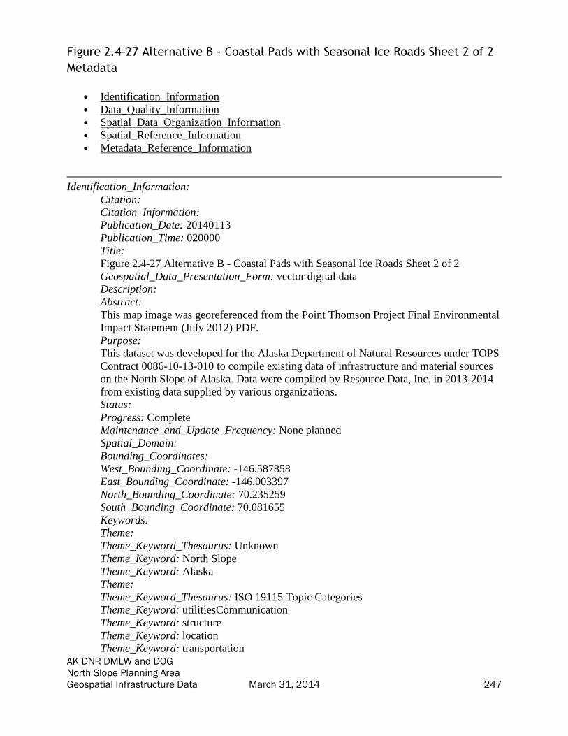
AK DNR DMLW and DOG North Slope Planning Area Geospatial Infrastructure Data March 31, 2014 247
Figure 2.4-27 Alternative B - Coastal Pads with Seasonal Ice Roads Sheet 2 of 2
Metadata
• Identification_Information
• Data_Quality_Information
• Spatial_Data_Organization_Information
• Spatial_Reference_Information
• Metadata_Reference_Information
Identification_Information:
Citation:
Citation_Information:
Publication_Date: 20140113
Publication_Time: 020000
Title:
Figure 2.4-27 Alternative B - Coastal Pads with Seasonal Ice Roads Sheet 2 of 2
Geospatial_Data_Presentation_Form: vector digital data
Description:
Abstract:
This map image was georeferenced from the Point Thomson Project Final Environmental
Impact Statement (July 2012) PDF.
Purpose:
This dataset was developed for the Alaska Department of Natural Resources under TOPS
Contract 0086-10-13-010 to compile existing data of infrastructure and material sources
on the North Slope of Alaska. Data were compiled by Resource Data, Inc. in 2013-2014
from existing data supplied by various organizations.
Status:
Progress: Complete
Maintenance_and_Update_Frequency: None planned
Spatial_Domain:
Bounding_Coordinates:
West_Bounding_Coordinate: -146.587858
East_Bounding_Coordinate: -146.003397
North_Bounding_Coordinate: 70.235259
South_Bounding_Coordinate: 70.081655
Keywords:
Theme:
Theme_Keyword_Thesaurus: Unknown
Theme_Keyword: North Slope
Theme_Keyword: Alaska
Theme:
Theme_Keyword_Thesaurus: ISO 19115 Topic Categories
Theme_Keyword: utilitiesCommunication
Theme_Keyword: structure
Theme_Keyword: location
Theme_Keyword: transportation

AK DNR DMLW and DOG North Slope Planning Area Geospatial Infrastructure Data March 31, 2014 248
Theme_Keyword: planningCadastre
Theme:
Theme_Keyword_Thesaurus: ISO 19115 Topic Categories
Theme_Keyword: transportation
Theme_Keyword: location
Theme_Keyword: structure
Theme_Keyword: planningCadastre
Theme_Keyword: utilitiesCommunication
Temporal:
Temporal_Keyword_Thesaurus: Unknown
Temporal_Keyword: Unknown
Access_Constraints: None
Use_Constraints: Use limited by Alaska DNR.
Point_of_Contact:
Contact_Information:
Contact_Organization_Primary:
Contact_Organization:
AK Department of Natural Resources - Information Resource Management Section
Contact_Person: GIS Public Access Coordinator
Contact_Position: GIS Public Access Coordinator
Contact_Address:
Address_Type: mailing and physical
Address: 550 W. 7th Suite 706
City: Anchorage
State_or_Province: AK
Postal_Code: 99501
Country: US
Contact_Voice_Telephone: 907 269 8839
Contact_Facsimile_Telephone: 907 269 8920
Contact_Electronic_Mail_Address: [email protected]
Hours_of_Service: 800-1600 AST
Point_of_Contact:
Contact_Information:
Contact_Organization_Primary:
Contact_Organization:
AK Department of Natural Resources - Information Resource Management Section
Contact_Person: GIS Public Access Coordinator
Contact_Position: GIS Public Access Coordinator
Contact_Address:
Address_Type: mailing and physical
Address: 550 W. 7th Suite 706
City: Anchorage
State_or_Province: AK
Postal_Code: 99501
Country: US
Contact_Voice_Telephone: 907 269 8839
Contact_Facsimile_Telephone: 907 269 8920

AK DNR DMLW and DOG North Slope Planning Area Geospatial Infrastructure Data March 31, 2014 249
Contact_Electronic_Mail_Address: [email protected]
Hours_of_Service: 800-1600 AST
Native_Data_Set_Environment:
Microsoft Windows 7 Version 6.1 (Build 7601) Service Pack 1; Esri ArcGIS 10.1.0.3035
Data_Quality_Information:
Logical_Consistency_Report: Unknown
Lineage:
Process_Step:
Process_Description:
Data were obtained from the Point Thomson Project Final Environmental Impact
Statement (July 2012) PDF, as downloaded from ARLIS, and georeferenced and
converted to TIFF by RDI.
Process_Date: 20140110
Spatial_Data_Organization_Information:
Direct_Spatial_Reference_Method: Vector
Raster_Object_Information:
Raster_Object_Type: Pixel
Row_Count: 1239
Column_Count: 1795
Spatial_Reference_Information:
Horizontal_Coordinate_System_Definition:
Planar:
Map_Projection:
Map_Projection_Name: Albers Conical Equal Area
Albers_Conical_Equal_Area:
Standard_Parallel: 55.0
Standard_Parallel: 65.0
Longitude_of_Central_Meridian: -154.0
Latitude_of_Projection_Origin: 50.0
False_Easting: 0.0
False_Northing: 0.0
Planar_Coordinate_Information:
Planar_Coordinate_Encoding_Method: coordinate pair
Coordinate_Representation:
Abscissa_Resolution: 0.0000000030536018158500163
Ordinate_Resolution: 0.0000000030536018158500163
Planar_Distance_Units:
Geodetic_Model:
Horizontal_Datum_Name: D North American 1983
Ellipsoid_Name: GRS 1980
Semi-major_Axis: 6378137.0
Denominator_of_Flattening_Ratio: 298.257222101
Metadata_Reference_Information:

AK DNR DMLW and DOG North Slope Planning Area Geospatial Infrastructure Data March 31, 2014 250
Metadata_Date: 20140226
Metadata_Contact:
Contact_Information:
Contact_Organization_Primary:
Contact_Organization: Resource Data, Inc.
Contact_Person: Bixler McClure
Contact_Position: GIS Programmer/Analyst
Contact_Address:
Address_Type: mailing and physical
Address: 560 E. 34th Ave., Suite 100
City: Anchorage
State_or_Province: AK
Postal_Code: 99503
Country: US
Contact_Voice_Telephone: 907-563-8100
Contact_Facsimile_Telephone: 907-561-0159
Contact_Electronic_Mail_Address: [email protected]
Metadata_Standard_Name: FGDC Content Standard for Digital Geospatial Metadata
Metadata_Standard_Version: FGDC-STD-001-1998
Metadata_Time_Convention: local time
Generated by mp version 2.9.12 on Tue Mar 18 09:48:40 2014
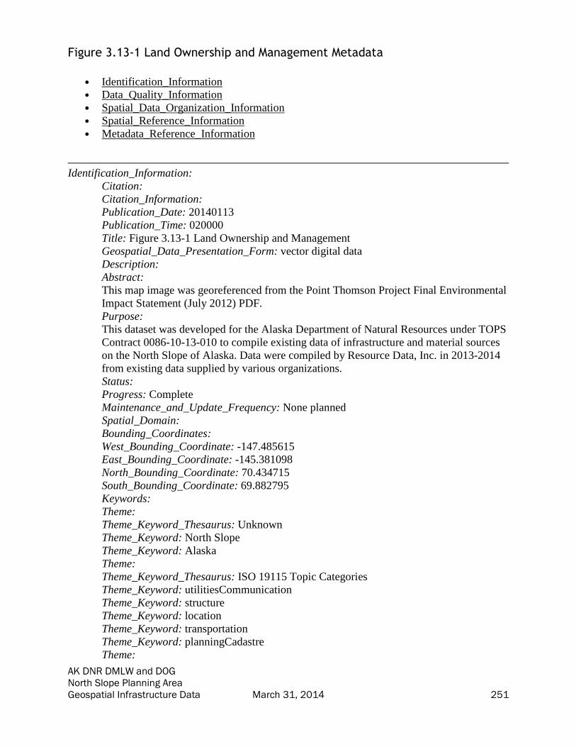
AK DNR DMLW and DOG North Slope Planning Area Geospatial Infrastructure Data March 31, 2014 251
Figure 3.13-1 Land Ownership and Management Metadata
• Identification_Information
• Data_Quality_Information
• Spatial_Data_Organization_Information
• Spatial_Reference_Information
• Metadata_Reference_Information
Identification_Information:
Citation:
Citation_Information:
Publication_Date: 20140113
Publication_Time: 020000
Title: Figure 3.13-1 Land Ownership and Management
Geospatial_Data_Presentation_Form: vector digital data
Description:
Abstract:
This map image was georeferenced from the Point Thomson Project Final Environmental
Impact Statement (July 2012) PDF.
Purpose:
This dataset was developed for the Alaska Department of Natural Resources under TOPS
Contract 0086-10-13-010 to compile existing data of infrastructure and material sources
on the North Slope of Alaska. Data were compiled by Resource Data, Inc. in 2013-2014
from existing data supplied by various organizations.
Status:
Progress: Complete
Maintenance_and_Update_Frequency: None planned
Spatial_Domain:
Bounding_Coordinates:
West_Bounding_Coordinate: -147.485615
East_Bounding_Coordinate: -145.381098
North_Bounding_Coordinate: 70.434715
South_Bounding_Coordinate: 69.882795
Keywords:
Theme:
Theme_Keyword_Thesaurus: Unknown
Theme_Keyword: North Slope
Theme_Keyword: Alaska
Theme:
Theme_Keyword_Thesaurus: ISO 19115 Topic Categories
Theme_Keyword: utilitiesCommunication
Theme_Keyword: structure
Theme_Keyword: location
Theme_Keyword: transportation
Theme_Keyword: planningCadastre
Theme:

AK DNR DMLW and DOG North Slope Planning Area Geospatial Infrastructure Data March 31, 2014 252
Theme_Keyword_Thesaurus: ISO 19115 Topic Categories
Theme_Keyword: transportation
Theme_Keyword: location
Theme_Keyword: structure
Theme_Keyword: planningCadastre
Theme_Keyword: utilitiesCommunication
Temporal:
Temporal_Keyword_Thesaurus: Unknown
Temporal_Keyword: Unknown
Access_Constraints: None
Use_Constraints: Use limited by Alaska DNR.
Point_of_Contact:
Contact_Information:
Contact_Organization_Primary:
Contact_Organization:
AK Department of Natural Resources - Information Resource Management Section
Contact_Person: GIS Public Access Coordinator
Contact_Position: GIS Public Access Coordinator
Contact_Address:
Address_Type: mailing and physical
Address: 550 W. 7th Suite 706
City: Anchorage
State_or_Province: AK
Postal_Code: 99501
Country: US
Contact_Voice_Telephone: 907 269 8839
Contact_Facsimile_Telephone: 907 269 8920
Contact_Electronic_Mail_Address: [email protected]
Hours_of_Service: 800-1600 AST
Point_of_Contact:
Contact_Information:
Contact_Organization_Primary:
Contact_Organization:
AK Department of Natural Resources - Information Resource Management Section
Contact_Person: GIS Public Access Coordinator
Contact_Position: GIS Public Access Coordinator
Contact_Address:
Address_Type: mailing and physical
Address: 550 W. 7th Suite 706
City: Anchorage
State_or_Province: AK
Postal_Code: 99501
Country: US
Contact_Voice_Telephone: 907 269 8839
Contact_Facsimile_Telephone: 907 269 8920
Contact_Electronic_Mail_Address: [email protected]
Hours_of_Service: 800-1600 AST

AK DNR DMLW and DOG North Slope Planning Area Geospatial Infrastructure Data March 31, 2014 253
Native_Data_Set_Environment:
Microsoft Windows 7 Version 6.1 (Build 7601) Service Pack 1; Esri ArcGIS 10.1.0.3035
Data_Quality_Information:
Logical_Consistency_Report: Unknown
Lineage:
Process_Step:
Process_Description:
Data were obtained from the Point Thomson Project Final Environmental Impact
Statement (July 2012) PDF, as downloaded from ARLIS, and georeferenced and
converted to TIFF by RDI.
Process_Date: 20140110
Spatial_Data_Organization_Information:
Direct_Spatial_Reference_Method: Vector
Raster_Object_Information:
Raster_Object_Type: Pixel
Row_Count: 1238
Column_Count: 1795
Spatial_Reference_Information:
Horizontal_Coordinate_System_Definition:
Planar:
Map_Projection:
Map_Projection_Name: Albers Conical Equal Area
Albers_Conical_Equal_Area:
Standard_Parallel: 55.0
Standard_Parallel: 65.0
Longitude_of_Central_Meridian: -154.0
Latitude_of_Projection_Origin: 50.0
False_Easting: 0.0
False_Northing: 0.0
Planar_Coordinate_Information:
Planar_Coordinate_Encoding_Method: coordinate pair
Coordinate_Representation:
Abscissa_Resolution: 0.0000000030536018158500163
Ordinate_Resolution: 0.0000000030536018158500163
Planar_Distance_Units:
Geodetic_Model:
Horizontal_Datum_Name: D North American 1983
Ellipsoid_Name: GRS 1980
Semi-major_Axis: 6378137.0
Denominator_of_Flattening_Ratio: 298.257222101
Metadata_Reference_Information:
Metadata_Date: 20140226
Metadata_Contact:

AK DNR DMLW and DOG North Slope Planning Area Geospatial Infrastructure Data March 31, 2014 254
Contact_Information:
Contact_Organization_Primary:
Contact_Organization: Resource Data, Inc.
Contact_Person: Bixler McClure
Contact_Position: GIS Programmer/Analyst
Contact_Address:
Address_Type: mailing and physical
Address: 560 E. 34th Ave., Suite 100
City: Anchorage
State_or_Province: AK
Postal_Code: 99503
Country: US
Contact_Voice_Telephone: 907-563-8100
Contact_Facsimile_Telephone: 907-561-0159
Contact_Electronic_Mail_Address: [email protected]
Metadata_Standard_Name: FGDC Content Standard for Digital Geospatial Metadata
Metadata_Standard_Version: FGDC-STD-001-1998
Metadata_Time_Convention: local time
Generated by mp version 2.9.12 on Tue Mar 18 09:48:41 2014
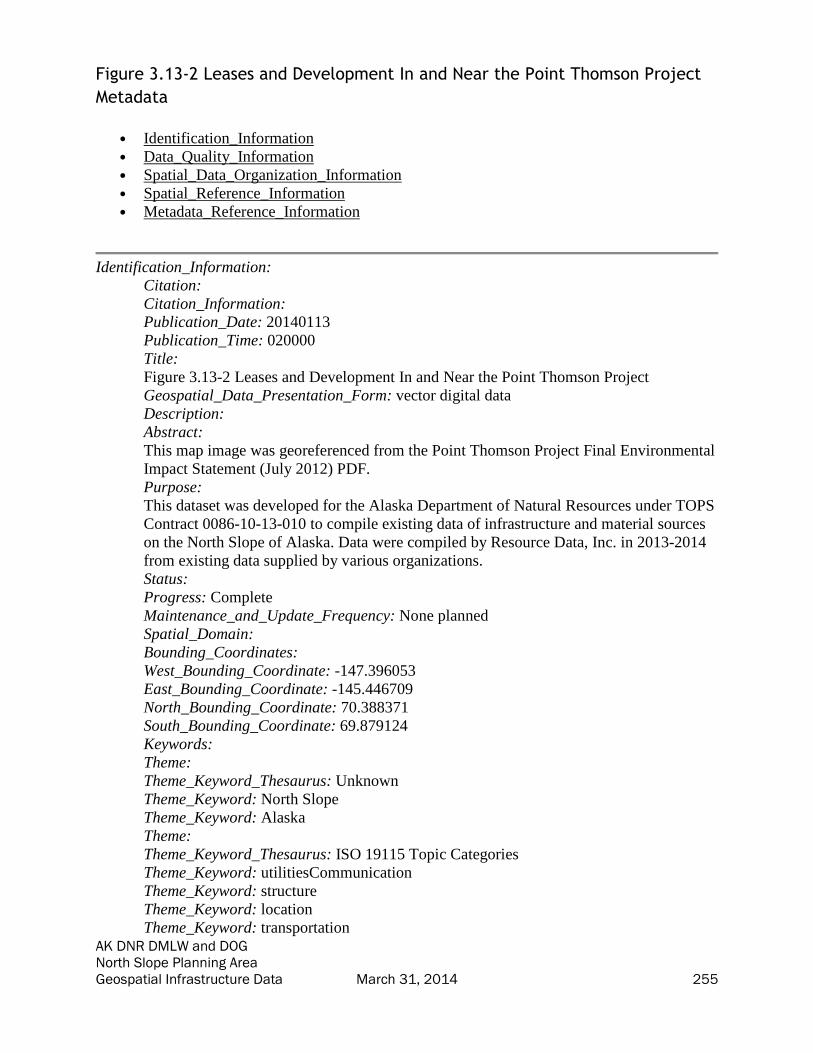
AK DNR DMLW and DOG North Slope Planning Area Geospatial Infrastructure Data March 31, 2014 255
Figure 3.13-2 Leases and Development In and Near the Point Thomson Project
Metadata
• Identification_Information
• Data_Quality_Information
• Spatial_Data_Organization_Information
• Spatial_Reference_Information
• Metadata_Reference_Information
Identification_Information:
Citation:
Citation_Information:
Publication_Date: 20140113
Publication_Time: 020000
Title:
Figure 3.13-2 Leases and Development In and Near the Point Thomson Project
Geospatial_Data_Presentation_Form: vector digital data
Description:
Abstract:
This map image was georeferenced from the Point Thomson Project Final Environmental
Impact Statement (July 2012) PDF.
Purpose:
This dataset was developed for the Alaska Department of Natural Resources under TOPS
Contract 0086-10-13-010 to compile existing data of infrastructure and material sources
on the North Slope of Alaska. Data were compiled by Resource Data, Inc. in 2013-2014
from existing data supplied by various organizations.
Status:
Progress: Complete
Maintenance_and_Update_Frequency: None planned
Spatial_Domain:
Bounding_Coordinates:
West_Bounding_Coordinate: -147.396053
East_Bounding_Coordinate: -145.446709
North_Bounding_Coordinate: 70.388371
South_Bounding_Coordinate: 69.879124
Keywords:
Theme:
Theme_Keyword_Thesaurus: Unknown
Theme_Keyword: North Slope
Theme_Keyword: Alaska
Theme:
Theme_Keyword_Thesaurus: ISO 19115 Topic Categories
Theme_Keyword: utilitiesCommunication
Theme_Keyword: structure
Theme_Keyword: location
Theme_Keyword: transportation

AK DNR DMLW and DOG North Slope Planning Area Geospatial Infrastructure Data March 31, 2014 256
Theme_Keyword: planningCadastre
Theme:
Theme_Keyword_Thesaurus: ISO 19115 Topic Categories
Theme_Keyword: transportation
Theme_Keyword: location
Theme_Keyword: structure
Theme_Keyword: planningCadastre
Theme_Keyword: utilitiesCommunication
Temporal:
Temporal_Keyword_Thesaurus: Unknown
Temporal_Keyword: Unknown
Access_Constraints: None
Use_Constraints: Use limited by Alaska DNR.
Point_of_Contact:
Contact_Information:
Contact_Organization_Primary:
Contact_Organization:
AK Department of Natural Resources - Information Resource Management Section
Contact_Person: GIS Public Access Coordinator
Contact_Position: GIS Public Access Coordinator
Contact_Address:
Address_Type: mailing and physical
Address: 550 W. 7th Suite 706
City: Anchorage
State_or_Province: AK
Postal_Code: 99501
Country: US
Contact_Voice_Telephone: 907 269 8839
Contact_Facsimile_Telephone: 907 269 8920
Contact_Electronic_Mail_Address: [email protected]
Hours_of_Service: 800-1600 AST
Point_of_Contact:
Contact_Information:
Contact_Organization_Primary:
Contact_Organization:
AK Department of Natural Resources - Information Resource Management Section
Contact_Person: GIS Public Access Coordinator
Contact_Position: GIS Public Access Coordinator
Contact_Address:
Address_Type: mailing and physical
Address: 550 W. 7th Suite 706
City: Anchorage
State_or_Province: AK
Postal_Code: 99501
Country: US
Contact_Voice_Telephone: 907 269 8839
Contact_Facsimile_Telephone: 907 269 8920

AK DNR DMLW and DOG North Slope Planning Area Geospatial Infrastructure Data March 31, 2014 257
Contact_Electronic_Mail_Address: [email protected]
Hours_of_Service: 800-1600 AST
Native_Data_Set_Environment:
Microsoft Windows 7 Version 6.1 (Build 7601) Service Pack 1; Esri ArcGIS 10.1.0.3035
Data_Quality_Information:
Logical_Consistency_Report: Unknown
Lineage:
Process_Step:
Process_Description:
Data were obtained from the Point Thomson Project Final Environmental Impact
Statement (July 2012) PDF, as downloaded from ARLIS, and georeferenced and
converted to TIFF by RDI.
Process_Date: 20140110
Spatial_Data_Organization_Information:
Direct_Spatial_Reference_Method: Vector
Raster_Object_Information:
Raster_Object_Type: Pixel
Row_Count: 1235
Column_Count: 1802
Spatial_Reference_Information:
Horizontal_Coordinate_System_Definition:
Planar:
Map_Projection:
Map_Projection_Name: Albers Conical Equal Area
Albers_Conical_Equal_Area:
Standard_Parallel: 55.0
Standard_Parallel: 65.0
Longitude_of_Central_Meridian: -154.0
Latitude_of_Projection_Origin: 50.0
False_Easting: 0.0
False_Northing: 0.0
Planar_Coordinate_Information:
Planar_Coordinate_Encoding_Method: coordinate pair
Coordinate_Representation:
Abscissa_Resolution: 0.0000000030536018158500163
Ordinate_Resolution: 0.0000000030536018158500163
Planar_Distance_Units:
Geodetic_Model:
Horizontal_Datum_Name: D North American 1983
Ellipsoid_Name: GRS 1980
Semi-major_Axis: 6378137.0
Denominator_of_Flattening_Ratio: 298.257222101
Metadata_Reference_Information:

AK DNR DMLW and DOG North Slope Planning Area Geospatial Infrastructure Data March 31, 2014 258
Metadata_Date: 20140226
Metadata_Contact:
Contact_Information:
Contact_Organization_Primary:
Contact_Organization: Resource Data, Inc.
Contact_Person: Bixler McClure
Contact_Position: GIS Programmer/Analyst
Contact_Address:
Address_Type: mailing and physical
Address: 560 E. 34th Ave., Suite 100
City: Anchorage
State_or_Province: AK
Postal_Code: 99503
Country: US
Contact_Voice_Telephone: 907-563-8100
Contact_Facsimile_Telephone: 907-561-0159
Contact_Electronic_Mail_Address: [email protected]
Metadata_Standard_Name: FGDC Content Standard for Digital Geospatial Metadata
Metadata_Standard_Version: FGDC-STD-001-1998
Metadata_Time_Convention: local time
Generated by mp version 2.9.12 on Tue Mar 18 09:48:41 2014

AK DNR DMLW and DOG North Slope Planning Area Geospatial Infrastructure Data March 31, 2014 259
Figure 3.14-1 Arctic National Wildlife Refuge Metadata
• Identification_Information
• Data_Quality_Information
• Spatial_Data_Organization_Information
• Spatial_Reference_Information
• Metadata_Reference_Information
Identification_Information:
Citation:
Citation_Information:
Publication_Date: 20140113
Publication_Time: 020000
Title: Figure 3.14-1 Arctic National Wildlife Refuge
Geospatial_Data_Presentation_Form: vector digital data
Description:
Abstract:
This map image was georeferenced from the Point Thomson Project Final Environmental
Impact Statement (July 2012) PDF.
Purpose:
This dataset was developed for the Alaska Department of Natural Resources under TOPS
Contract 0086-10-13-010 to compile existing data of infrastructure and material sources
on the North Slope of Alaska. Data were compiled by Resource Data, Inc. in 2013-2014
from existing data supplied by various organizations.
Status:
Progress: Complete
Maintenance_and_Update_Frequency: None planned
Spatial_Domain:
Bounding_Coordinates:
West_Bounding_Coordinate: -148.222413
East_Bounding_Coordinate: -142.410057
North_Bounding_Coordinate: 70.655714
South_Bounding_Coordinate: 69.106736
Keywords:
Theme:
Theme_Keyword_Thesaurus: Unknown
Theme_Keyword: North Slope
Theme_Keyword: Alaska
Theme:
Theme_Keyword_Thesaurus: ISO 19115 Topic Categories
Theme_Keyword: utilitiesCommunication
Theme_Keyword: structure
Theme_Keyword: location
Theme_Keyword: transportation
Theme_Keyword: planningCadastre
Theme:

AK DNR DMLW and DOG North Slope Planning Area Geospatial Infrastructure Data March 31, 2014 260
Theme_Keyword_Thesaurus: ISO 19115 Topic Categories
Theme_Keyword: transportation
Theme_Keyword: location
Theme_Keyword: structure
Theme_Keyword: planningCadastre
Theme_Keyword: utilitiesCommunication
Temporal:
Temporal_Keyword_Thesaurus: Unknown
Temporal_Keyword: Unknown
Access_Constraints: None
Use_Constraints: Use limited by Alaska DNR.
Point_of_Contact:
Contact_Information:
Contact_Organization_Primary:
Contact_Organization:
AK Department of Natural Resources - Information Resource Management Section
Contact_Person: GIS Public Access Coordinator
Contact_Position: GIS Public Access Coordinator
Contact_Address:
Address_Type: mailing and physical
Address: 550 W. 7th Suite 706
City: Anchorage
State_or_Province: AK
Postal_Code: 99501
Country: US
Contact_Voice_Telephone: 907 269 8839
Contact_Facsimile_Telephone: 907 269 8920
Contact_Electronic_Mail_Address: [email protected]
Hours_of_Service: 800-1600 AST
Point_of_Contact:
Contact_Information:
Contact_Organization_Primary:
Contact_Organization:
AK Department of Natural Resources - Information Resource Management Section
Contact_Person: GIS Public Access Coordinator
Contact_Position: GIS Public Access Coordinator
Contact_Address:
Address_Type: mailing and physical
Address: 550 W. 7th Suite 706
City: Anchorage
State_or_Province: AK
Postal_Code: 99501
Country: US
Contact_Voice_Telephone: 907 269 8839
Contact_Facsimile_Telephone: 907 269 8920
Contact_Electronic_Mail_Address: [email protected]
Hours_of_Service: 800-1600 AST

AK DNR DMLW and DOG North Slope Planning Area Geospatial Infrastructure Data March 31, 2014 261
Native_Data_Set_Environment:
Microsoft Windows 7 Version 6.1 (Build 7601) Service Pack 1; Esri ArcGIS 10.1.0.3035
Data_Quality_Information:
Logical_Consistency_Report: Unknown
Lineage:
Process_Step:
Process_Description:
Data were obtained from the Point Thomson Project Final Environmental Impact
Statement (July 2012) PDF, as downloaded from ARLIS, and georeferenced and
converted to TIFF by RDI.
Process_Date: 20140110
Spatial_Data_Organization_Information:
Direct_Spatial_Reference_Method: Vector
Raster_Object_Information:
Raster_Object_Type: Pixel
Row_Count: 1233
Column_Count: 1795
Spatial_Reference_Information:
Horizontal_Coordinate_System_Definition:
Planar:
Map_Projection:
Map_Projection_Name: Albers Conical Equal Area
Albers_Conical_Equal_Area:
Standard_Parallel: 55.0
Standard_Parallel: 65.0
Longitude_of_Central_Meridian: -154.0
Latitude_of_Projection_Origin: 50.0
False_Easting: 0.0
False_Northing: 0.0
Planar_Coordinate_Information:
Planar_Coordinate_Encoding_Method: coordinate pair
Coordinate_Representation:
Abscissa_Resolution: 0.0000000030536018158500163
Ordinate_Resolution: 0.0000000030536018158500163
Planar_Distance_Units:
Geodetic_Model:
Horizontal_Datum_Name: D North American 1983
Ellipsoid_Name: GRS 1980
Semi-major_Axis: 6378137.0
Denominator_of_Flattening_Ratio: 298.257222101
Metadata_Reference_Information:
Metadata_Date: 20140226
Metadata_Contact:

AK DNR DMLW and DOG North Slope Planning Area Geospatial Infrastructure Data March 31, 2014 262
Contact_Information:
Contact_Organization_Primary:
Contact_Organization: Resource Data, Inc.
Contact_Person: Bixler McClure
Contact_Position: GIS Programmer/Analyst
Contact_Address:
Address_Type: mailing and physical
Address: 560 E. 34th Ave., Suite 100
City: Anchorage
State_or_Province: AK
Postal_Code: 99503
Country: US
Contact_Voice_Telephone: 907-563-8100
Contact_Facsimile_Telephone: 907-561-0159
Contact_Electronic_Mail_Address: [email protected]
Metadata_Standard_Name: FGDC Content Standard for Digital Geospatial Metadata
Metadata_Standard_Version: FGDC-STD-001-1998
Metadata_Time_Convention: local time
Generated by mp version 2.9.12 on Tue Mar 18 09:48:41 2014

AK DNR DMLW and DOG North Slope Planning Area Geospatial Infrastructure Data March 31, 2014 263
Figure 3.17-4 Existing Transportation Systems Metadata
• Identification_Information
• Data_Quality_Information
• Spatial_Data_Organization_Information
• Spatial_Reference_Information
• Metadata_Reference_Information
Identification_Information:
Citation:
Citation_Information:
Publication_Date: 20140113
Publication_Time: 020000
Title: Figure 3.17-4 Existing Transportation Systems
Geospatial_Data_Presentation_Form: vector digital data
Description:
Abstract:
This map image was georeferenced from the Point Thomson Project Final Environmental
Impact Statement (July 2012) PDF.
Purpose:
This dataset was developed for the Alaska Department of Natural Resources under TOPS
Contract 0086-10-13-010 to compile existing data of infrastructure and material sources
on the North Slope of Alaska. Data were compiled by Resource Data, Inc. in 2013-2014
from existing data supplied by various organizations.
Status:
Progress: Complete
Maintenance_and_Update_Frequency: None planned
Spatial_Domain:
Bounding_Coordinates:
West_Bounding_Coordinate: -148.996400
East_Bounding_Coordinate: -145.688238
North_Bounding_Coordinate: 70.685431
South_Bounding_Coordinate: 69.840493
Keywords:
Theme:
Theme_Keyword_Thesaurus: Unknown
Theme_Keyword: North Slope
Theme_Keyword: Alaska
Theme:
Theme_Keyword_Thesaurus: ISO 19115 Topic Categories
Theme_Keyword: utilitiesCommunication
Theme_Keyword: structure
Theme_Keyword: location
Theme_Keyword: transportation
Theme_Keyword: planningCadastre
Theme:

AK DNR DMLW and DOG North Slope Planning Area Geospatial Infrastructure Data March 31, 2014 264
Theme_Keyword_Thesaurus: ISO 19115 Topic Categories
Theme_Keyword: transportation
Theme_Keyword: location
Theme_Keyword: structure
Theme_Keyword: planningCadastre
Theme_Keyword: utilitiesCommunication
Temporal:
Temporal_Keyword_Thesaurus: Unknown
Temporal_Keyword: Unknown
Access_Constraints: None
Use_Constraints: Use limited by Alaska DNR.
Point_of_Contact:
Contact_Information:
Contact_Organization_Primary:
Contact_Organization:
AK Department of Natural Resources - Information Resource Management Section
Contact_Person: GIS Public Access Coordinator
Contact_Position: GIS Public Access Coordinator
Contact_Address:
Address_Type: mailing and physical
Address: 550 W. 7th Suite 706
City: Anchorage
State_or_Province: AK
Postal_Code: 99501
Country: US
Contact_Voice_Telephone: 907 269 8839
Contact_Facsimile_Telephone: 907 269 8920
Contact_Electronic_Mail_Address: [email protected]
Hours_of_Service: 800-1600 AST
Point_of_Contact:
Contact_Information:
Contact_Organization_Primary:
Contact_Organization:
AK Department of Natural Resources - Information Resource Management Section
Contact_Person: GIS Public Access Coordinator
Contact_Position: GIS Public Access Coordinator
Contact_Address:
Address_Type: mailing and physical
Address: 550 W. 7th Suite 706
City: Anchorage
State_or_Province: AK
Postal_Code: 99501
Country: US
Contact_Voice_Telephone: 907 269 8839
Contact_Facsimile_Telephone: 907 269 8920
Contact_Electronic_Mail_Address: [email protected]
Hours_of_Service: 800-1600 AST

AK DNR DMLW and DOG North Slope Planning Area Geospatial Infrastructure Data March 31, 2014 265
Native_Data_Set_Environment:
Microsoft Windows 7 Version 6.1 (Build 7601) Service Pack 1; Esri ArcGIS 10.1.0.3035
Data_Quality_Information:
Logical_Consistency_Report: Unknown
Lineage:
Process_Step:
Process_Description:
Data were obtained from the Point Thomson Project Final Environmental Impact
Statement (July 2012) PDF, as downloaded from ARLIS, and georeferenced and
converted to TIFF by RDI.
Process_Date: 20140110
Spatial_Data_Organization_Information:
Direct_Spatial_Reference_Method: Vector
Raster_Object_Information:
Raster_Object_Type: Pixel
Row_Count: 1226
Column_Count: 1808
Spatial_Reference_Information:
Horizontal_Coordinate_System_Definition:
Planar:
Map_Projection:
Map_Projection_Name: Albers Conical Equal Area
Albers_Conical_Equal_Area:
Standard_Parallel: 55.0
Standard_Parallel: 65.0
Longitude_of_Central_Meridian: -154.0
Latitude_of_Projection_Origin: 50.0
False_Easting: 0.0
False_Northing: 0.0
Planar_Coordinate_Information:
Planar_Coordinate_Encoding_Method: coordinate pair
Coordinate_Representation:
Abscissa_Resolution: 0.0000000030536018158500163
Ordinate_Resolution: 0.0000000030536018158500163
Planar_Distance_Units:
Geodetic_Model:
Horizontal_Datum_Name: D North American 1983
Ellipsoid_Name: GRS 1980
Semi-major_Axis: 6378137.0
Denominator_of_Flattening_Ratio: 298.257222101
Metadata_Reference_Information:
Metadata_Date: 20140226
Metadata_Contact:

AK DNR DMLW and DOG North Slope Planning Area Geospatial Infrastructure Data March 31, 2014 266
Contact_Information:
Contact_Organization_Primary:
Contact_Organization: Resource Data, Inc.
Contact_Person: Bixler McClure
Contact_Position: GIS Programmer/Analyst
Contact_Address:
Address_Type: mailing and physical
Address: 560 E. 34th Ave., Suite 100
City: Anchorage
State_or_Province: AK
Postal_Code: 99503
Country: US
Contact_Voice_Telephone: 907-563-8100
Contact_Facsimile_Telephone: 907-561-0159
Contact_Electronic_Mail_Address: [email protected]
Metadata_Standard_Name: FGDC Content Standard for Digital Geospatial Metadata
Metadata_Standard_Version: FGDC-STD-001-1998
Metadata_Time_Convention: local time
Generated by mp version 2.9.12 on Tue Mar 18 09:48:41 2014

AK DNR DMLW and DOG North Slope Planning Area Geospatial Infrastructure Data March 31, 2014 267
Nikaitchuq-North Slope Development (NSD) Electrical Underground Power Plan
Oliktok Point Area Underground Installation (PLE01) Metadata
• Identification_Information
• Data_Quality_Information
• Spatial_Data_Organization_Information
• Spatial_Reference_Information
• Metadata_Reference_Information
Identification_Information:
Citation:
Citation_Information:
Publication_Date: 20140113
Publication_Time: 020000
Title:
Nikaitchuq-North Slope Development (NSD) Electrical Underground Power Plan Oliktok
Point Area Underground Installation (PLE01)
Geospatial_Data_Presentation_Form: vector digital data
Description:
Abstract:
This map image was georeferenced from a PDF provided by Eni Petroleum.
Purpose:
This dataset was developed for the Alaska Department of Natural Resources under TOPS
Contract 0086-10-13-010 to compile existing data of infrastructure and material sources
on the North Slope of Alaska. Data were compiled by Resource Data, Inc. in 2013-2014
from existing data supplied by various organizations.
Status:
Progress: Complete
Maintenance_and_Update_Frequency: None planned
Spatial_Domain:
Bounding_Coordinates:
West_Bounding_Coordinate: -149.895321
East_Bounding_Coordinate: -149.821406
North_Bounding_Coordinate: 70.517207
South_Bounding_Coordinate: 70.481870
Keywords:
Theme:
Theme_Keyword_Thesaurus: ISO 19115 Topic Categories
Theme_Keyword: location
Theme_Keyword: transportation
Theme_Keyword: structure
Theme_Keyword: utilitiesCommunication
Theme_Keyword: planningCadastre
Theme:
Theme_Keyword_Thesaurus: ISO 19115 Topic Categories
Theme_Keyword: utilitiesCommunication

AK DNR DMLW and DOG North Slope Planning Area Geospatial Infrastructure Data March 31, 2014 268
Theme_Keyword: structure
Theme_Keyword: location
Theme_Keyword: transportation
Theme_Keyword: planningCadastre
Theme:
Theme_Keyword_Thesaurus: Unknown
Theme_Keyword: North Slope
Theme_Keyword: Alaska
Temporal:
Temporal_Keyword_Thesaurus: Unknown
Temporal_Keyword: Unknown
Access_Constraints: None
Use_Constraints: Use limited by Alaska DNR.
Point_of_Contact:
Contact_Information:
Contact_Organization_Primary:
Contact_Organization:
AK Department of Natural Resources - Information Resource Management Section
Contact_Person: GIS Public Access Coordinator
Contact_Position: GIS Public Access Coordinator
Contact_Address:
Address_Type: mailing and physical
Address: 550 W. 7th Suite 706
City: Anchorage
State_or_Province: AK
Postal_Code: 99501
Country: US
Contact_Voice_Telephone: 907 269 8839
Contact_Facsimile_Telephone: 907 269 8920
Contact_Electronic_Mail_Address: [email protected]
Hours_of_Service: 800-1600 AST
Native_Data_Set_Environment:
Microsoft Windows 7 Version 6.1 (Build 7601) Service Pack 1; Esri ArcGIS 10.1.0.3035
Data_Quality_Information:
Logical_Consistency_Report: Unknown
Lineage:
Process_Step:
Process_Description:
Data were obtained from Eni Petroleum and georeferenced and converted to TIFF by
RDI.
Process_Date: 20140110
Spatial_Data_Organization_Information:
Direct_Spatial_Reference_Method: Vector
Raster_Object_Information:
Raster_Object_Type: Pixel

AK DNR DMLW and DOG North Slope Planning Area Geospatial Infrastructure Data March 31, 2014 269
Row_Count: 1681
Column_Count: 1170
Spatial_Reference_Information:
Horizontal_Coordinate_System_Definition:
Planar:
Map_Projection:
Map_Projection_Name: Albers Conical Equal Area
Albers_Conical_Equal_Area:
Standard_Parallel: 55.0
Standard_Parallel: 65.0
Longitude_of_Central_Meridian: -154.0
Latitude_of_Projection_Origin: 50.0
False_Easting: 0.0
False_Northing: 0.0
Planar_Coordinate_Information:
Planar_Coordinate_Encoding_Method: coordinate pair
Coordinate_Representation:
Abscissa_Resolution: 0.0000000030536018158500163
Ordinate_Resolution: 0.0000000030536018158500163
Planar_Distance_Units:
Geodetic_Model:
Horizontal_Datum_Name: D North American 1983
Ellipsoid_Name: GRS 1980
Semi-major_Axis: 6378137.0
Denominator_of_Flattening_Ratio: 298.257222101
Metadata_Reference_Information:
Metadata_Date: 20140226
Metadata_Contact:
Contact_Information:
Contact_Organization_Primary:
Contact_Organization: Resource Data, Inc.
Contact_Person: Bixler McClure
Contact_Position: GIS Programmer/Analyst
Contact_Address:
Address_Type: mailing and physical
Address: 560 E. 34th Ave., Suite 100
City: Anchorage
State_or_Province: AK
Postal_Code: 99503
Country: US
Contact_Voice_Telephone: 907-563-8100
Contact_Facsimile_Telephone: 907-561-0159
Contact_Electronic_Mail_Address: [email protected]
Metadata_Standard_Name: FGDC Content Standard for Digital Geospatial Metadata
Metadata_Standard_Version: FGDC-STD-001-1998

AK DNR DMLW and DOG North Slope Planning Area Geospatial Infrastructure Data March 31, 2014 270
Metadata_Time_Convention: local time
Generated by mp version 2.9.12 on Tue Mar 18 09:48:42 2014

AK DNR DMLW and DOG North Slope Planning Area Geospatial Infrastructure Data March 31, 2014 271
Eni OPP Barge Landing Asbuilt Location Metadata
• Identification_Information
• Data_Quality_Information
• Spatial_Data_Organization_Information
• Spatial_Reference_Information
• Metadata_Reference_Information
Identification_Information:
Citation:
Citation_Information:
Publication_Date: 20140113
Publication_Time: 020000
Title: Eni OPP Barge Landing Asbuilt Location
Geospatial_Data_Presentation_Form: vector digital data
Description:
Abstract:
This map image was georeferenced from a PDF provided by Eni Petroleum.
Purpose:
This dataset was developed for the Alaska Department of Natural Resources under TOPS
Contract 0086-10-13-010 to compile existing data of infrastructure and material sources
on the North Slope of Alaska. Data were compiled by Resource Data, Inc. in 2013-2014
from existing data supplied by various organizations.
Status:
Progress: Complete
Maintenance_and_Update_Frequency: None planned
Spatial_Domain:
Bounding_Coordinates:
West_Bounding_Coordinate: -149.906155
East_Bounding_Coordinate: -149.829110
North_Bounding_Coordinate: 70.529884
South_Bounding_Coordinate: 70.497413
Keywords:
Theme:
Theme_Keyword_Thesaurus: ISO 19115 Topic Categories
Theme_Keyword: location
Theme_Keyword: transportation
Theme_Keyword: structure
Theme_Keyword: utilitiesCommunication
Theme_Keyword: planningCadastre
Theme:
Theme_Keyword_Thesaurus: ISO 19115 Topic Categories
Theme_Keyword: utilitiesCommunication
Theme_Keyword: structure
Theme_Keyword: location
Theme_Keyword: transportation

AK DNR DMLW and DOG North Slope Planning Area Geospatial Infrastructure Data March 31, 2014 272
Theme_Keyword: planningCadastre
Theme:
Theme_Keyword_Thesaurus: Unknown
Theme_Keyword: North Slope
Theme_Keyword: Alaska
Temporal:
Temporal_Keyword_Thesaurus: Unknown
Temporal_Keyword: Unknown
Access_Constraints: None
Use_Constraints: Use limited by Alaska DNR.
Point_of_Contact:
Contact_Information:
Contact_Organization_Primary:
Contact_Organization:
AK Department of Natural Resources - Information Resource Management Section
Contact_Person: GIS Public Access Coordinator
Contact_Position: GIS Public Access Coordinator
Contact_Address:
Address_Type: mailing and physical
Address: 550 W. 7th Suite 706
City: Anchorage
State_or_Province: AK
Postal_Code: 99501
Country: US
Contact_Voice_Telephone: 907 269 8839
Contact_Facsimile_Telephone: 907 269 8920
Contact_Electronic_Mail_Address: [email protected]
Hours_of_Service: 800-1600 AST
Native_Data_Set_Environment:
Microsoft Windows 7 Version 6.1 (Build 7601) Service Pack 1; Esri ArcGIS 10.1.0.3035
Data_Quality_Information:
Logical_Consistency_Report: Unknown
Lineage:
Process_Step:
Process_Description:
Data were obtained from Eni Petroleum and georeferenced and converted to TIFF by
RDI.
Process_Date: 20140110
Spatial_Data_Organization_Information:
Direct_Spatial_Reference_Method: Vector
Raster_Object_Information:
Raster_Object_Type: Pixel
Row_Count: 1335
Column_Count: 1072
AK DNR DMLW and DOG North Slope Planning Area Geospatial Infrastructure Data March 31, 2014 273
Spatial_Reference_Information:
Horizontal_Coordinate_System_Definition:
Planar:
Map_Projection:
Map_Projection_Name: Albers Conical Equal Area
Albers_Conical_Equal_Area:
Standard_Parallel: 55.0
Standard_Parallel: 65.0
Longitude_of_Central_Meridian: -154.0
Latitude_of_Projection_Origin: 50.0
False_Easting: 0.0
False_Northing: 0.0
Planar_Coordinate_Information:
Planar_Coordinate_Encoding_Method: coordinate pair
Coordinate_Representation:
Abscissa_Resolution: 0.0000000030536018158500163
Ordinate_Resolution: 0.0000000030536018158500163
Planar_Distance_Units:
Geodetic_Model:
Horizontal_Datum_Name: D North American 1983
Ellipsoid_Name: GRS 1980
Semi-major_Axis: 6378137.0
Denominator_of_Flattening_Ratio: 298.257222101
Metadata_Reference_Information:
Metadata_Date: 20140226
Metadata_Contact:
Contact_Information:
Contact_Organization_Primary:
Contact_Organization: Resource Data, Inc.
Contact_Person: Bixler McClure
Contact_Position: GIS Programmer/Analyst
Contact_Address:
Address_Type: mailing and physical
Address: 560 E. 34th Ave., Suite 100
City: Anchorage
State_or_Province: AK
Postal_Code: 99503
Country: US
Contact_Voice_Telephone: 907-563-8100
Contact_Facsimile_Telephone: 907-561-0159
Contact_Electronic_Mail_Address: [email protected]
Metadata_Standard_Name: FGDC Content Standard for Digital Geospatial Metadata
Metadata_Standard_Version: FGDC-STD-001-1998
Metadata_Time_Convention: local time
Generated by mp version 2.9.12 on Tue Mar 18 09:48:42 2014

AK DNR DMLW and DOG North Slope Planning Area Geospatial Infrastructure Data March 31, 2014 274

AK DNR DMLW and DOG North Slope Planning Area Geospatial Infrastructure Data March 31, 2014 275
Nikaitchuq North Slope Development (NSD) Pipeline - Plan & Section Road
Crossing at DS-3Q (PLR02) Metadata
• Identification_Information
• Data_Quality_Information
• Spatial_Data_Organization_Information
• Spatial_Reference_Information
• Metadata_Reference_Information
Identification_Information:
Citation:
Citation_Information:
Publication_Date: 20140113
Publication_Time: 020000
Title:
Nikaitchuq North Slope Development (NSD) Pipeline - Plan & Section Road Crossing at
DS-3Q (PLR02)
Geospatial_Data_Presentation_Form: vector digital data
Description:
Abstract:
This map image was georeferenced from a PDF provided by Eni Petroleum.
Purpose:
This dataset was developed for the Alaska Department of Natural Resources under TOPS
Contract 0086-10-13-010 to compile existing data of infrastructure and material sources
on the North Slope of Alaska. Data were compiled by Resource Data, Inc. in 2013-2014
from existing data supplied by various organizations.
Status:
Progress: Complete
Maintenance_and_Update_Frequency: None planned
Spatial_Domain:
Bounding_Coordinates:
West_Bounding_Coordinate: -149.848525
East_Bounding_Coordinate: -149.840202
North_Bounding_Coordinate: 70.483707
South_Bounding_Coordinate: 70.481704
Keywords:
Theme:
Theme_Keyword_Thesaurus: ISO 19115 Topic Categories
Theme_Keyword: transportation
Theme_Keyword: utilitiesCommunication
Theme_Keyword: planningCadastre
Theme_Keyword: location
Theme_Keyword: structure
Theme:
Theme_Keyword_Thesaurus: ISO 19115 Topic Categories
Theme_Keyword: utilitiesCommunication
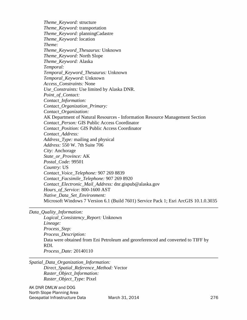
AK DNR DMLW and DOG North Slope Planning Area Geospatial Infrastructure Data March 31, 2014 276
Theme_Keyword: structure
Theme_Keyword: transportation
Theme_Keyword: planningCadastre
Theme_Keyword: location
Theme:
Theme_Keyword_Thesaurus: Unknown
Theme_Keyword: North Slope
Theme_Keyword: Alaska
Temporal:
Temporal_Keyword_Thesaurus: Unknown
Temporal_Keyword: Unknown
Access_Constraints: None
Use_Constraints: Use limited by Alaska DNR.
Point_of_Contact:
Contact_Information:
Contact_Organization_Primary:
Contact_Organization:
AK Department of Natural Resources - Information Resource Management Section
Contact_Person: GIS Public Access Coordinator
Contact_Position: GIS Public Access Coordinator
Contact_Address:
Address_Type: mailing and physical
Address: 550 W. 7th Suite 706
City: Anchorage
State_or_Province: AK
Postal_Code: 99501
Country: US
Contact_Voice_Telephone: 907 269 8839
Contact_Facsimile_Telephone: 907 269 8920
Contact_Electronic_Mail_Address: [email protected]
Hours_of_Service: 800-1600 AST
Native_Data_Set_Environment:
Microsoft Windows 7 Version 6.1 (Build 7601) Service Pack 1; Esri ArcGIS 10.1.0.3035
Data_Quality_Information:
Logical_Consistency_Report: Unknown
Lineage:
Process_Step:
Process_Description:
Data were obtained from Eni Petroleum and georeferenced and converted to TIFF by
RDI.
Process_Date: 20140110
Spatial_Data_Organization_Information:
Direct_Spatial_Reference_Method: Vector
Raster_Object_Information:
Raster_Object_Type: Pixel

AK DNR DMLW and DOG North Slope Planning Area Geospatial Infrastructure Data March 31, 2014 277
Row_Count: 1362
Column_Count: 2071
Spatial_Reference_Information:
Horizontal_Coordinate_System_Definition:
Planar:
Map_Projection:
Map_Projection_Name: Albers Conical Equal Area
Albers_Conical_Equal_Area:
Standard_Parallel: 55.0
Standard_Parallel: 65.0
Longitude_of_Central_Meridian: -154.0
Latitude_of_Projection_Origin: 50.0
False_Easting: 0.0
False_Northing: 0.0
Planar_Coordinate_Information:
Planar_Coordinate_Encoding_Method: coordinate pair
Coordinate_Representation:
Abscissa_Resolution: 0.0000000030536018158500163
Ordinate_Resolution: 0.0000000030536018158500163
Planar_Distance_Units:
Geodetic_Model:
Horizontal_Datum_Name: D North American 1983
Ellipsoid_Name: GRS 1980
Semi-major_Axis: 6378137.0
Denominator_of_Flattening_Ratio: 298.257222101
Metadata_Reference_Information:
Metadata_Date: 20140226
Metadata_Contact:
Contact_Information:
Contact_Organization_Primary:
Contact_Organization: Resource Data, Inc.
Contact_Person: Bixler McClure
Contact_Position: GIS Programmer/Analyst
Contact_Address:
Address_Type: mailing and physical
Address: 560 E. 34th Ave., Suite 100
City: Anchorage
State_or_Province: AK
Postal_Code: 99503
Country: US
Contact_Voice_Telephone: 907-563-8100
Contact_Facsimile_Telephone: 907-561-0159
Contact_Electronic_Mail_Address: [email protected]
Metadata_Standard_Name: FGDC Content Standard for Digital Geospatial Metadata
Metadata_Standard_Version: FGDC-STD-001-1998

AK DNR DMLW and DOG North Slope Planning Area Geospatial Infrastructure Data March 31, 2014 278
Metadata_Time_Convention: local time
Generated by mp version 2.9.12 on Tue Mar 18 09:48:43 2014

AK DNR DMLW and DOG North Slope Planning Area Geospatial Infrastructure Data March 31, 2014 279
Nikaitchuq North Slope Development (NSD) Pipeline - Plan & Section Road
Crossing at DS-3N (PLR02) Metadata
• Identification_Information
• Data_Quality_Information
• Spatial_Data_Organization_Information
• Spatial_Reference_Information
• Metadata_Reference_Information
Identification_Information:
Citation:
Citation_Information:
Publication_Date: 20140113
Publication_Time: 020000
Title:
Nikaitchuq North Slope Development (NSD) Pipeline - Plan & Section Road Crossing at
DS-3N (PLR02)
Geospatial_Data_Presentation_Form: vector digital data
Description:
Abstract:
This map image was georeferenced from a PDF provided by Eni Petroleum.
Purpose:
This dataset was developed for the Alaska Department of Natural Resources under TOPS
Contract 0086-10-13-010 to compile existing data of infrastructure and material sources
on the North Slope of Alaska. Data were compiled by Resource Data, Inc. in 2013-2014
from existing data supplied by various organizations.
Status:
Progress: Complete
Maintenance_and_Update_Frequency: None planned
Spatial_Domain:
Bounding_Coordinates:
West_Bounding_Coordinate: -149.817232
East_Bounding_Coordinate: -149.808706
North_Bounding_Coordinate: 70.437000
South_Bounding_Coordinate: 70.434938
Keywords:
Theme:
Theme_Keyword_Thesaurus: ISO 19115 Topic Categories
Theme_Keyword: transportation
Theme_Keyword: utilitiesCommunication
Theme_Keyword: planningCadastre
Theme_Keyword: location
Theme_Keyword: structure
Theme:
Theme_Keyword_Thesaurus: ISO 19115 Topic Categories
Theme_Keyword: utilitiesCommunication

AK DNR DMLW and DOG North Slope Planning Area Geospatial Infrastructure Data March 31, 2014 280
Theme_Keyword: structure
Theme_Keyword: transportation
Theme_Keyword: planningCadastre
Theme_Keyword: location
Theme:
Theme_Keyword_Thesaurus: Unknown
Theme_Keyword: North Slope
Theme_Keyword: Alaska
Temporal:
Temporal_Keyword_Thesaurus: Unknown
Temporal_Keyword: Unknown
Access_Constraints: None
Use_Constraints: Use limited by Alaska DNR.
Point_of_Contact:
Contact_Information:
Contact_Organization_Primary:
Contact_Organization:
AK Department of Natural Resources - Information Resource Management Section
Contact_Person: GIS Public Access Coordinator
Contact_Position: GIS Public Access Coordinator
Contact_Address:
Address_Type: mailing and physical
Address: 550 W. 7th Suite 706
City: Anchorage
State_or_Province: AK
Postal_Code: 99501
Country: US
Contact_Voice_Telephone: 907 269 8839
Contact_Facsimile_Telephone: 907 269 8920
Contact_Electronic_Mail_Address: [email protected]
Hours_of_Service: 800-1600 AST
Native_Data_Set_Environment:
Microsoft Windows 7 Version 6.1 (Build 7601) Service Pack 1; Esri ArcGIS 10.1.0.3035
Data_Quality_Information:
Logical_Consistency_Report: Unknown
Lineage:
Process_Step:
Process_Description:
Data were obtained from Eni Petroleum and georeferenced and converted to TIFF by
RDI.
Process_Date: 20140110
Spatial_Data_Organization_Information:
Direct_Spatial_Reference_Method: Vector
Raster_Object_Information:
Raster_Object_Type: Pixel

AK DNR DMLW and DOG North Slope Planning Area Geospatial Infrastructure Data March 31, 2014 281
Row_Count: 1380
Column_Count: 2091
Spatial_Reference_Information:
Horizontal_Coordinate_System_Definition:
Planar:
Map_Projection:
Map_Projection_Name: Albers Conical Equal Area
Albers_Conical_Equal_Area:
Standard_Parallel: 55.0
Standard_Parallel: 65.0
Longitude_of_Central_Meridian: -154.0
Latitude_of_Projection_Origin: 50.0
False_Easting: 0.0
False_Northing: 0.0
Planar_Coordinate_Information:
Planar_Coordinate_Encoding_Method: coordinate pair
Coordinate_Representation:
Abscissa_Resolution: 0.0000000030536018158500163
Ordinate_Resolution: 0.0000000030536018158500163
Planar_Distance_Units:
Geodetic_Model:
Horizontal_Datum_Name: D North American 1983
Ellipsoid_Name: GRS 1980
Semi-major_Axis: 6378137.0
Denominator_of_Flattening_Ratio: 298.257222101
Metadata_Reference_Information:
Metadata_Date: 20140226
Metadata_Contact:
Contact_Information:
Contact_Organization_Primary:
Contact_Organization: Resource Data, Inc.
Contact_Person: Bixler McClure
Contact_Position: GIS Programmer/Analyst
Contact_Address:
Address_Type: mailing and physical
Address: 560 E. 34th Ave., Suite 100
City: Anchorage
State_or_Province: AK
Postal_Code: 99503
Country: US
Contact_Voice_Telephone: 907-563-8100
Contact_Facsimile_Telephone: 907-561-0159
Contact_Electronic_Mail_Address: [email protected]
Metadata_Standard_Name: FGDC Content Standard for Digital Geospatial Metadata
Metadata_Standard_Version: FGDC-STD-001-1998

AK DNR DMLW and DOG North Slope Planning Area Geospatial Infrastructure Data March 31, 2014 282
Metadata_Time_Convention: local time
Generated by mp version 2.9.12 on Tue Mar 18 09:48:43 2014

AK DNR DMLW and DOG North Slope Planning Area Geospatial Infrastructure Data March 31, 2014 283
Nikaitchuq North Slope Development (NSD) Pipeline - Plan & Section Road
Crossing at CPF3 (PLR02) Metadata
• Identification_Information
• Data_Quality_Information
• Spatial_Data_Organization_Information
• Spatial_Reference_Information
• Metadata_Reference_Information
Identification_Information:
Citation:
Citation_Information:
Publication_Date: 20140113
Publication_Time: 020000
Title:
Nikaitchuq North Slope Development (NSD) Pipeline - Plan & Section Road Crossing at
CPF3 (PLR02)
Geospatial_Data_Presentation_Form: vector digital data
Description:
Abstract:
This map image was georeferenced from a PDF provided by Eni Petroleum.
Purpose:
This dataset was developed for the Alaska Department of Natural Resources under TOPS
Contract 0086-10-13-010 to compile existing data of infrastructure and material sources
on the North Slope of Alaska. Data were compiled by Resource Data, Inc. in 2013-2014
from existing data supplied by various organizations.
Status:
Progress: Complete
Maintenance_and_Update_Frequency: None planned
Spatial_Domain:
Bounding_Coordinates:
West_Bounding_Coordinate: -149.817743
East_Bounding_Coordinate: -149.809087
North_Bounding_Coordinate: 70.398917
South_Bounding_Coordinate: 70.396821
Keywords:
Theme:
Theme_Keyword_Thesaurus: ISO 19115 Topic Categories
Theme_Keyword: transportation
Theme_Keyword: utilitiesCommunication
Theme_Keyword: planningCadastre
Theme_Keyword: location
Theme_Keyword: structure
Theme:
Theme_Keyword_Thesaurus: ISO 19115 Topic Categories
Theme_Keyword: utilitiesCommunication

AK DNR DMLW and DOG North Slope Planning Area Geospatial Infrastructure Data March 31, 2014 284
Theme_Keyword: structure
Theme_Keyword: transportation
Theme_Keyword: planningCadastre
Theme_Keyword: location
Theme:
Theme_Keyword_Thesaurus: Unknown
Theme_Keyword: North Slope
Theme_Keyword: Alaska
Temporal:
Temporal_Keyword_Thesaurus: Unknown
Temporal_Keyword: Unknown
Access_Constraints: None
Use_Constraints: Use limited by Alaska DNR.
Point_of_Contact:
Contact_Information:
Contact_Organization_Primary:
Contact_Organization:
AK Department of Natural Resources - Information Resource Management Section
Contact_Person: GIS Public Access Coordinator
Contact_Position: GIS Public Access Coordinator
Contact_Address:
Address_Type: mailing and physical
Address: 550 W. 7th Suite 706
City: Anchorage
State_or_Province: AK
Postal_Code: 99501
Country: US
Contact_Voice_Telephone: 907 269 8839
Contact_Facsimile_Telephone: 907 269 8920
Contact_Electronic_Mail_Address: [email protected]
Hours_of_Service: 800-1600 AST
Native_Data_Set_Environment:
Microsoft Windows 7 Version 6.1 (Build 7601) Service Pack 1; Esri ArcGIS 10.1.0.3035
Data_Quality_Information:
Logical_Consistency_Report: Unknown
Lineage:
Process_Step:
Process_Description:
Data were obtained from Eni Petroleum and georeferenced and converted to TIFF by
RDI.
Process_Date: 20140110
Spatial_Data_Organization_Information:
Direct_Spatial_Reference_Method: Vector
Raster_Object_Information:
Raster_Object_Type: Pixel

AK DNR DMLW and DOG North Slope Planning Area Geospatial Infrastructure Data March 31, 2014 285
Row_Count: 1385
Column_Count: 2098
Spatial_Reference_Information:
Horizontal_Coordinate_System_Definition:
Planar:
Map_Projection:
Map_Projection_Name: Albers Conical Equal Area
Albers_Conical_Equal_Area:
Standard_Parallel: 55.0
Standard_Parallel: 65.0
Longitude_of_Central_Meridian: -154.0
Latitude_of_Projection_Origin: 50.0
False_Easting: 0.0
False_Northing: 0.0
Planar_Coordinate_Information:
Planar_Coordinate_Encoding_Method: coordinate pair
Coordinate_Representation:
Abscissa_Resolution: 0.0000000030536018158500163
Ordinate_Resolution: 0.0000000030536018158500163
Planar_Distance_Units:
Geodetic_Model:
Horizontal_Datum_Name: D North American 1983
Ellipsoid_Name: GRS 1980
Semi-major_Axis: 6378137.0
Denominator_of_Flattening_Ratio: 298.257222101
Metadata_Reference_Information:
Metadata_Date: 20140226
Metadata_Contact:
Contact_Information:
Contact_Organization_Primary:
Contact_Organization: Resource Data, Inc.
Contact_Person: Bixler McClure
Contact_Position: GIS Programmer/Analyst
Contact_Address:
Address_Type: mailing and physical
Address: 560 E. 34th Ave., Suite 100
City: Anchorage
State_or_Province: AK
Postal_Code: 99503
Country: US
Contact_Voice_Telephone: 907-563-8100
Contact_Facsimile_Telephone: 907-561-0159
Contact_Electronic_Mail_Address: [email protected]
Metadata_Standard_Name: FGDC Content Standard for Digital Geospatial Metadata
Metadata_Standard_Version: FGDC-STD-001-1998

AK DNR DMLW and DOG North Slope Planning Area Geospatial Infrastructure Data March 31, 2014 286
Metadata_Time_Convention: local time
Generated by mp version 2.9.12 on Tue Mar 18 09:48:43 2014

AK DNR DMLW and DOG North Slope Planning Area Geospatial Infrastructure Data March 31, 2014 287
Nikaitchuq North Slope Development (NSD) Pipeline - Plan & Section Road
Crossing at DS-1Y (PLR02) Metadata
• Identification_Information
• Data_Quality_Information
• Spatial_Data_Organization_Information
• Spatial_Reference_Information
• Metadata_Reference_Information
Identification_Information:
Citation:
Citation_Information:
Publication_Date: 20140113
Publication_Time: 020000
Title:
Nikaitchuq North Slope Development (NSD) Pipeline - Plan & Section Road Crossing at
DS-1Y (PLR02)
Geospatial_Data_Presentation_Form: vector digital data
Description:
Abstract:
This map image was georeferenced from a PDF provided by Eni Petroleum.
Purpose:
This dataset was developed for the Alaska Department of Natural Resources under TOPS
Contract 0086-10-13-010 to compile existing data of infrastructure and material sources
on the North Slope of Alaska. Data were compiled by Resource Data, Inc. in 2013-2014
from existing data supplied by various organizations.
Status:
Progress: Complete
Maintenance_and_Update_Frequency: None planned
Spatial_Domain:
Bounding_Coordinates:
West_Bounding_Coordinate: -149.743185
East_Bounding_Coordinate: -149.733392
North_Bounding_Coordinate: 70.344049
South_Bounding_Coordinate: 70.341663
Keywords:
Theme:
Theme_Keyword_Thesaurus: ISO 19115 Topic Categories
Theme_Keyword: transportation
Theme_Keyword: utilitiesCommunication
Theme_Keyword: planningCadastre
Theme_Keyword: location
Theme_Keyword: structure
Theme:
Theme_Keyword_Thesaurus: ISO 19115 Topic Categories
Theme_Keyword: utilitiesCommunication

AK DNR DMLW and DOG North Slope Planning Area Geospatial Infrastructure Data March 31, 2014 288
Theme_Keyword: structure
Theme_Keyword: transportation
Theme_Keyword: planningCadastre
Theme_Keyword: location
Theme:
Theme_Keyword_Thesaurus: Unknown
Theme_Keyword: North Slope
Theme_Keyword: Alaska
Temporal:
Temporal_Keyword_Thesaurus: Unknown
Temporal_Keyword: Unknown
Access_Constraints: None
Use_Constraints: Use limited by Alaska DNR.
Point_of_Contact:
Contact_Information:
Contact_Organization_Primary:
Contact_Organization:
AK Department of Natural Resources - Information Resource Management Section
Contact_Person: GIS Public Access Coordinator
Contact_Position: GIS Public Access Coordinator
Contact_Address:
Address_Type: mailing and physical
Address: 550 W. 7th Suite 706
City: Anchorage
State_or_Province: AK
Postal_Code: 99501
Country: US
Contact_Voice_Telephone: 907 269 8839
Contact_Facsimile_Telephone: 907 269 8920
Contact_Electronic_Mail_Address: [email protected]
Hours_of_Service: 800-1600 AST
Native_Data_Set_Environment:
Microsoft Windows 7 Version 6.1 (Build 7601) Service Pack 1; Esri ArcGIS 10.1.0.3035
Data_Quality_Information:
Logical_Consistency_Report: Unknown
Lineage:
Process_Step:
Process_Description:
Data were obtained from Eni Petroleum and georeferenced and converted to TIFF by
RDI.
Process_Date: 20140110
Spatial_Data_Organization_Information:
Direct_Spatial_Reference_Method: Vector
Raster_Object_Information:
Raster_Object_Type: Pixel
AK DNR DMLW and DOG North Slope Planning Area Geospatial Infrastructure Data March 31, 2014 289
Row_Count: 1379
Column_Count: 2081
Spatial_Reference_Information:
Horizontal_Coordinate_System_Definition:
Planar:
Map_Projection:
Map_Projection_Name: Albers Conical Equal Area
Albers_Conical_Equal_Area:
Standard_Parallel: 55.0
Standard_Parallel: 65.0
Longitude_of_Central_Meridian: -154.0
Latitude_of_Projection_Origin: 50.0
False_Easting: 0.0
False_Northing: 0.0
Planar_Coordinate_Information:
Planar_Coordinate_Encoding_Method: coordinate pair
Coordinate_Representation:
Abscissa_Resolution: 0.0000000030536018158500163
Ordinate_Resolution: 0.0000000030536018158500163
Planar_Distance_Units:
Geodetic_Model:
Horizontal_Datum_Name: D North American 1983
Ellipsoid_Name: GRS 1980
Semi-major_Axis: 6378137.0
Denominator_of_Flattening_Ratio: 298.257222101
Metadata_Reference_Information:
Metadata_Date: 20140226
Metadata_Contact:
Contact_Information:
Contact_Organization_Primary:
Contact_Organization: Resource Data, Inc.
Contact_Person: Bixler McClure
Contact_Position: GIS Programmer/Analyst
Contact_Address:
Address_Type: mailing and physical
Address: 560 E. 34th Ave., Suite 100
City: Anchorage
State_or_Province: AK
Postal_Code: 99503
Country: US
Contact_Voice_Telephone: 907-563-8100
Contact_Facsimile_Telephone: 907-561-0159
Contact_Electronic_Mail_Address: [email protected]
Metadata_Standard_Name: FGDC Content Standard for Digital Geospatial Metadata
Metadata_Standard_Version: FGDC-STD-001-1998

AK DNR DMLW and DOG North Slope Planning Area Geospatial Infrastructure Data March 31, 2014 290
Metadata_Time_Convention: local time
Generated by mp version 2.9.12 on Tue Mar 18 09:48:43 2014

AK DNR DMLW and DOG North Slope Planning Area Geospatial Infrastructure Data March 31, 2014 291
Nikaitchuq North Slope Development (NSD) Pipeline - Plan & Section Road
Crossing at Spine Road (PLR02) Metadata
• Identification_Information
• Data_Quality_Information
• Spatial_Data_Organization_Information
• Spatial_Reference_Information
• Metadata_Reference_Information
Identification_Information:
Citation:
Citation_Information:
Publication_Date: 20140113
Publication_Time: 020000
Title:
Nikaitchuq North Slope Development (NSD) Pipeline - Plan & Section Road Crossing at
Spine Road (PLR02)
Geospatial_Data_Presentation_Form: vector digital data
Description:
Abstract:
This map image was georeferenced from a PDF provided by Eni Petroleum.
Purpose:
This dataset was developed for the Alaska Department of Natural Resources under TOPS
Contract 0086-10-13-010 to compile existing data of infrastructure and material sources
on the North Slope of Alaska. Data were compiled by Resource Data, Inc. in 2013-2014
from existing data supplied by various organizations.
Status:
Progress: Complete
Maintenance_and_Update_Frequency: None planned
Spatial_Domain:
Bounding_Coordinates:
West_Bounding_Coordinate: -149.734875
East_Bounding_Coordinate: -149.726153
North_Bounding_Coordinate: 70.337565
South_Bounding_Coordinate: 70.335443
Keywords:
Theme:
Theme_Keyword_Thesaurus: ISO 19115 Topic Categories
Theme_Keyword: transportation
Theme_Keyword: utilitiesCommunication
Theme_Keyword: planningCadastre
Theme_Keyword: location
Theme_Keyword: structure
Theme:
Theme_Keyword_Thesaurus: ISO 19115 Topic Categories
Theme_Keyword: utilitiesCommunication

AK DNR DMLW and DOG North Slope Planning Area Geospatial Infrastructure Data March 31, 2014 292
Theme_Keyword: structure
Theme_Keyword: transportation
Theme_Keyword: planningCadastre
Theme_Keyword: location
Theme:
Theme_Keyword_Thesaurus: Unknown
Theme_Keyword: North Slope
Theme_Keyword: Alaska
Temporal:
Temporal_Keyword_Thesaurus: Unknown
Temporal_Keyword: Unknown
Access_Constraints: None
Use_Constraints: Use limited by Alaska DNR.
Point_of_Contact:
Contact_Information:
Contact_Organization_Primary:
Contact_Organization:
AK Department of Natural Resources - Information Resource Management Section
Contact_Person: GIS Public Access Coordinator
Contact_Position: GIS Public Access Coordinator
Contact_Address:
Address_Type: mailing and physical
Address: 550 W. 7th Suite 706
City: Anchorage
State_or_Province: AK
Postal_Code: 99501
Country: US
Contact_Voice_Telephone: 907 269 8839
Contact_Facsimile_Telephone: 907 269 8920
Contact_Electronic_Mail_Address: [email protected]
Hours_of_Service: 800-1600 AST
Native_Data_Set_Environment:
Microsoft Windows 7 Version 6.1 (Build 7601) Service Pack 1; Esri ArcGIS 10.1.0.3035
Data_Quality_Information:
Logical_Consistency_Report: Unknown
Lineage:
Process_Step:
Process_Description:
Data were obtained from Eni Petroleum and georeferenced and converted to TIFF by
RDI.
Process_Date: 20140110
Spatial_Data_Organization_Information:
Direct_Spatial_Reference_Method: Vector
Raster_Object_Information:
Raster_Object_Type: Pixel

AK DNR DMLW and DOG North Slope Planning Area Geospatial Infrastructure Data March 31, 2014 293
Row_Count: 1383
Column_Count: 2092
Spatial_Reference_Information:
Horizontal_Coordinate_System_Definition:
Planar:
Map_Projection:
Map_Projection_Name: Albers Conical Equal Area
Albers_Conical_Equal_Area:
Standard_Parallel: 55.0
Standard_Parallel: 65.0
Longitude_of_Central_Meridian: -154.0
Latitude_of_Projection_Origin: 50.0
False_Easting: 0.0
False_Northing: 0.0
Planar_Coordinate_Information:
Planar_Coordinate_Encoding_Method: coordinate pair
Coordinate_Representation:
Abscissa_Resolution: 0.0000000030536018158500163
Ordinate_Resolution: 0.0000000030536018158500163
Planar_Distance_Units:
Geodetic_Model:
Horizontal_Datum_Name: D North American 1983
Ellipsoid_Name: GRS 1980
Semi-major_Axis: 6378137.0
Denominator_of_Flattening_Ratio: 298.257222101
Metadata_Reference_Information:
Metadata_Date: 20140226
Metadata_Contact:
Contact_Information:
Contact_Organization_Primary:
Contact_Organization: Resource Data, Inc.
Contact_Person: Bixler McClure
Contact_Position: GIS Programmer/Analyst
Contact_Address:
Address_Type: mailing and physical
Address: 560 E. 34th Ave., Suite 100
City: Anchorage
State_or_Province: AK
Postal_Code: 99503
Country: US
Contact_Voice_Telephone: 907-563-8100
Contact_Facsimile_Telephone: 907-561-0159
Contact_Electronic_Mail_Address: [email protected]
Metadata_Standard_Name: FGDC Content Standard for Digital Geospatial Metadata
Metadata_Standard_Version: FGDC-STD-001-1998

AK DNR DMLW and DOG North Slope Planning Area Geospatial Infrastructure Data March 31, 2014 294
Metadata_Time_Convention: local time
Generated by mp version 2.9.12 on Tue Mar 18 09:48:43 2014

AK DNR DMLW and DOG North Slope Planning Area Geospatial Infrastructure Data March 31, 2014 295
Nikaitchuq Development 2010 Flowline Route Monitoring Program Regional
Overview & Index Map Metadata
• Identification_Information
• Data_Quality_Information
• Spatial_Data_Organization_Information
• Spatial_Reference_Information
• Metadata_Reference_Information
Identification_Information:
Citation:
Citation_Information:
Publication_Date: 20140113
Publication_Time: 020000
Title:
Nikaitchuq Development 2010 Flowline Route Monitoring Program Regional Overview
& Index Map
Geospatial_Data_Presentation_Form: vector digital data
Description:
Abstract:
This map image was georeferenced from a PDF provided by Eni Petroleum.
Purpose:
This dataset was developed for the Alaska Department of Natural Resources under TOPS
Contract 0086-10-13-010 to compile existing data of infrastructure and material sources
on the North Slope of Alaska. Data were compiled by Resource Data, Inc. in 2013-2014
from existing data supplied by various organizations.
Status:
Progress: Complete
Maintenance_and_Update_Frequency: None planned
Spatial_Domain:
Bounding_Coordinates:
West_Bounding_Coordinate: -150.029631
East_Bounding_Coordinate: -149.714702
North_Bounding_Coordinate: 70.573788
South_Bounding_Coordinate: 70.497116
Keywords:
Theme:
Theme_Keyword_Thesaurus: ISO 19115 Topic Categories
Theme_Keyword: transportation
Theme_Keyword: utilitiesCommunication
Theme_Keyword: planningCadastre
Theme_Keyword: location
Theme_Keyword: structure
Theme:
Theme_Keyword_Thesaurus: ISO 19115 Topic Categories
Theme_Keyword: utilitiesCommunication

AK DNR DMLW and DOG North Slope Planning Area Geospatial Infrastructure Data March 31, 2014 296
Theme_Keyword: structure
Theme_Keyword: transportation
Theme_Keyword: planningCadastre
Theme_Keyword: location
Theme:
Theme_Keyword_Thesaurus: Unknown
Theme_Keyword: North Slope
Theme_Keyword: Alaska
Temporal:
Temporal_Keyword_Thesaurus: Unknown
Temporal_Keyword: Unknown
Access_Constraints: None
Use_Constraints: Use limited by Alaska DNR.
Point_of_Contact:
Contact_Information:
Contact_Organization_Primary:
Contact_Organization:
AK Department of Natural Resources - Information Resource Management Section
Contact_Person: GIS Public Access Coordinator
Contact_Position: GIS Public Access Coordinator
Contact_Address:
Address_Type: mailing and physical
Address: 550 W. 7th Suite 706
City: Anchorage
State_or_Province: AK
Postal_Code: 99501
Country: US
Contact_Voice_Telephone: 907 269 8839
Contact_Facsimile_Telephone: 907 269 8920
Contact_Electronic_Mail_Address: [email protected]
Hours_of_Service: 800-1600 AST
Native_Data_Set_Environment:
Microsoft Windows 7 Version 6.1 (Build 7601) Service Pack 1; Esri ArcGIS 10.1.0.3035
Data_Quality_Information:
Logical_Consistency_Report: Unknown
Lineage:
Process_Step:
Process_Description:
Data were obtained from Eni Petroleum and georeferenced and converted to TIFF by
RDI.
Process_Date: 20140110
Spatial_Data_Organization_Information:
Direct_Spatial_Reference_Method: Vector
Raster_Object_Information:
Raster_Object_Type: Pixel

AK DNR DMLW and DOG North Slope Planning Area Geospatial Infrastructure Data March 31, 2014 297
Row_Count: 845
Column_Count: 1264
Spatial_Reference_Information:
Horizontal_Coordinate_System_Definition:
Planar:
Map_Projection:
Map_Projection_Name: Albers Conical Equal Area
Albers_Conical_Equal_Area:
Standard_Parallel: 55.0
Standard_Parallel: 65.0
Longitude_of_Central_Meridian: -154.0
Latitude_of_Projection_Origin: 50.0
False_Easting: 0.0
False_Northing: 0.0
Planar_Coordinate_Information:
Planar_Coordinate_Encoding_Method: coordinate pair
Coordinate_Representation:
Abscissa_Resolution: 0.0000000030536018158500163
Ordinate_Resolution: 0.0000000030536018158500163
Planar_Distance_Units:
Geodetic_Model:
Horizontal_Datum_Name: D North American 1983
Ellipsoid_Name: GRS 1980
Semi-major_Axis: 6378137.0
Denominator_of_Flattening_Ratio: 298.257222101
Metadata_Reference_Information:
Metadata_Date: 20140226
Metadata_Contact:
Contact_Information:
Contact_Organization_Primary:
Contact_Organization: Resource Data, Inc.
Contact_Person: Bixler McClure
Contact_Position: GIS Programmer/Analyst
Contact_Address:
Address_Type: mailing and physical
Address: 560 E. 34th Ave., Suite 100
City: Anchorage
State_or_Province: AK
Postal_Code: 99503
Country: US
Contact_Voice_Telephone: 907-563-8100
Contact_Facsimile_Telephone: 907-561-0159
Contact_Electronic_Mail_Address: [email protected]
Metadata_Standard_Name: FGDC Content Standard for Digital Geospatial Metadata
Metadata_Standard_Version: FGDC-STD-001-1998

AK DNR DMLW and DOG North Slope Planning Area Geospatial Infrastructure Data March 31, 2014 298
Metadata_Time_Convention: local time
Generated by mp version 2.9.12 on Tue Mar 18 09:48:44 2014