danbury branch improvement program task 5€¦ · • the endangered species act (esa) of 1973 (16...
TRANSCRIPT
W
S E C T I O N 6: T H R E AT E N E D A N D E N DA N G E R E D S P E C I E S MARCH 2009
DA N B U R Y B R A N C H I M P R O V E M E N T P R O G R A M
TA S K 5
ENVIRONMENTAL TECHNICAL MEMORANDUMSTATE PROJECT 302-008
FTA ALTERNATIVES ANALYSISDRAFT/FINAL ENVIRONMENTAL IMPACT STATEMENT

State Project No. 302-008 Connecticut Department of Transportation Danbury Branch Improvement Program AA/DEIS
Threatened and Endangered Species Page 6-1 March 2009
SECTION 6. THREATENED AND ENDANGERED SPECIES INTRODUCTION This section discusses the presence or potential presence of threatened and endangered species in the study corridor. Threatened and endangered species include plants and animals. Threatened and endangered species are identified at the national level by the federal government, resulting in a group of federally-listed species. Threatened and endangered species are also identified at the state level, in Connecticut by the Connecticut Department of Environmental Protection (DEP). The state list of threatened and endangered species includes federally-listed species which previously occurred in Connecticut or could still exist in Connecticut, plus additional species of rare or declining occurrence in the state. These species and their essential (or critical) habitats are protected at both the federal and state levels. Regulatory Context The federal and state laws that govern threatened and endangered species are described below. At the federal level, the following legislation is relevant to the project:
• The Fish and Wildlife Coordination Act (16 USC 661-667) requires federal agencies (and other agencies) to consult with the U.S. Fish and Wildlife Service (USFWS) and the state agency with jurisdiction over fish and wildlife resources when undertaking a federal action (or action requiring any federal permit or license) that could affect these resources. The purpose of consultation is to avoid, minimize, and/or mitigate potential adverse impacts. The act enables the USFWS and state agency to undertake project impact studies and states that the recommendations of these agencies must be given full consideration by the sponsoring federal agency in decision-making.
• The Endangered Species Act (ESA) of 1973 (16 USC 1531 et seq.) requires federal
agencies (and others) to avoid actions that would jeopardize threatened or endangered species or their critical habitats. The species and their critical habitats are designated by the USFWS for terrestrial and freshwater species and by the National Marine Fisheries Service (NMFS) for marine species and anadromous fish species. Section 7 of the ESA describes the steps for informal and formal consultation with the USFWS or NMFS if adverse impacts to federally designated (listed) species may occur due to a federal action. Consultation may require a biological assessment of potential project impacts on a listed species, after which the USFWS or NMFS issues a biological opinion regarding the conditions or prohibitions necessary for the project to proceed.
At the state level, the following legislation is relevant:
• The Connecticut Endangered Species Act, passed in 1989 (CGS 26-303), declared a policy of the state to conserve, protect, restore, and enhance any endangered or threatened species and essential habitat . The act authorized the Connecticut Department of Environmental Protection (DEP) to establish procedures to identify whether any native

State Project No. 302-008 Connecticut Department of Transportation Danbury Branch Improvement Program AA/DEIS
Threatened and Endangered Species Page 6-2 March 2009
species is endangered, threatened or of special concern and to review and update these designations every five years. The act requires that any action authorized, funded or performed by a state agency does not threaten the continued existence of any endangered or threa tened spec ies or resu lt in the dest ruction or adverse m odification of h abitat designated as essential to such species , using the best scientific data available. The act established the following definitions: “Endangered Species” means any native species documen ted by biological research and inventory to be in danger of extirpation throughout all or a signi ficant portion of its range within the state and to have no more than five occurrences in the state, and any species determined to be an “endange red species” pursuant to the federal Endangered Species Act. “Threatened Species” m eans any native spec ies documented by bi ological research and inventory to be likely to become an endangered species with in the foreseeable future throughout all or a significant porti on of its range within the state and to have no more than nine occurrences in the stat e, and any species determined to be a "threatened species" pursuant to the federa l Endangered Species Act, except for such species determined to be endangered (by the DEP). “Species of Special Concern” means any native plant species or any native non-harvested wildlife species documented by sc ientific research and inventory to have a naturally restricted range or habitat in the state, to be at a low population level, to be in such high demand by man that its unregulated taking wo uld be detrimental to the conservation of its population or has been extirpated from the state.
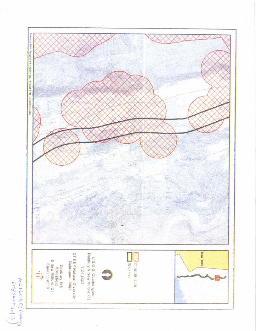
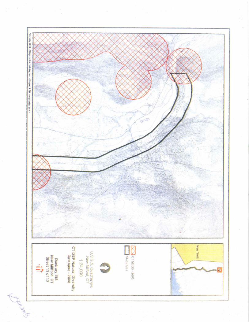
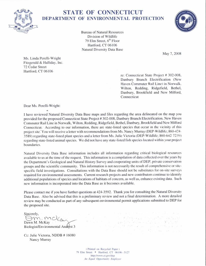
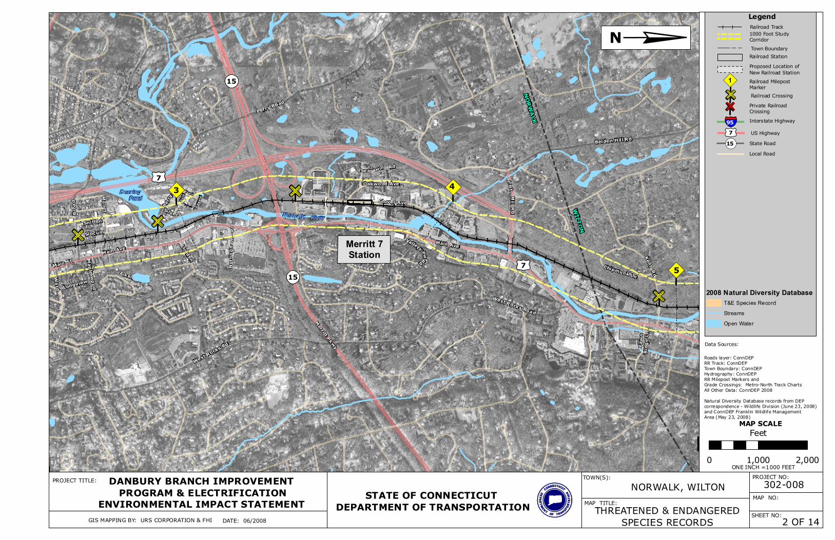
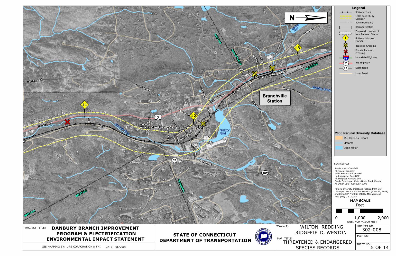
Methods, Coordination, and Data Sources Due to the risk of specimen collection or intentional destruction of threatened and endangered (T&E) species and their habitats, specific information on their whereabouts is not published for public use. The DEP and USFWS have established protocols that allow project sponsors to screen their project sites for potential T&E species. If this first-level screening indicates potential T&E species or habitats, direct consultation with DEP and/or the USFWS is required to find out more about potentially affected species. For projects in Connecticut, the DEP Natural Diversity Data Base (NDDB) is the primary resource for identifying T&E species. The NDDB contains data from over 100 years of biological inventories and observations. The NDDB has prepared maps with the general locations of threatened and endangered species, species of special concern, and unique ecological communities. The NDDB maps were reviewed for the Danbury Branch study corridor [GIS data consulted March 2008]. The maps showed numerous records (portrayed as broad circular areas) of threatened and endangered species, their habitats, ecologically unique areas, and/or species of special concern located in or adjacent to the corridor. Based on this screening – which further noted that the corridor is located in Fairfield and Litchfield Counties and passes through habitats
State Project No. 302-008 Connecticut Department of Transportation Danbury Branch Improvement Program AA/DEIS
Threatened and Endangered Species Page 6-3 March 2009
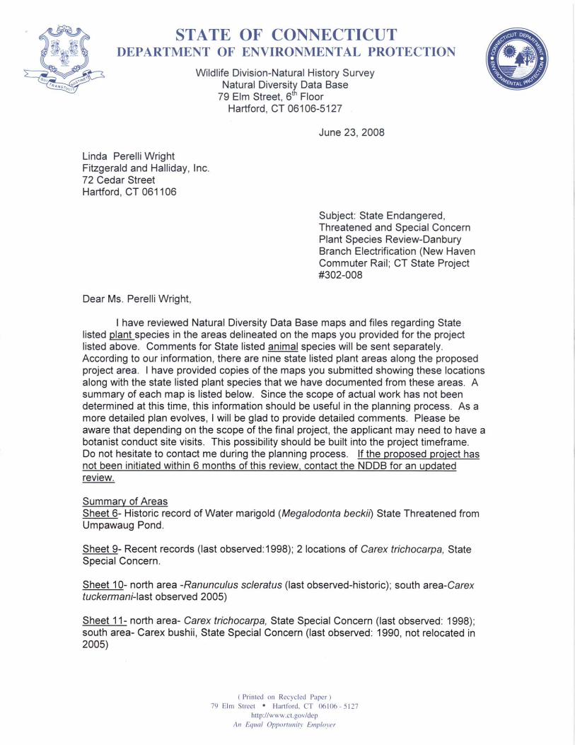
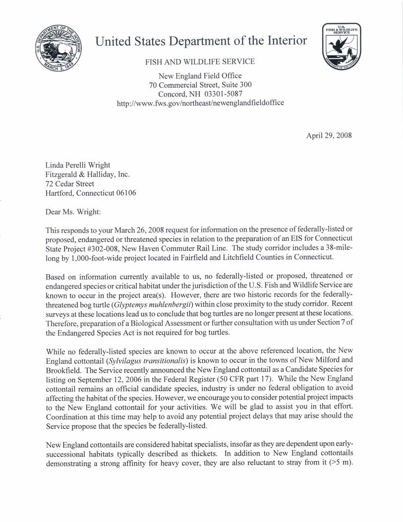
such as forest, wetlands, and waterways – direct consultation with DEP and USFWS was warranted and initiated. The responses from these agencies identified the T&E species and additional species of concern that have been recorded in or near the corridor, and the approximate locations of their occurrence (see correspondence letters in Appendix A). This is the most complete and most current information available for these resources and was used to characterize the potential for T&E species in the study corridor. Correspondence from DEP provided the scientific names, some common names, and some information about the habitat needs of the subject species. Where common names and habitat information was not provided, these were derived from published literature and on-line sources as noted in the References section. The NDDB records are subject to change, as research findings and new data are identified and added to the database. Further coordination with DEP will be necessary periodically during the course of the EIS to ensure that the T&E species information is current. EXISTING CONDITIONS Federally Listed Species Coordination from the USFWS (April 29, 2008) indicated that no federally-listed or proposed threatened or endangered species or critical habitats are located in the study corridor, based on current information. The USFWS noted that there were two historic records of the federally-threatened bog turtle (Glyptemys muhlenbergii ) within the study corridor, but recent surveys indicated that bog turtles are no longer present at those locations. The USFWS also pointed out that the New England cottontail (Sylvilagus trans itionalis) is known to occur in Brookfield and New Milford and that this species is a candidate for listing under the ESA. The USFWS encourages attempts to avoid adverse project effects on the habitat of this species, which consists primarily of heavily-shrubbed early-successional habitats. Such habitats include wetlands with beaver flowage, idle agricultural lands (old fields), power line corridors, railroad rights-of-way, and regenerating forests. The USFWS noted that no more coordination under the ESA is required for a period of one year from the correspondence date, after which further coordination will be necessary relative to potential project impacts. State Listed Species Coordination from DEP provided records of several state-listed plant and animal species located in the study corridor (correspondence from DEP Franklin Wildlife Management Area dated May 23, 2008 and from DEP Natural History Survey dated June 23, 2008). According to the DEP, their data is considered current for approximately six months, after which additional consultation is needed to ensure the most updated information. Based on the potential for state-listed species in the study corridor, there may be a need for field surveys in areas of potential project impacts in order to determine whether suitable habitat and/or state-listed species are present.

State PrConn
oject No. 302-008 ecticut Department of Transportation Danbury Branch Improvement Program AA/DEI
Threatened and Endangered Species Page 6-4 March 2009
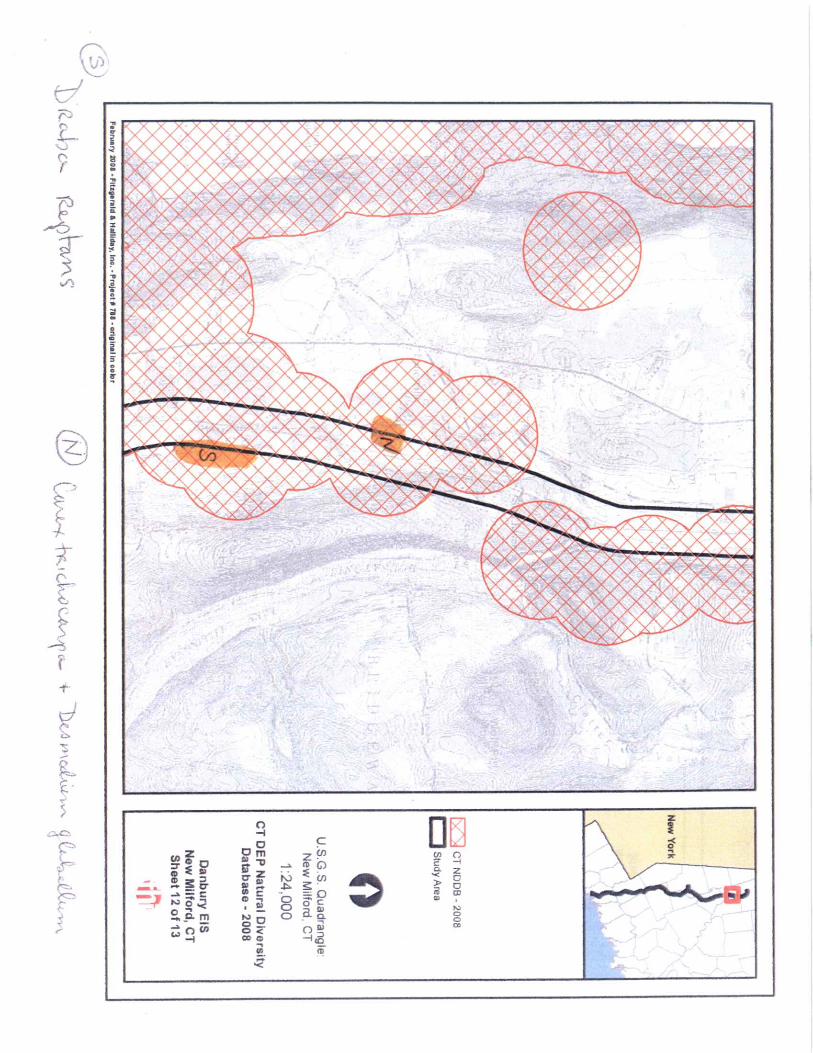
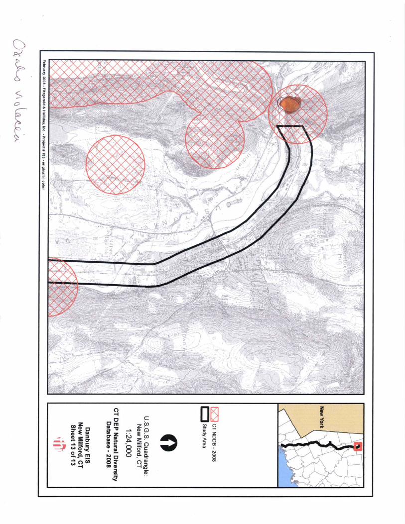
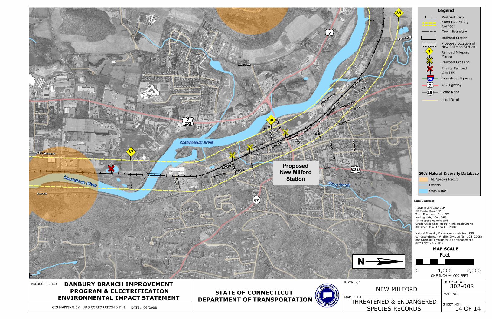
The general location of the records in relation to the corridor is shown in Appendix B, Sheets 1 to 14. [Note: the map sheet numbers referred to by DEP in their correspondence are not the same as the sheet numbers for this document.] Based on the DEP correspondence, the NDDB records in the study corridor include eight state-listed plants and fifteen state-listed animals, none of which are fish species. One of the plant records is historic, indicating that the species has not been observed recently, so the likelihood of its occurrence is low. The other records are more recent, indicating a greater likelihood of occurrence in the study corridor. State-listed species have been recorded from Ridgefield and Redding and northward in the study corridor; none were from Norwalk and Wilton. The species, their status, and the types of habitats they are associated with are listed in Table X1. Reflecting the information in Table 1, the potential locations of the state-listed species in the study corridor communities are described below. Norwalk: No records of state-listed species are located in the Norwalk portion of the study corridor. Wilton: No records of state-listed species are located in the Wilton portion of the study corridor. Redding: There is a historic record of a threatened plant in Redding and the possibility of habitat for seven state-listed animal species: two threatened butterfly species; one butterfly species of special concern; one moth species of special concern; two ground beetle species of special concern; and one aquatic snail species of special concern. Ridgefield: The Ridgefield portion of the study corridor has the possibility of habitat for the same seven state-listed animal species as Redding: two threatened butterfly species; one butterfly species of special concern; one moth species of special concern; two ground beetle species of special concern; and one aquatic snail species of special concern. Danbury: The Danbury portion of the study corridor has the possibility of habitat for one state-listed plant of special concern and one endangered butterfly species. Bethel: The Bethel portion of the study corridor has possible habitat for one endangered butterfly species. Brookfield: The Brookfield portion of the study corridor has a historic record of a special concern plant species and the possibility of habitat for two plant species (sedges) of special concern. The five state-listed animal species with possible habitat in the Brookfield portion of the study corridor include the state and federally endangered bog turtle, a threatened salamander species, two turtle species of special concern, and a snake species of special concern. New Milford: New Milford has the greatest potential for T&E species, based on the number of NDDB records from that community. The New Milford portion of the study corridor has the possibility of habitat for four plant species of special concern and seven animal species: the state and federally endangered bog turtle; an endangered hawk species; a threatened salamander species; two turtle species of special concern; one snake species of special concern; and a bird species of special concern.
S
State Project No. 302-008 Connecticut Department of Transportation Danbury Branch Improvement Program AA/DEIS
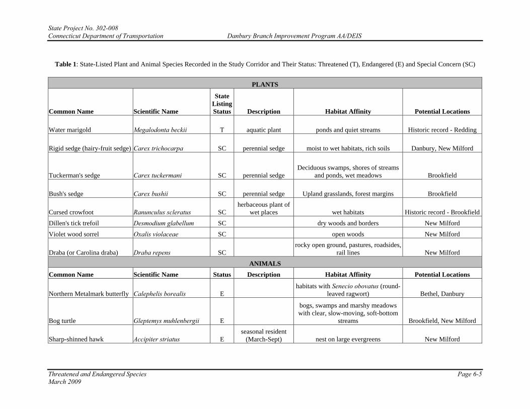
Table 1: State-Listed Plant and Animal Species Recorded in the Study Corridor and Their Status: Threatened (T), Endangered (E) and Special Concern (SC)
PLANTS
Common Name Scientific Name
State Listing Status Description Habitat Affinity Potential Locations
Water marigold Megalodonta beckii T aquatic plant ponds and quiet streams Historic record - Redding
Rigid sedge (hairy-fruit sedge) Carex trichocarpa SC perennial sedge moist to wet habitats, rich soils Danbury, New Milford
Tuckerman's sedge Carex tuckermani SC perennial sedge Deciduous swamps, shores of streams
and ponds, wet meadows Brookfield
Bush's sedge Carex bushii SC perennial sedge Upland grasslands, forest margins Brookfield
Cursed crowfoot Ranunculus scleratus SC herbaceous plant of
wet places wet habitats Historic record - BrookfieldDillen's tick trefoil Desmodium glabellum SC dry woods and borders New Milford Violet wood sorrel Oxalis violaceae SC open woods New Milford
Draba (or Carolina draba) Draba repens SC rocky open ground, pastures, roadsides,
rail lines New Milford
ANIMALS Common Name Scientific Name Status Description Habitat Affinity Potential Locations
Northern Metalmark butterfly Calephelis borealis E habitats with Senecio obovatus (round-
leaved ragwort) Bethel, Danbury
Bog turtle Gleptemys muhlenbergii E
bogs, swamps and marshy meadows with clear, slow-moving, soft-bottom
streams Brookfield, New Milford
Sharp-shinned hawk Accipiter striatus E seasonal resident
(March-Sept) nest on large evergreens New Milford
Threatened and Endangered Species Page 6-5 March 2009
ate Project No. 302-008 onnecticut Department of Transportation Danbury Branch Improvement Program AA/DEIS
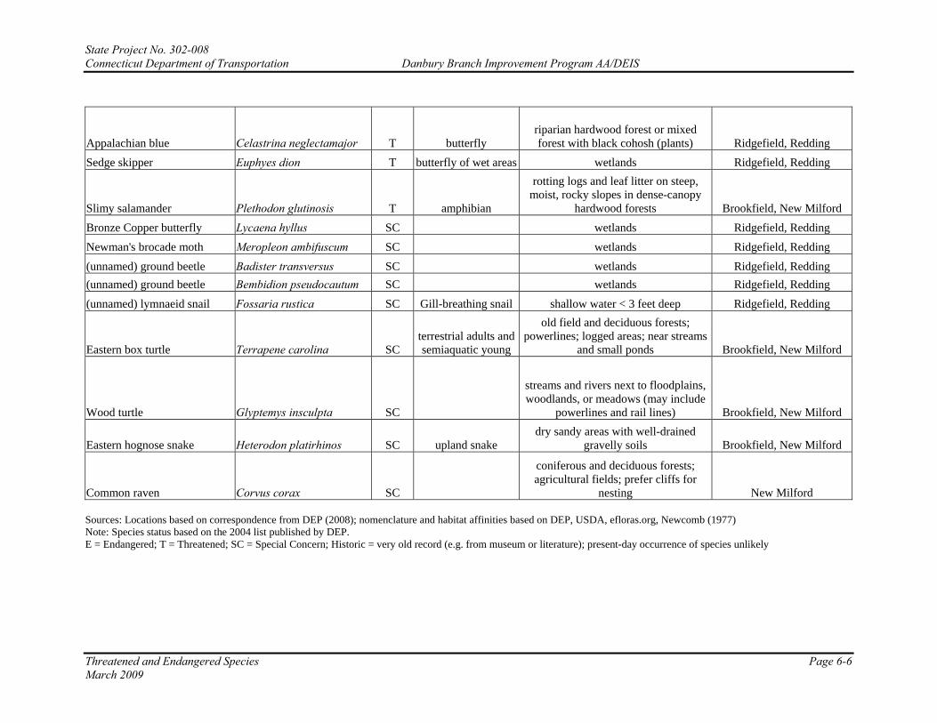
Appalachian blue Celastrina neglectamajor T butterfly riparian hardwood forest or mixed forest with black cohosh (plants) Ridgefield, Redding
Sedge skipper Euphyes dion T butterfly of wet areas wetlands Ridgefield, Redding
Slimy salamander Plethodon glutinosis T amphibian
rotting logs and leaf litter on steep, moist, rocky slopes in dense-canopy
hardwood forests Brookfield, New Milford Bronze Copper butterfly Lycaena hyllus SC wetlands Ridgefield, Redding Newman's brocade moth Meropleon ambifuscum SC wetlands Ridgefield, Redding (unnamed) ground beetle Badister transversus SC wetlands Ridgefield, Redding (unnamed) ground beetle Bembidion pseudocautum SC wetlands Ridgefield, Redding (unnamed) lymnaeid snail Fossaria rustica SC Gill-breathing snail shallow water < 3 feet deep Ridgefield, Redding
Eastern box turtle Terrapene carolina SC terrestrial adults and semiaquatic young
old field and deciduous forests; powerlines; logged areas; near streams
and small ponds Brookfield, New Milford
Wood turtle Glyptemys insculpta SC
streams and rivers next to floodplains, woodlands, or meadows (may include
powerlines and rail lines) Brookfield, New Milford
Eastern hognose snake Heterodon platirhinos SC upland snake dry sandy areas with well-drained
gravelly soils Brookfield, New Milford
Common raven Corvus corax SC
coniferous and deciduous forests; agricultural fields; prefer cliffs for
nesting New Milford
Threatened and Endangered Species Page 6-6 March 2009
Sources: Locations based on correspondence from DEP (2008); nomenclature and habitat affinities based on DEP, USDA, efloras.org, Newcomb (1977) Note: Species status based on the 2004 list published by DEP. E = Endangered; T = Threatened; SC = Special Concern; Historic = very old record (e.g. from museum or literature); present-day occurrence of species unlikely
StC

State Project No. 302-008 Connecticut Department of Transportation Danbury Branch Improvement Program AA/DEIS
Threatened and Endangered Species Page 6-7 March 2009
REFERENCES Connecticut Department of Environmental Protection. 2004. Connecticut’s List of Endangered, Threatened, and Special Concern Species, 2004. Web access: http://www.ct.gov/dep/lib/dep/wildlife/pdf_files/nongame/ETS04.pdf efloras.org. Flora of North America. Web access: www.efloras.org Newcomb, Lawrence. 1977. Wildlife guide. Little, Brown and Company, Boston. U.S. Department of Agricultural (USDA), Natural Resources Conservation Service. PLANTS Profile. Web access: http://plants.usda.gov

State Project No. 302-008 Connecticut Department of Transportation Danbury Branch Improvement Program AA/DEIS
Threatened and Endangered Species Page 6-8 March 2009
APPENDIX A
AGENCY CORRESPONDENCE RELATIVE TO THREATENED AND ENDANGERED SPECIES


Planning Consultants
FITZGERALD & HALLIDAY, INC.
72 Cedar Street, Hartford, Connecticut 06106 Tel. (860) 247-7200 Fax (860) 232-7536
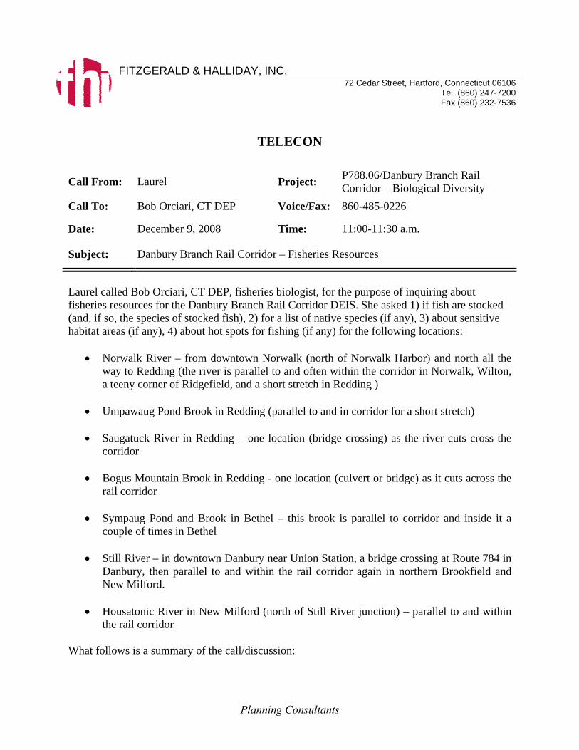
TELECON Call From: Laurel Project: P788.06/Danbury Branch Rail
Corridor – Biological Diversity Call To: Bob Orciari, CT DEP Voice/Fax: 860-485-0226
Date: December 9, 2008 Time: 11:00-11:30 a.m.
Subject: Danbury Branch Rail Corridor – Fisheries Resources
Laurel called Bob Orciari, CT DEP, fisheries biologist, for the purpose of inquiring about fisheries resources for the Danbury Branch Rail Corridor DEIS. She asked 1) if fish are stocked (and, if so, the species of stocked fish), 2) for a list of native species (if any), 3) about sensitive habitat areas (if any), 4) about hot spots for fishing (if any) for the following locations:
• Norwalk River – from downtown Norwalk (north of Norwalk Harbor) and north all the way to Redding (the river is parallel to and often within the corridor in Norwalk, Wilton, a teeny corner of Ridgefield, and a short stretch in Redding )
• Umpawaug Pond Brook in Redding (parallel to and in corridor for a short stretch)
• Saugatuck River in Redding – one location (bridge crossing) as the river cuts cross the
corridor
• Bogus Mountain Brook in Redding - one location (culvert or bridge) as it cuts across the rail corridor
• Sympaug Pond and Brook in Bethel – this brook is parallel to corridor and inside it a
couple of times in Bethel
• Still River – in downtown Danbury near Union Station, a bridge crossing at Route 784 in Danbury, then parallel to and within the rail corridor again in northern Brookfield and New Milford.
• Housatonic River in New Milford (north of Still River junction) – parallel to and within
the rail corridor What follows is a summary of the call/discussion:

Planning Consultants
Still River According to Mr. Orciari, the Still River is stocked with a mix of 400 trout (brook, brown, and rainbow) in downtown Danbury at Eagle Street. This Eagle Street location, a hot spot for fishing, is near the bridge crossing at Routes 7 and 84. Native fish found in the vicinity of Eagle Street include small mouth bass and white sucker. Carp are also common at this location, but they are a non-native species. The Still River in northern Brookfield and New Milford is a warm water resource. It does not support trout and is not stocked with fish. However, non-native carp are found in this part of the Still River. Housatonic River According to Mr. Orciari, the Housatonic in New Milford (north of Still River junction) is a warm water resource. It does not support trout and is not stocked with fish. However, non-native carp and native species such as small mouth bass and white suckers are found in this part of the Housatonic River. Saugatuck River According to Mr. Orciari, the Saugatuck River in Redding at the bridge crossing where the river cuts across the rail corridor is a very popular fishing spot. The Saugatuck River is stocked with trout (a mix of brook, brown, and rainbow) in the vicinity of the bridge crossing. This area is sensitive habitat for a variety of native species: long nose bass, black nose bass, white sucker, creek chubbs, and tessellated darter. Norwalk River There are several areas along the Norwalk River in the railroad corridor where trout are stocked. There is a Wild Trout Management Area along the Norwalk River starting from the vicinity of Wolfpit Road in Wilton, through Wilton to Ridgefield. This Wild Trout Management Area is a hot spot for fishing. Other key fishing and habitat areas along the Norwalk River are:
• South of Route 107 to Old Mill Road in Wilton (the Georgetown area) • One mile north of Route 106 in Wilton • The vicinity of the Cannon Road/Pimpewaug Road intersection in Wilton near the
railroad bridge Adult trout (brook, brown, and rainbow) are stocked, intermittently, along the Norwalk River. Approximately 8,000 trout are stocked each year. In 2007, approximately 1,800 brook trout, 3,200 brown trout, and 1,800 rainbow trout were stocked. Additionally, 500 trophy brown trout, 550 trophy rainbow trout, and 31 surplus brood trout stock (very large) were stocked. In the Wild Trout Management Area (Wilton to Ridgefield), brown trout fry are also stocked. Any fish less than nine inches in length must be released in the Wild Trout Management Area.

Planning Consultants
Native fish species found in the Norwalk River in the railroad corridor study area include: long nose bass, black nose bass, white sucker, creek chubbs, and tessellated darter. Brooks, and Ponds Mr. Orciari refered me to Mr. Michael Humphreys (860-567-3445), another CT DEP fisheries biologist for more information to discuss the Umpawaug Pond Brook in Redding, Bogus Mountain Brook in Redding, and Sympaug Pond and Brook in Bethel.

State Project No. 302-008 Connecticut Department of Transportation Danbury Branch Improvement Program AA/DEIS
Threatened and Endangered Species March 2009
APPENDIX B
THREATENED AND ENDANGERED SPECIES RECORDS SHEETS 1-14

Norwalk
River
Norwalk Harbor
Deering Pond
S. Main
Chestnut
Havi
land
Eliz
abet
h
W.
Was
hing
ton
Mad
ison
Cleveland
Water
Ann
PinePutnam Crescent
Science
Butle
r
Orchard
Merwin
Harbor
Chapel
Leonard Isaac
Wall
Smith
West Ave Burnell Hoyt
Commerce
Cross
School
Jefferson
God fry
Wilton
W. M
ainGr
and
Tin dall
Holmes
CatherineLounsbury
Center
Plymouth
Dele
war
eHu
dson
State
Franklin
£¤1
Main
Mar
N. Main
Reed
Jennings
East Ave
Nort
h Av
e
Main St.
Riverside A
ve
New
Cana
an A
ve
Broa
d
SlocumSniffen
123
53
136
Perry
Henr
y
Mon
roe
Martin Luther King
N. Water
shall
Aiken Longview
ÏÎ
ÏÎ
ÏÎ
ÏÎ
ÏÎ
ÏÎÏÎ
ÏÎ ÏÎÏÎ
")3
ÏÎ
Liberty
River S
t
Pearl
RubySilver
Gold
RR Tunnell
£¤7
£¤7
")2
+
")1
")0
Belden
£¤1
Was
hing
ton
Crescent
Main
Hor ton
Warren
Ohio
Ward
Davenport
Disesa
Canaan
Maple wood
Muller
Lin denMain Ave
Button St
Mulvoy
Ely Lexing- ton
Laura
Paradiso
Lowe
Win
dsor
Oak
Glasse r St
Ham
ilton
Bates
CliffPodm ore
New
+1-14
2-12
South Norwalk Station
§̈¦95
L
2-14§̈¦95
123
302-008
1 OF 14MAP TITLE:
DANBURY BRANCH IMPROVEMENT PROGRAM & ELECTRIFICATION
ENVIRONMENTAL IMPACT STATEMENT STATE OF CONNECTICUT DEPARTMENT OF TRANSPORTATION
MAP NO:
SHEET NO:
PROJECT TITLE: TOWN(S):NORWALK
DATE: 06/2008GIS MAPPING BY: URS CORPORATION & FHI
PROJECT NO:
THREATENED & ENDANGEREDSPECIES RECORDS
MAP SCALE
0 1,000 2,000
Feet
ONE INCH =1000 FEET
Data Sources:Roads layer: ConnDEPRR Track: ConnDEPTown Boundary: ConnDEPHydrography: ConnDEPRR Milepost Markers andGrade Crossings: Metro-North Track ChartsAll Other Data: ConnDEP 2008Natural Diversity Database records from DEPcorrespondence - Wildlife Division (June 23, 2008)and ConnDEP Franklin Wildlife Management Area (May 23, 2008)
Railroad Track1000 Foot Study Corridor Town BoundaryRailroad Station
Legend
New Railroad StationProposed Location of
")1 Railroad Milepost Marker Railroad CrossingPrivate Railroad CrossingÏÎ
ÏÎ
|NState Road!(15
Interstate Highway§̈¦95 US Highway£¤7
Local Road
2008 Natural Diversity DatabaseT&E Species RecordStreamsOpen Water
Deering Pond
Tin dall
CatherineCenter
Plymouth
Dele
war
eHu
dson
Main
Merritt Pkwy
Main St.
Norwalk River
New
Cana
an A
ve
West Rocks Rd
Broa
d
SlocumSniffen
Glover Ave
NORWALK
WILTON
Kent Rd
Belden Hill Rd
Arro
w-
Head
Kent Hills Winton
Oakwood Ave
Sear
Valley Vi
Perry
ÏÎ
Aiken Longview
ÏÎ
ÏÎÏÎ
")3
Nott
ingh
am
Pl
Pea rl
RubySilver
Gold
Emer
ald
Chipmunk Ln Chesso
r Ln
ÏÎ
Hill Rd
Mill Rd
Grist
Rid
ge L
nFa
wn
106
ewRd
£¤7
£¤715
Perry Road
Silvermine Rd
") 5
") 4
T
Ohio
Ward
Canaan
Maple woodMuller
Lin den
Main AveMain Ave
West Rocks Road
New
2-12
L
3-14
L
2-14
15
Merritt 7Station
123
L302-008
2 OF 14MAP TITLE:
DANBURY BRANCH IMPROVEMENT PROGRAM & ELECTRIFICATION
ENVIRONMENTAL IMPACT STATEMENT STATE OF CONNECTICUT DEPARTMENT OF TRANSPORTATION
MAP NO:
SHEET NO:
PROJECT TITLE: TOWN(S): NORWALK, WILTON
DATE: 06/2008GIS MAPPING BY: URS CORPORATION & FHI
PROJECT NO:
THREATENED & ENDANGEREDSPECIES RECORDS
MAP SCALE
0 1,000 2,000
Feet
ONE INCH =1000 FEET
Data Sources:
Roads layer: ConnDEPRR Track: ConnDEPTown Boundary: ConnDEPHydrography: ConnDEPRR Milepost Markers andGrade Crossings: Metro-North Track ChartsAll Other Data: ConnDEP 2008Natural Diversity Database records from DEPcorrespondence - Wildlife Division (June 23, 2008)and ConnDEP Franklin Wildlife Management Area (May 23, 2008)
Railroad Track1000 Foot Study Corridor Town BoundaryRailroad Station
Legend
New Railroad StationProposed Location of
")1 Railroad Milepost Marker Railroad CrossingPrivate Railroad CrossingÏÎ
ÏÎ
|NState Road!(15
Interstate Highway§̈¦95 US Highway£¤7
Local Road
2008 Natural Diversity DatabaseT&E Species RecordStreamsOpen Water

Kent Rd
Belden Hill Rd
Wolf
Norwalk River
Arro
w-
Head
Kent Hills Winton
Danbury Rd
Sharp Hill Rd
Orems
Range Rd
Old Highway
River RdNorwalk River
Old
Ridgef ield
Ridgefield Rd
Station
Butternut P l
ÏÎ
") 6
School
Pit
ÏÎ
Cricket
CrownePondLn
White
Wood Ln
")8
Skun
k Ln
Pimpewaug Rd
Chipmunk Ln Chesso
r Ln
Rid
ge L
nFa
wn
106
106
Godfrey
Hubbard Rd
Rd Danbury Rd
!(
33
!(
33
£¤7
") 5
T
Broad Axe Ln
Glen
Side
Rd
OldRidge-Field Rd
!(
33
106
106
Station
Ridg
efiel
d Rd
#2
Rd Old
Powder Horn
Hill
Rd
School Rd NSchool Rd
L
3-14
L
4-14
Old
5
Rd
£¤7
Wilton Station
")7
L302-008
3 OF 14MAP TITLE:
DANBURY BRANCH IMPROVEMENT PROGRAM & ELECTRIFICATION
ENVIRONMENTAL IMPACT STATEMENT STATE OF CONNECTICUT DEPARTMENT OF TRANSPORTATION
MAP NO:
SHEET NO:
PROJECT TITLE: TOWN(S): WILTON
DATE: 06/2008GIS MAPPING BY: URS CORPORATION & FHI
PROJECT NO:
THREATENED & ENDANGEREDSPECIES RECORDS
MAP SCALE
0 1,000 2,000
Feet
ONE INCH =1000 FEET
Data Sources:
Roads layer: ConnDEPRR Track: ConnDEPTown Boundary: ConnDEPHydrography: ConnDEPRR Milepost Markers andGrade Crossings: Metro-North Track ChartsAll Other Data: ConnDEP 2008Natural Diversity Database records from DEPcorrespondence - Wildlife Division (June 23, 2008)and ConnDEP Franklin Wildlife Management Area (May 23, 2008)
Railroad Track1000 Foot Study Corridor Town BoundaryRailroad Station
Legend
New Railroad StationProposed Location of
")1 Railroad Milepost Marker Railroad CrossingPrivate Railroad CrossingÏÎ
ÏÎ
|NState Road!(15
Interstate Highway§̈¦95 US Highway£¤7
Local Road
2008 Natural Diversity DatabaseT&E Species RecordStreamsOpen Water

ÏÎ
Olm
stea
d Hi
ll
Cannon Rd
Seeley Rd
ÏÎHoney
HillRiver
Danbury Rd
Mather St") 10
School
Scribner
WILTON
WESTON
Mountain Rd
Mill Hill
")8
") 9
Cobblestone Pl
Skun
k Ln
Pimpewaug Rd
") 11
ÏÎ
ÏÎ
Danbury Rd
Old
£¤7
+
TPowder Ho
rnHi
llRd
School Rd NSchool Rd
Cann
onRd
Pimpewaug
Rd
Ridge Blue
Rd
L
4-14
Norwalk
WILTON
6
7
Cannondale Station
£¤7
Danbury Rd
Rd
£¤7
Wilton Station
L
5-14
WESTON
302-008
4 OF 14MAP TITLE:
DANBURY BRANCH IMPROVEMENT PROGRAM & ELECTRIFICATION
ENVIRONMENTAL IMPACT STATEMENT STATE OF CONNECTICUT DEPARTMENT OF TRANSPORTATION
MAP NO:
SHEET NO:
PROJECT TITLE: TOWN(S): WILTON
DATE: 06/2008GIS MAPPING BY: URS CORPORATION & FHI
PROJECT NO:
THREATENED & ENDANGEREDSPECIES RECORDS
MAP SCALE
0 1,000 2,000
Feet
ONE INCH =1000 FEET
Data Sources:Roads layer: ConnDEPRR Track: ConnDEPTown Boundary: ConnDEPHydrography: ConnDEPRR Milepost Markers andGrade Crossings: Metro-North Track ChartsAll Other Data: ConnDEP 2008Natural Diversity Database records from DEPcorrespondence - Wildlife Division (June 23, 2008)and ConnDEP Franklin Wildlife Management Area (May 23, 2008)
Railroad Track1000 Foot Study Corridor Town BoundaryRailroad Station
Legend
New Railroad StationProposed Location of
")1 Railroad Milepost Marker Railroad CrossingPrivate Railroad CrossingÏÎ
ÏÎ
|NState Road!(15
Interstate Highway§̈¦95 US Highway£¤7
Local Road
2008 Natural Diversity DatabaseT&E Species RecordStreamsOpen Water
Norwalk River
!(
57
107
Mather St
WILTON
WESTON
Mountain Rd
Factory Pond
Norwalk River
Mill
RIDGEFIELD
REDDING
Redding Rd
Mountain Rd
School
NorthM
ain
Church St
W Church
Portland Ave
Candee
s
Pond
Depot Rd
Redding Brook
Florida Rd RIDGEFIELD
New St
Sm ith
") 11
") 12ÏÎ ÏÎ
ÏÎÏÎ
Park Ln
WilridgeRd
Bran
chvil
le Rd
") 13
Old
Ter
N Main
£¤7
+
102
T
REDDING
WILTON
New
Stre
et #
2
New Street #1Sunset
Hill Rd
Church
South
Sugar Hollow
Sunset Pass
Mountain Road
Peaceable St
Old Town
Branchville Rd
W
St
Smith
Old
N
MainStRd
7
Danbury Rd
BranchvilleStation
L
5-14
WESTON302-008
5 OF 14MAP TITLE:
DANBURY BRANCH IMPROVEMENT PROGRAM & ELECTRIFICATION
ENVIRONMENTAL IMPACT STATEMENT STATE OF CONNECTICUT DEPARTMENT OF TRANSPORTATION
MAP NO:
SHEET NO:
PROJECT TITLE: TOWN(S): WILTON, REDDINGRIDGEFIELD, WESTON
DATE: 06/2008GIS MAPPING BY: URS CORPORATION & FHI
PROJECT NO:
THREATENED & ENDANGEREDSPECIES RECORDS
MAP SCALE
0 1,000 2,000
Feet
ONE INCH =1000 FEET
Data Sources:Roads layer: ConnDEPRR Track: ConnDEPTown Boundary: ConnDEPHydrography: ConnDEPRR Milepost Markers andGrade Crossings: Metro-North Track ChartsAll Other Data: ConnDEP 2008Natural Diversity Database records from DEPcorrespondence - Wildlife Division (June 23, 2008)and ConnDEP Franklin Wildlife Management Area (May 23, 2008)
Railroad Track1000 Foot Study Corridor Town BoundaryRailroad Station
Legend
New Railroad StationProposed Location of
")1 Railroad Milepost Marker Railroad CrossingPrivate Railroad CrossingÏÎ
ÏÎ
|NState Road!(15
Interstate Highway§̈¦95 US Highway£¤7
Local Road
2008 Natural Diversity DatabaseT&E Species RecordStreamsOpen Water

") 14
Umpawaug Pond
Norwalk River
REDDING
Candee
s
Pond
Redding Brook
Florida Rd
Mountain R d
Old Redding Rd
Ethan Allen Highway Topstone Road
Tpk
Simpaug
Topledge Rd
RIDGEFIELD
REDD
ING
Picketts Ridge Rd
March
ant R
d
Sympaug
Turnpike
Rockledge Rd
ÏÎ
berry
ÏÎ
") 13
Fire H
ill Rd
£¤7
Chalburn Rd
RIDG
EFIE
LD
T
Road
£¤7
Simpaug Tpk
LnBay-
Topstone Road
")
ÏÎ
16
")15
9
REDDING
10
Sympaug Tpk
L
6-14
302-008
6 OF 14MAP TITLE:
DANBURY BRANCH IMPROVEMENT PROGRAM & ELECTRIFICATION
ENVIRONMENTAL IMPACT STATEMENT STATE OF CONNECTICUT DEPARTMENT OF TRANSPORTATION
MAP NO:
SHEET NO:
PROJECT TITLE: TOWN(S):
REDDING, RIDGEFIELD
DATE: 06/2008GIS MAPPING BY: URS CORPORATION & FHI
PROJECT NO:
THREATENED & ENDANGEREDSPECIES RECORDS
MAP SCALE
0 1,000 2,000
Feet
ONE INCH =1000 FEET
Data Sources:Roads layer: ConnDEPRR Track: ConnDEPTown Boundary: ConnDEPHydrography: ConnDEPRR Milepost Markers andGrade Crossings: Metro-North Track ChartsAll Other Data: ConnDEP 2008Natural Diversity Database records from DEPcorrespondence - Wildlife Division (June 23, 2008)and ConnDEP Franklin Wildlife Management Area (May 23, 2008)
Railroad Track1000 Foot Study Corridor Town BoundaryRailroad Station
Legend
New Railroad StationProposed Location of
")1 Railroad Milepost Marker Railroad CrossingPrivate Railroad CrossingÏÎ
ÏÎ
|NState Road!(15
Interstate Highway§̈¦95 US Highway£¤7
Local Road
2008 Natural Diversity DatabaseT&E Species RecordStreamsOpen Water

") 19
Umpawaug Pond
53
REDD
ING
Picketts Ridge Rd
March
ant R
d
Sympaug
Long Ridge Rd
Station Rd
Side
Danbury Rd
REDDING
BETHELDANBURY
Turkey Plain Road
BETHEL
Sympaug Pond
Turnpike
Rockledge Rd
Fire H
ill Rd
Hawley Pond
Rd
RIDG
EFIE
LD
Cut Rd
LampostDr
Deer SpringRd
")
")
")
ÏÎ
ÏÎ
ÏÎ
16
17
18
Redding Station
+7-14
10
Sympaug Tpk
302-008
7 OF 14MAP TITLE:
DANBURY BRANCH IMPROVEMENT PROGRAM & ELECTRIFICATION
ENVIRONMENTAL IMPACT STATEMENT STATE OF CONNECTICUT DEPARTMENT OF TRANSPORTATION
MAP NO:
SHEET NO:
PROJECT TITLE: TOWN(S): REDDING, BETHELDANBURY
DATE: 06/2008GIS MAPPING BY: URS CORPORATION & FHI
PROJECT NO:
THREATENED & ENDANGEREDSPECIES RECORDS
MAP SCALE
0 1,000 2,000
Feet
ONE INCH =1000 FEET
Data Sources:Roads layer: ConnDEPRR Track: ConnDEPTown Boundary: ConnDEPHydrography: ConnDEPRR Milepost Markers andGrade Crossings: Metro-North Track ChartsAll Other Data: ConnDEP 2008Natural Diversity Database records from DEPcorrespondence - Wildlife Division (June 23, 2008)and ConnDEP Franklin Wildlife Management Area (May 23, 2008)
Railroad Track1000 Foot Study Corridor Town BoundaryRailroad Station
Legend
New Railroad StationProposed Location of
")1 Railroad Milepost Marker Railroad CrossingPrivate Railroad CrossingÏÎ
ÏÎ
|NState Road!(15
Interstate Highway§̈¦95 US Highway£¤7
Local Road
2008 Natural Diversity DatabaseT&E Species RecordStreamsOpen Water

")
")")
") 19
20 21
22
302
Turkey Plain Road
BETHEL
DANBURY
GrassyPlain
St
Sympaug Pond
Taylor
South
Elizabeth St
Library PLDurant Ave
Diam
ond
High St
Grand St
South St
Mans
field
Great P
ast
She lte r Rock L n
Wixted AveHigh St
South St
Gree
nwoo
d Av
e
Henry
ÏÎ ÏÎÏÎ
ÏÎ
Trowbridge Dr
Sympaug Park Rd
Mannion's L n
Paul St
Whitney Rd
BETHEL
Div.
StOakland Hgts
Blackman Ave
Depot
Scho
ol
St Durant
Rd
53
53
ure
Rd+
8-14
+9-14
DANBURY
12 13
Simeon
BethelStation
Tract # 2104
302-008
8 OF 14MAP TITLE:
DANBURY BRANCH IMPROVEMENT PROGRAM & ELECTRIFICATION
ENVIRONMENTAL IMPACT STATEMENT STATE OF CONNECTICUT DEPARTMENT OF TRANSPORTATION
MAP NO:
SHEET NO:
PROJECT TITLE: TOWN(S):
BETHEL, DANBURY
DATE: 06/2008GIS MAPPING BY: URS CORPORATION & FHI
PROJECT NO:
THREATENED & ENDANGEREDSPECIES RECORDS
MAP SCALE
0 1,000 2,000
Feet
ONE INCH =1000 FEET
Data Sources:Roads layer: ConnDEPRR Track: ConnDEPTown Boundary: ConnDEPHydrography: ConnDEPRR Milepost Markers andGrade Crossings: Metro-North Track ChartsAll Other Data: ConnDEP 2008Natural Diversity Database records from DEPcorrespondence - Wildlife Division (June 23, 2008)and ConnDEP Franklin Wildlife Management Area (May 23, 2008)
Railroad Track1000 Foot Study Corridor Town BoundaryRailroad Station
Legend
New Railroad StationProposed Location of
")1 Railroad Milepost Marker Railroad CrossingPrivate Railroad CrossingÏÎ
ÏÎ
|NState Road!(15
Interstate Highway§̈¦95
US Highway£¤7
Local Road
2008 Natural Diversity DatabaseT&E Species RecordStreamsOpen Water

")
")
")
")
22
")23
25
26
53
South St
Mans
field
Great P
ast
She lte r Rock L n
Wixted AveHigh St
Jansen St
South St
StillRiver
TriangleLee M ac
Taylo
r St
Wildman
Pahquioque Ave
White Street
Patriot
Com stockFifth Ave
Tamarak Ave
Bates
Grand ville Ave
Federal Rd
Chappelle
Cole
Meadow St
Homestead
Crown
Au
Newton Rd
Beaver Brook
Germantown Rd
Sandpit Rd
Old N
ewto
wn Rd
Eagle Rd
Whi te Turkey Rd
Morgan
E Liberty
Chestnut
Whi
te
S
t
ÏÎ
ÏÎ
ÏÎ
ÏÎ
ÏÎÏÎ
ÏÎ
Balmforth Ave
Austin
Cook
Shalvoy's
Durant
Sharidan
Maple
Daleys Ln
Olive
BeaverBrook
Swanson St ar Rd
Inte
r-na
tiona
l Dr
Delay
§̈¦84
ÏÎ
Deerfield
Moss Ave
Eagle Rd
Exec
utiv e
Dr
Mannion's L n
Paul St
Whitney Rd
BETHEL
DanburyStation
Rd
53
ure
Rd
She lte r Rock R d
Casper St
StSt
Nicols St
Ives
Nat'l
Pl
R. R
.Pl
Lee
Harte
llDr
Inde-
pendance
WayDr
Holley St
burn
James
DANBURY
")24
14
Simeon
BethelStation
L
302-008
9 OF 14MAP TITLE:
DANBURY BRANCH IMPROVEMENT PROGRAM & ELECTRIFICATION
ENVIRONMENTAL IMPACT STATEMENT STATE OF CONNECTICUT DEPARTMENT OF TRANSPORTATION
MAP NO:
SHEET NO:
PROJECT TITLE: TOWN(S):
DANBURY
DATE: 06/2008GIS MAPPING BY: URS CORPORATION & FHI
PROJECT NO:
THREATENED & ENDANGEREDSPECIES RECORDS
MAP SCALE
0 1,000 2,000
Feet
ONE INCH =1000 FEET
Data Sources:Roads layer: ConnDEPRR Track: ConnDEPTown Boundary: ConnDEPHydrography: ConnDEPRR Milepost Markers andGrade Crossings: Metro-North Track ChartsAll Other Data: ConnDEP 2008Natural Diversity Database records from DEPcorrespondence - Wildlife Division (June 23, 2008)and ConnDEP Franklin Wildlife Management Area (May 23, 2008)
Railroad Track1000 Foot Study Corridor Town BoundaryRailroad Station
Legend
New Railroad StationProposed Location of
")1 Railroad Milepost Marker Railroad CrossingPrivate Railroad CrossingÏÎ
ÏÎ
|NState Road!(15
Interstate Highway§̈¦95 US Highway£¤7
Local Road
2008 Natural Diversity DatabaseT&E Species RecordStreamsOpen Water

")29
")
")26
27
Beaver Brook
Old N
ewto
wn Rd
Eagle Rd
Federal Rd
Whi te Turkey Rd
DANBURY
BROO
KFIE
LDVale Rd
Com merce Rd
St ony H il l R d
Still River
Federal Rd
Candlewood Lake Rd
Sand Cut
Gray 's
Bridge
St onyHi ll Rd
Morgan
Bro ok
Swanson St ar Rd
Inte
r-na
tiona
l Dr
ÏÎ
Deerfield
Eagle Rd
Riverview Dr
Rd
Vale Rd
Exec
utiv e
Dr
§̈¦84
£¤7
£¤202
Pocono R idge Rd
St ony Brook R d
BETH
EL
")28
Proposed Danbury North
Station
+10-14
15
16Vale Rd
Whi te Turkey Rd
302-008
10 OF 14MAP TITLE:
DANBURY BRANCH IMPROVEMENT PROGRAM & ELECTRIFICATION
ENVIRONMENTAL IMPACT STATEMENT STATE OF CONNECTICUT DEPARTMENT OF TRANSPORTATION
MAP NO:
SHEET NO:
PROJECT TITLE: TOWN(S): DANBURY, BEHTEL,BROOKFIELD
DATE: 06/2008GIS MAPPING BY: URS CORPORATION & FHI
PROJECT NO:
THREATENED & ENDANGEREDSPECIES RECORDS
MAP SCALE
0 1,000 2,000
Feet
ONE INCH =1000 FEET
Data Sources:
Roads layer: ConnDEPRR Track: ConnDEPTown Boundary: ConnDEPHydrography: ConnDEPRR Milepost Markers andGrade Crossings: Metro-North Track ChartsAll Other Data: ConnDEP 2008Natural Diversity Database records from DEPcorrespondence - Wildlife Division (June 23, 2008)and ConnDEP Franklin Wildlife Management Area (May 23, 2008)
Railroad Track1000 Foot Study Corridor Town BoundaryRailroad Station
Legend
New Railroad StationProposed Location of
")1 Railroad Milepost Marker
Railroad CrossingPrivate Railroad CrossingÏÎ
ÏÎ
|NState Road!(15
Interstate Highway§̈¦95 US Highway£¤7
Local Road
2008 Natural Diversity DatabaseT&E Species RecordStreamsOpen Water

")
")
")31
29
30
£¤7
202
Vale RdCom merce Rd
St ony H il l R d
Federal Rd
Junction Rd
Candlewood Lake Rd
Pocono R d
Silvermine R d
Oak
Wisconie r R
d
Federal Rd
Long Meadow Hill Rd
Still RiverIronw orks H i ll R oad
Limekiln Brook
Gray 's
Bridge
St onyHi ll Rd
Rd
Dean Rd
Westv iew Ln
Ledgew ood Dr
Pondv iew
fi eld
dow s
25
Ridgeview
Tucks R d
St ony H il l R d
Wisconie r R d
Obtuse H i ll Rd
Whi te
Pine Sunse t Hi ll Rd
£¤7 £¤7Grove
Rd
ook
BrMea
Dr
£¤202
Pocono R idge Rd
St ony Brook R d
T
Proposed Brookfield
Station
Silv
erm
ine
Rd
Ea st ViewJunction
Rd
Dean
Rd #2
Wisconie r R
d
Station Rd
11-14+
L
17
302-008
11 OF 14MAP TITLE:
DANBURY BRANCH IMPROVEMENT PROGRAM & ELECTRIFICATION
ENVIRONMENTAL IMPACT STATEMENT STATE OF CONNECTICUT DEPARTMENT OF TRANSPORTATION
MAP NO:
SHEET NO:
PROJECT TITLE: TOWN(S):BROOKFIELD
DATE: 06/2008GIS MAPPING BY: URS CORPORATION & FHI
PROJECT NO:
THREATENED & ENDANGEREDSPECIES RECORDS
MAP SCALE
0 1,000 2,000
Feet
ONE INCH =1000 FEET
Data Sources:Roads layer: ConnDEPRR Track: ConnDEPTown Boundary: ConnDEPHydrography: ConnDEPRR Milepost Markers andGrade Crossings: Metro-North Track ChartsAll Other Data: ConnDEP 2008Natural Diversity Database records from DEPcorrespondence - Wildlife Division (June 23, 2008)and ConnDEP Franklin Wildlife Management Area (May 23, 2008)
Railroad Track1000 Foot Study Corridor Town BoundaryRailroad Station
Legend
New Railroad StationProposed Location of
")1 Railroad Milepost Marker Railroad CrossingPrivate Railroad CrossingÏÎ
ÏÎ
|NState Road!(15
Interstate Highway§̈¦95
US Highway£¤7
Local Road
2008 Natural Diversity DatabaseT&E Species RecordStreamsOpen Water

")
")
")
")
32
34
31
33
£¤7202
£¤7
202
Long Meadow Hill Rd
Still RiverIronw orks H i ll R oad
Limekiln Brook
Prospect D r
Phoebe Ln
Aldr idge Rd
Old M iddle Rd
Long Middle H ill R d
Pumpkin H il l R d
BROOKFIELD
NEW MILFORD
Cros
s R
oad
Pum
pkin
Ol
dHi
llRd
Still River
June R d
Turkey
Sullivan
25
RidgeviewProspect Ct
Tucks R d
Trot t
Dian
a D
r
Er ickson Rd
Kary Ln
BROOKFIELD
T
Proposed Brookfield
Station
Wisconie r R
d
Station Rd
Rd
L
14-12
+14-1319
20302-008
12 OF 14MAP TITLE:
DANBURY BRANCH IMPROVEMENT PROGRAM & ELECTRIFICATION
ENVIRONMENTAL IMPACT STATEMENT STATE OF CONNECTICUT DEPARTMENT OF TRANSPORTATION
MAP NO:
SHEET NO:
PROJECT TITLE: TOWN(S):BROOKFIELD, NEW MILFORD
DATE: 06/2008GIS MAPPING BY: URS CORPORATION & FHI
PROJECT NO:
THREATENED & ENDANGEREDSPECIES RECORDS
MAP SCALE
0 1,000 2,000
Feet
ONE INCH =1000 FEET
Data Sources:
Roads layer: ConnDEPRR Track: ConnDEPTown Boundary: ConnDEPHydrography: ConnDEPRR Milepost Markers andGrade Crossings: Metro-North Track ChartsAll Other Data: ConnDEP 2008Natural Diversity Database records from DEPcorrespondence - Wildlife Division (June 23, 2008)and ConnDEP Franklin Wildlife Management Area (May 23, 2008)
Railroad Track1000 Foot Study Corridor Town BoundaryRailroad Station
Legend
New Railroad StationProposed Location of
")1 Railroad Milepost Marker Railroad CrossingPrivate Railroad CrossingÏÎ
ÏÎ
|NState Road!(15
Interstate Highway§̈¦95 US Highway£¤7
Local Road
2008 Natural Diversity DatabaseT&E Species RecordStreamsOpen Water

")
")
")36
35
34£¤
Pumpkin H il l R d
Cros
s R
oad
Pum
pkin
Ol
dHi
llRd
June R d
Turkey
Sullivan Road
Lars
on R
d
Sullivan Rd
Lanesv ill e Rd
Er icson R d
Lanesv ill e Rd
Housatonic River
Still River
Danbury Road
ÏÎ
Grov e StLover' s Leap Rd
Picket D istr ict RdMorey Rd
Trot t
Housatonic
Er ickson Rd
Kary Ln
St illRiver Dr
Grove St
ÏÎPumpkin H il l R d
Lake Lillinonah
River
Indian R idge Rd
Wampu
m Dr
£¤7
202
Pumpkin H il l R d
Rd
+14-13
+14-14
20 21 302-008
13 OF 14MAP TITLE:
DANBURY BRANCH IMPROVEMENT PROGRAM & ELECTRIFICATION
ENVIRONMENTAL IMPACT STATEMENT STATE OF CONNECTICUT DEPARTMENT OF TRANSPORTATION
MAP NO:
SHEET NO:
PROJECT TITLE: TOWN(S): NEW MILFORD
DATE: 06/2008GIS MAPPING BY: URS CORPORATION & FHI
PROJECT NO:
THREATENED & ENDANGEREDSPECIES RECORDS
MAP SCALE
0 1,000 2,000
Feet
ONE INCH =1000 FEET
Data Sources:Roads layer: ConnDEPRR Track: ConnDEPTown Boundary: ConnDEPHydrography: ConnDEPRR Milepost Markers andGrade Crossings: Metro-North Track ChartsAll Other Data: ConnDEP 2008Natural Diversity Database records from DEPcorrespondence - Wildlife Division (June 23, 2008)and ConnDEP Franklin Wildlife Management Area (May 23, 2008)
Railroad Track1000 Foot Study Corridor Town BoundaryRailroad Station
Legend
New Railroad StationProposed Location of
")1 Railroad Milepost Marker Railroad CrossingPrivate Railroad CrossingÏÎ
ÏÎ
|NState Road!(15
Interstate Highway§̈¦95 US Highway£¤7
Local Road
2008 Natural Diversity DatabaseT&E Species RecordStreamsOpen Water
")38£¤7202
67
£¤202Housatonic River
Grov e St
Anderson
We ll svi lle A ve
West St
Bostw ick Pl
Bridge St
High St
Sout h Ave
Mil l St
Ma in St
East St
Ra ilroad
St
Middle St
Bennett
Bank
Board- manHousatonic River
Great Brook
ÏÎ
Picket D istr ict Rd
ÏÎ
ÏÎÏÎ
Ter
St
Young's Field Rd
Fort H ill Rd
Ave
£¤7
£¤7
202
Nich
olas
SqSpr ing
ProposedNew Milford
Station
")
")37
39
St er ling
Housato
nic A ve
Te rrace PL
Taylor St
Pleasant StCulve r C
ity R d
Summ
it St
Aspetuk Ridge
Sostak
+14-14
21 22 302-008
14 OF 14MAP TITLE:
DANBURY BRANCH IMPROVEMENT PROGRAM & ELECTRIFICATION
ENVIRONMENTAL IMPACT STATEMENT STATE OF CONNECTICUT DEPARTMENT OF TRANSPORTATION
MAP NO:
SHEET NO:
PROJECT TITLE: TOWN(S): NEW MILFORD
DATE: 06/2008GIS MAPPING BY: URS CORPORATION & FHI
PROJECT NO:
THREATENED & ENDANGEREDSPECIES RECORDS
MAP SCALE
0 1,000 2,000
Feet
ONE INCH =1000 FEET
Data Sources:Roads layer: ConnDEPRR Track: ConnDEPTown Boundary: ConnDEPHydrography: ConnDEPRR Milepost Markers andGrade Crossings: Metro-North Track ChartsAll Other Data: ConnDEP 2008Natural Diversity Database records from DEPcorrespondence - Wildlife Division (June 23, 2008)and ConnDEP Franklin Wildlife Management Area (May 23, 2008)
Railroad Track1000 Foot Study Corridor Town BoundaryRailroad Station
Legend
New Railroad StationProposed Location of
")1 Railroad Milepost Marker Railroad CrossingPrivate Railroad CrossingÏÎ
ÏÎ
|N
State Road!(15
Interstate Highway§̈¦95 US Highway£¤7
Local Road
2008 Natural Diversity DatabaseT&E Species RecordStreamsOpen Water