dam(n)ing bc or remembering the dam(n)ed: site c and … · site c and mega dams in the era of...
TRANSCRIPT

Dam(n)ing BC or Remembering the dam(n)ed: Site C and mega dams in the era of contested economies and environments

deliberate #1? blocking/hiding part of the current Williston reservoir…
….hmmm…
SiteCproject.com: initial overview map

Site C: continuation of WAC Bennett Dam, Peace Canyon Dam, and Williston Reservoir

Preamble...
Consumers of electricity • current society needs / wants electricity
• only 1% - 3% electricity load saved on Earth Hour
Rivers and humans
humans have manipulated rivers for millennia
• Smith, N. A history of dams, 1971
• Goudie, A.S. The human impact on the natural environment: Past, present, and future (7th edition since the 1980s!)
• Wohl, E. & Merritts, D.J. What is a natural river? Geography Compass, 2007

deliberate #2? Note site C reservoir location…hmmm…
BC gov’t Dec.16, 2014 announcement slideshow
1,773 sq.kms
93 sq.kms
Vancouver, Burnaby, Richmond, Delta
1,367 sq.kms

Site C…
“…is in the public interest and that the benefits provided by the project outweigh the risks of significant adverse environmental, social and heritage effects.” (BC government newsroom, October 14, 2014)

cost$ to pay for electrical power
Site C “…would be accompanied by significant environmental and social costs, and the costs would not be borne by those who benefit.” (p.307)
“These losses will be borne by the people of the Valley… Those who benefit…will be future electricity consumers all across the province.” (p.307)
(Report of the Joint Review Panel: Site C project, 2014)
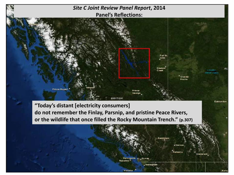
Site C Joint Review Panel Report, 2014 Panel’s Reflections:
“Today’s distant *electricity consumers] do not remember the Finlay, Parsnip, and pristine Peace Rivers, or the wildlife that once filled the Rocky Mountain Trench.” (p.307)

Finlay
Peace
Parsnip
How did we get from this…
[section of map from] Peace River Chronicles, 1963

Finlay
Peace
Parsnip
…to this… …let us remember the…

outline
• With a historical geography lens, how did the Findlay, Parsnip, and Peace Rivers end up
being considered as a potential major hydroelectric site?
• Remember the Findlay, Parsnip, Peace and their tributaries
methods / sources
• primary sources, gov’t reports and maps from late 18th century onwards

“Aboriginal Engagement” “…meaningful consultation with the potentially affected Aboriginal groups…” “…consultation has been carried out in good faith…” Federal / Provincial Consultation and Accommodation Report, 2014 (and BC gov’t announcement slideshow)
uses (exact) phrases from: Aboriginal Consultation and Accommodation: Updated Guidelines for Federal Officials to Fulfill the Duty to Consult, 2011

Site C Joint Review Panel Report, 2014
“All but two Aboriginal groups opposed the Project. Of the two, one favoured the Project and one was ambivalent.” (p.308)

for millennia…
100kms |_________|
Finlay R
Parsnip R
Wilson, L. [section of] First Nations of British Columbia, 2002.

May31, 1793 “…we arrived at the fork…” (p.177);
[section of] A map of Mackenzie's track from Fort Chipewyan to the Pacific Ocean in 1793, 1801. ~100kms |______________|
PeaceR canyon portage: May21 (p.168)
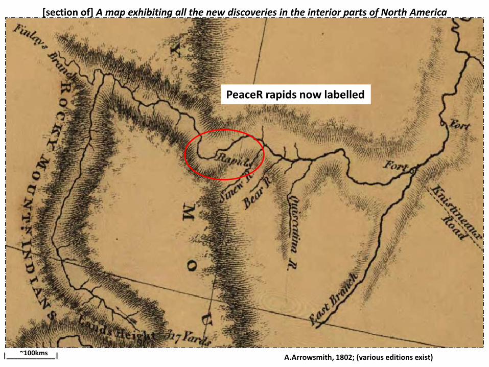
[section of] A map exhibiting all the new discoveries in the interior parts of North America
A.Arrowsmith, 1802; (various editions exist) ~100kms |_____________|
PeaceR rapids now labelled

*section of+ David Thompson’s Map of the North West Territory of the Province of Canada, (1814), 1834 100kms |_______________________|
first “fort” in BC; K.Fladmark, Early fur-trade forts of the Peace River area, 1985
South branch labelled PeaceR

[section of] Provinces of British Columbia and Vancouver Island, 1859
Arrowsmith, John 100kms |_____________________________|
early map with FinlayR (after John Finlay, 1797 journey)
Note “portage” labels

Canada’s “water power”
• 1866: “…there is good water power…” [for operating mining equipment] (p.298; Geological Survey of Canada Report on Progress, 1863 to 1866, 1866)
• 1870: “…Water-power, if needed, is accessible in several localities…” (p.308; Geological Survey of Canada Report on Progress, 1867-69, 1870)

[section of] Map of British Columbia to the 56th Parallel North Latitude, 1871
under the direction of Joseph W.Trutch; J. B. Launders, draughtsman 100kms |_____________________________|
early map of area made in BC by Royal Sapper Engineer
South branch still labelled PeaceR

BC’s “water power”
1874: “…the Qualicum River…would afford any amount of water power…” (p.101; Geological Survey of Canada Report of Progress, 1873-74, 1874)

[section of] Sketch survey of route from Quesnel mouth by Stewart and McLeod's lakes to junction of Smoky River and Peace River
Selwyn, A.R.C. Geological Survey of Canada, Multicoloured Geological Map no. 111, 1877 100kms |_____________________________|

“we passed into the Parsnip, so named on accounts of the cow-parsnip (Heracleum lanatuniy) being so abundant on its banks”
50kms |____________________________________|
Fossil Point
ParsnipR now labelled

“…we ascended the Parsnip River down to the mouth of Nation River…”, 1877
Selwyn, A.R.C. (BC Archives NA-41323)
LAC a037522, 1875

BC Minister of Mines: “water power”
1874 - onwards: several “water power” references throughout the province but not in reference to the Peace River… “There is not a mine in the district at which electricity generated by water power could not be used.” BC Annual Report of the Minister of Mines 1893, 1894

Map of the Finlay and Omineca Rivers, 1895
Russel(l), H.Y. Geological Survey of Canada, Multicoloured Geological Map 567, 1895

Omineca R: “…its current is extremely swift, the slope of the bed exceeding ten feet to the mile.” (p.7)
[section of] Map of the Finlay and Omineca Rivers. Russel(l), H.Y. Geological Survey of Canada, Multicoloured Geological Map 567, 1895

Canada’s “water power”
1899: "An examination of any good map of our broad Dominion, reveals… an inexpensive dam will hold back the water…” (p.4)
“…spruce…manufactured by our water power into paper… would yield this country ten times the value…” (p.11) Canadian water power and its electrical product in relation to the undeveloped resources of the Dominion , 1899

[section of] Map of the Northern Interior of British Columbia, shewing undeveloped areas
BC Provincial Bureau of Information, 1905 100kms |______________________|

looking up river from the entrance to the Peace River Canyon, 1901
unknown photographer
Canyon
BCA I- 55977, 1901

1903: “Peace River…of great size and volume…”
“So far as known to me no official or other competent survey or report has been made of the water power available in British Colombia.” (p.335; E. Jacobs, Water powers of British Columbia, 1903)
“Peace River”

BC water powers: “Peace River”
1911: “Peace River…power sites …there are two important sites… …the upper is at Rocky Mountain portage.” “At this point the river is a raging torrent flowing 25 miles through a canyon, and has a total fall of 270 feet” (p.287; Water-powers of Canada, 1911)

1912: “Water Power Investigations” (p.36)
(no reference to Peace region but elsewhere)
BC “water power”

Coal measures of Peace River Canyon (more interest in mineral exploration)
C.F.J.Galloway, BC Annual Report of the Minister of Mines, 1912

Coal measures of Peace River Canyon
(poor copy but…) no mills in area BC Dept. of Lands, Forest Branch, 1912

no fire fighting in area BC Dept. of Lands, Forest Branch, 1914

minimal timber extraction BC Dept. of Lands, Forest Branch, 1918
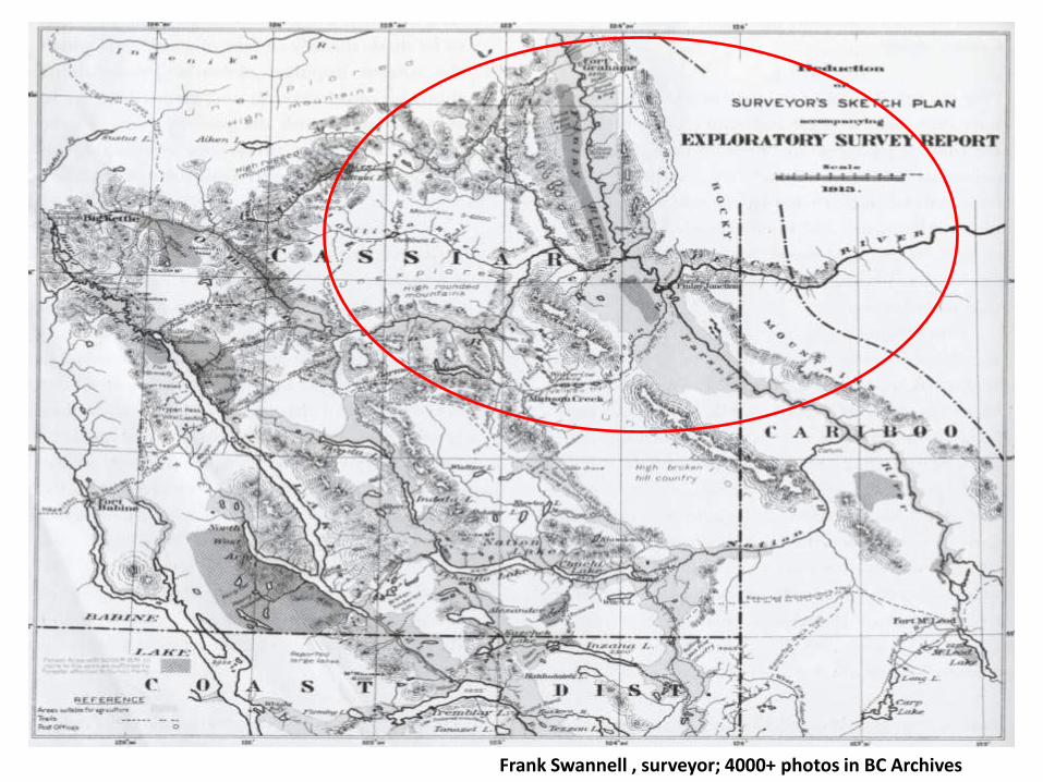
Frank Swannell , surveyor; 4000+ photos in BC Archives
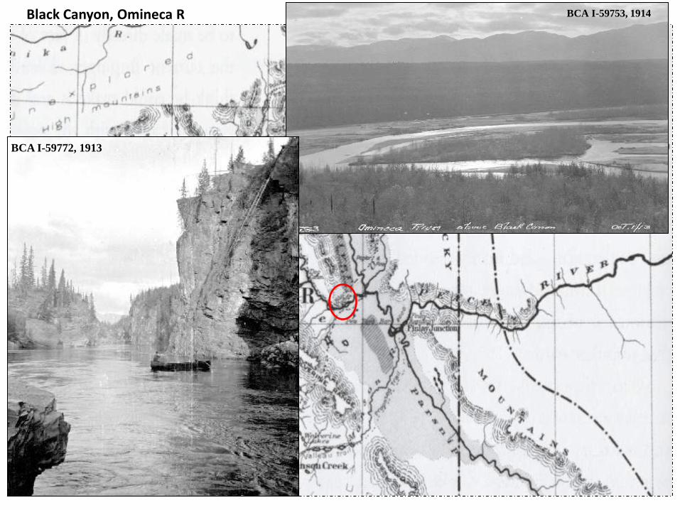
Black Canyon, Omineca R
BCA I-59772, 1913
BCA I-59753, 1914

[Frank Swannell] survey expedition crossing Finlay River at Moodie Trail, Oct.1914 (low water)
BCA I-33208

Finlay rapids on the Peace River, October (low water), 1914
BCA I-59806, 1914
BCA I-59753, 1914

Peace River “water powers”
1915: “Peace River…of great size and volume…” (p.12; Water powers of Canada, BC, 1915)

Peace River: Dreams and visions
1916: “To the east are enormous great factories for the immense power of the water in the canyon has been harnessed.” (p.215)
“…Finlay, whose broad valley will afford homes for many thousands…” (p.202) Call of the West: Letter from BC, 1916)

1917: “…this canyon will be harnessed to great turbines…great manufacturing establishments…” (p.266) On the headwaters of the Peace River
Peace River: Dreams and visions

Peace River “water powers” reality…
1918: “Many misleading statements have been published relating to the vast amount of power available on the Peace river.”
“…a power development at this site will be an expensive undertaking, and can only be accomplished when a market for the power is available close at hand.” (p.18)

Canada’s “White Coal”
1918: “…no country in the world is more fortunate in the extent and location of its white coal than is Canada…” (Five thousand facts about Canada, 1918, p.70)
“Canada …her heritage in white coal…” (Journal of the Engineering Institute of Canada, 1918, p.445)
Froschauer, K. White gold: Hydroelectric power in Canada, 2011

“…canyon…considerable magnitude…supply the lights and power needs…of Peace district.”
[potential] water powers the writing is on the wall…
Water Powers of British Columbia, Ottawa, 1919
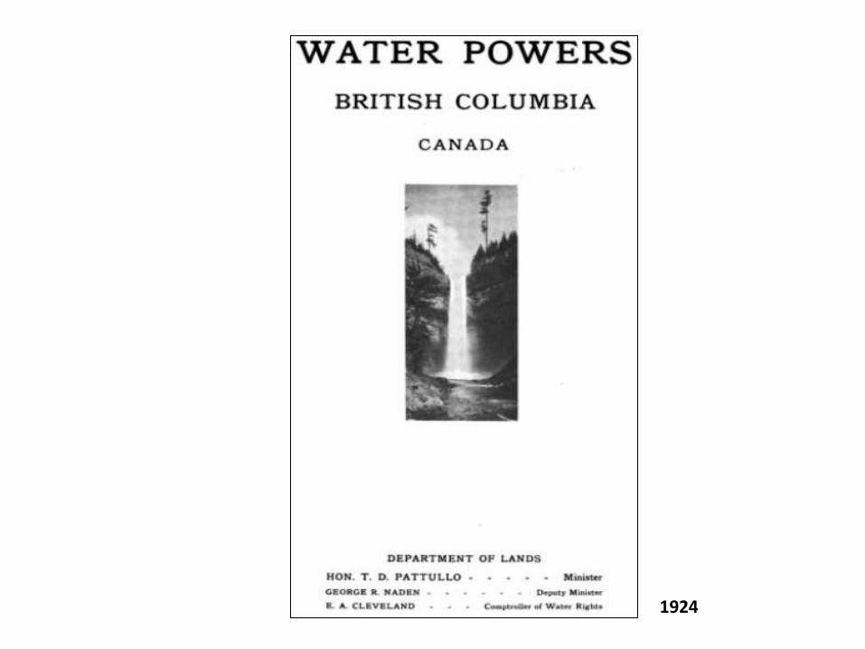
1924

Water powers of BC, 1924
BC Department of Lands, 1924
province has not identified the Peace… …yet…

making a dugout canoe near Fort Grahame, 1927
[section of] GSC Map 207A, Finlay River Area, 1928 BCA I-33314, 1927

(Nes) Parle Pas Rapids on the Peace River, July 1929 BCA I-33314
Frank Swannell, 1880-1969
BCA I-58153

mouth of the Ingenika River (at Finlay R), Oct. 1930
[section of] GSC Map 207A, 1928
BCA I-33314
Frank Swannell, 1880-1969

Finlay
Peace
Parsnip
1930: “…create a reservoir…upstream to Clearwater Creek…
Pacific Great Eastern Railway lands report of survey resources, 1930 [section of map from] Peace River Chronicles, 1963

Peace River Canyon near Gething Creek, 1946
(poor copy but…)
Peace area identified…
Major Water Powers, 1946
BC Minister of Lands

“...that’s just the place to drop a dam…1/4 million horsepower going to waste...”
[section of] GSC Map 793A, 1944
BCA I-28738, 1946

“Peace River Canyon offers a good site for future water-power development.” (p.5)
Kindle, E.D. [section of] Northeastern British Columbia, Geological Survey of Canada, Map 1000A, 1951 1:

British Columbia atlas of resources, 1956

British Columbia atlas of resources, 1956
Stream flow: thousands cubic feet / second; Peace area for power now etched in stone…


Peace River Chronicles, 1963
further reading…

Peace River Canyon near Gething Creek, 1946
Meg Stanley, 2010
further reading…

hydroelectric power reservoirs…
• interfere and obliterate the land of:
• First Peoples today and their ancestors
• current dwellers and their ancestors
• significantly alter the physical and cultural landscape

alternatives
“There are alternative sources of power available at similar or somewhat higher costs, notably geothermal power.”
“These sources, being individually smaller than Site C, would allow supply to better follow
demand…”
“…the policy constraints that the B.C. government has imposed on BC Hydro have made some other alternatives unavailable.”
(p.iv)

“The Panel concludes that a failure to pursue research over the last 30 years into B.C.’s geothermal resources has left BC Hydro without information about a resource that BC Hydro thinks may offer up to 700 megawatts of firm, economic power with low environmental costs.” (p.299)
[section of] Green electricity resources in British Columbia, 2002
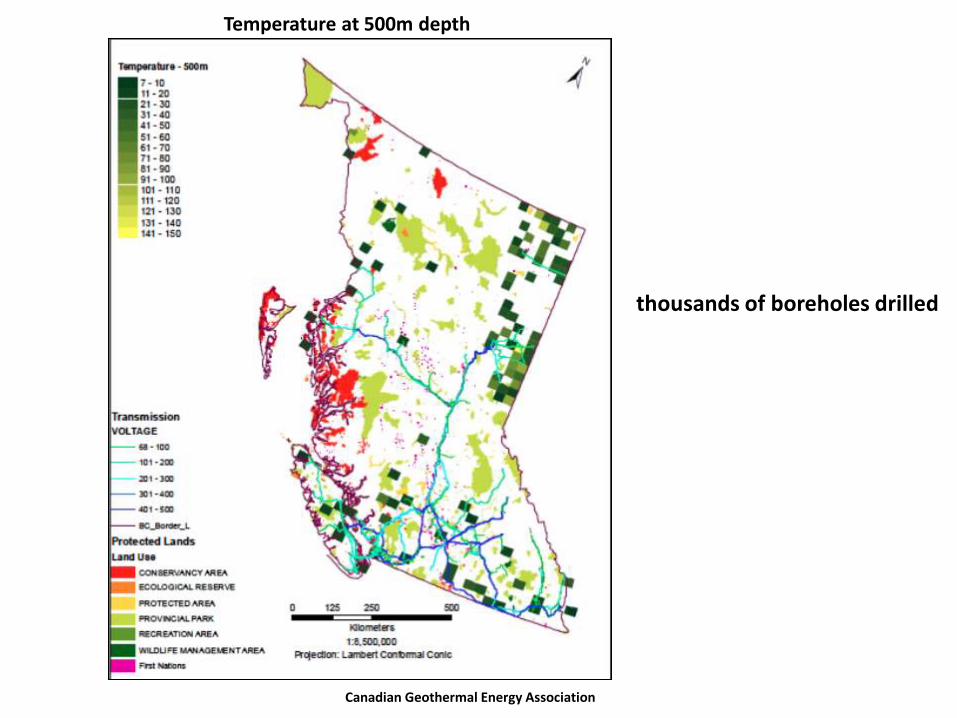
Temperature at 500m depth
Canadian Geothermal Energy Association
thousands of boreholes drilled

Tidal Power
[section of] Green electricity resources in British Columbia, 2002.
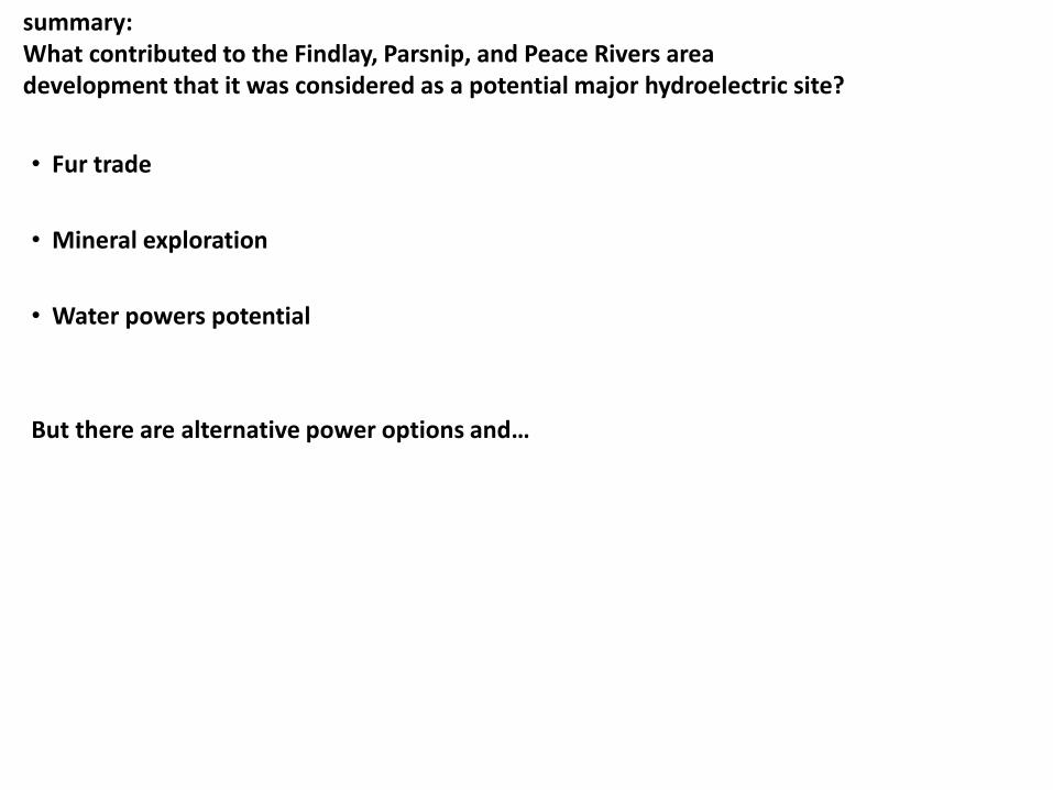
summary: What contributed to the Findlay, Parsnip, and Peace Rivers area development that it was considered as a potential major hydroelectric site?
• Fur trade
• Mineral exploration
• Water powers potential
But there are alternative power options and…

…ultimately rivers will triumph…

Elwha River, “free” after 100 years!