dam inspection report - gtcountymi.gov
TRANSCRIPT

2018 DAM INSPECTION REPORT FOR
SILVER LAKE LEVEL CONTROL SYSTEM
Submitted to: GRAND TRAVERSE COUNTY DRAIN COMMISSION
2650 LaFranier Road Traverse City, Michigan 49686 [email protected]
Submitted by: J.E. TIFFANY AND SONS, LLC
1707 N. 39 Road Manton, MI 49663
December, 2018

TABLE OF CONTENTS
- TITLE SHEET
- PART 307 DAM INSPECTION REPORT
APPENDICES
A. LOCATION MAP B. PHOTOGRAPHS

TITLE SHEET Name of Dam: Silver Lake Level Control System I.D. Number: 955 County: Grand Traverse Location: Blair Township, Section 07, Town 26N,
Range 11W Stream: Tributary to Beitner Creek Operator: Grand Traverse County Drain
Commission 2650 LaFranier Road Traverse City, Michigan 49686 Tel. (231) 922-4807 Hazard Potential Classification: N/A Inspection Date: October 23, 2018 Professional Engineer in Responsible Charge of Inspection: Name: James E. Tiffany, P.E. Address: J.E. Tiffany and Sons, LLC 1707 N. 39 Road Manton, Michigan 49663
Signature & Professional Seal:

MICHIGAN DEPARTMENT OF ENVIRONMENTAL QUALITY WATER RESOURCES DIVISION
DAM INSPECTION REPORT This form is to be used for inspection reports required by Part 307, Inland Lake Levels, for those dams that do not meet the size criteria as defined by Part 315, Dam Safety, of the Natural Resources and Environmental Protection Act, 1994 PA 451, as amended. Dams six (6) feet or more in height, as defined by Part 315, and impounding five (5) acres or more at the design flood elevation, must meet the inspection report format as outlined in Section 31518 of Part 315. A person failing to comply, or falsely representing dam conditions, is guilty of misconduct in office.
DAM NAME Silver Lake Level Control System
DAM ID 955
COUNTY Grand Traverse
DATE OF INSPECTION 10/23/2018
NAME OF WATERBODY Silver Lake/Trib. to Beitner Creek
SECTION, TOWN, RANGE Sec. __07____ T _26N___ R _11W___
LEVEL THIS DATE 861.38
DATE ELEVATION SET BY COURT 3/25/1987
LEGAL LEVEL 862.00
DRAWDOWN LEVEL N/A
HIGH WATER MARK ELEVATION N/A
EARTH EMBANKMENTS LEFT EMBANKMENT _N/A___ FT. RIGHT EMBANKMENT _N/A___ FT. TOTAL LENGTH __N/A___ FT. (LOOKING DOWNSTREAM) UPSTREAM CROWN DOWNSTREAM
VEGETATIVE COVER
*
*
*
EROSION
*
*
*
SEEPAGE
*
SLIDES, SLUMPS & CRACKS
*
*
*
ANIMAL BURROWS
*
*
*
WAVE ACTION PROTECTION
*
*
REMARKS*
*
* No embankment, natural high ground, 730' between intake
and discharge.
*
CONTROL STRUCTURE
TYPE 6' dia. fixed crest riser structure & butterfly valve on downstream 14" dia. discharge pipe
YEAR CONSTRUCTED 1987
STRUCTURAL HEIGHT (top of dam elevation minus stream invert): 24.5' +/-
LENGTH OF SPILLWAY N/A
FREEBOARD 18' +/-
HYDRAULIC HEIGHT (design flood elevation minus stream invert): 6.5' +/-
VERTICAL PIPE SIZE 6' dia. concrete
HORIZONTAL PIPE SIZE 14" dia x 730' long ductile iron
HEAD (normal headwater minus normal tailwater): Approx. 5.6'
DESCRIBE CONDITION OF THE FOLLOWING ITEMS.
STOPLOG VALVES AND GATES (open and close to check condition): Check location of top stoplog in relation to top of riser pipe intake box or fixed crest, for leakage, and condition of stoplogs, valves and gates. 14" diameter butterfly valve with riser stem and operating wheel in valve building approximately 75' downstream of the intake/riser structure. Has been operated in the last year. OUTLET PIPE: Check for damage from ice, logs, vandalism; inside discharge pipe for settlement and/or joint separation; condition of pipe coating. 14" diameter class 50 cement lined ductile iron pipe. Video recording of pipe in last year indicates that the pipe is in good condition overall.

CONTROL STRUCTURE (continued)
CONCRETE STRUCTURE: Check for erosion; location of cracking or spalling. If old or new; settlement; need for crack repairs. 6' dia. concrete intake/riser structure with trash rack cover. All appear to be in good condition. Vortex forms when water is significantly above the rim of the structure decreasing discharge efficiency leading to higher than necessary lake levels during periods of high runoff. WALKWAY & RAILING: Check if in place or removed, condition, and if adequate protection provided. N/A
TRASHRACK OR LOG BOOM: Check if operable. Trashrack over top of concrete intake/riser structure is in good condition. Fencing/mesh is used surrounding structure to catch leaves & debris.
EMERGENCY SPILLWAY: Size, type, and condition. N/A
INLET & OUTLET CHANNELS INLET OUTLET
SIZE Pond
Cox Pond
EXISTING CONDITION Good
Good
EROSION None
None
DEBRIS & OBSTRUCTIONS None
Small shrubs and grass in outlet channel but not of significant concern at this time.
RIPRAP PROTECTION None
Some riprap in bed of outlet channel downstream of discharge pipe.
REMARKS* Recent project to place filter fabric and stone in bed of pond surrounding the intake/riser structure
The 36" dia. CSP downstream of the Cox Pond is failing. A sliplining project is recommended.
RECOMMENDATIONS
List work needed, how to be done, by whom, estimated cost, source of funds, recommended completion date. If emergency, to what extent. ADDITIONAL COMMENTS. 1) Sliplining 36" dia. CSP downstream of Cox Pond $115,000 2) Improvements to prevent vortex formation $ 3,500 Inspection Ordered By: County Delegated Agent
James E. Tiffany INSPECTOR'S NAME (PRINTED) ADDRESS: 1707 N. 39 Rd.
SIGNATURE CITY, STATE, ZIP CODE: Manton, MI 49663 43942 P.E. REGISTRATION NO. TELEPHONE NUMBER : 231-735-4546 Please submit this completed report and photographs of the dam, downstream channel, and deficiencies cited in the report to: DAM SAFETY PROGRAM WATER RESOURCES DIVISION MICHIGAN DEPARTMENT OF ENVIRONMENTAL QUALITY PO BOX 30458 LANSING MI 48909-7958 *NOTE: If space is inadequate for remarks, attach additional sheets as needed. EQP 4526 (Rev. 9/2004)

A. LOCATION MAP

N
LOCATION
INTAKE
DISCHARGE


B. PHOTOGRAPHS

Silver Lake
Riser/Intake Structure in Pond Connected to Silver Lake
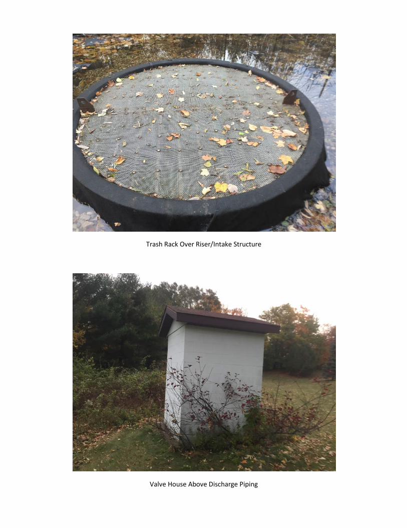
Trash Rack Over Riser/Intake Structure
Valve House Above Discharge Piping
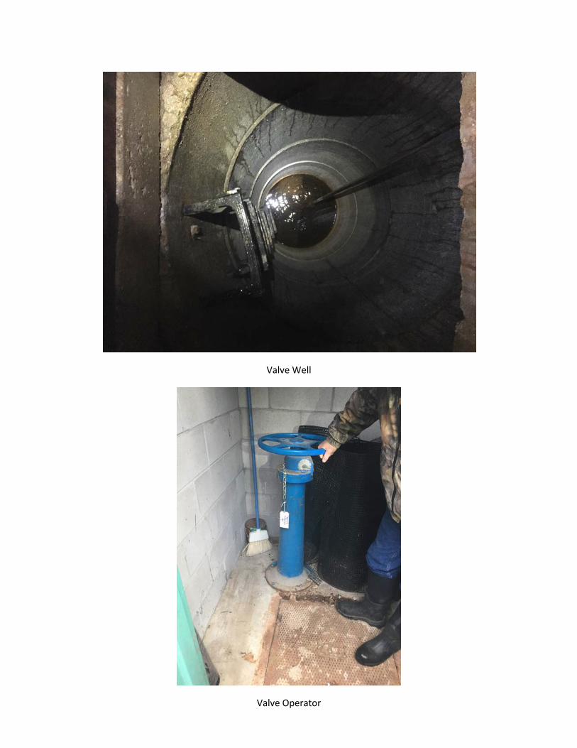
Valve Well
Valve Operator

Downstream End of 14" Diameter Discharge Pipe
Interior of 14" Diameter Ductile Iron Discharge Pipe
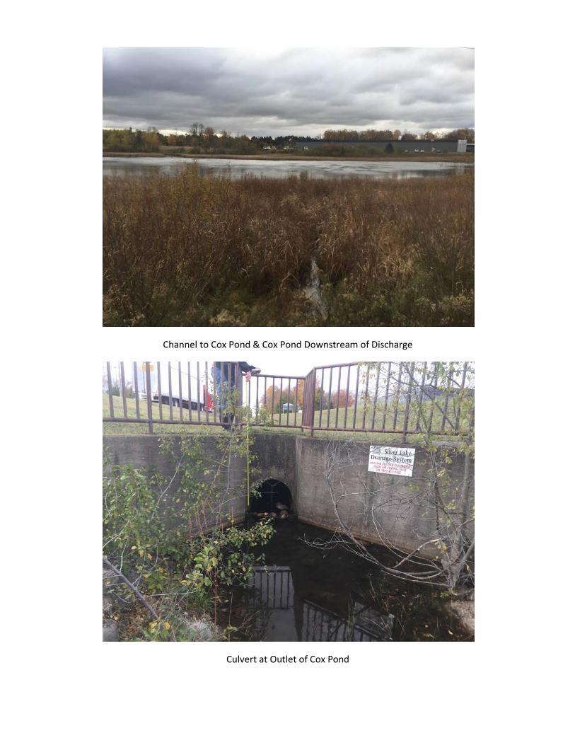
Channel to Cox Pond & Cox Pond Downstream of Discharge
Culvert at Outlet of Cox Pond
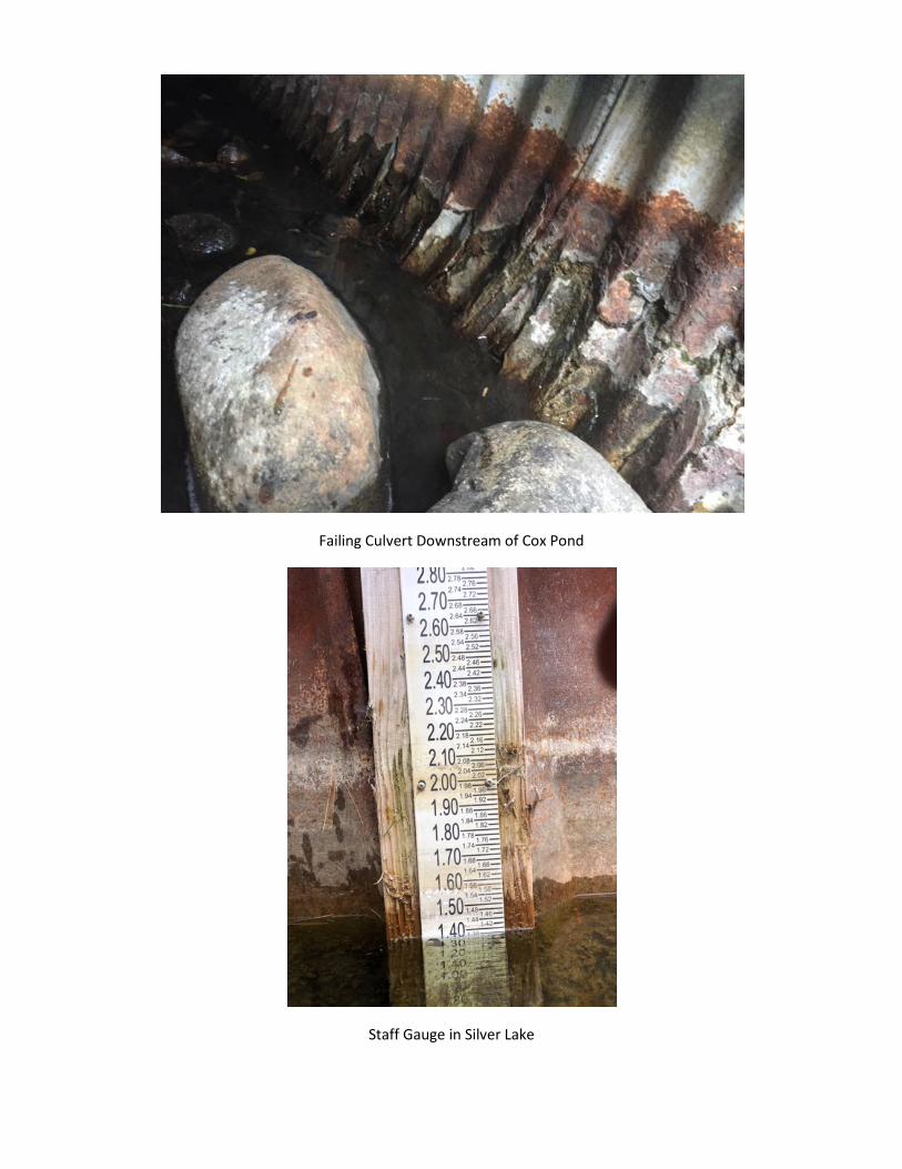
Failing Culvert Downstream of Cox Pond
Staff Gauge in Silver Lake
