dallas development guidedallascityhall.com/departments/sustainabledevelopment... · dallas...
TRANSCRIPT
DALLAS
DEVELOPMENT GUIDE
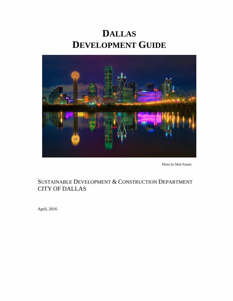
Photo by Matt Pasant
SUSTAINABLE DEVELOPMENT & CONSTRUCTION DEPARTMENT
CITY OF DALLAS
April, 2016
Dallas Development Guide
TABLE OF CONTENTS
Purpose _______________________________________________________________ 1
Permit Center __________________________________________________________ 2
Pre-Development Coordination ____________________________________________ 3
Land Development Review Process
Abandonment/Private License _____________________________________________ 6
Platting Process _________________________________________________________ 8
Street Lighting ________________________________________________________ 13
Zoning Change ________________________________________________________ 14
Development Plan ______________________________________________________ 16
Board of Adjustment Variance or Special Exception ___________________________ 18
Tree Survey Review Process _____________________________________________ 20
Thoroughfare Plan Amendment ___________________________________________ 22
Construction Review Process
Building Permit and Site Plan Review Process _______________________________ 25
Q-Team/Express Plan Review Process ______________________________________ 27
Construction Approval/Certificate of Occupancy _____________________________ 29
Certificate of Appropriateness ____________________________________________ 31
Development Impact Review and Residential Adjacency Review ________________ 33
Escarpment Permit _____________________________________________________ 34
Floodplain Fill Permit ___________________________________________________ 36
Sidewalk Waiver _______________________________________________________ 37
Special Parking Agreement ______________________________________________ 38
Street Name Change ____________________________________________________ 39
Landscape Plan Review Process ___________________________________________ 40
Sign Permit Process ____________________________________________________ 42
Appendices
Appendix I- Glossary of Development Terms ________________________________ 45
Appendix II- Directory of City Departments _________________________________ 46
Appendix III- Building Inspections Permit & Service Fees ______________________ 48
Appendix IIIA- PD/S.U.P/Zoning Change & Service Fees ______________________ 51
Dallas Development Guide
Appendix IV- Automated Inspection Request Information ______________________ 52
Appendix V- Permit Application __________________________________________ 54
Appendix VI- Sidewalk Waiver ___________________________________________ 55
Appendix VII- Landscape Checklist ________________________________________ 57
Appendix VIII- Internet Access to Building Inspection _________________________ 59
Appendix IX- Process Flow Charts List _____________________________________ 60
Dallas Development Guide
1 | P a g e
PURPOSE
This guide to the Development Review Process provides an overview of the entire process, describes what
circumstances will trigger a particular review process, and provides flow charts showing the
chronological processes that must be completed before proceeding to further reviews. It is not intended to
provide every technical detail or requirement of each review that makes up the development review
process.
The City of Dallas’ policies, standards, and regulations on land use, property development and
construction review are designed to help ensure the health, safety, and welfare of its citizens, while
protecting the rights and privileges of property owners. The development review process is the City’s
administrative system to efficiently and consistently enforce these policies, standards, and regulations.
The Development Guide addresses as many facets of the development process as possible. The Guide
includes sections on Business Development, Property Development, Construction Review, Special
Review Processes, and Development Coordination in the City of Dallas, as well as directories for
business and property development, fee schedules, ordinances, resolutions, and manuals.
The Guide is not intended to provide technical details or the requirements of each review that makes up
the development review process; it is intended to provide an overview of the whole system, while aiding
an identifying any potential issues early on in the process.
The Guide examines two types of processes that may be required in order to develop property or build
and occupy a building: Land Development and Construction Review. Examples of these processes are
the Platting, Zoning processes and the Building Permit and Construction Approval processes.
The number of processes you will need depends on your development plans and the existing
circumstances of your property. At the earliest stages of planning your project, you should be aware of
which of these steps will be required. You will also need to know where each process should be initiated,
what information will be required, who will be involved, what will happen, how long it will take, and
how much it will cost.
The Development Guide is intended to provide answers to these and other such questions.
Every effort has been made to ensure accuracy and completeness. To prevent any misunderstanding or
problems that may arise from out-of-date information, always contact the appropriate City staff indicated
in this guide before beginning any of the development review processes.

Dallas Development Guide
2 | P a g e
PERMIT CENTER
LOCATION
Oak Cliff Municipal Center, 320 E. Jefferson Blvd., Room 118
Building Inspection / Permit Center
Hours: Monday - Friday, 8:00 a.m. - 4:30 p.m.
Phone: 214.948.4480
PURPOSE
This center has been created in order to simplify the construction and development application and review
processes and allow individuals to conduct most of the related transactions at one convenient location.
Permits to perform the following types of construction work may be obtained at the Permit Center.
barricade
building
demolition
electrical
excavation
fence
fire alarm
fire extinguishing system
flammable liquids
landscape and tree removal
lawn sprinkler
liquid petroleum
mechanical
moving
paving (sidewalks & drive approaches) & grading
plumbing
septic tank
site plan review
swimming pools
tent
The following applications can be submitted at the Permit Center. Professional staff is available for
consultation prior to application submittal.
development impact review- Zoning Staff
residential adjacency review-Zoning Staff
subdivision of property-Subdivision Staff
certificate of occupancy-Zoning Consultation
food service permit applications-Sanitarian Staff
water and wastewater permits-Trade Staff
Additional services available include:
contractor registration
residential plan review
plat and addressing information
zoning verification letter

Dallas Development Guide
3 | P a g e
PRE-DEVELOPMENT COORDINATION
LOCATION
Oak Cliff Municipal Center, 320 E. Jefferson Blvd. Room 204
Building Inspection
Hours: Monday - Friday, 8:00 a.m. - 4:30 p.m.
Phone: 214.948.4337
PURPOSE
Pre-Development Coordination services were established to provide project coordination for development
projects, troubleshooting, problem solving, and problem intervention in the development processes. Pre-
development Meetings are available for any project (other than single family and duplex dwellings) and
are recommended during the early stages of project design. The pre-development meeting fee will be
applied towards the building permit fees if the building permit application is submitted within 12 months
of the meeting. For information about or to schedule a predevelopment meeting contact the Q-Team at
214-948-4337.
Please note: code specialists (Building, Fire, Zoning, Plumbing, Mechanical, Electrical, Health,
Arborists) are also available for consultation on a “first come first served” basis in room #118 for zoning
and room #105 for all other trades. A Fire Prevention Officer is located in room 204 and can assist in
addressing Fire Code related concerns.
INFORMATION TO PROVIDE
A development coordinator will be assigned when you submit your application for a predevelopment
meeting and will help you to determine what information you will need, at a minimum you will need to
provide a completed predevelopment application and a site plan for the project.
WHO MAY BE INVOLVED
Your development coordinator will help you to determine what agencies and processes you will need to
successfully complete your project, but the following list includes many of the most common groups:
City of Dallas- Predevelopment Staff (located at 320 E. Jefferson Blvd.):
Building Inspection Division: (zoning, building code, arborist/landscaping)
Real Estate Division
Subdivision
Private Development Engineering: (drainage & transportation, water & wastewater)
City of Dallas - Development Staff:
(Please note, City Hall Staff, located at 1500 Marilla St, may not be available for predevelopment
meetings and a meeting may need to be arranged directly with the desired department.)
City Attorney Staff Room 7DN 214.670.3519
Current Planning Division Room 5BN 214.670.4209
Park and Recreation Department Room 6FN 214.670.4100
Office of Economic Development Room 5CS 214.670.1685
City of Dallas – other City Departments:
Dallas Development Guide
4 | P a g e
Street Department 214.670.4491
Public Works 214.948.4645
Utilities: (Please note these utilities are private entities and not part of the City of Dallas
Pre-development process, names are provided for informational purpose only)
AT&T Dallas Area Rapid Transit (DART)
Atmos Gas Oncor Electric
COST
Less than 25,000 square feet $250
25,001 to 50,000 square feet $500
Greater than 50,000 square feet $750
PRE-DEVELOPMENT APPLICATION
The application can be found with the hyperlink below and should be used to request the desired
consulting staff for a pre-development meeting.
http://dallascityhall.com/departments/sustainabledevelopment/buildinginspection/DCH%20documents/pd
f/BI_Pre-Dev_Application_10-14-2015.pdf

Dallas Development Guide
5 | P a g e
Land Development
Review Process
Dallas Development Guide
6 | P a g e
ABANDONMENT/PRIVATE LICENSE
LOCATION
Oak Cliff Municipal Center, 320 E. Jefferson Blvd., Room 203
Real Estate Division
Hours: Monday - Friday, 8:00 a.m. - 5:00 p.m.
Phone: 214.948.4100
PURPOSE
Abandonment or issuance of a private license allows a citizen to purchase or use public right-of-way as
part of a development. Abandonment is the process where the City agrees to abandon ownership rights
to excess City-owned right-of-way at market value to the applicant. A License grants the applicant the
right to limited use of City-owned right-of-way for a limited period of time for a designated purpose as
part of a development. Sometimes, a private license may be more appropriate than abandonment if the
applicant’s uses are not considered permanent, or if the requested City property is considered necessary,
and should remain in public ownership.
INFORMATION TO PROVIDE
Application letter requesting abandonment or license of abutting City-owned right-of- way.
Application Fee
Written concurrence of all persons who own property abutting to the area proposed for
Abandonment or License.
Copies of recorded deeds and/or lease (if tenant) showing current ownership or tenancy of all
property abutting to the area proposed for Abandonment or License.
Plat showing the area requested for Abandonment or License.
Meets and bounds description of the area to be abandoned or licensed, signed and sealed by a
registered licensed surveyor of Texas.
Appraisal Fee for a street, alley or floodway management area (abandonment only).
Note: All taxes due and owing must be paid prior to scheduling an item for City Council hearing. All
code violations must be remediated prior to scheduling for the council agenda.
WHO MAY BE INVOLVED
City of Dallas:
City Attorney’s Office Public Works
Dallas Water Utilities Street Department
Economic Development Sanitation Services
Fire Department Sustainable Development and Construction
Parks and Recreation Trinity Watershed Management
Utilities:
AT&T
Atmos Energy (gas)
Dallas Area Rapid Transit (DART)
Dallas County
Oncor Electric
State of Texas
Time Warner Cable
Dallas Development Guide
7 | P a g e
HOW THE ABANDONMENT/PRIVATE LICENSE PROCESS WORKS
See Appendix IX, Figure 1.
TOP 5 REASON ABANDONMENTS/LICENSES ARE NOT APPROVED OR ARE DELAYED
1. Inadequate Request Letter submitted from appropriate party
2. Field notes missing
3. Deeds of record or in some instances leases and dedicatory information missing
4. Consent letters and/or recorded quitclaim deeds missing
5. Field note revisions not corrected and returned timely
HOW LONG IT WILL TAKE
The Abandonment/Private License process currently averages three months with a complete application.
COST
Application fee for abandonment is $4,250.00.
Application fee for a license is $750.00. The application fee is applied towards the first year license fee.
Both applications require an additional $75.00 recording fee. If the request is approved, there also will be
a property purchase price based on market value for the land or license fee based on use and Dallas
Central Appraisal District tax assessed land values usually based on market rate for the land. When an
appraisal is required on a request for abandonment the minimal appraisal fee is $2,500 and should be
submitted with the application.

Dallas Development Guide
8 | P a g e
PLATTING PROCESS
LOCATION
Oak Cliff Municipal Center, 320 E. Jefferson Blvd., Room 115
Subdivision
Hours: Monday - Friday, 8:00 a.m. - 4:30 p.m.
Phone: 214.948.4454 or 214.948.4344
PURPOSE
The Platting Process for the City of Dallas was established to subdivide, plat, or re-plat land and to
prepare infrastructure for development in a comprehensively planned manner. A plat is a legal document
by which land is subdivided or combined. It establishes a legal building site and is generally required
before a building permit or certificate of occupancy can be issued.
The two major components of the Platting Process are the Preliminary Plat Approval and the Final Plat
Approval processes.
PRELIMINARY PLAT means the initial plat proposed by the applicant, which is reviewed by city staff
and presented by staff to the city plan commission for consideration. If the commission determines that
approval subject to conditions is appropriate, the subdivision administrator ensures that those conditions
are met before the plat is finalized for endorsement by the commission chair.
FINAL PLAT means a plat that will be signed by the commission chair upon satisfaction of all
conditions of approval and all other requirements of this article, and will be effective once it is filed with
the county clerk.
A plat is considered a minor plat by meeting the following requirements:
5 acres or less in size for residential zoning districts (single family, duplex, and townhouse)
3 acres or less for all other zoning districts
No proposed streets or alleys
Fronts on an approved public or private street
Requires no new public infrastructure such as streets, water and wastewater, paving, and drainage
improvements.
A plat that does not meet the requirements of a minor plat is a major plat.
On occasion, early release of a building permit may be issued by the Subdivision Coordinator to allow,
upon specific stipulations by technical staff that a building permit or foundation permit may be issued
after City Plan Commission approval of a preliminary plat, but before approval of a final plat. However,
a certificate of occupancy will not be issued until the final plat is approved and recorded, and 15 recorded
copies returned to the subdivision section. The Engineering Division of Sustainable Development &
Construction may require approval of grading and/or engineering plans prior to signing off an early
release request.
INFORMATION TO PROVIDE
The City of Dallas Platting Process Guidelines are available from staff at 320 E. Jefferson, room 115.
The following section lists different documents required.

Dallas Development Guide
9 | P a g e
PRELIMINARY PLAT APPROVAL:
Application form completed and signed by the applicant. If the applicant is not the property
owner, then a notarized letter of authorization from the property owner is required.
(NOTE: The potential buyer of property in escrow is not the property owner.)
28 copies of the proposed plat, folded according to the Platting Process Guidelines
25 - 11x 17” copies of the preliminary plat folded to 8 ½ x 11” for the City Plan Commission
For residential replats, a certified copy of the original plat must be obtained from the county
clerk. (NOTE: This requirement is for replats of areas zoned for single family, townhouse, or
duplex land use, or for areas which within the last five years were zoned for single family,
townhouse, or duplex use.) Property that has NEVER been platted is exempt from this
requirement.
One 8 ½ x 11" clear transparency reduction of the plat
One 8 ½ x 11" zoning map
Property zoned to allow more than 2 units per lot is exempt from the residential replat
requirements.
Tree survey
Fees
The application and checklist can be found with the hyperlink below:
http://dallascityhall.com/departments/sustainabledevelopment/planning/Pages/Platting.aspx
Deadline: The deadline for submitting the above required items is 4:30 p.m. on the Tuesday three weeks
prior to the City Plan Commission (CPC) meeting at which the preliminary plat will be heard.
An approved preliminary plat is effective for one year from the date of Commission action.
ENGINEERING PLAN REVIEW
Site/Grading plan, engineering plans, bonds, and contracts are frequently required in the Platting Process
for major plats (e.g. drawings and specifications for paving, storm water drainage, and water and
wastewater utilities). These are necessary to assure proper and adequate infrastructure to serve the
proposed development. They also help to ensure that street geometrics, storm drainage, and utility
provisions required by the development do not and will not create adverse impacts on the property owner
and/or on property owners of land adjacent to the proposed development.
LOCATION
Oak Cliff Municipal Center, 320 E. Jefferson Blvd., Room 200
Engineering Division
Hours: Monday - Friday, 8:00 a.m. - 4:30 p.m.
Phone: 214.948.4205
See the Dallas Water Utilities Private Development Policies and Procedures for further information. The
review of water and wastewater engineering plans can be initiated at the following location:
FINAL PLAT APPROVAL
No final plat application will be accepted until all departments requiring releases have approved the plan
and a final plat fee has been paid. (Minor plats require no final plat fees.)

Dallas Development Guide
10 | P a g e
The final plat submitted for the Plan Commission Chairman’s signature will be reviewed by the Survey
Section to ensure it is the plat originally released by the Survey Section.
All property taxes due for the property being platted must be paid before the final plat is recorded with the
appropriate County Clerk.
All final plats submitted will be retained by the county in which the property is located and the City of
Dallas.
If additional copies are desired, they must be submitted with the required number of plats.
A final plat approved by the City Plan Commission should be filed in the office of the appropriate county
clerk within (30) thirty days of the date of the Commission’s approval. Failure to record the final plat
will result in the Plan Commission’s approval becoming void.
Failure to return the recorded plats to the Subdivision Section may result in holds being placed on your
Building Permits/Certificates of Occupancy or revocation of permits and/or certificates of occupancy.
Deadline:
Preliminary plat submittal deadline is 8:00 am to 3:00 pm Wednesday, Thursday; Friday the submittal
time is 8:00 am to 12 noon.
See hyperlink below for specific plat submittal calendar:
http://dallascityhall.com/departments/sustainabledevelopment/planning/DCH%20Documents/2016_Plat_
Submittal_Calendar.pdf
Final plat submittal deadline for the Chairman’s signature is 4:30 pm Tuesday the week of the CPC
hearing. The final plat will be routed to the Survey Section of the Sustainable Development &
Construction/Engineering Division to determine if the plat meets the requirements for recording.
WHO MAY BE INVOLVED
City of Dallas:
Sustainable Development & Construction
Fire Department
Parks & Recreation
Public Works
Water Utilities
Street Department
Utilities:
TXU Electric
Atmos Energy (Gas)
Southwestern Bell
Fiber Optic Cable Companies
Dallas Area Rapid Transit (DART)
Dallas Independent School District (DISD)
U.S. Post Office
Dallas Development Guide
11 | P a g e
HOW THE PLATTING PROCESS WORKS
See Appendix IX, Figure 2.
TOP 5 REASONS PRELIMINARY PLATS ARE NOT APPROVED OR ARE DELAYED
1. Topography lines and recorded easements not shown on the proposed plat.
2. Lot remainders being excluded from the proposed plat have not been determined to be building sites.
3. The property has no frontage on a public or private street.
4. The property is in a Planned Development District and a required development plan has not been
submitted.
5. The proposed plat would render a property nonconforming or illegal to the zoning code.
HOW LONG IT WILL TAKE
The City Plan Commission must render a decision on a minor plat or preliminary plat within 30 days of
application according to state law. The time to get approval on final plats varies depending on the
completeness of information submitted, consultation time between City staff and the property owner, and
revisions made by the applicant at its own facilities.
COST
See next page
Dallas Development Guide
12 | P a g e
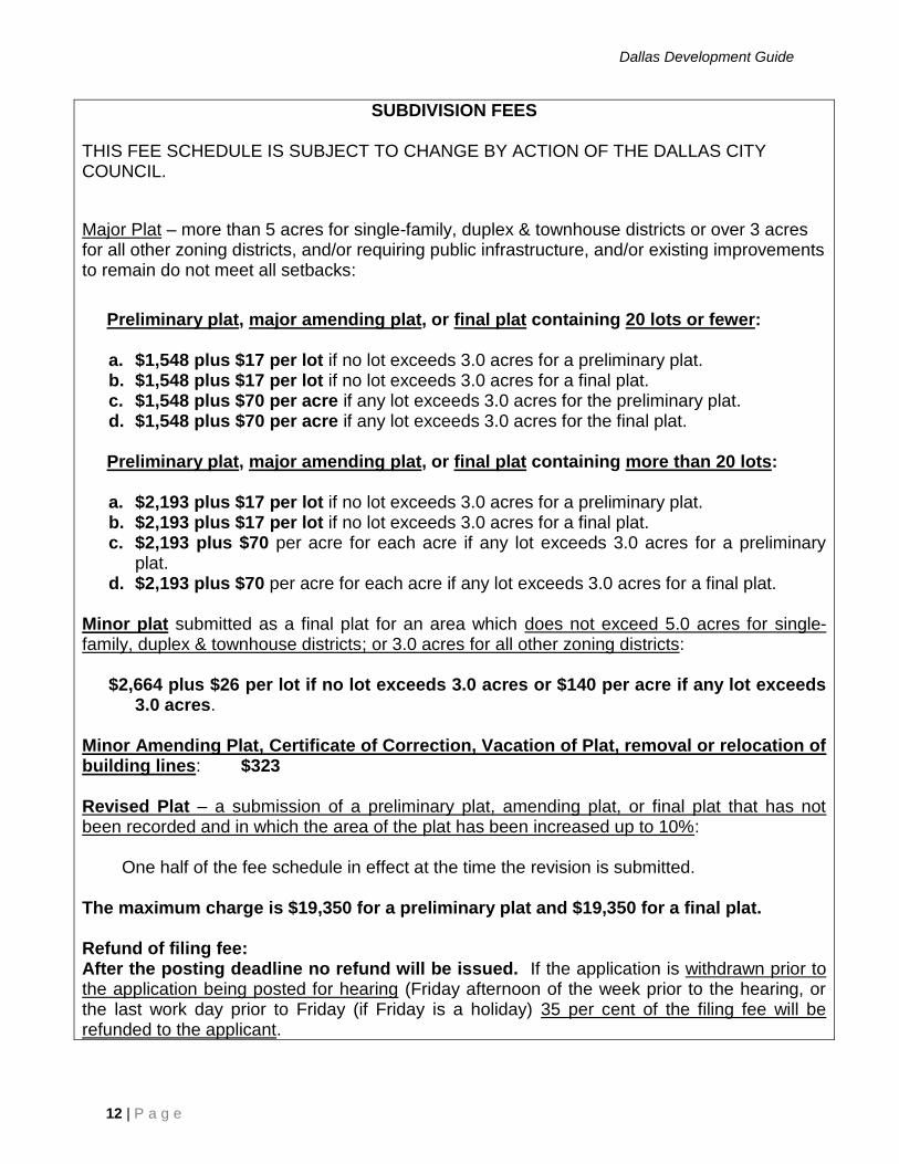
SUBDIVISION FEES THIS FEE SCHEDULE IS SUBJECT TO CHANGE BY ACTION OF THE DALLAS CITY COUNCIL.
Major Plat – more than 5 acres for single-family, duplex & townhouse districts or over 3 acres for all other zoning districts, and/or requiring public infrastructure, and/or existing improvements to remain do not meet all setbacks:
Preliminary plat, major amending plat, or final plat containing 20 lots or fewer:
a. $1,548 plus $17 per lot if no lot exceeds 3.0 acres for a preliminary plat. b. $1,548 plus $17 per lot if no lot exceeds 3.0 acres for a final plat. c. $1,548 plus $70 per acre if any lot exceeds 3.0 acres for the preliminary plat. d. $1,548 plus $70 per acre if any lot exceeds 3.0 acres for the final plat.
Preliminary plat, major amending plat, or final plat containing more than 20 lots:
a. $2,193 plus $17 per lot if no lot exceeds 3.0 acres for a preliminary plat. b. $2,193 plus $17 per lot if no lot exceeds 3.0 acres for a final plat. c. $2,193 plus $70 per acre for each acre if any lot exceeds 3.0 acres for a preliminary
plat. d. $2,193 plus $70 per acre for each acre if any lot exceeds 3.0 acres for a final plat.
Minor plat submitted as a final plat for an area which does not exceed 5.0 acres for single-family, duplex & townhouse districts; or 3.0 acres for all other zoning districts:
$2,664 plus $26 per lot if no lot exceeds 3.0 acres or $140 per acre if any lot exceeds
3.0 acres. Minor Amending Plat, Certificate of Correction, Vacation of Plat, removal or relocation of building lines: $323 Revised Plat – a submission of a preliminary plat, amending plat, or final plat that has not been recorded and in which the area of the plat has been increased up to 10%:
One half of the fee schedule in effect at the time the revision is submitted. The maximum charge is $19,350 for a preliminary plat and $19,350 for a final plat. Refund of filing fee: After the posting deadline no refund will be issued. If the application is withdrawn prior to the application being posted for hearing (Friday afternoon of the week prior to the hearing, or the last work day prior to Friday (if Friday is a holiday) 35 per cent of the filing fee will be refunded to the applicant.
Dallas Development Guide
13 | P a g e
STREET LIGHTING
LOCATION
Dallas City Hall, 1500 Marilla, Room L1/B/North
Streets Department, Street Lighting Section
Hours: Monday - Friday, 8:00 a.m. - 5:00 p.m.
Phone: 214.670.1229
PURPOSE
Street lighting is installed on City of Dallas streets for the primary purpose of traffic and pedestrian
safety. A secondary benefit of street lighting is the security that it provides for residential neighborhoods
and motorists who may experience automotive breakdowns while on the street.
If you are constructing a new street within or adjacent to your development, the City’s platting regulations
require the installation of street lighting at the time of development.
INFORMATION TO PROVIDE
The type of electrical distribution service for the subdivision (overhead on wood poles or
underground, front or rear service)
Two copies of the plat, if requested
Estimated starting and completion dates for street construction
Type of street lighting hardware preferred
WHO MAY BE INVOLVED
TXU Electric
HOW THE STREET LIGHTING PROCESS WORKS
See Appendix IX, Figure 2C.
HOW LONG IT WILL TAKE
The Street Lighting process time is primarily dependent upon the applicant and is done within the platting
process when required.
COST
There are no processing fees. Minimum cost for a street light is $500.00. The average cost is $1,000 per
light.
Dallas Development Guide
14 | P a g e
ZONING CHANGE
LOCATION
Dallas City Hall, 1500 Marilla Street, Room 5/B/North
Current Planning Division
Hours: Monday - Friday, 8:00 a.m. – 5:00 p.m. (Applications accepted from 8 a.m. - 4:30 p.m.)
Phone: 214.670.4209
Prior to submitting an application, you may contact Current Planning to schedule a pre-application
meeting.
PURPOSE
Zoning is the division of land into districts based on the allowable use of the land. These districts have
uniform zoning regulations that provide for permitted uses, height, setbacks, lot size, density, coverage,
and floor-area ratio (F.A.R.)
INFORMATION TO PROVIDE
The zoning change application package submittal must include:
Completed application form
Fees
Certification that no taxes are owed on the property to be considered
Certification that no liens by the City of Dallas are on the property to be considered
One 8 ½” x 11" current zoning maps showing area boundaries on the property to be considered in
red.
One certified plat showing the boundaries of the area be considered in red or two survey maps
showing certified metes and bounds with the commencing point coming off a street intersection.
If property is not platted or a partial lot is in the request area, a survey map showing certified
metes and bounds with the commencing point coming off a street intersection and a clean, typed
property description of the requested site is required.
Statement of proposed land use and justification for zoning change request with identification of
surrounding uses.
Property owner’s signature authorizing the zoning change. If ownership is a corporation or
partnership, a resolution authorizing the zoning change, signed by an officer, partners, or general
partner should be provided.
Traffic Impact Study (if the proposed development will generate more than 1,000 vehicle trips
per day). For details on the Traffic Impact Study, the applicant should contact the Engineering
Division of the Sustainable Development & Construction at (214) 948-4205.
If property is in a floodplain or escarpment area, see the Dallas Development Code for additional
required information.
For a specific use permit: 10 full size (24” x 36”) site plans, folded, & 1-8.5x11 reduction.
For Planned Development District: 10 full size (24” x 36”) conceptual and /or development plans,
folded, & 1-8.5x11 reduction.
WHO MAY BE INVOLVED
City of Dallas:
Aviation Public Works
City Attorney’s Office Park and Recreation
Dallas Development Guide
15 | P a g e
Economic Development Police Department
Housing Sustainable Development & Construction
Other Agencies:
Dallas Area Rapid Transit (DART)
Independent School Districts:
Dallas
Duncanville
Plano
Richardson
HOW THE ZONING CHANGE PROCESS WORKS
See Appendix IX, Figure 3.
TOP 5 REASONS ZONING APPLICATIONS ARE NOT ACCEPTED OR ARE DELAYED
1. Legal description incomplete or certified plat not provided
2. Original signature(s) not provided
3. Multiple revisions to the plans and conditions after submittal
4. Failure to contact the City Plan Commissioner or City Council Member
5. Failure to meet with neighborhood
HOW LONG IT WILL TAKE
The time required to process a zoning change application varies depending on the complexity of the case
and on any revisions that result from City Plan Commission and/or City Council public hearings, however
the average time is 10 - 12 weeks. Due to the annual Council July recess, scheduling will be affected and
should be considered prior to submission of an application.
COST
See Appendix IIIA.
Dallas Development Guide
16 | P a g e
DEVELOPMENT PLAN
LOCATION
Dallas City Hall, 1500 Marilla Street, Room 5/B/North
Current Planning Division
Hours: Monday-Friday, 8:00 a.m. – 5:00 p.m. (Applications accepted from 8 a.m. - 4:30 p.m.)
Phone: 214.670.4209
PURPOSE
When a Planned Development District (PD) is approved with a conceptual plan, a development and/or
landscape plan must be approved by the City Plan Commission before the issuance of a building permit.
The development and/or landscape plan must comply with the conceptual plan and the conditions of the
PD ordinance.
INFORMATION TO PROVIDE
The development plan application submittal must include:
Completed application form
Fees
Statement of request
Letter of authorization from property owner (if not individual). If ownership is a corporation or
partnership, a resolution authorizing the zoning change, signed by an officer, partners, or general
partner should be provided.
10 full size (24” x36”) plans, folded
One 8 ½ x11” reduction of plan
One zoning map with PD area outlined in red
The development plan may be on a single drawing and must clearly indicate:
Any proposed public or private streets and alleys
Building sites
Areas proposed for dedication or reserved as parks, open space, parkways, easements, etc.
Points of ingress and egress from existing public streets
Accurate survey of the boundaries of the site
Topography of the sites with contour intervals of not less than five feet
Location of proposed land uses
Location of buildings and the minimum distance between buildings and property lines, street and
alley rights-of-way, and private streets
Arrangement of off-street parking and loading
Special traffic regulation facilities proposed or required
For a landscape plan, show required landscaping with respect to approved or requested
development plan.
Screening, landscaping, and major tree groupings to be retained if this information is essential to
the proper arrangement of the development in relation to adjacent property and internal land uses
Indication of each phase of development, if separate phases are proposed

Dallas Development Guide
17 | P a g e
WHO MAY BE INVOLVED
City of Dallas:
Sustainable Development & Construction Department:
Current Planning Division
Engineering Division
Building Inspection Division
HOW THE DEVELOPMENT PLAN PROCESS WORKS
See Appendix IX, Figure 4.
TOP 5 REASONS DEVELOPMENT PLANS ARE NOT ACCEPTED OR ARE DELAYED
1. Revisions not returned in a timely manner
2. Dimensional controls missing
3. Summary table missing or incorrect
4. Topography lines missing
5. Original signature(s) not provided
HOW LONG WILL IT TAKE
The time required to process a development plan varies depending on the complexity of the PD and the
plan, which is required to be approved by the City Plan Commission. The average time is six weeks.
COST
Development Plan Review- $600
Minor Amendment- $825
Dallas Development Guide
18 | P a g e
BOARD OF ADJUSTMENT VARIANCE OR SPECIAL EXCEPTION
LOCATION
Oak Cliff Municipal Center, 320 E. Jefferson Blvd., Room 105
Building Inspection/ Technical Services Section
Hours: Monday - Friday, 8:00 a.m. - 4:30 p.m.
Phone: 214.948.4480
Todd Duerksen, Senior Plans Examiner 214.948.4475
PURPOSE
The Board of Adjustment is a 15-member citizen board, divided into three panels and appointed by City
Council to hear and take appropriate action on requests for variances and special exceptions to
Development Code regulations. Staff will review these requests and make recommendations to the Board
prior to the hearing.
If you wish to appeal the decision of the Building Official regarding Chapter 51 or 51A; if your project
needs a special exception as provided in Chapter 51 or 51A or a variance to requirements such as
setbacks, lot width or depth, floor area ratios, or height, you may choose to go to the Board of
Adjustment.
An applicant must obtain the approval from (75%) seventy-five percent of the five panel members who
are considering the application. If four members are present to consider a case, the applicant must obtain a
unanimous decision in order to have their case approved. Failure to obtain this approval will render a
decision of denial with prejudice (unless stated otherwise by the Board). This prohibits the applicant
from resubmitting the same application for two years unless circumstances change significantly.
INFORMATION TO PROVIDE FOR VARIANCES OR SPECIAL EXCEPTIONS
Incomplete applications will not be scheduled for a Board hearing. Additionally, one copy of each
required plan must be submitted on an 8 ½ x 11 inch size.
2 original appeal forms completely filled out and notarized, stating the specific type of relief
requested and reason(s) why relief should be granted.
2 copies – Affidavit (obtain from Building Inspection). Required only if the owner of the property
is not the applicant for the special exception or variance.
1 original and 1 copy – Certified Warranty Deed for the subject property (obtain from the
County).
Tax Certificate or proof that taxes have been paid (real & personal) (obtain from the County)
Lien Certificate or proof showing that there are no liens on the property. Obtain at Dallas City
Hall, 2DS.
4 copies of the site plan or survey to scale, showing the entire property and all existing and
proposed improvements.
3 copies of the zoning map (outline property in RED and initial); maps available at 320 E.
Jefferson Blvd., room 115.
3 copies of the plat map (outline property in RED and initial) maps available at 320 E. Jefferson
Blvd., room 115.
1 sign affidavit. Sign(s) must be posted on the property for Board of Adjustment cases. One sign
is required per each 5 acres (Max of 5 signs @ $10.00 each).

Dallas Development Guide
19 | P a g e
The following items may be needed depending on the type of application
4 copies of the elevation plan to scale (show property line and setback required).
4 copies of the landscaping plans to scale specifying size and species of all existing and proposed
landscaping. Please contact the arborist about your landscape or mitigation plan.
4 copies of the tree survey to scale.
4 copies of the floor plan to scale.
4 copies of a parking analysis to scale showing all uses, the square footage of all the uses and all
the parking to be provided and required parking.
1 copy of the Building Inspection Permit Application.
ALL PLANS AND SURVEYS MUST BE DRAWN TO SCALE. ALL FEES MUST BE PAID AT
THE TIME AN APPLICATION IS FILED.
WHO MAY BE INVOLVED
City of Dallas:
Sustainable Development & Construction:
Current Planning Division
Engineering Division
Attorney’s Office
HOW THE BOARD OF ADJUSTMENT PROCESS WORKS
See Appendix IX, Figure 5.
TOP 5 REASONS VARIANCES ARE NOT PROCESSED OR ARE DELAYED
1. Incomplete application.
2. Missing required documents. (ex. Original tax certificate warranty deed, etc.)
3. Incorrect document. (ex. A copy of a document that is required to be original or certified)
4. Missing required drawings.
5. Incomplete drawings.
HOW LONG IT WILL TAKE
The process averages 7 weeks. The Board of Adjustment does not meet during the month of July
COST
Single Family Variance- $600
Single Family Exception- $600
Multifamily/Non Residential Variance- $900 + $25/acre
Multifamily/Non Residential Exception- $1,200 + $25/acre
Landscaping or Tree Migration Exception- $1,200 + $25/acre
Variance and Exception to Off-street Parking Requirements- $900 + $100/space
Compliance Request for Non-Conforming Use- $1,000
All Other Non-Sign Appeals- $900

Dallas Development Guide
20 | P a g e
TREE SURVEY REVIEW PROCESS
LOCATION
Oak Cliff Municipal Center, 320 E. Jefferson Blvd., Room 105
Building Inspection Division
Hours: Monday-Friday, 8:00 a.m. - 4:30 p.m.
Phone: 214.948.4480
Phil Erwin, Chief Arborist 214.948.4117
Allison Headley, Arborist 214.948.4172
Tina Standeford, Arborist 214.948.4484
Clay Walker, Arborist 214.948.4471
PURPOSE
The Tree Survey Review Process for the City of Dallas was established in May of 1994 to assess the
amount of trees that may be impacted by development of property. A tree survey is designed to document
the presence of protected trees on property within the City of Dallas.
A protected tree is defined as a tree having a diameter at breast height of eight inches or greater. The
following species of trees are not protected regardless of size: Acer saccharinum (Silver Maple),
Ailanthus altissima (Tree of Heaven), Albizzia julibrissen (Mimosa or Silktree), Celtis
occidentalis/laevigata (Hackberry or Sugarberry), Fraxinus velutina (Arizona Ash), Maclura pomifera
{female only}(Bois d’Arc or Horseapple), Melia azedarach (Chinaberry), Salix nigra (Black Willow),
Sabium sebiferum (Chinese Tallow), and Ulmus pumila (Siberian Elm).
A tree survey may be required when applying for a plat, zoning change or building permit. Additionally,
a tree survey may be required when grading, demolition or house moving occurs on a lot within the City
of Dallas. The survey must be supplied in time to be reviewed prior to any plat, zoning change, or
building permit approval. The deadlines are therefore the same as any required for those mentioned
above.
INFORMATION TO PROVIDE
A tree survey must contain the following information:
Location on the lot
Diameter at breast height (4.5 feet above ground) in inches
Name (both common and scientific)
Date, scale, north point, and the names, addresses, and telephone numbers of each property owner
and the person preparing the plan.
Location of existing boundary lines and dimensions of the lot, the zoning classification of the lot,
and the zoning classification of adjacent properties. A vicinity map should also be attached to or
made part of the plan.
Project name, street address, and lot and block description.
All protected trees on the lot must be shown.
The survey does not have to be prepared by a registered surveyor, architect, or landscape architect.
However, accuracy of survey information is essential to assure the survey provides a fair assessment for
the property owner and does not overstate the number of protected trees on the property.
Dallas Development Guide
21 | P a g e
HOW THE TREE SURVEY REVIEW PROCESS WORKS
Tree surveys are reviewed by the City of Dallas Arborists. If a tree survey is verified as correct by the
arborist, the process is continued. If the survey is incorrect, the responsible arborist will notify the
applicant of the necessary changes.
COST
There is no fee for the tree survey review process.
Dallas Development Guide
22 | P a g e
THOROUGHFARE PLAN AMENDMENT
LOCATION
Dallas City Hall, 1500 Marilla St., Room L1B -South
Department of Planning and Urban Design – Mobility Planning
Hours: Monday - Friday 8:00 a.m. - 5:00 p.m.
Phone: 214.671.8172
PURPOSE
The Thoroughfare Plan (Ordinance #20860) and Central Business District Streets and Vehicular
Circulation Plan (Ordinance #13262) are comprehensive plans for the development of the street system to
meet existing and future travel demands, required by Dallas City Code Section 51-9.101. The
Thoroughfare Plan sets the minimum roadway standards, functional and dimensional characteristics.
The Central Business District Streets and Vehicular Circulation (CBD) Plan classifies future street
adjustments, pavement, and operational characteristics of streets within the Central Business District.
These plans incorporate official maps delineating thoroughfare routes, classifications/operation, and
locations; and provides for a process to amend the Thoroughfare/CBD Plan. Residential streets are not
shown.
Construction of a thoroughfare that does not conform to the plan must first receive City Council approval
through a Thoroughfare Plan amendment.
INFORMATION TO PROVIDE
application form
application fee
See hyperlink below for application and more information:
http://dallascityhall.com/departments/pnv/transportation-planning/Pages/default.aspx
WHO MAY BE INVOLVED
City of Dallas:
Dallas Water Utilities Dallas County
Fire Department DART
Park & Recreation DISD
Sustainable Development & Construction
HOW THE THOROUGHFARE PLAN AMENDMENT PROCESS WORKS
See Appendix IX, Figure 16.
HOW LONG IT WILL TAKE
The Thoroughfare Plan Amendment process averages 4 months.
COST
$1,115 per application for area of request up to 1,320 linear feet.

Dallas Development Guide
23 | P a g e
$0.87 for each linear foot greater than 1,320.

Dallas Development Guide
24 | P a g e
Construction
Review Process
Dallas Development Guide
25 | P a g e
BUILDING PERMIT AND SITE PLAN REVIEW PROCESS
LOCATION
Oak Cliff Municipal Center, 320 E. Jefferson Blvd., Room 118
Permit Center/ Building Inspection Division
Hours: Monday - Friday, 8:00 a.m. to 4:30 p.m.
Phone: 214.948.4480
PURPOSE
A building permit represents the City’s authorization to begin construction. This permit is issued only
after comprehensive review of development and construction plans to check for compliance with City
ordinances, policies, regulations and standards for land use, development and construction. A site plan
review is completed simultaneously when the permit is for new construction, additions or “changes in
use” for other than 1- or 2-family construction. The site plan must show all property lines, structures,
parking, landscaping, floor plans, and elevations. The site plan review application may be initially
submitted prior to the building permit application; or, the site plan review may be included concurrently
with the building permit application process.
If you want to erect, construct, enlarge, add to, alter, repair, replace, move, improve, remove, install,
convert, demolish, equip, use, occupy, or maintain a building, structure, or building service equipment,
you must follow the Building Permit process.
Please check the Building Inspection website for all of the latest application forms and checklists:
http://dallascityhall.com/departments/sustainabledevelopment/buildinginspection/Pages/index.aspx
Single Family/Duplex Permits (Residential)
Completed building permit application
Completed checklist
Applicable plan review and permit fees
Residential Infill Waiver (New construction only)
Water and Wastewater Service Application for Installation Services (New Construction Only)
2 copies of a site plan (see checklists for details required)
2 copies of construction plans (see checklists for details required)
Commercial and Multifamily Permits:
For Building Permit:
Completed building permit application
Completed checklist
Applicable plan review and permit fees
Two copies of construction plans (architectural, structural, MEPs, based on scope)
2 copies of the site plan – remodels do not require site plan (show all property lines, structures,
parking, landscaping, floor plans, and elevations); or, one set of stamped approved site plans that
have approved within 2 years of building permit application.
2 Landscape plans (Applies to new construction, additions of 10,000 or more square feet, 35% of
original floor area, any area of added floor, or addition of 2,000 or more of paving)
Site Plan Review prior to building permit application:

Dallas Development Guide
26 | P a g e
3 copies of site plan (show all property lines, structures, parking, landscaping, floor plans, and
elevations)
3 copies of landscape plan (Applies to new construction, additions of 10,000 or more square feet,
35% of original floor area, any area of added floor, or addition of 2,000 or more of paving)
Three copies of exterior elevation plans
Three copies of floor plans to determine parking requirements (if your project is for a church,
theater, dancehall, labor hall, bus terminal, and hazardous occupancies
Contact the Building Inspection Division, Technical Services Section (214/948-4480) for information
required on plans; or, refer to the specific checklist available on the Building Inspection web site.
A Predevelopment Meeting is available for any project (other than single family and duplex dwellings)
and is recommended during the early stages of project design and particularly before starting working
drawings. The predevelopment meeting fee will be applied towards the building permit fees if the
building permit application is submitted within 12 months of the meeting. For information about or to
schedule a predevelopment meeting contact the Q-Team at 214-948-4337.
Code specialists (Building, Fire, Zoning, Plumbing, Mechanical, Electrical, Health, Arborists) are
available for consultation on a “first come first served” basis.
HOW THE BUILDING PERMIT PROCESS WORKS
See Appendix IX, Figure 6.
TOP 5 REASON RESIDENTIAL PLANS ARE NOT APPROVED OR DELAYED
1. Plans not drawn to a standard scale
2. Copy of filed plat not provided/site plan does not match plat/building location is not a legal building
site
3. Missing engineering letter (foundation, engineered trusses, unconventional construction, etc.) when
required
4. Building code requirements: Emergency window egress from bedrooms (too small, fixed instead of
operable), lack of egress from habitable attic, stair headroom or width, fire hydrant location
5. Missing information on plans (Elevation & floor plan not matching, window/door schedule missing)
TOP 5 REASON COMMERCIAL PLANS ARE NOT APPROVED OR DELAYED
1. Plans not drawn to a standard scale/plans not legible
2. Key plan not provided or incomplete – multi-tenant
3. Floor plans do not show existing conditions - remodel
4. Uses of rooms/spaces not labeled
5. TDLR Accessibility registration number not provided
HOW LONG IT WILL TAKE
The Site Plan Review process averages three weeks. The Building Permit process averages two to three
weeks for commercial permits, and two to three days for single family-permits.
COST
See Appendix III.
Dallas Development Guide
27 | P a g e
Q-TEAM/EXPRESS PLAN REVIEW PROCESS
LOCATION
Oak Cliff Municipal Center, 320 E. Jefferson Blvd., Room 204
Q-team/Express Plan Review Team
Hours: Monday - Friday, 8:00 a.m. – 4:30 p.m.
Phone: 214.948.4337
PURPOSE
A Q-team/Express Plan Review is an alternative plan review for commercial projects that allow
individuals to take advantage of an accelerated plan review process for an additional fee. The Q-
team/Express Plan Review will expedite the building permit process from several weeks to a single
review session. If the plans meet necessary requirements of respective codes and ordinances, permits
may be issued following the review meeting. Please note that certain items such as the legal requirements
of a legal building site or special zoning issues may delay the processing of your building permit
application. Fire protection issues must also be addressed in addition to public infrastructure
requirements such as upgrading / new public water / waste water lines, and fire hydrants as well as storm
water drainage system and paving improvements. Sustainable Development & Construction/ Engineering
Division determines the public infrastructure requirements. Please be advised that you may not be able to
proceed with your construction and obtain construction permits if the public infrastructure needs have not
been met.
INFORMATION TO PROVIDE
Applicable fee
Completed checklists
Completed site plan review form
Q-team/Express pre-qualification review form
Notice of time issuance form
Two copies of building plans (paper or electronic, electronic plans have specific file
requirements)
Two landscape plans (if your project is for new commercial or multi-family construction)
Two copies of civil plans
See hyperlink below for application and more information:
http://dallascityhall.com/departments/sustainabledevelopment/buildinginspection/Pages/Q-team.aspx
WHO SHOULD ATTEND REVIEW MEETINGS
All project consultants are encouraged to attend to make ‘on the spot’ decisions, changes, etc. as required.
Contractors and owners are encouraged to but are not required to attend.
HOW THE EXPRESS PLAN REVIEW PROCESS WORKS
See Appendix IX, Figure 7.
TOP 5 REASONS EXPRESS PLAN REVIEWS ARE NOT APPROVED OR ARE DELAYED
1. Need engineering/water approval and/or private development contracts
Dallas Development Guide
28 | P a g e
2. Plans are incomplete and/or need architectural site plan with parking analysis
3. Property is not platted and/or need an early release
4. Project not compliant with zoning ordinance
5. Landscape does not comply with ordinance
HOW LONG IT WILL TAKE
Once the plans are logged into the Q-team/Express Plan Review system, a cursory pre-qualification
review is conducted by the Q-team/Express Plan Review Team. After the pre-qualification review is
completed, the applicant will be contacted and a review meeting will be scheduled, usually within 12
working days. At the conclusion of the Q-Team/Express Plan Review meeting, if no issues are found that
would prohibit a permit from being issued, the customer will be able to pay the Q-Team/Express Plan
Review fees and obtain their permits.
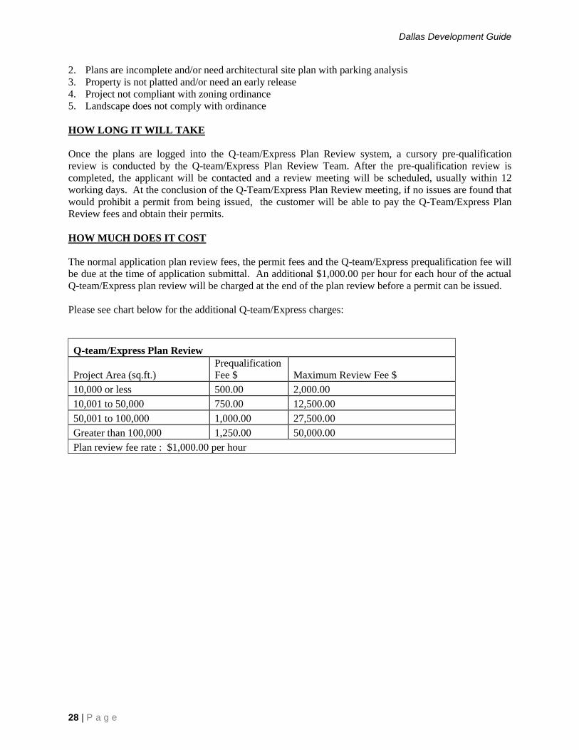
HOW MUCH DOES IT COST
The normal application plan review fees, the permit fees and the Q-team/Express prequalification fee will
be due at the time of application submittal. An additional $1,000.00 per hour for each hour of the actual
Q-team/Express plan review will be charged at the end of the plan review before a permit can be issued.
Please see chart below for the additional Q-team/Express charges:
Q-team/Express Plan Review
Project Area (sq.ft.)
Prequalification
Fee $ Maximum Review Fee $
10,000 or less 500.00 2,000.00
10,001 to 50,000 750.00 12,500.00
50,001 to 100,000 1,000.00 27,500.00
Greater than 100,000 1,250.00 50,000.00
Plan review fee rate : $1,000.00 per hour
Dallas Development Guide
29 | P a g e
CONSTRUCTION APPROVAL/CERTIFICATE OF OCCUPANCY
LOCATION
BUILDING INSPECTION FIELD OFFICES
Field Office Hours: Monday - Friday, 7:30 a.m. - 4:30 p.m.
(Inspectors available by phone 8:00 - 8:30 a.m. and 4:00 - 4:30 p.m.)
Northeast Northwest
11910 Greenville Ave #100 7610 N Stemmons Fwy #190
214.670.6115 214.670.7278
Southeast Southwest
725 N. Jim Miller 2730 Coombs Creek
214.670.8160 214.671.1532
PURPOSE
After a Master Permit is issued and construction begins, City staff must verify that the building is being
built according to the Dallas development and construction codes. This is accomplished through the
Construction Approval process which provides for inspection of the work in progress at varying stages of
construction. A permit expires within 120 days of issuance if work has not been started.
After the final inspection has been conducted and before the building can be occupied, a certificate of
occupancy (CO) must be approved. You will typically apply for a CO at the time you apply for a
construction permit. A CO is not required for single-family or duplex homes. However, utility services
will not be activated unless these structures meet City codes. Temporary and/or partial certificates of
occupancy may be issued prior to total completion of the entire building. Contact the appropriate district
manager for specific details (see below).
If you are doing work that requires a building permit or intend to occupy a building in Dallas, you must
follow the Construction Approval process.
PROCESS TO FOLLOW
Approved plans must be on site
The Master Permit must be posted on site
Construction information signs must be posted and visible from the street
You must ensure the inspector is notified of the need for an inspection at each required stage of
construction. The inspector must have access to the interior of the building for a scheduled
inspection, and the job stage must be completed before inspection has been scheduled. A re-
inspection fee will be charged if these requirements are not met.
WHO MAY BE INVOLVED
City codes may require special inspectors for various stages or circumstances of your project.
HOW THE CONSTRUCTION APPROVAL PROCESS WORKS
See Appendix IX, Figure 8.
Dallas Development Guide
30 | P a g e
TOP 5 REASON CERTIFICATE OF OCCUPANCIES ARE NOT APPROVED OR DELAYED
1. Open permits
2. Doors locked/no access
3. Plat not final
4. Project not compliant with zoning ordinance
5. Landscape does not comply with ordinance
HOW LONG IT WILL TAKE
Construction inspections can usually be conducted the next working day or on the same day, if scheduled
before 7:00 a.m. by the Automated Inspection Request System. They can be scheduled on the next
working day if scheduled through a field office (see Appendix IV).
To request an inspection:
1) To use the Automated Inspection Request System, call 214.670.5313. This is an automated
“phone-in” system that allows you to schedule an inspection over the phone. You can call this
number 7 days a week, 24 hours a day.
2) For special requests call the appropriate building inspection field office listed above.
3) To access the automated system through the internet, go to www.dallascityhall.com
COST
Inspections are paid for through permit fees.
A Certificate of Occupancy costs $215.00.
Temporary Certificates of Occupancy are $104.
See Appendix III.
Dallas Development Guide
31 | P a g e
CERTIFICATE OF APPROPRIATENESS
LOCATION
Dallas City Hall, 1500 Marilla Street, Room 5/B/North
Current Planning Division
Hours: Monday - Friday, 8:00 a.m. - 5:00 p.m.
Phone: 214.670.4209
PURPOSE
There are 145 historic overlay zoning districts (16 large districts and 129 sites) in Dallas.
The City of Dallas Code requires an approved certificate of appropriateness in order for approval of a
Master Permit for exterior renovation, new construction, or demolition to be issued for work in these
districts or on these structures. The City conducts a detailed review of the proposed work. The work for
which the permit is being requested must be consistent with architectural and design standards established
for the district/structure.
You must follow the Certificate of Appropriateness process in order to apply for a required Master Permit
for any exterior construction or renovation work or demolition within a historic district. Certificates of
appropriateness is required for all exterior work including all repairs, painting, etc., even if a building
permit is not required.
INFORMATION TO PROVIDE
A Certificate of Appropriateness or Certificate for Demolition or removal application
Photographs
Work plans and drawings
Shingle, brick, paint color and other samples
Additional information necessary to illustrate the work for which your building permit is
requested
WHO MAY BE INVOLVED
Landmark Commission: The Landmark Commission is appointed by the City Council. Decisions by the
Landmark Commission consider recommendations from its Neighborhood Task Forces and City staff.
The Landmark Commission meets on the first Monday of each month. The Landmark Commission has 8
Neighborhood Task Forces who provide recommendations to the Landmark Commission. Task Force
members are comprised of historic neighborhood residents and outside professional volunteers. A
decision by the Landmark Commission may be appealed to the City Plan Commission.
HOW THE CERTIFICATE OF APPROPRIATENESS PROCESS WORKS
See Appendix IX, Figure 9.
TOP 5 REASONS C of A’s ARE NOT APPROVED OR ARE DELAYED
1. Site plan to scale is not provided
2. Elevations do not match plans
3. Specifications for materials (windows, doors) not provided
4. Plans show requests not mentioned on the application
5. Applicant not attending Task Force meeting or Landmark Commission public hearing
Dallas Development Guide
32 | P a g e
HOW LONG IT WILL TAKE
The Certificate of Appropriateness process averages 30 days. Section 51A-4.501 of the Dallas
Development Code limits the process to a maximum of 65 days for contributing structures and 40 days
for non-contributing structures. Routine maintenance and replacement certificates of appropriateness are
required to be approved or denied within 20 day after a complete application. The average time for
routing a CA is one week.
COST
There is no fee associated with the Certificate of Appropriateness process.
Dallas Development Guide
33 | P a g e
DEVELOPMENT IMPACT REVIEW and RESIDENTIAL ADJACENCY
REVIEW
LOCATION
Oak Cliff Municipal Center, 320 E. Jefferson Blvd., Room 118
Building Inspection Division
Hours: Monday - Friday, 8:00 a.m. - 4:15 p.m.
Phone: 214.948.4480
PURPOSE
When City staff determines, based on standards adopted by City Council, that a development is likely to
have a significant impact on surrounding land uses and the need and demand for infrastructure, a
Development Impact Review (DIR) is required to assess the extent of that impact before a building permit
will be issued. Staff will review the proposed development’s impact based on traffic generation, building
site and layout, buffering, landscaping, and other data.
You must follow the Development Impact Review process if you need a building permit and your
development will have estimated trips generated from uses in the development greater than or equal to
6,000 trips per day and 500 trips per day per acre, and your zoning is a non-residential district [except
CA-1(a) or CA-2(a)], or you intend to build a use which requires DIR as listed in the district and use
regulations of the Development Code.
A Residential Adjacency Review (RAR) may be required if the lot has a residential adjacency and
contains a use for which an RAR is required by the district and use regulations.
INFORMATION TO PROVIDE
Completed application form (see Appendix V)
2 copies of the site plan
WHO MAY BE INVOLVED
City of Dallas
Building Inspection Division
Engineering Division
Street Services
HOW THE PROCESS WORKS
See Appendix IX, Figure 10.
HOW LONG IT WILL TAKE
The DIR and RAR processes may take no more than 30 days after submittal of a completed application.
They are normally processed within 10 working days concurrently with the Building Permit Review.
COST
The fee for a DIR is $50.00. The fee for a RAR is $50.00 or $.004 per sq. ft. of building area or area to be
paved or graded, whichever is greater.

Dallas Development Guide
34 | P a g e
ESCARPMENT PERMIT
LOCATION
Oak Cliff Municipal Center, 320 E. Jefferson, Room 200
Engineering Division
Hours: Monday - Friday 8:00 a.m. – 4:30 p.m.
Phone: 214.948.4205
PURPOSE
The escarpment is a steep, wooded, environmentally fragile bluff located in Southwest Dallas. It is the
contact line between two geological formations - the Austin Chalk and the Eagle Ford Shale. The
escarpment is defined in the Dallas Development Code. Section 51A-5.201, as a linear corridor within a
width the distance between:
a) the greater of 125 feet above chalk and shale contact, or 35 feet beyond the crest (that point above
the escarpment line where the slope becomes less than 4:1); and
b) the greater of 85 feet below the chalk and shale contact, or 10 feet beyond the toe (that point
below the escarpment line where the slope becomes less than 5:1).
No development is permitted in the escarpment. However, development may be permitted in the
Geologically Similar Area of the escarpment. The Escarpment Permit process ensures that any
development in the Geologically Similar Area of the escarpment is sensitive to its impact on the fragile
environmental conditions. It also seeks to prevent damage to development due to unstable slopes and
soils.
If your proposed development is in the Geologically Similar Area of the escarpment you must follow the
Escarpment Permit process. You must have proper zoning to begin the Escarpment Permit process.
INFORMATION TO PROVIDE
Completed application form
Plan showing the escarpment zone
Name and address of owner and of person who prepared the application
General vicinity map of proposed site
1"=800' scale locator map
Property limits on 1"=100' scale contour map, with 2' contour intervals, and details of terrain and
area drainage
1"=50' scale cross section and plan review of proposed project structure
Slope stability test data and results
Soil erosion control plans
Grading plan
Vegetation and tree mitigation proposals
Drainage plan including detention system
WHO MAY BE INVOLVED
Other City staff will review an Escarpment Permit application for potential impact from the proposed
project. These participants comprise the Escarpment Area Review Committee (EARC). The EARC is an
advisory committee comprised of at least one representative from the Engineering Division, Public Works
and the Park & Recreation Department. The committee meets as required to review applications.
Dallas Development Guide
35 | P a g e
HOW THE ESCARPMENT REVIEW PROCESS WORKS
See Appendix IX, Figure 11.
HOW LONG IT WILL TAKE
The Escarpment Permit process averages 4 months.
COST
$1,000 application fee.

Dallas Development Guide
36 | P a g e
FLOODPLAIN FILL PERMIT
LOCATION
Oak Cliff Municipal Center, 320 E. Jefferson Blvd., Room 200
Engineering Division
Hours: Monday - Friday, 8:00 a.m. - 4:30 p.m.
Phone: 214.948.4205
PURPOSE
A floodplain is any land area susceptible to inundation by flooding during a 100-year flood. The
floodplain fill permit process was established to ensure that reclamation by filling of a floodplain area
does not occur without the proper engineering analyses outlined in Section 51A-5.100, Part II of the
Dallas Development Code.
INFORMATION TO PROVIDE
Fill permit application form with letter of request and application fee
Vicinity map
Acreage figures for the entire tract, the area located in the floodplain, and the area proposed to be
filled, and description of proposed land use
Description of hydrologic and hydraulic analyses conducted, with copies of input and output, and
a disk containing data files
Plots of water surface profiles and cross-sections
Table of values for engineering criteria
Tree survey with inventory of trees of 6-inch or greater caliper
Landscape and erosion control plan
Grading plan
Environmental Impact Study, if applicable
WHO MAY BE INVOLVED
Dallas Water Utilities
Federal Emergency Management Agency
Park & Recreation
Sustainable Development & Construction
Trinity Watershed Management
U.S. Army Corps of Engineers
HOW THE FLOODPLAIN FILL PERMIT PROCESS WORKS
See Appendix IX, Figure 12.
HOW LONG IT WILL TAKE
The Floodplain Fill permit process averages 4 months.
COST $1,400 for a permit to fill a single residential lot
$3,500 for a permit to fill the in Trinity River or Elm Fork floodplain
$5,300 for all other permits

Dallas Development Guide
37 | P a g e
SIDEWALK WAIVER
LOCATION
Oak Cliff Municipal Center, 320 E. Jefferson Blvd., Room 118
Building Inspection Division
Hours: Monday - Friday, 8:00 a.m. - 4:30 p.m.
PURPOSE
Sidewalks are required to be installed before a new structure is occupied. This is especially important in
areas near schools, parks, and bus stops.
A waiver of the sidewalk requirements may be appropriate in the following instances:
a) The potential pedestrian traffic is so minimal that sidewalks are not warranted.
b) In a single family or duplex zoning district, at least 50 percent of the lots located on the same side
of the block as the proposed plat have been developed with completed, approved structures
without sidewalks.
c) A permanent line and grade cannot be set within the public street right-of-way.
d) It is desirable to preserve a natural topography or vegetation pre-existing the proposed plat, and
pedestrian traffic can be accommodated internally on the property. (Ord. Nos. 20092; 23384)
INFORMATION TO PROVIDE
Completed Sidewalk Waiver Application and Agreement Checklist (See hyperlink below)
Notarized “Standard Agreement” (see Appendix VI)
The application and agreement can be found with the hyperlink below:
http://dallascityhall.com/departments/sustainabledevelopment/buildinginspection/DCH%20documents/pd
f/BI_Sidewalk%20Waiver%20Checklist_Rev%2003-29-2016.pdf
WHO MAY BE INVOLVED
City of Dallas:
Sustainable Development & Construction
Planning and Urban Design
HOW THE SIDEWALK WAIVER PROCESS WORKS
See Appendix IX, Figure 13.
HOW LONG IT WILL TAKE
The Sidewalk Waiver Review process usually takes two weeks.
COST
A processing fee of $208.00 is required for a Sidewalk Waiver request.

Dallas Development Guide
38 | P a g e
SPECIAL PARKING AGREEMENT
LOCATION
Oak Cliff Municipal Center
320 E. Jefferson Blvd., Room 118
Building Inspection/Zoning Plans Examiner
Hours: Monday - Friday, 8 a.m. - 4:30 p.m.
Phone: 214.948.4480
PURPOSE
A special parking agreement allows a citizen to provide part or all of the required parking for his
development on a site other than that of the main use, and/or to share some required parking spaces with
another development. A special parking agreement operates as a covenant on the property providing the
parking.
If it is difficult or impossible to provide the required number of parking spaces for a development, or if it
is difficult or impossible to provide the required parking spaces on the same site as the main use, a Shared
Parking Agreement, a Remote Parking Agreement, or a Packed Parking Agreement can provide flexibility
in providing the required parking.
INFORMATION TO PROVIDE
5 copies of the parking analysis
Five (5) copies of a site plan, drawn to scale
A list of all uses showing floor areas and hours of operation for each (5 copies)
Proof of ownership of property (5 copies)
WHO MAY BE INVOLVED
City of Dallas
City Attorney’s Office
Sustainable Development & Construction:
Building Inspection Division
Engineering Division
HOW THE SPECIAL PARKING AGREEMENT PROCESS WORKS
See Appendix IX, Figure 14.
HOW LONG IT WILL TAKE
The Special Parking Agreement process averages two weeks.
COST
$375 - first 50 special parking spaces, plus $12.50 per space for each space over 50.
Dallas Development Guide
39 | P a g e
STREET NAME CHANGE
LOCATION
Oak Cliff Municipal Center, 320 E. Jefferson Blvd., Room 115
Current Planning/Subdivision
Hours: Monday - Friday, 8:00 a.m. - 4:30 p.m.
Phone: 214.948.4454 or 214.948.4344
PURPOSE
If you are renaming a street within the City of Dallas, you will need to consult Sustainable Development
& Construction to be certain you are not duplicating an existing street name or creating a street name so
similar to an existing street name that confusion might be caused.
INFORMATION TO PROVIDE
Completed application stating the reasons supporting a street name change
Application fee ($500 minimum depending on street length)
Existing and proposed status (Thoroughfare Plan designation)
Petition indicating 51% of owners abutting the street approve
Site plan showing street location
WHO MAY BE INVOLVED
See Appendix IX, Figure 15.
HOW THE STREET NAMING PROCESS WORKS
See Appendix IX, Figure 15.
HOW LONG IT WILL TAKE
Approximately 4 months.
COST
The fee is based on street length and the cost of replacing the street name blades:
¼ mile or less $750.00
¼ to ½ mile $1,050.00
½ to 1 mile $1,350.00
1 mile or more $900.00 plus $300.00 for each ¼ mile
Street name blade $113.00
Mast Arm $233.00
Texas Department of Transportation To be determined based on TXDOT actual cost
Change of Address Fee To be determined based on the number of address
changes

Dallas Development Guide
40 | P a g e
LANDSCAPE PLAN REVIEW PROCESS
LOCATION
Oak Cliff Municipal Center, 320 E. Jefferson Blvd., Room 105
Building Inspection
Hours: Monday-Friday, 8 a.m. - 4:30 p.m.
Phone: 214.948.4480
PURPOSE
Landscape plans are required for all new developments and some expansions under Article X of the
Dallas Development Code. This division only becomes applicable to a lot or tract when the non-
permeable coverage on the lot or tract increases by more than 2,000 square feet within a 24-month period,
or when an application is made for building permit for construction work that:
increases the number of stories in a building on the lot; or
increases by more than 35 percent or 10,000 square feet, whichever is less, the combined floor
areas of all buildings on the lot within a 24-month period. The increased in combined floor area is
determined by adding the floor area of all buildings on the lot within the 24 months prior to
application for a building permit, deducting any floor area that has been demolished in that time or
will be demolished as part of the building permit, and comparing this figure with the total
combined floor area after construction.
The requirements for landscaping in the City of Dallas are detailed in Article X of the Dallas
Development Code. A “Landscape Checklist” is included in Appendix VII.
Different or additional landscape requirements may be applicable if the subject property is located in a
Specific Use Permit (SUP) area or in a Planned Development (PD). These requirements may be
explained by the zoning staff of Building Inspection Division.
INFORMATION TO PROVIDE
Date, scale, north point, and the names, addresses, and telephone numbers of each property owner
and the person preparing the plan.
Location of existing boundary lines and dimensions of the lot, the zoning classification of the lot,
and the zoning classification of adjacent properties. A vicinity map should also be attached to or
made part of the plan.
Approximate centerlines of existing watercourses and the location of the flood plain, escarpment
zone, and geographically similar areas, as those terms are defined in Article V, if applicable; the
approximate location of significant drainage features and the location and size of existing and
proposed streets and alley, utility easements, driveways, and sidewalks on or adjacent to the lot.
Project name, street address, and lot and block description.
Location, height, and material of proposed screening and fencing (with berms to be delineated by
one-foot contours).
Locations and dimensions of proposed landscape buffer strips.
Complete description of plant materials shown on the plan, including names (common and
scientific), locations, quantities, container or caliper size at installation, heights, spread, and
spacing. The location and type of all existing trees on the lot over six inches in caliper must be
specifically indicated.
Complete description of landscaping and screening to be provided in or near off-street parking
and loading areas, including information as to the amount (in square feet) of landscape area to be

Dallas Development Guide
41 | P a g e
provided internal to parking areas and the number and location of required off-street parking and
loading spaces.
An indication of which protected trees will be removed during construction and how healthy,
existing trees proposed to be retained will be protected from damage during construction.
Size, height, location and material of proposed seating, lighting, planters, sculptures, and water
features.
A description of proposed watering methods.
Location of visibility triangles on the lot (if applicable).
HOW THE LANDSCAPE PLAN REVIEW PROCESS WORKS
A landscape plan must be submitted with building permit applications. An application cannot be
permitted without a compliant landscape plan. Additionally, landscape plans may be required for the
authorization of some Planned Developments. The plan must be submitted within the required time line
for Planned Development reviews.
HOW LONG IT WILL TAKE
Approximately 2-3 days.
COST
There is no fee associated with the landscape review process. Fees are collected through the permit fees.

Dallas Development Guide
42 | P a g e
SIGN PERMIT PROCESS
LOCATION
Oak Cliff Municipal Center, 320 E. Jefferson Blvd., Room LL04
Sign Permits
Hours: Monday - Friday 8:00 a.m. - 4:30 p.m.
Phone: 214.948.4480
LOCATION Sign Inspector
Northeast Oscar Lozoya
11910 Greenville Ave # 100 214.670.7288
Northwest Craig Holt
7610 N. Stemmons Fwy #190 214.671.1917
Southeast Ramiro Jaime
725 N. Jim Miller 214.670.8132
Southwest Vacant
2730 Coombs Creek Dr
320 E Jefferson Blvd #LL04 Sr. Sign Inspector: Michael Martin
214.948.4392
PURPOSE
A sign permit will be required in the following cases:
All signs more than twenty square feet in size
All signs more than eight feet height
All illuminated signs
All signs with movement
All signs erected in public right-of-way
All signs projecting more than 18 inches from wall, roof, parapet or eave
INFORMATION TO PROVIDE
Applicable Fee (see appendix III)
Completed permit application
Two copies of the proposed sign elevation showing
a. The placement of sign on the building
b. The clearance from the ground
c. Exact wording to appear on the sign
d. The letter height of each word and the length of each word on the sign
e. The overall dimension of the sign
f. Any other existing sign on the building
Two copies to show how sign will be mounted on the building (side view)

Dallas Development Guide
43 | P a g e
IN ADDITION FOR DETACHED SIGNS THE FOLLOWING IS REQUIRED
Two “sign premise warranty” forms signed by the property owner or property manager
Two scaled site plans of entire property showing location of sign and all existing detached signs
on the property
For signs along a state highway, a copy of state license for the sign (non-premise signs only)
For signs larger than 32 sq. ft. or more than 8 ft. tall, two copies of drawings with engineer
certification that sign will be able to withstand minimum 30 per square feet wind load.
The size and type of construction materials must be included.
Signs within 250 feet of a non-business zoning district are limited to monument signs only. All permits
for illuminated signs must be obtained by a registered electrical sign contractor.
WHO MAY BE INVOLVED
City of Dallas:
Sustainable Development & Construction
Aviation
Public Works
HOW LONG WILL IT TAKE
Detached sign- 1 to 2 weeks (require pre-inspection)
Attached sign- 1 to 2 days
SPSD sign- 6 weeks
COST
See Appendix III.
SPSD sign requiring a hearing will have $345 processing fee.

Dallas Development Guide
44 | P a g e
Appendices

Dallas Development Guide
45 | P a g e
APPENDIX I
Glossary of Development Terms
ABANDONMENT: The sale of excess City-owned property for private use.
BDA (ZONING BOARD OF ADJUSTMENT): The 15-member board, divided into three panels,
appointed by the City Council to hear and decide on various requests and appeals regarding conformity
with regulations in Chapter 51 and 51A of the Dallas Development Code.
CERTIFICATE OF APPROPRIATENESS (C.A.): Indicates compliance with special provisions for
construction, demolition, or exterior remodeling in a historic district/structure.
CERTIFICATE OF OCCUPANCY (C.O.): Approval from the Building Official to occupy a building
or use land after review for compliance with all City construction and development codes.
CITY COUNCIL (CC): The governing body of authority for the City of Dallas.
CITY PLAN COMMISSION (CPC): The body appointed by the City Council to administer long-range
planning direction of the City and review matters relating to zoning and subdivisions.
DEVELOPMENT STANDARDS: Regulations within the Dallas Development Code regarding height,
setbacks, parking, site coverage, and other standards.
ESCARPMENT: The steep, wooded, environmentally fragile bluff located in Southwest Dallas.
FLOODPLAIN (F.P.): An area adjacent to a river or stream subject to inundation by flood waters.
FLOOR AREA RATIO (F.A.R.): The relationship of a building’s floor area to its lot size.
INFRASTRUCTURE: Any street, storm drainage, bridge, culvert, water, or sanitary sewer improvement
that will be added to the public capital inventory for maintenance. OFF-SITE EASEMENT: An easement
that is outside the boundaries of a subdivision plat but is required in order to provide an infrastructure to
that subdivision.
PLANNED DEVELOPMENT DISTRICT (P.D.): A zoning district that allows for a mix of land use
and development standards as outlined in a City Council-adopted plan.
PRIVATE DEVELOPMENT CONTRACT: A legal agreement between a private developer and a
contractor, witnessed by the City, for construction of infrastructure improvements. Sometimes called a
“P” contract.
PRIVATE LICENSE: A license that allows private use of public property.
PROPERTY DEDICATION: The transfer of property by deed to someone else.
SPECIFIC USE PERMIT (S.U.P.): A permit that allows specific additional use not allowed by right in
a zoning district.
TRADE OUT AGREEMENT: A City of Dallas policy for participation in the cost of the extra
pavement width and thickness of streets on the Thoroughfare Plan when they are greater than 37 feet in
width and six inches in thickness. This pavement and curb construction trade-out is in the form of a
contract advertised, awarded, and administered by the City.
Dallas Development Guide
46 | P a g e
APPENDIX II
Directory of City Departments Involved in the Development Review Process
Aviation
Dallas Love Field, 8008 Herb Kelleher Way 214/670-6080
Monday - Friday, 8:15 a.m. - 5:15 p.m.
Building Inspection Division, Sustainable Development & Construction
Oak Cliff Municipal Center 214/948-4480
320 E. Jefferson Blvd.
Monday - Friday, 8:00 a.m. - 5:00 p.m.
Building Inspection Field Offices
Northeast Office 214/670-7278
11910 Greenville Ave., #100
Northwest District Office 214/671-0720
7610 N Stemmons Fwy, #190
Southeast District Office 214/670-8178
725 N. Jim Miller Rd.
Southwest District Office 214/671-1531
2730 Coombs Creek Dr.
City Attorney City Hall, 1500 Marilla, Room 7/C/North 214/670-3519
Monday - Friday, 8:15 a.m. - 5:15 p.m.
City Secretary City Hall, 1500 Marilla, Room 5/C/South 214/670-3738
Monday - Friday, 8:15 a.m. - 5:15 p.m.
Current Planning Division, Sustainable Development & Construction
City Hall, 1500 Marilla, Room 5/B/North 214/670-4209
Monday - Friday, 8:15 a.m. - 5:15 p.m.
Department of Planning and Urban Design – Mobility Planning
Dallas City Hall, 1500 Marilla St., Room L1B –South 214/671-8172
Hours: Monday - Friday 8:00 a.m. - 5:00 p.m.
Development Coordination, Sustainable Development & Construction
Oak Cliff Municipal Center, 320 E. Jefferson Blvd. Room 204 214/948-4337
Monday – Friday, 8:00 a.m. – 4:30 p.m.
Engineering, Sustainable Development & Construction
Oak Cliff Municipal Center, 320 E. Jefferson Blvd. Room 200 214/948-4205
Monday – Friday, 8:00 a.m. - 5:00 p.m.
Fire Plan Review, Sustainable Development & Construction
Oak Cliff Municipal Center, 320 E. Jefferson Blvd., Room 105 214/948-4480
Monday - Friday, 8:00 a.m. - 4:30 p.m.
Dallas Development Guide
47 | P a g e
Office of Economic Development City Hall, 1500 Marilla, Room 5/C/South 214/670-1685
Monday - Friday, 8:00 a.m. - 5:00 p.m.
Park and Recreation
City Hall, 1500 Marilla, Room 6/F/North 214/670-4071
Monday - Friday, 8:15 a.m. - 5:15 p.m.
Permit Center, Sustainable Development & Construction
Oak Cliff Municipal Center, 320 E. Jefferson Blvd., Room 118 214/948-4480
Monday - Friday, 8:00 a.m. - 4:30 p.m.
Public Works
Oak Cliff Municipal Center, 320 E. Jefferson Blvd., Room 101 214/948-4650
Monday - Friday, 8:00 a.m. - 5:00 p.m.
Real Estate Division, Sustainable Development & Construction Oak Cliff Municipal Center, 320 E. Jefferson Blvd., Room 203 214/948-4100
Monday - Friday, 8:00 a.m. - 5:00 p.m.
Street Services Department, Street Lighting Section
City Hall, 1500 Marilla, Room L1/B/North 214/670-1229
Monday - Friday, 8:00 a.m. - 5:00 p.m.
Sustainable Development & Construction
City Hall, 1500 Marilla, Room 5/C/N 214/670-4127
Monday - Friday, 8:15 a.m. - 5:15 p.m.
Trinity Watershed Management- Floodplain Division
Oak Cliff Municipal Center, 320 E. Jefferson Blvd., Room 307 214/948-4690
Monday - Friday, 8:00 a.m. - 4:30 p.m.
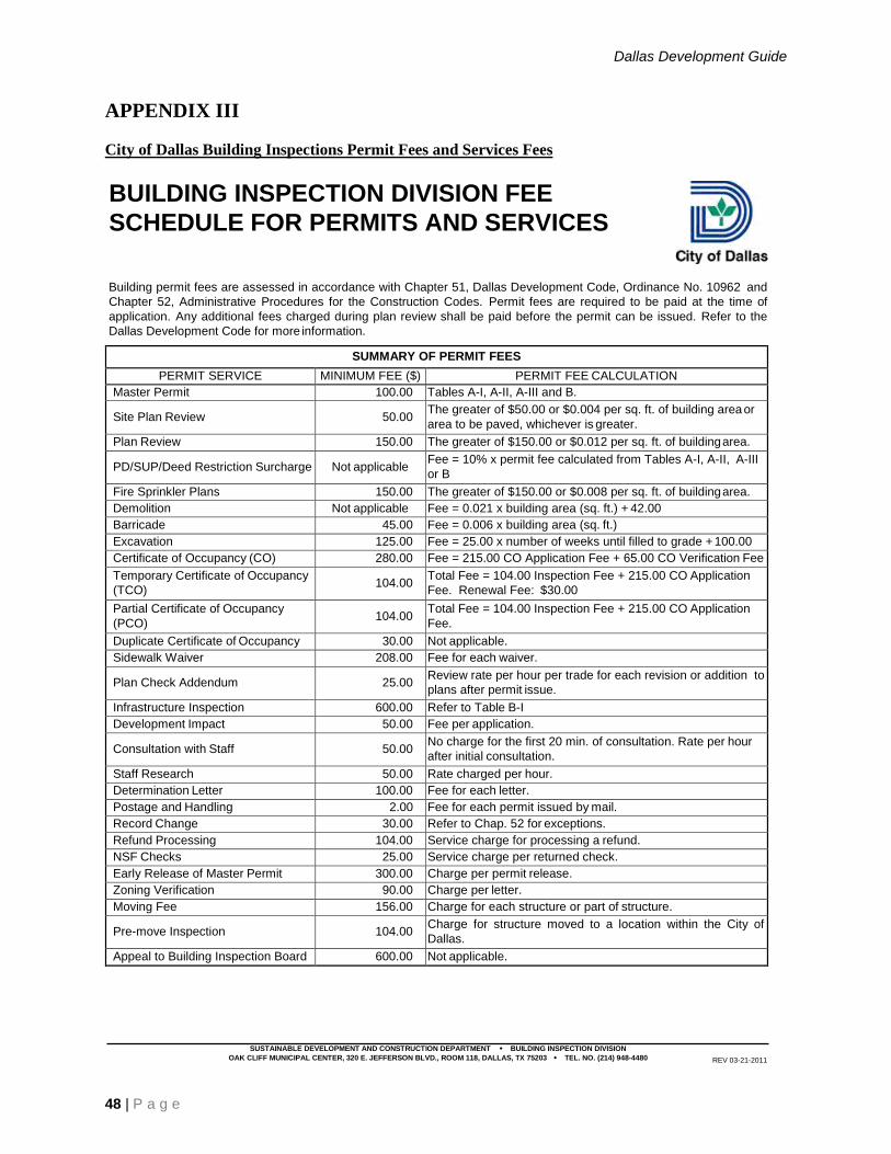
Dallas Development Guide
48 | P a g e
APPENDIX III
City of Dallas Building Inspections Permit Fees and Services Fees
SUSTAINABLE DEVELOPMENT AND CONSTRUCTION DEPARTMENT BUILDING INSPECTION DIVISION
OAK CLIFF MUNICIPAL CENTER, 320 E. JEFFERSON BLVD., ROOM 118, DALLAS, TX 75203 TEL. NO. (214) 948-4480 REV 03-21-2011
BUILDING INSPECTION DIVISION FEE
SCHEDULE FOR PERMITS AND SERVICES
Building permit fees are assessed in accordance with Chapter 51, Dallas Development Code, Ordinance No. 10962 and
Chapter 52, Administrative Procedures for the Construction Codes. Permit fees are required to be paid at the time of
application. Any additional fees charged during plan review shall be paid before the permit can be issued. Refer to the
Dallas Development Code for more information.
SUMMARY OF PERMIT FEES
PERMIT SERVICE MINIMUM FEE ($) PERMIT FEE CALCULATION
Master Permit 100.00 Tables A-I, A-II, A-III and B.
Site Plan Review 50.00 The greater of $50.00 or $0.004 per sq. ft. of building area or
area to be paved, whichever is greater.
Plan Review 150.00 The greater of $150.00 or $0.012 per sq. ft. of building area.
PD/SUP/Deed Restriction Surcharge Not applicable Fee = 10% x permit fee calculated from Tables A-I, A-II, A-III
or B
Fire Sprinkler Plans 150.00 The greater of $150.00 or $0.008 per sq. ft. of building area.
Demolition Not applicable Fee = 0.021 x building area (sq. ft.) + 42.00
Barricade 45.00 Fee = 0.006 x building area (sq. ft.)
Excavation 125.00 Fee = 25.00 x number of weeks until filled to grade + 100.00
Certificate of Occupancy (CO) 280.00 Fee = 215.00 CO Application Fee + 65.00 CO Verification Fee
Temporary Certificate of Occupancy
(TCO) 104.00
Total Fee = 104.00 Inspection Fee + 215.00 CO Application
Fee. Renewal Fee: $30.00
Partial Certificate of Occupancy
(PCO) 104.00
Total Fee = 104.00 Inspection Fee + 215.00 CO Application
Fee.
Duplicate Certificate of Occupancy 30.00 Not applicable.
Sidewalk Waiver 208.00 Fee for each waiver.
Plan Check Addendum 25.00 Review rate per hour per trade for each revision or addition to
plans after permit issue.
Infrastructure Inspection 600.00 Refer to Table B-I
Development Impact 50.00 Fee per application.
Consultation with Staff 50.00 No charge for the first 20 min. of consultation. Rate per hour
after initial consultation.
Staff Research 50.00 Rate charged per hour.
Determination Letter 100.00 Fee for each letter.
Postage and Handling 2.00 Fee for each permit issued by mail.
Record Change 30.00 Refer to Chap. 52 for exceptions.
Refund Processing 104.00 Service charge for processing a refund.
NSF Checks 25.00 Service charge per returned check.
Early Release of Master Permit 300.00 Charge per permit release.
Zoning Verification 90.00 Charge per letter.
Moving Fee 156.00 Charge for each structure or part of structure.
Pre-move Inspection 104.00 Charge for structure moved to a location within the City of
Dallas.
Appeal to Building Inspection Board 600.00 Not applicable.

Dallas Development Guide
49 | P a g e
BUILDING INSPECTION DIVISION FEE SCHEDULE FOR PERMITS AND SERVICES (Continued)
FORMULA FOR TABLES A-I, A-II, A-III AND B
PERMIT FEE ($) = VALUATION x MULTIPLIER + ADD
FACTOR
TABLE A-III
NEW COMMERCIAL CONSTRUCTION
VALUATION ($) MULTIPLIER ADD FACTOR
0 to 60,000 0.009525 0.00
60,001 to 200,000 0.004964 274.00
200,001 to 900,000 0.003914 484.00
900,001 to 1,500,000 0.002862 1,431.00
1,500,001 to 2,500,000 0.002197 2,429.00
2,500,001 to 5,000,000 0.001417 4,379.00
5,000,001 to 10,000,000 0.001036 6,285.00
10,000,001 or greater 0.000767 8,977.00
MINIMUM FEE SCHEDULE (based upon the number of trades or valuation, whichever is greater)
NUMBER OF
TRADES
MAX VALUE OF
PROPOSED WORK
MIN PERMIT FEE
($)
1 6,000 100.00
2 12,000 200.00
3 18,000 300.00
4 24,000 400.00
5 30,000 500.00
6 36,000 600.00
7 42,000 700.00
8 48,000 800.00
TABLE A-I
NEW SINGLE-FAMILY DWELLING CONSTRUCTION
VALUATION ($) MULTIPLIER ADD FACTOR
0 to 60,000 0.0095 0.00
60,001 to 200,000 0.0025 418.00
200,001 to 900,000 0.00203 512.00
900,001 to 2,500,000 0.000826 1,596.00
2,500,001 or greater 0.0004 2,661.00
MINIMUM FEE SCHEDULE (based upon the number of trades or valuation, whichever is greater)
NUMBER OF
TRADES
MAX VALUE OF
PROPOSED WORK
MIN PERMIT
FEE ($)
1 6,000 100.00
2 12,000 200.00
3 18,000 300.00
4 24,000 400.00
5 30,000 500.00
6 36,000 600.00
7 42,000 700.00
8 48,000 800.00
TABLE B
REMODEL, RENOVATION, FINISH-OUT
VALUATION ($) MULTIPLIER ADD FACTOR
0 to 100,000 0.009652 0.00
100,001 to 300,000 0.009525 13.00
300,001 to 500,000 0.009410 47.00
500,001 to 700,000 0.009285 110.00
700,001 to 900,000 0.009155 201.00
900,001 to 1,100,000 0.009045 300.00
1,100,001 to 2,500,000 0.008894 465.00
2,500,001 to 5,000,000 0.008768 780.00
5,000,001 to 10,000,000 0.008641 1,416.00
10,000,001 or greater 0.007940 8,426.00
MINIMUM FEE SCHEDULE (based upon the number of trades or valuation, whichever is greater)
NUMBER OF
TRADES
MAX VALUE OF
PROPOSED WORK
MIN PERMIT FEE
($)
1 6,000 100.00
2 12,000 200.00
3 18,000 300.00
4 24,000 400.00
5 30,000 500.00
6 36,000 600.00
7 42,000 700.00
8 48,000 800.00
TABLE A-II
NEW MULTI-FAMILY DWELLING CONSTRUCTION
FEE ($) FEE CALCULATION
225.00
Fee per dwelling unit only. For
other accessory structures, refer to
Table A-III.
SIGN FEES
EFFECTIVE AREA
(sq. ft.)
PREMISE
SIGN ($)
NON-PREMISE
SIGN ($)
20 or less 45.00 48.00
21 to 50 81.00 84.00
51 to 100 110.00 216.00
101 to 200 136.00 242.00
201 to 300 188.00 294.00
301 to 400 216.00 324.00
401 to 500 242.00 350.00
501 to 700 268.00 376.00
701 to 900 322.00 Not Permitted
901 or greater 374.00 Not Permitted
Sign plan review is $75.00.
The fee for removing or demolishing a sign is $78.00.
The fee for erecting, constructing, altering, rebuilding, en-
larging, extending, converting, replacing or relocating any
special purpose sign is $40.00.

Dallas Development Guide
50 | P a g e
See hyperlink below for fee schedule and fee calculator:
http://dallascityhall.com/departments/sustainabledevelopment/buildinginspection/Pages/fees.aspx
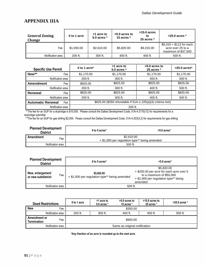
Dallas Development Guide
51 | P a g e
APPENDIX IIIA
General Zoning Change
0 to 1 acre >1 acre to 5.0 acres *
>5.0 acres to 15 acres *
>15.0 acres to
25 acres * >25.0 acres *
Fee $1,050.00 $2,610.00 $5,820.00 $9,315.00 $9,315 + $113 for each
acre over 25 to a maximum of $37,500
Notification area 200 ft. 300 ft. 400 ft. 400 ft. 500 ft.
Specific Use Permit 0 to 1 acre* >1 acre to 5.0 acres *
>5.0 acres to 25 acres * >25.0 acres*
New** Fee $1,170.00 $1,170.00 $1,170.00 $1,170.00
Notification area 200 ft. 300 ft. 400 ft. 500 ft.
Amendment Fee $825.00 $825.00 $825.00 $825.00
Notification area 200 ft. 300 ft. 400 ft. 500 ft.
Renewal Fee $825.00 $825.00 $825.00 $825.00
Notification area 200 ft. 300 ft. 400 ft. 500 ft.
Automatic Renewal Fee $825.00 ($350 refundable if 51A-1.105(a)(4) criteria met)
Notification area 200 ft.
**The fee for an SUP for a skybridge is $10,000. Please consult the Dallas Development Code, 51A-4.217b(12) for requirements for a skybridge submittal. **The fee for an SUP for gas drilling $2,000. Pease consult the Dallas Development Code, 51A-4.203(3.2) for requirements for gas drilling
Planned Development
District 0 to 5 acres* >5.0 acres*
Amendment Fee
$2,610.00 + $1,000 per regulation type** being amended
Notification area 500 ft.
Planned Development District
0 to 5 acres* >5.0 acres*
New, enlargement or new subdistrict
Fee $5,820.00
+ $1,000 per regulation type** being amended
$5,820.00 + $250.00 per acre for each acre over 5 to a maximum of $50,000 + $1,000 per regulation type** being amended
Notification area 500 ft.
Deed Restrictions 0 to 1 acre >1 acre to 5.0 acres *
>5.0 acres to 15 acres *
>15.0 acres to 25 acres *
>25.0 acres *
New Fee $350.00
Notification area 200 ft. 300 ft. 400 ft. 400 ft. 500 ft.
Amendment or Termination
Fee $900.00
Notification area Same as original notification
*Any fraction of an acre is rounded up to the next acre.

Dallas Development Guide
52 | P a g e
APPENDIX IV
Automated Inspection Request System
*For tone generating telephones only.
The Automated Inspection Request System is designed to dispatch requests for the next working day for
valid permits (or Certificate of Occupancy applications) only. The cut-off time for same day inspections
is 7:00 a.m.
For special inspection requests or assistance, or if your request for inspection includes testing of a portion
of a system, you must call the phone number in the box on the lower portion of your permit between 8:00
a.m. and 4:30 p.m. Monday through Friday.
INSTRUCTIONS
1. Dial (214) 670-5313, 24 hours.
2. You will hear a welcome message in English and Spanish.
3. To skip message and go immediately to instructions in English, press “1". To go immediately to
instructions in Spanish, press “9".
4. Press “1" to continue.
5. Enter 10-digit validation number for CO’s followed by # key. For all other permits, enter 13-digit
number followed by # key.
6. Number is repeated. If correct, press # key. If wrong, press * key and try again.
7. Enter 3-digit inspection code listed on lower part of contractor’s authorization or see reverse side
for directory. If correct, press # key. If wrong, press * and try again.
8. If request has been accepted, you will be informed verbally.
9. For another request, press # key. If none, hang up.
If your request is accepted by the computer and inspection does not occur within 36 hours, call the phone
number in the box on the lower portion of your permit. Please have permit number available.
WARNING: Re-inspection fees will be charged if work is not ready or door is locked, etc.

Dallas Development Guide
53 | P a g e
Automated Inspection Request System (continued)
INSPECTION CODES DIRECTORY
Building Inspections
110 Sidewalk and/or drive approach (public
property)
112 Swimming pool
115 Liquor license final
120 Pier, foundation, etc.
130 Framing/tent
133 Barricade
144 Demo final
140 Final
Plumbing Inspections
210 Yard service for gas, sewer or water
211 Lawn sprinkler backflow preventer
212 Swimming pool
220 Rough below floor level; DWV, water, etc.
230 Rough above floor level; DWV, gas, shower
pan, etc.
240 Final
Electrical Inspections
310 Electrical service
311 Landscape lighting
312 Swimming pool
313 Clean and show
320 Rough below floor level electrical
321 Rough walls
322 Rough ceiling
330 Rough above floor level electrical
331 Elevator
340 Final
Sign Inspections
530 Sign Foundations
540 Final
Fire Sprinkler/Fire Alarm
640 Final/No test required
Sign Inspections- Electrical
710 Service for electric sign
720 Underground/electric/pier
730 Underground/electric sign can wire
740 Final
Landscape
940 Final
Sign Inspections- Special Purpose
830 SP Sign Foundation
840 SP Final
Mechanical Inspections
420 Rough below floor level for heating,
ventilation, or air conditioning
430 Rough above floor level for heating,
ventilation, or air conditioning
431 Commercial kitchen exhaust system
440 Final
Certificate of Occupancy Inspections
150 Certificate of Occupancy for building inspector
only
250 Certificate of Occupancy for plumbing
inspector only
350 Certificate of Occupancy for electrical
inspector only
450 Certificate of Occupancy for mechanical
inspector only
650 All Certificate of Occupancy inspections
BUILDING INSPECTION DISTRICT OFFICES
Northeast District Office Northwest District Office
11910 Greenville Ave #100 7610 N Stemmons Fwy #190
(214) 670-7278 (214) 671-0720
Southeast District Office Southwest District Office
725 N Jim Miller 2730 Coombs Creek Dr.
(214) 670-8160 (214) 671-1531

Dallas Development Guide
54 | P a g e
APPENDIX V

Dallas Development Guide
55 | P a g e
APPENDIX VI

Dallas Development Guide
56 | P a g e
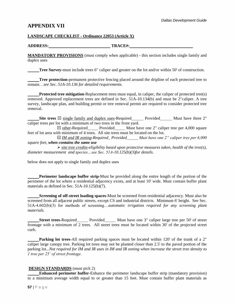
Dallas Development Guide
57 | P a g e
APPENDIX VII
LANDSCAPE CHECKLIST - Ordinance 22053 (Article X)
ADDRESS: TRACE#:
MANDATORY PROVISIONS (must comply when applicable) - this section includes single family and
duplex uses
Tree Survey-must include trees 6" caliper and greater on the lot and/or within 50' of construction.
Tree protection-permanent protective fencing placed around the dripline of each protected tree to
remain…see Sec. 51A-10.136 for detailed requirements.
Protected tree mitigation-Replacement trees must equal, in caliper, the caliper of protected tree(s)
removed. Approved replacement trees are defined in Sec. 51A-10.134(b) and must be 2"caliper. A tree
survey, landscape plan, and building permit or tree removal permit are required to consider protected tree
removal.
Site trees single family and duplex uses-Required Provided Must have three 2"
caliper trees per lot with a minimum of two trees in the front yard.
other-Required Provided Must have one 2" caliper tree per 4,000 square
feet of lot area with minimum of 4 trees. All site trees must be located on the lot.
IM and IR zoning-Required Provided Must have one 2” caliper tree per 6,000
square feet, when contains the same use
site tree credits-eligibility based upon protective measures taken, health of the tree(s),
diameter measurement and species…see Sec. 51A-10.125(b)(3)for details.
below does not apply to single family and duplex uses
Perimeter landscape buffer strip-Must be provided along the entire length of the portion of the
perimeter of the lot where a residential adjacency exists, and at least 10' wide. Must contain buffer plant
materials as defined in Sec. 51A-10.125(b)(7).
Screening of off-street loading spaces-Must be screened from residential adjacency. Must also be
screened from all adjacent public streets, except CS and industrial districts. Minimum 6' height. See Sec.
51A-4.602(b)(3) for methods of screening…automatic irrigation required for any screening plant
materials.
Street trees-Required Provided Must have one 3" caliper large tree per 50' of street
frontage with a minimum of 2 trees. All street trees must be located within 30' of the projected street
curb.
Parking lot trees-All required parking spaces must be located within 120' of the trunk of a 2"
caliper large canopy tree. Parking lot trees may not be planted closer than 2.5' to the paved portion of the
parking lot...Not required for IM and IR uses in IM and IR zoning when increase the street tree density to
1 tree per 25’ of street frontage.
DESIGN STANDARDS (must pick 2)
Enhanced perimeter buffer-Enhance the perimeter landscape buffer strip (mandatory provision)
to a minimum average width equal to or greater than 15 feet. Must contain buffer plant materials as

Dallas Development Guide
58 | P a g e
defined in Sec. 51A-10.125(b)(7).
Street buffers-Provide a landscape buffer strip along the entire adjacent public street frontage.
Minimum width of 10 feet or 10% lot depth, whichever is less. Must contain buffer plant materials as
defined in Sec. 51A-10.125(b)(7).
Screening of off-street parking-Screen all parking lots on the lot along the entire adjacent public
street frontages. Screening must be voluntary. Must be voluntary and at least 3 feet in height (ex. large
evergreen shrubs, 3' height, 7-9 gallon, 3' on center, 3' wide bed, or 3' tall solid fence, or 3' tall berm, or a
combination). Mandatory in NO(A), LO(A), LO-1, LO-2, LO-3, MO(A), MO-1, MO-2 and
GO(A) districts…automatic irrigation required for any screening plant materials.
Enhanced vehicular pavement-25% of all outdoor vehicular pavement must be any permeable or
non-permeable decorative pavement. The same pavement cannot satisfy this requirement and permeable
vehicular pavement. (ex. brick, stone or grass pavers, exposed aggregate concrete, or stamped and stained
concrete).
Permeable vehicular pavement-25% of all outdoor vehicular pavement must be a paving material
that permits water penetration to a soil depth of 18" or more. The same pavement cannot satisfy this
requirement and enhanced vehicular pavement. (ex. brick, stone or grass pavers).
Pedestrian facilities-Publicly accessible special pedestrian facilities such plazas, covered
walkways, fountains, lakes, ponds, seating areas and outdoor recreation facilities. These facilities and
features must occupy at least 5% of the lot area.
Foundation planting strip-Large evergreen shrubs (3' height, 7-9 gallon, 3' to 6' on center) in a 3'
wide bed along the foundation of the building that extends along at least 50% of the portion of the
foundation that faces a street.
Understory preservation-Preserve existing healthy understory which is a grouping of natural
low-level woody, herbaceous or groundcover species. Must occupy at least 5% of the lot area.
Enhanced pedestrian walkways-Walkways must consist of enhanced pavement intended for
pedestrian use and occupy at least 5% of the lot. See enhanced vehicular pavement for examples.

Dallas Development Guide
59 | P a g e
APPENDIX VIII
Internet access to Building Inspection Website
The city maintains a website at www.dallascityhall.com. To obtain details about Sustainable
Development and Construction, first click on City Departments, then click on Sustainable Development
and Construction to access the following useful information including this Development Guide.
Agendas
Applications and Forms
Building Inspection
Current Planning
Development Code
Engineering
FAQs
Fees and Rates
Forms
Interactive Maps
Pre-Development Meetings
Real Estate
Zoning Maps

Dallas Development Guide
60 | P a g e
APPENDIX IX
Process Flow Charts
Fig. 1 Abandonments Process
Fig. 2 Platting Process
Fig. 2A Engineering Review Paving Process
Fig. 2B Engineering Review Water Process
Fig. 2C Public Works Street Lighting Process
Fig. 3 Zoning Change Process
Fig. 4 Development Plan Process
Fig. 5 Board of Adjustment Process
Fig. 6 Permit Review Process
Fig. 7 Express Plan Review (Q Team) Process
Fig. 8 Flow Contractor Inspection Process
Fig. 9 Certificate of Appropriateness Process
Fig. 10 DIR RAR Process
Fig. 11 Escarpment Process
Fig. 12 Floodplain Fill Process
Fig. 13 Sidewalk Waiver Process
Fig. 14 Special Parking Process
Fig. 15 Street Name Change Process
Fig. 16 Thoroughfare Amendment Process

Application assigned to Agent
Administrative File Setup
Survey Field Notes Submitted for
Review(15 Days Min.)
Appraisal Ordered If Applicable
Survey Field Notes
Approved?
No
Real Estate Manager Review File and Approve
Signature
City Attorney’s Office Reviews (15 Days Min.)
CAO Approves ?
Prepare Packet and Documents for
City Council
Payment and Fees Collected Pre-Acceptance Executed
Route Packet to Agenda
Coordinator
Post Council Action
Request Certified Ordinance from City Secretaries
Office
Process Ends
Abandonment Process
Yes
No
Yes
All Responses Cleared?
Completed Packet with Application submitted to Real
Estate
Figure 1
Route Responses to City Departments
and Utility Providers for Responses
No
Yes
Resolve All CAO Concerns and Return to CAO
Ordinance conditions must be resolved
before proceeding to the next step
Prepare Quitclaim Deed
Record Quitclaim Deed with County
Office
Close Letter To Applicant Provide
QCD & Copy of Certified Ordinance

Applicant submits preliminary plat
Staff formulates recommendation
Scheduled for City Plan Commission
CPC votes on action of
preliminary plat
Applicant submits final plat to
Engineering and Survey
All departmental releases obtained
Applicant records plat and returns recorded plat to
Subdivision Administrator
End of process
Platting Process-Subdivision
Pre-application meeting with Subdivision staff
Figure 2
Applicant submits final plat with
owners signature
Final Approval
Pre
limin
ary
pla
t 3
0 d
ays m
axim
um
Ma
xim
um
fin
al pla
t tim
e v
ari
es d
ue
to
en
gin
ee
ring
de
sig
n a
nd r
evie
w p
roce
ss
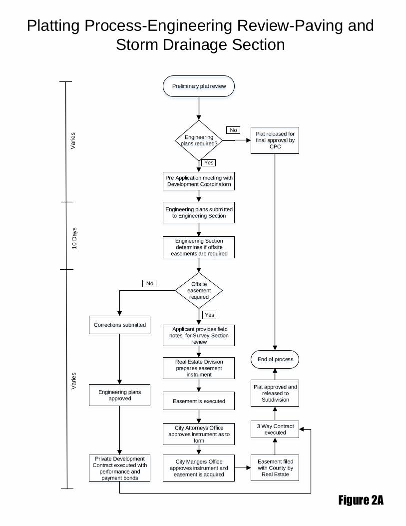
Platting Process-Engineering Review-Paving and
Storm Drainage Section
Figure 2A
Va
rie
s1
0 D
ays
Pre Application meeting with Development Coordinatorn
Engineering plans submitted to Engineering Section
Applicant provides field notes for Survey Section
review
End of process
Preliminary plat review
Engineering plans required?
Engineering Section determines if offsite
easements are required
Offsite easement required
Yes
Corrections submitted
Yes
No
Real Estate Division prepares easement
instrument
Easement is executed
City Attorneys Office approves instrument as to
form
City Mangers Office approves instrument and
easement is acquired
Engineering plans approved
Private Development Contract executed with
performance and payment bonds
Easement filed with County by
Real Estate
3 Way Contract executed
Plat approved and released to Subdivision
Va
rie
s Plat released for final approval by
CPC
No

Platting Process-Engineering Review-Water/Waste Water Section
Figure 2B
Va
rie
s1
0 D
ays
Pre Application meeting with Engineering Section
Engineering plans submitted to Engineering Section
Applicant provides field notes for Survey Section
review
End of process
Preliminary plat review
Engineering plans required?
Plat released for final approval by
CPC
Engineering Section determines if offsite
easements are required
Off site easement required?
No
Yes
Subsequent reviewYes
No
Real Estate Division prepares easement
instrument
Easement is executed
City Attorneys Office approves instrument as to
form
City Mangers Office approves instrument and
easement is acquired
Plan approved
3 Way Contract Executed
Easement filed with County by Real Estate
Va
rie
s
Covenant
Owner/applicant request Covenant in lieu of building
water and wastewater mains
Covenant request is forwarded to
Real Estate Division
Covenant is executed and filed
for record
Plat is released for approval by CPC
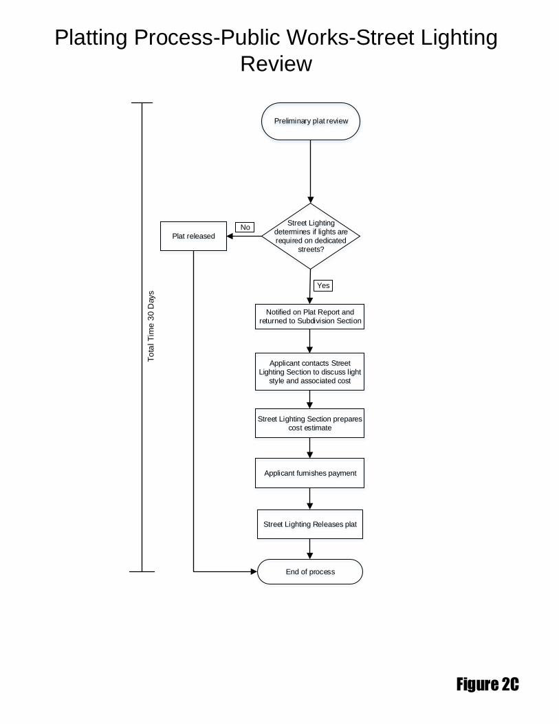
Platting Process-Public Works-Street Lighting
Review
Figure 2C
To
tal T
ime
30 D
ays
Notified on Plat Report and returned to Subdivision Section
Applicant contacts Street Lighting Section to discuss light
style and associated cost
End of process
Preliminary plat review
Street Lighting determines if lights are required on dedicated
streets?
Plat released
Street Lighting Section prepares cost estimate
No
Yes
Applicant furnishes payment
Street Lighting Releases plat
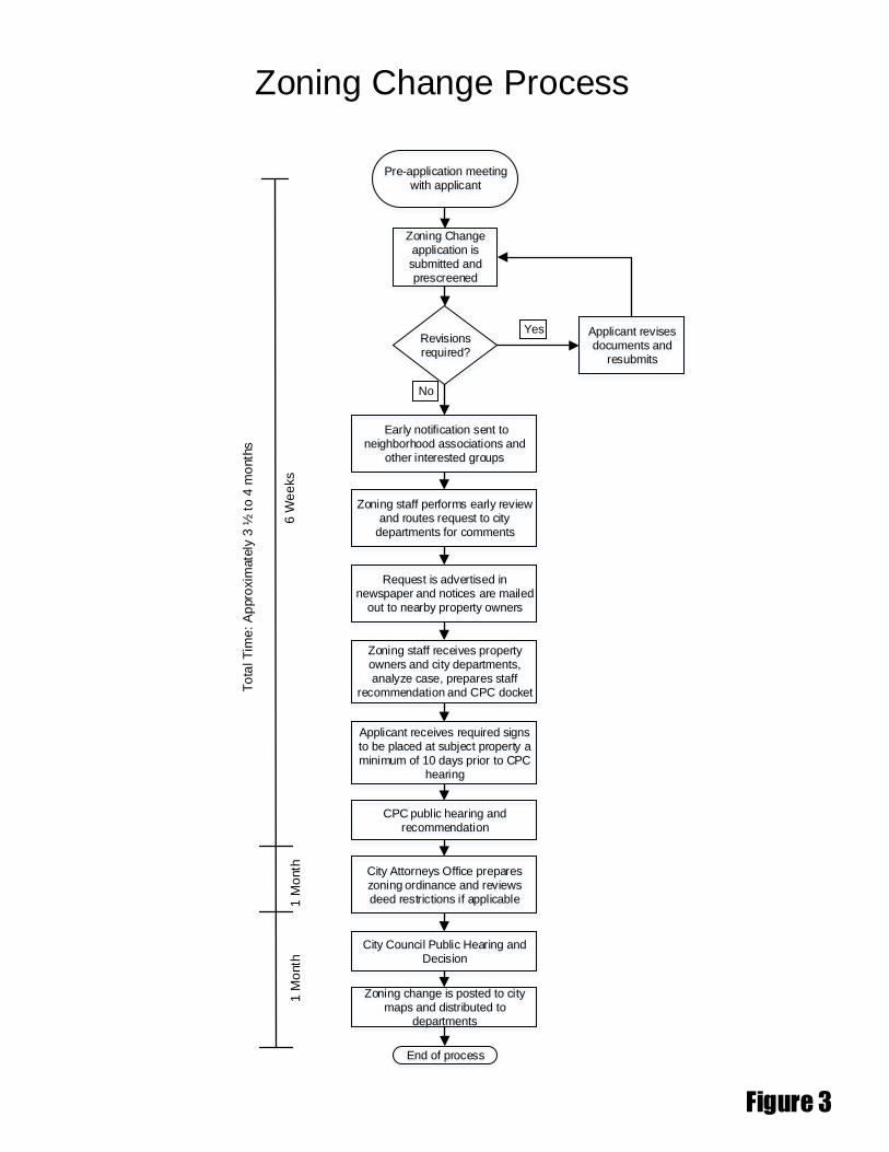
Zoning Change application is submitted and prescreened
Request is advertised in newspaper and notices are mailed
out to nearby property owners
CPC public hearing and recommendation
End of process
Zoning Change Process
Pre-application meeting with applicant
Figure 3
Zoning staff receives property owners and city departments, analyze case, prepares staff
recommendation and CPC docket
Applicant receives required signs to be placed at subject property a minimum of 10 days prior to CPC
hearing
6 W
ee
ks
To
tal T
ime
: A
ppro
xim
ate
ly 3
½ t
o 4
mo
nth
s
Revisions required?
Early notification sent to neighborhood associations and
other interested groups
Applicant revises documents and
resubmits
Yes
No
Zoning staff performs early review and routes request to city
departments for comments
City Attorneys Office prepares zoning ordinance and reviews deed restrictions if applicable
City Council Public Hearing and Decision
Zoning change is posted to city maps and distributed to
departments
1 M
onth
1 M
onth

Plans reviewed by Current Planning
Division and Engineering
Section
End of process
Development Plan Process
Application is submitted
Figure 4
Revisions required?
City Plan Commission Meeting
Applicant revises documents and
resubmits
Yes
No
Approved
No
Stamp approved plans and
distribute to applicant and departments
Yes
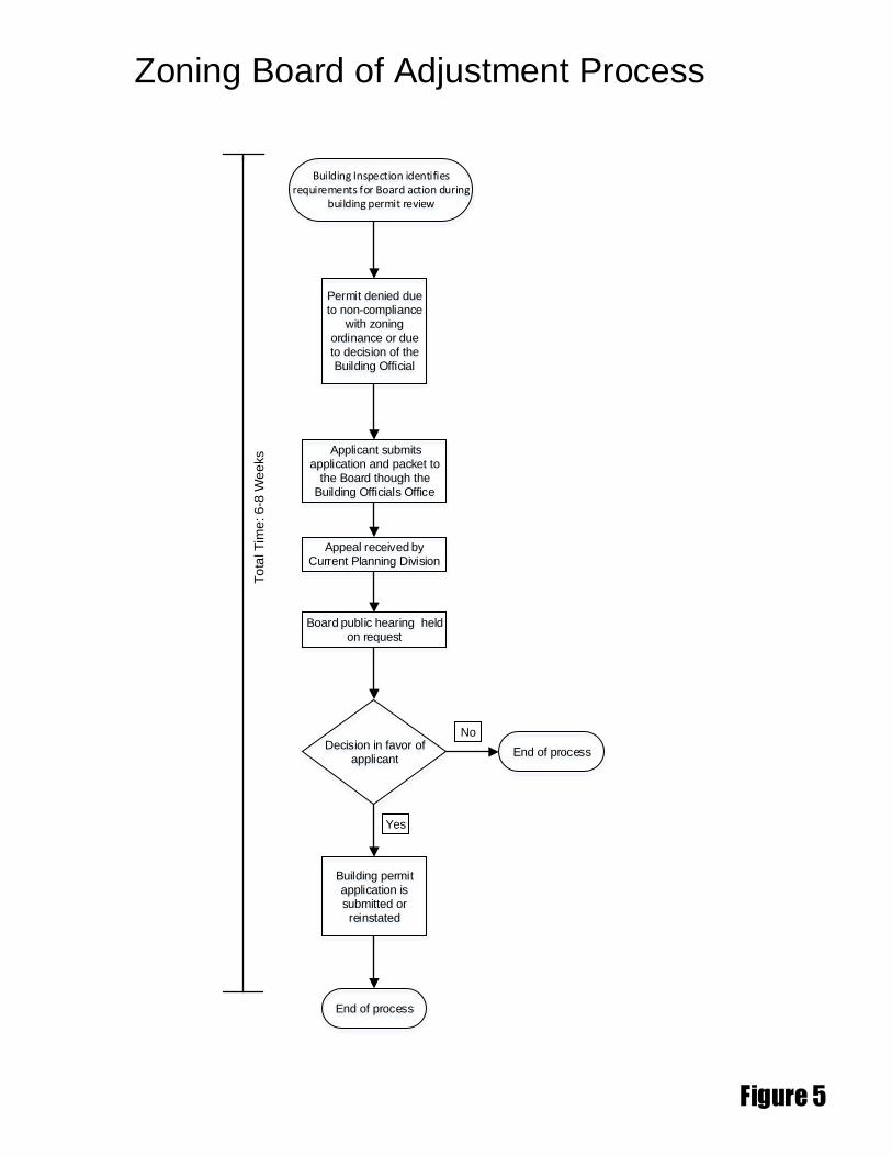
Permit denied due to non-compliance
with zoning ordinance or due to decision of the Building Official
Board public hearing held on request
Zoning Board of Adjustment Process
Building Inspection identifies requirements for Board action during
building permit review
Figure 5
To
tal T
ime
: 6-8
We
eks Applicant submits
application and packet to the Board though the
Building Officials Office
Yes
No
Appeal received by Current Planning Division
Decision in favor of applicant
End of process
Building permit application is submitted or reinstated
End of process
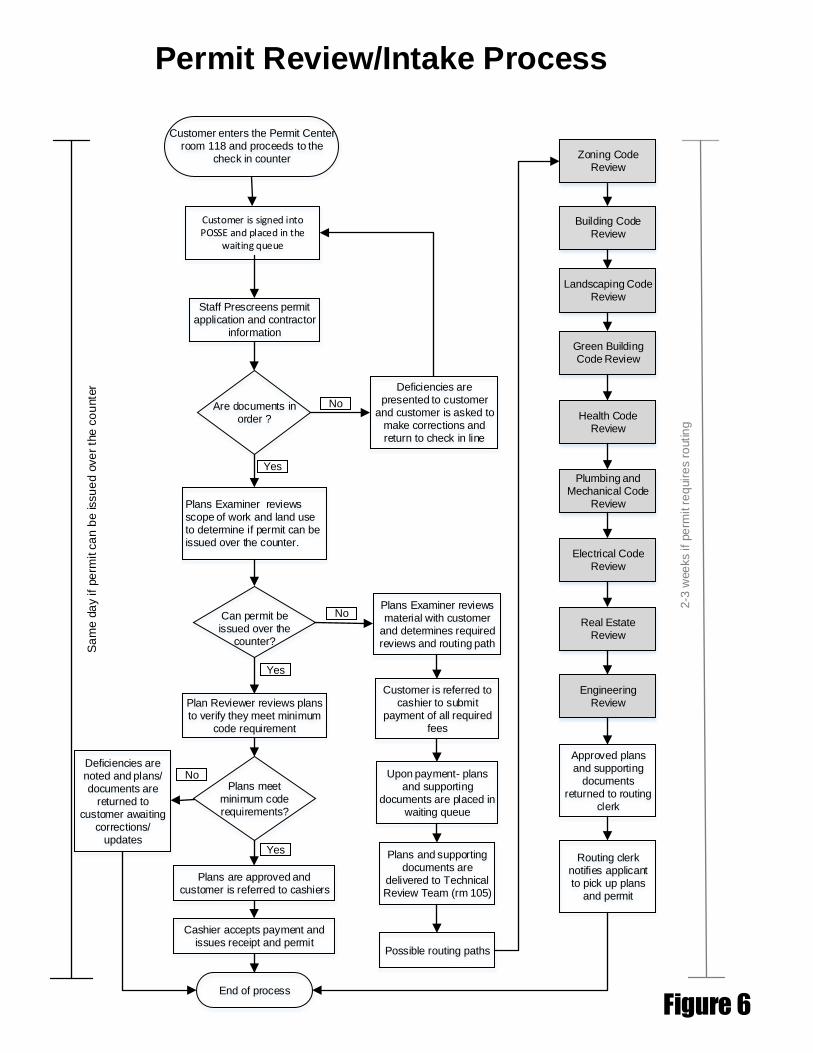
Customer enters the Permit Center room 118 and proceeds to the
check in counter
Permit Review/Intake Process
Deficiencies are presented to customer
and customer is asked to make corrections and return to check in line
Staff Prescreens permit application and contractor
information
Plans Examiner reviews scope of work and land use to determine if permit can be issued over the counter.
End of process
Figure 6
Are documents in order ?
No
Yes
Can permit be issued over the
counter?
Plans Examiner reviews material with customer
and determines required reviews and routing path
Plan Reviewer reviews plans to verify they meet minimum
code requirement
No
Yes
Plans meet minimum code requirements?
Plans are approved and customer is referred to cashiers
Yes
Cashier accepts payment and issues receipt and permit
Customer is referred to cashier to submit
payment of all required fees
Upon payment- plans and supporting
documents are placed in waiting queue
Plans and supporting documents are
delivered to Technical Review Team (rm 105)
Deficiencies are noted and plans/ documents are
returned to customer awaiting
corrections/ updates
Possible routing paths
Building Code Review
Landscaping Code Review
Green Building Code Review
Health Code Review
Plumbing and Mechanical Code
Review
Electrical Code Review
Real Estate Review
Engineering Review
Approved plans and supporting
documents returned to routing
clerk
Routing clerk notifies applicant to pick up plans
and permit
Zoning Code Review
Sa
me d
ay if
pe
rmit c
an
be issu
ed o
ve
r th
e c
ou
nte
r
2-3
wee
ks if
pe
rmit r
eq
uir
es r
outin
g
No
Customer is signed into POSSE and placed in the
waiting queue

Applicant applies for building permit and submits prequalification form
Q-Team/Express Plan Review Process
Q-team pre-screens prequalification packet
Deficiencies are noted and plans are placed on hold shelf,
awaiting customer resubmittal
Review meeting is scheduled by Q-Team/Express
Customer pays applicable fees and plans are routed to prequalification
Plan review meeting takes place
Deficiencies are noted and plans are placed on customer shelf awaiting corrections/ updates
Q-Team fees are paid & permit is issued
End of process
1 to
2 d
ays
1 to
12 d
ays
1 d
ay,
co
uld
va
ry
Figure 7
Are plans accepted?
No
Yes
Plans approved?
No
Yes

Subcontractors validate on to
permit
Contractor Approval Process for
Construction Inspection
Permit Issued
Figure 8
End of process
Schedule rough-in inspection/foundation
inspection before foundation is
poured
Framing/rough wall inspections before walls are
covered
Schedule Building final after all trades have been finalled
If permit is for a commercial or multifamily use Certificate of
Occupancy should be issued
1 to
2 d
ays
1 to
2 d
ays
2 d
ays
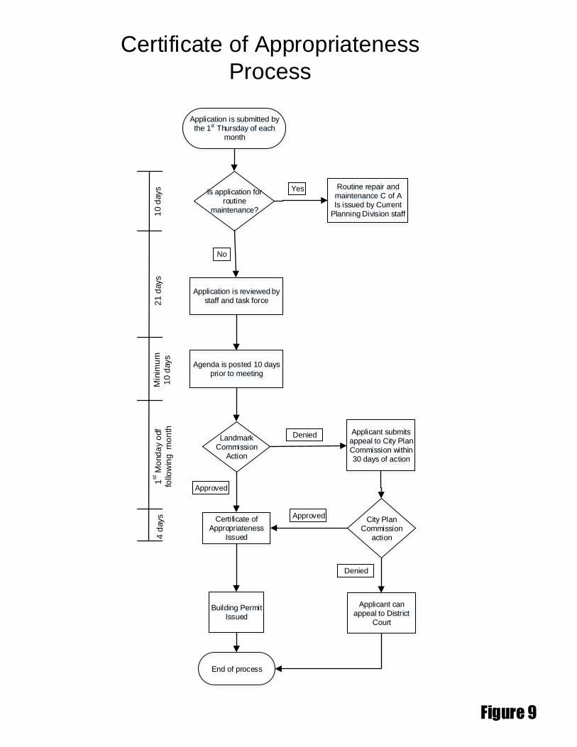
End of process
Certificate of Appropriateness
Process
Application is submitted by the 1st Thursday of each
month
Figure 9
Certificate of Appropriateness
Issued
Building Permit Issued
Is application for routine
maintenance?
Application is reviewed by staff and task force
Routine repair and maintenance C of AIs issued by Current
Planning Division staff
Yes
No
Agenda is posted 10 days prior to meeting
1st M
ond
ay o
df
follo
win
g m
on
th4
days
Landmark Commission
Action
Approved
Denied Applicant submits appeal to City Plan Commission within 30 days of action
City Plan Commission
action
Approved
Applicant can appeal to District
Court
Denied
10 d
ays
21 d
ays
Min
imu
m
10 d
ays

Application routed for Departmental
reviews
Development Impact Review (DIR) &
Residential Adjacency Review (RAR)
DIR or RAR application submitted
Figure 10
End of process
Staff recommendation
Appeal to City Plan Commission
No
Yes
Approval is noted on permit review
To
tal tim
e: 3
0 d
ays m
axim
um
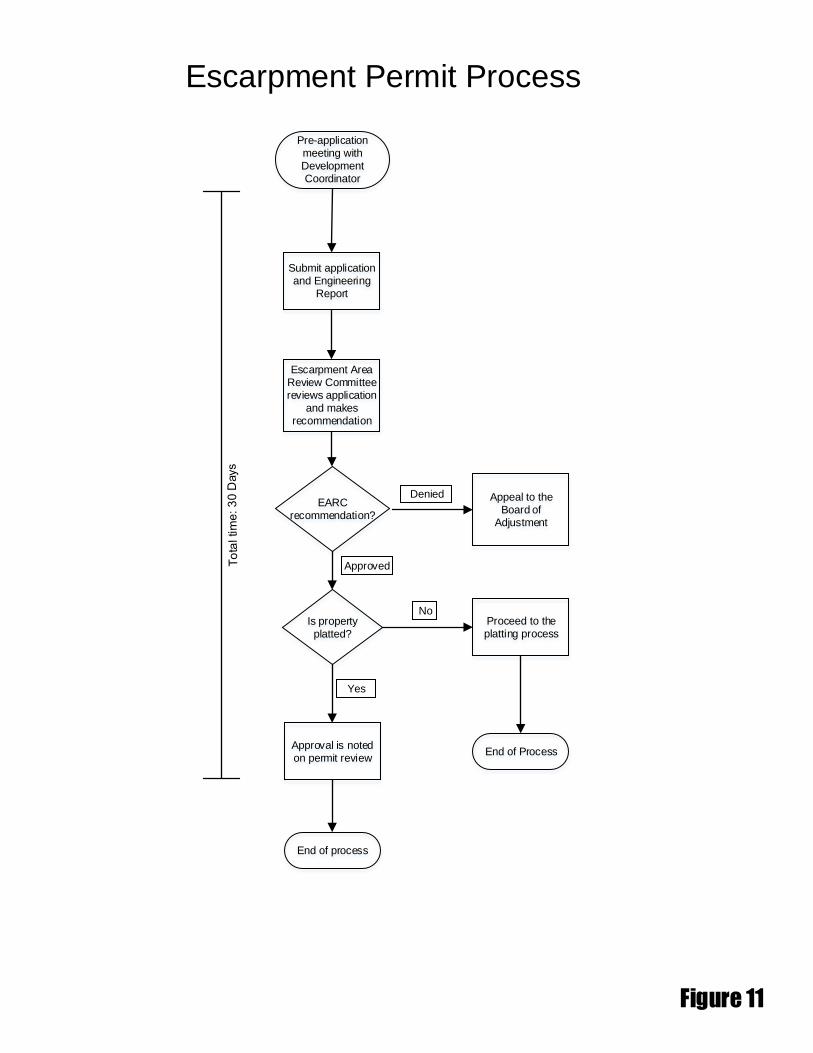
Submit application and Engineering
Report
Escarpment Permit Process
Pre-application meeting with Development Coordinator
Figure 11
End of process
EARC recommendation?
Appeal to the Board of
Adjustment
Denied
Approved
Approval is noted on permit review
Escarpment Area Review Committee reviews application
and makes recommendation
Is property platted?
Yes
Proceed to the platting process
End of Process
No

Submit application to Floodplain
Mgmt
Floodplain Fill Permit Process
Pre-application meeting with Trinity Watershed Management
Figure 12
End of process
Neighborhood meeting
Department reviews of
application and plans
Legal notice placed in
newspaper
Request goes before City
Council
Fill site, geotechnical and survey verification
submitted
Obtain LOMR from FEMA
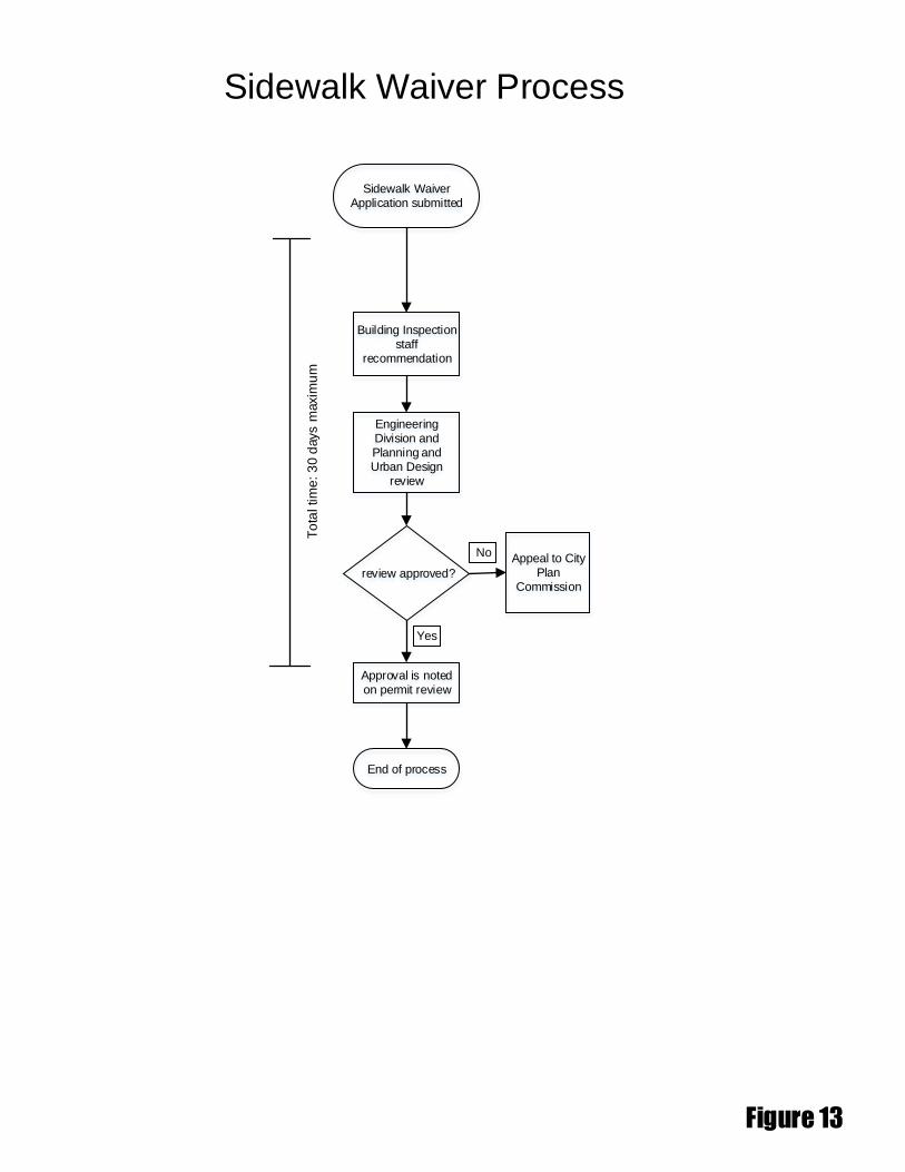
Building Inspection staff
recommendation
Sidewalk Waiver Process
Sidewalk Waiver Application submitted
Figure 13
End of process
review approved?
Appeal to City Plan
Commission
No
Yes
Approval is noted on permit review
To
tal tim
e:
30 d
ays m
axim
um
Engineering Division and Planning and Urban Design
review
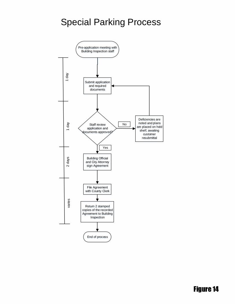
Submit application and required documents
Special Parking Process
Pre-application meeting with Building Inspection staff
Figure 14
End of process
Staff review application and
documents approved?
No
Yes
Building Official and City Attorney sign Agreement
1 d
ay
1 d
ay
2 d
ays
va
rie
s
Deficiencies are noted and plans
are placed on hold shelf, awaiting
customer resubmittal
File Agreement with County Clerk
Return 2 stamped copies of the recorded Agreement to Building
Inspection
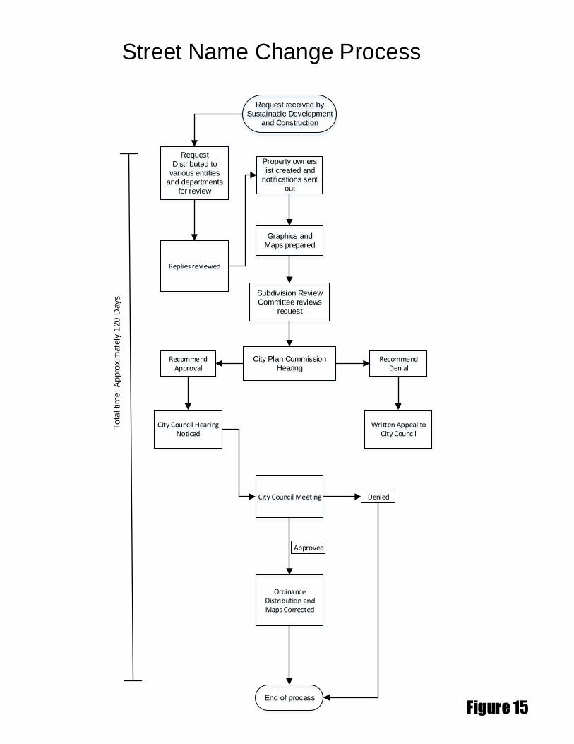
Street Name Change Process
Figure 15
To
tal tim
e: A
ppro
xim
ate
ly 1
20
Days
Graphics and Maps prepared
End of process
Request received by Sustainable Development
and Construction
Property owners list created and
notifications sent out
Request Distributed to
various entities and departments
for review
Subdivision Review Committee reviews
request
Replies reviewed
City Plan Commission Hearing
Recommend Approval
Recommend Denial
City Council Hearing Noticed
Written Appeal to City Council
City Council Meeting
Ordinance Distribution and Maps Corrected
Approved
Denied
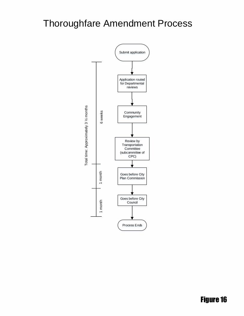
Application routed for Departmental
reviews
Thoroughfare Amendment Process
Submit application
Figure 16
Community Engagement
Goes before City Plan Commission
To
tal tim
e: A
ppro
xim
ate
ly 3
½ m
on
ths
Review by Transportation
Committee (subcommittee of
CPC)
Goes before City Council
Process Ends
6 w
ee
ks
1 m
onth
1 m
onth