d5.5.1 geoparser gazetteer v1.0 1 · · 2014-11-26geographical information and also as an...
TRANSCRIPT
D5.5.1 – The Europeana Geoparser
and Gazetteer
Documentation and final prototype
co-funded by the European Union
The project is co-funded by the European Union, through the eContentplus programme
http://ec.europa.eu/econtentplus
EuropeanaConnect is coordinated by the Austrian National Library
ECP-2008-DILI-528001
EuropeanaConnect
D5.5.1 – The Europeana Geoparser and Gazetteer
Deliverable number/name D 5.5.1
Dissemination level PU
Delivery date 3/5/2011
Status Final
Author(s) Nuno Freire (BNP, IST) André Soares (IST)
eContentplus
This project is funded under the eContentplus programme,
a multiannual Community programme to make digital content in Europe more accessible, usable and
exploitable.
EuropeanaConnect is coordinated by the Austrian National Library
EuropeanaConnect Deliverable D5.5.1 – The Europeana Geoparser and Gazetteer
3 / 41
Executive Summary
Task 5.5 in EuropeanaConnect aimed to build data oriented services to support geographical
information based user interfaces in the Europeana portal. Very few objects contain
structured geographical metadata, however. This kind of information mainly exists in
metadata records as unstructured natural language texts, which are difficult to use in
information systems. This task pursued two objectives:
• To support the organization and maintenance of geographic data, by providing
storage, data integration, and search services for geographical information.
• To enrich the object descriptions by analysing geographic and time references in
existing metadata records.
This document describes the specification, design, implementation, evaluation and usage, of
two services developed to achieve the above objectives: the Gazetteer and the Geoparser.
EuropeanaConnect Deliverable D5.5.1 – The Europeana Geoparser and Gazetteer
4 / 41
Table of Contents
Executive Summary ...................................................................................................................3
Table of Contents.......................................................................................................................4
1. Introduction .........................................................................................................................6
2. Gazetteer ............................................................................................................................7
2.1. Functional Specification ............................................................................................7
2.1.1. Product Position Statement...................................................................................7
2.1.2. Stakeholders .........................................................................................................7
2.1.3. System Qualities ...................................................................................................8
2.1.4. System Constraints ...............................................................................................8
2.1.5. Licensing Requirements........................................................................................9
2.1.6. Applicable Standards ............................................................................................9
2.1.7. Use cases..............................................................................................................9
2.2. Gazetteer Design ....................................................................................................10
2.2.1. Component Overview..........................................................................................10
2.2.2. Component Architecture .....................................................................................11
2.3. Gazetteer Implementation.......................................................................................13
2.3.1. Source Code .......................................................................................................13
2.3.2. ADL-GP interface usage .....................................................................................14
2.3.3. Human interface usage.......................................................................................18
3. Geoparser .........................................................................................................................22
3.1. Functional specifications .........................................................................................22
3.1.1. Product Position Statement.................................................................................22
3.1.2. Stakeholders .......................................................................................................22
3.1.3. System Qualities .................................................................................................23
3.1.4. System Constraints .............................................................................................24
3.1.5. Licensing Requirements......................................................................................24
3.1.6. Applicable Standards ..........................................................................................24
EuropeanaConnect Deliverable D5.5.1 – The Europeana Geoparser and Gazetteer
5 / 41
3.1.7. Use cases ...........................................................................................................24
3.2. Geoparser Design ...................................................................................................26
3.2.1. Components overview ........................................................................................26
3.2.2. The Geoparser component.................................................................................26
3.2.3. The GeoparserServiceREST component ...........................................................30
3.3. Implementation........................................................................................................32
3.3.1. Source code........................................................................................................32
3.3.2. Using geoparserLib.............................................................................................32
3.3.3. Deploying the geoparserService.........................................................................33
3.3.4. The REST interface of the GeoparserService....................................................33
3.3.5. Connecting to the Gazetteer...............................................................................36
3.4. Evaluation of the results..........................................................................................37
3.4.1. Evaluation of the machine learning based geoparsing reasoner .......................38
3.4.2. Comparative evaluation of the Geoparser..........................................................39
3.4.3. Evaluation for time periods .................................................................................40
4. Conclusions ......................................................................................................................41
EuropeanaConnect Deliverable D5.5.1 – The Europeana Geoparser and Gazetteer
6 / 41
1. Introduction
Aspects of the Europeana user interface, some developed in EuropeanaConnect task 3.3 –
Spatio-temporal access channels for Europeana, make use of both time related and
geographical metadata, providing a new visual access channel to the digital objects.
However, very few objects contain explicit geographical metadata. Therefore, specific
techniques must be employed to enrich the object descriptions by analysing geographic and
time references in existing metadata records.
This task improved and adapted, for Europeana, the geographical services developed within
the context of the DIGMAP and TELplus projects. Namely, two services have been the focus
of this task:
• The Gazetteer: a service for supporting the organization and maintenance of
geographic data, by providing storage, data integration, and search services;
• The Geoparser: a service that uses information extraction techniques to automatically
identify names of places and time periods that are mentioned in unstructured text. It
works together with the Gazetteer to be able to assign coordinates and dates with
the mentioned names of places and periods.
The target users of these services are Europeana, aggregators and data providers, which
need to enrich the object descriptions by analyzing geographic or temporal references in
existing metadata records.
This document will follow with the description of both systems, covering their specification,
design, implementation, evaluation and usage.

EuropeanaConnect Deliverable D5.5.1 – The Europeana Geoparser and Gazetteer
7 / 41
2. Gazetteer
Data representing the geographical aspects of our world can nowadays be stored and
processed efficiently, and many of the decisions people make today depend on the details of
our immediate surroundings, requiring information about specific places on the Earth’s
surface. This information, labeled geographical information, helps distinguish places and
helps to make decisions pertaining to specific locations.
A Gazetteer consists of a list of geographic names, together with their geographic locations
and other descriptive information. Mainly it serves as a storage and search service for
geographical information and also as an important tool to provide geographical context on
the Web.
The main target user of the Gazetteer is the Geoparser service, also described in this
document, but other services and casual users can also use it, as a search service for
geographical information.
The remainder of this section provides a detailed description of the Gazetteer service,
namely its system specifications, restrictions, design and implementation.
2.1. Functional Specification
2.1.1. Product Position Statement
For Europeana Geoparser service, casual users
Who Geoparser – Needs to access geographical features to enrich metadata
records.
Casual Users – Can use to obtain geographic information
Other web services – Can use to obtain geographic information
Product name Gazetteer
That Provides storage and a browsing service for geographical features, that
can be accessed by users or other services.
2.1.2. Stakeholders
Besides Europeana, the Gazetteer may be of interest also for casual users and other
services.
Name: Europeana – Geoparser service
Description The Geoparser service developed for Europeana.
Responsibilities To enrich the metadata records received from data providers, with
structured geographical coordinates and dates.

EuropeanaConnect Deliverable D5.5.1 – The Europeana Geoparser and Gazetteer
8 / 41
Name: Casual Users / Other web services
Description Random users (human and machine)
Responsibilities To access and obtain geographical information for their own intents and
purposes.
2.1.3. System Qualities
Quality Description
Usability The Gazetteer is accessible through a basic search interface, for
browsing geographic features.
Reliability The system should recover from failed requests.
The system must be ready to respond under stress and adverse
conditions.
The system should be able to return the previous valid state and
continue ongoing operations in case of hardware or software failure.
Performance No measurable performance requirements were identified for the
Gazetteer.
User interfaces Basic search interface.
Interfaces to
external systems
The Geoparser makes use of the Gazetteer, as its source of
geographical data and historical periods’ data.
Software
interfaces An XML over HTTP interface to access the Gazetteer service.
2.1.4. System Constraints
Constraint Description
Operating
systems
Any supporting the Java virtual machine
Programming
language
Java
Build tool Maven 2
Application server Apache Tomcat 6.x

EuropeanaConnect Deliverable D5.5.1 – The Europeana Geoparser and Gazetteer
9 / 41
2.1.5. Licensing Requirements
Available under dual licensing:
• European Union Public License – EUPL v.1.1
• GNU General Public License – GPLv3
2.1.6. Applicable Standards
ADL-GP1 – Alexandria Digital Library Gazetteer Protocol
ADL-FTT2 – Alexandria Digital Library Feature Type Thesaurus
2.1.7. Use cases
Figure 1 – Gazetteer’s Use Cases
Discover Feature
Description Search and access a specific feature or set of features based on
specified attributes.
Actors Client application or Human User
Preconditions None
Flow of events 1. The use case begins when the User (application or human)
submits a request either through the user interface or the ADL-
GP interface.
2. In case of the user interface:
1 http://www.alexandria.ucsb.edu/gazetteer/protocol/
2 http://www.alexandria.ucsb.edu/gazetteer/FeatureTypes/ver070302/

EuropeanaConnect Deliverable D5.5.1 – The Europeana Geoparser and Gazetteer
10 / 41
a. The user submits a feature name through the user
interface for search purposes;
b. A search request is built and sent to the Gazetteer
system;
c. The request is then processed and the result list is sent
to the user interface for presentation;
d. The user can than browse throw the result list or
perform another search;
e. If the chooses to access a feature, he is presented with
a descriptive page of the feature with its contents
structured into groups.
3. In the case of the ADL-GP interface:
a. A search request is sent to the gazetteer system;
b. The request is then processed by the system, a
response is built with the list of results from the search
and is returned;
4. The use case ends.
2.2. Gazetteer Design
This section describes the main design aspects of the Gazetteer software.
2.2.1. Component Overview
The Gazetteer consists of three software components: the Gazetteer User Interface, the
Gazetteer Service and the Repository for storing the features.
The Gazetteer Service component is to be built as a Java jar file. This component provides
an implementation of the Gazetteer Use Cases, and it can be embedded in other software
applications. It serves as a simple service providing the basic functionalities of an
International Organization for Standardization (ISO) and Open Geospatial Consortium (OGC)
defined gazetteer service.
The Gazetteer User Interface component is built as a Java Web application. This component
makes all the Gazetteer Use Cases available online. It is dependent on the Gazetteer
Service component.
The Repository is a relational database containing the geographic features managed by the
gazetteer service.
EuropeanaConnect Deliverable D5.5.1 – The Europeana Geoparser and Gazetteer
11 / 41
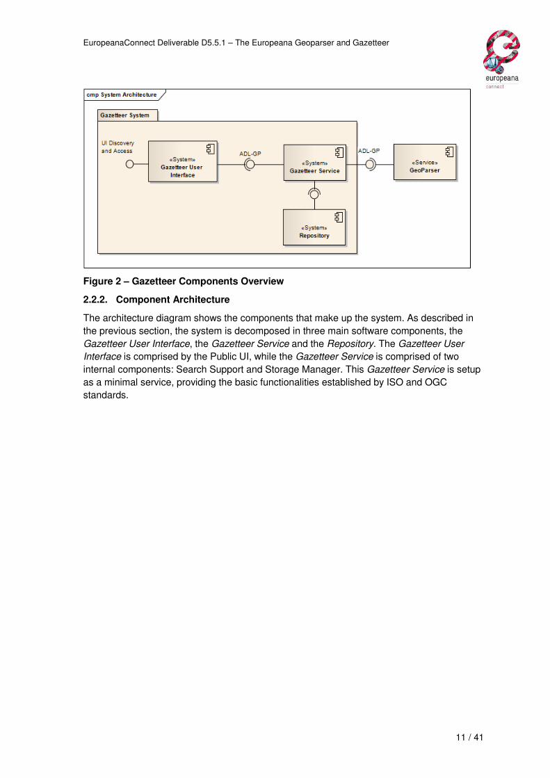
Figure 2 – Gazetteer Components Overview
2.2.2. Component Architecture
The architecture diagram shows the components that make up the system. As described in
the previous section, the system is decomposed in three main software components, the
Gazetteer User Interface, the Gazetteer Service and the Repository. The Gazetteer User
Interface is comprised by the Public UI, while the Gazetteer Service is comprised of two
internal components: Search Support and Storage Manager. This Gazetteer Service is setup
as a minimal service, providing the basic functionalities established by ISO and OGC
standards.

EuropeanaConnect Deliverable D5.5.1 – The Europeana Geoparser and Gazetteer
12 / 41
Figure 3 – The high level architecture for the gazetteer system
Component Description
Public User (interface) This is the human interface for the Gazetteer. It is
responsible for providing operations that require user
interaction searching for Features in the Gazetteer.
Administrative User (Interface) The Gazetteer administration interface. It provides the
authorized user with operations for managing the existing
content in the Gazetteer Repository.
Search Support Component responsible for handling the search requests
made either through the UI or through the REST interface
and processing them.
Storage Manager Handles all operations regarding access or altering data
into the Gazetteer Repository.

EuropeanaConnect Deliverable D5.5.1 – The Europeana Geoparser and Gazetteer
13 / 41
2.3. Gazetteer Implementation
2.3.1. Source Code
The source code of the Gazetteer is structured as two main Maven projects:
• gazetteer – Multi-module project. One of the modules (gazetteer-dist) builds a jar
containing all necessary modules for integration in other projects.
• gazetteerWebapp – Builds into a web application that makes the gazetteer
functionality available on the Internet, via a REST web services interface and a
human interface.
Both projects are available on Europeana Labs at:
• gazetteer - https://europeanalabs.eu/svn/contrib/gazetteer
• gazetteerWebapp - https://europeanalabs.eu/svn/contrib/gazetteerWebapp
2.3.1.1. Using the Gazetteer
The Gazetteer is divided into a multi-module project. Since its purpose is to serve as a stand-
alone service for browsing geographic features either through human interface or through
XML requests over HTTP, it requires deployment as a web-service to function properly. This
means it requires deploying the gazetteerWebapp project.
If you desire to fetch the Gazetteer in its entirety, there is a module (gazetteer-dist) that
builds a jar containing the complete project, in case you want to construct your own interface
for it.
2.3.1.2. Deploying the gazetteer web-app
The gazetteerWebapp is a web application that can be deployed in a J2EE application
server. It was tested on Apache Tomcat 6.x.
The war file is built using Maven, and then deployed according to the specific application
server’s instructions.
Regarding configuration, the web-service runs an install file gaz.install.xml that builds the
gazetteer classes. It should be specified in the deployment descriptor file WEB-INF/web.xml.
The only requirement that may need to be configured is the location of the two databases
used (gaz_record, which contains the xml feature data; and gaz_index, which contains
indexes for search performance) and the username and password to access them.
These entries are:
<bean id="eu.digmap.gaz.database" class="eu.digmap.gaz.database.DatabaseImpl">
<constructor-arg>
<bean class="org.apache.commons.dbcp.BasicDataSource" destroy-
method="close">
<property name="driverClassName" value="com.mysql.jdbc.Driver"/>
<property name="url" value="jdbc:mysql://...:3306/gaz_record"/>
<property name="username" value="..."/>
<property name="password" value="..."/>
...

EuropeanaConnect Deliverable D5.5.1 – The Europeana Geoparser and Gazetteer
14 / 41
</bean>
</constructor-arg>
And:
<bean id="eu.digmap.gaz.index" class="eu.digmap.gaz.database.DatabaseIndexImpl">
<constructor-arg>
<bean class="org.apache.commons.dbcp.BasicDataSource" destroy-
method="close">
<property name="driverClassName" value="com.mysql.jdbc.Driver"/>
<property name="url" value="jdbc:mysql://...:3306/gaz_index"/>
<property name="username" value="..."/>
<property name="password" value="..."/>
...
</bean>
</constructor-arg>
2.3.2. ADL-GP interface usage
The Gazetteer can be accessed via an XML over HTTP request interface and the
request/response protocol is the ADL-GP protocol.
Requests may be invoked using HTTP POST requests to the gazetteer base URL with the
required parameters, and all text encoded in UTF-8.
The current deployment of the Gazetteer, for demonstration purposes, has the base URL:
http://europeana-geo.isti.cnr.it/gazetteer (/services/gp is the servlet entry point for receiving
ADL-GP XML queries).

EuropeanaConnect Deliverable D5.5.1 – The Europeana Geoparser and Gazetteer
15 / 41
The base request format is shown in the following figure:
Figure 4 – Base format for a Gazetteer feature query
The query types can then be specified.
2.3.2.1. Query types
The following section describes the types of queries the system supports and some
examples.
A. Identifier Query
This simple query type fetches the feature, if existing, which matches with the
provided internal identifier as argument.
B. Name Query
This query type fetches the features whose name, being it primary or
alternative, matches with the provided text as argument, depending on the
matching operator provided as argument. Those different types of operators
may be:
a. “equals” – A name, in its entirety, matches the exact text;
b. “contains-all-words” – A name must contain all words specified in
the text, in no particular order;
c. “contains-any-words” – A name must contain at least one of the
words specified in the text;
d. “contains-phrase” – A name must contain the exact sequence of
words specified in the text
C. Class Query
This query type fetches the features whose classification matches the term
provided. The thesaurus used for search purposes is the ADL Feature Type
Thesaurus.
<identifier-query identifier="http://sws.geonames.org/299042/" />
<name-query operator="equals" text="lisboa" />

EuropeanaConnect Deliverable D5.5.1 – The Europeana Geoparser and Gazetteer
16 / 41
D. Relationship Query
This query type fetches the features that share a specified relation type with a
specified feature internal identifier. The relations covered are:
a. partOf – feature is contained within the area of target feature;
b. contains – feature contains target feature;
c. adjacentTo – feature has a frontier or border with target feature;
d. inCountry – feature is part of target country feature;
e. inContinent – feature is part of target continent feature;
These individual query types may be combined with one another in order to form more
complex queries.
2.3.2.2. Query Response
The XML response for any query request consists of a list of all search matches to the query
parameters. The following figure depicts its basic format:
Figure 5 – Base format for a gazetteer query-response
An example response follows:
<class-query thesaurus="ADL Feature Type Thesaurus" term="streams" />
<relationship-query relation="inCountry"
target-identifier="http://sws.geonames.org/2990440/"/>
<and>
<class-query thesaurus="ADL Feature Type Thesaurus" term="streams" />
<name-query operator="equals" text="Danube" />
</and>
EuropeanaConnect Deliverable D5.5.1 – The Europeana Geoparser and Gazetteer
17 / 41
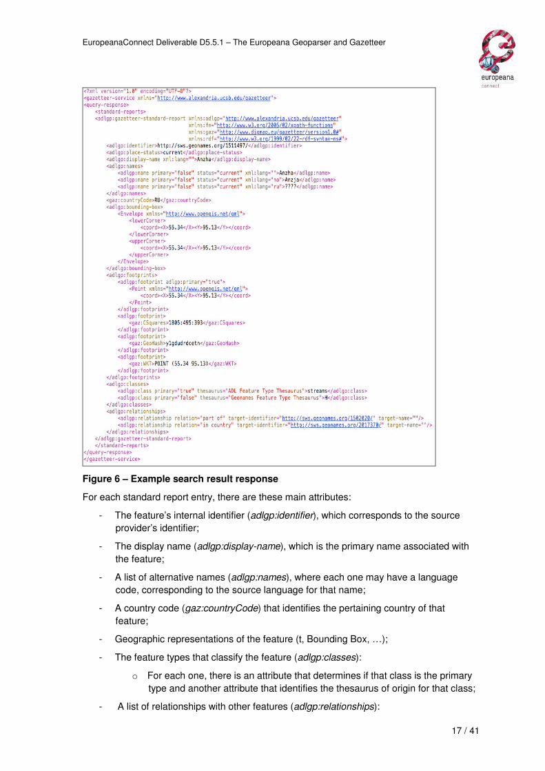
Figure 6 – Example search result response
For each standard report entry, there are these main attributes:
- The feature’s internal identifier (adlgp:identifier), which corresponds to the source
provider’s identifier;
- The display name (adlgp:display-name), which is the primary name associated with
the feature;
- A list of alternative names (adlgp:names), where each one may have a language
code, corresponding to the source language for that name;
- A country code (gaz:countryCode) that identifies the pertaining country of that
feature;
- Geographic representations of the feature (t, Bounding Box, …);
- The feature types that classify the feature (adlgp:classes):
o For each one, there is an attribute that determines if that class is the primary
type and another attribute that identifies the thesaurus of origin for that class;
- A list of relationships with other features (adlgp:relationships):

EuropeanaConnect Deliverable D5.5.1 – The Europeana Geoparser and Gazetteer
18 / 41
o For each one, there is an attribute that identifies the relationship type and
another that identifies the target feature identifier;
- Some other elements may be present, depending on the feature’s provenience, such
as Postal Codes, Population, external information articles (Wikipedia3, DBpedia4),
etc.
2.3.3. Human interface usage
Besides the web-service interface, there is a basic human interface for searching geographic
features.
Figure 7 – Main page
A user can then perform a quick search for a feature name, for which the following page is
produced:
3 http://www.wikipedia.org/
4 http://www.dbpedia.org/
EuropeanaConnect Deliverable D5.5.1 – The Europeana Geoparser and Gazetteer
19 / 41
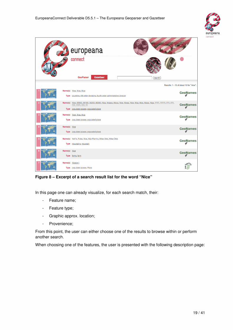
Figure 8 – Excerpt of a search result list for the word “Nice”
In this page one can already visualize, for each search match, their:
- Feature name;
- Feature type;
- Graphic approx. location;
- Provenience;
From this point, the user can either choose one of the results to browse within or perform
another search.
When choosing one of the features, the user is presented with the following description page:

EuropeanaConnect Deliverable D5.5.1 – The Europeana Geoparser and Gazetteer
20 / 41
Figure 9 – Description page of a selected feature
In this description page, one can see the structured information of a feature, divided into
groups:
- Registration – Contains information pertaining to the internal organizing of the
feature:
o ID – The feature identifier;
o Source – The data provider
- Description – Contains information that identifies the feature:
o Name – The primary name associated with the feature;
o Alternative Names: A list of the feature’s alternative names which may have in
brackets “()” the language code in which the feature is named;
- Classification – Contains a list of classifying terms for the feature;
- Data – Various information that describes the feature:
EuropeanaConnect Deliverable D5.5.1 – The Europeana Geoparser and Gazetteer
21 / 41
o Country Code – A two-letter code that identifies a country name, as defined
by the ISO 31665;
o Postal Code(s) – One or more series of letters and/or digits appended to a
postal address for the purpose of sorting mail [may not be present in all
features];
o Population – The approx. total population residing in the feature area [may not
be present in all features];
- Relationships – Contains information regarding connections between this feature and
others, regarding containment, proximity, among others;
- External Information – Contains links to other information articles or maps that add
more information regarding the feature and/or provide its contents in another
language [may not be present in all features];
- Geographic information – Contains positional information about the feature in the
form of geographic coordinates;
Below all this information are structured representations of the feature in several data types,
such as the ADL Content Standard6, Geonames ontology7 or KML8.
5 http://www.iso.org/iso/country_codes.htm
6 http://www.alexandria.ucsb.edu/gazetteer/ContentStandard/version3.2/GCS3.2-guide.htm
7 http://www.geonames.org/ontology/documentation.html
8 http://code.google.com/apis/kml/
EuropeanaConnect Deliverable D5.5.1 – The Europeana Geoparser and Gazetteer
22 / 41
3. Geoparser
Unstructured text, or semi-structured text (e.g. metadata records), may contain mentions to
places and historical periods that are not directly usable by software applications.
Geoparsing consists in automatically extracting structured information about places and time
periods from these textual resources.
The Geoparser is a web service that uses information extraction techniques to automatically
identify names of places and time periods that are mentioned in unstructured text. It works
together with the Gazetteer to be able to assign coordinates and dates with the mentioned
places and periods.
The target users of the Geoparser are Europeana and aggregators and data providers which
need to enrich the object descriptions by analyzing geographic or temporal references in
existing metadata records.
In this section a description of the Geoparser is provided, covering its specification, design,
implementation, usage and evaluation.
3.1. Functional specifications
This section presents the results of the functional requirements for the Geoparser.
3.1.1. Product Position Statement
For Europeana, aggregators and data providers
Who Who need to enrich the object descriptions by analyzing geographic or
temporal references in existing metadata records
Product name Geoparser
That It takes textual resources or metadata records as input. It identifies the
mentioned names of places and time periods, and assigns them
geographical coordinates or dates.
3.1.2. Stakeholders
Besides Europeana, the Geoparser may be of interest also for aggregators and data
providers who want to enrich their own data.
Name: Europeana - content ingestion
Description The content ingestion team of Europeana
Responsibilities To enrich the metadata records received from data providers, with
structured geographical coordinates and dates.
EuropeanaConnect Deliverable D5.5.1 – The Europeana Geoparser and Gazetteer
23 / 41
Name: Aggregators
Description Aggregators of digital objects for Europeana
Responsibilities To enrich the metadata records and textual resources with structured
geographical coordinates and dates.
Name: Data providers
Description Owners or hosts of digital objects
Responsibilities To enrich the metadata records and textual resources with structured
geographical coordinates and dates.
3.1.3. System Qualities
Quality Description
Usability The Geoparser is not intended for human use.
Reliability The system should recover from failed requests.
The system must be ready to respond under stress and adverse
conditions.
The system should be able to return the previous valid state and
continue ongoing operations in case of hardware or software failure.
Performance
No measurable performance requirements were identified for the
Geoparser.
User interfaces The Geoparser is not intended for human use. No user interface is
necessary.
Interfaces to
external systems
The Geoparser makes use of the Gazetteer, as its source of
geographical data and historical periods’ data. It uses the web service
interface of the Gazetteer.
Software
interfaces
An XML over HTTP interface (REST) to access the Geoparsing
service.
An application programmable interface (API) for embedding the
Geoparser in other applications.

EuropeanaConnect Deliverable D5.5.1 – The Europeana Geoparser and Gazetteer
24 / 41
3.1.4. System Constraints
Constraint Description
Operating
systems
Any OS supporting the Java virtual machine
Programming
language
Java 6
Build tool
Maven 2
Application server Apache Tomcat 6.x
3.1.5. Licensing Requirements
Available under dual licensing:
• European Union Public Licence – EUPL v.1.1
• GNU General Public License – GPLv3
3.1.6. Applicable Standards
The metadata format supported for geoparsing is Europeana Semantic Elements v3.39.
Geographic coordinates are encoded in signed decimal degrees, as used in the DCMI Point
Scheme10.
Dates are encoded according to the XML schema Date and Time format11.
3.1.7. Use cases
Figure 10 – Geoparser's use cases
9 http://group.europeana.eu/web/guest/technical-requirements/
10 http://dublincore.org/documents/dcmi-point/
11 http://www.w3.org/TR/2001/REC-xmlschema-2-20010502

EuropeanaConnect Deliverable D5.5.1 – The Europeana Geoparser and Gazetteer
25 / 41
Geoparse Europeana Metadata Record
Description Recognizing geographic or temporal references in descriptive fields of
the Europeana metadata records, and assignment of coordinates and
dates to the recognized references.
Actors Client application: a software client application
Preconditions None
Flow of events 1. The use case begins when the Client application submits a
Geoparsing request containing a metadata record.
2. The text is extracted from the descriptive metadata elements of
the record.
3. The geoparser passes the text to a named entity recognition
library that recognizes the geographic and temporal
references.
4. The geographic references are searched in the Gazetteer, and
coordinates are associated with the references.
5. The temporal references are searched in the Gazetteer, and
dates are associated with the references.
6. The response with the identified references is sent to the Client
application.
7. The use case ends.
Geoparse Free Text
Description Recognizing geographic or temporal references in free text, and
assignment of coordinates and dates to the recognized references.
Actors Client application: a software client application
Preconditions None
Flow of events 1. The use case begins when the Client application submits a
Geoparsing request containing the source text.
2. The Geoparser passes the text to a named entity recognition
library that recognizes the geographic and temporal
references.
3. The geographic references are searched in the Gazetteer, and
coordinates are associated with the references.
4. The temporal references are searched in the Gazetteer, and
dates are associated with the references.
5. The response with the identified references is sent to the Client
application.
6. The use case ends.
EuropeanaConnect Deliverable D5.5.1 – The Europeana Geoparser and Gazetteer
26 / 41
3.2. Geoparser Design
This section presents the main design aspects of the Geoparser software.
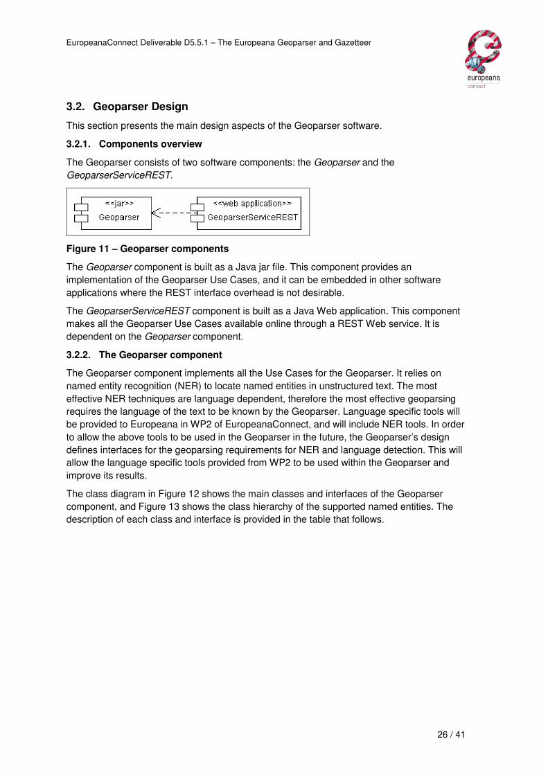
3.2.1. Components overview
The Geoparser consists of two software components: the Geoparser and the
GeoparserServiceREST.
Figure 11 – Geoparser components
The Geoparser component is built as a Java jar file. This component provides an
implementation of the Geoparser Use Cases, and it can be embedded in other software
applications where the REST interface overhead is not desirable.
The GeoparserServiceREST component is built as a Java Web application. This component
makes all the Geoparser Use Cases available online through a REST Web service. It is
dependent on the Geoparser component.
3.2.2. The Geoparser component
The Geoparser component implements all the Use Cases for the Geoparser. It relies on
named entity recognition (NER) to locate named entities in unstructured text. The most
effective NER techniques are language dependent, therefore the most effective geoparsing
requires the language of the text to be known by the Geoparser. Language specific tools will
be provided to Europeana in WP2 of EuropeanaConnect, and will include NER tools. In order
to allow the above tools to be used in the Geoparser in the future, the Geoparser’s design
defines interfaces for the geoparsing requirements for NER and language detection. This will
allow the language specific tools provided from WP2 to be used within the Geoparser and
improve its results.
The class diagram in Figure 12 shows the main classes and interfaces of the Geoparser
component, and Figure 13 shows the class hierarchy of the supported named entities. The
description of each class and interface is provided in the table that follows.

EuropeanaConnect Deliverable D5.5.1 – The Europeana Geoparser and Gazetteer
27 / 41
Figure 12 – High level design of the Geoparser
Figure 13 – Named entities class hierarchy

EuropeanaConnect Deliverable D5.5.1 – The Europeana Geoparser and Gazetteer
28 / 41
Class/Interface Description
Geoparser (interface) This is the interface for the Geoparser. It specifies the methods
for implementing all the Geoparser Use Cases.
GeoparserBase The base implementation of the Geoparser interface. It requires
an implementation for each of the NamedEntityRecognizer,
Gazetteer, PlaceNameResolver, and GeoparsingReasoner
interfaces. It orchestrates them to execute the geoparsing
methods.
NamedEntityRecognizer
(interface)
Interface for named entity recognition implementations. For
Geoparsing, implementations may only output Locations and
Time Periods. Other entity types may be in the output, and,
depending on the implementation of other interfaces of the
Geoparser, they may be used for some purpose or simply be
ignored.
LanguageIndependent-
NamedEntityRecognizer
An implementation of a NamedEntityRecognizer that relies only
on techniques for NER that are language independent, such as
capitalization of words, word position in the sentence, lists of
names of the entities, etc.
PlaceNameResolver
(interface)
Interface for implementations of resolvers of name places.
These resolvers take as input place names and try to geo-
reference them. When a resolution request contains more than
one place name, the resolver should assume that the place
names are related in some way (for example, they were found in
the same paragraph or the same metadata record). It should try
to use that information to find the most likely resolution for the
place names.
Gazetteer (interface) An interface for data sources of geo referenced place names
and time periods.
GazetteerEuropeana An implementation of the Gazetteer interface, which uses the
Europeana Gazetteer as a data source.
GazetteerGeonames An implementation of the Gazetteer interface, which uses the
Geonames web service a data source. Time periods are not part
of this data set.

EuropeanaConnect Deliverable D5.5.1 – The Europeana Geoparser and Gazetteer
29 / 41
PlaceNameResolverByH
euristic
An implementation of a PlaceNameResolver based on
heuristics. It uses a Gazetteer to query the place names and
obtain all the candidate locations for each place name. It
implements two different heuristics: one for resolving one single
place name, and one for resolving several place names
together. When resolving a single place name the heuristic
chooses the best candidate based on:
• Minimum edit distance of the place name to the name, or
one of the alternative names of the candidates.
• The population of the candidate. The higher the
population, the most likely it is to be the best candidate.
When resolving several place names, the heuristic chooses the
best candidate based on:
• Minimum edit distance of the place name to the name, or
one of the alternative names of the candidates.
• The population of the candidate. The higher the
population, the most likely it is to be the best candidate.
• The minimum geographic distance to the candidates of
the other place names.
• The minimum geographic area obtained when making a
polygon with the coordinates of the candidates of the
other place names.
GeoparsingReasoner
(interface)
Interface for implementations of the final reasoning of the
geoparsing process. Reasoners have access to all named
entities that have been recognized and also to all evidence that
was gathered to support the recognition and resolution of the
entity. Reasoners may exclude entities from the result or assign
them a confidence value.

EuropeanaConnect Deliverable D5.5.1 – The Europeana Geoparser and Gazetteer
30 / 41
GeoparsingReasonerRu
leBased
A rule based implementation of a GeoparsingReasoner. The
rules assign scores to each type of evidence, and calculate the
total score of the evidences found. Based on the score, the
named entity may be excluded from the geoparsing response (if
the score is too low) or the entity is included in the result (with a
confidence value assigned by the reasoner).
GeoparsingReasonerCl
assifier
A machine learning based implementation of a
GeoparsingReasoner. It is based on the Random Forest12
classification algorithm, and was trained from the training set
used for the evaluation of the Geoparser (described in Section
3.4).
NamedEntity A named entity found and processed in a geoparsing request.
TimePeriod A type of named entity that refers to a time period. May be a
named time period, such as XIX century, or a date, such as 25th
of December 1975.
Toponym A type of named entity that refers to a location. These entities
are found by the NamedEntityRecognizer and processed during
the rest of the geoparsing processing.
ToponymGazetteerEuro
peana
A specialization of the Toponym class, adapted to the
GazetteerEuropeana.
ToponymGeonames A specialization of the Toponym class, adapted to the
GazetteerGeonames.
Evidence A name-value pair containing any information that may be
relevant for reasoning on the correct recognition and resolution
of the entity.
3.2.3. The GeoparserServiceREST component
The GeoparserServiceREST component is built as a Java Web application. This component
provides a REST interface to the Geoparser, therefore it is dependent on the Geoparser
component.
12 Breiman, Leo (2001). "Random Forests". Machine Learning 45 (1): 5–32. doi:10.1023/A:1010933404324

EuropeanaConnect Deliverable D5.5.1 – The Europeana Geoparser and Gazetteer
31 / 41
Figure 14 – The GeoparserServiceREST component
Class/Interface Description
GeoparserServiceREST This class implements the controller of the Geoparser as
in the Model-View-Controler pattern. It allows all methods
of the Geoparser component to be exposed as a REST
web service.

EuropeanaConnect Deliverable D5.5.1 – The Europeana Geoparser and Gazetteer
32 / 41
3.3. Implementation
This section describes the implementation aspects of the Geoparser prototype. It describes
where the software can be found, how to deploy it, and how it can be used by other
applications either by integrating the Geoparser library or by using the REST web service.
3.3.1. Source code
The Source Code of the Geoparser is structured as two Maven projects:
• geoparserLib – Builds into a jar for integration in other projects.
• geoparserService – Builds into a web application that makes the geoparser
functionality available on the Internet, via a REST web services interface.
Both projects are available on Europeana Labs at:
• geoparserLib – https://europeanalabs.eu/svn/contrib/geoparser
• geoparserService – https://europeanalabs.eu/svn/contrib/geoparserService
3.3.2. Using geoparserLib
The geoparserLib may be integrated into other Maven projects by adding the following
dependency:
<dependency>
<groupId>europeana</groupId>
<artifactId>geoparserLib</artifactId>
<version>1.0</version>
</dependency>
The Geoparser requires a directory on the file system, which will be used for storing files
needed by the Geoparser. This working directory should already exist on the file system
when running the Geoparser, and its location is configured when requesting a Geoparser
instance.
The Geoparser is initialized via the following static method invocation:
europeana.geoparser.GeoparserFactory.newInstance(File workingDirectory, String europeanaGazetteerBaseURL)
The second parameter is the URL for accessing the web services interface of the
Gazetteer13. Please refer to the Gazetteer’s documentation for more information.
Refer to the europeana.geoparser.Geoparser java interface documentation for using the
Geoparser functionality.
13 At the time of writing of this document the base URL is
http://europeana-geo.isti.cnr.it/gazetteer/services/gp

EuropeanaConnect Deliverable D5.5.1 – The Europeana Geoparser and Gazetteer
33 / 41
3.3.3. Deploying the geoparserService
The geoparserService is a web application that can be deployed in a J2EE application
server. It was tested on Apache Tomcat 6.x.
The war file is built using Maven, and then deployed according to the specific application
server’s instructions.
Regarding configuration, the GeoparserService requires only the address of the Gazetteer. It
should be specified in the deployment descriptor file WEB-INF/web.xml, as an initialization
parameter of the controller servlet:
<servlet>
<servlet-name>Controller</servlet-name>
<servlet-class>europeana.geoparser.service.ControllerServlet</servlet-class>
<init-param>
<param-name>gazetteerBaseUrl</param-name>
<param-value>http://europeana-geo.isti.cnr.it/gazetteer/services/gp</param-value>
</init-param>
<load-on-startup>1</load-on-startup>
</servlet>
No further configuration is necessary since it automatically configures and creates the
working directory for the GeoparserLib to a location inside the web application directory:
“WEB-INF/tmp”.
3.3.4. The REST interface of the GeoparserService
Applications may use the Geoparser over a REST interface instead of integrating the
GeoparserLib jar.
The Geoparser REST interface makes available two types of requests: one for geoparsing
free text; and another for geoparsing Europeana metadata records.
Both requests may be invoked using HTTP POST of GET requests to the geoparsing base
URL with the required parameters, and all text encoded in UTF-8.
The current deployment of the Geoparser, for demonstration purposes, has the base URL:
http://europeana-geo.isti.cnr.it/geoparser.
3.3.4.1. Geoparsing free text
URL:
• <base_URL>/freeText
Parameters:
• “freeText” – The input text to geoparse encoded in UTF-8 (required)
• “language” – The language of the text (optional)
• “stylesheet” – A URL pointing to a XSLT stylesheet. The geoparser will add a
stylesheet processing instruction to the XML response (optional)

EuropeanaConnect Deliverable D5.5.1 – The Europeana Geoparser and Gazetteer
34 / 41
The XML response for this request list all entities recognized in the input text. It also presents
the input text with annotations on the recognized entities. An example response follows:
For the PLACE entities, the response contains the following data:
• entityURI – The URI that uniquely identifies the place in the Europeana Gazetteer.
• latitude – The latitude of the geographic centre of the place. In decimal degrees
(WGS 84).
• longitude - The latitude of the geographic centre of the place. In decimal degrees
(WGS 84).
• Name – The main name of the place.
• confidence – The confidence of the geoparsing result for the entity. A value from 0
(zero) to 1. It indicates the probability that the entity is indeed a place and that it was
resolved to the correct place.
For the TIME entities, the response contains the following data:
• entityURI – The URI that uniquely identifies the time period in the Europeana
Gazetteer.
• begin – The date when the time period begins. In ISO 8601.
• end – The date when the time period ends. In ISO 8601.
EuropeanaConnect Deliverable D5.5.1 – The Europeana Geoparser and Gazetteer
35 / 41
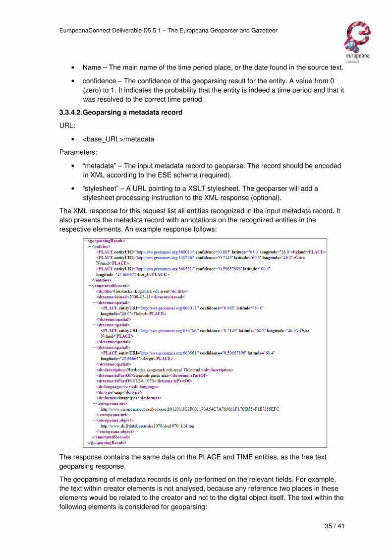
• Name – The main name of the time period place, or the date found in the source text.
• confidence – The confidence of the geoparsing result for the entity. A value from 0
(zero) to 1. It indicates the probability that the entity is indeed a time period and that it
was resolved to the correct time period.
3.3.4.2. Geoparsing a metadata record
URL:
• <base_URL>/metadata
Parameters:
• “metadata” – The input metadata record to geoparse. The record should be encoded
in XML according to the ESE schema (required).
• “stylesheet” – A URL pointing to a XSLT stylesheet. The geoparser will add a
stylesheet processing instruction to the XML response (optional).
The XML response for this request list all entities recognized in the input metadata record. It
also presents the metadata record with annotations on the recognized entities in the
respective elements. An example response follows:
The response contains the same data on the PLACE and TIME entities, as the free text
geoparsing response.
The geoparsing of metadata records is only performed on the relevant fields. For example,
the text within creator elements is not analysed, because any reference two places in these
elements would be related to the creator and not to the digital object itself. The text within the
following elements is considered for geoparsing:

EuropeanaConnect Deliverable D5.5.1 – The Europeana Geoparser and Gazetteer
36 / 41
• dcterms:temporal (geoparsed only for TIME entities)
• dcterms:spacial (geoparsed only for PLACE entities)
• dc: coverage
• dc:title
• dcterms:alternative
• dc:subject
• dc:description
• dcterms:tableOfContents
3.3.5. Connecting to the Gazetteer
Only the most relevant data about the recognized entities is provided in the Geoparser
response. The complete data is made available by the Gazetteer, which can be queried
using the entity URI given by the Geoparser. Please refer to the Gazetteer’s documentation
for more information.

EuropeanaConnect Deliverable D5.5.1 – The Europeana Geoparser and Gazetteer
37 / 41
3.4. Evaluation of the results
The results of the Geoparser were evaluated by two methods. The first method, by cross
validation, allowed to evaluate if the geoparsing reasoning, created by machine learning, was
generalizable to other data besides the evaluation collection. The second evaluation method
was to compare the results against those obtained by another existing Geoparsing service,
the Yahoo! Placemaker14.
An evaluation of the Geoparser was performed on a selected collection of ESE metadata
records. This collection was created by selecting records that contained place names that
exist on the Gazetteer data set. In order to have heterogeneous data, only up to 20 records
were selected from each data provider. This allowed the collection to have diverse languages
and metadata with different characteristics. A total of 752 records were selected for the
evaluation collection.
The evaluation collection was geoparsed by the two Geoparsers and the results of both were
inspected and annotated by a person. The manual annotation was sometimes uncertain,
because the metadata record may not contain enough information to enable a person to do
the annotations. Some sentences with place names may be too small and no other
information is available in the metadata record to support a decision, for example. So
annotation was performed according to the following criterion:
- Place names and named time periods were annotated with the identifier (an URI) of
the time period in the Gazetteer.
- Dates were annotated with a start and end date of the period they represent.
- If the annotator was not sure if a mentioned entity was a place, he would annotate it
as unknown. These annotations were not considered for the evaluation of the results.
- If the annotator was sure that a mentioned entity was a place, but could not know for
sure how to disambiguate it, it would be annotated as location_unknown. These
annotations were used only for testing the entity recognition phase of geoparsing,
and where not considered for the evaluation of the geoparsing results.
- If for any place name, the annotator was able to identify the country of the place but
was not able to disambiguate between alternatives within that country, he would use
its own judgement to choose the most likely one (the most populated, for example).
Although these annotations seam uncertain, they mimic the desired behaviour for the
Geoparser, so they were considered for the evaluation of the results.
- If a place name was not being used to refer to a place (for example if it is an
ambiguous word, or is the name of a person) it would be annotated as not_location.
These annotations were considered for the evaluation of the precision of geoparsing.
14 http://developer.yahoo.com/geo/placemaker/
EuropeanaConnect Deliverable D5.5.1 – The Europeana Geoparser and Gazetteer
38 / 41
- Similarly to places, if a time period name was not being used to refer to a time period,
it would be annotated as not_time, and were considered for the evaluation of the
precision of geoparsing.
In total, the evaluation collection contains 3811 annotated entity names, of which 2823 are
place names and 988 are time periods or dates.
3.4.1. Evaluation of the machine learning based geoparsing reasoner
The reasoning component of the Geoparser was trained on the evaluation collection. In order
to evaluate if it was not over fitted to the evaluation collection, we wanted to estimate how
accurately it would perform in practice. For this purpose, a cross-validation test was
performed.
The cross-validation test involves partitioning the evaluation collection into complementary
subcollections, training the random tree on one subset, and validating its results on the other
subset. Ten rounds of cross-validation were performed using different partitions, and the
validation results were averaged over the rounds.
For this evaluation, the following measurements were taken:
- Precision: the percentage of correctly identified entities in all entities found.
- Recall: the percentage of entities found compared to all existing entities.
- F1-measure: the weighted harmonic mean of precision and recall.
- F0,5-measure: the weighted harmonic mean of precision and recall, where precision is
weighted twice as much as recall.
The measurements were taken at five levels of minimum confidence given by the Geoparser.
They are shown in Figure 15 and Figure 16.
The results obtained allowed us to accept the machine learning based geoparsing reasoning
with confidence that its output is applicable to other data besides the evaluation collection.
The evaluation results also provide solid guidance for external applications that, when using
the Geoparser, need to choose a minimum confidence level, since to obtain very high levels
of precision, recall may lower considerably. Applications should choose the appropriate
confidence level for their own objectives.
Figure 15 – Measured precision and recall by cross-validation

EuropeanaConnect Deliverable D5.5.1 – The Europeana Geoparser and Gazetteer
39 / 41
Figure 16 – F1-measure and F0,5-measure results by cross-validation
3.4.2. Comparative evaluation of the Geoparser
To compare the results of the Geoparser against alternative solutions we have chosen to
evaluate and compare the geoparsing results of our solution against those obtained by using
the the Yahoo! Placemaker geoparser. This comparison was only possible to perform for
places, since Placemaker does not recognize time periods or dates.
For this comparison, the evaluation collection was geoparsed by both systems and the
results compared against those off the manual annotations. Also in this evaluation, the
values of precision, recall, F1-measure and F0,5-measure where calculated.
Analysis of the results shows that the Geoparser generally performed better on any
confidence level than Placemaker. F-measure and recall values where always higher for the
Geoparser, and in precision the Geoparser was only slightly lower on very low confidence
levels of 0,25.
Figure 17 – Precision and recall comparison between the Geoparser and the Yahoo!
Placemaker

EuropeanaConnect Deliverable D5.5.1 – The Europeana Geoparser and Gazetteer
40 / 41
Figure 18 – F-measure comparison between the Geoparser and the Yahoo! Placemaker
3.4.3. Evaluation for time periods
Evaluation of the geoparsing results for time periods was performed by comparing the results
of the Geoparser on the evaluation collection with the annotations done manually.
The evaluation collection turned out to be poor for this purpose, however. It contained only a
small amount of named time periods, and the great majority of references to time periods
where dates. For this reason, we measured precision, recall and F-measure at a minimum
confidence of 0,9 (Table 1).
Confidence level Precision Recall F1-measure F0,5-measure
0,90 0,975 0,91 0,941 0,916
Table 1 – Precision and recall evaluation result for time periods
Both precision and recall were high. However due to the limitations of the evaluation
collection, we consider the obtained values to be just an indicative.

EuropeanaConnect Deliverable D5.5.1 – The Europeana Geoparser and Gazetteer
41 / 41
4. Conclusions
This document described the specification, design, implementation, usage and evaluation of
two services developed to support other geographical and time based services in Europeana.
It is our belief that the developed and delivered systems are well implemented and satisfy the
corresponding requirements.
Next steps should now consist in its evaluation by Europeana, from which we expect to have
to revise small details (for which the IST will be available to assist until the end of the
project).
Meanwhile, it was proposed to provide a Search/Retrieval via URL (SRU)15 interface for the
Gazetteer. Since we believe this to be a straightforward implementation, it was taken into
consideration for an extra possible delivery of the Gazetteer’s software until the end of the
project (where we also might include other improvements suggested after Europeana’s
evaluation).
A pending issue is a suggested extension to the Geoparser to include a batch mode for
processing records, in order to accommodate processing entire datasets in a single
execution. This should be taken into account in a future development of the system.
15 http://www.loc.gov/standards/sru/