d g oean fones a n e s s s ocean frontiers ii
TRANSCRIPT

Discussion Guide | OCEAN FRONTIERS II: A New England Story for Sustaining the Sea
1
POST-SECONDARYDISCUSSION GUIDE
www.ocean-frontiers.org
Ocean Frontiers iiA New England Story for Sustaining the Sea

Discussion Guide | OCEAN FRONTIERS II: A New England Story for Sustaining the Sea
2
INTRODUCTION
Off the shores of New England, in a region steeped in old maritime tradition, comes a modern wave of big ships, energy industries and a changing climate, now testing the limits of an already crowded sea. But in a pioneering trial of far-sighted planning—pushed by blueprints for offshore wind energy—old residents and new are coming together to keep their ocean and livelihoods alive. New England’s experiences serve as an important milestone for all of us who care about the ocean.
The stories in Ocean Frontiers II: A New England Story for Sustaining the Sea help audiences understand key principles of coastal and marine spatial planning (ocean planning). The film showcases collaboration made possible by the Rhode Island Ocean Special Area Management Plan and the Northeast regional ocean planning process. These complex concepts come to life and are easy to grasp through the stories and people featured in Ocean Frontiers II.
This discussion guide was produced by the National Sea Grant Law Center and Green Fire Productions. It was developed to help educators incorporate Ocean Frontiers II into post-secondary classrooms and facilitate discussions on collaborative ocean planning and the future of our oceans.
Ocean Frontiers II: A New England Story for Sustaining the Sea was produced by Green Fire Productions. The film can be downloaded at no cost at: https://ocean-frontiers.org/resources. Two lengths are available: 28 minutes and 45 minutes. To learn more about the film series, explore the Ocean Frontiers website at https://ocean-frontiers.org. The series, including short clips, is also on Green Fire’s YouTube channel: www.youtube.com/user/GreenFireMedia
Additional post-secondary discussion guides, as well as secondary school lessons, are available for the entire Ocean Frontiers film series at: https://ocean-frontiers.org/educator-resources.
“Most of the laws and approaches that we have right now for marine resource management deal with the ocean
piecemeal. Fisheries deal with fishes one species at a time. We deal with economic sectors one at a time. And we know this is wrong. We do it this way because it’s simpler. If you
adjust shipping lanes so that they have minimal interference with marine mammals, the whale watch industry, the
boating industry, recreational fishing – they all benefit. So, the key to making marine spatial management efficient is to
back up and take a systems view.”
Les Kaufman, PhD. – Professor of Biology, Boston UniversityAll photos by Green Fire Productions, except where noted.

Discussion Guide | OCEAN FRONTIERS II: A New England Story for Sustaining the Sea
3
“BIG PICTURE” ISSUES
Ocean planning has been identified by scientists, policy makers and stakeholders around the globe as a practical approach to manage both conflicts and compatibilities in the marine environment in the face of both increasing development pressures and increasing interest and understanding of human interdependence on healthy ecosystems. It is a comprehensive, ecosystem-based planning process, built on sound science to analyze and plan for current and anticipated uses of the ocean. Pioneered in Western Europe, ocean planning is underway in more than 60 countries.
In the early 2000s two bi-partisan ocean commissions, the Pew Oceans Commission and the U.S. Commission on Ocean Policy, articulated a vision for comprehensive ocean governance in the United States, seeing a growing need to support stewardship,
Ocean Planning multiple use management and science-based decision making. Initial U.S. ocean planning efforts were local and state-based, with Massachusetts, Rhode Island, Oregon, Washington, New York and Connecticut creating state ocean plans for their coastal waters. Ocean planning has been used to reduce ship strikes on endangered whales outside of Boston Harbor by more than 80%, and the Florida Keys National Marine Sanctuary developed ocean plans to reduce conflicts among ocean stakeholders and to protect their coral reefs.
Ocean planning on a regional scale began as a result of the National Ocean Policy, established in 2010 by President Obama. This policy was the result of more than 10 years of work by scientists, policy makers and stakeholders, including ocean industries, coastal residents and conservationists. To implement ocean planning, nine ocean planning areas were designated in the U.S., mostly along large marine ecosystems. In 2016 the Northeast and Mid-Atlantic completed regional ocean plans and began implementing them in 2017. Other regions now have ocean plans in development.
In 2018 the White House revoked the National Ocean Policy, replacing it with one that emphasizes security and commerce over conservation and stewardship. The new policy shifts leadership of regional ocean planning to the states and allows for federal participation and data sharing to continue. With state leadership, ocean planning continues to move the U.S. away from an overly-simplistic issue-by-issue management approach toward comprehensive, informed and strategic ocean management.
Whale Center of New England, Photo taken under NOAA Fisheries Permit #981-1707

Discussion Guide | OCEAN FRONTIERS II: A New England Story for Sustaining the Sea
4
“BIG PICTURE” ISSUES
1. What are the different human activities that affect our coastal resources? Who are the stakeholders?
2. How are humans part of the ocean ecosystem? How might changes in the ocean ecosystem affect the economy or society and vice versa?
3. What types of information do managers need to effectively engage in ocean planning and ecosystem-based management? Is this information readily available? How might managers obtain it?
4. How might regional ocean planning help reduce conflicts over ocean uses? How might it help encourage compatible uses?
5. National policy for coastal management was set forth by Congress in the Coastal Zone Management Act of 1972. In 2010, President Obama laid out a national policy for our oceans through an executive order. Discuss the advantages and disadvantages of establishing national policy through the Executive Branch (as opposed to the Legislative Branch).
6. Discuss how stakeholder and local communities’ voices are included in regional ocean planning processes. How successful might the plans be without stakeholder input?
7. Discuss the likelihood of success of collaborative ocean planning. Research the current status of U.S ocean planning efforts to discover recent changes in ocean policy.
Ecosystem-Based Management Discussion Questions
Traditionally, management of ocean and coastal resources focused on a particular resource (e.g., fisheries) or issue (e.g., wetlands loss). With this type of management, the interconnections between species, habitat and other systems can be lost. Managers focusing on increasing the numbers of a target species might not notice the habitat degradation caused by the increase in population. Efforts taken to save one endangered species may increase predation on another, as seen with Steller sea lions and salmon in the Pacific Northwest.
Ecosystem-based management (EBM) is an integrated approach to management that considers the entire ecosystem, including humans. EBM shifts the focus away from managing the resource (sea lions or salmon) in isolation to managing the human uses (fishing or energy production) of the ecosystem in an integrated way, recognizing the complex and interconnected environmen-tal, economic and social impacts of management decisions. In addition, by broadening the scope of decision-making beyond a
single resource or issue, EBM facilitates the consideration of the cumulative impacts of mul-tiple human uses of the environ-ment.

Discussion Guide | OCEAN FRONTIERS II: A New England Story for Sustaining the Sea
5
• Pew Oceans Commissions Report, America’s Living Ocean
• U.S. Commission on Ocean Policy Report, An Ocean Blueprint for the 21st Century
• National Ocean Policy / National Ocean Council (Obama archives)
• National Ocean Policy, Executive Order 13,547 (July 19, 2010)
• Executive Order 13840 (June 21, 2018)
• NOAA - Coastal and Marine Spatial Planning
• Ecosystem-Based Management Tools Network
• Keep the Ocean Working
Regional Ocean Planning
• Northeast Ocean Planning | Northeast Ocean Plan
• Mid-Atlantic Ocean Planning | Mid-Atlantic Ocean Plan
• Mid-Atlantic Regional Ocean Assessment
• West Coast Regional Ocean Planning
• Pacific Islands Regional Ocean Planning
• Caribbean Regional Ocean Partnership
“BIG PICTURE” ISSUES
Resources
Florian Graner

Discussion Guide | OCEAN FRONTIERS II: A New England Story for Sustaining the Sea
6
The windy expanses of America’s Atlantic coast are estimated to possess the untapped power to supply the region’s entire needs for electricity, while cutting its greenhouse gas emissions by nearly 60 percent. But with the wind’s great promise comes the challenge of fitting this new energy industry amid an already crowded ocean—a challenge being met by a cadre of pioneering planners in Rhode Island.
RHODE ISLAND’S OCEAN SPECIAL AREA MANAGEMENT PLAN (SAMP)
When the Rhode Island Office of Energy Resources proposed a wind farm in waters off the coast of Rhode Island, community leaders and officials questioned how to plan for long-term use of common ocean resources, including fish stocks, transportation channels and the siting of offshore renewable energy facilities. In response, the state legislature issued funding and a two-year deadline for the development of the Rhode Island Ocean Special Area Management Plan (Ocean SAMP). The Ocean SAMP is a marine spatial planning tool that allows the state to use a balanced and comprehensive ecosystem-based management approach to the development and protection of Rhode Island’s ocean resources. The process engaged federal and state agencies, Native American Tribes, non-governmental organizations, industry leaders and recreational users to plan for multiple interests, including navigation areas, cultural sites, endangered marine mammal feeding areas, recreation areas, and spawning and nursery habitats off the coast of Rhode Island. Not all user groups were initially willing to participate. Commercial fishermen, for example, were reluctant to divulge their knowledge of fishing grounds but ultimately agreed to share them, as it gave them a say in protecting key
Overview
commercial fishing areas. The process identified current uses and key ecological and cultural marine features of the area. By looking at compatible uses, the plan was able to identify areas available for future development, like the Block Island Wind Farm. Rhode Island adopted the Ocean SAMP in 2010 and updated it in 2015 to reflect new scientific data and policies.
Discussion Guide | OCEAN FRONTIERS II: A New England Story for Sustaining the Sea
7
RHODE ISLAND’S OCEAN SPECIAL AREA MANAGEMENT PLAN (SAMP)
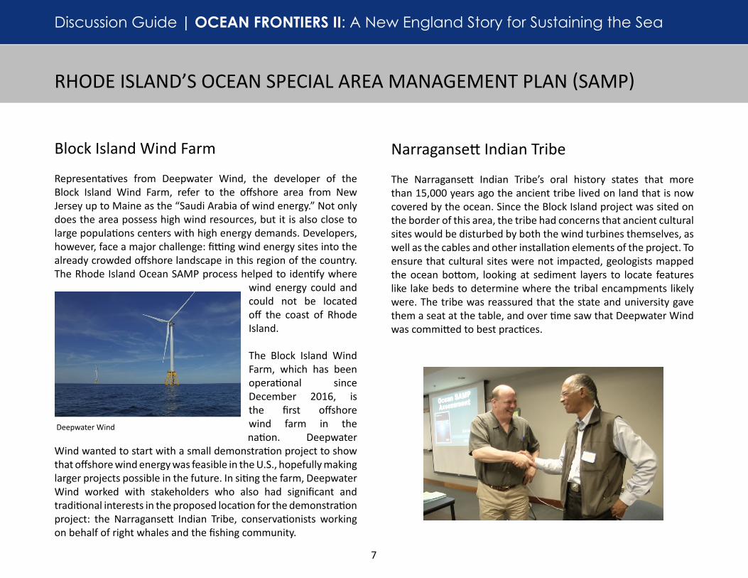
Representatives from Deepwater Wind, the developer of the Block Island Wind Farm, refer to the offshore area from New Jersey up to Maine as the “Saudi Arabia of wind energy.” Not only does the area possess high wind resources, but it is also close to large populations centers with high energy demands. Developers, however, face a major challenge: fitting wind energy sites into the already crowded offshore landscape in this region of the country. The Rhode Island Ocean SAMP process helped to identify where
wind energy could and could not be located off the coast of Rhode Island. The Block Island Wind Farm, which has been operational since December 2016, is the first offshore wind farm in the nation. Deepwater
Wind wanted to start with a small demonstration project to show that offshore wind energy was feasible in the U.S., hopefully making larger projects possible in the future. In siting the farm, Deepwater Wind worked with stakeholders who also had significant and traditional interests in the proposed location for the demonstration project: the Narragansett Indian Tribe, conservationists working on behalf of right whales and the fishing community.
Block Island Wind Farm
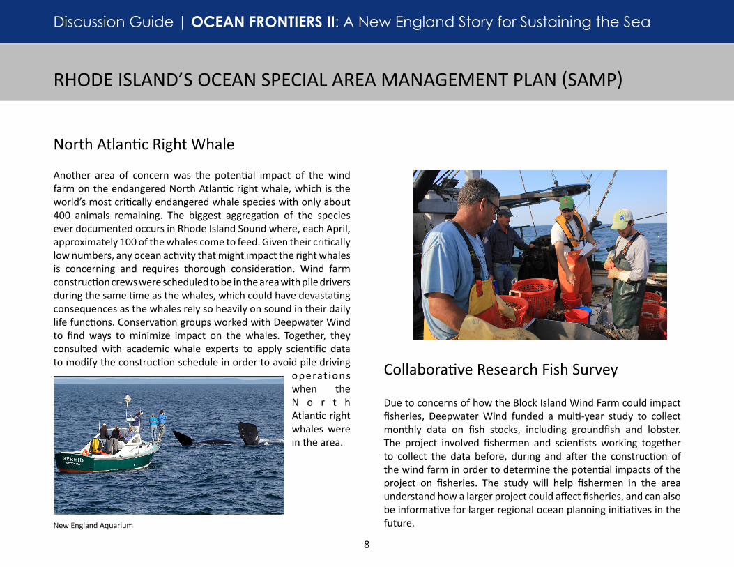
The Narragansett Indian Tribe’s oral history states that more than 15,000 years ago the ancient tribe lived on land that is now covered by the ocean. Since the Block Island project was sited on the border of this area, the tribe had concerns that ancient cultural sites would be disturbed by both the wind turbines themselves, as well as the cables and other installation elements of the project. To ensure that cultural sites were not impacted, geologists mapped the ocean bottom, looking at sediment layers to locate features like lake beds to determine where the tribal encampments likely were. The tribe was reassured that the state and university gave them a seat at the table, and over time saw that Deepwater Wind was committed to best practices.
Narragansett Indian Tribe
Deepwater Wind
Discussion Guide | OCEAN FRONTIERS II: A New England Story for Sustaining the Sea
8
RHODE ISLAND’S OCEAN SPECIAL AREA MANAGEMENT PLAN (SAMP)
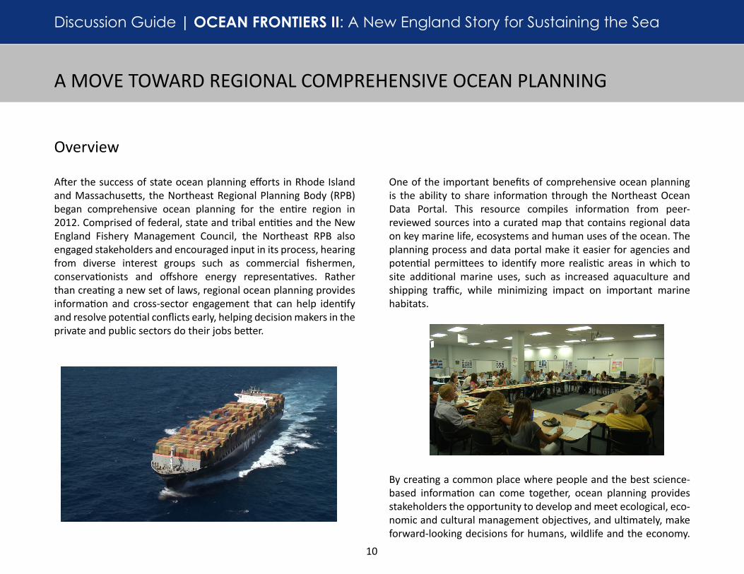
Due to concerns of how the Block Island Wind Farm could impact fisheries, Deepwater Wind funded a multi-year study to collect monthly data on fish stocks, including groundfish and lobster. The project involved fishermen and scientists working together to collect the data before, during and after the construction of the wind farm in order to determine the potential impacts of the project on fisheries. The study will help fishermen in the area understand how a larger project could affect fisheries, and can also be informative for larger regional ocean planning initiatives in the future.
North Atlantic Right Whale
Collaborative Research Fish Survey
Another area of concern was the potential impact of the wind farm on the endangered North Atlantic right whale, which is the world’s most critically endangered whale species with only about 400 animals remaining. The biggest aggregation of the species ever documented occurs in Rhode Island Sound where, each April, approximately 100 of the whales come to feed. Given their critically low numbers, any ocean activity that might impact the right whales is concerning and requires thorough consideration. Wind farm construction crews were scheduled to be in the area with pile drivers during the same time as the whales, which could have devastating consequences as the whales rely so heavily on sound in their daily life functions. Conservation groups worked with Deepwater Wind to find ways to minimize impact on the whales. Together, they consulted with academic whale experts to apply scientific data to modify the construction schedule in order to avoid pile driving
operat ions when the N o r t h Atlantic right whales were in the area.
New England Aquarium

Discussion Guide | OCEAN FRONTIERS II: A New England Story for Sustaining the Sea
9
1. Discuss the factors you think contributed to the success of the planning effort. What constitutes a successful planning effort? Would all stakeholders consider it successful?
2. Why is it important to have good science for decision-making?
3. What questions would you have if you were part of the process? What information do you think would be important to consider?
4. For successful planning, the plan had to incorporate stakeholder interests. Which groups were the most important to engage and why?
5. Why did Deepwater Wind engage with tribes, fishermen and conservationists early on in the process?
6. What was the importance of collecting the fish survey data before construction of the wind farm began?
7. What are the potential impacts to marine mammals from offshore energy development? What might be some ways to protect species when planning for offshore energy?
Discussion Questions
Resources
• Rhode Island Ocean SAMP
• Rhode Island Ocean SAMP Practitioner’s Guide
• Deepwater Wind
• Block Island Wind Farm
• The Narragansett Indian Tribe
RHODE ISLAND’S OCEAN SPECIAL AREA MANAGEMENT PLAN (SAMP)
• National Historic Preservation Act and Tribal Consultation
• North Atlantic Right Whale
• Marine Mammal Protection Act
• Endangered Species Act
• Local Knowledge and Strong Science Build Broad Support for the Block Island Wind Farm (INSPIRE Environmental)
Stellwagen Bank National Marine Sanctuary
Discussion Guide | OCEAN FRONTIERS II: A New England Story for Sustaining the Sea
10
A MOVE TOWARD REGIONAL COMPREHENSIVE OCEAN PLANNING
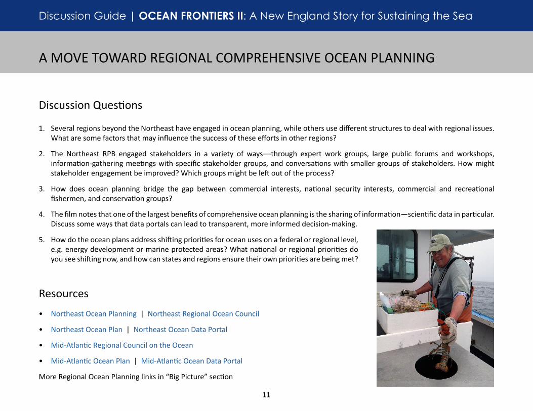
After the success of state ocean planning efforts in Rhode Island and Massachusetts, the Northeast Regional Planning Body (RPB) began comprehensive ocean planning for the entire region in 2012. Comprised of federal, state and tribal entities and the New England Fishery Management Council, the Northeast RPB also engaged stakeholders and encouraged input in its process, hearing from diverse interest groups such as commercial fishermen, conservationists and offshore energy representatives. Rather than creating a new set of laws, regional ocean planning provides information and cross-sector engagement that can help identify and resolve potential conflicts early, helping decision makers in the private and public sectors do their jobs better.
Overview
One of the important benefits of comprehensive ocean planning is the ability to share information through the Northeast Ocean Data Portal. This resource compiles information from peer-reviewed sources into a curated map that contains regional data on key marine life, ecosystems and human uses of the ocean. The planning process and data portal make it easier for agencies and potential permittees to identify more realistic areas in which to site additional marine uses, such as increased aquaculture and shipping traffic, while minimizing impact on important marine habitats.
By creating a common place where people and the best science-based information can come together, ocean planning provides stakeholders the opportunity to develop and meet ecological, eco-nomic and cultural management objectives, and ultimately, make forward-looking decisions for humans, wildlife and the economy.
Discussion Guide | OCEAN FRONTIERS II: A New England Story for Sustaining the Sea
11
Discussion Questions
1. Several regions beyond the Northeast have engaged in ocean planning, while others use different structures to deal with regional issues. What are some factors that may influence the success of these efforts in other regions?
2. The Northeast RPB engaged stakeholders in a variety of ways––through expert work groups, large public forums and workshops, information-gathering meetings with specific stakeholder groups, and conversations with smaller groups of stakeholders. How might stakeholder engagement be improved? Which groups might be left out of the process?
3. How does ocean planning bridge the gap between commercial interests, national security interests, commercial and recreational fishermen, and conservation groups?
4. The film notes that one of the largest benefits of comprehensive ocean planning is the sharing of information—scientific data in particular. Discuss some ways that data portals can lead to transparent, more informed decision-making.
5. How do the ocean plans address shifting priorities for ocean uses on a federal or regional level, e.g. energy development or marine protected areas? What national or regional priorities do you see shifting now, and how can states and regions ensure their own priorities are being met?
Resources
• Northeast Ocean Planning | Northeast Regional Ocean Council
• Northeast Ocean Plan | Northeast Ocean Data Portal
• Mid-Atlantic Regional Council on the Ocean
• Mid-Atlantic Ocean Plan | Mid-Atlantic Ocean Data Portal
More Regional Ocean Planning links in “Big Picture” section
A MOVE TOWARD REGIONAL COMPREHENSIVE OCEAN PLANNING