cumbria coastal strategy public engagement on draft
TRANSCRIPT

Cumbria County Council
Serving the people of Cumbria cumbria.gov.uk
Cumbria Coastal Strategy
Public engagement on draft strategy
Summary of feedback
January 2020
Working with:

Cumbria County Council
Serving the people of Cumbria cumbria.gov.uk
Contents 1 Introduction ........................................................................................................... 1
2 Public Engagement on draft strategy .................................................................. 2
3. Analysis of feedback ............................................................................................ 4
Next Steps ................................................................................................................. 5
Annex A ..................................................................................................................... 6
Annex B ..................................................................................................................... 7
Annex A: Log of Engagement Activity
Annex B: Summary of Findings and responses

Cumbria County Council
Serving the people of Cumbria cumbria.gov.uk
1
1 Introduction
Cumbria County Council is working with the Cumbria Coast Protection
Authorities and the Environment Agency to develop a strategy for the
future management of the coast from Arnside to the Scottish Border.
A coastal strategy is a plan that sets out how we will manage the risks related to
coastal flooding and erosion along our coastline over the next century. It is also
needed for us to get approval from the government for future flood and coastal risk
management schemes and to help get national funds to contribute to the cost of
defences.
This strategy forms a key step in setting out our future approach to managing risks
and will feed into our local plans.
It builds upon the policies set in the North West Shoreline Management Plan, which
was adopted in 2010, and will decide on the best approaches to carry out those
policies.
In some places, we will be recommending a change in Shoreline Management Plan
policy.
This document provides a summary of the findings from the public engagement
undertaken on the draft strategy between 14th November and 13th December 2019.

Serving the people of Cumbria cumbria.gov.uk
2 Public Engagement on draft strategy
2.1 Draft documentation for the engagement
All materials for the public engagement were made available on the project website:
https://cumbria.gov.uk/ccs/publicengagement.asp. This included a short leaflet, a
summary document, detailed technical reports for each of the 25 areas that the
Cumbria coast has been divided into for the strategy, technical reports on the
strategy economic and environmental assessments and the draft strategy action
plan. The leaflet, summary and action plans were also made available in the libraries
used for the options stage drop-in meetings that were held in autumn 2018.
The website included an online survey to collect feedback as well as a feedback
form that could be printed and returned by free post.
Information packs were distributed to County Councillors, Cumbria Association of
Local Councils and project partner organisations ahead of the engagement process.
The start of the public engagement was initially advertised through a Cumbria
County Council press release on 14th November 2019, see
http://www.yourcumbria.org/News/2018/haveyoursayonmanagingcumbriacoastline.a
spx.
The press release is reproduced below. Following this there were a number of
reports in the local press and on local radio. A detailed log of engagement activity is
provided in Annex A.
PRESS RELEASE, 14TH NOVEMBER 2019
14 November 2019
Have your say on managing Cumbria’s coastline
Local residents, businesses and visitors are being invited to have their say on a future strategy for managing Cumbria’s coastline, from Arnside to the Scottish border.
The strategy will set out the risks relating to coastal flooding and erosion along the Cumbrian coastline over the next century and recommend long term sustainable solutions.

Serving the people of Cumbria cumbria.gov.uk
Cumbria County Council is working with the Cumbria Coast Protection Authorities (District Councils) and the Environment Agency, to develop a strategy for the future management of the coast. The project is being funded by the Environment Agency.
Specific stretches of coastline were identified as requiring more attention and a public engagement on possible options was held in November and December 2018.
Comments and feedback have been taken into account and, after considering technical, economic and environmental factors, we are proposing a preferred strategic approach and future activities for each coastal frontage.
To ensure we fully understand and include the impacts on people, the local economy and environment, we are inviting people to have their say on how the coastline should be managed. The county council is launching a further round of public engagement on Friday 15 November and this will run until 13 December 2019.
Following this public engagement, the Cumbria Coastal Strategy will be finalised taking account of public feedback and any information provided. The final Strategy report is likely to be submitted for approval by the Environment Agency in Spring 2020.
Cumbria County Council would encourage people to get involved, look at what’s being proposed for our coastline and have their say to make sure we fully understand and include the impacts this has on people, the local economy and the environment.
More information on the Cumbria Coastal Strategy, and the proposed approaches and future activities recommended, together with a questionnaire, are available on the project website at www.cumbria.gov.uk/ccs/.
Serving the people of Cumbria cumbria.gov.uk
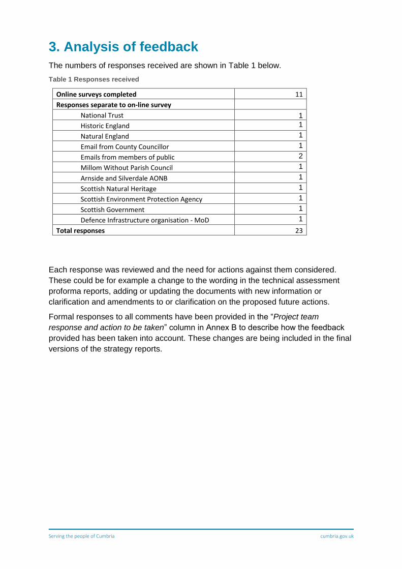
3. Analysis of feedback
The numbers of responses received are shown in Table 1 below.
Table 1 Responses received
Online surveys completed 11
Responses separate to on-line survey
National Trust 1
Historic England 1
Natural England 1
Email from County Councillor 1
Emails from members of public 2
Millom Without Parish Council 1
Arnside and Silverdale AONB 1
Scottish Natural Heritage 1
Scottish Environment Protection Agency 1
Scottish Government 1
Defence Infrastructure organisation - MoD 1
Total responses 23
Each response was reviewed and the need for actions against them considered.
These could be for example a change to the wording in the technical assessment
proforma reports, adding or updating the documents with new information or
clarification and amendments to or clarification on the proposed future actions.
Formal responses to all comments have been provided in the “Project team
response and action to be taken” column in Annex B to describe how the feedback
provided has been taken into account. These changes are being included in the final
versions of the strategy reports.

Serving the people of Cumbria cumbria.gov.uk
Next Steps
The next steps in the strategy development are as follows:
• Final updates to the strategy reports to take account of feedback from this
engagement
• Completing the final stages of the Habitat Regulations Assessment, including:
o development of a compensatory habitat creation plan to offset impacts
on the designated sites due to planned future works on the defences.
o Preparation of statement of case for agreement by Natural England
and sign-off by Defra
• Preparation of a summary business case for the strategy for submission to the
Environment Agency
• Adoption of the strategy by local authority partners and sign-off by other
partners
• Preparation of Post Adoption statement for the Strategic Environmental
Assessment
Further information on progress on these steps will be added to the project website,
https://www.cumbria.gov.uk/ccs/ .

Serving the people of Cumbria cumbria.gov.uk
Annex A
Log of engagement
Cumbria Coastal Strategy public engagement part 2 (Nov & Dec 2019) activity log
Engagement Activity Undertaken by Date Notes
Email & Information packs
sent to all CCC members CCC CCS Team 13/11/2019
Email & Information Packs
sent to CCC area teams CCC CCS Team 13/11/2019
Email & Information packs
sent to Project Review Group
members for distribution
CCC CCS Team 13/11/2019 PRG Members: Allerdale BCArnside and Silverdale AONBBarrow BCCarlisle City CouncilCopeland BCCumbria Wildlife Trust Environment Agency
Highways England
Historic England
Lake District National Park Authority
Low Level Waste Repository
Morecambe Bay Partnership
National Maritime Organisation
Natural England
Network Rail
Sellafield Ltd
Solway AONB
Solway Partnership
South Lakeland DC
United Utilities Ltd
Whitehaven Harbour Commissioners
Email & information pack
sent to all Parish and Town
Councils with coastline and
also CALC for distribution.
CCC CCS Team
13/11/2019,
14/11/19 and
reminder 5/12/19
Engagement summary
reports & questionnaires
sent to libraries CCC CCS Team 19/01/2019
Silloth, Workington, Whitehaven,
Millom, Barrow in Furness and
Grange over Sands libraries
Email & Information pack
sent to BAE and GSK.
CCC CCS Team
05/12/2019
Issuing of CCC press release
CCC Comms Team 14/11/2019
http://www.yourcumbria.org/News/
2018/haveyoursayonmanagingcumbr
iacoastline.aspx
Interview with CCC's Paul
Marriott on BBC Radio CCC CCS Team 10/12/2019
Social Media
Twitter: Issuing of CCC Tweet
(21,000 followers) CCC Comms Team 25/11/2019
10 retweets, 6 likes
CCC Facebook post CCC Comms Team 25/11/2019
7433 people reached, 506
engagements

Serving the people of Cumbria cumbria.gov.uk
Annex B
Detailed review of responses and actions required

Comments on Report? Unit area Policy Unit Unit NameResponse comment
OFFICIAL RESPONSE
Engagement Summary report Kent estuary 11c9 Arnside
I have been informed by Environment Agency officers that over the last few years there has been a build‐up of silt in the northern parts of Morecambe Bay. The River Kent estuary at Arnside has been particularly badly affected. The result of this is that the drainage ditches and dykes are not able to efficiently drain Arnside Moss, which floods far more often than it used to. Although there aren’t many dwellings on Arnside Moss, they are now being threatened by flood water for the first time since they were built over 50 years ago.
Section 11C9 of the Engagement Summary Report refers to many things in this area, but it does not address the need for continual monitoring of the effective operation of the sluice gates. Consideration should be given to some kind of management of the silt that is building up in the estuary. Clearly a dredging program for the whole estuary is out of the question, but some regular program of clearing silt away from the sluice gates that drain Arnside Moss should be compiled.
The detailed technical appraisal reports for the Kent Estuary, (11c8 and 11c9) recognises that in the Kent estuary there are issues with accretion of beach material and or saltmarsh build up restricting drainage in the discharge channels across the foreshore, reducing the gravity outflow, thereby affecting inland drainage (see 11c9 section 2.2.3). This is also an issue at a number of locations although Arnside Moss is not specifically mentioned. The action plan for the Shoreline Management Plan has an action for the outer Kent "Assess needs for intervention to manage land drainage in areas where saltmarsh accretion causes problems at outfalls. Undertake local survey to identify need for intervention." In the CCS this action has been included for a project for the outer Kent estuary, 11c9. The CCS technical reports and action plan will be revised to recognise this as a generic issue at a number of locations for both inner and outer Kent that needs to be managed by local inspections and silt management where justified.
Engagement Summary report 11c8.2 New Barns
Bullet 4. Should the risk to the access track increase, the AONB Partnership would like to be included in the discussions of possible options and the need for further studies. The Action Plan and technical appraisal report for 11c8 both already include AONB as a
supporting organisation for discussions about risk in 11c8.2. Words added into bullet 4 of the Engagement Summary report.
Engagement Summary report 11c8.4‘Ash Meadow…’ not just ‘Meadow’.
Typographic error to be corrected in Summary Report. Technical appraisal report for 11c8 already includes "Ash" in the title.
SEA and Engagement Summary report all all
The SEA covers designated and non‐designated (‘known’) archaeological assets but does not have any consideration of as‐yet unknown assets. It is also worth drawing to your attention that paleoenvironmental deposits are also considered archaeological assets and these are frequent along the North West coast and contain important information about people’s past environments, changes in relative sea level and climate change for example, as well as evidence of how people have affected and altered past environments. Therefore, it would be useful for the document to be amended to make reference to unknown archaeological assets as buried archaeology is not often known and much of it is discovered during development activities. This would ensure consistency between the summary and the SEA.
It has previously been noted in the Strategic Environmental Assessment (SEA) that there is a potential for buried archaeology throughout the extent of the Strategy area (see Section 3.6 of the SEA). Comments relating to the need to consider palaeo-environmental deposits will be captured in the SEA Post-Adoption Statement.
General comment
I have been visiting the Cumbrian coast for 50 years over this time I have seen many changes. We now have family who live there, it is important we protect the coast for future generations.I recently visited Cyprus who were having very similar erosion problems, their solution was to put a number of breaker walls out in the sea. This has a multitude of benefits, it will slow the break waters down to slow down erosion. It will be a great area to attract wildlife e.g. birds and molluscs etc. It also makes a bay type of area which is safer for swimming.I have attached a photo from Cyprus to show what I am trying to explain, you can see one of the walls out to sea. The walls were being constructed whilst we were there this did not reduce our enjoyment or disrupt the area to much.
Engineering options have been considered as part of the Cumbria Coastal Strategy in a case‐by‐case basis. This means that if an area is at risk of erosion, management options and potential structures were considered and assessed, and the ones not proven ideal were dismissed. Breakwaters (or break walls as stated on the comment) are structures sometimes placed in areas where wave action is causing erosion and beach recharge is then placed in the sheltered area created by the breakwaters to create new or larger beaches. These breakwaters work by trapping sediment between the shoreline and the structure (if enough sand is available), reducing erosion at the location, but potentially causing further erosion downdrift, as sediment is not arriving at those places anymore. Constructing offshore breakwaters and creating new or extended beaches is generally not very technically viable in Cumbria due to the large tidal range, strong currents and the limited need for creating larger tourist beaches.
In terms of any outstanding issues or concerns, we would welcome more information on how the progress of the strategy will be monitored and how the leading authorities will be held accountable for delivery.
The key project partners will sign up to the actions within the Strategy. Monitoring and ownership going forward is to be agreed, but CCC, the district councils, and the EA will all have a lead role in ensuring delivery of the Strategy. We expect that the Environment Agency will monitor delivery of the Local Authority and their own actions as part of their coastal overview role.
11c8 Heald Brow to Humphrey Head
11c8.1 Heald Brow to Frith Wood The National Trust support the recommendations Noted. No action required.
11c11 Outer Leven Estuary 11c11.2Leven viaduct to Canal Foot cottages
The National Trust support the recommendations Noted. No action required.
11c15 Walney Channel 11c15.3 Hindpool to Lowsy Point
“Discussion between Cumbria County Council, National Trust, Natural England, Barrow Borough Council and local property owners to consider further management of Lowsy Point. There may also need to be a slight amendment to the Shoreline Management Plan to cover any future works.” – These discussions are already underway and National Trust has provided partners and cabin holderswith a copy of the National Trust’s position statement for this area. This position statement confirms that National Trust are unlikely to support any works in relation to defences at Lowsy Point (either maintenance/repair of current defences or construction of new defences) and therefore a change in the current SMP2 policy. National Trust fully support the existing policy of No Active Intervention with the Do Nothing approach for all epochs of the SMP2.
Thanks your for the update. We will request a copy of the position statement and consider it when finalising the strategy report and proposed actions for this area.
11c16 Duddon Estuary 11c16.1 Lowsy Point to Askam Pier The National Trust support the recommendations Noted. No action required.
Cumbria Coastal StrategyDraft Strategy Engagement Responses November‐December 2019
Annex BDetailed review of responses and actions required Page 1 of 6

Comments on Report? Unit area Policy Unit Unit NameResponse comment
OFFICIAL RESPONSE
11d7 St Bees Head 11d7.1 St Bees Head The National Trust support the recommendations Noted. No action required.
11e1 St Bees to Whitehaven 11e1.1 St Bees Head to Saltom Pit The National Trust support the recommendations Noted. No action required.
11e1 St Bees to Whitehaven 11e1.2 Saltom Pit
“Colourful Coast Partnership (National Trust and Land Trust) is planning further investigations into the threat of cliff instability through cliff stability surveys.” – Funding is no longer available for these investigations through the Colourful Coast partnership or National Trust so this line will need to be removed from the strategy document. “Cliff stability surveys to investigate the current degree of threat of land sliding and to help inform a potential Shoreline Management Plan policy change” – National Trust agree that these surveys are essential in deciding the future of Saltom Pit and the responsibility of finding the funding and commissioning these studies lies with Copeland BC as the landowner.
Text will be amended on both technical appraisal report 18 and the summary report. Text was already included in the actions previously. Action plan will be updated to delete action.
11e1 St Bees to Whitehaven 11e1.3 Saltom Pit to Whitehaven The National Trust support the recommendations Note. No action required.
11e1 St Bees to Whitehaven 11e1.4 Whitehaven South Beach The National Trust support the recommendations Note. No action required.
We have a farm on the south west coast of Cumbria and during some major construction work we created a bund as sea defence it was done without much technical knowledge but using basic machines the project has been totally successful the idea is to create a defence that is not trying to stop the sea but to allow some degree of freedom without trying to stop it in it's natural movement this has been done with clayey material from a development on the farm but could be done with material from a recycling quarry much of the material once separated from reusable stone is ideal for such a construction and this material normally has to go to landfill, clay is a strong flexible material that only becomes unstable when wet to combat this clay can be treated with a Swiss product called consolid this stops the ingression of water, if you want to know more please contact me
No change to documents. This suggestion, although valid, should be considering during a scheme level, as this is when all the aspects relative to the scheme are considered and assessed: design, heights, widths, type of material, and so on.
11c16.8 Duddon Estuary
11c16.9 Millom Marshes
HRA 11e8 to Scottish Border
We note that although the documents available on the Council website include Appendix 3 ‐ HRA Screening Report, the full HRA has not yet been finalised. We would welcome any future opportunity to comment on the full HRA in the context of the SEA. We will ensure HRA is also shared with SNH once updated.
Environmental Report 11e8 to Scottish Border
Our previous comments have generally been addressed. This has helped to increase the consideration of issues and actions that span the Scotland‐England border with regard to coastal and marine nature conservation. We welcome the intention to take an “integrated, cross‐border approach”.
Thank you for the comments. No action required at this stage.
Environmental Report 11e8 to Scottish Border
The mitigation / management measures relating to nature conservation interests (ER page 66‐70) appropriately stress the importance of future monitoring, both geomorphological and ecological, and of coastal process modelling. This is pragmatic recognition of the uncertainty inherent in coastal management in a time of accelerating sea‐level rise. The need for an “estuary‐wide study looking at future gains and losses in marsh and flats across the whole of Solway” (a ‘key action’ for area 11e8 in the Options Development Report) is a highly important issue for the cross‐border coastal system and its designated nature sites.
Noted. No action required at this stage.
Environmental Report 11e8 to Scottish Border
There may be an opportunity to further develop such measures within the Strategy itself. The above proposal for an estuary‐wide study will need cross‐border partnership working before it can be progressed, but at this stage it should still be possible to explore: * how the various proposals for local monitoring and for modelling could be integrated and informed by the study * the potential timing of the study *and therefore how the findings of the study would inform and interact with the implementation of the many local Actions, in the areas closest to Scotland (especially 11e8).
Words added into the summary report.Action plan to be updated to include SNH as a supporting organisation.
1.Protec ng our residents from the risk of flooding is of key concern to the Parish Council. This means we are focussed on ensuring the safety of our residents and maintaining the current land usage without the constant threat of flooding. Changes of land use due to flooding could change the nature of this rural and agricultural based economy.
2.Your strategy to manage the above areas refers to “Hold the Line through a Do Minimum Risk based approach”. This approach which has a time frame of up to 20 years which does not provide sufficient re‐assurance that the current embankment is appropriately assessed as being “Future Proofed” by predicted changes to the climate – thus leading to a reactive strategy.
3.We are looking for a more robust assessment of the embankment given its age and its original design specification. There has been clear evidence of breaches of the embankment as tidal and weather conditions collide.
4.The DEFRA long term risk informa on also indicates the poten al flood plain and the severity of any significant breach.
The action plan, includes for collection of more detailed defence inspection data which would reduce uncertainty in defence condition, expected performance and need for repairs. The action plan also recommends investigations and consultation regarding the future management of the embankments beyond the 20 year hold‐the‐line policy in the Shoreline Management Plan.
Annex BDetailed review of responses and actions required Page 2 of 6

Comments on Report? Unit area Policy Unit Unit NameResponse comment
OFFICIAL RESPONSE
11d2
11d2.2 Selker and Eskmeals
How do you feel about the approaches and future activities recommended? We welcome the recognition of the priority for the road /beach interaction at Stubb Place and support the need for action to prevent damage to the road. The technical report is extremely disappointing in that the economic assessment is incomplete, therefore making both the optioneering and subsequent analysis inaccurate / inappropriate. No valuation has been included for the effect on local businesses which include Eskmeals MOD site ( a COMAH Tier 2 Site), several farms (loss of access to market, loss of feed delivery etc) and a large tourism related business at Eskmeals House. The £50k valuation included would be likely to be less than the cost of temporary repairs let alone the cost of permanent repairs or diversion of the road. Previous discussions have repeatedly raised this and local contact information to both CCC and Jacobs has been provided. Unfortunately, it seems that this has not been actively followed up and no significant changes to the report appear to have been made. The effects on residential housing (adjacent to the beach and at Monk Moors) i.e. both the immediate safety issue of emergency service access and the long term effect on property values if the road were breached, are not discussed. An accurate estimate of the costs of damage avoided/ true economic impact would improve the justification for action as proposed in 6b.1 and also the longer term aspiration of diverting the road along a less vulnerable route.
A meeting was held with the MoD and QinetiQ but unfortunately we were not able to obtain sufficient information from them to value the site in monetary terms to the national economy.The report makes it clear that the calculated benefits do not include the MoD / QinetiQ Eskmeals site and associated properties and that avoidance of loss of the site could potentially justify the costs of short term defence to the road and longer term realigning the road. The CCC Local Committee is keen to support improvements to this area although on the assumption that funding would be matched by Copeland BC and possibly Qinetiq.
11d2
11d2.2 Selker and Eskmeals
What do you think is the highest priority for the Cumbria Coast?11d2.2 option 6b.1 At Stubb Place the road is noted as having had regular episodes during storms when access northwards is not possible due to debris moved from the beach on to the road. This debris is the result of acknowledged erosion of the beach head which has continued for in excess of 30 years and shows no sign of producing a stable line. This erosion could in future remove the current line of the road , removing access for large vehicles to the area to the north including farms and the MOD facility at Eskmeals. Small vehicles would have access via Waberthwaite but this is subject to twice daily tidal flooding. It is known that several vehicles have had to be rescued this year after attempting this route when the tide was too high. Giving this a high priority is noted in the report, however the potential for losses to businesses and the safe access of residents to their homes should be properly assessed to make possible objective decision making in comparison with other areas of the coast.
Support for option 6b.1 noted. The CCC Local Committee is keen to support improvements to this area although on the assumption that funding would be matched by Copeland BC and possibly Qinetiq. Currently local area highways during high tides close the road to prevent access and assess readily following an adverse weather prior to opening.
11d2
11d2.2 Selker and Eskmeals
Do you have any other comments on the approaches and proposed activities?The Action Plan Document is just a list without any key to differentiate where several actions are proposed for a single stretch of several miles of coast. Nor does it define the responsible bodies for the actions to the lay person, it is just a set of meaningless initials. It doesn’t set out which the report considers a priority or which option is preferred where there are several options.
The Action Plan is not intended to be a list of options, it is a list of tasks that are to be prioritised subject to urgency and funding. People were asked to give their views on priority in the engagement survey and we have noted your response above, thank you.
11d2
11d2.2 Selker and Eskmeals
Any outstanding issues?Because the economic assessment is incomplete / inaccurate, then wrong / unfair decisions about where to spend the limited resources are likely to result. The feeling from many frustrated residents is that this is merely an expensive regurgitation of previous reports which had highlighted the same issues and that public money has been spent on more paper rather than being used for hard infrastructure to mitigate risk.
The MoD and QinetiQ have been asked again about valuation of and national importance of their site. If suitable data is obtained the economics table will be updated.
11c8.5 & part of 11c8.6
Arnside viaduct to Grange Over sands
How do you feel about the approaches and future activities recommended? 11cPU8.5 Disagree with the approach as there does not seem to be any that cover this area This area 11c8.5 Kent Viaduct to Holme Island was not defined as a priority unit for assessment
within Cumbria Coastal Strategy. This means that this area was not identified as having assets at urgent short‐term risk from coastal flooding or erosion, the current Shoreline Management Plan policy was not questioned in this area, and there were no significant opportunities to improve the environment and bring benefits to this area. The current SMP policy here in Hold the Line, which will keep managing risks to Furness Line, isolated properties, minor roads, golf course and the A590. The coastal defences at this location were identified as under responsibility of Network Rail.
11c8.5 & part of 11c8.6
Arnside viaduct to Grange Over sands
What do you think is the highest priority for the Cumbria Coast?11cPU8.5 If the current flooding is not addressed the railway line will be at risk as it is being undermined on the landward side of the track
See above.
The draft Action Plan does already include some proposed activities for this frontage, and this includes a possible project to address fluvial flooding caused by tidal locking and blockage of outfalls from saltmarsh accretion.
11c8.5 & part of 11c8.6
Arnside viaduct to Grange Over sands
Do you have any other comments on the approaches and proposed activities?All talk and no action at this stage! See above comment on action plan.
11c8.5 & part of 11c8.6
Arnside viaduct to Grange Over sands
Any outstanding issues?Immediate work required to keep Meathop road open as this is flooded for 4‐5 months each year. If not addressed will lead to loss of community facility (Grange Golf Club) and continued undermining of railway embankment.
The technical appraisal report will be updated to further note this issue.
Annex BDetailed review of responses and actions required Page 3 of 6

Comments on Report? Unit area Policy Unit Unit NameResponse comment
OFFICIAL RESPONSE
11c10.2, 11c10.3, 11c10.2.
Humphrey Head and Leven Viaduct
How do you feel about the approaches and future activities recommended?11c10.2, 11c10.3, 11c10.2. The Parish Council agree with the approach for these units, in particular 11c10.2 (Humphrey Head to Cowpren Point) which has been designated a priority area as requested by the Parish Council in the previous survey and this will protect the many businesses and farmland potentially at risk south of Flookburgh Village.
No action required
11c10.2 Humphrey Head to Cowpren Point.
What do you think is the highest priority for the Cumbria Coast?11c10.2 Humphrey Head to Cowpren Point. The area south of Flookburgh needs to be protected to prevent severe economic, social & historical impacts both on the local villages and further afield. The area includes major employers and historical sites. The area south of Flookburgh village comprises approximately 500 hectares of land which the Environment Agency state is at risk of flooding if defences are not maintained. This area includes the largest caravan site and the largest business park on the Cartmel Peninsula. It also includes 2 Scheduled Monuments and 7 Listed Buildings. There has been continual development and expansion of the businesses in this area.
The technical appraisal report for 11c10 already included most of the information described in this comment, but more detail will ne added within Section 2.2.2 Issues, constraints and opportunities.
11e2.8 to 11e2.10 Steel Works to The Howe
How do you feel about the approaches and future activities recommended?The Council agrees that Hold the Line is the appropriate approach in the short term, pending a review for exposed and less strategic areas of made ground which may be altered, subject to investigative work on possible contamination. The Council is concerned about the condition of the sea wall at the old Steel Works, and of the possible collapse of Derwent Howe by the failure to remediate the quarry workings on closure.
Condition of the seawall at the old Steel Works is already mentioned in Section 2.9 of technical Appraisal report 19. (11e2.8 and 11e2.9). Words will be added in the report for 11e2.10.
(11e2.4 ‐ 11e3.2) Harrington Parks and Risehow
What do you think is the highest priority for the Cumbria Coast?The rail line throughout 11e2 and 11e3 needs protecting effectively to maintain the rail link. 11e2.8 and 11e2.9 requires significant survey work, with defences holding the line to protect not just the developments on the Steel Works site, but also the low lying hinterland (all the way to Morrisons and Aldi), which is built on drained marshland. The area 11e.2.9 to 11e2.10 is compromised by the disused quarry workings, which have not been effectively re‐profiled and reclaimed following the closure of the quarry.
Noted. The importance of the railway line will be highlighted in the final strategy documents.
(11e2.4 ‐ 11e3.2) Harrington Parks and Risehow
Do you have any other comments on the approaches and proposed activities?The Council would have preferred a drop in session in Workington, which is actually the second largest coastal community in the county (with a shore line of 6 miles).
Noted. Although Workington wasn't one of the 5 locations for the drop‐ins at the options choice stage, following following correspondence, hard copies of the questionnaires and a copy of the Engagement Summary Report were placed in Workington Library for this engagement.
11e2.8 to 11e2.10 Steel Works to The Howe
Any outstanding issues?The Council continues to be concerned about the apparent lack of planning enforcement on the Steel Works wall and Derwent Howe, both of which have planning conditions putting the financial risk on developers, which does not seem to have been enforced.
Words will be added into the technical appraisal report to mention the planning conditions.
where the railway line goes
11e2.2 ‐ 11e2.4
How do you feel about the approaches and future activities recommended?11e2.2‐4 Something needs doing to make the railway line speed limit able to be raised. It seems very poor to have a railway line with a permanent 20 mph? speed limit and very much restricts train travel options due to the time required to get to Carlisle. Train travel to and from the area would become a considerably more attractive option with an upgraded railway line.
Noted. Speed restriction issues had previously been included in technical appraisal report for this area (no 19). Speed restrictions at this frontage is due to risk of cliff falls and flooding risk from wave overtopping. Network Rail recognised this area as a priority.
11e7.4 Saltcoats to Cardurnock
What do you think is the highest priority for the Cumbria Coast?Landowners should be actively encouraged and part funded to maintain and in places strengthen sea defences to protect homes and infrastructure not left abandoned or managed retreat
Words will be added to the Action Plan activity for this area to include managing risks to homes and infrastructure.
11e7.4 Saltcoats to Cardurnock
Do you have any other comments on the approaches and proposed activities?Managed retreat is a lazy and dangerous mentality to have when cost effective options are available to maintain coastal land and habitats
No changes proposed to documents. There are not believed to be formal defences managed by either the EA or local authority in this area. Note that due to the multiple national and international designations changes in land management, such as changes to drainage or informal embankments would require consent.
11e7.4 Saltcoats to Cardurnock
Any outstanding issues?yes ‐ EA are not a helpful organisation in rural areas as has been highlighted in Doncaster lately ‐ inept and only interested in urban areas. Misguided and inaccurate policies and it discriminates rural dwellers unfairly
The Cumbria Coastal Strategy is not able to change national policy or priorities. The government is proposing a new approach to Environmental Land Management payments in the Agriculture Bill 2020.
11d1 Hodbarrow Point and Haverigg
How do you feel about the approaches and future activities recommended?Haverigg 11d1 . My group was one of the original stakeholders back in 2008 and have continued to be involved in all the stages of the SMP and CCS. We have always pressed for the continued maintenance of the sea defences at Haverigg. We are pleased that our views have been taken on board and that our homes will be protected where possible.
No action required.
Annex BDetailed review of responses and actions required Page 4 of 6

Comments on Report? Unit area Policy Unit Unit NameResponse comment
OFFICIAL RESPONSE
11d1 Hodbarrow Point and Haverigg
What do you think is the highest priority for the Cumbria Coast?11d1 Haverigg is vulnerable to any increase in tide heights as the village and farm land would be inundated if the sea defences were to be breached or overtopped. Much of the village including my house has a floor height below the height of spring tides, which are only held back by the sea defence.
Noted. The importance of the existing defence to Haverigg will be highlighted in the final strategy documents.
11d1 Hodbarrow Point and Haverigg
Do you have any other comments on the approaches and proposed activities?Please identify yourselves when monitoring the condition of the sea defences so that local fishermen and the Coastguard can participate.
Noted. Cumbria County Council and partner authorities to consider when implementing the Strategy.
11d1 Hodbarrow Point and Haverigg
Any outstanding issues?CCS should have a better public profile. Very few people knew about your "drop in " in Millom last November and no details of this consultation have come to Millom for this consultation yet..
Comment Noted. Cumbria County Council did contact all coastal parish councils to raise awareness of the engagement, as well as issue a press release, post on social media, and give an interview on BBC Radio Cumbria.
c08 Heald Brow to Humphrey Head
11c8.4
How do you feel about the approaches and future activities recommended?11c 08.4. "Agree way forward for Kent estuary viaduct footpath/cycleway". This has been ongoing for years. The way forward is easy, get it done. It would help connect both sides of Morecambe bay for walker's and cyclists providing a physical link that would be an attraction to both locals and tourists. In the age of green transport and sustainability this link is an obvious choice and should be instigated as soon as possible. £50K was awarded as a "feasibility study" this time last year and since then nothing has been heard. I'm sure that the public would like to know where that £50K has gone!
Noted. Placing a cantilevered structure on the Kent Viaduct has been subject to a number of studies. The £50,000 referenced was awarded by the Department of Culture, Media and Sport to the Morecambe Bay Partnership to construct a business case for the proposal, which is still in development. The project has been identified as an aspirational project in the Cumbria Cycling Strategy 2017‐22. The proposal faces some significant engineering and financial challenges. Funding the proposal would require national funding, the business case is required to determine if the projects represents good value for money.
Selker ‐ Eskmeals ‐ Ravenglass
How do you feel about the approaches and future activities recommended?Come off it ‐ a public consultation where you want us to provide all the technical cross referencing ... !? In Selker Bay, Stubb Place, Eskmeals etc. I am heartened to see that your recommendations actually involve looking to do SOMETHING, as the last time I had any dealings with CCC, your intention was to let the road at the beach wash away and leave us with just the tidal flooded estuary road for access. Had you done something earlier, there wouldn't have been any problems now! You need to provide funding to maintain the DIY defences at Eskmeals beach that have effectively stopped the erosion. You also need to invest in a couple of Groynes for Eskmeals Beach and southwards towards Selker Point and that will probably safeguard the beach and road for decades to come. We don't need much money spending on us ‐ just some simple, tried and tested, old school methods.
Frontage is noted as a priority for the strategy but funding is a problem. No changes proposed to documents.
Selker ‐ Eskmeals ‐ Ravenglass
What do you think is the highest priority for the Cumbria Coast?Protect the railway! Noted. The importance of the railway line will be highlighted in the final strategy documents.
Selker ‐ Eskmeals ‐ Ravenglass
Do you have any other comments on the approaches and proposed activities?Please don't fall into the trap of thinking that solutions have to be new and shiny / expensive. Please remember basic Victorian methods such as Groynes. Our patch of coastline could be significantly protected for decades with a few tens of thousands of pounds.
Noted, but no changes to documents proposed.
Selker ‐ Eskmeals ‐ Ravenglass
Any outstanding issues?I am concerned that I only heard about this on a local newspaper website today 16Nov19, despite the fact that I was one of those involved in the hard fought battle to reclassify Eskmeals from the stupidity of "No active intervention" to the much more sensible "Managed Retreat" a few years back. Please ensure that you email me with all coastal consultations in the future. Sod the EU and GDPR ‐ I need to know what's being proposed for where I live!
Noted. Cumbria County Council and partner authorities to consider in future engagement for the frontage.
Flookborough to Barrow
How do you feel about the approaches and future activities recommended?I really feel it should be made beautiful like Grange and attract more tourism but also protect wildlife and visiting birds and species as very important area. Looks really run down and neglected in these areas Noted. Value of tourism to the area to be highlighted in final strategy documents.
Flookborough to Barrow
Do you have any other comments on the approaches and proposed activities?Attract bird watchers, fishermen, schools and nature groups stay at specialist observation centres and invest in area over 20 year plan making conservation area for tourism. I also think the windfarms are ugly and development and design of new more attractive and better more efficient wind farm harvesting should be encouraged. The universities and artists should be commissioned in line with the Eden Project in Morecambe bay. Surely we could have beautiful multifunctioning wind harvesting platforms that were sculptures and would attract people from all over to see them for attracting tourism? Incorporate windmills, new styles that generate energy of their own based on design, homes for wildlife too, lookout stations etc ‐ real lack of vision
Noted as enhancement opportunities for schemes, but no changes to strategy documents required.
Flookborough to Barrow
Any outstanding issues?The wildlife and balancing local peoples needs ‐ so much suicide ‐ people around there need hope and jobs for the future ‐ need exciting investment and things they can engage with ‐ put Barrow etc back on the map for the right reasons
Partner authorities to note comment, but no changes proposed to strategy documents at this stage.
Annex BDetailed review of responses and actions required Page 5 of 6

Comments on Report? Unit area Policy Unit Unit NameResponse comment
OFFICIAL RESPONSE
C16 Duddon Estuary
11c16.5 Kirkby‐In‐Furness
How do you feel about the approaches and future activities recommended?11c16.5 Kirkby‐In‐Furness (priority Unit) I broadly agree with the approach, but believe the wait for a 'study' to "improve understanding of the level of risk..... " etc is very concerning. If 22 residential properties are already classified in the document as VERY SIGNIFICANT RISK of flooding, this poses the question as to what more 'understanding' of the situation is needed!
The levels of risk to the railway and to properties are still in need of further understanding, given that the standard of protection provided by the railway embankment is currently unknown. In addition, acceptable levels of risk needs to be agreed given the current scenarios of future sea level rise and high uncertainty in future changes, specially considering the migration of a tributary river channel at this location, causing erosion.
C16 Duddon Estuary
11c16.5 Kirkby‐In‐Furness
What do you think is the highest priority for the Cumbria Coast?All areas where 'very significant risk of flooding to properties' as in 11c16.5 is multiple in number, has already been identified No changes to documents required, properties at risk already used in prioritisation.
C16 Duddon Estuary
11c16.5 Kirkby‐In‐Furness
Do you have any other comments on the approaches and proposed activities?Most timescales are SO far in the future, that they do little to allay the fears of those who's properties are likely to flood time and again. Noted, but no changes to documents proposed at this stage.
C16 Duddon Estuary
11c16.5 Kirkby‐In‐Furness
Any outstanding issues?The comment that the plan is subject to 'funding'‐this makes a mockery of having undertaken the process and making the extensive recommendations! The reports are not easily readable, which makes responding to this questionnaire very difficult, and means flipping backwards and forwards trying to make sense of what is being asked in terms of comments. My suspicion is that the whole process will be shelved on the grounds of cost, other than the parts NR HAS to undertake owing to the trainline being unable to function unless some erosion issues are dealt with.
Funding is currently an issue across all areas of the English coast, as government partnerships changed in the last few years. At some communities, private funding is secured and then a scheme can be planned and implemented. This coastal strategy was undertaken due to a recognised need to "do something". The strategy can be used to support bids for funding and to promote project partners, including Network Rail to work together on partnership projects.
Cumbria Coastal Strategy: Strategic Environmental Assessment and MCZ Assessment
all
We have provided comments in relation to the strategy’s previous iterations and consultations, specifically we have made a number of recommendations in relation to the Habitats Regulations Assessment (HRA). We have also attended project steering group meetings. We have no further comments to make in relation to the strategy options and recommendations or the main body of the SEA. We do however have comments to make in relations to the MCZ assessment presented as appendix 4 of the SEA.
Noted. Habitats Regulations Assessment work is ongoing.
MCZ Assessment Solway Firth MCZDetailed comments provided, advised that the site had now been designated and so should not have been screened out. Assessment should include consideration of Smelt feeding and breeding. Comments noted, MCZ assessment report will be updated.
MCZ Assessment Cumbria Coast MCZ Detailed comments provided regarding assessment of high energy intertidal rock sites. Comments noted, MCZ assessment report will be updated.
MCZ Assessment Allonby Bay MCZDetailed comments provided regarding assessment of intertidal rock sites, honeycomb worm (Sabellaria) reef assessment and the need for more detailed assessment at scheme level. Comments noted, MCZ assessment report will be updated.
SEA Environmental report allWe are pleased to note that the issues we raised in regard to the previous draft of the ER have been addressed in this updated ER and as such we have no further comment to make on the ER. Noted, no action required.
Engagement Summary report Stubb Place 11d2.2
We welcome the continued status of Policy Unit 11d2.2 as a priority unit and the proposed works to provide protection to the nationally important Eskmeals Ranges. We have previously submitted details of the importance of this site for national security and defence purposes. We similarly welcome the proposals in respect of the Stubb Place recommendations .
Noted, no action required.
Engagement Summary report, Action Plan and Proforma
Stubb Place 11d2.2
In respect of the Eskmeal MoD Range recommendations we note a requirement to “Liaison between QinetiQ and MoD, Natural England and LDNPA regarding future management of Eskmeals Range frontage to ensure impacts on adjacent designated sites are considered appropriately”. Historically the maintenance of the shingle bank has been carried out by Qinetiq as required, usually following storms that result in the bank being washed away. The MoD has concerns about the recommendation to liaise with NE and LDNPA prior to these works being carried out. Clarification is required as to what this means in practice. We would prefer to see a recommendation that requires liaison with these organisation within the first recommendation, namely “QinetiQ to develop management options and beach management plan to proactively manage the frontage to ensure risks to the site are minimised” and would suggest adding “….in liaison with NE and LDNPA” to the end of this recommendation and deleting the third bullet altogether
Noted. Documents have been updated with the following words: “QinetiQ and MoD to develop management options and beach management plan to proactively manage the frontage to ensure risks to the site are minimised including liaison with Natural England and Lake District National Park Authority to ensure impacts on adjacent designated sites are considered appropriately.”
Annex BDetailed review of responses and actions required Page 6 of 6