cultural patterns and chronology in the · pdf filein the northern sacramento river drainage ....
TRANSCRIPT

CULTURAL PATTERNS AND CHRONOLOGY
IN THE NORTHERN SACRAMENTO RIVER DRAINAGE
Elaine Sundahl Shasta College Archaeology Lab
Redding, CA 96049
ABSTRACT
Prior to the late 1960s almost all prehistoric cultural remains known in the northern end of the Sacramento Valley and surrounding mountains were assigned to a single cultural complex and dated within the past 1,000 years. A considerable accumulation of archaeological data within the past 25 years has led to an extensive elaboration of regional prehistory which is divided into 5 temporally and/or spatially discrete patterns spanning the past 8,000 years. This paper, one of a group of regional summaries presented on the occasion of the 25th anniversary of the Society for California Archaeology, reviews archaeological investigations and describes the cultural patterns and chronology as they are presently interpreted.
INTRODUCTION
A considerable amount of data has been collected on the prehistoric hunters and gatherers of the northern Sacramento Valley and surrounding mountainous areas in the 50 years since systematic archaeological investigation began in this area. The greatest strides have been toward the primary goal of archaeology, that of establishing local chronologies, with some success in the second goal, the reconstruction of the "ethnographies of extinct cultures" (Sanders and Marino 1970:3).A few attempts have been made toward the third goal, the investigation of the "conditions and forces influencing cultures, and the dynamic relationships between cultures and their natural environments" (Moratto 1984:xxxiv).
The complex pattern of Native American ethnolinguistic groups within the study area reflects in part the complex geologic and environmental patterns and, in part, the differing cultural histories which are coming to light through the pursuit of archaeological and linguistic stUdies. Allor portions of 3 ethnolinguistic groups resided in the study area which extends from Mt. Shasta southward to Red Bluff and from the crest of the North Coast Ranges eastward to the crest of the Southern Cascades. The wintu occupied the southwestern and largest portion, including the Sacramento Valley, the foothills and mountains to the west, and the foothills to the north (DuBois
89
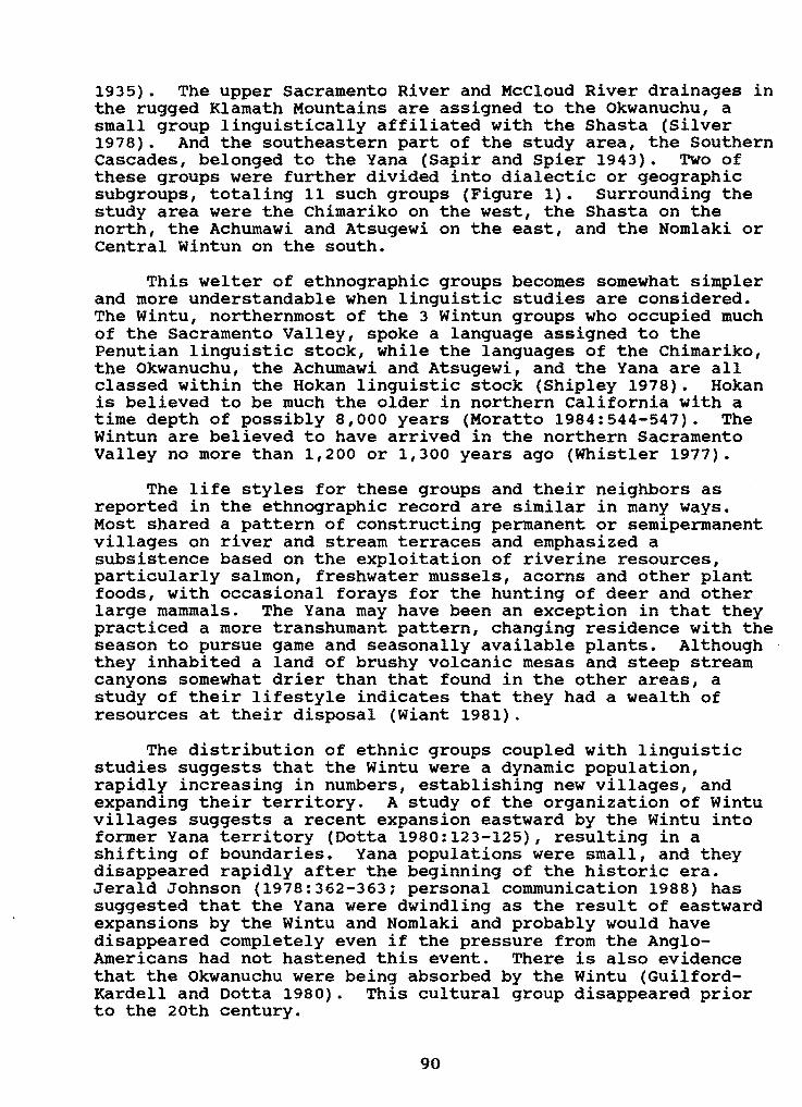
1935). The upper Sacramento River and McCloud River drainages in the rugged Klamath Mountains are assigned to the Okwanuchu, a small group linguistically affiliated with the Shasta (Silver 1978). And the southeastern part of the study area, the Southern Cascades, belonged to the Yana (Sapir and Spier 1943). Two of these groups were further divided into dialectic or geographic subgroups, totaling 11 such groups (Figure 1). Surrounding the study area were the Chimariko on the west, the Shasta on the north, the Achumawi and Atsugewi on the east, and the Nomlaki or Central wintun on the south.
This welter of ethnographic groups becomes somewhat simpler and more understandable when linguistic studies are considered. The Wintu, northernmost of the 3 wintun groups who occupied much of the Sacramento Valley, spoke a language assigned to the Penutian linguistic stock, while the languages of the Chimariko, the Okwanuchu, the Achumawi and Atsugewi, and the Yana are all classed within the Hokan linguistic stock (Shipley 1978). Hokan is believed to be much the older in northern California with a time depth of possibly 8,000 years (Moratto 1984:544-547). The wintun are believed to have arrived in the northern Sacramento Valley no more than 1,200 or 1,300 years ago (Whistler 1977).
The life styles for these groups and their neighbors as reported in the ethnographic record are similar in many ways. Most shared a pattern of constructing permanent or semipermanent villages on river and stream terraces and emphasized a sUbsistence based on the exploitation of riverine resources, particularly salmon, freshwater mussels, acorns and other plant foods, with occasional forays for the hunting of deer and other large mammals. The Yana may have been an exception in that they practiced a more transhumant pattern, changing residence with the season to pursue game and seasonally available plants. Although they inhabited a land of brushy volcanic mesas and steep stream canyons somewhat drier than that found in the other areas, a study of their lifestyle indicates that they had a wealth of resources at their disposal (Wiant 1981).
The distribution of ethnic groups coupled with linguistic studies suggests that the Wintu were a dynamic population, rapidly increasing in numbers, establishing new villages, and expanding their territory. A study of the organization of Wintu villages suggests a recent expansion eastward by the wintu into former Yana territory (Dotta 1980:123-125), resulting in a shifting of boundaries. Yana populations were small, and they disappeared rapidly after the beginning of the historic era. Jerald Johnson (1978:362-363; personal communication 1988) has suggested that the Yana were dwindling as the result of eastward expansions by the Wintu and Nomlaki and probably would have disappeared completely even if the pressure from the AngloAmericans had not hastened this event. There is also evidence that the Okwanuchu were being absorbed by the Wintu (GuilfordKardell and Dotta 1980). This cultural group disappeared prior to the 20th century.
90

\ ~
;I~
" J'
" I;--;;
t, #
\;f,."~ .;~ ~ '~~.,'
':r;!i, ,
,.:;:;
"-"" ,,""-, s_
'- rttIrmrttlnt StreQ'ft
Contour "'IO",al 500 Fee. o 0 20 30.,......... =
t<ilornt,.r.
Figure 1. Distribution of ethnic groups within the study area; (map from Johnson and Theodoratus 1984b).
91

ARCHAEOLOGICAL INVESTIGATIONS
Redding Area The archaeological record provides many parallels to
ethnographic and linguistic studies. The earliest systematic archaeological investigations within the study area were performed by archaeologists from the University of California at Berkeley and California State University at San Francisco in preparation for proposed dams and were concentrated along the major river and creek terraces. Large numbers of sites were recorded in what later became Shasta Lake (Smith and Weymouth 1952) and the Whiskeytown Reservoir (Treganza and Heicksen 1960) and in the proposed Redbanks Reservoir near Red Bluff (Treganza 1952, 1954). sites were usually ashy middens located on the river and stream terraces and often contained housepits, large quantities of fire-cracked rock, mussel shells, and obsidian and other lithic debitage. A few sites in these areas were tested, and the results along with surface collections produced a homogenous assemblage containing: small projectile points later termed the Gunther Series and Desert Side-Notched types, both assumed to have been used as arrow points; drills of several styles: large chert blades associated with burials; arrowshaft smoothers: hopper mortars: pestles: spire-lopped Olivella beads; clamshell disk beads: Haliotis pendants: and pine-nut beads. This assemblage was termed the Shasta Complex (Meighan 1955:3233), dated within the past 1,000 years, and in many cases was explicitly associated with the ethnographic Wintu (e.g., Smith and Weymouth 1952:29-30: Treganza and Heicksen 1960:42).
Additional reconnaissance work on the terraces of the Sacramento River and Cottonwood Creek has been extensive, and numerous excavations have been performed on similar midden sites (Clewett and Sundahl 1981: Dotta 1964: Dotta and Hullinger 1964: Farber and Neuenschwander 1984; Jensen 1980; Johnson and Skjelstad 1974; Johnson and Theodoratus 1984a, 1984b; Sundahl 1982: Woolfenden 1970). These more recent excavations have revealed many features, most notably semi-subterranean house floors generally about 3 m in diameter and 1 m-diameter baking ovens. A large complement of bone tools, particularly tips for composite harpoon points, has been added to the assemblage. Recent analysis of the mussel shells from Sha-47, a Shasta Complex site on the Sacramento River in Redding, demonstrated that mussels were being collected in the late summer and early autumn (data on file at the Shasta College Archaeology Laboratory), and an analysis of faunal materials recovered from Sha-266 indicates that villages were occupied year-round (George 1981; cf. Figure 2). Obsidian studies document that Tuscan was by far the predominant source used in these sites, usually constituting over 90% of the obsidian. Grasshopper Flat/Lost Iron Wells obsidian is the only other major source represented. Obsidian hydration values are <3.0 microns on Grasshopper Flat/Lost Iron Wells obsidian and <2.0 microns on Tuscan obsidian for Shasta Complex sites.
92

) north
20 miles
CA-Sha-288 •
CA-Sha-192
• CA-Teh-1490~---~---,-----t~
RED BLUFF
Sites
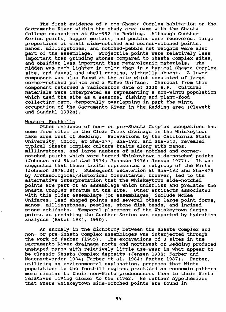
Figure 2. Selected archaeological sites within the northern Sacramento Valley and surrounding mountains.
93
The first evidence of a non-Shasta Complex habitation on the Sacramento River within the study area came with the Shasta college excavation at Sha-992 in Redding. Although Gunther Series points, hopper mortars, and pestles were recovered, large proportions of small side-notched and corner-notched points, manos, millingstones, and notched-pebble net weights were also part of the assemblage. Projectile points were relatively less important than grinding stones compared to Shasta Complex sites, and obsidian less important than metavolcanic materials. The midden was much lighter in color than in a typical Shasta Complex site, and faunal and shell remains, virtually absent. A lower component was also found at the site which consisted of large corner-notched points and a McKee Uniface. charcoal from this component returned a radiocarbon date of 3330 B.P. Cultural materials were interpreted as representing a non-Wintu population which used the site as a seasonal fishing and plant-food collecting camp, ·temporally overlapping in part the wintu occupation of the Sacramento River in the Redding area (Clewett and Sundahl 1982a).
western Foothills Other evidence of non- or pre-Shasta Complex occupations has
come from sites in the Clear Creek drainage in the Whiskeytown Lake area west of Redding. Excavations by the California state University, Chico, at Sha-177, Sha-192, and Sha-543, revealed typical Shasta Complex culture traits along with manos, millingstones, and large numbers of side-notched and cornernotched points which were termed Whiskeytown side-notched points (Johnson and Skjelstad 1974: Johnson 1976: Jenson 1977). It was suggested that these traits represented a subgroup of the wintu (Johnson 1976:28). Subsequent excavation at Sha-192 and Sha-479 by Archaeological/Historical Consultants, however, led to the alternative interpretation that the Whiskeytown side-notched points are part of an assemblage which underlies and predates the Shasta Complex stratum at the site. Other artifacts associated with this older assemblage (or assemblages) include McKee Unifaces, leaf-shaped points and several other large point forms, manos, millingstones, pestles, stone disk beads, and incised stone artifacts. Temporal placement of the Whiskeytown Series points as predating the Gunther Series was supported by hydration analyses (Baker 1984, 1990).
An anomaly in the dichotomy between the Shasta Complex and non- or pre-Shasta Complex assemblages was interjected through the work of Farber (1985). The excavations of 3 sites in the Sacramento River drainage north and northwest of Redding produced unshaped manos with relatively little use-wear in what appear to be classic Shasta Complex deposits (Jensen 1980: Farber and Neuenschwander 1984: Farber et ale 1984: Farber 1987). Farber, utilizing an environmental explanation, proposes that Wintu populations in the foothill regions practiced an economic pattern more similar to their non-wintu predecessors than to their Wintu relatives living closer to the river. He further hypothesizes that where Whiskeytown side-notched points are found in
94
association, these represent phases within the Wintu Shasta complex (Farber 1985, 1987).
Other than the sites in the Whiskeytown area summarized above there has been little excavation on the eastern slopes of the North Coast Ranges. Two exceptions include Sha-288 on Clear Creek near French Gulch and Sha-279 near Platina. The excavation of Sha-288 on Clear Creek by James Dotta under the auspices of the Shasta County Historical Society has never been fully reported, but 3 pages of artifact sketches are included in notes edited by Robert Edwards (1968:Figures 7-8). Cultural materials from this site are notable in that they include large numbers of incised stones, large contracting stem points and McKee Unifaces, and manos and millingstones. This assemblage was provisionallydated between 4000 and 3000 B.P. and assigned to the Northern Millingstone Complex.
Sha-279 was excavated by California State University in 1989, and the final report is still in progress. A deep cultural deposit was found which produced evidence of multicomponentsrepresented by Borax Lake projectile points, several notched point styles, and Gunther Series points (Kowta 1989; Russell Bevill, personal communication 1990).
Northern and Eastern Foothills Moving eastward to the area northeast of Redding and south
of the pit River, an excavation of Sha-286 on a terrace of North Cow Creek in Bella vista was conducted by James Dotta. The site produced cultural materials believed to be older than 1000 B.P. Designated the Bella vista Complex, the assemblage featured such traits as large corner-notched and side-notched points, pestles, bowl mortars, and other groundstone, including stone rings and stone balls (Edwards 1968:Figures 5-6). This excavation was never fully reported, and most of the information and artifacts are now lost, but it provides a brief glimpse of previously unknown cultural traits for the area.
The Shasta College archaeology program devoted a total of 8 field seasons to the archaeological testing of sites in the Clikapudi drainage, in the Sugarpine Canyon area of Backbone Ridge, in Jones Valley Creek, and in the Salt Creek drainage, all located northeast of Redding and south of the pit River. All of these site areas contained components similar in age to the Shasta Complex, but several also contained cultural materials which appear to be more closely affiliated with the MillCreek and Dye Creek complexes of the Southern Cascades. This, along with the excavation of Sha-992 in Redding, led Clewett and Sundahl (1982a, 1982b, 1982c) to propose an additional culture construct for the area which they named the Tehama Pattern. This pattern is characterized by an assemblage containing: fairly large proportions (generally more than 50%) of small side- and corner-notched points in addition to the Gunther Series projectile points: manos and millingstones, in addition to hopper mortars; and notched pebble net weights. It was proposed that
95

this assemblage represents the continuation of a transhumant sUbsistence pattern which coexisted with the more sedentary, river-oriented Shasta Complex pattern in the upper Sacramento valley.
Earlier cultural materials were found in these sites as well. The oldest component in the Clikapudi drainage, dated approximately 4000 B.P., consists of large contracting-stem points and McKee Unifaces, manos, millingstones, pestles, and bowl and slab mortars (Clewett and Sundahl 1982b). succeeding this was a component characterized by numerous large corner- and side-notched points and dated approximately 3000 to 1600 B.P. Materials of this type were found not only at Clikapudi, but also in the Jones Valley, Sugarpine Canyon, and Salt Creek areas (Clewett and Sundahl 1982b; Sundahl and Clewett 1985, 1991; Sundahl 1986). Noting a shift away from the use of obsidian from the Grasshopper Flat/Lost Iron Wells geochemical source in the Medicine Lake Highlands in favor of the local Tuscan source, Sundahl (1984) proposed that the Clikapudi-Backbone Ridge area was included within the territory of the Achumawi until they were replaced by the Yana approximately 2,000 years ago. The Yana in turn were pushed southeast from the pit River by the wintu perhaps about 500 or 600 years ago (Clewett and Sundahl 1982b).
Squaw Creek Drainage In 1971 Shasta College began a long-term commitment to
fieldwork in the Squaw Creek drainage, located in the Klamath Mountains north of the pit River. Excavations were focused at Sha-475, which has an extraordinarily deep and rich cultural deposit, extending to a depth of more than 3 m. The deepest component is characterized by Borax Lake style projectile points, entirely made of obsidian, a unique artifact believed to be an atlatl weight, unshaped manos, and millingstones. Charcoal from immediately beneath 1 millingstone produced a radiocarbon date of 6530 B.P. Other radiocarbon dates obtained from this lowest component at Sha-475 are 6870 B.P. and 7580 B.P. (Clewett and Sundahl 1983). Obsidian hydration measurements on artifacts from this component have been a disappointment, however. Micron values for the Borax Lake projectile points for the most part are identical to those from the middle component, even though they are fairly separate stratigraphically. This discrepancy is not yet explained, but it may be related to the extreme depth and dampness of the deposit, leading to cooler temperatures, which in turn may retard the rate of hydration in the lowest levels (Henn and Sundahl 1988).
The next major component found at Sha-475 is characterized by large contracting stem points, now termed the Squaw Creek Series, leaf shaped points, McKee Unifaces, abundant cobble spalls, millingstones, and manos, many of them extensively shaped. Obsidian hydration values on GF/LIW obsidian are between 3.9 and 5.3 microns. A single radiocarbon date for this component at Sha-475 is 4000 B.P. A series of large cornernotched and side-notched points were added to the assemblage
96

around 3000 B.P.
A thin upper component, beginning about 1500 B.P., is represented by small side-notched and corner-notched points, and Gunther series and triangular points, all believed to have been used with the bow and arrow. Hopper mortars and pestles and large quantities of fire-cracked rock are part of the upper component (Clewett and Sundahl 1983).
In 1988, Shasta college began excavations at Sha-499, the Chirpchatter Site, located approximately 400 m downstream on Squaw creek. It features a cultural sequence similar to that at Sha-475, but is only 1.7 m deep, about half as deep as the latter site. The obsidian hydration sequence appears to be much more interpretable than that from Sha-475 in that it patterns as would be expected relative to depth and typology. Obsidian from the Borax Lake levels at Chirpchatter produced hydration values on GF/LIW obsidian of 4.8 to 7.2 microns, averaging 5.6 microns. Hydration values for the levels bearing McKee Unifaces range between 3.7 and 5.4 microns, those for the side- and cornernotched points between 3.1 and 3.8 microns, and values on Gunther Series points were 1.7 and 1.9 microns. Averages are 4.8 microns, 3.6 microns, and 1.8 microns, respectively (Sundahl 1990:52) .
Upper Sacramento River Drainage A 21 km section of the upper Sacramento River canyon was
surveyed as part of Caltrans' planning process for the realignment of Interstate 5, and 18 prehistoric sites were recorded (Sletteland 1982a, 1982b). Seven of these sites were tested (Raven et ale 1984) and data recovery projects conducted at 4 (Basgall and Hildebrandt 1989). The latter study resulted in the development of a 3-part culture sequence for the project area with dating in large part based on obsidian hydration. Oldest in the sequence is the Pollard Flat Phase, dated 5300 to 2700 B.P. and characterized by Squaw Creek contracting Stem points, McKee Unifaces, manos, millingstones, numerous cobble spalls and incised stone artifacts. The Vollmers Phase is characterized by side-notched and corner-notched points named the Clikapudi Notched Series, manos and millingstones, notched stone net weights, core and cobble tools, an emphasis on non-obsidian materials, and large hearth or roasting oven features. This phase is dated between 4500 and 1700 B.P. Latest in the sequence and dated within the past 1,900 years is the Mosquito Creek Phase represented by Gunther points. This phase is minimally represented in the project area (Basgall and Hildebrandt 1989:202).
The 1,800-year overlap between the Pollard Flat and Vollmers phases is explained by posing 2 different popUlations with different adaptations. Using Binford's (1980) hunter-gatherer settlement systems, the investigators see the Pollard Flat phase as representing a residential base with a generalized foragertype system developed by a group with northern, montane-forest
97

affinities, while the Vollmers Phase represents populations maintaining base camps mainly to the south of the project area. The Mosquito Creek Phase occupation is seen as residentially oriented, yet of limited temporal duration (Basgall and Hildebrandt 1989:444-451).
Southern Cascades Archaeological investigation in Northern and Central Yana
territory is limited to a few small surveys (e.g., Heicksen 1962; Johnson and Johnson 1969), and excavation in Southern Yana territory has only recently begun. Most of the major reconnaissance and excavation has taken place farther to the south in traditional Yahi territory. Although outside of the geographic area under consideration, the latter work will be reviewed to provide a framework for understanding the Yana prehistory.
Four sequential prehistoric cultural complexes, spanning the past 4,500 years, have been defined for the Southern Cascades by archaeologists from the University of California, Davis, and the California State University, Sacramento (Baumhoff 1955, 1957; Johnson 1984; Greenway 1982; Wiant 1981). The earliest, termed the Deadman Complex and dated between 4500 and 3000 B.P., is characterized by large projectile points of chert and basalt and includes the Deadman and other side-notched points, large stemmed and large unifacially flaked leaf-shaped points, millingstones, manos, large disk-shaped and triangular Haliotis pendants, and other shell types. This was succeeded by the Kingsley Complex, dated between 3000 and 1500 B.P., which appears to be similar but contains the addition of mortars and pestles. The predominant projectile point styles are made of basalt and include relatively short, broad expanding stem points of the Kingsley series and Southern Cascade side-notched points. The Dye Creek Complex, dating between 1500 and 500 B.P., is represented by points of the Southern Cascade corner-notched and slightly notched styles, and variants of the Gunther series, all primarily made of obsidian. The most recent, termed the Mill Creek Complex and dating within the past 500 years, contains points of the Southern Cascade serrated and Desert side-notched series. Hopper mortars, pestles, manos, and millingstones all continue to be found in the Dye Creek and Mill Creek complexes. A paucity of late period sites near the Sacramento River led Johnston (1978) to propose that the land between the river and the 300-m elevation line in the Cascades was a no-man's-land between the Southern Yana/Yahi and Wintu/Nomlaki.
Teh-1490, located in the upper Battle Creek drainage in Southern Yana territory, was recently excavated by California State University, Chico. The artifact assemblage includes a series of side- and corner-notched and Gunther Series projectile points, numerous other flaked stone tools, a hopper mortar, 2 millingstones, and 2 manos. These were assigned to the Kingsley and Dye Creek complexes, and the site was interpreted as a hunting camp, occupied annually during the seasonal transhumance
98

rounds (Hamusek 1988).
Excavation by the Shasta College field archaeology class began in the spring of 1990 and continued in 1991 in the Bend area on the east bank of the Sacramento River just north of Red Bluff. TWo of the 3 prehistoric sites being investigated produced assemblages containing Gunther Series points, and all 3 had large and small side- and corner-notched points. But, as was true at Sha-992 in Redding, projectile points and obsidian are very minor elements, and the assemblage is dominated by cores, flake tools and debitage of metavolcanic material. Millingstones, mortars, and pestles are all present, also as minor elements. One site, Teh-810, contains a buried housefloor feature which has been radiocarbon dated at 680 B.P. (data on file at Shasta College).
SUMMARY AND SYNTHESIS
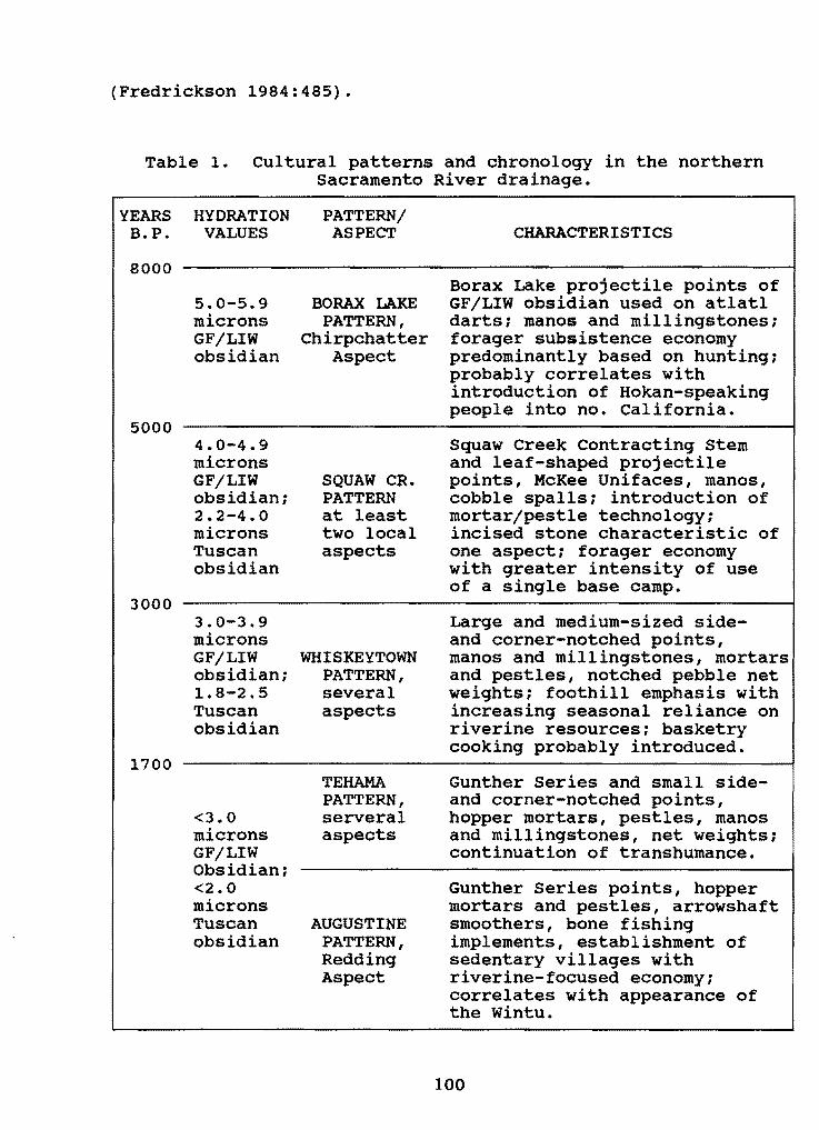
Artifacts and their contexts are the major medium with which archaeologists work. And, except for cultural materials dating within the past few hundred years, artifacts in northern California sites consist predominantly of stone. There are in use a number of different taxonomic systems for organizing artifacts and traits into meaningful arrangements which move a step beyond stone artifacts in the quest for understanding prehistoric humans and their behavior. This paper utilizes the Pattern/Aspect system developed by David Fredrickson (1973). The value of this system is that it is encompassing, allowing relationships in sUbsistence systems to be viewed across broad geographic areas, while at the same time it is flexible and specific enough to include localized complexes which ideally correlate with a group of people sharing a culture and a language or dialect. The cultural sequence for the northern Sacramento River drainage is organized below into 5 patterns (Table 1). Names of 2 of these have wide use and acceptance. The others are provisional terms for which no single taxonomic term is in common usage.
Borax Lake Pattern Fredrickson applied the Borax Lake Pattern label to
archaeological assemblages in the North Coast Ranges which contain large projectile points, manos, and millingstones. Although he used the designation Early Borax Lake Pattern to refer to those assemblages containing Borax Lake widestem points, reserving Late Borax Lake Pattern for complexes with other large point styles, it has become common practice in northern California to equate the Borax Lake Pattern with Borax Lake widestem points (e.g., Hayes and Hildebrandt 1985), and that usage is followed here. Within the study area the Borax Lake Pattern is well represented at Sha-475 and Sha-499 in the Squaw Creek drainage. Three radiocarbon assays date this stratum between 7580 and 6530 B.P., dates consistent with the 8000 to 5000 B.P. dating of the Borax Lake Aspect found in Lake County
99
(Fredrickson 1984:485).
Table 1. Cultural patterns and chronology in the northern Sacramento River drainage.
YEARS HYDRATION PATTERN/ B.P. VALUES ASPECT CHARACTERISTICS
8000
5000
5.0-5.9 microns GF/LIW obsidian
4.0-4.9 microns GF/LIW obsidian; 2.2-4.0 microns Tuscan obsidian
3000 3.0-3.9 microns GF/LIW obsidian; 1.8-2.5 Tuscan obsidian
1700
<3.0 microns GF/LIW Obsidian: <2.0 microns Tuscan obsidian
BORAX LAKE PATTERN,
Chirpchatter Aspect
SQUAW CR. PATTERN at least two local aspects
WHISKEYTOWN PATTERN, several aspects
Borax Lake projectile points of GF/LIW obsidian used on atlatl darts; manos and millingstones; forager SUbsistence economy predominantly based on hunting; probably correlates with introduction of Hokan-speaking people into no. California.
Squaw Creek contracting Stem and leaf-shaped projectile points, McKee unifaces, manos, cobble spalls; introduction of mortar/pestle technology; incised stone characteristic of one aspect; forager economy with greater intensity of use of a single base camp.
Large and medium-sized sideand corner-notched points, manos and millingstones, mortars and pestles, notched pebble net weights; foothill emphasis with increasing seasonal reliance on riverine resources; basketry cooking probably introduced.
TEHAMA Gunther Series and small sidePATTERN, and corner-notched points, serveral hopper mortars, pestles, manos aspects and millingstones, net weights;
continuation of transhumance.
Gunther Series points, hopper mortars and pestles, arrowshaft
AUGUSTINE smoothers, bone fishing PATTERN, implements, establishment of Redding sedentary villages with Aspect riverine-focused economy;
correlates with appearance of the Wintu.
100

The Borax Lake Pattern presence in Northern California is usually viewed against a backdrop of paleoenvironmental reconstruction. Numerous environmental studies in the western united states indicate in general outline that a warming trend began around 9,000 years ago, finally cooling to climates similar to the present day around 3,000 years ago (Moratto et al. 1978:149). Studies conducted by James west (1985, 1988, 1989) within and bordering the study area document the general trend, indicating that the warmest temperatures were in the earliest part of this time span (West 1988:26), thus coinciding with the introduction of the Borax Lake Pattern. Vegetation patterns were displaced upward relative to those of the present with oaks found some 300 meters higher than their present distribution. Douglas fir and tan oak began increasing in the Trinity River drainage within the past 3,500 years to form the present-day plant associations.
Most investigators associate the appearance of the Borax Lake Pattern materials in northern California with the migration into the area by peoples speaking a language or languages of the Hokan linguistic stock. Lathrap and Troike (1988:100-101) rephrase the Hokan Hypothesis as follows:
In the immediate post-Pleistocene, a specialized economy involving the intensive utilization of grass seeds developed at some point in the arid or semi-arid west of North America and was gradually spread outward by migration until it covered most of the present area of •.• California .•••This economic pattern had as its stigmata quantities of milling stones •... There is a fairly precise congruence between the Hokan languages of California and the early distribution of Milling stone cultures ••..
If the Borax Lake Pattern arrived in northern California as a homogenous complex featuring large widestem projectile points, manos, and millingstones, it rapidly differentiated into local aspects. The Chirpchatter Aspect on Squaw Creek is distinguished by the use of GF/LIW obsidian as the major flaking medium, Borax Lake points with flat basal margins predominating over indented basal margins, and unshaped manos and millingstones (Clewett and Sundahl 1983:80). The Trinity River Aspect of the Borax Lake Pattern, found in the northernmost North Coast Ranges, features chert as the predominant flaking medium with a minor use of GF/LIW obsidian, indented bases predominating on the widestem projectile points, deep serrations common on point and biface blades, large chert bifaces, and an unshaped mano form with one or more lateral grinding facets (Sundahl 1988:96). The Borax Lake Aspect, found in Lake County, shares with the Trinity Aspect the use of chert and indented bases on the widestem points, but emphasizes the use of obsidian from the Borax Lake and Mt. Konocti sources (Fredrickson 1984:497-499). It has been proposed that these aspects represent settlements by the ancestral ShastaAchumawi, Chimariko, and Pomo or Yuki, respectively. The Borax Lake Pattern appears to be lacking in the southern Cascades, but
101
may be present farther south in the Buck's Lake area of the northern Sierras. The Buck's Lake Widestem points (Markley 1980:114-117), while different from most of the very large widestem points found in the North Coast Ranges, are similar to the smaller square stemmed points found at Sha-475, associated there with the Borax Lake component. North of the Oregon border at this time period lies a culture complex which appears to be quite different. Named the Cascade Pattern (or Old Cordilleran Culture or Tradition), it is typified by large willow-leaf points named Cascade points; broad, oval bifaces: blade tools; and edgeground cobbles (Connolly 1986:125).
Squaw Creek Pattern Around 5,000 years ago new artifacts began to appear in the
northern part of the study area although these seem to represent a gradual change in artifact type rather than signaling a major change in sUbsistence pattern or population replacement. Characteristic artifacts include the Squaw Creek Contracting Stem points, leaf-shaped points, McKee Unifaces, cobble spalls, and perhaps somewhat later than 5000 B.P., bowl and slab mortars and pestles. Manos and millingstones are very common with the manos generally extensively shaped.
Cultural deposits bearing these diagnostics are far more numerous than the preceding Borax Lake pattern components and cultural materials more densely concentrated, suggesting more intensive habitations. The richest deposits are at the Hedge Creek site near Dunsmuir (Boynton 1973) and the Pollard Flat Site in the upper Sacramento River canyon, numerous sites in the Squaw Creek drainage, Sha-228 in the Clikapudi drainage, and Sha-288 in French Gulch. Scattered traces are found elsewhere in the Redding area. .
Although cultural materials from the Squaw Creek and upper Sacramento River drainages appear to be nearly identical, the latter has a large series of incised stones which it shares with sites in the Clear Creek drainage but which appear to be lacking at Squaw Creek. The source of obsidian at the Squaw Creek sites shifted from GF/LIW to the Tuscan source (Clewett and Sundahl 1983:83), while in the upper Sacramento River canyon GF/LIW remained the major source of obsidian (Basgall and Hildebrandt 1989:456). Thus, it appears that at least 2 aspects are present: the Pollard Flat Aspect and the Squaw Creek Aspect. These may possibly represent a differentiation between the Shasta to the west and Achumawi/Atsugewi to the east with reduced interaction between them. Far more detailed comparisons are necessary to sUbstantiate such hypotheses.
The southern Cascades during this period saw the first evidence of human occupation. Assigned to the Deadman Complex, the artifact assemblage shares with the northern part of the study area an emphasis on manos and millingstones, but projectile point styles were quite different, composed primarily of large side-notched and stemmed varieties made predominantly of basalt
102

and chert (Greenway 1982).
It is believed that the ancestral Yokuts and Miwok migrated from the northern Great Basin into central California between 5000 and 4000 B.P., one or both manifested as the Windmiller Pattern (Moratto 1984:552: Lathrap and Troike 1988:106), establishing the initial wedge within the Hokan ownership of most of California. They probably brought with them the bowl mortar and pestle, the use of which diffused rather rapidly throughout northern California. If the Deadman complex is correctly interpreted as representing the original Yana movement into the southern cascades, the direction of that movement must have been from the south or southwest since the point styles are quite different than those in the northern part of the study area. This movement by the Yana may have been stimulated by pressures from other populations which in turn were being pressed by the Miwok and/or Yokuts migration into central California.
Whiskeytown Pattern The subsequent culture period, dating from 3000 to 1700
B.P., is characterized by large and medium-sized corner-notched and side-notched points, manos, millingstones, and notched-pebble net weights. Several sites in the whiskeytown area of the foothills west of Redding are rich in artifacts of this pattern, which appears to represent a growing emphasis on riverine resources while still retaining a transhumant annual pattern. Aspects are not defined, but presumably there are several. There is some suggestion that the Yana began a northward movement during this time period, eventually restricting the Achumawi peoples north of the Pit River within the study area.
Problems in need of resolution regarding this phase are temporal and functional. While Clewett and Sundahl (1982b, 1983) see this as a linear development from the previous phase dating roughly 3000 to 2000 B.P., Basgall and Hildebrandt (1989:202, 445) view it as dating between 4500 and 1700 B.P., thus overlapping and coexisting with the Pollard Flat Aspect for some 1,500 years. Note that this overlapping period is based entirely on the hydration of GF/LIW obsidian: radiocarbon dates and stratigraphic position, where present in the upper Sacramento River canyon sites, support Clewett and Sundahls' dating sequence as well as Basgall and Hildebrandt's.
In addition, Basgall and Hildebrandt see a major functional difference between the generalized forager strategy that they attribute to the Pollard Flat people and the "fission-fusion" model they propose for the Vollmers Aspect. The Pollard Flat site is viewed as a residential base camp occupied for relatively extended periods by groups making seasonal movements to forage for resources (Basgall and Hildebrandt 1989:445). The fissionfusion system is defined as follows:
During the fall and winter the population was logistically organized around a strategically situated residential base
103

camp, but at other times of the year the social unit dispersed and smaller groups followed a forager strategy, moving between productive resource tracts as warranted [Basgall and Hildebrandt 1989:450].
Base camps are believed to be located farther to the south, and Sha-192 in the Clear Creek drainage is given as an example.
Again, cultural materials in the southern Cascades during this period seem quite distinct from those in the northern part of the study area. The Kingsley Aspect in the southern Cascades differs from the Vollmers Aspect, although less so than the earlier Deadman Aspect differed from the Pollard Flat. The large number of corner- and side-notched points found in the Southern Cascade sequence suggests that the movement of this culture group may have been the agents who introduced the notched point style to the northern cultures (although notched styles are present throughout California, Oregon, and the Great Basin). Obversely, a series of contracting stem and leaf-shaped points, which are a minor association within the Kingsley/Dye Creek interface period dated 2000 to 1200 B.P. (Greenway 1982), resemble types found in the earlier Pollard Flat Aspect farther northward. These suggest increasing contact and interaction between groups in the northern and southeastern parts of the study area.
Tehama Pattern The succeeding phase is arbitrarily dated as beginning with
the introduction of the bow and arrow, roughly 1500 to 1800 years ago and is termed the Tehama Pattern. The assemblage consists of medium-sized and small notched points along with Gunther Series points, hopper mortars, pestles, manos, millingstones, and notched pebble net weights. The Tehama Pattern is believed to represent a continuation of the transhumant SUbsistence pattern practiced by peoples affiliated with the Hokan linguistic stock. It is very similar in culture content to the Dye Creek and Mill Creek complexes, and it is proposed that the latter are aspects of the Tehama Pattern. Its presence in the Clikapudi drainage and in Redding may signal the presence of the Central and Northern Yana. If Clewett and Sundahl's (1982c) interpretation is correct, aspects may eventually be defined for the upper Sacramento River canyon and the Clear Creek drainage as well as the middle Trinity River, upper pit River, and so forth. Some aspects of this pattern, notably the Dye Creek/Mill Creek Aspect, continued into the ethnographic present while others, particularly on the Sacramento, Pit, and Trinity Rivers, were replaced by a riverine-oriented economic pattern.
Augustine Pattern Cultural deposits assigned to the Shasta Complex have
probably received more attention than any other within the study area. The assemblage is well documented, and there seems to be general agreement that, at least in the Redding area, this complex is associated with the prehistoric Wintu. The initial dating is still uncertain as radiocarbon dates are few and some
104

seem untrustworthy. Three radiocarbon dates ranging between 710 and 740 B.P. clearly document the presence of the Shasta Complex in Sha-266 on the Sacramento River in Redding. Portions of the midden deposit at Sha-222, located across the river from Sha-266, are obviously older: a date of 1080 B.P. from the 2.0-2.5-foot level is acceptable, but a second date of 2330 B.P. at the 6.06.5-foot level seems too early (Sundahl 1982:186-187). Estimated dates for the origin of this pattern vary from 1500 to 1200 B.P.
It has been suggested that the Shasta complex be renamed the Redding Aspect of the Augustine Pattern (Bennyhoff 1982). This aspect is believed to represent the migration into northern California of the Penutian-speaking Wintu who arrived, perhaps from southwestern Oregon (Whistler 1977), bearing a riverineoriented economy. They settled on the banks of the Sacramento River between Redding and Red Bluff and established permanent villages. At first they coexisted with the earlier residents who used the river resources seasonally, but as their more sedentary lifestyle encouraged a fairly rapid population growth, they expanded their territory, forcing their Tehama Pattern neighbors into more marginal areas, and in some cases absorbing them.
CONCLUSIONS
In summary, cultural remains from the Borax Lake Pattern through the Whiskeytown Pattern are seen as representing a continued habitation by Hokan speaking peoples, with the descendants of the same or related linguistic groups gradually evolving a more complex annual SUbsistence pattern, including a seasonal valley and riverine focus. This evolutionary process came to an end, however, when the Wintu arrived, bearing the Augustine Pattern, already more intensively riverine-oriented than that of the resident Hokan-speaking peoples. The Tehama Pattern represents the continuity of the latter group, who for a while continued to use the riverine resources on a seasonal basis. But as the Augustine Pattern people were more sedentary and their populations increased at a faster rate, they expanded their territory, eventually blocking access to the river. Some of the Tehama Pattern peoples, perhaps best represented by the Achumawi, adopted an Augustine Pattern way of life, while others, most notably the Yana, retained the mobile, transhumant Tehama Pattern up to historic contact.
REFERENCES CITED
Baker, Suzanne 1984 Archaeological Investigations in the Tower House District
Whiskeytown Unit of the Whiskeytown-Shasta-Trinity National Recreation Area, Shasta County, California. Submitted to the National Park Service, San Francisco.
105
1990 Archaeological Excavations at CA-Sha-479 and CA-Sha-195. Shasta County, California. Submitted to the National Park Service, San Francisco.
Basgall, Mark E., and William R. Hildebrandt 1989 Prehistory of the Sacramento River Canyon. Shasta county.
California. Center for Archaeological Research at Davis Publications No.9. University of California, Davis.
Baumhoff, Martin A. 1955 Excavation of site Teh-1 (Kingsley Cave). Uniyersityof
California Archaeological Survey Reports 30:40-73. Berkeley.
1957 An Introduction to Yana Archaeology. University of California Archaeological SUrvey Reports 40. Berkeley.
Bennyhoff, James A. 1982 Central California Augustine: Implications to Northern
California Archaeology. Paper presented to the Northern California Archaeology Symposium, California State University, Chico.
Binford, Lewis R. 1980 willow Smoke and Dogs' Tails: Hunter-Gatherer Settlement
Systems and Archaeological site Formation. American Antiquity 45:4-20.
Boynton, Michael J. 1973 Interim Progress Report for the Archaeological Salvage of
the Hedge Creek Site, 4-sis-S5. Siskiyou County. California. Submitted to the California Department of Transportation, Sacramento.
Clewett, S. Edward, and Elaine Sundahl 1981 The Archaeological Investigation of Eagle Court, a
Partial Mitigation of CA-Sha-266, Redding, California. Ms. on file, Shasta College Archaeology Laboratory, Redding, California.
1982a Archaeological Testing for the Hartnell Extension Project, Redding, California. Ms. on file, Shasta College Archaeology Laboratory, Redding, California.
1982b Clikapudi Archaeological District: 1981 Field Research. Ms. on file, Shasta-Trinity National Forests, Redding, California.
1982c Tehama Pattern: An Alternate Model for Northern California Prehistory. Paper presented at the Northern DataSharing Meeting of the Society for California Archaeology, Sacramento.
106
1983 Archaeological Excavations at Squaw Creek, Shasta County, California. Ms. on file, Shasta-Trinity National Forests, Redding, California.
Connolly, Thomas James 1986 Cultural Stability and Change in the Prehistory of
Southwest Oregon and Northern California. Unpublished Ph.D. dissertation, Department of Anthropology, university of Oregon, Eugene.
Dotta, James 1964 Salvage Archaeology of Sha-237. Shasta County.
California. Submitted to the California Department of Beaches and Parks, Sacramento.
1980 Some Elements of wintu Social Organization as Suggested by curtin's 1884-1889 Notes. In Papers on wintu Ethnography: 239 wintu Villages in Shasta County Circa 1850, edited by Margaret Guildford-Kardell and James Dotta, pp. 118-131. Redding Museum Occasional Papers No.1. Redding, California.
Dotta, James and R. Hullinger 1964 The Salvage Archaeology of a wintu Fishing station. Sha
207. Shasta County. California. Submitted to the California Department of Parks and Recreation. Sacramento.
Du Bois, Cora 1935 Wintu Ethnography. university of California publications
in American Archaeology and Ethnology 36:1-147. Berkeley.
Edwards, Robert (editor) 1968 Notes on the wintun. Ms. on file, Shasta College
Archaeology Laboratory, Redding, California
Farber, Alfred 1985 Alternative Approaches to the Shasta Complex and Adjacent
Expressions: Assemblages, Cultural Ecology, and Taxonomies. Journal of California and Great Basin Anthropology 7:75-88.
1987 Fay Hill Revisited: An Addendum to Archaeological Test Excavation at the Fay Hill site. CA-Sha-1481. Shasta County. California. 1984. Submitted to the U.S. Bureau of Land Management, Redding, California.
Farber, Alfred, and Neal Neuenschwander 1984 Archaeological Test Excavation at the Fay Hill Site. CA
Sha-1481. Shasta County. California. Submitted to the U.S. Bureau of Land Management, Redding, California.
Farber, Alfred, Eric W. Ritter, and Peter M. Jensen 1984 Archaeological Excavation at the Dotta Site, CA-Sha-782,
Shasta County, California. Ms. on file, Department of Anthropology, California State University, Chico.
107
Fredrickson, David A. 1973 Early Cultures of the North Coast Ranges. California.
Unpublished Ph.D. dissertation, Department of Anthropology, University of california, Davis.
1984 The North Coastal Region. In California Archaeology,by Michael J. Moratto, pp. 471-527. Academic Press, Orlando.
George, Julia 1981 Faunal Analysis of CA-Sha-266. Unpublished Master's
thesis, Department of Anthropology, California state University, Chico.
Guildford-Kardell, Margaret, and James Dotta (editors)1980 Papers on Wintu Ethnography: 239 wintu Villages in
Shasta County Circa 1850. Redding Museum Occasional Papers No.1. Redding, California.
Greenway, Gregory B. 1982 Projectile Point Variability at Dead Man's Cave (CA-Teh
290) in the Southern Cascade Mountains of Northeastern California. Unpublished Master's thesis, Department of Anthropology, California state University, Sacramento.
Hamesuk, Blossom 1988 The Stratigraphy and Archaeology at CA-Teh-1490; A
Hunting Camp in Yana Territory. Northern California.
tbe 1984 Field Season. Submitted to the U.S. Forest Service,
California Department of Forestry Reports No.1. Sacramento.
Hayes, 1985
John F., and William R. Hildebrandt Archaeological Investigation on Pilot Ridge: Results of
Six Rivers National Forest, Eureka, California.
Henn, Winfield G., and Elaine Sundahl 1988 Obsidian Hydration Dating: Problems at the Squaw Creek
site. Submitted to the U.S. Forest Service, Shasta-Trinity National Forests, Redding, California.
Heicksen, Martin H. 1962 Archaeological Reconnaissance in the pit River Area
between Big Bend and Fender's Flat, Shasta County,California. Ms. on file, University of California Archaeological Research Facility, Berkeley.
Jensen, Peter M. 1977 Test Excavations at CA-Sha-543 on the East Fork of Clear
Creek. Sbasta County, California. Submitted to the U.S. Bureau of Land Management, Redding, California.
1980 Archaeological Excayations at the Kett Site, CA-Sha-49l. Shasta County. California. California State UniversityResearch Archaeology Program publications, AnthropologicalPapers No.2. Chico.
108

Johnson, Jerald J. 1978 Yana. In California, edited by Robert F. Heizer, pp.
361-369. Handbook of the North American Indians, vol. 8, William C. sturtevant, general editor. smithsonian Institution, Washington, D.C.
1984 Ground stone Assemblages in Northeastern California. unpublished Ph.D. dissertation, Department of Anthropology,university of California, Davis.
Johnson, Jerald J., and Patti Palumbo Johnson 1969 Archaeological Reconnaissance of the pit 3, 4, and 5 and
Battle Creek Proiects. submitted to Pacific Gas and Electric Company, San Francisco.
Johnson, Jerald J., and Dorothea J. Theodoratus 1984a Cottonwood Creek Project, Shasta and Tehama Counties.
California: Dutch Gulch Lake, Intensive Cultural Resources Survey. Submitted to the u.s. Army Corps of Engineers, Sacramento.
1984b Cottonwood Creek project. Shasta and Tehama Counties. California: Tehama Lake, Intensive Cultural Resources Survey. Submitted to the u.s. Army Corps of Engineers, Sacramento.
Johnson, Keith L. 1976 Test Excavations at the Old Tower House Site (CA-Sha
192), Whiskeytown National Recreation Area, Shasta County, California. Submitted to the National Park Service, TUcson.
Johnson, Keith L., and Lucy S. Skjelstad 1974 The Salvage Archaeology of Site 4-Sha-177, Whiskeytown
National Recreation Area, Shasta County, California. Submitted to the National Park Service, TUcson.
Johnston, James 1978 The wintu and Yana Territorial Boundary. Paper presented
at the 12th Annual Meeting of the society for California Archaeology, Yosemite.
Kowta, Makoto 1989 Preliminary Results of the Platine Excavations. Paper
presented at the Society for California Archaeology Northern Data Sharing Meeting, Chico.
Lathrap, Donald W., and Rudolph C. Troike 1988 California Historical Linguistics and Archaeology.
Journal of the Steward Anthropological Society 15:99-157.
109

Markley, Richard E. 1980 Projectile Points. In Rainbow Point Revisited:
Archaeological Investigations at Bucks Lake, Plumas County, California, by Keith L. Johnson, pp. 102-141. Submitted to Pacific Gas and Electric Company, San Francisco.
Meighan, Clement W. 1955 Archaeology of the North Coast Ranges, California.
University of California Archaeological SUrvey Reports 30:139. Berkeley.
Moratto, Michael J. 1984 California Archaeology. Academic Press, Orlando.
Moratto, Michael J., Thomas F. King, and Wallace B. Woolfenden 1978 Archaeology and California's Climate. Journal of
California Anthropology 5:147-161.
Ravin, Christopher M., Susan K. Goldberg, Michael J. Moratto, and K.M. Banks
1984 Archaeological Investigations in the Sacramento River Canyon [vol. IJ: Report of Testing at Seven Aboriginal Sites. Submitted to the California Department of Transportation, Sacramento.
Sanders, William T., and Joseph Marino 1970 New World Prehistory: Archaeology of the American
Indian. Prentice-Hall, Englewood Cliffs, New Jersey.
Sapir, Edward, and Leslie Spier 1943 Notes on the Culture of the Yana. Anthropological
Records 3:239-298. University of California Press, Berkeley.
Shipley, William F. 1978 Native Languages of California. In California, edited by
Robert F. Heizer, pp. 80-90. Handbook of the North American Indians, vol. 8, William C. Sturtevant, general editor. smithsonian Institution, Washington, D.C.
Silver, Shipley 1978 Shastan Peoples. In California, edited by Robert F.
Heizer, pp. 211-224. Handbook of the North American Indians, vol. 8, William C. Sturtevant, general editor. Smithsonian Institution, Washington, D.C.
Sletteland, Trygvie B. 1982a Archaeological Survey Report of the Proposed Sacramento
River Canyon unit 1 Alternatives. Submitted to the California Department of Transportation, District 02, Redding.
1982b Archaeological Survey Report of the Proposed Sacramento River Canyon unit 2 Alternatives. Submitted to the California Department of Transportation, District 02, Redding.
110
smith, C.E., and W.D. Weymouth 1952 Archaeology of the Shasta Dam Area, California.
University of California Archaeological Survey Reports 18. Berkeley.
Sundahl, Elaine 1982 The Shasta Complex in the Redding Area. California.
Unpublished Master's thesis, Department of Anthropology, California state University, Chico.
1984 Shasta County Prehistory: The Obsidian Evidence. Paper presented at the 18th Annual Meeting of the Society for California Archaeology, Salinas.
1986 Archaeological Investigations in the Jones Valley Area of Shasta Lake. Shasta County. California. Submitted to the U.S. Forest Service, Shasta-Trinity National Forest, Redding, California.
1988 Cox Bar (CA-Tri-1008): A Borax Lake Pattern Site on the Trinity River. Trinity County. California. Submitted to the Cox Bar School District, Big Bar, California.
1990 Test Excavations at CA-Sha-499. the Chirpchatter site. Shasta County. California. Submitted to the U.S. Forest Service, Shasta-Trinity National Forests, Redding, California.
Sundahl, Elaine, and S. Edward Clewett 1985 Archaeological Investigations at Sugar Pine Canyon.
Shasta County. California. Submitted to the California Department of Corrections, Sacramento.
1991 Archaeological Investigations in the Salt Creek Drainage. Shasta County. California. Submitted to the U.S. Bureau of Land Management, Redding, CA.
Treganza, Adan E. 1952 The Archaeological Resources of Seven Reservoir Areas in
Central and Northern California. Submitted to the National Park Service, San Francisco.
1954 Salvage Archaeology in Nimbus and Redbank Reservoir Areas, Central California. University of California Archaeology Survey Reports 26. Berkeley.
Treganza, Adan E., and Martin H. Heicksen 1960 Salvage Archaeology in the Whiskeytown Reservoir Area and
the Wintu Pumping Plant. Shasta County. California. occasional Papers in Anthropology No.1. California State University, San Francisco.
111

west, G. James 1985 Holocene Veqetation and Climatic Chanqes in California's
North Coast Ranqes. In Archaeological Investigations on pilot Ridge: Results of the 1984 Field Season, by John F. Hayes and William R. Hildebrandt, pp. 8-29. Submitted to the u.S. Forest Service, Six Rivers National Forest, Eureka, California.
1988 Holocene Veqetation and Climatic History of the Trinity River Reqion: The Pollen Record. In Cox Bar (CA-Tri-1008l: A Borax Lake Pattern site on the Trinity River. TrinityCounty. California, by Elaine sundahl, pp. 13-27. Submitted to the Cox Bar School District, Biq Bar, California.
1989 Late Pleistocene/Holocene Veqetation and Climate. In Prehistory of the Sacramento River Canyon. Shasta county.California, by Mark E. Basqall and William R. Hildebrandt, pp. 36-50. Center for Archaeoloqical Research at Davis Publications No.9. university of California, Davis.
Whistler, Kenneth W. 1977 wintun Prehistory: An Interpretation Based on Linquistic
Reconstruction of Plant and Animal Nomenclature. Paperpresented at 3d Annual Meetinq of the Berkeley Linquistic society.
Wiant, Wayne Christopher1981 Southern Yana Subsistence and Settlement. Unpublished
Master's thesis, Department of Anthropoloqy, California State university, Sacramento.
Woolfenden, Wallace B. 1970 A Study in Historic sites Archaeology. Unpublished
Master's thesis, Department of Anthropoloqy, California state university, San Francisco.
112