cultural landscape report lincoln memorial grounds · the native forest cover was cleared ... at...
TRANSCRIPT

Cultural Landscape Report Lincoln Memorial Grounds
10

Site History
11

Cultural Landscape Report Lincoln Memorial Grounds
12
Introduction
The overwhelming acclaim for the grand Beaux Arts-inspired design of the World’sColumbian Exposition, held in Chicago in 1893, influenced professionals and the publicalike in their appreciation for well-conceived and beautifully designed urban spaces. Thesuccess of the fair helped to inspire the “City Beautiful Movement.” In 1900 GlennBrown, Washington architect and national secretary of the American Institute ofArchitects, as well as others developed proposals and lobbied Congress for the creation ofa grand design for the future development of Washington, D.C. At this time LandscapeArchitect Frederick Law Olmsted, Jr. suggested that the formal design of the historicL’Enfant Plan continued to be an appropriate way to demonstrate the greatness of thenation’s capital and its setting.
...great public edifices must be strongly formal, whether they are perfectlysymmetrical or not, and this formal quality ought to be recognized on theplan of their surroundings if the total effect is to be consistent. ...where thescale of the general scheme is large, there should be a correspondingsimplicity.1
Brown’s efforts inspired the legislation establishing the Park Improvement Commissionof the District of Columbia, or the Senate Park Commission, of 1901-1902. ArchitectsDaniel Burnham and Charles McKim and Frederick Law Olmsted, Jr. were the three keyprofessionals appointed to the commission. The acclaimed sculptor, Augustus St.Gaudens, joined later as the fourth member. Three of them, Burnham, McKim, and St.Gaudens, had held major roles in the creation of the 1893 fair. The commission sooncame to be called the McMillan Commission, after its sponsor, Senator James McMillan.In the succeeding decades various aspects of the city plan developed by the commissionwere implemented. As the youngest and longest surviving member of the commission,Frederick Law Olmsted, Jr., became the unofficial guardian of the plan, contributing hisexpertise to various projects through his membership on the Commission of Fine Arts(1910-1918), the National Capital Park Commission (1924-1926), and the NationalCapital Parks and Planning Commission (1926-1932). The focus of this section of thereport concerns the Lincoln Memorial, or the “western anchor” of the Mall and thecenterpiece of the McMillan Commission Plan, its physical history, and the role ofOlmsted and others in its development.2
The landscape of the Lincoln Memorial and the surrounding areas in West Potomac Parkhave a rich and varied history that is defined by six primary periods of growth anddevelopment. These include a period of early development between 1791 and 1914, whenthe tidal shoreline became the landform of the future park and the McMillan Commissionplanned for the design of the memorial, the reflecting pools, and the Watergate; a periodof design development and construction, from 1914 through 1922, that culminated in thededication of the Lincoln Memorial; a period characterized by the completion of theplans for the grounds surrounding the memorial between 1923 and 1933; and threesubsequent periods, when the Lincoln Memorial and West Potomac Park came under themanagement of the National Park Service (NPS). Each of the NPS periods, which began

Site History
13
in 1933 and continue to the present, reflect the issues and concerns that have influencedchanges in the landscape. The first NPS period occurred between 1933 and 1945, thesecond between 1945 and 1970, and the third between 1970 and 1996.
Early Development1791-1914
Creation of a Park Site
Prior to the arrival of European settlers, the area that would one day become Washington,D.C., was bordered on the northwest by the Potomac River, where stands of sweet gum,oak, and hickory stood on the flat land. To the southeast where the Anacostia Riverflowed toward the Potomac, the shoreline was covered in marsh. Subsequently, much ofthe native forest cover was cleared for the cultivation. When Pierre L’Enfant laid out thenew capital on the hills above the Potomac and Anacostia Rivers in 1792, some of thesefields, exhausted from a tobacco-based agriculture, had been allowed by their owners torevert to woody growth.
The natural shoreline of the Potomac followed the eastern edge of what would becomethe Tidal Basin and the northern side of Maine Avenue. The mouth of Tiber Creek, “aslowly meandering stream,” which flowed from the north down Capitol Hill, stretchedacross the “flats,” near the intersection of present-day 17th Street and ConstitutionAvenue. At the time that L’Enfant submitted his proposal for the design of the capitalcity, David Burns had a farmstead and cultivated fields along the north shore of the Tiber,from the mouth to the base of Capitol Hill. Both sides of the Tiber were edged inmarshland that was frequently covered by large flocks of waterfowl. Wild oats, reeds, andthickets of berry bushes and other shrubs grew in places along the marsh. On the southernshore of the creek, in the area that would eventually become West Potomac Park, Dr.William Thornton had planted an assortment of saplings and shrubs on about 18 acres tocatch the river silt and to establish title to the land. L’Enfant’s plan called for Tiber Creekto be widened and adapted into a canal system, designed to carry commerce through thenew city.3
When the Washington City Canal was finally completed in 1815, the portion of its routefollowing the old Tiber had the effect of creating a river “island” to the south. The canal,however, failed to develop into a viable waterway. By the 1870s, the neighborhoodsalong its banks were considered slums, with the canal serving as a fetid sewer openinginto the Potomac, rather than a commercial thoroughfare. Among the civic improvementprojects of the District’s territorial government (1871-1874) were the installation ofsewerlines. In 1872, one line was constructed along the canal between 7th and 17th Streets,where it emptied directly into the river. To complete the sewer project, the Board ofPublic Works filled in and covered over the Washington Canal, a project that wascompleted by 1873. The land between the canal and the Washington Monument, thenunder construction, was also made level. Once filled, the old canal route was paved and

Cultural Landscape Report Lincoln Memorial Grounds
14
named B Street. Only the former lockkeepers’ stone house, located at the intersection of17th and B Street, remained to mark the site of the defunct waterway.
Another feature of the civic improvements program that affected the Potomac Rivershoreline was the regrading of major streets and thoroughfares in the center of the city,which occurred mostly in 1871. Dirt from the cutting and filling of streets added to thedebris and silt normally brought by rain and runoff to the river. By 1870 the Potomac hadbecome so silted and shallow in places that the shipping channels were seriouslythreatened. At this time, the Congress authorized the Army Corps of Engineers todevelop a permanent plan to keep the channels clear by dredging and disposing ofdredged materials in such a way as to prevent renewed siltation. The scope of the project,begun in earnest in 1882, included constructing containment barriers (or bulkheads),terminating the Washington channels at the Long Bridge at 14th Street, providingsluicing basins on the west to keep the channel clean, depositing the dredged materials ona tidal “flat” that stretched southeast from Long Bridge to the confluence of the riverchannels, narrowing the Georgetown channel, and completely filling in the marsh landlocated between Easby’s Point (near the present crossing of the Roosevelt Bridge) and17th Street.
Figure 1 – The City of Washington. Birds-Eye View from the Potomac – looking north. (Drawn byCharles Parsons) Published by Currier & Ives, 1892. Courtesy of Library of Congress, Prints andPhotographs.
In 1897 congressional legislation authorized the designation of the 621 acres of reclaimedmarsh and “flats”and 118 acres of tidal reservoirs as a site for a public park. By 1901, 31acres adjacent to the Washington Monument grounds had been filled and subsequentlytransferred to the Army Corps of Engineers’ Office of Public Buildings and Grounds(OPBG) to be turned into the Potomac Park. Some of this filled area had been createdfrom dredged materials, and some from private construction projects in the District.

Site History
15
Contractors who had obtained dumping permits were to deposit clean fill on the “flats.”At the time of the land transfer, the site, with its uneven topography, scattered shallowwater collection pools, and “wild growth of willows, grasses, bushes and trees,” was farfrom parklike. As the reclamation project neared completion, the outline and shape of theproposed park closely reflected the natural and historic pattern of river siltation. By 1907the area in Potomac Park that would become the site of both the Lincoln Memorial andthe Reflecting Pool had been filled to a grade of 12 or 13 feet above sea level. Eventuallya base height of 14 to 16 feet would be achieved.
The McMillan Commission Plan
The 1902 report of the McMillan Commission outlined with great thought and care asignificant and highly symbolic use for Potomac Park. With the understanding that theirrecommendations would be based on the L’Enfant Plan, members studied old maps andsurveys and examined first- hand the layout of historic sites in tidewater Virginia. In June1901 the three key members and Charles Moore, commission secretary, traveled toEurope to investigate the cities and sites that would have influenced L’Enfant. Inspiredby both the work of Andre LeNotre, particularly at Versailles, and by the example ofRome, where they noted the role of the fountain as the “proper ornament” for the heat ofWashington, Burnham, McKim, and Olmsted returned shortly thereafter to formulate aplan for the monuments and parks of the nation’s capital.
Map 2 - Senate Park Commission, Plan of 1901-1902, General Plan of the Mall System, March 1915.Used by permission from the National Geographic Society.

Cultural Landscape Report Lincoln Memorial Grounds
16
With models, artistic renderings, drawings, photographs, and a text composed byOlmsted and Moore, the McMillan Commission Plan was presented to Congress in 1902.The primary focus of the plan was the placement of public buildings and the developmentof a public park system. In the monumental core and on the newly reclaimed land alongthe Potomac, the plan called for the formal treatment, advocated earlier by Olmsted, thatfollowed a continuation of the east/west and north/south alignments established byL’Enfant. In plan view, the design for this area appeared to be kite-shaped. The westernend of the extension of the Mall axis was designed mostly by McKim. He placed a seriesof plazas and fountains on axis to surround the Washington Monument and located thesite for a memorial to Lincoln that would be complemented by a pair of basins, oneessentially oval and another that had a long, cruciform shape. The reflecting basins,which would also contain several fountains, were set in lawn that was flanked by largegroves of deciduous trees. The memorial, a classical structure, with its form and styleselected by the commission, was to be constructed on a circular mound, or "rond point,"to be placed west of the long basin.
The commission incorporated the long-planned monumental bridge linking Potomac Parkand the Mall with Arlington Cemetery into the design. The commission placed itsouthwest of the memorial to Lincoln. The memorial was also designed to mark thebeginning of a regional park system to be planned mostly by Olmsted. A ceremonialwatergate united the bridge, the park system entrance, and the memorial, with the wholedesign of the western end making a gateway to the river and beyond. In general, PotomacPark was to be developed according to “the landscape of natural river bottoms - greatopen meadows, fringed by trees along the water side.”4
Although the McMillan Commission Plan used the axes established in the L’Enfantdesign, the proposed placement of the Lincoln Memorial and the plan for trees along theriver would, if allowed to mature, block the open views and vistas to the Potomacoutlined in L’Enfant’s work. Regardless of the irregularities in the McMillan design, theplan was generally well-received. Although prolonged and often heated, public debateoccurred about the commission’s proposal for a memorial suitable to commemorateAbraham Lincoln. In 1910 President Taft created the Commission of Fine Arts (CFA) tooversee and guide the implementation of the McMillan Commission’s proposals. DanielBurnham and Frederick Law Olmsted, Jr. were among the first to serve on theCommission of Fine Arts.
During the course of the debate over various aspects of the report, the Office of PublicBuildings and Grounds (OPBG) worked to improve the appearance of West PotomacPark, the area of reclaimed land stretching from Easby’s Point to 14th Street, SW.Although thousands of cubic yards of earth continued to be deposited in the park, theOPBG worked throughout 1906 and 1907 to complete the construction of a riversidedrive, bridle paths, and footpaths. These extended along the shoreline from 17th Street, tothe Tidal Basin, then turned northwest to the foot of 26th Street. The office consultedwith Frederick Law Olmsted, Jr., about tree planting along a portion of the route. Tosupplement the existing willow trees, Olmsted recommended planting in grove-likegroups “black and yellow birches” (Betula lenta, Betula alleghaniensis), “white and

Site History
17
laurel-leaved willow” (Salix alba, Salix pentandra), “Sycamore and American Elm”(Platanus occidentalis, Ulmus americana), and even pecan trees (Carya illinoiensis). Forstraighter vistas, he advocated linden trees (Tilia sp.). However, the route appears to havebeen lined primarily with elm trees. In 1908 Congress also authorized the extension of BStreet to the Potomac at 26th Street, which would eventually form the northern boundaryof the park. Finally, during 1911 and 1912, the interior of West Potomac Park wasdrained and graded.5
Figure 2 – Cross section of proposed Potomac Park speedway and trail system, c. 1907. NPS Map801/801067.
By 1914 the McMillan Commission’s site for the memorial to Lincoln and thecorresponding long basin stretched for nearly a mile westward from the WashingtonMonument. It encompassed almost 700 acres and had been landscaped with scatteredtrees and shrubs. It had also been improved by the addition of several tennis courts on thenorth and organized with a simple grid pattern of drives. A narrow section of B Streetthat was lined with small trees formed most of the northern boundary, while mature tree-lined 17th Street formed the eastern boundary. In May 1914 the Commission of Fine Artsapproved the planting done by the OPBG in the area between B Street and the memorialsite and in the area set aside for the basins. Any additional fill required to develop the sitefurther would have to be obtained from adjacent building and construction projectsoccurring in the vicinity.
Early Design Concepts
The Lincoln Memorial Commission was established by Congress in 1911, and acompetition for the design of the memorial was announced the same year. At this time theCommission of Fine Arts strongly recommended the West Potomac Park site proposed bythe McMillan Commission.
For a long distance in every direction the surroundings are absolutely freefor such treatment as would best enhance the effect of the memorial. Thefact that there are now no features of interest or importance, thateverything is yet to be done, means that no embarrassing obstacles would
Cultural Landscape Report Lincoln Memorial Grounds
18
interfere with the development of a setting in extent and perfect design,without compromise and without discord.6
It is impossible to overestimate the importance of giving to a monument ofthe size and significance of the Lincoln Memorial complete andundisputed domination over a large area, together with a certain dignifiedisolation from competing structures, or even from minor featuresunrelated to it. Upon no other possible site in the city of Washington canthis end be secured so completely as upon the Potomac Park site.7
The design submitted by Henry Bacon, a protege of Charles McKim, was selected by theLincoln Memorial Commission. Bacon’s drawings closely followed the design proposalsfor the structure in the renderings submitted in the McMillan Commission’s report.Shortly thereafter, Bacon was commissioned to be the project’s architect. Bacon himselfsummarized best the appropriateness of the site in West Potomac Park in his statement onthe overall design intent.
...I believed that the site in Potomac Park was the best one for amonument to Abraham Lincoln, and since devoting my time for fourmonths to a study of its possible development, I am certain of it.Terminating the axis which unites it with the Washington Monument andthe Capitol, it has significance which that of no other site can equal, andany emulation or aspiration engendered by a Memorial there to Lincolnand his great qualities will be immeasurably stimulated by beingassociated with the like feelings already identified with the Capitol and themonument to George Washington. Containing the National legislative andjudicial bodies we have at one end of the axis a beautiful building which isa monument to the United States Government. At the other end of the axiswe have the possibility of a Memorial to the man who saved thatGovernment and between the two is a monument to its founder. All threeof these structures, stretching in one grand sweep from Capitol Hill to thePotomac River, will lend, one to the others, the associations and memoriesconnected with each, and each will have its value increased by being onthe one axis and having visual relation to the other.8
Although mostly concerned with the architectural details, Bacon also paid attention to thelayout and the arrangement of landscape features at the Lincoln site. Shortly after he wasnamed project architect, he wrote to Frederick Law Olmsted, Jr. to request thespecifications shown on the McMillan plan for the “avenue” between the trees west of theWashington Monument and along the proposed long basin, or canal. In 1912, Bacon alsoindicated his interest in the design of the landscape when he testified to the LincolnMemorial Commission that he intended to use either elms or lindens in the planting plan.At that time, Commission members also suggested horse chestnut and pin oaks (Aesculushippocastanum, Quercus palustris). This concern for the types of trees to be planted alsoanticipates the Commission of Fine Art’s interest in the landscape setting for thememorial in deliberations between 1911 and 1932.

Site History
19
Throughout the design history of the Lincoln Memorial and West Potomac Park, variousgovernment organizations have had oversight in the areas of planning and design. In theearly years of the development of the Lincoln Memorial, the Commission of Fine Artshad direct influence on all aspects of design in the memorial project. Layout, spatialrelationships, planting, and site features were often conceived, shaped, and reviewed bythe landscape architect member of the commission prior to approval by the fullcommission. Subsequently, other planning agencies and government agencies, such asthe National Capital Parks and Planning Commission (NCPPC) and the National ParkService (NPS), also became responsible for the Lincoln Memorial and its grounds.9
As the first landscape architect on the CFA and the only surviving member of theMcMillan Commission, Olmsted exercised a unique influence over the development ofthe Lincoln Memorial grounds, serving as arbiter of design decisions regarding allaspects of the treatment of the landscape.
...as the only present survivor of the designers (indeed as the one who nextto McKim was most responsible for the treatment of the Mall plan) Ishould hate to occupy merely the position appropriate to a member of theCommission of Fine Arts as such, and to let some other fellow shape theplan to suit his own ideas, even though they might be just as good as mine.It is a case where I can perfectly well do my part in designing from thebackground without pay or official recognition, because I had myrecognition as a member of the old Park Commission, and a continuanceof what was originally unpaid work may very properly itself be unpaid.Indeed I would rather do it without personal compensation, because itwould put the whole thing on a different plane if after McKim and the restwere dead I began to draw pay for work which we all undertook togetheras a matter of public spirit. But to sit on the side lines and let someoneelse overhaul the plan would be rather bitter.10
In June 1913 Henry Bacon and his staff prepared for Olmsted’s review drawings of thelayout for the memorial grounds and an adjacent river road . In his proposal, Bacon“endeavored to follow out the old Park Commission’s plan.”11 He offered two schemesfor the road, trying to avoid the necessity for a high retaining wall along the river. ByAugust 1913, one of these schemes showed “the river roadway running under theproposed bridge to Arlington.” Even though Bacon had refined his original designsaccording to Olmsted’s suggestions, he continued to send his revisions to Olmsted forreview. Olmsted had stipulated that the design should avoid the use of heavy retainingwalls around the river edge, because walls would probably not be funded with theconstruction of the memorial. He also noted that the “wide roadway around theMemorial” should have its outer edge lower than its inner to prevent the appearance of adepression in the land. Bacon followed another of Olmsted’s suggestions in hisplacement of the walks along the radial roads. Olmsted proposed that Bacon not border“the radial roadways immediately by sidewalks,” but carry “the tree planting out to theline of the roadway itself” and put “the parallel walks behind the first row of trees.”12

Cultural Landscape Report Lincoln Memorial Grounds
20
Development, Planting, and Dedication1914-1922
Refinement of an Overall Landscape Plan
The groundbreaking ceremony for the Lincoln Memorial was held on February 12, 1914,Lincoln’s birthdate. Construction of the foundations, which followed soon after,consisted of a “mass of concrete and steel,” rising high above the ground to a height of afair-sized building, all of which would be beneath the earth when the building wasfinished.13
After the pilgrim has grown accustomed to the notion that the foundationsaren’t really the superstructure, his attention is attracted by the apparentchaos which exists. Scaffolding, heavy timber, ropes scrapes of iron andodds and ends are everywhere. Workmen move around apparently withouta definite plan. It is thus when a project is nearing completion.14
The laying of the cornerstone and construction of the superstructure began in February ofthe following year.
Throughout the various phases of the building’s development, Bacon attempted to beinvolved with all aspects of the memorial’s design, including landscape and setting. Theconcept for Bacon’s plan for the reflecting pools came directly from the cruciform design
Figure 3 - Construction of approachway, Dec. 12, 1918. U.S. Navy photo. MRC 1-58.

Site History
21
shown on the McMillan Commission plan. The McMillan design was apparently CharlesMcKim’s concept, which was inspired by the “long tree-lined stretches of water” foundin the “formal landscapes at Versailles, Fontainebleu and Hampton Court.” In thecommission’s design the pool’s length was some 3,600 feet long and 320 feet wide. In1911 Bacon described his concept for the pools:
To the east of the Memorial extending towards the Washington Monumentis proposed a large lagoon which will introduce into the landscape anelement of repose and beauty, and in its waters the reflection of theMemorial will add to its tranquility and retirement.
During the spring and summer of 1915, guidelines for tree planting and establishinggrades in the pool area were developed in preliminary sketches by the OPBG at theurging of Colonel Harts, who was both officer-in-charge of the OPBG and secretary tothe CFA. All this work was done under the personal supervision of Olmsted. At this time,Olmsted and Bacon reviewed the original McMillan Commission design of the twobasins and Bacon’s interpretation of it. In staking a layout of Bacon’s proposed plan onthe ground, Olmsted perceived a problem with the relatively shorter length and thebroader width of the long cruciform-shaped pool indicated in Bacon’s design, andproposed to the CFA that this pool be made longer and narrower. Although Bacon feltthat the cross arms should be eliminated, his opinion did not completely sway Olmsted.Olmsted’s rationale for elongating Bacon’s design was based on his understanding of thehistoric pools, lagoons, canals, and basins visited by the commission during their 1901European tour. Olmsted thought the proportions of the canal relative to the vista atFontainebleu were the most appropriate example for the Lincoln Memorial reflectingpool. He also felt that the relationship between the terraced rows of trees and the canal atNymphenburg in Munich were also worthy of consideration.15
Olmsted had not only worked with Bacon on these issues, but also with Colonel Hartsand J.G. Langdon, OPBG landscape architect and former employee of the Olmsted firm,to develop a plan with and without the cruciform for this area. Key to the plan for a broadcorridor along the main axis was Olmsted’s recommendation that the inner row of trees,which were located on each side of the basins, would be 320 feet apart, rather than the300 feet shown in Bacon’s plan. The 160-foot width of the basins would in turn occupyhalf of the distance between the trees. The spacing between the pairs of parallel rows oftrees was set at 40 feet. Within these rows Olmsted specified the placement of individualtrees in positions approximately 25 feet apart, with some adjustments given for the thoseplanted along the curved portion of the smaller basin planned for the eastern end near 17th
Street. Olmsted and the others recommended the previously established grade of 14 feetfor the main axis and established a range of 14 to 16 feet for the grade on the cross arms.They selected a 280-foot width for this axis. The proposal did not provide for theexcavation and installation of the cross arms portion of the pool, but it did provide for thetrees outlining the cross arms to be planted to determine the spatial effect. Their plan alsocalled for temporary drainage ditches to provide proper growing conditions for the youngelm trees that would be planted there. Olmsted recommended “English elms,” knownthen as Ulmus campestris.16

Cultural Landscape Report Lincoln Memorial Grounds
22
In accepting the recommendations of Olmsted, Harts, and Langdon, the CFA determinedthe need to hire a landscape architect to execute plans for the entire park area between theLincoln Memorial and the Washington Monument. Olmsted suggested Landscapearchitect C.E. Howard of Syracuse, New York, and the commission authorized ColonelHarts to offer Howard this position. The announcement of Howard’s contract describedhis job as assisting in the preparation of plans for the development of the circular areaaround the memorial, including the terraced levels, and a planting plan for both the circleand the reflecting pool axis.17
Olmsted continued to pursue finalization of the selection of “English elms” “for plantingthe formal vistas in connection with the Lincoln Memorial. . . .” He would not considerany other tree for use near the memorial. He strongly believed that the English elm wouldsatisfy several design requirements with “its habits being exactly right for the purpose,and its foliage harmonizing with that of the American elm which is designed for usearound the Washington Monument and to the eastward.” With the assistance of theOlmsted firm, OPBG located the elms in England and ordered 500 of them fromDicksons nursery in Chester.18
During this period architect Henry Bacon worked on other aspects of the groundssurrounding the Lincoln Memorial. In July 1915 he prepared studies on the “cheekblocks, steps and flagging.” In December Bacon demonstrated his continuing interest inthe final design for the grounds by offering for the CFA’s approval an alternative toHoward’s plans for the eastern approach. After a discussion of the design issues thatextended over the course of several meetings, the CFA instructed Howard to develop a“skilled general plan” incorporating elements of the designs submitted by both Howardand Bacon. Howard’s drawings, slightly modified by Olmsted, were approved by thecommission in the fall of 1916. Elements of the plan included widening north and south23rd streets, limiting the roadways around the memorial to one rather than the twooriginally proposed, making the one circular roadway into a narrow route only 60 feetwide, and establishing a tree-filled perimeter consisting of five curving rows of deciduoustree with selected openings in the rows.19
In 1915 and 1916, as construction of the walls, colonnade, columns, and main corniceneared completion on the memorial itself, 398 of the English elms ordered from Englandwere planted in four parallel rows flanking the vista between the Washington Monumentand the Lincoln Memorial. The other 104 trees were planted south of the parallel rows.As part of the planting, drain tile for improving soil conditions was also laid in this area.In this same year Bacon completed the design for the raised terrace and the wallsurrounding the memorial and for the approachway, or main walk, leading up to it. Thefill used to create the terrace and form the visual base for the memorial was brought bytemporary railway from the Interior Department construction site at 18th and F Streets,N.W., and placed around the foundations of the Lincoln Memorial. Once the area behind

Site History
23
Map
3 -
191
6 C
.E. H
owar
d pl
an o
f "Po
tom
ac P
ark
Impr
ovem
ents
" fr
om B
Str
eet N
. to
B S
tree
t S. a
nd 1
7th
Stre
et to
the
Poto
mac
Riv
er. N
PS M
ap 8
01/8
0095
.

Cultural Landscape Report Lincoln Memorial Grounds
24
the raised terrace wall had been filled, the top was sodded and a gravel walkway laidaround all four sides of the terrace level. Bacon planned for these gravel and cobblestonewalks to serve as drainage along top of the raised terrace.20
Efforts to Complete the Park
When the superstructure of the memorial was completed in 1917, efforts were underwayto complete the overall landscape setting for the Lincoln Memorial. A new bulkhead, orseawall, which followed the shoreline for approximately 3,000 feet, was constructedalong the river between the Lincoln Memorial and the Highway Bridge at 14th Street.The design called for filling in the shallow shoreline of the Potomac behind the seawall toextend the shoreline west of the Lincoln Memorial. The proposed extension would createmore room for the full effect of the “rond point,” or end point of the east/west axis, whichconsisted of the Lincoln Memorial, its base, the circular terrace and roadway. Grading ofthe radial roadway northeast of the Lincoln and of the circular road around the memorialwas also initiated, as was the preparation of the soil for the lawn on the circular terrace.Much of this work was completed in 1919. However, the concrete gutters, sidewalks andcurb were not completed until 1922.
Figure 4 – Grading operations around the memorial, April 17, 1921. MRC 1-60.

Site History
25
At the same time, the OPBG worked to improve other sections of West Potomac Park andto prepare the area for the completion of its development. In 1915 improved portions ofthe park benefitted from a flock of grazing sheep brought there to fertilize and to promotethe establishment of the lawn. On the unimproved interior portions, sod was lifted tocreate beds for the planting of approximately 1,500 trees and 3,100 shrubs. Nurserieswere also established. On both sides of 17th street, sidewalks were installed betweenexisting rows of American elms (Ulmus americana), planted in 1907. When they startedto excavate the pools, several of the 17th Street trees were removed along the east andwest sides of the road to provide an opening for the visual extension of the east/west axisof the Mall into West Potomac Park. The relatively narrow opening limited the view zoneto the width of the new Reflecting Pool. The old Washington Canal lock keeper’s house,which extended into the southwest portion of the intersection of 17th Street and B Street,was relocated 49 feet to a new site west of the corner to improve traffic circulation.
Other changes in the park occurred between 1916 and 1918 as a result of World War I.To make a site for the construction of temporary government office buildings, the areabetween the proposed basins and B Street North was cleared of 23 tennis courts and allexisting shrubs and trees, including some 5,000 young trees. By March 1918 two three-story structures had been constructed. These were occupied by the War Department andwere intended for use for the duration of the war. Shortly thereafter, additional structureswere put up in the same area. Collectively these were known as the Navy and MunitionsBuildings. A parking lot for automobiles was laid out in the area between the buildingsand the northern most row of elm trees. A post-and-wire fence enclosed the lot with a lineof fast-growing poplars (probably Populus nigra ‘Italica’) providing some screening.21
Figure 5 - Finished grading of circular road and partial completion of radial roads, 1921. MRC 1-62.

Cultural Landscape Report Lincoln Memorial Grounds
26
Planting Plan for the Inner Circle - East Front
In 1919, with all structural work on the memorial nearing completion, the OPBGassigned responsibility for the development of a landscape plan for the circular terracearound the Lincoln structure to staff Landscape Architect Irving Payne. Bacon’s originalconcept for the vegetation around the memorial was noteworthy for its lack of specifics.In 1911 Bacon had merely stated that
It will be conspicuous from many points of view and by means of openingsin the encircling foliage, will be seen in its entirety from six differentmonumental approaches. Its whole eastern and western facades will beexposed to view, the former towards the Washington Monument, and thelatter towards the Potomac River and the hills of Arlington.22
Without specific direction, Payne attempted initially to design a treatment thatcomplimented Bacon’s concept. Payne eventually submitted nine planting plans for thecircular terrace to the Commission of Fine Arts for consideration.
The OPBG first sought approval for Payne’s design at a meeting of the Commission ofFine Arts, held at Cornish, New Hampshire on September 20, 1919. At this meeting,James Greenleaf, Olmsted’s successor on the CFA, outlined his objections to Payne’splans. Greenleaf’s statements were consistent with the character of his work on thelandscape for large, country estates. A master of spatial composition, Greenleaffrequently employed “seemingly random spacing” to soften rectilinear plans in his estatedesigns. He introduced this approach to the Commission of Fine Arts and later to theArlington Memorial Bridge project, where he would serve as consulting landscapearchitect. Greenleaf apparently felt that Bacon’s original landscape design for theplanting around the memorial, which was based on the McMillan Commission plan, andPayne’s interpretation of Bacon’s work, was inappropriate for the architectural characterof the completed building.
According to Greenleaf, the circular terrace called for “... a strong rugged type ofinformal planting, with irregular rounded foliage masses, in general about the base of theretaining wall.”23
[A]round the foundations and platform terrace there should be bold,strong outlines of evergreen, which do not spire up against the masonry,but form a big, broad outline... The planting should be begun right, in asmall way, so that the real results, showing the grounds fully developedand the planting of trees, etc., well grown would show for not perhaps fiftyyears.24
Greenleaf noted that yews (Taxus sp.) can reach a width of 25 feet and a height of nearly15 feet.
Site History
27
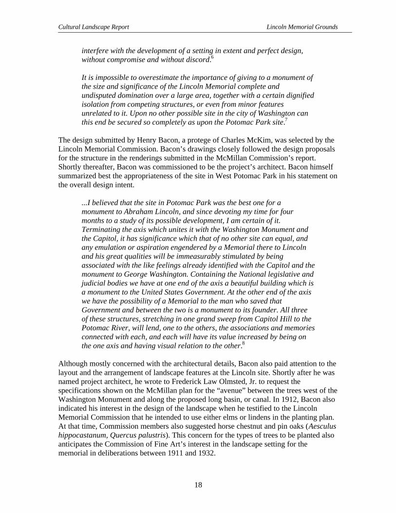
Figure 6 – Mature boxwood and yew shrubs on southeast side of Lincoln Memorial, August 1922. MRC2-16.
Greenleaf’s specific recommendations included using the six or more large yews ofdiffering varieties and the large “box bushes” (Buxus sempervirens) indicated on Payne’splan. However, his views differed from Bacon’s view and Payne’s interpretation inseveral key areas. Greenleaf called for “rugged,” seven-foot wide hedges flanking thesides of the steps. Mass planting shown by Payne should be “eliminated so that the edgeof the Memorial at each end should be straight, but there should be some goodbackground.” A bushy vine growth planted along the retaining wall should be used to“break up the diversion of lines.”
The 1919-20 planting plans submitted after the Cornish meeting reflected these andsubsequent discussions. These plans showed the locations of masses of shrubs and werebased in part on the availability of large scale plant material known to be growing onother federal reservations located throughout the city. The use of boxwood and Englishyews was approved for the area immediately adjacent to the retaining wall on the east,and at the southeast and northeast corners. Bacon continued to insert his ideas on variouslandscape treatments. One of his ideas entailed the addition of a large spreading vinecovering the pink granite surface of the raised terrace wall. To illustrate this concept,Bacon added to the record a photograph of an English manor house overwhelmed withvines. At one time, Bacon objected to the use of boxwood in the planting design. Heapparently changed his mind after reviewing Payne’s installation of the planting plan atthe site in July 1920. Bacon then expressed his preference for large box shrubs rather thanthe yews already planted on opposite sides of the entrance steps. The Commission

Cultural Landscape Report Lincoln Memorial Grounds
28
recommended that the two yews in question, being of thinner habit, be replaced by 12-15foot high boxwood “to secure the desired effect of strength and solidarity (by a heavierleaved material).”25
Throughout the process, Greenleaf and the CFA continued to further refine and exercisecontrol over the planting plan. The Office of Public Buildings and Grounds started toprepare beds inside the inner circle of the memorial grounds in December 1919, with theintention of planting some 44 large specimens of boxwood and 6 holly (Ilex opaca) treesshown on the plans. In the spring of 1920, the commission specified that only mature,large-scale specimen shrubs should be selected for the Lincoln Memorial. However, bythe end of the year, only 15 specimen boxwood shrubs and one yew had been installed onthe eastern side. Not until the fall of 1922, after the memorial’s dedication, were “10additional boxwood trees (known then as Buxus sempervirens ‘Arborescens’), 164 linearfeet of boxwood hedge (consisting of dwarf boxwood, or Buxus sempervirens‘Suffruticosa’) and 200 trailing vines planted.”26 Also, at that time, ground on the southside of the memorial was filled in, brought up to grade, and then prepared for lawn.Subsequently, the CFA called for different treatments on the west side and at thesouthwest and northwest corners, recommending the use of pines, such as Swiss stone(Pinus cembra), Scotch (Pinus sylvestris), mountain and mugo pines (Pinus mugo), beused.
Concepts for the West Side
Although the OPBG landscape architect was also charged with developing planting plansfor the west side of the memorial, the design concept that was finally approved wasGreenleaf’s. Greenleaf advocated both coniferous and glossy-leafed evergreens planted indistinct groupings for the west side. One combination he suggested, which differed fromthe east side, was magnolia and pine planted together with the idea that the pine would beremoved when the magnolia matured. He envisioned Magnolia grandiflora, with its year-round beauty and upright, broad-leaved character, providing a strong background for therear of the memorial. Magnolia, however, was not so strong as to interfere with a goodview of the memorial from Arlington, and would serve as a foil to the already approvedplantings for the east side and corners. He felt magnolia to be especially effective inrelation to the large scale vista from the proposed parkway “sweeping from thenorthwest” designed to link Rock Creek with Potomac Park and the Lincoln Memorial.The CFA approved of his suggestion, that “magnolia trees should be planted in thevicinity of the inner edge of the great circle,” which would eliminate the need forevergreen planting at the northwest and southwest corners of the retaining wall. Thecommission also adopted a 2 to 1 slope for the lower terrace level near the entry to thememorial at this time.
Irving Payne’s interpretation of these recommendations did not completely satisfyGreenleaf. Payne did incorporate “numerous openings through a grove of trees, whichwhen observed from various positions on the “Great Terrace,” or from the road boundingthe “Great Circle,” opened up everchanging vistas.” However, his schemes showed the

Site History
29
Map
4 -
Irvi
ng P
ayne
as-
inst
alle
d pl
antin
g pl
an fo
r fir
st p
hase
of t
he L
inco
ln M
emor
ial f
ound
atio
n pl
antin
g, 1
920-
1928
.C
ourt
esy
of th
e N
atio
nal A
rchi
ves.

Cultural Landscape Report Lincoln Memorial Grounds
30
trees and shrubs far away from the retaining wall in an arrangement that was too regularand geometric. Greenleaf continued to struggle to convey his ideas to Irving Payne. Heenvisioned plantings with numerous bays and indentations for informality with views ofthe Lincoln Memorial from the northwest and southwest preserved. At the same time,Greenleaf believed that certain vistas should be visible from the colonnade on both thenorth and south sides of the memorial.
Payne’s drawings for the west side were finally approved by the commission in January1920. In them, as Greenleaf had suggested, Magnolia grandiflora served as a backdrop tothe structure. In addition, a large, wedge-shaped, open section separated plantings alongthe northwest and the southwest segments of the western retaining wall. Transition plants,uniting the vegetation on both the east and west sides, consisted of American and Englishhollies (Ilex opaca and Ilex aquifolium) and mugo pines. However, the design for thewest side was put aside for several years until construction of the Arlington MemorialBridge was near completion in 1931-1932. When the plan was finally implemented,James Greenleaf no longer served on the CFA, but was the consulting landscape architectfor the Arlington Memorial Bridge Commission.27
Efforts to Complete the Design
Between 1920 and 1921, the project of filling behind the new seawall west of the Lincolncontinued, as did the grading for park grounds located outside of the circular roadway. InJanuary 1921 two plans for the completion of the circular roadway were submitted. Onecalled for a 9-inch crown, using no catch basins or curbing, while the second proposed an11-inch crown without a curb. The CFA approved the concepts of both designs with theunderstanding that the slope differential between the inner and outer edges of theroadways were to be designed to keep the road from appearing sunken. Shortly thereafter,Congress appropriated funds for the construction of roads and walks around the LincolnMemorial. The final design for the circular roadway called for a 60-foot bituminousmacadam road, with curb and gutter and edged by a fifteen-foot sidewalk of “scrubbedconcrete.” Catch basins were designed, but apparently not installed at this time. Twenty-third Street, NW was designed with a grassy median down the center. The sidewalksparallelling this radial road were set back from the curb and constructed of “smoothconcrete.”28 While these plans were being formulated, examination of the recentlyconstructed masonry approaches and the terrace around the memorial revealed that thesewere settling at a faster rate than anticipated by the project’s engineers. As a result, theoriginal slab foundations were removed, and new foundations, built to bedrock, wereinstalled in March 1921. The concrete sidewalks and curbs around the inner circle and onthe east side of the outer circle to north and south 23rd Street were completed in the fall of1922. The radial roadway in the southeast quadrant was also prepared for construction.This road would thereafter be named French Drive for Lincoln sculptor Daniel ChesterFrench.
Both Bacon and Daniel Chester French complained that dirt and dust from the variousgrading operations around the memorial in 1921 had soiled the sculpture of Lincoln.

Site History
31
Regardless, all grading, planting, and road improvements on the west side of the buildingwere temporarily suspended pending funding by Congress for the development of theArlington Memorial Bridge. Design of the bridge’s eastern abutment and the layout forthe riverside drive connecting Rock Creek Park and the route to the “Speedway” alongthe Potomac River was expected to include the landscape treatment for the west side ofthe Lincoln Memorial. In November 1921 Bacon acquiesced to limited illumination ofthe memorial by specifying that streetlights on the traffic circle should be the sole sourceof exterior lighting. He recommended the Potomac Park lamppost and globe. In July1922 he provided sketches of a lamppost with a spherical globe and the designs for twosmall memorial fountains. He had designated on his plan for the west end of the pool thatthe fountains should be located near the concrete steps leading down from the circularroadway. His streetlight design was not selected for the circle and the fountains werenever installed. However, the need for lighting the exterior of the Lincoln Memorialwould not be revisited until 1926.
The Reflecting Pool
During 1919 and 1920 the CFA undertook the finalization of the design for the reflectingpools, including the grading and planting plans for the basins and the adjoining areas. TheCFA advocated an initial shallow excavation, at a temporary level, mostly for ease ofmaintenance. Once the official depth was determined, a permanent treatment would bedesigned. These temporary measures may explain the ditch-like appearance of the poolsseen in some of the early photographs of the area. Excavation for the pools began inNovember 1919, with the excavated earth removed for use on the creation of the circularterrace around the memorial. As with the filling of the raised terrace, a temporary and“small narrow gauge industrial railway” carried the fill dirt across the site from the poolsto the inner circle. Elimination of the cross arms was discussed again, with thecommission generally in favor of their removal from the design. Bacon continued to beagainst the cross arms, as well. Olmsted preferred to reserve judgement until after thelong section of the larger pool had been installed.29
Members did note that the unsightly temporary war buildings on the north side of thereflecting pool prevented any construction of the cross arms on that side. In fact, theincreasing permanence of the temporaries seemed to be in direct conflict with the opendesign originally envisioned for the monumental core.
In a vista over two miles long, these three large structures [Capitol,Washington Monument and Lincoln Memorial] so placed that they will beforever free from proximity to the turmoil of ordinary affairs, and thediscordant irregularity of adjacent secular buildings, will testify to thereverence and honor which attended their erection, and the impression oftheir dignity and stateliness on the mind of the beholder will be augmentedby their surroundings, for which we have a free field for symmetrical andproper arrangement.30

Cultural Landscape Report Lincoln Memorial Grounds
32
Figure 7 – View from Washington Monument showing ditch-like appearance of pools and temporarynursery on the south side of the pools, 1921. MRC 1-53
Olmsted’s earlier opinions seem to have had the most enduring influence on thecommission’s decision to construct only the long section, to lengthen the basin, and toeliminate the squared-off, or jogged, portions of the pool’s outline on the western end.The cross arms remained on the plan and were to be delineated, where possible, on theground by the tree planting. In revisiting this issue, Greenleaf viewed the cross arms as away to force the removal of the temporary buildings, although he acknowledged that thearms were out of scale with the design as it existed on the ground. In November 1920 thecommission finally approved the extension of the western edge of the basin’s coping.They extended the pool by an additional 20 ½ feet to a point located 55 feet east of thebottom steps leading up from the basin toward the memorial. The length of the long poolthus became 2,000 feet; the length of the transverse pool was 300 feet.
In June of 1921, the CFA determined the design of the coping and edge for the reflectingbasin and the smaller basin sited immediately west of 17th street. The CFA approved a 3-foot wide coping that was 9 inches thick with a ¼ inch radius edge, as well as a pooldepth of 2-3 feet. The coping was to be flush with any adjacent sidewalk and grass areas,so that contiguous materials would appear to be a continuation of each other. Later thatyear granite from Mt. Airy, North Carolina, was selected for the coping. Excavation,laying of conduit, and the foundation for the coping were all completed in 1921. Watersupply and an extensive drainage system for the pool and the surrounding area were alsoincorporated into the completed design. Although D.C. public water supply served as the

Site History
33
main water source, additional quantities came from rainwater runoff directed to the poolfrom the memorial and its approaches. The coping foundations were supported by 20-footpiles standing on bedrock, with reinforced concrete beams supported by the piles. Thestability from the piles and beams was used to mitigate the effects of any future settlingon the coping. Through trial and error, contractors working with the OPBG developed awater-proof base consisting of an asphalt coated membrane, slate, and concrete tile. Thedark color of the tile created the illusion of greater depth and a more profound reflection.
Although installation of fountains for the smaller pool was not undertaken at this time,the planned design for the fountains was to incorporate
...a huge water display with two center jets sending water high into the airand 150 side jets around the edges with water issuing toward the center.An electrical display is planned which will illuminate the fountains atnight.31
However, neither pool was completed in time for the memorial’s dedication in May 1922.The larger basin was filled with water for the first time the following December.Concrete walks around the pools were only partially completed by June of 1923 and wereonly fully installed by 1924. To complete the effect of the long, uncluttered vista, over550 trees and shrubs were removed from the area south of the reflecting pool. Gradingand seeding on both the north and south sides also took place at this time. Once the poolswere complete, maintenance personnel planned to flood the surfaces when ice formed onthe pools to create two skating rinks for the public’s use.32
Dedication of the Memorial
Although the grounds surrounding the Lincoln Memorial had not yet been fullydeveloped by the time of the official dedication on May 30, 1922, many of the keyelements were in place. The raised terrace, approachway, and reflecting pool steps hadbeen constructed and subsequently secured to bedrock. Mature specimens of boxwoodand yew had been planted in groupings along the east or front facade. These irregularmasses of shrubs marked the inside corners at the raised terrace steps and wrapped theoutside corners on the northeast and southeast. Four large box shrubs had been planted atthe entrance to the approachway in the two walled beds surrounding the entry benches.Two additional boxwoods flanked the outside pedestals. However, the low box hedgeproposed for the area behind each bench had yet to be planted. Small, no-yet mature elmslined the two paths that paralleled the reflecting pool and the transverse, or oval, pool onthe eastern end. Openings on both the north and south side had been created in the rowsof trees for the future cross arms section of the reflecting pool. Trees on the south markedthat uncompleted segment, while on the north the presence of the parking lot for thetemporary Navy and Munitions buildings prevented such a planting.33 Neither pool heldwater. Fountains and walks along the pools had yet to be installed. The coping on theedge, however, did provide some hard surface for the some 50,000 people that hadgathered to view the dedication from this area.

Cultural Landscape Report Lincoln Memorial Grounds
34
Figure 8 – Dedication festivities for the official opening of the Lincoln Memorial, May 30, 1922. MRC1-30.
Figure 9 – Partially planted east side of Lincoln Memorial during the dedication ceremony, May 30,1922. MRC 1-31.

Site History
35
At the dedication, invited guests were seated on the approachway levels, while otherhonored individuals were seated on chairs that had been set up on the top of the raisedterrace. Here along the terrace wall, the organizers, the Lincoln Memorial Commission,had installed a temporary guardrail. From their vantage point, these guests could see thatthe arrangement of walks and drives around and emanating from the circular terrace wasnot yet complete. The circle drive had been paved and the sidewalk had been installedaround the eastern segment of the inner edge as far as the 23rd Street radial. Twenty-thirdStreet, N.W. and, the as-yet unnamed, Bacon Drive had also been paved and improvedwith sidewalks along each side. Much grading and seeding for lawn remained to be doneas well. Completion of the radial roads and walks, the reflecting and transverse pools, thewalks along the pools, and the installation of streetlights would occur shortly thereafter.Planting on the west side of the memorial and the development of the Watergate and theroads connecting the area to the proposed memorial bridge and the regional parkwaysystem would not occur until the beginning of the next decade.34
Completion of the Lincoln Memorial Grounds1923-1933
Completion of Specific Projects - The Rainbow Pool
In May 1923, The American Institute of Architects (AIA) organized a tribute to HenryBacon that was held at the Lincoln Memorial. The AIA honored Bacon with a dinnerunder a tent set up near the smaller basin. A triumphant procession along the full lengthof the pool, with Bacon riding on a ceremonial barge, followed the dinner. At the Lincolnsteps, Chief Justice William Howard Taft, who had served as chair of the LincolnMemorial Commission, decorated Bacon.
At the time of the tribute to Bacon, the fountains planned for the small, transverse poolhad not been installed. The fountain for this pool was designated the “Rainbow Fountain”in October 1924, when during a trial run just before its dedication a rainbow formedabove the fountain’s spray. Operating with 124 nozzles arranged in an elliptical patternnear the outer edge of the pool, and with two clusters of nine north and south of thecenter, the fountain made a “hazy vista” through which to view the WashingtonMonument and the Lincoln Memorial. Evidently provision was made at this time for thenecessary electrical connections to install a colored light display in the future. In 1925, aninspection of the fountain by members of the Commission of Fine Arts resulted in thefollowing observation and objection: too many spouts and the “playing” fountainobstructed the view of the Lincoln Memorial from 17th Street.35 According to varioussources, the fountain indeed was occasionally illuminated at night.36

Cultural Landscape Report Lincoln Memorial Grounds
36
Figure 10 – Rainbow Pool fountain in all its glory as shown in National Geographic, April 1935, byJacob Gayer. Used by permission from the National Geographic Society.
Throughout 1923 and 1924, landfill along the banks of the Potomac River continued toextend the area behind the new seawall to the west of the Lincoln Memorial.37 By mid-1925, all significant changes in the landform at the Lincoln Memorial had beencompleted. Projects that had transformed the areas included the filling up and grading ofthe ground around the structure; the construction of the circular macadam drive and theradial roads coming off the circle; the excavation and finishing of the long reflecting poolwith concrete walks along each edge; the installation of the transverse pool and fountain;and the grading of the areas adjacent to the long pool with the laying of parallel walks oneither side.38
During the period following the memorial’s dedication, Daniel Chester French, HenryBacon, the CFA, and the OPBG addressed the issues of both exterior and interiorlighting.39 In January 1926, 18 street light units were placed uniformly around the outsideperimeter of the circle, opposite all four sides of the structure. The acorn-style lamp globeselected had been designed by General Electric for use in the District’s streetlight system,as had a special incandescent lamp also developed by G.E.40 In January 1927 the CFAapproved an interior lighting installation that brought about a “quiet, subdued light atnight,” and that had been designed with the assistance of both Daniel Chester French andW. D’Arcy Ryan of G.E. for the Office of Public Buildings and Public Parks (OPBPPwas the successor to the Office of Public Buildings and Grounds established in 1925).The project was contracted out to the firm of Biggs and Kirchner, who installed 24 floodsfor the illumination of the statue and additional 125 lights for general lighting purposes.Lighting the interior of the structure at night became critical by 1927, when visiting hourswere periodically extended into the early evening. However, completion of the lighting

Site History
37
Figure 11 - D.C. street lamp standardsas adopted in 1923.
installation did not occur until1929. By April 1930 the Memorialwas scheduled to stay open until9:30 P.M. throughout the year.41
Another response to the increasein visitation was the 1927construction of two “publiccomfort stations” under the raisedterrace on the eastern front of thebuilding. Two openings forentrances were cut through theraised terrace wall on both sides of
the steps leading up to the memorial. Spaces for the restrooms were created behind thewall and a pair of bronze doors were hung at each entrance. Access to the “stations” fromthe approachway came from the two sets of sidewalks coming off the main walk andpassing through the foundation planting. Construction activity associated with this projectmay have adversely compacted the soil surface along the approachway. In subsequentyears, compaction from other projects and special events in this area would adverselyaffect adjacent shrubs.42
Figure 12 – Narrow passageway underboxwoods to “Men’s” restroom south ofthe main steps, May 1, 1927. MRC 2-11.
Additional Trees and Shrubs
Throughout this period, the OPBGcontinued to strategically placetrees and shrubs, especially on thecircular terrace immediatelysurrounding the memorial. One of
these shrubs, a large, specimen boxwood, had been moved from the grounds of theCorcoran estate and former residence of Daniel Webster, to the Lincoln Memorial site in1922, and planted in Webster’s memory.43 In 1924, hardy vines were planted to grow onthe raised terrace wall. These were soon visible on the wall at the base of the west facade,where few shrubs had been installed since the dedication ceremony. More boxwoodshrubs and “hedge plants” (Buxus sempervirens ‘Suffruticosa’) were planted between1924 and 1926 along the approachway and around the memorial in unspecifiedlocations.44

Cultural Landscape Report Lincoln Memorial Grounds
38
In addition to OPBG’s work on the grounds, they worked with various civic groups andorganizations to plant memorial trees in West Potomac Park. On May 23, 1923, thelieutenant governor of Massachusetts and the mayors of 39 cities in the commonwealthplanted 40 American elm trees along French Drive, creating the “Massachusetts Avenueof Memorial Trees.”45 Mrs. Coolidge and the president of Oberlin College planted thefirst individual memorial tree on the Lincoln grounds on November 5, 1923. Elsewhere inthe park, Rhode Islanders planted the Liberty Tree to commemorate the 148thanniversary of that state’s independence from Great Britain. The American ForestryAssociation gave two elms, one for the Army and one for the Navy, to begin aninternational avenue. The Boy Scouts of the District of Columbia planted a white oaknearby to honor Nancy Hanks, Lincoln’s mother. Additional locations around the LincolnCircle and along the radial roads were designated for memorial trees to be planted by therelatives of former servicemen. These trees would have no commemorative marker, savea small identification tag. One group of children planted a red oak near Bacon Drive andB Street, N.W. to honor John Burroughs and to complete a grouping of dedicated trees,serving as a “hall of fame” to John Muir, Henry Thoreau, Walt Whitman and John JamesAudubon. Not all requests for living memorials were granted. One, for example,
Figure 13– View of newly planted elms along radial roads and Reflecting Pool area, 1927. MRC 1-54.

Site History
39
concerned a proposal to plant a white birch in the area as a memorial tree. Because theplanting plans for both the east and west facades of the Lincoln called for a variety ofevergreen plants, the CFA refused to approve such a radical change in concept. The CFAreaffirmed that
The success of the planting already in place calls for the completion of thescheme, the essence of which is the honor to the memory of AbrahamLincoln and not a shrine for votive offerings.46
Map 5 - One of the many memorial tree plans for the Lincoln Memorial circle and radial roads area,1924. NPS Map 801/80081.
Between 1927 and 1928, the Horticulture Division of the OPBPP worked to complete theapproved planting plan for the north, east, and south sides and focused on several otherissues affecting the area around the memorial. Fifteen large magnolia trees weretransplanted from the memorial grounds to another location in West Potomac Park. Inturn, seven large, tree-type boxwood were planted at the memorial. During this period,the division noted in the annual reports that the elm leaf beetle and the caterpillar caused“usual damage” to the public reservations in the city. Although West Potomac Park wasnot specifically cited for pests, the large number of elm trees growing on the grounds
Cultural Landscape Report Lincoln Memorial Grounds
40
around the memorial and along the Reflecting Pool may have been treated for theseproblems. By 1928, the box-leaf miner was also cited as a pest for extermination.Whether the boxwood shrubs around the Lincoln Memorial were affected by box-leafminer has yet to be determined.47
Park Developments
In 1924 the CFA approved the location for the development of a secondary focal point,south of the Lincoln Memorial. This point had been on the 23rd Street axis designated onthe McMillan Commission Plan. The site, which overlooked the river directly south ofthe “Great Circle,” was set aside for a memorial to John Ericsson, Swedish-born inventorof the screw propeller and designer of the U.S. Navy’s famous ironclad warship, theMonitor. The monument was designed to be set in a small traffic circle, prominentlylocated at the southern end of 23rd Street. While preliminary site preparation took place in1924, realization of the project was delayed for several years. The dedication, using aplaster casting to mark the place for the future statue, was held on May 1926, but sculptorJames Earle Fraser’s work was not completed until July 1927. As with the west side ofthe Lincoln Memorial, final treatment of the grounds around the Ericsson Memorial wasscheduled for completion at the same time as the construction of the Arlington MemorialBridge approaches, which occurred in 1932.48
Other developments occurred in West Potomac Park that had less immediate impact onthe grounds around the Lincoln Memorial but would eventually become significant issuesfor this part of the park. The impact of the shift from passive recreation to more activesports on adjacent park land was one of the concerns voiced when the second of two golfcourses in West Potomac Park opened in 1924. The first nine-hole course had been laidout in an adjacent area just northwest of the Lincoln Memorial in 1923; the second waslocated in the far southeast area of West Potomac Park. Both were operated under aconcession arrangement.49 The improvement of adjacent streets to thoroughfares, whichbrought about increases in automobile traffic and the need for parking, was anotherconcern. When B Street North was realigned, extended from Capitol Hill to the river,widened, improved, and renamed Constitution Avenue during September of 1931, such athrough-route was inadvertently created. Requests to allow automobile parking at theLincoln were brought before the Commission of Fine Arts in both 1931 and 1934. TheCFA did not grant these requests, and although the public adhered to the existing parkingrestrictions, parking was prohibited on the west side of the circle in 1934. However, a taxistand was permitted.50

Site History
41
Management of the Reflecting Pool
In the Reflecting Pool area, the double rows of elms had developed such full crowns thatthey appeared to require pruning and reshaping. Further investigation revealed that whilethe canopy was full, the root development of the individual trees was very poor. Theroots were so underdeveloped that the trees were not secure in the ground. Several yearspassed before the elms’ condition stabilized. Of the 250 elms planted in 1916, prior to theexcavation of the reflecting basins, most exhibited such poor root development by 1929that they were top-heavy and prone to falling over in high winds. Because the elms hadbeen planted in moist, soggy conditions with inadequate drainage, replacement of thesespecimens would eventually be required. With the subsequent improvement of thegroundwater level, the replacements evidently survived.51
Figure 14 & Figure 15 – Series of images document the condition of “English” elms along theReflecting Pool north and south walk, 1928-1929. MRC 2-37 & 2-38.

Cultural Landscape Report Lincoln Memorial Grounds
42
Figure 16 – Skating on theReflecting Pool, February3, 1935. MRC 3-22.
Figure 17 – Swimming inthe main Reflecting Poolsoon after its completion,1926. MRC 3-23.
Recreational use of the Reflecting Pool began around 1926. The pool was used forswimming, ice skating, model sailboat races, flycasting contests, and as the setting forsuch large-scale events as the George Washington Bicentennial Festival of Youth held onMay 14, 1932.52
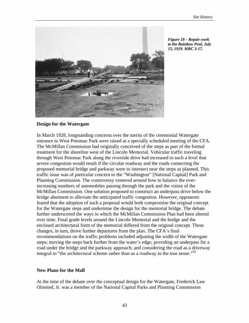
In 1929 both reflecting basins required repair. Because they had been constructed on“hydraulic fill” and had settled unequally, the smaller pool needed a new reinforcedconcrete bottom. The larger pool needed routine sealing maintenance. Rose Brotherscompleted these repairs in the fall of 1929. There may have also been problems withvegetation growing in the pools.53
Site History
43
Figure 18 – Repair workto the Rainbow Pool, July15, 1929. MRC 3-17.
Design for the Watergate
In March 1928, longstanding concerns over the merits of the ceremonial Watergateentrance to West Potomac Park were raised at a specially scheduled meeting of the CFA.The McMillan Commission had originally conceived of the steps as part of the formaltreatment for the shoreline west of the Lincoln Memorial. Vehicular traffic travelingthrough West Potomac Park along the riverside drive had increased to such a level thatsevere congestion would result if the circular roadway and the roads connecting theproposed memorial bridge and parkway were to intersect near the steps as planned. Thistraffic issue was of particular concern to the “Washington” [National Capital] Park andPlanning Commission. The controversy centered around how to balance the ever-increasing numbers of automobiles passing through the park and the vision of theMcMillan Commission. One solution proposed to construct an underpass drive below thebridge abutment to alleviate the anticipated traffic congestion. However, opponentsfeared that the adoption of such a proposal would both compromise the original conceptfor the Watergate steps and undermine the design for the memorial bridge. The debatefurther underscored the ways in which the McMillan Commission Plan had been alteredover time. Final grade levels around the Lincoln Memorial and the bridge and theenclosed architectural form of the memorial differed from the original concept. Thesechanges, in turn, drove further departures from the plan. The CFA’s finalrecommendations on the traffic problems included adjusting the width of the Watergatesteps; moving the steps back further from the water’s edge; providing an underpass for aroad under the bridge and the parkway approach; and considering the road as a drivewayintegral to “the architectural scheme rather than as a roadway in the true sense.”54
New Plans for the Mall
At the time of the debate over the conceptual design for the Watergate, Frederick LawOlmsted, Jr. was a member of the National Capital Parks and Planning Commission

Cultural Landscape Report Lincoln Memorial Grounds
44
(NCPPC). The NCPPC had been authorized in 1928 to be responsible for allcomprehensive planning and project planning for the city. Olmsted, with his vastexperience on other municipal and regional projects, his work on the McMillanCommission, and his service on the CFA, formulated the objectives for the commissionat the outset. In his role, Olmsted personally oversaw the planning for parkways, parks,and neighborhood playgrounds. One of the first efforts of the commission was thedevelopment of comprehensive plans for the city that included recommendations for theMall, which were based on both the L’Enfant and McMillan plans. Although the 1928-29NCPPC plans for the Mall mostly focused on the expanse between the Capitol and theWashington Monument, key elements of their concept for the area between theWashington Monument and the Lincoln Memorial underscore the essential elements ofthe landscape around the memorial.
These plans reaffirm the simplicity of formal geometric patterns of circulation andvegetation along the Reflecting and Rainbow Pools, around the circular roadway, andalong the radial roads. Delineation of the geometry established by the McMillanCommission was reinforced in the NCPPC design through the regular planting of treesand through the shape of the pools and the corridor of open spaces on both the north andsouth sides. Perhaps because of Olmsted’s continuing influence on the landscapetreatment, the cross arms of the original reflecting pool design remained as an outline oftrees on the ground plain, more a horticultural feature than a water feature. In the moredistant spaces, informal, wooded plantings of deciduous trees filled the triangles andrectangles created by the arrangement of the roads and drives. In reality, the complete“tapis vert” of the design could not be implemented fully until the Navy and MunitionsBuildings and the adjacent parking lot north of the Reflecting Pool were removed.55
Planting Plans - West Side and the Watergate
In 1928 Irving Payne oversaw the installation of plantings for the west side of the LincolnMemorial according to the plan approved by the CFA several years earlier. However,because of the construction of the Arlington Memorial Bridge abutment, Payne had madechanges “in the character of the planting and treatment. . . .” Payne’s installation includeda special treatment for the central area on the west side of the memorial, “with ascattering of trees and shrubs on the north and south sides.” CFA landscape architectmember Ferrucio Vitale overrode Payne’s work by recommending a simpler design forthe north, south, and west corners, consisting mostly of boxwood, which was to extend nomore than 30 feet from the base of the memorial. Vitale also envisioned the circle of lawnto be free of trees and shrubs. In addition, he called for removing the vines growing onthe raised terrace wall that had been planted a few years earlier. To save the masonryfrom damage by climbing vines, Vitale suggested climbing euonymus (similar toEuonymus fortunei var. radicans ‘Vegetus’) as a replacement.
By the end of the decade, James Greenleaf, former CFA member and consultinglandscape architect for Arlington Memorial Bridge Commission, and the OPBPP haddeveloped preliminary planting plans and contour and grading studies for the area at the

Site History
45
eastern end of the Arlington Memorial Bridge. This site development encompassed thebridge plaza on the District side; the riverside drive connection with the still uncompletedRock Creek and Potomac Parkway; the north approach roads from B Street [ConstitutionAvenue] to the bridge underpass; the Ericsson Memorial site; and the south underpassapproach road to the bridge. Several collections of existing trees had to be relocated toimplement these designs. Six Japanese flowering cherry trees were transplanted from theriverside parkway at the Arlington Memorial Bridge to Meridian Hill Park, near thecenter of the city. Six Scotch and American Elms growing near the route proposed for aroad that linked the Ericsson Memorial with a West Potomac Park polo field were alsoremoved in anticipation of the completion of that memorial, although pavement, curbs,and gutters were not installed around it until the summer of 1932. Another 16 cherry treesand 20 mature Scotch and American Elms were removed from the vicinity of the bridgeand riverside drive. Ten of these same elms may have been transplanted to the southernend of Rock Creek and Potomac Parkway only a short time after the opening of the KStreet to West Potomac Park section of the parkway in April 1932.56
Map 6 - Plan to relocate elms located along abandoned section of Riverside Drive, rev. 1929. NPS Map801/80129.
Construction of the Arlington Memorial Bridge and its intersection with the LincolnMemorial axis and the Watergate was almost completed in May 1932. At that time theOPBPP worked to install trees and shrubs around the Watergate and on the west side ofthe Lincoln Memorial. Gilmore Clarke, a landscape architect appointed to replace Vitaleon the CFA, was initially alarmed by Payne’s installation of Greenleaf’s planting designfor the west side of the Lincoln. Clarke had a strong background in large-scale landscapeprojects, especially from his award-winning work on the Westchester County Parkway.

Cultural Landscape Report Lincoln Memorial Grounds
46
Payne’s “overdone” work drew additional criticism from other professionals concernedwith the Arlington Memorial Bridge and the Lincoln Memorial. In the case of theWatergate and the bridge and parkway connections, the problems lay in the interpretationof the plan and not with the plan itself. However, the plant selection and choice of certaintypes of trees and shrubs at the Lincoln were the cause of significant disagreementbetween Clarke and Greenleaf. While both Clark and Greenleaf found Payne’s work “onthe ground” lacking in aesthetic sensitivity, the two could not agree on the philosophicalbasis for the overall planting design.
Clarke considered the implementation of the design for the west side of the memorial tobe “coming up higher than it should . . . extending above the base of the columns.” Inaddition, he found the selection of trees and shrubs for the west side “not in harmony”with those that had been planted on the east side. In particular, Clarke took exception tothe choice of Magnolia grandiflora, the tree so strongly advocated by Greenleaf a decadeearlier. Clarke found its “coarse foliage texture”. . . “too large in contrast with thedelicate texture of the boxwood foliage heretofore used as the principal plant material.”On the other hand, Greenleaf felt that because of the range of vistas on the west side, theplantings at the rear of the Lincoln should be of a broader scale than those on the front.He also felt that the rear, unlike the front, should not appear as a tight bedding group, andthat it would be inappropriate to carry a similar planting scheme around all four sides ofthe memorial. Greenleaf cited the hardiness of the magnolia and suggested Americanholly as a companion plant. He further praised the character of the tree by noting
The splendid rounded masses of rich green foliage that this Magnoliaultimately develops can be a fine foil to the white marble columns of theMemorial building. In fact, I would like to return fifty years later and seeirregular massing exclusively of Magnolia grandiflora contrasting withthe mellowed marble of this perfect architecture, the box and yewbecoming relatively unimportant but nevertheless enriching the effect inplaces against the granite wall of the platform.57
The issue was never clearly resolved in 1932, and Clarke and Greenleaf continued to holdto their respective opinions. Since the revised planting plan had been originally approvedby the CFA in the fall of 1931, prior to Clarke’s term on the CFA, the installation of treesand shrubs on the west side of the Lincoln Memorial proceeded according to Greenleaf’sdesign scheme.
Field inspection and tagging of this choice ornamental evergreen materialfor planting the Lincoln Memorial terrace, including the Watergate andwing walls, was made before transplanting, necessitating tripsaggregating over 5,000 miles through the States of Virginia, WestVirginia, Maryland and Pennsylvania. Further, careful inspection wasmade of all plant materials at the planting site to determine the quality,size, character, orientation, and final location of each plant to secure themost pleasing planting composition possible.58

Site History
47
Figure 19 - Aerial view of installation of trees and shrubs on west side of Lincoln Memorial and bedsflanking the Watergate steps, 1932. MRC 1-66.
In the end, the plant material used for the west side of the Lincoln Memorial, Watergate,and wing walls included several different types of glossy-leafed and coniferous evergreentrees and shrubs. Selected for the Lincoln Memorial were large specimens of southernmagnolia, American holly, “treebox,” dwarf boxwood, common boxwood, Japanese yew(Taxus cuspidata) and mugo pines. Similar plants were used at the Watergate and wingwalls, with the exception of the southern magnolia, which were replaced by white pines(Pinus strobus).
In conjunction with the Arlington Memorial Bridge construction and planting plans,several contracts for the removal and the installation of trees on the west side of theLincoln were given to different nurseries in 1932. One company removed elm trees onand around the bridge plaza and transplanted them. Another furnished and plantedornamental evergreens in the same area. The third company moved elms to theapproaches at the plaza. James Greenleaf had prepared the plans to accommodate thisactivity. According to his specifications, 193 large American elms and 15 white pineswere moved into the area bounded by Constitution Avenue, “B Street, south,” 23rd Street,and the Potomac River. The elms were transplanted from their location between 23rd
Street and Constitution Avenue, northeast of the Lincoln Circle and placed on each sideof Constitution Avenue between the Potomac River and Henry Bacon Drive, south ofConstitution Avenue between 16th and 17th Streets, along the circular road west of the

Cultural Landscape Report Lincoln Memorial Grounds
48
Figure 20 – Completion of Watergate plaza, sidewalks and bridle trail, June 9, 1933. MRC 1-75.
Lincoln Memorial and adjacent to the north and south wing walls of the Watergate plaza,and on each side of 23rd Street, S.W. The white pines were removed from their locationsnear the intersection of 26th Street and Constitution Avenue to new sites on the slopesadjacent to the north and south wing walls.
With the completion of the landscape treatment around the memorial in 1932, anirrigation system for the inner circle was installed. Other “improvements” included theaddition of temporary, free-standing handrails on the raised terrace and stylobate steps,which were set-up as needed in alignment with the entrance to the memorial chamber.Although the Watergate area, including the bridge plaza, wing walls, and the descent offorty steps, was also completed by 1932, several features on the District side of the bridgewere not finished until later. Schemes for the storage rooms under the Rock Creekapproach were not approved by the CFA until October 1933, only to have the approvalsrescinded the following month. Approvals for the design of the statues for the eastern endof the bridge and the parkway approach were not issued until 1935, and even then theirgranite bases remained unadorned by any sculpture for some 19 years.

Site History
49
Figure 21 - Temporary wooden steps tomemorial chamber, Lincoln Birthdaycelebration, February 12, 1946. MRC 1-125.
Management by the National Park Service1933-1945
New Stewardship Role for the National Park Service
In August 1933 the responsibility for the care and maintenance of monuments in thenation’s capital was transferred from the War Department’s Office of Public Buildingsand Public Parks (OPBPP) to the National Park Service. This change meant that theOPBPP would no longer be directly involved in the stewardship of the Lincoln Memorial,the Reflecting Pool, and the Watergate area. Rather, a new division of the park service,known as National Capital Parks, was responsible for the management of all thereservations belonging to the federal government, including Rock Creek Park, East andWest Potomac Park, and the George Washington Memorial Parkway. After the change,the Commission of Fine Arts commended the park service for its attention to theappearance of the capital’s parks. They noted the service’s efforts in growing “turf,elimination of scraggly shrubs, use of decorative low planting and the care of worth-while trees” particularly in the smaller parks of the “old city.” At this time, the parkservice submitted designs for two styles of park benches, a concrete and an iron version,both of which the CFA approved.59
The park service also worked to revive significant plantings at the Lincoln Memorial.In March 1936, under the direction of the park, Public Works Administration workersreplaced selected yew and boxwood shrubs, as well as portions of the dwarf boxwoodhedges lining the approach at the Lincoln Memorial, with similar mature plants. Theyalso supplemented existing boxwood specimens in the beds flanking the entrance to theapproachway. Poor soil conditions and poor drainage combined with problems broughton by a combination of drought, winter cold, pests, and sun-scald had necessitated arehabilitation of the boxwood. At this time drainage trenches were installed on both sidesof the approachway to improve the conditions for both the newly planted hedges and
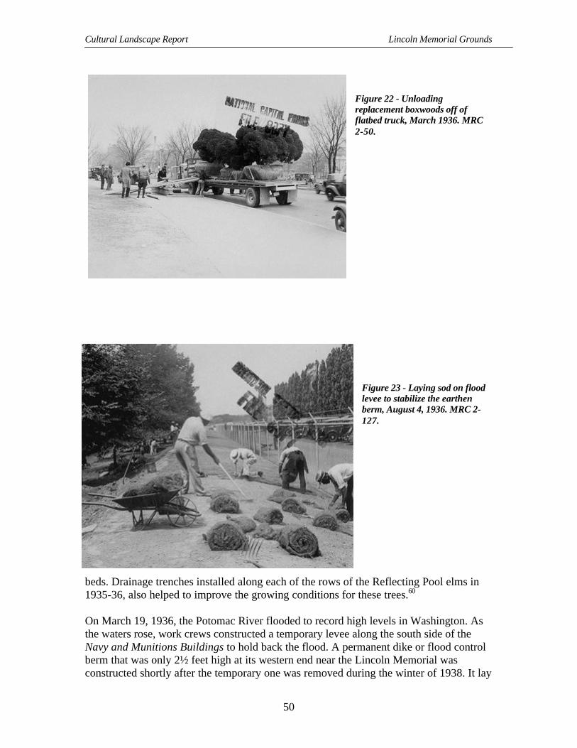
Cultural Landscape Report Lincoln Memorial Grounds
50
Figure 22 - Unloadingreplacement boxwoods off offlatbed truck, March 1936. MRC2-50.
Figure 23 - Laying sod on floodlevee to stabilize the earthenberm, August 4, 1936. MRC 2-127.
beds. Drainage trenches installed along each of the rows of the Reflecting Pool elms in1935-36, also helped to improve the growing conditions for these trees.60
On March 19, 1936, the Potomac River flooded to record high levels in Washington. Asthe waters rose, work crews constructed a temporary levee along the south side of theNavy and Munitions Buildings to hold back the flood. A permanent dike or flood controlberm that was only 2½ feet high at its western end near the Lincoln Memorial wasconstructed shortly after the temporary one was removed during the winter of 1938. It lay

Site History
51
parallel to the east/west axis, “at approximately one-half the distance between theReflecting Pool and Constitution Avenue.”61
Cultural Events and Social Significance
As the frequency of summertime band performances declined at the D.C. War Memorial,the National Capital Parks began to introduce music on the west side of the LincolnMemorial. Here in the amphitheater created by the Watergate steps, temporary chairs,booths, and kiosks were set up for the public’s enjoyment of outdoor musicalperformances at the river’s edge. Over time a series of increasingly elaborate orchestraconcert shells were constructed on barges anchored near the base of the Watergate steps.Although the first program of concerts was held during the summer of 1935,
Figure 24 - Concert barge tethered at the base of the Watergate steps, in preparation for a concert, July12, 1939. MRC 1-3.
documentation suggests that a formal orchestral barge was not in place before 1937. Amore stylized architectural shell was created in 1939, and the third, an elaborate coveredstage set off by flagpoles and planter boxes, was developed during 1947-1948. The stepsprovided most of the seating, with additional chairs arranged for the audience on the stripof lawn along the river, on platforms that spanned the road surface of the drive locatedbetween the steps and the lawn, and at the top of the steps. During concerts the underpasswas closed to traffic, which was probably directed away from the river road to theLincoln Circle. The summer series of concerts included performances by military bands,opera companies, and by the Watergate Symphony Orchestra “and the world’s great

Cultural Landscape Report Lincoln Memorial Grounds
52
artists,” organized under the auspices of the National Symphony. The theater and relatedservices were managed and operated by a concessionaire, Government Services,Incorporated. A former storage facility located underneath the Rock Creek and PotomacParkway approach (Parkway Drive) housed public restrooms for the area. Performanceswere discontinued in 1973. The barge was hauled away at that time, although the piers,which had provided anchorage for the floating stage, remained in the river until 1984.
The most significant cultural event that occurred at the Lincoln Memorial during theearly years of NPS management was the Marian Anderson Easter Sunday concert onApril 6, 1939. While this concert was ostensibly cultural, its significance is derived fromthe larger social and political impact on the nation as a whole. Because the Daughters ofthe American Revolution (DAR) had prohibited this noted African-American contraltofrom performing at the DAR’s Constitution Hall, Secretary of the Interior Harold Ickesoffered the steps of the Lincoln Memorial as an alternative concert location. Some 50,000people positioned themselves on the approachway and at the Reflecting Pool steps to hearAnderson sing. Her performance was also broadcast live over national radio. The successof the concert marked the first nationally significant use of the memorial, the main steps,the approachway, the Reflecting Pool steps, and the circle as both a stage and a theatersince the memorial’s dedication in 1922 and the AIA’s ceremonial dinner for HenryBacon in 1923. While the selection of the site and the design of the Lincoln had beenoriginally “conceived as a symbol of national consensus, linking North and South onholy, national ground,” with the Anderson concert, the memorial became the “strongholdof racial justice.”62 From 1939 the memorial became the setting from which to stage othersignificant events associated with both civil rights and freedom of speech.
Effects of Park Planning
Construction of the last segment of Rock Creek and Potomac Parkway was completed in1936. Over the years landscape architects such as Olmsted, Langdon, and Greenleaf hadparticipated in the development of the final design. Although originally intended to linkRock Creek Park with West Potomac Park by means of a scenic, recreational drive,increasingly high volumes of commuter automobile traffic caused parkwayadministrators to institute one-way only routes during morning and evening rush hours in1937. Because of the public perception that the parkway serves as an express route todowntown Washington, these one-way restrictions have remained in effect on theparkway to the present day. Since 1937 commuting traffic has had a profound effect onthe circulation around the Lincoln Memorial. Park land near the memorial has beensacrificed to make road improvements to control traffic. The resulting changes to theoverall landscape have detracted from the setting.
The National Capital Parks and Planning Commission updated their plans for thedevelopment of the Mall in 1937, 1939, and 1941. These plans reflect several changesthat had taken place at the western end. The three proposals eliminated the cross armsfrom their treatment for the Reflecting Pool, showed the completion of the expansion ofConstitution Avenue, and the addition of the Ericsson and the D.C. War Memorials. The

Site History
53
effect of the new flood control berm on the double rows of elms and the design for theplanned open space next to the north side of the Reflecting Pool are not depicted,probably because a parking lot for the World War I temporary buildings still occupiedthis area, even though it was not marked on the NCPPC plans. While the berm served tohelp screen the parking from the pool area at this time, it eventually would become atopographical barrier, separating spaces that were designed to be together.
Elements of these plans that remain consistent with earlier NCPPC plans and theMcMillan Plan for the Lincoln Memorial are the overall spatial organization, thevehicular and pedestrian circulation, and the longstanding arrangement of vegetationaround the memorial structure along the outer edge of the circular roadway and along thepool. The three plans, however, outline new treatment for the Washington Monumentgrounds and the Tidal Basin that had a long-term impact on the Lincoln Memoriallandscape. The 1939 and the 1941 plans, conceived by Gilmore Clarke, indicate the siteof the Jefferson Memorial, which was then under construction. All three delineateproposals for the extension of Independence Avenue west from 14th Street along theroute of B Street, S.W. Only the 1941 plan includes the design of an access ramp near theWatergate to connect the Independence Avenue extension with Arlington MemorialBridge and Rock Creek and Potomac Parkway.63
Map 7 -Development plans for the later part of the 1930s no longer depicted the Reflecting Pool "crossarms," 1939. NPS Map microfilm 35-52F/1.

Cultural Landscape Report Lincoln Memorial Grounds
54
War and Changes in Land Use
The proposal for the extension of Independence Avenue from 14th Street to 23rd Street,S.W. was presented to the Commission of Fine Arts in November 1941. Concerns overthe effect that a through route, designed primarily for connecting the new WarDepartment Building (the Pentagon) in Virginia with the two major river crossings, at14th Street and at Memorial Bridge, would have on the adjacent park land was a keyissue in efforts to win approval for the change. The approved route, developed by mid-1942, created a system of one-way routes, rather than a single, two-way road that wouldmake “. . . driving safer and pleasanter.” This design also incorporated sections ofexisting park roads and portions of a circumferential road system designed by FrederickLaw Olmsted Jr. in 1931 for the Washington Monument grounds. (The Olmsted designwas never fully implemented.)64 Automobiles using the old riverside drive still had tonegotiate the small traffic circle at the Ericsson Memorial. However, sometime in 1943the route was altered around this smaller monument to accommodate higher volumes ofcars that developed when a separate eastbound lane was completed. This lane passed overthe Tidal Basin on a newly constructed bridge, which was subsequently named KutzBridge in 1954 to honor D.C. Commissioner Engineer Charles Kutz. As part of theextension project, which was completed in August 1943, the entrances and exits to theRock Creek and Potomac Parkway and Arlington Memorial Bridge were realigned to apartial cloverleaf pattern.
Figure 25 - New configuration of road system, with the addition of Independence Avenue and the onand off ramps from Lincoln Circle, January 27, 1960. MRC 1-108.

Site History
55
Figure 26 - Temporary elevated pedestrian bridges over the Reflecting Pool, June 1944. MRC 3-29.
The area around the Reflecting Pool was adapted in other ways to meet the expansion ofthe federal government during World War II. During 1942 temporary office anddormitory buildings were constructed for the use of government employees brought to thecity to work on the war effort. Some of these quickly-built “tempos” were located on thewestern side of the Washington Monument grounds, on the main axis between 17th Streetand the monument. Others were constructed in the area south of the reflecting pools. Achain-link fence, running along the most southern line of elm trees, separated thesestructures from the Reflecting Pool area. Two additional structures were constructedperpendicular to the older cluster of World I temporary buildings in the space formerlyoccupied by the parking lot on the north side of the flood control embankment. Finallytwo covered, elevated pedestrian bridges were erected in 1942 across the east/west axis tolink the WWI structures with the newer WWII temporary buildings to the south. Onespanned the Reflecting Pool close to the 19th street alignment, and the second crossedover the small plaza between the Reflecting Pool and the Rainbow Pool. A third bridgecrossing 17th Street, just south of Constitution Avenue, linked the “tempos” on theWashington Monument grounds with the east side of the WWI structures. The cluster of“temporaries” located at the base of the Washington Monument grounds was expanded in1943, when three wings were added to one of those buildings. With the influx ofadditional government workers to offices located in park areas, all-day parking wasallowed in lots adjacent to the “temporaries” and along park roads in the monumentalcore. Over time, other changes to the Lincoln Memorial were proposed but were notapproved. One was for the installation of light posts adjacent to the Reflecting Pool for

Cultural Landscape Report Lincoln Memorial Grounds
56
the purpose of practicing fly fishing techniques in the evening. Another was for theinstallation of permanent handrails on the raised terrace and stylobate steps leading to thememorial and for increased illumination of the steps.
Tourism and Traffic1945-1970
Revival and Completion of Pre-War Plans
Near the end of World War II, the National Park Service, the Commission of Fine Artsand the National Capital Parks and Planning Commission prepared to return WestPotomac Park to the conditions shown on the pre-war plans. The CFA urged
that the area along the south side of Constitution Avenue, now occupiedby buildings, be planned as a naturalistic park area, within the rigidborders of the straight avenues, roads, and walks, with broad expanses oflawn with trees in mass, in groups, and singly, composed in a mannerappropriate for passive recreation and in keeping with the immediateenvironment of two of the greatest memorials ever erected, theWashington Monument and the Lincoln Memorial. This is no place foractive, noisy recreation: the area belongs to the people of the UnitedStates and it should not be dedicated for the use by Government employeesand other residents of Washington as baseball and football fields.65
Notwithstanding the commission’s recommendations, the temporary buildings and theaccompanying parking lots and fencing remained on both sides of the Reflecting Pooland at the base of the Washington Monument for many more years, prohibiting thedevelopment of these areas for “passive” recreation. However, the bridges crossing overthe pools were removed during the immediate post-war period.
Four statuary groups of allegorical equestrian groupings were installed at the eastern endof the Arlington Memorial Bridge and at the approach to Rock Creek and PotomacParkway in June 1951. Two of them, the Arts of War representing “Valor and Sacrifice,”were designed by Leo Friedlander; the other two, the Arts of Peace shown as “Music andHarvest” and “Aspiration and Literature,” were designed by James Earle Fraser. With theinstallation of these figures the plans for the bridge and the parkway approach werefinally completed. However, several elements from the original bridge design werealtered before and just after these last pieces were set in place. Not only had the roadconnections been realigned in the 1940s to meet the Independence Avenue extension, butby 1952, the original granite block pavers on the bridge was replaced with “asphalticconcrete.”66 Such changes improved the flow and speed of traffic but also undermined theformal, ceremonial character of the bridge and its symbolic relationship to the LincolnMemorial.

Site History
57
Figure 27 - Installation of "Sacrifice" statue on north side of entrance to Arlington Memorial Bridge,June 1951. MRC 1-76.
Repairs and Incremental Changes
The National Capital Parks worked to improve the appearance of the landscape aroundthe Lincoln Memorial wherever possible. Some of the boxwood shrubs located adjacentto the retaining wall and the main approachway were thin and scraggly in appearance. Inthe spring of 1944, Irving Payne, the former OPBG landscape architect who had workedon previous memorial projects, recommended that the park service modify the originalplan by changing the arrangement of evergreens. In June, a partial installation of yew(Taxus cuspidata ‘Nana’) replaced the dwarf boxwood hedge located on the south side ofthe approachway. By the summer of 1945, 348 yews had been planted on both sides ofthe approachway. The beds of dwarf boxwood flanking the entrance to the approachwayand facing the circular sidewalk were rehabilitated with additional and replacementboxwood shrubs. A select number of larger boxwood shrubs on the front side of theraised terrace wall were also treated under this “program to rehabilitate” the Lincolngrounds. Among the 12 boxwoods brought in for the project was a large Americanboxwood, approximately 200 years old, that had been found growing in a South Carolinacottonfield near the ruins of a former colonial residence. Park plans designated thisspecimen for the lawn area just south of the approachway. National Capital Parkscompleted the rehabilitation in 1947.
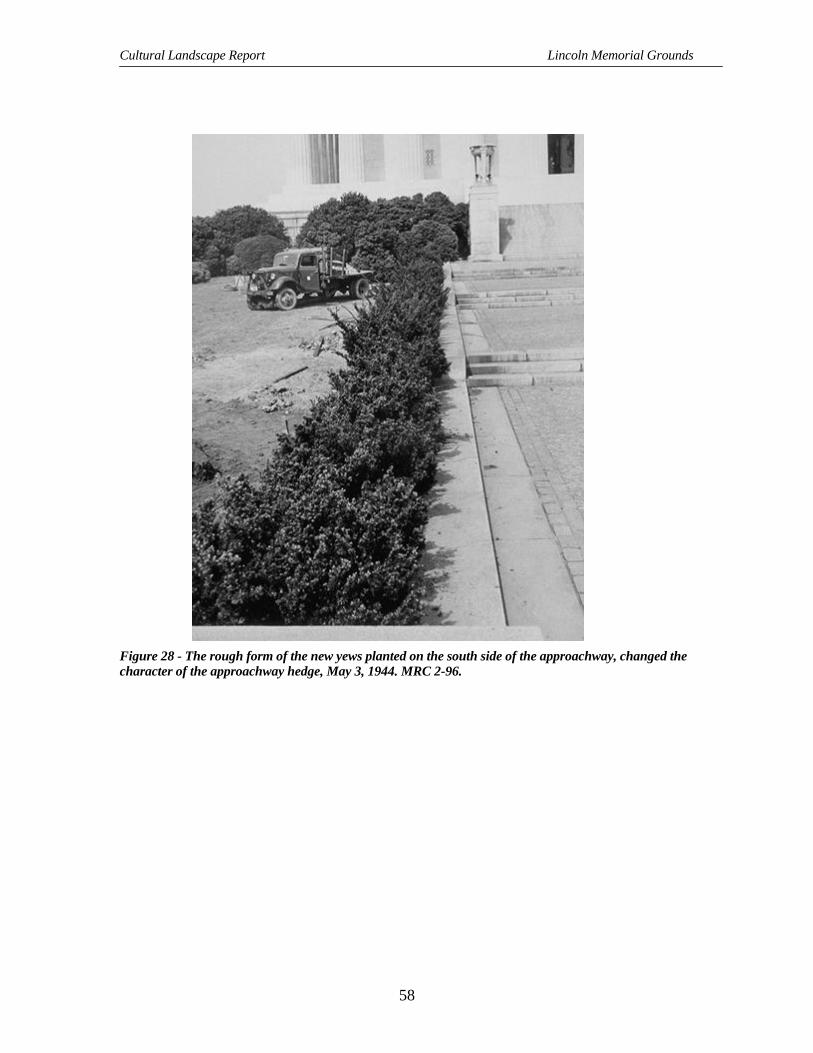
Cultural Landscape Report Lincoln Memorial Grounds
58
Figure 28 - The rough form of the new yews planted on the south side of the approachway, changed thecharacter of the approachway hedge, May 3, 1944. MRC 2-96.
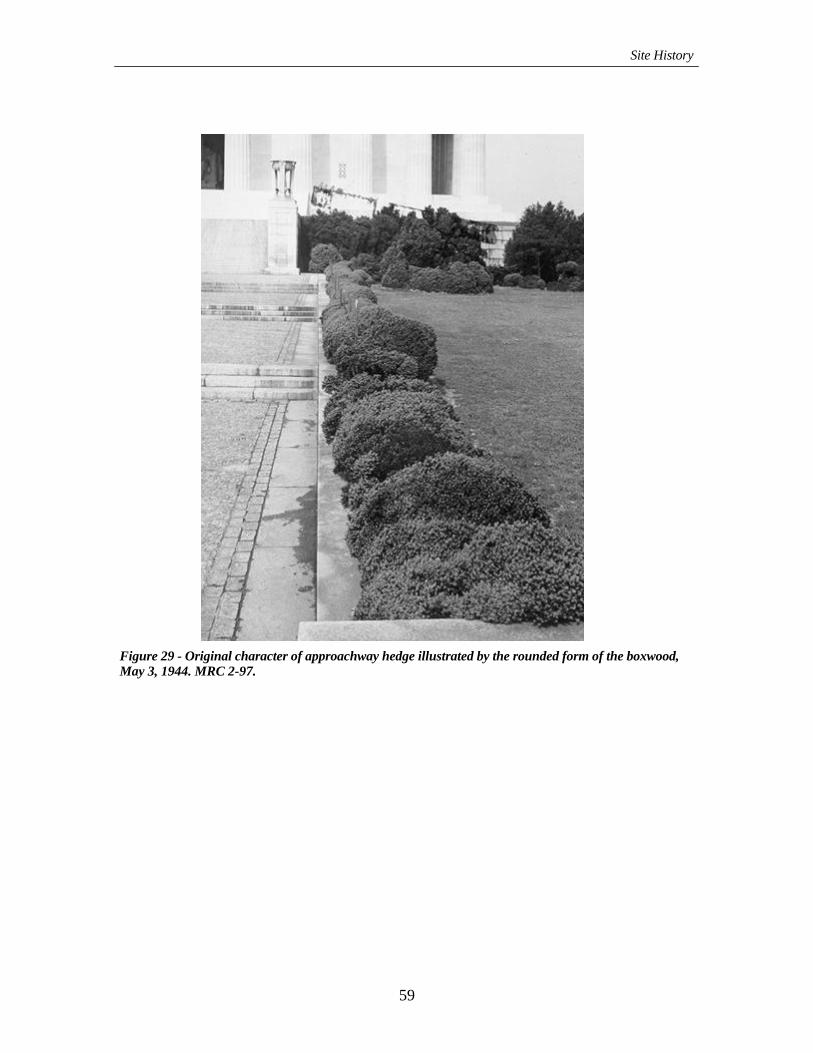
Site History
59
Figure 29 - Original character of approachway hedge illustrated by the rounded form of the boxwood,May 3, 1944. MRC 2-97.

Cultural Landscape Report Lincoln Memorial Grounds
60
Although control of horticultural pests had been a problem in West Potomac Park prior tothe National Park Service stewardship, the first case of Dutch elm disease was not founduntil May 1947, in an area south of the Lincoln Memorial. Poor turf and pest “troubles”were among the longstanding concerns in the maintenance of the grounds around thecity’s “most popular structure.” The yearly budget for caring for the approximately300,000 dollars worth of trees and shrubs at the Lincoln Memorial grounds amounted to$5,000 annually. Yet the site was plagued with “every trouble . . . in the country.” GeorgeHarding, chief of horticulture and planting for National Capital Parks confirmed that:
The turf is filled with all sorts of stuff, from river muck to sand. It’s theworst trouble spot we’ve got in town.67
As part of a 1953 repaving of the circular roadway, National Capital Parks eliminated therectangular edge of the circle’s outer curb at the Reflecting Pool steps in favor of creatinga continuous curb edge. Since the 1922 dedication, the rectangular section had beengradually adapted into an area for parking. The presence of parked automobiles, inaddition to taxicab stands and the three bus stops allocated to the city’s private buscompanies, marred the area between the memorial and the pool and hindered pedestrianscrossing from one to the other. Two triangular planting beds, shaped by the outline of thenew and old curbs and new sidewalk connections, flanked the landing at the top of thesteps. The beds, which were planted in boxwood, replaced most of the parking area andcompleted the changes made at this time.68
Map 8 - Construction plans showing new layout of shrub beds at top of Reflecting Pool steps, 1953. NPSMap 31-209.

Site History
61
Visitation, New Uses and Incremental Change
Visitation at the Lincoln Memorial increased from over 1.5 visitors in 1948 to 2 millionin 1959. At the same time increased levels of automobile traffic, from both visitors andcommuters, continued to be a major concern of not only the National Park Service butalso the District’s Department of Highways and Traffic. In 1950, for example, bridletrails were closed within Potomac Park because of the incompatibility of horseback ridingand large numbers of automobiles.
During the 1945-1970 period, the memorial steps and the approachway were increasinglyused for public ceremonies and functions. By this time, the Lincoln Memorial and thesurrounding grounds had developed into a significant setting for high-profile publicevents that ranged from prayer pilgrimages during the early years of the Civil Rightsmovement, to the destination for the 1963 March on Washington, which is bestremembered for the famous “I Have A Dream” speech delivered from the memorial’ssteps by Martin Luther King Jr., the Resurrection City camp site for the Poor People’scampaign in 1968, and a rallying point for the anti-Vietnam War movement. Eventsstaged there ranged from the serious, such as the 1963 memorial service for PresidentJohn F. Kennedy, to the celebratory, such as the Smithsonian Folklife Festivals held in1975 and 1976. In addition, interior and exterior views of the Lincoln Memorial werefrequently used by cinema production companies shooting films in Washington, D.C.69
Figure 30 - Thousands of participants at the Lincoln Memorial grounds for the March on Washington,August 28, 1963. MRC 1-46.

Cultural Landscape Report Lincoln Memorial Grounds
62
Figure 31 - Lighting effect on west colonnade of Lincoln Memorial, June 7, 1966. MRC 3-44.
Throughout the late 1960s and early 1970s, The Commission of Fine Arts reviewed theeffectiveness of the original interior and exterior lighting at the memorial. New exteriorlighting around the perimeter of the building was in place by the time of the NixonInaugural in January 1969. The incandescent spotlamps used to light the main steps wereinstalled on both sides of the approachway in large rectangular box units. Theirinstallation necessitated the removal of selected yew and box shrubs from the frontfacade planting. Two sets of lamps mounted on poles were also placed in the vegetationto cast light on the north and south sides of the building. Two other pole units wereinstalled among the trees and shrubs on the west side. No evidence of alterations to theplanting are documented for these pole installations. Floodlights located on the top of themarble column capital, around the base of the structure itself, directed light toward thecolonnade of the memorial.70
National Park Service “Mission 66” improvements at the Lincoln centered on theaddition of a “Tourist Information Kiosk.” In 1965 the kiosk was constructed on thesouth side of the Reflecting Pool steps, several yards northeast of the intersection ofFrench Drive and the Lincoln Circle. By 1968, soil compaction caused by pedestrianactivity around the kiosk and adjacent refreshment trailer prompted the development of anew paving plan for this area. Although designed to prevent any further damage to theelms growing there, the character of the design in the proposal marks a significantdeparture from the original simple and balanced geometric layout of the landscape. Someyears later a slightly different version of the plan was in fact implemented.

Site History
63
As other visitor issues arose, the National Capital Parks apparently evaluated them on anindividual basis. In the early 1960s the Interior Department and the National Park Serviceresponded to citizen requests for artificial ice-making capabilities at the Reflecting Poolby establishing a task force to investigate extending the use of the pool throughout thecold weather months for ice skating. Proposals were developed, but these plans werenever realized. Eventually skating on the pools was prohibited all together. In 1964 thepark installed permanent bronze handrails on the outside of both the raised terrace stepsand the steps ascending the stylobate. The use of a temporary wood handrails appears tohave ceased once the bronze versions were in place.71
Concern for pedestrian safety at the Reflecting Pool and at the entrance to theapproachway were addressed in August 1972, when the eastern portion of the roadwayaround the Lincoln was closed to automobile traffic in the area between Bacon andFrench Drives. The road closing, which required the rerouting of traffic onto adjacentstreets and onto Rock Creek and Potomac Parkway, was done on a seasonal basis forseveral years. The change became permanent in 1976 as part of the planning for theBicentennial celebration. At that time, planners created a two-way traffic segment on thewest side of the circle between Memorial Bridge and Bacon Drive.
Another change in circulation occurred in 1973, when the park management decided toremove the L-shaped sidewalks located along the top of the Watergate wing walls. A setof curving walkways replaced the originals. These were a continuation of the sidewalkson the bridge and the parkway approach (Parkway Drive) that followed the outer curbedge of the western portion of the Lincoln Circle and led down to Ohio Drive and theshoreline.72
Plans for New Site Developments
In 1960 the park service sponsored a plan developed by landscape architects andengineering consultants to alleviate traffic around the Lincoln Circle by connectingexisting road systems to the planned Inner Loop of the Interstate Highway System. Thisplan incorporated the construction of a tunnel under the western edge of the circularroadway that would connect the proposed Theodore Roosevelt Bridge approach on thenorthwest with Independence Avenue on the southeast. The proposal also called for acomplete redevelopment of the grounds around the memorial and the surrounding area,including the Reflecting Pool, the radial roads and the Watergate. This landscape designproposed by Umberto Innocenti and Richard Webel marks the first overall plan for theLincoln Memorial grounds since 1916. Although their design was never implemented,the Innocenti/Webel plan demonstrates the level of change considered possible at theLincoln in the 1960s. To alleviate the impact of parking and automobile circulation,Innocenti/Webel’s plan eliminated the circular roadway, French Drive and a section ofBacon Drive, while redirecting vehicles to a new route around the west side of thememorial and along the full length of the Reflecting Pool. To accommodate theseelements of the design, they also proposed several alterations in pedestrian circulation,spatial organization, and vegetation. More significantly, however, they chose not to alter

Cultural Landscape Report Lincoln Memorial Grounds
64
certain elements from the original design. These elements included the organization ofthe overall design along the east/west axis; the double rows of elms along the ReflectingPool; the shape and form of both pools; the memorial approachway; and the masses ofshrubs planted around the memorial structure.73
Shortly after the 1960 proposal, Skidmore Owings and Merrill (SOM) created a Mallmaster plan for the National Park Service that incorporated the underpass concept.Although the landscape treatment for the Lincoln Memorial area featured in the SOMplan differed from the Innocenti/Webel design, and showed changes in the design of theRainbow Pool and in the trees growing north and south of the elm walks, the similaritiesbetween the two proposals underscore, again, significant aspects of the original designthat were deemed inappropriate for change. Among these are the linear arrangementalong the east/west axis, the double rows of elms flanking the Reflecting Pool and themasses of shrubs around the memorial structure.74
Acceptance of the underpass concept was influenced by the continuous public debateoccurring throughout the 1960s and into the 1970s over the merits of freeways in theinner city. After prolonged deliberation the tunnel plan was eventually rejected, eventhough the Theodore Roosevelt Bridge and the west leg of the inner loop freeway,designed to connect with the tunnel, were under construction throughout the early 1960s.With the construction of the bridge approach and freeway segment near the westernterminus of Constitution Avenue, changing the grade and adding several access roadswere necessary in the area just north of the Watergate. The Theodore Roosevelt Bridgewas dedicated in 1964; the west leg opened in 1966.
Throughout the 1966 to 1976 period, SOM worked with the park service and otheragencies to refine their initial proposal. By the time of the 1976 Bicentennial, SOM’sproposed treatment for the area around the Lincoln Memorial had developed into a designthat featured much of the original layout and geometric arrangement along the ReflectingPool, the circle and radial roads. Two areas that contrasted with the longstandingformality lay on the north and south sides of the Reflecting Pool, where SOM developeda more naturalistic landscape plan. The tunnel was no longer part of the overall design.
Conceptual planning for the improvement of the Mall may have influenced decisions thathad a positive effect on the landscape surrounding the Lincoln Memorial. Oneimprovement was the removal of the temporary WWII buildings from both the south sideof the Reflecting Pool and the west side of the Washington Monument grounds duringAugust of 1964. With this action, an unimpeded view between the Lincoln Memorial andthe Washington Monument and the large open area south of the pool was restored.However, removal of WWI temporary buildings located on the north side of the floodcontrol embankment did not occur until the summer of 1970.
Another visual improvement was initiated at about the same time as the demolition of theWorld War II structures. The National Capital Parks beautification program of 1964-1968designated certain sites and federal reservations throughout the city for the planting ofbulbs, annuals, and other flowers in beds, planters, and on slopes. While aquatic plants

Site History
65
had been floating on the Reflecting Pool for several years, the park added other seasonalcolor to planters on the Watergate plaza, a circular bed at the west end of ConstitutionAvenue, and on the hillside adjacent to the Rock Creek and Potomac Parkway approach.While the water lilies and other plants were removed from the pools in 1968, the planters,beds, and hillside were still maintained.75
Figure 32 – Water lilies in Rainbow Pool, August 17, 1944. MRC 2-119.
Response to Contemporary Issues Through New Design andPreservation1970-1996
Bicentennial Changes
In preparation for the Bicentennial celebration, several areas within the larger landscapeof the Lincoln Memorial were altered. Although considered improvements orenhancements at the time, the changes that occurred around the west end of theReflecting Pool and on the southeast side of the circle, between the Reflecting Pool andFrench Drive, deviated considerably from the original symmetry and balanced design forthe memorial grounds. Most of these changes occurred in the rearrangement of pedestriancirculation and the selection of site details and materials. On the southeast segment,granite block pavers, ground cover, post-and-chain fencing, concrete, and concretecurbing were used together to create individual tree beds and a plaza-like area around the

Cultural Landscape Report Lincoln Memorial Grounds
66
two hexagon-shaped kiosks and a refreshment trailer, which had been set up there by1973. While this treatment around the elms and along French Drive was done toaccommodate higher levels of visitation and to protect the trees in this area, the overalleffect detracted from the longstanding simplicity of design on the site as a whole. A moresympathetic installation of paving was added to the area between the base of theReflecting Pool steps and the pool at about the same time. Here, cobblestone, granite, andconcrete panels replaced relatively narrow walks of flagstone pavers, which had beenadded shortly after the completion of the pools. Although the design for the panels wasbased on an interpretation of the original treatment for the main approachway, theselection of materials and pattern of the new installation was not in keeping with theoriginal design intent for this end of the Reflecting Pool. The two elm walks parallelingthe pools were also repaved as part of this project with a bituminous paving, rather thanconcrete, the historic surface.76
The most significant change to occur within the circle at the Lincoln Memorial since theinstallation of exterior lighting in 1969 was the construction of handicap accessible rampsand elevators. The ramps followed a modified L-shaped course along the outer edge ofthe wall behind the planting beds adjacent to the approachway and along the hedgeslining the entry walks leading up to the memorial. Construction of the ramps, the lowretaining walls behind the north/south sections of the ramps, and the elevatorsnecessitated the removal of boxwoods and yews from both sides of the front facadeplanting. Construction may also have affected the condition of shrubs growing inadjacent areas. Soil compaction and other forms of disturbance appear to have causeddamage to specimens other than those growing in the direct path of the ramps. One otheraspect of the project was the construction of more than 100 curb cuts to accommodate
Figure 33 - View of north side of Lincoln Memorial, 1992. NPS DSC photo.

Site History
67
wheelchairs at the intersection of roadways and walks around the Mall and other parkareas in the monumental core. These additions were completed in 1976. As part of theramp construction, the park replanted several yews and boxwood on the east side. At thistime two sets of six yews were planted in a semicircle to screen the exterior light boxes.The park also removed the two hedges of yews (Taxus x media ‘Densiformis’) flankingthe approachway and subsequently planted new yews according to the samearrangement.77
In 1977 park management replaced plantings near the approachway and on the oppositeside of the Lincoln Circle with inkberry, or Ilex glabra. Shrubs in the pair of rectangularbeds flanking the beginning of the approach to the memorial and in the two triangularbeds marking the descent to the Reflecting Pool and had been damaged by exposure tointense sun and increased pedestrian traffic at these points. The Buxus sempervirens‘Suffruticosa’ originally designated for these areas were unable to rejuvenate at a fastenough rate once they were damaged. Before the 1977 planting, park staff had replaced,at least one other time, the boxwood shrubs growing in the beds on both sides of theentrance to the approachway with Japanese holly, or Ilex crenata. As part of this plantingeffort, “boxwood, holly and yew, replacement and filler planting,” were placed mostly onthe north, south, and west sides of the memorial, “as directed by the [park] landscapearchitect.” The American hollies and yews included in this planting were maturespecimens. The two large hollies now growing on the east front were probably from thisplanting. Another plant type added to the landscape design was Liriope variegata, whichwas placed in the triangular beds at the top of the Reflecting Pool steps.78
Other changes brought about by the Bicentennial occurred in areas adjacent to theLincoln Memorial. These ranged from the installation of a floating dock near the EricssonMemorial for the operation of commercial boat cruises on the Potomac, to the FolklifeFestival, held in 1975 and 1976, on the open ground just south of the Reflecting Pool, tofull-scale redesign of the former site of the World War I temporary buildings on the northside of the pool. Named Constitution Gardens, this naturalistic garden, reminiscent of19th century public parks, was dedicated May 27, 1976.
The Development of Preservation Plans
In 1976 it was determined that the large population of midges and spiders congregating atthe Lincoln Memorial at night was responsible for the soiling of the white marble exteriorsurfaces of the building. Attracted from their natural habitat along the Potomac shorelineto the Lincoln by the bright night lights, the midges attracted spiders. Large numbers ofbirds, in turn, were attracted to the spiders. As a result, the birds established nesting areasin the upper recesses of the structure. Cleaning debris and residue left by these pests withhigh pressure water proved to be damaging to the memorial itself. Park management triedvarious treatments to reverse this deterioration, but to no avail.79
The plaza between the traffic circle and the Reflecting Pool required several repairs in1977. The park service noted that the joints in the stone sidewalk needed repointing.

Cultural Landscape Report Lincoln Memorial Grounds
68
Moreover, exposed aggregate in the south walk was deteriorating, showing evidence ofcracking, spalling, and missing stones. The north walk and center panel had vegetationgrowing between the joints. Similar problems affected the memorial approachway, wherethe cobblestone panels were cracked and missing stones. Some of these conditionspersisted for several years. In 1983 NPS employees noted that exterior drains around thebuilding were inadequate, and unable to prevent seepage into lower chambers. Inaddition, the aggregate walks were crumbling.
Although swimming or wading in the pools had been prohibited for many years, duringwarm weather, large-scale gatherings on weekends, holidays, and other occasionsprompted spontaneous wading. By 1978 periodic cleaning was required once or twice peryear. It would take approximately three weeks per cleaning, as on average, 10 to 15 largetruckloads of debris would need to be removed from the pools. In addition to the build-upof debris, the bottom was no longer watertight and the intake and drainage of surpluswater required improvements. The reflecting pool underwent "reconstruction" in 1981.Upon completion of the project, the park service introduced a “self-sustaining ecologicalsystem,” consisting of selected aquatic plants combined with natural bacterial actiondesigned to consume algae and maintain the appearance of the pools.80
In 1984, the National Capital Region proposed to rectify site problems in the areabetween the Lincoln Memorial and the Arlington Memorial Bridge. The large woodenpiles formerly used to secure the Watergate concert barge were to be removed, as was theaccess road at the top of the steps, which had been used to service the concerts. However,the granite curb, marking the river side of the access road was to be left in place. Thesame proposal called for a “handicap access ramp,” similar to the existing aggregatewalk, at “the juncture of the walks connecting the Lincoln Approach, Bridge andWatergate steps.”81
Since the Bicentennial, ongoing preservation of the vegetation at the Lincoln has centeredon the American elms lining the radial roads and the circular road and on the Dutch elmsgrowing along both sides of the Reflecting Pool. Although the arrangement of theoriginal planting had not always been maintained, efforts at sustaining a healthycollection of trees have been substantial. These efforts include following a prescribedbalance in the selection of elm varieties and the cultivation of replacement elms at theNational Park Service’s nursery on Daingerfield Island near National Airport.82
Other vegetation preservation has been directed toward the lawn areas around thememorial structure and along the Reflecting Pool. The 1993 Presidential Inauguralfestivities necessitated the reseeding of grassy areas in late January. Because only ryeseed, rather than the preferred fescue, could germinate at that time of year, sections werecordoned off with temporary fencing for a more rapid reestablishment of the lawn Thelongstanding use of temporary or snow-type fencing to restrict pedestrian access to thelawn during the off-season is now prevalent throughout the year as different grassy areasare allowed to rejuvenate.
Site History
69
Beginning in 1988 the Denver Service Center of the National Park Service, incollaboration with National Capital Parks-Central and the National Capital RegionalOffice, conducted studies about the need for the preservation of the Lincoln Memorial.As a result of their initial examinations, the raised terrace and the approachway wereidentified as two significant landscape features that required preservation. The restorationof the raised terrace, including the coping along the top of the retaining wall, began in thefall of 1993, and that of the approachway began in the fall of 1995.
In 1993, the National Park Service, in cooperation with the District of Columbia, theFederal Highway Administration, and the Architect of the Capitol, agreed on unifieddesign guidelines for the vicinity of the National Mall streetscape. This area encompassedPresident’s Park on the north, the Potomac River and the Southwest Freeway on the westand south, and Second Street on the east, including the Capitol grounds. The StreetscapeManual outlined consistent treatments for roadways, walkways, vegetation and sitefurniture. For the Lincoln Memorial grounds, Constitution and Independence avenueswere defined as “major park roads,” French and Bacon drive were defined as “park roadsand drives”, and the Reflecting Pool area and eastern portion of the Lincoln Circle weretermed “special pedestrian ways.” Based on this classification system, the manualprovided standard details for each area. In 1991 17th Street, between Constitution andIndependence Avenue, was the first NPS road project to implement the StreetscapeManual standards. Since the guidelines were developed, the NPS has used them for alltheir road projects in West Potomac Park and the Mall.
New Memorials, New Commemorative Landscapes
After the Bicentennial several new memorials were proposed for sites adjacent to theLincoln Memorial. Unlike the Ericsson Memorial, the locations of some of these did notfollow the geometric patterns established by the McMillan Commission plan, and laterreiterated by the NCPPC plans, for the development of secondary sites in West PotomacPark. Two had little impact on the memorial grounds. The first, a separate memorial tothe Signers of the Declaration of Independence, was located on a 1-acre island in themiddle of the Constitution Gardens lake. It was completed in 1982. The second consistedof adding the names of Alaska and Hawaii to the other states already commemorated onthe Lincoln Memorial. Although a bill introduced in the U.S. Senate in 1973 sought toinclude the names of Alaska and Hawaii on the attic frieze, where the other states wererecognized, after lengthy debate a different proposal was eventually adapted. In 1985 thenames of the two new states were engraved on a rectangular-shaped plaque that wasinstalled on the center of the approachway, aligned with axis of the WashingtonMonument.83
Two larger memorials developed during this decade have had significant impact on theLincoln Memorial grounds. The first of these was a memorial to Vietnam War veterans,designed by Maya Lin, which was located in the western portion of Constitution Gardensadjacent to the northeast segment of the circular road. The Vietnam Veterans Memorialwas dedicated in 1982. Two years later, a flag pole and statuary group, designed by

Cultural Landscape Report Lincoln Memorial Grounds
70
sculptor Frederick Hart, was added to Lin’s understated, yet dramatic, geometric work.An overhead tree canopy and understory trees planted next to the sidewalk along theouter edge of the circular roadway screen this memorial from the Lincoln Memorial.However, they also affect the formal character of the planting of the American elmsaround the circle. Near the northeast section of the circle, a curved arrangement of pathsleading from Constitution Gardens and the Vietnam Veterans Memorial intersects withthe more linear walks on the north side of the Reflecting Pool steps. This arrangement haschanged the formal character of the pedestrian circulation.
With the successful completion of the Vietnam Veterans Memorial, the area at the westend of the Constitution Gardens became strongly associated with veterans. Soonthereafter, veterans organizations requested permission to set up concession tents nearConstitution Avenue, where they sold merchandise expressing veterans’ points of viewon pertinent issues. In 1983 the tents were moved to the top of the steps on the north sideof the Reflecting Pool, where they have remained.The second major memorial, dedicated to Korean War veterans, was authorized in 1988and constructed on the south of the pool in 1995. The design of this memorialincorporated many of the same geometric elements as the Vietnam Veterans Memorialbut adapted them to achieve a different overall effect. Like the Vietnam VeteransMemorial, the Korean War Veterans Memorial is adjacent to a section of the circularroadway around the Lincoln Memorial. Informal paths also intersect with the straightwalks found on the south side of the Reflecting Pool. An overhead tree canopy andunderstory trees, planted to create a screen, are immediately adjacent to the sidewalkalong the outer edge of the circle, as well. Both the walks and the trees at the western endof the Korean War Veterans Memorial fundamentally transform the formality originallyplanned for this area of the circle.
The kiosks and refreshment trailer that had been on the south side of the Reflecting Poolsteps since the late 1960s and early 1970s were removed and relocated or replaced in1995 as part of the Korean War Veterans Memorial’s development. A “Tourmobile”kiosk, a souvenir kiosk, and a new, enlarged refreshment trailer now occupy sites on thewest side of French Drive. A new information kiosk has been installed at the edge of therecently planted understory trees between the Reflecting Pool and French Drive. The oldnonhistoric treatment of clustered structures, extended pavement, individual beds aroundthe elms, and post-and-chain fencing has been continued in this designated area forvisitor services.