cruise report samba moorings & monitoring line rs algoa ...€¦ · cruise report . samba...
TRANSCRIPT

Cruise Report
SAMBA Moorings & Monitoring Line RS Algoa Voyage 221
30 November - 06 December 2015
Compiled by Marcel van den Berg, Chief Scientist
Contributions from: Janine van der Poel (Biological sampling)
Angelo Marco (Engineering Technical Report) Kholeka Batyi- Nkwenkwe(Engineering Technical Report)

Alg221- track chart
Contents: 1. Cruise Objectives 2. Cruise Participants 3. Introduction 4. Cruise narrative 5. Station details 6. SAMBA Mooring recoveries 7. SAMBA Mooring deployments 8. Argo float deployments 9. CTD Stations & Hydrography 10. Biological Sampling 11. Scientific Underway Equipment
11.1 Underway ADCP 11.2 Thermosalinograph (TSG) 11.3 Underway pCO2 systems
11.4 Underway sampling 11.5 Scientific Data System (SDS)
12. References 13. Scientific Daily Log
Annexure I – Technical Report (submitted by Angelo Marco & Kholeka Batyi-Nkwenkwe) Annexure II - Mooring recovery designs (with corrected instrument depths) Annexure III – Mooring deployment designs Annexure IV – Mooring deployment sheets

C1. Cruise Objectives:
1. Deploy 2 ADCP moorings along the IEP’s Scarborough Monitoring line to collect current data on the Benguela Jet Current
2. Recover; Service and re-deploy 4 x tall moorings on the SAMBA transect, incorporating ADCP’s and Sea-Bird Microcats.
3. Undertake 3 S-ADCP transects across the shelf off Slangkop, to determine the position and variability of the Benguela Jet current.
4. Undertake CTD casts to 1000 m along the SAMBA transect. 5. Undertake DIC; nutrient; chlorophyll and oxygen sampling at CTD stations along SAMBA mooring
line 6. Undertake Vertical Bongo casts to 200m, at all stations along the SAMBA Transect, for collection
of plankton samples 7. Deploy drift net at each station to collect plankton samples 8. Run under-way TSG and pCO2 systems 9. Undertake underway sampling for oxygen 10. Deploy 4 Argo floats to enhance the Global Ocean Observing System of IOC (GOOS) in the South
Atlantic Ocean ARGO float program (on behalf UK Meteorological Office )

C2. Cruise participants: CRUISE SCIENTIFIC PERSONNEL / PARTICIPANTS (Title, Name, Surname – Affiliation/Institution)
Title Name and Surname
SAMSA medical certificate (Y/N) –
expiry date
Institution /
Affiliation
Responsibility Cabin #
1. Marcel van den Berg
Y– 09/03/2016 DEA Chief Scientist: Moorings, CTD, Logistics
2. Gavin Louw Y - 23/02/2016 DEA Co-Chief Scientist: Moorings, CTD, Logistics
3. Mbulelo Makhetha Y - 01/06/2016 DEA Moorings and CTD
4. Bradley Blows Y- 24/06/2016 BCRE Moorings
5. Leon Jacobs Y – 10/03/2016 DEA Mooring and CTD
6. Khaya Siswana Y-14/09/2016 DEA pCO2 and underway/CTD sampling
7. Khanyisile Vena * Y-15/09/2016 DEA Underway and CTD sampling
8. Janine van der Poel *
Y-23/10/2015 DEA Bongo / Drift net sampling
9. Kholeka Batyi* Y – 22/10/2016 DEA Electronics and Engineering support
10. Angelo Marco Y - 10/06/2016 DEA Electronics and Engineering support
11. Azwifaneli Tshisikhawe *
Y – 28/04/2016 DEA Intern
pCO2 and underway/CTD sampling
12. Letshego Rakgetla *
Y – 29/04/2016 DEA Intern
pCO2 and underway/CTD sampling
13. Leolin Qegu Y – 29/04/2016 DEA Intern
Bongo/ Drift net sampling
(Notes and Abbreviations) Note: * denotes a Female DEA = Department of Environmental Affairs BCRE = Bayworld Centre for Research and Education

C3. Introduction
Observations and models consistently indicate that variations in the Meridional Overturning Circulation (MOC) are strongly correlated to important climate changes such as variations in precipitation and surface air temperatures. To date, most MOC observations have been focused in the North Atlantic where the largest volume of new deep water is formed. Numerical model studies have shown, however, that the South Atlantic is not just a passive conduit for the deep water masses formed in the North Atlantic and Southern Ocean, but instead actively participates in their transformation as they are exchanged with the other ocean basins. Recognition of this led to the formation of a group dedicated to both advancing our understanding of the role of the South Atlantic Ocean in the MOC system and the establishment of an observing system to capture key components of the circulation: this initiative is known as South Atlantic Meridional Overturning Circulation, or SAMOC.
The South Atlantic Ocean is unique in its role as a nexus and melting pot for water-masses formed elsewhere and transiting between the far regions of the World Ocean. Its mean meridional circulation involves a deep, southward, flow of cold and salty North Atlantic Deep Water and, a compensating northward flow that is a mixture of warm and salty surface waters and cooler and fresher Antarctic Intermediate Waters. At a much greater depth, the lowest limb of the MOC is driven by formation of very salty and cold Antarctic Bottom Water near the Antarctic coast, and this limb of the MOC stretches throughout the complete South Atlantic, interacting with the North Atlantic Deep Water flow along the way before returning south. This complicated circulation pattern results in a significant equatorward oceanic heat flux, which is unlike any of the other ocean basins. Observations and models have shown that many of the components of the MOC in the South Atlantic are highly variable, with changes occurring on time scales ranging from a few days to many years. This variability is further complicated by the active transformation of these water masses as they pass through the South Atlantic. These changes occur across the entire basin, but are particularly intensified in regions of high mesoscale variability at the Brazil/Malvinas Confluence and at the Agulhas Retroflection. Observations show, for example, interannual variations in the sources that feed the Benguela Current, and hence in the upper ocean northward flow that eventually crosses the equator into the North Atlantic. It is this mounting evidence of the contribution of the South Atlantic to the global MOC system that has motivated broader study and international collaboration.
The main objectives of the SAMOC initiative are to measure the strength and variability of the MOC as well as the meridional heat and fresh-water transport in the South Atlantic, all of which are crucial to improving our understanding of climate system variability.

C4. Cruise Narrative
The loading of mooring equipment and weights commenced early on the morning of the 30th of November 2015. Once all equipment was loaded and secured the RS Algoa departed Cape Town harbor at 13h30 (all times in GMT). The weather conditions, on departure, was good with just a light breeze and no swell – perfect conditions to allow scientists to get there “sea legs” before work started. The vessel started steaming for the deployment position for Mooring 1, off Slangkop Lighthouse. After passing the harbor breakwater the pumps for the scientific water supply was started and allowed to run for 30 minutes before all underway systems started logging data. This included the Thermosalinograph (TSG) ; pCO2 and mast mounted light (SPAR) systems. All underway data (except for pCO2) was captured to the SDS (Scientific Data System) for real-time displays and archiving. The vessel mounted ADCP (S-ADCP) was also set to record currents whilst underway.
The two shelf moorings were setup to start recording after the estimated deploy times and Argos beacons were installed on the moorings. The first shelf mooring was deployed later that evening at 17h38, with the second shelf mooring deployed at 18h12. This was a great opportunity to train the new deck crew in our set mooring deployment techniques before the recovery and re-deployment of the “tall” moorings was to commence.
Once the first two moorings (Mooring 1 & Mooring 2)were deployed the vessel proceeded further offshore, to the 1000m depth contour, before turning around to commence (at 19h51) the first of two cross shelf S-ADCP runs, to a position close to the Slangkop Lighthouse. The aim of the transects is to study the variability in the Benguela Jet current. Whilst the vessel steamed the transects, at a speed of 8 knots, underway surface samples for nutrients and chlorophyll were collected at 20 minute intervals. The collection of samples were only done during the in-bound leg of the transect.
The next morning (1 December 2015) the vessel completed the out-bound S-ADCP transect at 05h00. The end position was also the location of the first “tall” mooring to be recovered. Before recovery a safety “toolbox” talk was held with the deck crew to inform them of the recovery plan and the procedure used. The first “tall” mooring (Mooring 3 – SAMBA M7) was released at 06h14 and successfully recovered by 07h44.
After the recovery of the mooring a safety/ emergency drill (muster station) was held for all crew and scientists, to familiarise everyone with the safety and emergency procedures on the vessel.
The rest of the morning was spent downloading instrument (ADCP & SBE37 micro-cat) data, servicing the equipment recovered and preparing the mooring for re-deployment. The re-deployment of the mooring, in the same position, was started at 11h34 and by 12h20 was successfully deployed. Due to the fact that the scientists from IFREMER, France who recently serviced the CPIES and bottom mounted ADCP’s in the area , care had to be taken when deploying the “tall” mooring(s) to avoid the positions of their deployments. The navigational officers were made aware of the IFREMER mooring positions and they adjusted their approach tracks during the deployment(s)

With weather conditions still favorable for mooring work the vessel proceeded to the position of the second “tall” mooring. Mooring 4 (SAMBA M8) was released at 14h10 and successfully recovered by 16h00. The vessel drifted, in the area, for the evening whilst the recovered mooring was serviced and pre-paired for re-deployment the next morning.
Another sunny, calm day greeted us the next morning (2 December 2015). The re-deployment of Mooring 4 was started after breakfast at 06h40 and was completed at 09h30. The vessel headed straight for the next recovery position (Mooring 5 – SAMBA M9) to enable us to use the good weather to our advantage. Mooring 5 was released at 10h35 and successfully recovered by 13h40. The rest of the afternoon was spend pre-pairing the mooring for re-deployment, after all the ADCP and SBE37 Microcat data was downloaded and instruments serviced. The re-deployment of Mooring 5 was started at 17h24 and was completed at 19h35.
The vessel steamed overnight to the location of Mooring 6 (SAMBA M10) and mooring was recovered the next morning (3 December 2015) between 06h22 and 08h56. After all data was downloaded and mooring pre-paired for re-deployment, it was successfully deployed between 13h32 and 16h04.
The weather had played along for the whole recovery and deployment period of the cruise and mooring technicians were relieved that everything went successfully. For all 4 mooring recoveries the 17” glass floats got tangled with each other and it was thought that the cause was a lack of swivels in the mooring design. There was a swivel inserted at the top end of the chain holding the glass floats, but on re-deployment of all moorings an additional swivel was inserted at the bottom end of the chain, holding the glass floats. This will hopefully solve the problem on the next recovery in 2016.
That evening a test CTD and Vertical Bongo station was completed to get all the equipment ready for the hydrographic transect back inshore along the transect. The Vertical Bongo system was successfully tested, but the CTD system had some issues with the “firing” of the Niskin bottles at discrete depths. This problem had occurred on previous cruises, since the vessel’s dry-docking in August, where no indication is given that bottles had actually fired. It was decided that for the transect the bottles would be “fired” via the deck-unit and a *.mrk (mark) file would be created via the SeaSave software to indicate the depths that bottles were fired.
The next morning (4 December 2015) at 06h00 the hydrographic survey, along the SAMBA transect, was started with stations running from the most offshore positions back inshore. During the day a total of 7 CTD and Vertical Bongo stations were completed and 2 Argo floats were deployed.

On the morning of the 5th of December we experienced our first day of bad weather for the cruise, with winds blowing up to 34 knots and swells increasing to around 3-4m. We were still able to continue the hydrographic survey, although the vessel had to proceed between stations at a slower speed.
At around 10h00, after completing station 9, the SA Agulhas II passed the RS Algoa, on her way to the SANAE base (Antarctica) for the summer. The Agulhas II was at this point also joining the SAMBA transect at 34.5° S, to collect S-ADCP data and deploy XBT’s underway.
In the afternoon the weather conditions improved again, with both winds and swells moderating. This enabled us to complete the 15 stations along the transect by the early hours of the 6th of December. Two Argos float was also deployed at selected
stations during the day. After completion of the hydrographic survey the vessel continued along the transect to a position off the Slangkop Lighthouse, closer inshore, to collect additional S-ADCP and underway surface nutrient and chlorophyll samples to add to the data collected during the S-ADCP survey at the start of the cruise. After this vessel started heading back towards Cape Town harbor.
The next morning (6 December 2015), before the vessel was scheduled to dock, was the first opportunity for downloading of emails, due to lack of cell phone reception, whilst we were working further offshore. Notifications were downloaded from CLS (for the monitoring of ARGOS beacon deployed on each mooring) indicating that Mooring 1, deployed on the 30th of November, had surfaced and was drifting further up the west coast. The decision was made to delay docking and try and recover the mooring. All the positions received, every 90 minutes, from CLS was plotted and a predicted drift path was plotted to enable the vessel to intercept the surfaced mooring. The surfaced mooring was spotted at around 09h40 and then recovered. Upon inspection it found that the one acoustic release had flooded and activated the release motor to release the mooring. The mooring could not be re-deployed, as no spare acoustic release was available, so the vessel headed back to Cape Town harbor.
The vessel docked at 16h00 and all scientists disembarked after a successful cruise.

C5. Station Details
Figure 1. Station detail map – Alg211
Ships Station Number
Grid Number
Latitude Longitude Depth (m) Operations
Alg11374 CTD001 34° 30.2987’S 14° 58.7312’E 4472 CTD Vertical Bongo Webb Apex Float
Alg11375 CTD002 34° 30.2141’S 15° 15.0801’E 4445 CTD Vertical Bongo
Alg11376 CTD003 34° 30.0310’ S 15° 31.6270 E 4363 CTD Vertical Bongo
Alg11377 CTD004 34° 29.9980’S 15° 47.2858’E 4230 CTD Vertical Bongo Webb Apex Float
Alg11378 CTD005 34° 29.9969’S 16° 04.6896’E 4078 CTD Vertical Bongo
Alg11379 CTD006 34° 30.0069’S 16° 19.973’E 3922 CTD Vertical Bongo/Drift Net Webb Apex Float
Alg11380 CTD007 34° 30.0252’S 16° 36.2885’E 3474 CTD Vertical Bongo
Alg11381 CTD008 34° 29.9835’S 16° 51.9827’E 3293 CTD Vertical Bongo
Alg11382 CTD009 34° 29.9533’S 17° 08.2866’E 2883 CTD Vertical Bongo Webb Apex Float
Alg11383 CTD010 34° 29.8792’S 17° 17.9951’E 2128 CTD Vertical Bongo
Alg11384 CTD011 34° 26.9825’S 17° 26.4123’E 1697 CTD Vertical Bongo
Alg11385 CTD012 34° 23.6174’ S 17° 35.6375’E 1113 CTD Vertical Bongo
Alg11386 CTD013 34° 19.9854’S 17° 44.9816’E 403 CTD Vertical Bongo
Alg11387 CTD014 34° 16.9621’S 17° 54.9988’E 295 CTD Vertical Bongo
Alg11388 CTD015 34° 12.9631’S 18° 08.0109’E 234 CTD Vertical Bongo/Drift Net
Table 1 –Station position details
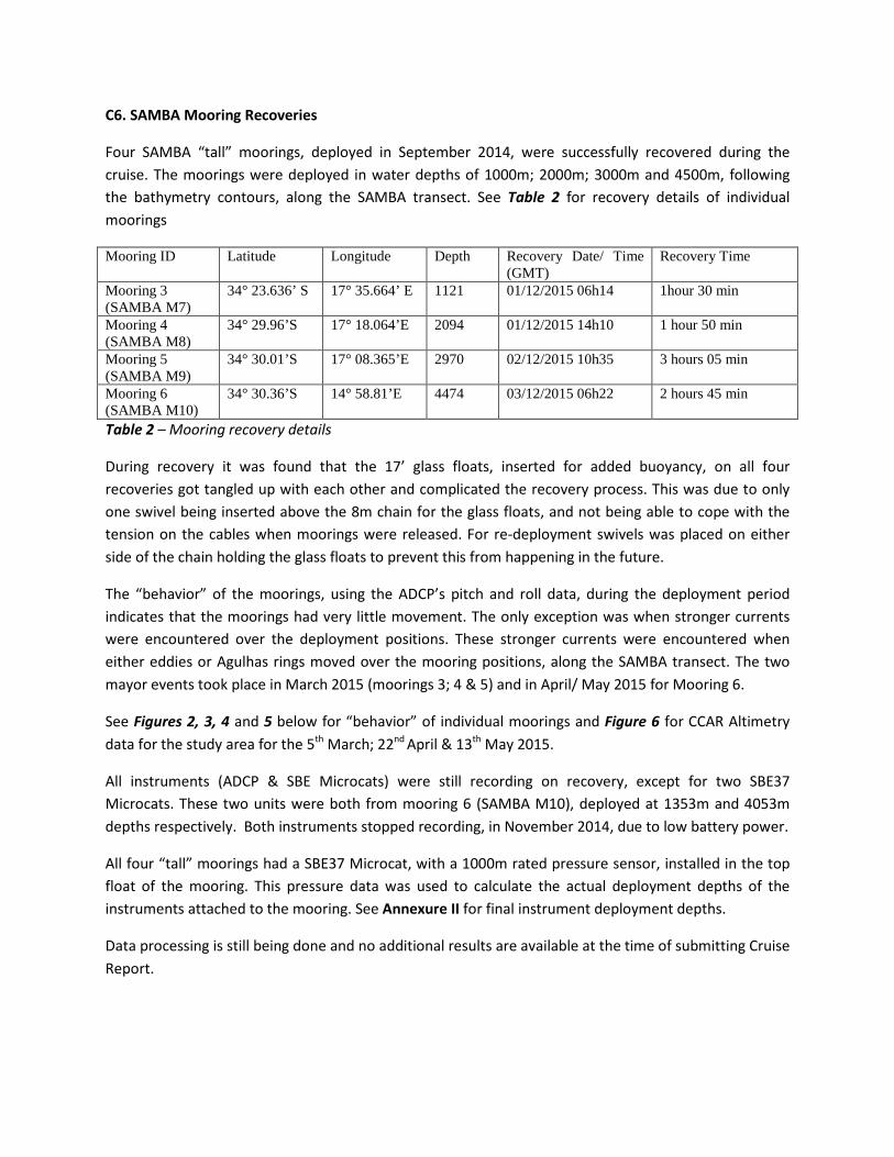
C6. SAMBA Mooring Recoveries
Four SAMBA “tall” moorings, deployed in September 2014, were successfully recovered during the cruise. The moorings were deployed in water depths of 1000m; 2000m; 3000m and 4500m, following the bathymetry contours, along the SAMBA transect. See Table 2 for recovery details of individual moorings
Mooring ID Latitude Longitude Depth Recovery Date/ Time (GMT)
Recovery Time
Mooring 3 (SAMBA M7)
34° 23.636’ S 17° 35.664’ E 1121 01/12/2015 06h14 1hour 30 min
Mooring 4 (SAMBA M8)
34° 29.96’S 17° 18.064’E 2094 01/12/2015 14h10 1 hour 50 min
Mooring 5 (SAMBA M9)
34° 30.01’S 17° 08.365’E 2970 02/12/2015 10h35 3 hours 05 min
Mooring 6 (SAMBA M10)
34° 30.36’S 14° 58.81’E 4474 03/12/2015 06h22 2 hours 45 min
Table 2 – Mooring recovery details
During recovery it was found that the 17’ glass floats, inserted for added buoyancy, on all four recoveries got tangled up with each other and complicated the recovery process. This was due to only one swivel being inserted above the 8m chain for the glass floats, and not being able to cope with the tension on the cables when moorings were released. For re-deployment swivels was placed on either side of the chain holding the glass floats to prevent this from happening in the future.
The “behavior” of the moorings, using the ADCP’s pitch and roll data, during the deployment period indicates that the moorings had very little movement. The only exception was when stronger currents were encountered over the deployment positions. These stronger currents were encountered when either eddies or Agulhas rings moved over the mooring positions, along the SAMBA transect. The two mayor events took place in March 2015 (moorings 3; 4 & 5) and in April/ May 2015 for Mooring 6.
See Figures 2, 3, 4 and 5 below for “behavior” of individual moorings and Figure 6 for CCAR Altimetry data for the study area for the 5th March; 22nd April & 13th May 2015.
All instruments (ADCP & SBE Microcats) were still recording on recovery, except for two SBE37 Microcats. These two units were both from mooring 6 (SAMBA M10), deployed at 1353m and 4053m depths respectively. Both instruments stopped recording, in November 2014, due to low battery power.
All four “tall” moorings had a SBE37 Microcat, with a 1000m rated pressure sensor, installed in the top float of the mooring. This pressure data was used to calculate the actual deployment depths of the instruments attached to the mooring. See Annexure II for final instrument deployment depths.
Data processing is still being done and no additional results are available at the time of submitting Cruise Report.

Figure 2: Pitch; Roll and Depth data for Mooring 3 (SAMBA M7) over the deployment period. The velocity data indicates stronger currents during November 2014 and March 2015.
Figure 3: Pitch; Roll and Depth data for Mooring 4 (SAMBA M8) over the deployment period. The velocity data indicates stronger currents during March 2015.
Figure 4: Pitch; Roll and Depth data for Mooring 5 (SAMBA M9) over the deployment period. The velocity data indicates stronger currents during March 2015.

Figure 5: Pitch; Roll and Depth data for Mooring 6 (SAMBA M10) over the deployment period. The velocity data indicates stronger currents during March 2015 and May 2015.
Figure 6: Altimetry data (from CCAR) for (a) 5 March 2015; (b)22 April 2015 and (c) 13 May 2015 shown in relation to the SAMBA transect and mooring positions (indicated in red)

C7. SAMBA Mooring deployments
Mooring ID Deployment Date/Time
Start Latitude/ Longitude
End Latitude/ Longitude
Deploy Depth
Set-up distances
Total Deployment time
Mooring 1 30/11 2015 17h38
34° 16.464’S 17° 56.384’E
284m 20 min
Mooring 2 30/11/2015 18h12
34° 17.679’S 17° 52.815’E
312m 20 min
Mooring 3 (SAMBA M7)
01/12/2015 14h20
34° 23.1’S 17° 34.7’E
34° 23.77’S 17° 35.80’E
1119m 1nmile + 200m*
2hrs 50min
Mooring 4 (SAMBA M8)
02/12/2015 06h28
34° 27.2’ S 17° 14.9’E
34° 30.119’S 17° 18.248’E
2120m 3nmiles + 400m
2hrs 08min
Mooring 5 (SAMBA M9)
02/12/2015 19h35
34° 27.3’S 17° 06.3’E
34° 30.357’S 17° 08.585’E
2728 3nmiles + 600m
2hrs 11min
Mooring 6 (SAMBA M10)
03/12/2015 16h04
34° 26.366’S 14° 58.825’E
34° 30.859’S 14° 58.802’E
4481m 4nmiles + 900m
3hrs 22min
Mooring 1 surfaced 3 hours after deployment *drop point over run by 170m
Table 3 – Mooring deployment details
The two shelf moorings (Mooring 1 and 2) were deployed to collect current data in the Benguela Jet Current. During the planning stages of the SAMBA project it was envisage to deploy 6 moorings along the shelf, but to date only 2 moorings have been deployed. This is mainly due to the area being a demersal trawling area for the fishing industry and an understanding between the industry and the department has been reached for fishing vessels to avoid these two deployment positions. Mooring 1 broke free from its deployment weights about 3 hours after deployment. Confirmation that the mooring had surfaced was received, via the ARGOS beacons installed on each mooring, from CLS once the vessel returned closer inshore. This was after completing the mooring deployments and hydrographic survey. Notification was received via email and only downloaded once vessel was in cellphone range again. The mooring was tracked using GPS positions received from CLS, at 90 minutes intervals, from the time it surfaced. Once the vessel got to last received position and predicted the track of the moorings trajectory it was following, the surfaced mooring was sited and successfully recovered. (See Figure 7 for the trajectory of the surfaced mooring) In future the vessels email system, via satellite, will be used to receive notification of any surfaced moorings. Upon inspection of the mooring it was found that one of the acoustic releases was “flooded”, which shorted out the release motor fuse and started the release motor. This opened the pin holding the weights and surfaced the mooring.

Figure 7 – Surfaced mooring trajectory over a period of 7 days
The four “tall” moorings were re-deployed in the same positions as they were recovered from – see Table 3 for mooring deployment details.
All “tall” moorings have a sub-surface depth of 500m, with an upwards looking 75kHz RDI ADCP deployed in uppermost FT float, set to sample the top 500m of the water column. At selected depths along mooring lines, SBE 37 MicroCat’s, with optical oxygen sensors, and RD Instruments DVS single point current meters were attached. See Table 4 for instrumentation settings used for deployed instruments.
For moorings 3 and 6 (SAMBA M7 & M10) two AURAL autonomous hydrophones were installed in the extra floatation buoys on the mooring. (See Annexure III for mooring design details) These hydrophones are used to monitor whale movement along and across the SAMBA transect.
See Annexure III and IV for final deployment diagrams and deployment sheets.
The moorings were deployed in close proximity to CPIES and bottom mounted ADCP moorings deployed, in July 2015, by IFREMER, France from the SA Agulhas II. These moorings also form part of the

SAMBA project. Special care was taken in selecting the deployment track of the “tall” moorings to avoid these moorings.
Due to vessel noise, no attempts were made at tri-angulating mooring positions of the “tall” moorings after deployment
75kHZ RDI ADCP – Long Ranger No of depth bins 37 Bin depth size (m) 16 Pings per ensemble 25 Blanking distance 7.04m Sampling interval 1 hour Magnetic variation 0 °
2400 kHz RDI DVS Current Meters No of depth bins 5 Bin depth size (m) 0.75m Pings per ensemble 25 Sampling interval 1 hour Magnetic variation 0°
SBE 37 SMP- ODO Microcats Sampling Interval 3600s (1 Hour) Sampling Type Autonomous Pump setting Adaptive Pump Control = 1
Table 4 – Instrument settings for “tall” mooring instrumentation
C8. ARGO Float Deployments
Four Argo floats (Webb APEX floats) were deployed on behalf of the UK Meteorological Office, to enhance the Global Ocean Observation System of IOC (GOOS) in the South Atlantic.
Each float was deployed after the completion of the CTD and Vertical Bongo casts at the selected deployment stations.
See Table 5 for deployment details
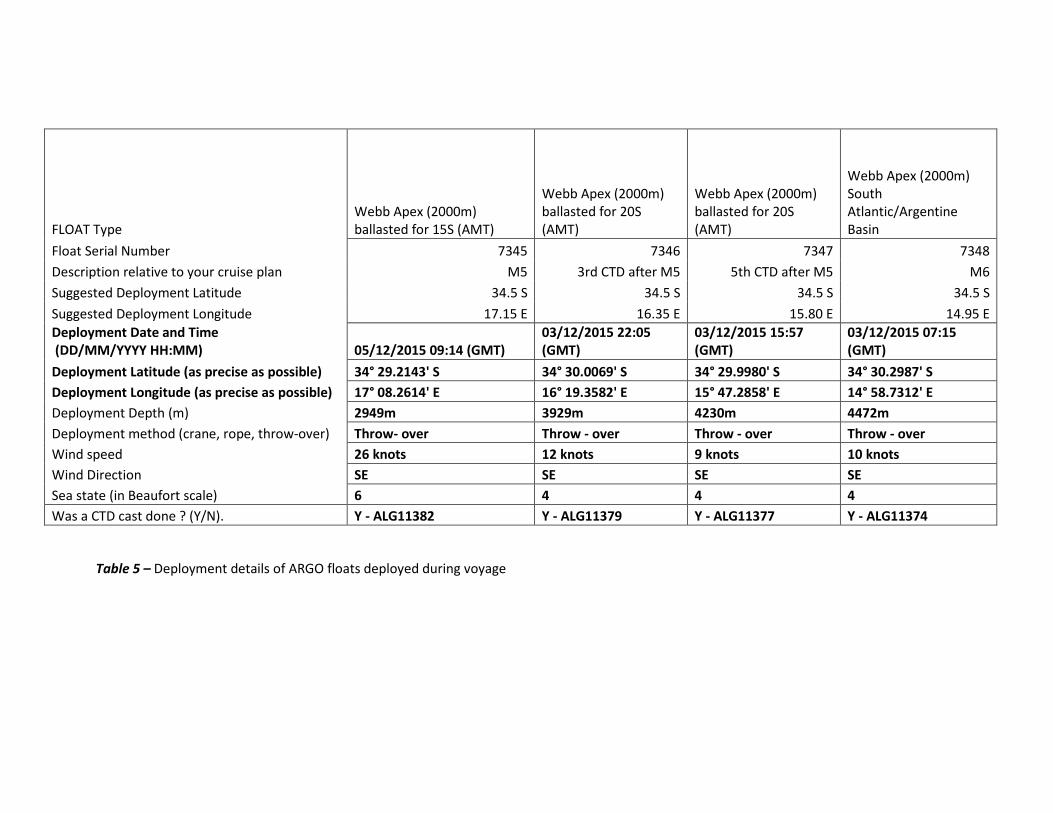
FLOAT Type Webb Apex (2000m) ballasted for 15S (AMT)
Webb Apex (2000m) ballasted for 20S (AMT)
Webb Apex (2000m) ballasted for 20S (AMT)
Webb Apex (2000m) South Atlantic/Argentine Basin
Float Serial Number 7345 7346 7347 7348 Description relative to your cruise plan M5 3rd CTD after M5 5th CTD after M5 M6 Suggested Deployment Latitude 34.5 S 34.5 S 34.5 S 34.5 S Suggested Deployment Longitude 17.15 E 16.35 E 15.80 E 14.95 E Deployment Date and Time (DD/MM/YYYY HH:MM) 05/12/2015 09:14 (GMT)
03/12/2015 22:05 (GMT)
03/12/2015 15:57 (GMT)
03/12/2015 07:15 (GMT)
Deployment Latitude (as precise as possible) 34° 29.2143' S 34° 30.0069' S 34° 29.9980' S 34° 30.2987' S Deployment Longitude (as precise as possible) 17° 08.2614' E 16° 19.3582' E 15° 47.2858' E 14° 58.7312' E Deployment Depth (m) 2949m 3929m 4230m 4472m Deployment method (crane, rope, throw-over) Throw- over Throw - over Throw - over Throw - over Wind speed 26 knots 12 knots 9 knots 10 knots Wind Direction SE SE SE SE Sea state (in Beaufort scale) 6 4 4 4 Was a CTD cast done ? (Y/N). Y - ALG11382 Y - ALG11379 Y - ALG11377 Y - ALG11374
Table 5 – Deployment details of ARGO floats deployed during voyage

C9. CTD Stations and Hydrography
A total of 15 CTD/Carousel stations were completed during the cruise. See Table 1 for list of station details. All CTD casts were profiled to a maximum of 1000m wire. CTD profiles were collected with a Sea-Bird SBE-911+ CTD/SBE 32 carousel water sampler equipped with 12 x 5 liter Niskin sampling bottles. See Table 6 for list and location of sensors mounted on CTD system.
Channel Sensor Serial number
Frequency 1 Temperature – SBE 3+ 4128
Frequency 2 Conductivity – SBE4C 2673
Frequency 3 Pressure (Digiquartz with TC) 83525
Voltage 0 Oxygen – SBE43 0237
Voltage 1 Wetlabs Fluorometer FLRTD-0936
Voltage 2 Free
Voltage 3 Free
Voltage 4 Benthos Altimeter 873
Voltage 5 Biospherical PAR 70253
Voltage 6 Cambell Scientific OBS 3+ - Turbidity sensor T8684
Voltage 7 Cambell Scientific OBS 3+ - Turbidity sensor T8684
SPAR Voltage Biospherical SPAR 203616
Table 6- Sensors mounted on SBE 911 CTD Plots of the down and up traces were generated and stored with the CTD cast log sheets. Data from casts were averaged over 1m bins and saved separately as up and down traces during post processing. The data was logged and bottles triggered using Seabird Seasave Win32 Version 7.21d and the data processed using SBE Data Processing Version 7.21g. Downcast profile data was re-formatted then imported into Ocean Data View (ODV) for further analysis. See Figure 8 and Figure 9 for preliminary results obtained from CTD casts
Problems were encountered with the firing of the discrete bottle samples. When using either the Seasave software or deck-unit to “fire” discreet bottles, there is no indication given that the bottles had actually closed. After some test CTD dips it was established that the bottles did close on the “fire” command, even though that no *.bl (Bottle file) being created or any indication of bottles closing being received. It was decided to “fire” discreet bottles using the deck-unit and then creating a *.mrk (mark file) using the Seasave software to indicate at which depths the bottles were fired. The problem is still being looked at and will hopefully shortly be resolved – See Annexure I for Technical Report, submitted by Electronic Engineers.

Water samples were collected at discrete depths on all casts. Samples were collected for the following parameters:
• Nutrients – A double set of samples collected at all depths, for each CTD station. All samples were frozen and stored at -80°C for later analysis.
• Chlorophyll samples – 200ml of sample was collected at 6 selected depths for each CTDstation. The selected depths were sampled around the chlorophyll max. Each sample was filtered through GF/F filters and samples frozen and stored at -80°C for later analysis.
• Dissolved Inorganic Carbon (DIC) – samples through the water column at discrete depths were collected at two stations (ALG11374 & ALG11385). Samples were preserved with HgCl2 for later analysis.
• Oxygen and salinity samples were collected at 4 discrete depths for each CTD station. These samples are for the calibration of the CTD sensors. Analyses will be completed once vessel returns to port.
Fig 8 - Scatter diagram and TSO plot of preliminary results obtained from CTD casts along SAMBA transect

Figure 9 - Vertical Section of preliminary results obtained from CTD casts along SAMBA transect

C10. Biological Sampling (submitted by Janine van der Poel)
A Hydro-Bios Vertical Bongo, with net probe CTD and two electronic flowmeters, was used to collect plankton samples at each of the 15 CTD stations (see Table 1 for list of stations) along the SAMBA transect.
Both nets on the Vertical Bongo had a net size of 200 microns and all casts were done to a maximum depth of 200m. With a heaving speed of 1m/s, flowrate measurements was collected using the Hydro-Bios logging software. Samples collected were preserved in 10% buffered formalin for later analysis.
Two drift net stations (ALG11379 and ALG11388) were done to collect female Calanoides copepods. The first station was at the most offshore station (oceanic waters) and the second station was the inshore station (shelf waters) on the transect. Although no calanoides copepods were found an abundance of nano calanus were found in the samples at both stations.
C11. Scientific Underway Equipment:
C11.1 Shipbased ADCP (S-ADCP) Data:
The vessel’s keel mounted 75kHz Teledyne RD Instruments ADCP was set to collect data for selected transects during the voyage. Data was recorded using the Teledyne RDI VMDAS (version1.46) software. The instrument was setup to collect data for 70 bins, with a bin size of 8m to a total depth of 560m. The instruments alignment correction, in relation to the vessel, was set to -46°. This value was determined after installation trials in July 2012.The blanking distance was set at 8m.
See Table 7 below for information on filenames and related transects.
Transect description ADCP File name Transect from Cape Town to Mooring 1&2 deployment positions ALG221 001 Two transects from 1000m depth contour to inshore position of Slangkop (uninterrupted) – Benguela Jet variability study
ALG221 002
Transect from M3 to M4 (include recovery/ deployment and drifts) ALG221 003 Transect from M4 to M6 ((include recovery/ deployment and drifts) ALG221 004 Transect along CTD stations (includes CTD stations) ALG221 005 Table 7 – ADCP transect details
After the deployment of the two shelf moorings, the vessel proceeded to the 1000m depth contour (mooring 3 position) and then steamed back inshore, across the shelf, to a position inshore, off the Slangkop light house, investigate the variability of the Benguela Jet Current. This transect was completed twice during the night of 30 November (ADCP file ALG221 002). The two transects were steamed at a constant speed of 8 knots, whilst underway surface samples for nutrients and chlorophyll samples were collected every 20 minutes (this was only done for the in-bound transect). Figure 10 shows the surface currents for the two uninterrupted cross shelf transects from the 1000 depth contour to the inshore position, off the Slangkop Light House Figure 11 shows the surface currents along the SAMBA transect, during the hydrographic survey (includes vessel stops for CTD stations)

Figure 10 - Surface current along cross shelf transects

Figure 11 - Surface current along SAMBA transects

C11.2 Thermosalinograph (TSG)
The SeaBird SBE45 Thermosalinograph (TSG), with remote SBE38 Temperature probe, system was run for the duration of the voyage for the collection of underway temperature and salinity data. The instrument obtains sea water from the on-board seawater supply manifold, with seawater being pumped from the sea-chest located in the engine room to the laboratory. The data is recorded in raw format (*.hex) and relayed to the Scientific Data System (SDS). Few issues were encountered with the SeaSave software when the “octobox” lost connection to the NMEA GPS feed. On occasion the unit had to be re-booted to enable data logging again. See Technical Report (ANNEXURE I) for more details. Figure 12 shows the temperature and salinity data obtained from TSG data , where (a) indicates the fronts for the out-bound transect (during mooring recoveries and deployments) and (b) the in-bound transect (during hydrographic survey).
Figure 12– Temperature and salinity data obtained from TSG data, where (a) the out-bound transect (during mooring recoveries and deployments) and (b) the in-bound transect (during hydrographic survey).

C11.3 Underway pCO2 Systems
For the duration of the voyage continuous surface pCO2 data was collected. Surface water was obtained from the seawater intake. The PCO2 analysis was done by a LiCor Li-7000 CO2 / H2O analyser.The pCO2 system samples the sea surface water that flows through the system every minute and collects additional data from the TSG system and atmospheric air intakes connected to the system.
C11.4 Underway sampling During the first cross shelf S-ADCP transects (30 November 2015), underway surface samples were collected for nutrients and chlorophyll. These samples were collected every 20 minutes and stored at -80°C for later analysis. This process was repeated (5 December 2015) during the CTD transect, once the vessel reach the shelf (1000m depth contour).
Underway oxygen calibration samples were also collected, every 4 hours, from the scientific seawater outlet to attempt calibration of pCO2 oxygen sensor.
C11.5 Scientific Data System (SDS)
The Scientific Data System (SDS) records underway data on the vessel from various instruments (ie TSG; Surface light meter (SPAR); navigational; scientific winches and weather stations), installed on the vessel, continuously during the voyage. From the database the “live” data is streamed, via the vessels network, to relevant scientific laboratories for use by the scientists. No metrological information was recorded during the cruise, due to the Coastal Environmental Systems meteorological system not being available. The unit has been returned to the manufacture for repairs and re-calibration. C12 References: http://www.aoml.noaa.gov/phod/SAMOC_international/index.php
Schlitzer, R., Ocean Data View, http://www.awi.bremerhaven.de/GEO/ODV, 2001.
VISEA DPS, Aquavision – ADCP data
Near real-time Altimetry provided by Colorado Center for Astrodynamics Research (CCAR)at the University of Colorado, Boulder. (http://ccar.colorado.edu)

C13. Scientific Log
30 November 2015, Monday
08h00 – 14h00 – Load all mooring equipment and set-up chemistry and Plankton equipment
15h30 – leave Cape Town harbor and start steaming for Slangkop mid shelf deployments.
15h40 – start ADCP transect from Cape Town to mooring positions.
ADCP file name - ALG221 001
Get all underway systems up and running – TSG and pCO2
Setup and test ADCP’s for moorings 1 & 2 to start recording at 22h00 (30/11/2015)
Setup and test ARGOS beacons for moorings 1 & 2 and record all details on deployment sheets.
19h38 – Deploy Mooring 1 in 280m of water
20h12 – Deploy Mooring 2 in 312m of water
Start steaming towards 1000m isobaths for ADCP & underway sampling to commence.
21h51 – Start ADCP transect (ALG221 002) running from offshore to inshore to capture the Benguela Jet. Vessel steaming at 8 knots - with surface nutrient/chlorophyll sampling every 20 minutes.
1 December 2015, Tuesday
07h03 – Finish outbound transect across the shelf. Stop ADCP recording. Underway samples only collected on inbound transect at 20 minute intervals.
Start ADCP (ALG221 – 003) – 1000m contour west bound during mooring recovery/ deployments.
08h14 – release tall mooring 3 (1000m)
09h44 – Mooring 3 successfully recovered
10h30 – safety muster drill for all on-board
Start down loading data and servicing the instruments for re-deployment. Get mooring weights and hardware ready for deployment
13h34 – start re-deploying mooring 3 in the same position
14h20 – complete deployment of mooring 3
Start steaming towards tall mooring 4 (2000m) to recover.
16h10 – 18h00 Successfully release tall mooring 4 and recovery

18h00 – 21h00 - down load and service instruments recovered and setup for re-deployment; get mooring equipment ready for deployment in the morning.
2 December 2015, Wednessday
06h00 start getting Mooring 4 ready for re -deployment – connecting up cables and weights
07h00 – power failure that crashed ADCP PC – stopped logging
08h00 – start logging ADCP again – ALG221 004 – at deployment site for Mooring 2
08h40 – 11h30 – Deploy Mooring 4
12h35 – 15h40 – Recover Mooring 5
16h00 – 19h00 – Get Mooring 5 ready for re-deployment
19h24 – 21h35 – Re-deploy Mooring 5
3 December 2015, Thursday
08h22 – 10h56 – Recover mooring 6
11h00 – 15h20 - Get mooring 6 ready for re-deployment
15h32 – 18h04 – Re-deploy mooring 6
19h00 – 20h20 – Do test hydrographic and biological station to test all equipment required for sampling. All system operational and ready.
The problem with the bottle firing still occurring , this after certain modifications were made to the system. Recorded the error messages and will consult with SeaBird as to a solution to the bottle firing problem. All bottles are still closing when firing command send, but no indication is given that bottles have triggered.
For CTD transect the bottles will be fired from the deck-unit and the triggering data to be saved to *.mrk (Mark) file – as no btl (bottle file) is created.
4 December 2015, Friday
08h00 – Start CTD transect (CTD and vertical bongo) from Mooring 6 positions.
08h09 – 09h13 CTD Station 11374 (total station time 1h30)
09h15 – deploy 1st Argo float – serial number 7348
09h20 – start ADCP transect (Alg221-005)

10h52 – 11h50 CTD 002 & VBongo – Station 11375
13h32 – 15h04 CTD 003 & VBongo – Station 11376. CTD redone after inconsistent bottle triggering
15h57 – Deploy 2nd Argo float – serial number 7347
16h44 – 17h57 CTD 004 & VBongo – Station 11377.
19h38- 20h46 CTD 005 & VBongo – Station 11378
22h22 - 02h08 CTD 006& VBongo – Station 11379.
First attempt at CTD cast had to be aborted due to RS232 communication error on CTD. Electronics technicians redid the two underwater joints, after the strain relieve, to eliminate any possible water ingress into the joints. The CTD casts was successfully completed after repairs were done. The VBongo was completed before the CTD casts.
22h30 – deploy 3rd Argo float – serial number 7346
5 December 2015, Saturday
04h19 – 05h25 CTD 007 & VBongo – Station 11380
First day of bad weather with wind over 34 knots from the SE. Seas rough with 3 – 4 m swells. Vessel making 7.8 knots.
07h25 – 08h28 CTD 008 & VBongo – Station 11381
10h40 – 11h35 CTD 009 & VBongo – Station 11382
11h14 – deploy 4th Argo float – serial number 7345
12h00 – the SA Agulgas II joins us on the SAMBA transect, on her way to Antarctica, doing XBT’s along the transect and recording S-ADCP data. The Agulgas passes us at Mooring 5’s position.
12h50 – 13h55 CTD 010 & VBongo – Station 11383
15h00 – winds calms down to 15 knots and swell drops
14h59 – 16h00 CTD 11 & VBongo – Station 11384
17h06 – 18h07 – CTD 12 & VBongo – Station 11385
19h07 – 19h48 – CTD 13 & VBongo – Station 11386
20h57 – 21h35 – CTD 14 & VBongo – Station 11387
22h07 – 23h40 – CTD 15 & VBongo – Station 11388
Drift net deployed at station
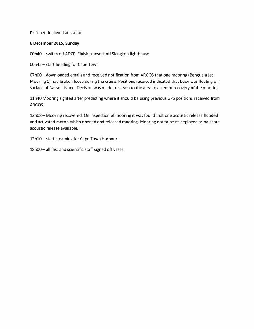
6 December 2015, Sunday
00h40 – switch off ADCP. Finish transect off Slangkop lighthouse
00h45 – start heading for Cape Town
07h00 – downloaded emails and received notification from ARGOS that one mooring (Benguela Jet Mooring 1) had broken loose during the cruise. Positions received indicated that buoy was floating on surface of Dassen Island. Decision was made to steam to the area to attempt recovery of the mooring.
11h40 Mooring sighted after predicting where it should be using previous GPS positions received from ARGOS.
12h08 – Mooring recovered. On inspection of mooring it was found that one acoustic release flooded and activated motor, which opened and released mooring. Mooring not to be re-deployed as no spare acoustic release available.
12h10 – start steaming for Cape Town Harbour.
18h00 – all fast and scientific staff signed off vessel


ANNEXURE I
Technical Report

South Atlantic Mooring Buoy Array (SAMBA)
Monitoring Line
Voyage 221
Technical Report
Angelo Marco Control Engineering Technician
&
Kholeka Batyi-Nkwenkwe Marine Research Assistant III
Chief Directorate: Oceans & Coastal Research
Submitted to the Chief Scientist
30 November 2015 – 06 December 2015

Technical Report ALG 221 - SAMBA
Voyage 221 November 2015
1. Introduction
This report covers duties, responsibilities and activities carried out by the duty technicians while providing technical support for the achievement of the cruise objectives. It also serves as a platform to highlight areas where attention is needed, and/or possible recommendations to improve scientific operations onboard the RV Algoa.
2. Scientific systems
2.1 Winch Systems 2.1.1 Hydrographic Winch [SBE 911plus CTD]
The Hydrographic Winch was used exclusively for the deployment of the CTD underwater unit. No problems related to mechanical operation of the Hydrographic winch were experienced. Inconsistent cable runout readings from the winch displays, which were reported by previous cruises, have been resolved with a percentage error of ±0.6 %.
2.1.2 Vertical Plankton Winch The Vertical Plankton Winch was used exclusively for the deployment of the Hydrobios DCP 3000 Direct Combine Probe. This winch did not suffer any mechanical failures and previously reported inconsistencies in the displayed cable runout values were successfully resolved prior to the commencement of this voyage.
2.1.3 Small Towing Winch [Multi-plankton Sampler] The Small Towing Winch was used for the recovery and re-deployment of moorings on the SAMBA transect. No mechanical malfunctions reported for this winch during the voyage. The winch display located at the aft starboard gantry platform was replaced prior to the preceding cruise and functioned without mishap during the voyage.
Note that operation of the winch did not require accurate cable runout readings and thus this operational aspect was not monitored and verified.
2.2 SBE911plus CTD System • Following previously reported errors with the SBE911plus CTD system, the deck unit was replaced
prior to commencement of the voyage. Additionally, the inverter supplying power to the deck unit was earthed as this could be a possible path for ground loop interference.
• A dip test was conducted on Voyage Day 4 with a sounding depth of ≈4500m. On the descent cast to a depth of 1000m, the SeaSave program reported an unsupported modem message, without any communication being initiated with the underwater unit. A bottle closure was initiated at 1000m depth, with no confirmation message received from the underwater unit. A further 5 additional bottle closures were triggered at various depths on the ascent cast, with a sole closure confirmation message received for a trigger at 25m. It was noted that although the sequential bottle fire window did not update where no confirmation message was received, the sequence was correctly recorded and reported by the underwater unit when communication was restored at shallower depths.
• It was further confirmed that, when the underwater unit was brought on deck, bottle closures had been successfully executed.
Page 1 of 6

Technical Report ALG 221 - SAMBA
Voyage 221 November 2015
• The Chief Scientist then established the following work-around:
a) All bottle closures to be triggered from the front panel of the deck unit. b) The Mark Scan file was configured to record the most important parameters normally
captured into the bottle file generated by the SeaSave application. After triggering a bottle closure, the operator then had to execute the mark scan command, which would ensure that the relevant data was recorded by the system.
• All subsequent deployments followed the above procedure with data verified as being successfully captured.
• A faulty underwater joint was reported during deployment at station CTD-006. The vessel remained on station while the fault was attended to by the duty technicians. The fault was repaired by attaching a guided two pin circular series female connector to the Hydrographic winch cable end. Additionally, an adapter cable was constructed consisting of a two pin female impulse connector (which plugged into the underwater unit) and a guided two pin circular male connector. All joints were sealed using a combination of 3M Scotchfill Electrical Insulation Putty and 3M Scotch 23 Self Bonding Electrical Tape.
• The root cause of the fault and the conditions under which it arises has neither been determined nor completely understood. It is recommended that a further study be devoted to this issue, as this will grow our knowledge base and underpin a corrective strategy. Recommended tests strategy:
a) Functional verification of Seabird CTD unit and Rosette water sampling system As the CTD and carousel were obtained from the FRV Ellen Khuzwayo, it would be politic to deploy unit using this vessel and monitor the modem messages. If messages are successfully received from the unit, then it follows that the fault is endemic to the RV Algoa and the tests listed below should be performed.
b) Noise from interconnection cables or connectors on the carousel Attach dummy plugs to all non-essential connectors and deploy the unit with only the SBE 32 water sampler and SBE9 underwater unit connected. If bottle data is successfully captured during testing then troubleshooting can be limited to the cables or connectors.
c) Faulty SBE 32 water sampler The SBE 32 water sampler was replaced previously as part of the initial investigation but did not resolve the fault. Although most unlikely that both the original and replacement water samplers exhibit the same fault, the possibility exists and must be tested for. Deploy the CTD/water sampler only configuration discussed above. After deployment, check the water sampler for evidence of moisture ingress. Additionally, the water sampler could be replaced with a known working unit and the CTD/water sampler re-deployed.
d) Pin-hole leak in sea cable The cable, underwater joint and cable connection from the winch slip-ring to the PC and were checked as part of previous investigations with no errors detected. Subsequently, the unit was connected to a different winch system but that too failed to resolve the fault. Based on these previous experiments, it appears unlikely that the sea cable is at fault.
Page 2 of 6

Technical Report ALG 221 - SAMBA
Voyage 221 November 2015
Should it prove necessary, an acid test can be performed by re-terminating the sea cable with a cut-back of 5m – 10m and checking if modem errors occur at shallower depths than previously, i.e. <50m.
• To ensure that we meet our operational objectives, it is further advised that in parallel with the recommended testing, we leverage our existing relationships with other roleplayers e.g. CSIR, DAFF, UCT, etc. and engage in negotiations to have a loan unit be on standby should the unit need arise.
2.3 Hydrobios Bongo Plankton Net
• A dip test was conducted on Voyage Day 4. The unit was successfully deployed to a depth of 200m and operated without any malfunctions for the duration of the voyage.
2.4 Scientific Data System The Scientific Data System (SDS) performed without mishap for the duration of the cruise.
Suggested Improvements:
• Computer Room DELL KMM Console The monitor of the DELL combined rack-mount KMM console functioned erratically when the vessel was underway, losing power and/or signal. Although not critical to the logging functionality of the SDS system, it is highly frustrating when working on the server. As this is a sealed unit, repair at sea was not possible. It is recommended that this unit either be sent for repair or replaced completely.
• Air Conditioning Unit Leak It was observed that the airconditioning unit in the Computer Room is leaking water. This is indicative of either a fault with the condenser pump or the condenser itself. Although only miniscule amounts of water leakage were observed, it is recommended that the unit is checked and serviced as a matter of priority.
• Diesel Leaks
Damp spots on the concrete cast over the diesel tank raise concerns that not all diesel leaks have been repaired. Although these could be ascribed to the leak from the air conditioning unit, it is felt that a much higher ingress of water would be required. This should be looked into by the ship’s engineer and ship management.
3. Underway Sampling Systems
3.1 South African Weather Services Meteorological Station Currently, the South African Weather Services (SAWS) Meteorological System logs atmospheric data on a dedicated computer in the acoustic lab. Unfortunately, this data is not yet available on the SDS system. It is recommended that this be resolved as soon as possible, with SAWS indicating the communication interface type and the output data format. This would have to be communicated to Sea Technology Services (STS) for inclusion in the Scientific Data System. Additionally, a discrepancy in wind speed was reported between the bridge anemometer and the SAWS system. It is recommended that SAWS be contacted to investigate and make corrections to their system.
Page 3 of 6

Technical Report ALG 221 - SAMBA
Voyage 221 November 2015
3.2 SBE45 MicroTSG The TSG was mostly stable for the entire cruise barring a few sampling interruptions. These were due to the following: • Thermosalinograph (TSG) Opto-box
It was observed that the SeaSave application would randomly stop working, requiring a restart of both the software and the opto-box. Subsequent checks on incoming data from the TSG showed that the NMEA messages were incorrectly parsed by the opto-box, with sentence identifiers appended to the date and time parameters.
Based on fault observations, it appears that the parsing error causes a buffer overflow in the opto-box and the unit then enters into an irrecoverable time-out state. In turn, no GPS data is received by the SeaSave application, causing it to suspend the logging functionality. It is recommended that either the opto-box be replaced or, if possible, that the firmware be upgraded.
3.3 pCO2 System The system performed well for the entire cruise. To improve the sampling quality, the following is recommended:
• The installation of a flow meter at the manifold would allow for greater precision and control by the operator when adjusting the valves.
• Further, by implementing an electronic flow meter, the measured flow rate can be included as a parameter displayed by the SDS system. This can be then be monitored with high and low alarms pre-programmed into the system.
• Currently, a pressure meter is used to monitor the system, with fluctuations ranging between 1 and 2 bar, due to the cyclic action of the peristaltic pump. This results in an erratic flow, which is not ideal for a system like the pCO2, which requires a constant flow rate. Two options are available viz. increase the pump RPM and number of rollers or use a combination of inlet stabilizers and pulsation dampeners.
• It is recommended that a feasibility study be performed to determine the most cost-effective and efficient solution.
3.4 ADCP System The ADCP system functioned well over the course of the voyage.
4. General Observations 4.1 Finalise GPT relocation The early part of Sailing Day 1 was spent securing and finalizing the temporary installation of the 18, 38, 120 & 200kHz GPTs following their relocation from the Acoustic Lab to the Sonar Compartment. Power is provisionally supplied to the units via an extension cable, as provision for stabilized power was only made available shortly before departure. It is recommended that stabilized supply be connected immediately. Additionally, heating panels should be installed to combat the prevailing moisture resultant from condensation.
Page 4 of 6

Technical Report ALG 221 - SAMBA
Voyage 221 November 2015
4.2 Faulty Locksets Faulty locksets were identified in the following areas:
• Cupboard marked “D” in Computer Room. • Both sets of access doors to Ops Room Racking.
It is recommended that all faulty locksets are replaced.
5. Summary of Recommended Actions 5.1 Scientific Winch Systems • All winch systems must be checked and serviced before each voyage. This includes all sheaves,
spooling systems, communications and instrumentation. • Currently, no reference documents are available for the winch display system. Access to these
documents would aid service personnel to resolve faults in a timeous manner. It is recommended that the ship management urgently obtain the relevant documents from the contractor.
5.2 CTD System • Develop integrated test plan and execute accordingly. • Initiate negotiations to obtain a spare underwater unit as part of risk management. • In future, ensure that all CTD components are calibrated and have not exceeded their calibration
validity period.
5.3 Weather Systems • Both the Weather-Pak and Aanderaa systems have been sent for repair and calibration to the
respective manufacturers. These systems must be re-installed immediately upon receipt as these are used for navigational purposes.
• The SAWS meteorological system is envisioned as a back-up system to the Weather-Pak and Aanderaa systems. It is highly recommended that data from this system be included in the SDS display prior to the next voyage as it is highly unlikely that either the Weather-Pak or Aanderaa systems will be available.
• Request SAWS to investigate and correct wind speed readout of meteorological system.
5.4 Scientific Data System (SDS) • Replace faulty Dell rackmount KMM console on the SDS server machine. • Ship management to ensure that recurrent diesel leaks in Computer Room are resolved. • Leaking air conditioner unit to be serviced.
5.5 SBE45 MicroTSG • Replace opto-box and evaluate system stability. • Determine if firmware upgrade is available for opto-box. • A dedicated scientific GPS system will provide the TSG system with a stable interference-free GPS
message structure. It is thus recommended that the changeover to the scientific GPS be completed as soon as possible.
• It is further recommended that a suitable filtration system be implemented on the seawater intake system to prevent biological fouling of the instrument. Note that this recommendation is also
Page 5 of 6

Technical Report ALG 221 - SAMBA
Voyage 221 November 2015
applicable to the pCO2 system.
5.6 pCO2 System • Install a flow meter at the manifold to allow for greater precision and control by the operator. • Incorporate flow rate data into SDS system with preset high and low alarm monitoring. • Reduce pressure spikes caused by cyclic nature of peristaltic pump. Options to be investigated are:
a) Increasing the pump RPM and number of rollers or b) Employing inlet stabilizers and pulsation dampeners
5.7. GPT Installation • Design permanent installation for GPTs in sonar compartment. • Install heating panels for temporary installation to combat condensation.
5.8. Faulty Locksets
• Replace locksets on : a) Cupboard “D” in Computer Room. b) Both sets of access doors to Ops Room racking.
Page 6 of 6

ANNEXURE II
Mooring Recovery Design
(Corrected Instrument deployment depths)

Sea Level
304m
604m
1108m
Mooring 3 (SAMBA M7)
49” FT Float Serial no: J7937-005
49” FT Float Serial no: J7937-010
4 Glass spheres on 3m 14mm ELL chain
2 Benthos 865-A releases Serial number: 46772 & 46773
Anchor Weight (1665kg)
488m
1118m
75kHz RDI ADCP – Serial no: 15521
SBE37 SMP-ODO & P – Serial no: 37-9585
606m
SBE37 SMP-ODO – Serial no: 37-9598
SBE37 SMP-ODO & P – Serial no: 37-9593
SBE37 SMP-ODO – Serial no: 37-9570 775m
940m
163m
165m
160m
1 x Aural recorder
300m
Argos Beacon – AS900A Serial no: A06-097
1100m
Sea Level
610m
630m
1110m
2100m
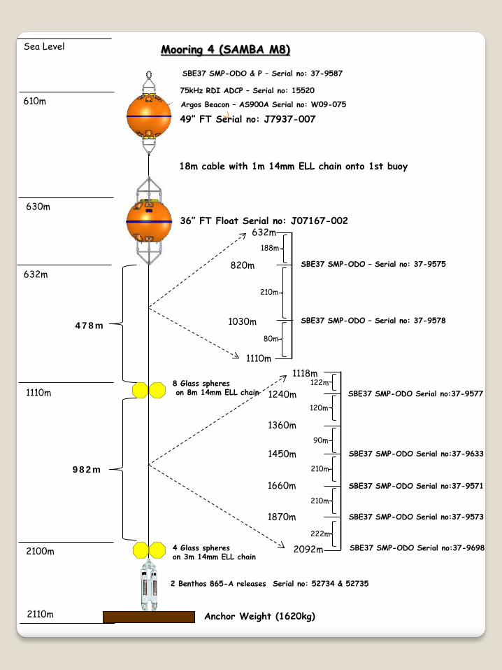
Mooring 4 (SAMBA M8)
49” FT Serial no: J7937-007
36” FT Float Serial no: J07167-002
8 Glass spheres on 8m 14mm ELL chain
4 Glass spheres on 3m 14mm ELL chain
2 Benthos 865-A releases Serial no: 52734 & 52735
Anchor Weight (1620kg)
18m cable with 1m 14mm ELL chain onto 1st buoy
478m
2110m
SBE37 SMP-ODO & P – Serial no: 37-9587
75kHz RDI ADCP – Serial no: 15520
632m
982m
632m
1110m
SBE37 SMP-ODO – Serial no: 37-9575
SBE37 SMP-ODO – Serial no: 37-9578
820m
1030m
188m
210m
80m
1118m
2092m
SBE37 SMP-ODO Serial no:37-9577
SBE37 SMP-ODO Serial no:37-9571
SBE37 SMP-ODO Serial no:37-9573
SBE37 SMP-ODO Serial no:37-9698
SBE37 SMP-ODO Serial no:37-9633
122m
120m
90m
210m
210m
222m
1240m
1360m
1450m
1660m
1870m
Argos Beacon – AS900A Serial no: W09-075

Sea Level
457m
937m
1937m
2919m
Mooring 5 (SAMBA M9)
49” FT Float Serial no: J07168-002
36” FT Float Serial no: J07167-004
8 Glass spheres on 8m 14mm ELL chain
8 Glass spheres on 8m 14mm ELL chain
4 Glass spheres on 3m 14mm ELL chain
2 Benthos 865-A releases Serial no: 52733 & 52736
Anchor Weight (1886kg)
18m cable with 1m 14mm ELL chain onto 1st buoy
982m
992m
2929m
437m
SBE37 SMP-ODO & P – Serial no: 37-9582
75kHz RDI ADCP – Serial no: 18259
478m
459m
937m
737m SBE37 SMP-ODO – Serial no: 37-9699
278m
200m
945m
1937m SBE37 SMP-ODO – Serial no: 37-9574
SBE37 SMP-ODO – Serial no: 37-9599
SBE37 SMP-ODO – Serial no: 37-9589
SBE37 SMP-ODO – Serial no: 37-9632
SBE37 SMP-ODO – Serial no: 37-9602
1037m
1337m
1637m
1737m
92m
300m
300m
100m
200m
1945m
2919m SBE37 SMP-ODO – Serial no: 37-9601
SBE37 SMP-ODO – Serial no: 37-9600
SBE37 SMP-ODO – Serial no: 37-9576
2097m
2237m
2457m
2537m
2837m
152m
140m
220m
80m
300m
82m
Argos Beacon – AS900A Serial no: Y02-023

Sea Level
473m
1203m
2453m
3703m
4443m
Mooring 6 (SAMBA M10)
49” FT Float Serial no: J07936-001
37” FT Float Serial no: J7167-001
8 Glass spheres on 8m 14mm ELL chain
8 Glass spheres on 8m 14mm ELL chain
8 Glass spheres on 8m 14mm ELL chain
4 Glass spheres on 3m 14mm ELL chain
2 Benthos 865-A releases Serial no: 52732 & 56419
Anchor Weight (2275kg)
18m cable with 1m 14mm ELL chain onto 1st buoy
728m
1242m
1242m
732m
4453m
453m 75kHz RDI ADCP – Serial no: 18262
SBE37 SMP-ODO & P – Serial no: 37-9586
SBE37 SMP-ODO – Serial no: 37-9579
475m
1203m
903m 428m
300m
SBE37 SMP – Serial no: 8333
SBE37 SMP-ODO – Serial no: 37-9588
SBE37 SMP-ODO – Serial no: 37-9561
1211m
2453m
1353m
1803m
2253m
142m
450m
450m
200m
SBE37 SMP-ODO – Serial no: 37-9572
SBE37 SMP-ODO – Serial no: 37-9697
SBE37 SMP-ODO – Serial no: 37-9580
2461m
2703m
3153m
3603m
3703m
242m
450m
450m
100m
3711m
4053m
4435m
SBE37 SMP – Serial no: 8334
SBE37 SMP-ODO – Serial no: 37-9603
342m
382m
Argos Beacon – AS900A Serial no: X03-109

ANNEXURE III
Mooring Deployment Design

2.0m
0.5m
0.6m
2.0m
Total: 5m
Mooring 2 (Benguela Jet)
Anchor Weight (500kg) – cement block
2 Benthos 866-A releases Serial no: 56456 / 56452
36” FT Float Serial no: J07938-002
150kHz RDI ADCP – Serial no: 18424
Argos Beacon – AS900A Serial no: Z03-012
Sea Level
200m
500m
990m
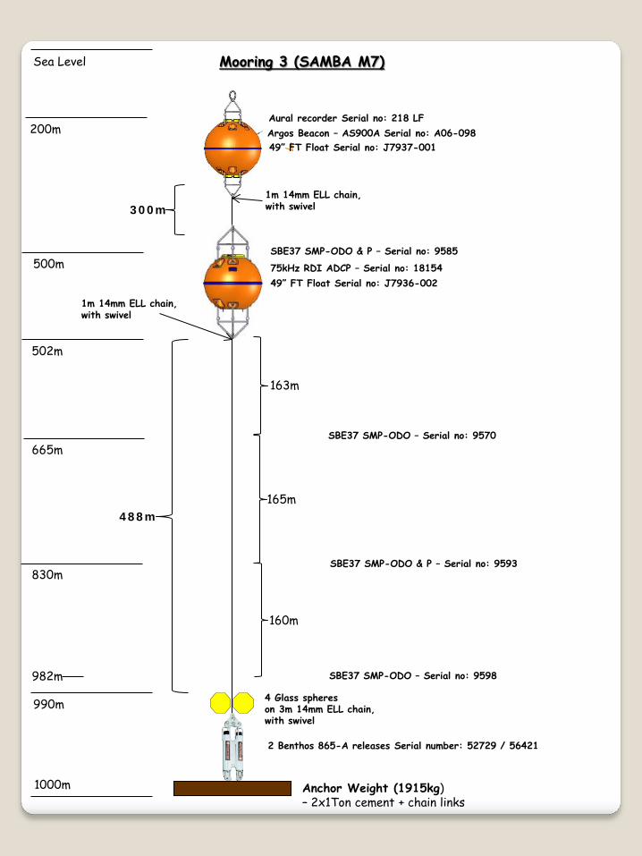
Mooring 3 (SAMBA M7)
49” FT Float Serial no: J7937-001
49” FT Float Serial no: J7936-002
4 Glass spheres on 3m 14mm ELL chain, with swivel
2 Benthos 865-A releases Serial number: 52729 / 56421
Anchor Weight (1915kg) – 2x1Ton cement + chain links
488m
1000m
75kHz RDI ADCP – Serial no: 18154
SBE37 SMP-ODO & P – Serial no: 9585
502m
SBE37 SMP-ODO – Serial no: 9598
SBE37 SMP-ODO & P – Serial no: 9593
SBE37 SMP-ODO – Serial no: 9570 665m
830m
163m
165m
160m
Aural recorder Serial no: 218 LF
300m
982m
Argos Beacon – AS900A Serial no: A06-098
1m 14mm ELL chain, with swivel
1m 14mm ELL chain, with swivel

Sea Level
500m
520m
1000m
1990m
Mooring 4 (SAMBA M8)
36” FT Serial no: J07167-002
49” FT Float Serial no: J7937-007
8 Glass spheres on 8m 14mm ELL chain, with swivel
4 Glass spheres on 3m 14mm ELL chain, with swivel
2 Benthos 865-A releases Serial no: 56420 / 56552
Anchor Weight (1870kg) - 2x1Ton cement + chain links
18m cable with 1m 14mm ELL chain, with swivel, onto 1st buoy
478m
2000m
SBE37 SMP-ODO & P – Serial no: 9587 75kHz RDI ADCP – Serial no: 10790
522m
242m
522m
1000m
SBE37 SMP-ODO – Serial no: 9575
SBE37 SMP-ODO – Serial no: 9578
710m
920m
188m
210m
80m
1008m
1982m
SBE37 SMP-ODO Serial no: 9577
SBE37 SMP-ODO Serial no: 9571
SBE37 SMP-ODO Serial no: 9573
SBE37 SMP-ODO Serial no: 9698
SBE37 SMP-ODO Serial no: 9633
122m
120m
88m
210m
210m
222m
1130m
1250m
1340m
1550m
1760m
Argos Beacon – AS900A Serial no: A06-102
RDI DVS 600kHz– Serial no: 14978
738m
2m (DVS)
1252m
1m 14mm ELL chain, with swivel

Sea Level
520m
1000m
2000m
2990m
Mooring 5 (SAMBA M9)
36” FT Float Serial no: J07167-004
49” FT Float Serial no: J07168-002
8 Glass spheres on 8m 14mm ELL chain, with swivel
8 Glass spheres on 8m 14mm ELL chain, with swivel
4 Glass spheres on 3m 14mm ELL chain, with swivel
2 Benthos 865-A releases Serial no: 56423 / 46924
Anchor Weight (2010kg) – 1x2Ton cement + chain links
18m cable with 1m 14mm ELL Chain, with swivel, onto 1st buoy
152m
792m
3000m
500m
SBE37 SMP-ODO & P – Serial no: 9582 75kHz RDI ADCP – Serial no: 18050
478m
522m
1000m
800m SBE37 SMP-ODO – Serial no: 9699
278m
200m
1008m
2000m SBE37 SMP-ODO – Serial no: 9602
SBE37 SMP-ODO – Serial no: 9599
SBE37 SMP-ODO – Serial no: 9589
SBE37 SMP-ODO – Serial no: 9632 1100m
1400m
1700m 1800m
92m
300m
300m
100m
198m
2008m
2982m SBE37 SMP-ODO – Serial no: 9600
SBE37 SMP-ODO – Serial no: 9576
SBE37 SMP-ODO – Serial no: 9574
2160m
2300m 2520m
2600m 2900m
152m
138m
220m
78m
300m
80m
Argos Beacon – AS900A Serial no: A06-095
RDI DVS 600kHz– Serial no: 14979
198m
RDI DVS 600kHz– Serial no: 14976
RDI DVS 600kHz– Serial no: 15010
RDI DVS 600kHz– Serial no: 15011
358m
378m
88m
2m (DVS)
2m (DVS)
2m (DVS)
2m (DVS) 1802m
2162m
2522m
2902m
1m 14mm ELL chain, with swivel

Sea Level
500m
1250m
2500m
3750m
4490m
Mooring 6 (SAMBA M10)
49” FT Float Serial no: J7937-005
49” FT Float Serial no: J07936-001
8 Glass spheres on 8m 14mm ELL chain, with 2 x swivel
8 Glass spheres on 8m 14mm ELL chain, with 2 x swivel
8 Glass spheres on 8m 14mm ELL chain, with 2 x swivel
4 Glass spheres on 3m 14mm ELL chain, with swivel
2 Benthos 865-A releases Serial no: 56553 / 56551
Anchor Weight (2564kg) – 1x2Ton cement + chain links
748m
1242m
1242m
732m
4500m
200m
75kHz RDI ADCP – Serial no: 18155 SBE37 SMP-ODO & P – Serial no: 9586
SBE37 SMP-ODO – Serial no: 9579
502m
1250m
950m 428m
300m
SBE37 SMP – Serial no: 8332
SBE37 SMP-ODO – Serial no: 9588
SBE37 SMP-ODO – Serial no: 9561
1258m
2500m
1400m
1850m
2300m
142m
450m
450m
200m
SBE37 SMP-ODO – Serial no: 9572
SBE37 SMP-ODO – Serial no: 9697
SBE37 SMP-ODO – Serial no: 9580
2508m
2750m
3200m
3650m
3750m
242m
450m
450m
100m
3758m
4100m
4482m
SBE37 SMP-ODO – Serial no: 9601
SBE37 SMP-ODO – Serial no: 9603
342m
382m
Argos Beacon – AS900A Serial no: A06-094 1 x Aural recorder: 220LF
300m 1m 14mm ELL chain, with swivel
1m 14mm ELL chain, with swivel
swivel

ANNEXURE IV
Mooring deployment sheets

Ship: Algoa
Serial number 18424 (150kHZ)FT Float J07938-002 (36")ADCP Firmware 50.40ADCP Memory 256
First Ping Date: 30/11/2015 Time: 20h00 (GMT) Sampling Interval 60minDeployment Duration: 365 days Blank distance 3.52m
Transducer depth 300mBattery Voltage : 45.05V / 45.03V First Bin range: 12.21
Last Bin range: 308.21 Filename SAM04No of Bins: 38
Wh Battery Usage: 926Wh Acoucstic releasesBin Size (m): 8
Std Deviation: 0.68 1) 56456 RX xx.xx TX 12.00 Enable Code: I Release Code: MPings per Ensemble: 110
Storage needed: 7.64 2) 56452 RX xx.xx TX 12.00 Enable Code: J Release Code: LMagnetic Variation: 0
Temp 5°C ARGOS Beacon
Was TESTADCP run Y N Z03-012 (72630/8A8876A) - DEACompass Calibrated: Y NO-Rings Checked: Y NWas Transducer heads anti-fouled: Y NSufficient disc space available: Y N
Position:Lat: 34°117.679'S Long:17° 552.815'E
Personnel: Marcel; Bradley; Gavin; Leon & MbuleloTime: 18h12 (GMT)
312m
First Good Reading:
Benguela Jet - Mooring 2DEPLOYMENT RECOVERY
DEPLOYMENT/RECOVERY SHEET - ADCP WOKHORSE
Notes:
Settings:
Consequences:
Date: Time:Personnel:
Last Good Reading:Date: 30/11/2015

MOORING DEPLOYMENT SHEET - SAMBA EASTERN BASIN (SOUTH AFRICA)
Cruise: ALG221 Mooring: Mooring 3 (SAMBA M7)Date: 01/12/2015
Site Arrival Time: 11h30 (GMT) Set-up Distance: 1nmile +200m Start Time: 11H34 (GMT) End Time: 12h20 (GMT)
Start Latitude: 34° 23.1 S Start Longitude: 17° 34.7' E
MOORING INSTRUMENT DEPLOYMENT:Item Serial #: Time Comment:
(on mooring)49" FT Float J7937-001 11h34Aural recorder 218FArgos Beacon A06-09849" FT Float J7936-002 11h5275kHz ADCP 18154SBE37 - ODO&P 9585SBE37 - ODO 9570 12h00SBE37 - ODO&P 9593 12h05SBE37 - ODO 9598 14h184x17" glass spheres 14h18Acoustic releases 52729
56421Weights (1915kg) 14h20
Enable Code: H Enable Code: ARelease Code: A Release Code: BFrequency: 10.5 Frequency: 13.5
A06-098 (120490/AF7C4AD)
Anchor Release: Latitude: 34° 23.77'SLongitude: 17° 35.80'E
1114 + 5 = 1119m
Technicians: Instruments: Marcel Moorings: Bradley; Gavin; Leon & Mbulelo
Drop point over run by 170mWeights - 2 x 1Ton cement (1280kg) + chain link (635kg) - 1915kg
Water Depth (including draft):
ARGOS Beacon ID #:
Acoustic Releases:

MOORING DEPLOYMENT SHEET - SAMBA EASTERN BASIN (SOUTH AFRICA)
Cruise: ALG221 Mooring: Mooring 4 (SAMBA M8)Date: 02/12/2015
Site Arrival Time: 04h00 (GMT) Set-up Distance: 3nmile + 400m Start Time: 06h38 (GMT) End Time: 08h28 (GMT)
Start Latitude: 34°27.2 S Start Longitude: 17° 14.9' E
MOORING INSTRUMENT DEPLOYMENT:Item Serial #: Time Comment:
(on mooring)36" FT Float J07167-002 06h38Argos Beacon A06-10249" FT Float J7937-007 06h4175kHz ADCP 10790SBE37 - ODO&P 9587SBE37 - ODO 9575 06h48SBE37 - ODO 9578 06h548 x 17" glass spheres 07h01SBE37 - ODO 9577 07h05RDI DVS -600kHz 14978 07h11SBE37 - ODO 9633 07h14SBE37 - ODO 9571 07h21SBE37 - ODO 9573 07h28SBE37 - ODO 9698 07h364x17" glass spheres 07h54Acoustic releases 56420/56552
1.5 nmile steam to get to drop positionWeights (1870kg) 08h28
Enable Code: M Enable Code: ERelease Code: L Release Code: FFrequency: 13.25 Frequency: 11
A06-102 (120494/AF7C4E1)
Anchor Release: Latitude: 34° 30.119'SLongitude: 17° 18.248'E
2115m + 5m = 2120m
Technicians: Instruments: Marcel Moorings: Bradley; Gavin; Leon & Mbulelo
Weights - 2 x 1Ton cement (1280kg) + chain link (590kg) - 1870kg
Water Depth (including draft):
ARGOS Beacon ID #:
Acoustic Releases:

MOORING DEPLOYMENT SHEET - SAMBA EASTERN BASIN (SOUTH AFRICA)
Cruise: ALG221 Mooring: Mooring 5 (SAMBA M9)Date: 02/12/2015
Site Arrival Time: 17h00 (GMT) Set-up Distance: 3nmile + 600m Start Time: 17h24 (GMT) End Time: 19h35 (GMT)
Start Latitude: 34°27.3 S Start Longitude: 17° 06.3' E
MOORING INSTRUMENT DEPLOYMENT:Item Serial #: Time Comment:
(on mooring)36" FT Float J07167-004 17h25Argos Beacon A06-09549" FT Float J07168-002 17h2775kHz ADCP 18050SBE37 - ODO&P 9582SBE37 - ODO 9699 17h368 x 17" glass spheres 17h45SBE37 - ODO 9632 17h49SBE37 - ODO 9589 17h58SBE37 - ODO 9599 18h10RDI DVS -600kHz 14979 18h15SBE37 - ODO 9602 18h248 x 17" glass spheres 18h28RDI DVS -600kHz 14976 18h36SBE37 - ODO 9574 18h42RDI DVS -600kHz 15010 18h52SBE37 - ODO 9576 18h55RDI DVS -600kHz 15011 19h06SBE37 - ODO 9600 19h094x17" glass spheres 19h22Acoustic releases 56423/46924
Weights (2010kg) 19h35
Enable Code: C Enable Code: GRelease Code: D Release Code: EFrequency: 9 Frequency: 11.5
A06-095 (120487/AF7C479)
Anchor Release: Latitude: 34°30.357'SLongitude: 17° 08.585'E
2723m + 5m =2728m
Technicians: Instruments: Marcel Moorings: Bradley; Gavin; Leon & Mbulelo
Weights - 1 x 2Ton cement (1280kg) + chain link (730kg) - 2010kg
Water Depth (including draft):
ARGOS Beacon ID #:
Acoustic Releases:

MOORING DEPLOYMENT SHEET - SAMBA EASTERN BASIN (SOUTH AFRICA)
Cruise: ALG221 Mooring: Mooring 6 (SAMBA M10)Date: 03/12/2015
Site Arrival Time: 13h32 (GMT) Set-up Distance: 4nmile + 900m Start Time: 13h35 (GMT) End Time: 16h04 (GMT)
Start Latitude: 34°26.366 S Start Longitude: 14° 58.825' E
MOORING INSTRUMENT DEPLOYMENT:Item Serial #: Time Comment:
(on mooring)49" FT Float J7937-005 13h42Argos Beacon A06-094Aural recorder 220LF49" FT Float J0936-001 13h5475kHz ADCP 18155SBE37 - ODO&P 9586SBE37 - ODO 9579 14h058 x 17" glass spheres 14h14SBE37 -SMP 8332 14h18SBE37 - ODO 9588 14h27SBE37 - ODO 9561 14h368 x 17" glass spheres 14h44SBE37 - ODO 9572 14h49SBE37 - ODO 9697 14h59SBE37 - ODO 9580 15h098 x 17" glass spheres 15h14SBE37 - ODO 9601 15h22SBE37 - ODO 9603 15h314x17" glass spheres 15h38Acoustic releases 56553/56551
steam for ± 1nmile to drop poitionWeights (2564kg) 16h04
Enable Code: F Enable Code: DRelease Code: G Release Code: EFrequency: 11.5 Frequency: 10
A06-094 (120486/AF7C46A)
Anchor Release: Latitude: 34°30.859'SLongitude: 14° 58.802'E
4476m + 5m =4481m
Technicians: Instruments: Marcel Moorings: Bradley; Gavin; Leon & Mbulelo
Weights - 1 x 2Ton cement (1280kg) + chain link (679kg + 605kg) - 2564kg
Water Depth (including draft):
ARGOS Beacon ID #:
Acoustic Releases: