cruise report for noaa’s monterey bay national marine
TRANSCRIPT

FinalCruiseReport 8/31/17
1
Cruise Report for NOAA’s Monterey Bay National Marine Sanctuary & Northwest Fisheries Science Center Conduct
Autonomous Underwater Vehicle (AUV) Dive Surveys July 6 through 19, 2017
Submitted by Karen Grimmer & Sophie de Beukelaer
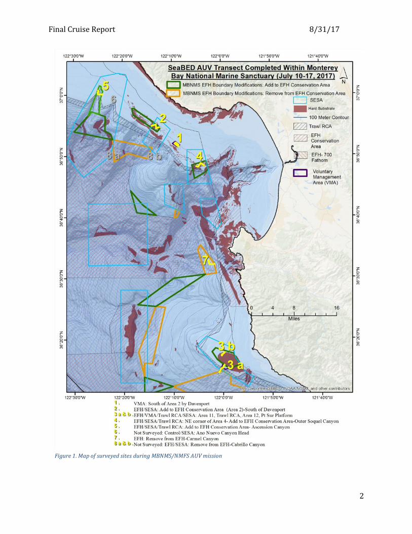
Introduction: Monterey Bay National Marine Sanctuary (MBNMS) and National Marine Fisheries Service (NMFS) surveyed seven sites in federal ocean waters aboard the NOAA research vessel Fulmar using an autonomous underwater vehicle (AUV) from July 10th to 18th (see map and calendar of events below). The AUV expedition was funded through restoration settlement funds with a focus to collect data on the distribution, abundance, and condition of deep sea coral and sponge communities. The seven sites surveyed were selected based on areas identified in a 2013 Essential Fish Habitat (EFH) Proposal developed (http://montereybay.noaa.gov/resourcepro/ebmi/130731efh_proposal.pdf ) by the Monterey Collaborative which included local trawl fishermen, conservation groups and Monterey Bay National Marine Sanctuary. The overall goal of the proposal was to protect more total area and more sensitive habitats while improving fishing opportunities for the bottom trawl fleet relative to the current array of EFH Conservation Areas. The images collected during the expedition will be analyzed and provide biological and geological data that can support the Monterey Collaborative’s proposal as it moves through the decision process. The Pacific Fishery Management Council (PFMC) is slated to make decisions on west coast wide modifications to groundfish EFH areas in March 2018. Data resulting from analyses of the images taken by the AUV will also provide a better understanding of the Sanctuary’s diverse seafloor habitats. To view the team’s mission log go to: http://montereybay.noaa.gov/new/2017/170710auv/welcome.html
FinalCruiseReport 8/31/17
2
Figure1.MapofsurveyedsitesduringMBNMS/NMFSAUVmission
FinalCruiseReport 8/31/17
3
Date 7/6 Thu
7/7 Fri
7/8 Sat
7/9 Sun
7/10 Mon
7/11 Tue
7/12 Wed
Operation Mob Mob Mob Weather AUV AUV AUV
Location Outer Soquel Canyon
South Davenport Reef
NW-Ascension Canyon
Site #:
4
1
5
Spatial Designation1
EFH; SESA
VMA EFH, SESA
Depth (m) 93-360 90-103 134-383
Dive Length (m)
3782 4988 3556
Date 7/13 Thu
7/14 Fri
7/15 Sat
7/16 Sun
7/17 Mon
7/18 Tue
7/19 Wed
Operation AUV AUV AUV Weather AUV Weather Demob
Location Pt. Sur
NW MB W of Carmel Canyon
Pt. Sur
Site 3a
2
7
3b
Spatial Designation1
VMA; EFH; SESA
EFH; SESA
EFH EFH; SESA
Depth (m) 82-469 83-96 439-670 69-86
Dive Length (m)
3372 3890 3081 3693
Table 1: Summary of Sites Information 1 Spatial designations: EFH (Essential Fish Habitat) VMA (Voluntary Management Area) SESA (Sanctuary Ecologically Significant Area) Methods: We used a SeaBED AUV (Figure2) aboard the R/V Fulmar to collect still photography imagery. The SeaBED AUV is owned by the Northwest Fisheries Science Center, isapproximatelytwometerslongandweighsnearlytwo---hundredkilograms.Ithastwomainpressurehousings,

FinalCruiseReport 8/31/17
4
atophullandabottomhull.TheCPUelectronicsarelocatedinthetophull,thebatteries,cameras,andsensorsarelocatedinthebottomhull,andallareconnectedbywetcablingthatisroutedthroughverticalstruts.Withamaximumoperationaldepthrangeof2,000m,SeaBEDcanbeusedtosurveyhabitatsrangingfromshallowcoralreefstodeepgroundfishenvironments.Thisoperationaldepthrangemaybereducedbyotheronboardsensor'sdepthcapabilitiestoamaximumdepthof1,500m.TheAUVhasthreecameras–oneangledcamerathatshootsobliquephotosandtwothatshootstraightdownonportandstarboard.The AUV is programed to fly at an altitude of 3 meters over the seabed and snap images every 8 seconds.Forthisprojectwealsoattachedadissolvedoxygenmetertomeasureanyoxygenchangesatdepth.
Survey locations were based on the maximum depth of the AUV (800 m with this navigational package) as well as seafloor topography and features. The study areas are management areas of interest to MBNMS. Some of the areas have previous data and we can compare and see if there are changes in the diversity and abundance of sponges, corals and fish. For example, Ascension Canyon located west of Santa Cruz on the northern edge of the Monterey Bay Submarine Canyon, includes a proposed closure to trawl fishing, and was studied with a NMFS submersible back in 1994 as well as more recently by California State University Monterey Bay (CSUMB). Other areas such as the outer Carmel Canyon have little existing data, so the data will be more of (an initial) characterization of the area.
The AUV transects for each site were designed based on the slope of the seafloor (limit for good images is 45 degrees), depth, and strategically overlapped historical data collections completed by entities such as NMFS or CSUMB.
Figure2.TheSeaBEDAUVonthebackdeckoftheNOAAResearchVesselFulmar.TheSeaBEDAUVisunlikeother,moretraditionalAUV’s,inthatitstwin-hulldesignprovidesgreatlyenhancedstabilityforlow-speedphotographicsurveys
FinalCruiseReport 8/31/17
5
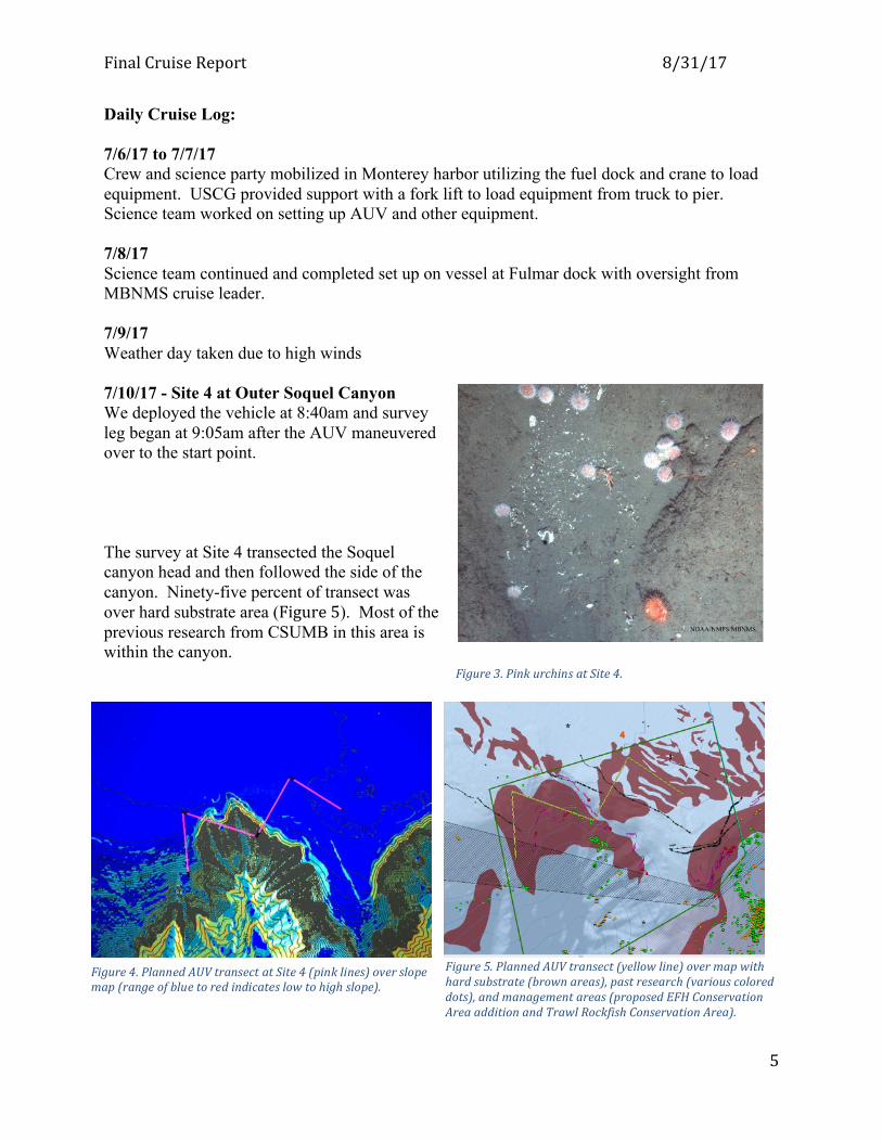
Daily Cruise Log: 7/6/17 to 7/7/17 Crew and science party mobilized in Monterey harbor utilizing the fuel dock and crane to load equipment. USCG provided support with a fork lift to load equipment from truck to pier. Science team worked on setting up AUV and other equipment. 7/8/17 Science team continued and completed set up on vessel at Fulmar dock with oversight from MBNMS cruise leader. 7/9/17 Weather day taken due to high winds 7/10/17 - Site 4 at Outer Soquel Canyon We deployed the vehicle at 8:40am and survey leg began at 9:05am after the AUV maneuvered over to the start point. The survey at Site 4 transected the Soquel canyon head and then followed the side of the canyon. Ninety-five percent of transect was over hard substrate area (Figure5). Most of the previous research from CSUMB in this area is within the canyon.
Figure5.PlannedAUVtransect(yellowline)overmapwithhardsubstrate(brownareas),pastresearch(variouscoloreddots),andmanagementareas(proposedEFHConservationAreaadditionandTrawlRockfishConservationArea).
Figure4.PlannedAUVtransectatSite4(pinklines)overslopemap(rangeofbluetoredindicateslowtohighslope).
Figure3.PinkurchinsatSite4.

FinalCruiseReport 8/31/17
6
Figure6.SpotprawntrapwithsunstarssittingonsoftbottomhabitatatSite4.
After two-thirds of the dive had been completed, the AUV hit a rock or ledge and was unable to navigate forward. The dive was aborted and the AUV was recovered with no damage. 7/11/17 - Site 1 at Davenport Reef VMA Survey Site is #1 is offshore of Davenport in federal waters, which was selected by fishermen and the Monterey Collaborative group as a proposed voluntary management area (VMA).
We deployed vehicle at 8:40am and survey leg began at 8:55am after the AUV maneuvered to the start point of the sparse grid which connected seven 500 meter long transects over the area of interest. In addition to seeing a number of humpbacks and Pacific white sided dolphins on the topside, the AUV took some nice images of the rocky and soft bottom habitats (Figure7). This area has many large boulders and some large fish species including lingcod, flag and a cowcod rockfish. A number of molas were swimming along at the surface. Therewerenomechanicalissueswiththegear,andalloperationswentsmoothly.
Figure7.Astarryskate,featherycrinoidsandacoupleofrockfishhangoutsouthofDavenportReefin100meterdepthrockyhabitatthatwillbevoluntarilyavoidedinthefuturebythetrawlfishery.

FinalCruiseReport 8/31/17
7
7/12/17 - Site 5 at Ascension Canyon We transited aboard the R/V Fulmar to Site #5 at Ascension Canyon, which is slated as a proposed EFH conservation area closure. We deployed vehicle at 9:20am and survey leg began at 9:45am after the AUV maneuvered to the area of interest along the lower part of the canyon wall at approximately 280 meters depth (Figure10). At about 1:30pm the vehicle gave a signal that it was in the same place, and then began to ascend. The survey ended and it was discovered that the AUV had lost the 8lb ballast weight when it bumped into a ledge or wall in the canyon. The images in the canyon included species such as pleurobranchia (Figure8), lingcod, spot prawns, squat
lobsters and rockfish. There were some images of fresh trawl tracks (Figure9), and we assume
Figure8.Alargenudibranch(pleurobranchia)(topleftofimage),sitsonthesoftbottomatSite5.
Figure9.ImageoftheslopeatAscensionCanyon;thepinklineistheAUVtransect,showingittraversedavarietyofdepthsandslopesduringthisparticularsurvey(lowtohighslopeisshowninacolorrangefrombluetored).
Figure10.AfishsitsnexttoatrawltracknearAscensionCanyonhead.

FinalCruiseReport 8/31/17
8
the trawling in this area was within a few days of the survey based on recent Automatic Identification System (AIS) data. 7/13/17 – Site 3a at Point Sur We deployed the AUV at 8:45 AM to survey Site 3a at Point Sur. The transect began at 9:12 AM within a Voluntary Management Area at a depth of 106 meters, went through the Trawl Rockfish Conservation Area (RCA), then down a canyon head through a proposed re-open EFH area at a depth of 490 meters. This area has little if any existing survey information so we were excited to review the images to better understand the habitat and benthic biology in this area. Highlighted images from this dive survey show a remarkable difference in habitat as the slope gets steeper and the AUV moves down into the canyon. The survey started in more shallow waters just south of the main Pt Sur Platform (also known as Schmieder Bank) at about 3 miles offshore, which has mainly rocky habitat, and progressed deeper into soft bottom habitat (Figure11).
Figure11.CompletedAUVtransectsatPointSur.

FinalCruiseReport 8/31/17
9
The AUV completed the entire planned transect by 12:39 PM and the R/V Fulmar headed back to port at 1:30 PM while the AUV was on the bottom, we enjoyed quite a show from Pacific White-sided Dolphins close to the boat and continued to see a lot of sooty shearwaters.
7/14/17: Site 2 – Davenport Reef EFH Closure We started the AUV dive at 8:50 AM to survey Site 2 at Davenport Reef, off Santa Cruz. The survey transect began at 9:05 AM within a proposed EFH closure at a depth of 90 to 100 meters (Figure18). This area has some existing data from MBARI and CSUMB, and the purpose is to see how the habitat has changed since the last survey.
Figure13.RockfishinaspongeatSite3a. Figure12.VasespongesonrockysubstrateatSite3a.
Figure14.Metridiumonayellowmetaltankwhichismarinedebris.
Figure15.Longnoseskate,pinksea-urchins,starfishandseacucumbersonsoftbottomatsite3a.

FinalCruiseReport 8/31/17
10
The dive survey at Davenport Reef provided interesting images of hard and soft bottom habitats (Figure16) that included boulders and large flat rocks many of which were covered in crinoids (Figure19). In addition, we see some cobble patches of brachiopod beds which are small bivalves (Figure17).
Figure18.PopokitheAUVfollowstheseaflooratanaltitudeofthreemetersandyoucanseebythisprofilehowcloselyshecanprofilethebottom.ThepurplelineistheAUVandthegreenlineistheseafloorbottomatSite2.
Figure16.Brachipodsbedsarefoundsinpatchesinthisarea.
Figure17.AsolesitsnexttoaseawhipsurroundedbywhitebrittlestarsatSite2.
FinalCruiseReport 8/31/17
11
Figure19.AstarryrockfishhangsoutwithcrinoidsonhardbottomsubstrateatSite2.
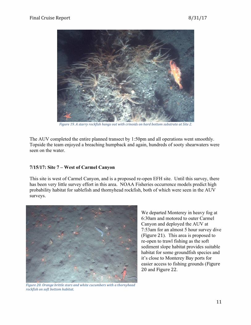
The AUV completed the entire planned transect by 1:50pm and all operations went smoothly. Topside the team enjoyed a breaching humpback and again, hundreds of sooty shearwaters were seen on the water. 7/15/17: Site 7 – West of Carmel Canyon This site is west of Carmel Canyon, and is a proposed re-open EFH site. Until this survey, there has been very little survey effort in this area. NOAA Fisheries occurrence models predict high probability habitat for sablefish and thornyhead rockfish, both of which were seen in the AUV surveys.
We departed Monterey in heavy fog at 6:30am and motored to outer Carmel Canyon and deployed the AUV at 7:53am for an almost 5 hour survey dive (Figure21). This area is proposed to re-open to trawl fishing as the soft sediment slope habitat provides suitable habitat for some groundfish species and it’s close to Monterey Bay ports for easier access to fishing grounds (Figure20 and Figure22.
Figure20.Orangebrittlestarsandwhitecucumberswithathornyheadrockfishonsoftbottomhabitat.

FinalCruiseReport 8/31/17
12
7/16/17 Taken as a weather day due to high winds estimated at 15 to 25 knots. 7/17/17: Site 3b-Point Sur We departed the Monterey harbor at 6:30am to transit to Site 3b at Point Sur Platform. The team was on site at 8:15am, deployed the vehicle at 8:43am and the AUV descended to depth and started the dive survey at 9:05am. The AUV transect was conducted on the north side and across the shelf. We decided to end the dive at 11:45am after the AUV became stuck five consecutive times in the rocks. Later in the afternoon, we were able to review the photos and saw that the AUV was navigating across some very large fractured outcrops that look to be massive granite slabs (Figure23-Figure25).
Figure24.Hydrocoralsandcupcoralsonarockyledge.
Figure23.Scallop,barrelsponges,andahidingvermillionrockfish(topright).
Figure21.DeploymentoftheAUV.TheAUVisnotreleaseduntilafterconfirmingthatwehavecommunicationwithittosharenavigationdata.
Figure22.Asablefish(akablackcod)withadoversoleandathornyheadrockfish

FinalCruiseReport 8/31/17
13
7/18/17 We departed the Monterey harbor at 6:30am to transit to Site 8b in the Cabrillo Canyon area. We were about 10 minutes from the site at 9:50 am but due to the mixed swell state, the 20 knot wind, some breaking waves and the short period of the swell, both the scientists and the crew of the R/V Fulmar decided not to risk deploying the AUV. We headed back to the dock and started demobilizing. 7/19/17 The crew and team demobilized in Monterey, and unloaded at the fuel dock during lunch. US Coast Guard again provided support with a fork lift to unload the AUV and containers from Fulmar and load into the U-Haul for transport.
Figure25.CrinoidsonlargegraniteblockswithSebastomusrockfish.