crp 804 land use analysis - united states environmental ... · crp 804 land use analysis stephen l....
TRANSCRIPT

CRP 804 Land Use Analysis Stephen L. Sperry, Clemson University
CRP 804 Land Use Analysis Stephen L. Sperry Associate Professor
Clemson University Department of Planning and Landscape Architecture 121 Lee Hall, Box 340511 Clemson, SC 29634-0511 Phone: 864-656-3635 Fax: 864-656-7519 [email protected]
i

CRP 804 Land Use Analysis Stephen L. Sperry, Clemson University
Course Instructors
Stephen L. Sperry Stephen Sperry is an associate professor in City and Regional Planning. His teaching emphasis is land use planning applications using Geographic Information Systems (GIS). He received a bachelor and master’s degrees in Landscape Architecture from SUNY, College of Environmental Sciences and Forestry at Syracuse University in 1970 and Harvard University in 1975.With over 25 years of experience in GIS applications; he has been a pioneer in the industry. As a former Director of Strategic Planning at ERDAS, Inc., he worked with ESRI, Microsoft, and others. He led the development of the first raster/vector integration, the ERDAS/ArcInfo Live Link. He won research grants from NASA for Expert Classifier and MapSheets, a desktop GIS that used Microsoft’s Excel for spatial analysis. Professor Sperry previously taught at The Ohio State University. He has recently been analyzing rural land use development, particularly sprawl and its consequences on environmental issues. This includes investigating the growth of retirement communities in rural lakeside areas. Professor Sperry has a strong ability for land use analysis, future growth models and demographic change analysis. He also has a strong understanding of rural transit systems and in particular, non-emergency medial transportation. Previously to coming to Clemson, Professor Sperry served as acting CEO of a start-up company, taking a GIS logistics software product to market. He was responsible for managing the overall operations including expanding the company’s solution for transportation agencies providing non-emergency transportation. He understands the transportation needs of the mobility-challenged rural residents, as well as the ability to provide transportation services in rapid growth areas or population declining areas. His understanding includes the funding challenges associated with operating, maintaining and building rural transportation infrastructure.
Dr. Anne Dunning Clemson University Phone: 864-656-0151 [email protected]
Dr. Anne Dunning is an assistant professor in City and Regional Planning with teaching and research expertise in sustainability, particularly in terms of sustainable transportation planning. She received a bachelor’s degree from Cornell University in 1992 and master’s degrees in Civil Engineering and City Planning from the Georgia Institute of Technology in 1998. In 2005, Dr. Dunning received her Ph.D. in Civil Engineering. She initiated the first research initiatives for transportation in the history of Glacier National Park, which now faces a $200 million engineering rehabilitation of the Going-to-the-Sun Road. Dr. Dunning's work included examining the overall impacts of the project on the park, internal circulation, and local economies, as well as establishing the foundation for research into alternative fuel vehicles and intelligent transportation systems. Her work with the National Park Service continued with the lead role for research on the impacts of local communities when transit is introduced into national parks for multiple parks across the nation. Her current work includes participation and work on the organizing
ii

CRP 804 Land Use Analysis Stephen L. Sperry, Clemson University
committee for an intercontinental collaboration on sustainable transportation through the Sustainable Transportation Analysis and Research / Sustainable Transportation in Europe and Links and Liaisons with America (STAR/STELLA) network under the National Academies of Science. Community service includes interactions with Greenville, South Carolina, as local leaders engage issues of transit planning and nonattainment for particulate standards under the Clean Air Act Amendment. She holds roles as principal investigator on studies of highway safety, hurricane evacuation, rural travel patterns, and rural transit coordination. Dr. Dunning brings her research and field experience to the classroom to teach students about general principles of sustainable transportation, applications of surveys for gauging public awareness of sustainability issues and planning practices, and financial programming to tie planning visions to budget realities.
iii

CRP 804 Land Use Analysis Stephen L. Sperry, Clemson University
CRP 804 – Land Use Planning Analysis
1.0 Introduction
Clemson’s Department of Planning and Landscape Architecture focuses on land use development, transportation, and sustainability issues. In 2003, the City and Regional Planning program changed its degree curriculum. An important part was the merging of planning methods – quantitative analysis, Geographic Information Systems (GIS), and statistics. They were integrated into two courses. This submittal is the second semester course. It builds on the first semester course of statistics, GIS, and environmental analysis. The second semester focuses on comprehensive planning and smart growth initiatives. It also includes fiscal assessment of the planning decisions. The course is organized around the topics listed below:
• Regional visioning • Scenario planning • Urban and rural smart growth • Compact development • Agriculture and open space preservation • Transit analysis and traffic systems • Fiscal analysis of development
The course is based on the Hypothetical City Workbook: Exercises, Spreadsheets, and GIS data to Accompany Urban Land Use Planning, Fourth Edition, by Edward J. Kaiser, David R. Godschalk, Richard E. Klosterman, and Ann-Margaret Esnard (Urbana and Chicago, IL: University of Illinois Press, 1998). The course has been modified to address needs for real GIS data and student interaction with an existing environment as a study area. The students use ArcGIS and the Spatial Analyst extension for their planning analysis. The course is an effective, hands-on class. It focuses on smart growth principles to help communities protect and enhance their natural environments while their economies prosper. The course addresses the following smart growth principles.Mix land uses.
• Create walkable neighborhoods. • Preserve open space, farmland, natural beauty, and critical environmental areas. • Reinvest in strengthening communities to achieve a more balanced regional
development. • Provide a variety of transportation choices. • Make development decisions predictable, fair, and cost-effective. • Encourage citizen and stakeholder participation in the development process.
This course introduces a set of concepts and tools typically used in the practice of city and regional planning. Its focus is developing an understanding of operational GIS planning techniques and data used in planning applications. This course is structured to introduce planning methods in the context of analytical, procedural, and institutional needs of the planner. This approach is critical for smart growth planning. Land use
1

CRP 804 Land Use Analysis Stephen L. Sperry, Clemson University
planning provides the structure and procedures with which GIS technology and techniques are meshed. To support this work, students learn and apply smart growth planning methods to planning data sets in developing a land suitability analysis and a land use plan.
By the end of the course, students can articulate a clear vision of what is an effective land use plan and can describe a range of possible planning formats. They understand the components of a land use-planning program and where a plan fits into that program. They learn how to formulate a plan based on a county context. The course provides students with an understanding of resource allocation and the dynamics of regional growth or decline. More specifically, the course teaches both analysis and syntheses skills: oral, graphic, and written communication. Finally, the students learn skills for working effectively as members of teams and with community stakeholders.
The laboratory portion uses hands-on experience to provide students with mapping and spatial analysis skills. The course balances lectures on smart growth principles with applied GIS instruction on managing, processing and interpreting spatial data. It is particularly useful for students interested in conducting environmental, demographic, land use suitability and transportation-related research.
The course has two aspects. First is a series of lectures in which different elements of theories and methods applicable to smart growth and spatial analysis are reviewed. The lectures and readings include case studies in which particular planning processes are reviewed. Lab exercises reinforce the planning concepts presented in the lectures and readings. Students, as members of teams, develop a land use plan with a report. They present the results to the class. The presentations offer a comparison of stakeholder roles. The land use plans indicate how the students use their mapping and analysis skills to investigate planning issues. The course relies on student initiative and interest. The analysis methods share fundamental operations in the inventory, organization, and analysis of spatial data.
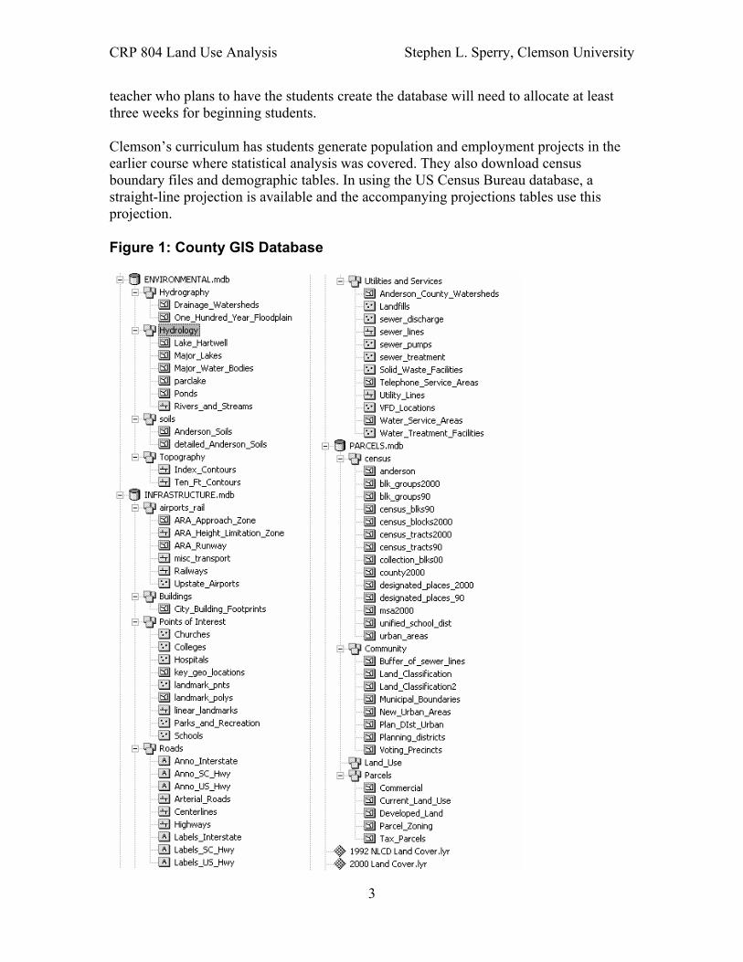
Data Requirements As stated earlier, the course is an outgrowth of the Hypothetical City exercises. A key course difference is using real government data such as census, soils, topography, drainage, watersheds, imagery and national land cover data (see Figure 1). Except for land parcels and zoning, all the data are available for download from federal and state internet sites. This course can be modified to address regional or local issues. Creating a local presence allows students to visit and interpret the data. The biggest hurdle in creating a database is getting everything into the same projection and coordinate system
In using ArcGIS from ESRI, there are issues mixing coordinate systems such as State Plane and Universal Transverse Mercator (UTM). Boundary files of different coordinate systems will probably not work together. Using ESRI’s geodatabase formats automatically updates the area and perimeter fields. So this course can be easily changed and adapted to a “client” need. This transferability is important for the students in balancing the land use density with their projected populations and housing densities. A
2
CRP 804 Land Use Analysis Stephen L. Sperry, Clemson University
teacher who plans to have the students create the database will need to allocate at least three weeks for beginning students.
Clemson’s curriculum has students generate population and employment projects in the earlier course where statistical analysis was covered. They also download census boundary files and demographic tables. In using the US Census Bureau database, a straight-line projection is available and the accompanying projections tables use this projection.
Figure 1: County GIS Database
3
CRP 804 Land Use Analysis Stephen L. Sperry, Clemson University
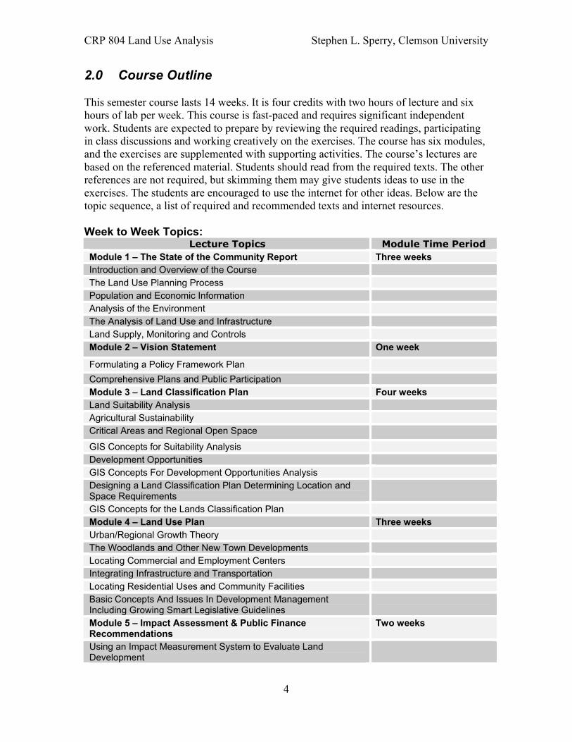
2.0 Course Outline
This semester course lasts 14 weeks. It is four credits with two hours of lecture and six hours of lab per week. This course is fast-paced and requires significant independent work. Students are expected to prepare by reviewing the required readings, participating in class discussions and working creatively on the exercises. The course has six modules, and the exercises are supplemented with supporting activities. The course’s lectures are based on the referenced material. Students should read from the required texts. The other references are not required, but skimming them may give students ideas to use in the exercises. The students are encouraged to use the internet for other ideas. Below are the topic sequence, a list of required and recommended texts and internet resources.
Week to Week Topics: Lecture Topics Module Time Period
Module 1 – The State of the Community Report Three weeks Introduction and Overview of the Course The Land Use Planning Process Population and Economic Information Analysis of the Environment The Analysis of Land Use and Infrastructure Land Supply, Monitoring and Controls Module 2 – Vision Statement One week
Formulating a Policy Framework Plan Comprehensive Plans and Public Participation Module 3 – Land Classification Plan Four weeks Land Suitability Analysis Agricultural Sustainability Critical Areas and Regional Open Space
GIS Concepts for Suitability Analysis Development Opportunities GIS Concepts For Development Opportunities Analysis Designing a Land Classification Plan Determining Location and Space Requirements GIS Concepts for the Lands Classification Plan Module 4 – Land Use Plan Three weeks Urban/Regional Growth Theory The Woodlands and Other New Town Developments Locating Commercial and Employment Centers Integrating Infrastructure and Transportation Locating Residential Uses and Community Facilities Basic Concepts And Issues In Development Management Including Growing Smart Legislative Guidelines Module 5 – Impact Assessment & Public Finance Recommendations
Two weeks
Using an Impact Measurement System to Evaluate Land Development
4

CRP 804 Land Use Analysis Stephen L. Sperry, Clemson University
Lecture Topics Module Time Period Fiscal Impact Assessment/Development Exactions Feasibility Analysis/Market Analysis Use Of Taxes, Fees, Bonds, and Other Financing Devices In Growth Management Module 6 – Final Report One week The Final Plan Review
Required Text and Readings: The required text that is available at the University Bookstore is
• Kaiser, Godschalk, and Chapin. Urban Land Use Planning, Urbana: University of Illinois Press, 1995.
• Marsh, William. Landscape Planning, John Wiley and Sons, Inc., 1998. • Burchell, Robert W. and Listoken, David, The New Practitioners Guide to Fiscal
Impact Analysis, New Brunswick: Rutgers University, 1985.
Other recommended texts include: • Ormsby, Tim. Getting To Know ArcGIS Desktop, ESRI Press, 2004. • Klosterman, Richard E. Community Analysis and Planning Techniques, Savage,
Maryland: Rowman & Littlefield Publishers, 1990.
Three key planning documents were available on reserve. The students use them as guides in developing their plan. They are:
• Weitz, Jerry and Waldner, Lenora S, 2002. Smart Growth Audits. Advisory Service Report Number 512, American Planning Association (on reserve).
• American Planning Association August, 1998. Growing Smart Legislative Guidelines: Model Statutes for Planning and the Management of Change Ch. 7, “Local Planning,” www.planning.org/guidebook/pdf/guidebook/chapter7.pdf (in PDF format on the web page).
• American Planning Association January, 2002. Growing Smart User Manual (in PDF format on the web page).
Additional Internet Reports and Planning Articles to Stimulate Ideas: The students use several planning references that support sustainable principals they are:
• Howard County, Maryland, “The 2000 General Plan” www.co.ho.md.us/DPZ//GP2000/dpz_gp2000.asp
• Boulder County Comprehensive Plan, www.co.boulder.co.us/lu/bccp/exec_sum.htm
• Calvert County “1997 Comprehensive Plan”, 1997 www.co.cal.md.us/planning/compplan/start.htm
• City of Fairfax Comprehensive Plan, www.ci.fairfax.va.us/Services/CommDevPlan/compplan-contents.htm
• Madison County Comprehensive Plan, Development Policy, www.mcplanning.net/pdf/Comprehensive%20Plan/section_b_policy.pdf
• 1996 Oregon's Statewide Planning Goals & Guidelines http://www.uoregon.edu/~pppm/landuse/INTRO.html
5

CRP 804 Land Use Analysis Stephen L. Sperry, Clemson University
• Monroe County, PA www.gsd.harvard.edu/research/projects/la/monroe/00.htm • Camp Pendleton, CA www.gsd.harvard.edu/studios/brc/brc.html • Solimar Research Group: "Open Space Protection: Conservation Meets Growth
Management" by William Fulton and Linda E. Hollis http://www.solimar.org/pdfs/hollisfultonopenspace.pdf
• Heimlich, Ralph E. and Anderson, William D. “Development at the Urban Fringe and Beyond: Impacts on Agriculture and Rural Land”, Economic Research Service, U.S. Department of Agriculture. Agricultural Economic Report No. 803. http://www.ers.usda.gov/publications/aer803/
• A Landscape of Choice: Strategies for Improving Patterns of Community Growth” http://www.farmlandinfo.org/fic/ft/landcal.html
• “Planning for Natural Hazards: Oregon Technical Resource Guide”, http://www.lcd.state.or.us/hazhtml/Guidehome.htm
• Forsyth, Ann 2002 “Planning Lessons from Three New Towns of the 1960s and 1970s”, Irvine, Columbia, and The Woodlands, APA Journal, Autumn 2002, Vol. 68, No 4 pp 387 – 415.
• Wallace, McHarg, Roberts and Todd, “Woodlands New Community – An Ecological Plan”, Philadelphia, Pennsylvania 1974.
The course relies on student initiative and interest. Depending on the student interest, different smart growth principals can be emphasized. Students need to remember this is a team project. For one or two students, this course is too much work. However, in teams of three or four with the labor divided, it should be reasonable amount of work. Students are encouraged to share experiences, knowledge and suggestions with the instructor and each other. The analysis methods share fundamental operations in the inventory, organization, and analysis of planning data.
3.0 End Products
This laboratory course provides students with planning, mapping, and spatial analysis skills. Students learn what constitutes a comprehensive plan, where to start, the specific steps to take, data needs, land use issues, and match methods to fit community situations. Students learn how to work in a team environment. They also learn how to apply GIS technology to specify plan-making tasks such as map presentations and land suitability analyses. Finally, they learn how to design a future land use patterns that meets the community’s objectives, accommodates a future population and economy, and protect the region’s quality of life. The course has six modules supplemented with supporting and enriching exercises. They are:
I. State of the Community Report, 1. Use GIS mapping of existing conditions 2. Adjust a housing regression modeling
II. Community Vision Statement 1. Participate in a community visioning meeting 2. Write a vision statement based on the team’s role
III. Land Classification Plan
6
CRP 804 Land Use Analysis Stephen L. Sperry, Clemson University
1. Develop a land suitability analysis 2. Produce a development opportunities analysis 3. Create a the land classification with development zones and
urban growth boundaries IV. Land Use Design Plan
1. Conduct a survey of a county issue 2. Develop a land use design 3. Generate space allocation tables 4. Create a transportation plan to address the new development
and population needs V. Land Use Plan Evaluation
1. Produce a fiscal impact/market assessment 2. Critique of planning methodology
VI. Final Plan Report and Presentation 1. Present the plan at a public hearing 2. Produce the complete plan report
Module I: The Community Report – Existing And Emerging Conditions This section introduces the land use planning process and the use of GIS. We also discuss smart growth in the context for land use, environmental, and transportation planning. As part of this section, students develop a community report for a county. Students create a draft report with maps, and make a presentation of the existing and emerging conditions for the county and the urban areas. The assignment incorporates the use of ArcGIS to create maps and other visuals. The objective for this assignment is to develop skills in defining and presenting a clear assessment of the state of the community, derived as information from a database. In their community analysis, the students answer the following questions to identify the planning issues:
1. What has changed the past ten years? 2. What major changes will occur in the next 20 years? 3. What are the big decisions in the next 10 years? 4. How will growth and change affect the quality of life? 5. What should be done to improve its quality of life?
Existing Conditions Report The students assess the county’s existing conditions for each planning element and recognizes any critical gaps in the current planning process. It forms the basis for the next exercise The Vision Statement. The report blends inventory findings with public input to create a vision for the county and set priorities for strengthening community resources. The Community Report addresses the seven elements of the South Carolina Comprehensive Planning Enabling Act of 1994. In accordance with the State planning law, the comprehensive plan includes the following plan elements:
• The Population Element – includes information related to trends and projections for size and characteristics of households; educational levels; income characteristics; race; sex; and age.
7

CRP 804 Land Use Analysis Stephen L. Sperry, Clemson University
• The Economic Element – presents an analysis of the local economy, including projection trends of the numbers and occupational characteristics of the labor force; where people live in the community work; where people work in the community reside; wages; major employers; and short/long-term market trends.
• The Natural Resources Element – identifies and assesses critical plant and animal habitats; agricultural resources; unique scenic views; wetlands; floodplains; and soils, air, and water quality.
• The Cultural Resources Element – addresses landmarks; and other unique features, areas, and facilities that relate to the history, culture, or architecture.
• The Housing Element – includes an analysis of existing housing by age and condition; owner and renter occupancy; location; type; affordability; market absorption and vacancy rates. Housing projections needs to accommodate existing and future populations.
• The Community Facilities Element – includes an analysis of existing water and wastewater facilities; solid waste management; the roadway network; pedestrian, bicycle and transit facilities; parks and recreational facilities; storm water management; fire protection; emergency medical services; public safety; government facilities; educational facilities; and libraries, museums, and other cultural facilities.
• The Land Use Element – represents a synthesis of all plan elements; examining existing land use by categories, including residential, commercial, industrial, institutional, parks/recreation, and open space.
Figure 2: Example Existing Conditions Map
Population Growth –Percent Change
The teams briefly summarize, evaluate, and report on the existing and emerging conditions. Their starting point is the base information provided in a GIS database. In addition, the students add information and factors by exploring smart growth issues, such as environmental or economic development issues. In any case, they should not simply repeat what is in the text, tables or maps the teams use but interpret the information. Their report identifies existing and emerging conditions and major problems relating to
8
CRP 804 Land Use Analysis Stephen L. Sperry, Clemson University
land development and redevelopment. Physical deterioration and location of new land uses, the environment, and community facilities are discussed.
ArcGIS Exercises This section introduces several ArcGIS exercises. Students individually perform a series exercises using ArcMap, ArcCatalog and the Spatial Analysis extensions. The students produce the report’s maps by spatial queries, classification and raster modeling. The exercises focus on the GIS concepts that are fundamental to true spatial modeling and analysis.
Module II: Writing A Community Vision Statement In this exercise, the teams create a vision statement for the entire county and the planning districts surrounding the central city. This exercise is intended to derive issues and opportunities for the community and a vision of the future. It uses the “state of the community report” to formulae goals, objectives, and policies for the community. The students present their results in a draft written plan. There is a class discussion of the community “issues, opportunities, and visioning” for the county. The class discusses how scenario building could fit into the policy framework concept. The objectives of this exercise are to develop an ability to derive a concise statement of the issues, opportunities, values, and visions of the community; to integrate them with the results of their state of the community report; and then to write an internally consistent set of goals, objectives, and general development policies. The students review other county vision statements, as well as, skim comprehensive plans for their goals, maps, verbal policy plans and policy framework components of land use design and land classification plans. As part of this exercise, there was a brainstorming session for all the students to discuss what the county is today and where it will be in twenty years. The teams represented the following stakeholders:
1. County Planners 2. Department of Health and Environmental Control 3. Economic Development Association 4. Local City Citizens Group 5. Local County Citizens Association.
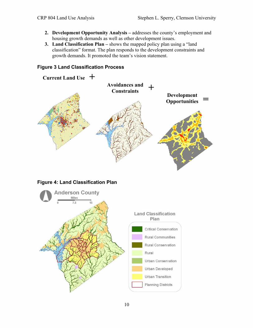
Module III: Preparing A Land Classification Plan This section of the course covered methods and techniques for designing a land classification plan (see Figure 4). This plan is appropriate for counties and multi-county regions in determining the location and densities for new development. Students created a written land classification plan for the County. The assignment incorporated a suitability and development opportunities analysis (see Figure 3). The plan responds to development constraints and growth demands. It also follows the American Planning Smart Growth Model Legislation for urban growth boundaries. Protection of the environment is essential, and it should promote vision statement’s goals, objectives, and policies. There are three sections to the module:
1. Suitability Analysis – analyzes the county's existing and emerging development constraints and conditions. Protection of the environment is essential.
9
CRP 804 Land Use Analysis Stephen L. Sperry, Clemson University
2. Development Opportunity Analysis – addresses the county’s employment and housing growth demands as well as other development issues.
3. Land Classification Plan – shows the mapped policy plan using a “land classification” format. The plan responds to the development constraints and growth demands. It promoted the team’s vision statement.
Figure 3 Land Classification Process
Current Land Use + Avoidances and +Constraints
Development Opportunities =
Figure 4: Land Classification Plan
10

CRP 804 Land Use Analysis Stephen L. Sperry, Clemson University
Module IV: Creating A Land Use Design In this section, teams use a land use and transportation design approach to visualized future urban form; detail specific locations; and calculate space requirements. The design integrated transportation into the land use plan. Students examined alternative concepts of urban form (e.g., neo-traditional neighborhoods, cluster development, or the transit-oriented development). Each team creates a land use design. This assignment incorporates ArcGIS to make a computerized map of a land use (see Figure 5). The objective of this exercise is to design a desirable land use pattern for the next 20 years. It required consistency with the earlier constraints, goals, policies, and land classification plan, and incorporated transportation improvements. The land use design should be consistent with the students’ vision statement and the team role. The plan must be sensitive to environmental and infrastructure conditions. At a minimum, the design indicates the location of open space (perhaps several types), industrial areas, commercial areas of retail, office, and mixed uses. Finally, the teams used Smart Growth Audits, Appendix A, as their checklist to assure their plan is sustainable. They also stated in their report how their design is sustainable. Creativity, rationality, and a clear, concise, compelling presentation of the plan are their goals of the exercise.
Figure 5: Land Use Design Plan
11

CRP 804 Land Use Analysis Stephen L. Sperry, Clemson University
Module V: Assessing Fiscal Impact of Development Plans and Public Finance Recommendations Communities planning for new development must plan for the associated costs imposed on public. In this exercise, students assess the impact on infrastructure and public services that will accompany the development their land use plan encourages. They primarily focus is the fiscal impact, but they also provide some qualitative indication of expected social, environmental, and economic impacts using Smart Growth Audits. In particular, the students need to analyze and discuss to how the County will accommodate:
• Transportation • Sewer and wastewater treatment • School districts: • Public services
Using The New Practitioners Guide to Fiscal Impact Analysis, the students consider the new fiscal burdens assumed by the County’s budget. It included development exactions to transfer some of the burden to developers, as well as other mechanisms that contribute to covering impacts of development. To assess the impact, the students need to:
• Take an inventory of existing mechanisms for public revenue and their contributions to financial inflows
• Characterize current budget allocations • Project the inflows and outflows for existing infrastructure and services • Use their fiscal impact analysis to identify future budget shortfalls based on their
land use planning • Make recommendations to either increase contributions through existing
mechanisms, reallocate spending to accommodate future needs, and/or make recommendations for public finance.
Module VI: Final Report And Presentation The final product of the class is a complete land use plan for a twenty-year period. It includes the existing and emerging conditions; the students’ vision statement for the plan with goals, objectives and policies; the land classification plan with suitability and opportunities analyses; the urban land use design; and the fiscal assessment. Once the earlier exercises have been completed or refined, the individual module products are compiled into a single report of the land use plan. This saves time with the final exercise. At this final stage, the teams ensure that the various plan components fit together in a logically integrated report. The students need to consistently present text, tables, maps and graphics through out the final report. The assumed audience consists of community residents, elected officials, and stakeholders.
4.0 Course Application and Experience
Upon completing the course, the students understood the planning process, smart growth principals, and they had a fundamental capability of GIS operations. The students learned that compact development especially mixed use development could slow down the sprawling pattern of urban development and retain more of the rural character of the
12
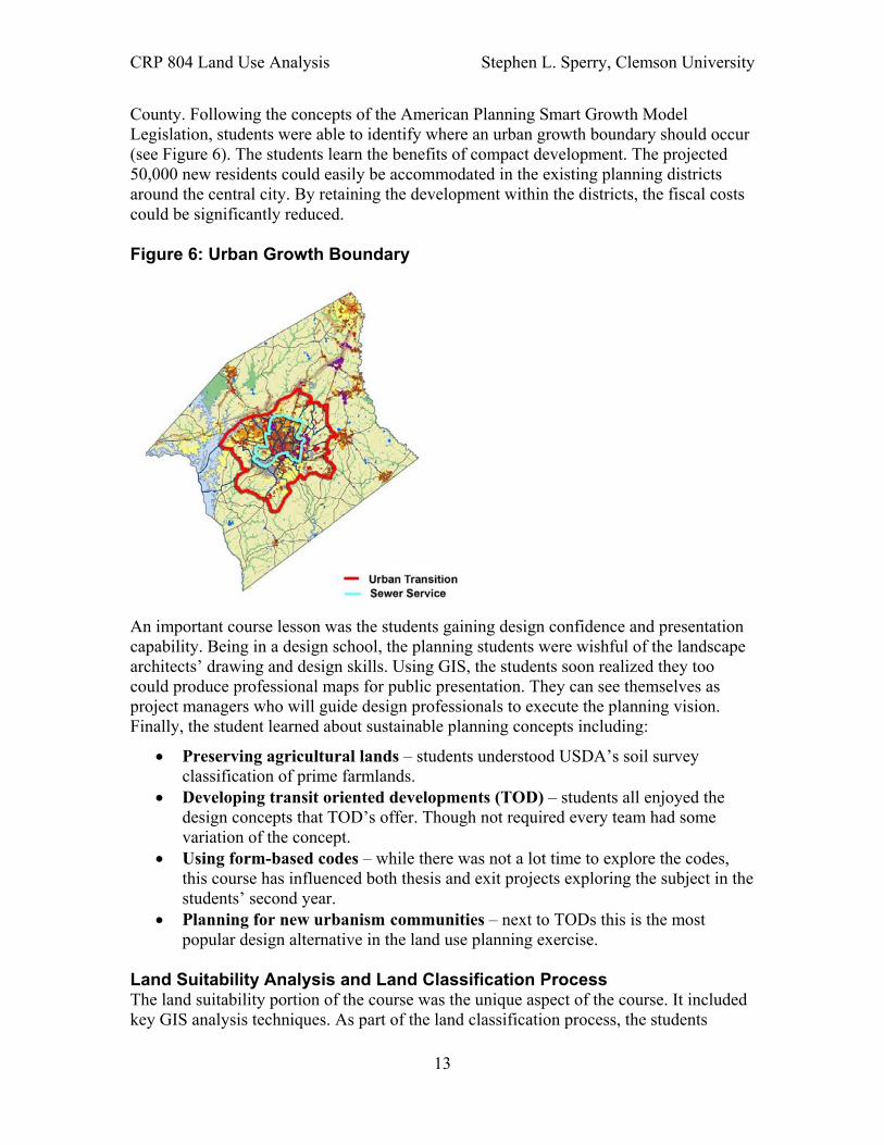
CRP 804 Land Use Analysis Stephen L. Sperry, Clemson University
County. Following the concepts of the American Planning Smart Growth Model Legislation, students were able to identify where an urban growth boundary should occur (see Figure 6). The students learn the benefits of compact development. The projected 50,000 new residents could easily be accommodated in the existing planning districts around the central city. By retaining the development within the districts, the fiscal costs could be significantly reduced.
Figure 6: Urban Growth Boundary
An important course lesson was the students gaining design confidence and presentation capability. Being in a design school, the planning students were wishful of the landscape architects’ drawing and design skills. Using GIS, the students soon realized they too could produce professional maps for public presentation. They can see themselves as project managers who will guide design professionals to execute the planning vision. Finally, the student learned about sustainable planning concepts including:
• Preserving agricultural lands – students understood USDA’s soil survey classification of prime farmlands.
• Developing transit oriented developments (TOD) – students all enjoyed the design concepts that TOD’s offer. Though not required every team had some variation of the concept.
• Using form-based codes – while there was not a lot time to explore the codes, this course has influenced both thesis and exit projects exploring the subject in the students’ second year.
• Planning for new urbanism communities – next to TODs this is the most popular design alternative in the land use planning exercise.
Land Suitability Analysis and Land Classification Process The land suitability portion of the course was the unique aspect of the course. It included key GIS analysis techniques. As part of the land classification process, the students
13

CRP 804 Land Use Analysis Stephen L. Sperry, Clemson University
created an analysis of the areas best suited for development. Suitability analysis overlaid a series of selected data such as slope, floodplains, agricultural soils, permeability, and proximity to highways to generate suitability scores for particular land uses at specific locations. It was used to identify the best areas for land uses such as commercial centers or housing. Students queried the vector data, converted the selected features to raster. They weighted and ranked the data files. This approach is summarized in Urban Land Use Planning. Many students selected additional variables to respond to sustainability issues. Their criteria for weighting were based on Landscape Planning and Smart Growth Audits. Students learned that suitability analysis is an easy way to identify constraints and opportunities for development. The students determine the pressures on growth in each of the planning districts and the rest of the county. They also determined new employment and retail centers and modify the model for new employment figures and housing density.
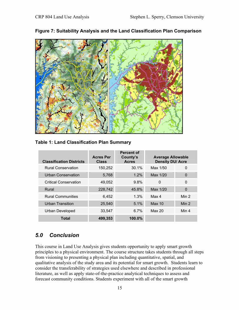
Making the Land Classification Plan The land classification plan included a map of proposed land classification, a table showing the number of acres in each classification district, a list of implementation policies for each classification district and a brief one to two page description (see Figure 7 and Table 1). The land classification plan is the tool for displaying the planning policy toward the location and timing of future growth and infrastructure provision (see Urban Land Use Planning, 1994). The plan (suitability’s green shades) represents the lands where development is encouraged (the developed and urban transition areas), and where development is limited (suitability’s yellow to orange shades) or completely restricted (black areas representing the floodplains and conservation areas). It translates the written development policies into a graphic representation. At the county scale, the common approach for county and regional plans is to map general policies for development and conservation, rather than specifying the “exact land use” for each land parcel. The development policy focuses on infill or brownfields by encouraging higher densities.. It should not include the scattered developed areas outside the planning districts limits. Students consider an agriculture district separate from the rural district. They also consider dividing the urban transition zone into two sections, one where the development will be encouraged through infrastructure scheduling for ten years and one for the following ten years. This approach is encouraged by the American Planning Association’s model legislation.
The land classification plan is designed to accommodate the projected growth. The students assign density policies (dwellings per acre for the development occurring in each planning district). They needed to ensure that the classified land is sufficient for future development at these densities. Key to this process is determining an urban growth boundary in the planning districts. The land classification plan should be consistent with the students’ vision statement and the existing conditions of the county. The plan must be sensitive to the environmental conditions determined in the suitability analysis. It should reflect coordination with private development and public infrastructure such as roads, water and sewer systems. Remember, the students are delineating proposed policy districts, not existing conditions. Therefore, existing development were not shown as islands within the sea of a classification.
14
CRP 804 Land Use Analysis Stephen L. Sperry, Clemson University
Figure 7: Suitability Analysis and the Land Classification Plan Comparison
Table 1: Land Classification Plan Summary
Classification Districts Acres Per
Class
Percent of County’s
Acres Average Allowable Density DU/ Acre
Rural Conservation 150,252 30.1% Max 1/50 0
Urban Conservation 5,768 1.2% Max 1/20 0
Critical Conservation 49,052 9.8% 0 0
Rural 228,742 45.8% Max 1/20 0
Rural Communities 6,452 1.3% Max 4 Min 2
Urban Transition 25,540 5.1% Max 10 Min 2
Urban Developed 33,547 6.7% Max 20 Min 4
Total 499,353 100.0%
5.0 Conclusion
This course in Land Use Analysis gives students opportunity to apply smart growth principles to a physical environment. The course structure takes students through all steps from visioning to presenting a physical plan including quantitative, spatial, and qualitative analysis of the study area and its potential for smart growth. Students learn to consider the transferability of strategies used elsewhere and described in professional literature, as well as apply state-of-the-practice analytical techniques to assess and forecast community conditions. Students experiment with all of the smart growth
15

CRP 804 Land Use Analysis Stephen L. Sperry, Clemson University
principles identified earlier (mixing land uses, creating walkable neighborhoods, preserving open space, balancing regional development, offering transportation choices, informing public decision making, and encouraging stakeholder participation). Students learn to envision how these principles can fit into spaces and communities where traditional growth patterns might otherwise dominate.
Lessons Learned This course is intensive, but to reduce the level of effort, portions of the course can be used in other courses or as standalone courses. The course developers have found that interacting with faculty teaching concurrent core courses can reinforce the theory and application of smart growth principles taught as a physical planning process in this course. As examples:
• the vision statement module can be incorporated with planning theory where public participation is discussed.
• the database and existing conditions analysis work with most GIS courses. • the fiscal assessment can also work with our urban systems and growth
management course.
The instructors found that they could modify team structures to accommodate student needs for focused individual work or reduced workload. The entire class can conduct the existing conditions analysis instead of as teams. Conducting the vision statement meeting with the students playing a stakeholders role was the student’s favorite module. The suitability analysis and the land use design works well with the different team roles. Our faculty likes the approach of having the student doing the full methodology even if it is not in-depth. Then the other planning classes can build on the experience. If other courses cover the lecture material, these modules can work easily in a project studio environment.
While we had no client, the faculty expects this course to be a model for the future. Most of the data can easily be replicated. The only issue is the availability of parcel data. Therefore, there is an opportunity to build a GIS database and conduct workshops on sustainability issues. If the client has a well-developed GIS database, the course or workshop can focus on sustainability.
Using the Course Materials If this course appeals to your interest in sustainable planning, there are three options. One is to use the Hypothetical City exercise book. It is designed to be used with ArcView 3.1 and comes with a workbook with data. Students can purchase the workbooks. Secondly, if you are using ArcGIS and desire to use real GIS planning data, the Clemson instructors are willing to help you. The database, handouts and PowerPoint lectures can be shared upon request. Example suitability analyses are available in model builder format. We can also email existing student reports for you to review and see the full range of exercises. Finally, the instructors can help other interested instructors with building local databases from existing state and national data.
16

CRP 804 Land Use Analysis Stephen L. Sperry, Clemson University
Instructors who wish to give students experience working with a public sector client can easily adapt this course structure to a local situation. Primarily, the instructor will need to ensure the availability of data resources on the client’s subject area, including GIS data comparable to the items listed in figure 1. Clients should provide feedback throughout the term to indicate catalysts and impedances that students should consider as they make their plans. The client can also recommend people to contact in the study area to gain additional information or local perspective on development and community organizational structures. Applying this course model to a client’s real-world situation will provide students with a realistic sense of how they can implement smart growth principles in planning practice. The final plan review should involve presentation to the client, as well as several stakeholders who might not have been involved throughout the term. Students can then gain experience answering questions and explaining their methods to a mixed audience of informed and uninformed stakeholders.
The modular approach to this course makes it flexible to meet the needs of many planning curricula. Faculty can offer the full course to senior students who have already acquired many of the analytical skills used for land use planning, or earlier coursework for junior students can focus on individual modules and skill development. The template of the course can apply to a hypothetical study area or the more tangible needs of a client. Regardless of the modular construction chosen, students can use this course construct to experiment with smart growth principles and gain experience applying them to land use planning.
17